settlement hierarchy local plan technical paper - exmoor€¦ · settlement hierarchy – local...
TRANSCRIPT
2015
Exmoor National Park Authority
Settlement Hierarchy Local Plan Technical Paper

If you have any queries or questions relating to this document please get in touch with the Policy & Community Team using the contact details below: Exmoor National Park Authority
Exmoor House Dulverton Somerset TA22 9HL
01398 323665

CONTENTS:
1. PURPOSE OF THE TECHNICAL PAPER ..................................................................... 1
2. NATIONAL POLICY CONTEXT ..................................................................................... 1
3. LOCAL PLAN CONTEXT ............................................................................................... 1
4. STRATEGIC OPTIONS CONSULTATION ..................................................................... 2
5. SUSTAINABILITY APPRAISAL (SA) OF THE STRATEGIC OPTIONS ......................... 2
6. PROPOSED SETTLEMENTS ........................................................................................ 3
7. EVALUATION ................................................................................................................ 4
8. SETTLEMENT EVALUATION ........................................................................................ 8
9. ROLE AND FUNCTION OF SETTLEMENTS WITHIN THE HIERARCHY ................... 58
10. APPENDIX 1: EXMOOR NATIONAL PARK LOCAL PLAN 2001-2011 – THE CHARACTERISTICS OF THE SETTLEMENTS .......................................................... 61

[Page intentionally left blank]
Settlement Hierarchy – Local Plan Technical Paper 2014
1
1. PURPOSE OF THE TECHNICAL PAPER
1.1 The Local Plan must identify a settlement hierarchy which will help inform the spatial strategy within the National Park. This paper sets out the approach taken and the analysis of settlements which underpins this. The spatial strategy will set out the focus for new housing and employment development in the National Park and where this will take place, to achieve the Vision and Objectives of the Local Plan.
1.2 The settlement hierarchy identifies the settlements which are considered to be appropriate locations for future development. For each settlement category within the hierarchy, the Local Plan will set out the type of development considered acceptable according to the role and function of those settlements.
2. NATIONAL POLICY CONTEXT
2.1 National policy1 states that the purpose of the planning system is to contribute to the achievement of sustainable development – the ‘social role’ is one of three key dimensions to sustainable development which should support strong, vibrant and healthy communities by providing the type of development that reflects the community’s needs and supports its health, and social and cultural well-being.
2.2 Plans should take account of the different roles and character of areas and in promoting sustainable development in rural areas, locate development, such as housing, where it will enhance or maintain the vitality of rural communities. This includes recognising that groups of smaller settlements may share and support services within and between their communities.
2.3 The publication of the Taylor Review2 in 2008 provided an in depth focus on what sustainability should mean for rural areas. This report recognises that planning has an important role in delivering sustainable development in the right places to make positive contributions to people’s lives, whilst ensuring the protection of important open spaces, the countryside and the natural and historic environment. However, the report highlighted that in many cases the criteria used to identify sustainable locations for development were too inflexible which meant that many settlements in rural areas faced a downward cycle of decline through loss of services and local people unable to afford to live there.
3. LOCAL PLAN CONTEXT
3.1 Previous Local Plans for Exmoor National Park have identified a range of settlements as suitable locations for development including those with a relatively extensive range of services and facilities that also serve surrounding communities and smaller settlements with a more limited range of services that serve the local community.
3.2 In preparing for the emerging Local Plan the evidence arising from several stages of early consultation3 has focussed on reviewing the settlement hierarchy and identifying a wider range of settlements across the National Park where new development could be considered acceptable in principle, based on the need to provide balanced and sustainable communities. This helped to inform the development of three strategic options4 for the location of new development:
a) Settlement Option A: Allow for new build development in all towns and villages listed in the Exmoor National Park Local Plan 2001-2011 namely: Allerford, Barbrook, Bridgetown/Exton, Brendon, Brompton Regis, Challacombe, Dulverton, Dunster, Exford, Luccombe, Luxborough, Lynton and Lynmouth, Monksilver, Parracombe,
1 NPPF 2012 DCLG 2 A Living Working Countryside: The Taylor Review of Rural Economy and Affordable Housing (2008) 3 Stakeholder Issues & Options Consultation (Nov 2008 – Jan 2009), Your Future Exmoor (Jan – Mar 2010) and Housing & Settlements
Topic Group Meeting (Nov 2010) 4 Local Plan Vision & Objectives, General Policies and Strategic Options relating to the settlement hierarchy and the delivery of affordable housing (21 November 2011 – 30 January 2012)

Settlement Hierarchy – Local Plan Technical Paper 2014
2
Porlock, Roadwater, Simonsbath, Timberscombe, Winsford, Withypool, Wheddon Cross/ Cutcombe and Wootton Courtenay.
b) Settlement Option B: Allow for new build development only in those towns and villages where there is a school, a regular bus service which runs 5+ times a week and a shop. This would include: Cutcombe/Wheddon Cross, Dulverton, Dunster, Exford, Lynton and Lynmouth, Parracombe, Porlock and Timberscombe.
c) Settlement Option C: Allow for new build development in all towns and villages listed in Option A and settlements with a shop and/or pub and/or village hall5. This would include the additional settlements of: Hawkridge, Twitchen, Heasley Mill, Martinhoe, Countisbury, Rockford, Oare, Porlock Weir, West Porlock, Selworthy, and Withycombe.
4. STRATEGIC OPTIONS CONSULTATION 2011
4.1 The consultation on the Local Plan Strategic Options was held between November 2011 and January 20126. Response to the consultation was low with 57 responses overall, although the consultation was widely publicised and run simultaneously with consultation on the draft Exmoor National Park Partnership Plan. In terms of responses to the options for the location of new development, Option C received the highest proportion of responses (39% or 22 responses), with Options A and B closely aligned at 24% and 23% respectively. Associated comments were strongly supportive of an approach that helped to sustain a wider range of settlements on Exmoor.
4.2 Those in support of settlement options A and B were concerned about the role of settlements in the National Park and their suitability in meeting all socio-economic needs of communities within the National Park. A further concern related to whether there would be a hierarchy within the list of settlements under option C. The continuation of a settlement hierarchy approach to development in the National Park is considered to be essential to ensure that development addresses the needs of a particular community and will not harm the landscape or settlement character.
4.3 Option C was also criticised as an approach that would lead to increased commuting to settlements with a wider range of services, facilities and employment. Whilst this may have some merit, the converse is also true, that in allowing development that addresses local needs may also help to minimise commuting distances where people are living and working in the vicinity. Local need affordable housing has generally been inhabited by people already living in Exmoor communities either in unsatisfactory accommodation or as hidden households where adults are still living with their parents.
4.4 It was also suggested that some of the proposed settlements listed under Option C should be omitted including Martinhoe, Countisbury and Selworthy. Although it is recognised that the majority of surrounding land, and a number of properties particularly within Selworthy and Countisbury are owned by the National Trust, it is considered that policy measures in the Local Plan will seek to ensure that opportunities to reuse existing buildings are the first consideration and any new build development should reflect the form and character of the settlement and not harm the landscape, wildlife and historic environment.
5. SUSTAINABILITY APPRAISAL (SA)
5.1 The inclusion of a range of smaller settlements within the settlement hierarchy7 scored positively for a range of sustainability topics including ‘community and wellbeing’, ‘economy and employment’, ‘housing’ and ‘land’ compared to the alternative strategic options A and B. Option C scored negatively against sustainability objectives relating to landscape, transport
5 Kentisbury was subsequently included as a settlement which met the criteria for smaller settlements - following consultation on Strategic Options 6 Consultation also included the Local Plan Vision & Objectives, General Policies and Strategic Options relating to the settlement hierarchy and the delivery of affordable housing. 7 Sustainability Appraisal of the Local Plan Vision & Objectives, General Policies and Strategic Options Consultation (November 2011)
Settlement Hierarchy – Local Plan Technical Paper 2014
3
and climate change mitigation. It is considered that policy safeguards in the Local Plan will alleviate many of the concerns raised including:
a) Possible increase in the need to travel for jobs and services;
b) Increase in the range of settlements with potential impacts arising from new development on biodiversity, vulnerability to flooding, character of the settlements, landscape and the capacity these additional settlements have to accommodate new development.
5.2 It was considered appropriate to retain a settlement hierarchy whereby the defined settlements were split into distinct categories and the type of development acceptable in the settlement is specified for each category – given the inclusion of a wider range of settlements in the Draft Local Plan (November 2013) and addressing concerns raised through the consultation and in the SA.
5.3 Although the Your Future Exmoor issues and options consultation events (2010) demonstrated that most people were in favour of treating all settlements the same rather than distinguishing between them, the inclusion of the additional settlements meant that the settlement hierarchy approach is an appropriate policy measure to ensure that the character of smaller communities and their landscape setting are conserved and enhanced whilst providing limited development opportunities to help sustain their communities over the long term.
6. NATIONAL PLANNING PRACTICE GUIDANCE UPDATE
6.1 Updates to planning practice guidance introduced on 28th November 2014 in relation to S106 thresholds for affordable housing8 sets out minimum thresholds for the size of housing developments where affordable housing can be sought and introduces a vacant buildings credit. The thresholds for National Parks can be set at 5 dwellings or fewer. The guidance is clear that rural exceptions sites are excluded from this change.
6.2 However, whilst this guidance is in force, these thresholds will apply to applications for the change the use of existing non-residential buildings or the redevelopment of vacant buildings to dwellings in settlements within the settlement hierarchy. This is likely to result in a number of market dwellings being delivered within Exmoor’s communities with no contribution towards the local affordable homes that are needed.
6.3 This change has an impact on the proposed spatial strategy consulted on in the Local Plan strategic options consultation (November 2011) and the Draft Local Plan consultation (November 2013). This was to increase the number of settlements where new build development to address local affordable housing needs would be considered to be acceptable by introducing a new tier of smaller rural settlements – identified as ‘Rural Communities’ in the Draft Exmoor National Park Local Plan (November 2013).
6.4 The inclusion of this tier of ‘Rural Communities’ as part of the settlement hierarchy within the spatial strategy was subsequently reconsidered due to the risk that a change of use of buildings to market housing due to the thresholds introduced would:
undermine the policy approach and have unintended consequences for the sustainability of these small communities;
reduce opportunities for the provision of affordable homes through the change of use of existing buildings; and
increase the demand for limited greenfield sites for new build given the small scale character of these settlements and their landscape capacity for new buildings.
6.5 An alternative approach would be to consider these settlements as open countryside, but to allow some flexibility for new self-build local affordable dwellings within these locations – whilst the policy approach to the change of use of buildings in the open countryside would also apply (e.g. for local affordable homes). This would ensure a consistent policy approach to that proposed in the Draft Local Plan; to provide opportunities for local affordable homes within
8 Planning Practice Guidance – Planning Obligations (paragraphs 012, 017, 019, 020, 021, 022, 023) – accessed 31.3.2015 http://planningguidance.planningportal.gov.uk/blog/guidance/planning-obligations/planning-obligations-guidance/
Settlement Hierarchy – Local Plan Technical Paper 2014
4
these small rural communities for people that live or work locally but in a way that does not simply provide opportunities to meet external housing demand.
7. PROPOSED SETTLEMENTS
7.1 The evaluation of settlements will inform the settlement hierarchy and the spatial strategy for the emerging Exmoor National Park Local Plan. The selection of settlements is based on:
The existing settlement hierarchy within the adopted Exmoor National Park Local Plan 2001-2011 (adopted March 2005),
The additional settlements proposed under Option C in the Local Plan Strategic Options consultation, and
Further settlements split by the boundary of the National Park also considered as requiring evaluation.
7.2 The full list of settlements for assessment include: Allerford, Barbrook, Brendon, Bridgetown
and Exton, Brompton Regis, Carhampton, Challacombe, Cutcombe and Wheddon Cross, Countisbury, Dulverton, Dunster, Exford, Hawkridge, Heasley Mill, Kentisbury, Luccombe, Luxborough, Lynton & Lynmouth, Martinhoe, Monksilver, Oare and Malmsmead, Parracombe, Porlock, Porlock Weir, Roadwater, Rockford, Selworthy, Simonsbath, Timberscombe, Twitchen, West Porlock, Winsford, Withycombe, Withypool, Wootton Courtenay.
8. EVALUATION
8.1 The following section will evaluate each settlement separately against specific criteria to finalise the identification of settlements within the settlement hierarchy.
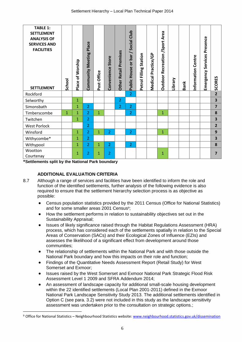
SERVICES AND FACILITIES 8.2 Each settlement has been evaluated against a list of 14 community services and facilities -
identified in Table 1. These have been rationalised from the list of characteristics used to inform the settlement hierarchy in the adopted Exmoor National Park Local Plan 2001-2011 (see Appendix 1).
8.3 These characteristics have been reviewed to inform the services and facilities listed in Table 1 which are used in the wider evaluation of Exmoor’s settlements within this Technical Paper. Changes in the way we access services, service provision and rationalisation of services following reductions in public expenditure mean that not all the characteristics listed are considered to be relevant in assessing how sustainable a settlement is currently, or could be in the future. For example, visiting GP or dentist surgeries are no longer provided, and recycling facilities are considerably reduced following the introduction of weekly kerbside collections. IT centres are less relevant as a greater majority of people have personal IT devices to access the internet. Libraries tend to also provide this service rather than a stand-alone centre specifically.
8.4 The category of bus service has been omitted in recognition of the decline of rural bus services that were subsidised by the Local Authorities due to cuts to public services. There are however alternative solutions available in several communities, including demand responsive transport, community transport and other rural transport initiatives that help to address the needs of those without access to public transport or their own car.
8.5 It should also be noted that the presence of a facility or service is counted whether or not it is located in the same premises. This reflects the multi-functional use of buildings and the flexibility to achieve community service provision in new and innovative ways. For example the Village Hall at Brompton Regis also hosts the village shop and the Post Office outreach service, and the church at Simonsbath has facilities so that it can also be used as a community meeting place to hold meetings and events.

Settlement Hierarchy – Local Plan Technical Paper 2014
5
8.6 To objectively assess the settlements it has been considered that the key services used to inform the selection of the smaller settlements (derived from the Local Plan Strategic Options Consultation – Option C); namely a shop, a pub or a community meeting place, should be weighted accordingly. Therefore a shop (both convenience and non-convenience retail premises), pub and community meeting place are weighted scores (2) and all other services and facilities are weighted (1); the highest potential score being 18.
TABLE 1: SETTLEMENT ANALYSIS OF
SERVICES AND FACILITIES
SETTLEMENT Sch
oo
l
Pla
ce o
f W
ors
hip
Co
mm
un
ity
Mee
tin
g P
lace
Po
st O
ffic
e
Co
nve
nie
nce
Sto
re
Oth
er R
etai
l Pre
mis
es
Pu
blic
Ho
use
or
bar
/ S
oci
al C
lub
Pe
tro
l Fill
ing
Stat
ion
Med
ical
Pra
ctic
e/G
P
Ou
tdo
or
Rec
reat
ion
/Sp
ort
Are
a
Lib
rary
Ban
k
Info
rmat
ion
Cen
tre
Emer
gen
cy S
ervi
ces
Pre
sen
ce
SCO
RES
Allerford 2 1 2 2 1 8
Barbrook 1 2 2 1 6
Brendon 2 2 1 5
Bridgetown and Exton
1 2 2 1 6
Brompton Regis 1 2 1 2 2 8
Carhampton* 1 2 1 2 2 1 9
Challacombe 1 2 2 5
Cutcombe and Wheddon Cross
1 1 2 1 2 2 2 1 1 13
Countisbury 1 2 3
Dulverton 1 1 2 1 2 2 2 1 1 1 1 1 1 1 18
Dunster 1 1 2 1 2 2 2 1 1 1 14
Exford 1 1 2 2 2 2 2 1 12
Hawkridge 1 2 3
Heasley Mill* 2 2
Kentisbury* 2 1 2 5
Luccombe 1 2 3
Luxborough 1 2 2 2 7
Lynton & Lynmouth
1 1 2 1 2 2 2 1 1 1 1 1 1 17
Martinhoe 1 2 3
Monksilver* 1 2 2 5
Oare and Malmsmead
1 2 3
Parracombe 1 1 2 1 2 2 9
Porlock 1 1 2 1 2 2 2 1 1 1 1 1 1 17
Porlock Weir 1 2 2 2 7
Roadwater 1 2 1 2 2 1 1 10
Settlement Hierarchy – Local Plan Technical Paper 2014
6
TABLE 1: SETTLEMENT ANALYSIS OF
SERVICES AND FACILITIES
SETTLEMENT Sch
oo
l
Pla
ce o
f W
ors
hip
Co
mm
un
ity
Mee
tin
g P
lace
Po
st O
ffic
e
Co
nve
nie
nce
Sto
re
Oth
er R
etai
l Pre
mis
es
Pu
blic
Ho
use
or
bar
/ S
oci
al C
lub
Pe
tro
l Fill
ing
Stat
ion
Med
ical
Pra
ctic
e/G
P
Ou
tdo
or
Rec
reat
ion
/Sp
ort
Are
a
Lib
rary
Ban
k
Info
rmat
ion
Cen
tre
Emer
gen
cy S
ervi
ces
Pre
sen
ce
SCO
RES
Rockford 2 2
Selworthy 1 2 3
Simonsbath 1 2 2 2 7
Timberscombe 1 1 2 1 2 1 8
Twitchen 1 2 3
West Porlock 2 2
Winsford 1 2 1 2 2 1 9
Withycombe* 1 2 3
Withypool 1 2 1 2 2 8
Wootton Courtenay
1 2 1 2 1 7
*Settlements split by the National Park boundary
ADDITIONAL EVALUATION CRITERIA
8.7 Although a range of services and facilities have been identified to inform the role and function of the identified settlements, further analysis of the following evidence is also required to ensure that the settlement hierarchy selection process is as objective as possible:
Census population statistics provided by the 2011 Census (Office for National Statistics) and for some smaller areas 2001 Census9;
How the settlement performs in relation to sustainability objectives set out in the Sustainability Appraisal;
Issues of likely significance raised through the Habitat Regulations Assessment (HRA) process, which has considered each of the settlements spatially in relation to the Special Areas of Conservation (SACs) and their Ecological Zones of Influence (EZIs) and assesses the likelihood of a significant effect from development around those communities;
The relationship of settlements within the National Park and with those outside the National Park boundary and how this impacts on their role and function;
Findings of the Quantitative Needs Assessment Report (Retail Study) for West Somerset and Exmoor;
Issues raised by the West Somerset and Exmoor National Park Strategic Flood Risk Assessment Level 1 2009 and SFRA Addendum 2014;
An assessment of landscape capacity for additional small-scale housing development within the 22 identified settlements (Local Plan 2001-2011) defined in the Exmoor National Park Landscape Sensitivity Study 2013. The additional settlements identified in Option C (see para. 3.2) were not included in this study as the landscape sensitivity assessment was undertaken prior to the consultation on strategic options.;
9 Office for National Statistics – Neighbourhood Statistics website: www.neighbourhood.statistics.gov.uk/dissemination

Settlement Hierarchy – Local Plan Technical Paper 2014
7
Other significant information including parish plans and neighbourhood plans;
The Rural Housing Enabler’s assessment of outstanding local affordable housing need (October 2013); and
The Exmoor National Park Strategic Housing Land Availability Assessment (SHLAA) provides evidence to support the preparation of the Local Plan in terms of sites that are suitable and available for housing development (deliverable sites) and those which are considered to be suitable but not available (i.e. they are considered to be suitable for housing development but have not been promoted by the landowner). Where a settlement has no sites identified in the SHLAA there may still be development opportunities through the change of use of existing buildings, on sites smaller than the 0.1 hectare (ha) threshold used for the assessment of SHLAA sites, or through future rural exception sites and windfall sites coming forward as housing need is identified and schemes are promoted.
8.8 It should be noted in terms of the Quantitative Needs Assessment, that tourists and visitors bring additional retail expenditure to the National Park, which is a benefit to the local economy through supporting retail and leisure uses in part or, in some circumstances, in their entirely. This has benefits for jobs and positive knock-on effects for the local economy. In addition, tourist expenditure can help to support and retain shops and services which could not be supported by local residents’ expenditure alone.
Settlement Hierarchy – Local Plan Technical Paper 2014
8
9. SETTLEMENT EVALUATION
ALLERFORD
Parish Population 477 Services and Facilities Score 8
Issues Raised Through Sustainability Appraisal and Habitat Regulations Assessment
Key factors include the risk of fluvial flooding within the majority of the settlement and the wildlife designations around the settlement which are likely to significantly constrain future development levels. Barbastelle bats, a feature of the Exmoor and Quantock Woodlands SAC, are likely to commute and forage around the village. Potential impacts on Natura 2000 Sites – disturbance or fragmentation of commuting habit; degradation of foraging habitat of barbastelle bats.
Relationship to surrounding settlements
Allerford is the largest settlement within Selworthy and Minehead Without Parish, with Selworthy and Bossington as smaller settlement groupings within the parish. There are some key services within the village, although the nearest First School and GP is located in Porlock.
Quantitative Needs Assessment
Porlock is popular for top-up food shopping for residents in Allerford; with Minehead as the main food shopping destination. Minehead and Taunton are popular shopping centres for comparison goods.
Exmoor National Park Strategic Flood Risk Assessment (SFRA) Level 1 Addendum 2014
The main settlement area of Allerford lies within flood zone 3b (functional flood plain) as identified in the Exmoor National Park SFRA Level 1 Addendum 2014.
Landscape Sensitivity Study 2013
Allerford has a low landscape capacity for future housing development. Due to the constraints and low landscape capacity for new build it will only be able to address the needs of the parish. Landscape capacity for 13 units of housing development is identified within low and moderate areas of landscape sensitivity within the settlement although this is mostly constrained by flood risk.
Local Affordable Housing Need 0 households Exmoor National Park SHLAA 2014
No identified sites are considered suitable for housing development within or adjoining the settlement.
Parish Plan
The Porlock Vale Parish Plan “Shaping Our Future” was published following extensive community consultation and includes the parishes of Porlock and Selworthy & Minehead Without. This plan identified a wide range of issues that were reviewed to inform a series of actions defined as Priority 1 or 2. Priorities that are linked to planning and land use included more affordable homes for local families, improved footpath access and cycle route creation.
Local Plan 2001-2011 Designation
Village
Conclusion
It is proposed that Allerford will not be identified as a settlement within the settlement hierarchy, ‘due to the considerable constraints to future development within this location identified by the Sustainability Appraisal, Habitats Regulations Assessment and SFRA. This

Settlement Hierarchy – Local Plan Technical Paper 2014
9
ALLERFORD
location would only be suitable for very limited development to help address local affordable need.
BARBROOK
Parish Population 1441 (estimated settlement population 15010) Services and Facilities Score 6
Issues Raised Through Sustainability Appraisal and Habitat Regulations Assessment
Much of the surrounding woodland area has a local wildlife site designation or is identified as Section 3 Woodland. Considerable area of the village is within an area of flood risk, and further constrained by topography and physical constraints including main A39 and B3224. No significant effect likely on SACs.
Relationship to surrounding settlements
Barbrook lies on the junction of the B3234 and the A39 approximately 1 mile south from the larger settlement Lynton & Lynmouth. Although it has some key services, the majority of services, including primary school and GP are found in Lynton and Lynmouth. The settlement does have the only petrol filling station for a considerable area the nearest being at Porlock (13.6 miles to the east) or Combe Martin (11.3 miles to the west), which helps to sustain the local shop on the same premises.
Quantitative Needs Assessment
It is recognised that smaller villages are at best served by a small local store – such as Barbrook. However, nearby Lynton & Lynmouth has a significant retail, leisure and commercial floorspace in comparison and will therefore attract day to day small scale food shopping trips, basic service trips and niche non-food shopping trips. Most main food shopping trips, for this postcode sector, are lost to Barnstaple (65%), 15% to Minehead, and 20% remain in Lynton & Lynmouth.
Exmoor National Park Strategic Flood Risk Assessment (SFRA) Level 1 Addendum 2014
The settlement is located at the confluence of the Barbrook and West Lyn rivers and a significant area is within flood zones 3b and 2. Most existing dwellings are located outside areas of flood risk. The most significant historic event was the Lynmouth Flood in 1952 which killed 12 people in Barbrook.
Landscape Sensitivity Study 2013
It is physically difficult to accommodate further housing within Barbrook. Most available sites have already been developed, are too steep or are liable to flood. Some capacity exists on land adjacent to existing developed areas where the slope is shallow enough to permit development. Barbrook has moderate landscape capacity for future housing of around 10 units. In conjunction with Lynton & Lynmouth the landscape capacity for new build housing development on greenfield sites may be able
10 Estimated population based on number of households multiplied by average household number for the parish (does not include allowance for dwellings with no usual residents).

Settlement Hierarchy – Local Plan Technical Paper 2014
10
BARBROOK
to address the need of the parish and some need in its adjoining parishes that have limited capacity
Local Affordable Housing Need See parish housing need assessment for Lynton & Lynmouth
Exmoor National Park SHLAA 2014
No identified sites are considered suitable for housing development within or adjoining the settlement.
Lynton & Lynmouth Neighbourhood Plan
Barbrook is within the parish area for the Lynton and Lynmouth Neighbourhood Plan which was brought into force in December 2013 to enable the development needed for the long term sustainable future of the parish.
Local Plan 2001-2011 Designation
Village
Conclusion
Although the shop and Post Office within Barbrook closed following the 2008 round of Post Office closures, the settlement has still retained a local shop at the garage, and therefore has many service elements that support the local community. Barbrook is proposed to remain as a Village within the settlement hierarchy.
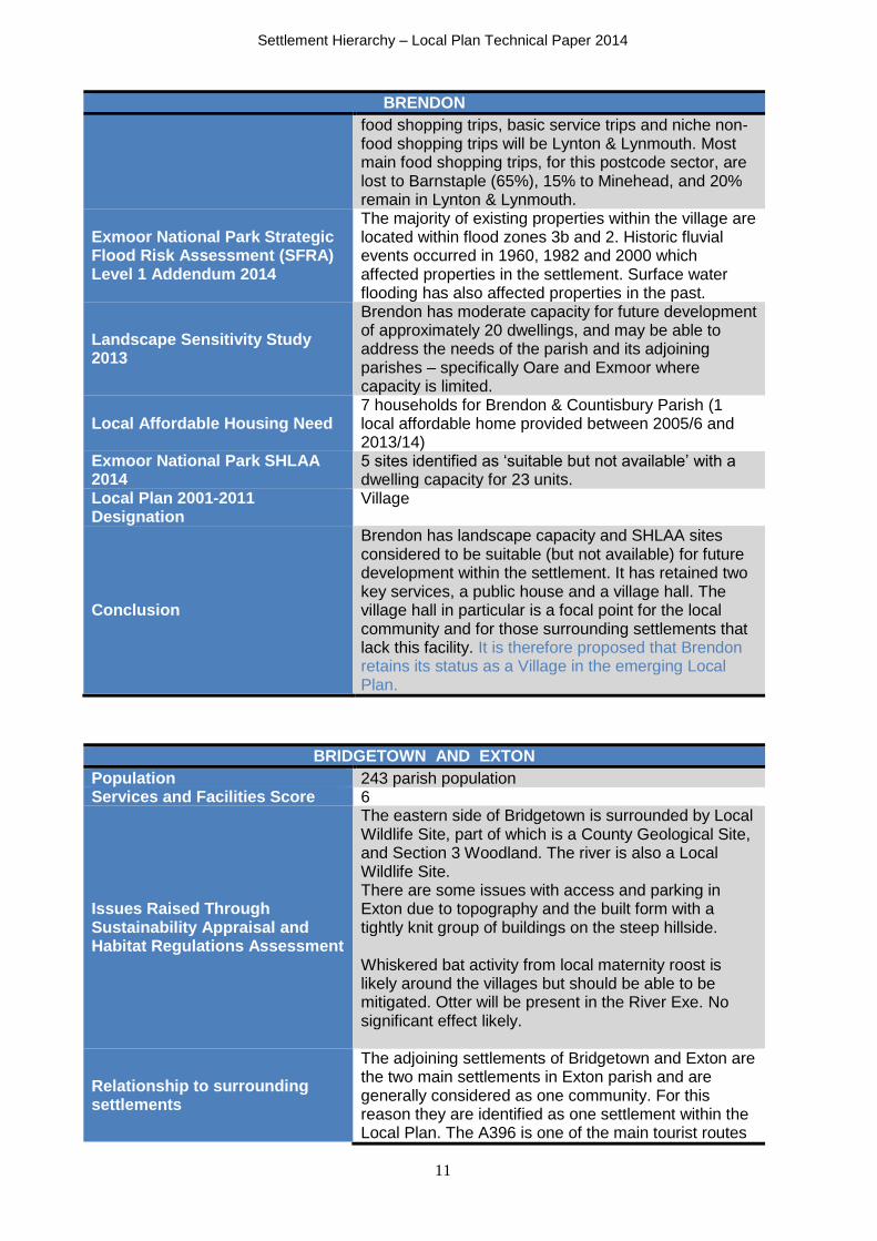
BRENDON
Population 206 within the parish of Brendon & Countisbury11 Services and Facilities Score 5
Issues Raised Through Sustainability Appraisal and Habitat Regulations Assessment
Mill Wood to the west of the village is part of the Exmoor and Quantocks Oakwoods SAC. However, the scale of development is unlikely to have a significant effect although a test of likely significance may be required for recreational and air quality impacts on lichens and bryophytes. The river and areas to the north of the village are Local Wildlife Sites. Due to its riverside setting a considerable area of the village is within an area at risk of flooding, including local amenities. Capacity exists for development outside flood risk areas. Relatively enclosed landscape with some open spaces that designated as Important Open Space for Visual Amenity
Relationship to surrounding settlements
Brendon is a small village situated in the East Lyn valley accessed by a network of single carriageway lanes, 4 miles east of Lynton and Lynmouth. Its location, setting and accessibility mean that it is relatively remote. Smaller settlements of Rockford and Countisbury are also located within the parish, and Oare/Malmsmead is on the boundary of the parish.
Quantitative Needs Assessment It is noted that many smaller settlements have no retail provision, and the closest settlement for day to day
11 Population for Brendon & Countisbury parishes (population of Brendon Parish 159 in 2001)
Settlement Hierarchy – Local Plan Technical Paper 2014
11
BRENDON
food shopping trips, basic service trips and niche non-food shopping trips will be Lynton & Lynmouth. Most main food shopping trips, for this postcode sector, are lost to Barnstaple (65%), 15% to Minehead, and 20% remain in Lynton & Lynmouth.
Exmoor National Park Strategic Flood Risk Assessment (SFRA) Level 1 Addendum 2014
The majority of existing properties within the village are located within flood zones 3b and 2. Historic fluvial events occurred in 1960, 1982 and 2000 which affected properties in the settlement. Surface water flooding has also affected properties in the past.
Landscape Sensitivity Study 2013
Brendon has moderate capacity for future development of approximately 20 dwellings, and may be able to address the needs of the parish and its adjoining parishes – specifically Oare and Exmoor where capacity is limited.
Local Affordable Housing Need 7 households for Brendon & Countisbury Parish (1 local affordable home provided between 2005/6 and 2013/14)
Exmoor National Park SHLAA 2014
5 sites identified as ‘suitable but not available’ with a dwelling capacity for 23 units.
Local Plan 2001-2011 Designation
Village
Conclusion
Brendon has landscape capacity and SHLAA sites considered to be suitable (but not available) for future development within the settlement. It has retained two key services, a public house and a village hall. The village hall in particular is a focal point for the local community and for those surrounding settlements that lack this facility. It is therefore proposed that Brendon retains its status as a Village in the emerging Local Plan.
BRIDGETOWN AND EXTON
Population 243 parish population Services and Facilities Score 6
Issues Raised Through Sustainability Appraisal and Habitat Regulations Assessment
The eastern side of Bridgetown is surrounded by Local Wildlife Site, part of which is a County Geological Site, and Section 3 Woodland. The river is also a Local Wildlife Site. There are some issues with access and parking in Exton due to topography and the built form with a tightly knit group of buildings on the steep hillside. Whiskered bat activity from local maternity roost is likely around the villages but should be able to be mitigated. Otter will be present in the River Exe. No significant effect likely.
Relationship to surrounding settlements
The adjoining settlements of Bridgetown and Exton are the two main settlements in Exton parish and are generally considered as one community. For this reason they are identified as one settlement within the Local Plan. The A396 is one of the main tourist routes

Settlement Hierarchy – Local Plan Technical Paper 2014
12
BRIDGETOWN AND EXTON
in the National Park and passes directly through Bridgetown. The settlements are 5.5 miles from Dulverton which has a GP, first school and middle school. It is also 3 miles from Winsford that has a shop and Post Office.
Quantitative Needs Assessment
It is noted that many smaller settlements have no retail provision, and the one of the closest settlements for day to day food shopping trips, basic service trips and niche non-food shopping trips will be Dulverton. This postcode sector loses around 54% of all main food shopping trips and 9% of top-up shopping trips to centres outside of the West Somerset/Exmoor area. Dulverton retains 24% of main food trips and 75% of top-up trips, while Minehead attracts 20% of main food trips and 3% of top-up trips.
Exmoor National Park Strategic Flood Risk Assessment (SFRA) Level 1 Addendum 2014
Exton is not within an area of flood risk. The settlement area of Bridgetown is located either side of the River Exe and therefore flood zones 2 and 3b extend either side of the river, although properties affected are limited. The caravan site is within an area of flood risk. Fluvial flood events have occurred in 1982, 1998 and recently in 2012 where properties were affected.
Landscape Sensitivity Study 2013
Bridgetown and Exton have a moderate landscape capacity for housing development of around 21 units and may be able to address the housing needs of the parish and need that arises in its adjoining parishes.
Local Affordable Housing Need 0 households Exmoor National Park SHLAA 2014
One deliverable site with planning permission for 2 local need affordable dwellings.
Local Plan 2001-2011 Designation
Village
Conclusion
Bridgetown and Exton have landscape capacity for further development and although current housing need is not identified there are opportunities for limited development within the settlement should a need arise during the Plan period. There are also two key services which suggest that the settlement should retain its status as a Village.

Settlement Hierarchy – Local Plan Technical Paper 2014
13
BROMPTON REGIS
Population 449 parish population Services and Facilities Score 8
Issues Raised Through Sustainability Appraisal and Habitat Regulations Assessment
Key community facilities are the pub and village hall which also hosts the village shop and the mobile Post Office. Pulham river has poor water quality, possibly including issues arising from sewage. No significant effect on SACs likely.
Relationship to surrounding settlements
The settlement of Brompton Regis lies 5.7 miles east of Dulverton on the Brendon Hills. The village is served by a network of single track roads leading off to the B3190 and B3224. The road from Heathpoult Cross to Machine Cross, less than a mile to the west, is also part of the local freight route that links with the B3224 and B3190. Wimbleball Lake lies two miles to the east and is a key visitor attraction for the area.
Quantitative Needs Assessment
Many smaller settlements are at best served by a small local store. The situation for small rural settlements has been compounded by the closure of rural post offices – this meant that both the post office and local shop closed in Brompton Regis in 2008 and has been replaced by a volunteer-run village shop and twice weekly post office outreach service in the village hall. It is noted that Brompton Regis is among a number of very small villages with convenience stores on Exmoor, where their ability to attract levels of spend is noteworthy and are clearly performing more strongly than the villages in West Somerset. The closest settlements for day to day food shopping trips, basic service trips and niche non-food shopping trips will be Dulverton. This postcode sector loses around 54% of all main food shopping trips and 9% of top-up shopping trips to centres outside of the West Somerset/Exmoor area. Dulverton retains 24% of main food trips and 75% of top-up trips, while Minehead attracts 20% of main food trips and 3% of top-up trips.
Exmoor National Park Strategic Flood Risk Assessment (SFRA) Level 1 Addendum 2014
The main area of the settlement lies within Flood Zone 1 and has not been at risk from fluvial flooding. Historic flood events on the Pulham River in 1994 and 1997 affected a small number of properties on the edge of the settlement.
Landscape Sensitivity Study 2013
Brompton Regis, in terms of its size, has a moderate landscape capacity for future housing development. Over the long term it is considered that a landscape capacity of around 11 dwelling units will predominantly help to address the needs of the

Settlement Hierarchy – Local Plan Technical Paper 2014
14
BROMPTON REGIS
parish and potentially some need arising from adjoining parishes with low landscape capacity.
Local Affordable Housing Need 4 households (1 local affordable home provided between 2005/6 and 2013/14)
Exmoor National Park SHLAA 2014
1 deliverable site for 18 dwellings and 1 site with planning permission for a single dwelling.
1 ‘suitable but not available’ site for 6 dwellings. Local Plan 2001-2011 Designation
Village
Conclusion
Brompton Regis has retained a number of services including a local shop due to community support. There is also landscape capacity and suitable sites identified for further development within the settlement without significant constraints. It is proposed that Brompton Regis retains the status of Village in the emerging Local Plan.
CARHAMPTON
Population 865 parish population – there are around 14 dwellings within the area of the settlement within the National Park.
Services and Facilities Score 9 Issues Raised Through Sustainability Appraisal and Habitat Regulations Assessment
Not assessed.
Relationship to surrounding settlements
Carhampton is mainly located within the West Somerset local planning authority area. A small area of the settlement to the south of Park Lane and bounded by The Court, is within the National Park boundary. The A39 bisects the settlement and leads to Minehead, 2 miles to the west, and Williton, 5 miles to the east. The settlement has a number of services and facilities and is identified as a Primary Village within the Revised Draft Preferred Strategy of the emerging Local Plan for West Somerset.
Quantitative Needs Assessment
Many smaller settlements are at best served by a small local store – usually associated with a petrol station or post office. It is noted that Carhampton is among a limited number of villages with convenience stores in West Somerset. However, village convenience shops in West Somerset do not perform as strongly as those in Exmoor villages where their ability to attract levels of spend is noteworthy. Carhampton is within postcode sector TA24 6. Minehead is the dominant shopping destination across this sector attracting almost all trips.

Settlement Hierarchy – Local Plan Technical Paper 2014
15
CARHAMPTON
West Somerset & Exmoor National Park Strategic Flood Risk Assessment (SFRA) Level 1 2009
Areas of flood zone 3b were shown to exist to the west of the settlement, extending within the National Park boundary. Historic events include blocked river structures which flooded 5 houses and gardens in 1994. Current Environment Agency flood mapping shows that there are no longer areas of flood risk affecting the settlement.
Landscape Sensitivity Study 2013
Landscape sensitivity analysis was not undertaken for this settlement.
Local Affordable Housing Need
Assessment of housing need has taken place for Carhampton parish and surrounding parish to establish housing need for a scheme coming forward just outside the National Park at Townsend Farm.
Exmoor National Park SHLAA 2014
2 deliverable sites with capacity for 6 dwellings (through the conversion of existing farm buildings). Two further greenfield sites on the edge of Carhampton were excluded from the SHLAA process as the settlement is not identified within the adopted Local Plan (2001-2011) settlement hierarchy.
Local Plan 2001-2011 Designation
Open Countryside
Conclusion
Carhampton has a number of facilities and services and is well connected to larger centres. The majority of the settlement and opportunities for future development are considered to be able to be accommodated outside the National Park boundary given its proposed status as a Primary Village in the West Somerset Local Plan (Publication Draft). Only a relatively small proportion of the settlement is within the National Park boundary and the opportunities for future housing development to meet local affordable need within the parish and adjoining parishes, are more likely to be accommodated outside the National Park given the settlement’s status within the West Somerset adopted Local Plan and emerging Local Plan. It is therefore proposed that the area of Carhampton within the National Park boundary continues to be identified as open countryside.

Settlement Hierarchy – Local Plan Technical Paper 2014
16
CHALLACOMBE
Population 141 parish population Services and Facilities Score 5 Issues Raised Through Sustainability Appraisal and Habitats Regulations Assessment
No significant constraints identified through the SA only in relation to landscape capacity (see below). No significant effect on SACs likely.
Relationship to surrounding settlements
Challacombe mainly lies in the shallow valley of the upper reaches of the Bray River extending to the top of Bickfont Hill. It is accessed via the B3358 which is one of the main transport routes that pass through the National Park. It is relatively remote from other settlements within the National Park - 6 miles to Simonsbath and 6.4 miles to Parracombe.
Quantitative Needs Assessment
Many smaller settlements are at best served by a small local store. It is noted that Challacombe is among a number of very small villages with convenience stores on Exmoor, where their ability to attract levels of spend is noteworthy and are clearly performing more strongly than the villages in West Somerset. The majority of main food shop trips for this postcode area (EX31 4) are made to Barnstaple. Whilst Challacombe has its own shop and post office which is likely to serve the local population; nearly 20% of top up food shopping trips across the whole postcode sector area are made to Bratton Fleming.
Exmoor National Park Strategic Flood Risk Assessment (SFRA) Level 1 Addendum 2014
The River Bray flows through Challacombe and flood risk zones 2 and 3b affect a number of properties that are located along the valley bottom from the junction with the B3358 through to Challacombe Bridge. Fluvial flood incidents in 2000 and 2012 affected properties within the settlement. Challacombe (Swincombe) Reservoir is located to the north of the settlement, and the reservoir flood extent in the event of dam failure could mean that areas within the valley bottom at Challacombe experience flooding with estimated depths of up to 2m.
Landscape Sensitivity Study 2013
Challacombe has a very low landscape capacity of around 5 dwellings for future housing development. Therefore it is likely that it will only be able to address its own needs for affordable housing over the long term.
Local Affordable Housing Need 4 households (1 local affordable home provided between 2005/6 and 2013/14)
Exmoor National Park SHLAA 2014
Two sites identified as ‘suitable but not available’ with a capacity for 8 dwellings.
Local Plan 2001-2011 Designation
Village
Conclusion
Challacombe is a relatively small and remote settlement and has wider relationships to other settlements outside the National Park such as Bratton Fleming (primary school, sports facilities etc.) and Barnstaple (wider service provision). It has retained key services such as the village shop and post office

Settlement Hierarchy – Local Plan Technical Paper 2014
17
CHALLACOMBE
and the pub – although the petrol pumps (formerly outside the shop) are no longer in operation. Landscape capacity for future development is low; however the SHLAA has identified two sites which are considered to be suitable (but not currently available). It is therefore proposed that Challacombe retains its status as a Village.
COUNTISBURY
Population 206 – Brendon & Countisbury parish population12 Services and Facilities Score 3
Issues Raised Through Sustainability Appraisal and Habitats Regulations Assessment
There are potentially leisure and recreational impacts on heathland to the north of the community in Exmoor Heaths Special Area of Conservation and to sensitive woodland habitats to the south in the Exmoor and Quantocks Oak Woodlands SAC.
Relationship to surrounding settlements
Countisbury a small settlement is situated on Countisbury Hill approximately 1 ½ miles east of Lynton & Lynmouth. The settlement is split by the main A39 tourist route through Exmoor which is particularly busy through the main summer months. Countisbury is within Brendon and Countisbury Parish and is therefore linked to the settlement of Brendon in terms of parish matters and use of facilities such as the village hall. Lynton provides wider services, including GP, food shopping and primary school.
Quantitative Needs Assessment
It is acknowledged that many smaller settlements have no retail provision, and the closest settlement for day to day food shopping trips, basic service trips and niche non-food shopping trips will be Lynton & Lynmouth. Most main food shopping trips, for this postcode sector, are lost to Barnstaple (65%), 15% to Minehead, and 20% remain in Lynton & Lynmouth.
Exmoor National Park Strategic Flood Risk Assessment (SFRA) Level 1 Addendum 2014
There are no flood risk issues noted for this settlement.
Landscape Sensitivity Study 2013
Landscape sensitivity analysis was not undertaken for this settlement. It is considered that policy safeguards are necessary to ensure that the level of development/growth is proportionate to the settlement size and will not harm the landscape character or local environment.
Local Affordable Housing Need 7 households for Brendon & Countisbury Parish
Exmoor National Park SHLAA 2014
No sites were considered for housing development within or adjoining the settlement. The SHLAA mainly addressed housing sites associated with the settlements identified in the adopted Local Plan.
Local Plan 2001-2011 Designation
Open Countryside
Conclusion Countisbury was proposed as an additional tier within the settlement hierarchy in the Local Plan consultation for Strategic Options. It was identified as a defined
12 Population of Countisbury in 2001 census was 66
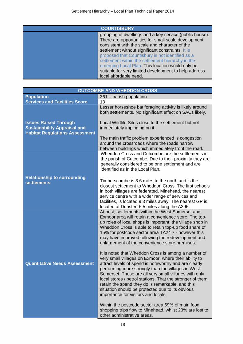
Settlement Hierarchy – Local Plan Technical Paper 2014
18
COUNTISBURY
grouping of dwellings and a key service (public house). There are opportunities for small scale development consistent with the scale and character of the settlement without significant constraints. It is proposed that Countisbury is not identified as a settlement within the settlement hierarchy in the emerging Local Plan. This location would only be suitable for very limited development to help address local affordable need.
CUTCOMBE AND WHEDDON CROSS
Population 361 – parish population Services and Facilities Score 13
Issues Raised Through Sustainability Appraisal and Habitat Regulations Assessment
Lesser horseshoe bat foraging activity is likely around both settlements. No significant effect on SACs likely. Local Wildlife Sites close to the settlement but not immediately impinging on it. The main traffic problem experienced is congestion around the crossroads where the roads narrow between buildings which immediately front the road.
Relationship to surrounding settlements
Wheddon Cross and Cutcombe are the settlements in the parish of Cutcombe. Due to their proximity they are generally considered to be one settlement and are identified as in the Local Plan.
Timberscombe is 3.6 miles to the north and is the closest settlement to Wheddon Cross. The first schools in both villages are federated. Minehead, the nearest service centre with a wider range of services and facilities, is located 9.3 miles away. The nearest GP is located at Dunster, 6.5 miles along the A396.
Quantitative Needs Assessment
At best, settlements within the West Somerset and Exmoor area will retain a convenience store. The top-up roles of local shops is important; the village shop in Wheddon Cross is able to retain top-up food share of 15% for postcode sector area TA24 7 - however this may have improved following the redevelopment and enlargement of the convenience store premises. It is noted that Wheddon Cross is among a number of very small villages on Exmoor, where their ability to attract levels of spend is noteworthy and are clearly performing more strongly than the villages in West Somerset. These are all very small villages with only local stores / petrol stations. That the stronger of them retain the spend they do is remarkable, and this situation should be protected due to its obvious importance for visitors and locals. Within the postcode sector area 69% of main food shopping trips flow to Minehead, whilst 23% are lost to other administrative areas.

Settlement Hierarchy – Local Plan Technical Paper 2014
19
CUTCOMBE AND WHEDDON CROSS Exmoor National Park Strategic Flood Risk Assessment (SFRA) Level 1 Addendum 2014
The settlement is within flood zone 1 and is not in an area of fluvial flood risk.
Landscape Sensitivity Study 2013
Both Cutcombe and Wheddon Cross were assessed as having moderate landscape capacity for future housing development on greenfield sites (21 units). There is potential capacity to accommodate new build development to address local needs in the parish and additional need that may arise in its adjoining parishes particularly where future landscape capacity is limited.
Local Affordable Housing Need 4 households
Exmoor National Park SHLAA 2014
One deliverable site with capacity for 3 dwellings.
One site with planning permission for 2 dwellings.
11 sites which are considered to be ‘suitable but not available’ with capacity for 48 dwellings.
Local Plan 2001-2011 Designation
Village
Conclusion
Wheddon Cross and Cutcombe have retained and enhanced the level of services and facilities within the settlement. There is recognised landscape capacity and suitable SHLAA sites for future development to address the needs of the community without significant constraints. Wheddon Cross / Cutcombe is proposed to retain the status of Village in the emerging Local Plan.
DULVERTON
Population 1408 including the area of the parish outside the National Park boundary
Services and Facilities Score 18
Issues Raised Through Sustainability Appraisal and Habitats Regulations Assessment
Dulverton has the highest emissions of CO2 from domestic oil and solid fuel use in the National Park, however the Scoping Report concluded that the combined impacts of raised PM10 emissions from the burning of biomass and solid fuel would not exceed PM10 objectives for this area, and no AQMA has been designated. Conservation Area and several listed buildings. Most of the capacity for development is likely to be outside of the historic settlement core as this is already densely developed. Considered to have limited capacity for development due to constraints of landscape (setting of Pixton and Hollam Park), wildlife designations, land liable to flooding, Important Open Space and physical constraints of steeply sloping landscape. The Burridge Woods component site of the Exmoor and Quantocks Oak Woodlands SAC lies just to the north of the town. The surrounding woodland areas are

Settlement Hierarchy – Local Plan Technical Paper 2014
20
DULVERTON
important for wildlife particularly within the SAC. The River Barle supports otters, which are features of the SAC. The River Barle also supports a number of species of European importance including Daubenton’s bats and kingfishers, which are sensitive to human disturbance particularly from lighting and frequent recreational activity. Lesser horseshoe bat foraging habitat is present to the north of the B3222.
Relationship to surrounding settlements
Dulverton lies on the southern boundary of the National Park within the Barle valley which broadens considerably at this point. The main A396 route lies a mile to the east with the B3222 passing directly through the town via the High Street and the B3223, leading off from Fore Street towards Winsford Hill.
Dulverton is one of the largest settlements within the National Park and has a wide range of services and facilities (see Table 1) that serve the local community and several surrounding communities within and outside the National Park boundary, including Battleton and Brushford. The town is also an important visitor destination for those visiting or staying on Exmoor, and there are several shops and facilities to cater for their needs.
Quantitative Needs Assessment
Dulverton is recognised as one of the settlements that have a significant retail, leisure and commercial floorspace within Exmoor and West Somerset, and a focal point for visitors to the area. Convenience uses accommodate 10.6% of all units and comparison uses 48.9% (both higher than the national average). However the level of service uses is much lower than the national average although vacancy rates are also relatively low. The majority of the turnover in relation to convenience food shopping comes from the surrounding postcode sector area with a lesser catchment area from TA24 7 (which includes settlements such as Winsford, Withypool, Exford and Simonsbath. 54% of all main food shopping trips and 9% of top-up shopping trips are lost to centres outside the West Somerset/Exmoor area (e.g. Tiverton); however Dulverton retains 24% of main food trips and 75% of top-up trips which are above second tier settlement averages. The key need for settlements such as Dulverton is to reinforce and enhance existing provision – particularly important when the needs of older people are considered.
Exmoor National Park Strategic Flood Risk Assessment (SFRA) Level 1 Addendum 2014
Areas of flood risk exist near the River Barle and the stream channelled through the town. A number of properties within the historic core of Dulverton are

Settlement Hierarchy – Local Plan Technical Paper 2014
21
DULVERTON
therefore in areas of flood risk. Historic flood events are noted a number of times since 1950 – and most
recently, in December 2012 fluvial flooding from the River Barle caused extensive flooding throughout Dulverton, damaging several properties. Other forms of flood events have arisen from sewer flooding and surface water flooding. The police station and fire station in Dulverton are at risk of flooding together with transport routes around the town. Maximum reservoir flood extents for Wimbleball Reservoir exist near Dulverton. In these areas risk of flooding from reservoirs should be considered as part of the plan making process.
Landscape Sensitivity Study 2013
The long-term landscape capacity for housing development in Dulverton is moderate to low – around 26 dwelling units. Therefore it is considered that there is capacity to address the housing needs of the parish over the longer term, and some need in its adjoining parishes.
Local Affordable Housing Need 8 households (22 local affordable homes provided between 2005/6 and 2013/14)
Exmoor National Park SHLAA 2014
Dulverton has three identified deliverable sites for up to 97 dwellings together with one site which has planning permission for 4 dwellings. A further site is considered to be ‘suitable but not available’ - identified capacity for 6 dwellings.
Local Plan 2001-2011 Designation
Local Rural Centre
Parish Plan
Dulverton produced a Parish Plan in 2010 which expressed the views of residents under a series of topic headings. Many of the issues raised have been resolved or are in the process of being resolved.
Conclusion
It is clear that Dulverton provides an extensive range of services and is therefore most suitable, in principle, for new development to consolidate employment and services to help address the needs of the National Park as a whole and the local community. Nevertheless, it is not any larger than many villages elsewhere in Devon and Somerset, and it is only because of its relative isolation and the extent of the surrounding areas it serves that such a wide range of services has been sustained. The influence of tourism on Exmoor also provides a retail boost for the area and potentially influences the type and scale of shops and what they offer. Although there are constraints to be considered in terms of flood risk and impacts on biodiversity, it is considered there is landscape capacity and deliverable sites for future development to sustain the needs of the settlement and to retain and enhance existing businesses. It is therefore proposed that Dulverton is identified within the higher tier of the settlement hierarchy as a Local Service Centre.

Settlement Hierarchy – Local Plan Technical Paper 2014
22
DUNSTER
Population 817 parish population – estimated to be 585 within the settlement of Dunster13
Services and Facilities Score 14
Issues Raised Through Sustainability Appraisal and Habitat Regulations Assessment
Areas to the north west of the town are likely to be used by foraging lesser horseshoe bats and to the west by greater horseshoe bats. Dunster Castle supports roosting bats. Daubenton’s bats and otters use the River Avill. No significant effect on SACs likely. Conservation Area and 120 listed buildings. Historic Parks and Gardens. The setting of Dunster and conservation of its character is significant and land surrounding the settlement is sensitive to development, which will constrain development.
Relationship to surrounding settlements
The parish of Dunster lies partly within the National Park boundary. The main settlement is Dunster situated on the A396 close to the National Park boundary and the junction with the A39. The settlement known as Dunster Marsh is located to the north east of the A39 outside the National Park boundary within the local planning area of West Somerset Council.
Although smaller than Exmoor’s largest settlements, Dunster does have a number of facilities that serve a wider area including the first school and medical practice. Dunster has been described as one of the finest examples of a medieval settlement in the country, with notable buildings such as the castle, yarn market, church and priory. This historic interest therefore supports its popularity as tourist destination. The coastal town of Minehead (outside the National Park) has a wide range of services and facilities and is located 2 miles to the west of Dunster.
Quantitative Needs Assessment
As Dunster has a high prevalence of retail and leisure uses for its small size it was included in the assessment. Dunster is also noted as a popular tourism destination, benefiting from close proximity to the junction of the A396 and A39, close to Minehead. As a consequence, many of the shops and services in Dunster cater for the tourism market which is likely to provide a significant part of their annual turnover. Analysis of retail and service uses has shown that Dunster is dominated by the comparison goods retail sector (65%) considerably higher than the national average – many of these uses are orientated towards
13 Estimated population based on number of households multiplied by average household number for the parish (does not include allowance for dwellings with no usual residents).
Settlement Hierarchy – Local Plan Technical Paper 2014
23
DUNSTER
the tourism market. There are only 3 convenience shops in Dunster (delicatessen, newsagent and sweet shop) which serve limited day to day needs of the local population and cater for the tourism market. Other service uses consist of main food and drink uses such as tearooms and cafes, but the proportion is lower than national and Exmoor average levels. At the point of the assessment there was only one vacancy in Dunster which indicates the strength of the centre in terms of its ability to attract retailers and other businesses. The size of available facilities will indicate how they are used, coupled with local geography which will affect convenience spend. It is not expected that Dunster will be able to increase its main or top-up food shopping shares due to the proximity of Minehead and due to the likely reliance on seasonal visitor spend. It is noted that there are potential disadvantages to the influence of tourism, including the lack of choice for local residents’ day to day shopping needs and tourist businesses being able to ‘out bid’ local businesses for premises and increase property prices and rents. This is particularly applicable to Dunster which together with the proximity of Minehead means that there is little in the way of retail provision for day-to-day shopping needs which are evident in centres such as Dulverton, Lynton & Lynmouth and Porlock. Minehead (outside the National Park) possesses large supermarkets and multiple national retailers and is the dominant comparison shopping destination in West Somerset and Exmoor. Its primary catchment zone includes Dunster for both comparison and almost all convenience goods shopping trips.
Exmoor National Park Strategic Flood Risk Assessment (SFRA) Level 1 Addendum 2014
The floodplain of the River Avill flows around Dunster’s southern boundary and does not extend into the built environment. The majority of the settlement is therefore within flood zone 1.
Landscape Sensitivity Study 2013
Dunster has low overall landscape capacity for future housing development (21 units) due to the high landscape and historic value associated with the settlement, and it is only likely to be able to address the housing needs of the parish (rather than surrounding parishes) over the longer term.
Local Affordable Housing Need 5 households
Exmoor National Park SHLAA 2014
1 deliverable site within the parish for 3 dwellings.
1 site for a local affordable dwelling that has planning permission.
1 ‘suitable but not available’ site identified for 1 dwelling.
Local Plan 2001-2011 Designation
Village
Other Information The Dunster Working Group is a partnership of local authorities, voluntary organisations and businesses

Settlement Hierarchy – Local Plan Technical Paper 2014
24
DUNSTER
that seek to enhance the environmental quality, economic viability and social well-being for Dunster Village and the surrounding area. As a result of extensive consultation the Dunster Action Plan14 presents a range of enhancement projects for the village, including detailed analysis and proposals by Ben Hamilton-Baillie Associates relating to future design, management and maintenance of streets and the public realm.
Conclusion
Although Dunster is one of Exmoor’s larger settlements, and is recognised as having a number of key services which serve the local community and surrounding areas, its main retail and service functions are mainly reliant on seasonal visitor spend. The importance of its medieval heritage and resulting low landscape capacity also indicates that there are key constraints for future development. In terms of accessing convenience and comparison goods, the local population is more likely to travel to Minehead making use of the transport connections between the settlements. It is therefore proposed that Dunster retains its status as a Village in the emerging Local Plan.
EXFORD
Population 405 parish population Services and Facilities Score 12
Issues Raised Through Sustainability Appraisal and Habitat Regulations Assessment
The river is a Local Wildlife Site and is likely to support otters. Also LWS to the north of the village but not likely to constrain development. There are a few properties lying close to the river that are within an area of flood risk. No significant effect on SACs likely.
Relationship to surrounding settlements
Exford is located in the centre of the National Park on the B3224 which traverses the National Park East to West and connects with routes to Porlock and Dulverton at Exford. The village has retained many key services and facilities but has lost the petrol station the closest being at Wheddon Cross – 5 miles to the east. The nearest GP is in Dulverton.
Quantitative Needs Assessment
Many smaller settlements are at best served by a small local store. Exford has a convenience food shop with Post Office and retains a reasonable amount of top-up shopping trips. It is noted that Exford is among a number of very small villages with convenience stores on Exmoor, where their ability to attract levels of spend is noteworthy and are clearly performing more strongly than the villages in West Somerset.
14 A Draft Action Plan for Dunster 2012 to 2014

Settlement Hierarchy – Local Plan Technical Paper 2014
25
EXFORD
There is no retention of main food shopping trips within this postcode sector (TA24 7) with expenditure lost to Minehead (69%) and Barnstaple. The village shops are important to local communities and visitors and should be supported by all means possible.
Exmoor National Park Strategic Flood Risk Assessment (SFRA) Level 1 Addendum 2014
The settlement is centred around the crossing of the River Exe, therefore a number of properties and businesses are located within flood zones 2 and 3b. As the village has grown, development has increasingly been located along the hillsides and out of flood risk areas. A number of historic fluvial flood risk events affecting properties have occurred, particularly in the early 1980s, 1994, and most recently in 2012.
Landscape Sensitivity Study 2013
Exford has moderate landscape capacity for future housing development (20 units) and therefore is considered to be able to address the local need for housing arising in the parish and those adjoining parishes where capacity is limited.
Local Affordable Housing Need 3 households (10 local affordable homes provided between 2005/6 and 2013/14)
Exmoor National Park SHLAA 2014
1 deliverable site with a capacity for 6 dwellings.
5 ‘suitable but not available’ sites with a capacity for 15 dwellings.
Local Plan 2001-2011 Designation
Village
Conclusion
Exford has retained a number of services including a local shop, school and post office which serve the local community and surrounding communities such as Simonsbath. There is also landscape capacity and suitable sites identified in the SHLAA for further development within the settlement without significant constraints. It is proposed that Exford retains the status of Village in the emerging Local Plan.
HAWKRIDGE
Population
201 – population for the parish of Withypool and Hawkridge (it is estimated that there are around 40 people in the local community including outlying farmsteads)
Services and Facilities Score 3
Issues Raised Through Sustainability Appraisal and Habitats Regulations Assessment
SSSI abuts the settlement at East Hollowcombe. Hazel (or common dormouse) may be present in hedgerows to the south of the community. No significant effect on SACs likely.
Relationship to surrounding settlements
Hawkridge is a small isolated moorland settlement in the parish of Withypool & Hawkridge, accessed by single track narrow lanes four miles south of Withypool and 5.6 miles west of Dulverton. The settlement has a community of just over 40 people (including outlying farmsteads). It is considered that it will look to

Settlement Hierarchy – Local Plan Technical Paper 2014
26
HAWKRIDGE
Withypool and Dulverton for wider services and facilities including top-up shopping trips.
Quantitative Needs Assessment
It is noted that many settlements on Exmoor have limited or no retail offer. Hawkridge is within the TA22 9 postcode sector which includes Dulverton. Within this sector area, Dulverton retains 24% of main shopping trips and 75% of top-up shopping trips influenced by a large Co-op store which accounts for most of this retention.
Exmoor National Park Strategic Flood Risk Assessment (SFRA) Level 1 Addendum 2014
The settlement is not located within an area of flood risk.
Landscape Sensitivity Study 2013
Landscape sensitivity analysis was not undertaken for this settlement. It is considered that policy safeguards are necessary to ensure that the level of development/growth is proportionate to the settlement size and will not harm the landscape character or local environment.
Local Affordable Housing Need 5 households (for the whole of Withypool and Hawkridge Parish) – also see Withypool
Exmoor National Park SHLAA 2014
No sites were considered for housing development within or adjoining the settlement. The SHLAA mainly addressed housing sites associated with the settlements identified in the adopted Local Plan.
Local Plan 2001-2011 Designation
Open Countryside
Conclusion
Hawkridge has a defined grouping of dwellings and a key service (village hall). There are opportunities for small scale development without significant constraints. It is proposed that Hawkridge is not identified as a settlement within the settlement hierarchy in the emerging Local Plan. This location would only be suitable for very limited development to help address local affordable need.
HEASLEY MILL
Population
The parish population for North Molton would not be relevant for Heasley Mill, which is a small settlement of around 12 dwellings of which 8 are within the National Park boundary.
Services and Facilities Score 2 Issues Raised Through Sustainability Appraisal and Habitats Regulations Assessment
Includes areas of flood risk but most properties are not within the flood risk area. No significant effect on SACs likely.
Relationship to surrounding settlements
Heasley Mill is located in the parish of North Molton and is split by the southern boundary of the National Park. The majority of the settlement is within the National Park; however a few of the dwellings to the south of the settlement lie within the area North Devon Council is responsible for in terms of planning. The settlement is located 2 miles north of North Molton that has a number of services and facilities and is identified as a Local Centre in the North Devon &

Settlement Hierarchy – Local Plan Technical Paper 2014
27
HEASLEY MILL
Torridge Local Plan Publication Draft. The local community are most likely to travel to North Molton for their top-up shopping and to South Molton for main food shop and wider services and facilities.
Quantitative Needs Assessment N/A. It is noted that Exmoor has a relationship with surrounding centres including South Molton.
Exmoor National Park Strategic Flood Risk Assessment (SFRA) Level 1 Addendum 2014
The eastern edge of the settlement lies within flood zones.
Landscape Sensitivity Study 2013
Landscape sensitivity analysis was not undertaken for this settlement. It is considered that policy safeguards are necessary to ensure that the level of development/growth is proportionate to the settlement size and will not harm the landscape character or local environment.
Local Affordable Housing Need 0 households
Exmoor National Park SHLAA 2014
No sites were considered for housing development within or adjoining the settlement. The SHLAA mainly addressed housing sites associated with the settlements identified in the adopted Local Plan.
Local Plan 2001-2011 Designation
Open Countryside
Conclusion
Heasley Mill has a defined grouping of dwellings and a key service (village hall). There are opportunities for small scale development without significant constraints. It is therefore proposed that the area of Heasley Mill within the National Park is not identified as a settlement within the settlement hierarchy. This location would only be suitable for very limited development to help address local affordable need.
KENTISBURY
Population A relatively small proportion of the wider parish population which includes Kentisbury Ford and Patchole.
Services and Facilities Score 3 Issues Raised Through Sustainability Appraisal and Habitats Regulations Assessment
No significant issues raised. No significant effect on SACs likely.
Relationship to surrounding settlements
Kentisbury Parish is partly within the North Devon area of the National Park. There are three distinct settlement groupings that form a dispersed settlement pattern within the parish at:
Kentisbury (split by the National Park boundary),
Kentisbury Ford and
Patchole.
Kentisbury/Kentisbury Ford is identified as a Village in the North Devon & Torridge Local Plan Publication Draft. There are a number of services within the parish which support the local community. The primary school is federated with primary schools at Parracombe and Lynton (West Exmoor Federation).

Settlement Hierarchy – Local Plan Technical Paper 2014
28
KENTISBURY
Quantitative Needs Assessment
Kentisbury has a shop within the parish (not part of the settlement group split by the National Park boundary). The area is assessed in terms of the EX31 4 postcode sector area. Within this area popular top-up food shopping destinations include other smaller stores (19.7%), whereas most main food shopping destinations are in Barnstaple.
Exmoor National Park Strategic Flood Risk Assessment (SFRA) Level 1 Addendum 2014
The settlement area is not within an area at risk of flooding.
Landscape Sensitivity Study 2013
Landscape sensitivity analysis was not undertaken for this settlement. It is considered that policy safeguards are necessary to ensure that the level of development/growth is proportionate to the settlement size and will not harm the landscape character or local environment.
Local Affordable Housing Need 1 household
Exmoor National Park SHLAA 2014
Only one site was considered for housing development within or adjoining the settlement but this was excluded from the SHLAA as Kentisbury is not currently identified as a settlement in the adopted Local Plan.
Local Plan 2001-2011 Designation
Open Countryside
Conclusion
Kentisbury has a defined grouping of dwellings and there are services within a reasonable walking distance (village hall and primary school within 500m). There are also opportunities for some small scale development without significant constraints. Given the relatively small area of the settlement within the National Park it is recognised that most development opportunities are likely to arise in the North Devon local planning authority area of the settlement pattern. It is therefore proposed that the area of Kentisbury (sometimes referred to as Kentisbury Town) within the National Park boundary is not identified as a settlement within the settlement hierarchy in the emerging Local Plan. This location would only be suitable for very limited development to help address local affordable need.
LUCCOMBE
Population 157 Services and Facilities Score 3
Issues Raised Through Sustainability Appraisal and Habitat Regulations Assessment
Local Wildlife Sites surround the village including Luccombe Plantation and Holnicote Estate. Development will be constrained by the designations around the village.
A conservation area was designated in 1984 which includes most of the village.

Settlement Hierarchy – Local Plan Technical Paper 2014
29
LUCCOMBE
Barbastelle bats, a feature of the Exmoor and Quantocks Oak Woodlands SAC, are likely to be foraging and /or commuting around the village and development may require a ‘test of likely significance.’ It is also likely that lesser horseshoe bats are foraging and commuting around the village. Hazel (or common dormouse) may be present in hedgerows around the community.
Relationship to surrounding settlements
The settlement of Luccombe is a small, linear village lying in a wooded valley at the foot of Luccombe Hill. The National Trust has owned the Holnicote Estate since 1944 which includes a number of dwellings in the village.
Luccombe can only be reached by a series of winding single track lanes; this and its setting contribute to its sense of remoteness although the village is only three miles from Porlock, four miles from Minehead and just over a mile from the A39 main tourist route. Porlock and Minehead are key destinations in terms of accessing wider services and facilities.
Quantitative Needs Assessment
Luccombe is within the primary catchment area for Porlock, which has an important local centre role. Porlock retains 30% of top up food shopping trips, but given the proximity to Minehead, this will also the key destination for both top-up shopping and main food shopping trips.
Exmoor National Park Strategic Flood Risk Assessment (SFRA) Level 1 Addendum 2014
The settlement is not located within an area of flood risk.
Landscape Sensitivity Study 2013
Very low landscape capacity for housing development (2 units) which indicates that the settlement will only be able to address its own parish needs for affordable housing in the long term.
Local Affordable Housing Need 0 households
Exmoor National Park SHLAA 2014
No sites were considered for housing development within or adjoining the settlement. Either none came forward through the ‘call for sites’ process or any potential sites that may have been identified were screened out as being below the 0.1ha threshold.
Local Plan 2001-2011 Designation
Village
Conclusion
Luccombe has significant constraints in terms of landscape capacity, biodiversity and the historic environment. The level of service provision is low compared to other identified settlements in the National Park and is more comparable to smaller rural settlements/hamlets. It is therefore proposed that Luccombe is not identified as a settlement within the settlement hierarchy in the emerging Local Plan. This location would only be suitable for very limited development to help address local affordable housing needs.

Settlement Hierarchy – Local Plan Technical Paper 2014
30
LUXBOROUGH
Population 237 – population for the parishes of Luxborough and Treborough15
Services and Facilities Score 7
Issues Raised Through Sustainability Appraisal and Habitat Regulations Assessment
Hazel (or common) dormouse may be present in hedgerows around the village and may act as a constraint to development which requires land take. No significant effect on SACs likely. Local Wildlife Sites close to the village including the river.
Relationship to surrounding settlements
Luxborough lies in a deep valley in the Brendon Hills, accessed by a network of narrow lanes leading off the A39, A396 and B3224. Regarded as one settlement but comprising 3 settlement groups of Churchtown, Kingsbridge and Pooltown. Close links with settlements along the valley with Roadwater (nearest Post Office and Shop) and Washford (GP and first school).
Quantitative Needs Assessment
In relation to main food shopping 73% of trips from this area (TA23 0) flow to stores in Minehead, whereas 45% of top-up shopping trips remain in Watchet, 18% to Minehead and 17% flow to Williton.
Exmoor National Park Strategic Flood Risk Assessment (SFRA) Level 1 Addendum 2014
Both Kingsbridge and Pooltown have areas within flood zones 2 and 3b by the Washford River. Some properties are within these flood risk areas; with the last recorded historic event in 1960.
Landscape Sensitivity Study 2013
The dispersed settlement pattern results in low capacity for future housing and will only be able to address its own needs for affordable housing over the long term.
Local Affordable Housing Need 0 households
Exmoor National Park SHLAA 2014
Two deliverable sites were identified within the parish with a capacity for 6 dwellings.
One ‘suitable but not available’ site identified with a capacity for 3 dwellings.
Local Plan 2001-2011 Designation
Village
Conclusion
Luxborough has retained key services including a public house and village hall. Although it is a small community there is some capacity to meet its needs for affordable housing including through change of use of existing buildings. It is therefore proposed that Luxborough retains the status of Village in the emerging Local Plan.
LYNTON & LYNMOUTH
Population 1441 parish population (including Barbrook) Services and Facilities Score 17 Issues Raised Through Sustainability Appraisal and Habitats Regulations Assessment
Woodland in the East Lyn valley towards. Watersmeet is internationally designated for its ecological importance (Exmoor & Quantocks Oakwoods SAC). Rivers are designated as Local Wildlife Sites.
15 Population combined with Treborough parish whose population was 42 in 2001.

Settlement Hierarchy – Local Plan Technical Paper 2014
31
LYNTON & LYNMOUTH
Development will be constrained by the surrounding local wildlife interest but development and conversions within the settlement are not likely to have significant wildlife impact. No significant effect on SACs likely. Flood zone 3b along the river.1952 flood led to re-routing of part of the river and additional flood defences being built in 1956, there has not been significant fluvial flooding since. There has also been recent flooding from coastal flooding. Draft Shoreline Management plan policy is to hold the line. Two Conservation Areas (one in Lynton and one in Lynmouth).
Relationship to surrounding settlements
Lynton, Lynmouth and Lynbridge are considered together as one settlement (Lynton & Lynmouth) with a range of services and facilities serving the local and wider community, including Brendon, Countisbury, Martinhoe and Parracombe. The primary school is federated with primary schools at Parracombe and Kentisbury (West Exmoor Federation). Lynton is approached by road via the B3234 from Lynmouth or Barbrook, which links with the A39. The steep gradients of Countisbury Hill on the A39 and on the B3234 from Lynmouth tend to emphasize its sense of seclusion. The settlement is a considerable distance from the nearest main town with wider ranges of services including large supermarkets and hospital facilities. Barnstaple is 19 miles, Minehead 18 miles, and Ilfracombe (secondary school education provision) 18 miles.
Quantitative Needs Assessment
Lynton & Lynmouth is a settlement within Exmoor and West Somerset that is recognised as being a focal point for visitors and possessing a significant retail, leisure and commercial floorspace compared to other settlements within this area. Retail, leisure and other commercial uses are spread across both settlements. In Lynton, retail and service uses are located mainly on Lee Road and Queen Street, whilst similar uses in Lynmouth are located on Lynmouth Street and Watersmeet Road. 7.9% of retail and service premises are occupied by convenience goods retailers – this is lower than the national and Exmoor averages (9.5%). 47.7% of units are occupied by comparison goods retailers, which is higher than the national average. The proportion of service uses (34.1% is commensurate with the national average (34.6%) and higher than the Exmoor average of 29.5% as there are many tearooms and cafes and takeaways. Hotels, bed and breakfast establishments and public houses occupy around one third of all commercial premises. It is acknowledged that Lynton & Lynmouth is particularly remote – this is reflected in the retention of

Settlement Hierarchy – Local Plan Technical Paper 2014
32
LYNTON & LYNMOUTH
convenience shopping particularly top-up shopping which is drawn from the EX35 6 postcode sector (Martinhoe, Brendon, Barbrook, Brendon and Countisbury). 20% of main food shopping trips remain in Lynton with a top-up retention of 53% - both higher than second tier settlements within West Somerset/Exmoor. Lynton & Lynmouth is thus clearly identified as an important local centre with a strong hinterland.
Exmoor National Park Strategic Flood Risk Assessment (SFRA) Level 1 Addendum 2014
The majority of flood incidents shown on the focused assessment map are from tidal flooding; however fluvial flooding has also occurred in the area. The most notable flood events include:
December 1952 severe fluvial flooding from the East and West Lyn was experienced in Lynmouth. 34 lives were claimed, 93 houses and 123 vehicles affected;
Fluvial flooding in January 1983 (3 properties affected) and October 2000;
Tidal overtopping in February 1990, March 2006, October 2012 and January 2014; and
Fluvial / Tidal flooding in May 1996 – exact number of properties affected during these events unknown.
Landscape Sensitivity Study 2013
Lynton & Lynmouth has moderate landscape capacity for housing over the long term for 12 units (on greenfield land). In conjunction with Barbrook the capacity for new-build housing development on greenfield sites may be able to address the needs of the parish and some need in its adjoining parishes that have low capacity. Lynton & Lynmouth is considered to have greater opportunities for brownfield redevelopment compared with other locations.
Local Affordable Housing Need 8 households identified within the parish.
Other Information
The Lynton and Lynmouth Neighbourhood Plan was brought into force in December 2013 to enable the development needed for the long term sustainable future of the parish.
Local Plan 2001-2011 Designation
Local Rural Centre
Conclusion
It is evident that Lynton & Lynmouth provides an extensive range of services and is therefore most suitable, in principle, for new development to consolidate employment and services to help address the needs of the National Park as a whole and the local community. Nevertheless, it is not any larger than many villages elsewhere in Devon and Somerset, and it is only because of its isolation and the extent of the surrounding communities it serves, that such a wide range of services has been sustained. As a focal point for tourism, this provides a significant retail boost for the area and potentially influences the type and scale of shops and what they offer. Although there are constraints to be considered in terms of flood risk in Lynmouth and impacts on biodiversity, it is considered there is capacity for future development to

Settlement Hierarchy – Local Plan Technical Paper 2014
33
LYNTON & LYNMOUTH
sustain the needs of the settlement and to retain and enhance existing businesses, particularly through redevelopment opportunities on brownfield sites. It is therefore proposed that Lynton & Lynmouth is identified within the higher tier of settlements as a Local Service Centre within the emerging Local Plan.
MARTINHOE
Population 159 for the parishes of Martinhoe and Trentishoe16 Services and Facilities Score 3
Issues Raised Through Sustainability Appraisal and Habitats Regulations Assessment
Martinhoe is within Landscape Character Type Enclosed Farmed Hills with Commons – the northern area is strongly influenced by its proximity to Exmoor’s coastline with views along the coast and out to sea. No significant effect on SACs likely.
Relationship to surrounding settlements
Martinhoe is a small tightly grouped settlement within the parish of Martinhoe. It is accessed by single track narrow lanes off the main A39, approximately 4 miles west of Lynton. The proximity to Lynton & Lynmouth would suggest that the local community would have a strong relationship with the town given the range of services and facilities it provides.
Quantitative Needs Assessment
Lynton & Lynmouth has a strong retention of convenience shopping particularly top-up shopping which is drawn from the EX35 6 postcode sector (Martinhoe, Brendon, Barbrook, Brendon and Countisbury). 20% of main food shopping trips remain in Lynton with a top-up shopping retention of 53%.
Exmoor National Park Strategic Flood Risk Assessment (SFRA) Level 1 Addendum 2014
The settlement is within flood zone 1.
Landscape Sensitivity Study 2013
Landscape sensitivity analysis was not undertaken for this settlement. It is considered that policy safeguards are necessary to ensure that the level of development/growth is proportionate to the settlement size and will not harm the landscape character or local environment.
Local Affordable Housing Need 0 households Exmoor National Park SHLAA 2014
One suitable but not available site is identified in the SHLAA with a capacity for 4 dwellings.
Local Plan 2001-2011 Designation
Open Countryside
Conclusion
Martinhoe was proposed to be included within an additional tier of the settlement hierarchy in the Local Plan consultation for Strategic Options. It was identified as a defined grouping of dwellings with a key service (village hall). There are opportunities for small scale development without significant constraints. It is therefore proposed that Martinhoe is identified as a Rural Community in the emerging Local Plan.
16 Includes population for Trentishoe parish which was recorded as 42 in the 2001 census

Settlement Hierarchy – Local Plan Technical Paper 2014
34
MONKSILVER
Population 113 parish population – the area of Monksilver within the National Park is estimated at 7317
Services and Facilities Score 5
Issues Raised Through Sustainability Appraisal and Habitat Regulations Assessment
Greater, lesser horseshoe and Natterer’s bat foraging activity is likely abutting the village to the northeast and south. Daubenton’s bats are likely to be present on the river. No significant effect on SACs likely. The river is a Local wildlife site. No other designations close to the settlement. Development could be constrained by wildlife A number of properties lie within an area at risk of flooding.
Relationship to surrounding settlements
Monksilver lies on the very eastern edge of Exmoor National Park. The National Park boundary splits both the parish and the village along the B3188. For planning purposes, therefore, part of Monksilver village lies within the National Park and part within West Somerset District Council’s area.
In terms of accessing a wider range of services and facilities, residents are likely to travel to Minehead (10miles) or Williton (3 miles).
Quantitative Needs Assessment
It is acknowledged that at best settlements will have a convenience store, but many settlements (such as Monksilver) will lack even this facility. Monksilver is within the postcode sector TA4 4 identified in the assessment as the Williton zone. Main food shopping trips flow to Williton (27%), Minehead (49%) and outside the West Somerset area (Bridgwater and Taunton). Top up food shopping trips are mainly retained in Williton (82%) influenced by the comparatively large stores in Williton which account for this performance.
Exmoor National Park Strategic Flood Risk Assessment (SFRA) Level 1 Addendum 2014
A stream flows through the centre of the settlement, which is channelled through the gardens of properties along Front Street. There are some areas of the settlement within flood zones 2 and 3b with a few properties at risk of flooding. Historic flood events are recorded for 1996 at Back Way (fluvial and surface water flooding).
Landscape Sensitivity Study 2013
There is low landscape capacity for future housing development for the area of Monksilver within the National Park, and therefore the settlement is considered to be able to only address its own parish housing needs over the longer term. However there may be additional capacity in the area of Monksilver within the West Somerset local planning authority area, which may mean that there would be some ability to
17 Estimated population based on number of households multiplied by average household number for the parish (does not include allowance for dwellings with no usual residents).

Settlement Hierarchy – Local Plan Technical Paper 2014
35
MONKSILVER
address needs arising in those adjoining parishes without a defined settlement.
Local Affordable Housing Need 2 households (Monksilver and Stogumber parishes within the National Park)
Exmoor National Park SHLAA 2014
There were no identified sites within the SHLAA considered suitable for housing development within or adjoining the settlement.
Local Plan 2001-2011 Designation
Village
Conclusion
Monksilver has retained two key services, the village hall (shared with adjoining parishes of Elworthy and Nettlecombe) and the pub. There is also some landscape capacity within the area of the settlement within the National Park boundary to enable future development to meet the long term community needs for affordable housing taking into account any biodiversity or flood risk constraints. Monksilver is proposed to retain the status of Village in the emerging Local Plan. Monksilver is not identified as a settlement within the Publication Draft Local Plan for West Somerset; however the approach of providing for rural exception sites in the open countryside where an established long-term need is demonstrated would be consistent with the status of Village in the emerging Exmoor National Park Local Plan.
OARE / MALMSMEAD
Population 75 parish population of Oare18 Services and Facilities Score 3
Issues Raised Through Sustainability Appraisal and Habitats Regulations Assessment
There is potential for leisure and recreational impacts on heathland near to the community in Exmoor Heaths Special Area of Conservation SSSI and local wildlife sites close to the settlement. Flood risk area but also potential areas to accommodate future development outside this area.
Relationship to surrounding settlements
Oare is a small dispersed settlement of farmsteads and individual dwellings (with two main settlement clusters) within the parish of Oare and the closely associated building group at Malmsmead on the edge of Brendon & Countisbury parish. The settlement is located on small single track roads, set in a deep valley south of the main A39. The main settlement grouping is around 7 miles from Porlock to the east and 7 miles from Lynton & Lynmouth in the west. Both settlements are likely to have an influence in terms of where local residents may choose to shop or access wider services. As
18 2001 Census data only available as 2011 Census data combines parish population of Oare with Porlock parish.

Settlement Hierarchy – Local Plan Technical Paper 2014
36
OARE / MALMSMEAD
Porlock first school catchment will include Oare parish, it is likely that Porlock will have a greater influence for families with school age children.
Quantitative Needs Assessment
Oare parish although within West Somerset district is split between postcode sectors EX35 6 (Lynton area) and TA24 8 (Porlock area) – although there are a greater proportion of properties within EX35 6. This demonstrates that the local community are likely to differ in where they choose to shop locally. However, given the proximity of Minehead it is most likely the main food shopping destination for local residents unless these trips are retained at Lynton or Porlock. Lynton and Porlock are most likely to be the key destinations for top-up shopping trips.
Exmoor National Park Strategic Flood Risk Assessment (SFRA) Level 1 Addendum 2014
Malmsmead is particularly affected by areas of flood risk with a number of properties within flood zones 2 and 3b. Historic events indicate there was fluvial flooding affecting properties in Malmsmead in 1996 through debris affecting river levels for Badgworthy Water.
Landscape Sensitivity Study 2013
Landscape sensitivity analysis was not undertaken for this settlement. It is considered that policy safeguards are necessary to ensure that the level of development/growth is proportionate to the settlement size and will not harm the landscape character or local environment.
Local Affordable Housing Need 0 households
Exmoor National Park SHLAA 2014
Only one site was considered for housing development within or adjoining the settlement but this was excluded from the SHLAA as Oare/Malmsmead is not currently identified as a settlement in the adopted Local Plan.
Local Plan 2001-2011 Designation
Open Countryside
Conclusion
Oare/Malmsmead has a defined grouping of dwellings with a key service (shop). There are opportunities for small scale development within the settlement groupings without significant constraints. It is therefore proposed that Oare/Malmsmead is not identified as a settlement within the settlement hierarchy in the emerging Local Plan. This location would only be suitable for very limited development to help address local affordable need.
Settlement Hierarchy – Local Plan Technical Paper 2014
37
PARRACOMBE
Population 293 Services and Facilities Score 9
Issues Raised Through Sustainability Appraisal and Habitats Regulations Assessment
Valley bottom and land along the Heddon River and its tributaries are at risk from flooding. 1952 and 1960 floods caused considerable flood damage in the village. Number of properties within areas at greater risk from flooding, particularly those close to Parracombe bridge Conservation Area including a number of listed buildings. Part of the dismantled Lynton & Barnstaple railway line ran through the village at Prisonford. No significant effect on SACs likely.
Relationship to surrounding settlements
Parracombe has a number of services and is closely linked to the A39 which by-passes the settlement. Lynton & Lynmouth are 5 miles to the north-east and are likely to offer some wider services and facilities including a GP. The primary school at Parracombe is federated with primary schools at Lynton and Kentisbury.
Quantitative Needs Assessment
Parracombe is within postcode sector EX31 4. Barnstaple (14 miles from Parracombe) is the key destination for main food shopping and also factors strongly for top-up shopping. However, other stores retain almost 20% of top-up food trips; Parracombe Stores would be included within this category. It is noted that Parracombe is among a number of very small villages with convenience stores on Exmoor, where their ability to attract levels of spend is noteworthy and are clearly performing more strongly than the villages in West Somerset.
Exmoor National Park Strategic Flood Risk Assessment (SFRA) Level 1 Addendum 2014
The River Heddon flows through Parracombe with areas identified as flood zones 2 and 3b adjoining this watercourse and its minor tributaries. There are properties near the centre of the village, adjacent to Parracombe Bridge within areas at risk of flooding and part of the school grounds.
Landscape Sensitivity Study 2013
Parracombe has moderate landscape capacity for future housing development (23 units) on greenfield sites, and is considered may be able to address the local affordable housing need arising in its parish and those adjoining parishes, where capacity is low or where there is no identified settlement.
Local Affordable Housing Need 4 households Exmoor National Park SHLAA 2014
Three deliverable sites identified with a capacity for 7 dwellings.
Local Plan 2001-2011 Designation
Village

Settlement Hierarchy – Local Plan Technical Paper 2014
38
PARRACOMBE
Conclusion
Parracombe has a number of services and facilities and identified landscape capacity for future development. Although the whole settlement is within a conservation area it is not considered to significantly constrain development to meet the needs of the local community. It is proposed that Parracombe retains the status of Village in the emerging Local Plan.
PORLOCK
Population 1440 – population of Porlock parish and Oare parish19 Services and Facilities Score 17
Issues Raised Through Sustainability Appraisal and Habitat Regulations Assessment
Porlock has one of the highest emissions of CO2 from domestic oil and solid fuel use in the National Park, however the Scoping Report concluded that the combined impacts of raised PM10 emissions from the burning of biomass and solid fuel would not exceed PM10 objectives for this area, and no AQMA has been designated. Local Wildlife Sites, Section 3 woodland, TPOs. Woodlands to the south form part of the Exmoor and Quantocks Oakwoods SAC. Flood zone 3b along Hawkcombe stream, zone 3a and 2. Porlock is at risk from fluvial, combined fluvial/tidal and surface water flooding.
Porlock Conservation Area, listed buildings. The protection of the CA and the built heritage of the area are considered to be important locally.
Barbastelle bats from the Exmoor and Quantocks Oak Woodlands SAC commute around and, where suitable, through the settlement to forage on the coast and development here would be constrained by maintenance of these commuting routes. Barbastelle bat hunting territories are also likely to exist around the southern edge of the town. Any development requiring land take may require a test of likely significance under the Habitats Regulations 2010.
Relationship to surrounding settlements
Porlock is located on the Exmoor coast between Minehead six miles to the east and Lynton, about fifteen miles to the west. The range of services and facilities within Porlock (see Table 1) serves the local parish community and those communities within surrounding parishes including Oare, Luccombe and Selworthy & Minehead Without.
19 Oare - population 75 in 2001 Census

Settlement Hierarchy – Local Plan Technical Paper 2014
39
PORLOCK
Quantitative Needs Assessment
Porlock has an important local centre role and is acknowledged as one of the settlements within Exmoor and West Somerset that has any significant retail, leisure and commercial floorspace. It is also a focal point for visitors to the area. Porlock has 59 retail, leisure, and other commercial units - the majority of which are located along High Street. There are five convenience uses, which represents 14% of those units. This is above national average and Exmoor average levels. The proportion of comparison units is also slightly above national average levels, whilst there are below average service uses and vacancies within Porlock. The key area which Porlock serves is postcode sector TA24 8 (Oare, Luccombe, Selworthy & Minehead Without, and Wootton Courtenay) – however Minehead attracts over 90% of main food trips, but Porlock retains 30% of top-up trips.
Exmoor National Park Strategic Flood Risk Assessment (SFRA) Level 1 Addendum 2014
New information has resulted in significant changes to the SFRA Flood Maps, for example in Porlock where Flood Zone 2 and Flood Zone 3 have been updated, the relevant figures have been reproduced as part of the Level 1 SFRA Addendum. Porlock is at risk from fluvial, combined fluvial/tidal and surface water flooding. Notable flood events which have been recorded in the town include:
Fluvial event in August and October 1960;
Fluvial flooding caused by structural blockages in September 1980;
Tidal flooding in December 1981; and
Fluvial flooding caused by structure blockages in January 1993
Tidal flooding in April 1996. Flood zones 2 and 3a extend out from the centre of the village and incorporate a number of existing properties within these areas of flood risk. Flood zone 3b extends out from the built up limits of the settlement towards Porlock Marsh and includes areas such as Sparkhayes campsite and the caravan park to the north of the settlement.
Landscape Sensitivity Study 2013
Moderate landscape capacity for future housing development has been identified in Porlock for 47 dwelling units. The capacity available for new build housing in Porlock over the longer term may be sufficient to address the needs of the parish and those adjoining parishes where capacity is low, although this may be compromised in part by updated information relating to flood risk areas.
Local Affordable Housing Need 8 households in the parish
Other Information The Porlock Vale Parish Plan “Shaping Our Future” was published following extensive community

Settlement Hierarchy – Local Plan Technical Paper 2014
40
PORLOCK
consultation – this plan identified a wide range of issues that were reviewed to inform a series of actions defined as Priority 1 or 2. Priorities that are linked to planning and land use included more affordable homes for local families, improved footpath access and cycle route creation.
Local Plan 2001-2011 Designation
Local Rural Centre
Conclusion
It is evident that Porlock provides an extensive range of services for local residents and surrounding communities. It is therefore most suitable, in principle, for new development to consolidate employment and services to help address the needs of the National Park as a whole and the local community. Nevertheless, it is not any larger than many villages elsewhere in Devon and Somerset, and it is only because of its relative isolation and the extent of the surrounding communities it serves, that such a wide range of services has been sustained. As a focal point for tourism, visitor spend provides a significant retail income for the area and influences the type and scale of shops and what they offer. Although there are constraints to be considered in terms of increased areas of flood risk and impacts on biodiversity due to the proximity to the Exmoor & Quantock Oakwoods SAC, it is considered there is capacity for future development to sustain the needs of the settlement and to retain and enhance existing businesses. It is therefore proposed that Porlock is identified within the higher tier of settlements as a Local Service Centre within the emerging Local Plan.
PORLOCK WEIR
Population Included within the parish population for Porlock and Oare (1440). There is estimated to be over 40 dwellings within the built extent of the settlement.
Services and Facilities Score 7
Issues Raised Through Sustainability Appraisal and Habitat Regulations Assessment
Barbastelle bats, a feature of the Exmoor and Quantocks Oak Woodlands SAC, are likely to be foraging to the south of the village and development may require a ‘test of likely significance.’ However, this is likely to be on the edge of its home range and any development is likely to be limited. The shingle ridge along the coast is an important geomorphological feature and is also designated as a Site of Special Scientific Interest. .Local wildlife site adjoining the settlement.

Settlement Hierarchy – Local Plan Technical Paper 2014
41
PORLOCK WEIR
Porlock Weir considered as a separate category in the spatial strategy due to the risk of flooding and coastal change.
A conservation area encompasses the whole settlement, foreshore, surrounding fields, and the small grouping of buildings at Worthy.
The settlement is an area subject to coastal change which could affect some of the heritage assets. Porlock Weir is at risk of flooding and is identified as a community at risk of coastal change.
Relationship to surrounding settlements
Porlock Weir is a small coastal community within the parish of Porlock. The settlement is accessed via the B3225 road 1.5 miles west of Porlock – this is a no through road, apart from the privately owned Worthy Toll Road that provides an alternative route to the 1:4 Porlock Hill along the A39. Although the settlement has a few key services, a wider range can be accessed at Porlock and Minehead.
Quantitative Needs Assessment
It is acknowledged that at best settlements are able to retain a local convenience store – such as Porlock Weir. Many of these are also dependent on visitor spend through the main tourist season. Porlock Weir is located within postcode sector TA24 8 which is closely related to Porlock as a local service centre. Within this sector Minehead attracts over 90% of main food trips, but Porlock retains 30% of top-up trips.
Exmoor National Park Strategic Flood Risk Assessment (SFRA) Level 1 Addendum 2014
A number of properties and infrastructure, close to the coastline, are within flood zone 3b. These include Turkey Island, Gibraltar Cottages, The Ship Inn, Anchor Hotel, shops close to the harbour, and the car park. There have been a number of historic flood events in the settlement where properties have been flooded.
Landscape Sensitivity Study 2013
Landscape sensitivity analysis was not undertaken for this settlement. It is considered that policy safeguards are necessary to ensure that the level of development/growth is proportionate to the settlement size and will not harm the landscape character or local environment.
Local Affordable Housing Need Included within Porlock Parish as a whole (8 households).
Exmoor National Park SHLAA 2014
Only one site was considered for housing development within or adjoining the settlement but this was excluded from the SHLAA as Porlock Weir is not currently identified as a settlement in the adopted Local Plan.

Settlement Hierarchy – Local Plan Technical Paper 2014
42
PORLOCK WEIR
Parish Plan
The Porlock Vale Parish Plan “Shaping Our Future” was published following extensive community consultation – this plan identified a wide range of issues that were reviewed to inform a series of actions defined as Priority 1 or 2. Priorities that are linked to planning and land use included more affordable homes for local families, improved footpath access and cycle route creation.
Draft Shoreline Management Plan
Porlock Weir’s coastal location is likely to become a particular issue for certain areas of the settlement in the future, due to the fact that future coastal defence provision will be unlikely to attract public funds, and the retention of defences would potentially impact on the wider coastal area. The North Devon and Somerset Coastal Advisory Group are responsible for producing a Shoreline Management Plan from Anchor Point to Hartland Point. This plan sets out the approach to future coastal management and has proposed that there will be a move towards no active intervention with currently defended areas facing increased risk of flooding and erosion in the medium to long term due to rising sea levels and increased exposure to wave activity20.
Somerset Coastal Change Pathfinder Project
An 18 month partnership project led by Somerset County Council aimed to help local residents and businesses understand what is likely to happen to the coastline and develop innovative ways to adapt to coastal change. The project highlights the resilience of residents who have learned to cope with particularly high tides that encroach on to their properties. The storm surge of 1996 is particularly highlighted in terms of the damage to properties and the altered physical form of the Porlock coast and marsh.
Local Plan 2001-2011 Designation
Open Countryside
Conclusion
It is acknowledged that the level of service provision within the settlement is comparable to other settlements proposed to be identified as a Village in the emerging Local Plan. However, the risk of coastal change is a considerable constraint which implies that an alternative approach is required to ensure that the scale and type of development to sustain the settlement over the longer term does not impede the need to plan for replacement of existing development ‘at risk of being lost to coastal change’ through relocation to less constrained areas. It is therefore proposed that Porlock Weir should be identified within a separate category in the settlement hierarchy due to the risk of flooding and coastal change.
20 Draft Shoreline Management Plan 2010 Hartland Point to Anchor Head

Settlement Hierarchy – Local Plan Technical Paper 2014
43
PORLOCK WEIR
A strategy will be required for Porlock Weir and surrounding area to ensure there is a coordinated approach for the long term adaptation and relocation of buildings and other facilities, including assessing the capacity for any additional development which may help to address needs of the local community to sustain Porlock Weir over the longer term.
ROADWATER
Population
1672 is the parish population of Old Cleeve which includes settlements outside the National Park such as Washford. The estimated population of the parish within the National Park is 55021.
Services and Facilities Score 10
Issues Raised Through Sustainability Appraisal and Habitats Regulations Assessment
The settlement is nestled in the valley bottom along the Washford river, and a considerable number of properties are located within an area at risk of flooding. The landscape setting has influenced the strong linear pattern of the village. No significant effect on SACs likely.
Relationship to surrounding settlements
Roadwater lies in the narrow valley of the Washford River, along the road linking the neighbouring village of Luxborough with the A39 at Washford (has a GP and first school) to the north. Minehead is the largest service centre in West Somerset and is located 7 miles to the west and Williton 4 miles to the east.
Quantitative Needs Assessment
At best, settlements within the West Somerset and Exmoor area will retain a convenience store. The village shop in Roadwater is able to attract top-up food shopping trips from Luxborough, Treborough and Washford residents. It is noted that Roadwater is among a number of very small villages on Exmoor, where their ability to attract levels of spend is noteworthy and are clearly performing more strongly than the villages in West Somerset. The settlement is within postcode sector TA23 0, with Minehead identified as the main food shopping destination (73% of trips), with 6% remaining in Watchet and 4% flowing to Williton. Such retention levels for main food shopping are below the average retention rate for main food shopping in the second tier settlements across West Somerset and Exmoor.
21 Estimated population based on number of households multiplied by average household number for the parish (does not include allowance for dwellings with no usual residents).

Settlement Hierarchy – Local Plan Technical Paper 2014
44
ROADWATER
Exmoor National Park Strategic Flood Risk Assessment (SFRA) Level 1 Addendum 2014
The linear form of the settlement along the Washford River valley signify that there are a number of properties in Roadwater that are within flood zones 2 and 3b, particularly within the southern area of the settlement around the junction to Watersmeet Close Station Road.
Landscape Sensitivity Study 2013
The future landscape capacity for housing development on greenfield sites in Roadwater is assessed as moderate (18 units) and therefore may address the housing needs of the parish within the National Park over the longer term and those adjoining parishes with low landscape capacity or no defined settlement.
Local Affordable Housing Need 6 households
Exmoor National Park SHLAA 2014
Currently 2 sites have planning permission to deliver 6 dwellings. No additional sites identified were considered suitable for housing development within or adjoining the settlement.
Local Plan 2001-2011 Designation
Village
Conclusion
Roadwater retains a number of key services and facilities, and has capacity to accommodate development over the longer term, although constraints of landform and flood risk are acknowledged. It is proposed that Roadwater retains its status as a Village within the emerging Local Plan.
ROCKFORD
Population Included within the parish population for Brendon & Countisbury – 206. There are around 10 dwellings within the settlement group.
Services and Facilities Score 2
Issues Raised Through Sustainability Appraisal and Habitats Regulations Assessment
Development is likely to be constrained as the community is within the Exmoor and Quantocks Oak Woodlands SAC and development is likely to require a ‘test of likely significance’, possibly for habitat loss or recreational impacts. Includes areas of flood risk.
Relationship to surrounding settlements
Rockford is within the parish of Brendon and Countisbury. It is located on a narrow single track carriageway off the B3224 which also accesses the settlement of Brendon a mile further along the valley. The settlement is 4.5 miles from Lynton and Lynmouth to the west.
Quantitative Needs Assessment
It is noted that many smaller settlements have no retail provision, and the closest settlement for day to day food shopping trips, basic service trips and niche non-food shopping trips will be Lynton & Lynmouth. Most main food shopping trips, for this postcode

Settlement Hierarchy – Local Plan Technical Paper 2014
45
ROCKFORD
sector, are lost to Barnstaple (65%), 15% to Minehead, and 20% remain in Lynton & Lynmouth.
Exmoor National Park Strategic Flood Risk Assessment (SFRA) Level 1 Addendum 2014
Some of the properties within Rockford which have a close proximity to Badgworthy Water are located within flood zones 2 and 3b.
Landscape Sensitivity Study 2013
Landscape sensitivity analysis was not undertaken for this settlement. It is considered that policy safeguards are necessary to ensure that the level of development/growth is proportionate to the settlement size and will not harm the landscape character or local environment.
Local Affordable Housing Need 7 households within Brendon & Countisbury parish Local Plan 2001-2011 Designation
Open Countryside
Conclusion
Given that the settlement is severely constrained in terms of its capacity for further development by areas designated for their international importance for wildlife and areas of flood risk, it is proposed that Rockford is not included within the settlement hierarchy and remains as a hamlet within the open countryside.
SIMONSBATH
Population 156 – population for Exmoor parish. Services and Facilities Score 7
Issues Raised Through Sustainability Appraisal and Habitats Regulations Assessment
An estate village created by the Knight family in the 19th century with some later additions. Many of the dwellings were built for farm workers. Very little modern development. Elements of picturesque designed landscape. Grade II listed Simonsbath House hotel is the most dominant building in the village
Otters, a feature of the Exmoor and Quantocks Woodlands SAC, may be present in the River Barle and development may result in increased access to the watercourse causing disturbance is likely to require a ‘test of likely significance’ under the Habitats Regulations. River Barle and the adjoining floodplain are SSSI Water voles have been recorded in the river to the west of the village in the past and are possibly still present. Birch Cleave woods protected by TPO, also Section 3 woodland. Ashcombe plantation is a Local Wildlife Site and an important designed landscape formerly associated with Simonsbath House.
Relationship to surrounding settlements
Simonsbath is the most isolated settlement in the National Park located on the junction of the B3223

Settlement Hierarchy – Local Plan Technical Paper 2014
46
SIMONSBATH
and B3358 at a crossing of the River Barle. Challacombe is 5.5 miles to the west and Exford 5.5 miles to the east, both have local convenience stores.
Larger service centres with a wider range of services and facilities are South Molton 11.5 miles to the south. Barnstaple is 16 miles to the west and Minehead 19 miles to the east.
Quantitative Needs Assessment
Simonsbath is within postcode sector TA24 7 – this area has a low retention rate for main food shopping trips with 69% flowing to Minehead and 23% to other administrative areas. In Simonsbath, respondents indicated their preference equally for Minehead, South Molton and Exeter – for main food shopping.
Retention of top-up food shopping is higher with 19% for Exford and 12% leakage outside the West Somerset/Exmoor area.
Exmoor National Park Strategic Flood Risk Assessment (SFRA) Level 1 Addendum 2014
The built extent of the settlement lies within flood zone 1 away from flood risk areas close to the River Barle.
Landscape Sensitivity Study 2013
Simonsbath has very low landscape capacity to accommodate further housing development (3 units) on greenfield land. Due to its limited landscape capacity it is likely that Simonsbath will only be able to address its own needs for local affordable housing.
Additional Information
The National Park Authority is working with the Parish Council and consulting the local community about how to conserve and utilise Simonsbath’s unique heritage, including White Rock Cottage (on the former school site- developed by the Knight family within a designed garden landscape) and other heritage sites in Simonsbath.
Local Affordable Housing Need 4 households Exmoor National Park SHLAA 2014
Four ‘suitable but not available’ sites have been identified in the SHLAA with capacity for 20 dwellings.
Local Plan 2001-2011 Designation
Village
Conclusion
Simonsbath is a small isolated settlement that still retains some key services. Although landscape capacity is low, there are opportunities for development to address the long term needs of the community and to promote the heritage of Simonsbath. It is therefore proposed that Simonsbath retains the status of Village in the emerging Local Plan.

Settlement Hierarchy – Local Plan Technical Paper 2014
47
SELWORTHY
Population Within the parish of Selworthy and Minehead Without which has a total population of 477. Selworthy has around 20 dwellings within the settlement.
Services and Facilities Score 3
Issues Raised Through Sustainability Appraisal and Habitats Regulations Assessment
Barbastelle bats, a feature of the Exmoor and Quantocks Oak Woodlands SAC, are likely to be foraging to the south of the village and development may require a ‘test of likely significance.’ It is also likely that lesser horseshoe bats are foraging and commuting around the community. Selworthy is set within a Local Wildlife Site. A small part of SSSI adjoins the settlement by the Church. There are significant areas of woodland particularly to the north of the settlement. Levels of development will be constrained by designations. A Conservation Area which includes the entire 19th century boundary of the settlement was designated in 1984 and includes 19 listed buildings and structures and the historic farmstead of Selworthy Farm.
Relationship to surrounding settlements
The settlement of Selworthy lies within Selworthy & Minehead Without parish. This historic settlement is part of the Holnicote Estate and a number of the properties and majority of the surrounding land is owned by the National Trust. Selworthy has a strong relationship with Allerford (also within the parish) which has a convenience shop with Post Office and a village hall. Porlock is the nearest local centre with a wider range of facilities including first school and GP – 2.5 miles to the west. Minehead, a larger service centre, is located just over 3 miles to the east.
Quantitative Needs Assessment
Selworthy is within postcode sector TA24 8 which is closely linked to Porlock. Minehead attracts over 90% of main food shopping trips and Porlock retains 30% of top-up trips. Those none of the respondents from Selworthy indicated that Porlock was the town they visited most frequently – this is probably due to the proximity of Minehead.
Exmoor National Park Strategic Flood Risk Assessment (SFRA) Level 1 Addendum 2014
The settlement is located within flood zone 1 and therefore is not considered to be at risk from fluvial flooding.
Landscape Sensitivity Study 2013
Landscape sensitivity analysis was not undertaken for this settlement. It is considered that policy safeguards are necessary to ensure that the level of development/growth is proportionate to the settlement size and will not harm the landscape character or local environment.

Settlement Hierarchy – Local Plan Technical Paper 2014
48
SELWORTHY Local Affordable Housing Need 0 households
Exmoor National Park SHLAA 2014
No identified sites were considered for housing development within or adjoining the settlement, as the SHLAA mainly addressed housing sites associated with the settlements identified in the adopted Local Plan.
Local Plan 2001-2011 Designation
Open Countryside
Conclusion
Selworthy has a defined grouping of dwellings with a key service (shop). Although there are wildlife and historic environment constraints, opportunities for small scale development are possible. It is proposed that Selworthy is not identified as a settlement within the settlement hierarchy in the emerging Local Plan. This location would only be suitable for very limited development to help address local affordable housing needs.
TIMBERSCOMBE
Population 402 Services and Facilities Score 8
Issues Raised Through Sustainability Appraisal and Habitat Regulations Assessment
Lesser horseshoe bats from a maternity colony to the south are likely to be foraging and commuting around the village. No significant effect on SACs likely. Many historic orchard sites, largely lost but some replanted. Development may be constrained by wildlife.
Some properties within the centre of the village are located in an area at risk of flooding. Significant areas of flood risk to the north and west of the village along the River Avill and its tributaries.
Relationship to surrounding settlements
Timberscombe has a number of key services including a first school and village hall. The nearest settlements are Dunster (3 miles to the east) which has a GP. The nearest convenience shops are located at Wootton Courtenay (2.5 miles) and Wheddon Cross (3.7 miles). Minehead is 6 miles away and the nearest service centre and destination for a wider range of services.
Quantitative Needs Assessment
Timberscombe is within postcode sector TA24 7. The main food shopping destination for those living in Timberscombe is Minehead. Although many local stores retain top-up shopping, Minehead also attracts 31% of these trips.
Exmoor National Park Strategic Flood Risk Assessment (SFRA) Level 1 Addendum 2014
Properties located in the centre of the settlement near the Timberscombe Stream (tributary of the River Avill) are within flood zone 3b – including those in Brook Street, Great House Street and Orchard Way.
Settlement Hierarchy – Local Plan Technical Paper 2014
49
TIMBERSCOMBE
The functional flood plain widens to the north of the A396 around Waneroo Farm. A number of historic fluvial flood events have been recorded in the village in 1960, 1979, 1980 and 1990.
Landscape Sensitivity Study 2013
Timberscombe has a moderate landscape capacity in terms of future housing development (17 units), although flood constraints are likely to reduce the landscape capacity on greenfield sites. Therefore it is considered that Timberscombe will only be able to address its own needs for local affordable housing over the long term.
Local Affordable Housing Need 7 households Exmoor National Park SHLAA 2014
Three sites are identified as ‘deliverable’ with a capacity for 15 dwellings.
Parish Plan
A parish plan has been published following extensive engagement with parishioners to help shape the long term future for the parish. The parish plan includes an Action Plan to help address issues highlighted through consultation. Actions that are related to planning and land-use include the future provision of parking in the village, protecting local services such as the Post Office, provision of a village shop, and ensuring suitable housing provision.
Local Plan 2001-2011 Designation
Village
Conclusion
Timberscombe has retained a number of key services including a first school (federated with Cutcombe First School), a pub and Post Office. Although there are areas of flood risk and wildlife constraints it is considered that the settlement has landscape capacity to accommodate future development to address the needs of the community. It is proposed that Timberscombe retains the status of Village in the emerging Local Plan.
TWITCHEN
Population 7022 Services and Facilities Score 3
Issues Raised Through Sustainability Appraisal and Habitat Regulations Assessment
Exmoor Heaths SAC to the east of the settlement but located the other side of the river. Development may require a ‘test of likely significance’ under the Habitats Regulations due to leisure and recreational impacts on heathland near to the community.
Relationship to surrounding settlements
The settlement of Twitchen is located in the parish of Twitchen of the National Park, around a junction of narrow single track lanes. It is closely related to North Molton (3.6 miles to the west), a settlement within the North Devon local planning authority area which is
22 2001 Census data as 2011 Census combines the parish population figure with North Molton parish

Settlement Hierarchy – Local Plan Technical Paper 2014
50
TWITCHEN
identified as a Local Centre in the North Devon & Torridge Publication Draft Local Plan. The local community are most likely to travel to North Molton for their top-up shopping and to South Molton for main food shop and wider services and facilities.
Quantitative Needs Assessment N/A. It is noted that Exmoor has a relationship with surrounding centres including South Molton.
Exmoor National Park Strategic Flood Risk Assessment (SFRA) Level 1 Addendum 2014
The majority of the settlement is located in flood zone 1, only Twitchen Mill is located near/partly within flood zone 3b.
Landscape Sensitivity Study 2013
Landscape sensitivity analysis was not undertaken for this settlement. It is considered that policy safeguards are necessary to ensure that the level of development/growth is proportionate to the settlement size and will not harm the landscape character or local environment.
Local Affordable Housing Need 0 households
Exmoor National Park SHLAA 2014
No identified sites were considered for housing development within or adjoining the settlement. The SHLAA mainly addressed housing sites associated with the settlements identified in the adopted Local Plan.
Local Plan 2001-2011 Designation
Open Countryside
Conclusion
Twitchen has a defined grouping of dwellings and a key service (village hall). There are opportunities for small scale development without significant constraints. It is proposed that Twitchen is not identified as a settlement within the settlement hierarchy in the emerging Local Plan. This location would only be suitable for very limited development to help address local affordable housing needs.
WEST PORLOCK
Population Included within the parish population for Porlock and Oare (1440). There is estimated to be over 25 dwellings within the built extent of the settlement.
Services and Facilities Score 2
Issues Raised Through Sustainability Appraisal and Habitat Regulations Assessment
Barbastelle bats, a feature of the Exmoor and Quantocks Oak Woodlands SAC, are likely to be foraging to the south of the village and commuting through and to the west end of the community to access feeding territories on the coastal salt marsh. Development is likely to require a ‘test of likely significance.’ Local wildlife Site to the south and west of the settlement which could constrain some development but not all of the settlement is constrained

Settlement Hierarchy – Local Plan Technical Paper 2014
51
WEST PORLOCK
The woodland to the south and west of the settlement is protected by a tree preservation order (TPO) and the settlement is located within the area designated as Heritage Coast.
Relationship to surrounding settlements
West Porlock is a small nucleated settlement situated between the settlements of Porlock and Porlock Weir (see separate settlement profiles). The settlement is predominantly residential dwellings mostly clustered on the southern side of the B3225 road.
Quantitative Needs Assessment
It is acknowledged that at many settlements within West Somerset and Exmoor do not have a local convenience store. West Porlock is located within postcode sector TA24 8 which is closely related to Porlock as a local service centre. Within this sector Minehead attracts over 90% of main food trips, but Porlock retains 30% of top-up trips.
Exmoor National Park Strategic Flood Risk Assessment (SFRA) Level 1 Addendum 2014
The settlement is set back from the coastline within flood zone 1 and is not in an area of fluvial/tidal flood risk.
Landscape Sensitivity Study 2013
Landscape sensitivity analysis was not undertaken for this settlement. It is considered that policy safeguards are necessary to ensure that the level of development/growth is proportionate to the settlement size and will not harm the landscape character or local environment.
Local Affordable Housing Need 8 households within Porlock Parish Local Plan 2001-2011 Designation
Open Countryside
Conclusion
West Porlock has a defined grouping of dwellings and a key service (community hall). There are opportunities for small scale development without significant constraints. It is proposed that West Porlock is not identified as a settlement within the settlement hierarchy in the emerging Local Plan. This location would only be suitable for very limited development to help address local affordable housing needs.
WINSFORD
Population 321 Services and Facilities Score 9
Issues Raised Through Sustainability Appraisal and Habitats Regulations Assessment
Kingfishers have been known to breed along the river to the west of the village and would be susceptible to increased disturbance. There is a maternity colony of whiskered bats in the area which may use roost sites within the village, connectivity to these would be an important consideration. No significant effect on SACs likely.

Settlement Hierarchy – Local Plan Technical Paper 2014
52
WINSFORD
Berry Cleeve wood is a local wildlife site and important upland oak habitat which lies close to the village and strongly influences the landscape setting of the village. Also Section 3 woodland. The River Exe is also a local wildlife site. Several properties are within area of flood risk.
Relationship to surrounding settlements
Winsford, in common with many Exmoor villages has a valley setting and originates from an ancient river crossing, where the Winn Brook meets the River Exe. The settlement is situated off the main road network just a mile and a half west of the A396.
The closest settlements are Bridgetown/Exton, 2 miles and Wheddon Cross, 3.6/5 miles – however, Winsford is relatively self-contained in terms of the services offered by these settlements. Although, Wheddon Cross has the closest petrol station. Dulverton is the nearest local centre with a GP, first school and middle school, which is 6.6 miles. Minehead is the closest service centre with a large supermarket which is 13 miles.
Quantitative Needs Assessment 2011
At best, settlements within the West Somerset and Exmoor area will retain a convenience store. The top-up roles of local shops is important; the village shop in Winsford was noted to retain top-up food share of 6% for postcode sector area TA24 7. It is noted that Winsford is among a number of very small villages on Exmoor, where their ability to attract levels of spend is noteworthy and are clearly performing more strongly than the villages in West Somerset. These are all very small villages with only local stores and/or petrol stations. That the stronger of them retain the spend they do is remarkable, and this situation should be protected due to its obvious importance for visitors and locals. Within the postcode sector area 69% of main food shopping trips flow to Minehead, whilst 23% are lost to other administrative areas.
Exmoor National Park Strategic Flood Risk Assessment (SFRA) Level 1 Addendum 2014
As a result, of the valley setting of Winsford at the confluence of Winn Brook and the River Exe, there are a number of properties within flood zones 2 and 3b – particularly in the centre of the settlement and along Exford Road. There have been a number of historic flood events recorded in Winsford the earliest in 1910, and the most extensive damage in 1952 at the time of the Lynmouth Floods. The most recent flood event was recorded in 2012.

Settlement Hierarchy – Local Plan Technical Paper 2014
53
WINSFORD
Landscape Sensitivity Study 2013
There is low landscape capacity for future housing development on greenfield sites in Winsford in terms of landscape sensitivity within and around the settlement. However; there is potential to accommodate up to 20 units of new build housing development in the village which suggests that it may address its own needs for local affordable housing and that of its adjoining parishes where landscape capacity is low.
Local Affordable Housing Need 5 households
Exmoor National Park SHLAA 2014
One deliverable site with a capacity for 5 dwellings.
Two sites with planning permission for 3 dwellings.
Five sites which are considered to be ‘suitable but not available’ with capacity for 25 dwellings.
Local Plan 2001-2011 Designation
Village
Conclusion
Winsford has retained a level of services and facilities within the settlement. There is a recognised landscape capacity for future development to address the needs of the community without significant constraints in terms of flood risk. Wildlife impacts would require assessment on a case by case basis. Winsford is proposed to retain the status of Village in the emerging Local Plan.
WITHYCOMBE
Population 299 – parish population23
Services and Facilities Score 3
Issues Raised Through Sustainability Appraisal and Habitats Regulations Assessment
No significant issues were raised through the Sustainability Appraisal. No significant effect on SACs likely.
Relationship to surrounding settlements
Withycombe is located on the north eastern edge of the National Park. The National Park boundary passes through the village with only a few residential properties along West Street within the National Park boundary.
The main built area of the settlement is within the local planning authority area of West Somerset Council and policies within the West Somerset Council development plan will apply.
Withycombe is closely related to Carhampton, which is just over a mile away from the settlement and
23 Only part of the settlement/parish is within the National Park boundary

Settlement Hierarchy – Local Plan Technical Paper 2014
54
WITHYCOMBE
identified as a Primary Village in the Revised Draft Preferred Strategy Local Plan for West Somerset. Washford (2.7 miles) is the closest settlement with a first school and GP, with Minehead the closest service centre offering a wide range of services and facilities, just over 4 miles from Withycombe.
Quantitative Needs Assessment
Withycombe is within the postcode sector TA24 6. The closest convenience store is identified as a ‘smaller village shop’, located in Carhampton. Minehead is the dominant shopping destination across this area, attracting almost all trips, although Williton attracts 5% of top-up food shopping trips.
Exmoor National Park Strategic Flood Risk Assessment (SFRA) Level 1 Addendum 2014
The settlement is within flood zone 1 and is not in an area of fluvial flood risk.
Landscape Sensitivity Study 2013
Landscape sensitivity analysis was not undertaken for this settlement. It is considered that policy safeguards are necessary to ensure that the level of development/growth is proportionate to the settlement size and will not harm the landscape character or local environment.
Local Affordable Housing Need Parish housing need assessed for housing scheme in neighbouring settlement Carhampton.
Exmoor National Park SHLAA 2014
No identified sites were considered for housing development within or adjoining the settlement. The SHLAA mainly addressed housing sites associated with the settlements identified in the adopted Local Plan.
Local Plan 2001-2011 Designation
Open Countryside
Conclusion
The area of Withycombe within the National Park has a defined grouping of dwellings with a key service (village hall outside the National Park). Opportunities for small scale development are possible. It is proposed that the area of Withycombe within the National Park boundary is not identified as a settlement within the settlement hierarchy in the emerging Local Plan. This location would only be suitable for very limited development to help address local affordable housing needs. Withycombe is not identified as a settlement within the Publication Draft Local Plan for West Somerset; however the approach of providing for rural exception sites in the open countryside, where an established long-term need is demonstrated, would be consistent with the proposed approach.

Settlement Hierarchy – Local Plan Technical Paper 2014
55
WITHYPOOL
Population 201 – parish population of Withypool and Hawkridge Services and Facilities Score 8
Issues Raised Through Sustainability Appraisal and Habitat Regulations Assessment
Barbastelle bats, a feature of the Exmoor and Quantocks Oak Woodlands SAC, are likely to be foraging to the south and east of the village and development in these areas may require a ‘test of likely significance.’ Daubenton’s bats are present on the river and would be sensitive to introduced lighting and removal of bank side vegetation. River Barle SSSI, Withypool Common is part of Exmoor Heaths SAC. Local Wildlife Sites in various locations around the village. Also Section 3 Woodland on edge of the settlement.
Relationship to surrounding settlements
Withypool is situated in the Barle Valley a mile west of the B3223. The community has links with the closest settlements of Winsford (4 miles) and Exford (2.5 miles) although many have similar facilities. Exford has a first school where the catchment area extends to Withypool. The nearest local centre is Dulverton (8 miles) which has a GP, middle school and petrol stations.
Quantitative Needs Assessment 2011
At best, settlements within the West Somerset and Exmoor have retained a convenience store. The top-up roles of local shops is important; the village shop in Withypool retains 12% of top-up food shopping visits for the entire TA24 7 sector. It is noted that Withypool is among a number of very small villages on Exmoor, where their ability to attract levels of spend is noteworthy and are clearly performing more strongly than the villages in West Somerset. These are all very small villages with only local stores and/or petrol stations. That the stronger of them retain the spend they do is remarkable, and this situation should be protected due to its obvious importance for visitors and locals. Within the postcode sector area 69% of main food shopping trips flow to Minehead, whilst 23% are lost to other administrative areas. Within Withypool there is a greater variation in main-food shopping destinations within other administrative areas including Taunton, Tiverton and Barnstaple.
Exmoor National Park Strategic Flood Risk Assessment (SFRA) Level 1 Addendum 2014
The settlement has developed around the crossing of the River Barle, there are a few properties within areas of high flood risk and are those located close to New Bridge and at the confluence of Pennycombe Water and the River Barle along Sparrow Lane.
Settlement Hierarchy – Local Plan Technical Paper 2014
56
WITHYPOOL
A number of historic flood events have occurred, most notably in 1952 at the time of the Lynmouth Flood when extensive damage was recorded. Events are also recorded for 1980, 81 and 82, with the most recent in December 2012.
Landscape Sensitivity Study 2013
Withypool has low future landscape capacity for housing development on greenfield sites (6 units). Due to its limited landscape capacity it is likely that Withypool will only be able to address its own needs for local affordable housing over the longer term.
Local Affordable Housing Need 5 households
Exmoor National Park SHLAA 2014
Two sites identified as ‘deliverable’ with capacity for 7 dwellings.
Two sites considered to be ‘suitable but not available’ with capacity for 15 dwellings.
Local Plan 2001-2011 Designation
Village
Conclusion
Withypool has retained a number of key services and facilities, and also has landscape capacity and identified suitable SHLAA sites to accommodate future development to address local needs over the longer term. It is acknowledged that there are constraints in terms of flood risk and proximity of international wildlife designations, however given past development rates within the settlement; it is considered that there is scope for development to sustain the settlement and its services over the longer term. It is proposed that Withypool retains its status of Village in the emerging Local Plan.
WOOTTON COURTENAY
Population 264 Services and Facilities Score 7
Issues Raised Through Sustainability Appraisal (including Habitat Regulations Assessment)
Barbastelle bats, a feature of the Exmoor and Quantocks Oak Woodlands SAC, are likely to be foraging and /or commuting around the village and development may require a ‘test of likely significance.’ It is also likely that lesser horseshoe bats are foraging and commuting around the village. Section 3 Woodland – River Avill is local wildlife site. Development is likely to be constrained by wildlife. The lower village area has a few properties in an area at risk of flooding. Historic centre of the settlement is a Conservation Area including several listed buildings and structures.
Relationship to surrounding settlements
Wootton Courtenay is situated on the lower slopes of Wootton Common. A number of narrow winding lanes connect the village to the main A39 and A396 routes lying to the north and south of the settlement.

Settlement Hierarchy – Local Plan Technical Paper 2014
57
WOOTTON COURTENAY
Timberscombe and Luccombe are the closest settlements - both 2.5 miles from the settlement. Whereas Wootton Courtenay may provide services for both Timberscombe and Luccombe residents in terms of a local convenience store, Timberscombe has a first school which includes Wootton Courtenay in its catchment area. The closest service centre is Minehead around 4 miles away which provides a wider range of services and facilities.
Quantitative Needs Assessment 2011
At best, settlements within the West Somerset and Exmoor area will retain a convenience store. The top-up roles of local shops is important; the village shop in Wootton Courtenay was noted in terms of its ability to attract noteworthy levels of spend and is clearly performing more strongly than some of the villages in West Somerset. This is among a number of very small villages on Exmoor with only local stores and/or petrol stations. That the stronger of them retain the spend they do is remarkable, and this situation should be protected due to its obvious importance for visitors and locals. Within the postcode sector area of TA24 8, 90% of main food shopping trips flow to Minehead
Exmoor National Park Strategic Flood Risk Assessment (SFRA) Level 1 Addendum 2014
The majority of the built extend of the settlement is located in flood zone 1. Only a few properties are located within flood zone 3b which are in close proximity to the River Avill which flows through the lower part of Wootton Courtenay.
Landscape Sensitivity Study 2013
Wootton Courtenay has moderate landscape capacity for future housing development on greenfield sites (6 dwelling units). Due to its limited landscape capacity it is likely that the settlement will only be able to address its own needs for affordable housing over the long term.
Local Affordable Housing Need 4 households
Exmoor National Park SHLAA 2014
Two deliverable sites with capacity for 2 dwellings.
Two sites which are ‘suitable but not available’ with capacity for 5 dwellings.
Local Plan 2001-2011 Designation
Village
Conclusion
Wootton Courtenay has retained a number of key services and facilities, and also has landscape capacity to accommodate future development to address local needs over the longer term. It is acknowledged that there are some wildlife constraints in terms of the likelihood of species which are a feature of the Exmoor and Quantocks Oak Woodlands SAC. However given past development rates within the settlement; it is considered that there is scope for development to sustain the settlement and its services over the longer term. It is proposed that Wootton Courtenay retains its status of Village in the emerging Local Plan.

Settlement Hierarchy – Local Plan Technical Paper 2014
58
10. ROLE AND FUNCTION OF SETTLEMENTS WITHIN THE HIERARCHY
10.1 To support sustainable, rural communities across the National Park, the settlement hierarchy proposes three tiers of settlements: Local Service Centres, Villages and Porlock Weir (a community at risk of coastal change); within the context of a sparsely populated rural area with a dispersed settlement pattern. The settlement hierarchy is structured in this way to ensure the scale and type of development occurs in the appropriate location and positively contributes to the needs of local communities by providing homes, employment and sustaining services, whilst protecting and enhancing the visual setting and character of the settlement and the National Park as a whole. This approach reflects the National Planning Policy Framework24 and the vision for a living working countryside set out in The Taylor Review25 - ensuring that social, economic and environmental factors are taken into account when developing the spatial strategy for the Local Plan, which is informed by the settlement hierarchy.
10.2 One of the aims of the settlement hierarchy is to ensure that the settlements identified are socially cohesive and equitable by maintaining and creating balanced and mixed communities. Opportunities to be in closer proximity to services and jobs and maintaining social networks are improved through increasing the range of settlements where new development is considered to be acceptable. The social sustainability of communities should not be underestimated in dispersed rural areas and allowing for new development provides opportunities for friends and families to live in close proximity as part of a support network. In small communities even one or two affordable homes can enhance their long term sustainability and have a positive outcome for those who live and work there.
10.3 Some of the settlements have strong, long-standing community links with surrounding farmsteads, which are significant in terms of supporting the ‘sense of community’, not just in terms of factual elements such as the number of facilities, but through social gatherings and events that help to define the community and key linkages within it.
10.4 Local Service Centres: the Local Service Centres are the largest settlements on Exmoor and provide the most extensive range of services in one place. However, their populations are not likely to be more than 1200 given that there are isolated dwellings, farms and other settlements often within the parish area. Therefore, they are considered to be the most suitable, in principle, for new development to help maintain and enhance existing employment and services and help address the needs of the local community including those smaller communities in surrounding areas that are largely dependent upon the services and facilities they provide.
10.5 It is important to acknowledge that Exmoor’s Local Service Centres are often not any larger than many villages elsewhere in Devon and Somerset, and it is only because of their relative isolation and the extent of the surrounding communities they serve that such a high level of services and facilities (well above what may be expected elsewhere) has been sustained. Outside the National Park, this level of service provision would only be found in considerably larger settlements such as Watchet in West Somerset, or Combe Martin in North Devon. The Local Service Centres are also key destinations for visitors to the National Park, and the resulting visitor spend supports retail and leisure uses in part, or sometimes in their entirety – this potentially influences the type and scale of shops and what they offer 26.
10.6 All three settlements have identified capacity for future development to support the provision of affordable housing for local needs, either in terms of the landscape capacity within low and medium areas of landscape sensitivity or suitable housing sites identified in the SHLAA.
10.7 Villages: The settlements identified as Villages have a number of services and facilities, and the range of services within this category can vary considerably. However, even those with a
24 DCLG (March 2012) – National Planning Policy Framework – Department of Communities and Local Government: paragraph 17 (bullet point 5). 25 Taylor, M. (2008) – A Living Working Countryside: The Taylor Review of Rural Economy and Affordable Housing – published by the Department of Communities and Local Government 26 Quantitative Needs Assessment – West Somerset Council and Exmoor National Park Authority 2011 (GVA & C4G)

Settlement Hierarchy – Local Plan Technical Paper 2014
59
relatively high level of service provision are not considered to undertake the same role and function as the Local Service Centres. They also tend to be considerably smaller and relatively isolated from other larger settlements outside the National Park (particularly those west of the A396) which in turn supports the ongoing viability of the services and employment opportunities they provide.
10.8 Villages are focal points for people living across Exmoor. Some of the villages and surrounding communities function collectively by having a range of services and facilities between them. New development in the 'Villages' will help maintain or enhance their communities by providing for the diversification of the economy and to help retain and enhance key services and facilities (which are often vulnerable to closure), and address the housing needs of these communities.
10.9 Porlock Weir has a number of shops and businesses, and other community facilities that could justify the status of a ‘Village’. However, the increased risks of coastal flooding and erosion that face Porlock over the longer term combined with the Draft Shoreline Management Plan policy of ‘no active intervention’, indicate a different approach to ensure that new development avoids increased vulnerability to the impacts of coastal change. A coastal change management area (CCMA) has been identified to define the area likely to be affected by physical changes to the coast.
10.10 Owing to these constraints, development at Porlock Weir should be guided by a strategy for the settlement and surrounding area produced with the community, landowners and other relevant organisations to ensure there is a coordinated approach for the long term adaptation and relocation of buildings and other facilities and capacity for any new development to address local needs for affordable housing.
10.11 Open Countryside defines the remaining area of the National Park, which includes isolated dwellings and buildings groups such as farmsteads and hamlets. Within the open countryside a hamlet is considered to be an established tightly built group of dwellings. These often very small communities may have limited community service provision. Such small rural communities that have at least one key service27, may provide opportunities for limited new build development to address the local need for affordable housing; helping to sustain these communities over the longer term; whilst protecting the character of the settlement and surrounding landscape. Opportunities for employment premises or other uses should be met through the change of use and/or conversion of existing buildings within the settlement, or through extension of existing business premises.
10.12 The settlement hierarchy proposed by this Technical Paper, will inform the strategic policy within the Local Plan which sets out the spatial strategy for the National Park; identifying locations where development will be considered to be acceptable in principle.
27 A shop, a pub, or a community meeting place/hall

Settlement Hierarchy – Local Plan Technical Paper 2014
60
TABLE 2: SETTLEMENT HIERARCHY Local Service Centres Dulverton
Lynton & Lynmouth Porlock
Villages Barbrook Brendon Bridgetown and Exton Brompton Regis Challacombe Cutcombe and Wheddon Cross Dunster Exford Luxborough
Monksilver Parracombe Roadwater Simonsbath Timberscombe Winsford Withypool Wootton Courtenay
Porlock Weir

Settlement Hierarchy – Local Plan Technical Paper 2014
61
11. APPENDIX 1: EXMOOR NATIONAL PARK LOCAL PLAN 2001-2011 – THE CHARACTERISTICS OF THE SETTLEMENTS
11.1 The adopted Exmoor National Park Local Plan 2001-2011 includes a table listing the characteristics of the settlements identified within the settlement hierarchy policy S1 Settlements. The characteristics are listed as follows:
Parish population
Children aged 0-15
Elderly (60+)
Total household spaces
Holiday/Second homes
Properties for rent
Bus – no. of days per week
Community transport
Primary school
Middle school
Church/chapel
Village/community hall
Post Office/General Store
Public House
Petrol filling station
Police station
Fire station
Permanent surgery/GP
Visiting surgery/GP
Permanent dentist surgery
Visiting dentist surgery
Sports field/Public open space
Children’s play area
Public toilets
Public car park
Library (including mobile library)
Bank
Visitor centre
IT centre
Recycling facilities
11.2 These characteristics have been reviewed to inform the services and facilities listed in Table 1 which are used in the wider evaluation of Exmoor’s settlements within this technical paper. Changes in the way we access services, service provision and rationalisation of services following reductions in public expenditure mean that not all the characteristics listed are considered to be relevant in assessing how sustainable a settlement is currently, or could be in the future. For example, visiting GP or dentist surgeries are no longer provided, and recycling facilities are considerably reduced following the introduction of weekly kerbside collections. IT centres are less relevant as a greater majority of people have personal IT devices to access the internet. Libraries tend to also provide this service rather than a stand-alone centre specifically.