severe thunderstorms, flash flooding, & isolated tornadoes ... · weather forecast office...
TRANSCRIPT

Weather Forecast Office Presentation Created
4/15/2018 7:31 AM Follow us on Twitter Follow us on Facebook
Slight Risk for Severe Thunderstorms
Upgraded to Enhanced Risk
Flash Flood Watch Now in Effect for this
Afternoon and Evening
Rainfall Amounts Increased Slightly
Severe Thunderstorms, Flash Flooding, &
Isolated Tornadoes Possible
What Has Changed?
Decision Support Briefing #4
As of: 700 AM April 15, 2018
Blacksburg, VA 1

Weather Forecast Office Presentation Created
4/15/2018 7:31 AM Follow us on Twitter Follow us on Facebook
Flash Flooding and Flooding
Possible
Blacksburg, VA 2
Potential for storms to train along slow moving front Sunday afternoon/evening producing flooding/flash flooding.
Impacts include flooded roads and some streams and creeks out of their banks.

Weather Forecast Office Presentation Created
4/15/2018 7:31 AM Follow us on Twitter Follow us on Facebook
Main Points
Hazard Impacts Location Timing
Damaging
Winds
Flash
Flooding
Tornadoes
Localized downed trees and
power lines expected. Isolated
structural damage possible with
the strongest storms.
Creeks and rivers may rise out
of their banks and cause
flooding in low-lying and
typically vulnerable locations.
Isolated tornadoes possible with
damage to structures, trees, and
power lines. Power outages
possible.
Entire Region
Entire Region
North Carolina and
Virginia Foothills and
Piedmont
Sunday Afternoon & Evening
Sunday Afternoon & Evening
Sunday Afternoon & Evening
Blacksburg, VA 3
Weather Forecast Office Presentation Created
4/15/2018 7:31 AM Follow us on Twitter Follow us on Facebook
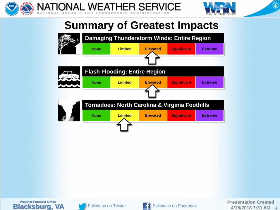
None Limited Elevated Significant Extreme
Summary of Greatest Impacts
None Limited Elevated Significant Extreme
None Limited Elevated Significant Extreme
Damaging Thunderstorm Winds: Entire Region
Flash Flooding: Entire Region
Tornadoes: North Carolina & Virginia Foothills
Blacksburg, VA 4
Weather Forecast Office Presentation Created
4/15/2018 7:31 AM Follow us on Twitter Follow us on Facebook
5
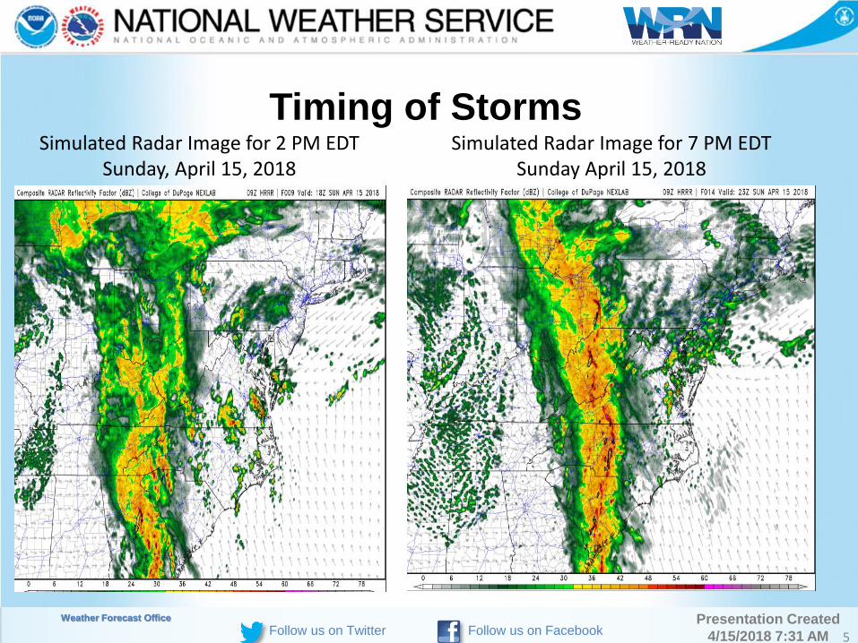
Timing of Storms Simulated Radar Image for 2 PM EDT
Sunday, April 15, 2018 Simulated Radar Image for 7 PM EDT
Sunday April 15, 2018

Weather Forecast Office Presentation Created
4/15/2018 7:31 AM Follow us on Twitter Follow us on Facebook 6
Simulated Radar Image for 11 PM EDT, Sunday, April 15, 2018

Weather Forecast Office Presentation Created
4/15/2018 7:31 AM Follow us on Twitter Follow us on Facebook
7
Rainfall Forecast

Weather Forecast Office Presentation Created
4/15/2018 7:31 AM Follow us on Twitter Follow us on Facebook
Event Summary
Main threat from damaging winds with north-
south oriented line of thunderstorms Sunday
afternoon and evening.
Isolated tornadoes possible east of the Blue
Ridge.
Heavy rain with leading line of storms, followed
by longer period of moderate rain with the cold
front could result in flash flooding Sunday
afternoon to just after midnight Sunday night.
Minor river flooding possible, with at least
elevated rises on main stem rivers.
Blacksburg, VA 8
Weather Forecast Office Presentation Created
4/15/2018 7:31 AM Follow us on Twitter Follow us on Facebook
Contact Resources
Blacksburg, VA 9
Share your reports of storm damage, hail and/or flooding with our office by using one of the methods listed below, or by submitting an online report through the 'submit a storm report' icon at the bottom of our web site: Telephone: 1-540-552-0084 E-mail: [email protected] Facebook: www.fb.com/NWSBlacksburg Twitter: @NWSBlacksburg NWS Blacksburg web page: www.weather.gov/rnk or mobile.weather.gov In addition, please monitor our web page and social media feeds, as well as these other web sites for the latest updates on the forecast: Storm Prediction Center: www.spc.noaa.gov Weather Prediction Center: www.wpc.ncep.noaa.gov River Information: http://water.weather.gov/ahps2/index.php?wfo=rnk

Weather Forecast Office Presentation Created
4/15/2018 7:31 AM Follow us on Twitter Follow us on Facebook
Contact and Next Briefing Information
Next Briefing (if needed)
Disclaimer: The information contained within this briefing is
time-sensitive, do not use after 7 PM Sunday (04/15/18).
Method: Email
When: By 6 PM This Evening
Blacksburg, VA 10
Web:
http://www.weather.gov/rnk
Phone (public):
(540) 552-0084
E-mail:
Facebook:
/NWSBlacksburg
Twitter:
@NWSBlacksburg
YouTube:
NWS RNK