shefford - central bedfordshire
TRANSCRIPT

SHEFFORDCONSERVATION AREA APPRAISAL
DRAFTJANUARY 2010
A conservation area is an area of special architectural or
historic interest, the character or appearance of which it
is desirable to preserve or enhance. This document is one
of a series of up-to-date conservation area character
appraisals published by Central Bedfordshire Council.
The purpose of the appraisal is to define which features
contribute to the special interest, what is significant and
what requires preservation. Opportunities for
enhancement are also identified in the appraisal.
CONSERVATION AREA APPRAISAL
Central Bedfordshire Council 1SHEFFORD
CONTENTS
1.0 Introduction 2
2.0 Summary 2
3.0 Location and Setting 2
4.0 Historical Development 3
5.0 Character 6
6.0 Appearance 8
7.0 Boundary Changes 21
8.0 Opportunities for enhancement 21
APPENDICES
1 References
2 Listed Buildings
CONSERVATION AREA APPRAISAL
Central Bedfordshire Council 2SHEFFORD
1.0 INTRODUCTION
1.1 The Shefford Conservation Area was designated by Bedfordshire County Council
on 2 January 1971 and was reviewed by Mid Bedfordshire Council and adopted
in July 2001. This document assesses the setting, character and appearance of
the conservation area. It also identifies opportunities for improving the
character of the area. The appraisal is, therefore, the basis for the management
of the Shefford Conservation Area through the planning system
2.0 SUMMARY
2.1 The special interest that justifies designation of the Shefford Conservation Area
derives from a number of architectural, historic and environmental factors,
including:
Important historic buildings including St Michaels and All Angels Church,
Roman Catholic Church of St Francis of Assisi and the associated
Presbytery and St Francis Home.
Linear settlement developed along main routes
High sense of enclosure formed by continuous building line on back
edge of pavement
Concentration of listed buildings and positive buildings such as Jubilee
Fire Station
Good examples of traditional shop fronts
Old and new carriage entrances
3.0 LOCATION AND SETTING
3.1 Shefford is situated 8 miles to the south of Bedford and lies close to the border
with Hertfordshire to the east. It is 6 miles from Hitchin, 7 miles from Baldock
and 11 miles from Stevenage. Biggleswade is 5 miles to the North East and
Ampthill 7 miles to the west.
3.2 Shefford lies between the river Flit and the River Hit (or Hiz) both tributaries of
the River Ivel. It is located in the Upper Ivel Valley Clay character area, which
follows the course of the River Ivel flowing from north to south with the River
Hiz from east to west. It is a level wide river valley founded on underlying Gault
Clay with Chalk to the south east. The River Flit flows from the west forming a
CONSERVATION AREA APPRAISAL
Central Bedfordshire Council 3SHEFFORD
medium scale valley cutting through the band of Greensand which runs South
West to North East through Bedfordshire to the north of Shefford. Alluvium
marks the course of the three water bodies. The Upper Ivel Clay Valley contains
fairly dense settlement of large villages and the market town of Shefford.
3.3 The conservation area includes the linear historic core of the town along the
main routes through it.
4.0 HISTORICAL DEVELOPMENT
4.1 The township of Shefford grew between two bridges at the point where the
Bedford to Hitchin Road crosses the River Ivel. The name derived from Sheep
Ford the name by which the crossing was known in 1000 AD.
4.2 It appears to have been a thriving commercial centre, possibly influenced by the
nearby Gilbertine Priory of Chicksands, founded in 1154.
4.3 A weekly market existed by 1225 and an annual fair was held from 1312. By
1713 there were three annual fairs, all of which continued into the early 19th
century. As late as 1877 the annual market was held mainly for the sale of straw
plait.
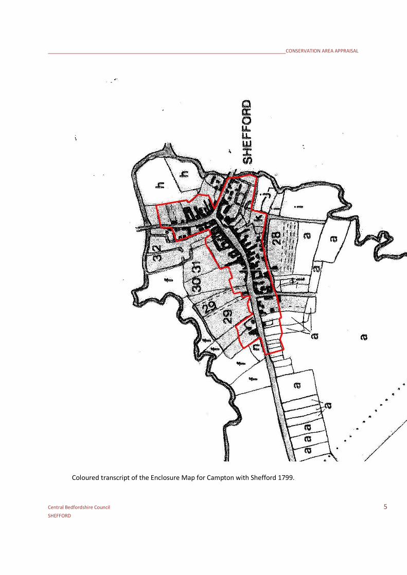
4.4 Old maps indicate that the street plan in the town centre has remained
essentially the same since 1736. The section of the Bedford to Hitchin Road that
lies within the town was a toll road and this provided trade to the town. During
the 17th century it became a base for carriers’ wagons and the surviving carriage
entrances are evidence of the town’s status.
4.5 The foundation of the town came from it position at the crossing point of the
river and from its waterways. The river Ivel had been navigable to Biggleswade.
In 1822, Shefford was linked to Kings Lynn by a navigable waterway, an
extension of the Ivel Navigation. This gave a direct trading route to the east.
Corn and coal were the main commodities carried and a commercial wharf
opened up in Northbridge Street.
4.6 In 1857 the Midland Railway Company opened the railway and the wharf’s
importance declined. A railway bridge carried the Midland Railway over the High
Street towards the western part of the Shefford Conservation Area to the west
of The Bridge PH. The branch line closed in 1962 and the bridge was demolished
in 1976. This made a considerable change to the character of the High Street.

CONSERVATION AREA APPRAISAL
Central Bedfordshire Council 4SHEFFORD
Evidence of the former line remains in the form of an embankment to the north
of the Conservation area and of the town itself.
4.7 Unlike High Street and Northbridge Street, there are no remaining buildings in
Southbridge Street earlier than the 18th century. This suggests that a significant
widening or realignment of the road has taken place in recent times.
4.8 Shefford was part of Campton Civil Parish until 1866, and the church of St
Michael and All Angels was a chapel of ease until the formation of the new
ecclesiastical parish in 1903. The church has 15th century origins, parts of which
still survive however the building was extensively restored in 1822, the south
aisle added in 1850 and altered again in 1907.
4.9 In 1801 Shefford had 474 inhabitants and probably no more than one hundred
buildings. The Ivel Navigation and the arrival of the railway produced a steady
growth throughout the century so that the population stood at 990 in 1891.
Development continued along the main routes and with new side roads such as
New Street and Ivel Road.
4.10 The most dramatic changes have taken place in the 20th century with the
construction of housing estates and the opening of the Shefford by-pass in 1990
strongly influenced the town’s economy. Development in the conservation area
has consisted of the conversion of the 19th century maltings building to the rear
of 40 High Street and the development of outbuildings to the rear of
Northbridge Street with new build consisting of the shop, flats and library next
to the church and the flats on the corner of High Street and Old Bridge Court.
The most recent estimate for 2007 is of a population of 5,770.
CONSERVATION AREA APPRAISAL
Central Bedfordshire Council 5SHEFFORD
Coloured transcript of the Enclosure Map for Campton with Shefford 1799.
CONSERVATION AREA APPRAISAL
Central Bedfordshire Council 6SHEFFORD
5.0 CHARACTER
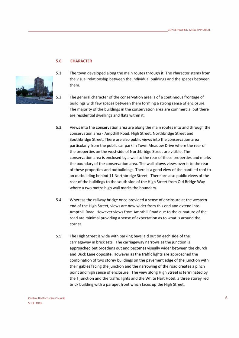
5.1 The town developed along the main routes through it. The character stems from
the visual relationship between the individual buildings and the spaces between
them.
5.2 The general character of the conservation area is of a continuous frontage of
buildings with few spaces between them forming a strong sense of enclosure.
The majority of the buildings in the conservation area are commercial but there
are residential dwellings and flats within it.
5.3 Views into the conservation area are along the main routes into and through the
conservation area - Ampthill Road, High Street, Northbridge Street and
Southbridge Street. There are also public views into the conservation area
particularly from the public car park in Town Meadow Drive where the rear of
the properties on the west side of Northbridge Street are visible. The
conservation area is enclosed by a wall to the rear of these properties and marks
the boundary of the conservation area. The wall allows views over it to the rear
of these properties and outbuildings. There is a good view of the pantiled roof to
an outbuilding behind 11 Northbridge Street. There are also public views of the
rear of the buildings to the south side of the High Street from Old Bridge Way
where a two metre high wall marks the boundary.
5.4 Whereas the railway bridge once provided a sense of enclosure at the western
end of the High Street, views are now wider from this end and extend into
Ampthill Road. However views from Ampthill Road due to the curvature of the
road are minimal providing a sense of expectation as to what is around the
corner.
5.5 The High Street is wide with parking bays laid out on each side of the
carriageway in brick sets. The carriageway narrows as the junction is
approached but broadens out and becomes visually wider between the church
and Duck Lane opposite. However as the traffic lights are approached the
combination of two storey buildings on the pavement edge of the junction with
their gables facing the junction and the narrowing of the road creates a pinch
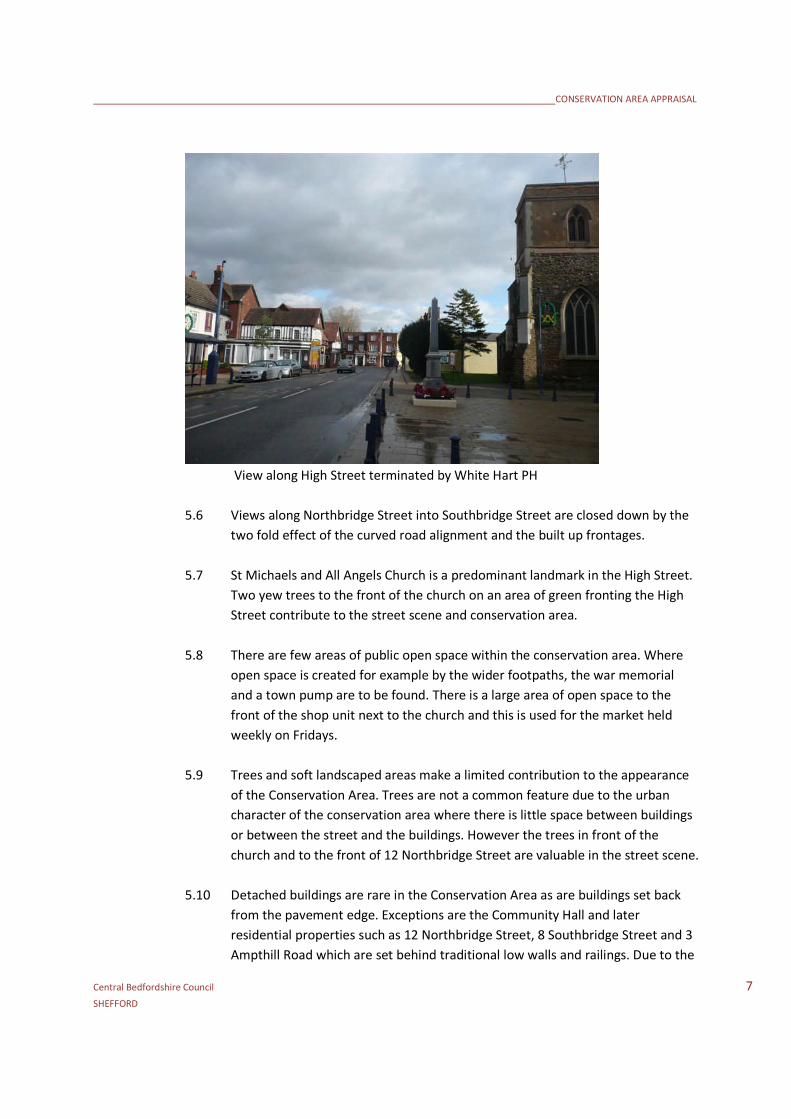
point and high sense of enclosure. The view along High Street is terminated by
the T junction and the traffic lights and the White Hart Hotel, a three storey red
brick building with a parapet front which faces up the High Street.
CONSERVATION AREA APPRAISAL
Central Bedfordshire Council 7SHEFFORD
View along High Street terminated by White Hart PH
5.6 Views along Northbridge Street into Southbridge Street are closed down by the
two fold effect of the curved road alignment and the built up frontages.
5.7 St Michaels and All Angels Church is a predominant landmark in the High Street.
Two yew trees to the front of the church on an area of green fronting the High
Street contribute to the street scene and conservation area.
5.8 There are few areas of public open space within the conservation area. Where
open space is created for example by the wider footpaths, the war memorial
and a town pump are to be found. There is a large area of open space to the
front of the shop unit next to the church and this is used for the market held
weekly on Fridays.
5.9 Trees and soft landscaped areas make a limited contribution to the appearance
of the Conservation Area. Trees are not a common feature due to the urban
character of the conservation area where there is little space between buildings
or between the street and the buildings. However the trees in front of the
church and to the front of 12 Northbridge Street are valuable in the street scene.
5.10 Detached buildings are rare in the Conservation Area as are buildings set back
from the pavement edge. Exceptions are the Community Hall and later
residential properties such as 12 Northbridge Street, 8 Southbridge Street and 3
Ampthill Road which are set behind traditional low walls and railings. Due to the
CONSERVATION AREA APPRAISAL
Central Bedfordshire Council 8SHEFFORD
lack of spacing between buildings and the back edge of pavement location,
boundary walls and enclosures are not a common feature to the fronts of
properties in the conservation area.
6.0 APPEARANCE
6.1 In the middle ages, the local material for most buildings was timber. Evidence of
timber framing can be seen at 6/8 Northbridge Street and The Tudor House at
36/ 38 High Street which date back to the 16th and 17th centuries. Further
framing survives but is less apparent as properties have been re-fronted in brick
such as the White Hart PH or rendered over such as 10 Northbridge Street.
6.2 Stone was used for higher status buildings such as The Church of St Michael and
All Angels. Much of the church is built in coursed ironstone. This is iron-bearing
sandstone that weathers to a rusty brown colour as the iron salts oxidise.
6.3 From the 18th century, brick takes over as the dominant building material. There
are good examples of early red brick to The White Hart PH and later to the
Jubilee Fire Station and especially to the southern side of the High Street. Bricks
are generally laid in Flemish bond – alternating stretchers and headers. The use
of contrasting brick is not commonly seen. Fishscale tile hangings are seen on
many listed buildings especially in the High Street.
6.4 The Gault clays of the Ivel valley are particularly suited to the production of
cream and pale yellow bricks. The use of these bricks is seen with examples at
the Victorian detached villas at 8 Southbridge Street and 3 Ampthill Road, the
Community Hall and the Brewery Tap PH.
6.5 There is a high survival of timber windows and a variety of window styles
particularly to the buildings on the southern side of the High Street which exhibit
oriel windows and two storey canted bays. With most properties on the back
edge of the pavement windows are generally sash type at ground floor although
there are examples of ground floor bays. There is an oriel window to 28 High
Street. Dormer windows are not a common feature but examples are seen in the
High Street and A. 15 High Street reputed to have been designed by Mr Williams
of Southill and each window on its front elevation is different. Leaded mullion
and transom windows are seen on the older timber framed buildings at 6/8
Northbridge Street and 34/36 High Street.
CONSERVATION AREA APPRAISAL
Central Bedfordshire Council 9SHEFFORD
6.6 The traditional roofing materials are clay plain tile. There are no surviving
thatched properties although the steeper roof pitches seen are indicative that
thatch was once used. Welsh slate is seen on a number of the 18th and 19th
century buildings although historically its arrival would have been in the 19th
century. Concrete tile is found on a number of buildings to the detriment of the
conservation area.
6.7 There are a number of historic panelled doors, moulded door cases and back
bracketed door hoods. There are good timber shop fronts surviving
especially to the north side of the High Street and to the east side of
Northbridge Street. A particular good example is the shop front at 2/4 High
Street with shop windows on two side facing Duck Lane and the High Street .
High Street
6.8 The Church of St Michael and All Angels is built in coursed ironstone with ashlar
dressings with a slate roof. It is a prominent feature in the High Street with the
full extent of the tower being visible when approached from the west due to the
set back of the adjacent shop unit and flats behind the war memorial. The
church is separated from the pavement by a grassed area planted with two yew
trees. The church does not have a graveyard and there is no boundary treatment
enclosing the church such as railing or walls although a short section of wall to
the rear remains. The surrounding hard surfacing makes no distinction between
the thoroughfare and the church precinct. The pedestrian route from the High
Street alongside the church to the supermarket to the rear of the conservation
area known as Church Walk. There are few areas of recreational open space
within the conservation area. An area of Important Open Space exists off Church
Walk between the supermarket and the rear of the Church. This area is used a
children’s play area with play equipment. The boundary treatment separating
the play area from Church Walk is metal chain link fencing and this detracts from
the Conservation Area. A more visually sensitive form of enclosure is required
or this area could be incorporated more into the broader area.

CONSERVATION AREA APPRAISAL
Central Bedfordshire Council 10SHEFFORD
6.9 The southern side of the High Street is dominated by the Grade II* Roman
Catholic Church of St Francis of Assisi and the associated Grade II Presbytery and
St Francis Home, the former orphanage and seminary all designed by J Nicholl in
1869. The building replaced an earlier church, dated 1780, dedicated to St
George the Martyr.
6.10 The front elevation of the presbytery has windows of varying sizes and styles.
The building has references on its front elevation to Saint George including a
plaque “St George for England”, a niche to the left hand side of the building
containing a statue of Saint George and a decorative carved panel showing a
shield with a St. George cross.
6.11 The top of the Catholic Church punctuates the building line with its gable with
the crucifix finial and the bell-cote and its profile is clearly visible against the
skyline. There is a central niche with a statue of St Francis to the front elevation.
CONSERVATION AREA APPRAISAL
Central Bedfordshire Council 11SHEFFORD
6.12 Attached to the church is the former orphanage and seminary. The style of these
buildings is influenced by the Gothic revival. They are characterised by large
through-eaves gables finished with white render and mock timber framing which
bear the dates 1879 and 1884. These buildings are ornate with decorative
ridges, bargeboards, anted oriel windows, two storey canted bays and Tudor
arched carriageway.
6.13 The buildings on this side of the street are predominately 19th century and this
side has a higher proportion of 20th century buildings such as the three storey
blocks of flats with the shops below at Richard Daniels House and the three
storey block of flats on the corner at Old Bridge Court on the corner of the High
Street and Old Bridge Way. The south side of the High Street contains most of
the taller buildings within the Conservation Area in particular the Anglican and
Catholic churches. This side of the High Street is dominated by the three storey
and two and a half storey nature of these buildings.
6.14 The scale of the buildings on the south side is juxtaposed with the lower and
comparatively plainer architectural style of the buildings on the opposite side of
the High Street. The properties on the north side of the High Street are generally
older and of 18th century and many coach entrances survive. Coach entrances
punctuate the frontage providing glimpses to the yards behind. Vehicle
entrances over the footpaths are marked by granite blocks creating a contrast in
surfaces.

CONSERVATION AREA APPRAISAL
Central Bedfordshire Council 12SHEFFORD
6.15 The buildings on the north side of the High Street have a more comfortable
“human” scale. Properties are generally two storeys of varying widths with
simple pitched roofs with eaves parallel to the pavement edge. Windows are
generally vertical sliding sash windows. There is a mixture of clay plain tiles and
slate. There is a concentration of rendered properties on this side of the street.
6.16 The Tudor House at 36/ 38 High Street is one of the oldest surviving buildings on
the north side and is exceptional having a hipped clay tile roof. The building is
17th century in origin and timber framed with mullion and transom windows.
6.17 On the corner of Old Bridge Way and High Street is the former Shefford Laundry
Building, a large flat roofed white rendered building. This site is vacant and in a
poor state of repair. It was identified as a site where enhancement is to be
encouraged on the previous conservation area appraisal. The site is in a poor
state of maintenance, the building does not contribute to the appearance of the
conservation area.
6.18 There are views into New Street from the High Street. There are two flat roof
garage blocks which could be screened by landscaping.
Ampthill Road
6.19 To the west of the High Street junction with New Street lays Ampthill Road
which is characterised by detached dwellings with eaves parallel to the road
CONSERVATION AREA APPRAISAL
Central Bedfordshire Council 13SHEFFORD
with all but one built on the pavement edge. This is the detached property at 3
Ampthill Road, a Victorian villa which is set behind a brick wall and garden.
6.20 The side wall of 5 Ampthill Road presents a feature to the western edge of the
conservation area and is particularly visible as it is seen across the front of the
adjacent Methodist church which is set back from the pavement edge. The
Grade II listed church is currently outside of the conservation area. Being listed
this building contributes to the setting of the conservation area and it is
considered that this building should be included within the Conservation Area.
Methodist Church
Northbridge Street
6.21 The buildings increase in height towards the meeting point of Northbridge
Street, Southbridge Street and the High Street.
6.22 To the west side the buildings form a continuous frontage with their roof ridges
of varying heights and eaves aligned parallel with the pavement. The buildings
from 3 to 11 are all listed. The frontage and two storey roofline is broken by the
modern single storey detached public conveniences. The skyline is then
punctuated by the Jubilee Fire Station. The visual space either side of the
Jubilee Fire Station created by the single storey buildings either side of it enables
the profile of the building with its gable and bell-cote facing the street roof to be
CONSERVATION AREA APPRAISAL
Central Bedfordshire Council 14SHEFFORD
clearly seen against the sky and as a prominent building in the street scene.
Jubilee Fire Station erected 1897
6.23 The continuous building line starts again from 17 to 25 Northbridge Street with
buildings in red brick and with rendered finishes. Bloomfield House is a red brick
property which was the home of the poet Robert Bloomfield. A plaque to the
front of Bloomfield House reads “Robert Bloomfield, The Pastoral Poet died
here, August 19th 1823. Erected by Constance Isherwood, Meppershall Rectory
1904”. This building is considered to be of local importance and positively
enhance the conservation area.
6.24 This side of the road is predominately residential and is set further back from the
road being separated by parking bays. A traditional shop front remains to the
listed property at 21 Northbridge Street. This property appears to be vacant.
6.25 To the north side there is not the same uniformity of the building line created by
the similar alignment of the rooflines and seen on the opposite side of the
street. The building line is broken up by buildings with varying roof types, styles
and building heights. Many of the buildings are detached providing visual space
between them and preventing continuity. The building line is also broken by
vehicular accesses serving Coach House Mews and Byrnes Mews to the rear.

CONSERVATION AREA APPRAISAL
Central Bedfordshire Council 15SHEFFORD
6.26 The White Hart Hotel is three storeys with a parapet roof and is faced in red
brick. It forms a visual stop at the end of the High Street. It is separated from its
neighbour by the plainer rendered two storey section to its side.
White Hart Hotel
6.27 The detached property at 4 Northbridge Street is two storeys with a pitched roof
with a central gable with the words W Caton and Sons painted on it. To the rear
of this property is Coach House Mews.
6.28 There is only one example in the conservation area of a building which
overhangs the pavement, the bank premises at 6 Northbridge Street. This
building is timber framed and presents a gable to the street. It is one of the
oldest secular buildings within the conservation area. It has a half timbered with
brick infill and is jettied at first floor over the pavement.
6.29 8 Northbridge Street is a three storey building with a gambrel roof attached to 6
Northbridge Street and presents a gable to the street and 10 Northbridge Street
is detached rendered property. The spacing between the buildings at 8 and 10
Northbridge Street provides views across the entrance to Byrnes Mews of the
entire side elevation of 8 Northbridge Street and of the side wall of 10
Northbridge Street. Chimneys stacks are particularly prominent in this part of
the conservation area. This is due to the fact that they are chunkier and the
ridge levels are lower. The stack to the side wall of 10 High Street is particularly
prominent being seen across the entrance to Byrnes Mews.

CONSERVATION AREA APPRAISAL
Central Bedfordshire Council 16SHEFFORD
6.30 12 Northbridge Street is set back from the pavement by a small front garden
and walls. Next to it is The Brewery Tap Public House is in cream brick with a
slate roof and is wide providing a horizontal emphasis to the building. The final
buildings within the conservation area a pair of cottages with a rendered finish.
The Brewery Tap
Southbridge Street
6.31 The eastern boundary of the conservation area is marked by the south bridge
and the River Ivel. The conservation area includes only buildings on the south
western side of this street. Crossing the river the first property on the right is
the detached Victorian dwelling at 8 Southbridge Street. The property is set back
from the pavement edge behind a low boundary wall and formal clipped hedge.
The dwelling has two storey gables to both its front and side elevations and
contributes to the appearance of the area as it faces both the street and up the
street.
6.32 A parade of shops on the left hand side as you approach the town centre from
the east hug the pavement and lead the eye towards the junction. Views from
this direction into Northbridge Street are deflected by the buildings in
Northbridge Street.
6.33 Although numbers 1 and 3 Southbridge Street lie outside of the conservation
area their position adjoining and opposite the conservation area boundary mean

CONSERVATION AREA APPRAISAL
Central Bedfordshire Council 17SHEFFORD
that their design and form are visually detrimental to the appearance of the
conservation area by impairing views into and out of the conservation area.
Duck Lane
6.34 Duck Lane is a pedestrian access connecting High Street with the Town Meadow
Car Park at the rear of the north side of the High Street. The lane is formed
between the three storey high building at 2/4 High Street which fronts it and the
Shefford Scout Hut which presents a side wall to it. To the rear of the scout hut
is another building that lines this lane and reinforces the enclosure of the lane. It
is a detached single storey in red brick laid in a Flemish bond with a plain tiled
roof and timber framing visible to its gable facing the lane. To the rear wall is a
plaque F dated 1835. The F is likely to represent Feoffee, the local name for the
charitable trust which Robert Lucas established in the 16th century.
Duck Lane looking towards High Street
CONSERVATION AREA APPRAISAL
Central Bedfordshire Council 18SHEFFORD
7.0 BOUNDARY CHANGES
7.1 Consideration should be given to the following proposed amendments of the
conservation area boundaries as shown on the management map:
Extension of the conservation area to include the Shefford Methodist Church in
Ampthill Road.
Reason: The church is of architectural and historic importance and is Grade II
Listed. It is next to the conservation area and it is considered it should be
included as it contributes to the character and appearance of the conservation
area.
8.0 OPPORTUNITIES FOR ENHANCEMENT
8.1 While the general condition of the conservation area is good, the following are
considered as opportunities to enhance buildings and spaces:
Encouragement to be given to the reinstatement of traditional roofing materialsin place of concrete roof tiles
Ensure that there is only the limited introduction of trees, if any into the streetscene in order to safeguard the urban character and building dominatedappearance of the Conservation Area.
Encourage enhancement/redevelopment of Old Laundry site.
Although numbers 1 and 3 Southbridge Street lie outside of the conservationarea their position adjoining the conservation area boundary mean that theirdesign and form area visually detrimental to the appearance of the conservationarea by impairing views into and out of the conservation area.
Encourage enhancement to the perimeter of St Michaels and All Angels Churchand the boundary of the play area with Church Walk.
CONSERVATION AREA APPRAISAL
Central Bedfordshire Council 19SHEFFORD
CONSERVATION AREA APPRAISAL
Central Bedfordshire Council 20SHEFFORD

CONSERVATION AREA APPRAISAL
Central Bedfordshire Council 21SHEFFORD
APPENDIX 1: REFERENCES
Peter Harwood -The Story of Shefford (Illustrated)
http://www.sheffordtown.co.uk/shefford-history.html
http://www.galaxy.bedfordshire.gov.uk/webingres/bedfordshire/vlib/0.digitised_resources/shefford_di
gitisation.htm
Mid Bedfordshire District Landscape Character Assessment August 2007
Maps:
Coloured transcript of the Enclosure Map for Campton with Shefford dated 1799.
CONSERVATION AREA APPRAISAL
Central Bedfordshire Council 22SHEFFORD
APPENDIX 2: LISTED BUILDINGS
GRADE II*
Catholic Church of St Francis of Assisi, High Street
GRADE II
1 Ampthill Road
High Street, North side
2 and 4 High Street816-2224 and 26323436 and 38 (The Tudor House)40 and 40a46 and 48
High Street, South side
Parish church of St Michael and All Angels19 and 21 23St Francis’ Home25 Presbytery adjacent to Catholic Church or St. Francis 35 (Avondale House)3739 and 43
Northbridge Street
3 and 57 and 9
11 (Bloomfield House)21 and 23The White Hart PH
6 Barclays Bank8 Lemon Tree10
Positive buildings:
CONSERVATION AREA APPRAISAL
Central Bedfordshire Council 23SHEFFORD
Ampthill Road
5
Northbridge Street
12Banks and Taylor
Southbridge Street
2 The Paper Shop4 Cafe6 Post OfficeIvel House, 8 Southbridge Street
High Street
31544