shinnecock bay/atlantic ocean watershed · shinnecock bay/atlantic ocean watershed (0203020206)...
TRANSCRIPT

Shinnecock Bay/Atlantic Ocean Watershed (0203020206)
Water Index Number Waterbody Segment Category (MW7.1a) AO-P776 Hook Pond (1701-0131) Minor Impacts (MW7.1a) AO-P780 Georgica Pond (1701-0145) Impaired (MW7.1a) AO-P782/P784 Wainscott Pond/Fairfield Pond (1701-0144) Impaired (MW7.1a) AO-P786 Sagaponack Pond (1701-0146) Impaired (MW7.1a) AO-P786-1-P787 Poxabogue Pond (1701-0286) No Known Impact (MW7.1b) AO-P790 Mecox Bay and tribs (1701-0034) Impaired (MW7.1b) AO-P790- 2 thru 5 (select) Tribs (fresh) to Mecox Bay (1701-0289) Unassessed (MW7.1b) AO-P790- 2-2-P793,P794 Mill and Seven Ponds (1701-0113) Impaired (MW7.1b) AO-P790- 5-P798 Kellis Pond (1701-0290) Impaired (MW7.1b) AO-P790-P799,P800,P803 Little Long, Long, and Shorts Ponds (1701-0291) No Known Impact (MW7.1b) AO-P790..P808 Channel Pond (1701-0292) Minor Impacts (MW7.1b) AO-P809 Jule Pond (1701-0121) Unassessed (MW7.1b) AO-P811 Phillips Pond (1701-0120) Unassessed (MW7.1b) AO-P812 Wickapogue Pond (1701-0119) Impaired (MW7.1b) AO-P814 Old Town Pond (1701-0118) Impaired (MW7.1b) AO-P815 Agawam Lake (1701-0117) Impaired (MW7.1b) AO-P817 Coopers Neck Pond (1701-0116) Unassessed (MW7.1b) AO-P818 Halsey Neck Pond (1701-0355) Minor Impacts

Water Index Number Waterbody Segment Category (MW7.1b) AO-SB Shinnecock Bay (and Inlet) (1701-0033) Impaired (MW7.1b) AO-SB-143,144 Heady and Taylor Creeks and tribs (1701-0294) Impaired (MW7.1b) AO-SB-145 thru 146a Old Fort, Middle, and Far Ponds (1701-0295) No Known Impacts (MW7.1b) AO-SB-148 thru 150 Penny Pond, Wells and Smith Creeks (1701-0298) Impaired (MW7.1b) AO-SB-153 Weesuck Creek and tidal tribs (1701-0111) Impaired (MW7.1b) AO-SB-155 Phillips Creek, Lower, and tidal tribs (1701-0299) Impaired (MW7.1b) AO-SB-156 Penniman Creek and tidal tribs (1701-0300) Impaired (MW7.1b) AO-SB-QgC Quogue Canal (1701-0301) Impaired (MW7.1b) AO-SB-QgC-P834 Ogden Pond (1701-0302) Impaired (MW7.1b) AO-SB-TB Tiana Bay and tidal tribs (1701-0112) Minor Impacts (MW7.1c) AO-SB-QB Quantuck Bay (1701-0042) Impaired (MW7.1c) AO-SB-QB-157 thru 160(sel) Tidal Tribs to Quantuck Bay/Canal (1701-0303) Minor Impacts (MW7.1c) AO-SB-QB-158-P835a Old Ice Pond (1701-0304) Unassessed (MW7.1c) AO-SB-QB-QtC Quantuck Canal/Moneybogue Bay (1701-0371) Impaired (MW7.2a) AO-MB (portion 1) Moriches Bay, East (1701-0305) Impaired (MW7.2a) AO-MB (portion 2) Moriches Bay, West (1701-0038) Impaired (MW7.2a) AO-MB (portion 3) Tuthill, Harts, Seatuck Coves (1701-0309) Impaired (MW7.2a) AO-MB (portion 4) Forge River, Lower and Cove (1701-0316) Impaired (MW7.2a) AO-MB-160a thru 168 (sel.) Tidal Tribs to East Moriches Bay (1701-0306) Minor Impacts (MW7.2a) AO-MB-162-P837 Beaverdam Pond (1701-0307) Unassessed (MW7.2a) AO-MB-167-P840b Unnamed (Eastport) Pond (1701-0311) Unassessed (MW7.2a) AO-MB-168a thru 175 (sel.) Tidal tribs to West Moriches Bay (1701-0312) Impaired (MW7.2a) AO-MB-170 Terrell River, Lower, and tribs (1701-0103) Minor Impacts (MW7.2a) AO-MB-170 Minor Impacts (MW7.2a) AO-MB-170-P847 No Known Impacts (MW7.2a) AO-MB-174-P850/P851 Needs Verification (MW7.2b) AO-MB-NB
Terrell River, Upper, and tidal tribs (1701-0313) Mill Pond (1701-0314) West and East Mill Ponds (1701-0026) Narrow Bay (1701-0318) Impaired
(MW7.2b) AO-MB-NB-175a thru 176d Tidal Tribs to Narrow Bay (1701-0319) Minor Impacts

Hook Pond (1701-0131) Minor Impacts Waterbody Location Information Revised: 6/20/2016
Water Index No: (MW7.1a) AO-P776 Water Class: C Hydro Unit Code: Shinnecock Bay-Atlantic Ocean (0203020206) Drainage Basin: Atlantic-Long Island Sound Water Type/Size: Lake/Reservoir 80.3 Acres Reg/County: 1/Suffolk (52) Description: entire lake Water Quality Problem/Issue Information (CAPS indicate MAJOR Pollutants/Sources) Uses Evaluated Severity Confidence
Water Supply N/A - Public Bathing N/A - Recreation Stressed Suspected Aquatic Life Stressed Unconfirmed Fish Consumption Fully Supported Unconfirmed
Conditions Evaluated Habitat/Hydrology Unknown Aesthetics Fair
Type of Pollutant(s) Known: Harmful Algal Blooms Suspected: Nutrients (phosphorus) Unconfirmed: Low D.O./Oxygen Demand
Source(s) of Pollutant(s) Known: - - - Suspected: Urban/Storm Runoff Unconfirmed: Other (waterfowl)
Management Information
Management Status: Verification of Problem Severity Needed Lead Agency/Office: DOW/BWAM IR/305(b) Code: Water Attaining All Standards (IR Category 1)
Further Details Overview Hook Pond is currently assessed as needing verification of minor impacts/possible impairment due to recreational uses that may be stressed, but this evaluation is based on limited sampling and needs to be more fully assessed. Harmful algal blooms have been documented and nutrient loadings are a concern. Nonpoint runoff and residential onsite (septic) systems are suspected sources. Use Assessment Hook Pond is a Class C waterbody, suitable for general recreation use and support of aquatic life, but not as a water supply or for public bathing. Recreation use is considered to be impaired due to occasional occurrences of harmful (blue-green) algal blooms in the Pond. Aesthetic conditions of the pond are also considered to be only fair due to algal blooms. Aquatic life support and recreational uses (fishing) in Hook Pond may be affected by low dissolved oxygen, but these conditions need to be verified. The pond supports naturally reproducing populations of largemouth bass, bluegill, pumpkinseed , yellow perch, white perch, carp and brown bullhead. (DEC/DFW, Region 1, January 2015)

There are no health advisories in place limiting the consumption of fish from this waterbody (beyond the general advice for all waters). Fish consumption is considered to be fully supported based on the absence of any waterbody-specific advisory, but is noted as unconfirmed since routine monitoring of contaminants in fish is limited. (NYS DOH Health Advisories and DEC/DOW, BWAM, January 2014)
Water Quality Information Hook Pond was sampled in 2015 by SUNY Stony Brook as part of a harmful algae bloom (HAB) collaborative with NYSDEC Division of Water. Only limited water chemistry data are available, precluding more complete assessments. The most recent DEC monitoring data was collected in 1999 and showed no significant impacts. But subsequent documentation of HABs suggest follow up monitoring is needed. (DEC/DOW, BWAM/LAMS and SUNY SoMAS, May 2016)
Source Assessment Based on surrounding land use and other knowledge of the waterbody, the most likely sources of pollutants to the waterbody are largely nonpoint runoff from developed and undeveloped lands; residential onsite (septic) systems; agricultural activity and open space/forest; direct waterfowl/wildlife inputs and boats and marinas also may contribute. Relative contributions from each type of source are very site-specific in nature, particularly in localized areas of study. (DEC/DOW, BWRM, September 2015)
Management Action A water quality improvement study and management plan for the watershed was developed in 2015. (Hook Pond WQ Improvement Project, Lombardo Assoc for Village of East Hampton, April 2015)
The NYS Legislature authorized $5 million to DEC and the Long Island Regional Planning Council (LIRPC) for a Long Island nitrogen management and mitigation plan. Plan development – with active input from local stakeholders and public – is underway. Chief among the expectations for the plan is a focus on wastewater issues, including sewering of unsewered communities in Suffolk County and the evaluation and use of advanced alternative onsite wastewater treatment systems to reduce nitrogen loads from individual septic systems where sewering in not viable. (DEC/DOW, BRWM, November 2015)
This waterbody is also included within the South Shore Estuary Reserve (SSER). The SSER encompasses the tidal waters and watershed between the Nassau–Queens County line and the eastern boundary of Shinnecock Bay. The goals of the SSER Program outlined in the 2001 Comprehensive Management Plan (CMP) include improvement and maintenance of water quality, protection and restoration of living resources, expansion of public use and enjoyment, sustaining and of the estuary–related economy, and increasing education, outreach and stewardship. Program activities focus on point and nonpoint source pollution reduction, protection and restoration of water quality and coastal habitat, increasing shellfish harvesting, open space preservation and enhancing other public uses of the estuary. A vessel waste no discharge zone was established for the entire South Shore Estuary in 2009 to address impacts from boat pollution. (DEC/DOW, Region 1, March 2010)
Section 303(d) Listing Hook Pond is not included on the current (2016) NYS Section 303(d) List of Impaired/TMDL Waters. There appear to be no impacts/impairments that would justify the listing of this waterbody. However additional monitoring to verify the magnitude of impacts is recommended. (DEC/DOW, BWAM/WQAS, January 2016)
Segment Description This segment includes the total area of the pond.

Georgica Pond (1701-0145) Impaired Waterbody Location Information Revised: 6/13/2016
Water Index No: (MW7.1a) AO-P780 Water Class: SA Hydro Unit Code: Shinnecock Bay-Atlantic Ocean (0203020206) Drainage Basin: Atlantic-Long Island Sound Water Type/Size: Estuary Waters 291.7 Acres Reg/County: 1/Suffolk (52) Description: entire tidal waterbody Water Quality Problem/Issue Information (CAPS indicate MAJOR Pollutants/Sources) Uses Evaluated Severity Confidence
Shellfishing Precluded Known Public Bathing Stressed Unconfirmed Recreation Impaired Known Aquatic Life Fully Supported Unconfirmed Fish Consumption Fully Supported Unconfirmed
Conditions Evaluated Habitat/Hydrology Good Aesthetics Good
Type of Pollutant(s) Known: PATHOGENS, HARMFUL ALGAL BLOOMS Suspected: Nutrients (nitrogen) Unconfirmed: - - -
Source(s) of Pollutant(s) Known: URBAN/STORM RUNOFF, Agriculture Suspected: OTHER SOURCE (waterfowl/wildlife) Unconfirmed: - - -
Management Information
Management Status: Strategy Implementation Scheduled or Underway Lead Agency/Office: ext/WQCC IR/305(b) Code: Impaired Water, TMDL Completed (IR Category 4a)
Further Details Overview Georgica Pond is assessed as an impaired waterbody due to shellfishing use that is considered to be precluded by pathogens and recreational use impaired by harmful algal blooms. This assessment is based on year-round shellfishing closures. Urban and storm runoff are the primary sources of pathogens, although various other sources such as waterfowl/wildlife may also contribute. Public bathing and other recreational uses are fully supported, however these uses may also be stressed or threatened, as a result of the shellfishing restrictions and related pathogen levels. Use Assessment Georgica Pond is a Class SA waterbody, suitable for shellfishing, public bathing and general recreation use, and support of aquatic life. Shellfish harvesting for consumption is considered to be precluded in these waters. All of this waterbody (included within Shellfish Growing Area #68) has been designated uncertified for the taking of shellfish for use as food. Shellfish that grow in contaminated waters can accumulate disease-causing microorganisms (bacteria, viruses) that can be eaten with the shellfish. These shellfishing designations are based on results of water quality sampling and evaluation of data against New York State and National Shellfish Sanitation Program monitoring criteria and/or

shoreline surveys of actual or potential sources of contamination. Certified/uncertified shellfish area designations are revised regularly; for the most up to date and detailed descriptions of current designations, go to www.dec.ny.gov/regs/4014.html. (DEC/DFWMR, Region 1, July 2010)
Recreational use including public bathing is thought to be impaired due to frequent to persistent occurences of harmful (blue-green) algal blooms; shellfishing certification monitoring also suggests impacts to recreation. Aesthetic conditions of the pond are also considered to be poor due to algal blooms. There are no regularly monitored beaches in this waterbody, but bacteriological sampling conducted through the shellfishing monitoring program indicate elevated pathogen levels. However criteria for shellfishing are lower than those for public bathing and additional bacteriological sampling is needed to more fully evaluate swimming use. Restrictions on shellfishing represent an impact to recreational use. (DEC/DOW and DFWMR, January 2016)
Based on other available indicators for other related uses, this waterbody is expected to support a healthy marine water fishery, although no specific fishery or biological reports are included in this assessment.
There are no health advisories in place limiting the consumption of fish from this waterbody (beyond the general advice for all waters). Fish consumption is considered to be fully supported based on the absence of any waterbody-specific advisory, but is noted as unconfirmed since routine monitoring of contaminants in fish is limited. (NYS DOH Health Advisories and DEC/DOW, BWAM, January 2014)
Water Quality Information Assessments of recreational uses and aquatic life in marine waters are based primarily on information from NYS and local health departments and the NYSDEC Division of Fish Wildlife and Marine Resources. This information is compiled and updated in regularly issued advisories and certifications regarding bathing beaches, shellfishing harvest and sportfish consumption. (NYSDOH and DEC/DFWMR, 2014)
Georgica Pond was sampled in 2015 by SUNY Stony Brook as part of a harmful algae bloom (HAB) collaborative with NYSDEC Division of Water. Only limited water chemistry data are available, precluding more complete assessments. (DEC/DOW, BWAM/LAMS and SUNY SoMAS, May 2016)
Source Assessment Based on surrounding land use and other knowledge of the waterbody, the most likely sources of pathogens to the waterbody are largely nonpoint runoff from developed and undeveloped lands, agricultural activity and open space/forest; direct waterfowl/wildlife inputs and boats and marinas also may contribute. Relative contributions from each type of source are very site-specific in nature, particularly in localized areas of study. (DEC/DOW, BWRM, September 2015)
Management Action Georgica Pond was among the waterbodies covered by the Long Island Pathogen TMDL to address shellfishing impairments that was established in 2007. (DEC/DOW, BWAM/WQMS, July 2010)
The NYS Legislature authorized $5 million to DEC and the Long Island Regional Planning Council (LIRPC) for a Long Island nitrogen management and mitigation plan. Plan development – with active input from local stakeholders and public – is underway. Chief among the expectations for the plan is a focus on wastewater issues, including sewering of unsewered communities in Suffolk County and the evaluation and use of advanced alternative onsite wastewater treatment systems to reduce nitrogen loads from individual septic systems where sewering in not viable. (DEC/DOW, BRWM, November 2015)
This waterbody is also included within the South Shore Estuary Reserve (SSER). The SSER encompasses the tidal waters and watershed between the Nassau–Queens County line and the eastern boundary of Shinnecock Bay. The goals of the SSER Program outlined in the 2001 Comprehensive Management Plan (CMP) include improvement and maintenance of water quality, protection and restoration of living resources, expansion of public use and enjoyment, sustaining and of the estuary–related economy, and increasing education, outreach and stewardship. Program activities focus on point and nonpoint source pollution reduction, protection and restoration of water quality and coastal habitat, increasing shellfish harvesting, open space preservation and enhancing other public uses of the estuary. A vessel waste no discharge zone was established for the entire South Shore Estuary in 2009 to address impacts from boat

pollution. (DEC/DOW, Region 1, March 2010) Section 303(d) Listing Georgica Pond is not included on the current (2016) NYS Section 303(d) List of Impaired/TMDL Waters. Although it is assessed as an impaired water, it is categorized as an IR Category 4a water that is not listed due to the inclusion of the waterbody in the 2007 Long Island Pathogens (Shellfishing) TMDL. (DEC/DOW, BWAM, January 2015) Segment Description This segment includes the total area of the Estuary Pond and its tidal tribs.

Wainscott Pond/Fairfield Pond (1701-0144) Impaired Waterbody Location Information Revised: 6/20/2016
Water Index No: (MW7.1a) AO-P782/P784 Water Class: C Hydro Unit Code: Shinnecock Bay-Atlantic Ocean (0203020206) Drainage Basin: Atlantic-Long Island Sound Water Type/Size: Lake/Reservoir 35.7 Acres Reg/County: 1/Suffolk (52) Description: total area of both lakes Water Quality Problem/Issue Information (CAPS indicate MAJOR Pollutants/Sources) Uses Evaluated Severity Confidence
Water Supply N/A - Public Bathing N/A - Recreation Impaired Known Aquatic Life Stressed Unconfirmed Fish Consumption Fully Supported Unconfirmed
Conditions Evaluated Habitat/Hydrology Unknown Aesthetics Poor
Type of Pollutant(s) Known: HARMFUL ALGAL BLOOMS Suspected: LOW D.O./OXYGEN DEMAND, Nutrients Unconfirmed: - - -
Source(s) of Pollutant(s) Known: Urban/Storm Runoff Suspected: Agriculture Unconfirmed: Onsite/Septic Systems
Management Information
Management Status: Verification of Problem Severity Needed Lead Agency/Office: ext/SMAS IR/305(b) Code: Impaired Water Requiring a TMDL (IR Category 5)
Further Details Overview Wainscott, Fairfield Ponds is assessed as an impaired waterbody due to recreational uses that are considered to be impaired by frequent to persistent occurrences of harmful algal blooms. Aquatic life may also be impacted by resulting low dissolved oxygen in the ponds. Nonpoint stormwater runoff, agricultural activity and residential onsite septic systems are suspected sources of pollutants. Use Assessment Wainscott, Fairfield Ponds is a Class C waterbody, suitable for general recreation use and support of aquatic life, but not as a water supply or for public bathing. Recreation use is considered to be impaired due to frequent to persistent occurences of harmful (blue-green) algal blooms in Wainscott Pond. Aesthetic conditions of the pond are also considered to be poor due to algal blooms. Aquatic life support and recreational uses (fishing) in Wainscott/Fairfield Ponds may be affected by low dissolved oxygen, but these conditions need to be verified.
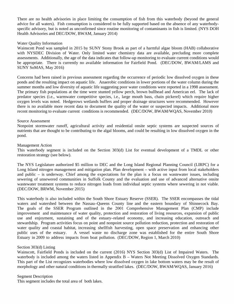
There are no health advisories in place limiting the consumption of fish from this waterbody (beyond the general advice for all waters). Fish consumption is considered to be fully supported based on the absence of any waterbody-specific advisory, but is noted as unconfirmed since routine monitoring of contaminants in fish is limited. (NYS DOH Health Advisories and DEC/DOW, BWAM, January 2014)
Water Quality Information Wainscott Pond was sampled in 2015 by SUNY Stony Brook as part of a harmful algae bloom (HAB) collaborative with NYSDEC Division of Water. Only limited water chemistry data are available, precluding more complete assessments. Additionally, the age of the data indicates that follow-up monitoring to evaluate current conditions would be appropriate. There is currently no available information for Fairfield Pond. (DEC/DOW, BWAM/LAMS and SUNY SoMAS, May 2016)
Concerns had been raised in previous assessment regarding the occurrence of periodic low dissolved oxygen in these ponds and the resulting impact on aquatic life. Anaerobic conditions in lower portions of the water column during the summer months and low diversity of aquatic life suggesting poor water conditions were reported in a 1998 assessment. The primary fish populations at the time were stunted yellow perch, brown bullhead and American eel. The lack of predator species (i.e., warmwater competitive species, i.e., large mouth bass, chain pickerel) which require higher oxygen levels was noted. Hedgerows wetlands buffers and proper drainage structures were recommended. However there is no available more recent data to document the quality of the water or suspected impacts. Additional more recent monitoring to evaluate current conditions is recommended. (DEC/DOW, BWAM/WQAS, November 2010)
Source Assessment Nonpoint stormwater runoff, agricultural activity and residential onsite septic systems are suspected sources of nutrients that are thought to be contributing to the algal blooms, and could be resulting in low dissolved oxygen in the pond.
Management Action This waterbody segment is included on the Section 303(d) List for eventual development of a TMDL or other restoration strategy (see below).
The NYS Legislature authorized $5 million to DEC and the Long Island Regional Planning Council (LIRPC) for a Long Island nitrogen management and mitigation plan. Plan development – with active input from local stakeholders and public – is underway. Chief among the expectations for the plan is a focus on wastewater issues, including sewering of unsewered communities in Suffolk County and the evaluation and use of advanced alternative onsite wastewater treatment systems to reduce nitrogen loads from individual septic systems where sewering in not viable. (DEC/DOW, BRWM, November 2015)
This waterbody is also included within the South Shore Estuary Reserve (SSER). The SSER encompasses the tidal waters and watershed between the Nassau–Queens County line and the eastern boundary of Shinnecock Bay. The goals of the SSER Program outlined in the 2001 Comprehensive Management Plan (CMP) include improvement and maintenance of water quality, protection and restoration of living resources, expansion of public use and enjoyment, sustaining and of the estuary–related economy, and increasing education, outreach and stewardship. Program activities focus on point and nonpoint source pollution reduction, protection and restoration of water quality and coastal habitat, increasing shellfish harvesting, open space preservation and enhancing other public uses of the estuary. A vessel waste no discharge zone was established for the entire South Shore Estuary in 2009 to address impacts from boat pollution. (DEC/DOW, Region 1, March 2010)
Section 303(d) Listing Wainscott, Fairfield Ponds is included on the current (2016) NYS Section 303(d) List of Impaired Waters. The waterbody is included among the waters listed in Appendix B – Waters Not Meeting Dissolved Oxygen Standards. This part of the List recognizes waterbodies where low dissolved oxygen in lake bottom waters may be the result of morphology and other natural conditions in thermally stratified lakes. (DEC/DOW, BWAM/WQAS, January 2016)
Segment Description This segment includes the total area of both lakes.

Sagaponack Pond (1701-0146) Impaired Waterbody Location Information Revised: 6/13/2016
Water Index No: (MW7.1a) AO-P786 Water Class: SA Hydro Unit Code: Shinnecock Bay-Atlantic Ocean (0203020206) Drainage Basin: Atlantic-Long Island Sound Water Type/Size: Estuary Waters 92.8 Acres Reg/County: 1/Suffolk (52) Description: entire tidal waterbody Water Quality Problem/Issue Information (CAPS indicate MAJOR Pollutants/Sources) Uses Evaluated Severity Confidence
Shellfishing Precluded Known Public Bathing Stressed Unconfirmed Recreation Impaired Known Aquatic Life Fully Supported Unconfirmed Fish Consumption Fully Supported Unconfirmed
Conditions Evaluated Habitat/Hydrology Good Aesthetics Good
Type of Pollutant(s) Known: PATHOGENS Suspected: Nutrients (nitrogen), Low D.O./Oxygen Demand Unconfirmed: - - -
Source(s) of Pollutant(s) Known: URBAN/STORM RUNOFF, Agriculture Suspected: OTHER SOURCE (waterfowl/wildlife) Unconfirmed: - - -
Management Information
Management Status: Strategy Implementation Scheduled or Underway Lead Agency/Office: ext/WQCC IR/305(b) Code: Impaired Water, TMDL Completed (IR Category 4a)
Further Details Overview Sagaponack Pond is assessed as an impaired waterbody due to shellfishing use that is considered to be precluded by pathogens and recreational use impaired by harmful algal blooms. This assessment is based on year-round shellfishing closures. Urban/stormwater runoff is the primary source of pathogens, although various other sources such as agricultureal activity and waterfowl/wildlife may also contribute. Public bathing and other recreational uses are fully supported, however these uses may also be stressed or threatened, as a result of the shellfishing restrictions and related pathogen levels. Algal blooms have also been noted. Use Assessment Sagaponack Pond is a Class SA waterbody, suitable for shellfishing, public bathing and general recreation use, and support of aquatic life. Shellfish harvesting for consumption is considered to be precluded in these waters. All of this waterbody (included within Shellfish Growing Area #69) has been designated uncertified for the taking of shellfish for use as food. Shellfish that grow in contaminated waters can accumulate disease-causing microorganisms (bacteria, viruses) that can be eaten with the shellfish. These shellfishing designations are based on results of water quality sampling and

evaluation of data against New York State and National Shellfish Sanitation Program monitoring criteria and/or shoreline surveys of actual or potential sources of contamination. Certified/uncertified shellfish area designations are revised regularly; for the most up to date and detailed descriptions of current designations, go to www.dec.ny.gov/regs/4014.html. (DEC/DFWMR, Region 1, July 2010)
Recreational use including public bathing is thought to be impaired due to frequent to persistent occurences of harmful (blue-green) algal blooms; shellfishing certification monitoring also suggests impacts to recreation. Aesthetic conditions of the pond are also considered to be poor due to algal blooms. There are no regularly monitored beaches in this waterbody, but bacteriological sampling conducted through the shellfishing monitoring program indicate elevated pathogen levels. However criteria for shellfishing are lower than those for public bathing and additional bacteriological sampling is needed to more fully evaluate swimming use. Restrictions on shellfishing represent an impact to recreational use. (DEC/DOW and DFWMR, January 2016)
Based on other available indicators for other related uses, this waterbody is expected to support a healthy marine water fishery, although no specific fishery or biological reports are included in this assessment.
There are no health advisories in place limiting the consumption of fish from this waterbody (beyond the general advice for all waters). Fish consumption is considered to be fully supported based on the absence of any waterbody-specific advisory, but is noted as unconfirmed since routine monitoring of contaminants in fish is limited. (NYS DOH Health Advisories and DEC/DOW, BWAM, January 2014)
Water Quality Information Assessments of recreational uses and aquatic life in marine waters are based primarily on information from NYS and local health departments and the NYSDEC Division of Fish Wildlife and Marine Resources. This information is compiled and updated in regularly issued advisories and certifications regarding bathing beaches, shellfishing harvest and sportfish consumption. (NYSDOH and DEC/DFWMR, 2014)
Source Assessment Based on surrounding land use and other knowledge of the waterbody, the most likely sources of pathogens to the waterbody are largely nonpoint runoff from developed and undeveloped lands, agricultural activity and open space/forest; direct waterfowl/wildlife inputs and boats and marinas also may contribute. Relative contributions from each type of source are very site-specific in nature, particularly in localized areas of study. (DEC/DOW, BWRM, September 2015)
Management Action Sagaponack Pond was among the waterbodies covered by the Long Island Pathogen TMDL to address shellfishing impairments that was established in 2007. (DEC/DOW, BWAM/WQMS, July 2010)
The NYS Legislature authorized $5 million to DEC and the Long Island Regional Planning Council (LIRPC) for a Long Island nitrogen management and mitigation plan. Plan development – with active input from local stakeholders and public – is underway. Chief among the expectations for the plan is a focus on wastewater issues, including sewering of unsewered communities in Suffolk County and the evaluation and use of advanced alternative onsite wastewater treatment systems to reduce nitrogen loads from individual septic systems where sewering in not viable. (DEC/DOW, BRWM, November 2015)
This waterbody is also included within the South Shore Estuary Reserve (SSER). The SSER encompasses the tidal waters and watershed between the Nassau–Queens County line and the eastern boundary of Shinnecock Bay. The goals of the SSER Program outlined in the 2001 Comprehensive Management Plan (CMP) include improvement and maintenance of water quality, protection and restoration of living resources, expansion of public use and enjoyment, sustaining and of the estuary–related economy, and increasing education, outreach and stewardship. Program activities focus on point and nonpoint source pollution reduction, protection and restoration of water quality and coastal habitat, increasing shellfish harvesting, open space preservation and enhancing other public uses of the estuary. A vessel waste no discharge zone was established for the entire South Shore Estuary in 2009 to address impacts from boat pollution. (DEC/DOW, Region 1, March 2010)
Section 303(d) Listing

Sagaponack Pond is not included on the current (2016) NYS Section 303(d) List of Impaired/TMDL Waters. Although it is assessed as an impaired water, it is categorized as an IR Category 4a water that is not listed due to the inclusion of the waterbody in the 2007 Long Island Pathogens (Shellfishing) TMDL. (DEC/DOW, BWAM, January 2015) Segment Description This segment includes the entire pond and tidal tribs.
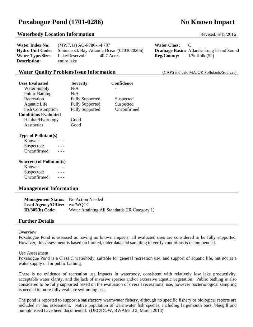
Poxabogue Pond (1701-0286) No Known Impact Waterbody Location Information Revised: 6/15/2016
Water Index No: (MW7.1a) AO-P786-1-P787 Water Class: C Hydro Unit Code: Shinnecock Bay-Atlantic Ocean (0203020206) Drainage Basin: Atlantic-Long Island Sound Water Type/Size: Lake/Reservoir 40.7 Acres Reg/County: 1/Suffolk (52) Description: entire lake Water Quality Problem/Issue Information (CAPS indicate MAJOR Pollutants/Sources) Uses Evaluated Severity Confidence
Water Supply N/A - Public Bathing N/A - Recreation Fully Supported Suspected Aquatic Life Fully Supported Suspected Fish Consumption Fully Supported Unconfirmed
Conditions Evaluated Habitat/Hydrology Good Aesthetics Good
Type of Pollutant(s) Known: - - - Suspected: - - - Unconfirmed: - - -
Source(s) of Pollutant(s) Known: - - - Suspected: - - - Unconfirmed: - - -
Management Information
Management Status: No Action Needed Lead Agency/Office: ext/WQCC IR/305(b) Code: Water Attaining All Standards (IR Category 1)
Further Details Overview Poxabogue Pond is assessed as having no known impacts; all evaluated uses are considered to be fully supported. However, this assessment is based on limited, older data and sampling to verify conditions is recommended. Use Assessment Poxabogue Pond is a Class C waterbody, suitable for general recreation use, and support of aquatic life, but not as a water supply or for public bathing. There is no evidence of recreation use impacts in waterbody, consistent with relatively low lake productivity, acceptable water clarity, and the lack of invasive species and/or excessive aquatic vegetation. Public bathing is also considered to be fully supported based on the evaluation of overall recreational use, however bacteriological sampling is needed to more fully evaluate swimming use. The pond is reported to support a satisfactory warmwater fishery, although no specific fishery or biological reports are included in this assessment. Native population of warmwater fish species, including largemouth bass, bluegill and pumpkinseed have been documented. (DEC/DOW, BWAM/LCI, March 2014)

Water Quality Information Water quality sampling of Poxabogue Pond through the NYSDEC Lake Classification and Inventory (LCI) Program is limited to a single sample in 2003. Results of this sampling indicate the lake is best characterized as mesoeutrophic, or only moderately productive. Phosphorus concentrations are low high and lake clarity measurements indicate water transparency that meets the recommended minimum criteria for swimming beaches. (DEC/DOW, BWAM/LMAS, March 2011) Source Assessment There are no apparent sources of pollutants to the waterbody. Management Action No specific management actions have been identified or are deemed necessary for the waterbody. Additional sampling to verify current conditions in the pond is needed. Section 303(d) Listing Poxabogue Pond is not included on the current (2016) NYS Section 303(d) List of Impaired/TMDL Waters. There appear to be no impacts/impairments that would justify the listing of this waterbody. However water quality sampling is limited. (DEC/DOW, BWAM/WQAS, January 2016) Segment Description This segment includes the total area of the entire lake.

Mecox Bay and tribs (1701-0034) Impaired Waterbody Location Information Revised: 6/13/2016
Water Index No: (MW7.1b) AO-P790 Water Class: SA Hydro Unit Code: Shinnecock Bay-Atlantic Ocean (0203020206) Drainage Basin: Atlantic-Long Island Sound Water Type/Size: Estuary Waters 1067.5 Acres Reg/County: 1/Suffolk (52) Description: entire bay and selected/smaller tidal tribs Water Quality Problem/Issue Information (CAPS indicate MAJOR Pollutants/Sources) Uses Evaluated Severity Confidence
Shellfishing Impaired Known Public Bathing Stressed Unconfirmed Recreation Stressed Known Aquatic Life Fully Supported Unconfirmed Fish Consumption Fully Supported Unconfirmed
Conditions Evaluated Habitat/Hydrology Good Aesthetics Good
Type of Pollutant(s) Known: PATHOGENS Suspected: - - - Unconfirmed: - - -
Source(s) of Pollutant(s) Known: URBAN/STORM RUNOFF, Agriculture Suspected: OTHER SOURCE (waterfowl/wildlife) Unconfirmed: - - -
Management Information
Management Status: Strategy Implementation Scheduled or Underway Lead Agency/Office: ext/WQCC IR/305(b) Code: Impaired Water, TMDL Completed (IR Category 4a)
Further Details Overview Mecox Bay is assessed as an impaired waterbody due to shellfishing use that is considered to be precluded by pathogens. This assessment is based on year-round shellfishing closures. Urban and storm runoff are the primary sources of pathogens, although various other sources such as waterfowl/wildlife may also contribute. Public bathing and other recreational uses are fully supported, however these uses may also be stressed or threatened, as a result of the shellfishing restrictions and related pathogen levels. Use Assessment Mecox Bay is a Class SA waterbody, suitable for shellfishing, public bathing and general recreation use, and support of aquatic life. Shellfish harvesting for consumption is considered to be precluded in these waters. All of this waterbody (included within Shellfish Growing Area #11) has been designated uncertified or only seasonally certified for the taking of shellfish for use as food. Year-round restrictions apply to the eastern and northwestern portions of the bay and tributaries, while the remainder of the Bay is seasonally certified. A cooperative effort between the Town of Southampton and NYS DEC to collect seasonal rainfall and water quality data resulted in the reclassification of about

500 acres in the interior of the bay as seasonally open to shellfishing in 1996. Shellfish that grow in contaminated waters can accumulate disease-causing microorganisms (bacteria, viruses) that can be eaten with the shellfish. These shellfishing designations are based on results of water quality sampling and evaluation of data against New York State and National Shellfish Sanitation Program monitoring criteria and/or shoreline surveys of actual or potential sources of contamination. Certified/uncertified shellfish area designations are revised regularly; for the most up to date and detailed descriptions of current designations, go to www.dec.ny.gov/regs/4014.html. (DEC/DFWMR, Region 1, July 2010)
Recreational use including public bathing is thought to be stressed based on shellfishing certification monitoring. There are no regularly monitored beaches in this waterbody, but bacteriological sampling conducted through the shellfishing monitoring program indicate elevated pathogen levels. However criteria for shellfishing are lower than those for public bathing and additional bacteriological sampling is needed to more fully evaluate swimming use. Restrictions on shellfishing represent an impact to recreational use. (DEC/DFWMR, July 2014)
Based on other available indicators for other related uses, this waterbody is expected to support a healthy marine water fishery, although no specific fishery or biological reports are included in this assessment.
There are no health advisories in place limiting the consumption of fish from this waterbody (beyond the general advice for all waters). Fish consumption is considered to be fully supported based on the absence of any waterbody-specific advisory, but is noted as unconfirmed since routine monitoring of contaminants in fish is limited. (NYS DOH Health Advisories and DEC/DOW, BWAM, January 2014)
Water Quality Information Assessments of recreational uses and aquatic life in marine waters are based primarily on information from NYS and local health departments and the NYSDEC Division of Fish Wildlife and Marine Resources. This information is compiled and updated in regularly issued advisories and certifications regarding bathing beaches, shellfishing harvest and sportfish consumption. (NYSDOH and DEC/DFWMR, 2014)
Source Assessment Based on surrounding land use and other knowledge of the waterbody, the most likely sources of pathogens to the waterbody are largely nonpoint runoff from developed and undeveloped lands, agricultural activity and open space/forest; direct waterfowl/wildlife inputs and boats and marinas also may contribute. Relative contributions from each type of source are very site-specific in nature, particularly in localized areas of study. (DEC/DOW, BWRM, September 2015)
Management Action Mecox Bay was among the waterbodies covered by the Long Island Pathogen TMDL to address shellfishing impairments that was established in 2007. (DEC/DOW, BWAM/WQMS, July 2010)
The NYS Legislature authorized $5 million to DEC and the Long Island Regional Planning Council (LIRPC) for a Long Island nitrogen management and mitigation plan. Plan development – with active input from local stakeholders and public – is underway. Chief among the expectations for the plan is a focus on wastewater issues, including sewering of unsewered communities in Suffolk County and the evaluation and use of advanced alternative onsite wastewater treatment systems to reduce nitrogen loads from individual septic systems where sewering in not viable. (DEC/DOW, BRWM, November 2015)
This waterbody is also included within the South Shore Estuary Reserve (SSER). The SSER encompasses the tidal waters and watershed between the Nassau–Queens County line and the eastern boundary of Shinnecock Bay. The goals of the SSER Program outlined in the 2001 Comprehensive Management Plan (CMP) include improvement and maintenance of water quality, protection and restoration of living resources, expansion of public use and enjoyment, sustaining and of the estuary–related economy, and increasing education, outreach and stewardship. Program activities focus on point and nonpoint source pollution reduction, protection and restoration of water quality and coastal habitat, increasing shellfish harvesting, open space preservation and enhancing other public uses of the estuary. A vessel waste no discharge zone was established for the entire South Shore Estuary in 2009 to address impacts from boat pollution. (DEC/DOW, Region 1, March 2010)

Section 303(d) Listing Mecox Bay is not included on the current (2016) NYS Section 303(d) List of Impaired/TMDL Waters. Although it is assessed as an impaired water, it is categorized as an IR Category 4a water that is not listed due to the inclusion of the waterbody in the 2007 Long Island Pathogens (Shellfishing) TMDL. (DEC/DOW, BWAM, January 2015) Segment Description This segment includes tidal portions of Burnett Creek (-1), Mill Creek (-2), Hayground Cove, Calf Creek (-5), Swan Creek (-6), and Sams Creek (-7). The waters of this segment are primarily Class SA, with small portions designated Class SB (Middle Hayground Cove) and Class SC (Upper Hayground Cove, Upper Mill Creek, Swan and Sams Creek). Channel Pond (P808) and freshwater ponds in the watershed are listed separately.

Tribs (fresh) to Mecox Bay (1701-0289) Unassessed Waterbody Location Information Revised: 6/20/2016
Water Index No: (MW7.1b) AO-P790- 2 thru 5 (select) Water Class: C Hydro Unit Code: Shinnecock Bay-Atlantic Ocean (0203020206) Drainage Basin: Atlantic-Long Island Sound Water Type/Size: River/Stream 3.7 Miles Reg/County: 1/Suffolk (52) Description: total length of selected (fresh) tribs to bay Water Quality Problem/Issue Information (CAPS indicate MAJOR Pollutants/Sources) Uses Evaluated Severity Confidence
Water Supply N/A - Public Bathing N/A - Recreation Unassessed - Aquatic Life Unassessed - Fish Consumption Unassessed -
Conditions Evaluated Habitat/Hydrology Unknown Aesthetics Unknown
Type of Pollutant(s) Known: - - - Suspected: - - - Unconfirmed: - - -
Source(s) of Pollutant(s) Known: - - - Suspected: - - - Unconfirmed: - - -
Management Information
Management Status: Unassessed Lead Agency/Office: DOW/BWAM IR/305(b) Code: Water with Insufficient Data (IR Category 3)
Further Details Overview Currently there is inadequate data/information to evaluate uses and determine a water quality assessment for this waterbody. Use Assessment This waterbody segment] is a Class C waterbody, suitable for general recreation use and support of aquatic life, but not as a water supply or for public bathing. Water Quality Information There is currently no water quality information available upon which to base an assessment. Source Assessment Specific sources of pollutants to the waterbody have not been identified. Management Action No specific management actions have been identified for the waterbody. Baseline sampling to evaluate

conditions in this waterbody segment is needed. Section 303(d) Listing This waterbody is not included on the current (2016) NYS Section 303(d) List of Impaired/TMDL Waters. There is insufficient information to make a listing decision. (DEC/DOW, BWAM/WQAS, January 2015) Segment Description Includes freshwater portions of Mill Creek (-2), unnamed tribs (-3, -4) and Calf Creek (-5), and tribs. Segment length estimated to be 1.0 mi.

Mill and Seven Ponds (1701-0113) Impaired Waterbody Location Information Revised: 6/20/2016
Water Index No: (MW7.1b) AO-P790- 2-2-P793,P794 Water Class: B Hydro Unit Code: Shinnecock Bay-Atlantic Ocean (0203020206) Drainage Basin: Atlantic-Long Island Sound Water Type/Size: Lake/Reservoir 115.9 Acres Reg/County: 1/Suffolk (52) Description: total area of both lakes Water Quality Problem/Issue Information (CAPS indicate MAJOR Pollutants/Sources) Uses Evaluated Severity Confidence
Water Supply N/A - Public Bathing Impaired Known Recreation Impaired Known Aquatic Life Impaired Known Fish Consumption Unassessed -
Conditions Evaluated Habitat/Hydrology Fair Aesthetics Fair
Type of Pollutant(s) Known: ALGAL/PLANT GROWTH, LOW D.O./OXYGEN DEMAND Suspected: NUTRIENTS (phosphorus) Unconfirmed: Pathogens
Source(s) of Pollutant(s) Known: URBAN/STORM RUNOFF Suspected: Agriculture, Other Source Unconfirmed: Onsite/Septic Systems
Management Information
Management Status: Verification of Sources Needed Lead Agency/Office: DEC/Reg1 IR/305(b) Code: Impaired Water Requiring a TMDL (IR Category 5)
Further Details Overview The Mill and Seven Ponds segment is assessed as impaired due to public bathing and recreational uses and aquatic life that are known to be impaired by nutrients and resulting dissolved oxygen depletion, harmful algae blooms, and associated algal toxins in Mill Pond (Seven Ponds is unassessed). Sources of these impacts include urban stormwater runoff, agricultural activities and runoff, onsite (septic) systems and waterfowl. Use Assessment This waterbody segment is a Class B waterbody, suitable for public bathing, general recreation use and support of aquatic life, but not as a water supply. Recreation use and public bathing is considered to be impaired due to elevated levels of nutrients (phosphorus) and resulting algal growth and low clarity and frequent to persistent occurences of harmful (blue-green) algal blooms in Mill Pond. Aesthetic conditions of the pond are also considered to be poor due to algal blooms. Aquatic life support and recreational uses (fishing) in Mill, Seven Ponds is affected by nutrient-driven low dissolved oxygen.

There are no health advisories in place limiting the consumption of fish from this waterbody (beyond the general advice for all waters). Fish consumption is considered to be fully supported based on the absence of any waterbody-specific advisory, but is noted as unconfirmed since routine monitoring of contaminants in fish is limited. (NYS DOH Health Advisories and DEC/DOW, BWAM, January 2014)
Water Quality Information Mill Pond was sampled in 2015 by SUNY Stony Brook as part of a harmful algae bloom (HAB) collaborative with NYSDEC Division of Water. Only limited water chemistry data are available, precluding more complete assessments. Additionally, a 2007-08 SUNY Stony Brook study conducted by Dr. Christopher Gobler indicated the presence of cyanobacteria (microcystis-LR) levels in excess of 20 ug/l in samples collected from Mill Pond. This sampling effort also revealed very high phosphorus and chlorophyll-a levels, indicating eutrophic conditions. These results are indicative of a high risk of recreational use impacts from algal toxins. It is likely that elevated nutrient levels have contributed to excessive algae growth leading to the production of these toxins. A large fish kill involving hundreds of catfish, white perch, eels and bass was reported in 2008. Lake aeration was conducted in 2007. (DEC/DOW, BWAM/LAMS and SUNY SoMAS, May 2016)
Source Assessment Based on surrounding land use and other knowledge of the waterbody, the most likely sources of pathogens to the waterbody are largely nonpoint runoff from developed and undeveloped lands, agricultural activity and open space/forest; direct waterfowl/wildlife inputs and boats and marinas also may contribute. Relative contributions from each type of source are very site-specific in nature, particularly in localized areas of study. (DEC/DOW, BWRM, September 2015)
Management Action The Town of Southampton (Board of Trustees) evaluated several lake management actions to improve lake water quality conditions in Mill Pond, and the use of PhosLock to control excessive nutrients was approved in 2010. The Town is also considering the use of hydroraking to control excessive growth of water lilies in a portion of the Pond. (DEC/DOW, BWAM/LMAS, June 2011)
The NYS Legislature authorized $5 million to DEC and the Long Island Regional Planning Council (LIRPC) for a Long Island nitrogen management and mitigation plan. Plan development – with active input from local stakeholders and public – is underway. Chief among the expectations for the plan is a focus on wastewater issues, including sewering of unsewered communities in Suffolk County and the evaluation and use of advanced alternative onsite wastewater treatment systems to reduce nitrogen loads from individual septic systems where sewering in not viable. (DEC/DOW, BRWM, November 2015)
This waterbody is also included within the South Shore Estuary Reserve (SSER). The SSER encompasses the tidal waters and watershed between the Nassau–Queens County line and the eastern boundary of Shinnecock Bay. The goals of the SSER Program outlined in the 2001 Comprehensive Management Plan (CMP) include improvement and maintenance of water quality, protection and restoration of living resources, expansion of public use and enjoyment, sustaining and of the estuary–related economy, and increasing education, outreach and stewardship. Program activities focus on point and nonpoint source pollution reduction, protection and restoration of water quality and coastal habitat, increasing shellfish harvesting, open space preservation and enhancing other public uses of the estuary. A vessel waste no discharge zone was established for the entire South Shore Estuary in 2009 to address impacts from boat pollution. (DEC/DOW, Region 1, March 2010)
Section 303(d) Listing: Mill and Seven Ponds is included on the current (2016) NYS Section 303(d) List of Impaired/TMDL Waters. The waterbody is included on Part 3a of the List as an impaired waterbody where TMDL development is deferred pending verification of impairment due to phosphorus. However subsequent monitoring and reports of HABs suggest the waterbody could be moved to Part 1. This listing is based on impairment in Mill Pond; there is insufficient data available to assess conditions in Seven Pond This waterbody was first listed on the 2012 List. (DEC/DOW, BWAM/WQAS, January 2010)
Segment Description

This segment includes the total area of both Mill Pond (P793) and Sevens Pond (P794), as well as smaller unnamed pond (P795).

Kellis Pond (1701-0290) Impaired Waterbody Location Information Revised: 6/20/2016
Water Index No: (MW7.1b) AO-P790- 5-P798 Water Class: C Hydro Unit Code: Shinnecock Bay-Atlantic Ocean (0203020206) Drainage Basin: Atlantic-Long Island Sound Water Type/Size: Lake/Reservoir 37.4 Acres Reg/County: 1/Suffolk (52) Description: entire lake Water Quality Problem/Issue Information (CAPS indicate MAJOR Pollutants/Sources) Uses Evaluated Severity Confidence
Water Supply N/A - Public Bathing N/A - Recreation Impaired Suspected Aquatic Life Stressed Unconfirmed Fish Consumption Fully Supported Unconfirmed
Conditions Evaluated Habitat/Hydrology Unknown Aesthetics Poor
Type of Pollutant(s) Known: HARMFUL ALGAL BLOOMS Suspected: Low D.O./Oxygen Demand, Nutrients Unconfirmed: - - -
Source(s) of Pollutant(s) Known: Urban/Storm Runoff Suspected: Agriculture Unconfirmed: Onsite/Septic Systems
Management Information
Management Status: Verification of Problem Severity Needed Lead Agency/Office: ext/SMAS IR/305(b) Code: Impaired Water, Pollution, not Pollutant (IR Category 4c)
Further Details Overview Kellis Pond is assessed as an impaired waterbody due to recreational uses that are considered to be impaired by frequent to persistent occurrences of harmful algal blooms. Aquatic life may also be impacted by resulting low dissolved oxygen in the ponds. Nonpoint stormwater runoff, agricultural activity and residential onsite septic systems are suspected sources of pollutants. Use Assessment Kellis Pond is a Class C waterbody, suitable for general recreation use and support of aquatic life, but not as a water supply or for public bathing. Recreation use is considered to be impaired due to frequent to persistent occurences of harmful (blue-green) algal blooms in the Pond. Aesthetic conditions of the pond are also considered to be poor due to algal blooms. Aquatic life support and recreational uses (fishing) in the Pond may be affected by low dissolved oxygen, but these conditions need to be verified.

There are no health advisories in place limiting the consumption of fish from this waterbody (beyond the general advice for all waters). Fish consumption is considered to be fully supported based on the absence of any waterbody-specific advisory, but is noted as unconfirmed since routine monitoring of contaminants in fish is limited. (NYS DOH Health Advisories and DEC/DOW, BWAM, January 2014)
Water Quality Information Kellis Pond was sampled in 2015 by SUNY Stony Brook as part of a harmful algae bloom (HAB) collaborative with NYSDEC Division of Water. Only limited water chemistry data are available, precluding more complete assessments. Additionally, the age of the data indicates that follow-up monitoring to evaluate current conditions would be appropriate. (DEC/DOW, BWAM/LAMS and SUNY SoMAS, May 2016)
Source Assessment Nonpoint stormwater runoff, agricultural activity and residential onsite septic systems are suspected sources of nutrients that are thought to be contributing to the algal blooms, and could be resulting in low dissolved oxygen in the pond.
Management Action The NYS Legislature authorized $5 million to DEC and the Long Island Regional Planning Council (LIRPC) for a Long Island nitrogen management and mitigation plan. Plan development – with active input from local stakeholders and public – is underway. Chief among the expectations for the plan is a focus on wastewater issues, including sewering of unsewered communities in Suffolk County and the evaluation and use of advanced alternative onsite wastewater treatment systems to reduce nitrogen loads from individual septic systems where sewering in not viable. (DEC/DOW, BRWM, November 2015)
This waterbody is also included within the South Shore Estuary Reserve (SSER). The SSER encompasses the tidal waters and watershed between the Nassau–Queens County line and the eastern boundary of Shinnecock Bay. The goals of the SSER Program outlined in the 2001 Comprehensive Management Plan (CMP) include improvement and maintenance of water quality, protection and restoration of living resources, expansion of public use and enjoyment, sustaining and of the estuary–related economy, and increasing education, outreach and stewardship. Program activities focus on point and nonpoint source pollution reduction, protection and restoration of water quality and coastal habitat, increasing shellfish harvesting, open space preservation and enhancing other public uses of the estuary. A vessel waste no discharge zone was established for the entire South Shore Estuary in 2009 to address impacts from boat pollution. (DEC/DOW, Region 1, March 2010)
Section 303(d) Listing Kellis Pond not included on the current (2016) NYS Section 303(d) List of Impaired/TMDL Waters. Although it is assessed as an impaired water, it is categorized as an IR Category 4c water that is not listed because the cause of the impairment (harmful algal blooms) is not a pollutant for which a TMDL can be developed. A listing for phosphorus may be appropriate but there is insufficient data to justify such a listing at this time. (DEC/DOW, BWAM, January 2016)
Segment Description This segment includes the total area of the pond.

Little Long, Long, and Shorts Ponds (1701-0291) No Known Impacts Waterbody Location Information Revised: 6/21/2016
Water Index No: (MW7.1b) AO-P790-P799,P800,P803 Water Class: C Hydro Unit Code: Shinnecock Bay-Atlantic Ocean (0203020206) Drainage Basin: Atlantic-Long Island Sound Water Type/Size: Lake/Reservoir 48.9 Acres Reg/County: 1/Suffolk (52) Description: total area of all three lakes Water Quality Problem/Issue Information (CAPS indicate MAJOR Pollutants/Sources) Uses Evaluated Severity Confidence
Water Supply N/A - Public Bathing N/A - Recreation Fully Supported Suspected Aquatic Life Fully Supported Suspected Fish Consumption Fully Supported Unconfirmed
Conditions Evaluated Habitat/Hydrology Good Aesthetics Good
Type of Pollutant(s) Known: - - - Suspected: - - - Unconfirmed: - - -
Source(s) of Pollutant(s) Known: - - - Suspected: - - - Unconfirmed: - - -
Management Information
Management Status: No Action Needed Lead Agency/Office: ext/WQCC IR/305(b) Code: Water Attaining All Standards (IR Category 1)
Further Details Overview The Little Long, Long and Shorts Ponds segment is assessed as having no known impacts; all evaluated uses are considered to be fully supported. However, this assessment is based on sampling conducted at one of the Ponds (Little Long Pond). This pond is considered to be representative of the other ponds in the segment, butadditional sampling in the other ponds is recommended. Use Assessment The Little Long, Long and Shorts Ponds segment is a Class C waterbody, suitable for general recreation use, and support of aquatic life, but not as a water supply or for public bathing. There is no evidence of recreation use impacts in waterbody, consistent with relatively low lake productivity, acceptable water clarity, and the lack of invasive species and/or excessive aquatic vegetation. Public bathing is also considered to be fully supported based on the evaluation of overall recreational use, however bacteriological sampling is needed to more fully evaluate swimming use. The pond is reported to support a satisfactory warmwater fishery, although no specific fishery or biological reports are

included in this assessment. Native population of warmwater fish species, including largemouth bass, bluegill and pumpkinseed have been documented. (DEC/DOW, BWAM/LCI, March 2014) Water Quality Information Water quality sampling of Little Long Pond through the NYSDEC Citizens Statewide Lake Assessment Program (CSLAP) from 2007-09 and 2011-15. Results of this sampling indicate the lake is best characterized as mesoeutrophic, or only moderately productive. Chlorophyll/algal levels are well below criteria corresponding to impacted recreational uses, while phosphorus concentrations are somewhat elevated, though lower in more recent years. Lake clarity measurements indicate water transparency typically meets the recommended minimum criteria for swimming beaches. Readings of pH fall within the range established in state water quality standards for protection of aquatic life. (DEC/DOW, BWAM/LMAS, March 2011) Source Assessment There are no apparent sources of pollutants to the waterbody. Management Action No specific management actions have been identified or are deemed necessary for the waterbody. Additional sampling to verify current conditions in the pond is needed. Little Long Pond is part of the Long Pond Greenbelt complex. The Long Pond Greenbelt is an approximately 11 kilometer (7 mile) north-south corridor of ponds, streams, and adjacent upland areas in the Outer Coastal Plain physiographic province. The preservation of land in the Long Pond Greenbelt has been a goal in the master plan for the town of Southampton since 1970. Long Pond Greenbelt is recognized by the New York State Department of State as a Significant Coastal Fish and Wildlife Habitat, and by the U.S. Fish and Wildlife Service as a priority wetland complex under the federal Emergency Wetlands Resources Act of 1986. The New York State Natural Heritage Program, in conjunction with The Nature Conservancy, recognizes several Priority Sites for Biodiversity within the Long Pond Greenbelt complex. Information about the Long Pond Greenbelt can be found at http://library.fws.gov/pubs5/web_link/text/lpg_form.html. (DEC/DOW, BWAM/LMAS, March 2011) Section 303(d) Listing Little Long, Long and Shorts Ponds is not included on the current (2016) NYS Section 303(d) List of Impaired/TMDL Waters. There appear to be no impacts/impairments that would justify the listing of this waterbody. However water quality sampling is limited to just one of the ponds in the segment. (DEC/DOW, BWAM/WQAS, January 2016) Segment Description This segment includes the total area of Little Long Pond (P799), Long Pond (P800) and Shorts Pond (P803), as well as the smaller Goldfish Pond (P801) and unnamed pond (P802).

Channel Pond (1701-0292) Minor Impacts Waterbody Location Information Revised: 6/13/2016
Water Index No: (MW7.1b) AO-P790..P808 Water Class: SC Hydro Unit Code: Shinnecock Bay-Atlantic Ocean (0203020206) Drainage Basin: Atlantic-Long Island Sound Water Type/Size: Estuary Waters 26.8 Acres Reg/County: 1/Suffolk (52) Description: entire tidal waterbody Water Quality Problem/Issue Information (CAPS indicate MAJOR Pollutants/Sources) Uses Evaluated Severity Confidence
Shellfishing N/A - Public Bathing N/A - Recreation Stressed Suspected Aquatic Life Fully Supported Unconfirmed Fish Consumption Fully Supported Unconfirmed
Conditions Evaluated Habitat/Hydrology Unknown Aesthetics Unknown
Type of Pollutant(s) Known: Pathogens Suspected: - - - Unconfirmed: - - -
Source(s) of Pollutant(s) Known: - - - Suspected: Urban/Storm Runoff Unconfirmed: Onsite/Septic Systems
Management Information
Management Status: Strategy Implementation Scheduled or Underway Lead Agency/Office: ext/WQCC IR/305(b) Code: Water Attaining All Standards (IR Category 1)
Further Details Overview Channel Pond is assessed as a waterbody having minor impacts due to recreational uses that are thought to be stressed by pathogens. This assessment is based on pathogens levels identified through shellfishing program monitoring. Use Assessment Channel Pond is a Class SC waterbody, suitable for general recreation use and support of aquatic life, but not as a shellfishing water – although sampling of the waterbody has been included in the shellfish monitoring program – or for public bathing. All of this waterbody (included within Shellfish Growing Area #11) has been designated as uncertified for the taking of shellfish for use as food. Although this waterbody is monitored through the shellfish program and designated as uncertified, its Class SC designation does not include shellfishing as an appropriate use and this assessment does not include an evaluation for the support of shellfishing use. (DEC/DFWMR, Region 1, July 2015) Recreational use including public bathing is thought to be stressed based on shellfishing certification monitoring. There are no regularly monitored beaches in this waterbody, but bacteriological sampling conducted through the

shellfishing monitoring program indicate elevated pathogen levels. However criteria for shellfishing are lower than those for public bathing and additional bacteriological sampling is needed to more fully evaluate swimming use. (DEC/DFWMR, July 2014)
Based on other available indicators for other related uses, this waterbody is expected to support a healthy marine water fishery, although no specific fishery or biological reports are included in this assessment.
There are no health advisories in place limiting the consumption of fish from this waterbody (beyond the general advice for all waters). Fish consumption is considered to be fully supported based on the absence of any waterbody-specific advisory, but is noted as unconfirmed since routine monitoring of contaminants in fish is limited. (NYS DOH Health Advisories and DEC/DOW, BWAM, January 2014)
Water Quality Information Assessments of recreational uses and aquatic life in marine waters are based primarily on information from NYS and local health departments and the NYSDEC Division of Fish Wildlife and Marine Resources. This information is compiled and updated in regularly issued advisories and certifications regarding bathing beaches, shellfishing harvest and sportfish consumption. (NYSDOH and DEC/DFWMR, 2014)
Source Assessment Based on surrounding land use and other knowledge of the waterbody, the most likely sources of pathogens to the waterbody are largely nonpoint runoff from developed urban and residential areas agricultural activity and open space/forest; direct waterfowl/wildlife inputs; and boats and marinas. Onsite/septic systems have also been identified as a possible contributing source. Relative contributions from each type of source are very site-specific in nature, particularly in localized areas of study. (DEC/DOW, BWRM, September 2015)
Management Action The NYS Legislature authorized $5 million to DEC and the Long Island Regional Planning Council (LIRPC) for a Long Island nitrogen management and mitigation plan. Plan development – with active input from local stakeholders and public – is underway. Chief among the expectations for the plan is a focus on wastewater issues, including sewering of unsewered communities in Suffolk County and the evaluation and use of advanced alternative onsite wastewater treatment systems to reduce nitrogen loads from individual septic systems where sewering in not viable. (DEC/DOW, BRWM, November 2015)
This waterbody is also included within the South Shore Estuary Reserve (SSER). The SSER encompasses the tidal waters and watershed between the Nassau–Queens County line and the eastern boundary of Shinnecock Bay. The goals of the SSER Program outlined in the 2001 Comprehensive Management Plan (CMP) include improvement and maintenance of water quality, protection and restoration of living resources, expansion of public use and enjoyment, sustaining and of the estuary–related economy, and increasing education, outreach and stewardship. Program activities focus on point and nonpoint source pollution reduction, protection and restoration of water quality and coastal habitat, increasing shellfish harvesting, open space preservation and enhancing other public uses of the estuary. A vessel waste no discharge zone was established for the entire South Shore Estuary in 2009 to address impacts from boat pollution. (DEC/DOW, Region 1, March 2010)
Section 303(d) Listing Channel Pond is not included on the current (2016) NYS Section 303(d) List of Impaired/TMDL Waters. There appear to be no impacts that would justify the listing of this waterbody. (DEC/DOW, BWAM/WQAS, January 2015)
Segment Description This segment includes the total area of the estuary creek and its tidal tribs.

Jule Pond (1701-0121) Unassessed Waterbody Location Information Revised: 6/20/2016
Water Index No: (MW7.1b) AO-P809 Water Class: C Hydro Unit Code: Shinnecock Bay-Atlantic Ocean (0203020206) Drainage Basin: Atlantic-Long Island Sound Water Type/Size: Lake/Reservoir 18.1 Acres Reg/County: 1/Suffolk (52) Description: entire lake Water Quality Problem/Issue Information (CAPS indicate MAJOR Pollutants/Sources) Uses Evaluated Severity Confidence
Water Supply N/A - Public Bathing N/A - Recreation Unassessed - Aquatic Life Unassessed - Fish Consumption Unassessed -
Conditions Evaluated Habitat/Hydrology Unknown Aesthetics Unknown
Type of Pollutant(s) Known: - - - Suspected: - - - Unconfirmed: - - -
Source(s) of Pollutant(s) Known: - - - Suspected: - - - Unconfirmed: - - -
Management Information
Management Status: Unassessed Lead Agency/Office: DOW/BWAM IR/305(b) Code: Water with Insufficient Data (IR Category 3)
Further Details Overview Currently there is inadequate data/information to evaluate uses and determine a water quality assessment for this waterbody. Use Assessment Jule Pond is a Class C waterbody, suitable for general recreation use and support of aquatic life, but not as a water supply or for public bathing. Water Quality Information There is currently no water quality information available upon which to base an assessment. Concerns were raised in previous assessment regarding the impact on aquatic life support in Jule Pond due to pollutants from storm and urban nonpoint runoff. However there is no available data to document the quality of the water or suspected impacts. The Town of Southhampton has an unusual provision in its governing charter limiting NYSDEC ability to monitor waters within the town. (DEC/DOW, BWAM/SWMS, August 2010)

Source Assessment Specific sources of pollutants to the waterbody have not been identified. Management Action No specific management actions have been identified for the waterbody. Baseline sampling to evaluate conditions in this waterbody segment is needed. Section 303(d) Listing This waterbody is not included on the current (2016) NYS Section 303(d) List of Impaired/TMDL Waters. There is insufficient information to make a listing decision. (DEC/DOW, BWAM/WQAS, January 2016) Segment Description This segment includes the total area of the pond.

Phillips Pond (1701-0120) Unassessed Waterbody Location Information Revised: 6/20/2016
Water Index No: (MW7.1b) AO-P811 Water Class: C Hydro Unit Code: Shinnecock Bay-Atlantic Ocean (0203020206) Drainage Basin: Atlantic-Long Island Sound Water Type/Size: Lake/Reservoir 15.6 Acres Reg/County: 1/Suffolk (52) Description: entire lake Water Quality Problem/Issue Information (CAPS indicate MAJOR Pollutants/Sources) Uses Evaluated Severity Confidence
Water Supply N/A - Public Bathing N/A - Recreation Unassessed - Aquatic Life Unassessed - Fish Consumption Unassessed -
Conditions Evaluated Habitat/Hydrology Unknown Aesthetics Unknown
Type of Pollutant(s) Known: - - - Suspected: - - - Unconfirmed: - - -
Source(s) of Pollutant(s) Known: - - - Suspected: - - - Unconfirmed: - - -
Management Information
Management Status: Unassessed Lead Agency/Office: DOW/BWAM IR/305(b) Code: Water with Insufficient Data (IR Category 3)
Further Details Overview Currently there is inadequate data/information to evaluate uses and determine a water quality assessment for this waterbody. Use Assessment Phillips Pond is a Class C waterbody, suitable for general recreation use and support of aquatic life, but not as a water supply or for public bathing. Water Quality Information There is currently no water quality information available upon which to base an assessment. Concerns were raised in previous assessment regarding the impact on aquatic life support in Phillips Pond due to pollutants from storm and urban nonpoint runoff. However there is no available data to document the quality of the water or suspected impacts. The Town of Southhampton has an unusual provision in its governing charter limiting NYSDEC ability to monitor waters within the town. (DEC/DOW, BWAM/SWMS, August 2010)

Source Assessment Specific sources of pollutants to the waterbody have not been identified. Management Action No specific management actions have been identified for the waterbody. Baseline sampling to evaluate conditions in this waterbody segment is needed. Section 303(d) Listing This waterbody is not included on the current (2016) NYS Section 303(d) List of Impaired/TMDL Waters. There is insufficient information to make a listing decision. (DEC/DOW, BWAM, January 2016) Segment Description This segment includes the total area of the pond.

Wickapogue Pond (1701-0119) Impaired Waterbody Location Information Revised: 6/20/2016
Water Index No: (MW7.1b) AO-P812 Water Class: C Hydro Unit Code: Shinnecock Bay-Atlantic Ocean (0203020206) Drainage Basin: Atlantic-Long Island Sound Water Type/Size: Lake/Reservoir 10.5 Acres Reg/County: 1/Suffolk (52) Description: entire lake Water Quality Problem/Issue Information (CAPS indicate MAJOR Pollutants/Sources) Uses Evaluated Severity Confidence
Water Supply N/A - Public Bathing N/A - Recreation Impaired Suspected Aquatic Life Stressed Unconfirmed Fish Consumption Fully Supported Unconfirmed
Conditions Evaluated Habitat/Hydrology Unknown Aesthetics Poor
Type of Pollutant(s) Known: HARMFUL ALGAL BLOOMS Suspected: Low D.O./Oxygen Demand, Nutrients Unconfirmed: - - -
Source(s) of Pollutant(s) Known: Urban/Storm Runoff Suspected: Agriculture Unconfirmed: Onsite/Septic Systems
Management Information
Management Status: Verification of Problem Severity Needed Lead Agency/Office: ext/SMAS IR/305(b) Code: Impaired Water, Pollution, not Pollutant (IR Category 4c)
Further Details Overview Wickapogue Pond is assessed as an impaired waterbody due to recreational uses that are considered to be impaired by frequent to persistent occurrences of harmful algal blooms. Aquatic life may also be impacted by resulting low dissolved oxygen in the ponds. Nonpoint stormwater runoff, agricultural activity and residential onsite septic systems are suspected sources of pollutants. Use Assessment Wickapogue Pond is a Class C waterbody, suitable for general recreation use and support of aquatic life, but not as a water supply or for public bathing. Recreation use is considered to be impaired due to frequent to persistent occurences of harmful (blue-green) algal blooms in the pond. Aesthetic conditions of the pond are also considered to be poor due to algal blooms. Aquatic life support and recreational uses (fishing) in the pond may be affected by low dissolved oxygen, but these conditions need to be verified.

There are no health advisories in place limiting the consumption of fish from this waterbody (beyond the general advice for all waters). Fish consumption is considered to be fully supported based on the absence of any waterbody-specific advisory, but is noted as unconfirmed since routine monitoring of contaminants in fish is limited. (NYS DOH Health Advisories and DEC/DOW, BWAM, January 2014)
Water Quality Information Wickapogue Pond was sampled in 2015 by SUNY Stony Brook as part of a harmful algae bloom (HAB) collaborative with NYSDEC Division of Water. Only limited water chemistry data are available, precluding more complete assessments. Additionally, the age of the data indicates that follow-up monitoring to evaluate current conditions would be appropriate. (DEC/DOW, BWAM/LAMS and SUNY SoMAS, May 2016)
Source Assessment Nonpoint stormwater runoff, agricultural activity and residential onsite septic systems are suspected sources of nutrients that are thought to be contributing to the algal blooms, and could be resulting in low dissolved oxygen in the pond.
Management Action The NYS Legislature authorized $5 million to DEC and the Long Island Regional Planning Council (LIRPC) for a Long Island nitrogen management and mitigation plan. Plan development – with active input from local stakeholders and public – is underway. Chief among the expectations for the plan is a focus on wastewater issues, including sewering of unsewered communities in Suffolk County and the evaluation and use of advanced alternative onsite wastewater treatment systems to reduce nitrogen loads from individual septic systems where sewering in not viable. (DEC/DOW, BRWM, November 2015)
This waterbody is also included within the South Shore Estuary Reserve (SSER). The SSER encompasses the tidal waters and watershed between the Nassau–Queens County line and the eastern boundary of Shinnecock Bay. The goals of the SSER Program outlined in the 2001 Comprehensive Management Plan (CMP) include improvement and maintenance of water quality, protection and restoration of living resources, expansion of public use and enjoyment, sustaining and of the estuary–related economy, and increasing education, outreach and stewardship. Program activities focus on point and nonpoint source pollution reduction, protection and restoration of water quality and coastal habitat, increasing shellfish harvesting, open space preservation and enhancing other public uses of the estuary. A vessel waste no discharge zone was established for the entire South Shore Estuary in 2009 to address impacts from boat pollution. (DEC/DOW, Region 1, March 2010)
Section 303(d) Listing Wickapogue Pond not included on the current (2016) NYS Section 303(d) List of Impaired/TMDL Waters. Although it is assessed as an impaired water, it is categorized as an IR Category 4c water that is not listed because the cause of the impairment (harmful algal blooms) is not a pollutant for which a TMDL can be developed. A listing for phosphorus may be appropriate but there is insufficient data to justify such a listing at this time. (DEC/DOW, BWAM, January 2016)
Segment Description This segment includes the total area of the pond.

Old Town Pond (1701-0118) Impaired Waterbody Location Information Revised: 6/20/2016
Water Index No: (MW7.1b) AO-P814 Water Class: C Hydro Unit Code: Shinnecock Bay-Atlantic Ocean (0203020206) Drainage Basin: Atlantic-Long Island Sound Water Type/Size: Lake/Reservoir 8.5 Acres Reg/County: 1/Suffolk (52) Description: entire lake Water Quality Problem/Issue Information (CAPS indicate MAJOR Pollutants/Sources) Uses Evaluated Severity Confidence
Water Supply N/A - Public Bathing N/A - Recreation Impaired Suspected Aquatic Life Stressed Unconfirmed Fish Consumption Fully Supported Unconfirmed
Conditions Evaluated Habitat/Hydrology Unknown Aesthetics Poor
Type of Pollutant(s) Known: HARMFUL ALGAL BLOOMS Suspected: LOW D.O./OXYGEN DEMAND, Nutrients Unconfirmed: - - -
Source(s) of Pollutant(s) Known: URBAN/STORM RUNOFF Suspected: Agriculture Unconfirmed: Onsite/Septic Systems
Management Information
Management Status: Verification of Problem Severity Needed Lead Agency/Office: ext/SMAS IR/305(b) Code: Impaired Water Requiring a TMDL (IR Category 5)
Further Details Overview Old Town Pond is assessed as an impaired waterbody due to recreational uses that are considered to be impaired by frequent to persistent occurrences of harmful algal blooms. Aquatic life may also be impacted by resulting low dissolved oxygen in the ponds. Nonpoint stormwater runoff, agricultural activity and residential onsite septic systems are suspected sources of pollutants. Use Assessment Old Town Pond is a Class C waterbody, suitable for general recreation use and support of aquatic life, but not as a water supply or for public bathing. Recreation use is considered to be impaired due to frequent to persistent occurences of harmful (blue-green) algal blooms in the pond. Aesthetic conditions of the pond are also considered to be poor due to algal blooms. Aquatic life support and recreational uses (fishing) in the pond may be affected by low dissolved oxygen, but these conditions need to be verified.

There are no health advisories in place limiting the consumption of fish from this waterbody (beyond the general advice for all waters). Fish consumption is considered to be fully supported based on the absence of any waterbody-specific advisory, but is noted as unconfirmed since routine monitoring of contaminants in fish is limited. (NYS DOH Health Advisories and DEC/DOW, BWAM, January 2014)
Water Quality Information Old Town Pond was sampled in 2015 by SUNY Stony Brook as part of a harmful algae bloom (HAB) collaborative with NYSDEC Division of Water. Only limited water chemistry data are available, precluding more complete assessments. Additionally, the age of the data indicates that follow-up monitoring to evaluate current conditions would be appropriate. (DEC/DOW, BWAM/LAMS and SUNY SoMAS, May 2016)
Previous concerns were raised in previous assessment regarding the impact on aquatic life support in Old Town Pond due to pollutants from storm and urban nonpoint runoff. Anoxic conditions, caused by algal die-off, as well as fish kills had been reported in the past (this suspicion led to a Section 303(d) List Appendix B Listing). However there is no available data to document the quality of the water or suspected impacts. The Town of Southhampton has an unusual provision in its governing charter limiting NYSDEC ability to monitor waters within the town. (DEC/DOW, BWAM/SWMS, August 2010)
Source Assessment Nonpoint stormwater runoff, agricultural activity and residential onsite septic systems are suspected sources of nutrients that are thought to be contributing to the algal blooms, and could be resulting in low dissolved oxygen in the pond.
Management Action The NYS Legislature authorized $5 million to DEC and the Long Island Regional Planning Council (LIRPC) for a Long Island nitrogen management and mitigation plan. Plan development – with active input from local stakeholders and public – is underway. Chief among the expectations for the plan is a focus on wastewater issues, including sewering of unsewered communities in Suffolk County and the evaluation and use of advanced alternative onsite wastewater treatment systems to reduce nitrogen loads from individual septic systems where sewering in not viable. (DEC/DOW, BRWM, November 2015)
This waterbody is also included within the South Shore Estuary Reserve (SSER). The SSER encompasses the tidal waters and watershed between the Nassau–Queens County line and the eastern boundary of Shinnecock Bay. The goals of the SSER Program outlined in the 2001 Comprehensive Management Plan (CMP) include improvement and maintenance of water quality, protection and restoration of living resources, expansion of public use and enjoyment, sustaining and of the estuary–related economy, and increasing education, outreach and stewardship. Program activities focus on point and nonpoint source pollution reduction, protection and restoration of water quality and coastal habitat, increasing shellfish harvesting, open space preservation and enhancing other public uses of the estuary. A vessel waste no discharge zone was established for the entire South Shore Estuary in 2009 to address impacts from boat pollution. (DEC/DOW, Region 1, March 2010)
Section 303(d) Listing Old Town Pond is included on the current (2016) NYS Section 303(d) List of Impaired Waters. The waterbody is included among the waters listed in Appendix B – Waters Not Meeting Dissolved Oxygen Standards. This part of the List recognizes waterbodies where low dissolved oxygen in lake bottom waters may be the result of morphology and other natural conditions in thermally stratified lakes. The waterbody is also categorized as an IR Category 4c water that is not listed because the cause of the impairment (harmful algal blooms) is not a pollutant for which a TMDL can be developed. A listing for phosphorus may be appropriate but there is insufficient data to justify such a listing at this time. (DEC/DOW, BWAM, January 2016)
Segment Description This segment includes the total area of the pond.

Agawam Lake (1701-0117) Impaired Waterbody Location Information Revised: 05/17/2016
Water Index No: (MW7.1b) AO-P815 Water Class: C Hydro Unit Code: Shinnecock Bay-Atlantic Ocean (0203020206) Drainage Basin: Atlantic-Long Island Sound Water Type/Size: Lake/Reservoir 64.0 Acres Reg/County: 1/Suffolk (52) Description: entire lake Water Quality Problem/Issue Information (CAPS indicate MAJOR Pollutants/Sources) Uses Evaluated Severity Confidence
Water Supply N/A - Public Bathing N/A - Recreation Impaired Known Aquatic Life Stressed Suspected Fish Consumption Unassessed -
Conditions Evaluated Habitat/Hydrology Unassessed Aesthetics Unassessed
Type of Pollutant(s) Known: HARMFUL ALGAL BLOOMS, Suspected: Nutrients (phosphorus, nitrogen), LOW D.O./OXYGEN DEMAND Unconfirmed: - - -
Source(s) of Pollutant(s) Known: - - - Suspected: URBAN/STORM RUNOFF, Onsite/Septic Systems Unconfirmed: - - -
Management Information
Management Status: Verification of Sources Needed Lead Agency/Office: DOW/Reg 1 IR/305(b) Code: Impaired Water Requiring a TMDL (IR Category 5)
Further Details Overview Agawam Lake is assessed as an impaired waterbody due to recreational uses that are known to be impaired by phosphorus and low dissolved oxygen. These conditions result in frequent and severe harmful algal blooms in the lake. No specific pollutant or sources have been identified, but land use suggests failing onsite wastewater treatment systems and urban non-point source runoff contribute to the impacts. Use Assessment Agawam Lake is a Class C waterbody, suitable for general recreation use and support of aquatic life, but not as a water supply or for public bathing. Recreation uses are considered to be impaired due to elevated nutrients (phosphorus), excessive algae, poor water clarity and shoreline harmful algal blooms. Algae (chlorophyll-a) levels in the open water were well above the threshold of 10 µg/l associated with impaired recreational conditions during 2014, consistent with phosphorus levels that at all times exceed the DEC threshold of 20 µg/l. Aesthetic conditions of the lake are considered to be poor because of lake wide algal blooms. (DEC/DOW, BWAM/LMAS, December 2015)

Aquatic life is considered to be supported but stressed by shoreline toxic algae blooms and low dissolved oxygen. Periodic fish kills (including a large event in 1981 that was reported on national news) have been report in the past. There are no health advisories in place limiting the consumption of fish from this waterbody (beyond the general advice for all waters). There are no records of tissue analysis on fish collected from Lake Agawam. However, due to the presence of shoreline algae toxins, fish consumption use may be threatened, despite the lack of information about contaminants in fish flesh. (NYS DOH Health Advisories and DEC/DOW, BWAM/LMAS, December 2015)
Water Quality Information Regular water quality sampling of Agawam Lake was conducted by researchers at SUNY Stony Brook from 2011 to 2015. Phosphorus levels in the lake frequently exceed the state guidance values of 20 µg/l, and chlorophyll a levels most always exceed the 10 µg/l threshold associated with elevated risk for algae blooms, unsafe water clarity, algae toxins, and poor aesthetic conditions. Water clarity was severely restricted because of cyanobacteria blooms. Water transparency measurements often failed to meet the minimum recommended criteria for swimming beaches and water clarity was determined to be severely restricted as a result of high algae levels. Harmful algae bloom samples collected over this period revealed algal toxin levels that frequently exceeded the World Health Organization (WHO) threshold for safe swimming; however, these toxin samples were limited to shoreline locations. (DEC/DOW, BWAM/LMAS, SUNY Stony Brook unpublished data, December 2015 WHO, 2009)
Source Assessment Based on surrounding land use and other knowledge of the waterbody, the most likely source(s) of phosphorus/nutrients to the waterbody are urban/storm water runoff and/or failing onsite septic systems.
Management Actions Agawam Lake is included on the Section 303(d) List for eventual development of a TMDL or other restoration strategy (see below).
The NYS Legislature authorized $5 million to DEC and the Long Island Regional Planning Council (LIRPC) for a Long Island nitrogen management and mitigation plan. Plan development – with active input from local stakeholders and public – is underway. Chief among the expectations for the plan is a focus on wastewater issues, including sewering of unsewered communities in Suffolk County and the evaluation and use of advanced alternative onsite wastewater treatment systems to reduce nitrogen loads from individual septic systems where sewering in not viable. (DEC/DOW, BRWM, November 2015)
This waterbody is also included within the South Shore Estuary Reserve (SSER). The SSER encompasses the tidal waters and watershed between the Nassau–Queens County line and the eastern boundary of Shinnecock Bay. The goals of the SSER Program outlined in the 2001 Comprehensive Management Plan (CMP) include improvement and maintenance of water quality, protection and restoration of living resources, expansion of public use and enjoyment, sustaining and of the estuary–related economy, and increasing education, outreach and stewardship. Program activities focus on point and nonpoint source pollution reduction, protection and restoration of water quality and coastal habitat, increasing shellfish harvesting, open space preservation and enhancing other public uses of the estuary. A vessel waste no discharge zone was established for the entire South Shore Estuary in 2009 to address impacts from boat pollution. (DEC/DOW, Region 1, March 2010)
Section 303(d) Listing Agawam Lake is included on the current (2016) NYS Section 303(d) List of Impaired/TMDL Waters. The waterbody is included on Part 1 of the List as an impaired waterbody requiring TMDL development for phosphorus and related low dissolved oxygen. This waterbody was first listed on the 2008 List in Appendix B – Waters Not Meeting Dissolved Oxygen Standards. (DEC/DOW, BWAM/WQAS, January 2016)
Segment Description This segment includes the total area of the Agawam Lake.

Coopers Neck Pond (1701-0116) Unassessed Waterbody Location Information Revised: 6/20/2016
Water Index No: (MW7.1b) AO-P817 Water Class: C Hydro Unit Code: Shinnecock Bay-Atlantic Ocean (0203020206) Drainage Basin: Atlantic-Long Island Sound Water Type/Size: Lake/Reservoir 9.1 Acres Reg/County: 1/Suffolk (52) Description: entire lake Water Quality Problem/Issue Information (CAPS indicate MAJOR Pollutants/Sources) Uses Evaluated Severity Confidence
Water Supply N/A - Public Bathing N/A - Recreation Unassessed - Aquatic Life Unassessed - Fish Consumption Unassessed -
Conditions Evaluated Habitat/Hydrology Unknown Aesthetics Unknown
Type of Pollutant(s) Known: - - - Suspected: - - - Unconfirmed: - - -
Source(s) of Pollutant(s) Known: - - - Suspected: - - - Unconfirmed: - - -
Management Information
Management Status: Unassessed Lead Agency/Office: DOW/BWAM IR/305(b) Code: Water with Insufficient Data (IR Category 3)
Further Details Overview Currently there is inadequate data/information to evaluate uses and determine a water quality assessment for this waterbody. Use Assessment Coopers Neck Pond is a Class C waterbody, suitable for general recreation use and support of aquatic life, but not as a water supply or for public bathing. Water Quality Information There is currently no water quality information available upon which to base an assessment. Concerns were raised in previous assessment regarding the impact on aquatic life support in Coopers Neck Pond due to pollutants from storm and urban nonpoint runoff. However there is no available data to document the quality of the water or suspected impacts. The Town of Southhampton has an unusual provision in its governing charter limiting NYSDEC ability to monitor waters within the town. Sampling in 2005 by SUNY Stony Brook as part of a harmful algae bloom (HABs) collaborative with NYSDEC Division of Water found not occurrence of HABs. (DEC/DOW,
BWAM/SWMS, August 2015) Source Assessment Specific sources of pollutants to the waterbody have not been identified. Management Action No specific management actions have been identified for the waterbody. Baseline sampling to evaluate conditions in this waterbody segment is needed. Section 303(d) Listing This waterbody is not included on the current (2016) NYS Section 303(d) List of Impaired/TMDL Waters. There is insufficient information to make a listing decision. (DEC/DOW, BWAM/WQAS, January 2016) Segment Description This segment includes the total area of the Pond.

Halsey Neck Pond (1701-0355) Minor Impacts Waterbody Location Information Revised: 6/13/2016
Water Index No: (MW7.1b) AO-P818 Water Class: SC Hydro Unit Code: Shinnecock Bay-Atlantic Ocean (0203020206) Drainage Basin: Atlantic-Long Island Sound Water Type/Size: Estuary Waters 8.3 Acres Reg/County: 1/Suffolk (52) Description: entire pond Water Quality Problem/Issue Information (CAPS indicate MAJOR Pollutants/Sources) Uses Evaluated Severity Confidence
Shellfishing N/A - Public Bathing N/A - Recreation Stressed Suspected Aquatic Life Fully Supported Unconfirmed Fish Consumption Fully Supported Unconfirmed
Conditions Evaluated Habitat/Hydrology Unknown Aesthetics Unknown
Type of Pollutant(s) Known: Pathogens Suspected: - - - Unconfirmed: - - -
Source(s) of Pollutant(s) Known: - - - Suspected: Urban/Storm Runoff Unconfirmed: Onsite/Septic Systems
Management Information
Management Status: Strategy Implementation Scheduled or Underway Lead Agency/Office: ext/WQCC IR/305(b) Code: Water Attaining All Standards (IR Category 1)
Further Details Overview Halsey Neck Pond is assessed as a waterbody having minor impacts due to recreational uses that are thought to be stressed by pathogens. This assessment is based on pathogens levels identified through shellfishing program monitoring. Use Assessment Halsey Neck Pond is a Class SC waterbody, suitable for general recreation use and support of aquatic life, but not as a shellfishing water – although sampling of the waterbody has been included in the shellfish monitoring program – or for public bathing. All of Taylor Creek (included within Shellfish Growing Area #11) – which is connected to Halsey Neck Pond – has been designated as only seasonally certified for the taking of shellfish for use as food. Although this adjoining waterbody is monitored through the shellfish program it is not clear whether similar conditions exist in Halsey Neck Pond. The Class SC designation of the Pond does not include shellfishing as an appropriate use and this assessment does not include an evaluation for the support of shellfishing use. (DEC/DFWMR, Region 1, July 2015)

Recreational use including public bathing is thought to be stressed based on shellfishing certification monitoring in adjacent waters. There are no regularly monitored beaches in this waterbody, but bacteriological sampling conducted through the shellfishing monitoring program indicate elevated pathogen levels. However criteria for shellfishing are lower than those for public bathing and additional bacteriological sampling is needed to more fully evaluate swimming use. (DEC/DFWMR, July 2014)
Based on other available indicators for other related uses, this waterbody is expected to support a healthy marine water fishery, although no specific fishery or biological reports are included in this assessment.
There are no health advisories in place limiting the consumption of fish from this waterbody (beyond the general advice for all waters). Fish consumption is considered to be fully supported based on the absence of any waterbody-specific advisory, but is noted as unconfirmed since routine monitoring of contaminants in fish is limited. (NYS DOH Health Advisories and DEC/DOW, BWAM, January 2014)
Water Quality Information Assessments of recreational uses and aquatic life in marine waters are based primarily on information from NYS and local health departments and the NYSDEC Division of Fish Wildlife and Marine Resources. This information is compiled and updated in regularly issued advisories and certifications regarding bathing beaches, shellfishing harvest and sportfish consumption. (NYSDOH and DEC/DFWMR, 2014)
Source Assessment Based on surrounding land use and other knowledge of the waterbody, the most likely sources of pathogens to the waterbody are largely nonpoint runoff from developed urban and residential areas agricultural activity and open space/forest; direct waterfowl/wildlife inputs; and boats and marinas. Onsite/septic systems have also been identified as a possible contributing source. Relative contributions from each type of source are very site-specific in nature, particularly in localized areas of study. (DEC/DOW, BWRM, September 2015)
Management Action The NYS Legislature authorized $5 million to DEC and the Long Island Regional Planning Council (LIRPC) for a Long Island nitrogen management and mitigation plan. Plan development – with active input from local stakeholders and public – is underway. Chief among the expectations for the plan is a focus on wastewater issues, including sewering of unsewered communities in Suffolk County and the evaluation and use of advanced alternative onsite wastewater treatment systems to reduce nitrogen loads from individual septic systems where sewering in not viable. (DEC/DOW, BRWM, November 2015)
This waterbody is also included within the South Shore Estuary Reserve (SSER). The SSER encompasses the tidal waters and watershed between the Nassau–Queens County line and the eastern boundary of Shinnecock Bay. The goals of the SSER Program outlined in the 2001 Comprehensive Management Plan (CMP) include improvement and maintenance of water quality, protection and restoration of living resources, expansion of public use and enjoyment, sustaining and of the estuary–related economy, and increasing education, outreach and stewardship. Program activities focus on point and nonpoint source pollution reduction, protection and restoration of water quality and coastal habitat, increasing shellfish harvesting, open space preservation and enhancing other public uses of the estuary. A vessel waste no discharge zone was established for the entire South Shore Estuary in 2009 to address impacts from boat pollution. (DEC/DOW, Region 1, March 2010)
Section 303(d) Listing Halsey Neck Pond is not included on the current (2016) NYS Section 303(d) List of Impaired/TMDL Waters. There appear to be no impacts that would justify the listing of this waterbody. (DEC/DOW, BWAM/WQAS, January 2015)
Segment Description This segment includes to total area of this estuary pond.

Shinnecock Bay/Inlet (1701-0033) Impaired Waterbody Location Information Revised: 6/13/2016
Water Index No: (MW7.1b) AO-SB Water Class: SA Hydro Unit Code: Shinnecock Bay-Atlantic Ocean (0203020206) Drainage Basin: Atlantic-Long Island Sound Water Type/Size: Estuary Waters 7962.5 Acres Reg/County: 1/Suffolk (52) Description: entire bay (including inlet) Water Quality Problem/Issue Information (CAPS indicate MAJOR Pollutants/Sources) Uses Evaluated Severity Confidence
Shellfishing Fully Supported Known Public Bathing Stressed Known Recreation Impaired Known Aquatic Life Stressed Known Fish Consumption Stressed Suspected
Conditions Evaluated Habitat/Hydrology Unknown Aesthetics Unknown
Type of Pollutant(s) Known: ALGAL/PLANT GROWTH (brown/rust tide), NUTRIENTS (nitrogen), Pathogens Suspected: Priority Organics (PCBs/migratory fish), Low D.O./Oxygen Demand Unconfirmed: - - -
Source(s) of Pollutant(s) Known: URBAN/STORM RUNOFF Suspected: Municipal Discharges, ON-SITE/SEPTIC SYST, OTHER SOURCE (migratory fish
species) Unconfirmed: - - -
Management Information
Management Status: Strategy Implementation Scheduled or Underway Lead Agency/Office: DEC/Reg1 IR/305(b) Code: Impaired Water Requiring a TMDL (IR Category 5)
Further Details Overview Shinnecock Bay/Inlet is assessed as an impaired waterbody due to recreational uses that are known to be impaired by nutrient loadings that result in algal blooms (including rust tide) and occasional low dissolved oxygen. Urban stormwater runoff and impacts from onsite wastewater treatment in this densely developed area are considered the more significant sources. Impacts from wildlife/waterfowl are also concerns, as are recreational boating impacts, though a vessel no discharge zone has been established for these waters. Fish consumption is considered to experience minor impacts due to precautionary health advisories limiting the consumption of certain species due to elevated PCB levels. These advisories are the result of the migratory range of these fish species, and not related to any known contamination in this specific waterbody. Shellfishing and recreational uses including public bathing are considered to be supported, but with minor impacts due to shellfishing restrictions in small portions of these waters and the periodic occurrence of brown tides. Aquatic life is impacted by low D.O. thought to be the result of nitrogen loads to the stream. Use Assessment This portion of Shinnecock Bay/Inlet is a Class SA waterbody, suitable for shellfishing, public bathing, general

recreation use and support of aquatic life. Much of this portion of Shinnecock Bay (Shellfish Growing Area #10) has been certified as safe for the taking of shellfish for use as food. Shellfishing restrictions are in place for numerous adjacent tribs, canals and marinas of the bay, however many of these restrictions are captured in other segment assessments. The remaining year-round or seasonally uncertified waters within the Shinnecock Bay/Inlet are quite small relative to the size of the Bay (less than 1%). These shellfishing designations are based on results of water quality monitoring and evaluation of data against New York State and National Shellfish Sanitation Program monitoring criteria for pathogens. Certified/uncertified shellfish area designations are revised regularly; for detailed descriptions of current designations, go to www.dec.ny.gov/regs/4014.html. Although more than 90% of the waters of the Bay are certified for the taking of shellfish, this use is considered to be stressed due to the smaller areas that remain uncertified and the impact of brown tide on the shellfish population. (DEC/DFWMR, Region 1, July 2010) Recreational use including public bathing is considered to be impacted based on the periodic occurrence of harmful algal blooms (HABs) in the Bay. Public bathing is also affected by the HABs, however monitoring conducted through the shellfishing program that results in most of the Bay being certified for shellfishing indicates that there are no significant impacts from pathogens. There are no regularly monitored beaches in this segment. (DEC/DOW, BWAM, May 2016) Aquatic life in the waterbody is considered to be stressed due to periodic low dissolved oxygen, the result of elevated nitrogen loadings. Nitrogen source including residential wastewater, urban/storm runoff and atmospheric deposition promote algal growth, die-off, settlement to the sediment, and create and oxygen demand which results in low dissolved oxygen in the bottom waters of the Bay. The resulting low dissolved oxygen conditions impact the fishery and other aquatic life. (DEC/DOW and FWMR, Region 1, August 2015) NYS DOH has issued precautionary health advisories recommending limiting consumption of American eel, bluefish, striped bass and weakfish from these waters due to possible elevated levels of PCBs. These advisories are largely precautionary and are related to the specific habits and characteristics of these species, specifically the wide migratory range, predatory nature and high lipid/fat content that make them more likely to accumulate contaminants. Because possible contamination is more a result of the migratory range and other factors rather than any known sources of PCBs in this waterbody, fish consumption use in this segment is considered to be stressed. In addition, for some species the advisories recommend limiting consumption to no more than one meal per week which is no more stringent than the general statewide advisory for all New York waters and does not result in significant impact to uses. Health advisories regarding the consumption of fish are revised regularly; for the most current advisories, go to www.nyhealth.gov/environmental/outdoors/fish/fish.html. (2009-10 NYS DOH Health Advisories and DEC/DFWMR, Habitat, January 2010) Water Quality Information Assessments of recreational uses and aquatic life in marine waters are based primarily on information from NYS and local health departments and the NYSDEC Division of Fish Wildlife and Marine Resources. This information is compiled and updated in regularly issued advisories and certifications regarding bathing beaches, shellfishing harvest and sportfish consumption. (NYSDOH and DEC/DFWMR, 2014) A Long Island dissolved oxygen monitoring effort led by The Nature Conservancy in collaboration with SUNY Stony Brook SoMAS and USGS began continuous monitoring of dissolved oxygen in a number of marine embayments in 2014. This sampling documented significant diurnal swings in dissolved oxygen during some summer periods. The initial results of this sampling are consistent with this assessment that aquatic life is known to be stressed by nutrients and the resulting episodic low dissolved oxygen. (DEC/DOW, BWAM, April 2016) Source Assessment Urban stormwater runoff and possibly residential onsite wastewater/septic systems are considered to be the primary sources of pathogens, although various other sources such as boat discharges, municipal wastewater discharges and waterfowl may also contribute. Algal blooms resulting in extensive brown/rust tide events have occurred regularly in this waterbody. The brown/rust tide reduces light penetration, causing a die-off of seagrass beds, which in turn affects scallops, larval fish, and other

species for which the seagrass provides critical habitat. There is evidence the algae may also generate some associated toxicity as be a poor nutrition source for desired species. Chronic brown/rust tides are a likely impediment to ecosystem and fishery recovery efforts on Long Island's south shore. The tides are a known impairment to recreational uses in these waters. The conditions that promote algal growth and the resulting brown tide are the result of multiple factors, but elevated nitrogen loading is considered to be a key component. The primary source of nitrogen loads to the South Shore Estuary waters is thought to come from is onsite wastewater treatment (septic) systems delivered through groundwater.
Management Action The NYS Legislature authorized $5 million to DEC and the Long Island Regional Planning Council (LIRPC) for a Long Island nitrogen management and mitigation plan. Plan development – with active input from local stakeholders and public – is underway. Chief among the expectations for the plan is a focus on wastewater issues, including sewering of unsewered communities in Suffolk County and the evaluation and use of advanced alternative onsite wastewater treatment systems to reduce nitrogen loads from individual septic systems where sewering in not viable. (DEC/DOW, BRWM, November 2015)
This waterbody is also included within the South Shore Estuary Reserve (SSER). The SSER encompasses the tidal waters and watershed between the Nassau–Queens County line and the eastern boundary of Shinnecock Bay. The goals of the SSER Program outlined in the 2001 Comprehensive Management Plan (CMP) include improvement and maintenance of water quality, protection and restoration of living resources, expansion of public use and enjoyment, sustaining and of the estuary-related economy, and increasing education, outreach and stewardship. Program activities focus on point and nonpoint source pollution reduction, protection and restoration of water quality and coastal habitat, increasing shellfish harvesting, open space preservation and enhancing other public uses of the estuary. A vessel waste no discharge zone was established for the entire South Shore Estuary in 2009 to address impacts from boat pollution. (DEC/DOW, Region 1, March 2010)
Section 303(d) Listing Shinnecock Bay/Inlet is included on the current (2016) NYS Section 303(d) List of Impaired/TMDL Waters. The waterbody is included on Part 1 of the List as an impaired waterbody requiring development of a TMDL to address nitrogen and resluting low dissolved oxygen. This waterbody was first listed on the 2010 List. (DEC/DOW, BWAM, April 2016)
Segment Description This segment includes the entire bay and smaller coves and tributaries. Many larger tributaries are listed separately.

Heady and Taylor Creeks and tribs (1701-0294) Impaired Waterbody Location Information Revised: 6/13/2016
Water Index No: (MW7.1b) AO-SB-143,144 Water Class: SA Hydro Unit Code: Shinnecock Bay-Atlantic Ocean (0203020206) Drainage Basin: Atlantic-Long Island Sound Water Type/Size: Estuary Waters 229.1 Acres Reg/County: 1/Suffolk (52) Description: total length of both streams and tribs Water Quality Problem/Issue Information (CAPS indicate MAJOR Pollutants/Sources) Uses Evaluated Severity Confidence
Shellfishing Impaired Known Public Bathing Stressed Unconfirmed Recreation Stressed Known Aquatic Life Fully Supported Unconfirmed Fish Consumption Fully Supported Unconfirmed
Conditions Evaluated Habitat/Hydrology Good Aesthetics Good
Type of Pollutant(s) Known: PATHOGENS Suspected: - - - Unconfirmed: - - -
Source(s) of Pollutant(s) Known: URBAN/STORM RUNOFF, Agriculture Suspected: OTHER SOURCE (waterfowl/wildlife) Unconfirmed: - - -
Management Information
Management Status: Strategy Implementation Scheduled or Underway Lead Agency/Office: ext/WQCC IR/305(b) Code: Impaired Water, TMDL Completed (IR Category 4a)
Further Details Overview The Heady, Taylor Creeks segment is assessed as an impaired waterbody due to shellfishing use that is considered to be precluded by pathogens. This assessment is based on seasonal shellfishing closures. Urban and storm runoff are the primary sources of pathogens, although various other sources such as waterfowl/wildlife may also contribute. Public bathing and other recreational uses are fully supported, however these uses may also be stressed or threatened, as a result of the shellfishing restrictions and related pathogen levels. Use Assessment The Heady, Taylor Creeks segment is a Class SA waterbody, suitable for shellfishing, public bathing and general recreation use, and support of aquatic life. Shellfish harvesting for consumption is considered to be precluded in these waters. Much of this waterbody (included within Shellfish Growing Area #10) has been designated only seasonally for the taking of shellfish for use as food. Seasonal restrictions apply to both tidal creeks above their mouths; the tidal waters below the creek mouths and east of the inlet to Shinnecock Bay are certified shellfishing waters. Shellfish that grow in contaminated waters can accumulate disease-causing microorganisms (bacteria, viruses) that can be eaten with the shellfish. These shellfishing

designations are based on results of water quality sampling and evaluation of data against New York State and National Shellfish Sanitation Program monitoring criteria and/or shoreline surveys of actual or potential sources of contamination. Certified/uncertified shellfish area designations are revised regularly; for the most up to date and detailed descriptions of current designations, go to www.dec.ny.gov/regs/4014.html. (DEC/DFWMR, Region 1, July 2010)
Recreational use including public bathing is thought to be stressed based on shellfishing certification monitoring. There are no regularly monitored beaches in this waterbody, but bacteriological sampling conducted through the shellfishing monitoring program indicate elevated pathogen levels. However criteria for shellfishing are lower than those for public bathing and additional bacteriological sampling is needed to more fully evaluate swimming use. Restrictions on shellfishing represent an impact to recreational use. (DEC/DFWMR, July 2014)
Based on other available indicators for other related uses, this waterbody is expected to support a healthy marine water fishery, although no specific fishery or biological reports are included in this assessment.
There are no health advisories in place limiting the consumption of fish from this waterbody (beyond the general advice for all waters). Fish consumption is considered to be fully supported based on the absence of any waterbody-specific advisory, but is noted as unconfirmed since routine monitoring of contaminants in fish is limited. (NYS DOH Health Advisories and DEC/DOW, BWAM, January 2014)
Water Quality Information Assessments of recreational uses and aquatic life in marine waters are based primarily on information from NYS and local health departments and the NYSDEC Division of Fish Wildlife and Marine Resources. This information is compiled and updated in regularly issued advisories and certifications regarding bathing beaches, shellfishing harvest and sportfish consumption. (NYSDOH and DEC/DFWMR, 2014)
Source Assessment Based on surrounding land use and other knowledge of the waterbody, the most likely sources of pathogens to the waterbody are largely nonpoint runoff from developed and undeveloped lands, agricultural activity and open space/forest; direct waterfowl/wildlife inputs and boats and marinas also may contribute. Relative contributions from each type of source are very site-specific in nature, particularly in localized areas of study. (DEC/DOW, BWRM, September 2015)
Management Action Heady, Taylor Creeks was among the waterbodies covered by the Long Island Pathogen TMDL to address shellfishing impairments that was established in 2007. (DEC/DOW, BWAM/WQMS, July 2010)
The NYS Legislature authorized $5 million to DEC and the Long Island Regional Planning Council (LIRPC) for a Long Island nitrogen management and mitigation plan. Plan development – with active input from local stakeholders and public – is underway. Chief among the expectations for the plan is a focus on wastewater issues, including sewering of unsewered communities in Suffolk County and the evaluation and use of advanced alternative onsite wastewater treatment systems to reduce nitrogen loads from individual septic systems where sewering in not viable. (DEC/DOW, BRWM, November 2015)
This waterbody is also included within the South Shore Estuary Reserve (SSER). The SSER encompasses the tidal waters and watershed between the Nassau–Queens County line and the eastern boundary of Shinnecock Bay. The goals of the SSER Program outlined in the 2001 Comprehensive Management Plan (CMP) include improvement and maintenance of water quality, protection and restoration of living resources, expansion of public use and enjoyment, sustaining and of the estuary–related economy, and increasing education, outreach and stewardship. Program activities focus on point and nonpoint source pollution reduction, protection and restoration of water quality and coastal habitat, increasing shellfish harvesting, open space preservation and enhancing other public uses of the estuary. A vessel waste no discharge zone was established for the entire South Shore Estuary in 2009 to address impacts from boat pollution. (DEC/DOW, Region 1, March 2010)
Section 303(d) Listing Heady, Taylor Creeks is not included on the current (2016) NYS Section 303(d) List of Impaired/TMDL Waters.

Although it is assessed as an impaired water, it is categorized as an IR Category 4a water that is not listed due to the inclusion of the waterbody in the 2007 Long Island Pathogens (Shellfishing) TMDL. (DEC/DOW, BWAM, January 2015) Segment Description This segment includes tidal portions of both Heady Creek and Taylor Creek, as well as the lower portion of these waters east of the inlet to Shinnecock Bay.

Old Fort, Middle, and Far Ponds (1701-0295) No Known Impacts Waterbody Location Information Revised: 6/13/2016
Water Index No: (MW7.1b) AO-SB-145 thru 146a Water Class: SA Hydro Unit Code: Shinnecock Bay-Atlantic Ocean (0203020206) Drainage Basin: Atlantic-Long Island Sound Water Type/Size: Estuary Waters 145.9 Acres Reg/County: 1/Suffolk (52) Description: total area of all three ponds Water Quality Problem/Issue Information (CAPS indicate MAJOR Pollutants/Sources) Uses Evaluated Severity Confidence
Shellfishing Fully Supported Known Public Bathing Fully Supported Suspected Recreation Fully Supported Suspected Aquatic Life Fully Supported Suspected Fish Consumption Fully Supported Unconfirmed
Conditions Evaluated Habitat/Hydrology Good Aesthetics Good
Type of Pollutant(s) Known: - - - Suspected: - - - Unconfirmed: - - -
Source(s) of Pollutant(s) Known: - - - Suspected: - - - Unconfirmed: - - -
Management Information
Management Status: No Action Needed Lead Agency/Office: DEC/FWMR IR/305(b) Code: Water Attaining All Standards (IR Category 1)
Further Details Overview Old Fort, Middle, Far Ponds is assessed as having no known impacts; all evaluated uses are considered to be fully supported. Use Assessment Old Fort, Middle, Far Ponds is a Class SA waterbody, suitable for shellfishing, public bathing and general recreation use, and support of aquatic life. Shellfish harvesting for consumption is considered to be fully supported in these waters. Virtually all of this waterbody (included within Shellfish Growing Area #10) has been certified as safe for the taking of shellfish for use as food. The only restriction in this segment is a seasonal closure for three marinas (Club on the Bay, Best Boat Works, Southampton Yacht Club). Because these closures represent less than 1% of the total area of the ponds, the waterbody is considered to be fully supporting of shellfishing use. These shellfishing designations are based on results of water quality monitoring and evaluation of data against New York State and National Shellfish Sanitation Program monitoring criteria. Certified/uncertified shellfish area designations are revised regularly; for the most up to date and detailed descriptions of current designations, go to www.dec.ny.gov/regs/4014.html. (DEC/DFWMR, Region 1, July

2010)
Recreational use including public bathing is considered fully supported based on shellfishing certification monitoring. There are no regularly monitored beaches in this waterbody, but bacteriological sampling conducted through the shellfishing monitoring program suggest public bathing is supported. (NYSDOH BEACH Act monitoring results, 2010 and DEC/DFWMR, July 2014)
Based on other available indicators for other related uses, this waterbody is reported to support a healthy marine water fishery, although no specific fishery or biological reports are included in this assessment.
There are no health advisories in place limiting the consumption of fish from this waterbody (beyond the general advice for all waters). Fish consumption is considered to be fully supported based on the absence of any waterbody-specific advisory, but is noted as unconfirmed since routine monitoring of contaminants in fish is limited. (NYS DOH Health Advisories and DEC/DOW, BWAM, January 2014)
Water Quality Information Assessments of recreational uses and aquatic life in marine waters are based primarily on information from NYS and local health departments and the NYSDEC Division of Fish Wildlife and Marine Resources. This information is compiled and updated in regularly issued advisories and certifications regarding bathing beaches, shellfishing harvest and sportfish consumption. (NYSDOH and DEC/DFWMR, 2014)
Source Assessment There are no apparent sources of pollutants to the waterbody.
Management Action This waterbody is included within the South Shore Estuary Reserve (SSER). The SSER encompasses the tidal waters and watershed between the Nassau–Queens County line and the eastern boundary of Shinnecock Bay. The goals of the SSER Program outlined in the 2001 Comprehensive Management Plan (CMP) include improvement and maintenance of water quality, protection and restoration of living resources, expansion of public use and enjoyment, sustaining and of the estuary–related economy, and increasing education, outreach and stewardship. Program activities focus on point and nonpoint source pollution reduction, protection and restoration of water quality and coastal habitat, increasing shellfish harvesting, open space preservation and enhancing other public uses of the estuary. A vessel waste no discharge zone was established for the entire South Shore Estuary in 2009 to address impacts from boat pollution. (DEC/DOW, Region 1, March 2010)
Section 303(d) Listing Old Fort, Middle, Far Ponds is not included on the current (2014) NYS Section 303(d) List of Impaired/TMDL Waters. There are no impacts that would justify the listing of this waterbody. (DEC/DOW, BWAM/WQAS, January 2015)
Segment Description This segment includes the total area of these tidal ponds, including tidal tribs.

Penny Pond, Wells and Smith Creeks (1701-0298) Impaired Waterbody Location Information Revised: 6/13/2016
Water Index No: (MW7.1b) AO-SB-148 thru 150 Water Class: SA Hydro Unit Code: Shinnecock Bay-Atlantic Ocean (0203020206) Drainage Basin: Atlantic-Long Island Sound Water Type/Size: Estuary Waters 91.3 Acres Reg/County: 1/Suffolk (52) Description: total area of both waters Water Quality Problem/Issue Information (CAPS indicate MAJOR Pollutants/Sources) Uses Evaluated Severity Confidence
Shellfishing Precluded Known Public Bathing Stressed Unconfirmed Recreation Stressed Known Aquatic Life Fully Supported Unconfirmed Fish Consumption Fully Supported Unconfirmed
Conditions Evaluated Habitat/Hydrology Good Aesthetics Good
Type of Pollutant(s) Known: PATHOGENS Suspected: - - - Unconfirmed: - - -
Source(s) of Pollutant(s) Known: URBAN/STORM RUNOFF, Agriculture Suspected: OTHER SOURCE (waterfowl/wildlife) Unconfirmed: - - -
Management Information
Management Status: Strategy Implementation Scheduled or Underway Lead Agency/Office: ext/WQCC IR/305(b) Code: Impaired Water, TMDL Completed (IR Category 4a)
Further Details Overview The Penny Pond and Wells, Smith Creeks segment is assessed as an impaired waterbody due to shellfishing use that is considered to be precluded by pathogens. This assessment is based on year-round shellfishing closures. Urban and storm runoff are the primary sources of pathogens, although various other sources such as waterfowl/wildlife may also contribute. Public bathing and other recreational uses are fully supported, however these uses may also be stressed or threatened, as a result of the shellfishing restrictions and related pathogen levels. Use Assessment The Penny Pond and Wells, Smith Creeks segment is a Class SA waterbody, suitable for shellfishing, public bathing and general recreation use, and support of aquatic life. Shellfish harvesting for consumption is considered to be precluded in these waters. All of this waterbody (included within Shellfish Growing Area #10) has been designated uncertified for the taking of shellfish for use as food. Shellfish that grow in contaminated waters can accumulate disease-causing microorganisms (bacteria, viruses) that can be eaten with the shellfish. These shellfishing designations are based on results of water quality sampling and evaluation of data against New York State and National Shellfish Sanitation Program monitoring criteria and/or

shoreline surveys of actual or potential sources of contamination. Certified/uncertified shellfish area designations are revised regularly; for the most up to date and detailed descriptions of current designations, go to www.dec.ny.gov/regs/4014.html. (DEC/DFWMR, Region 1, July 2010)
Recreational use including public bathing is thought to be stressed based on shellfishing certification monitoring. There are no regularly monitored beaches in this waterbody, but bacteriological sampling conducted through the shellfishing monitoring program indicate elevated pathogen levels. However criteria for shellfishing are lower than those for public bathing and additional bacteriological sampling is needed to more fully evaluate swimming use. Restrictions on shellfishing represent an impact to recreational use. (DEC/DFWMR, July 2014)
Based on other available indicators for other related uses, this waterbody is expected to support a healthy marine water fishery, although no specific fishery or biological reports are included in this assessment.
There are no health advisories in place limiting the consumption of fish from this waterbody (beyond the general advice for all waters). Fish consumption is considered to be fully supported based on the absence of any waterbody-specific advisory, but is noted as unconfirmed since routine monitoring of contaminants in fish is limited. (NYS DOH Health Advisories and DEC/DOW, BWAM, January 2014)
Water Quality Information Assessments of recreational uses and aquatic life in marine waters are based primarily on information from NYS and local health departments and the NYSDEC Division of Fish Wildlife and Marine Resources. This information is compiled and updated in regularly issued advisories and certifications regarding bathing beaches, shellfishing harvest and sportfish consumption. (NYSDOH and DEC/DFWMR, 2014)
Source Assessment Based on surrounding land use and other knowledge of the waterbody, the most likely sources of pathogens to the waterbody are largely nonpoint runoff from developed and undeveloped lands, agricultural activity and open space/forest; direct waterfowl/wildlife inputs and boats and marinas also may contribute. Relative contributions from each type of source are very site-specific in nature, particularly in localized areas of study. (DEC/DOW, BWRM, September 2015)
Management Action Penny Pond and Wells, Smith Creeks was among the waterbodies covered by the Long Island Pathogen TMDL to address shellfishing impairments that was established in 2007. (DEC/DOW, BWAM/WQMS, July 2010)
The NYS Legislature authorized $5 million to DEC and the Long Island Regional Planning Council (LIRPC) for a Long Island nitrogen management and mitigation plan. Plan development – with active input from local stakeholders and public – is underway. Chief among the expectations for the plan is a focus on wastewater issues, including sewering of unsewered communities in Suffolk County and the evaluation and use of advanced alternative onsite wastewater treatment systems to reduce nitrogen loads from individual septic systems where sewering in not viable. (DEC/DOW, BRWM, November 2015)
This waterbody is also included within the South Shore Estuary Reserve (SSER). The SSER encompasses the tidal waters and watershed between the Nassau–Queens County line and the eastern boundary of Shinnecock Bay. The goals of the SSER Program outlined in the 2001 Comprehensive Management Plan (CMP) include improvement and maintenance of water quality, protection and restoration of living resources, expansion of public use and enjoyment, sustaining and of the estuary–related economy, and increasing education, outreach and stewardship. Program activities focus on point and nonpoint source pollution reduction, protection and restoration of water quality and coastal habitat, increasing shellfish harvesting, open space preservation and enhancing other public uses of the estuary. A vessel waste no discharge zone was established for the entire South Shore Estuary in 2009 to address impacts from boat pollution. (DEC/DOW, Region 1, March 2010)
Section 303(d) Listing Penny Pond and Wells, Smith Creeks is not included on the current (2016) NYS Section 303(d) List of Impaired/TMDL Waters. Although it is assessed as an impaired water, it is categorized as an IR Category 4a water that is not listed due to the inclusion of the waterbody in the 2007 Long Island Pathogens (Shellfishing) TMDL.

(DEC/DOW, BWAM, January 2015) Segment Description This segment includes tidal portions of Penny Pond (-148), Wells Creek (-149) and Smith Creek (-150), as well as tidal tribs.

Weesuck Creek and tidal tribs (1701-0111) Impaired Waterbody Location Information Revised: 9/14/2010
Water Index No: (MW7.1b) AO-SB-153 Water Class: SA Hydro Unit Code: Shinnecock Bay-Atlantic Ocean (0203020206) Drainage Basin: Atlantic-Long Island Sound Water Type/Size: Estuary Waters 15.7 Acres Reg/County: 1/Suffolk (52) Description: entire tidal reach and tribs Water Quality Problem/Issue Information (CAPS indicate MAJOR Pollutants/Sources) Uses Evaluated Severity Confidence
Shellfishing Precluded Known Public Bathing Stressed Unconfirmed Recreation Stressed Known Aquatic Life Fully Supported Unconfirmed Fish Consumption Fully Supported Unconfirmed
Conditions Evaluated Habitat/Hydrology Good Aesthetics Good
Type of Pollutant(s) Known: PATHOGENS Suspected: - - - Unconfirmed: - - -
Source(s) of Pollutant(s) Known: URBAN/STORM RUNOFF, Agriculture Suspected: OTHER SOURCE (waterfowl/wildlife) Unconfirmed: - - -
Management Information
Management Status: Strategy Implementation Scheduled or Underway Lead Agency/Office: ext/WQCC IR/305(b) Code: Impaired Water, TMDL Completed (IR Category 4a)
Further Details Overview Weesuck Creek is assessed as an impaired waterbody due to shellfishing use that is considered to be precluded by pathogens. This assessment is based on year-round shellfishing closures. Urban and storm runoff are the primary sources of pathogens, although various other sources such as waterfowl/wildlife may also contribute. Public bathing and other recreational uses are fully supported, however these uses may also be stressed or threatened, as a result of the shellfishing restrictions and related pathogen levels. Use Assessment Weesuck Creek is a Class SA waterbody, suitable for shellfishing, public bathing and general recreation use, and support of aquatic life. Shellfish harvesting for consumption is considered to be precluded in these waters. All of this waterbody (included within Shellfish Growing Area #10) has been designated uncertified for the taking of shellfish for use as food. Shellfish that grow in contaminated waters can accumulate disease-causing microorganisms (bacteria, viruses) that can be eaten with the shellfish. These shellfishing designations are based on results of water quality sampling and evaluation of data against New York State and National Shellfish Sanitation Program monitoring criteria and/or

shoreline surveys of actual or potential sources of contamination. Certified/uncertified shellfish area designations are revised regularly; for the most up to date and detailed descriptions of current designations, go to www.dec.ny.gov/regs/4014.html. (DEC/DFWMR, Region 1, July 2010)
Recreational use including public bathing is thought to be stressed based on shellfishing certification monitoring. There are no regularly monitored beaches in this waterbody, but bacteriological sampling conducted through the shellfishing monitoring program indicate elevated pathogen levels. However criteria for shellfishing are lower than those for public bathing and additional bacteriological sampling is needed to more fully evaluate swimming use. Restrictions on shellfishing represent an impact to recreational use. (DEC/DFWMR, July 2014)
Based on other available indicators for other related uses, this waterbody is expected to support a healthy marine water fishery, although no specific fishery or biological reports are included in this assessment.
There are no health advisories in place limiting the consumption of fish from this waterbody (beyond the general advice for all waters). Fish consumption is considered to be fully supported based on the absence of any waterbody-specific advisory, but is noted as unconfirmed since routine monitoring of contaminants in fish is limited. (NYS DOH Health Advisories and DEC/DOW, BWAM, January 2014)
Water Quality Information Assessments of recreational uses and aquatic life in marine waters are based primarily on information from NYS and local health departments and the NYSDEC Division of Fish Wildlife and Marine Resources. This information is compiled and updated in regularly issued advisories and certifications regarding bathing beaches, shellfishing harvest and sportfish consumption. (NYSDOH and DEC/DFWMR, 2014)
Source Assessment Based on surrounding land use and other knowledge of the waterbody, the most likely sources of pathogens to the waterbody are largely nonpoint runoff from developed and undeveloped lands, agricultural activity and open space/forest; direct waterfowl/wildlife inputs and boats and marinas also may contribute. Relative contributions from each type of source are very site-specific in nature, particularly in localized areas of study. (DEC/DOW, BWRM, September 2015)
Management Action Weesuck Creek was among the waterbodies covered by the Long Island Pathogen TMDL to address shellfishing impairments that was established in 2007. (DEC/DOW, BWAM/WQMS, July 2010)
The NYS Legislature authorized $5 million to DEC and the Long Island Regional Planning Council (LIRPC) for a Long Island nitrogen management and mitigation plan. Plan development – with active input from local stakeholders and public – is underway. Chief among the expectations for the plan is a focus on wastewater issues, including sewering of unsewered communities in Suffolk County and the evaluation and use of advanced alternative onsite wastewater treatment systems to reduce nitrogen loads from individual septic systems where sewering in not viable. (DEC/DOW, BRWM, November 2015)
This waterbody is also included within the South Shore Estuary Reserve (SSER). The SSER encompasses the tidal waters and watershed between the Nassau–Queens County line and the eastern boundary of Shinnecock Bay. The goals of the SSER Program outlined in the 2001 Comprehensive Management Plan (CMP) include improvement and maintenance of water quality, protection and restoration of living resources, expansion of public use and enjoyment, sustaining and of the estuary–related economy, and increasing education, outreach and stewardship. Program activities focus on point and nonpoint source pollution reduction, protection and restoration of water quality and coastal habitat, increasing shellfish harvesting, open space preservation and enhancing other public uses of the estuary. A vessel waste no discharge zone was established for the entire South Shore Estuary in 2009 to address impacts from boat pollution. (DEC/DOW, Region 1, March 2010)
Section 303(d) Listing Weesuck Creek is not included on the current (2016) NYS Section 303(d) List of Impaired/TMDL Waters. Although it is assessed as an impaired water, it is categorized as an IR Category 4a water that is not listed due to the inclusion of the waterbody in the 2007 Long Island Pathogens (Shellfishing) TMDL. (DEC/DOW, BWAM, January 2015)

Segment Description This segment includes tidal portions of Weesuck Creek, including tidal tribs and the portion of the creek above Weesuck Avenue which is Class SC.

Phillips Creek, Lower, and tidal tribs (1701-0299) Impaired Waterbody Location Information Revised: 6/13/2016
Water Index No: (MW7.1b) AO-SB-155 Water Class: SA Hydro Unit Code: Shinnecock Bay-Atlantic Ocean (0203020206) Drainage Basin: Atlantic-Long Island Sound Water Type/Size: Estuary Waters 43.5 Acres Reg/County: 1/Suffolk (52) Description: tidal portion of stream and tribs Water Quality Problem/Issue Information (CAPS indicate MAJOR Pollutants/Sources) Uses Evaluated Severity Confidence
Shellfishing Precluded Known Public Bathing Stressed Unconfirmed Recreation Stressed Known Aquatic Life Fully Supported Unconfirmed Fish Consumption Fully Supported Unconfirmed
Conditions Evaluated Habitat/Hydrology Good Aesthetics Good
Type of Pollutant(s) Known: PATHOGENS Suspected: - - - Unconfirmed: - - -
Source(s) of Pollutant(s) Known: URBAN/STORM RUNOFF, Agriculture Suspected: OTHER SOURCE (waterfowl/wildlife) Unconfirmed: - - -
Management Information
Management Status: Strategy Implementation Scheduled or Underway Lead Agency/Office: ext/WQCC IR/305(b) Code: Impaired Water Requiring a TMDL (IR Category 5)
Further Details Overview Lower Phillips Creek is assessed as an impaired waterbody due to shellfishing use that is considered to be precluded by pathogens. This assessment is based on year-round shellfishing closures. Urban and storm runoff are the primary sources of pathogens, although various other sources such as waterfowl/wildlife may also contribute. Public bathing and other recreational uses are fully supported, however these uses may also be stressed or threatened, as a result of the shellfishing restrictions and related pathogen levels. Use Assessment Lower Phillips Creek is a Class SA waterbody, suitable for shellfishing, public bathing and general recreation use, and support of aquatic life. Shellfish harvesting for consumption is considered to be precluded in these waters. All of this waterbody (included within Shellfish Growing Area #10) has been designated uncertified for the taking of shellfish for use as food. Shellfish that grow in contaminated waters can accumulate disease-causing microorganisms (bacteria, viruses) that can be eaten with the shellfish. These shellfishing designations are based on results of water quality sampling and evaluation of data against New York State and National Shellfish Sanitation Program monitoring criteria and/or

shoreline surveys of actual or potential sources of contamination. Certified/uncertified shellfish area designations are revised regularly; for the most up to date and detailed descriptions of current designations, go to www.dec.ny.gov/regs/4014.html. (DEC/DFWMR, Region 1, July 2010)
Recreational use including public bathing is thought to be stressed based on shellfishing certification monitoring. There are no regularly monitored beaches in this waterbody, but bacteriological sampling conducted through the shellfishing monitoring program indicate elevated pathogen levels. However criteria for shellfishing are lower than those for public bathing and additional bacteriological sampling is needed to more fully evaluate swimming use. Restrictions on shellfishing represent an impact to recreational use. (DEC/DFWMR, July 2014)
Based on other available indicators for other related uses, this waterbody is expected to support a healthy marine water fishery, although no specific fishery or biological reports are included in this assessment.
There are no health advisories in place limiting the consumption of fish from this waterbody (beyond the general advice for all waters). Fish consumption is considered to be fully supported based on the absence of any waterbody-specific advisory, but is noted as unconfirmed since routine monitoring of contaminants in fish is limited. (NYS DOH Health Advisories and DEC/DOW, BWAM, January 2014)
Water Quality Information Assessments of recreational uses and aquatic life in marine waters are based primarily on information from NYS and local health departments and the NYSDEC Division of Fish Wildlife and Marine Resources. This information is compiled and updated in regularly issued advisories and certifications regarding bathing beaches, shellfishing harvest and sportfish consumption. (NYSDOH and DEC/DFWMR, 2014)
Source Assessment Based on surrounding land use and other knowledge of the waterbody, the most likely sources of pathogens to the waterbody are largely nonpoint runoff from developed and undeveloped lands, agricultural activity and open space/forest; direct waterfowl/wildlife inputs and boats and marinas also may contribute. Relative contributions from each type of source are very site-specific in nature, particularly in localized areas of study. (DEC/DOW, BWRM, September 2015)
Management Action Lower Phillips Creek is included on the Section 303(d) List for eventual development of a TMDL or other restoration strategy (see below).
The NYS Legislature authorized $5 million to DEC and the Long Island Regional Planning Council (LIRPC) for a Long Island nitrogen management and mitigation plan. Plan development – with active input from local stakeholders and public – is underway. Chief among the expectations for the plan is a focus on wastewater issues, including sewering of unsewered communities in Suffolk County and the evaluation and use of advanced alternative onsite wastewater treatment systems to reduce nitrogen loads from individual septic systems where sewering in not viable. (DEC/DOW, BRWM, November 2015)
This waterbody is also included within the South Shore Estuary Reserve (SSER). The SSER encompasses the tidal waters and watershed between the Nassau–Queens County line and the eastern boundary of Shinnecock Bay. The goals of the SSER Program outlined in the 2001 Comprehensive Management Plan (CMP) include improvement and maintenance of water quality, protection and restoration of living resources, expansion of public use and enjoyment, sustaining and of the estuary–related economy, and increasing education, outreach and stewardship. Program activities focus on point and nonpoint source pollution reduction, protection and restoration of water quality and coastal habitat, increasing shellfish harvesting, open space preservation and enhancing other public uses of the estuary. A vessel waste no discharge zone was established for the entire South Shore Estuary in 2009 to address impacts from boat pollution. (DEC/DOW, Region 1, March 2010)
Section 303(d) Listing Lower Phillips Creek is included on the current (2016) NYS Section 303(d) List of Impaired/TMDL Waters. The waterbody is included on Part 2c of the List as an impaired shellfishing waterbody requiring a TMDL for pathogens. This waterbody was first listed on the 2012 List. This listing was subsequent to the 2007 Long Island Pathogens

(Shellfishing) TMDL. (DEC/DOW, BWAM, January 2015) Segment Description This segment includes the entire tidal portion of the stream and tribs. Tribs to the creek include Stone Creek (-1) which is Class SB.

Penniman Creek and tidal tribs (1701-0300) Impaired Waterbody Location Information Revised: 04/01/2016
Water Index No: (MW7.1b) AO-SB-156 Water Class: SA Hydro Unit Code: Shinnecock Bay-Atlantic Ocean (0203020206) Drainage Basin: Atlantic-Long Island
Sound Water Type/Size: Estuary Waters 54 Acres Reg/County: 1/Suffolk (52) Description: entire tidal reach and tribs Water Quality Problem/Issue Information (CAPS indicate MAJOR Pollutants/Sources) Uses Evaluated Severity Confidence
Shellfishing Precluded Known Public Bathing Stressed Suspected Recreation Impaired Suspected Aquatic Life Impaired Unconfirmed Fish Consumption Unassessed -
Conditions Evaluated Habitat/Hydrology Unknown Aesthetics Unknown
Type of Pollutant(s) Known: PATHOGENS Suspected: Nutrients (nitrogen), Low D.O./Oxygen Demand Unconfirmed: - - -
Source(s) of Pollutant(s) Known: OTHER SOURCE (boat pollution), URBAN/STORM RUNOFF Suspected: Onsite/Septic Systems Unconfirmed:
Management Information
Management Status: Strategy Implementation Scheduled or Underway Lead Agency/Office: DEC/Reg1 IR/305(b) Code: Impaired Water, TMDL Completed (IR Category 4a)
Further Details Overview Shellfishing in Penniman Creek is impaired due to pathogen contamination that results in restrictions on shellfishing for consumption purposes. Urban stormwater and other nonpoint source runoff are the primary sources of pathogens, although various other sources such as waterfowl/wildlife may also contribute. Public bathing and other recreational uses are fully supported, however these uses may also be stressed, as a result of the shellfishing restrictions and related pathogen levels. Aquatic life is impacted by low D.O. thought to be the result of nitrogen loads to the stream. Use Assessment Shellfish harvesting for consumption purposes in the pond is restricted due to year–round designation of the area

(Shellfish Growing Area #10) as uncertified for the taking of shellfish for use as food due to pathogens. Year–round restrictions apply to the total area of the creek. Shellfish that grow in contaminated waters can accumulate disease–causing microorganisms (bacteria, viruses) that can be eaten with the shellfish. This designation is based on results of water quality monitoring and evaluation of data against New York State and National Shellfish Sanitation Program monitoring criteria for pathogens. (DEC/DFWMR, Region 1, July 2010)
Recreational use including public bathing is considered to be stressed based on monitoring at beaches in the segment and the shellfish advisory indicating uncertified shellfishing waters. There are no monitored beaches in this segment, but pathogen data collected through the shellfish monitoring program suggest recreational uses may experience impacts. (DEC/DOW, BWAM, August 2010)
Water Quality Information Assessments of recreational uses and aquatic life in marine waters are based primarily on information from NYS and local health departments and the NYSDEC Division of Fish Wildlife and Marine Resources. This information is compiled and updated in regularly issued advisories and certifications regarding bathing beaches, shellfishing harvest and sportfish consumption. (NYSDOH and DEC/DFWMR, 2014)
A Long Island dissolved oxygen monitoring effort led by The Nature Conservancy in collaboration with SUNY Stony Brook SoMAS and USGS began continuous monitoring of dissolved oxygen in a number of marine embayments in 2014. This sampling documented significant diurnal swings in dissolved oxygen during some summer periods. The initial results of this sampling are consistent with this assessment that aquatic life is known to be stressed by nutrients and the resulting episodic low dissolved oxygen. It is possible that the conditions found in the near-shore waters, if representative of the larger waterbody, rise to the level of impairment. (DEC/DOW, BWAM, April 2016)
Source Assessment Urban stormwater runoff and possibly residential onsite wastewater/septic systems are considered to be the primary sources of pathogens, although various other sources such as boat discharges, municipal wastewater discharges and waterfowl may also contribute.
Management Action The NYS Legislature authorized $5 million to DEC and the Long Island Regional Planning Council (LIRPC) for a Long Island nitrogen management and mitigation plan. Plan development – with active input from local stakeholders and public – is underway. Chief among the expectations for the plan is a focus on wastewater issues, including sewering of unsewered communities in Suffolk County and the evaluation and use of advanced alternative onsite wastewater treatment systems to reduce nitrogen loads from individual septic systems where sewering in not viable. (DEC/DOW, BRWM, November 2015)
This waterbody is also included within the South Shore Estuary Reserve (SSER). The SSER encompasses the tidal waters and watershed between the Nassau–Queens County line and the eastern boundary of Shinnecock Bay. The goals of the SSER Program outlined in the 2001 Comprehensive Management Plan (CMP) include improvement and maintenance of water quality, protection and restoration of living resources, expansion of public use and enjoyment, sustaining and of the estuary–related economy, and increasing education, outreach and stewardship. Program activities focus on point and nonpoint source pollution reduction, protection and restoration of water quality and coastal habitat, increasing shellfish harvesting, open space preservation and enhancing other public uses of the estuary. A vessel waste no discharge zone was established for the entire South Shore Estuary in 2009 to address impacts from boat pollution. (DEC/DOW, Region 1, March 2010)
Penniman Creek was also among the waterbodies covered by the Long Island Waters Pathogen TMDL to address shellfishing impairments that was established in 2007. (DEC/DOW, BWAM/WQMS, July 2010)
Section 303(d) Listing Penniman Creek is referenced on the current (2016) NYS Section 303(d) List of Impaired/TMDL Waters. The Creek is noted as a trib to the nitrogen impaired embayment of Shinnecock Bay. The waterbody is also impaired by pathogens, but was removed from the List in 2008 due to the completion of the Long Island Waters Pathogens (Shellfishing) TMDL in 2007. (DEC/DOW, BWAM, April 2016)

Segment Description This segment includes tidal portions of Penniman Creek, including tidal tribs.

Quogue Canal (1701-0301) Impaired Waterbody Location Information Revised: 6/13/2016
Water Index No: (MW7.1b) AO-SB-QgC Water Class: SA Hydro Unit Code: Shinnecock Bay-Atlantic Ocean (0203020206) Drainage Basin: Atlantic-Long Island Sound Water Type/Size: Estuary Waters 24.1 Acres Reg/County: 1/Suffolk (52) Description: entire canal, between Shinnecock Bay and Quantuck Bay Water Quality Problem/Issue Information (CAPS indicate MAJOR Pollutants/Sources) Uses Evaluated Severity Confidence
Shellfishing Impaired Known Public Bathing Stressed Unconfirmed Recreation Stressed Known Aquatic Life Fully Supported Unconfirmed Fish Consumption Fully Supported Unconfirmed
Conditions Evaluated Habitat/Hydrology Good Aesthetics Good
Type of Pollutant(s) Known: PATHOGENS Suspected: - - - Unconfirmed: - - -
Source(s) of Pollutant(s) Known: URBAN/STORM RUNOFF, Agriculture Suspected: OTHER SOURCE (waterfowl/wildlife) Unconfirmed: - - -
Management Information
Management Status: Strategy Implementation Scheduled or Underway Lead Agency/Office: ext/WQCC IR/305(b) Code: Impaired Water Requiring a TMDL (IR Category 5)
Further Details Overview Quogue Canal is assessed as an impaired waterbody due to shellfishing use that is considered to be impaired by pathogens. This assessment is based on seasonal shellfishing closures for a portion of the waterbody. Urban and storm runoff are the primary sources of pathogens, although various other sources such as waterfowl/wildlife may also contribute. Public bathing and other recreational uses are fully supported, however these uses may also be stressed or threatened, as a result of the shellfishing restrictions and related pathogen levels. Use Assessment Quogue Canal is a Class SA waterbody, suitable for shellfishing, public bathing and general recreation use, and support of aquatic life. Shellfish harvesting for consumption is considered to be precluded in these waters. Much of this waterbody (included within Shellfish Growing Area #9) has been designated as only seasonally certified for the taking of shellfish for use as food. The seasonal restrictions apply to the western portion of the Canal between Quantuck Bay and Bascule Bridge at Post Lane. Shellfish that grow in contaminated waters can accumulate disease-causing microorganisms (bacteria, viruses) that can be eaten with the shellfish. These shellfishing designations are based on results of water quality

sampling and evaluation of data against New York State and National Shellfish Sanitation Program monitoring criteria and/or shoreline surveys of actual or potential sources of contamination. Certified/uncertified shellfish area designations are revised regularly; for the most up to date and detailed descriptions of current designations, go to www.dec.ny.gov/regs/4014.html. (DEC/DFWMR, Region 1, July 2010)
Recreational use including public bathing is thought to be stressed based on shellfishing certification monitoring. There are no regularly monitored beaches in this waterbody, but bacteriological sampling conducted through the shellfishing monitoring program indicate elevated pathogen levels. However criteria for shellfishing are lower than those for public bathing and additional bacteriological sampling is needed to more fully evaluate swimming use. Restrictions on shellfishing represent an impact to recreational use. (DEC/DFWMR, July 2014)
Based on other available indicators for other related uses, this waterbody is expected to support a healthy marine water fishery, although no specific fishery or biological reports are included in this assessment.
There are no health advisories in place limiting the consumption of fish from this waterbody (beyond the general advice for all waters). Fish consumption is considered to be fully supported based on the absence of any waterbody-specific advisory, but is noted as unconfirmed since routine monitoring of contaminants in fish is limited. (NYS DOH Health Advisories and DEC/DOW, BWAM, January 2014)
Water Quality Information Assessments of recreational uses and aquatic life in marine waters are based primarily on information from NYS and local health departments and the NYSDEC Division of Fish Wildlife and Marine Resources. This information is compiled and updated in regularly issued advisories and certifications regarding bathing beaches, shellfishing harvest and sportfish consumption. (NYSDOH and DEC/DFWMR, 2014)
Source Assessment Based on surrounding land use and other knowledge of the waterbody, the most likely sources of pathogens to the waterbody are largely nonpoint runoff from developed and undeveloped lands, agricultural activity and open space/forest; direct waterfowl/wildlife inputs and boats and marinas also may contribute. Relative contributions from each type of source are very site-specific in nature, particularly in localized areas of study. (DEC/DOW, BWRM, September 2015)
Management Action Quogue Canal is included on the Section 303(d) List for eventual development of a TMDL or other restoration strategy (see below).
The NYS Legislature authorized $5 million to DEC and the Long Island Regional Planning Council (LIRPC) for a Long Island nitrogen management and mitigation plan. Plan development – with active input from local stakeholders and public – is underway. Chief among the expectations for the plan is a focus on wastewater issues, including sewering of unsewered communities in Suffolk County and the evaluation and use of advanced alternative onsite wastewater treatment systems to reduce nitrogen loads from individual septic systems where sewering in not viable. (DEC/DOW, BRWM, November 2015)
This waterbody is also included within the South Shore Estuary Reserve (SSER). The SSER encompasses the tidal waters and watershed between the Nassau–Queens County line and the eastern boundary of Shinnecock Bay. The goals of the SSER Program outlined in the 2001 Comprehensive Management Plan (CMP) include improvement and maintenance of water quality, protection and restoration of living resources, expansion of public use and enjoyment, sustaining and of the estuary–related economy, and increasing education, outreach and stewardship. Program activities focus on point and nonpoint source pollution reduction, protection and restoration of water quality and coastal habitat, increasing shellfish harvesting, open space preservation and enhancing other public uses of the estuary. A vessel waste no discharge zone was established for the entire South Shore Estuary in 2009 to address impacts from boat pollution. (DEC/DOW, Region 1, March 2010)
Section 303(d) Listing Quogue Canal is included on the current (2016) NYS Section 303(d) List of Impaired/TMDL Waters. The waterbody is included on Part 2c of the List as an impaired shellfishing waterbody requiring a TMDL for pathogens. This

waterbody was first listed on the 2002 List. This listing was subsequent to the 2007 Long Island Pathogens (Shellfishing) TMDL. (DEC/DOW, BWAM, January 2015) Segment Description This segment includes the entire area of the canal, between Shinnecock Bay and Quantuck Bay.

Ogden Pond (1701-0302) Impaired Waterbody Location Information Revised: 6/13/2016
Water Index No: (MW7.1b) AO-SB-QgC-P834 Water Class: SA Hydro Unit Code: Shinnecock Bay-Atlantic Ocean (0203020206) Drainage Basin: Atlantic-Long Island Sound Water Type/Size: Estuary Waters 13 Acres Reg/County: 1/Suffolk (52) Description: entire pond Water Quality Problem/Issue Information (CAPS indicate MAJOR Pollutants/Sources) Uses Evaluated Severity Confidence
Shellfishing Precluded Known Public Bathing Stressed Unconfirmed Recreation Stressed Known Aquatic Life Fully Supported Unconfirmed Fish Consumption Fully Supported Unconfirmed
Conditions Evaluated Habitat/Hydrology Good Aesthetics Good
Type of Pollutant(s) Known: PATHOGENS Suspected: - - - Unconfirmed: - - -
Source(s) of Pollutant(s) Known: URBAN/STORM RUNOFF, Agriculture Suspected: OTHER SOURCE (waterfowl/wildlife) Unconfirmed: - - -
Management Information
Management Status: Strategy Implementation Scheduled or Underway Lead Agency/Office: ext/WQCC IR/305(b) Code: Impaired Water, TMDL Completed (IR Category 4a)
Further Details Overview Ogden Pond is assessed as an impaired waterbody due to shellfishing use that is considered to be precluded by pathogens. This assessment is based on year-round shellfishing closures. Urban and storm runoff are the primary sources of pathogens, although various other sources such as waterfowl/wildlife may also contribute. Public bathing and other recreational uses are fully supported, however these uses may also be stressed or threatened, as a result of the shellfishing restrictions and related pathogen levels. Use Assessment Ogden Pond is a Class SA waterbody, suitable for shellfishing, public bathing and general recreation use, and support of aquatic life. Shellfish harvesting for consumption is considered to be precluded in these waters. All of this waterbody (included within Shellfish Growing Area #9) has been designated uncertified for the taking of shellfish for use as food. Shellfish that grow in contaminated waters can accumulate disease-causing microorganisms (bacteria, viruses) that can be eaten with the shellfish. These shellfishing designations are based on results of water quality sampling and evaluation of data against New York State and National Shellfish Sanitation Program monitoring criteria and/or shoreline surveys of

actual or potential sources of contamination. Certified/uncertified shellfish area designations are revised regularly; for the most up to date and detailed descriptions of current designations, go to www.dec.ny.gov/regs/4014.html. (DEC/DFWMR, Region 1, July 2010)
Recreational use including public bathing is thought to be stressed based on shellfishing certification monitoring. There are no regularly monitored beaches in this waterbody, but bacteriological sampling conducted through the shellfishing monitoring program indicate elevated pathogen levels. However criteria for shellfishing are lower than those for public bathing and additional bacteriological sampling is needed to more fully evaluate swimming use. Restrictions on shellfishing represent an impact to recreational use. (DEC/DFWMR, July 2014)
Based on other available indicators for other related uses, this waterbody is expected to support a healthy marine water fishery, although no specific fishery or biological reports are included in this assessment.
There are no health advisories in place limiting the consumption of fish from this waterbody (beyond the general advice for all waters). Fish consumption is considered to be fully supported based on the absence of any waterbody-specific advisory, but is noted as unconfirmed since routine monitoring of contaminants in fish is limited. (NYS DOH Health Advisories and DEC/DOW, BWAM, January 2014)
Water Quality Information Assessments of recreational uses and aquatic life in marine waters are based primarily on information from NYS and local health departments and the NYSDEC Division of Fish Wildlife and Marine Resources. This information is compiled and updated in regularly issued advisories and certifications regarding bathing beaches, shellfishing harvest and sportfish consumption. (NYSDOH and DEC/DFWMR, 2014)
Source Assessment Based on surrounding land use and other knowledge of the waterbody, the most likely sources of pathogens to the waterbody are largely nonpoint runoff from developed and undeveloped lands, agricultural activity and open space/forest; direct waterfowl/wildlife inputs and boats and marinas also may contribute. Relative contributions from each type of source are very site-specific in nature, particularly in localized areas of study. (DEC/DOW, BWRM, September 2015)
Management Action Ogden Pond was among the waterbodies covered by the Long Island Pathogen TMDL to address shellfishing impairments that was established in 2007. (DEC/DOW, BWAM/WQMS, July 2010)
The NYS Legislature authorized $5 million to DEC and the Long Island Regional Planning Council (LIRPC) for a Long Island nitrogen management and mitigation plan. Plan development – with active input from local stakeholders and public – is underway. Chief among the expectations for the plan is a focus on wastewater issues, including sewering of unsewered communities in Suffolk County and the evaluation and use of advanced alternative onsite wastewater treatment systems to reduce nitrogen loads from individual septic systems where sewering in not viable. (DEC/DOW, BRWM, November 2015)
This waterbody is also included within the South Shore Estuary Reserve (SSER). The SSER encompasses the tidal waters and watershed between the Nassau–Queens County line and the eastern boundary of Shinnecock Bay. The goals of the SSER Program outlined in the 2001 Comprehensive Management Plan (CMP) include improvement and maintenance of water quality, protection and restoration of living resources, expansion of public use and enjoyment, sustaining and of the estuary–related economy, and increasing education, outreach and stewardship. Program activities focus on point and nonpoint source pollution reduction, protection and restoration of water quality and coastal habitat, increasing shellfish harvesting, open space preservation and enhancing other public uses of the estuary. A vessel waste no discharge zone was established for the entire South Shore Estuary in 2009 to address impacts from boat pollution. (DEC/DOW, Region 1, March 2010)
Section 303(d) Listing Ogden Pond is not included on the current (2016) NYS Section 303(d) List of Impaired/TMDL Waters. Although it is assessed as an impaired water, it is categorized as an IR Category 4a water that is not listed due to the inclusion of the waterbody in the 2007 Long Island Pathogens (Shellfishing) TMDL. (DEC/DOW, BWAM, January 2015)

Segment Description This segment includes total area of tidal portions of Ogden Pond, including tidal tribs.
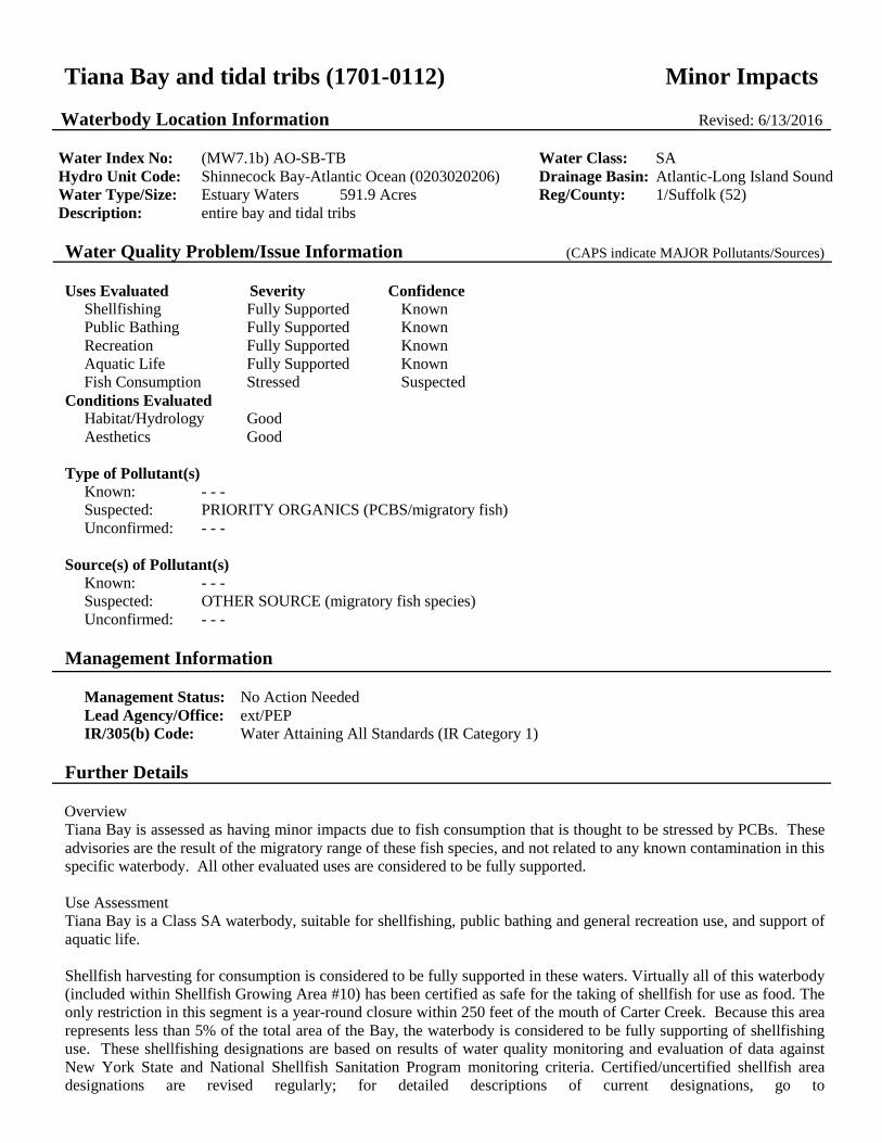
Tiana Bay and tidal tribs (1701-0112) Minor Impacts Waterbody Location Information Revised: 6/13/2016
Water Index No: (MW7.1b) AO-SB-TB Water Class: SA Hydro Unit Code: Shinnecock Bay-Atlantic Ocean (0203020206) Drainage Basin: Atlantic-Long Island Sound Water Type/Size: Estuary Waters 591.9 Acres Reg/County: 1/Suffolk (52) Description: entire bay and tidal tribs Water Quality Problem/Issue Information (CAPS indicate MAJOR Pollutants/Sources) Uses Evaluated Severity Confidence
Shellfishing Fully Supported Known Public Bathing Fully Supported Known Recreation Fully Supported Known Aquatic Life Fully Supported Known Fish Consumption Stressed Suspected
Conditions Evaluated Habitat/Hydrology Good Aesthetics Good
Type of Pollutant(s) Known: - - - Suspected: PRIORITY ORGANICS (PCBS/migratory fish) Unconfirmed: - - -
Source(s) of Pollutant(s) Known: - - - Suspected: OTHER SOURCE (migratory fish species) Unconfirmed: - - -
Management Information
Management Status: No Action Needed Lead Agency/Office: ext/PEP IR/305(b) Code: Water Attaining All Standards (IR Category 1)
Further Details Overview Tiana Bay is assessed as having minor impacts due to fish consumption that is thought to be stressed by PCBs. These advisories are the result of the migratory range of these fish species, and not related to any known contamination in this specific waterbody. All other evaluated uses are considered to be fully supported. Use Assessment Tiana Bay is a Class SA waterbody, suitable for shellfishing, public bathing and general recreation use, and support of aquatic life. Shellfish harvesting for consumption is considered to be fully supported in these waters. Virtually all of this waterbody (included within Shellfish Growing Area #10) has been certified as safe for the taking of shellfish for use as food. The only restriction in this segment is a year-round closure within 250 feet of the mouth of Carter Creek. Because this area represents less than 5% of the total area of the Bay, the waterbody is considered to be fully supporting of shellfishing use. These shellfishing designations are based on results of water quality monitoring and evaluation of data against New York State and National Shellfish Sanitation Program monitoring criteria. Certified/uncertified shellfish area designations are revised regularly; for detailed descriptions of current designations, go to

www.dec.ny.gov/regs/4014.html. (DEC/DFWMR, Region 1, July 2010)
Recreational use including public bathing is considered supported based on monitoring at beaches in the waterbody and shellfishing certification monitoring. Beach monitoring revealed no elevated bacteriological levels at beaches and no beach closures. Beaches within this reach include Tatiana Shores Beach. Additionally, bacteriological sampling conducted through the shellfishing monitoring program suggest public bathing is supported. (NYSDOH BEACH Act monitoring results, 2010 and DEC/DFWMR, July 2014)
Fish consumption is considered to be stressed due to NYSDOH precautionary health advisories recommending limiting consumption of larger weakfish (over 25 inches) and other species from these marine waters due to possible elevated levels of PCBs. These advisories are largely precautionary and are related to the specific habits and characteristics of these species, specifically the wide migratory range, predatory nature and high lipid/fat content that make them more likely to accumulate contaminants. In addition, for some species the advisories recommend limiting consumption to no more than one meal per week which is no more stringent than the general statewide advisory for all New York waters and does not result in significant impact to uses. Because possible contamination is more a result of the migratory range and other factors rather than any known sources of PCBs in this waterbody, fish consumption use in this segment is considered to be stressed rather than impaired. (NYS DOH Health Advisories and DEC/FWMR, Habitat, January 2014)
Water Quality Information Assessments of recreational uses and aquatic life in marine waters are based primarily on information from NYS and local health departments and the NYSDEC Division of Fish Wildlife and Marine Resources. This information is compiled and updated in regularly issued advisories and certifications regarding bathing beaches, shellfishing harvest and sportfish consumption. (NYSDOH and DEC/DFWMR, 2014)
Source Assessment Impacts to fish consumption are the result of elevated PCBs in fish species with a wide migratory range; there are no known PCB sources within the waterbody of significance.
Management Action This waterbody is also included within the South Shore Estuary Reserve (SSER). The SSER encompasses the tidal waters and watershed between the Nassau–Queens County line and the eastern boundary of Shinnecock Bay. The goals of the SSER Program outlined in the 2001 Comprehensive Management Plan (CMP) include improvement and maintenance of water quality, protection and restoration of living resources, expansion of public use and enjoyment, sustaining and of the estuary–related economy, and increasing education, outreach and stewardship. Program activities focus on point and nonpoint source pollution reduction, protection and restoration of water quality and coastal habitat, increasing shellfish harvesting, open space preservation and enhancing other public uses of the estuary. A vessel waste no discharge zone was established for the entire South Shore Estuary in 2009 to address impacts from boat pollution. (DEC/DOW, Region 1, March 2010)
Section 303(d) Listing Tiana Bay is not included on the current (2016) NYS Section 303(d) List of Impaired/TMDL Waters. There are no impacts that would justify the listing of this waterbody. (DEC/DOW, BWAM/WQAS, January 2015)
Segment Description This segment includes waters of the bay north of a line from Pine Neck to West Points.
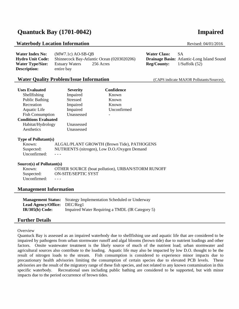
Quantuck Bay (1701-0042) Impaired Waterbody Location Information Revised: 04/01/2016
Water Index No: (MW7.1c) AO-SB-QB Water Class: SA Hydro Unit Code: Shinnecock Bay-Atlantic Ocean (0203020206) Drainage Basin: Atlantic-Long Island Sound Water Type/Size: Estuary Waters 256 Acres Reg/County: 1/Suffolk (52) Description: entire bay Water Quality Problem/Issue Information (CAPS indicate MAJOR Pollutants/Sources) Uses Evaluated Severity Confidence
Shellfishing Impaired Known Public Bathing Stressed Known Recreation Impaired Known Aquatic Life Impaired Unconfirmed Fish Consumption Unassessed -
Conditions Evaluated Habitat/Hydrology Unassessed Aesthetics Unassessed
Type of Pollutant(s) Known: ALGAL/PLANT GROWTH (Brown Tide), PATHOGENS Suspected: NUTRIENTS (nitrogen), Low D.O./Oxygen Demand Unconfirmed: - - -
Source(s) of Pollutant(s) Known: OTHER SOURCE (boat pollution), URBAN/STORM RUNOFF Suspected: ON-SITE/SEPTIC SYST Unconfirmed: - - -
Management Information
Management Status: Strategy Implementation Scheduled or Underway Lead Agency/Office: DEC/Reg1 IR/305(b) Code: Impaired Water Requiring a TMDL (IR Category 5)
Further Details Overview Quantuck Bay is assessed as an impaired waterbody due to shellfishing use and aquatic life that are considered to be impaired by pathogens from urban stormwater runoff and algal blooms (brown tide) due to nutrient loadings and other factors. Onsite wastewater treatment is the likely source of much of the nutrient load; urban stormwater and agricultural sources also contribute to the loading. Aquatic life may also be impacted by low D.O. thought to be the result of nitrogen loads to the stream. Fish consumption is considered to experience minor impacts due to precautionary health advisories limiting the consumption of certain species due to elevated PCB levels. These advisories are the result of the migratory range of these fish species, and not related to any known contamination in this specific waterbody. Recreational uses including public bathing are considered to be supported, but with minor impacts due to the period occurrence of brown tides.

Use Assessment Quantuk Bay is a Class SA waterbody, suitable for shellfishing, public bathing and general recreation use, and support of aquatic life. Shellfish harvesting for consumption purposes in the bay is restricted due to the seasonal designation of the entire area (included within the Quantuck Bay Shellfish Growing Area #9) as uncertified for the taking of shellfish for use as food. Shellfish that grow in contaminated waters can accumulate disease–causing microorganisms (bacteria, viruses) that can be eaten with the shellfish. This designation is based on results of water quality monitoring and evaluation of data against New York State and National Shellfish Sanitation Program monitoring criteria for pathogens. (DEC/DFWMR, Region 1, July 2010) NYS DOH has issued precautionary health advisories recommending limiting consumption of American eel, bluefish, striped bass and weakfish from these waters due to possible elevated levels of PCBs. These advisories are largely precautionary and are related to the specific habits and characteristics of these species, specifically the wide migratory range, predatory nature and high lipid/fat content that make them more likely to accumulate contaminants. Because possible contamination is more a result of the migratory range and other factors rather than any known sources of PCBs in this waterbody, fish consumption use in this segment is considered to be stressed. In addition, for some species the advisories recommend limiting consumption to no more than one meal per week which is no more stringent than the general statewide advisory for all New York waters and does not result in significant impact to uses. Health advisories regarding the consumption of fish are revised regularly; for the most current advisories, go to www.nyhealth.gov/environmental/outdoors/fish/fish.html. (2009–10 NYS DOH Health Advisories and DEC/DFWMR, Habitat, January 2010) Recreational use including public bathing is considered to be stressed based on monitoring at beaches in the segment and the shellfish advisory indicating uncertified shellfishing waters. There are no monitored beaches in this segment, but pathogen data collected through the shellfish monitoring program suggest recreational uses may experience impacts. (DEC/DOW, BWAM, August 2010) Water Quality Information Assessments of recreational uses and aquatic life in marine waters are based primarily on information from NYS and local health departments and the NYSDEC Division of Fish Wildlife and Marine Resources. This information is compiled and updated in regularly issued advisories and certifications regarding bathing beaches, shellfishing harvest and sportfish consumption. (NYSDOH and DEC/DFWMR, 2014) A Long Island dissolved oxygen monitoring effort led by The Nature Conservancy in collaboration with SUNY Stony Brook SoMAS and USGS began continuous monitoring of dissolved oxygen in a number of marine embayments in 2014. This sampling documented significant diurnal swings in dissolved oxygen during some summer periods. The initial results of this sampling are consistent with this assessment that aquatic life is known to be stressed by nutrients and the resulting episodic low dissolved oxygen. (DEC/DOW, BWAM, April 2016) Source Assessment Urban stormwater runoff and possibly residential onsite wastewater/septic systems are considered to be the primary sources of pathogens, although various other sources such as boat discharges, municipal wastewater discharges and waterfowl may also contribute. Since 1985, algal blooms resulting in extensive brown tide events have occurred periodically in this waterbody. The brown tide reduces light penetration, causing a die–off of seagrass beds, which in turn affects scallops, larval fish, and other species for which the seagrass provides critical habitat. There is evidence the algae may also generate some associated toxicity as be a poor nutrition source for desired species. Chronic brown tides are a likely impediment to ecosystem and fishery recovery efforts on Long Island's south shore. The tides are a known impairment to recreational uses in these waters. The conditions that promote algal growth and the resulting brown tide are the result of multiple factors, but elevated nitrogen loading is considered to be a key component. The primary source of nitrogen loads to the South Shore Estuary waters is thought to come from is onsite wastewater treatment (septic) systems delivered through groundwater.

Management Action Quantuck Bay was also among the waterbodies covered by the Long Island Waters Pathogen TMDL to address shellfishing impairments that was established in 2007. (DEC/DOW, BWAM/WQMS, July 2010)
The NYS Legislature authorized $5 million to DEC and the Long Island Regional Planning Council (LIRPC) for a Long Island nitrogen management and mitigation plan. Plan development – with active input from local stakeholders and public – is underway. Chief among the expectations for the plan is a focus on wastewater issues, including sewering of unsewered communities in Suffolk County and the evaluation and use of advanced alternative onsite wastewater treatment systems to reduce nitrogen loads from individual septic systems where sewering in not viable. (DEC/DOW, BRWM, November 2015)
This waterbody is also included within the South Shore Estuary Reserve (SSER). The SSER encompasses the tidal waters and watershed between the Nassau–Queens County line and the eastern boundary of Shinnecock Bay. The goals of the SSER Program outlined in the 2001 Comprehensive Management Plan (CMP) include improvement and maintenance of water quality, protection and restoration of living resources, expansion of public use and enjoyment, sustaining and of the estuary–related economy, and increasing education, outreach and stewardship. Program activities focus on point and nonpoint source pollution reduction, protection and restoration of water quality and coastal habitat, increasing shellfish harvesting, open space preservation and enhancing other public uses of the estuary. A vessel waste no discharge zone was established for the entire South Shore Estuary in 2009 to address impacts from boat pollution. (DEC/DOW, Region 1, March 2010)
Section 303(d) Listing Quantuck Bay is included on the current (2016) NYS Section 303(d) List of Impaired/TMDL Waters. The waterbody is included on Part 1 of the List as an impaired waterbody requiring development of a TMDL to address nitrogen. This waterbody was first listed on the 2010 List. The waterbody is also impaired by pathogens but was removed from the List in 2008 due to the completion of the Long Island Waters Pathogens (Shellfishing) TMDL in 2007. (DEC/DOW, BWAM, April 2016)
Segment Description This segment includes lower Class SA portions of Quantuck Creek (-158) and Aspatuck Creek (-159), below Route 27. The upper tidal Class SC portions of these creeks (above Route 27) are listed separately.

Tidal Tribs to Quantuck Bay/Canal (1701-0303) Minor Impacts Waterbody Location Information Revised: 6/13/2016
Water Index No: (MW7.1c) AO-SB-QB-157 thru 160(sel) Water Class: SC Hydro Unit Code: Shinnecock Bay-Atlantic Ocean (0203020206) Drainage Basin: Atlantic-Long Island Sound Water Type/Size: Estuary Waters 214.2 Acres Reg/County: 1/Suffolk (52) Description: total area of selected (Class SC) tribs to bay/canal Water Quality Problem/Issue Information (CAPS indicate MAJOR Pollutants/Sources) Uses Evaluated Severity Confidence
Shellfishing N/A - Public Bathing N/A - Recreation Stressed Suspected Aquatic Life Fully Supported Unconfirmed Fish Consumption Fully Supported Unconfirmed
Conditions Evaluated Habitat/Hydrology Unknown Aesthetics Unknown
Type of Pollutant(s) Known: Pathogens Suspected: - - - Unconfirmed: - - -
Source(s) of Pollutant(s) Known: - - - Suspected: Urban/Storm Runoff Unconfirmed: Onsite/Septic Systems
Management Information
Management Status: Strategy Implementation Scheduled or Underway Lead Agency/Office: ext/WQCC IR/305(b) Code: Water Attaining All Standards (IR Category 1)
Further Details Overview This tidal tribs waterbody is assessed as a waterbody having minor impacts due to recreational uses that are thought to be stressed by pathogens. This assessment is based on pathogens levels identified through shellfishing program monitoring. Use Assessment This tidal tribs waterbody is a Class SC waterbody, suitable for general recreation use and support of aquatic life, but not as a shellfishing water – although sampling of the waterbody has been included in the shellfish monitoring program – or for public bathing. All of this waterbody (included within Shellfish Growing Area #9) has been designated as uncertified or only seasonally certified for the taking of shellfish for use as food. Although this waterbody is monitored through the shellfish program and designated as uncertified, its Class SC designation does not include shellfishing as an appropriate use and this assessment does not include an evaluation for the support of shellfishing use. (DEC/DFWMR, Region 1, July 2015)

Recreational use including public bathing is thought to be stressed based on shellfishing certification monitoring. There are no regularly monitored beaches in this waterbody, but bacteriological sampling conducted through the shellfishing monitoring program indicate elevated pathogen levels. However criteria for shellfishing are lower than those for public bathing and additional bacteriological sampling is needed to more fully evaluate swimming use. (DEC/DFWMR, July 2014)
Based on other available indicators for other related uses, this waterbody is expected to support a healthy marine water fishery, although no specific fishery or biological reports are included in this assessment.
There are no health advisories in place limiting the consumption of fish from this waterbody (beyond the general advice for all waters). Fish consumption is considered to be fully supported based on the absence of any waterbody-specific advisory, but is noted as unconfirmed since routine monitoring of contaminants in fish is limited. (NYS DOH Health Advisories and DEC/DOW, BWAM, January 2014)
Water Quality Information Assessments of recreational uses and aquatic life in marine waters are based primarily on information from NYS and local health departments and the NYSDEC Division of Fish Wildlife and Marine Resources. This information is compiled and updated in regularly issued advisories and certifications regarding bathing beaches, shellfishing harvest and sportfish consumption. (NYSDOH and DEC/DFWMR, 2014)
Source Assessment Based on surrounding land use and other knowledge of the waterbody, the most likely sources of pathogens to the waterbody are largely nonpoint runoff from developed urban and residential areas agricultural activity and open space/forest; direct waterfowl/wildlife inputs; and boats and marinas. Onsite/septic systems have also been identified as a possible contributing source. Relative contributions from each type of source are very site-specific in nature, particularly in localized areas of study. (DEC/DOW, BWRM, September 2015)
Management Action The NYS Legislature authorized $5 million to DEC and the Long Island Regional Planning Council (LIRPC) for a Long Island nitrogen management and mitigation plan. Plan development – with active input from local stakeholders and public – is underway. Chief among the expectations for the plan is a focus on wastewater issues, including sewering of unsewered communities in Suffolk County and the evaluation and use of advanced alternative onsite wastewater treatment systems to reduce nitrogen loads from individual septic systems where sewering in not viable. (DEC/DOW, BRWM, November 2015)
This waterbody is also included within the South Shore Estuary Reserve (SSER). The SSER encompasses the tidal waters and watershed between the Nassau–Queens County line and the eastern boundary of Shinnecock Bay. The goals of the SSER Program outlined in the 2001 Comprehensive Management Plan (CMP) include improvement and maintenance of water quality, protection and restoration of living resources, expansion of public use and enjoyment, sustaining and of the estuary–related economy, and increasing education, outreach and stewardship. Program activities focus on point and nonpoint source pollution reduction, protection and restoration of water quality and coastal habitat, increasing shellfish harvesting, open space preservation and enhancing other public uses of the estuary. A vessel waste no discharge zone was established for the entire South Shore Estuary in 2009 to address impacts from boat pollution. (DEC/DOW, Region 1, March 2010)
Section 303(d) Listing Tidal Tribs to Quantuck Bay/Canal is not included on the current (2016) NYS Section 303(d) List of Impaired/TMDL Waters. There appear to be no impacts that would justify the listing of this waterbody. (DEC/DOW, BWAM/WQAS, January 2015)
Segment Description This segment includes Class SC portions of unnamed trib (-157), Quantuck Creek (-158), Aspatuck River (-159) and unnamed trib (-160).

Old Ice Pond (1701-0304) Unassessed Waterbody Location Information Revised: 6/21/2016
Water Index No: (MW7.1c) AO-SB-QB-158-P835a Water Class: B Hydro Unit Code: Shinnecock Bay-Atlantic Ocean (0203020206) Drainage Basin: Atlantic-Long Island Sound Water Type/Size: Estuary Waters 10 Acres Reg/County: 1/Suffolk (52) Description: entire pond Water Quality Problem/Issue Information (CAPS indicate MAJOR Pollutants/Sources) Uses Evaluated Severity Confidence
Water Supply N/A - Public Bathing Unassessed - Recreation Unassessed - Aquatic Life Unassessed - Fish Consumption Unassessed -
Conditions Evaluated Habitat/Hydrology Unknown Aesthetics Unknown
Type of Pollutant(s) Known: - - - Suspected: - - - Unconfirmed: - - -
Source(s) of Pollutant(s) Known: - - - Suspected: - - - Unconfirmed: - - -
Management Information
Management Status: Unassessed Lead Agency/Office: DOW/BWAM IR/305(b) Code: Water with Insufficient Data (IR Category 3)
Further Details Overview Currently there is inadequate data/information to evaluate uses and determine a water quality assessment for this waterbody. Use Assessment Old Ice Pond is a Class B waterbody, suitable for public bathing and general recreation use and support of aquatic life, but not as a water supply. Water Quality Information There is currently no water quality information available upon which to base an assessment. Source Assessment Specific sources of pollutants to the waterbody have not been identified. Management Action No specific management actions have been identified for the waterbody. Baseline sampling to evaluate conditions in

this waterbody segment is needed. Section 303(d) Listing This waterbody is not included on the current (2016) NYS Section 303(d) List of Impaired/TMDL Waters. There is insufficient information to make a listing decision. (DEC/DOW, BWAM/WQAS, January 2016) Segment Description This segment includes the total area of the Pond.

Quantuck Canal/Moneybogue Bay (1701-0371) Impaired Waterbody Location Information Revised: 6/13/2016
Water Index No: (MW7.1c) AO-SB-QB-QtC Water Class: SA Hydro Unit Code: Shinnecock Bay-Atlantic Ocean (0203020206) Drainage Basin: Atlantic-Long Island Sound Water Type/Size: Estuary Waters 114.9 Acres Reg/County: 1/Suffolk (52) Description: entire canal/bay, as described below Water Quality Problem/Issue Information (CAPS indicate MAJOR Pollutants/Sources) Uses Evaluated Severity Confidence
Shellfishing Impaired Known Public Bathing Stressed Unconfirmed Recreation Stressed Known Aquatic Life Fully Supported Unconfirmed Fish Consumption Fully Supported Unconfirmed
Conditions Evaluated Habitat/Hydrology Good Aesthetics Good
Type of Pollutant(s) Known: PATHOGENS Suspected: - - - Unconfirmed: - - -
Source(s) of Pollutant(s) Known: URBAN/STORM RUNOFF, Agriculture Suspected: OTHER SOURCE (waterfowl/wildlife) Unconfirmed: - - -
Management Information
Management Status: Strategy Implementation Scheduled or Underway Lead Agency/Office: ext/WQCC IR/305(b) Code: Impaired Water, TMDL Completed (IR Category 4a)
Further Details Overview Quantuck Canal/Moneybogue Bay is assessed as an impaired waterbody due to shellfishing use that is considered to be impaired by pathogens. This assessment is based on year-round and seasonal shellfishing closures. Urban and storm runoff are the primary sources of pathogens, although various other sources such as waterfowl/wildlife may also contribute. Public bathing and other recreational uses are fully supported, however these uses may also be stressed or threatened, as a result of the shellfishing restrictions and related pathogen levels. Use Assessment Quantuck Canal/Moneybogue Bay is a Class SA waterbody, suitable for shellfishing, public bathing and general recreation use, and support of aquatic life. Shellfish harvesting for consumption is considered to be impaired in these waters. All of this waterbody (included within Shellfish Growing Area #9) has been designated uncertified or only seasonally certified for the taking of shellfish for use as food. Seasonal restrictions apply to the entire canal and bay; year-round restrictions apply to the Stevens Park Yacht Basin and other smaller boat basins. Shellfish that grow in contaminated waters can accumulate disease-causing microorganisms (bacteria, viruses) that can be eaten with the shellfish. These shellfishing designations

are based on results of water quality sampling and evaluation of data against New York State and National Shellfish Sanitation Program monitoring criteria and/or shoreline surveys of actual or potential sources of contamination. Certified/uncertified shellfish area designations are revised regularly; for the most up to date and detailed descriptions of current designations, go to www.dec.ny.gov/regs/4014.html. (DEC/DFWMR, Region 1, July 2010)
Recreational use including public bathing is thought to be stressed based on shellfishing certification monitoring. There are no regularly monitored beaches in this waterbody, but bacteriological sampling conducted through the shellfishing monitoring program indicate elevated pathogen levels. However criteria for shellfishing are lower than those for public bathing and additional bacteriological sampling is needed to more fully evaluate swimming use. Restrictions on shellfishing represent an impact to recreational use. (DEC/DFWMR, July 2014)
Based on other available indicators for other related uses, this waterbody is expected to support a healthy marine water fishery, although no specific fishery or biological reports are included in this assessment.
There are no health advisories in place limiting the consumption of fish from this waterbody (beyond the general advice for all waters). Fish consumption is considered to be fully supported based on the absence of any waterbody-specific advisory, but is noted as unconfirmed since routine monitoring of contaminants in fish is limited. (NYS DOH Health Advisories and DEC/DOW, BWAM, January 2014)
Water Quality Information Assessments of recreational uses and aquatic life in marine waters are based primarily on information from NYS and local health departments and the NYSDEC Division of Fish Wildlife and Marine Resources. This information is compiled and updated in regularly issued advisories and certifications regarding bathing beaches, shellfishing harvest and sportfish consumption. (NYSDOH and DEC/DFWMR, 2014)
Source Assessment Based on surrounding land use and other knowledge of the waterbody, the most likely sources of pathogens to the waterbody are largely nonpoint runoff from developed and undeveloped lands, agricultural activity and open space/forest; direct waterfowl/wildlife inputs and boats and marinas also may contribute. Relative contributions from each type of source are very site-specific in nature, particularly in localized areas of study. (DEC/DOW, BWRM, September 2015)
Management Action Quantuck Canal/Moneybogue Bay was among the waterbodies covered by the Long Island Pathogen TMDL to address shellfishing impairments that was established in 2007. (DEC/DOW, BWAM/WQMS, July 2010)
The NYS Legislature authorized $5 million to DEC and the Long Island Regional Planning Council (LIRPC) for a Long Island nitrogen management and mitigation plan. Plan development – with active input from local stakeholders and public – is underway. Chief among the expectations for the plan is a focus on wastewater issues, including sewering of unsewered communities in Suffolk County and the evaluation and use of advanced alternative onsite wastewater treatment systems to reduce nitrogen loads from individual septic systems where sewering in not viable. (DEC/DOW, BRWM, November 2015)
This waterbody is also included within the South Shore Estuary Reserve (SSER). The SSER encompasses the tidal waters and watershed between the Nassau–Queens County line and the eastern boundary of Shinnecock Bay. The goals of the SSER Program outlined in the 2001 Comprehensive Management Plan (CMP) include improvement and maintenance of water quality, protection and restoration of living resources, expansion of public use and enjoyment, sustaining and of the estuary–related economy, and increasing education, outreach and stewardship. Program activities focus on point and nonpoint source pollution reduction, protection and restoration of water quality and coastal habitat, increasing shellfish harvesting, open space preservation and enhancing other public uses of the estuary. A vessel waste no discharge zone was established for the entire South Shore Estuary in 2009 to address impacts from boat pollution. (DEC/DOW, Region 1, March 2010)
Section 303(d) Listing Quantuck Canal/Moneybogue Bay is not included on the current (2016) NYS Section 303(d) List of Impaired/TMDL Waters. Although it is assessed as an impaired water, it is categorized as an IR Category 4a water that is not listed due

to the inclusion of the waterbody in the 2007 Long Island Pathogens (Shellfishing) TMDL. (DEC/DOW, BWAM, January 2015) Segment Description This segment includes tidal waters between the Bascule Bridge at Jessup Lane to Quantuck Bay.

Moriches Bay, East (1701-0305) Impaired Waterbody Location Information Revised: 6/13/2016
Water Index No: (MW7.2a) AO-MB (portion 1) Water Class: SA Hydro Unit Code: Shinnecock Bay-Atlantic Ocean (0203020206) Drainage Basin: Atlantic-Long Island Sound Water Type/Size: Estuary Waters 3142 Acres Reg/County: 1/Suffolk (52) Description: portion of bay, as described below Water Quality Problem/Issue Information (CAPS indicate MAJOR Pollutants/Sources) Uses Evaluated Severity Confidence
Shellfishing Stressed Known Public Bathing Stressed Known Recreation Impaired Known Aquatic Life Impaired Unconfirmed Fish Consumption Stressed Suspected
Conditions Evaluated Habitat/Hydrology Good Aesthetics Fair
Type of Pollutant(s) Known: ALGAL/PLANT GROWTH (Brown Tide), Pathogens Suspected: NUTRIENTS (nitrogen), Low D.O./Oxygen Demand Unconfirmed: - - -
Source(s) of Pollutant(s) Known: OTHER SOURCE (boat pollution), URBAN/STORM RUNOFF, AGRICULTURE Suspected: ON-SITE/SEPTIC SYST Unconfirmed: - - -
Management Information
Management Status: Strategy Implementation Scheduled or Underway Lead Agency/Office: DEC/Reg1 IR/305(b) Code: Impaired Water Requiring a TMDL (IR Category 5)
Further Details Overview This portion of Moriches Bay is assessed as an impaired waterbody due to recreational uses that are considered to be impaired by pathogens from urban stormwater runoff and algal blooms (brown tide) due to nutrient loadings and other factors. Onsite wastewater treatment is the likely source of much of the nutrient load; urban stormwater and agricultural sources also contribute to the loading. Aquatic life may also be impacted by low D.O. thought to be the result of nitrogen loads to the stream. Fish consumption is considered to experience minor impacts due to precautionary health advisories limiting the consumption of certain species due to elevated PCB levels. These advisories are the result of the migratory range of these fish species, and not related to any known contamination in this specific waterbody. Recreational uses including public bathing are considered to be supported, but with minor impacts due to the period occurrence of brown tides. Use Assessment This portion of Moriches Bay is a Class SA waterbody, suitable for shellfishing, public bathing, general recreation use and support of aquatic life. Much of this portion of Moriches Bay (Shellfish Growing Area #8) has been certified as safe for the taking of shellfish

for use as food. Shellfishing restrictions are in place for numerous coves and adjacent tribs of the bay, however many of these restrictions apply to Class SC waters, which are captured in other segment assessments. The remaining areas where shellfishing is restricted (year-round restrictions for Beaverdam and Speonk Coves and a number of smaller boat basins and coves; seasonal restrictions in the eastern and northeastern portion of the bay) are small relative to the bay. As a result of these considerations, shellfishing use in the bay is listed as stressed. These shellfishing designations are based on results of water quality monitoring and evaluation of data against New York State and National Shellfish Sanitation Program monitoring criteria for pathogens. Certified/uncertified shellfish area designations are revised regularly; for detailed descriptions of current designations, go to www.dec.ny.gov/regs/4014.html. Although more than 90% of the waters of the Bay are certified for the taking of shellfish, this use is considered to be stressed due to the smaller areas that remain uncertified and the impact of brown tide on the shellfish population. (DEC/DFWMR, Region 1, July 2010) Recreational use including public bathing is considered to be impacted based on the periodic occurrence of harmful algal blooms (HABs) in the Bay. Public bathing is also affected by the HABs, however monitoring conducted through the shellfishing program that results in most of the Bay being certified for shellfishing indicates that there are no significant impacts from pathogens. There are no regularly monitored beaches in this segment. (DEC/DOW, BWAM, May 2016) Aquatic life in the waterbody is considered to be stressed due to periodic low dissolved oxygen, the result of elevated nitrogen loadings. Nitrogen source including residential wastewater, urban/storm runoff and atmospheric deposition promote algal growth, die-off, settlement to the sediment, and create and oxygen demand which results in low dissolved oxygen in the bottom waters of the Bay. The resulting low dissolved oxygen conditions impact the fishery and other aquatic life. (DEC/DOW and FWMR, Region 1, August 2015) NYS DOH has issued precautionary health advisories recommending limiting consumption of American eel, bluefish, striped bass and weakfish from these waters due to possible elevated levels of PCBs. These advisories are largely precautionary and are related to the specific habits and characteristics of these species, specifically the wide migratory range, predatory nature and high lipid/fat content that make them more likely to accumulate contaminants. Because possible contamination is more a result of the migratory range and other factors rather than any known sources of PCBs in this waterbody, fish consumption use in this segment is considered to be stressed. In addition, for some species the advisories recommend limiting consumption to no more than one meal per week which is no more stringent than the general statewide advisory for all New York waters and does not result in significant impact to uses. Health advisories regarding the consumption of fish are revised regularly; for the most current advisories, go to www.nyhealth.gov/environmental/outdoors/fish/fish.html. (2009-10 NYS DOH Health Advisories and DEC/DFWMR, Habitat, January 2010) Water Quality Information Assessments of recreational uses and aquatic life in marine waters are based primarily on information from NYS and local health departments and the NYSDEC Division of Fish Wildlife and Marine Resources. This information is compiled and updated in regularly issued advisories and certifications regarding bathing beaches, shellfishing harvest and sportfish consumption. (NYSDOH and DEC/DFWMR, 2014) A Long Island dissolved oxygen monitoring effort led by The Nature Conservancy in collaboration with SUNY Stony Brook SoMAS and USGS began continuous monitoring of dissolved oxygen in a number of marine embayments in 2014. This sampling documented significant diurnal swings in dissolved oxygen during some summer periods. The initial results of this sampling are consistent with this assessment that aquatic life is known to be stressed by nutrients and the resulting episodic low dissolved oxygen. (DEC/DOW, BWAM, April 2016) Source Assessment Urban stormwater runoff and possibly residential onsite wastewater/septic systems are considered to be the primary sources of pathogens, although various other sources such as boat discharges, municipal wastewater discharges and waterfowl may also contribute. Algal blooms resulting in extensive brown tide events have occurred regularly in this waterbody. The brown tide reduces light penetration, causing a die-off of seagrass beds, which in turn affects scallops, larval fish, and other species for which the seagrass provides critical habitat. There is evidence the algae may also generate some associated

toxicity as be a poor nutrition source for desired species. Chronic brown tides are a likely impediment to ecosystem and fishery recovery efforts on Long Island's south shore. The tides are a known impairment to recreational uses in these waters. The conditions that promote algal growth and the resulting brown tide are the result of multiple factors, but elevated nitrogen loading is considered to be a key component. The primary source of nitrogen loads to the South Shore Estuary waters is thought to come from is onsite wastewater treatment (septic) systems delivered through groundwater.
Management Action East Moriches Bay is included on the Section 303(d) List for eventual development of a TMDL or other restoration strategy (see below).
The NYS Legislature authorized $5 million to DEC and the Long Island Regional Planning Council (LIRPC) for a Long Island nitrogen management and mitigation plan. Plan development – with active input from local stakeholders and public – is underway. Chief among the expectations for the plan is a focus on wastewater issues, including sewering of unsewered communities in Suffolk County and the evaluation and use of advanced alternative onsite wastewater treatment systems to reduce nitrogen loads from individual septic systems where sewering in not viable. (DEC/DOW, BRWM, November 2015)
This waterbody is also included within the South Shore Estuary Reserve (SSER). The SSER encompasses the tidal waters and watershed between the Nassau–Queens County line and the eastern boundary of Shinnecock Bay. The goals of the SSER Program outlined in the 2001 Comprehensive Management Plan (CMP) include improvement and maintenance of water quality, protection and restoration of living resources, expansion of public use and enjoyment, sustaining and of the estuary-related economy, and increasing education, outreach and stewardship. Program activities focus on point and nonpoint source pollution reduction, protection and restoration of water quality and coastal habitat, increasing shellfish harvesting, open space preservation and enhancing other public uses of the estuary. A vessel waste no discharge zone was established for the entire South Shore Estuary in 2009 to address impacts from boat pollution. (DEC/DOW, Region 1, March 2010)
Section 303(d) Listing This portion of Moriches Bay is included on the current (2016) NYS Section 303(d) List of Impaired/TMDL Waters. The waterbody is included on Part 1 of the List as an impaired waterbody requiring development of a TMDL to address nitrogen and resulting low dissolved oxygen. This waterbody was first listed on the 2010 List. (DEC/DOW, BWAM, April 2016)
Segment Description This segment includes the bay east of a line from Havens Point and west of Potunk Point (Jessup Lane) and including smaller coves and tributaries; but excluding Harts/Seatuck Coves. Many larger tributaries are listed separately.

Moriches Bay, West (1701-0038) Impaired Waterbody Location Information Revised: 9/15/2010
Water Index No: (MW7.2a) AO-MB (portion 2) Water Class: SA Hydro Unit Code: Shinnecock Bay-Atlantic Ocean (0203020206) Drainage Basin: Atlantic-Long Island Sound Water Type/Size: Estuary Waters 3011.5 Acres Reg/County: 1/Suffolk (52) Description: portion of bay, as described below Water Quality Problem/Issue Information (CAPS indicate MAJOR Pollutants/Sources) Uses Evaluated Severity Confidence
Shellfishing Stressed Known Public Bathing Stressed Known Recreation Impaired Known Aquatic Life Impaired Unconfirmed Fish Consumption Stressed Suspected
Conditions Evaluated Habitat/Hydrology Good Aesthetics Fair
Type of Pollutant(s) Known: ALGAL/PLANT GROWTH (Brown Tide), Pathogens Suspected: NUTRIENTS (nitrogen), Low D.O./Oxygen Demand Unconfirmed: - - -
Source(s) of Pollutant(s) Known: OTHER SOURCE (boat pollution), URBAN/STORM RUNOFF, AGRICULTURE Suspected: ON-SITE/SEPTIC SYST Unconfirmed: - - -
Management Information
Management Status: Strategy Implementation Scheduled or Underway Lead Agency/Office: DEC/Reg1 IR/305(b) Code: Impaired Water Requiring a TMDL (IR Category 5)
Further Details Overview This portion of Moriches Bay is assessed as an impaired waterbody due to recreational uses that are considered to be impaired by pathogens from urban stormwater runoff and algal blooms (brown tide) due to nutrient loadings and other factors. Onsite wastewater treatment is the likely source of much of the nutrient load; urban stormwater and agricultural sources also contribute to the loading. Aquatic life may also be impacted by low D.O. thought to be the result of nitrogen loads to the stream. Fish consumption is considered to experience minor impacts due to precautionary health advisories limiting the consumption of certain species due to elevated PCB levels. These advisories are the result of the migratory range of these fish species, and not related to any known contamination in this specific waterbody. Recreational uses including public bathing are considered to be supported, but with minor impacts due to the period occurrence of brown tides. Use Assessment This portion of Moriches Bay is a Class SA waterbody, suitable for shellfishing, public bathing, general recreation use and support of aquatic life. Much of this portion of Moriches Bay (Shellfish Growing Area #8) has been certified as safe for the taking of shellfish

for use as food. Shellfishing restrictions are in place for numerous coves and adjacent tribs of the bay, however many of these restrictions apply to Class SC waters, which are captured in other segment assessments. The remaining areas where shellfishing is restricted (year–round restrictions at the mouth of the Terrell River; seasonal restrictions for an inlet on Fire Island) are small relative to the bay. As a result of these considerations, shellfishing use in the bay is listed as stressed. These shellfishing designations are based on results of water quality monitoring and evaluation of data against New York State and National Shellfish Sanitation Program monitoring criteria for pathogens. Certified/uncertified shellfish area designations are revised regularly; for detailed descriptions of current designations, go to www.dec.ny.gov/regs/4014.html. Although more than 90% of the waters of the Bay are certified for the taking of shellfish, this use is considered to be stressed due to the smaller areas that remain uncertified and the impact of brown tide on the shellfish population. (DEC/DFWMR, Region 1, July 2010) Recreational use including public bathing is considered to be impacted based on the periodic occurrence of harmful algal blooms (HABs) in the Bay. Public bathing is also affected by the HABs, however monitoring conducted through the shellfishing program that results in most of the Bay being certified for shellfishing indicates that there are no significant impacts from pathogens. There are no regularly monitored beaches in this segment. (DEC/DOW, BWAM, May 2016) Aquatic life in the waterbody is considered to be stressed due to periodic low dissolved oxygen, the result of elevated nitrogen loadings. Nitrogen source including residential wastewater, urban/storm runoff and atmospheric deposition promote algal growth, die-off, settlement to the sediment, and create and oxygen demand which results in low dissolved oxygen in the bottom waters of the Bay. The resulting low dissolved oxygen conditions impact the fishery and other aquatic life. (DEC/DOW and FWMR, Region 1, August 2015) NYS DOH has issued precautionary health advisories recommending limiting consumption of American eel, bluefish, striped bass and weakfish from these waters due to possible elevated levels of PCBs. These advisories are largely precautionary and are related to the specific habits and characteristics of these species, specifically the wide migratory range, predatory nature and high lipid/fat content that make them more likely to accumulate contaminants. Because possible contamination is more a result of the migratory range and other factors rather than any known sources of PCBs in this waterbody, fish consumption use in this segment is considered to be stressed. In addition, for some species the advisories recommend limiting consumption to no more than one meal per week which is no more stringent than the general statewide advisory for all New York waters and does not result in significant impact to uses. Health advisories regarding the consumption of fish are revised regularly; for the most current advisories, go to www.nyhealth.gov/environmental/outdoors/fish/fish.html. (2009-10 NYS DOH Health Advisories and DEC/DFWMR, Habitat, January 2010) Water Quality Information Assessments of recreational uses and aquatic life in marine waters are based primarily on information from NYS and local health departments and the NYSDEC Division of Fish Wildlife and Marine Resources. This information is compiled and updated in regularly issued advisories and certifications regarding bathing beaches, shellfishing harvest and sportfish consumption. (NYSDOH and DEC/DFWMR, 2014) A Long Island dissolved oxygen monitoring effort led by The Nature Conservancy in collaboration with SUNY Stony Brook SoMAS and USGS began continuous monitoring of dissolved oxygen in a number of marine embayments in 2014. This sampling documented significant diurnal swings in dissolved oxygen during some summer periods. The initial results of this sampling are consistent with this assessment that aquatic life is known to be stressed by nutrients and the resulting episodic low dissolved oxygen. (DEC/DOW, BWAM, April 2016) Source Assessment Urban stormwater runoff and possibly residential onsite wastewater/septic systems are considered to be the primary sources of pathogens, although various other sources such as boat discharges, municipal wastewater discharges and waterfowl may also contribute. Algal blooms resulting in extensive brown tide events have occurred regularly in this waterbody. The brown tide reduces light penetration, causing a die-off of seagrass beds, which in turn affects scallops, larval fish, and other species for which the seagrass provides critical habitat. There is evidence the algae may also generate some associated toxicity as be a poor nutrition source for desired species. Chronic brown tides are a likely impediment to ecosystem

and fishery recovery efforts on Long Island's south shore. The tides are a known impairment to recreational uses in these waters. The conditions that promote algal growth and the resulting brown tide are the result of multiple factors, but elevated nitrogen loading is considered to be a key component. The primary source of nitrogen loads to the South Shore Estuary waters is thought to come from is onsite wastewater treatment (septic) systems delivered through groundwater.
Management Action West Moriches Bay is included on the Section 303(d) List for eventual development of a TMDL or other restoration strategy (see below).
The NYS Legislature authorized $5 million to DEC and the Long Island Regional Planning Council (LIRPC) for a Long Island nitrogen management and mitigation plan. Plan development – with active input from local stakeholders and public – is underway. Chief among the expectations for the plan is a focus on wastewater issues, including sewering of unsewered communities in Suffolk County and the evaluation and use of advanced alternative onsite wastewater treatment systems to reduce nitrogen loads from individual septic systems where sewering in not viable. (DEC/DOW, BRWM, November 2015)
This waterbody is also included within the South Shore Estuary Reserve (SSER). The SSER encompasses the tidal waters and watershed between the Nassau–Queens County line and the eastern boundary of Shinnecock Bay. The goals of the SSER Program outlined in the 2001 Comprehensive Management Plan (CMP) include improvement and maintenance of water quality, protection and restoration of living resources, expansion of public use and enjoyment, sustaining and of the estuary-related economy, and increasing education, outreach and stewardship. Program activities focus on point and nonpoint source pollution reduction, protection and restoration of water quality and coastal habitat, increasing shellfish harvesting, open space preservation and enhancing other public uses of the estuary. A vessel waste no discharge zone was established for the entire South Shore Estuary in 2009 to address impacts from boat pollution. (DEC/DOW, Region 1, March 2010)
Section 303(d) Listing This portion of Moriches Bay is included on the current (2016) NYS Section 303(d) List of Impaired/TMDL Waters. The waterbody is included on Part 1 of the List as an impaired waterbody requiring development of a TMDL to address nitrogen and resulting low dissolved oxygen. This waterbody was first listed on the 2010 List. (DEC/DOW, BWAM, April 2016)
Segment Description This segment includes the bay east of a line south from Floyd Point, south of a line from Floyd Point to Davids Point, west of a line south of Havens Point (Jessup Lane) and including smaller coves and tributaries; but excluding Tuthill/Harts/Seatuck Coves. Many larger tributaries are listed separately.

Tuthill, Harts, Seatuck Coves (1701-0309) Impaired Waterbody Location Information Revised: 6/13/2016
Water Index No: (MW7.2a) AO-MB (portion 3) Water Class: SA Hydro Unit Code: Shinnecock Bay-Atlantic Ocean (0203020206) Drainage Basin: Atlantic-Long Island Sound Water Type/Size: Estuary Waters 1049.8 Acres Reg/County: 1/Suffolk (52) Description: total area of all three coves Water Quality Problem/Issue Information (CAPS indicate MAJOR Pollutants/Sources) Uses Evaluated Severity Confidence
Shellfishing Precluded Known Public Bathing Stressed Unconfirmed Recreation Stressed Known Aquatic Life Fully Supported Unconfirmed Fish Consumption Fully Supported Unconfirmed
Conditions Evaluated Habitat/Hydrology Good Aesthetics Good
Type of Pollutant(s) Known: PATHOGENS Suspected: - - - Unconfirmed: - - -
Source(s) of Pollutant(s) Known: URBAN/STORM RUNOFF, Agriculture Suspected: OTHER SOURCE (waterfowl/wildlife) Unconfirmed: - - -
Management Information
Management Status: Strategy Implementation Scheduled or Underway Lead Agency/Office: ext/WQCC IR/305(b) Code: Impaired Water, TMDL Completed (IR Category 4a)
Further Details Overview The Tuthill, Hart, Seatuck Coves waterbody is assessed as an impaired waterbody due to shellfishing use that is considered to be precluded by pathogens. This assessment is based on year-round shellfishing closures. Urban and storm runoff are the primary sources of pathogens, although various other sources such as waterfowl/wildlife may also contribute. Public bathing and other recreational uses are fully supported, however these uses may also be stressed or threatened, as a result of the shellfishing restrictions and related pathogen levels. Use Assessment The Tuthill, Hars, Seatuck Coves waterbody is a Class SA waterbody, suitable for shellfishing, public bathing and general recreation use, and support of aquatic life. Shellfish harvesting for consumption is considered to be precluded in these waters. All of this waterbody (included within Shellfish Growing Area #8) has been designated uncertified for the taking of shellfish for use as food. Shellfish that grow in contaminated waters can accumulate disease-causing microorganisms (bacteria, viruses) that can be eaten with the shellfish. These shellfishing designations are based on results of water quality sampling and evaluation of data against New York State and National Shellfish Sanitation Program monitoring criteria and/or shoreline surveys of

actual or potential sources of contamination. Certified/uncertified shellfish area designations are revised regularly; for the most up to date and detailed descriptions of current designations, go to www.dec.ny.gov/regs/4014.html. (DEC/DFWMR, Region 1, July 2010)
Recreational use including public bathing is thought to be stressed based on shellfishing certification monitoring. There are no regularly monitored beaches in this waterbody, but bacteriological sampling conducted through the shellfishing monitoring program indicate elevated pathogen levels. However criteria for shellfishing are lower than those for public bathing and additional bacteriological sampling is needed to more fully evaluate swimming use. Restrictions on shellfishing represent an impact to recreational use. (DEC/DFWMR, July 2014)
Based on other available indicators for other related uses, this waterbody is expected to support a healthy marine water fishery, although no specific fishery or biological reports are included in this assessment.
There are no health advisories in place limiting the consumption of fish from this waterbody (beyond the general advice for all waters). Fish consumption is considered to be fully supported based on the absence of any waterbody-specific advisory, but is noted as unconfirmed since routine monitoring of contaminants in fish is limited. (NYS DOH Health Advisories and DEC/DOW, BWAM, January 2014)
Water Quality Information Assessments of recreational uses and aquatic life in marine waters are based primarily on information from NYS and local health departments and the NYSDEC Division of Fish Wildlife and Marine Resources. This information is compiled and updated in regularly issued advisories and certifications regarding bathing beaches, shellfishing harvest and sportfish consumption. (NYSDOH and DEC/DFWMR, 2014)
Source Assessment Based on surrounding land use and other knowledge of the waterbody, the most likely sources of pathogens to the waterbody are largely nonpoint runoff from developed and undeveloped lands, agricultural activity and open space/forest; direct waterfowl/wildlife inputs and boats and marinas also may contribute. Relative contributions from each type of source are very site-specific in nature, particularly in localized areas of study. (DEC/DOW, BWRM, September 2015)
Management Action Tuthill, Harts, Seatuck Coves weere among the waterbodies covered by the Long Island Pathogen TMDL to address shellfishing impairments that was established in 2007. (DEC/DOW, BWAM/WQMS, July 2010)
The NYS Legislature authorized $5 million to DEC and the Long Island Regional Planning Council (LIRPC) for a Long Island nitrogen management and mitigation plan. Plan development – with active input from local stakeholders and public – is underway. Chief among the expectations for the plan is a focus on wastewater issues, including sewering of unsewered communities in Suffolk County and the evaluation and use of advanced alternative onsite wastewater treatment systems to reduce nitrogen loads from individual septic systems where sewering in not viable. (DEC/DOW, BRWM, November 2015)
This waterbody is also included within the South Shore Estuary Reserve (SSER). The SSER encompasses the tidal waters and watershed between the Nassau–Queens County line and the eastern boundary of Shinnecock Bay. The goals of the SSER Program outlined in the 2001 Comprehensive Management Plan (CMP) include improvement and maintenance of water quality, protection and restoration of living resources, expansion of public use and enjoyment, sustaining and of the estuary–related economy, and increasing education, outreach and stewardship. Program activities focus on point and nonpoint source pollution reduction, protection and restoration of water quality and coastal habitat, increasing shellfish harvesting, open space preservation and enhancing other public uses of the estuary. A vessel waste no discharge zone was established for the entire South Shore Estuary in 2009 to address impacts from boat pollution. (DEC/DOW, Region 1, March 2010)
Section 303(d) Listing The Tuthill, Harts, Seatuck Coves waterbody is not included on the current (2016) NYS Section 303(d) List of Impaired/TMDL Waters. Although it is assessed as an impaired water, it is categorized as an IR Category 4a water that is not listed due to the inclusion of the waterbody in the 2007 Long Island Pathogens (Shellfishing) TMDL.

(DEC/DOW, BWAM, January 2015) Segment Description This segment includes the waters of the coves north of a line from Tuthill Cove to the foot of Remsen Lane. These waters are Class SA; the northern portion of Harts Cove is Class SC and is listed separately.

Forge River, Lower and Cove (1701-0316) Impaired Waterbody Location Information Revised: 9/15/2010
Water Index No: (MW7.2a) AO-MB (portion 4) Water Class: SA Hydro Unit Code: Shinnecock Bay-Atlantic Ocean (0203020206) Drainage Basin: Atlantic-Long Island Sound Water Type/Size: Estuary Waters 996.6 Acres Reg/County: 1/Suffolk (52) Description: reach from mouth to Ely Creek (Class SA portion) Water Quality Problem/Issue Information (CAPS indicate MAJOR Pollutants/Sources) Uses Evaluated Severity Confidence
Shellfishing Precluded Known Public Bathing Stressed Unconfirmed Recreation Stressed Known Aquatic Life Stressed Suspected Fish Consumption Fully Supported Unconfirmed
Conditions Evaluated Habitat/Hydrology Good Aesthetics Fair
Type of Pollutant(s) Known: PATHOGENS Suspected: - - - Unconfirmed: - - -
Source(s) of Pollutant(s) Known: URBAN/STORM RUNOFF, Agriculture Suspected: OTHER SOURCE (waterfowl/wildlife) Unconfirmed: - - -
Management Information
Management Status: Strategy Implementation Scheduled or Underway Lead Agency/Office: ext/WQCC IR/305(b) Code: Impaired Water Requiring a TMDL (IR Category 5)
Further Details Overview Lower Forge River is assessed as an impaired waterbody due to shellfishing use that is considered to be precluded by pathogens. This assessment of shellfishing use is based on year-round shellfishing closures. Urban and storm runoff are the primary sources of pathogens, although various other sources such as waterfowl/wildlife may also contribute. Recreational uses and aquatic life are considered to be stressed by nitrogen loads and the resulting low dissolved oxygen. These impacts are the result of past/historic duck farm discharges and oxygen demand in the river sediment. Use Assessment Lower Forge River is a Class SA waterbody, suitable for shellfishing, public bathing and general recreation use, and support of aquatic life. Shellfish harvesting for consumption is considered to be precluded in these waters. Virtually all of this waterbody (included within Shellfish Growing Area #9) has been designated uncertified for the taking of shellfish for use as food. Shellfish that grow in contaminated waters can accumulate disease-causing microorganisms (bacteria, viruses) that can be eaten with the shellfish. These shellfishing designations are based on results of water quality sampling and evaluation of data against New York State and National Shellfish Sanitation Program monitoring criteria and/or

shoreline surveys of actual or potential sources of contamination. Certified/uncertified shellfish area designations are revised regularly; for the most up to date and detailed descriptions of current designations, go to www.dec.ny.gov/regs/4014.html. (DEC/DFWMR, Region 1, July 2010) Recreational use including public bathing is thought to be stressed based on shellfishing certification monitoring. There are no regularly monitored beaches in this waterbody, but bacteriological sampling conducted through the shellfishing monitoring program indicate elevated pathogen levels. However criteria for shellfishing are lower than those for public bathing and additional bacteriological sampling is needed to more fully evaluate swimming use. Restrictions on shellfishing represent an impact to recreational use. (DEC/DFWMR, July 2014) Aquatic life is thought to be stressed based on low dissolved oxygen conditions in the Upper Forge River which is likely to influence water quality in this reach. No specific fishery or biological reports are included in this assessment. There are no health advisories in place limiting the consumption of fish from this waterbody (beyond the general advice for all waters). Fish consumption is considered to be fully supported based on the absence of any waterbody-specific advisory, but is noted as unconfirmed since routine monitoring of contaminants in fish is limited. (NYS DOH Health Advisories and DEC/DOW, BWAM, January 2014) Water Quality Information Assessments of recreational uses and aquatic life in marine waters are based primarily on information from NYS and local health departments and the NYSDEC Division of Fish Wildlife and Marine Resources. This information is compiled and updated in regularly issued advisories and certifications regarding bathing beaches, shellfishing harvest and sportfish consumption. (NYSDOH and DEC/DFWMR, 2014) Source Assessment Based on surrounding land use and other knowledge of the waterbody, the most likely sources of pathogens to the waterbody are largely nonpoint runoff from developed and undeveloped lands, agricultural activity and open space/forest; direct waterfowl/wildlife inputs and boats and marinas also may contribute. Relative contributions from each type of source are very site-specific in nature, particularly in localized areas of study. (DEC/DOW, BWRM, September 2015) Management Action Water quality has been a concern in the Forge River for decades, a result of historic impact of multiple duck farms as well as the extremely dense, unsewered residential development in the river's ground watershed. To address these issues the Forge River Task Force was formed. The Task Force is chaired by the NYSDEC Regional Director and includes stakeholders from local agencies and community members. The Task Force has raised the profile of water quality issues in the river, the result of which has been the designation of the upper river as a Section 303(d) Impaired/TMDL Water. The Town of Brookhaven is currently in the process of soliciting consultant to perform a third-party TMDL for the river. (DEC/DOW, Region 1, June 2011) Suffolk County Department of Health Services, a participant in the Task Force, has conducted water quality analyses which show that the major contributor of nutrients loads to the river is likely groundwater underflow, urban runoff and industrial discharges. Various state and local funding has been secured to conduct sediment characterization efforts, implement stormwater remediation projects, develop an illicit discharge reporting and response program for area communities and develop a Watershed Management Plan. A watershed (development) moratorium has also been suggested and is under consideration Lower Forge River is included on the Section 303(d) List for eventual development of a TMDL or other restoration strategy (see below). The NYS Legislature authorized $5 million to DEC and the Long Island Regional Planning Council (LIRPC) for a Long Island nitrogen management and mitigation plan. Plan development – with active input from local stakeholders and public – is underway. Chief among the expectations for the plan is a focus on wastewater issues, including sewering of unsewered communities in Suffolk County and the evaluation and use of advanced alternative onsite wastewater treatment systems to reduce nitrogen loads from individual septic systems where sewering in not viable. (DEC/DOW, BRWM, November 2015)
This waterbody is also included within the South Shore Estuary Reserve (SSER). The SSER encompasses the tidal waters and watershed between the Nassau–Queens County line and the eastern boundary of Shinnecock Bay. The goals of the SSER Program outlined in the 2001 Comprehensive Management Plan (CMP) include improvement and maintenance of water quality, protection and restoration of living resources, expansion of public use and enjoyment, sustaining and of the estuary–related economy, and increasing education, outreach and stewardship. Program activities focus on point and nonpoint source pollution reduction, protection and restoration of water quality and coastal habitat, increasing shellfish harvesting, open space preservation and enhancing other public uses of the estuary. A vessel waste no discharge zone was established for the entire South Shore Estuary in 2009 to address impacts from boat pollution. (DEC/DOW, Region 1, March 2010)
Section 303(d) Listing Lower Forge River is included on the current (2016) NYS Section 303(d) List of Impaired/TMDL Waters. The waterbody is included on Part 2c of the List as an impaired shellfishing waterbody requiring a TMDL for pathogens. This waterbody was first listed on the 2012 List. This listing was subsequent to the 2007 Long Island Pathogens (Shellfishing) TMDL. (DEC/DOW, BWAM, January 2015)
Segment Description This segment includes the Class SA tidal waters north of a line from Floyd Point to Davids Point.
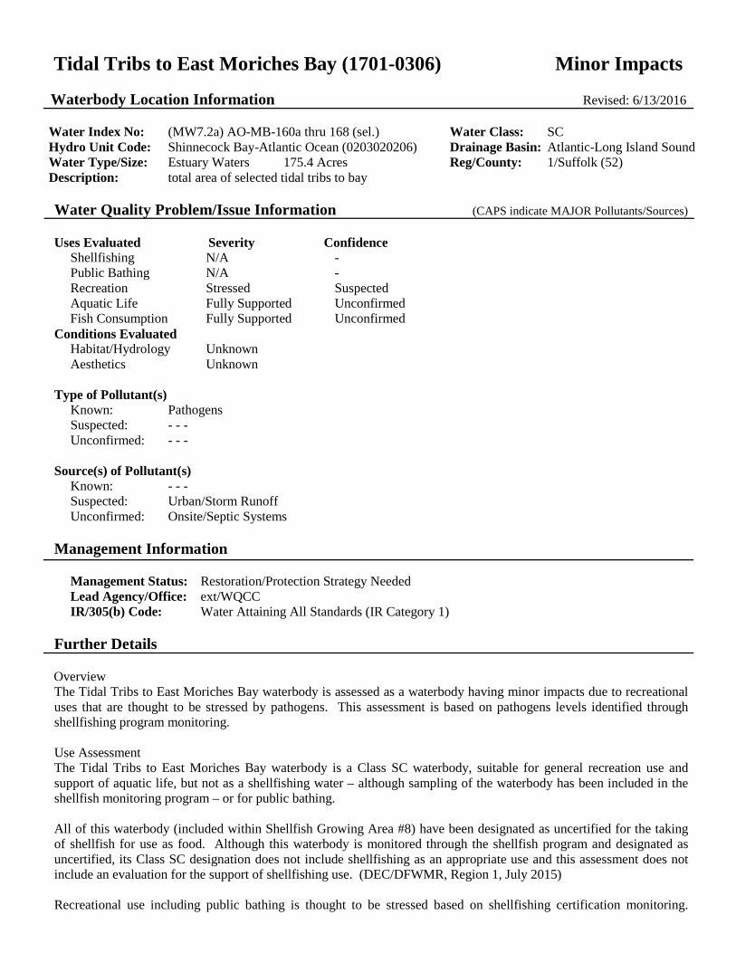
Tidal Tribs to East Moriches Bay (1701-0306) Minor Impacts Waterbody Location Information Revised: 6/13/2016
Water Index No: (MW7.2a) AO-MB-160a thru 168 (sel.) Water Class: SC Hydro Unit Code: Shinnecock Bay-Atlantic Ocean (0203020206) Drainage Basin: Atlantic-Long Island Sound Water Type/Size: Estuary Waters 175.4 Acres Reg/County: 1/Suffolk (52) Description: total area of selected tidal tribs to bay Water Quality Problem/Issue Information (CAPS indicate MAJOR Pollutants/Sources) Uses Evaluated Severity Confidence
Shellfishing N/A - Public Bathing N/A - Recreation Stressed Suspected Aquatic Life Fully Supported Unconfirmed Fish Consumption Fully Supported Unconfirmed
Conditions Evaluated Habitat/Hydrology Unknown Aesthetics Unknown
Type of Pollutant(s) Known: Pathogens Suspected: - - - Unconfirmed: - - -
Source(s) of Pollutant(s) Known: - - - Suspected: Urban/Storm Runoff Unconfirmed: Onsite/Septic Systems
Management Information
Management Status: Restoration/Protection Strategy Needed Lead Agency/Office: ext/WQCC IR/305(b) Code: Water Attaining All Standards (IR Category 1)
Further Details Overview The Tidal Tribs to East Moriches Bay waterbody is assessed as a waterbody having minor impacts due to recreational uses that are thought to be stressed by pathogens. This assessment is based on pathogens levels identified through shellfishing program monitoring. Use Assessment The Tidal Tribs to East Moriches Bay waterbody is a Class SC waterbody, suitable for general recreation use and support of aquatic life, but not as a shellfishing water – although sampling of the waterbody has been included in the shellfish monitoring program – or for public bathing. All of this waterbody (included within Shellfish Growing Area #8) have been designated as uncertified for the taking of shellfish for use as food. Although this waterbody is monitored through the shellfish program and designated as uncertified, its Class SC designation does not include shellfishing as an appropriate use and this assessment does not include an evaluation for the support of shellfishing use. (DEC/DFWMR, Region 1, July 2015) Recreational use including public bathing is thought to be stressed based on shellfishing certification monitoring.

There are no regularly monitored beaches in this waterbody, but bacteriological sampling conducted through the shellfishing monitoring program indicate elevated pathogen levels. However criteria for shellfishing are lower than those for public bathing and additional bacteriological sampling is needed to more fully evaluate swimming use. (DEC/DFWMR, July 2014)
Based on other available indicators for other related uses, this waterbody is expected to support a healthy marine water fishery, although no specific fishery or biological reports are included in this assessment.
There are no health advisories in place limiting the consumption of fish from this waterbody (beyond the general advice for all waters). Fish consumption is considered to be fully supported based on the absence of any waterbody-specific advisory, but is noted as unconfirmed since routine monitoring of contaminants in fish is limited. (NYS DOH Health Advisories and DEC/DOW, BWAM, January 2014)
Water Quality Information Assessments of recreational uses and aquatic life in marine waters are based primarily on information from NYS and local health departments and the NYSDEC Division of Fish Wildlife and Marine Resources. This information is compiled and updated in regularly issued advisories and certifications regarding bathing beaches, shellfishing harvest and sportfish consumption. (NYSDOH and DEC/DFWMR, 2014)
Source Assessment Based on surrounding land use and other knowledge of the waterbody, the most likely sources of pathogens to the waterbody are largely nonpoint runoff from developed urban and residential areas agricultural activity and open space/forest; direct waterfowl/wildlife inputs; and boats and marinas. Onsite/septic systems have also been identified as a possible contributing source. Relative contributions from each type of source are very site-specific in nature, particularly in localized areas of study. (DEC/DOW, BWRM, September 2015)
Management Action This waterbody is also included within the South Shore Estuary Reserve (SSER). The SSER encompasses the tidal waters and watershed between the Nassau–Queens County line and the eastern boundary of Shinnecock Bay. The goals of the SSER Program outlined in the 2001 Comprehensive Management Plan (CMP) include improvement and maintenance of water quality, protection and restoration of living resources, expansion of public use and enjoyment, sustaining and of the estuary–related economy, and increasing education, outreach and stewardship. Program activities focus on point and nonpoint source pollution reduction, protection and restoration of water quality and coastal habitat, increasing shellfish harvesting, open space preservation and enhancing other public uses of the estuary. A vessel waste no discharge zone was established for the entire South Shore Estuary in 2009 to address impacts from boat pollution. (DEC/DOW, Region 1, March 2010)
Section 303(d) Listing The Tidal Tribs to East Moriches Bay waterbody is not included on the current (2016) NYS Section 303(d) List of Impaired/TMDL Waters. There appear to be no impacts that would justify the listing of this waterbody. (DEC/DOW, BWAM/WQAS, January 2015)
Segment Description This segment includes the tidal portions of Beaverdam Creek (-162), Speonk River (-163), Fish Creek (-165), East River (-166), Seatuck Creek (-167), Little Seatuck Creek (-167-1), Heils Creek (-168) and smaller tidal tribs, boat basins and coves.

Beaverdam Pond (1701-0307) Unassessed Waterbody Location Information Revised: 6/21/2016
Water Index No: (MW7.2a) AO-MB-162-P837 Water Class: B Hydro Unit Code: Shinnecock Bay-Atlantic Ocean (0203020206) Drainage Basin: Atlantic-Long Island Sound Water Type/Size: Estuary Waters 9 Acres Reg/County: 1/Suffolk (52) Description: entire pond Water Quality Problem/Issue Information (CAPS indicate MAJOR Pollutants/Sources) Uses Evaluated Severity Confidence
Water Supply N/A - Public Bathing Unassessed - Recreation Unassessed - Aquatic Life Unassessed - Fish Consumption Unassessed -
Conditions Evaluated Habitat/Hydrology Unknown Aesthetics Unknown
Type of Pollutant(s) Known: - - - Suspected: - - - Unconfirmed: - - -
Source(s) of Pollutant(s) Known: - - - Suspected: - - - Unconfirmed: - - -
Management Information
Management Status: Unassessed Lead Agency/Office: DOW/BWAM IR/305(b) Code: Water with Insufficient Data (IR Category 3)
Further Details Overview Currently there is inadequate data/information to evaluate uses and determine a water quality assessment for this waterbody. Use Assessment Beaverdam Pond is a Class B waterbody, suitable for public bathing and general recreation use and support of aquatic life, but not as a water supply. Water Quality Information There is currently no water quality information available upon which to base an assessment. Source Assessment Specific sources of pollutants to the waterbody have not been identified. Management Action No specific management actions have been identified for the waterbody. Baseline sampling to evaluate conditions in

this waterbody segment is needed. Section 303(d) Listing This waterbody is not included on the current (2016) NYS Section 303(d) List of Impaired/TMDL Waters. There is insufficient information to make a listing decision. (DEC/DOW, BWAM/WQAS, January 2016) Segment Description This segment includes the total area of the Pond.

Unnamed (Eastport) Pond (1701-0311) Unassessed Waterbody Location Information Revised: 6/20/2016
Water Index No: (MW7.2a) AO-MB-167-P840b Water Class: B Hydro Unit Code: Shinnecock Bay-Atlantic Ocean (0203020206) Drainage Basin: Atlantic-Long Island Sound Water Type/Size: Lake/Reservoir 28 Acres Reg/County: 1/Suffolk (52) Description: entire pond Water Quality Problem/Issue Information (CAPS indicate MAJOR Pollutants/Sources) Uses Evaluated Severity Confidence
Water Supply N/A - Public Bathing Unassessed - Recreation Unassessed - Aquatic Life Unassessed - Fish Consumption Unassessed -
Conditions Evaluated Habitat/Hydrology Unknown Aesthetics Unknown
Type of Pollutant(s) Known: - - - Suspected: - - - Unconfirmed: - - -
Source(s) of Pollutant(s) Known: - - - Suspected: - - - Unconfirmed: - - -
Management Information
Management Status: Unassessed Lead Agency/Office: DOW/BWAM IR/305(b) Code: Water with Insufficient Data (IR Category 3)
Further Details Overview Currently there is inadequate data/information to evaluate uses and determine a water quality assessment for this waterbody. Use Assessment Eastport Pond is a Class B waterbody, suitable for public bathing and general recreation use and support of aquatic life, but not as a water supply. Water Quality Information There is currently no water quality information available upon which to base an assessment. Source Assessment Specific sources of pollutants to the waterbody have not been identified. Management Action No specific management actions have been identified for the waterbody. Baseline sampling to evaluate conditions in

this waterbody segment is needed. Section 303(d) Listing This waterbody is not included on the current (2016) NYS Section 303(d) List of Impaired/TMDL Waters. There is insufficient information to make a listing decision. (DEC/DOW, BWAM, January 2016) Segment Description This segment includes the total area of the pond.

Tidal tribs to West Moriches Bay (1701-0312) Impaired Waterbody Location Information Revised: 9/15/2010
Water Index No: (MW7.2a) AO-MB-168a thru 175 (sel.) Water Class: SC Hydro Unit Code: Shinnecock Bay-Atlantic Ocean (0203020206) Drainage Basin: Atlantic-Long Island Sound Water Type/Size: Estuary Waters 329.1 Acres Reg/County: 1/Suffolk (52) Description: total area of selected tidal tribs to coves Water Quality Problem/Issue Information (CAPS indicate MAJOR Pollutants/Sources) Uses Evaluated Severity Confidence
Shellfishing N/A - Public Bathing N/A - Recreation Impaired Known Aquatic Life Impaired Known Fish Consumption Unassessed -
Conditions Evaluated Habitat/Hydrology Unknown Aesthetics Poor
Type of Pollutant(s) Known: LOW D.O./OXYGEN DEMAND, NUTRIENTS (nitrogen), PATHOGENS Suspected: - - - Unconfirmed: - - -
Source(s) of Pollutant(s) Known: AGRICULTURE (duck farms), ON-SITE/SEPTIC SYST, OTHER SOURCE (boat pollution),
TOX/CONTAM. SEDIMENT (Organic/D.O. Demand), URBAN/STORM RUNOFF Suspected: - - - Unconfirmed: - - -
Management Information
Management Status: Restoration/Protection Strategy Needed Lead Agency/Office: DEC/Reg1 IR/305(b) Code: Impaired Water Requiring a TMDL (IR Category 5)
Further Details Overview The Tidal Tribs to West Moriches Bay segment is assessed as an impaired waterbody due to recreational uses and aquatic life that are known to be impaired by nutrient loads and the resulting low dissolved oxygen. Pathogens also contribute to the impairments. The Upper Forge River, in particular, is impaired by high nutrient loadings, low dissolved oxygen and pathogen contamination from urban/storm runoff, effects of dense unsewered residential development. Historic impacts from duck farm discharges and resulting impacts from river sediments also contribute to water quality problems. Use Assessment The Tidal Tribs to West Moriches Bay waterbody is a Class SC waterbody, suitable for general recreation use and support of aquatic life, but not as a shellfishing water – although sampling of the waterbody has been included in the shellfish monitoring program – or for public bathing. All of this waterbody (included within Shellfish Growing Area #8) has been designated as uncertified for the taking of shellfish for use as food. Although this waterbody is monitored through the shellfish program and designated as

uncertified, its Class SC designation does not include shellfishing as an appropriate use and this assessment does not include an evaluation for the support of shellfishing use. (DEC/DFWMR, Region 1, July 2015)
Recreational use including public bathing is considered to be impaired based on available monitoring data and shellfishing certification monitoring. There are no regularly monitored beaches in this waterbody, but bacteriological sampling conducted through the shellfishing monitoring program indicate elevated pathogen levels. However criteria for shellfishing are lower than those for public bathing and additional bacteriological sampling is needed to more fully evaluate swimming use. (DEC/DFWMR, July 2014)
Aquatic life is considered to be impaired based on low dissolved oxygen conditions in the Upper Forge River. However no specific fishery or biological reports are included in this assessment.
Fish Consumption use is considered to be unassessed. There are no health advisories limiting the consumption of fish from this waterbody (beyond the general advice for all waters). However due to the presence of impacts/contaminants in the stream and the uncertainty as to whether the lack of a waterbody-specific health advisory is based on actual sampling, fish consumption use is noted as unassessed, rather than fully supported but unconfirmed. (NYS DOH Health Advisories and DEC/DOW, BWAM, December 2014)
Water Quality Information Assessments of recreational uses and aquatic life in marine waters are based primarily on information from NYS and local health departments and the NYSDEC Division of Fish Wildlife and Marine Resources. This information is compiled and updated in regularly issued advisories and certifications regarding bathing beaches, shellfishing harvest and sportfish consumption. (NYSDOH and DEC/DFWMR, 2014)
Source Assessment Based on surrounding land use and other knowledge of the waterbody, the most likely sources of pathogens to the waterbody are largely nonpoint runoff from developed urban and residential areas agricultural activity and open space/forest; direct waterfowl/wildlife inputs; and boats and marinas. Onsite/septic systems have also been identified as a possible contributing source. Relative contributions from each type of source are very site-specific in nature, particularly in localized areas of study. (DEC/DOW, BWRM, September 2015)
Management Action Water quality has been a concern in the Forge River for decades, a result of historic impact of multiple duck farms as well as the extremely dense, unsewered residential development in the river's ground watershed. To address these issues the Forge River Task Force was formed. The Town of Brookhaven is currently in the process of finalizing a third–party TMDL for the river via consultant service. (DEC/DOW, Region 1, June 2016)
Suffolk County Department of Health Services, a participant in the Task Force, has conducted water quality analyses which show that the major contributor of nutrients loads to the river is groundwater underflow. Various state and local funding has been secured to conduct sediment characterization efforts, implement stormwater remediation projects, develop an illicit discharge reporting and response program for area communities and develop a Watershed Management Plan. A watershed (development) moratorium has also been suggested and is under consideration
The NYS Legislature authorized $6 million to DEC and the Long Island Regional Planning Council (LIRPC) for a Long Island nitrogen management and mitigation plan. Plan development – with active input from local stakeholders and public – is underway. Chief among the expectations for the plan is a focus on wastewater issues, including sewering of unsewered communities in Suffolk County and the evaluation and use of advanced alternative onsite wastewater treatment systems to reduce nitrogen loads from individual septic systems where sewering in not viable. (DEC/DOW, BRWM, June 2016)
This waterbody is also included within the South Shore Estuary Reserve (SSER). The SSER encompasses the tidal waters and watershed between the Nassau–Queens County line and the eastern boundary of Shinnecock Bay. The goals of the SSER Program outlined in the 2001 Comprehensive Management Plan (CMP) include improvement and maintenance of water quality, protection and restoration of living resources, expansion of public use and enjoyment, sustaining and of the estuary–related economy, and increasing education, outreach and stewardship. Program activities focus on point and nonpoint source pollution reduction, protection and restoration of water quality and coastal habitat,

increasing shellfish harvesting, open space preservation and enhancing other public uses of the estuary. A vessel waste no discharge zone was established for the entire South Shore Estuary in 2009 to address impacts from boat pollution. (DEC/DOW, Region 1, March 2010) Section 303(d) Listing The Tidal Tribs of West Moriches Bay segment is included on the current (2016) NYS Section 303(d) List of Impaired/TMDL Waters. The waterbody is included on Part 1 of the List as an impaired waterbody requiring development of a TMDL to address both nitrogen (and resulting low dissolved oxygen) and pathogens. This waterbody was first listed on the 2006 List. (DEC/DOW, BWAM/WQAS, January 2016) Segment Description This segment includes the Class SC portion of northern Harts Cove, tidal portions of Orchard Neck Creek (-171), Areskand Creek (-172), Senix Creek (-173), West Senix/Mud Creek (-173-1), Class SC portions of Forge River (-174), Old Neck Creek (-174-2), Poospatuck Creek (-174-3), Ely Creek (-174-4), Home Creek (-175) and smaller tidal tribs, boat basins and coves.

Terrell River, Lower, and tidal tribs (1701-0313) Minor Impacts Waterbody Location Information Revised: 6/15/2016
Water Index No: (MW7.2a) AO-MB-170 Water Class: SC Hydro Unit Code: Shinnecock Bay-Atlantic Ocean (0203020206) Drainage Basin: Atlantic-Long Island Sound Water Type/Size: Estuary Waters 71.5 Acres Reg/County: 1/Suffolk (52) Description: tidal portion of stream and tribs fr mouth to Mill Pond Water Quality Problem/Issue Information (CAPS indicate MAJOR Pollutants/Sources) Uses Evaluated Severity Confidence
Shellfishing N/A - Public Bathing N/A - Recreation Stressed Suspected Aquatic Life Stressed Unconfirmed Fish Consumption Fully Supported Unconfirmed
Conditions Evaluated Habitat/Hydrology Unknown Aesthetics Unknown
Type of Pollutant(s) Known: Pathogens Suspected: Silt/Sediment (duck sludge), Low D.O./Oxygen Demand Unconfirmed: - - -
Source(s) of Pollutant(s) Known: Urban/Storm Runoff Suspected: Agriculture, Onsite/Septic Systems Unconfirmed:
Management Information
Management Status: Strategy Implementation Scheduled or Underway Lead Agency/Office: ext/WQCC IR/305(b) Code: Water Attaining All Standards (IR Category 1)
Further Details Overview Lower Terrell River is assessed as a waterbody having minor impacts due to recreational uses and aquatic life that are thought to be stressed by pathogens from urban stormwater runoff and other nonpoint sources. Historically, a number of duck farms operated in the watershed and accumulations of duck sludge in the river have been documented. However, currently there is very little continuing agricultural activity in the watershed. This assessment is based on pathogens levels identified through shellfishing program monitoring. Use Assessment Lower Terrell River is a Class SC waterbody, suitable for general recreation use and support of aquatic life, but not as a shellfishing water – although sampling of the waterbody has been included in the shellfish monitoring program – or for public bathing. All of this waterbody (included within Shellfish Growing Area #8) have been designated as uncertified for the taking of shellfish for use as food. Although this waterbody is monitored through the shellfish program and designated as uncertified, its Class SC designation does not include shellfishing as an appropriate use and this assessment does not include an evaluation for the support of shellfishing use. (DEC/DFWMR, Region 1, July 2015)

Recreational use including public bathing is thought to be stressed based on shellfishing certification monitoring. There are no regularly monitored beaches in this waterbody, but bacteriological sampling conducted through the shellfishing monitoring program indicate elevated pathogen levels. However criteria for shellfishing are lower than those for public bathing and additional bacteriological sampling is needed to more fully evaluate swimming use. (DEC/DFWMR, July 2014)
Aquatic life is evaluated as supported but stressed based on biological sampling in the upper freshwater reach of the river that shows minor impacts. No aquatic life assessment has been conducted in the lower reach. (DEC, DOW, BWAM, July 2014)
There are no health advisories in place limiting the consumption of fish from this waterbody (beyond the general advice for all waters). Fish consumption is considered to be fully supported based on the absence of any waterbody-specific advisory, but is noted as unconfirmed since routine monitoring of contaminants in fish is limited. (NYS DOH Health Advisories and DEC/DOW, BWAM, January 2014)
Water Quality Information Assessments of recreational uses and aquatic life in marine waters are based primarily on information from NYS and local health departments and the NYSDEC Division of Fish Wildlife and Marine Resources. This information is compiled and updated in regularly issued advisories and certifications regarding bathing beaches, shellfishing harvest and sportfish consumption. (NYSDOH and DEC/DFWMR, 2014)
Source Assessment Based on surrounding land use and other knowledge of the waterbody, the most likely sources of pathogens to the waterbody are largely nonpoint runoff from developed urban and residential areas agricultural activity and open space/forest; direct waterfowl/wildlife inputs; and boats and marinas. Onsite/septic systems have also been identified as a possible contributing source. Relative contributions from each type of source are very site-specific in nature, particularly in localized areas of study. Oxygen damand from sediments are also a suspected source of impacts. (DEC/DOW, BWRM, September 2015)
Management Action This waterbody is also included within the South Shore Estuary Reserve (SSER). The SSER encompasses the tidal waters and watershed between the Nassau–Queens County line and the eastern boundary of Shinnecock Bay. The goals of the SSER Program outlined in the 2001 Comprehensive Management Plan (CMP) include improvement and maintenance of water quality, protection and restoration of living resources, expansion of public use and enjoyment, sustaining and of the estuary–related economy, and increasing education, outreach and stewardship. Program activities focus on point and nonpoint source pollution reduction, protection and restoration of water quality and coastal habitat, increasing shellfish harvesting, open space preservation and enhancing other public uses of the estuary. A vessel waste no discharge zone was established for the entire South Shore Estuary in 2009 to address impacts from boat pollution. (DEC/DOW, Region 1, March 2010)
Section 303(d) Listing Lower Terrell River is not included on the current (2016) NYS Section 303(d) List of Impaired/TMDL Waters. There appear to be no impacts that would justify the listing of this waterbody. (DEC/DOW, BWAM/WQAS, January 2015)
Segment Description This segment includes all tidal waters and tribs of the river.
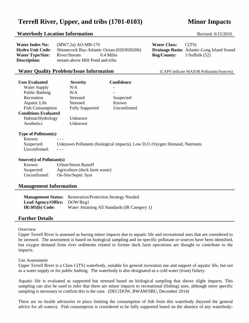
Terrell River, Upper, and tribs (1701-0103) Minor Impacts Waterbody Location Information Revised: 6/15/2016
Water Index No: (MW7.2a) AO-MB-170 Water Class: C(TS) Hydro Unit Code: Shinnecock Bay-Atlantic Ocean (0203020206) Drainage Basin: Atlantic-Long Island Sound Water Type/Size: River/Stream 0.4 Miles Reg/County: 1/Suffolk (52) Description: stream above Mill Pond and tribs Water Quality Problem/Issue Information (CAPS indicate MAJOR Pollutants/Sources) Uses Evaluated Severity Confidence
Water Supply N/A - Public Bathing N/A - Recreation Stressed Suspected Aquatic Life Stressed Known Fish Consumption Fully Supported Unconfirmed
Conditions Evaluated Habitat/Hydrology Unknown Aesthetics Unknown
Type of Pollutant(s) Known: - - - Suspected: Unknown Pollutants (biological impacts), Low D.O./Oxygen Demand, Nutrients Unconfirmed: - - -
Source(s) of Pollutant(s) Known: Urban/Storm Runoff Suspected: Agriculture (duck farm waste) Unconfirmed: On-Site/Septic Syst
Management Information
Management Status: Restoration/Protection Strategy Needed Lead Agency/Office: DOW/Reg1 IR/305(b) Code: Water Attaining All Standards (IR Category 1)
Further Details Overview Upper Terrell River is assessed as having minor impacts due to aquatic life and recreational uses that are considered to be stressed. The assessment is based on biological sampling and no specific pollutant or sources have been identified, but oxygen demand from river sediments related to former duck farm operations are thought to contribute to the impacts. Use Assessment Upper Terrell River is a Class C(TS) waterbody, suitable for general recreation use and support of aquatic life, but not as a water supply or for public bathing. The waterbody is also designated as a cold water (trout) fishery. Aquatic life is evaluated as supported but stressed based on biological sampling that shows slight impacts. This sampling can also be used to infer that there are minor impacts to recreational (fishing) uses, although more specific sampling is necessary to confirm this is the case. (DEC/DOW, BWAM/SBU, December 2014) There are no health advisories in place limiting the consumption of fish from this waterbody (beyond the general advice for all waters). Fish consumption is considered to be fully supported based on the absence of any waterbody-
specific advisory, but is noted as unconfirmed since routine monitoring of contaminants in fish is limited. (NYS DOH Health Advisories and DEC/DOW, BWAM, January 2014)
Water Quality Information A biological (macroinvertebrate) assessment of Terrell River in Center Moriches (at Fowen Road) was conducted as part of the RIBS biological screening effort in 2013. Sampling results reflect fair water quality, with the macroinvertebrate community altered from what is expected under natural conditions and indications of organic inputs. Some expected sensitive species are not present and overall macroinvertebrate species richness is lower than expected. Some changes in community composition have occurred due to replacement of sensitive ubiquitous taxa by more tolerant taxa, but overall there is still balanced distribution of all expected taxa. In spite of these minor impacts, aquatic life is considered to be supported. These results are consistent with sampling conducted in 2008 (one other 2008 sample suggested poor water quality, but the stream was neaerly dry at the time of sampling and not thought to be representative). Results of sampling in 2003 found more significant impacts. (DEC/DOW, BWAM/SBU, January 2015)
Source Assessment Sources of the impacts in the waterbody are thought to be from and urban/stormwater runoff and agricultural activites (duck farming). Historically, a number of duck farms operated in the watershed and accumulations of duck sludge in the river have been documented. There is limited duck farming activity remaining in the watershed. (DEC/DOW, Region 1, 1998)
Management Action No specific management actions have been identified for the waterbody.
This waterbody is also included within the South Shore Estuary Reserve (SSER). The SSER encompasses the tidal waters and watershed between the Nassau–Queens County line and the eastern boundary of Shinnecock Bay. The goals of the SSER Program outlined in the 2001 Comprehensive Management Plan (CMP) include improvement and maintenance of water quality, protection and restoration of living resources, expansion of public use and enjoyment, sustaining and of the estuary–related economy, and increasing education, outreach and stewardship. Program activities focus on point and nonpoint source pollution reduction, protection and restoration of water quality and coastal habitat, increasing shellfish harvesting, open space preservation and enhancing other public uses of the estuary. A vessel waste no discharge zone was established for the entire South Shore Estuary in 2009 to address impacts from boat pollution. (DEC/DOW, Region 1, March 2010)
Section 303(d) Listing Upper Terrell River is included on the current (2016) NYS Section 303(d) List of Impaired/TMDL Waters. The waterbody is included on Part 3b of the List as a waterbody for which TDML development may be deferred pending the verification of the cause/pollutant. The listing was based on biological impacts, however this updated assessment suggests that the suspected impacts to water quality and uses are no longer sufficient to warrant continued listing. This waterbody should be considered for delisting during the next update of the List. (DEC/DOW, BWAM, June 2016)
Segment Description This segment includes the entire stream above tidal waters and all tribs. The waters of the stream are Class C(TS). Tribs to this reach/segment are also Class C(TS).

Mill Pond (1701-0314) No Known Impacts Waterbody Location Information Revised: 6/21/2016
Water Index No: (MW7.2a) AO-MB-170-P847 Water Class: B Hydro Unit Code: Shinnecock Bay-Atlantic Ocean (0203020206) Drainage Basin: Atlantic-Long Island Sound Water Type/Size: Lake/Reservoir 16.2 Acres Reg/County: 1/Suffolk (52) Description: entire pond Water Quality Problem/Issue Information (CAPS indicate MAJOR Pollutants/Sources) Uses Evaluated Severity Confidence
Water Supply N/A - Public Bathing Fully Supported Unconfirmed Recreation Fully Supported Suspected Aquatic Life Fully Supported Suspected Fish Consumption Fully Supported Unconfirmed
Conditions Evaluated Habitat/Hydrology Good Aesthetics Good
Type of Pollutant(s) Known: - - - Suspected: - - - Unconfirmed: - - -
Source(s) of Pollutant(s) Known: - - - Suspected: - - - Unconfirmed: - - -
Management Information
Management Status: No Action Needed Lead Agency/Office: ext/WQCC IR/305(b) Code: Water Attaining All Standards (IR Category 1)
Further Details Overview Mill Pond is assessed as having no known impacts; all evaluated uses are considered to be fully supported. However, this assessment is based on limited data (a single sampling event) and additional sampling to verify conditions is recommended. Use Assessment Mill Pond is a Class B waterbody, suitable for public bathing and general recreation use, and support of aquatic life, but not as a water supply. There is no evidence of recreation use impacts in waterbody, consistent with relatively low lake productivity, acceptable water clarity, and the lack of invasive species and/or excessive aquatic vegetation. Public bathing is also considered to be fully supported based on the evaluation of overall recreational use, however bacteriological sampling is needed to more fully evaluate swimming use. The pond is thought to support a warmwater fishery, although no specific fishery or biological reports are included in this assessment. (DEC/DOW, BWAM/LCI, March 2014)

Water Quality Information Water quality sampling of Mill Pond through the NYSDEC Lake Classification and Inventory (LCI) Program is limited to a single sample in 2013. Results of this sampling indicate the lake is best characterized as mesotrophic, or only moderately productive. Phosphorus concentrations are low high and lake clarity measurements indicate water transparency that meets the recommended minimum criteria for swimming beaches. (DEC/DOW, BWAM/LMAS, March 2014) Source Assessment There are no apparent sources of pollutants to the waterbody. Management Action No specific management actions have been identified or are deemed necessary for the waterbody. Additional sampling to verify current conditions in the pond is needed. Section 303(d) Listing Mill Pond is not included on the current (2016) NYS Section 303(d) List of Impaired/TMDL Waters. There appear to be no impacts that would justify the listing of this waterbody. However water quality sampling is limited. (DEC/DOW, BWAM/WQAS, January 2016) Segment Description This segment includes the total area of the entire lake.

West and East Mill Ponds (1701-0026) Needs Verification Waterbody Location Information Revised: 6/22/2016
Water Index No: (MW7.2a) AO-MB-174-P850/P851 Water Class: C Hydro Unit Code: Shinnecock Bay-Atlantic Ocean (0203020206) Drainage Basin: Atlantic-Long Island Sound Water Type/Size: Lake/Reservoir 17.8 Acres Reg/County: 1/Suffolk (52) Description: total area of both ponds Water Quality Problem/Issue Information (CAPS indicate MAJOR Pollutants/Sources) Uses Evaluated Severity Confidence
Water Supply N/A - Public Bathing N/A - Recreation Impaired Unconfirmed Aquatic Life Impaired Unconfirmed Fish Consumption Unassessed -
Conditions Evaluated Habitat/Hydrology Unknown Aesthetics Fair
Type of Pollutant(s) Known: - - - Suspected: Nutrients, Silt/Sediment, LOW D.O./OXYGEN DEMAND, Pathogens Unconfirmed: - - -
Source(s) of Pollutant(s) Known: Suspected: AGRICULTURE (duck farms), Urban/Storm Runoff Unconfirmed: Other Non-Permitted Sanitary Disch
Management Information
Management Status: Assessment/Reassessment Scheduled Lead Agency/Office: DOW/Reg1 IR/305(b) Code: Impaired Water Requiring a TMDL (IR Category 5)
Further Details Overview The West and East Mill Ponds segment is currently assessed as needing verification of possible impairment due to recreational uses and aquatic life that may be impaired, but this evaluation is based on limited older data and needs to be more fully assessed. Specific pollutants of concern include low dissolved oxygen as well as phosphorus ad silt/sediment (turbidity). Agricultural activity related to an area duck farm (Jurgielewicz Duck Farm) is noted as the most significant source of pollutants. However the last two duck farms (Titmus and Jurgielewicz) on the Forge River (West Mill Pond) have been closed permanently since 2012. Current conditions, in light of reductions in duck farm activity, should be verified. Use Assessment West and East Mill Ponds is a Class C waterbody, suitable for general recreation use and support of aquatic life, but not as a water supply or for public bathing. Recreation use is thought to be impaired due to elevated nutrients (phosphorus), excessive algae and poor water clarity. (DEC/DOW, BWAM/LMAS, July 2013)

Low fish diversity and numbers have been reported in West Mill Pond in the past. Odors from decaying organic matter (likely from past duck farm runoff) have also been noted. (DEC/DOW, Region 1, 1998)
Fish Consumption use is considered to be unassessed. There are no health advisories limiting the consumption of fish from this waterbody (beyond the general advice for all waters). However due to the presence of impacts/contaminants in the stream and the uncertainty as to whether the lack of a waterbody-specific health advisory is based on actual sampling, fish consumption use is noted as unassessed, rather than fully supported but unconfirmed. (NYS DOH Health Advisories and DEC/DOW, BWAM, December 2014)
Water Quality Information Water quality sampling of West and East Mill Ponds was conducted through the NYSDEC Lake Classification and Inventory (LCI) Program in 2004. Results of this limited sampling indicate the lake is best characterized as eutrophic, or highly productive. Chlorophyll/algal levels are above criteria corresponding to impacted recreational uses in West Mill Pond; Algal levels in East Mill Pond are lower, but still elevated. Phosphorus concentrations were found to be very high. Lake clarity measurements indicate water transparency to be somewhat limited. (DEC/DOW, BWAM/LMAS, May 2006)
Sampling of West Mill Pond by the Suffolk County Department of Health Services shows a declining trend for phosphorus and nitrogen from 2006 to present. Total nitrogen has decreased from about 10 to below 2 mg/l and total phosphorus from about 3.8 to 0.2 mg/l. These results likely reflect that the last two duck farms (Titmus and Jurgielewicz) on the Forge River (West Mill Pond) have been closed permanently since 2012. (DEC/DOW, Region 1, June 2016)
A NYSDEC Fisheries survey was also conducted on the ponds in 2006. The survey was conducted to evaluate water quality and investigate potential impacts of the duck farm discharges. (DEC/DFWMR, Region 1, 2006)
Source Assessment Sources of the impacts in the ponds are thought to be primarily from past agricultural activites (duck farming). Historically, a number of duck farms operated in the watershed and accumulations of duck sludge in the river have been documented. There is limited duck farming activity remaining in the watershed. Urban stormwater runoff is also a likely but lesser contributing source. (DEC/DOW, Region 1, 2008)
Management Action Federal grants have been allocated to Suffolk County Department of Health Services for the construction of a new nitrogen removal wastewater treatment plant for the Forge River watershed. The project is in the planning stage and sewer district formation will be an issue Suffolk County must overcome. (DEC/DOW, Region 1, June 2016)
This waterbody is also included within the South Shore Estuary Reserve (SSER). The SSER encompasses the tidal waters and watershed between the Nassau–Queens County line and the eastern boundary of Shinnecock Bay. The goals of the SSER Program outlined in the 2001 Comprehensive Management Plan (CMP) include improvement and maintenance of water quality, protection and restoration of living resources, expansion of public use and enjoyment, sustaining and of the estuary–related economy, and increasing education, outreach and stewardship. Program activities focus on point and nonpoint source pollution reduction, protection and restoration of water quality and coastal habitat, increasing shellfish harvesting, open space preservation and enhancing other public uses of the estuary. A vessel waste no discharge zone was established for the entire South Shore Estuary in 2009 to address impacts from boat pollution. (DEC/DOW, Region 1, March 2010)
Section 303(d) Listing The West and East Mill Ponds segment is included on the current (2016) NYS Section 303(d) List of Impaired Waters. The lakes are included among the waters listed in Appendix B – Waters Not Meeting Dissolved Oxygen Standards. This part of the List recognizes waterbodies where low dissolved oxygen in lake bottom waters may be the result of morphology and other natural conditions in thermally stratified lakes. However because NYS water quality standards for dissolved oxygen do not include an explicit exception for natural conditions or averaging of dissolved oxygen over lake depth, USEPA requires that the Section 303(d) List recognize such waters. (DEC/DOW, BWAM/WQAS, April 2016)

Segment Description This segment includes the total area of both West Mill (P850) and East Mill (P851) Ponds.

Narrow Bay (1701-0318) Impaired Waterbody Location Information Revised: 6/15/2016
Water Index No: (MW7.2b) AO-MB-NB Water Class: SA Hydro Unit Code: Shinnecock Bay-Atlantic Ocean (0203020206) Drainage Basin: Atlantic-Long Island Sound Water Type/Size: Estuary Waters 1068.9 Acres Reg/County: 1/Suffolk (52) Description: entire bay, as described below Water Quality Problem/Issue Information (CAPS indicate MAJOR Pollutants/Sources) Uses Evaluated Severity Confidence
Shellfishing Precluded Known Public Bathing Stressed Unconfirmed Recreation Stressed Known Aquatic Life Fully Supported Unconfirmed Fish Consumption Fully Supported Unconfirmed
Conditions Evaluated Habitat/Hydrology Good Aesthetics Good
Type of Pollutant(s) Known: PATHOGENS Suspected: - - - Unconfirmed: - - -
Source(s) of Pollutant(s) Known: URBAN/STORM RUNOFF, Agriculture Suspected: OTHER SOURCE (waterfowl/wildlife) Unconfirmed: - - -
Management Information
Management Status: Strategy Implementation Scheduled or Underway Lead Agency/Office: ext/WQCC IR/305(b) Code: Impaired Water, TMDL Completed (IR Category 4a)
Further Details Overview Narrow Bay is assessed as an impaired waterbody due to shellfishing use that is considered to be precluded by pathogens. This assessment is based on year-round shellfishing closures. Urban and storm runoff are the primary sources of pathogens, although various other sources such as waterfowl/wildlife may also contribute. Public bathing and other recreational uses are fully supported, however these uses may also be stressed or threatened, as a result of the shellfishing restrictions and related pathogen levels. Use Assessment Narrow Bay is a Class SA waterbody, suitable for shellfishing, public bathing and general recreation use, and support of aquatic life. Shellfish harvesting for consumption is considered to be precluded in these waters. All of this waterbody (included within Shellfish Growing Area #8) has been designated uncertified for the taking of shellfish for use as food. The year-round shellfishing closure applies to the all tidal waters between Smith Point and the foot of Washington Street, near the Mastic Beach Yacht Club.Shellfish that grow in contaminated waters can accumulate disease-causing microorganisms (bacteria, viruses) that can be eaten with the shellfish. These shellfishing designations are based on

results of water quality sampling and evaluation of data against New York State and National Shellfish Sanitation Program monitoring criteria and/or shoreline surveys of actual or potential sources of contamination. Certified/uncertified shellfish area designations are revised regularly; for the most up to date and detailed descriptions of current designations, go to www.dec.ny.gov/regs/4014.html. (DEC/DFWMR, Region 1, July 2010)
Recreational use including public bathing is thought to be stressed based on shellfishing certification monitoring. There are no regularly monitored beaches in this waterbody, but bacteriological sampling conducted through the shellfishing monitoring program indicate elevated pathogen levels. However criteria for shellfishing are lower than those for public bathing and additional bacteriological sampling is needed to more fully evaluate swimming use. Restrictions on shellfishing represent an impact to recreational use. (DEC/DFWMR, July 2014)
Based on other available indicators for other related uses, this waterbody is expected to support a healthy marine water fishery, although no specific fishery or biological reports are included in this assessment.
There are no health advisories in place limiting the consumption of fish from this waterbody (beyond the general advice for all waters). Fish consumption is considered to be fully supported based on the absence of any waterbody-specific advisory, but is noted as unconfirmed since routine monitoring of contaminants in fish is limited. (NYS DOH Health Advisories and DEC/DOW, BWAM, January 2014)
Water Quality Information Assessments of recreational uses and aquatic life in marine waters are based primarily on information from NYS and local health departments and the NYSDEC Division of Fish Wildlife and Marine Resources. This information is compiled and updated in regularly issued advisories and certifications regarding bathing beaches, shellfishing harvest and sportfish consumption. (NYSDOH and DEC/DFWMR, 2014)
Source Assessment Based on surrounding land use and other knowledge of the waterbody, the most likely sources of pathogens to the waterbody are largely nonpoint runoff from developed and undeveloped lands, agricultural activity and open space/forest; direct waterfowl/wildlife inputs and boats and marinas also may contribute. Relative contributions from each type of source are very site-specific in nature, particularly in localized areas of study. (DEC/DOW, BWRM, September 2015)
Management Action Narrow Bay was among the waterbodies covered by the Long Island Pathogen TMDL to address shellfishing impairments that was established in 2007. (DEC/DOW, BWAM/WQMS, July 2010)
The NYS Legislature authorized $5 million to DEC and the Long Island Regional Planning Council (LIRPC) for a Long Island nitrogen management and mitigation plan. Plan development – with active input from local stakeholders and public – is underway. Chief among the expectations for the plan is a focus on wastewater issues, including sewering of unsewered communities in Suffolk County and the evaluation and use of advanced alternative onsite wastewater treatment systems to reduce nitrogen loads from individual septic systems where sewering in not viable. (DEC/DOW, BRWM, November 2015)
This waterbody is also included within the South Shore Estuary Reserve (SSER). The SSER encompasses the tidal waters and watershed between the Nassau–Queens County line and the eastern boundary of Shinnecock Bay. The goals of the SSER Program outlined in the 2001 Comprehensive Management Plan (CMP) include improvement and maintenance of water quality, protection and restoration of living resources, expansion of public use and enjoyment, sustaining and of the estuary–related economy, and increasing education, outreach and stewardship. Program activities focus on point and nonpoint source pollution reduction, protection and restoration of water quality and coastal habitat, increasing shellfish harvesting, open space preservation and enhancing other public uses of the estuary. A vessel waste no discharge zone was established for the entire South Shore Estuary in 2009 to address impacts from boat pollution. (DEC/DOW, Region 1, March 2010)
Section 303(d) Listing Narrow Bay is not included on the current (2016) NYS Section 303(d) List of Impaired/TMDL Waters. Although it is assessed as an impaired water, it is categorized as an IR Category 4a water that is not listed due to the inclusion of the

waterbody in the 2007 Long Island Pathogens (Shellfishing) TMDL. (DEC/DOW, BWAM, January 2015) Segment Description This segment includes all Class SA tidal waters between Smith Point and Floyd Point. Class SC tributaries are listed separately.

Tidal Tribs to Narrow Bay (1701-0319) Minor Impacts Waterbody Location Information Revised: 6/15/2016
Water Index No: (MW7.2b) AO-MB-NB-175a thru 176d Water Class: SC Hydro Unit Code: Shinnecock Bay-Atlantic Ocean (0203020206) Drainage Basin: Atlantic-Long Island Sound Water Type/Size: Estuary Waters 179.4 Acres Reg/County: 1/Suffolk (52) Description: total area of selected tidal tribs to bay Water Quality Problem/Issue Information (CAPS indicate MAJOR Pollutants/Sources) Uses Evaluated Severity Confidence
Shellfishing N/A - Public Bathing N/A - Recreation Stressed Suspected Aquatic Life Fully Supported Unconfirmed Fish Consumption Fully Supported Unconfirmed
Conditions Evaluated Habitat/Hydrology Unknown Aesthetics Unknown
Type of Pollutant(s) Known: Pathogens Suspected: Harmful Algal Blooms Unconfirmed: - - -
Source(s) of Pollutant(s) Known: Urban/Storm Runoff Suspected: Agriculture, Onsite/Septic Systems Unconfirmed: - - -
Management Information
Management Status: Strategy Implementation Scheduled or Underway Lead Agency/Office: ext/WQCC IR/305(b) Code: Water Attaining All Standards (IR Category 1)
Further Details Overview The Tidal Tribs to Narrow Bay segment is assessed as a waterbody having minor impacts due to recreational uses that are thought to be stressed by pathogens. This assessment is based on pathogens levels identified through shellfishing program monitoring. Algal growth (brown tides) that impact uses have also been reported. Use Assessment Narrow Bay Tidal Tribs is a Class SC waterbody, suitable for general recreation use and support of aquatic life, but not as a shellfishing water – although sampling of the waterbody has been included in the shellfish monitoring program – or for public bathing. All of this waterbody (included within Shellfish Growing Area #8) has been designated as uncertified for the taking of shellfish for use as food. Although this waterbody is monitored through the shellfish program and designated as uncertified, its Class SC designation does not include shellfishing as an appropriate use and this assessment does not include an evaluation for the support of shellfishing use. (DEC/DFWMR, Region 1, July 2015) Recreational use including public bathing is thought to be stressed based on shellfishing certification monitoring.

There are no regularly monitored beaches in this waterbody, but bacteriological sampling conducted through the shellfishing monitoring program indicate elevated pathogen levels. However criteria for shellfishing are lower than those for public bathing and additional bacteriological sampling is needed to more fully evaluate swimming use. Algal growth (brown tides) that impact uses have also been reported. (DEC/DFWMR, July 2014)
Based on other available indicators for other related uses, this waterbody is expected to support a healthy marine water fishery, although no specific fishery or biological reports are included in this assessment.
There are no health advisories in place limiting the consumption of fish from this waterbody (beyond the general advice for all waters). Fish consumption is considered to be fully supported based on the absence of any waterbody-specific advisory, but is noted as unconfirmed since routine monitoring of contaminants in fish is limited. (NYS DOH Health Advisories and DEC/DOW, BWAM, January 2014)
Water Quality Information Assessments of recreational uses and aquatic life in marine waters are based primarily on information from NYS and local health departments and the NYSDEC Division of Fish Wildlife and Marine Resources. This information is compiled and updated in regularly issued advisories and certifications regarding bathing beaches, shellfishing harvest and sportfish consumption. (NYSDOH and DEC/DFWMR, 2014)
Source Assessment Based on surrounding land use and other knowledge of the waterbody, the most likely sources of pathogens to the waterbody are largely nonpoint runoff from developed urban and residential areas agricultural activity and open space/forest; direct waterfowl/wildlife inputs; and boats and marinas. Onsite/septic systems have also been identified as a possible contributing source. Relative contributions from each type of source are very site-specific in nature, particularly in localized areas of study. (DEC/DOW, BWRM, September 2015)
Management Action The NYS Legislature authorized $5 million to DEC and the Long Island Regional Planning Council (LIRPC) for a Long Island nitrogen management and mitigation plan. Plan development – with active input from local stakeholders and public – is underway. Chief among the expectations for the plan is a focus on wastewater issues, including sewering of unsewered communities in Suffolk County and the evaluation and use of advanced alternative onsite wastewater treatment systems to reduce nitrogen loads from individual septic systems where sewering in not viable. (DEC/DOW, BRWM, November 2015)
This waterbody is also included within the South Shore Estuary Reserve (SSER). The SSER encompasses the tidal waters and watershed between the Nassau–Queens County line and the eastern boundary of Shinnecock Bay. The goals of the SSER Program outlined in the 2001 Comprehensive Management Plan (CMP) include improvement and maintenance of water quality, protection and restoration of living resources, expansion of public use and enjoyment, sustaining and of the estuary–related economy, and increasing education, outreach and stewardship. Program activities focus on point and nonpoint source pollution reduction, protection and restoration of water quality and coastal habitat, increasing shellfish harvesting, open space preservation and enhancing other public uses of the estuary. A vessel waste no discharge zone was established for the entire South Shore Estuary in 2009 to address impacts from boat pollution. (DEC/DOW, Region 1, March 2010)
Section 303(d) Listing Narrow Bay Tidal Tribs is not included on the current (2016) NYS Section 303(d) List of Impaired/TMDL Waters. There appear to be no impacts that would justify the listing of this waterbody. (DEC/DOW, BWAM/WQAS, January 2015)
Segment Description This segment includes total area of Class SC tidal tribs to the bay, including Mastic Yacht Club Boat Basin (-175b), Pattersquash Creek (-176), Johns Neck Creek (-176c) and Shirley Basin (-176d).