shkoder peje deep fracture
DESCRIPTION
Albanian geomorphology coastTRANSCRIPT

1
JUBILEE CONFERENCE “90 YEARS OF THE ALBANIAN GEOLOGY”, Tirana, 26-28 October 2012
GENERALIZED GEOPHYSICAL OVERVIEW
ON SHKODËR-PEJË DEEP TRANSVERSAL FRACTURE
Frashëri A1
.; Bushati S.2
; Frashëri N.3
; Dema Sh.4
1
Faculty of Geology and Mining, Polytechnic University of Tirana; [email protected] 2
Academy of Sciences of Albania 3
Faculty of Information Technology, Polytechnic University of Tirana 4
Albanian Geological Survey
Abstract The article presents an attempt to generalize the complex of geophysical data: Gravity, Magnetic,
Paleomagnetic, Geothermal, Seismological and Remote Sensing of Cukali tectonic subzone, where
it crosses the deep transversal fracture Shkodër – Pejë, as well as marine seismic data, and
hydrological observations on the shelf of the Southern Adriatic Basin. Analyses of the results of
these studies are based on regional geological setting data.
Regional geological-tectonic setting of Shkodër-Pejë sector of Mediterranean Alpine Folded Belt,
presents the existence of this important disjunctive deep tectonics element. The geological surveys
and detailed mapping at the scale 1:25.000 up to regional ones at the scale 1:200.000, does not have
traced at the Earth’s surface the outcrop of this thrust. Consequently, have brought about the
different concepts on it: “scharung” (1901), “deviation” (1920—1930), “an accident” (1960),
“transform transversal fault” (1970-2012), “transverse fault” (1990-2012), “deep transversal
fracture” (2012), and to silence about its existence, even to denial of its presence. These changes in
the course of a century, not just in terms of use, were related to different geological schools over the
geological setting of the Albanides. This transformation of concepts, unfortunately even in our days
in some studies, related to the fact that the geological hypothesis or theories about the geological-
tectonic setting of the region, were formed solely on the basis of surface geological surveys, which
undertake to presented geological setting to the Moho Discontinuity without geophysical data, as
necessary to known the depth.
During the last two decades, the Shkodër-Pejë region was involved in geophysical surveys
polygons. Gravity Bouguer Anomaly Map, Magnetic Anomaly Map, Paleomagnetic Studies, Heat
Flow Density Map, analyze of the satellite imagery, have provided important information about
tectonic setting in the depth of the region. This information, interpreted in complex with the existing
geological-tectonic data has cast light on the depth of the area, where it crosses the transverse
Shkodër-Pejë. They argued that it represent a deep transverse vertical fracture, which affects the
Moho Discontinuity. Its amplitude at those levels is about 4 km. It decreases toward the Earth’s
surface, until extinguished in some segments. This fracture represent a wide belt, was also
interrupted by the deep regional or lowest order longitudinal thrusts.
Key Words: Mediterranean Alpine Folded Belt, Shkodër - Pejë transversal, geophysical anomalies,
deep fracture.
2
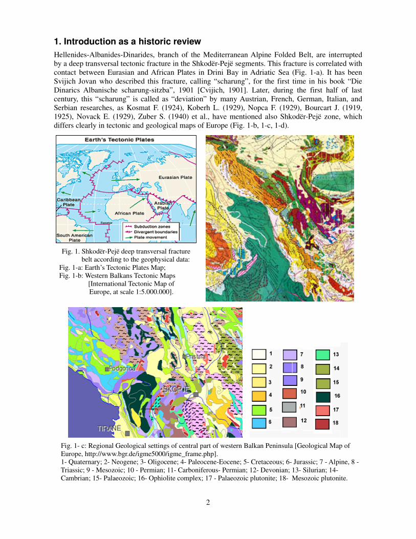
1. Introduction as a historic review Hellenides-Albanides-Dinarides, branch of the Mediterranean Alpine Folded Belt, are interrupted
by a deep transversal tectonic fracture in the Shkodër-Pejë segments. This fracture is correlated with
contact between Eurasian and African Plates in Drini Bay in Adriatic Sea (Fig. 1-a). It has been
Svijich Jovan who described this fracture, calling “scharung”, for the first time in his book “Die
Dinarics Albanische scharung-sitzba”, 1901 [Cvijich, 1901]. Later, during the first half of last
century, this “scharung” is called as “deviation” by many Austrian, French, German, Italian, and
Serbian researches, as Kosmat F. (1924), Koberh L. (1929), Nopca F. (1929), Bourcart J. (1919,
1925), Novack E. (1929), Zuber S. (1940) et al., have mentioned also Shkodër-Pejë zone, which
differs clearly in tectonic and geological maps of Europe (Fig. 1-b, 1-c, 1-d).
Fig. 1. Shkodër-Pejë deep transversal fracture
belt according to the geophysical data:
Fig. 1-a: Earth’s Tectonic Plates Map;
Fig. 1-b: Western Balkans Tectonic Maps
[International Tectonic Map of
Europe, at scale 1:5.000.000].
Fig. 1- c: Regional Geological settings of central part of western Balkan Peninsula [Geological Map of
Europe, http://www.bgr.de/igme5000/igme_frame.php].
1- Quaternary; 2- Neogene; 3- Oligocene; 4- Paleocene-Eocene; 5- Cretaceous; 6- Jurassic; 7 - Alpine, 8 -
Triassic; 9 - Mesozoic; 10 - Permian; 11- Carboniferous- Permian; 12- Devonian; 13- Silurian; 14-
Cambrian; 15- Palaeozoic; 16- Ophiolite complex; 17 - Palaeozoic plutonite; 18- Mesozoic plutonite.

3
Fig. 1.d. Cosmotectonic Map of European Countries, SEV and SFRJ members, at the scale 1:
1.000.000 (Union Aerogeologia- Geological production for regional studies of geological setting of
country territory, 1987)
__________ Lineaments interpreted not so unique (hidden fractures, planetary fissures, flexures)
Shkodër-Pejë deep fracture according to the geophysical data.

4
In the second half of the 20th century, the French geologist Aubouin J. and Albanian geologist
Ndoja I. Gj. have called the Shkodër-Pejë fracture as “accident“ [Aubouin J. & Ndoja I.Gj. 1964].
Later, Aubouin J. has considered “ancient transform fault” the Shkodër-Pejë transversal, and as an
“element inherits of the Tethyan Ocean paleogeography” [Aubouin J. et al. 1970]. Like a “Faille
transversale Scutari-Pec” was presented by Çollaku A. & Cadet J.P. (1991).
After these, for almost several decades in Albanian geological studies, this fracture had not been
mentioned, because the Albanides geological setting and its geologic history (palaeogeographic and
tectonic) had been based on geosyncline’s theory [Geology of Albania, 1970].
Fig. 1-d: Geological Map of Northern region of Albania, at scale 1:200.000, (Xhomo A. et al. 2002), and
neigbor area from the Geological Map of Kosova.
1-Quaternary; 2- Neogene, molasse, 3- Lower Neogene-marlstone and flyschoid formation; 4- Oligocene,
flysch formation; 5- Eocene-Paleocene, limestone; 6-Cretaceous- carbonate formation; 7- Jurassic- carbonate
formation, melange; 8- Triassic- carbonate – terrigene formations; 9- Lower Triassic- volcanite formation;
10- Permian-Triassic- evaporate formation, gypsum; 11- Permian- limestone, sandstone, conglomerate,
schist; 12- Carboniferous-Permian- sandstone, conglomerate, schist; 13- Ordovician-Devonian- limestone,
schist; 14- Plagiogranite, granodiorite; 15- Ophiolite complex; 16- Jurassic- splitite, keratophyre – diabase
17- Gephysical inversion line; 18- Shkodër-Pejë deep tranversal fracture according to the gravity Bouguer
anomaly inversion.
Later, seismological studies argued the presence of an active fault zone according to the well known
Shkodër-Pejë direction [Aliaj Sh. 1999, Muço B. et al. 2001, and Sulstarova E. et al. 1972]. The
authors of the Geologic Map of Albania [Geology of Albania, 1970] and latter Papa A., Xhomo A.,
et al. have analyzed Shkodër-Pejë transversal and its role in Albanides (Papa A. et al. 1985, 1991).

5
They mentioned it as a transversal zone, which represents an area where there are rapid
paleogeographic transitions, with the presence of a talus, connecting the Albanian Alps Ridge with
the Krasta-Cukali Groove. They wrote, also, that this area marks the southern paleogeographic
closure of the Albanian Alps Ridge, constituting the paleotectonic etape, the natural boundary
between the northern and southern Albanides. Melo V. wrote “…in the Southern side of the thrust,
which some described as transform fault, lies Mirdita tectonic zone of Albanides [Melo V. 1986].
Shkodër-Pejë thrust as a transform-transversal fault is considered also by many authors, mainly by
the autoctonists, which accepted the formation of ophiolitic belt as a result of the Mirdita Ocean
opening [Kodra A. et al. 1994, Melo V. et al. 1991]. Shkodër-Pejë “scharung” is considered a real
tectonic regional element, because the area of the Albanian Alps, with compelling scientific basis,
so far not yet found in southern Albanides, according to the Peza L. et al. (1971). According to Aliaj
Sh. “…the Shkodër-Pejë transverse fault dividing Dinarides from the Hellenides” [Aliaj Sh., 1999,
2006]. Some geologists did not mention this fracture among those who analyze their books became
[Vranaj A. et. al. 1997]. Shehu V. has written “so called Shkodër-Pejë transversal” and denied its
existence, accepted that this tectonic line represents simply the border of the northwest front of the
Mirdita’s zone [Shehu V., 1967].
During the last quarter century, the geophysical studies, and remote sensing that were carried out
have a cast light on the Shkodër-Pejë fracture, giving new evidences on its structure. In satellite
images, Chorowicz J. has observed some tectonic lineaments along the Shkodër-Pejë transversal
zone [Chorowicz J. et al. 1981]. In the paper, related to the study region, are presented and analyzed
the offshore geophysical exploration results at Montenegro Adriatic shelf and littoral [Dragasević
T., 1983], and remote sensing surveys (Frashëri N. 2012).
Is important to show that the existence of Shkodër – Pejë thrust and its position cannot being
observed and mapped during geological field surveys, even at the 1:25.000 scale [Qirinxhi A., et al.
1983]. Qirinxhi A. confirmed that in the field they were not capable to distinguish the tectonic
borders between the Paleozoic (of Albanian Alps tectonic zone) and Paleogenic black schists (of
Cukali tectonic zone). Because the tectonic border between them does not represent the Scutari-Pec
fracture, about this fracture they had not discussed. Later, during the Symposium “Thrust Tectonics
in Albania“, they sustained that Shkodër-Pejë fracture does not exist on the surface but, perhaps,
exist in the depth [Qirinxhi A. et al. 1991].
The above interpretations regarding the Shkodër-Pejë fracture also have resulted in alternative of
the geological opinion concerning its position. Some authors, who admit the opening of the Mirdita
Ocean and interpreted this transversal as oceanic transform fracture. After them, Shkodër-Pejë
transform fault is represented by the north-western front of the ophiolitic belt [Xhomo A. et al.
2002]. After some other authors, this transversal is represented by the northern border of Cukali
subzone as natural geological border between Alps Zone and Cukali ones [Papa A. et al. 1991].
2. Methodology of Study Already avalaible are the results of integrated surveys and studies, which include Shkodër-Pejë
fracture zone [Frashëri A. et al 2009].
Geologic-tectonic settings of Shkodër-Pejë region is included in the regional Geological Maps of
Albania, by Nopça F. (1929), Novack E. (1929), and Zuber S. (1940), in the Geological Maps of
Albania at the scale 1:200.000 (1967, 1983, 2002), and in the Tectonics Map at the scale 1:200.000
(1984), Neotectonics Maps of Albania, and seismicity studies [Sulstarova E. et al. 2011]. Detailled
geological setting of the Kiraj-Ndreaj-Brashtë in Cukali zone was presented in the Geological Map
at the scale 1:25.000 [Qirinxhi A. et al. 1983].
The seismicity of Albania was study by analyze of the historical and instrumental data, and the
distribution in time and space of the seismic activity in Albania and surrounding areas. The study
covers a period of about 2000 years. During the period about half a century have been compilated

6
the catalogues of Earthquakes in Albania up to 2005, and Atlas of the Isoseismic Maps for 198
earthquakes occurred in Albania and nearby during 1800-1990 [Sulstarova A., et al. 2011]. Present-
day stress field in Albania was study based on the earthquakes focal mechanism solutions in the
complex with structural analysis of the faults from Middle Pleistocene up to our time, and
neotectonic analyze [Aliaj A. 1988, Sulstarova E.1986, Tagari Dh.1993, Muço B., 1994]. The
seismic hazard estimation of Albanian territory, which presents a part of the seismological studies,
is accompanied and with important geological information to investigated the Earth Crust structure
of Albanides.
Have been compilated the Map of Gravity Bouguer Anomalies of Albania [Bushati S., 1988] and
Map of Total Magnetic Vector (T) of Albania [Bushati S., 1998] at the scales 1:200.000. For the
Shkodër - Pejë area have been observed also two detailled profiles (Fig. 1-b). Gravity and magnetic
surveys were accompanied with density and magnetic properties of the rock detailled studies
(Qirinxhi A. et al. 1983).
The dynamic evolution of the Albanides is recorded in the paleomagnetic data, collected from the
paleomagnetic studies in Albania during 1991-1995: Frashëri A. and Bushati S., 1995; Kissel C. et
al., 1992, 1994, 1995; and Mauritsch H.J., Scholge R., Bushati S., 1991, 1994; [Frashëri A. and
Bushati S. 1995, Kissel C. et al, 1995, Mauritsch H.J., et al. 1995, Speranza F. 1995].
Geophysical investigation has provided some information related to the crystal basement of
Albanides (Aliaj Sh. 2006; Frashëri A. et al. 1991, 2004, 2010; Bushati S. 1988, 1998; Koçiu S.
1989). In particular, was analyzed the propagation of the Earth Thermal Field. This analysis has
been performed according the Heat Flow Density Map, based on the temperature records in
boreholes at Ragami in Tropoja region, and Palaj-Karmë zone [Frashëri A. et al. 2004].
Remote sensing based on Landsat and Modis data was used to identify some regional geological
features and analyse the ground temperatures.
The ofshore area of Drini Bay, at the south-western edge of Shkodër - Pejë fracture zone, is
included in the contour of the polygone of offshore geothermal studies in South Adriatic Sea. Was
observed marine currents, waves, water salinity and temperature at various depth, as well as Earth
Heat Flow Density at the sea bottom (Frashëri A. et al. 2011, Geothermal Atlas of Europe, 1992).
3. Results and discussion
Complex methods used for studies also in northern Albania and in the Adriatic Sea have brough the
new information of great value for the Albanides depth, and which throw light on the Shkodra - Peja
fracture zone. Follow separately analyze for results from each used method, and in the end will be
presented their generalization.
Geophysical investigation results show that crystal basement of Albanides has a blocks character
(Fig. 2) (Bushati S., 1988, 1998, Koçiu S., 1989, Frashëri A. et al. 1991, 2010). Thickness of the
location of these blocks is shallower in Mirdita Tectonic Zone. The crust construction and their
dynamics are reflected in the geological setting of the Albanides tectonic zones, and their tectonic
styles. Block structure controlled by a system of NW-SE longitudinal faults as well as transverse
ones.
Local heat hearths put in evidence the transversal faults. Geothermal energy is related with a great
heat flow through these fractures (Fig. 3) [Frashëri A. et al. 2004].
The Shkodër-Pejë deep fracture represents one of deep thrusts, which transversally divides
Albanides in two parts (Fig. 3, 4). In northern part are including western-northern edge of Kruja
tectonic zone, northern part of Cukali zone, Albanian Alps and Gashi zones, which follow by the
Dinarides tectonic zones: Budva, High Karst, Dalmate, Durmitor, Serbian, and Golia zone. In the
southern part of the Albanides, represented by Sazani, Ionian, southern part of Cukali zone, Krasta-
Cukali, Mirdita and Korabi tectonic zones, which follows by the Hellenides. This deep fracture

7
generally considered a multi phase’s transversal tectonic faults zone, with a north-eastern extension
of about 30o. Consequently, Shkodër-Pejë deep fracture divides two big areas with different
geological settings and developing geological history, but not only in the continent, also to the
orogenic front in the Adriatic Shelf.
The Albanian orogenic thrust front is cut and displaced by the Othoni Island-Dhërmi, the north of
Sazani Island, and the Gjiri i Drinit-Lezha strike-slip faults, which divide the orogen into separate
segments showing diachronous development (Fig. 5) [Aliaj Sh., 2006]. The orogenic front, north of
the Drini Bay-Lezha town strike-slip fault, in the Adriatic offshore, belongs to the Kruja Zone. The
buried orogenic front, north-west-trending here, is expressed by the Kruja Zone thrusting over the
Albanian Basin. The external margin of the fold and thrust belt in Albania was thrust on the Adria
microplate, partly over the Apulian Platform and partly over the Albanian Basin [Aliaj Sh., 2006].
During the Tertiary phase, this strike-slip fault functioned as a right pushing, being shifted
towardsthe south-western inner zones [Sulstarova E. et al. 2011]. Ophiolitic Belt of the Mirdita
Tectonic Zone is displaced more than 100 km south - west, and touching the outer zones. During
Pliocene - Quaternary was processed with the normal disjunctive, mainly along north - western
border of Mirdita Tectonic Zone. In outer zones, at the transversal Drini Bay - Lezha Town, cut and
displaced front thrust of the orogen [Sulstarova E. et al. 2011].
Fig. 2. Map of the Moho
Discontinuity depth calculated by
the Geiss relation [Koçiu S. 1989]
using the Gravity Map of Albania
[Bushati S. 1988].

8
Fig. 3. Tectonic scheme of the Albanides
[Xhomo A. et al. 2002].
G-Gashi zone; MOJ- Mirdita ophiolites; MOT-
T2-J3 Ophiolites (Efusive-sedimentary
formation): Ko, Ko1, Ko2-subzones of Korabi
zone; MK4 Gjallica subzone; Ao, A1, A2
sobzones of Alps zone; K-C1- Cukali subzone;
K-C2- Krasta subzone; Kr1- Dajti subzone of
Kruja zone.
1. The trace of the deep transversal thrust
Shkodër-Pejë after gravity inversion,
2- Thermal anomaly axis of the Heat Flow
Density value mW/m2 ;
3- Strike-slip faults Gjiri Drinit-
Lezhë.
Offshore seismic surveying at the Montenegrin Adriatic shelf and deep wells [Dragasević T. 1983,
Picha F.J. 2002] very well have enlightened geological setting at the depth on the western edge of
Shkodër-Pejë deep thrust in the Adriatic shelf (Fig. 6, 7). Deep fractures in this region represent a
wide zone with the presence of different fault branches, arising out of the common trunk that comes
from deep.
Onshore geological surveys from Adriatic coast line-Shkodër-Cukal-Tropoja have mapping two
regional disjunctive tectonics in northern southern borders of Cukali subzone, divided this subzone
from Alps zone and Mirdita zone, respectively (Fig. 4).
Fig. 4. Shkodër-Pejë deep transversal fault
[Collage A. & Cadet J.P., 1991]
Fig. 5. Southern convergent margine of Eurasia plate:
Adriatique collision and Aegean Arc [Aliaj Sh.,
2006].Convergent margine segments: LU- Lezha-Ulqin;
FD- Frakull-Durrës; KS-Karaburun- Sazani Island; LK-Lefkas-Corfu Island.

9
Fig. 6. Seismic section through area
of Boka Kotorska perpendicular to
the coastline [Dragasevic, 1983],
showing the over thrusting of the
buried orogen front over the South
Adriatic Basin
Intensively folded structure of the Cukali subzone has northwest-southeast strike. They are cut
transversally by Albanian Alps zone, at the north, and Mirdita zone at the south. Cukali zone, itself,
is suppressed as an accordion -by these mentioned above two zones, during their overthrusting
toward west and southwest. According to the estimation by the palinspatic opening of the Cukali
folds, result that the displacement of its northwest edge toward the west-southwest is at least xxx
km. After this geological mapping, in the Cukali subzone (sensu stricto), had not been observed any
evidences of disjunctive tectonics of the Shkodër-Pejë tranversal fault [Qirinxhi A. et al. 1983].
From surface geological data, ranging from the Permian rocks of Albanian Alps tectonic zone, the
Upper Triassic - Maastrichtian- Paleocene - Eocene rocks in Cukali subzone, and also from all
magmatic and sedimentary rocks that spread of the Mirdita zone at the surface, had not been
deduced any arguments which can help to accept the presence at the surface of the Shkodër-Pejë
transversal fault. There are not any phenomenon of their influence for paleogeographic and
paleotectonic of these zones [Qirinxhi A. et al. 1983].
Fig. 7. Cross section BB’, interpreted
from wells and seismic lines, shows
the relation between the frontal zone
of the thinned thrust belt, consisting
of a series of shallow anticlines,
apparently detached within the
evaporitic horizon, dissected by the
younger strike-slip fault, also shown
the juxtaposition of the deep side of
the Pliocene-Quaternary Albanian
fore deep toward the Adriatic strike-
slip fault system [Pica F.J., 2002].
AF - Adriatic strike-slip fault
system; U - Lucan deep structure;
A/T direction of strike-slip motion:
A- away; T- toward.
In contrast with surface geological surveys, the gravity and magnetic surveys, seismological, and
geothermal studies have provided information on the presence of this regional transversal deep
thrust, and consequences of its action for geological history of the Albanides setting, which will

10
analyzed below.
In these conditions the alternatives of characterisation of this transversal fault as a transform
tranversal fault, aligned with the overthrust tectonic in the northern boundary of the Mirdita zone
[Kodra A. et al. 1994, Xhomo A. et al. 2002], or as a tectonique border between Cukali and Alps
zone as natural geological border between them [Papa A. et al. 1991] have not support by
geophysical and remote sensing data.
3.2. Gravity and Magnetic field scattering Scattering of gravity and magnetic fields have very well contoured Inner Albanides, particularly the
ophiolitic belt (Fig. 8, 9). Bouguer gravity anomaly and magnetic ones have common peculiarities:
a) epicenters are located over the eastern belt of the ophiolites; b) Ophiolitic belt represented in two
parts: northern and southern, separated by flyschoid corridor; c) gravity and magnetic anomalies are
very intensive, compared with Internal Albanides. These pecularities and anomaly configuration
have argued the nape character of the ophiolitic belt [Frashëri A. et al. 1991, 2010].
According the gravity and magnetic surveing (Bushati S. 1987), Alps zone represented by a
minimum of Bouguer gravity anomaly in general, with particularly a small amplitude anomaly in
southern part of the Alp’s zone (Fig. 8). In the northern direction there are observed the trend of the
increasing of the intensivity of magnetic anomaly. This pecularity of the magnetic anomaly express
overthrust character of the Albanian Alps, too. Over the Cukali subzone is observed a linear upward
trend of the intensity of the Bouguer anomaly toward the Mirdita zone (Fig. 8, 10). This trend’s
anomaly can explained by the presence of the vertical deep tectonic thrust.
After the inversion model, thrust level resulted with amplitude about 4km in the Moho
Discontinuity (Fig. 10). Thrust amplitude toward the Earth’s surface is gradually reduced and, until
the surface of the Earth, is almost extinguished, also according to the geological mapping. This deep
thrust represents Shkodër - Pejë fracture. By analogy with the deep strike-fault in the Adrietic Shelf
Crust (Fig. 7) and this, Shkodër - Pejë deep fracture, at the depth expected to be composed by
several branches, occupying a wide zone of their influence and action.
3.3. Paleomagnetic surveys - an important indicator of the presence of Shkodër - Pejë deep fracture and its geodynamic evolution role in Alpine Mediterranean Foldet Belt Hellenide-Albanides-Dynarides
Dynamic evolution of the Northern Albanides has its reflection in paleomagnetic data, collected
from the paleomagnetic studies in Albania, which were performed during 90 years, performed by
Mauritsch H.J. et al. (1991-1995), Kissel C. et al. (1992-), Muttoni G. et al (1940), Frashëri A. and
Bushati S. (1995) [Frashëri A. et al., 1995; Kissel C. et al., 1995; Mauritsch H.J. et al., 1995, 2006,
Mauritsch H.J. 2000, Muttoni G. et al. 1994, Speranca F. 1995].

11
Fig. 8. Gravity Bouguer Anomaly Map of Albania [Bushati S. 1988]
Paleomagnetic studies shows that Ionic and Kruja tectonic zones, located at southern side of the
Shkodër - Pejë transversal, have support a joint clockwise rotation, with an angle 45-50o during and
after Eocene-Oligocene period. This rotation has been realized through two phases, by 25o every
phase in the middle Miocene up to Plio-Pleistocen. Ionic and Kruja zones don’t have any different
rotation between each other. Clockwise rotation for 40o-45
o since Early-Middle Miocene is
observed at Kçira site. For this rotation, the Kçira pole acquires a West Gondwana affinity [Mutoni
G. et al. 1996]. A large Neogene clockwise rotation, D=40o, I=3.8
o, is observed also in the Mirdita
zone of Inner Albanides, at southern Albania, northern of Albanian-Greek border [Mauritsch et al.,
1994].
Fig. 9. Magnetic Anomaly Map of Albania [Bushati S. 1998]

12
Fig. 10. Gravity Bouguer Anomaly (∆g) and Magnetic Anomaly (T) profile I-I, Mountain Sheniku at the
Albanian Alps-Kabash in Mirdita zone, and gravity inversion results.
Eocene limestone anticlines of the Renz and Kakariq area, which are located in southern side of the
Shkodër - Pejë transversal zone, have a rotation about 31o. Consequently, these two anticlines have
a declination with 18o smaller than the declination of the Eocene limestone in the Central Albania.
These two anticlines maybe have superposition of two rotations with inverse sense: clockwise
rotation of 50o, which has been subdued all External Albanides structures and local
counterclockwise rotation by 25o, which has rotated only these two anticlines that have a Dinaride
strike.
At the Komani area, in the southern side of Shkodër - Pejë transvesal, at north-western edge of the
ophiolitic belt of Mirdita zone, have been observed declinations, which show the 82o-140
o
clockwise rotation of the Jurassic limestone. The same 28o-57
o clockwise rotation is observed for
ultrabasic rocks of western edge of the Gomsiqe massive, at south-western direction from Komani
(Fig. 11).
Gabro massive at Bozhaj, southern of Korça city have a magnetization vector with declination
Do=282o and inclination Io=60.9
o, the same direction as in the Khalkidhiki in Greece (D=240
o-312
o
and I=30o-68
o), which have demonstrated an Upper Cretaceous anti-clockwise rotation, and Upper
Tertiary clockwise rotation of the Khalkidhiki [Feinberg H. et al. 1996].

13
Fig. 11. Scheme of the paleomagnetic echantionage in Northern Albania, during 1989-1994.
1-Sazani Zone; 2-Ionian Zone; 3-Kruja Zone; 4-Krasta-Cukali Zone; 5- Albanian Alps Zone; 6-Vermoshi
Zone; 7- Gashi Zone; 8-Korabi Zone; 9-Mirdita Zone; 10- Periadriatic Depression; 11-Mollasic depressions;
12- Jurasic limestone; 13- Upper Cretaceous-Eocene limestone: 14- Middle Neogene molasses: 15- Pliocene
formation: 16- Ophiolite.
Limestone samples from Albanian Alps at Selca area, in the north of Shkodër - Pejë transversal,
shows a counterclockwise rotation for 20o in relation with present north, the same value as in
southern Dinaride’s structures. The analogue counterclockwise rotation as in Selca area, have also
Jurassic limestone at southern Shkodra lakeshore. This fact shows that both these sections appertain
to the same tectonic zone, in northern of Shkodër-Pejë transversal area.
The Kotori to the Split area, which belongs to the Dinarides in Dalmatia in the North is almost
immovable for the time period being studies starting from the Eocene onwards. Dinaride’s orogen
in the north are characterized by the regional direction f the structures N12o, unlike the Albanides
orogen structures with a direction N150o, as in southern Hellenides [Kissel C., 1994; Mauritch H.J.
et al 1993, 1995, 2006; Mauritch H.J. 2000]. Paleomagnetic studies in the external Dinarides have
shown that this orogen has no any significant counter-clockwise rotation in relation to Africa,
ranking from the Eocene, such small rotation that is observed in limestone of the Albanian Alps to
the southern shore of Shkodra Lake.
Paleomagnetic directions demonstrate a strong tectonic disturbance in the Central part of Shkodër -
Pejë zone. In the Jurassic limestone of the northern side of Cukali subzone, about 4 km northwest of
Prekali village, is observed a country-clockwise rotation for about 45o. Only in less than 2 km

14
south, a 60o clockwise rotation is observed. Such result attests to the strong tectonic influence in
transversal thrust zone.
Paleomagnetic studies have demonstrated that Shkodër - Pejë belt presents a transition zone
between counter-clockwise rotation in the north, and clockwise rotation in the south sides (Fig. 11,
12). Consequently has a great tectonic influence over Cukali subzone. Thus, Shkodër-Pejë
lineament, defines a transition zone which separates the Albanian Alps and the Dinarides
(counterclockwise rotation), from Albanides and Hellenides (clockwise rotation).
For the rotation pole located at Shkodër - Pejë transversal thrust, Southern Albania has undergone a
horizontal displacement is about 173 Km [Speranza F., 1995].
Fig. 12. Regional Paleomagnetic Declinations around Adriatic Sea and expected paleomagnetic declination
for Africa during the Eocene-middle Pliocene period (Speranza, 1995).
3.4. Seismological pecularities related to Shkodra-Peja seismoactive tranversal fault zone
Seismological studies carried during the last half of century in Albania have mapping seismoactive
longitudinal and transversal deep tectonic fault zones of the Albanides (Fig. 13 and 14).
Among them is situated the Shkodër - Pejë transversal fault zone, which represent a seismoactive
transversal normal fault zone There are systematic misallocations of the earthquakes (between
zones 4-5, fig. 13-a, or one Nr. 4 in fig. 13-b), with strong lateral velocity contrasts, with a
difference across the fault about 3-7%. It is well delineated also by present-days seismic
activity. His more intensive activity, after relatively strong earthquakes, it appears in zones
where interrupted by longitudinal faults. The following earhtquakes have been recorded in the
Shkodra-Peja fault zone: Peja, Io=VIII, Febryary 11, 1662; Shkodra, Io=VIII, July 3, 1855, and
1 June 1905; Trush-Shkodra M=5,5, August 27, 1948; Ulqini, 1444, and M=5,5, November 3,
1968. During the period 1976 - 1992, in some segments of the fault zone, were evident lots of
micro and small earthquakes with a magnitude Ms≤5.0, mainly as clusters of earthquakes
(Muço B., 1984; 1991, Sulstarova S. et al. 2011). The expected seismic potential of this
seismogene zone is of a Mmax=5,5 to 6,0 [Sulstarova S. et al. 2011].
Shkodër - Pejë transversal fault zone divided in two segments the northern part of the Ionian-
Adriatic thrust fault zone, which presented the longest fault zone along the Adriatic and Ionian

15
coasts:
a) Lezha town in Albania - Ulqini in Montenegro coastline Northern segment, WNW trending. This
segment is more than 200 km long, including Northern side of Kruja tectonic zone in Albanides
and Southern part of Dalmatian zone in Montenegro.
b) Lezha town-Vlora city, with an N to NNW trending. This segment, which is situated along
Periadriatic Depression and stroked by Adriatic coastline, is about 130 km long.
Fig13-a. The map of
seismogenic zone and the
earthquakes epicenter, occurred
in the period of time 2002-2006,
where the models of velocity of
the Earth crust are calculated
[Aliaj Sh. 2000]
Fig. 13-b. Map of the seismoactive
zones in Albania, with maximal
Albania [Aliaj Sh. 1988].
Figure 14. Map of active fault
zones in Albania [Aliaj Sh. 2000]
Based on focal mechanism solution, results that in Northern littoral side of the Shkodër- Pejë fault
zone, the compression strain has a P=160 NE-W strike, and 10
0 plunge, while the axis of expansion
T = 1240 and 79
0 dep. In the Southern side of the Shkodër- Pejë fault zone, the compression strain
has a P=2740 E-W strike, and 10
0 deep, and the axis of expansion T = 164
0 SE-NW and 64
0 deep
(Sulstarova, 1988, Tagari (1993). In the internal area, region Vau i Dejes-Pukë-Tropojë, the
tensional stress regime has a NWN extending (Muço B. 1994, Sulstarova 1988). Axis of expansion
have a strike direction NNE T=140, and compression axis SSE-NNW P=1520 and 74
0 dep. The
focal mechanism solution of November 21, 1985 earthquake with Mw=5,6, generated from Lezha
strike-slip, shows that this fault acts as a dextral transpression strike-slip stress axis P-207o/30
o and
T-940/33
0 [Muço B. 1994, Aliaj Sh. 2000]. This fault there presents the SW edge of Shkodra - Peja
transversal fault zone in the internal domain of compressional regime. The existence of Lezha
transversal as a important element, that cut and transfer the orogen front is testified not only from
geologic-geophysical and seismological data, but also from GPS ones [Sulstarova et al, 2011].
Offshore geophysical explorations have discovered a deep fractures zone in the Adriatic Sea
between Buna River discharge and Kotorri Estuary, about 15-20 km from coastline, with the NW
strike direction. In this Adriatic ofshore area, near Albanian-Montenegrin border, at the northern
side of the Shkodra - Peja fault zone, was located focus of earthquake, 15 April 1979. According to

16
the scattering of his aftershocks, the focal dimensions are: longue 70 km and width 25 km. Focal
zone, as a narrow belt, has a NW-SE strike direction from Ulqini city to Kotorri Estuary (Sulstarova
E. et al. 2011). Thrust fault plane has a NW 500 strike direction, with NE 160 plunge, while slip
vector has a NE 48o direction, slipping angle λ = + 16
0, axis of the stress P=46
o SW with 28
o deep,
and T=520 VL and 62
0 deep [Sulstarova E., 1983; Sulstarova E. et al. 2011].
The analyze of the seismic P waves velocities (Vp) and ratio Vp/Vs show that exist a difference
0,12-0.46 k/s between upper part of the Earth Crust (0-30 km) in the both side of the Shkodra-Peja
fault zone [Ormëni Rr., 2010]. Such difference presents a 1,9-8,5 % of the Vp size. At the greatest
depths, 30-45 km the difference is insignificant.
The stress field, the fault system and the spatial distribution of the seismic activity shows that the
Albanian territory and the surrounding areas is constructed by many blocks which move relatively
to each other due to the collision of two great plates, the Eurasia and African ones, in the region of
the Adriatic promontory of African plate [Sulstarova et al. 2011].
All seismological features indicated above argues that Shkodra-Peja transversal present a deep
fracture, a relatively wide active fault zone that separates the paleogeographic units with different
geological settings, and dynamic of their developments.
3.5. Heat Flow density anomalies Geothermal studies at Northern Albania have been performed in 19 boreholes and in one deep well.
As for the whole territory of Albanides, even in northern their part extends Heat Flow Density
anomaly. Their axes are presented in Fig. 3. There are there heat hearths. Two of them, in Ragami in
Tropoja and Karma-Palaj are located in the unic axis, which extends from northeast to southwest,
over the overthrust tectonics in the northern border of the ophiolitic belt. Thirty axes is located in
Keçel village in eastern site of the Kukesi ultrabasic massif. The heat flow density values are up to
60-70 mW/m2. Radiogenic heat generation of the ophiolites is very low. In these conditions,
increasing of the heat flow in the ophiolitic belt is linked with heat flow transmitting from the depth.
Ophiolitic belt Heat Flow Density highest value can be explained by the small thickness of the
geological section down to the top of crystalline basement, and MOHO discontinuity. The granites
of the crystalline basement, with the radiogenic heat generation, represent the heat source. Heat
flow anomalies are conditioned by intensive heat transmitting through deep and transversal
fractures. Distance between trace of the Shkodër - Pejë thrust and thermal anomaly axis is 9 km.
Thermal anomaly is located on the mounted side of the fracture, where the crystalline basement top
is located in lower depth than on the sitting side of the fracture.
By comparing these characteristic of the thermal field and zone geological setting with structure of
the strike-fault system in southwestern side of the Shkodër - Pejë transversal in Adriatic Shelf, we
assume that this thermal anomaly associated with the branches of transversal fracture.
3.6. Offshore geothermal information Heat flow density anomaly in the Adriatic See shelf, has been presented “Geothermal Atlas of
Europe”, 1992, (Fig. 15). The thermal anomaly over the Adriatic Shelf, with epicenter in Drini Bay
is linked with Adriatic strike-slip fault system. In the same time, this thermal anomaly epicenter is
located over the prolongation into Albanian Adriatic Shelf of Shkodër - Pejë transversal deep
fracture. These facts show that the Shkodër - Pejë transversal deep thrust continues even in the
Adriatic Shelf, where interrupted with Adriatic longitudinal strike-slip fault system. Over their
intersection node is located thermal anomaly, which is linked with heat flow from Crystalline
Basement through these deep fractures.

17
Fig. 15. Adriatic Heat Flow Density Anomaly
[Geothermal Atlas of Europe, 1992] (a), and correlation
of the thermal anomaly with trace of the Shkodër-Pejë
transversal deep fracture (b).
3.5. Remote sensing and GIS information First study by Landsat imagery, conducted Chorowich J., Cadet J.P. and Stephan J.F. [Chorowich J.
et al. 1981], for disjunctive tectonics in Northern Albania, include Shkodër - Pejë transversal fault.
In fig 16 are presented a sketch of thrust tectonic in Northern Albania, which differenced clearly
main segments of Shkodër - Pejë transversal fault.
Fig. 16. Major tectonic accidents in northern
and southern side of the Shkodër-Pejë
transversal accodin to the landsat data
[Chorowich J. et al. 1981]
Based on GIS and seismological investigations are determined velocities of microplates movement
in Adriatiuc Sea. Nubia (Africa) microplate is moving NW with respect to Eurasia with a velocity
of 6 mm/yr, while the Adria microplate moves NE at a rate of 4-5 mm/yr (Fig. 18) [Battaglia M. et
al. 2004]. For Nocquet J.M., Adriatic is an independent microplate within Nubia – Eurasia plate
boundary one [Nocquet J.M. et al. 2001]. Oldov et al. (2002) propose that Adria is divided by
Gargano-Dubrovnic fault in two blocks. Northern Adria has little or no motion relative to Europe
and its part of Alpine collage of Southern Europe. Southern Adria is moving with Nubia and is
continuous from Sicily to Apulia, [Oldov J.S. et al. 2002].

18
Fig. 17. Satelite image of Shkodër-Pejë transversal fault at Northern Albania.
Fig. 18. Location of the segments (solid lines) and
blocks used to model the Adriatic Region. [NAd]
North Adria, [Sad] South Adria, [G] Gargano-
Dubrovnik fault zone, [K] Kefallinic fault zone, [A]
Apulia escarpment. GIS velocities and their 95
confidence ellipses. The grey dots indicate the
location of the shallow seismicity from 1975 to
2000 (M>3.5) [Battaglia M., et al. 2004].
Figure 19. Contour plot of the bathymetry of the
Adriatic Sea with horizontal resolution of 1 min. The
Mid Adriatic Pit is the relatively deep region which
nearly transects the Adriatic. The contour interval is
50 m. [Dietrich D., et al., 2002].

19
In the frame of these interpretation data is necessary to discussed also the position of NW edge of
Otranto Street, which is located in the direction of the Shkodër-Pejë deep transversal fault in the
eastern Adriatic Shelf, that result parallel with Gargano – Dubrovnic fault zone (Fig. 19).
Fig. 20. Combination of Landsat bands 7 ~ Red, 4 ~ Green, 2 ~ Blue.
Green areas represent the vegetation coverage.
Usage of satellite imagery for identification of geological structures resulted difficult because of
two factors: vegetation coverage of the area and soil coverage of rocks. Nevertheless in different
band combinations from Landsat it is possible to distinguish two areas separated during the same
delineation of Shkodra – Peja fault (Figure 20 represents in false colors the area from Landsat7
images with the band 7 as Red, band 4 as Green and band 2 as Blue).
Fig. 21-a. Average of daily ground temperature for the period 2004 – 2006 from MODIS images

20
Analysis of ground temperature from MODIS images was done calculating the average for day and
night temperatures from 24 images spanned in the period 2004 – 2006. In these images it is visible a
“bridge” of relatively higher temperature delineated between Shkodra and Peja (Fig. 21).
Fig. 21-b. Average of night ground temperature for the period 2004 – 2006 from MODIS images
At the end of our analysis on the Skoder-Peje transversal thrust we find reasonable to confront our
results with new reference of the model for European crust, EuCRUST-07 (Mahdala Tesaauro et al.
2008). As is evident from Fig. 22 , which represents map of Moho depth, is very clear existence
of the transversal Shkodër-Pejë belt with reduced Moho depth, which is a determining argument for
the presence and nature of its.
Fig. 22. Moho depth (km), EuCRUST-07:
A new reference for the European crust
(Teasuro M. et al. 2008)
4. Conlusions 1. Earth Crust of the Albanides exhibits a block structure controlled by a system of NW-SE
longitudinal faults as well as transverse ones. The blocks have different thickness.
2. According to the gravity data inversion, Shkodër-Pejë zone present a vertical deep transversal
fracture, which separate two Earth crust blocks. Fracture interrupts the MOHO Discontinuity
with amplitude about 4 km that decrease towards the Earth surface. This fracture represents a

21
seismically active belt. Based on satellite image, this vertical fracture outcropped through
Cukali subzone.
3. Paleomagnetic studies have demonstrated that assemblage of the Albanides margin encountered a
clockwise rotation of about 45o, after upper Oligocene. This rotation happened in two phases.
This is also the case for the Western margin of the Hellenides. Shkodër-Pejë transverse fault
represents a transition zone between the clockwise rotation of the Albanides and Hellenides and
the counterclockwise of Albanian Alps on e and Dinarides. For the rotation pole located at
Shkodër-Pejë transverse fault, the horizontal displacement is about 173 Km in Southern
Albanian border.
4. Continuation of Shkodër-Pejë fracture in the Albanian Adriatic Shelf in Drini Bay passes over the
epicenter of Heat Flow. This correlation argues relation of the geothermal anomaly with depth
fractures of the Earth Crust in Adriatic Shelf.
References Aliaj Sh., 1988, Features of the neotectonic structures of Albania. (In Albaniua, abstract in french)
Geographical Studies, Nr. 3, 37-53.
Aliaj Sh., 2000 - Geotectonic and seismicity of Albania. In book of Meço, S., Aliaj., Sh. and Turku, I:
“Geology of Albania”, 155-178. Gebruder Borntraeger. Berlin. Stuttgart.
Aliaj Sh., 2006. The Albanian orogen: Convergence zone between Eurasia and the Adria microplate. The
Adria Microplate: GPS Geodesy. Tectonic and Hazards, NATO Science Series, IV. Earth and Environmental
Sciences-Vol.61, pp. 133-149. 2006 Pringer, Printed in the Netherlands.
Aubouen, J., and Ndojaj, I., 1964, Regards sur la géologie de l’Albanie e sa place dans la géologie des
Dinarides : Bull. Soc. France (97) VI, 593-625.
Aubouen J., Blanchet R., Cadet J.P., Celet P., Charvet J., Chorowicz J. Cousin M., Rampou J.P. .1970. Essai
sur la geologie des Dinaride. B.S.G.F. (7), VI, p. 593-624.
Battaglia M., Murray M.H., Serpelloni E., and Bürgmann, 2004. The Adriatic Region: And independent
microplates within the Africa-Eurasia Collision one. Berkeley Seismological Laboratory, Annual Reports.
http://seismo.berkeley.edu/annual_report/ar03_...
Bushati S., Dema Sh. 1985. Gravity Map of Albania at the scale 1:200.000. Geophysical Center, Tirana.
Bushati, S., 1988, Regional study of the distribution of gravity field of the Internal Albanides, for tectonics
and metallogenic zoning (In Albanian): Ph.D. thesis Polytechnic University of Tirana.
Bushati S. 1997. Total magnetic field anomalies of Albania, at the scale 1:200.000. Geophysical Center,
Tirana.
Cadet J.P., Bonneau M., Çollaku A., 1991. Sur la position de l’Albanie dans le systeme Dinarico-Hellenique.
Séance spécialisée de la Societe Geologiqiue Francese (S.G.F.) Colloque sur la “Gologie de l?Albanie”,
Paris, 12-13 Avril, 1991.
Chorowich J.. Cadet J.P., Stephan J.F., 1981. Le secteur tranversal de Scuari-Pec: apports de l’etude de la
fracturation à partir does donne Landsat. B.S.G.F. (7), XXIII, p. 217-228.
Cosmotectonic Map of European Countries, SEV and SFRJ members, at the scale 1: 1.000.000
(Union Aerogeologia- Geological production for regional studies of geological setting of country
territory, 1987)
Cvijiç J. 1901. Die Dinarics Albanische scharung-sitzba. D.Kais Ak. D. wiss. Bt.CX. Wien, 1901.
Çollaku A., Cadet J.P., 1991. Sur L’Allochtone des Albanides: Apport des donnes de L’Albanie
Septentrionale. (In French, resume in Albanian). Symposium «Thrust tectonics in Albania. Bulletin of
Geological Sciences, Nr. 1, 1991, p.255-271.
Dercourt J. , 1967. Sur l’accident de Scutari.Pec, la signification paléogéographique de quelque series

22
condense en Albanie Septentrionale. Annales Soc. Gel. Du Nord, t. 98, p. 109-117.
Dietrich D., Carnevale G.F., and Orlandi P. 2002. Adriatic simulations by DieCAST. Center for Turbulence
Research , Proceedings of the Summer Program 2002, 269.
Dragasević T., 1983 - Oil geologic exploration in the Montenegro offshore in Yugoslavia. Nafta, 34 (7-8),
397-404.
Frashëri A., Bushati S., Bare V., 2010. Geophysical outlook on structure of the Albanides. Journal of Balkan
Geophysical Society (JBGS), Vol. 12, 2009, pp. 9-30.
Frashëri A., Cermak.V., Doracaj M., Lico R., Safanda J., Bakalli F., Kresl M., Kapedani N., Stulc P, Malasi
E., Çanga B., Vokopola E., Halimi H., Kucerova L., Jareci E., 2004. Atlas of Geothermal Resources in
Albania. Published by Facylty of Geology and Mining, Polytechnic University of Tirana and Academy of
Sciences of Albania.
Frashëri, A., and Bushati, S., 1995, Paleomagnetic outlook on geodynamics of Albanides (In Albanian):
Report Faculty of Geology and Mining, Polytechnic University of Tirana, Geophysical-Geochemical Center
of Tirana, 121 and 21 Map Shhets.
Frashëri N., Pano N., Frashëri A., Bushati, 2011. Outlook on seawaters dynamics and geological setting
factors for the Albanian Adriatic coastline developments. EGU 2011, Wiena.
Feinberg H., Edel B., Kondopoulou D., Michard A., 1996. Implications of ophiolite palaeomagnetism for
the interpretation of the geodynamics of Northern Greece. The Geological Society.
Geothermal Atlas of Europe, 1992.[Eds. Hurtig E., Çermak V., Haenel R. and Zui V.], International Heat
Flow Commission, Herman Haak Vertagsgesellschaft mbH, Germany, 156 and 25 Map Plates..
Institute of Geologinal &Mining Studies and Design. 1970.Geology of Albania. Explanatory text of
Geological Map of Albania, at the scale 1:200.000. (in Albanian). Publishing House Naim Frashëri, Tirana.
Institute of Geological Studies, Faculty of Geology and Mining, Geological Insitute of Oil and Gas, 1983.
Geological Map of Albania, at scale 1:200.000.
Institute of Geological Studies, Faculty of Geology and Mining, Geological Insitute of Oil and Gas, 1983.
Tectonic Map of Albania, at scale 1:200.000.
Kissel, C., Speranza, F., Islami, I., and Hyseni, A., 1995, Paleomagnetic evidence for Cenozoic clockwise
rotation of External Albanides: Earth and Planetary Science Letters, 129, 121-134.
Kober L.,1914. Geological map of Balkan, at scale 1:15.000.000
Koçiu, S., 1989, On the construction of the Earth Crust in Albania according to the first onset of P waves in
the seismologic stations. (In Albanian, abstract in English): Bull. of the Geological Sciences, 1, 137-159,
Kodra A., Vergely P., Meshi A. (1994) – Evolucioni tektonik i ofioliteve të Shqipërisë. Fondi i I.S.P.GJ.,
Tirane.
Komatina M. and S. Komatina-Petrovic, 2009. Geodynamics af Serbia. 5th Congress of Balkan Geophysical
Society, Belgrade, Serbia, 10-16 May, 2009.
Mauritsch J. H., Scholger R., Bushati L. S., Xhomo A., Pirdeni A. Paleomagnetic works in the field of the
Krasta-Cukali, Alps and Sazani zones carried out in September 1993, Conference in Albanian Geological
Institute of GEOALBA, November 1994, etc., publications. Tectonophysics. 1995.
Mauritsch H. J., Scholger R., Bushati S. L., A. Xhomo A. 2006. Palaeomagnetic investigations in Northern
Albania and their significance for the geodynamic evolution of the Adriatic-Aegean realm. Geological
Society, London, Special Publications, 2006, 260:155-178,
Magnetic Map of Albania. Monography, Center of Geophysical and Geochemical Investigation: Albanian
Geological Survey.
Meço S., Aliaj Sh., Turku I., 2000 - Geology of Albania. Gebrüder Borntraeger. Berlin. Stuttgart, 2000.
Melo V., 1986. Structural Geology, Geotectonics (Geological setting and geodynamics development of
Albanides. (In Albanian), Published by Faculty of Geology and Mining, Polytechnic University of Tirana,
Text Books Typography, Tirana.

23
Mejellovsky N.V., 1987. Cosmotectonic Map of European Countries, SEV and SFRJ members, at
the scale 1: 1.000.000 (Union Aerogeologia- Geological production for regional studies of
geological setting of country territory, 1987)
Melo V., Shallo M., Aliaj Sh., Xhomo A. & Bakia H., 1991 - Tektonika mbihipëse dhe mbulesore në
strukturën gjeologjike të Albanideve. Bul. Shk. Gjeol., 1, 7-20.
Muço B., 1994 - Focal mechanism solutions of earthquakes for the period 1964-1988. Techtonophysics, 231.
Muttoni G., Dennis V.K., Meço S., Nicora A., Gaetani M., Bahini M., Germani D., Rettori R. 1996.
Magnetostratigraphy of the Spathian to Anician (Lower.Middle Triassic) Kçira section, Albania. Geophys. J.
Int. (1996) 127, pp. 503-514.
Nopçsa F., 1929 - Geographie und Geologie Nord- Albaniens. Geol. Hungarica, S. geol., t. III, 1-704.
Nocquet J.M., Calais E., Altamini ., Sillart P., and Bounder C., 2001. Intraplate deformation in western
Europe deducted from an analysis of the International Terrestrial Reference Frame 1997 (ITRF97) velocity
field. J. Geophys. Rs. 106,11,239-11,257,2001.
Nowack E., 1929 - Geologische Ubersicht von Albanien. Salzburg.
Oldow J.S. et al. 2002. Active fragmentation of Adria, the north Africa promontory, Central Mediterranean
Orogen. Geology, 30, 779-782,2002.
Papa A. et al., 1985. Shkodra-Peja transversal and its role in Albanides. 5th National Geological Conference,
Tirana, 18-19 September, 1985.
Papa A., Xhomo A., Aliaj Sh. , 1991. Le secteur transversal Shkoder-Peje et sn role dans l’evolution
geologique des Albanides”. Séance spécialisée de la Societe geologiqiue Francese (S.G.F.) Colloque sur la
“Gologie de l?Albanie”, Paris, 12-13 Avril, 1991.
Peza L., Xhomo A., Qirinxhi A., 1971. Geology of Albania. (In Albanian). The Publishing House of
Universitary Books, Tirana, 449.
Picha F.J. 2002. Late orogenic strike-slip faulting and ascape tectonics in frontal Dinarides-Hellenides,
Croatia, yugoslavia, Albania, and Greece. AAPG Bulletin, v.86, No. 9 (September 2002), pp. 1659-1671.
Qirinxhi A., Nyftari A., Bicaj Z., Tashko A., Zhegu V., Kosho P., Bushati S., Monika K., Kastrati N., 1983.
Geological Setting and utile minerals of the Kçira-Ndrecaj-Brashtë region, and geochemical and geophysical
surveys performed during 1981-1982. Technical repport. Geological Archive, Geological Service of Albania,
Tirana.
Qirinxhi A., Nasi V., Hyseni A., Kokobobo A., Leci V., 1991. Review on relation of Albanides tectonic zones
and main featuresnof their inner structure. (In Albanian, resume in English). Symposium «Thrust tectonics in
Albania. Bulletin of Geological Sciences, Nr. 1, 1991, p. 129-139.
Speranza, F., 1995, Evolution of Cenozoic geodynamic of Alpine Belt at Mediterranean Centrale:
Paleomagnetisme contribution. Ph.D. University Pierre and Marie Curie, Paris VI, France.
Sulstarova E., Koçiaj S., Aliaj Sh. , 1972. Seismic map of Popular Republic of Albania, at scale 1.250.000.
(In Albania), Published by Faculty of Geology and Mining, Polytechnoc University of Tirana, 201.
Sulstarova E., 1988 - The seismic faults in Albania. Proceedings of first symposium on the Recent Trends in
Seismology and Geophysics og Aegean Area, July 1-3, Thessaloniki, Greece, pp 164-180.
Sulstarova E., Aliaj Sh., Muço B., Koçiu S.. 2011. Seismicity, seismotectonics and seismic hazard
esstimation in Albania. Academy of Sciences of Albania. Tirana.
Tagari Dh., 1993 - Etude neotectonique et seismotectonique des Albanides: Analyse des deformations et
geodynamique du Langhien a l’actuel. These de Docteur en Science. Paris-Sud, Orsay.
Tesauro M., Kaban M.K., and Sierd A.P.L. Cloetingh. 2008. Geophysical Research Letters, vol. 35,
L05313, doi:10.1029/2007GLO32244,2008.
Shehu R., Shallo M., Kodra A., Vranai A., Gjata K., Gjata Th., Melo V., Yzeiri D., Bakiaj H., Xhomo A.,
Aliaj Sh., Pirdeni A., Pashko P., 1990 - Gjeologjia e Shqipërisë. Shtëpia Botuese "8 Nëntori" Tiranë.

24
Shehu V., 1967. On so-called Shkoder.Peje transversal and some problems of the geological setting of the
Albania. (In Albanian, abstract In French), Bulletin of the State University of Tirana, Serie of Natural
Scences, Nr. 3, p. 87-96.
Vranaj A., Shallo M., Xhomo A. 1997. Geology of Albania. Published Home “Universitary Books”.
Xhomo A., Kodra A., Xhafa Z., Shallo M. 2002. Gjeologjia e Shqipërisë. Instituti i Kërkimeve Gjeologjike,
Tiranë, Instituti i Naftës dhe Gazit, Fier, Fakulteti i Gjeologjisë dhe Minierave, Tiranë, 171.
Zuber S., 1940 - Appunti sulla tettonica e sull'evoluzione geologica dei giacimenti metalliferi albanesi. AIPA,
Publ. Sc. Techn., Fasc. 1, Roma.