site allocations dpd - sequential test of sites (december
TRANSCRIPT

December 2015, p1
Local Development Documents
Research Report
SEQUENTIAL TESTING OF SITES IN SITE ALLOCATIONS DPD
November 2018
For further information, please contact: Planning Policy, Woking Borough Council,
Civic Offices, Gloucester Square, Woking, Surrey, GU21 6YL
Tel: 01483 743871

December 2015, p2
Sequential Testing of Sites in the Site Allocations DPD 1.0 Purpose of this document 1.1 The National Planning Policy Framework (NPPF) requires local authorities to
prioritise potential sites for allocation for future development located within a lower risk flood zone over those exposed to a higher risk of flooding.
1.2 This document explains how Woking Borough Council has applied the
sequential test to inform the selection of both urban and Green Belt sites within Woking Borough, for inclusion in the Draft Site Allocations Development Plan Document (DPD). By considering the flood evidence for each site and applying the sequential testing methodology, the Council has sought to locate development away from areas vulnerable to flooding.
2.0 Planning context 2.1 This document should be read in conjunction with the latest Strategic Flood
Risk Assessment (SFRA) together with the Strategic Housing Land Availability Assessment (SHLAA) the Employment Land Review and the Green Belt boundary review report, from which potential alternative, reasonably available sites were drawn.
2.2 The probability or likelihood of flooding is described as the chance that a
location will flood in any one year. This can be expressed as a percentage or as a ratio. If an area is classified as having a 1% (1 in 100) Annual Exceedance Probability of flooding, for example, it does not mean that a 100 year flood will happen regularly every 100 years, or only once in 100 years. In any given 100 period a 100 year event may occur once, twice, more, or not at all.
2.3 Definitions of the Flood Zones are provided in Table 1 of the National Planning
Practice Guidance (NPPG):
Flood Zone 1 (Low Probability): Land having a less than 1 in 1,000 annual probability of river or sea flooding (shown as ‘clear’ on the Environment Agency Flood Map – all land outside Zones 2 and 3);
Flood Zone 2 (Medium Probability): Land having between a 1 in 100 and 1 in 1,000 annual probability of river flooding; or Land having between a 1 in 200 and 1 in 1,000 annual probability of sea flooding (land shown in light blue on the Flood Map);
Flood Zone 3a (High Probability): Land having a 1 in 100 or greater annual probability of river flooding; or Land having a 1 in 200 or greater annual probability of sea flooding (land shown in dark blue on the Flood Map); and
Flood Zone 3b (Functional Floodplain): This zone comprises land where water has to flow or be stored in times of flood. Local planning authorities should identify in their Strategic Flood Risk Assessments areas of functional floodplain and its boundaries accordingly, in agreement with the Environment Agency (not separately distinguished from Zone 3a on the Flood Map).
2.4 Table 5-4 of the latest Strategic Flood Risk Assessment (SFRA 2015)
complements this by setting out definitions of the flood zones used in the SFRA, for each watercourse in the Borough: the Lower Wey, Hoe

December 2015, p3
Stream/Whitmoor Common Brook, Hoe Stream tributary, Addlestone Bourne and Rive Ditch. This table is reproduced below.
Table 5-4 Definition of Flood Zones used within this SFRA
SFRA Flood Zone
Lowey Wey
Hoe Stream/Whitmoor Common Brook
Hoe Stream Tributary
Addlestone Rive Ditch
SFRA Flood Zone 2
0.1% AEP event
0.1% AEP event EA Flood Zone 2
EA Flood Zone 2
EA Flood Zone 2
SFRA Flood Zone 3 – Plus climate change
1% AEP + CC event
1% AEP + CC event
Not defined – displays EA Flood Zone 3
1% AEP + CC event
Not defined – displays EA Flood Zone 3
SFRA Flood Zone 3a
1% AEP event
1% AEP event EA Flood Zone 3
1% AEP event
EA Flood Zone 3
SFRA Flood Zone 3b
5% AEP event
5% AEP event EA Flood Zone 3
5% AEP event
EA Flood Zone 3
SFRA Flood Zone 3b - undeveloped
5% AEP event
5% AEP event Not defined – displays EA Flood Zone 3
5% AEP event
Not defined – displays EA Flood Zone 3
SFRA Flood Zone 3b - developed
5% AEP event
5% AEP event Not defined – displays EA Flood Zone 3
5% AEP event
Not defined – displays EA Flood Zone 3
2.5 The principle aim of the Sequential Test is to direct new development to areas
of lowest flood risk. Where there are no available sites in Flood Zone 1 the vulnerability of a site may be considered and used to direct development to alternative sites in Flood Zone 2 followed by Flood Zone 3 applying the Exception Test, if required.
2.6 Table 2 of the NPPG provides vulnerability classifications for different types of
development. Table 3 of the NPPG gives information on Flood Risk Vulnerability and Flood Zone Compatibility. Both tables are reproduced next.
Flood Risk Vulnerability Classification (Table 2 of the NPPG) Essential infrastructure
Essential transport infrastructure (including mass evacuation routes) which has to cross the area at risk.
Essential utility infrastructure which has to be located in a flood risk area for operational reasons, including electricity generating power stations and grid and primary substations; and water treatment works that need to remain operational in times of flood.
Wind turbines.

December 2015, p4
Highly vulnerable
Police and ambulance stations; fire stations and command centres; telecommunications installations required to be operational during flooding.
Emergency dispersal points.
Basement dwellings.
Caravans, mobile homes and park homes intended for permanent residential use.
Installations requiring hazardous substances consent. (Where there is a demonstrable need to locate such installations for bulk storage of materials with port or other similar facilities, or such installations with energy infrastructure or carbon capture and storage installations, that require coastal or water-side locations, or need to be located in other high flood risk areas, in these instances the facilities should be classified as ‘Essential Infrastructure’).
More vulnerable
Hospitals
Residential institutions such as residential care homes, children’s homes, social services homes, prisons and hostels.
Buildings used for dwelling houses, student halls of residence, drinking establishments, nightclubs and hotels.
Non–residential uses for health services, nurseries and educational establishments.
Landfill* and sites used for waste management facilities for hazardous waste. Sites used for holiday or short-let caravans and camping, subject to a specific warning and evacuation plan.
Less vulnerable
Police, ambulance and fire stations which are not required to be operational during flooding.
Buildings used for shops; financial, professional and other services; restaurants, cafes and hot food takeaways; offices; general industry, storage and distribution; non-residential institutions not included in the ‘More Vulnerable’ class; and assembly and leisure.
Land and buildings used for agriculture and forestry.
Waste treatment (except landfill* and hazardous waste facilities).
Minerals working and processing (except for sand and gravel working).
Water treatment works which do not need to remain operational during times of flood.
Sewage treatment works, if adequate measures to control pollution and manage sewage during flooding events are in place.
Water-compatible development
Flood control infrastructure.
Water transmission infrastructure and pumping stations.
Sewage transmission infrastructure and pumping stations.
Sand and gravel working.
Docks, marinas and wharves.
Navigation facilities.
Ministry of Defence defence installations.
Ship building, repairing and dismantling, dockside fish processing and refrigeration and compatible activities requiring a waterside location.
Water-based recreation (excluding sleeping accommodation).
Lifeguard and coastguard stations.
Amenity open space, nature conservation and biodiversity, outdoor sports and recreation and essential facilities such as changing rooms.
Essential ancillary sleeping or residential accommodation for staff required by uses in this category, subject to a specific warning and evacuation plan.
Flood Risk Vulnerability and Flood Zone ‘Compatibility’ (Table 3 of the NPPG)
Flood Zones
Essential Infrastructure
Highly Vulnerable
More Vulnerable
Less Vulnerable
Water Compatible
Flood Zone 1

December 2015, p5
Flood Zone 2 Exception Test required
Flood Zone 3a Exception Test required†
x Exception Test required
Flood Zone 3b* Exception Test Required*
x x x *
Key: development is appropriate x development should not be permitted Notes to Table 3: •This table does not show the application of the Sequential Test which should be applied first to guide development to Flood Zone 1, then Zone 2, and then Zone 3; nor does it reflect the need to avoid flood risk from sources other than rivers and the sea; •The Sequential and Exception Tests do not need to be applied to minor developments and changes of use, except for a change of use to a caravan, camping or chalet site, or to a mobile home or park home site; •Some developments may contain different elements of vulnerability and the highest vulnerability category should be used, unless the development is considered in its component parts. * In Flood Zone 3b (functional floodplain) essential infrastructure that has to be there and has passed the Exception Test, and water-compatible uses, should be designed and constructed to:
remain operational and safe for users in times of flood;
result in no net loss of floodplain storage;
not impede water flows and not increase flood risk elsewhere. † In Flood Zone 3a essential infrastructure should be designed and constructed to remain operational and safe in times of flood.
2.7 The Sequential Test, as set out in the NPPG, aims to steer vulnerable development towards areas of lower flood risk. The Sequential Test for Local Plan preparation should demonstrate where there are sites available in areas of a lower probability of flooding.
2.8 Diagram 2 of the NPPG (below) illustrates the application of the Sequential
Test for Local Plan preparation. An equivalent diagram is also set out in the latest SFRA (final draft 2015).

December 2015, p6
2.9 After following the Sequential Test, if it is not possible, consistent with wider
sustainability objectives, for the development to be located in zones with lower probability of flooding, the Exception Test can be applied if appropriate. Paragraph 163 of the NPPF sets out the conditions for passing the Exceptions Test.
2.10 Diagram 3 of the NPPG - reproduced on the following page - illustrates the
application of the Exception Test to Local Plan preparation.
2.11 For the Exception Test to be passed it must be demonstrated that:

December 2015, p7
the development provides wider sustainability benefits to the community that outweigh flood risk, informed by an SFRA where one has been prepared; and
a site specific Flood Risk Assessment demonstrates that the development will be safe for its lifetime taking into account the vulnerability of its users, without increasing flood risk elsewhere, and where possible, will reduce flood risk overall.
2.12 Both parts of the Exception Test must be passed for development to be
acceptable. 2.13 It should not be used to justify 'highly vulnerable' development in Flood Zone
3a, or 'less vulnerable', 'more vulnerable' and 'highly vulnerable' development in Flood Zone 3b if the sequential test has been passed.
2.14 The adopted Core Strategy for Woking Borough includes Policy CS9: Flooding
and water management. Policy CS9 states:
The Council expects development to be in Flood Zone 1 as defined in the SFRA.
Applications or allocations within Flood Zone 2 will only be considered if it can be demonstrated that there are no suitable alternatives in areas at lower risk.
The Council will not encourage development in Flood Zones 3a and 3b however it accepts that this is possible in exceptional circumstances.
Development proposals in Flood Zones 3a and 3b will be required to be accompanied by a comprehensive Flood Risk Assessment to demonstrate that the development will not increase flood risk elsewhere or exacerbate the existing situation.
A sequential approach will apply to all developments in Flood Zone 3 and areas at risk of flooding from sources other than river.
Any development in Flood Zone 3b will only be acceptable when it is either water compatible, essential infrastructure, or if brownfield land, does not increase the net number of residential units or business floorspace and improves local flood risk.
2.15 The reasoned justification supporting Policy CS9 advises:
‘The Council has undertaken a Strategic Housing Land Availability Assessment in order to identify sufficient land with housing potential to meet its development requirements. The current assessment highlights that there is sufficient land outside of Flood Zone 3a or 3b to meet the Borough’s housing requirements. In addition, and in accordance with the sequential approach, Flood Zone 2 will only be considered if sufficient housing land supply cannot be identified in Flood Zone 1 to meet the housing target and all suitable alternatives have been considered. It will not be necessary to permit development in Flood Zone 3a or 3b. However, applications for replacement properties in these locations will be considered providing that there is a similar or reduced built footprint and measures to reduce flood risk will be expected. The aim of the policy is not to prejudice redevelopment of existing buildings if it will not lead to an intensification of development which will adversely impact on flooding.

December 2015, p8
Consequently, a like for like redevelopment of existing buildings will not be resisted. However, the Council will take the opportunity to encourage redevelopment schemes to improve flood risk’ (paragraph 5.47).
2.16 Paragraph 5.48 continues:
‘National policy on flooding requires Flood Risk Assessment for all development proposals in Flood Zones 3a, 3b, and 2 as well as all development proposals of one hectare or above in Flood Zone 1. Applicants will also be required to undertake a Flood Risk Assessment for development proposals within or adjacent to areas at risk from other forms of flooding. The SFRA and the forthcoming surface water management plan identify areas of potential risk, although circumstantial evidence will be considered on a case by case basis. Where there is potential for other sources of flooding, a Flood Risk Assessment should be evaluated to investigate the level of impact of the risk and propose mitigation measures in accordance with national guidance, the Council’s SFRA and advice of the Environment Agency. Applicants will be encouraged to recognise the benefits that undertaking a Flood Risk Assessment can bring to a development, even if not required. It is important for applicants to note that incorporating SUDs in new development will also help reduce the risk of diffuse pollution from run-off, improve amenity and biodiversity’.
2.17 ‘A sequential approach to development will be applied for Flood Zones 3a and
3b’ (paragraph 5.49). 2.18 The Environment Agency confirmed to Woking Borough Council on 1 June
2015 that, if any proposed allocation sites are within Flood Zone 2 or 3, the Council will need to set out the sequential test.
2.19 The Council’s overall methodology to assessing potential sites for allocation is
explained in the Site Allocations Site Assessment Methodology. This explains that any sites absolutely constrained affected by the following policy constraints (amongst others) will be rejected and assessed no further: Flood Zone 3 - Evaluation on this point will be guided by the Council’s Strategic Flood Risk Assessment (SFRA) and the latest Environment Agency flood maps. The Borough has no critical drainage areas.
2.20 This Sequential Testing of Sites document explains how Woking Borough
Council has followed both national policy (the National Planning Policy Framework), guidance (Planning Practice Guidance) and the Core Strategy in preparing the Draft Site Allocations DPD consultation document (November 2018). The protocol for applying the Sequential Test is as agreed with the Environment Agency, in line with the latest SFRA ( 2015).
2.21 Evidence of the application of the Sequential Test is also provided through the
Sustainability Appraisal (SA) process. In summary, the SA Framework has been used to evaluate each reasonably alternative site in terms of a range of social, economic and environmental objectives. These objectives included Objective 3 which seeks to ’reduce vulnerability to flooding and harm from flooding to public well-being, the economy and the environment’. The SA process scored each site against Objective 3, allocating scores to sites in relation to flood risk as follows:

December 2015, p9
++ Very positive impact – site allocation/use would significantly help in achieving Objective 3
+ Positive impact – site allocation/use would help in achieving Objective 3. These scores were not used as every development will have an impact in terms of increasing incidence of surface water flooding by increasing run off and as no sites would bring forward significant flood/ drainage alleviation measures.
0 Neutral impact – site allocation/use would neither help nor hinder the achievement of Objective 3. For example, a site wholly within Flood Zone 1 (low risk) and where there is no or some surface water flooding which would be mitigated through compliance with Policy CS9.
- Negative impact – site allocation/use would be in conflict with Objective 3. For example, a site where all or part of site is in Flood Zone 2 and where there is no or some surface water flooding which would be mitigated through compliance with Policy CS9.
-- Very negative impact – site allocation/use would be in significant conflict with the objective. For example, a site where all or part of site at risk of flooding: in Flood Zone 3a (high probability) and 3b (functional floodplain) or areas of known pluvial flooding, and where there is no or some surface water flooding which would be mitigated through compliance with Policy CS9.
I Effect depends on how the allocation is implemented.
? Uncertain – need more information. Unlikely that this score was used due to availability of information regarding flood risk.
2.22 This assessment of flood risk for each site was considered alongside
assessments against other objectives, giving recommendations for each site. A number of sites were not recommended for inclusion in the Draft Site Allocations DPD as a result of the Sustainability Appraisal findings. In light of the number of sites required, flood risk was a contributing factor in the decision to reject some sites, as the Draft Sustainability Appraisal Report explains in Section 151. The rationale behind this is explained fully in this Sequential Testing of Sites document.
2.23 Both this Sequential Testing of Sites document and the Draft Sustainability
Appraisal Report demonstrate that a transparent process has been followed, which has sought to steer new development to areas with the lowest probability of flooding. They also show that full consideration has been given to reasonably available alternatives on land with a lower probability of flooding, before those at higher risk of flooding.
3.0 Information sources
1 For example see Table 8 for such sites in the Green Belt: Byfleet Mill, Mill Lane, Byfleet KT14 7RR
(SHLAABY069); Land south of High Road and adjacent M25, Byfleet KT14 7QG (SHLAABY079); Land east of Byfleet, adjacent Summer Close, Byfleet, KT14 7RY (SHLAABY078); Land between Homespun and Little Yarrows, Guildford Road, Woking, GU22 0SD (SHLAAMSG018); Land to the south of Carters Lane, Old Woking, GU22 8JQ (SHLAAOW021).

December 2015, p10
3.1 Evidence of local fluvial flood risk has been drawn from the latest Strategic
Flood Risk Assessment (SFRA) and the latest Environment Agency flood information. The Sustainability Appraisal (SA) also provides commentary on flood risk, in particular under the assessment of each site against SA Framework Objective 3.
3.2 The Environment Agency publishes a Flood Map (see http://maps.environment-
agency.gov.uk or type Environment Agency Flood Maps into any search engine). This shows areas deemed to be at potential risk of flooding for all watercourses with a catchment area greater than 3 sq.km in the UK. The Flood Map highlights the following areas:
Flood Zone 2 (light blue on the Environment Agency map); and
Flood Zone 3 (dark blue on the Environment Agency map). It also publishes Flood Map for Planning, which is available at the following link: http://apps.environment-agency.gov.uk/wiyby/37837.aspx. The Flood Map for Planning shows the extent of flood zone 2 and 3 and it is used to assess planning applications and site allocations against the risk of flooding.
3.3 The Flood Map also shows flood defences and the areas benefiting from flood
defences for Flood Zone 3 areas. The Flood Map is updated periodically, typically every 3 – 6 months, to take account of the latest data.
3.4 The Council has liaised with the Environment Agency on an informal technical
basis throughout preparation of the Draft Site Allocations DPD. The Environment Agency’s responses assisted the Council in confirming the fluvial Flood Zones and any other potential sources of flood risk affecting individual potential sites.
3.5 The Strategic Flood Risk Assessment (SFRA, final draft 2015) for Woking
(River Wey) – Volume 1: Decision support document final states (page 3):
‘The [National Planning Policy Framework] NPPF and its accompanying Planning Practice Guidance (PPG, March 2014) maintain the requirement to apply a risk-based, sequential process to the location of development in order to avoid flood risk to people and property. The key difference for flood risk policy compared to [now superseded Planning Policy Statement 25 – Development and Flood Risk] PPS25 is that the NPPF gives local authorities a wider remit to interpret and implement local policies. This makes the SFRA process all the more important in establishing suitable, reasonable and practical local development policies to manage local flood risk’.
3.6 The SFRA states on page 2:
‘The Level 1 SFRA provides an evidence base for Woking Borough Council to carry out the Sequential Test. In applying the Sequential Test, development should be steered toward areas at least risk of flooding from all sources’.
3.7 The SFRA (final draft 2015) explains how the SFRA is to be used in carrying out the Sequential Test.
Other sources of flooding

December 2015, p11
3.8 This sequential testing of sites document explains the Council’s approach to only fluvial flooding. The Site Allocations process and any subsequent individual planning applications will rely upon the latest Strategic Flood Risk Assessment (SFRA), and any detailed site specific requirement set out as ‘key requirements’ in the Site Allocations DPD, to demonstrate that there are no issues arising from other sources of flooding, for example from pluvial (surface water run off). In accordance with Core Strategy Policy CS9 Flooding and water management, a Flood Risk Assessment will be required for any site within or adjacent to areas at risk of surface water flooding as identified by the SFRA.
3.9 As an inland area, coastal flooding is not a consideration.
Climate change assumptions
3.10 With regard to climate change impacts in Woking, the latest SFRA (final draft
2015) states that:
‘From the available modelling, an increase of 20% in the volume of flow in the fluvial inflows to the hydraulic model shows very minimal increase in the extent of areas at risk of fluvial flooding. It is expected that climate change is likely to increase the intensity of rainfall events; uplift on rainfall intensities should be applied when designing to 2085 and beyond. Going forwards, climate change allowances should be considered in line with forthcoming policy; UKCIP09. These will be based on catchment projections with a range of allowances, and will depend on the vulnerability classification of the development or risk to the area. At the time of publication of the Sequential Tests document, Woking Borough Council is aware that new allowance for climate change will be released as we cannot currently give an expected date of publication. In the urbanised parts of the Borough, (including Woking and Byfleet) an increase in rainfall as a result of climate change is likely to increase surface water flooding due to impermeable surfaces and the current capacity of the drainage network’.
Water quality 3.11 Development must also take into account ground and water quality, particularly
at the detailed application stage. Core Strategy Policy CS9: Flooding and water management sets out the Council's policy with regard to water quality. Paragraph 5.46 advises that ‘All proposals must conform to the Water Framework Directive 2000 and the Flood and Water Management Act 2010...The impact of development on water quality will be taken into account when determining planning applications’. Policy CS17: Open space, green infrastructure, sport and recreation sets out that development that would have a detrimental impact upon water quality will not normally be permitted. Draft Development Management policies DM: Air and Water Quality and DM8: Land contamination and hazards expand on these Core Strategy policies.
4.0 Site assessment 4.1 The Diagram 3 (next) is the Council’s illustration of the detailed process of
applying the sequential test. This is consistent with current guidance in the NPPG and the latest SFRA (see Diagram 2 above).

December 2015, p12
4.2 Following section 5 sets out the sequential test approach and its findings in relation to the Draft Site Allocations DPD.

December 2015, p13

December 2015, p14
5.0 Sequential assessment of sites
Pre-assessment - Identify reasonably available alternatives. 5.1 The SFRA (paragraph 3.12) states:
‘To perform the Sequential Test Woking Borough Council first need to be aware of what sites are reasonably available alternatives in their council area. It is necessary to clearly define “reasonably available” and be able to provide evidence that there are not locations outside of those considered with a lower probability of flooding that could be considered to be “reasonably available”.
5.2 The Council first undertook a screening process to determine sites that were reasonably available. This was informed by the Strategic Housing Land Availability Assessment (SHLAA) and the Employment Land Review (ELR).
5.3 This process provided a list of available sites. A number of these sites were not
considered appropriate for further assessment because they were absolutely constrained (in line with Policy CS9, in some cases this was because they lay wholly or largely within Flood Zone 3a or 3b). These sites are listed in Appendix 8 of the Draft Sustainability Appraisal Report. The Council is of the opinion that there is no reasonable prospect of development overcoming these constraints to enable the sites to come forward for development within the period of the Core Strategy.
5.4 A number of sites were also rejected as being too small, below the
development size threshold2 for the Site Allocations DPD; these are listed in Appendix 7 of the Draft Sustainability Appraisal Report. Sites below this threshold may still come forward for development as windfall sites to be determined on their individual merits. A Flood Risk Assessment (FRA) will be required for windfall sites in line with the requirements for FRA for sites in Flood Zone 2 or 3 or 1 hectare in size, and sequential test evidence. The requirements for site specific flood risk assessment is set out in paragraph 103 and footnote 20 of the NPPF.
5.5 The sites left were considered reasonable alternatives and were appraised
further, through sustainability appraisal which incorporated the sequential approach to flood risk. The sustainability appraisal process resulted in a number of reasonable alternative sites being rejected. Urban Area and Green Belt sites rejected at this stage are listed in paragraph 15.25 (page 96) and Table 8 (page 89) of the Draft Sustainability Appraisal Report, respectively.
5.6 The following tables also list these rejected sites. The accompanying
commentary explains why – in accordance with the sequential test process and Table 3 of the NPPG – these were rejected.
2 Minimum site size threshold is 10 dwellings or 500 gross sq. m floorspace (both net additional).

December 2015, p15
Reasonable alternative site
Commentary
Rejected urban area sites
SHLAABR019: BT Telephone Exchange, Bagshot Road, Brookwood, GU21 2RP
Site located within Flood Zone 1. However, rejected due to loss of operational infrastructure (telecommunications) and site not available.
SHLAAKN026: Car park opposite The Vyne, Reading Way, Knaphill, GU21 2DU
Site located within Flood Zone 1. However, rejected due to loss of operational infrastructure (public car park serving local centre) and site not available.
SHLAAMHE013: Car park (west) and signalling station, Oriental Road, Woking, GU22 7AE
Site located within Flood Zone 1. However, rejected due to loss of operational infrastructure (public car park serving railway station) and site not available.
SHLAAMHE016: Lion House and car park, Oriental Road, Woking, GU22 7BA
Site located within Flood Zone 1. However, rejected as site not available.
SHLAAWB071: 1, 3, 5, 7, 9, 11, 13 and 15 Old Woking Road, West Byfleet, KT14 6LW
Site located within Flood Zone 1. However, rejected as comprises multiple units, potential adverse impact on heritage assets (some of site comprises Locally Listed buildings and within Conservation Area), which may affect deliverability.
SHLAAGE072: Land over Woking Railway Station, Station Approach. Woking, GU22 7AE
Site located within Flood Zone 1. However, rejected as site not at this stage considered deliverable.
SHLAABY031b: Churchill House and Beaver House, York Close, Byfleet, KT14 7HN
Site located within Flood Zone 1. However, rejected due to loss of employment use and as site not available.
SHLAABY017: Works at 11 Royston Road, Byfleet, KT14 7NX
Site located within Flood Zone 1. However, rejected due to loss of employment use and as site not available.
SHLAABY038: Land to rear of Byfleet Village Hall, High Road, Byfleet, KT14 7QL
Site located within Flood Zone 1. However, rejected as in operational use (car park to community facility) and as site not available.
SHLAABY065: 96-120 Church Road, Byfleet, KT14 7NF
The majority of the site is located within Flood Zone 1, however the north east corner of the site is within Flood Zone 2. Whilst careful site layout design could contain development on area of site within Flood Zone 1, the site is also not known to be available (the most recent planning history is outline planning application PLAN/2010/0908 which was withdrawn).
SHLAABY016: 94-100 Royston Road, Byfleet, KT14 7QE
Site located within Flood Zone 1. However, rejected due to loss of employment use and as site not available.
SHLAABY018: Wey Retail Park, Royston Road, Byfleet, KT14 7NY
Most of the site is located within Flood Zone 1, the north east corner of the site is within Flood Zone 2. Whilst careful site layout design could potentially contain development on area of site within Flood Zone 1, the site is also not known to be available and would result in a loss of an

December 2015, p16
employment use.
SHLAABY064: The Manor School, Magdalen Crescent, Byfleet, KT14 7SR
Site located within Flood Zone 1. However, rejected due to loss of community facility (vacant) and as site not available.
SHLAAGE023 Part of car park at Goldsworth Park Centre, Denton Way, Woking, GU21 3LG
Site located within Flood Zone 1. However, rejected due to loss of operational infrastructure (public car park serving local centre and adjacent hospice premises) and as site not available.
SHLAAMS035: Monument Hill Playing Fields, Alpha Road, Woking, GU22 8HF
Site located within Flood Zone 1. However, rejected due to loss of operational infrastructure (allotments, open space) and as site not available.
SHLAAWB008: Phoenix House, Pyrford Road, West Byfleet, KT14 6RA
Site located within Flood Zone 1. However, rejected due to loss of employment use (the site is used as a SME/incubator for start up businesses) and as site not currently available (will be in five plus years).
SHLAAWB025: Electricity Sub Station, Birch Walk, West Byfleet, KT14 6EJ
Site located within Flood Zone 1. However, rejected due to loss of operational infrastructure (utilities) and site not available.
SHLAAWB017: Camphill Industrial Estate and Apex Court, Camphill Road, West Byfleet, KT14 6EB
The majority of the site lies within Flood Zone 2, as located adjacent to the Basingstoke Canal and the Rive Ditch. Whilst site potentially available, would result in loss of employment use.
SHLAAGE033: Land to the rear of Waitrose Supermarket, Bampton Way, Woking GU21 3LE
Site located within Flood Zone 1. However, site rejected due to loss of trees (protected by a Tree Preservation Order) and as site not available.
Rejected Green Belt sites
SHLAABR0021: The Meadows, Bagshot Road, Brookwood GU21 2RP
The majority of the site is located within Flood Zone 1. However, site rejected as it forms part of a strategic gap between Brookwood and Knaphill. Its development will create an isolated satellite development within the Green Belt that is not contiguous with the existing urban area.
SHLAABRO030: Blackhorse Road and Heath House Road, Brookwood, GU22 0QT
Site located within Flood Zone 1. However, site rejected as development will lead to significant loss of woodland and potential habitat. The site has poor accessibility to local services and facilities, in particular by food and cycling.
SHLAABR034: Land at the corner of Heath House Road and Rough Road, Woking ,GU22 0RB
Site located within Flood Zone 1. However, site rejected as development will lead to the significant loss of woodland. A significant number of trees on the site are covered by Tree Preservation Orders. Development of the site will have adverse impacts on the landscape character of the area. Site is remote with poor accessibility to key services and facilities, in particular by foot and cycling.

December 2015, p17
SHLAAKN029: Land at Lynbrook, Chobham Road, Knaphill GU21 2QF
Site located within Flood Zone 1. However, site rejected as most of the site is biodiversity opportunity site. It has a strong landscape character that form an integral part of the landscape setting of the area. There are existing mature tree with strong tree belts and woodland strips that are protected by TPO. The site contains areas of woodland.
SHLAAKN030: Land adjacent to 1 – 6 Littlewick Cottages, Littlewick Common, Knaphill GU21 2EX
The majority of the site is located within Flood Zone 1, but eastern edge of the site touches on Flood Zone 2. However site rejected as it forms part of the urban fringe landscape. Its development will create a satellite development within the Green Belt that is not contiguous with the existing urban area.
SHLAAKN036: Land at the Mount, Chobham Road, Knaphill GU21 2TX
Site located within Flood Zone 1. However, site rejected as the landscape is largely unspoilt and reinforces the sense of visual separation between the north western edge of the town and Bisley
SHLAAKN064: Stanley Farm, Corner of Limecroft Road and Chobham Road, Knaphill GU21 2QF
Site located within Flood Zone 1. However, site rejected as the landscape is largely unspoilt and reinforces the sense of visual separation between the north western edge of the town and Bisley
SHLAAKN052: Land off Carthouse Lane, Knaphill GU21 4XS
The majority of the site is in Flood Zone 2 whilst the western section of the site is Flood Zone 1. A number of watercourses run through the site whilst the Parley Brook is adjacent to the eastern boundary. However the site rejected as it forms part of the urban fringe landscape. Its development will create an isolated satellite development within the Green Belt that is not contiguous with the existing urban area.
SHLAABY069: Byfleet Mill, Mill Lane, Byfleet KT14 7RR
The site is roughly split between land falling within Flood Zone 2 and land that is both Flood Zone 3a and 3b. The site is rejected as it falls within Flood Zone 3a and 3b (within the functional floodplain). It is designated as Surrey Biodiversity Action Plan Floodplain Grazing Marsh habitat. These are protected by TPO. Byfleet Mill is a Grade 11 listed building.
SHLAABY073: Land to the south of Murrays Lane, Byfleet KT14 7NE.
The majority of the site is in Flood Zone 1, but the southern boundary of the site touches on Flood Zone 2. However site rejected as the site is grazing land and part is designated by the Surrey Biodiversity Action plan as Floodplain Grazing Marsh Habitat. There are mature trees on the site. It is crossed by high voltage power lines and associated pylons. There is no visual relationship with the existing community of Byfleet because of the raised M25 and associated screening.

December 2015, p18
SHLAA n/a: Murrays Lane, Byfleet KT14 7NE
The majority of the site is in Flood Zone 1; but a small part in the south of the site is within Flood Zone 2. Site rejected as the Site Allocations DPD is not allocating sites for agricultural grazing. This use is an acceptable use in the Green Belt and can continue as such. The Scout Hut has already got planning permission for its delivery. There is no evidence to designate the site as open space. In any case it is also acceptable use in the Green Belt. Site has been specifically appraised because it was promoted alongside a petition.
SHLAABY079: Land south of High Road and adjacent M25, Byfleet KT14 7QG
The site is in Flood Zone 1, 2 and 3. The southern most part of the site is in the functional floodplain (3b). Site is in close proximity to the M25 and development could be exposed to significant noise pollution. The site is traversed by high voltage power lines and associated pylons.
SHLAABY078: Land east of Byfleet, adjacent Summer Close, Byfleet, KT14 7RY
Most of the site (about 90%) is in Flood Zone 2 and the rest in Flood Zone 3. The risk of flooding could be compounded by the risk of surface water flooding. The Environment Agency has given early indication that the site might be susceptible to contamination.
SHLAAHEW006: Woodham Court, Martyrs Lane, Woking, GU21 5NJ
Site located within Flood Zone 1. However, site rejected as development would result in an isolated satellite development within the Green Belt. Site is remote from key services and facilities and will encourage car use. There is limited opportunity to encourage waling and cycling.
SHLAAHEW016: Land adjacent to 462 Woodham Lane, Woking, KT15 3QA
Site located within Flood Zone 1. However, site rejected as in a dense wooded area protected by TPO. Site is well defined. Site is remote from key services and facilities and will encourage car use. There is limited opportunity to encourage waling and cycling. Site help defines the northern landscape setting of the Borough.
SHLAAHEW027: Land to the east of Martyrs Lane, Woking, GU21 5NJ
Site located within Flood Zone 1. However, site rejected as not within reasonable distance to key services and facilities. Development of the site would result in an isolated satellite development within the Green Belt.
SHLAAMSG010: Compound, New Lane, Sutton Green, GU4 7QF
Site located within Flood Zone 1. However, site rejected as has poor accessibility to key services and facilities and would encourage car use. There is limited opportunity to promote walking and cycling. Development of the site would result in an isolated satellite development within the Green Belt.

December 2015, p19
SHLAAMSG011: Land adjacent to Maybourne Rise, Mayford, Woking, GU22 0SH
Site located within Flood Zone 1. However, site rejected as has poor accessibility to key services and facilities and would encourage car use. There is limited opportunity to promote walking and cycling. Development of the site would result in an isolated satellite development within the Green Belt.
SHLAAMSG012: Land to the south of Mayford Grange, Westfield Road, Woking, GU22 9QR
Site located within Flood Zone 1. However, site rejected as development would result in an isolated satellite development within the Green Belt.
SHLAAMSG013: Silverly, Pyle Hill, Woking, GU22 0SR
Site located within Flood Zone 1. However, site rejected as has poor accessibility to key services and facilities and would encourage car use. There is limited opportunity to promote walking and cycling. Development of the site would result in an isolated satellite development within the Green Belt. Site contains mature trees
SHLAAMSG014: Sunhill House, Hook Hill Lane, Woking, GU22 0PS
Site located within Flood Zone 1. However, site rejected as development would result in an isolated satellite development within the Green Belt. Site is adjacent to railway line and its development would increase vulnerable to noise pollution.
SHLAAMSG018: Land between Homespun and Little Yarrows, Guildford Road, Woking, GU22 0SD
Although the majority of the site is within Flood Zone 1, around a quarter of the site to the west is within Flood Zone 3 and is in close proximity to the Hoe Stream river network. Also rejected as site has poor accessibility to key services and facilities and would encourage car use. There is limited opportunity to promote walking and cycling. Development of the site would result in an isolated satellite development within the Green Belt.
SHLAAMSG027: Havering Farm, Guildford Road, Mayford, Woking, GU4 7QA
The majority of the site is in Flood Zone 1, with the southern and western boundary and access road are in Flood Zone 2, 3a and 3b. Site rejected, also as has poor accessibility to key services and facilities and would encourage car use. There is limited opportunity to promote walking and cycling. Development of the site would result in an isolated satellite residential development within the Green Belt. Site is currently used for industrial purposes. Development would lead to significant loss of employment land.
SHLAAMSG037: Runtley Wood Farm, off New Lane, Sutton Green, Woking, GU4 7QQ
Site located within Flood Zone 1. However, site rejected as has poor accessibility to key services and facilities and would encourage car use. There is limited opportunity to promote walking and cycling. Development of the site would result in an isolated satellite residential development within the Green Belt.

December 2015, p20
SHLAAMSG038: Land to the south of Smart’s Heath Road, Woking, GU22 0NP
The majority of the site is in Flood Zone 1, a small corner in the south-east corner of the site lies within Flood Zone 2. Site rejected as development would result in an isolated satellite residential development within the Green Belt.
SHLAAMSG040: Land to the north east of Hedge Cottage, Saunders Lane, Mayford, Woking, GU22 0NT
Site located within Flood Zone 1. However, site rejected as land predominantly consists of woodland, including mature trees covered by TPO. The site features Escarpment and Rising Ground of Landscape Importance. Half the site is designated as Fishers Hill Hook Heath Conservation Area. Site has limited accessibility to key services and facilities. Development of the site would result in an isolated satellite residential development within the Green Belt.
SHLAAMSG041: Land to the south of Moor Lane, Woking, GU22 9RB
The majority of the site is in Flood Zone 1. Parts of the site are vulnerable to flood risk: particularly the eastern boundary which is within Flood Zone 3. The middle and eastern parts of the site are within Flood Zone 2. Site rejected as development would represent a significant incursion into a sensitive landscape of strong rural character with few detracting features and little or no association with the built up area of Woking. Site is beyond reasonable walking distance to key services and facilities. Development of the site would result in an isolated satellite residential development within the Green Belt.
SHLAAOW021: Land to the south of Carters Lane, Old Woking, GU22 8JQ
The majority of the site falls within land classed as Flood Zone 2 and 3, and there are drainage channels surrounding the site. Site rejected as, depending of the specific nature of the uses proposed, development will be an isolated development in the Green Belt. The proposed uses are part of the acceptable uses in the Green Belt.
SHLAAPY006: Warren Farm Mobile Home Park, Warren Lane Pyrford, GU22 8XF
Whilst the site itself is in Flood Zone 1, where new development is recommended to take place, the site is surrounded by Flood Zones 2 and 3, where development would be at risk of flooding or would exacerbate the risk of flooding. Site rejected as in remote location with limited accessibility to key services and facilities. There is limited opportunity to encourage walking and cycling. Most journeys are likely to be car borne. Development of the site would result in an isolated satellite residential development within the Green Belt. The woodland on the site forms a strong landscape character of the area. Development of the site will lead to loss of commercial

December 2015, p21
activity.
SHLAAPY020: Cranfield Cottage Paddock, Pryford Road, Pyrford, GU22 8UT
Site located within Flood Zone 1. However, site rejected as development would result in an isolated satellite residential development within the Green Belt.
SHLAAMHE012: Land to the south of Old Woking Road (Shey Copse) GU22 8HR
Site located within Flood Zone 1. However, site rejected as lies south of the clear demarcation of the existing urban area, formed by the Old Woking Road. The character of this south side of Old Woking Road is markedly different from that of the urban area opposite; it is more rural and wooded. As such this site fulfils an important role in terms of containing this southern edge of the town, preventing development from extending up to or beyond the very significant ridge of land that runs from west to east (the escarpment). Development of the site for housing would lead to loss of a community use (outdoor activity space for scouts) unless alternative provision is made as part of the development or provided elsewhere. It is emphasised that the recreational use of the site would be an acceptable use in the Green Belt. Allocating the site for development and releasing it from the Green Belt would not allow a defensible Green Belt boundary to be drawn.
SHLAASJH044: Land to the rear of Hook Heath Road, Hook Heath, Woking GU22 OLF
Site located within Flood Zone 1. However, site rejected. Site has been appraised for a special reason because of the potential yield quoted in other sources of evidence such as the Green Belt boundary review report. It is estimated by the Green Belt boundary review that the site has a potential to yield 12 dwellings. Officers have visited the site and are of the view it will be difficult to achieve a satisfactory access, maintain and or enhance the character of the area and also achieve 10 or more dwellings on the site. In this regard, it is recommended that the site should not be allocated for housing development.
Stage 1 - Can development be allocated in Zone 1?
5.7 The SFRA (final draft 2015, page 14) refers to the national planning policy guidance tests to protect people and property from flooding: ‘Where these tests are not met, national policy is clear that new development should not be allowed. The main step to be followed is designed to ensure that development is directed to the lowest risk of flooding (the Sequential Test). Development should not be allocated or permitted if there are reasonably available sites appropriate for the proposed development in areas with a lower probability of flooding. This is in accordance with the NPPF’.

December 2015, p22
5.8 The Council has followed national planning policy (NPPF), national planning practice guidance (NPPG), and local planning policy (Core Strategy Policy CS9), which provide in principle support for development sites within Flood Zone 1.
5.9 All of the following sites proposed by the Draft Site Allocations DPD are wholly
within Flood Zone 1. The Draft Site Allocations DPD and the SHLAA both provide additional information about each site.
UA2 : Trizancia House, Thomson House and 72 (Woodstead House), Chertsey Road, Woking, GU21 5BJ
UA3 : Chester House, 76-78 Chertsey Road, Woking, GU21 5BJ
Site now deleted - UA4 : King’s Court, Church Street East, Woking, GU21 6HA
UA5 : The Cornerstone, The Broadway and Elizabeth House, Duke Street, GU21 5AS
Site now deleted - UA6 : Land at Albion House, High Street, Woking, GU21 6BD
UA4 : 1-12 High Street and 26-34 Commercial Way, Woking, GU21 6EN
UA6 : 2-24 Commercial Way and 13-28 High Street, Woking, GU21 6BW
Site now deleted - UA9 : Victoria Square Development, Church Street West, Woking, GU21 6HD
UA10 : The Coign Church, 1-5 Church Street West and 5-19 Oaks Road, Woking, GU21 6DJ
UA8 : Former Goldsworth Arms PH, Goldsworth Road, Woking, GU21 6LQ
UA12 : 113-129 Goldsworth Road, Woking, GU21 6LR
UA10 ): MVA and Select House, Victoria Way, Woking, GU21 6DD
UA11 : 1-7 Victoria Way and 1-29 Goldsworth Road, Woking, GU21 6JZ
UA12 : Synergy House, 8 Church Street West, Woking, GU21 6DJ
UA13 : 30-32, Woking Railway and Athletic Club, Systems House and Bridge House, Goldsworth Road, Woking, GU21 6JT
UA14 : Poole Road Industrial Estate, Woking, GU21 6EE
UA15 : The Big Apple American Amusements Ltd, H.G. Wells Conference Centre, The Rat and Parrot PH, 48-58 Chertsey Road, Woking, GU21 5AJ
UA16 : Chertsey House, 61 Chertsey Road, Woking, GU21 5BN
UA17 : Griffin House, West Street, Woking, GU21 6BS
UA18 : Concorde House, 165 Church Street East, Woking, GU21 6HJ
Site now deleted - UA22 : Spectrum House, 56 Goldsworth Road, Woking GU21 6LE
UA7 : Woking Railway Station, bus/rail interchange, railway flyover and Victoria Arch, High Street, Broadway, Station Approach and Victoria Way, Woking,GU22 7AE
Site now deleted - UA24 : Barratt House, Chertsey Road, Woking, GU21 5AB
Site now deleted - UA25 : Goldsworth House, Denton Way, Woking, GU21 3LG
UA19 : Timber Yard, Arthurs Bridge Road/ Horsell Moor, Woking, GU21 4NQ
Now deleted - UA27 : 73 Horsell Moor, Horsell, GU21 4NL
UA20 : Backland gardens of houses facing Ash Road, Hawthorn Road, Willow Way and Laburnum Road (Barnsbury sites 1 & 2), Barnsbury Farm Estate, Woking, GU22 0BN

December 2015, p23
UA21 : Backland gardens of houses facing Laburnum Road, Ash Road and Ash Close (Barnsbury Site 3), Barnsbury, Woking, GU22 0BU
UA23 : Elmbridge House, Elmbridge Lane, Kingfield, Woking, GU22 9AW
UA34 : Sherpa House, Kingfield Road, Kingfield, Woking, GU22 9EH
UA26 : 101-121 Chertsey Road, Woking, GU21 5BG
UA27 : Forsyth Road Industrial Estate, Forsyth Road, Woking, GU21 5SU
UA28 : Monument Way West Industrial Estate, Monument Way West, Woking, GU21 5LY
UA29 : 29-31 Walton Road, Woking, GU21 5BX
UA30 : 1 to 5 Elliot Court, North Road, to the rear of 1 to 13 North Road, and 95-105 Maybury Road, Woking, GU21 5JL
UA31 : Walton Road Youth Centre, Walton Road, Woking GU21 5DL
UA33 : Royal Mail Sorting/Delivery Office, White Rose Lane, Woking, GU22 7AJ
UA32 : Car park (east), Oriental Road, Woking, GU22 8BD
UA34 : Coal Yard/Aggregates Yard adjacent to the railway line, Guildford Road, Bradfield Close, Woking, GU22 7QE
Site now deleted - UA42 : 11-15 Guildford Road, Southern House, Jubilee House, Lynton House, Station Approach, Woking, GU22 7PX
UA35 : Quadrant Court, Guildford Road, Woking, GU22 7QQ
Site now deleted - : Former St Dunstans, White Rose Lane, Woking, GU22 7AG
UA37 : Owen House and The Crescent, Heathside Crescent, Woking, GU22 7AG
UA38 : Somerset House, 1-18 Oriental Road, Heathside Crescent, Woking, GU22 7BG
Site now deleted - UA47 : Coroner’s Court (former Woking Magistrates Court), Station Approach, Woking, GU22 7YL
UA39 : Corner Garage, 16-18 St Johns Road, St Johns, GU21 7SA
UA40 : Camphill Tip, Camphill Road, West Byfleet, KT14 6EW
UA41 : Car park to east of Enterprise House, adjacent Social Club, Station Approach, West Byfleet, KT14 6NW
UA42 : Land at Station Approach, West Byfleet, KT14 6NG
UA43 : Camphill Club and Scout Hut, Camphill Road, West Byfleet, KT14 6EF
GB2 : Five Acres, Brookwood Lye Road, Brookwood GU24 OHD
GB4 : Land south of High Road, Byfleet, KT14 7QL
GB6 : Six Crossroads roundabout and environs, Chertsey Road, Woking, GU21 5SH
GB7 : Nursery land adjacent to Egley Road, Mayford GU22 OPL
GB8 : Woking Garden Centre, Egley Road, Mayford, Woking GU22 0NH
Site now deleted - GB10 : Land to the north east of Saunders Lane, between Saunders Lane and Hook Hill Lane, Mayford, GU22 0NN
Site now deleted - GB11 : Land to the north west of Saunders Lane, Mayford, GU22 0NN
Site now deleted - GB12: Land rear of 79 – 95 Lovelace Drive, Teggs Lane, Pyrford, Surrey GU22 8QZ
Site now deleted - GB13 : Land east of Upshot Lane and South Aviary Road, Pyrford, GU22 8QZ
GB9 : Land adjacent to Hook Hill Lane, Hook Heath, Woking, GU22 0PS
GB10 : Land surrounding West Hall, Parvis Road, West Byfleet KT14 6EY
GB19 , Mayford SANG, land to the south of Moor Lane, Mayford, Woking, GU22 9RB

December 2015, p24
GB18 : West Byfleet Junior and Infant School Playing Fields, Parvis Road, West Byfleet, KT14 6EG
5.10 Conclusion on sites in Flood Zone 1 - these sites have passed the
Sequential Test. 5.11 The above sites located wholly within Flood Zone 1 are considered appropriate
for development and have passed the Sequential Test. 5.12 Subject to becoming a firm allocation in the Site Allocations DPD, a site based
Flood Risk Assessment (FRA) should be undertaken on those sites in Flood Zone 1 for proposals of 1 hectare or greater to show that the development will be safe for its lifetime3.
5.13 In addition, all major forms of development are required to incorporate
appropriate sustainable drainage systems (SUDS) as part of any development proposals. If this is not feasible, the Council will require evidence illustrating this.
Stage 2 - Where are the available sites in Zone 2? Can development be allocated within them?
5.14 Core Strategy Policy CS9 is very clear that allocations within Flood Zone 2 will only be considered if it can be demonstrated that there are no suitable alternatives in areas at lower risk.
5.15 All reasonable alternative sites within Flood Zone 1 were first identified to take
forward for inclusion in the Draft Site Allocations DPD. However additional sites were required to enable delivery of the development set out in the Core Strategy.
5.16 The Draft Sustainability Appraisal Report acknowledges this at paragraph
15.12: ‘The developable areas of the preferred sites to take forward into the Site Allocations DPD will be in flood zone 1 where development is encouraged. However, it is acknowledged that some sites are adjacent to or have little parts in flood zone 2 and 3 such as Ten Acres Farm, Mayford and land south of High Road, Byfleet. Appropriate mitigation will be introduced as part of such developments to ensure that their development will not exacerbate flooding elsewhere’.
5.17 No reasonable alternative sites fall entirely within Flood Zone 2; instead some
sites are mainly within Flood Zone 1 with a small percentage of their land within Flood Zone 2, or the site lies equally across both Flood Zones 1 and 2. These sites are listed below, with an explanatory commentary. They are ranked in accordance with their proportion (% area) within each flood zone, so those sites with the least proportion of their area in Flood Zone 2 are listed first.
Site Flood Zone 1 Flood Zone 2 Flood Zone 3
GB11 : Broadoaks, Parvis Road,
95%
5%
3 A site-specific flood risk assessment is required for proposals of 1 hectare or greater in Flood Zone 1 (NPPF, para. 103)

December 2015, p25
West Byfleet KT14 6LP
0%
GB5 (SHLAABY044): Land to the south of Rectory Lane, Byfleet KT14 7NE
93%
7%
0%
UA25 : Land within Sheerwater Priority Place, Albert Drive, Woking, GU21 5RE
74.1%
25.9%
0%
: Library, 71 High Road, Byfleet, KT14 7QN
69%
31%
0%
5.18 None of the proposed developments on these sites are highly vulnerable uses.
In each case, the ‘key requirements’ for the draft site allocation are very clear that development would need to be directed away from the part of the site that lies within Flood Zone 2. In the case of Grosvenor Court, Hipley Street, the site already has the benefit of planning approval through prior approval.
5.19 Conclusion on sites in Flood Zone 2 – all reasonable alternative sites
within Flood Zone 1 were first identified to take forward for inclusion in the Draft Site Allocations DPD. However additional sites were required to enable delivery of the development set out in the Core Strategy. No reasonable sites fall entirely within Flood Zone 2. All reasonable sites which partially fall within Flood Zone 2 were identified, beginning with those with the least proportion of Flood Zone 2 within their boundaries, to take forward for inclusion in the Draft Site Allocations DPD. The decision making process follows the steps set out in diagram 2.
These sites have passed the Sequential Test, subject to the clear requirements of the Draft Site Allocations DPD which directs development away from the part of the site that lies within Flood Zone 2 (and where applicable also Flood Zone 3).
5.20 Subject to becoming firm allocations in the Site Allocations DPD, developers preparing site layouts for these sites will be expected to utilise areas of the site at lowest flood risk and no development should take place on land in Flood Zone 2 (or 3) in accordance with the sequential approach. In addition, the requirements specify that development must not exacerbate any flood risk beyond the boundaries of the site. Consideration should be given to the provision of a safe access and egress route during flood events within areas at lower risk of flooding.
5.21 This is considered an enforceable approach; the appropriate location of
development will be clearly stated in the adopted site allocation, part of the

December 2015, p26
development plan, and would carry significant weight in decision-making on a future planning application for the site. This is considered preferable to excluding areas of greater flood risk (Flood Zone 2 or 3) from the site boundary, as inclusion allows a suitable complementary use to be secured as a part of any development (for example, open space, landscaping, flood storage).The Exception Test is not applicable because none of the proposed developments are highly vulnerable.
Stage 3 - Where are the lowest risk available sites in Zone 3? Can development be allocated within them?
5.22 Core Strategy Policy CS9 makes clear that it will not encourage development in Flood Zones 3a and 3b however it accepts that this is possible in exceptional circumstances.
5.23 All reasonable alternative sites within Flood Zone 1 were identified to take
forward for inclusion in the Draft Site Allocations DPD. Also those partially within Flood Zone 2 were also identified, in ranked order considering those with least Flood Zone 2 first. However additional sites were required to enable delivery of the development set out in the Core Strategy.
5.24 As explained above, the Draft Sustainability Appraisal Report acknowledges
that some ‘sites are adjacent to or have little parts in flood zone 2 and 3… Appropriate mitigation will be introduced as part of such developments to ensure that their development will not exacerbate flooding elsewhere’.
5.25 No sites for housing or employment4 in the following ranking table fall entirely
within Flood Zone 3a, flood zone 3b developed and flood zone 3b undeveloped. However, GB20 and GB21, which are classified as water compatible development, are located within flood zone 3a and 3b undeveloped (94.4% and 100% respectively). These sites are listed below, with an explanatory commentary. They are ranked in accordance with their proportion within each flood zone, so those sites with the least proportion of their area in Flood Zone 3 are listed first.
Site Flood Zone 1 Flood Zone 2 Flood Zone 3
GB1 : Land at Coblands Nursery and Lyndhurst, Brookwood Lye Road, Brookwood, GU24 0EZ
98.994%
1%
0.006%
GB2 : Five Acres, Brookwood Lye Road, Brookwood GU24 OHD
87.97%
6.52%
5.51%
Site now deleted: Ten Acres Farm,
72.05%
15.06%
12.89%
4 Only GB21 is 100% Flood Zone 3 and is proposed for SANG use only, a water compatible use.

December 2015, p27
Smarts Heath Road, Mayford GU22 0NP
GB13 : Brookwood Farm SANG, Bagshot Road, Brookwood, GU21 2TR
41.34%
4.58%
54.08%
GB17 : Woking Palace, Carters Lane, Old Woking, GU22 8JQ
16.91%
14.7%
68.39%
GB12 : Byfleet SANG, land to the south of Parvis Road, Byfleet, KT14 7AB
13.9%
17.57%
68.53%
GB15 : First SANG at Gresham Mill, High Street, Old Woking, GU22 9LH
0%
5.6%
94.4%
GB16 : Second SANG at Gresham Mill, High Street, Old Woking, GU22 9LH
0%
0%
100%
UA22: Ian Allan Motors
89.59 5.66% 4.75%
5.26 In each case, the ‘key requirements’ for the site are very clear that
development would need to be directed away from the part of the site that lies within Flood Zone 3 (and Flood Zone 2, where also applicable). This is considered an enforceable approach; the appropriate location of development will be clearly stated in the adopted site allocation, part of the development plan, and would carry significant weight in decision-making on a future planning application for the site. This is considered preferable to excluding areas of greater flood risk (Flood Zone 2 or 3) from the site boundary, as inclusion allows a suitable complementary use to be secured as a part of any development (for example, open space, landscaping, flood storage). Decisions about this will follow the sequential approach. Consideration should be given to the provision of a safe access and egress route to ensure that these routes avoid areas located in flood zone 2 and 3.
5.27 Development in Flood Zone 3 is categorised as more vulnerable, and it likely that an essential infrastructure (NPPF) and or mitigation will additionally be required to pass the Exception Test. It is particularly important that the Draft Site Allocations DPD directs development away from Flood Zones 2 and 3 on proposed allocation sites GB2 and GB7, recognising that caravans and mobile homes are highly vulnerable uses. The Draft Site

December 2015, p28
Allocations DPD does so. Table 3, reference ID 7-067-20140306 of the NPPG makes clear that highly vulnerable development in flood zone 3a and 3b should not be permitted. A sequential approach to the layout of sites GB2 and GB7 should be applied to ensure pitches for caravans and mobile homes are positioned in the areas with the lowest flood risk.
5.28 The remainder of proposed sites that fall partly within Flood Zone 3 are
proposed for open space, in particular as Suitable Alternative Natural Green space (SANG) uses, not built development. The Draft Sustainability Appraisal Report (paragraph 15.20) records that recommending SANGs for allocation in the Site Allocations DPD will facilitate improvements to the health and wellbeing of the community and reduce vulnerability to flooding and harm from
flooding. These uses are considered appropriate development for this level of flood risk.
5.29 Conclusion on sites in Flood Zone 3 – all reasonable alternative sites
within Flood Zone 1, and then in Flood Zone 2, were first identified to take forward for inclusion in the Draft Site Allocations DPD. However additional sites were required to enable delivery of the development set out in the Core Strategy. No reasonable sites fall entirely within Flood Zone 3. All reasonable sites which partially fall within Flood Zone 3 were identified, beginning with those with the least proportion of Flood Zone 3 within their boundaries, to take forward for inclusion in the Draft Site Allocations DPD.
5.30 These sites have passed the Sequential Test, subject to the clear
requirements of the Draft Site Allocations DPD which directs development away from the part of the site that lies within Flood Zone 3 (and where applicable also Flood Zone 2). This is considered an enforceable approach; the appropriate location of development will be clearly stated in the adopted site allocation, part of the development plan, and would carry significant weight in decision-making on a future planning application for the site. This is considered preferable to excluding areas of greater flood risk (Flood Zone 2 or 3) from the site boundary, as inclusion allows a suitable complementary use to be secured as a part of any development (for example, open space, landscaping, flood storage). The Exception Test is not applicable because none of the proposed developments are highly vulnerable.
5.31 In addition, the requirements specify that development must not exacerbate
any flood risk beyond the boundaries of the site. Stage 4 - Where is development appropriate and permissible in remaining
areas? 5.32 With the exception of sites GB15 and GB16 that has already been assessed,
no further sites remain for assessment as all sites wholly within Flood Zone 3a or 3b were removed before this sequential test as absolutely constrained.
5.33 A full schedule of all of the reasonable alternative sites is provided at Appendix
A of this document, next, setting out the information which has informed the above analyses.
6.0 Conclusion

December 2015, p29
6.1 Based on the analyses above, the potential allocation sites set out in the Draft Site Allocations Development Plan Document (DPD) have passed the Sequential Test and no sites require the Exception Test to be applied.

December 2015, p30
Appendix A – Sequential Testing of Reasonable Alternative Sites
Draft Site Allocations DPD site reference (SHLAA reference in brackets) and site address
EA Flood Zone
Total site area (ha.)
Flood Zone 3
Proportion of site in FZ3 (%)
Area of site in FZ3 (ha.)
Flood Zone 2
Proportion of site in FZ2 (%)
Area of site in FZ2 (ha.)
Vulnerability of proposed use (note - the most vulnerable use is shown in bold)
Justification commentary for uses highlighted in preceding column.
FZ1 > 1HA (Flood zone 1 and site area is more than 1ha in area, this is in line with the Environment Agency's statutory duty in regards to surface water flooding)
Whether the site has a modelled risk of surface water flooding
Main River (Larger rivers and streams or smaller streams of local significance (all included on the main river map))
Ordinary Watercourses (Any other water course not included in the main river map)
High Risk Ground Water areas (areas which are more susceptible to contamination from activities at the surface)
UA2 : Trizancia House, Thomson House and 72 (Woodstead House), Chertsey Road, Woking, GU21 5BJ
Flood Zone 1
0.19 ha.
N 0% 0 ha. N 0% 0 ha. More vulnerable - Residential including Affordable Housing, offices
Site wholly in Flood Zone 1 - Sequential Test passed.
N Y (10%) N N None on site, but within 100 metres
UA3 : Chester House, 76-78 Chertsey Road, Woking, GU21 5BJ
Flood Zone 1
0.15 ha.
N 0% 0 ha. N 0% 0 ha. Less vulnerable - Offices
Site wholly in Flood Zone 1 - Sequential Test passed.
N Y (30%) N N None on site, but within 100 metres
Site deleted: Kings Court, Church Street East, Woking, GU21 6HA
Flood Zone 1
0.14 ha.
N 0% 0 ha. N 0% 0 ha. More vulnerable - Residential including Affordable Housing, offices
Site wholly in Flood Zone 1 - Sequential Test passed.
N Y (10%) N N None on site, but within 100 metres
UA5 (SHLAAGE026): The Cornerstone, The Broadway and Elizabeth House, Duke Street, GU21 5AS
Flood Zone 1
0.21 ha.
N 0% 0 ha. N 0% 0 ha. More vulnerable - Residential including Affordable Housing, offices
Site wholly in Flood Zone 1 - Sequential Test passed.
N Y (<5%) N N N
Site deleted: Land at Albion House, High Street, Woking, GU21 6BD
Flood Zone 1
0.2 ha.
N 0% 0 ha. N 0% 0 ha. More vulnerable - Residential including Affordable Housing, offices, retail
Site wholly in Flood Zone 1 - Sequential Test passed.
N Y (<5%) N N N
UA4 (SHLAAGE031): 1-12 High Street and 26-34 Commercial Way, Woking, GU21 6EN
Flood Zone 1
0.58 ha.
N 0% 0 ha. N 0% 0 ha. More vulnerable - Residential including Affordable Housing, offices, retail
Site wholly in Flood Zone 1 - Sequential Test passed.
N N N N N

December 2015, p31
Draft Site Allocations DPD site reference (SHLAA reference in brackets) and site address
EA Flood Zone
Total site area (ha.)
Flood Zone 3
Proportion of site in FZ3 (%)
Area of site in FZ3 (ha.)
Flood Zone 2
Proportion of site in FZ2 (%)
Area of site in FZ2 (ha.)
Vulnerability of proposed use (note - the most vulnerable use is shown in bold)
Justification commentary for uses highlighted in preceding column.
FZ1 > 1HA (Flood zone 1 and site area is more than 1ha in area, this is in line with the Environment Agency's statutory duty in regards to surface water flooding)
Whether the site has a modelled risk of surface water flooding
Main River (Larger rivers and streams or smaller streams of local significance (all included on the main river map))
Ordinary Watercourses (Any other water course not included in the main river map)
High Risk Ground Water areas (areas which are more susceptible to contamination from activities at the surface)
UA6 : 2-24 Commercial Way and 13-28 High Street, Woking, GU21 6BW
Flood Zone 1
0.45 ha.
N 0% 0 ha. N 0% 0 ha. More vulnerable - Residential including Affordable Housing, offices, retail
Site wholly in Flood Zone 1 - Sequential Test passed.
N Y (<5%0 N N N
Site deleted: Victoria Square Development, Church Street West, Woking, GU21 6HD
Flood Zone 1
0.76 ha.
N 0% 0 ha. N 0% 0 ha. More vulnerable - Retail, hotel, medical/offices, residential, infrastructure (new Energy Centre, highway improvements, public open space)
Site wholly in Flood Zone 1 - Sequential Test passed.
N Y (10%) N N N
Site deleted: The Coign Church, 1-5 Church Street West and 5-19 Oaks Road, Woking, GU21 6DJ
Flood Zone 1
0.4 ha.
N 0% 0 ha. N 0% 0 ha. More vulnerable - Residential including Affordable Housing, community uses
Site wholly in Flood Zone 1 - Sequential Test passed.
N Y (10%) N N None on site, but within 100 metres
UA8 : Former Goldsworth Arms PH, Goldsworth Road, Woking, GU21 6LQ
Flood Zone 1
0.12 ha.
N 0% 0 ha. N 0% 0 ha. More vulnerable - Residential including Affordable Housing
Site wholly in Flood Zone 1 - Sequential Test passed.
N N N N None on site, but within 100 metres
UA9 : 113-129 Goldsworth Road, Woking, GU21 6LR
Flood Zone 1
0.32 ha.
N 0% 0 ha. N 0% 0 ha. More vulnerable - Retail, offices, residential including Affordable Housing
Site wholly in Flood Zone 1 - Sequential Test passed.
N Y (20%) N N Y

December 2015, p32
Draft Site Allocations DPD site reference (SHLAA reference in brackets) and site address
EA Flood Zone
Total site area (ha.)
Flood Zone 3
Proportion of site in FZ3 (%)
Area of site in FZ3 (ha.)
Flood Zone 2
Proportion of site in FZ2 (%)
Area of site in FZ2 (ha.)
Vulnerability of proposed use (note - the most vulnerable use is shown in bold)
Justification commentary for uses highlighted in preceding column.
FZ1 > 1HA (Flood zone 1 and site area is more than 1ha in area, this is in line with the Environment Agency's statutory duty in regards to surface water flooding)
Whether the site has a modelled risk of surface water flooding
Main River (Larger rivers and streams or smaller streams of local significance (all included on the main river map))
Ordinary Watercourses (Any other water course not included in the main river map)
High Risk Ground Water areas (areas which are more susceptible to contamination from activities at the surface)
UA10: MVA and Select House, Victoria Way, Woking, GU21 6DD
Flood Zone 1
0.15 ha.
N 0% 0 ha. N 0% 0 ha. Less vulnerable - Offices
Site wholly in Flood Zone 1 - Sequential Test passed.
N N N N N
UA11 : 1-7 Victoria Way and 1-29 Goldsworth Road, Woking, GU21 6JZ
Flood Zone 1
0.3 ha.
N 0% 0 ha. N 0% 0 ha. More vulnerable - Retail, offices, residential including Affordable Housing
Site wholly in Flood Zone 1 - Sequential Test passed.
N N N N N
UA12 : Synergy House, 8 Church Street West, Woking, GU21 6DJ
Flood Zone 1
0.02 ha.
N 0% 0 ha. N 0% 0 ha. Less vulnerable - Offices
Site wholly in Flood Zone 1 - Sequential Test passed.
N N N N N
UA13: 30-32, Woking Railway and Athletic Club, Systems House and Bridge House, Goldsworth Road, Woking, GU21 6JT
Flood Zone 1
0.72 ha.
N 0% 0 ha. N 0% 0 ha. More vulnerable - Residential, offices, retail
Site wholly in Flood Zone 1 - Sequential Test passed.
N N N N N
UA14 : Poole Road Industrial Estate, Woking, GU21 6EE
Flood Zone 1
1.56 ha.
N 0% 0 ha. N 0% 0 ha. Essential infrastructure - Offices, warehousing, new Energy Station
Site wholly in Flood Zone 1 - Sequential Test passed.
N Y (30%) N N N

December 2015, p33
Draft Site Allocations DPD site reference (SHLAA reference in brackets) and site address
EA Flood Zone
Total site area (ha.)
Flood Zone 3
Proportion of site in FZ3 (%)
Area of site in FZ3 (ha.)
Flood Zone 2
Proportion of site in FZ2 (%)
Area of site in FZ2 (ha.)
Vulnerability of proposed use (note - the most vulnerable use is shown in bold)
Justification commentary for uses highlighted in preceding column.
FZ1 > 1HA (Flood zone 1 and site area is more than 1ha in area, this is in line with the Environment Agency's statutory duty in regards to surface water flooding)
Whether the site has a modelled risk of surface water flooding
Main River (Larger rivers and streams or smaller streams of local significance (all included on the main river map))
Ordinary Watercourses (Any other water course not included in the main river map)
High Risk Ground Water areas (areas which are more susceptible to contamination from activities at the surface)
UA15 : The Big Apple American Amusements Ltd, H.G. Wells Conference Centre, The Rat and Parrot PH, 48-58 Chertsey Road, Woking, GU21 5AJ
Flood Zone 1
0.69 ha.
N 0% 0 ha. N 0% 0 ha. More vulnerable - Community, leisure, offices, residential including Affordable Housing
Site wholly in Flood Zone 1 - Sequential Test passed.
N N N N N
UA16 : Chertsey House, 61 Chertsey Road, Woking, GU21 5BN
Flood Zone 1
0.12 ha.
N 0% 0 ha. N 0% 0 ha. Less vulnerable - Offices
Site wholly in Flood Zone 1 - Sequential Test passed.
N Y (<5%) N N N
UA17 : Griffin House, West Street, Woking, GU21 6BS
Flood Zone 1
0.08 ha.
N 0% 0 ha. N 0% 0 ha. Less vulnerable - Offices
Site wholly in Flood Zone 1 - Sequential Test passed.
N Y (<5%) N N None on site, but within 100 metres
UA18 : Concorde House, 165 Church Street East, Woking, GU21 6HJ
Flood Zone 1
0.1 ha.
N 0% 0 ha. N 0% 0 ha. Less vulnerable - Offices
Site wholly in Flood Zone 1 - Sequential Test passed.
N N N N None on site, but within 100 metres
Site deleted: Spectrum House, 56 Goldsworth Road, Woking GU21 6LE
Flood Zone 1
0.08 ha.
N 0% 0 ha. N 0% 0 ha. More vulnerable - Offices, residential including Affordable Housing
Site wholly in Flood Zone 1 - Sequential Test passed.
N N N N N

December 2015, p34
Draft Site Allocations DPD site reference (SHLAA reference in brackets) and site address
EA Flood Zone
Total site area (ha.)
Flood Zone 3
Proportion of site in FZ3 (%)
Area of site in FZ3 (ha.)
Flood Zone 2
Proportion of site in FZ2 (%)
Area of site in FZ2 (ha.)
Vulnerability of proposed use (note - the most vulnerable use is shown in bold)
Justification commentary for uses highlighted in preceding column.
FZ1 > 1HA (Flood zone 1 and site area is more than 1ha in area, this is in line with the Environment Agency's statutory duty in regards to surface water flooding)
Whether the site has a modelled risk of surface water flooding
Main River (Larger rivers and streams or smaller streams of local significance (all included on the main river map))
Ordinary Watercourses (Any other water course not included in the main river map)
High Risk Ground Water areas (areas which are more susceptible to contamination from activities at the surface)
UA7 : Woking Railway Station, bus/rail interchange, railway flyover and Victoria Arch, High Street, Broadway, Station Approach and Victoria Way, Woking,GU22 7AE
Flood Zone 1
9.43 ha.
N 0% 0 ha. N 0% 0 ha. Water-compatible development - Essential infrastructure (transport)
Site wholly in Flood Zone 1 - Sequential Test passed.
N Y (25%) N N N
Site deleted (SHLAAGE052): Barratt House, Chertsey Road, Woking, GU21 5AB
Flood Zone 1
0.02 ha.
N 0% 0 ha. N 0% 0 ha. More vulnerable - Residential including Affordable Housing
Site wholly in Flood Zone 1 - Sequential Test passed.
tbc tbc tbc tbc tbc
Site deleted: Goldsworth House, Denton Way, Woking, GU21 3LG
Flood Zone 1
0.52 ha.
N 0% 0 ha. N 0% 0 ha. More vulnerable - Specialist residential accommodation, community use
Site wholly in Flood Zone 1 - Sequential Test passed.
tbc tbc tbc tbc tbc
UA19 : Timber Yard, Arthurs Bridge Road/ Horsell Moor, Woking, GU21 4NQ
Flood Zone 1
0.9 ha.
N 0% 0 ha. N 0% 0 ha. More vulnerable - Residential including Affordable Housing
Site wholly in Flood Zone 1 - Sequential Test passed.
N Y (<5%) N Y (adjacent canal)
Y
Site deleted: 73 Horsell Moor, Horsell, GU21 4NL
Flood Zone 1
0.18 ha.
N 0% 0 ha. N 0% 0 ha. More vulnerable - Residential including Affordable Housing
Site wholly in Flood Zone 1 - Sequential Test passed.
N N N N Y
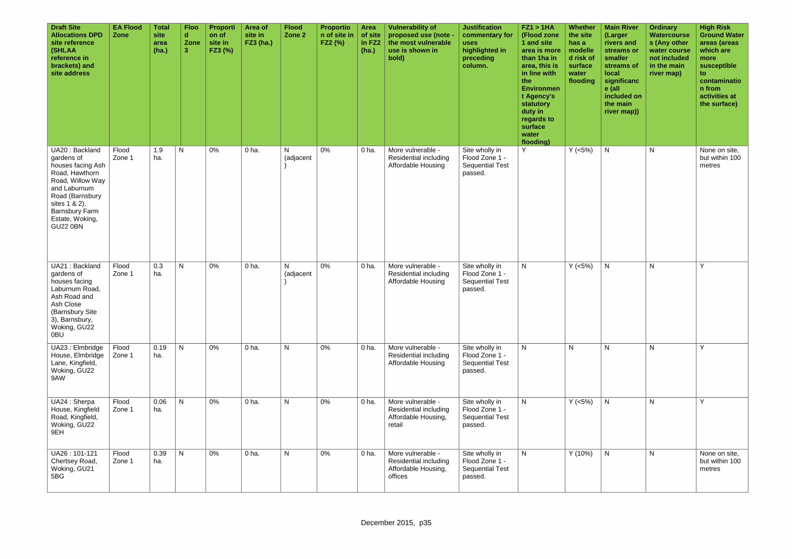
December 2015, p35
Draft Site Allocations DPD site reference (SHLAA reference in brackets) and site address
EA Flood Zone
Total site area (ha.)
Flood Zone 3
Proportion of site in FZ3 (%)
Area of site in FZ3 (ha.)
Flood Zone 2
Proportion of site in FZ2 (%)
Area of site in FZ2 (ha.)
Vulnerability of proposed use (note - the most vulnerable use is shown in bold)
Justification commentary for uses highlighted in preceding column.
FZ1 > 1HA (Flood zone 1 and site area is more than 1ha in area, this is in line with the Environment Agency's statutory duty in regards to surface water flooding)
Whether the site has a modelled risk of surface water flooding
Main River (Larger rivers and streams or smaller streams of local significance (all included on the main river map))
Ordinary Watercourses (Any other water course not included in the main river map)
High Risk Ground Water areas (areas which are more susceptible to contamination from activities at the surface)
UA20 : Backland gardens of houses facing Ash Road, Hawthorn Road, Willow Way and Laburnum Road (Barnsbury sites 1 & 2), Barnsbury Farm Estate, Woking, GU22 0BN
Flood Zone 1
1.9 ha.
N 0% 0 ha. N (adjacent)
0% 0 ha. More vulnerable - Residential including Affordable Housing
Site wholly in Flood Zone 1 - Sequential Test passed.
Y Y (<5%) N N None on site, but within 100 metres
UA21 : Backland gardens of houses facing Laburnum Road, Ash Road and Ash Close (Barnsbury Site 3), Barnsbury, Woking, GU22 0BU
Flood Zone 1
0.3 ha.
N 0% 0 ha. N (adjacent)
0% 0 ha. More vulnerable - Residential including Affordable Housing
Site wholly in Flood Zone 1 - Sequential Test passed.
N Y (<5%) N N Y
UA23 : Elmbridge House, Elmbridge Lane, Kingfield, Woking, GU22 9AW
Flood Zone 1
0.19 ha.
N 0% 0 ha. N 0% 0 ha. More vulnerable - Residential including Affordable Housing
Site wholly in Flood Zone 1 - Sequential Test passed.
N N N N Y
UA24 : Sherpa House, Kingfield Road, Kingfield, Woking, GU22 9EH
Flood Zone 1
0.06 ha.
N 0% 0 ha. N 0% 0 ha. More vulnerable - Residential including Affordable Housing, retail
Site wholly in Flood Zone 1 - Sequential Test passed.
N Y (<5%) N N Y
UA26 : 101-121 Chertsey Road, Woking, GU21 5BG
Flood Zone 1
0.39 ha.
N 0% 0 ha. N 0% 0 ha. More vulnerable - Residential including Affordable Housing, offices
Site wholly in Flood Zone 1 - Sequential Test passed.
N Y (10%) N N None on site, but within 100 metres

December 2015, p36
Draft Site Allocations DPD site reference (SHLAA reference in brackets) and site address
EA Flood Zone
Total site area (ha.)
Flood Zone 3
Proportion of site in FZ3 (%)
Area of site in FZ3 (ha.)
Flood Zone 2
Proportion of site in FZ2 (%)
Area of site in FZ2 (ha.)
Vulnerability of proposed use (note - the most vulnerable use is shown in bold)
Justification commentary for uses highlighted in preceding column.
FZ1 > 1HA (Flood zone 1 and site area is more than 1ha in area, this is in line with the Environment Agency's statutory duty in regards to surface water flooding)
Whether the site has a modelled risk of surface water flooding
Main River (Larger rivers and streams or smaller streams of local significance (all included on the main river map))
Ordinary Watercourses (Any other water course not included in the main river map)
High Risk Ground Water areas (areas which are more susceptible to contamination from activities at the surface)
UA27: Forsyth Road Industrial Estate, Forsyth Road, Woking, GU21 5SU
Flood Zone 1
10.1 ha.
N 0% 0 ha. N 0% 0 ha. Less vulnerable - Industrial, warehousing, offices
Site wholly in Flood Zone 1 - Sequential Test passed.
Y Y (15%) N N Y
UA28): Monument Way West Industrial Estate, Monument Way West, Woking, GU21 5LY
Flood Zone 1
4.3 ha.
N 0% 0 ha. N 0% 0 ha. Less vulnerable - Industrial/warehousing, road infrastructure (fourth arm to the Sheerwater link road)
Site wholly in Flood Zone 1 - Sequential Test passed.
Y Y N Y (adjacent canal)
Y
UA29: 29-31 Walton Road, Woking, GU21 5BX
Flood Zone 1
0.05 ha.
N 0% 0 ha. N 0% 0 ha. More vulnerable - Residential including Affordable Housing
Site wholly in Flood Zone 1 - Sequential Test passed.
N Y (<5%) N N N
Site deleted: 1 to 5 Elliot Court, North Road, to the rear of 1 to 13 North Road, and 95-105 Maybury Road, Woking, GU21 5JL
Flood Zone 1
0.77 ha.
N 0% 0 ha. N 0% 0 ha. More vulnerable - Residential including Affordable Housing, offices (or an alternative employment use meeting Policy CS5)
Site wholly in Flood Zone 1 - Sequential Test passed.
N Y (<5%) N N N
UA31: Walton Road Youth Centre, Walton Road, Woking GU21 5DL
Flood Zone 1
0.08 ha.
N 0% 0 ha. N 0% 0 ha. More vulnerable - Residential including Affordable Housing, community facility (youth centre)
Site wholly in Flood Zone 1 - Sequential Test passed.
N N N N N

December 2015, p37
Draft Site Allocations DPD site reference (SHLAA reference in brackets) and site address
EA Flood Zone
Total site area (ha.)
Flood Zone 3
Proportion of site in FZ3 (%)
Area of site in FZ3 (ha.)
Flood Zone 2
Proportion of site in FZ2 (%)
Area of site in FZ2 (ha.)
Vulnerability of proposed use (note - the most vulnerable use is shown in bold)
Justification commentary for uses highlighted in preceding column.
FZ1 > 1HA (Flood zone 1 and site area is more than 1ha in area, this is in line with the Environment Agency's statutory duty in regards to surface water flooding)
Whether the site has a modelled risk of surface water flooding
Main River (Larger rivers and streams or smaller streams of local significance (all included on the main river map))
Ordinary Watercourses (Any other water course not included in the main river map)
High Risk Ground Water areas (areas which are more susceptible to contamination from activities at the surface)
UA33: Royal Mail Sorting/Delivery Office, White Rose Lane, Woking, GU22 7AJ
Flood Zone 1
0.36 ha.
N 0% 0 ha. N 0% 0 ha. More vulnerable - Residential including Affordable Housing
Site wholly in Flood Zone 1 - Sequential Test passed.
N N N N N
UA32: Car park (east), Oriental Road, Woking, GU22 8BD
Flood Zone 1
1.22 ha.
N 0% 0 ha. N 0% 0 ha. More vulnerable - Residential including Affordable Housing, open space
Site wholly in Flood Zone 1 - Sequential Test passed.
N Y (20%0 N N N
UA34: Coal Yard/Aggregates Yard adjacent to the railway line, Guildford Road, Bradfield Close, Woking, GU22 7QE
Flood Zone 1
2.11 ha.
N 0% 0 ha. N 0% 0 ha. More vulnerable - Residential including Affordable Housing
Site wholly in Flood Zone 1 - Sequential Test passed.
Y Y (10%) N N N
Site deleted: 11-15 Guildford Road, Southern House, Jubilee House, Lynton House, Station Approach, Woking, GU22 7PX
Flood Zone 1
0.44 ha.
N 0% 0 ha. N 0% 0 ha. More vulnerable - Residential including Affordable Housing, offices, retail
Site wholly in Flood Zone 1 - Sequential Test passed.
N Y (<5%) N N N
UA35: Quadrant Court, Guildford Road, Woking, GU22 7QQ
Flood Zone 1
0.9 ha.
N 0% 0 ha. N 0% 0 ha. Less vulnerable - Offices
Site wholly in Flood Zone 1 - Sequential Test passed.
N Y (<5%) N N N

December 2015, p38
Draft Site Allocations DPD site reference (SHLAA reference in brackets) and site address
EA Flood Zone
Total site area (ha.)
Flood Zone 3
Proportion of site in FZ3 (%)
Area of site in FZ3 (ha.)
Flood Zone 2
Proportion of site in FZ2 (%)
Area of site in FZ2 (ha.)
Vulnerability of proposed use (note - the most vulnerable use is shown in bold)
Justification commentary for uses highlighted in preceding column.
FZ1 > 1HA (Flood zone 1 and site area is more than 1ha in area, this is in line with the Environment Agency's statutory duty in regards to surface water flooding)
Whether the site has a modelled risk of surface water flooding
Main River (Larger rivers and streams or smaller streams of local significance (all included on the main river map))
Ordinary Watercourses (Any other water course not included in the main river map)
High Risk Ground Water areas (areas which are more susceptible to contamination from activities at the surface)
Site deleted: Former St Dunstans, White Rose Lane, Woking, GU22 7AG
Flood Zone 1
0.21 ha.
N 0% 0 ha. N 0% 0 ha. More vulnerable - Retail, residential including Affordable Housing
Site wholly in Flood Zone 1 - Sequential Test passed.
N N N N N
UA37: Owen House and The Crescent, Heathside Crescent, Woking, GU22 7AG
Flood Zone 1
0.1 ha.
N 0% 0 ha. N 0% 0 ha. More vulnerable - Offices, residential including Affordable Housing
Site wholly in Flood Zone 1 - Sequential Test passed.
N N N N N
UA38: Somerset House, 1-18 Oriental Road, Heathside Crescent, Woking, GU22 7BG
Flood Zone 1
0.17 ha.
N 0% 0 ha. N 0% 0 ha. More vulnerable - Offices, residential including Affordable Housing
Site wholly in Flood Zone 1 - Sequential Test passed.
N N N N N
Site deleted: Coroner’s Court (former Woking Magistrates Court), Station Approach, Woking, GU22 7YL
Flood Zone 1
0.32 ha.
N 0% 0 ha. N 0% 0 ha. More vulnerable - Offices, residential including Affordable Housing
Site wholly in Flood Zone 1 - Sequential Test passed.
N N N N N
UA39: Corner Garage, 16-18 St Johns Road, St Johns, GU21 7SA
Flood Zone 1
0.12 ha.
N 0% 0 ha. N 0% 0 ha. More vulnerable - Residential including Affordable Housing
Site wholly in Flood Zone 1 - Sequential Test passed.
N N N N Not on site, but within 100 metres

December 2015, p39
Draft Site Allocations DPD site reference (SHLAA reference in brackets) and site address
EA Flood Zone
Total site area (ha.)
Flood Zone 3
Proportion of site in FZ3 (%)
Area of site in FZ3 (ha.)
Flood Zone 2
Proportion of site in FZ2 (%)
Area of site in FZ2 (ha.)
Vulnerability of proposed use (note - the most vulnerable use is shown in bold)
Justification commentary for uses highlighted in preceding column.
FZ1 > 1HA (Flood zone 1 and site area is more than 1ha in area, this is in line with the Environment Agency's statutory duty in regards to surface water flooding)
Whether the site has a modelled risk of surface water flooding
Main River (Larger rivers and streams or smaller streams of local significance (all included on the main river map))
Ordinary Watercourses (Any other water course not included in the main river map)
High Risk Ground Water areas (areas which are more susceptible to contamination from activities at the surface)
UA40: Camphill Tip, Camphill Road, West Byfleet, KT14 6EW
Flood Zone 1
4.82 ha.
N 0% 0 ha. N 0% 0 ha. Less vulnerable - Industrial
The latest information available to the LPA shows the site to be wholly in Flood Zone 1 - Sequential Test passed. It is however adjacent to land classified as Flood Zone 2 and 3.
Y Y (10%) Y (adjacent) Y (adjacent) Y
UA41: Car park to east of Enterprise House, adjacent Social Club, Station Approach, West Byfleet, KT14 6NW
Flood Zone 1
0.08 ha.
N 0% 0 ha. N 0% 0 ha. More vulnerable - Retail, residential including Affordable Housing
Site wholly in Flood Zone 1 - Sequential Test passed.
N Y (100%) N N N
UA42: Land at Station Approach, West Byfleet, KT14 6NG
Flood Zone 1
0.91 ha.
N 0% 0 ha. N 0% 0 ha. More vulnerable - Retail, community (library), offices, retail (Waitrose), residential including Affordable Housing
Site wholly in Flood Zone 1 - Sequential Test passed.
N Y (10%) N N N
UA43: Camphill Club and Scout Hut, Camphill Road, West Byfleet, KT14 6EF
Flood Zone 1
0.38 ha.
N 0% 0 ha. N (adjacent)
0 ha. More vulnerable - Residential including Affordable Housing, community use
Site wholly in Flood Zone 1 - Sequential Test passed.
N Y (<5%) N N None on site but within 100 metres

December 2015, p40
UA22: Alan motors
Flood zone 1
0.28ha
N 0% 0ha N 0% 0ha
UA44 : Woking Football Stadium, Gymnastic Club, Woking Snooker Club, Westfield Avenue, Woking, GU22 9AA
Flood Zone 1
4.64 N 0% 0ha N 0% 0ha
UA36 : land at Bradfield Close and 7 York Road, GU22 7XH
Flood Zone 1
0.12 N 0% 0ha N 0% 0%
Draft Site Allocations DPD site reference (SHLAA reference in brackets) and site address
EA Flood Zone
Total site area (ha.)
Flood Zone 3
Proportion of site in FZ3 (%)
Area of site in FZ3 (ha.)
Flood Zone 2
Proportion of site in FZ2 (%)
Area of site in FZ2 (ha.)
Vulnerability of proposed use (note - the most vulnerable use is shown in bold)
Justification commentary for uses highlighted in preceding column.
FZ1 > 1HA (Flood zone 1 and site area is more than 1ha in area, this is in line with the Environment Agency's statutory duty in regards to surface water flooding)
Whether the site has a modelled risk of surface water flooding
Main River (Larger rivers and streams or smaller streams of local significance (all included on the main river map))
Ordinary Watercourses (Any other water course not included in the main river map)
High Risk Ground Water areas (areas which are more susceptible to contamination from activities at the surface)
GB2: Five Acres, Brookwood Lye Road, Brookwood GU24 OHD
Flood Zone 1.
0.32 ha.
N 0% 0 ha. N 0% 0 ha. Highly vulnerable - Traveller pitches
Site wholly in Flood Zone 1 - Sequential Test passed.
tbc tbc tbc tbc tbc
GB4 (SHLAABY043): Land south of High Road, Byfleet, KT14 7QL
Flood Zone 1.
5.83 ha.
N 0% 0 ha. N 0% 0 ha. More vulnerable (potentially) - To meet long term development needs
Site wholly in Flood Zone 1 - Sequential Test passed.
Y Y (20%) N Y Y
GB6 (SHLAA n/a): Six Crossroads roundabout and environs, Chertsey Road, Woking, GU21 5SH
Flood Zone 1
1.139ha
N 0% 0 ha. N 0% 0 ha. Essential infrastructure - (junction upgrade and improvements)
Site wholly in Flood Zone 1 - Sequential Test passed.
N Y N N N

December 2015, p41
GB7 : Nursery land adjacent to Egley Road, Mayford GU22 OPL
Flood Zone 1
18.65 ha.
N 0% 0 ha. N 0% 0 ha. More vulnerable - Residential including Affordable Housing, recreational/open space and education
Site wholly in Flood Zone 1 - Sequential Test passed. The eastern boundary is adjacent to land classified as Flood Zone 2 and 3 (around the Hoe Stream).
Y Y (50%) N N N but within 100 metres of site
GB8: Woking Garden Centre, Egley Road, Mayford, Woking GU22 0NH
Flood Zone 1
1.62 ha.
N 0% 0 ha. N 0% 0 ha. More vulnerable (potentially) - To meet long term development needs
Site wholly in Flood Zone 1 - Sequential Test passed.
N Y (10%) N N N but within 100 metres of site
Draft Site Allocations DPD site reference (SHLAA reference in brackets) and site address
EA Flood Zone
Total site area (ha.)
Flood Zone 3
Proportion of site in FZ3 (%)
Area of site in FZ3 (ha.)
Flood Zone 2
Proportion of site in FZ2 (%)
Area of site in FZ2 (ha.)
Vulnerability of proposed use (note - the most vulnerable use is shown in bold)
Justification commentary for uses highlighted in preceding column.
FZ1 > 1HA (Flood zone 1 and site area is more than 1ha in area, this is in line with the Environment Agency's statutory duty in regards to surface water flooding)
Whether the site has a modelled risk of surface water flooding
Main River (Larger rivers and streams or smaller streams of local significance (all included on the main river map))
Ordinary Watercourses (Any other water course not included in the main river map)
High Risk Ground Water areas (areas which are more susceptible to contamination from activities at the surface)
Site deleted: Land to the north east of Saunders Lane, between Saunders Lane and Hook Hill Lane, Mayford, GU22 0NN
Flood Zone 1
7.82 ha.
N 0% 0 ha. N 0% 0 ha. More vulnerable (potentially) - To meet long term development needs
Site wholly in Flood Zone 1 - Sequential Test passed.
Y Y (30%) N N N
Site deleted: Land to the north west of Saunders Lane, Mayford, GU22 0NN
Flood Zone 1
19.59 ha.
N 0% 0 ha. N 0% 0 ha. More vulnerable (potentially) - To meet long term development needs
Site wholly in Flood Zone 1 - Sequential Test passed.
Y Y (10%) N Y N
Site deleted: Land rear of 79 – 95 Lovelace Drive, Teggs Lane, Pyrford, Surrey GU22 8QZ
Flood Zone 1
11.64 ha.
N 0% 0 ha. N 0% 0 ha. More vulnerable (potentially) - To meet long term development needs
Site wholly in Flood Zone 1 - Sequential Test passed.
Y Y (10%) N N N

December 2015, p42
Site deleted): Land east of Upshot Lane and South Aviary Road, Pyrford, GU22 8QZ
Flood Zone 1
11.14 ha.
N 0% 0 ha. N 0% 0 ha. More vulnerable (potentially) - To meet long term development needs
Site wholly in Flood Zone 1 - Sequential Test passed.
Y Y (10%) N N N
GB9: Land adjacent to Hook Hill Lane, Hook Heath, Woking, GU22 0PS
Flood Zone 1
8.51 ha.
N 0% 0 ha. N 0% 0 ha. More vulnerable (potentially) - To meet long term development needs
Site wholly in Flood Zone 1 - Sequential Test passed.
Y Y (10%) N N N
Draft Site Allocations DPD site reference (SHLAA reference in brackets) and site address
EA Flood Zone
Total site area (ha.)
Flood Zone 3
Proportion of site in FZ3 (%)
Area of site in FZ3 (ha.)
Flood Zone 2
Proportion of site in FZ2 (%)
Area of site in FZ2 (ha.)
Vulnerability of proposed use (note - the most vulnerable use is shown in bold)
Justification commentary for uses highlighted in preceding column.
FZ1 > 1HA (Flood zone 1 and site area is more than 1ha in area, this is in line with the Environment Agency's statutory duty in regards to surface water flooding)
Whether the site has a modelled risk of surface water flooding
Main River (Larger rivers and streams or smaller streams of local significance (all included on the main river map))
Ordinary Watercourses (Any other water course not included in the main river map)
High Risk Ground Water areas (areas which are more susceptible to contamination from activities at the surface)
GB10: Land surrounding West Hall, Parvis Road, West Byfleet KT14 6EY
Flood Zone 1
29.33 ha.
N 0% 0 ha. N 0% 0 ha. More vulnerable - Residential including Affordable Housing
Site wholly in Flood Zone 1 - Sequential Test passed. It is adjacent to land classified as Flood Zone 2 and 3 (across the River Wey Navigation)
Y Y (10%) N Y Y
Site deleted Mayford SANG, land to the south of Moor Lane, Mayford, Woking, GU22 9RB
Flood Zone 1
17.4 ha.
N 0% 0 ha. N 0% 0 ha. Water-compatible development - Suitable Accessible Natural Greenspace (SANG)
Site wholly in Flood Zone 1 - Sequential Test passed.
Y Y (50%) N Y Y
GB18: West Byfleet Junior and Infant School Playing Fields, Parvis Road, West Byfleet, KT14 6EG
Flood Zone 1
6.78 ha.
N 0% 0 ha. N 0% 0 ha. Water-compatible development - Open space
Site wholly in Flood Zone 1 - Sequential Test passed.

December 2015, p43
Draft Site Allocations DPD site reference (SHLAA reference in brackets) and site address
EA Flood Zone
Total site area (ha.)
Flood Zone 3
Proportion of site in FZ3 (%)
Area of site in FZ3 (ha.)
Flood Zone 2
Proportion of site in FZ2 (%)
Area of site in FZ2 (ha.)
Vulnerability of proposed use (note - the most vulnerable use is shown in bold)
Justification commentary for uses highlighted in preceding column.
FZ1 > 1HA (Flood zone 1 and site area is more than 1ha in area, this is in line with the Environment Agency's statutory duty in regards to surface water flooding)
Whether the site has a modelled risk of surface water flooding
Main River (Larger rivers and streams or smaller streams of local significance (all included on the main river map))
Ordinary Watercourses (Any other water course not included in the main river map)
High Risk Ground Water areas (areas which are more susceptible to contamination from activities at the surface)

December 2015, p44
GB111: Broadoaks, Parvis Road, West Byfleet KT14 6LP
Majority in Flood Zone 1. 5% in Flood Zone 2
14.7 ha.
N 0% 0 ha. Y 5% 0 ha. More vulnerable - Quality offices and research premises, residential including Affordable Housing and housing to meet the accommodation needs of the elderly
The majority of the site is located within Flood Zone 1, with 7% in Flood Zone 2. Allocation of site is clearly based on use of sites in Flood Zone 1 first (following the sequential test) and on a clear written 'key requirement' that the site layout design must contain development on the area of the site within Flood Zone 1, avoiding any part in Flood Zone 2, ensuring the development will not exacerbate flood risk on site or elsewhere. Development is appropriate in terms of flood risk, no Exception Test is required.
Y Y (50%) N N Y
Draft Site Allocations DPD site reference (SHLAA reference in brackets) and site address
EA Flood Zone
Total site area (ha.)
Flood Zone 3
Proportion of site in FZ3 (%)
Area of site in FZ3 (ha.)
Flood Zone 2
Proportion of site in FZ2 (%)
Area of site in FZ2 (ha.)
Vulnerability of proposed use (note - the most vulnerable use is shown in bold)
Justification commentary for uses highlighted in preceding column.
FZ1 > 1HA (Flood zone 1 and site area is more than 1ha in area, this is in line with the Environment Agency's statutory duty in regards to surface water flooding)
Whether the site has a modelled risk of surface water flooding
Main River (Larger rivers and streams or smaller streams of local significance (all included on the main river map))
Ordinary Watercourses (Any other water course not included in the main river map)
High Risk Ground Water areas (areas which are more susceptible to contamination from activities at the surface)

December 2015, p45
GB5 : Land to the south of Rectory Lane, Byfleet KT14 7NE
Majority in Flood Zone 1. Southern boundary in Flood Zone 2.
4.436 ha.
N 0% 0 ha. Y 7% 0.317 ha.
More vulnerable (potentially) - To meet long term development needs
The latest information available to the LPA shows a majority of the site to be in Flood Zone 1, with 7% in Flood Zone 2. It is however adjacent to land classified as Flood Zone 3. Allocation of site is clearly based on use of sites in Flood Zone 1 first (following the sequential test) and on a clear written 'key requirement' that the site layout design must contain development on the area of the site within Flood Zone 1, avoiding any part in Flood Zone 2, ensuring the development will not exacerbate flood risk on site or elsewhere. Development is appropriate in terms of flood risk, no Exception Test is required.
Y N N N Y
Draft Site Allocations DPD site reference (SHLAA reference in brackets) and site address
EA Flood Zone
Total site area (ha.)
Flood Zone 3
Proportion of site in FZ3 (%)
Area of site in FZ3 (ha.)
Flood Zone 2
Proportion of site in FZ2 (%)
Area of site in FZ2 (ha.)
Vulnerability of proposed use (note - the most vulnerable use is shown in bold)
Justification commentary for uses highlighted in preceding column.
FZ1 > 1HA (Flood zone 1 and site area is more than 1ha in area, this is in line with the Environment Agency's statutory duty in regards to surface water flooding)
Whether the site has a modelled risk of surface water flooding
Main River (Larger rivers and streams or smaller streams of local significance (all included on the main river map))
Ordinary Watercourses (Any other water course not included in the main river map)
High Risk Ground Water areas (areas which are more susceptible to contamination from activities at the surface)

December 2015, p46
UA25: Land within Sheerwater Priority Place, Albert Drive, Woking, GU21 5RE
Flood Zones 1 and 2.
33.118 ha.
N 0% 0 ha. Y 25.90% 8.569 More vulnerable - Residential including Affordable Housing, community uses, retail, open space and leisure facilities
The majority of the site (75%) is located within Flood Zone 1, with 25% falling within Flood Zone 2. Allocation of the site is based on use of sites in Flood Zone 1 first (following the sequential test) and is informed by the current planning hybrid planning application (LPA reference PLAN/2015/1260) which proposes replacing existing dwellings in Flood Zone 2 with an equivalent number of higher credentials in terms of reducing run-off, ensuring the development will not exacerbate flood risk on site or elsewhere. Development is appropriate in terms of flood risk, no Exception Test is required.
Y Y (50%) Y (adjacent) Y (runs through site)
Y
Draft Site Allocations DPD site reference (SHLAA reference in brackets) and site address
EA Flood Zone
Total site area (ha.)
Flood Zone 3
Proportion of site in FZ3 (%)
Area of site in FZ3 (ha.)
Flood Zone 2
Proportion of site in FZ2 (%)
Area of site in FZ2 (ha.)
Vulnerability of proposed use (note - the most vulnerable use is shown in bold)
Justification commentary for uses highlighted in preceding column.
FZ1 > 1HA (Flood zone 1 and site area is more than 1ha in area, this is in line with the Environment Agency's statutory duty in regards to surface water flooding)
Whether the site has a modelled risk of surface water flooding
Main River (Larger rivers and streams or smaller streams of local significance (all included on the main river map))
Ordinary Watercourses (Any other water course not included in the main river map)
High Risk Ground Water areas (areas which are more susceptible to contamination from activities at the surface)

December 2015, p47
UA1 : Library, 71 High Road, Byfleet, KT14 7QN
Flood Zones 1 and 2.
0.134 ha.
N 0% 0 ha. Y 31% 0.042 More vulnerable - Residential including Affordable Housing, replacement library, community use
The majority of the site (around 70%) is located within Flood Zone 1, with 31% falling within Flood Zone 2. Allocation of site is clearly based on use of sites in Flood Zone 1 first (following the sequential test) and on a clear written 'key requirement' that the site layout design must contain development on the area of the site within Flood Zone 1, ensuring the development will not exacerbate flood risk on site or elsewhere. Development is appropriate in terms of flood risk, no Exception Test is required.
N N N N Y
Draft Site Allocations DPD site reference (SHLAA reference in brackets) and site address
EA Flood Zone
Total site area (ha.)
Flood Zone 3
Proportion of site in FZ3 (%)
Area of site in FZ3 (ha.)
Flood Zone 2
Proportion of site in FZ2 (%)
Area of site in FZ2 (ha.)
Vulnerability of proposed use (note - the most vulnerable use is shown in bold)
Justification commentary for uses highlighted in preceding column.
FZ1 > 1HA (Flood zone 1 and site area is more than 1ha in area, this is in line with the Environment Agency's statutory duty in regards to surface water flooding)
Whether the site has a modelled risk of surface water flooding
Main River (Larger rivers and streams or smaller streams of local significance (all included on the main river map))
Ordinary Watercourses (Any other water course not included in the main river map)
High Risk Ground Water areas (areas which are more susceptible to contamination from activities at the surface)

December 2015, p48
GB1 (SHLAABRO14a): Land south of Brookwood Lye Road, Brookwood, GU24 0EZ
Majority in Flood Zone 1. Small portion in Flood Zone 2. Very small portion in Flood Zone 3.
1.053 ha.
Y 0.006% 0.000063 ha.
Y 1% 0.012 ha.
More vulnerable - Residential including Affordable Housing
The latest information available to the LPA shows the majority of the site to be in Flood Zone 1, with 1% in Flood Zone 2 and a tiny proportion in Flood Zone 3. Allocation of site is clearly based on use of sites in Flood Zone 1 first (following the sequential test) and on a clear written 'key requirement' that the site layout design must contain development on the area of the site within Flood Zone 1, avoiding any part in Flood Zone 2 and 3, ensuring the development will not exacerbate flood risk on site or elsewhere. The area of the site in Flood Zone 3 is very small and the 'key requirements' will ensure this is not developed. Notwithstanding this the scheme would, in any event, pass the required Exception Test as the development would provide housing including Affordable Housing (bringing a wider sustainability benefit). A site specific Flood Risk Assessment would be required at the application stage.
Y N N N Y

December 2015, p49
Draft Site Allocations DPD site reference (SHLAA reference in brackets) and site address
EA Flood Zone
Total site area (ha.)
Flood Zone 3
Proportion of site in FZ3 (%)
Area of site in FZ3 (ha.)
Flood Zone 2
Proportion of site in FZ2 (%)
Area of site in FZ2 (ha.)
Vulnerability of proposed use (note - the most vulnerable use is shown in bold)
Justification commentary for uses highlighted in preceding column.
FZ1 > 1HA (Flood zone 1 and site area is more than 1ha in area, this is in line with the Environment Agency's statutory duty in regards to surface water flooding)
Whether the site has a modelled risk of surface water flooding
Main River (Larger rivers and streams or smaller streams of local significance (all included on the main river map))
Ordinary Watercourses (Any other water course not included in the main river map)
High Risk Ground Water areas (areas which are more susceptible to contamination from activities at the surface)
GB2: Five Acres, Brookwood Lye Road, Brookwood GU24 OHD
Majority in Flood Zone 1. 7% Flood Zone 2, 5% in Flood Zone 3 (to the north of Brookwood Lye Road).
1.288 ha.
Y 5.51% 0.071 ha. Y 6.52% 0.084 ha.
Highly vulnerable - Traveller pitches and Traveller transit site
The latest information available to the LPA shows the majority of the site to be in Flood Zone 1, with almost 7% in Flood Zone 2 and a 6% proportion in Flood Zone 3. Allocation of site
tbc tbc tbc tbc tbc

December 2015, p50
is clearly based on use of sites in Flood Zone 1 first (following the sequential test) and on a clear written 'key requirement' that the site layout design must contain development on the area of the site within Flood Zone 1, avoiding any part in Flood Zone 2 and 3, ensuring the development will not exacerbate flood risk on site or elsewhere. The area of the site in Flood Zone 3 is modest and the 'key requirements' will ensure this is not developed, allowing the conclusion that the development does not fall within those that should not be permitted.
Draft Site Allocations DPD site reference (SHLAA reference in brackets) and site address
EA Flood Zone
Total site area (ha.)
Flood Zone 3
Proportion of site in FZ3 (%)
Area of site in FZ3 (ha.)
Flood Zone 2
Proportion of site in FZ2 (%)
Area of site in FZ2 (ha.)
Vulnerability of proposed use (note - the most vulnerable use is shown in bold)
Justification commentary for uses highlighted in preceding column.
FZ1 > 1HA (Flood zone 1 and site area is more than 1ha in area, this is in line with the Environment Agency's statutory duty in regards to surface water flooding)
Whether the site has a modelled risk of surface water flooding
Main River (Larger rivers and streams or smaller streams of local significance (all included on the main river map))
Ordinary Watercourses (Any other water course not included in the main river map)
High Risk Ground Water areas (areas which are more susceptible to contamination from activities at the surface)
Site deleted: Ten Acres Farm, Smarts Heath Road, Mayford GU22 0NP
Majority in Flood Zone 1. Southern parts in Flood Zone 2 and a smaller part in
3.36 ha.
Y 12.89% 0.433 ha. Y 15.06% 0.506 ha.
Highly vulnerable - Traveller pitches
The latest information available to the LPA shows the majority of the site to be in Flood Zone 1, with 15% in Flood Zone 2 and 13% in Flood
Y Y Y N Y

December 2015, p51
Flood Zone 3(a).
Zone 3. Allocation of site is clearly based on use of sites in Flood Zone 1 first (following the sequential test) and on a clear written 'key requirement' that the site layout design must contain development on the area of the site within Flood Zone 1, avoiding any part in Flood Zone 2 and 3, ensuring the development will not exacerbate flood risk on site or elsewhere. The area of the site in Flood Zone 3 is limited and the 'key requirements' will ensure this is not developed, allowing the conclusion that the development does not fall within those that should not be permitted.
Draft Site Allocations DPD site reference (SHLAA reference in brackets) and site address
EA Flood Zone
Total site area (ha.)
Flood Zone 3
Proportion of site in FZ3 (%)
Area of site in FZ3 (ha.)
Flood Zone 2
Proportion of site in FZ2 (%)
Area of site in FZ2 (ha.)
Vulnerability of proposed use (note - the most vulnerable use is shown in bold)
Justification commentary for uses highlighted in preceding column.
FZ1 > 1HA (Flood zone 1 and site area is more than 1ha in area, this is in line with the Environment Agency's statutory duty in regards to surface water flooding)
Whether the site has a modelled risk of surface water flooding
Main River (Larger rivers and streams or smaller streams of local significance (all included on the main river map))
Ordinary Watercourses (Any other water course not included in the main river map)
High Risk Ground Water areas (areas which are more susceptible to contamination from activities at the surface)

December 2015, p52
GB13: Brookwood Farm SANG, Bagshot Road, Brookwood, GU21 2TR
Flood Zones 1, 2 and 3
8.057 ha.
Y 54.08% 4.367 ha. Y 4.58% 0.369 ha.
Water-compatible development - Suitable Accessible Natural Greenspace (SANG)
A majority of the site is within Flood Zone 2 (54%), with 41% in Flood Zone 1 and a smaller portion (5%) in Flood Zone 3. Allocation of site is clearly based on use of sites in Flood Zone 1 first (following the sequential test) and on a clear written 'key requirement' that the site layout design must contain any development on the area of the site within Flood Zone 1, avoiding Flood Zones 2 and 3, ensuring the development will not exacerbate flood risk on site or elsewhere. The proposed development is water compatible and therefore permissible in Flood Zone 3, which affects part of the site.
Y Y (100%) N Y Y
Draft Site Allocations DPD site reference (SHLAA reference in brackets) and site address
EA Flood Zone
Total site area (ha.)
Flood Zone 3
Proportion of site in FZ3 (%)
Area of site in FZ3 (ha.)
Flood Zone 2
Proportion of site in FZ2 (%)
Area of site in FZ2 (ha.)
Vulnerability of proposed use (note - the most vulnerable use is shown in bold)
Justification commentary for uses highlighted in preceding column.
FZ1 > 1HA (Flood zone 1 and site area is more than 1ha in area, this is in line with the Environment Agency's statutory duty in regards to surface water flooding)
Whether the site has a modelled risk of surface water flooding
Main River (Larger rivers and streams or smaller streams of local significance (all included on the main river map))
Ordinary Watercourses (Any other water course not included in the main river map)
High Risk Ground Water areas (areas which are more susceptible to contamination from activities at the surface)
GB17: Woking Palace, Carters Lane, Old Woking, GU22 8JQ
Flood Zones 2 and 3
64.421 ha.
Y 68.39% 44.055 ha. Y 14.70% 9.479 ha.
Water-compatible development - Heritage Parkland/Country Park
The site falls largely within land classed as Flood Zone 3, with the remaining approximately
Y Y (20%) Y Y Y

December 2015, p53
20% split across Flood Zones 1 and 2. Allocation of site is clearly based on use of sites in Flood Zone 1 first (following the sequential test), however additional land required for SANG use and insufficient such land available in Flood Zones 1 or 2, supporting need to use this site. Clear written 'key requirement' that the site layout design must contain any development on the area of the site within Flood Zone 1, ensuring the development will not exacerbate flood risk on site or elsewhere. The proposed development is water compatible and therefore permissible in Flood Zone 3, which affects part of the site.
Draft Site Allocations DPD site reference (SHLAA reference in brackets) and site address
EA Flood Zone
Total site area (ha.)
Flood Zone 3
Proportion of site in FZ3 (%)
Area of site in FZ3 (ha.)
Flood Zone 2
Proportion of site in FZ2 (%)
Area of site in FZ2 (ha.)
Vulnerability of proposed use (note - the most vulnerable use is shown in bold)
Justification commentary for uses highlighted in preceding column.
FZ1 > 1HA (Flood zone 1 and site area is more than 1ha in area, this is in line with the Environment Agency's statutory duty in regards to surface water flooding)
Whether the site has a modelled risk of surface water flooding
Main River (Larger rivers and streams or smaller streams of local significance (all included on the main river map))
Ordinary Watercourses (Any other water course not included in the main river map)
High Risk Ground Water areas (areas which are more susceptible to contamination from activities at the surface)

December 2015, p54
12: Byfleet SANG, land to the south of Parvis Road, Byfleet, KT14 7AB
Flood Zones 1, 2 and 3
15.428 ha.
Y 68.53% 10.5721 ha.
Y 17.57% 2.7103 ha.
Water-compatible development - Suitable Accessible Natural Greenspace (SANG)
The majority of the site (68%) is located within Flood Zone 1, with 18% falling within Flood Zone 2. Allocation of site is clearly based on use of sites in Flood Zone 1 first (following the sequential test) and on a clear written 'key requirement' that the site layout design must contain development on the area of the site within Flood Zone 1, ensuring the development will not exacerbate flood risk on site or elsewhere. The proposed development is water compatible and therefore permissible in Flood Zone 3, which affects part of the site.
Y N N Y Y
Draft Site Allocations DPD site reference (SHLAA reference in brackets) and site address
EA Flood Zone
Total site area (ha.)
Flood Zone 3
Proportion of site in FZ3 (%)
Area of site in FZ3 (ha.)
Flood Zone 2
Proportion of site in FZ2 (%)
Area of site in FZ2 (ha.)
Vulnerability of proposed use (note - the most vulnerable use is shown in bold)
Justification commentary for uses highlighted in preceding column.
FZ1 > 1HA (Flood zone 1 and site area is more than 1ha in area, this is in line with the Environment Agency's statutory duty in regards to surface water flooding)
Whether the site has a modelled risk of surface water flooding
Main River (Larger rivers and streams or smaller streams of local significance (all included on the main river map))
Ordinary Watercourses (Any other water course not included in the main river map)
High Risk Ground Water areas (areas which are more susceptible to contamination from activities at the surface)

December 2015, p55
GB15: First SANG at Gresham Mill, High Street, Old Woking, GU22 9LH
Flood Zones 2 and 3
9.925 ha.
Y 94.40% 9.37 ha. Y 5.60% 0.555 ha.
Water-compatible development - Suitable Accessible Natural Greenspace (SANG)
The majority of the site (94%) is located within Flood Zone 3, with under 6% falling within Flood Zone 2 and none in Flood Zone 1. Allocation of site is clearly based on use of sites in Flood Zone 1 first (following the sequential test) and on a clear written 'key requirement' that the site layout design must contain any development on the area of the site within Flood Zone 2, avoiding Flood Zone 3, ensuring the development will not exacerbate flood risk on site or elsewhere. The proposed development is water compatible and therefore permissible in Flood Zone 3, which affects part of the site.
Y Y (50%) Y Y Y
Draft Site Allocations DPD site reference (SHLAA reference in brackets) and site address
EA Flood Zone
Total site area (ha.)
Flood Zone 3
Proportion of site in FZ3 (%)
Area of site in FZ3 (ha.)
Flood Zone 2
Proportion of site in FZ2 (%)
Area of site in FZ2 (ha.)
Vulnerability of proposed use (note - the most vulnerable use is shown in bold)
Justification commentary for uses highlighted in preceding column.
FZ1 > 1HA (Flood zone 1 and site area is more than 1ha in area, this is in line with the Environment Agency's statutory duty in regards to surface water flooding)
Whether the site has a modelled risk of surface water flooding
Main River (Larger rivers and streams or smaller streams of local significance (all included on the main river map))
Ordinary Watercourses (Any other water course not included in the main river map)
High Risk Ground Water areas (areas which are more susceptible to contamination from activities at the surface)

December 2015, p56
GB16: Second SANG at Gresham Mill, High Street, Old Woking, GU22 9LH
Flood Zone 3
9.519 ha.
Y 100% 9.519 ha. N 0% 0 ha. Water-compatible development -Suitable Accessible Natural Greenspace (SANG)
The site falls wholly within land classed as Flood Zone 3 – the River Wey runs through the site. Allocation of site is clearly based on use of sites in Flood Zone 1 first (following the sequential test), however additional land required for SANG use and insufficient such land available in Flood Zones 1 or 2. The proposed development is water compatible and therefore permissible in Flood Zone 3.
Y Y (50%) Y Y Y