local development framework · 2018-08-17 · colchester borough council’s site allocations dpd...
TRANSCRIPT

Colchester Borough Council’s Site Allocations DPD Sustainability Appraisal: Revised Scoping Report
1
Local Development Framework
Site Allocations Regulation 25 Consultation
Sustainability Appraisal: Revised Scoping Report
Spatial Policy Team Colchester Borough Council
(January 2009)

Colchester Borough Council’s Site Allocations DPD Sustainability Appraisal: Revised Scoping Report
2
Contents 1. Introduction 4 2. Integrating SA with Colchester’s Local Development Framework 6
Sustainable Development Principles Sustainability Appraisal and Strategic Environmental Assessment Stages and tasks involved in the SA process Scoping Colchester’s Local Development Framework Core Strategy Methodology for the Site Allocations DPD
3. Identifying key sustainability issues and problems facing Colchester 15
SA Task A1 – Identifying other relevant policies, plans and programmes and sustainability objectives SA Task A2 – Collecting baseline information SA Task A3 – Sustainability issues and problems facing Colchester Areas of the Borough experiencing change during the plan period Likely evolution without the plan based on existing plans, trends and practices Difficulties encountered during the development of the SA
4. SA Task A4 – Developing the SA Framework 35 SA Framework SA scoring system
Sustainability objectives and links with SEA SA Task A5 – Consulting on the scope of the SA
5. Initial appraisal of options 42 North Colchester Growth Area Stanway Growth Area East Colchester Regeneration Area Town Centre South Colchester Regeneration Area Borough wide 6. Subsequent stages and tasks of the SA process 69 Stage B: Developing and refining options and assessing effects Stage C: Preparing the SA report

Colchester Borough Council’s Site Allocations DPD Sustainability Appraisal: Revised Scoping Report
3
Stage D: Consulting on the DPD and SA report Stage E: Monitoring the significant effects of implementing the DPD
7. Habitat Regulations Assessment screening opinion 70 8. Flood risk sequential test 79 List of Tables Table 1. Links between plan making & SEA/SA 9 Table 2. SA Framework 35 Appendices A. Extract from Colchester Local Development Scheme 110 B. Colchester’s Economic Social & Environmental Baseline Data 111 C. International sites summary 129 D. In-combination assessment 165 E. Flood risk vulnerability classification table 177 F. Sequential test available sites 186 G. List of consultees 193 H. Glossary 195 I. References 202
This publication includes maps based upon or reproduced from Ordnance Survey material, with the permission of Ordnance Survey on behalf of the Controller of Her Majesty’s Stationery Office © Crown copyright. Unauthorised reproduction
infringes Crown copyright and may lead to prosecution or civil proceedings. Licence number 100023706, 2009.
The maps used in Sequential Test showing Flood Zones 2 and 3 included in Section 8 of this report were produced using the most up to date Flood Zone information available from the Environment Agency’s website (www.environment-agency.gov.uk).

Colchester Borough Council’s Site Allocations DPD Sustainability Appraisal: Revised Scoping Report
4
Section 1. Introduction This scoping report sets out the scope of the Sustainability Appraisal (SA) for the Site Allocations Development Plan Document (DPD). The Site Allocations DPD, when complete, will be the main tool for determining land use across Colchester Borough until 2021. Scoping and accompanying consultation represents the first major stage of the SA process (see stage A of Table 1, page 9). This revised scoping report replaces the scoping report published in November 2007 alongside the Site Allocations Issues and Options paper. SAs have already been completed for the Core Strategy DPD and the Sustainable Construction Supplementary Planning Document. A revised SA scoping report has also been prepared to accompany the emerging Development Policies DPD. Since the original period of consultation the regulations have been amended and the Council is to undertake the Regulation 25 consultation stage to build upon the Issues and Options work. Under the previous regulations the Council had to undertake two formal stages of consultation before the document was submitted to the Secretary of State. However under the amended regulations, one of the formal stages of consultation has been removed, but even greater emphasis has been placed on community engagement. The community engagement the Council undertakes needs to be appropriate, continuous, transparent and in accordance with the adopted Statement of Community Involvement. This Regulation 25 consultation ensures the appropriate level of consultation is undertaken and those landowners, stakeholders, residents, agents and interested parties have the opportunity to comment accordingly. Although a SA scoping report has already been produced and consulted upon it was considered necessary to revise the scoping report to publish alongside the Regulation 25 consultation; this decision was taken for three reasons. Firstly, it was considered necessary to update the baseline data and review of policies, plans and programmes and sustainability objectives to ensure the most up to date environmental baseline. Secondly, in order to be open and transparent it was considered appropriate to publish the summary appraisal of each of the genuine options to allow statutory consultees, landowners and members of the public to comment on the Council’s initial conclusions to better inform the formal appraisal of each site. Finally, the Council have decided to combine the SA with the Habitat Regulations Assessment and flood risk sequential test in order that these processes can complement one another; publishing a revised SA scoping report provides the opportunity to also publish the Habitat Regulations Assessment screening report and document the outcome of the flood risk sequential test. The report is structured into the following sections: Section 2 provides an overview of the SA process and how it integrates with the Site Allocations DPD being prepared as part of Colchester’s Local Development Framework.

Colchester Borough Council’s Site Allocations DPD Sustainability Appraisal: Revised Scoping Report
5
Section 3 includes they key messages from the review of relevant policies, plans and programmes and sustainability objectives, as well as a collection of baseline information and indicators used during the development of Colchester’s Local Development Framework. This chapter also identifies the key characteristics of Colchester Borough including the key sustainability issues and problems to be addressed across the Borough. Section 4 sets out the proposed SA Framework for Colchester’s Local Development Framework including information about the development of the sustainable development objectives it contains. Section 5 summarises the conclusions of the initial appraisal of sites carried out as part of SA task B2. Section 6 provides an explanation of subsequent stages and tasks of the SA process and how this will be integrated with the production of the Site Allocations DPD. Section 7 is the Habitat Regulations Assessment screening report. Section 8 documents the flood risk sequential test. We welcome your comments on this SA Scoping Report for the Site Allocations DPD. Comments should be sent to: Colchester Borough Council PO Box 885 Colchester CO1 1ZE Alternatively email your comments to [email protected] . The closing date of the consultation is 27 February 2009.

Colchester Borough Council’s Site Allocations DPD Sustainability Appraisal: Revised Scoping Report
6
Section 2. Integrating Sustainability Appraisal with Colchester’s Local Development Framework Sustainable Development Principles One of the most widely used definitions of sustainable development comes from the report of the World Commission on Environment and Development (the Bruntland Commission), ‘Our Common Future’ (1987), which defines it as “development that meets the needs of the present without compromising the ability of future generations to meet their own needs”. A more detailed definition is offered in the government’s strategy for sustainable development, ‘Securing the Future’ (2005), which includes five guiding principles for sustainable development, set out below. Living within environmental limits This involves respecting the limits of the planet’s environment, resources and biodiversity – to improve our environment and ensure that the natural resources needed for life are unimpaired and remain so for future generations. Globally the rate at which natural resources are being consumed is at an all time high. Nationally there is a high demand for more homes and this will inevitably place a strain on natural resources. It is important for Colchester to ensure that it can accommodate the required amount of new dwellings as set out in the Regional Spatial Strategy (RSS) whilst also protecting and enhancing the quality of the environment. Climate change is an important global issue and measures to tackle and adapt to the effects of climate change are of vital importance. National and regional targets for the production of renewable energy, water efficiency and landfill waste minimisation should be met and where possible exceeded. Ensuring a strong, healthy and just society This includes meeting the diverse needs of all people in existing and future communities, promoting personal wellbeing, social cohesion and inclusion and creating equal opportunity for all. Colchester Borough is not a deprived area as a whole; however four of the wards within the Borough are in the most deprived 20% of wards in the East of England. One of the wards has the highest level of children living in poverty in Essex. The Local Development Framework (LDF) can facilitate the regeneration of deprived areas and help to create equal opportunities. The community is provided with a wide range of Council run services and facilities, which promote wellbeing and healthy lifestyles. By 2021 there will be an aging population in Colchester, which will need to be provided for.

Colchester Borough Council’s Site Allocations DPD Sustainability Appraisal: Revised Scoping Report
7
Achieving a sustainable economy This includes building a strong, stable and sustainable economy which provides prosperity and governance and opportunities for all, and in which environmental and social costs fall on those who impose them (the polluter pays principle) and efficient resource use is incentivised. The East of England has one of the fastest growing economies nationally, whilst this growth benefits residents it creates increasing strain on the level of housing, infrastructure, services and the environment. The economy has a vital role to play in improving the prosperity of an area and therefore creating a stronger, healthier and just society. It is important that existing employment land is maintained and new employment growth is encouraged close to centres of population. Promoting good governance This is the active promotion of effective participative systems of levels of society – engaging people’s creativity and diversity. Active involvement of stakeholders is essential in the development and implementation of the Local Development Framework. The Council will therefore need to ensure that it involves all relevant stakeholders at all stages of production as set out in the Statement of Community Involvement. Using sound science responsibly This ensures that policy is developed and implemented on the basis of strong scientific evidence, whist taking into account scientific uncertainty (through the precautionary principle) as well as public attitudes and values. Decisions should be based around a robust evidence base, which will ensure that decisions are credible. A comprehensive evidence base was developed for the Core Strategy and this should be built upon where necessary. Sustainability Appraisal and Strategic Environmental Assessment Sustainability Appraisal (SA) is about asking at various intervals during plan preparation: “how sustainable is my plan?”. A range of objectives are established and all options are assessed against these objectives to compare their environmental, economic and social effects and ultimately to assess how sustainable an option is. Under the Planning and Compulsory Purchase Act 2004 (as amended), SA is mandatory for Regional Spatial Strategies (RSS), Development Plan Documents (DPDs) and Supplementary Planning Documents (SPDs).
Colchester Borough Council’s Site Allocations DPD Sustainability Appraisal: Revised Scoping Report
8
In addition to an SA, the DPD must also undergo a Strategic Environmental Assessment (SEA) in accordance with European Directive 2001/42/EC on the assessment of the effects of certain plans and programmes. The objective of SEA, as defined in the Government’s guidance on strategic environmental assessment, is “to provide for a high level of protection of the environment and contribute to the integration of environmental considerations into the preparation and adoption of plans….with a view to promoting sustainable development” (Article 1). There is a distinct difference between SA and SEA. SA examines all sustainability related effects including social, economic and environmental impacts, whereas SEA is focused primarily on environmental impacts. Clearly there is some overlap between these two processes and it is therefore best practice to incorporate the requirements of the SEA Directive into the SA process. Therefore all references to SA in this and subsequent reports also refer to and incorporate the requirements of SEA. Stages & tasks involved in the SA process Table 1, overleaf, demonstrates how the SA is incorporated within the DPD process.

Colchester Borough Council’s Site Allocations DPD Sustainability Appraisal: Revised Scoping Report
9
(ODPM Guidance (2005). ‘Sustainability Appraisal of Regional Spatial Strategies & Local Development Frameworks’. p 39.) Scoping As illustrated in Table 1 scoping involves five key stages:
• SA Task A1: Identifying other relevant policies, plans, programmes and sustainability objectives

Colchester Borough Council’s Site Allocations DPD Sustainability Appraisal: Revised Scoping Report
10
• SA Task A2: Collecting baseline data • SA Task A3: Identifying sustainability issues and problems • SA Task A4: Developing the SA framework • SA Task A5: Consulting on the scope of the SA
All of these stages were undertaken as part of the initial scoping exercise (November 2007) and this revised scoping report:
• updates the review of relevant policies, plans and programmes and sustainability objectives and provides a summary of the key messages from this review (SA Task A1);
• updates the baseline data (SA Task A2); • reviews the identified sustainability issues and problems facing the
Borough (SA Task A3); • sets out the SA framework, which remains unchanged from the initial
scoping report (SA Task A4); • outlines the outcomes of the initial appraisal of the DPD options (SA Task
B2); • includes the Habitat Regulations Assessment screening opinion; and • documents the flood risk sequential test, in accordance with PPS25.
Information about subsequent stages of the SA process is set out in Section 6 of this report. Colchester’s Local Development Framework The LDF comprises a number of documents that set out the blueprint for the future development of the Borough. Colchester’s LDF will contain a series of Local Development Documents (LDDs), including Development Plan Documents (DPDs) and Supplementary Planning Documents (SPDs). The production of the LDF follows on from the development of the East of England Regional Spatial Strategy (RSS), which was adopted in May 2008 and was also subject to SA. Colchester’s LDF will need to demonstrate conformity with the RSS and compliment Colchester’s Sustainable Community Strategy (2007). The timetable for the delivery of Colchester’s LDF is set out in the Local Development Scheme (LDS) and is summarised in appendix A. The Core Strategy DPD is the main document within the LDF and includes an overall vision, which sets out how the area and the places within it should develop; strategic objectives for the area focussing on the key issues to be addressed; and a delivery strategy for achieving these objectives, which should set out how much development is intended to happen where, when, and by what means it will be delivered. Preparation of the Core Strategy began in 2005 and involved numerous stages, which culminated in an Examination in summer 2008. An independent Inspector concluded that the Core Strategy was sound and it was adopted by the Council in December 2008. The Development Policies DPD is being prepared alongside the Site Allocations DPD and will also be published

Colchester Borough Council’s Site Allocations DPD Sustainability Appraisal: Revised Scoping Report
11
in January for Regulation 25 consultation. The Development Policies DPD will include a number of criteria based policies that will be used by development control in the determination of planning applications. Various SPDs have and are being prepared as set out in the LDS extract in appendix A. Further details about these documents can be found in the LDS, which is available on the Council’s website. Core Strategy The core policies identified in Colchester’s Core Strategy are set out below. The policies in the Core Strategy provide the overarching policy direction for the LDF, and for the delivery of development, infrastructure, facilities and services in Colchester up to 2021. The Site Allocations DPD must be in conformity with the Core Strategy DPD. SD1 - SD3 Sustainable Development The Strategy establishes a Settlement Hierarchy to guide development towards the most sustainable locations. These development locations will be coordinated with the provision of transportation infrastructure, community facilities, shopping, employment opportunities and open space to create sustainable communities. The Core Strategy seeks to provide excellent health, education, culture and leisure facilities to meet the needs of Colchester’s growing community. Major community facilities (including the University of Essex and the Colchester General Hospital) will form key components of the growth areas and will be better connected by Transit Corridors. The Strategy also seeks to deliver new community facilities, including the Firstsite Building and Community Stadium. CE1 - CE3 Centres and Employment Achieving a prestigious regional centre and sustainable communities requires the enhancement of our Town Centre as well as other local centres. The Core Strategy establishes a hierarchy that secures the important role of the Town Centre and encourages the regeneration of Urban Gateways to Colchester (e.g. North Station). The Core Strategy also promotes the enhancement of district and local Centres to support communities with local employment, shops and services. Strategic Employment Zones have also been identified to accommodate business development at locations to the north, east and west of Colchester Town that are well supported with infrastructure. H1 – H5 Housing Colchester Borough needs to accommodate 17,100 homes between 2001 and 2021, and an additional 1,710 homes by 2023. Over two-thirds of this housing is already accounted for through existing allocations, permissions and completions. In broad terms, the majority of housing development in the Borough will be accommodated at the following locations:

Colchester Borough Council’s Site Allocations DPD Sustainability Appraisal: Revised Scoping Report
12
• Town Centre • North Growth Area plus greenfield allocations • East Growth Area • South Growth Area • Stanway Growth Area plus greenfield allocations
Housing developments will need to provide 35% affordable housing and provide a mix of housing to meet the diverse needs of the community. UR1 - UR2 Urban Renaissance The Core Strategy seeks to maximise the potential of the existing regeneration areas and stimulate a broader urban renaissance throughout the Town Centre. The Core Strategy also seeks to protect the historic character of the Borough whilst securing high standards of urban design in new developments. PR1 - PR2 Public Realm Creating a high quality public realm, including parks, squares and streets, is integral to the success of sustainable communities, and is therefore a key element of the Core Strategy. The Strategy seeks to improve the street environment and calm traffic in urban areas to attract residents to local shops, schools, parks and bus stops. Existing parkland and green links will be enhanced, and new open space will be acquired at appropriate locations, to meet the recreational needs of Colchester’s growing community. TA1 – TA5 Transport and Accessibility The key aims of the transport strategy and policies are to improve accessibility and promote sustainable travel behaviour. Improved access to shops, employment and services can be achieved through a long-term strategy of coordinating land use and transport. The Strategy seeks to coordinate the following elements in order to improve accessibility and create sustainable communities:
• Support development at accessible locations to reduce the need to travel. • Create people-friendly streets and encourage walking and cycling. • Improve the public transport network with Transit Corridors, Park and
Ride, and quality gateways/interchanges. • Improve the strategic road network and manage car traffic and parking in
urban areas. • Support rural communities with demand responsive transport services. • Travel planning and improved public information
ENV1 - ENV2 Environment and Rural Communities The natural, historic and built environment, countryside and coastline will be conserved to protect the Borough’s diverse history, archaeology, geology, and biodiversity. Development will be directed away from sites of landscape and

Colchester Borough Council’s Site Allocations DPD Sustainability Appraisal: Revised Scoping Report
13
conservation importance and land at risk from flooding. The unique character of Colchester’s villages will be protected, with only limited development supported to meet identified needs for local employment, affordable housing and community facilities. ER1 Energy, Resources, Waste, Water and Recycling Establishing sustainable communities in Colchester requires careful management of our energy, resources and waste. The Strategy will promote environmentally sustainable developments that are designed to:
• Utilise renewable energy sources and techniques. • Reduce household energy and water consumption. • Encourage the principles of reducing, reusing and recycling of waste.
Methodology for the Site Allocations DPD The Site Allocations DPD will allocate land for a range of site specific uses which will provide the site detail for the strategic vision and objectives of the Core Strategy. The Site Allocations DPD will also set out policies and proposals relevant to the sites including detailed requirements for their development. Once completed the DPD will include a range of site proposals to deliver the objectives of the Core Strategy. The Site Allocations Issues and Options document (November 2007) outlined a number of general themes and started the debate surrounding the amount of land which needs to be allocated and the different options available to the Council. Within the document, questions were posed on issues affecting the formation of the criteria used to evaluate sites. The document also gave landowners, agents, stakeholders and interested parties the opportunity to submit their sites for consideration. In response to the consultation the Council received upwards of 300 site representations which ranged in size and proposed use to a number of objections relating to various sites. The Council considered each of the sites submitted by third parties and sites identified in the Housing Land Availability Assessment and discounted those sites that did not conform with national, regional and local policy. Sites that conform with policy are included in the document currently out for consultation. At this stage the Council is not making any firm commitments to the sites which are being put forward. These sites have only been included because they are considered to accord with the Core Strategy and therefore could be appropriate for development. It is essential to engage stakeholders and interested parties at every stage of the decision making process to ensure that appropriate sites are allocated for appropriate uses. At this stage the Council wish to seek the views on the content of the document and the sites the Council considers appropriate and the uses proposed for each of them.

Colchester Borough Council’s Site Allocations DPD Sustainability Appraisal: Revised Scoping Report
14
Following public consultation and an Examination in Public the Council will produce a Proposals Map which will outline those sites appropriate for future development and which deliver the spatial vision as outlined in the Core Strategy. Site designations which seek to protect certain areas from future development because of their integral value and their contribution to the social well-being of the Borough will also be allocated through the Site Allocations document. Allocations likely to feature on the Proposals Map include (not exhaustive):
• Housing; • Employment Zones; • Community Facilities; • Open Space; • Area of Outstanding Natural Beauty; • Areas at risk of flooding; • Sites of Special Scientific Interest (SSSI).

Colchester Borough Council’s Site Allocations DPD Sustainability Appraisal: Revised Scoping Report
15
Section 3. Identifying key sustainability issues & problems facing Colchester SA Task A1 - Identifying other relevant policies, plans, and programmes, and sustainability objectives A review of relevant policies, plans and programmes and sustainability objectives was undertaken for the SA of the Core Strategy. This review has been updated to include a greater number of documents and update documents already reviewed where necessary. The purpose of reviewing policies, plans and programmes is to help set the context for the SA and consider relevant constraints and targets. Generally plans and programmes tend to sit in a hierarchy, with the same issues covered in increasing detail from the international level through to the local level. Consequently this review of policies, plans and programmes focuses more closely on regional and local level plans and only deals with a few plans at international and national level. The full review of policies, plans and programmes is available from the Council upon request and the table below includes the key messages from this review, which are split up into economic, environmental and social issues. Economic
Key Messages Source Ensure that town centres provide an attractive, accessible and safe environment for businesses, shoppers and residents through the promotion of high quality and inclusive design, improvement of the quality of the public realm and open spaces, protection and enhancement of the architectural and historic heritage of centres and provision of a sense of place and a focus for the community and for civic activity.
PPS6, Sustainable Community Strategy, By Design, Regional Economic Strategy
Schemes for rural diversification should be supported. PPS7, The Taylor Review Developments should take account of the role and value of biodiversity in supporting economic diversification and contributing to a high quality environment.
PPS9, Ramsar convention
Development should be located in areas which minimise the length and number of trips, especially by motor vehicles and can be served by more energy efficient modes of transport (this is particularly important in the case of offices, light industrial development and campus style developments such as science and business parks likely to have large numbers of employees).
PPG4, PPG13, RSS14
The countryside can provide opportunities for recreation and visitors can play an important role in the regeneration of the economies of rural areas.
PPS7, PPG17
Support business innovation and take-up of best practice in renewable energy technology and management.
Johannesburg Declaration on Sustainable Development – from our origins to the future, RSS14
Provide for the needs of an expanding tourism sector. RSS14, A Better Life Harness the region’s economic strengths specifically in science, technology and research.
IRS, Regional Economic Strategy, Regional Health

Colchester Borough Council’s Site Allocations DPD Sustainability Appraisal: Revised Scoping Report
16
Strategy Create a framework for private investment and regeneration that promotes economic, environmental and social well being, particularly in deprived areas.
Sustainable Community Strategy, Corporate Strategy, Regional Business Plan for the Olympic Games, Regional Economic Strategy, PPS6, RSS14, PPS12, Regional Health Strategy
Olympic spirit: maximise the benefits from the Olympics coming to London in 2012 by playing a part and getting people involved and participating in sport (£600 million is the estimate economic impact for the East of England from the Olympic Games).
A Better Life, Regional Business Plan for the Olympic Games, Regional Health Strategy
Promote the development of the Haven Gateway as a New Growth Point.
Haven Gateway Programme of Development
LDFs should contain policies to support home based working. The Taylor review Protect sites and routes which could be critical in developing infrastructure to widen transport choices for both passenger and freight movements.
PPG13
Environmental
Key Messages Source The quality and extent of natural habitats and geological and geomorphological sites; the natural physical processes on which they depend; and the populations of naturally occurring species which they support should be protected and enhanced.
PPS9, RSS14, Future Water, IRS, Corporate Strategy, Johannesburg Declaration, Ramsar Convention, Water Framework Directive, Future Water, Essex Biodiversity Action Plan, Essex Minerals Development Document Core Strategy Issues and Options Paper, Essex Minerals Local Plan
Developments should take account of the role and value of biodiversity in supporting economic diversification, contributing to a high quality environment and a better quality of life.
PPS9, RSS14, Sustainable Community Strategy, East of England Regional Social Strategy, Essex and Southend Waste Local Plan
Maximise the potential for landscape and biodiversity enhancement by securing the high quality restoration of land at the earliest opportunity, with appropriate aftercare to facilitate beneficial after uses.
PPS9, Sustainable Development Framework for the East of England, Essex Minerals Development Document Core Strategy Issues and Options Paper, Essex Minerals Local Plan
The biodiversity value of brownfield sites must be considered. PPS9 Consideration should be given to the fundamental ecological functions of wetlands as regulators of water regimes and as habitats supporting a characteristic flora and fauna, especially
Ramsar convention on Wetlands of international importance especially as

Colchester Borough Council’s Site Allocations DPD Sustainability Appraisal: Revised Scoping Report
17
waterfowl and the interdependence of man and his environment.
waterfowl habitat
Identify priority habitats and species which are important on an international and national scale, important in Essex or where there is a special responsibility.
Essex Biodiversity Action Plan
High quality green infrastructure should be delivered over the next 20 years to complement and support planned housing and development growth.
Haven Gateway Green Infrastructure Strategy Study
Development should not be located on greenfield land outside of settlements.
PPS7, PPS3, RSS14
The partnership between urban and rural areas should be strengthened so as to create a new urban-rural relationship.
European Spatial Development Perspective
Landscape character should be protected. RSS14, PPS7, Essex Minerals Development Document Core Strategy Issues and Options Paper, Essex Minerals Local Plan
Use resources more efficiently, minimising waste and increasing rates of reuse and recycling
Johannesburg Declaration on Sustainable Development – from our origins to the future, RSS14, IRS, Sustainable Community Strategy, Corporate Strategy, Regional Economic Strategy, Sustainable Development Framework for the East of England, Essex and Southend Waste Local Plan
Sustainable water use based on a long-term protection of available water resources should be promoted.
Water Framework Directive, RSS14, Future Water
Identify land at risk (and the degree of risk) of flooding from river, sea and other sources.
PPS25, PPS25 practice guide
Safeguard land from development that is required for current and future flood management eg conveyance and storage of flood water, and flood defences.
PPS25, Future Water
Reduce flood risk to and from new development through location, layout and design, incorporating sustainable drainage systems (SUDS).
PPS25, PPS25 practice guide RSS14, Future Water
Consideration of the fundamental ecological functions of wetlands as regulators of water regimes.
Ramsar convention on Wetlands of international importance especially as waterfowl habitat
Follow the flood risk management hierarchy (assess, avoid, substitute, control and mitigate).
PPS25, PPS25 practice guide
The pollution of groundwater must be reduced. Water Framework Directive Adopt a precautionary approach. PPS23 Make the polluter pay. PPS23 Noise-sensitive developments should be separated from major sources of noise (such as road, rail and air transport and certain types of industrial development) and development involving noisy activities should, if possible, be sited away from noise-sensitive land uses.
PPG24, Sustainable Development Framework for the East of England

Colchester Borough Council’s Site Allocations DPD Sustainability Appraisal: Revised Scoping Report
18
The need for growth should be reconciled with the need to protect the historic environment.
PPG15, PPG16, RSS14, IRS, Corporate Strategy, ESDP, Sustainable Community Strategy, Essex Minerals Development Document Core Strategy Issues and Options Paper, Essex Minerals Local Plan
Areas must be maintained as attractive places to live, work and visit with their own distinctive identity.
PPS1, PPS3, PPS6, PPS7, RSS14, By Design, A Better Life
There should be an emphasis on design, quality and preserving and enhancing natural and built assets.
Sustainable Community Strategy
10% of UK electricity to come from renewable energy sources by 2010 and 20% by 2020.
PPS22, RSS14, Johannesburg Declaration
Separate economic growth from increases in resource use, especially in terms of energy and water.
IRS
Development plans should contribute to global sustainability by reducing carbon emissions and addressing other causes & impacts of climate change.
PPS1, PPS12, RSS14, Sustainable Community Strategy, Sustainable Development Framework for the East of England, Essex Climate Change Strategy, Johannesburg Declaration, IRS, Code for Sustainable Homes, Adapting to climate change; a framework for action, Limiting Global Climate Change to 2 degrees Celsius: The way ahead for 2020 and beyond, climate change PPS
Adaption will be crucial in reducing vulnerability to climate change and is the only way to cope with impacts that are inevitable.
Adapting to climate change; a framework for action, Limiting Global Climate Change to 2 degrees Celsius: The way ahead for 2020 and beyond, climate change PPS
There is a need to look holistically at systems (ecological and human) affected by climate change.
Adapting to climate change; a framework for action, climate change PPS
Open space and green infrastructure help wildlife to adapt to the effects of climate change.
Haven Gateway Green Infrastructure Strategy, PPG17, Regional Health Strategy, climate change PPS
Social Key Messages Source Access policies should be clear, comprehensive & inclusive. PPS1 Community involvement is essential. PPS1 The needs of the changing demographic should be met. IRS, Regional Social

Colchester Borough Council’s Site Allocations DPD Sustainability Appraisal: Revised Scoping Report
19
Strategy Support people in the region in ‘active ageing’ and adding life to years, linking in with the National Service Framework for older people.
Regional Health Strategy
Policies should promote high quality, inclusive design. PPS1, Regional Economic Strategy, Regional Social Strategy, Regional Health Strategy
Housing developments must be located in suitable locations that make efficient use of land and offer a good range of community facilities and with good access to jobs, key services and infrastructure.
PPS3, Corporate Strategy, Regional Housing Strategy, RSS14, PPS1, PPG13, Regional Health Strategy
Housing shortages must be addressed by securing a step change in the delivery of additional housing throughout the region and giving priority to the provision of affordable housing to meet identified needs.
RSS14, PPS3, IRS, Corporate Strategy, Regional Housing Strategy, Affordable Housing Strategy
The combination of high cost homes and low rural wages is putting rural housing out of the reach of many who work in the countryside.
The Taylor Review
Promote social inclusion, ensuring that both urban and rural communities have access to a range of main town centre uses and that deficiencies in provision are remedied.
PPS6, IRS, Regional Economic Strategy, East of England Regional Social Strategy, PPS3, PPS7
Open spaces, sports and recreational facilities promote social inclusion and are a means of promoting healthy living and preventing illness, and in the social development of children.
PPG17, Open Space SPD, Regional Business Plan for the Olympic Games, East of England Regional Social Strategy, Regional Health Strategy
Biodiversity should be enhanced in green spaces and among developments so that they are used by wildlife and valued by people, recognising that healthy functional ecosystems can contribute to a better quality of life and to people’s sense of well-being.
PPS9, RSS14, Regional Social Strategy
Consistent with the aims of sustainable development, a balance between safeguarding the environment of Essex, and the quality of life of its residents must be achieved.
PPS9, RSS14, Sustainable Community Strategy, East of England Regional Social Strategy, Essex and Southend Waste Local Plan
Locate day to day facilities which need to be near their clients in local centres so that they are accessible by walking and cycling.
PPG13, RSS14, East of England Regional Social Strategy
Reduce levels of poverty and exclusion and promote well being through community cohesion and social capital.
RSS14, IRS, East of England Regional Social Strategy
Improve the skills base through increased learning opportunities for all.
IRS, Corporate Strategy, Sustainable Community Strategy, The Leitch Review of Skills
Those who live in the most deprived areas are likely to be multiply disadvantaged and without gainful employment are
Sustainable Community Strategy, East of England

Colchester Borough Council’s Site Allocations DPD Sustainability Appraisal: Revised Scoping Report
20
more likely to be socially excluded from the community at large. Regional Social Strategy Olympic spirit: maximise the benefits from the Olympics coming to London in 2012 by playing a part and getting people involved and participating in sport.
A Better Life, Regional Business Plan for the Olympic Games
SA Task A2 - Collecting baseline information Annex 1b of the SEA Directive requires the assessment to provide information on “the relevant aspects of the current state of the environment and the likely evolution there of without implementation of the plan or programme”. Collation of existing environmental and sustainability data has helped to identify the key sustainability issues facing Colchester and set the context for the appraisal of the Site Allocations DPD. Data has been presented in terms of social, economic and environmental issues in Colchester, although it is recognised that many issues are cross-cutting. It should be noted that the data sources in this section have been updated from the initial scoping report and will continue to be revisited during subsequent stages of the SA to check for updated and new information against which to predict and assess the effects of Colchester’s Site Allocations DPD. The baseline information, trends and indicators are set out in appendix B and will be referred to when assessing the Site Allocations DPD. General characteristics The Borough of Colchester is located in the county of Essex in the east of England and is situated 62 miles north east of London. The Borough covers an area of almost 125 square miles (34,540 hectares) and has the main town of Colchester surrounded by a rural hinterland with centres of population in the larger villages of Tiptree, West Mersea and Wivenhoe. These three prosperous and growing villages each have their own strong identity, aspirations and requirements. The remainder of the Borough is largely rural in character with a number of smaller villages and many small hamlets. The northern part of the Borough which borders with Suffolk lies within the Dedham Vale Area of Outstanding Natural Beauty. Data from the mid-2007 population estimates that the population of the Borough is 175,500. Less than 7% of the population comprises ethnic minority groups, an increase of 3% since 2001. Two–thirds of the total population is concentrated within the built-up areas of Colchester and Stanway. Colchester’s population has seen a growth of 12.5% since mid-2001. It accounts for 12.8% of the Essex County population and based on mid-2007 figures the average population density of Colchester was 533 people per square kilometre (sq km). This is an increase from 2001 when there were 329 people per sq km. The population of Colchester is expected to grow by 30.9% (since mid-2006 population estimates) to 223,500 people in 2021. The largest growth will be in the older age groups (60+), whilst growth levels are expect to decline in the

Colchester Borough Council’s Site Allocations DPD Sustainability Appraisal: Revised Scoping Report
21
younger ages groups (aged 19 or younger). This means that by 2021, there will be an ‘ageing population’ in Colchester, which will affect many areas of the community for example, the economy, housing and health. The aging population is evidenced by the fact that 16.1% of Colchester’s population will be aged 65 or over in 2021. At 1st April 2008 there were approximately 72,634 dwellings within the Borough of which 80.5% were privately owned. The average household size was 2.37 people per household in 2001 but it is estimated that this may have decreased in recent years. A total of 1,243 homes were built between 1 April 2007 and 31 March 2008. Under current policies, 825 dwellings are expected to be built in the Borough each year. There has been an annual completion of 921 flats and 555 houses in 2007/8 and 236 recorded affordable housing completions. During this same time period 81% of residential completions were located on previously developed land (brownfield sites), a decrease from over 90% in previous years. It was also recorded that no new dwellings were completed at less than 30 dwellings per hectare, 292 dwellings were completed at between 30 and 50 dwellings per hectare and 959 were completed at above 50 dwellings per hectare. A national rise in house prices and improved commuter links to London have contributed to an increase in local house prices, out of line with local wage levels. Colchester’s mean house price was £198,728 in 2007, this remains below the national and county average of £218,910 and £230,588 respectively. Colchester’s mean house price has increased from a mean of £65,926 in 1996. The Borough therefore has a significant and growing issue with the supply of housing that people can afford and research shows the need for more affordable housing within the Borough. The Borough is connected to a comprehensive network of major roads via the A12 and A120, which provide routes to London, the M25, Harlow and Cambridge. The Borough also lies in close proximity to the major seaport of Harwich (20 miles) and Stansted Airport (30 miles). Transportation provision includes six railway stations, bus routes operated by ten bus companies and several cycle trails including National Cycle Route One. Cycling infrastructure will increase in future as the town was awarded Cycling Town status in 2008. One of the biggest challenges to Colchester is traffic growth and the dominance of the car as the main mode of travel. The 2001 census indicated that 78.9% of households own one or more cars and vans and this figure is expected to have increased in recent years. The census also indicated that 61.1% of Colchester’s working age population usually travelled to work by car or van, 13.0% usually travelled by public transport and a further 9.1% usually worked from home (working-age population includes full-time, part-time, self-employed and full-time students). Consequently, it is apparent that significant congestion can occur

Colchester Borough Council’s Site Allocations DPD Sustainability Appraisal: Revised Scoping Report
22
during peak times within Colchester, the A12 and on several of the minor roads to the south of the Borough. Economic characteristics The Borough is well connected to the strategic road and rail networks between London and East Anglia. Stansted Airport is close by, located in the district of Uttlesford. This strategic position has meant the Borough has been a magnet for growth resulting in a healthy and vibrant economy with the mean gross income estimated at £31,396 in 2006 (up from £24,065 in 2002), although the median income is significantly less at £23,874. Colchester’s economy is dominated largely by the service sector accounting for an estimated 78.9% of jobs in 2001, with 11.3% in manufacturing, 7.8% in construction and the remainder in the primary sector (agriculture, fishing, energy and water). These figures illustrate Colchester’s move away from manufacturing and agriculture in recent years. In 2007 the Department for Communities and Local Government reported that Colchester contained 385,000 sqm of retail floorspace and, 221,000 sqm of office floorspace. The Borough also held 372,000 sqm of factory floorspace and 328,000 sqm of warehouse floorspace. The overall stock of floorspace reported in 2007 totalled 1,361,000 sqm, a fall of 27,000 sqm over the total for 2006. In order to fulfil East of England 2021 targets, the Borough will need to provide a further 48,259 sqm of retail floorspace in the town centre; this figure will be slightly surpassed with the development by 2013 of the Vineyard Gate shopping complex which will deliver 50,000 sqm. Employment targets for Colchester outline the likely employment change up to 2021 required to achieve the employment target in the East of England Plan. This illustrates the Borough’s need to take advantage of growth employment sectors and minimise employment loss in declining sectors. The data shows a continuing move towards the service industry (‘retail’ to gain 2,400 jobs and ‘hotels & catering’ to gain 2,300 jobs) and away from agriculture (loss of 500 jobs) and manufacturing (loss of 1,500 jobs). The Annual Population Survey puts the number of people economically active at approximately 92,000. Of these people 94.6% are classed as ‘in employment’. Colchester’s main employment is the Garrison, which has close links with the town and there are sizeable educational facilities, including the University of Essex. The Borough is relatively prosperous ranking 224 out of 354 districts on the Index of Multiple Deprivation 2007 (rank 1 being the most deprived), the rank has improved from 217 in 2004. Although average earnings are lower than those in the rest of the East of England and Colchester has the third lowest wage levels compared to its "family group" of similar local authorities. There are variations in

Colchester Borough Council’s Site Allocations DPD Sustainability Appraisal: Revised Scoping Report
23
prosperity and there are pockets of deprivation in parts of both the towns and rural areas. Tourism plays an important part in the local economy. In 2006 the value of tourism to the economy was £185.2 million, up from £175.3m in 2003 and representing an increase of 193% since 1993. There were over 4.3 million visitor trips in 2006, a rise of 54% from 1993, although less than 2003. These trips were made up of 54,000 trips by overseas staying visitors, 218,000 trips by domestic staying visitors and 4 million by day-trippers. Since 2003 the number of overseas visitors has increased, whilst the number of domestic visitors has decreased. The number of jobs this creates is 4496 (including part-time and seasonal) the majority are in the catering sector. The following five areas are undergoing ambitious regeneration programmes: North Colchester, the Garrison, St. Botolph’s, East Colchester and North Station. The redevelopments will collectively provide new housing, employment, a university research park, new army garrison, a visual arts facility and new community stadium. Environmental Characteristics Colchester has a rich and vast heritage. As Camulodonum, it was the first capital of England and it is also Britain's oldest recorded town, recorded by Pliny the Elder in AD77. The Borough has a rich archaeological and cultural heritage, dating back to at least 4000BC. There are 22 conservation areas, 1600 listed buildings (41 of these are Grade 1 listed buildings) and 40 Scheduled Monuments. There are 4 parks within Colchester on the National Register of Special Historic Interest including Colchester Castle Park, Severalls Hospital, Layer Marney Tower gardens and Wivenhoe Park. The rural landscape of the Borough has a rich ecological character, influenced by geology and landform. Habitats include woodland, grassland, heath, estuary, saltmarsh, mudflat and freshwater and open water habitats. There is a substantial amount of coastline. Many sites are recognised for their value by international and national designations, including the coastal and estuary areas in the south east and the Dedham Vale Area of Outstanding Natural Beauty in the north of the Borough. Whilst the Borough of Colchester is extensively rural, the majority of the population live in the towns and villages. As a result, it is the built up areas, which figure most prominently in many people's lives and the appearance, and quality of their urban surroundings is an important factor in the quality of life. There are 2 Air Quality Management Areas in Colchester. These are located on Mersea Road and Brook Street.

Colchester Borough Council’s Site Allocations DPD Sustainability Appraisal: Revised Scoping Report
24
Between 2007 and 2008 19.7% of domestic waste was dry recycled, up from 17.8% in the previous year, and 12% was composted. During this time period Colchester’s AMR recorded that no planning applications had been approved contrary to the advice of the Environment Agency. In 2005, the average domestic consumption of gas stood at 18,364 kWh, a decrease from 20,336 kWh in 2004. The average domestic consumption of electricity stood at 4,787 kWh, a slight decrease from 4,875 kWh in 2004. In 2004 the daily domestic water use was recorded at 145 litres (per capita consumption). Social Characteristics Colchester is not a deprived area when measured against national statistics however three of its wards are in the most deprived 20% of wards in East of England (2007, a decrease from four wards in 2004). St Andrew’s ward has the highest levels of children living in poverty in Essex. 12,084 crimes were reported between August 2007 and July 2008 and approximately a quarter of these were within Castle ward. Life expectancy in the Borough has been estimated as nearly 78 years for men and approximately 82 years for women. There are 2 hospitals, 32 doctors and 26 dental surgeries within the Borough. In addition, there are 6 clinics, 15 opticians and 21 pharmacies. There are 79 maintained schools: 64 primary, 11 secondary and 4 special schools. There are two further education colleges, Colchester Sixth Form College and the Colchester Institute, plus the University of Essex, making the Borough a major educational base with visiting students significantly adding to the diversity of the population. The provision of day care, nursery education and out-of-school care is a significant issue for the Borough, with there being more demand than formal supply. Educational achievement in the Borough is generally good and has improved from recent years. In 2007 29.9% of Colchester’s working age population were qualified to NVQ level 4 or above standard and over three quarters were qualified to NVQ level 1 or above. However, 9.5% of the working age population had no qualifications. The community has access to a wide range of council run services and facilities, including those owned by the 31 parish councils. Facilities include country parks at Cudmore Grove, East Mersea and Highwoods, Colchester; and a leisure centre (Leisure World) including swimming pools and four multi-activity centres. A 10,000 seat capacity Community Stadium in North Colchester opened in autumn 2008. SA Task A3 – Sustainability issues and problems facing Colchester

Colchester Borough Council’s Site Allocations DPD Sustainability Appraisal: Revised Scoping Report
25
As part of the SA process it is necessary to identify the key sustainability issues that are facing the Borough. These issues have been identified from collection and analysis of the baseline data, evidence and consultation with stakeholders. General Issues It will be increasingly important to match the population growth with economic growth within the Borough and as projections indicate an aging population the impact of smaller, older households on services and housing will need to be managed. Similarly, meeting the demand for affordable housing, including allocation of sites for gypsies and travellers, will also need to be considered and met. It is also important to recognise and manage the other potential impacts that an aging population may have on the Colchester community. These will include a greater stress on health services, on the local economy and on other key services such as retail, education, public transport, leisure and tourism. It is likely that many of these impacts can be positive if planned for and managed correctly. If current car ownership and usage trends continue it will be important to prevent the creation of further dispersed growth patterns in Colchester that often result in high car dependency. In order to encourage a decrease in car usage, it will be important to develop an integrated, affordable public transport network, including fast and frequent bus services. Improving pedestrian and cycle provision will also help deliver this objective. Economic Issues As the current economy of the Borough is generally good and unemployment is low, the key sustainability issues for the economy are around maintaining a healthy, vibrant and diverse economy into the future. This may include reviving the rural economy which has been affected in recent years by falling incomes from farming, and as a significant part of the Borough is rural, there is a need to support the revitalisation of the rural economy including diversification schemes. Improving access in rural areas to jobs and services will significantly contribute to this aim. The main urban areas of Colchester Borough provide the focus for local communities with the majority of facilities, services and activities being concentrated there. In order to ensure their improved vitality and viability a revitalisation programme is underway. Colchester’s LDF will provide the planning policy framework for the promotion of the revitalisation programme. Improved transportation and attractive travel links are a major issue for Colchester and it is essential that planning for transport is an integral part of the whole LDF. It will be particularly important to improve and maintain Colchester’s

Colchester Borough Council’s Site Allocations DPD Sustainability Appraisal: Revised Scoping Report
26
transportation infrastructure so that the Borough can continue to attract businesses, retailers, tourists and home buyers, therefore boosting the local economy. There are currently five major regeneration sites in the Borough, each of which should boost the economy. The tourist industry should also be much improved, especially with the opening of the Community Stadium towards the north of Colchester and the Firstsite Visual Arts Facility in the Town. The provision of attractive, accessible and flexible business premises may also help generate new investment opportunities and encourage businesses to remain in Colchester. The table below highlights the key economic issues facing Colchester. Also included within the table is the relevant sustainability objective, which is taken from the SA framework. This demonstrates that the SA framework fully addresses the identified issues and problems. Key Issue/ Problem Sustainability Objectives - Provide a range of high quality jobs close to centres of settlement
To ensure that development is located sustainably and makes efficient use of land
- Meeting EE RSS and LDF target to provide 14,200 new jobs
- Providing a suitable range of employment land and premises
- Need to diversify the rural economy
- Need to provide high quality local jobs
- Need to attract new employment opportunities into Colchester Town
- Provide a greater diversity of employment opportunities
- Improving access to internet- WIFI coverage
- Promoting Colchester as a Prestigious Regional Centre i.e. creating an image that will attract new businesses
- Maintain and encourage new retail businesses within Colchester’s Town Centre.
To achieve a prosperous and sustainable economy and improve the vitality of town centres
- Support local training initiatives to improve the skill base
To improve the education, skills and health of the Borough’s population

Colchester Borough Council’s Site Allocations DPD Sustainability Appraisal: Revised Scoping Report
27
Environmental Issues Maintaining and enhancing the natural and built environment of the Borough (including the historic and built heritage) are very important to the residents and communities of Colchester. All future developments will need to take account of current cultural and heritage assets as well as continuing to protect and enhance them. One key consideration will be the preservation of countryside areas and strategic green gaps between settlements. New development will also need to consistently achieve best practice in sustainable construction and design. The natural environment of the Borough has been shaped by land management and as a result there is a variety of good quality landscapes and habitats, supporting a diverse range of species including internationally significant areas of saltmarsh, oyster fishery and coastline. Within the Borough there are three Special Protection Areas (Colne Estuary, Blackwater Estuary and Abberton Reservoir), which are also designated as Ramsar Sites and one Special Area of Conservation (Essex Estuaries). New development has the potential to lead to the loss of habitat and species. This must be avoided where possible and mitigated in all other circumstances. Colchester’s LDF will promote the reuse of land (i.e. development on brownfield sites) and require a density of development that makes the most efficient use of land. This will reduce the pressure for greenfield sites, where landscape and biodiversity value is greater. Brownfield sites however can sometimes also have ecological importance, as they may provide a refuge for species in an otherwise urban area. Climate change is a major issue that the whole LDF will need to consider. It is predicted that through climate change the summers in England will become, longer, drier and hotter, whilst the winters will become stormier and wetter. This could have adverse impacts not only on the environment, but also on economic and social aspects of life in Colchester. Colchester’s LDF has an important role to play in dealing with climate change. For example, by encouraging planning that reduces the emissions of greenhouse gases and considering how to plan for dealing with the effects of climate change, for example increased incidents of flooding (promotion of Sustainable Drainage Systems), and more droughts in the summer (promotion of water efficiency techniques). The development of renewable sources of energy will also need to be encouraged throughout development, local businesses and local communities. Connected to climate change are a whole collection of other related issues, which could compound the effects. For example water usage is increasing both through ongoing development and increased demand, and this coupled with drier summers could lead to sustained periods of restrictions on water supply. The inevitable increased rate of development will put further pressure on the water resources available in the Borough. Similarly the amount of waste produced in Colchester is increasing, and at the same time the land available to dispose of this waste (landfill sites) is reducing.

Colchester Borough Council’s Site Allocations DPD Sustainability Appraisal: Revised Scoping Report
28
Water quality is another important issue for the Borough. As a result of the Water Framework Directive there is a requirement for all inland and coastal waters to reach "good status" by 2015. In order to achieve this it is going to be important for issues such as sewerage infrastructure to be considered on all developments to ensure that the Boroughs watercourses are not adversely affected and improved. The table below highlights the key environmental issues facing Colchester. Also included within the table is the relevant sustainability objective, which is taken from the SA framework. This demonstrates that the SA framework fully addresses the identified issues and problems. Key Issue/ Problem Sustainability Objectives
- Re-use of previously developed land
To ensure that development is located sustainably and makes efficient use of land
- Need to conserve the historic built environment and townscape as part of wider development and regeneration pressures
- Retention of the locally distinct character of settlements within the Borough
- Need to conserve and enhance local distinctiveness
To conserve and enhance the townscape character, historic and cultural assets of the Borough.
- Need to conserve high quality landscapes
- Need to conserve the network of designated nature conservation (including Local Sites) (formerly SINC’s) sites across rural, urban and coastal areas in the Borough from inappropriate development
- Need to maintain a network of strategic green links between and within settlements
- Loss of high quality brownfield sites in urban areas
- Conserving the biodiversity resource of the Borough
To conserve and enhance the natural environment, natural resources and the biodiversity of the Borough.
- Need to address climate change impacts
- Minimise risk of flooding
To make efficient use of energy and resources, and reduce waste and greenhouse emissions.

Colchester Borough Council’s Site Allocations DPD Sustainability Appraisal: Revised Scoping Report
29
- Potential to promote suitable types of renewable energy at appropriate locations
- Sustainable Waste Management i.e. reduce, recycle and re-use
Social Issues The provision of housing to meet government targets and local needs is a major issue in Colchester. In planning this housing provision it will need to be ensured that dwellings are located in areas that are not at risk of flooding. For a number of reasons access to a variety of services and facilities can be an issue for Colchester residents. The Indices of Multiple Deprivation measure social inclusion by considering and scoring a whole range of issues, from access to certain facilities, to income and employment. The score provides an indication of how deprived an area is. On a national level Colchester Borough scores very low. Despite this there are areas in the Borough where deprivation exists and which contrast with the surrounding more affluent areas. It is therefore important to encourage social inclusion through the design of new communities and to ensure adequate community infrastructure and services are available. As Colchester has a large rural area rural isolation can also be an issue. Rural areas often have limited facilities, and this coupled with poor public transport links can prevent those without access to a car accessing the facilities they need. Recent public consultation in the LDF has also highlighted the perceived need for villages to retain a sense of community and to avoid ‘commuter villages.’ In promoting healthy lifestyles, access to recreation, leisure and open space is as important as access to formal health facilities like hospitals, doctor's surgeries and NHS dentists. An aging population will increase demands on health and social care, particularly the need for residential nursing care. However, it will also impact upon other sectors of the Borough such as the local economy, the increased housing demand and an increase on public transport and other key services. A general increase in population figures will also impact upon the current number of schools and nursery establishments. The table below highlights the key social issues facing Colchester. Also included within the table is the relevant sustainability objective, which is taken from the SA framework. This demonstrates that the SA framework fully addresses the identified issues and problems. Key Issue/ Problem Sustainability Objectives - Need to provide an appropriate mix of housing and tenure to meet local needs- Lack of affordable housing in both urban and rural areas to meet local
To ensure that everyone has the opportunity to live in a decent and affordable home.

Colchester Borough Council’s Site Allocations DPD Sustainability Appraisal: Revised Scoping Report
30
needs - Heavy dependency on the
private car - Need to provide high quality jobs
closer to where people live - Poor provision of public
transport - Need to address transport and
access barriers by elderly and young people, people with disabilities and socially /economically disadvantaged
- need to provide access to housing, services including jobs and high community facilities to meet local needs
- Support local training initiatives to improve access to education and skills training.
- Unequal access to health, open space and recreational facilities
- Reducing levels of deprivation across the Borough
To ensure that development is located sustainably and makes efficient use of land. To achieve more sustainable travel behaviour and reduce the need to travel. To improve the education, skills and health of the Borough’s population.
- Tackling fear of crime - Designing out crime - Tackling anti social behaviour
To create safe and attractive public spaces and reduce crime.
Areas of the Borough experiencing change during the plan period The Spatial Strategy, set out in the Core Strategy DPD, emphasises the importance of the Town Centre and regeneration areas and these areas accordingly are expected to change the most during the plan period. The strategy directs development towards the most accessible and sustainable locations, and plans for the provision of transport, employment and community facilities to support the following growth areas. The Town Centre will be the focus of regeneration activity to deliver 2000 new homes, 67,000sqm of retail floorspace and 40,000sqm of office floorspace. The regeneration of St Botolphs and the North Station area will also deliver key outcomes, including the Firstsite Building, Cultural Quarter and North Station gateway. The North Growth Area will accommodate 6200 homes, including a sustainable urban extension and the regeneration of the former Severalls Hospital. This growth area will also deliver the Community Stadium, North Transit Corridor, A12 junction and Park and Ride.

Colchester Borough Council’s Site Allocations DPD Sustainability Appraisal: Revised Scoping Report
31
The East Growth Area will regenerate the former harbour to accommodate 2600 new homes, as well as delivering the East Transit Corridor, Hythe Station improvements, the University Research Park, and expansion of the University itself. The South Growth Area will deliver a new Army Garrison and regenerate the former garrison to accommodate 3000 homes within an urban village with good links to the Town Centre. The Stanway Growth Area will also be subject to significant development during the life of the plan, including 1800 homes, employment development, and the south-west distributor. Tiptree, Wivenhoe and West Mersea are the main district settlements outside of Colchester Town. These settlements will accommodate about 1600 homes and provide shops and services to their surrounding rural hinterland. The distinct local character of other villages will be protected by the Core Strategy and local housing and employment development will be supported to meet community needs. Likely evolution without the plan based on existing plans, trends and practices Through the collection of baseline data and consideration of sustainability issues facing the Borough, it is possible to predict how current policies, practices and trends might change in the future in the absence of any active intervention through the LDF. Failure to formulate a LDF would result in development pressures that exceed the scope of the existing Local Plan. The existing Local Plan provides for the delivery of approximately two-thirds of the housing required by the East of England Plan. There is sufficient employment land to accommodate the growth of employment development at the fringe of Colchester Town, however there are insufficient policy mechanisms to facilitate enough regeneration to deliver an adequate level of retail and office development within the Town Centre. Failure to plan for development and change beyond the scope of the existing Local Plan would have severe implications, including:
• Climate change and flood risk: Colchester’s coastal location in the East of England makes it particularly vulnerable to the ever increasing effects of climate change, sea level rise and flood risk. Furthermore without the LDF in place areas will not be made available for species to move to in order to adapt to the effects of climate change.
• Carbon footprint reduction and sustainable construction: Current trends indicate that the carbon footprint of the Borough will increase without such measures as the promotion of waste reduction, reuse and recycling; reduction in the need to travel; and increased use of sustainable

Colchester Borough Council’s Site Allocations DPD Sustainability Appraisal: Revised Scoping Report
32
construction methods. Although recycling and sustainable construction measures will be implemented through legislation their improvement should be encouraged through the LDF. The LDF will play a fundamental role in reducing the need to travel by private car.
• Biodiversity: The continuation of existing trends without modification would lead to a loss of biodiversity as a result of new development as species are displaced and habitat enhancement is not introduced.
• Development of sustainable communities supported by community infrastructure, accessible services and transport infrastructure: Studies have demonstrated the high cost of providing comprehensive infrastructure, with for example the Haven Gateway Infrastructure Study estimating that £2.5 billion is needed to fund infrastructure in the area to 2021. This would only be forthcoming in full if supported by planning policies ensuring adequate contributions from development.
• Housing affordability: Delivery of affordable housing is increasing year on year in Colchester, but the overall percentage of affordable housing completions between 2007 and 2008 was 21% even though the current Local Plan target is 25%. This reflects the fact that many developments fall below the Local Plan threshold, or are on sites where particular site viability issues have led to a reduction in the target. It also reflects the completion of dwellings approved prior to the 2004 implementation of the 25% target. Without the LDF and the 35% affordable housing target, with lower thresholds, there would be severe housing affordability problems.
• Development of a sustainable spatial economic hierarchy: Without the LDF outlining clear roles for the various centres within the district the role of the town centres would be undermined by increasing levels of out of-centre employment and retail developments, which would also fail to reduce the need to travel. Additionally, related to this people without a car would find it difficult to access out of town centre sites, which would result in issues of inequality.
• Economic decline and corresponding unemployment problems: Colchester’s location in the prosperous South East means that it benefits from relatively low unemployment rates. The 2008 Annual Monitoring Report notes that 4.2% of the economically active population are unemployed, this represents a fall from the previous year when unemployment was estimated at 4.5%. Colchester does, however, have areas of deprivation; according to the Index of Multiple Deprivation 2007 approximately 5% of the population live in seriously deprived neighbourhoods. In the absence of targeted programmes to address deprivation in these areas, it could be expected that economic decline in those areas would continue.
• Traffic congestion and poor accessibility: The 2006-2011 Local Transport Plan identified congestion on key routes in Colchester as a key problem. In the absence of policies to manage travel demand, improve the accessibility of new development, and implement targeted transport

Colchester Borough Council’s Site Allocations DPD Sustainability Appraisal: Revised Scoping Report
33
improvements, traffic congestion can be expected to worsen due to new development and increasing car usage.
• Preservation of greenfield land and countryside and coastal protection: Currently, Colchester is achieving brownfield development rates of over 80% (2008 Annual Monitoring Report), whilst this is good previous years delivered brownfield development rates of over 90%. By the end of the plan period, however, the supply of brownfield land will have diminished, placing demands on greenfield land. Unmanaged development patterns could degrade the countryside, breaks between settlements and areas of environmental value and built character. Of particularly sensitivity to development are Special Areas of Conservation, Special Protection Areas and Ramsar Sites, of which Colchester has four. Development needs to be carefully controlled in order to ensure the continued protection and enhancement of these internationally designated ecological sites.
• Delivery of high quality design of both individual developments and the public realm: A particularly important role for the Development Policies DPD is in providing mechanisms to ensure the delivery of high quality design. In the absence of specific development control policies, developers could lack sufficient guidance and incentives to produce consistently high quality levels of new development design and construction and public realm improvements would be carried out less frequently and without overall co-ordination.
• Healthy lifestyles: The LDF has a role to play in the promotion of healthy lifestyles through the provision of green infrastructure, public open spaces and recreational facilities. Without the LDF sustainable transport links will unlikely be provided (which will also increase congestion and greenhouse gas emission) and the population will fail to have safe areas to use for recreation and obesity will increase.
It is clear from the above that there would be many adverse affects to the Borough under the no-plan scenario. Spatial planning has the potential to maintain favourable status or bring about beneficial change and SAs will ensure that DPDs will result in sustainable development. Difficulties encountered during the development of the SA The general difficulties encountered include limitations of information, incomplete data/evidence, changes to national planning policy and a lack of guidance for Site Allocations DPDs. Baseline information collection is an ongoing process and the Council’s resources are limited so it is not appropriate to commission a study in relation to every issue. Therefore this local evidence base has been supplemented by research undertaken at the national and regional level, and interpreted in light of the knowledge and experience of local residents and professionals.

Colchester Borough Council’s Site Allocations DPD Sustainability Appraisal: Revised Scoping Report
34
One of the difficulties faced in collecting baseline data has been finding data at a Borough level. For example, in several instances environmental data is only collected at county or regional level, which consequently limits local data analysis and impact assessment. Several pieces of baseline data has been gained from Census information, which was last collected in 2001. As a full Census is only conducted every ten years, some of this data is not particularly accurate as it is, or will be, out of date and cannot be monitored on a frequent basis. The case of aging data is also present for the Borough’s biodiversity indicators. However, where possible, more recent updates have been provided to try and counterbalance these limitations. Several indicators have been identified as being useful for the SA process, in particular monitoring. However, as yet, no formal mechanism is in place to collect this data, and therefore none currently exists. The Council has been using ‘Flare’ since March 2007, which is a software system to collate all planning application data. This has the potential to significantly increase the efficiency of the Council’s monitoring and therefore provide more accurate data for all subsequent SAs. However, data is not being inputted by the relevant staff and so there are many gaps in the data. The plan making process for Colchester’s LDF began in 2005. Ideally it is a ‘frontloaded’ process, however national and regional policy is constantly evolving and often incomplete. The plan making and SA processes have had to be flexible and responsive to these changes to reflect national and regional planning guidance. During the early stages of this DPD preparation the planning regulations altered and so the spatial policy team have had to amend the work they were doing to ensure compliance with the new regulations. The decision to produce a revised SA scoping report was largely as a result of these new regulations. Finally, there has been a lack of guidance and examples of best practice on SA of Site Allocations DPDs.

Colchester Borough Council’s Site Allocations DPD Sustainability Appraisal: Revised Scoping Report
35
Section 4. SA Task A4 – Developing the SA Framework SA Framework Developing SA objectives is a recognised way in which sustainability effects can be described, analysed and compared. Table 2, below, outlines the sustainability objectives and assessment criteria (sub-objectives) against which the genuine site options will be appraised. Small amendments have been made to the assessment criteria and indicators from previous SAs to reflect the objectives of the Site Allocations DPD. The table also identifies the indicators and evidence that relates to each sustainability objective. These indicators and evidence will provide a basis for appraising and scoring how well each proposed development policy option performs against the various objectives and criteria and will be used for monitoring.
Table 2. SA Framework
Objectives Assessment Criteria
Indicators Evidence
To ensure that everyone has the opportunity to live in a decent and affordable home.
- Will the delivery of affordable housing increase?
- Will it deliver the number of houses needed to support the existing and growing population?
- Will it deliver a range of housing types to meet the diverse needs of the
Borough? - Will it deliver good quality and sustainable housing?
- Number of affordable homes completed annually - Housing completions per annum (net) - Number of dwellings built to code for sustainable homes level 3 and above - Number of households accepted as full homeless - Financial contributions towards affordable housing provision - Number of key worker households delivered annually
Housing Land Availability Assessment Housing Needs Study Housing Market Assessment Housing Topic Paper
To ensure that development is located sustainably and makes efficient use of land
- Will it promote regeneration?
- Will it reduce the need for development on greenfield land?
- Will it provide people with good access to their needs?
- Will the densities
- Number of planning applications approved contrary to advice given by the EA on flood risk/flood defence grounds - Number of applications resulting in the loss of community facilities - Properties at risk from flooding, as defined by the EA
Housing Land Availability Assessment Housing Topic Paper Strategic Flood Risk Assessment

Colchester Borough Council’s Site Allocations DPD Sustainability Appraisal: Revised Scoping Report
36
make efficient use of land?
- Will it reduce the risk of flooding?
To achieve a prosperous and sustainable economy and improve the vitality of town centres
- Will it improve the delivery of employment to support the growing population?
- Will it support the vitality and viability of town centres?
- Will it provide new employment opportunities consistent with people’s employment needs?
- Will it help sustain the rural economy through appropriate diversification schemes?
- Will it help retain exiting businesses?
- Will it support the growth of new local business?
- Will it encourage mixed use live /work developments?
- Will it encourage micro and small businesses?
- Will it encourage home based businesses?
- Will it provide adequate employment land attractive for new businesses?
- Number of applications resulting in new, extended or improved community facilities - Percentage of new residential development accessible to community facilities - Amount of leisure floorspace (Use Class D2) completed (gross) - Financial contributions towards leisure facilities - Number of new businesses setting up in the Borough - Percentage of employment floorspace (Use Classes B1, B2 and B8) on previously developed land (completed and occupied)
Retail Study Haven Gateway Employment Land Study Employment Study (initial report) Employment Land Study Centres and Employment Topic Paper
To achieve more sustainable travel
- Will it reduce the need to travel?
- Will the levels of sustainable travel
- Monetary investment in sustainable transport schemes, such as public transport facilities,
Local Transport Plan Transport Topic Paper

Colchester Borough Council’s Site Allocations DPD Sustainability Appraisal: Revised Scoping Report
37
behaviour and reduce the need to travel.
increase? - Will it improve sustainable transport infrastructure and linkages?
- Will it reduce dependence on car travel?
- Will more Travels Plans be developed?
cycleways, traffic calming measures and bus shelters - proportion of journeys to work by public transport - proportion of journeys to work by car
To improve the education, skills and health of the Borough’s population
- Will it provide equitable access to education, health, recreation and community facilities?
- Will it help stem the out- migration of skilled younger residents?
- Will it provide improved skills and knowledge in the workplace?
- Will it deliver a range of community facilities at the most appropriate locations?
- Will it maintain and increase the levels of open space and recreational facilities in the Borough?
- Will it support healthy lifestyles?
- Will it help reduce levels of deprivation across the Borough?
- Will it improve access to vocational training, education and skills for young people?
- percentage of population of working age qualified to NVQ level 3 or equivalent - percentage of adults with poor literacy and numeracy skills - percentage of new residential development accessible to community facilities
Community Strategy
To create safe and
- Will attractive and safe public spaces
- Increase in areas of public open space
Urban Place Supplement

Colchester Borough Council’s Site Allocations DPD Sustainability Appraisal: Revised Scoping Report
38
attractive public spaces and reduce crime.
be created? - Will actual crime be reduced?
- Will the fear of crime be reduced?
- Will it encourage crime sensitive design?
- All crime – number of crimes per 1000 residents per annum - Number of Domestic Burglaries per 1000 households
Crime Safety Audit
To conserve and enhance the townscape character, historic and cultural assets of the Borough.
- Will it protect Colchester’s historic core?
- Will it protect and enhance the historic and cultural assets of the Borough?
- Will it protect and enhance the locally distinct character and attractiveness of the Borough’s settlements?
- Will it safeguard sites of archaeological importance (scheduled & unscheduled)?
- Condition of Landscape Character Areas - Buildings of Grade I and II* and scheduled monuments at risk - Number of new pieces of community art installed in the Borough
Townscape Character Assessment Landscape Character Assessment
To conserve and enhance the natural environment, natural resources and the biodiversity of the Borough.
- Will it maintain and enhance the attractive and diverse landscape character of the borough?
- Will it protect designated areas of the countryside and coastal environment from inappropriate development?
- Will it protect and improve the biodiversity resource of the Borough?
- Will it protect the
-Condition of internationally and nationally important wildlife and geological sites (SSSI, SPA, SAC & Ramsar) - Number and area of Local Sites within the Borough - Area of ancient woodland within the Borough. - Change in priority habitats and species
Landscape Character Assessment Essex Biodiversity Action Plan (BARS monitoring) Appropriate Assessment

Colchester Borough Council’s Site Allocations DPD Sustainability Appraisal: Revised Scoping Report
39
nature conservation and cultural heritage assets outside designated areas?
- Will it improve environmental quality in terms of water air and soil quality?
- Will it enhance the borough’s biodiversity resource?
To make efficient use of energy and resources, and reduce waste and our contribution to climate change.
- Will it reduce pollution and greenhouse gas emissions?
- Will it increase the use of renewable energy and reduce the use of fossil fuels?
- Will it help to reduce, reuse and recycle resources and minimise waste?
- Will it encourage more low carbon developments in the Borough?
- Number of developments built to BREEAM /code for sustainable homes level 3+ standards - Number of developments using reclaimed/recycled materials in construction - Percentage of electricity consumed that is generated from renewables - Domestic energy consumption per household - Percentage of domestic waste composted - Per capita consumption of water
Sustainability Topic Paper
SA scoring system The following scoring system has been used to assess the economic, environmental and social impacts of the genuine site options. One score is allocated to each sub-objective, a general evaluation is provided to explain the reasoning for the scores given and an overall summary is included. Score initio Definition
+ + Clear and substantive positive effect in response to criteria
+ Some positive effect in response to criteria
- - Clear and substantive negative effect in response to criteria

Colchester Borough Council’s Site Allocations DPD Sustainability Appraisal: Revised Scoping Report
40
- Some negative effect in response to criteria
O No effect in response to criteria
? Effect uncertain
I Depends upon implementation
n/a Not applicable Sustainability objectives and links with SEA The SEA Directive says “(f) the likely significant effects (1) on the environment, including on issues such as biodiversity, population, human health, fauna, flora, soil, water, air, climatic factors, material assets, cultural heritage including architectural and archaeological heritage, landscape and the interrelationship between the above factors”; (should be considered) (Annex 1). The table below demonstrates the correlation between the sustainability objectives and SEA Directive topics and demonstrates that all SEA topics have been incorporated into the SA framework. SEA topic/ SA objective
Bio
dive
rsit
y popu
latio
n
Hum
an
heal
th
faun
a
flora
soil
wat
er
air
Clim
atic
fa
ctor
s
Mat
eria
l as
sets
Cul
tura
l he
ritag
e
land
scap
e
SA obj. 1
SA obj. 2
SA obj. 3
SA obj. 4
SA obj. 5
SA obj. 6
SA obj. 7
SA obj. 8
SA obj. 9
SA Task A5 - Consulting on the scope of the SA Previous SA Scoping Reports prepared to accompany the Core Strategy DPD, Sustainable Construction SPD, Site Allocations Issues and Options paper and Development Policies Issues and Options paper were sent to all the statutory consultees on Colchester’s LDF consultation list, as detailed in the Council’s Statement of Community Involvement. The documents were also made available at Council offices, public libraries, the Council’s website (www.colchester.gov.uk)

Colchester Borough Council’s Site Allocations DPD Sustainability Appraisal: Revised Scoping Report
41
and issued to any consultees requesting hard copies of all the documents. The list of consultees is set out in appendix C. Representations made during the consultation periods were recorded and made available on the Council’s website. Consultee responses received were also used to amend and refine the DPDs and SA reports. This was necessary to ensure that the SA was comprehensive and robust. The revised SA scoping report prepared to accompany the Site Allocations DPD will be issued for a 6 week consultation period starting on the 16 January 2009. In order to include a broad range of views and fulfil SA/SEA requirements, Planning and Compulsory Purchase Act 2004 and comply with the Statement of Community Involvement consultation requirements, Colchester Borough Council will consult with statutory, specific and general consultees (see appendix G). In addition the revised SA scoping report will be available on the Council’s website (www.colchester.gov.uk) or available on request. The responses from the consultation will be used to refine and shape the next stage (more detail on the subsequent stages is included in section 6).

Colchester Borough Council’s Site Allocations DPD Sustainability Appraisal: Revised Scoping Report
42
Section 5. Initial appraisal of options SA Task B2 requires the SA to ‘develop the DPD options’. This will help the plan makers by showing which options are the most sustainable. For the Site Allocations DPD each option is a particular site and land use. It would not be appropriate for the SA to appraise every site submitted by third parties and every site identified in the Housing Land Availability Assessment. SA should only appraise those sites that are considered genuine. The Site Allocations fits into a hierarchy of documents; regional policy contained in the Regional Spatial Strategy (RSS) conforms with national guidance and the Core Strategy conforms with the RSS. Therefore sites that fail to conform with the Core Strategy are unlikely to come forward for development and are therefore not genuine options. Appendix 3 of the Site Allocations consultation document identifies those sites that are not considered genuine options and cites the reasons why. Therefore this stage of the SA has not appraised sites identified as contrary to policy. However, this stage of the SA has appraised a number of sites put forward during the Core Strategy consultation periods. The Council are of the view that these sites do not conform with the pattern of development set out in the Core Strategy, however it was considered appropriate to consider these sites at the Site Allocations level in further detail. Furthermore, the allocated Local Plan sites where development has not yet commenced have been appraised. Although these sites were carefully assessed during the preparation of the Local Plan and consideration was given to their contribution to sustainable development they were not subject to SA. It is important to note that this is an initial appraisal of options; in most cases the principal of the use has been appraised rather than the detailed site proposal. As part of the next stage (more information about this is contained in section 6) a more detailed appraisal will be undertaken for the Council’s preferred sites in order to predict and evaluate the effects of the DPD and consider mitigation and enhancement measures. The tables below, which are split into the different Growth Areas, include a summary of the initial SA of each genuine site. Views are sought from statutory consultees, interested organisations, land owners and the public. These views will be vital to the more detailed appraisal of sites. North Colchester Growth Area Site Ref.
Site Name Proposed Use
SA Summary SA Recommendation
S037 Land North of Axial Way
Residential This site is located within the broad area of search for the North Colchester growth area and so will help to promote regeneration of this area and contribute to the Boroughs housing and job growth figures. A comprehensive Master Plan will be prepared for North Colchester, which will ensure that services/ facilities are provided to serve the new population, ensure that pressure is not placed
This site should be allocated for development and included within the North Colchester Growth Area.

Colchester Borough Council’s Site Allocations DPD Sustainability Appraisal: Revised Scoping Report
43
on existing services/ facilities and secure improved transport links to the town centre. Healthy lifestyles will be supported as the Master Plan will encourage people to walk and cycle and will ensure that the infrastructure is in place to make this an attractive option. Residential development is located to the south of the site and employment development is located to the north. There is a clearly defined boundary between this site and employment to the north. As a Greenfield site there is a higher likelihood of large areas of open space, sustainable construction and renewable energy technologies being provided. Although this is a Greenfield site and there are likely to be adverse affects on biodiversity, the site is located in-between an area of residential development and area of employment development, it has low landscape value and will reduce pressure on the release of sites at the edge of the town.
S044 Colchester North
Residential This site is located within the North Colchester growth area and so will help to promote regeneration of this area and contribute to the Boroughs housing and growth figures. A comprehensive Master Plan will be prepared for North Colchester, which will ensure that services/ facilities are provided to serve the new population, ensure that pressure is not placed on existing services/ facilities and secure improved transport links to the town centre. Healthy lifestyles will be supported as the Master Plan will encourage people to walk and cycle and will ensure that the infrastructure is in place to make this an attractive option. This large site should form a key part of this Master Plan. As a large site a range of new facilities to support the new housing will be required, for example, schools, local shops, recreation facilities, etc, which will provide new jobs. However, as a site of 140.89 hectares it would be more sustainable to allocate it as a mixed-use site to provide the flexibility to provide a number of different uses, which will deliver limited employment opportunities to support the growing population. As a greenfield site there is a higher likelihood of large areas of open space, sustainable construction and renewable energy technologies being provided and contributions secured towards open space, education, affordable housing and sustainable transport infrastructure will benefit the existing population of north Colchester. However, development will affect landscape quality and biodiversity and has the potential to impact on existing open space and green links. Furthermore if land to the north of the A12 is developed the settlement character of Colchester will be adversely affected. A small part of the site is located within flood zone 3a, however it is only a small part of the edge of the site and this can either be removed from the site or allocated for open space.
This site should be allocated for mixed-use development and included within the North Colchester Growth Area, although the area to the north of the A12 should not be allocated, which will also remove the high flood risk area. Chesterwell Wood, which is located within the site should be protected.
52 Land between Mile End Road & Bergholt Road
Residential This site is located within the North Colchester growth area and so will help to promote regeneration of this area and contribute to the
This site should be allocated for development as
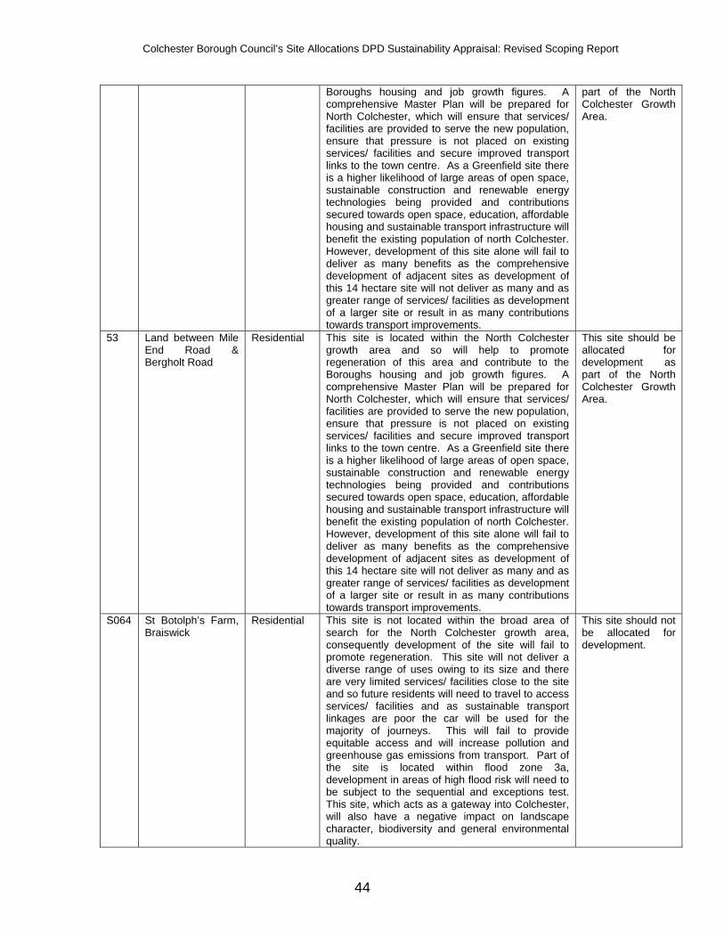
Colchester Borough Council’s Site Allocations DPD Sustainability Appraisal: Revised Scoping Report
44
Boroughs housing and job growth figures. A comprehensive Master Plan will be prepared for North Colchester, which will ensure that services/ facilities are provided to serve the new population, ensure that pressure is not placed on existing services/ facilities and secure improved transport links to the town centre. As a Greenfield site there is a higher likelihood of large areas of open space, sustainable construction and renewable energy technologies being provided and contributions secured towards open space, education, affordable housing and sustainable transport infrastructure will benefit the existing population of north Colchester. However, development of this site alone will fail to deliver as many benefits as the comprehensive development of adjacent sites as development of this 14 hectare site will not deliver as many and as greater range of services/ facilities as development of a larger site or result in as many contributions towards transport improvements.
part of the North Colchester Growth Area.
53 Land between Mile End Road & Bergholt Road
Residential This site is located within the North Colchester growth area and so will help to promote regeneration of this area and contribute to the Boroughs housing and job growth figures. A comprehensive Master Plan will be prepared for North Colchester, which will ensure that services/ facilities are provided to serve the new population, ensure that pressure is not placed on existing services/ facilities and secure improved transport links to the town centre. As a Greenfield site there is a higher likelihood of large areas of open space, sustainable construction and renewable energy technologies being provided and contributions secured towards open space, education, affordable housing and sustainable transport infrastructure will benefit the existing population of north Colchester. However, development of this site alone will fail to deliver as many benefits as the comprehensive development of adjacent sites as development of this 14 hectare site will not deliver as many and as greater range of services/ facilities as development of a larger site or result in as many contributions towards transport improvements.
This site should be allocated for development as part of the North Colchester Growth Area.
S064 St Botolph’s Farm, Braiswick
Residential This site is not located within the broad area of search for the North Colchester growth area, consequently development of the site will fail to promote regeneration. This site will not deliver a diverse range of uses owing to its size and there are very limited services/ facilities close to the site and so future residents will need to travel to access services/ facilities and as sustainable transport linkages are poor the car will be used for the majority of journeys. This will fail to provide equitable access and will increase pollution and greenhouse gas emissions from transport. Part of the site is located within flood zone 3a, development in areas of high flood risk will need to be subject to the sequential and exceptions test. This site, which acts as a gateway into Colchester, will also have a negative impact on landscape character, biodiversity and general environmental quality.
This site should not be allocated for development.

Colchester Borough Council’s Site Allocations DPD Sustainability Appraisal: Revised Scoping Report
45
79, Local Plan site 6
Severalls Hospital Residential The site is located within the North Colchester regeneration area and so will help to promote regeneration of this area and reduce the need for development on greenfield land. This site has planning permission for 1500 dwellings, which will contribute to delivering the minimum housing provision of 17,100 homes by 2021 and 1,710 homes by 2023 in accordance with the East of England Plan. Of these dwellings 25% will be affordable, which is a total of 375. The East of England Plan requires Colchester to provide approximately 14,200 jobs to support the growing population and economy. This option will accommodate employment development and economic growth to contribute to this figure. Employment, community facilities, retail and live work units will all be included as part of the development of this site and the development will tackle deprivation through the creation of new jobs. The need to travel will be reduced and cycle/pedestrian paths and green links will be created. A mix of uses will be provided including housing, employment, retail, a community centre, primary school, open space, a cricket ground, allotments. Although not listed, some of the Severalls buildings have historic value as an example of an Edwardian asylum, the most important of these will be retained and converted. Severalls park is on the register of Parks and Gardens of Historic Interest and this will be maintained. Thus the character of the area will be maintained and enhanced. The Environmental Statement that accompanied the application concluded that there would be no adverse effects on air and noise and no impact on species provided that mitigation measures are incorporated. The risk of flooding will be reduced through the use of sustainable urban drainage systems, which will also increase biodiversity on the site.
This Local Plan allocation should be included in the Site Allocations DPD. Consideration should be given to encouraging the use of sustainable construction materials and techniques as part of discussions on the reserved matters application.
S137 Land off Braiswick Lane
Residential This site is located within the broad area of search for the North Colchester Growth Area and forms part of a much larger site of 140 hectares. If this site were developed alone, as a relatively small site there are limitations over how much the site will be able to deliver in terms of, for example, contributions towards community facilities and sustainable transport infrastructure; the site will fail to contribute to the local economy; and there are issues with access. However, if developed in conjunction with adjacent land as part of a Master Plan services/ facilities will be provided to serve the new population, ensuring that pressure is not placed on existing services/ facilities and secure improved transport links to the town centre. As a Greenfield site there is a higher likelihood of securing large areas of open space, sustainable construction measures and renewable energy technologies. However, development will affect landscape quality and biodiversity and needs to ensure that it fits in with the character of existing housing to the east.
This site should be allocated for development and included within the North Colchester Growth Area as part of the larger site (S044).

Colchester Borough Council’s Site Allocations DPD Sustainability Appraisal: Revised Scoping Report
46
S153 & 184
Land at Chapmans Farm, Nayland Road
Residential This site is located within the broad area of search for the North Colchester growth area and so will help to promote regeneration of this area and contribute to the Boroughs housing figures. A comprehensive Master Plan will be prepared for North Colchester, which will ensure that services/ facilities are provided to serve the new population, ensure that pressure is not placed on existing services/ facilities and secure improved transport links to the town centre. This site is very close to the Severalls Hospital site, separated by Boxted Road, and future residents of this site will benefit from the mixed use development of this key regeneration site. The site is also adjacent to existing residential development, indeed the site boundary runs parallel with the northern boundary of existing development and so residential development of this site will not conflict with the character of the area and can be seen as a natural expansion of this residential area. To the west of the site is a main road and so access to the site is good. As a Greenfield site development will inevitably affect landscape quality and biodiversity, however there are existing farm buildings on this site.
This site should be allocated for residential development and should be phased to come forward after the development of the large Greenfield site to the west and Severalls site to the east to ensure that sufficient services/ facilities/ employment/ transport links are in place.
S159 & 162
Land South of Moorlands Lodge, Boxted Road
Mixed use This site is located within the broad area of search for the North Colchester growth area and so will help to promote regeneration of this area and contribute to the Boroughs housing figures. Although the site is proposed to be a mixed use site owing to the size, characteristics and access a limited number of uses will be delivered, and so users will still need to travel outside of the site for certain services/ facilities. A comprehensive Master Plan will be prepared for North Colchester, which will ensure that services/ facilities are provided to serve the new population, ensure that pressure is not placed on existing services/ facilities and secure improved transport links to the town centre. The Severalls Hospital site is located to the east and the proposed major Greenfield site is located to the west, numerous proposed small sites are located adjacent. Future users of this site will therefore benefit from the mixed use development of the two key sites and transport improvements they will deliver and other smaller sites. Importantly the Master Plan will ensure that these sites are not delivered in a piecemeal fashion. As a Greenfield site development will inevitably affect landscape quality and biodiversity and as the site is located to the rear of existing homes and Moorlands Lodge development will need to ensure that it is compatible with the scale and character of the existing development.
It is recommended that this site is allocated for development. It should be phased to come forward after the development of the large Greenfield site (ref: S044) and after the development of previously developed land to ensure that transport improvements are in place and there are a range of services/ facilities available in close proximity to the site.
S162 Land off Braiswick Residential This site is not located within the broad area of search for the North Colchester growth area, consequently development of the site will fail to promote regeneration. This site will not deliver a diverse range of uses owing to its size and there are very limited services/ facilities close to the site and so future residents will need to travel to access services/ facilities and as sustainable transport
This site should not be allocated for residential development and should remain in use for recreational purposes.

Colchester Borough Council’s Site Allocations DPD Sustainability Appraisal: Revised Scoping Report
47
linkages are poor the car will be used for the majority of journeys. This will fail to provide equitable access and will increase pollution and greenhouse gas emissions from transport. The site is currently used as part of a golf course and its development would therefore fail to maintain levels of recreational facilities within the Borough, although it is accepted that open space would be required as part of development.
165 Land East of Nayland Road and South of the A12
Mixed use The site is located within the broad area of search for the North Colchester growth area and so will help to promote regeneration of this area and contribute to the Boroughs housing and employment figures. Employment development on sites such as these are likely to be cheaper than sites in the town centre or in the business parks and of a smaller scale, which should help to support the growth of new local, micro/small and home based businesses. This site is covered, almost completely, by site ref: 261, a site of almost 10 hectares and the development of these sites as one will provide a more co-ordinated development. A comprehensive Master Plan will be prepared for North Colchester, which will ensure that services/ facilities are provided to serve the new population, ensure that pressure is not placed on existing services/ facilities and secure improved transport links to the town centre. This site is located in-between the Severalls Hospital site and proposed major Greenfield site; future users of this site will therefore benefit from the mixed use development of these two key sites and transport improvements they will deliver. Developing this site will help to ensure that development is condensed to the south of the A12, which will protect the countryside to the north of the A12. As a Greenfield site development will inevitably affect landscape quality and biodiversity, however measures to enhance biodiversity can be incorporated into the Master Plan.
Site ref: 261 includes the majority of this site and it is recommended that these sites are allocated together as a mixed use site. This site should be phased to come forward after the development of the large Greenfield site (ref: S044) and after the development of previously developed land to ensure that transport improvements are in place and there are a range of services/ facilities available in close proximity to the site.
166 Land South of A12 and West of Nayland Road
Residential This site is located within the North Colchester growth area and so will help to promote regeneration of this area and contribute to the Boroughs housing and job growth figures. A comprehensive Master Plan will be prepared for North Colchester, which will ensure that services/ facilities are provided to serve the new population, ensure that pressure is not placed on existing services/ facilities and secure improved transport links to the town centre. Healthy lifestyles will be supported as the Master Plan will encourage people to walk and cycle and will ensure that the infrastructure is in place to make this an attractive option. This large site will form a key part of this Master Plan. As a large site a range of new facilities to support the new housing will be required, for example, schools, local shops, recreation facilities, which will provide new jobs. As a Greenfield site there is a higher likelihood of large areas of open space, sustainable construction and renewable energy technologies being provided and contributions secured towards
This site should be allocated for development and included within the North Colchester Growth Area. Chesterwell Wood is located within the site and should be protected.
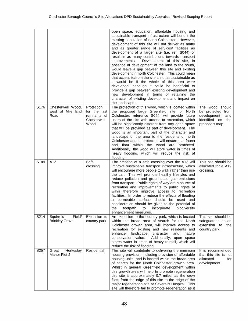
Colchester Borough Council’s Site Allocations DPD Sustainability Appraisal: Revised Scoping Report
48
open space, education, affordable housing and sustainable transport infrastructure will benefit the existing population of north Colchester. However, development of this site will not deliver as many and as greater range of services/ facilities as development of a larger site (i.e. ref: S044) or result in as many contributions towards transport improvements. Development of this site, in absence of development of the land to the south, would leave a gap between this site and existing development in north Colchester. This could mean that access to/from the site is not as sustainable as it would be if the whole of this area were developed, although it could be beneficial to provide a gap between existing development and new development in terms of retaining the character of existing development and impact on the landscape.
S176 Chesterwell Wood, west of Mile End Road
Protection for the last remnants of Chesterwell Wood
The protection of this wood, which is located within the proposed large Greenfield site for North Colchester, reference S044, will provide future users of the site with access to recreation, which will be significantly different from any open space that will be provided as part of development. The wood is an important part of the character and landscape of the area to the residents of north Colchester and its protection will ensure that fauna and flora within the wood are protected. Additionally, the wood will store water in times of heavy flooding, which will reduce the risk of flooding.
The wood should be protected from development and identified on the proposals map
S189 A12 Safe crossing
The creation of a safe crossing over the A12 will improve sustainable transport infrastructure, which will encourage more people to walk rather than use the car. This will promote healthy lifestyles and reduce pollution and greenhouse gas emissions from transport. Public rights of way are a source of recreation and improvements to public rights of ways therefore improve access to recreation facilities. In order to reduce the effects of flooding a permeable surface should be used and consideration should be given to the potential of the footpath to incorporate biodiversity enhancement measures.
This site should be allocated for a A12 crossing.
S214 Squirrels Field/ Brinkley Grove
Extension to country park
An extension to the country park, which is located within the broad area of search for the North Colchester growth area, will improve access to recreation for existing and new residents and enhance landscape character and nature conservation value. Additionally, open space stores water in times of heavy rainfall, which will reduce the risk of flooding.
This site should be safeguarded as an extension to the country park.
S257 Great Horkesley Manor Plot 2
Residential This site will contribute to delivering the minimum housing provision, including provision of affordable housing units, and is located within the broad area of search for the North Colchester growth area. Whilst in general Greenfield development within this growth area will help to promote regeneration this site is approximately 0.7 miles, as the crow flies, from the edge of this site to the edge of the major regeneration site at Severalls Hospital. This site will therefore fail to promote regeneration as it
It is recommended that this site is not allocated for development.

Colchester Borough Council’s Site Allocations DPD Sustainability Appraisal: Revised Scoping Report
49
is detached from the north Colchester regeneration area in distance and also by the A12. The extent to which this site will reduce the need to travel and reduce car dependence depends upon whether adjacent Greenfield sites are developed. As this site is somewhat detached from the north Colchester regeneration area if it were developed independent of adjacent sites it would fail to reduce the need to travel as residents would be required to travel for services/ facilities. However, if the proposed Greenfield sites to the west and south of this site are developed numerous services/ facilities would be required to ensure a sustainable community. Although there is residential development to the north and west of the site, the south and east of the site are very open and development of this site would encroach on countryside between Colchester and Horkesley, which would fail to maintain the landscape character of the Borough and set a precedent for further development outside the area constrained by the A12, which acts as a physical barrier to development.
261 Land East of Nayland Road and South of the A12
Residential This site is located within the broad area of search for the North Colchester growth area and so will help to promote regeneration of this area and contribute to the Boroughs housing figures. This site will be expected to deliver a diverse range of uses, contribute to improved sustainable transport infrastructure and provide renewable energy technologies. A comprehensive Master Plan will be prepared for North Colchester, which will ensure that services/ facilities are provided to serve the new population, ensure that pressure is not placed on existing services/ facilities and secure improved transport links to the town centre. This site is located in-between the Severalls Hospital site and proposed major Greenfield site; future users of this site will therefore benefit from the mixed use development of these two key sites and transport improvements they will deliver. Developing this site will ensure that development is condensed to the south of the A12, which will protect the countryside to the north of the A12. As a Greenfield site development will inevitably affect environmental quality, landscape quality and biodiversity. Biodiversity enhancement measures should be incorporated into development.
This site covers the majority of site ref: 165 and it is recommended that this site and site ref: 165 are allocated together as a mixed use site. This site should be phased to come forward after the development of the large Greenfield site (ref: S044) and after the development of previously developed land to ensure that transport improvements are in place and there are a range of services/ facilities available in close proximity to the site.
262 Land South of A12 and West of Nayland Road
Residential This site is located within the North Colchester growth area and so will help to promote regeneration of this area and contribute to the Boroughs housing and job growth figures. A comprehensive Master Plan will be prepared for North Colchester, which will ensure that services/ facilities are provided to serve the new population, ensure that pressure is not placed on existing services/ facilities and secure improved transport links to the town centre. Healthy lifestyles will be supported as the Master Plan will encourage
This site should be allocated for development and included within the North Colchester Growth Area.

Colchester Borough Council’s Site Allocations DPD Sustainability Appraisal: Revised Scoping Report
50
people to walk and cycle and will ensure that the infrastructure is in place to make this an attractive option. This large site will form a key part of this Master Plan. As a large site a range of new facilities to support the new housing will be required, for example, schools, local shops, recreation facilities, which will provide new jobs. As a Greenfield site there is a higher likelihood of large areas of open space, sustainable construction and renewable energy technologies being provided and contributions secured towards open space, education, affordable housing and sustainable transport infrastructure will benefit the existing population of north Colchester. Development of this site will not deliver as many and as greater range of services/ facilities as development of a larger site (i.e. ref: S044) or result in as many contributions towards transport improvements, although it will deliver a more sustainable community than the development of the smaller site to the north (site ref: 166).
S265 Land north of A12 near Cuckoo Farm
Creation of public right of way
The creation of a new public right of way will improve sustainable transport infrastructure, which will encourage more people to walk rather than use the car. This will promote healthy lifestyles and reduce pollution and greenhouse gas emissions from transport. Public rights of way are a source of recreation and improvements to public rights of ways therefore improve access to recreation facilities. A permeable surface should be used and consideration should be given to the potential of the footpath to incorporate biodiversity enhancement measures.
This site should be safeguarded for a new public right of way.
Stanway Growth Area Site Ref.
Site Name Proposed Use
SA Summary SA Recommendation
S033 Land at Furze Hill, Warren Lane
Residential The sustainability of this site in terms of availability of services/ facilities and transport links is very much linked to the development of the site to the north (reference S070). In the absence of development at the northern site this site will be detached from the built up area of Stanway and will be unlikely to provide sustainable transport linkages. Although this site may appear to be a logical expansion to Stanway (providing the site to the north is developed), this site is covered by mature trees and is therefore of high biodiversity value. Additionally the site is adjacent to an area identified by the quarry for future expansion and so development of this site may affect the future of the quarry. Furthermore this site and the site to the north are separated by a small road, this is of a rural nature and acts as a natural barrier to further development south of the existing built up area.
This site should not be allocated for development.
48, Local Plan site 3
Land north of Church Lane
Residential This site is located within the broad area of search for the Stanway growth area and will contribute to delivering the minimum housing provision of 17,100 homes by 2021 and 1,710 homes by 2023 in accordance with the East of England Plan,
This Local Plan allocation should be included in the Site Allocations DPD, although the

Colchester Borough Council’s Site Allocations DPD Sustainability Appraisal: Revised Scoping Report
51
including a significant contribution towards affordable housing. Access links to the site are good and it is located adjacent to the Tollgate centre, existing housing and the new employment site, Stane Park, which will provide future residents with good access to their needs. Although proposed as residential use development of a site of this size will be expected to provide community facilities and possibly some offices/ light industrial uses, which will contribute to the target of providing 14,200 jobs. This large site can also be expected to contribute to improvements to the sustainable transport network, which will involve improved public transport links to the town centre. Development of this site will help to protect the historical and cultural assets of west Stanway by reducing the need to develop close to Gosbecks Park. Although this is a Greenfield site it is located in-between existing development and so development of this site will reduce pressure for development on sites at the edge of the town, which will protect the landscape character and settlement pattern of the town. The site currently appears to be heathland and is therefore likely to be of high nature conservation value, the loss of which will be detrimental to the biodiversity resource of the Borough. Measures should be incorporated to conserve part of the heathland and enhance its biodiversity value.
site should be allocated for mixed use development rather than solely residential. An area of heathland within the site should be retained and enhanced.
S070 Land between Warren Lane & Dyers Road
Residential This site will contribute to delivering the minimum housing provision of 17,100 homes by 2021 and 1,710 homes by 2023 in accordance with the East of England Plan and can be expected to deliver approximately 356 dwellings, which would result in 125 affordable dwellings. This site will form part of the Stanway growth area, which will reduce the need to travel by encouraging compact and mixed use development at accessible locations. This will also support sustainable travel behaviour, investment in sustainable transport infrastructure and reduce car dependence. This site will deliver new community facilities to support new residents and as a Greenfield site the provision of new community facilities may be more viable than a brownfield site. Although this is a Greenfield site development is located to the north of the site and so accessibility is good and the existing community may benefit from new facilities. As a major housing development 10% of the site area will be provided as open space, which will increase the amount of open space in the Borough, support healthy lifestyles and reduce the fear of crime. Development of this site will help to protect the historical and cultural assets of Stanway by reducing the need to develop close to Gosbecks Park. All development will inevitably affect the character and attractiveness of the Borough and as a Greenfield site development here will also affect biodiversity and environmental quality. The site is bounded by hedgerows, which contributes to the rural nature of the area; their loss would be detrimental to the natural environment and rural
This site should be allocated for development as part of the Stanway growth area. The hedgerow along the south-east boundary of the site should be retained to protect biodiversity and maintain the rural character of the area.

Colchester Borough Council’s Site Allocations DPD Sustainability Appraisal: Revised Scoping Report
52
character of the area. As a Greenfield site the site should come forward post 2016 by which time level 6 of the code for sustainable homes must be complied with, which will ensure that water use will become more efficient, recycling facilities will be provided, renewable energy will be provided and construction materials will be more sustainable.
S072 Land between Warren Lane & Dyers Road
Residential The sustainability of this site is largely dependent on the site to the north (S070). If this larger site is developed this site will become connected to the built up area of Stanway and will benefit from sustainable transport linkages into Stanway, which will provide residents with equitable access to their needs. However, if this larger site is not developed future residents will be detached from Stanway and car dependence will fail to reduce. Open space and affordable housing will be expected, however owing to the size of the site other facilities are unlikely. Warren Lane is a gateway into Stanway and development here will be prominent and therefore detrimental to the rural nature of this area. There are numerous hedgerows on the site which are of importance for nature conservation and their loss would be detrimental to the biodiversity resource of the Borough.
This site should not be allocated for development.
S076 Land at Chitts Hill Residential This Greenfield site is not located within a regeneration or growth area and so will fail to promote regeneration and benefit from comprehensive mixed use development. It is located on the edge of a small existing built up area and so future residents are unlikely to benefit from directly adjacent facilities, but will benefit from development within the Stanway growth area, to the south of the A12. However, pedestrian and cycle access to the south of the A12 is poor and users are unlikely to view it as a realistic option. Therefore equitable access will not be provided and car dependence will not be reduced, which will increase pollution and greenhouse gas emissions. The A12 acts as a natural barrier to development, thereby containing the town. This site is located to the north of the A12 and will set a precedent for further development in the open countryside, to the detriment of the established pattern of development and landscape character.
It is recommended that this site is not allocated for development.
S095 Land north of London Road, Tollgate
District centre
This site is located within the broad area of search for the Stanway growth area. Existing and future residents will be provided with good access to their retail needs and the need to travel will be reduced. Although this option proposes to develop an allocated employment site as a district centre as part of the outline planning consent for this site the existing Sainsburys site, to the south, will be allocated as employment land. Thereby effectively swapping land designations. This will ensure that land is available for new employment uses and that Sainsburys can be retained within this area. As this site is adjacent to an existing retail park and close to the proposed Stanes Park Business Park it will be compatible with the character of the area
It is recommended that this site is allocated as a district centre and the existing Sainsburys site is allocated as employment land
S242 &
Stane Park Employment The East of England Plan requires Colchester to provide approximately 14,200 jobs to support the
It is recommended that these sites are

Colchester Borough Council’s Site Allocations DPD Sustainability Appraisal: Revised Scoping Report
53
S243 growing population and economy. This option will accommodate employment development and economic growth to contribute to this figure. The site (phases 1 and 2) are expected to deliver approximately 3,500 jobs. The site is proposed to house incubator units for start up firms and provide help and advice for new businesses, which will help stem the outmigration of skilled younger residents. New businesses will be able to grow through the provision of ‘graduation’ buildings. This site is likely to reduce the need to travel as it forms part of the Stanway growth area where sustainable transport linkages will be incorporated into new development. Additionally Stanway is well served by Quality Bus Routes and so those living elsewhere in Colchester should be able to travel sustainably to the site. However, development here will fail to promote regeneration and will affect landscape quality.
allocated for employment development.
S268 Land at Wyvern Farm
Mixed use This mixed-use site will contribute to delivering the minimum housing provision and job growth. It will provide a good mix of housing, including affordable housing and may encourage local and starter businesses. The site is located within the broad area of search for the Stanway Growth Area. The comprehensive development of this area will ensure that services/ facilities are provided to serve the new population and ensure that pressure is not placed on existing services/ facilities. As a compact and mixed use development car dependence will be reduced, which will support sustainable travel behaviour and investment in sustainable transport infrastructure. Through the Core Strategy the Council set out a sequential approach to new development, ensuring that previously developed land is developed before Greenfield and so by the time this site comes forward for development new homes will have to comply with high levels of the code for sustainable homes, which will result in more efficient water use, the provision of recycling facilities, provision of renewable energy and sustainable construction materials. Such practices will also be encouraged for the non residential development. However, as a Greenfield site development will affect landscape quality and biodiversity. The site is located between Stanway and Copford and care must be taken to ensure that settlement coalescence does not occur.
It is recommended that part of this site is allocated for a mixed use development. A gap should be retained between the western edge of this site and Copford and to further increase separation of Stanway and Copford it is recommended that the western edge of this site be designated as open space.
S284 Land at Colchester Quarry
Quarry expansion
Expansion of the quarry will secure existing jobs and may create new ones, although there will be adverse affects to environmental quality and landscape character. However, it is sensible for the quarry to expand onto adjacent land rather than identifying a site elsewhere.
It is recommended that the site is only allocated for quarry expansion if identified by Essex County Council in their Minerals LDF.
S294 Land at Evergreen House & D Hollick Car Sales
Residential This is a previously developed site and so development here will reduce the need for development on Greenfield land, which will help to ensure the protection of the landscape character and biodiversity. The site is located adjacent to the Stane Park proposed employment site and Tollgate
It is recommended that this site is not allocated for residential development.

Colchester Borough Council’s Site Allocations DPD Sustainability Appraisal: Revised Scoping Report
54
retail centre and so future residents will be provided with good access to their employment and retail needs. However, the development of this site for housing will result in the loss of an employment site, which will be detrimental to the Council’s target of securing 14,200 jobs over the plan period. Furthermore, it will place pressure on adjacent employment sites and would be out of character with the immediate area.
S294 Land at Evergreen House & D Hollick Car Sales
Employment This is a previously developed site and so development here will reduce the need for development on Greenfield land, which will help to ensure the protection of the landscape character and biodiversity. The site is located adjacent to the Stane Park proposed employment site and Tollgate retail centre and is currently in use as employment land. Access to the site is good and future users will benefit from adjacent uses.
It is recommended that this site is allocated for employment development.
East Colchester Regeneration Area Site Ref.
Site Name Proposed Use
SA Summary SA Recommendation
106 Wilson Marrage Centre, Barrack Street
Residential This site has planning permission for 110 dwellings and associated infrastructure. The SA of this site demonstrates that it is a sustainable proposal and should be allocated in accordance with the planning consent. In brief the proposal accords with the principles of the development brief and the developer has secured several parcels of land, thereby ensuring comprehensive development of this area. The site will provide an attractive and sustainable development that contributes to the regeneration of this area of town.
It is recommended that this site is allocated for residential development in accordance with the existing planning consent.
S107 Land between University of Essex and Wivenhoe
Mixed use A mix of uses is proposed, which includes residential and employment, which will contribute to the Borough’s housing and employment figures as set out in the East of England Plan. This option will reduce the need to travel by encouraging compact and mixed use development at accessible locations. Part of the site is included within the East Colchester regeneration area and so the site will also benefit from the mix of uses delivered in this area. Sustainable transport links to the university are currently good and further development in this area is likely to improve links and further reduce car dependency. A research park, which currently has outline planning consent, and university improvements are likely to help stem the outmigration of skilled younger residents. However, development of Greenfield land inevitably affects biodiversity and environmental quality. Development of this entire site will result in settlement coalescence between East Colchester and Wivenhoe, which will adversely affect the character of both of these settlements. Part of the site is located within flood zone 2 and part is within flood zone 3, in order to reduce the risk of flooding areas of medium/ high flood risk should not be developed unless it can be demonstrated that there are no reasonably available alternative sites in
It is recommended that the research park, which has outline planning consent, is allocated for employment development. Further land should not be allocated unless it can be demonstrated that the Upper Colne Marshes SSSI will not be adversely affected; land within flood zones 2 and 3 should not be allocated for development; and land adjacent to Wivenhoe should not be allocated in order to avoid settlement coalescence.

Colchester Borough Council’s Site Allocations DPD Sustainability Appraisal: Revised Scoping Report
55
areas of no/low flood risk. The western boundary of the site is adjacent to the Upper Colne Marshes SSSI and development will likely affect this designated site.
S112 Disused Haven Road Travellers site
Mixed use A mix of uses is proposed on this site, which will contribute to the Borough’s housing and employment targets. The site is located within the East Colchester regeneration area and so will contribute to the regeneration objectives for this area. Regeneration of brownfield sites will reduce the need for development on greenfield land, which will help to protect landscape character. This is an untidy site and its development will improve the character and attractiveness of this area. The site is located within an exiting community so accessibility is good and future users will live in close proximity to services and facilities. The site is close to the Hythe railway station and a cycle path runs along the south-western boundary of the site. However, the site is located entirely within flood zone 3a, which is high risk of flooding. The sequential test has been applied and has demonstrated that there are no reasonably available alternative sites in areas of lower flood risk and so development is acceptable in principle. An agreement has been reached between Colchester Borough Council, the Environment Agency and the Department for Communities and Local Government that the sustainability benefits the regeneration of East Colchester brings outweigh the flood issues.
It is recommended that this site is allocated for mixed use development. The detailed proposals for this site will need to be accompanied by a flood risk assessment and part (c) of the exception test must be satisfied.
S116 Land at Place Farm Residential and commercial
This mixed-use site will contribute to delivering the minimum housing provision and job growth. It will provide a good mix of housing, including affordable housing and may encourage local and starter businesses. The site is located within an exiting community, which means that accessibility is relatively good and future occupants will live in close proximity to services and facilities. Furthermore, as a mixed use site occupants of the site will have access to employment opportunities. However, the site is not located within one of the Council’s regeneration/ growth areas, it is a Greenfield site, part of the site is located in flood zone 3a, the site is directly adjacent to the Upper Colne Marshes SSSI and as a predominantly residential area commercial development may adversely affect the character of the existing area.
It is recommended that this site is not allocated for development. However, if it is allocated it is recommended that the site area is reduced to exclude the flood risk area and create a buffer between the Upper Colne Marshes SSSI.
Town Centre Site Ref.
Site Name Proposed Use
SA Summary SA Recommendation
Local Plan site 13
North Station Road Residential This small site (0.37 hectares) will contribute to the regeneration of North Station Road. A Master Plan is currently being prepared for this area, which will ensure comprehensive development of this regeneration area. Development of this site will help to improve this key gateway into Colchester town centre and contribute to reducing deprivation. As a highly accessible site sustainable travel will be
This Local Plan allocation should be included in the Site Allocations DPD.

Colchester Borough Council’s Site Allocations DPD Sustainability Appraisal: Revised Scoping Report
56
promoted and high density can be expected, which will ensure the most efficient use of land.
Local Plan site 15
Middle Mill Residential Planning permission was granted in 2008 for residential development on this site, however work has yet to commence. The site is located on the edge of the town centre and so future occupants will be provided with equitable access to a wide mix of uses. Accessibility is very high and so sustainable travel will be a realistic option. Development will improve the townscape character. The site is located within an area of high flood risk; however as part of the planning application the sequential test and exception test have been passed. The Environment Agency agreed with the Council’s conclusions and also found the flood risk assessment acceptable.
It is recommended that the site continues to be allocated in accordance with the planning consent.
27, Local Plan site 11
BT Site off Cowdray Avenue
Residential Redevelopment of this site will help to provide decent, affordable and sustainable homes for the Borough’s population. As a highly accessible site, close to the town centre and main railway station, densities will make efficient use of land, reduce car dependency and increase levels of sustainable travel, which will subsequently reduce air pollution and greenhouse gas emissions from traffic. However, the development of this site will result in the loss of employment land, which will be detrimental to the objective of achieving a prosperous and sustainable economy. Half of the site is located within flood zone 3a, however the sequential test and parts (a) and (b) of the exceptions test have been passed. Open space will be provided as part of the site and this should be within the high flood risk part of the site. As the site is currently developed introducing areas of open space may reduce the risk of surface water flooding and enhance biodiversity.
This Local Plan allocation should be included in the Site Allocations DPD.
S127 Land at Cowdray Centre
Mixed use This site is proposed as a mixed use site and will contribute to the Borough’s employment and housing (including affordable housing) targets. This site is previously developed land and is allocated as a regeneration area; development here will reduce the need for development on Greenfield land, which will help to protect landscape, biodiversity and environmental quality. The site is highly accessible, being close to the town centre and train station, and will deliver a mix of uses, users of the site will be provided with good access to their needs and sustainable travel is likely to increase. However, the impacts on the vitality and viability of the town centre and retention of existing businesses is uncertain. The site is proposed to deliver retail uses, which could undermine the vitality and viability of the town centre, the impact will depend upon the type of retail proposed. The site is currently in use as an employment area and redevelopment of the site may affect existing businesses
It is recommended that the site is allocated as a mixed use development and included in the North Station Master Plan.
South Colchester Regeneration Area Site Site Name Proposed SA Summary SA

Colchester Borough Council’s Site Allocations DPD Sustainability Appraisal: Revised Scoping Report
57
Ref. Use Recommendation S093 Land bounded by
Circular Road West, Butt Road and Goojerat Road
Neighbourhood centre
The site is located within one of the Council’s regeneration areas and so will contribute to the regeneration of this area and reduce pressure on Greenfield sites. This option proposes a neighbourhood centre, which will provide nearby residents with good access to small scale shops, services and community facilities. This will reduce the need to travel and thus reduce greenhouse gas emissions and pollution from transport. This option will increase the delivery of jobs and small independent shops. A neighbourhood centre should create an attractive and safe public space, although youths often congregate in such areas, which may increase the fear of crime.
It is recommended that this site is allocated as a neighbourhood centre. Development should be in accordance with the Master Plan.
S298 Arena Site, North Circular Road/ Circular Road East
Mixed use This site is proposed as a mixed use development; it will contribute to the Borough’s housing figures and if commercial development is proposed will contribute to the Borough’s employment targets. The site is within 400 metres of an urban gateway and so is classed, in accordance with the Core Strategy, as being of very high accessibility, future users will be provided with equitable access to a wide range of services/ facilities. The site is located within one of the Council’s regeneration areas and so will help to promote regeneration of this area. Regeneration of brownfield sites will reduce the need for development on greenfield land thereby helping to protect the landscape character, countryside and coast of the Borough. Although open space will be required as part of this development tennis courts are currently located on the site; their loss will reduce the amount of recreational facilities within the Borough. The site is adjacent to a recreational area and development here could put pressure on this area. The site is also within close proximity to the recently discovered Roman Circus which is a scheduled ancient monument. Development of this site will have to be sympathetic to the Roman Circus and be taken into account when considering the site as a whole.
It is recommended that this site is allocated for a mixed use development and the DPD should indicate what uses would be acceptable at this site. A soft boundary should be provided adjacent to the recreation ground and a recreational facility should be provided. Development should be in accordance with the Master Plan.
Borough wide Site Ref.
Site Name Proposed Use
SA Summary SA Recommendation
S003 Waldegraves Holiday Park
Extension to holiday park
This option will help to retain the existing holiday camp and will contribute to the rural economy. The site is in a fairly isolated location and access is achieved by one road, Waldegraves Lane. The site is not accessible by sustainable modes of transport and by its nature visitors will need to travel to visit the site. Although development on Greenfield land affects the character of an area the use proposed is one you would expect to see in a rural, coastal location. Part of the site is located in flood zone 3, which is high flood risk. PPS25 seeks to avoid flood risk areas and direct development to areas of no/low risk of flooding. However, the sequential test is passed as there are
Although this option brings benefits to the rural economy unless it can be demonstrated that development will not adversely affect the integrity of the Colne Estuary SPA/ Ramsar. Additionally the area within flood zone 3a should not be built on.

Colchester Borough Council’s Site Allocations DPD Sustainability Appraisal: Revised Scoping Report
58
no reasonably available sites in areas of lower flood risk for this use. The southern edge of the site is approximately 250 metres from the Colne Estuary SPA/ Ramsar site, development of this site is therefore likely to adversely affect this designated site.
S006, 102, Local Plan site 9
Land rear of Magdalen Street
Residential Development of this site will contribute to the Borough’s housing figures. As an accessible site, close to the town centre high density will be expected, which will make the most efficient use of land. A development brief has been prepared to facilitate the regeneration of Magdalen Street and development of this site will contribute to the regeneration of this area, a gateway into Colchester’s town centre. Sustainable travel is likely to increase owing to the close proximity of the town centre and railway station. The site is currently undeveloped with may trees on the site, and so development will likely harm biodiversity and soil quality.
This Local Plan allocation should be included in the Site Allocations DPD.
S009 Land adjacent Waldegraves Business Park, West Mersea
Employment This site is not located within any of the Council’s regeneration or growth areas; the development of the site will therefore fail to promote regeneration. The site is in a fairly isolated location and access is achieved by one road, Waldegraves Lane; it is not accessible by sustainable modes of transport and greenhouse gas emissions are likely to increase. The site is proposed as an extension to an existing business park and so the principal of the use in this location is established. Rural employment sites increase the delivery of employment and help new and small businesses as rural employment sites are likely to be cheaper than sites within business parks and strategic employment zones. As an extension this allocation may help to retain existing businesses by allowing space for them to expand. New built development will have an adverse impact on the coastal protection belt and landscape quality, although this area is sandwiched between a business park and caravan site and so is unlikely to significantly affect the character of the area. The southern edge of the site is less than 400 metres from the northern edge of the Colne Estuary SPA/ Ramsar site. Development of this site is therefore likely to affect this designated site, unless it can be proven that development of this site will not affect the integrity of the Colne Estuary SPA/ Ramsar site it should not be allocated for development
This site has many benefits, however unless it can be demonstrated that development will not adversely affect the integrity of the Colne Estuary SPA/ Ramsar the site should not be allocated for development.
15b Land north of A120, abutting Great Tey Road and Church Lane
Residential Development of this site will contribute to the Boroughs housing figures, including affordable housing. Development of large Greenfield sites is likely to increase the viability of affordable housing and renewable energy provision. However, as a Greenfield site this option fails to promote regeneration and may even direct investment away from the regeneration and growth areas. Part of the site is located in flood zone 3 and the site is adjacent to Marks Tey Brickpit SSSI. Development at this location will fail to optimise accessibility and most future residents would commute to Colchester town and other regional centres for services/ facilities. This will increase car dependency and
It is recommended that this site is not allocated for development.

Colchester Borough Council’s Site Allocations DPD Sustainability Appraisal: Revised Scoping Report
59
undermine the objective of achieving sustainable travel behaviours. Development of this Greenfield site will adversely affect the character of the settlement, almost doubling the amount of dwellings in Marks Tey.
Local Plan site 18
Newbridge Road, Tiptree
Residential This site already has planning permission for residential development, although it has not yet been implemented. Tiptree is classified in the Core Strategy as a District Centre. Part of the spatial strategy is to provide a limited amount of development in the district centres in order to secure modest growth to sustain the village. The Local Plan estimates that the site can deliver 15 dwellings, which is appropriate for this location. The site is located within an existing built up area and will be compatible with the character of the area.
This Local Plan allocation should be included in the Site Allocations DPD.
Local Plan site 20
School Road, Messing
Residential Residential development in this location is contrary to the spatial strategy set out in the Core Strategy, which directs housing to the most sustainable locations. As a small village, with a limited number of services and facilities and poor public transport, future occupants will not be provided with good access to their needs and will rely on the car for journeys, which will increase greenhouse gas emissions and pollution. Biodiversity is likely to be adversely affected as the site is not previously developed. Numerous sites have come forward for residential development in Messing in recent years and further development in this village will alter the character of the village.
This Local Plan allocation is not a sustainable site for housing and is contrary to the Core Strategy’s spatial strategy and so it should not be allocated in the Site Allocations DPD.
Local Plan site 21
Rose Lane, Salcott Residential Residential development in this location is contrary to the spatial strategy set out in the Core Strategy, which directs housing to the most sustainable locations. As a small village, with a limited number of services and facilities and poor public transport, future occupants will not be provided with good access to their needs and will rely on the car for journeys, which will increase greenhouse gas emissions and pollution. Biodiversity is likely to be adversely affected as the site is not previously developed.
This Local Plan allocation is not a sustainable site for housing and is contrary to the Core Strategy’s spatial strategy and so it should not be allocated in the Site Allocations DPD.
Local Plan site 23
School Lane, Great Wigborough
Residential Residential development in this location is contrary to the spatial strategy set out in the Core Strategy, which directs housing to the most sustainable locations. As a small village, with a limited number of services and facilities and poor public transport, future occupants will not be provided with good access to their needs and will rely on the car for journeys, which will increase greenhouse gas emissions and pollution. Biodiversity is likely to be adversely affected as the site is not previously developed.
This Local Plan allocation is not a sustainable site for housing and is contrary to the Core Strategy’s spatial strategy and so it should not be allocated in the Site Allocations DPD.
S026 Coopers Beach Holiday Park, East Mersea
Extension to holiday park
This option will help to retain the existing holiday camp and will contribute to the rural economy. Although development on Greenfield land affects the character of an area the use proposed is one you would expect to see in a rural, coastal location. The site is in a fairly isolated location and access is achieved by one road, Church Lane. The site is not accessible by sustainable modes of transport although by its nature visitors will need to travel to
Although this option brings benefits to the rural economy unless it can be demonstrated that development will not adversely affect the integrity of the Colne Estuary

Colchester Borough Council’s Site Allocations DPD Sustainability Appraisal: Revised Scoping Report
60
visit the site. St Edmunds Church, which is a listed building is located directly to the north of the site, another listed building is located to the east of the church, extension of the caravan park is likely to affect the setting of these listed buildings. A large part of the site is located in flood zone 3, which is high flood risk. However, the sequential test is passed as there are no reasonably available sites in areas of lower flood risk for this use. The southern edge of the site is directly adjacent to the Colne Estuary SPA/ Ramsar site, development of this site is therefore likely to adversely affect this designated site.
SPA/ Ramsar.
45 Land west of Irvine Road
Residential This site will contribute to the Boroughs housing figures and will reduce pressure for development on sites at the edge or outside of the town, which will benefit the settlement pattern. As the site is located within an established residential area it will benefit from existing services/ facilities. Although the area is not mixed use and is approximately a mile from the town centre and so it is likely that residents will need to travel to access their needs. The site is not located within one of the Council’s regeneration areas and is Greenfield land and so it will fail to promote regeneration. The site is currently open space and so its loss will fail to maintain the levels of open space and recreational facilities within the Borough. The Council has been made aware from third parties that this site has a high biodiversity value and in the absence of a survey proving otherwise it is likely that development of this site will have a negative impact on objectives relating to biodiversity.
It is recommended that the site be safeguarded as open space.
S065 Land at Hare and Hounds Public House, Birch
Tourist accommodation with swimming pool and gym
This site is located within a village and will therefore fail to promote regeneration and support the vitality and viability of the town centre. As a prominent site on the edge of the village the development of a hotel, gym and swimming pool on this site will affect the landscape character and may affect the adjacent SINC. The proposal will provide local residents with good access to their recreational needs and support healthy lifestyles; however other users of the site will need to travel by private car. The proposed use is an intensive resource (particularly water) use.
It is recommended that the site is not allocated for this use.
S066 Land at Hare and Hounds Public House, Birch
Office space This site is located within a village and will therefore fail to promote regeneration and support the vitality and viability of the town centre. As a prominent site on the edge of the village the development of office space on this site will affect the landscape character and may affect the adjacent SINC. The proposal will provide local residents with good access to employment and will be an attractive site for new and small businesses; however other users of the site will need to travel by private car.
It is recommended that this site is not allocated for employment development.
S068 Land at Hare and Hounds Public House, Birch
Residential care home for the elderly
This option will help to meet the diverse housing needs of the Borough, however the site is located within a village and accessibility is poor. The majority of visitors and staff will be forced to travel by private car, which will increase congestion, air pollution and greenhouse gas emissions.
It is recommended that the site is not allocated for this use, however if it is concluded that the need for this type of

Colchester Borough Council’s Site Allocations DPD Sustainability Appraisal: Revised Scoping Report
61
Residents of the home will not be served by a range of services/ facilities, which can lead to isolation. The option fails to promote regeneration and support the vitality and viability of the town centre. Development is likely to affect the landscape character and may affect the adjacent SINC, although it is accepted that this is largely dependent on the scale of the proposal.
housing outweighs the sustainability effects a good Travel Plan should be prepared, which fully considers sustainable travel to the site.
S109 Pantiles Farm Employment – storage and light industry
The site is not located within any of the Council’s regeneration or growth areas and development of the site will fail to promote regeneration and may even take investment away from these areas. Employment development on this site will improve the delivery of employment land and help new and small businesses as rural employment sites are likely to be cheaper than sites within business parks and strategic employment zones. Accessibility is poor and so workers will be forced to use the private car for journeys. The site is in a fairly isolated location, approximately 2/3 of a mile from Abberton village. New built development will have an adverse impact on landscape quality, biodiversity and the character of the area.
It is recommended that this site is only allocated for employment development if it involves the re-use of existing buildings. New built development should not be permitted.
S117 & S119
Land at Marks Tey Station
Residential Development of this site will contribute to the Boroughs housing figures, including affordable housing. Development of large Greenfield sites is likely to increase the viability of affordable housing and renewable energy provision. However, as a Greenfield site this option fails to promote regeneration and may even direct investment away from the regeneration and growth areas. Part of the site is located in flood zone 3 and the site is adjacent to Marks Tey Brickpit SSSI. Development at this location will fail to optimise accessibility and most future residents would commute to Colchester town and other regional centres for services/ facilities. This will increase car dependency and undermine the objective of achieving sustainable travel behaviours. Development of this Greenfield site will adversely affect the character of the settlement.
It is recommended that this site is not allocated for development.
S118 Land to the rear of Bridge Farm, Marks Tey
Employment This option will provide new jobs, which will benefit residents of Marks Tey. New businesses may be encouraged to use the site as rents may be cheaper than the town centre. However, workers living outside of the village will likely travel to the site by car as accessibility by sustainable modes of transport is relatively poor. Greater car use will increase congestion, air pollution and greenhouse gas emissions. As a Greenfield site it will fail to promote regeneration and will adversely affect biodiversity and environmental quality. The site is located on the edge of Marks Tey and there is a recreation ground between this site and residential development to the west. Development of this site would adversely affect the openness of the road into Marks Tey, to the detriment of the character of the settlement.
It is recommended that a site on the edge of Marks Tey is allocated for small scale employment. Further appraisal work at the next stage of the SA will determine which site is the most sustainable.
S120 Andersons land and adjoining land, Marks Tey
Mixed use including residential, employment
This site is located within a village, which generally has poor accessibility; this will result in users of the site having to travel into Colchester town for services/ facilities. Greater car use will increase
It is recommended that a site on the edge of Marks Tey is allocated for

Colchester Borough Council’s Site Allocations DPD Sustainability Appraisal: Revised Scoping Report
62
and recreation
congestion, air pollution and greenhouse gas emissions. Furthermore those without a private car will find it difficult to access employment on the site and future occupants without a car will find themselves isolated. As a previously developed site it will reduce pressure on Greenfield sites, which will help to protect the landscape character, countryside and coast, and good design will create a quality gateway into the village. New businesses may be encouraged to use the site as rents may be cheaper than the town centre, however care must be taken to ensure that any employment uses on the site can be accommodated by the existing highway network. Residential development at this site would be unsustainable; however the employment use of the site should be retained.
small scale employment. Further appraisal work at the next stage of the SA will determine which site is the most sustainable.
S128 Land at Picketts Farm, Fingringhoe
Employment The site is not located within any of the Council’s regeneration or growth areas and development of the site will fail to promote regeneration and may even take investment away from these areas. Employment development on this site will improve the delivery of employment land and help new and small businesses as rural employment sites are likely to be cheaper than sites within business parks and strategic employment areas. Accessibility is poor and so workers who live outside of Fingringhoe will be forced to use the private car for journeys. However, employment development on this site could provide local employment, thereby reducing the need for village residents to travel. New built development will have an adverse impact on landscape quality, biodiversity and the character of the area. However, if existing buildings are redeveloped there is unlikely to be an impact on landscape character.
It is recommended that this site is only allocated for employment development if it involves the re-use of existing buildings. New built development should not be permitted.
S128 Land at Picketts Farm, Fingringhoe
Residential This site could deliver 48 dwellings at a density of 30 dph, which would provide 17 affordable housing units, although such a density may not be appropriate for a village location. The site is not located within any of the Council’s regeneration or growth areas and development of the site will fail to promote regeneration and may even take investment away from these areas. Fingringhoe is a village with limited services/ facilities and public transport links and so future residents will not be provided with good access to their needs and will be forced to use the private car for the majority of journeys. Development of this site, particularly at a density that will make efficient use of land, will fail to protect the character of the village The development of Greenfield sites will inevitably affect landscape quality and biodiversity. This site is located in-between a gap in housing and would effectively fill in this large gap, to the detriment of the landscape and character of the area. In the Local Plan this site is designated as a Countryside Character Area, although this designation is not included in the Core Strategy this designation demonstrates the high quality of this area of countryside.
It is recommended that this site is not allocated for residential development.
S136 Land at Employment The site is not located within any of the Council’s It is recommended

Colchester Borough Council’s Site Allocations DPD Sustainability Appraisal: Revised Scoping Report
63
Queensmeade, The Folley
regeneration or growth areas and development of the site will fail to promote regeneration and may even take investment away from these areas. Employment development on this site will improve the delivery of employment land and help new and small businesses as rural employment sites are likely to be cheaper than sites within business parks and strategic employment zones. Accessibility is poor and so workers who live outside of the village will be forced to use the private car for journeys. However, employment development on this site could provide local employment, thereby reducing the need for village residents to travel. New built development will have an adverse impact on landscape quality, biodiversity and the character of the area. However, if existing buildings are redeveloped there is unlikely to be an impact on landscape character.
that this site is only allocated for employment development if it involves the re-use of existing buildings. New built development should not be permitted.
S141 Land at Cymbeline Way
Hotel A hotel use outside of the town centre would fail to support the vitality and viability of the town centre (PPS6 classes hotels as a town centre use). Furthermore the Hotel Market Demand Study concluded that if an out of town site is required the North Colchester Growth Area would be most suitable owing to the good public transport links to the town centre. This site is not accessible by a choice of means of transport, it is some distance from the town centre and approximately 2.5km from the railway station. The area around and including this site acts as a green approach into Colchester, it is sensitive to change and any development here will adversely affect the landscape character of the area. A SINC is located adjacent to the site and is likely to be affected if development takes place.
This site should not be allocated for development.
S142 Land at Wick Road, Langham
Residential This option will deliver housing to contribute to the Borough’s housing target, including affordable housing and although a range of housing types will be required, not everyone will want to live in a rural location. This Greenfield site is not located within any of the Council’s regeneration or growth areas; the development of the site will therefore fail to promote regeneration. The site is not accessible by a choice of means of transport and is not surrounded by a range of services/ facilities; equitable access will not be provided. Therefore future residents will not be provided with good access to their needs. Although the Core Strategy sets out a minimum density of 30dph this density may not be achieved on this site as development will need to fit in with the character of the area. Residential development at this site would result in an extension of existing ribbon development in the countryside, which would adversely affect the rural character of the area, landscape quality and biodiversity. For these reasons it is not considered that the alternative, to develop the site entirely for affordable housing, would be sustainable. However, a very small part of the site could possibly be suitable for a small scale affordable housing development in order to meet local needs
It is recommended that this site is not allocated for development.

Colchester Borough Council’s Site Allocations DPD Sustainability Appraisal: Revised Scoping Report
64
only. S143 & S144
Land west of A12, Langham
Business park and park and ride
This Greenfield site is not located within any of the Council’s regeneration or growth areas; the development of the site will therefore fail to promote regeneration and may direct investment away from regeneration/ growth areas. This option will accommodate employment development, however, employment opportunities will not be consistent with peoples employment needs as accessibility to the site is poor. Although park and ride may improve the vitality and viability of the town centre by making access more attractive new office development as part of the business park may be detrimental to the vitality and viability of the town centre. Although the site is located in a rural area it will not help to sustain the rural economy; as part of the work carried out for the Core Strategy the Council concluded that additional employment development in Langham would be inappropriate and that existing rural employment sites would be sufficient to meet local employment need. A business park at this location may be detrimental to existing rural employment sites in the area. A new business park and park and ride in this location would conflict with the rural character of the village; the scale is out of character with surrounding development and local roads are unsuitable for additional traffic generated by park and ride.
It is recommended that this site is not allocated for park and ride or business use.
S145 Land at School Road, Langham
Residential This option will deliver housing to contribute to the Borough’s housing target, including affordable housing and although a range of housing types will be required, not everyone will want to live in a rural location. This Greenfield site is not located within any of the Council’s regeneration or growth areas; the development of the site will therefore fail to promote regeneration. The site is not accessible by a choice of means of transport and although a school and community centre are located adjacent to the site it is not surrounded by a range of services/ facilities. Therefore future residents will not be provided with equitable access to their needs and the need to travel will not be reduced. The Core Strategy sets out a minimum density of 30dph; this density will be out of character with this relatively dispersed rural area. Development of this site would adversely affect the rural character of the area, landscape quality and biodiversity.
It is recommended that this site is not allocated for development.
S146 Land at School Road, Langham
Residential This option will deliver housing to contribute to the Borough’s housing target, including affordable housing and although a range of housing types will be required, not everyone will want to live in a rural location. This Greenfield site is not located within any of the Council’s regeneration or growth areas; the development of the site will therefore fail to promote regeneration. The site is not accessible by a choice of means of transport and although a school is located opposite and a community centre is located close by the site is not surrounded by a range of services/ facilities. Therefore future residents will not be provided with equitable access to their needs and the need to travel will not be reduced. The Core Strategy sets out a minimum
It is recommended that this site is not allocated for development.

Colchester Borough Council’s Site Allocations DPD Sustainability Appraisal: Revised Scoping Report
65
density of 30dph; this density will be out of character with this relatively dispersed rural area. Development of this site would adversely affect the rural character of the area, landscape quality and biodiversity. For these reasons it is not considered that the alternative, to develop the site entirely for affordable housing, would be sustainable. However, a very small part of the site could possibly be suitable for a small scale affordable housing development in order to meet local needs only.
S147 Land at Choats Corner, Eight Ash Green
Residential and community use
Development of this site will contribute to the Boroughs housing figures and a range of housing will be provided, however not everyone will want to live in a rural location. A community use will be provided in addition to residential development, which will also benefit existing residents. However, this option involves Greenfield development and will fail to promote regeneration. The site abuts a small residential settlement with a school located at the centre. Future residents will not be provided with equitable access to services/ facilities, with Stanway approximately 3km away. This is a remote location and coupled with the busy roads, sustainable transport is unlikely to be a realistic option. Although the Core Strategy promotes a minimum density of 30dph it may be difficult to achieve this on this site as development will need to fit in with the character of the area and so the most efficient use of land may not be made. Residential development here would be out of character with the surrounding area and encroach into the countryside. This is a small rural settlement and development of this site would constitute a significant expansion. Development as a rural exceptions site would also be unacceptable for the same reasons, however if a local need for affordable housing is identified it is considered that a small part of the site could potentially be developed as affordable housing only, although this should come forward through the development control process.
It is recommended that this site is not be allocated for development.
S169 Depot, Old Ipswich Road, Dedham
Employment The site is not located within any of the Council’s regeneration or growth areas and development of the site will fail to promote regeneration and may even take investment away from these areas. Employment development on this site will improve the delivery of employment land and help new and small businesses as rural employment sites are likely to be cheaper than sites within business parks and strategic employment zones. Accessibility is poor and workers will be forced to use the private car for journeys, which will increase pollution and greenhouse gas emissions. New built development will have an adverse impact on landscape quality, biodiversity and the character of the area. However, if existing buildings are redeveloped there is unlikely to be an impact on landscape character. The character and appearance of the AONB and SINC could be affected, however it is considered that as the last use of the site was an employment use
It is recommended that this site is only allocated for employment development if it involves the re-use of existing buildings. New built development should not be permitted. Furthermore the levels of screening should be retained and ideally enhanced to protect the character of the AONB.

Colchester Borough Council’s Site Allocations DPD Sustainability Appraisal: Revised Scoping Report
66
development would not result in any additional adverse impacts on these designated sites.
S246 Land at Abbotts Hall Plot 3
Residential Development of this site will contribute to the Boroughs housing figures, including affordable housing. This option involves greenfield development and will fail to promote regeneration, although Greenfield development is more likely to provide affordable housing and renewable energy technologies. This site does not propose a mix of uses and is located in a predominantly residential area. Although development in this location will benefit in part from the Stanway growth area as the site is approximately 2/3 mile from the growth area access will not be equitable. It is likely that this site will increase car dependency and undermine the objective of achieving sustainable travel behaviours. Development of this Greenfield site will adversely affect the character of the settlement. This site is located to the north of the A12 and is characterised by fairly low density ribbon development. Residential development here would be out of character with the surrounding area and encroach into the countryside.
It is recommended that this site is not allocated for development
S248 Land to the south of The Rectory, Church Lane, Abberton
Leisure and recreation
This is a Greenfield site and so it will fail to promote regeneration. However, development of this site as a leisure/ recreational use will provide residents of Abberton with good access to a leisure/ recreational facility, which will reduce the need for them to travel out of the village for such facilities. A leisure/ recreational use will provide new jobs and will promote healthy lifestyles. However, the site abuts the western boundary of the village and so development here may affect the open character of the area and will likely affect biodiversity and environmental quality. Leisure uses are a town centre use and in the first instance this type of use should be located in Colchester town centre
It is recommended that this site is not allocated for development.
S267 Land at Marks Tey Mixed use Development of this site will contribute to the Boroughs housing and employment figures, and may support small and new businesses. Development of large Greenfield sites is likely to increase the viability of affordable housing and renewable energy provision. However, as a Greenfield site this option fails to promote regeneration and may even direct investment away from the regeneration and growth areas. Development at this location will fail to optimise accessibility and most future residents would commute to Colchester town and other regional centres for services/ facilities, although it is accepted that as a mixed use site some services/ facilities will be provided on-site. This will increase car dependency and undermine the objective of achieving sustainable travel behaviours. Development of this Greenfield site will adversely affect the character of the settlement, almost doubling the amount of dwellings in Marks Tey. There are several listed buildings at the centre of the site and development may affect the character, appearance and setting of these buildings.
It is recommended that this site is not allocated for development.
S279 Old London Road, Marks Tey
Employment This option will provide new jobs, which will benefit residents of Marks Tey. New businesses may be
It is recommended that a site on the

Colchester Borough Council’s Site Allocations DPD Sustainability Appraisal: Revised Scoping Report
67
encouraged to use the site as rents may be cheaper than the town centre. However, workers living outside of the village will likely travel to the site by car as accessibility by sustainable modes of transport is relatively poor. Greater car use will increase congestion, air pollution and greenhouse gas emissions. As a Greenfield site it will fail to promote regeneration and will adversely affect biodiversity and environmental quality. The site is located on the edge of Marks Tey, adjacent to the roundabout, and there is a recreation ground between this site and residential development to the west. Development of this site would adversely affect the openness of the road into Marks Tey, to the detriment of the character of the settlement.
edge of Marks Tey is allocated for small scale employment. Further appraisal work at the next stage of the SA will determine which site is the most sustainable.
S289 Land at Grange Road, Tiptree
Sport and leisure with ancillary community use
This is a Greenfield site and so it will fail to promote regeneration. However, development of this site as a sport/leisure centre will provide residents of Tiptree with good access to a recreational and community facility, which will reduce the need for them to travel out of the village for such facilities. A sport/leisure development will provide new jobs and will promote healthy lifestyles. The employment and residential elements of the site will contribute to the Core Strategy employment and housing figures, although these need to be small scale to meet local needs. The site abuts the western boundary of the village and so development here will increase the size of the settlement, therefore altering its character and affecting biodiversity and environmental quality. There are some dispersed dwellings to the west of this site and development here may encourage further development in the countryside. A large scale residential and/or employment development on this site would not be sustainable.
It is considered that the benefits a sport/leisure development will bring will outweigh the negative impacts of development on Greenfield land. It is therefore recommended that this land is allocated for a mixed-use development. The residential and employment elements must be small scale.
440 Land between Old Coach Road and railway line
Residential This site is located close to the town centre and so future residents will benefit from the town centre uses and good public transport links. Developing sites within the town reduces pressure for development of Greenfield land, which helps to protect landscape and environmental quality. However, this is a very small site and it is unlikely to deliver any affordable housing, open space or financial contributions towards infrastructure.
This site should be allocated for residential development
1250 Betts Factory, Ipswich Road
Mixed use The development of this site will reduce pressure on the release of greenfield sites. The site is located within an existing built up area and as a mixed use site users of the site will be provided with good access to their needs and the need to travel will be reduced. However, the area is congested during peak travel periods and this issue will need to be addressed for a more intensive use to be acceptable. The site is currently in employment use and the loss of employment land would be detrimental to the Borough’s economy, however an employment use is proposed on the site. Part of Bullock Wood SSSI is located within the site and so development will adversely affect this nationally designated site. Development of the site will only be acceptable if the area within Bullock Wood is removed from the site boundary,
It is recommended that the site is allocated for a mixed use development providing that the area within Bullock Wood SSSI is excluded from the site area.

Colchester Borough Council’s Site Allocations DPD Sustainability Appraisal: Revised Scoping Report
68
although the SSSI will still be affected by the more intensive use of the site, principally through increased disturbance.

Colchester Borough Council’s Site Allocations DPD Sustainability Appraisal: Revised Scoping Report
69
Section 6. Subsequent stages and tasks of the SA process This revised scoping report fulfils stage A of the SA requirements. Work to be undertaken for the remaining stages of the SA process is discussed below. Stage B: Developing and refining options and assessing effects Work on stage B has begun and is documented in this report. An initial appraisal of options has been carried out, which fulfils task B2 (section 5). As part of the next stage the Spatial Policy Team will consider the representations received and carry out a more detailed appraisal of the preferred sites in order to predict and evaluate the effects of the DPD and consider any mitigation and/or enhancement measures and monitoring measures. As part of this more detailed appraisal the likelihood/certainty, geographical area, permanency and timing of effects will be considered. Stage C: Preparing the SA report The work carried out for stage B will be compiled into a SA report, which complies with government guidance on SA and the SEA Directive. Stage D: Consulting on the DPD and SA report The SA report prepared as part of stage C will be published for consultation alongside the Regulation 27 pre-submission consultation DPD. Consultation will need to comply with the Statement of Community Involvement. Any significant changes made to the DPD as a result of representations prior to submission will be appraised and a revised SA report will be prepared for submission. Stage E: Monitoring the significant effects of implementing the DPD The SA report will set out recommendations for monitoring the sustainability effects of the DPDs. Monitoring will be carried out in accordance with government guidance (Local Development Framework Monitoring: a good practice guide 2005) which proposes the inclusion of the following types of indicators:
a) Contextual indicators for monitoring the wider background against which the plan operates.
b) Output indicators to monitor the direct effect of plan policies and progress towards policy targets. These include both mandatory Core output indicators as well as discretionary local outputs indicators.
c) Significant effects indicators.

Colchester Borough Council’s Site Allocations DPD Sustainability Appraisal: Revised Scoping Report
70
Section 7. Habitat Regulations Assessment Screening Opinion Introduction The Habitats Regulations Assessment of land use plans relates to Special Protection Areas (SPAs), Special Areas of Conservation (SAC) and Ramsar Sites. SPAs are sites classified in accordance with Article 4 of the EC Directive on the conservation of wild birds (79/409/EEC), more commonly known as the Birds Directive. They are classified for rare and vulnerable birds, listed in Annex I to the Birds Directive, and for regularly occurring migratory species. SACs are classified in accordance with EC Directive 92/43/EEC on the conservation of natural habitats and of wild fauna and flora (the Habitats Directive). Article 3 of this Directive requires the establishment of a European network of important high-quality conservation sites that will make a significant contribution to conserving the 189 habitat types and 788 species identified in Annexes I and II of the Directive. These sites are known as the Natura 2000 network and are commonly referred to as European sites. Ramsar Sites are designated under the International Convention on Wetlands of International Importance especially as Waterfowl Habitat (the Ramsar Convention, Iran 1971 and amended by the Paris Protocol 1992). Although Ramsar Sites are not protected in law by the Birds and Habitats Directives as a matter of policy government has decreed that unless otherwise specified procedures relating to SPAs and SACs will also apply to Ramsar Sites. Therefore the term ‘international sites’ is used in this report to refer to all three of these designated sites. Background Article 6(3) of the Habitats Directive requires that: “Any plan or project not directly connected with or necessary to the management of the site but likely to have a significant effect thereon, either individually or in combination with other plans or projects, shall be subject to appropriate assessment of its implications for the site in view of the site’s conservation objectives. In the light of the conclusions of the assessment of the implications for the site and subject to the provisions of paragraph 4, the competent national authorities shall agree to the plan or project only after having ascertained that it will not adversely affect the integrity of the site concerned and, if appropriate, after having obtained the opinion of the general public.” On 20 October 2005 the European Court of Justice ruled that the UK had failed to transpose the Habitats Directive into UK law in the proper manner. Land use plans were incorrectly described under the UK Habitat Regulations as not requiring an appropriate assessment to determine the impacts of the plan on sites designated under the Habitats Directive and Birds Directive (under Regulation 48 appropriate assessments are required for a plan or project, which either alone or in-combination with other plans or projects, is likely to have a significant impact on an international site).

Colchester Borough Council’s Site Allocations DPD Sustainability Appraisal: Revised Scoping Report
71
Following this ruling the UK Habitat Regulations were revised and paragraph 85B of Part IVA of Schedule 1 of the Habitat Regulations 1994 (as amended) now states that: “(1) Where a land use plan— (a) is likely to have a significant effect on a European site in Great Britain or a European offshore marine site (either alone or in combination with other plans or projects), and (b) is not directly connected with or necessary to the management of the site, the plan-making authority for that plan shall, before the plan is given effect, make an appropriate assessment of the implications for the site in view of that site’s conservation objectives. (2) The plan-making authority shall for the purposes of the assessment consult the appropriate nature conservation body and have regard to any representations made by that body within such reasonable time as the authority specifies. (3) They shall also, if they consider it appropriate, take the opinion of the general public, and if they do so, they shall take such steps for that purpose as they consider appropriate. (4) In the light of the conclusions of the assessment, and subject to regulation 85C (considerations of overriding public interest), the plan-making authority or, in the case of a regional spatial strategy, the Secretary of State shall give effect to the land use plan only after having ascertained that it will not adversely affect the integrity of the European site or the European offshore marine site (as the case may be).” An appropriate assessment is a decision by the competent authority, in this case Colchester Borough Council, as to whether a proposed plan or project can be determined as not having a significant adverse effect on the integrity of an international site. The integrity of a site is defined as the “coherence of its ecological structure and function, across its whole area, that enables it to sustain the habitat, complex of habitats and/or the levels of populations of the species for which it was classified” (Circular 06/05 paragraph 20). A fundamental element of the appropriate assessment is that the precautionary principle must be applied. In the Waddenzee judgment (ECJ Case C-127/02) the European Court of Justice ruled that a plan or project may be authorised only if a competent authority has made certain that the plan or project will not adversely affect the integrity of the site. “That is the case where no reasonable scientific doubt remains as to the absence of such effects” (Circular 06/05 paragraph 21). This case signals that the competent authority must be absolutely convinced that a project or plan will not result in any adverse affects. Owing to the number of international sites within the Borough and the scale of development proposed it cannot be ascertained that the Site Allocations DPD will not adversely affect the integrity of an international site and therefore an appropriate assessment will be required. The scope of this appropriate assessment will be related to the level of this DPD within the LDF hierarchy;

Colchester Borough Council’s Site Allocations DPD Sustainability Appraisal: Revised Scoping Report
72
bearing in mind that the adopted East of England Plan sets regional level policy, which the LDF must comply with and itself was subject to an appropriate assessment; the Core Strategy, which this DPD must conform with, has been subject to an appropriate assessment; and notwithstanding the appropriate assessment, planning applications will continue to be subject to the Habitat Regulations. Although the appropriate assessment of the Core Strategy concluded that there will be no adverse impacts on the integrity of international sites within the Borough and the Site Allocations DPD is an extension to this document, specifically it will not allocate more housing than is set out in the Core Strategy, the Council acknowledged that the appropriate assessment of the Core Strategy had some shortcomings and are taking this opportunity to expand on the appropriate assessment work already undertaken, particularly in light of the findings of the Haven Gateway Water Cycle Study. It is important to recognise that the Habitat Regulations Assessment does not necessarily restrict growth, it can be a positive tool to ensure that new development in the Borough has a positive impact on the environment and negative impacts are avoided or mitigated, through for example, increased levels of recreation, sustainable urban drainage systems and high quality design. Methodology for Habitat Regulations Assessment It is intended to link the Habitat Regulations Assessment and Sustainability Appraisal as closely as possible. Although the assessments have a different focus part of the assessments can overlap and carrying out the Habitat Regulations Assessment alongside the Sustainability Appraisal will ensure that all sites are fully considered during plan preparation and sites that are likely to directly affect an international site can be discounted at the earliest stage. The EU methodological guidance (‘Assessment of plans and projects significantly affecting Natura 2000 sites: Methodologcial guidance on the provisions of Article 6(3) and (4) of the Habitats Directive 92/43/EEC’) identifies the stages to be taken within the Appropriate Assessment process as follows:
• Stage 1: Screening • Stage 2: Appropriate assessment • Stage 3: Assessment of alternative solutions • Stage 4: Assessment where no alternative solutions existing and where
adverse impacts remain (the imperative reasons of overriding public interest test) and compensatory measures
This report is the first stage, screening; the second stage will be the actual appropriate assessment. As part of the Sustainability Appraisal Revised Scoping Report each site was considered in terms of its direct impact on an international site. Those sites that were identified as likely to have a direct impact are listed in this section. Although only a few sites are likely to have a direct impact on international sites there are likely to be indirect effects on sites from the amount

Colchester Borough Council’s Site Allocations DPD Sustainability Appraisal: Revised Scoping Report
73
of new housing and employment land that the DPD will allocate. A key part of the appropriate assessment will be to consider the indirect effects in detail in order to ascertain whether the DPD will adversely affect the integrity of the international sites, either alone or in-combination. If adverse effects are likely as a result of the DPD avoidance or mitigation measures will be considered that will enable the Council to conclude no adverse effects. Failure to secure appropriate avoidance or mitigation measures will mean the Council will have to consider alternatives before applying the test of imperative reasons of overriding public interest. A draft report of the findings of the appropriate assessment will be prepared and consulted upon at the same time as the regulation 27 pre-submission consultation Site Allocations document and draft Sustainability Appraisal report. International sites and their features The following international sites are located within Colchester Borough and may be affected by the Site Allocations DPD: Designated under the Birds Directive:
• Abberton Reservoir Special Protection Area; • Blackwater Estuary (Mid Essex Coast Phase 4) Special Protection Area;
and • Colne Estuary (Mid Essex Coast Phase 2) Special Protection Area.
These sites are also designated under the Ramsar Convention on wetlands and the conservation features of this designation must also be considered. Designated under the Habitats Directive:
• Essex Estuaries Special Area of Conservation. In accordance with the appropriate assessment of the East of England Plan distances were applied in relation to certain types of development to check whether there are any sites outside of the district that may also be affected by the Core Strategy. These distances are as follows:
• 200m – for road schemes (Highways Agency, 2007 ‘Design Manual for Roads and Bridges (DMRB) Volume 11, Section 3, Part 1 (HA207/07) Air Quality ’);
• 5km – for increases in recreational use as a result of new residential developments (English Nature, 2006 ‘Thames Basin Heaths Special Protection Area: Mitigation standards for residential development’. [version dated 26th May 2006] English Nature, Newbury.); and
• 10km - for IPPC processes other than major emitters such as large power stations, refineries or iron and steelworks (Environment Agency, 2002 ‘Integrated Pollution Prevention and Control (IPPC) - Environmental

Colchester Borough Council’s Site Allocations DPD Sustainability Appraisal: Revised Scoping Report
74
Assessment and Appraisal of BAT. Horizontal Guidance Note IPPC H1 ’). No additional sites outside of the Borough were identified. Appendix C includes a full summary of each of the international sites and their features. The tables include general site information and for each of the qualifying features the conservation objectives, qualification, season, status, attributes, sensitivity and possible effects. It was considered sensible to include the likely effects of the Core Strategy on each qualifying feature, even though there is repetition within the table, to ensure that every single qualifying feature is carefully assessed. Maintaining sites in favourable condition The conservation objectives for the designated sites include maintaining qualifying features (habitats and species) in favourable condition. Natural England has identified targets in order to maintain the favourable condition of the designated sites as outlined within the report on Essex Estuaries European Marine Site (English Nature, 2000). In summary these targets are as follows: In relation to qualifying species:
• No significant displacement of birds due to human disturbance. • No significant reduction in waterfowl assemblage numbers.
In relation to qualifying habitats (subject to natural change):
• No decrease in extent or change in distribution of the qualifying habitats. • No change in creek density or morphology. • No change in the surface level of the saltmarsh and foreshore relative to
sea level rise. No significant deviations in: • Vegetation structure. • Algal mat cover. • Temperature and salinity of estuaries. • Particle size analysis parameters and organic carbon content of mud and
sand. • Shore profile. • Abundance of prey species.
Much of the data available for assessing international site condition relates to the nature conservation interests of the Site of Special Scientific Interest (SSSI) and not to the condition of the specific features the international site was designated for. However, SPAs are generally based on SSSI designations and so it is considered that this data is highly relevant. The data in the table below was taken from Natural England’s November 2008 update of SSSI site condition. SSSI % area
favourabl% area unfavoura
% area unfavoura
% area unfavoura
% area destroyed

Colchester Borough Council’s Site Allocations DPD Sustainability Appraisal: Revised Scoping Report
75
e ble recovering
ble no change
ble declining
/ partly destroyed
Abberton Reservoir
100 0 0 0 0
Blackwater Estuary
28.46 10.80 1.72 59.02 0
Colne Estuary
47.16 0 0 52.84 0
Data on SSSI site condition was collected in 2006 for the appropriate assessment of the Core Strategy. With the exception of the Blackwater Estuary site condition has remained the same for all of the sites since this time. The Blackwater Estuary has shown an improvement; the percentage of the area classed as ‘unfavourable but recovering’ has increased from 6.8% to 10.8% with a decrease in area classed as ‘unfavourable declining’ reducing from 63.01% to 59.02%. Potential effects of the Core Strategy on international sites English Nature (now Natural England) has produced a number of Habitat Regulations guidance notes to help ensure consistency in applying the Habitat Regulations. Habitat Regulations Guidance Note 3 includes a list of examples of types of effects which are likely to be significant; although this list is not exhaustive it will be used when looking at the likely effects of the Site Allocations DPD:
1. Causing change to the coherence of the site or to the Natura 2000 series (e.g. presenting a barrier between isolated fragments, or reducing the ability of the site to act as a source of new colonisers).
2. Causing reduction in the area of habitat or of the site. 3. Causing direct or indirect change to the physical quality of the
environment (including the hydrology) or habitat within the site. 4. Causing ongoing disturbance to species or habitats for which the site is
notified. 5. Altering community structure (species composition). 6. Causing direct or indirect damage to the size, characteristics or
reproductive ability of populations on the site. 7. Altering the vulnerability of populations etc to other impacts. 8. Causing a reduction in the resilience of the feature against external
change (for example its ability to respond to extremes of environmental conditions).
9. Affecting restoration of a feature where this is a conservation objective. In compiling the tables of information for each of the sites the following threats were identified:

Colchester Borough Council’s Site Allocations DPD Sustainability Appraisal: Revised Scoping Report
76
• Recreational fishing. • Pollution. • Recreational/ human disturbance. • Cold winter weather. • Water levels. • Water quality. • Water quantity. • Water based recreation. • Predation. • Intensive agriculture. • Erosion. • Flooding. • Wetland drainage. • Habitat fragmentation. • Coastal squeeze. • Loss of habitats. • Sea level rise.
Notwithstanding the above list, from the appropriate assessment of the Core Strategy and a review of appropriate assessments carried out by other local planning authorities, the following are identified as the key issues that may affect site integrity as a result of the Site Allocations DPD:
• Water quality • Water resources • Non-physical disturbance • Physical disturbance • Habitat loss • Predation.
These key issues will be considered in detail in stage 2 (the appropriate assessment) of the Habitat Regulations Assessment. In-combination assessment The Habitat Regulations require an in-combination assessment to be made, which considers the effects of the plan in-combination with other plans or projects. The following plans and projects are considered likely to affect the sites in-combination with the Core Strategy:
• East of England Regional Spatial Strategy • Tendring District’s Local Plan • Babergh District’s Core Strategy • Braintree District’s Core Strategy • Maldon District’s Core Strategy

Colchester Borough Council’s Site Allocations DPD Sustainability Appraisal: Revised Scoping Report
77
• Proposal to raise the water level of Abberton Reservoir Within appendix D is a table that identifies those plans from the list above where an appropriate assessment has either been carried out or is being carried out. It lists the options/policies that the competent authority identified in the assessment as likely to result in significant effects, the avoidance/mitigation measures proposed and likely in-combination effects with the Site Allocations DPD. This table is a starting point for the more detailed in-combination assessment that will be completed as part of the appropriate assessment. Identification of sites for inclusion in the appropriate assessment The initial appraisal of sites carried out as part of the Sustainability Appraisal Revised Scoping Report considered whether each site would directly affect the integrity of an international site. The following sites were considered likely to have a direct effect:
• S003 Waldegraves Holiday Park, West Mersea – extension to holiday park • S009 Waldegraves Business Park, West Mersea – extension to business
park • S026 Coopers Beach Holiday Park, West Mersea – extension to holiday
park. Unless it can be demonstrated with certainty as part of the appropriate assessment that these sites will not adversely affect the integrity of an international site they should not be allocated for development. Current survey and monitoring work The Council carried out an appropriate assessment of its Core Strategy prior to its adoption in December 2008. This assessment concluded that the affects of increased disturbance from an increase in population would be likely to have an adverse impact on the integrity of the international sites within the Borough. In order to avoid and/or mitigate against such affects the Council agreed to undertake a programme of survey and monitoring of sites in order to ascertain whether or not the Core Strategy would bring increased numbers of visitors to the sites and whether or not this increase would lead to adverse affects to site integrity. The Council understand that management requires an integrated approach between organisations and disciplines. Therefore, the Council are currently in discussions with Natural England and the Colne Estuary Partnership to progress a programme. Consultation Regulation 85B(2) of the Habitat Regulations 1994 (as amended) requires plan-making authorities to consult the appropriate nature conservation body (Natural England) regarding the assessment within such reasonable time as the plan-

Colchester Borough Council’s Site Allocations DPD Sustainability Appraisal: Revised Scoping Report
78
making authority may specify. This screening opinion is an opportunity for Natural England and other interested bodies to comment on the content of this report, prior to the Council undertaking an appropriate assessment.

Colchester Borough Council’s Site Allocations DPD Sustainability Appraisal: Revised Scoping Report
79
Section 8. Flood risk sequential test Introduction PPS25 (Development and Flood Risk) sets out a flood risk management hierarchy, with the following five stages: assess, avoid, substitute, control and mitigate. Application of the sequential test and exception test form a key part of the assessment and avoidance stage by ensuring that development is directed to areas of low flood risk and that less vulnerable development is only located in areas of flood risk in exceptional circumstances. Applying the sequential test at the regulation 25 Site Allocations stage ensures that the Core Strategy housing targets can be sustainably delivered, developers do not waste their time promoting proposals in areas of flood risk and there is consistency when dealing with flood risk issues in development control. The PPS25 good practice guide states that the sequential test must be done in an open and transparent way and must be clearly documented. This section of the SA documents the draft sequential test; the Environment Agency, landowners and other interested parties all have the chance to comment on the draft sequential test. The sequential test will be finalised as a result of representations received and continuing dialogue with the Environment Agency and will be published in the SA report, which will accompany the regulation 27 pre-submission consultation document. The sequential approach is a decision making tool designed to ensure that areas at little or no risk of flooding are developed in preference to flood risk areas. It is the Council’s responsibility to make the most appropriate use of land in order to minimise flood risk; ensuring that the most vulnerable uses are located in the lowest flood risk areas. The Council should also make the most of opportunities to reduce flood risk through sustainable urban drainage systems. Related to this, PPS25 states that a development proposal must take into account the likelihood of flooding from other sources as well as from rivers and the sea. The Council has complied with this requirement by integrating the findings of the Strategic Flood Risk Assessment into the sequential test and through the inclusion of policy DP17 in the Development Policies DPD, which requires a Local Drainage Plan to be submitted as part of proposals where surface water flooding is known to be a problem. The sequential test is only one part of the process of managing flood risk and more detailed sequential tests may be required at the development control stage (i.e. for sites where the permission sought differs from the allocation) and the sequential test does not preclude the need for a detailed flood risk assessment. In exceptional circumstances more vulnerable uses may pass the sequential test in flood risk areas. Where this is the case the exception test must be undertaken

Colchester Borough Council’s Site Allocations DPD Sustainability Appraisal: Revised Scoping Report
80
and the proposal can only be supported when the exception test is passed. There are three parts to this test; (a) wider sustainability benefits, (b) previously developed land, and (c) safe development. Parts (a) and (b) are determined by the Council, part (c) is the developer’s responsibility to prove through the flood risk assessment. Part (c) looks at the resilience of the building to flooding and the safety of occupants. This part is determined by the Environment Agency. Methodology As a starting point all sites within flood risk zones 2 and 3 (medium and high), which were submitted by third parties, were assessed in terms of the proposed use against the flood zone the site falls within and vulnerability classification (e.g. more vulnerable, water compatible etc). This exercise informed the selection of reasonable sites as part of the plan making process (appendix E). The sequential test was then applied to each growth/ regeneration area once preferred sites were selected; those sites that do not fall within any of the growth/ regeneration areas have been assessed on a Borough wide level. Unlike the SA, sites from the Housing Land Availability Assessment have been included. These sites have been tested in order to ensure that all alternative sites are considered and to assist development control; carrying out the sequential test at this stage means that it does not have to be carried out at the planning application stage, which also ensures consistency. The PPS25 good practice guide recognises that the sequential test may need to be applied to different geographical areas and this approach ensures that the amount of development as set out in the Core Strategy can be delivered in each area. The vast majority of the Council’s preferred sites are located within flood zone 1; however some of the preferred sites are located within zones 2 and 3. For each of the growth/ regeneration area where sites in areas of flood risk are proposed, a table has been compiled (appendix F), which details all the reasonably available alternative sites within that area. Each site in flood zones 2 and 3 was then assessed in order to conclude whether or not it passed the sequential test; consideration was given to the proposed use against the flood zone the site falls within and vulnerability classification (e.g. more vulnerable, water compatible etc) and the findings of the Strategic Flood Risk Assessment. For those sites where it was concluded that it passed the sequential test, but the flood risk vulnerability and flood zone compatibility matrix identified that the exception test was required, stages (a) and (b) of this were also carried out [stage (c) of the exception test is the responsibility of the developer as part of the detailed flood risk assessment]. The spatial policy team consulted the Environment Agency on this methodology in August 2008 following a meeting and this was agreed as set out in a letter from the Environment Agency dated 3 October 2008. Importantly the Environment Agency has agreed on the application of the sequential test for each growth/ regeneration area (Town Centre, North Growth Area, East Growth Area, South Growth Area and Stanway Growth Area) rather than on a Borough wide level.

Colchester Borough Council’s Site Allocations DPD Sustainability Appraisal: Revised Scoping Report
81
North Colchester Name of site S044 North Colchester Map
Preferred use mixed use Site flood zone A very small part of the northern edge
of the site submitted for consideration is located within flood zone 3a; the remainder of the site is located within flood zone 1. However, the local planning authority has amended the site boundary to exclude the land to the north of the A12, which falls within the flood risk zone.
Is there an alternative reasonably available site in flood zone 1?
-
Is there an alternative reasonably available site in flood zone 2?
-
Does the site lie in the functional floodplain (zone 3b)?
No
SFRA comments The SFRA states that 40% of the North Colchester growth area will be located on greenfield land and that this will need to be taken into account

Colchester Borough Council’s Site Allocations DPD Sustainability Appraisal: Revised Scoping Report
82
in the flood risk assessment. Annex E of PPS25, which outlines the requirements of flood risk assessment is referred to.
Will the proposed development type be acceptable in this flood zone?
Yes
Conclusion The local planning authority has excluded the flood risk area from the preferred site boundary and is proposing to show it as white land on the proposals map. Therefore the sequential test is passed.

Colchester Borough Council’s Site Allocations DPD Sustainability Appraisal: Revised Scoping Report
83
Town Centre Name of site 27 BT site, Cowdray Avenue Map
Preferred use residential Site flood zone Approximately half of the site is
located within flood zone 3a. Is there an alternative reasonably available site in flood zone 1?
No (see table of town centre sites in appendix F, which demonstrates that there are no available sites within the town centre in flood zone 1).
Is there an alternative reasonably available site in flood zone 2?
Yes, although this is a small site so cannot realistically be compared to this site.
Does the site lie in the functional floodplain (zone 3b)?
No
SFRA comments The SFRA does not comment on this site or land adjacent.
Will the proposed development type be acceptable in this flood zone?
Housing is a more vulnerable use and the PPS25 flood risk vulnerability and flood zone compatibility matrix recognises that development is accessible in zone 3a if it can pass the exception test. Furthermore, half of the site is located within flood zone

Colchester Borough Council’s Site Allocations DPD Sustainability Appraisal: Revised Scoping Report
84
1; development should be directed to this part of the site.
Conclusion As there are no reasonably available alternative sites in areas of a lower risk of flooding the sequential test is passed. However, development should nevertheless be directed to the low flood risk part of the site. Parts (a) and (b) of the exception test are also passed:
(a) Redevelopment of this site will help to provide decent, affordable and sustainable homes for the Borough’s population. As a highly accessible site, close to the town centre and main railway station, densities will make efficient use of land, reduce car dependency and increase levels of sustainable travel, which will subsequently reduce air pollution and greenhouse gas emissions from traffic. Open space will be provided as part of the site and this should be within the high flood risk part of the site. As the site is currently developed introducing areas of open space may reduce the risk of surface water flooding and enhance biodiversity.
(b) The site is previously development land.

Colchester Borough Council’s Site Allocations DPD Sustainability Appraisal: Revised Scoping Report
85
Name of site 31 Garages and land at East Bay Mill Map
Preferred use residential Site flood zone The majority of the site is located
within flood zone 2; the remainder is within flood zone 3a.
Is there an alternative reasonably available site in flood zone 1?
No (see table of town centre sites in appendix F, which demonstrates that there are no available sites within the town centre in flood zone 1).
Is there an alternative reasonably available site in flood zone 2?
N/A
Does the site lie in the functional floodplain (zone 3b)?
No
SFRA comments The SFRA does not comment on this site or land adjacent.
Will the proposed development type be acceptable in this flood zone?
The proposed use passes the sequential test and providing that housing is not located within the part of the site within flood zone 3a the exception test is not necessary. However, as part of the assessment of the site for this sequential test it was considered inappropriate due to

Colchester Borough Council’s Site Allocations DPD Sustainability Appraisal: Revised Scoping Report
86
its existing use as an allotment and nature conservation value.
Conclusion Although this site passes the sequential test it should not be allocated for development due to its existing use as an allotment and nature conservation value.

Colchester Borough Council’s Site Allocations DPD Sustainability Appraisal: Revised Scoping Report
87
Name of site 410 Land north of 5 Middle Mill Map
Preferred use residential Site flood zone 3a - defended Is there an alternative reasonably available site in flood zone 1?
No (see table of town centre sites in appendix F, which demonstrates that there are no available sites within the town centre in flood zone 1).
Is there an alternative reasonably available site in flood zone 2?
Yes (although only two small sites are available)
Does the site lie in the functional floodplain (zone 3b)?
No
SFRA comments The SFRA does not comment on this site or land adjacent.
Will the proposed development type be acceptable in this flood zone?
Yes, the Council has carried out a sequential test for this site as part of the recent planning application for residential development.
Conclusion As part of the recent planning application for this site the Council has carried out a sequential test and exception test. The Environment Agency agreed with the Council’s conclusions and also found the flood risk assessment acceptable.

Colchester Borough Council’s Site Allocations DPD Sustainability Appraisal: Revised Scoping Report
88
Name of site 433 Frontage 1 – 15 East Bay Map
Preferred use residential Site flood zone The whole site is located within flood
zone 2. Is there an alternative reasonably available site in flood zone 1?
No (see table of town centre sites in appendix F, which demonstrates that there are no available sites within the town centre in flood zone 1).
Is there an alternative reasonably available site in flood zone 2?
N/A
Does the site lie in the functional floodplain (zone 3b)?
No
SFRA comments The SFRA does not comment on this site or land adjacent.
Will the proposed development type be acceptable in this flood zone?
Yes, the sequential test is passed.
Conclusion This site passes the sequential test as there are no reasonably available sites in flood zone 1.

Colchester Borough Council’s Site Allocations DPD Sustainability Appraisal: Revised Scoping Report
89
Borough Name of site S003 Waldegraves Caravan Park Map
Preferred use caravan park Site flood zone Part of the south-west corner of the
site is located within flood zone 3a; the remainder of the site is located within flood zone 1.
Is there an alternative reasonably available site in flood zone 1?
Yes, but this is proposed as an extension to an existing caravan park.
Is there an alternative reasonably available site in flood zone 2?
-
Does the site lie in the functional floodplain (zone 3b)?
No
SFRA comments The caravan park is located east of a modelled breach scenario in Colchester’s SFRA (Figure C57). Under the 1 in 200 year and 1 in 1000 year, plus climate change scenarios peak flood water is 2.36 metres and 1.32 metres above the corresponding 1 in 100 year and 1 in 1000 year flood event peaks, however the flooding

Colchester Borough Council’s Site Allocations DPD Sustainability Appraisal: Revised Scoping Report
90
extends marginally into the existing caravan site. Under present day conditions (1 in 200 year scenario) the level of flood risk is regarded as relatively low. SFRA recommends that improvements are made to emergency access to and from West Mersea to assist the ability of emergency services to access potentially flooded areas.
Will the proposed development type be acceptable in this flood zone?
The proposed use is classed as a ‘more vulnerable’ use as defined by PPS25. However, as only a small part of the site is located within the flood risk zone and it is an extension to an existing use the development type is acceptable.
Conclusion Under present day conditions (1 in 200 year scenario) the level of flood risk on this site is regarded as relatively low. However, flood hazard mapping shows that evacuation and access routes to West Mersea are at risk of inundation during the breach event. The breach scenario represents an extreme scenario. The site is considered acceptable for the proposed use subject to the flood risk assessment and providing that no caravans are sited within the flood risk area and improvements are considered to the access route to/from the site to ensure safe egress and access in the event of flooding in accordance with the SFRA. However, in the long term this site may become more vulnerable, particularly with the affects of climate change and development may need to move inland to minimise flood risk.

Colchester Borough Council’s Site Allocations DPD Sustainability Appraisal: Revised Scoping Report
91
Name of site S026 Coopers Beach Map
Preferred use caravan park Site flood zone A small part of the southern edge of
the site is located within flood zone 3a. The remainder of the site is located within flood zone 1.
Is there an alternative reasonably available site in flood zone 1?
Yes, but this is proposed as an extension to an existing caravan park.
Is there an alternative reasonably available site in flood zone 2?
-
Does the site lie in the functional floodplain (zone 3b)?
No
SFRA comments The SFRA does not comment on this site or land adjacent.
Will the proposed development type be acceptable in this flood zone?
The proposed use is classed as a ‘more vulnerable’ use as defined by PPS25. However, as only a small part of the site is located within the flood risk zone and it is an extension to an existing use the development type is considered acceptable.
Conclusion The site is considered acceptable for the proposed use subject to

Colchester Borough Council’s Site Allocations DPD Sustainability Appraisal: Revised Scoping Report
92
the flood risk assessment and providing that no caravans are sited within the flood risk area.

Colchester Borough Council’s Site Allocations DPD Sustainability Appraisal: Revised Scoping Report
93
Name of site 267 Rowhedge Port Map
Preferred use mixed use, predominantly residential Site flood zone Part of the site is included within flood
zone 3a. The site is located at the confluence of the Roman River and River Colne.
Is there an alternative reasonably available site in flood zone 1?
Yes
Is there an alternative reasonably available site in flood zone 2?
Yes
Does the site lie in the functional floodplain (zone 3b)?
No
SFRA comments The SFRA states that the principles of the sequential test should guide the master planning of the site and that a flood risk assessment will be required. The flood risk assessment will be required to demonstrate that the development will not increase the risk of overland flow to the site and surroundings. Surface water attenuation onsite with respect to increased infiltration and storage will
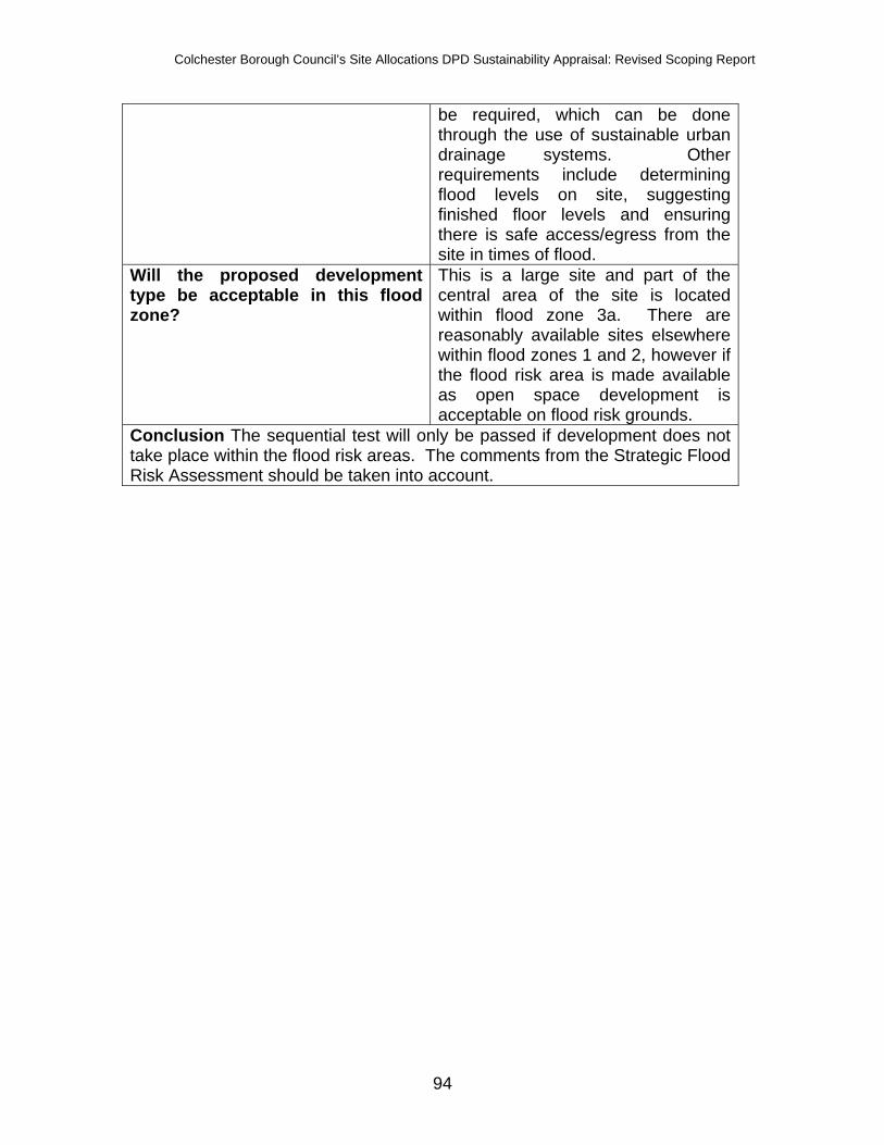
Colchester Borough Council’s Site Allocations DPD Sustainability Appraisal: Revised Scoping Report
94
be required, which can be done through the use of sustainable urban drainage systems. Other requirements include determining flood levels on site, suggesting finished floor levels and ensuring there is safe access/egress from the site in times of flood.
Will the proposed development type be acceptable in this flood zone?
This is a large site and part of the central area of the site is located within flood zone 3a. There are reasonably available sites elsewhere within flood zones 1 and 2, however if the flood risk area is made available as open space development is acceptable on flood risk grounds.
Conclusion The sequential test will only be passed if development does not take place within the flood risk areas. The comments from the Strategic Flood Risk Assessment should be taken into account.

Colchester Borough Council’s Site Allocations DPD Sustainability Appraisal: Revised Scoping Report
95
Name of site S284 Colchester Quarry Map
Preferred use quarry Site flood zone A very small part of the south-western
corner of this large site is located within flood zone 3a. The remainder of the site is located within flood zone 1.
Is there an alternative reasonably available site in flood zone 1?
No
Is there an alternative reasonably available site in flood zone 2?
No
Does the site lie in the functional floodplain (zone 3b)?
No
SFRA comments The SFRA does not comment on this site or land adjacent.
Will the proposed development type be acceptable in this flood zone?
Yes
Conclusion Sand and gravel workings are classed as water compatible development in PPS25 and as there are very limited locations where a quarry would be suitable it is considered that the sequential test is passed.

Colchester Borough Council’s Site Allocations DPD Sustainability Appraisal: Revised Scoping Report
96
Name of site 574 Land south of 168 Rowhedge Road Map
Preferred use residential Site flood zone The whole site is located within flood
zone 3a. Is there an alternative reasonably available site in flood zone 1?
Yes
Is there an alternative reasonably available site in flood zone 2?
Yes
Does the site lie in the functional floodplain (zone 3b)?
No
SFRA comments The SFRA does not comment on this site or land adjacent.
Will the proposed development type be acceptable in this flood zone?
No, this site is located within a high flood risk area.
Conclusion This site does not pass the sequential test and should not be allocated for development.

Colchester Borough Council’s Site Allocations DPD Sustainability Appraisal: Revised Scoping Report
97
Name of site 577 23 Hillview, Rowhedge Road Map
Preferred use residential Site flood zone A very small part of the north-eastern
corner of the site is located within flood zone 3a.
Is there an alternative reasonably available site in flood zone 1?
Yes
Is there an alternative reasonably available site in flood zone 2?
Yes
Does the site lie in the functional floodplain (zone 3b)?
No
SFRA comments The SFRA does not comment on this site or land adjacent.
Will the proposed development type be acceptable in this flood zone?
Only a very small part of the site is located within flood zone 3a and providing that this area is excluded development is acceptable in terms of flood risk.
Conclusion The sequential test is passed providing that the small area in the north-eastern corner of the site located within flood zone 3a is removed.

Colchester Borough Council’s Site Allocations DPD Sustainability Appraisal: Revised Scoping Report
98
Name of site 1222 1/2 Marine Row, Wivenhoe Map
Preferred use residential Site flood zone Almost the whole of the site is located
within flood zone 3a. Is there an alternative reasonably available site in flood zone 1?
Yes
Is there an alternative reasonably available site in flood zone 2?
Yes
Does the site lie in the functional floodplain (zone 3b)?
No
SFRA comments The SFRA does not comment on this site or land adjacent.
Will the proposed development type be acceptable in this flood zone?
No
Conclusion There are numerous sites available within the Council’s growth and regeneration areas to meet the RSS housing targets. In addition to this there are numerous sites within the Borough and not in a growth or regeneration area that are located within flood zone 1. It is therefore considered that this site does not pass the sequential test and should not be allocated for residential development.

Colchester Borough Council’s Site Allocations DPD Sustainability Appraisal: Revised Scoping Report
99
East Colchester The PPS25 good practice guide recognises that where redevelopment of an area in flood zones 2 and 3 is ongoing as part of an established regeneration programme regeneration should not be compromised where a scheme is already partly complete. This is the case for the regeneration of East Colchester, which began prior to the publication of PPS25 and the application of the sequential test. As part of the preparation of the Core Strategy an agreement was reached between the Council, the Environment Agency and the Department for Communities and Local Government that development should continue. Detailed flood risk assessments for individual sites will be carried out, which will ensure that safe access and egress can be provided and flood risk is not increased elsewhere; and more vulnerable development types such as residential should preferably be set back from the Colne with less vulnerable development types in between the Colne and more vulnerable development types. As a previous industrial area contamination is likely to be an issue for many of the sites. However, all sites have been appraised as part of the sequential test on flood risk grounds only. The risk of contamination does not mean that the site is not a reasonably available alternative site, although it is accepted that the cost of de-contaminating sites may make certain sites unviable.

Colchester Borough Council’s Site Allocations DPD Sustainability Appraisal: Revised Scoping Report
100
Name of site 3 Warehouses between River Colne and Hawkins Road Map
Preferred use residential Site flood zone The entire site is located within flood
zone 3a Is there an alternative reasonably available site in flood zone 1?
No
Is there an alternative reasonably available site in flood zone 2?
No
Does the site lie in the functional floodplain (zone 3b)?
No
SFRA comments The SFRA shows that parts of the site are dry islands; however these are surrounded by areas of high flood hazard under the 1 in 200 and 1 in 1000 flood events plus climate change.
Will the proposed development type be acceptable in this flood zone?
Mixed use development would be acceptable on this site. There are no available sites in this regeneration area at lower flood risk. Residential use should be confined to upper storeys with commercial uses at ground level.

Colchester Borough Council’s Site Allocations DPD Sustainability Appraisal: Revised Scoping Report
101
Conclusion The sequential test is passed and parts (a) and (b) of the exception test are also passed:
(a) Redevelopment of this site will contribute to the regeneration of this area and contribute to the creation of a sustainable community. It will help to provide decent, affordable and sustainable homes for the Borough’s growing population. As a highly accessible site, close to the town centre and Hythe railway station, densities will make efficient use of land, reduce car dependency and increase levels of sustainable travel, which will subsequently reduce air pollution and greenhouse gas emissions from traffic. The mix of uses required for the site will cater for local needs.
(b) The site is previously development land.

Colchester Borough Council’s Site Allocations DPD Sustainability Appraisal: Revised Scoping Report
102
Name of site 5 Phase 3, Hythe Quays, off Lighthouse Way Map
Preferred use residential Site flood zone The whole site is located within flood
zone 3a Is there an alternative reasonably available site in flood zone 1?
No
Is there an alternative reasonably available site in flood zone 2?
No
Does the site lie in the functional floodplain (zone 3b)?
No
SFRA comments The SFRA shows that the whole site is in a high hazard zone under the 1 in 200 and 1 in 1000 flood events plus climate change.
Will the proposed development type be acceptable in this flood zone?
Under normal circumstances residential development would not be acceptable; however an agreement has been reached to continue the regeneration of this area as referred to above. Part of this site has already been developed and there is a current planning consent for the remainder of the site.

Colchester Borough Council’s Site Allocations DPD Sustainability Appraisal: Revised Scoping Report
103
Conclusion This site has been considered as part of this sequential test as development has not yet commenced and the site is a reasonably available alternative site.

Colchester Borough Council’s Site Allocations DPD Sustainability Appraisal: Revised Scoping Report
104
Name of site 8 Derelict Depot, Hythe Station Road between railway line and River Colne Map
Preferred use residential Site flood zone The whole site is located within flood
zone 3a Is there an alternative reasonably available site in flood zone 1?
No
Is there an alternative reasonably available site in flood zone 2?
No
Does the site lie in the functional floodplain (zone 3b)?
No
SFRA comments The SFRA shows that a small section of the site on the western boundary is in a high hazard zone under the 1 in 200 and 1 in 1000 flood events plus climate change with the rest of the site falling in low or medium flood hazard.
Will the proposed development type be acceptable in this flood zone?
Yes, with scope to keep residential use away from the highest flood hazard areas.
Conclusion The sequential test is passed and detailed site layout and design should ensure that residential development is directed to the lower flood

Colchester Borough Council’s Site Allocations DPD Sustainability Appraisal: Revised Scoping Report
105
hazard areas within the site. Parts (a) and (b) of the exception test are also passed:
(a) Redevelopment of this site will contribute to the regeneration of this area and contribute to the creation of a sustainable community. It will help to provide decent, affordable and sustainable homes for the Borough’s growing population. As a highly accessible site, close to the town centre and Hythe railway station, densities will make efficient use of land, reduce car dependency and increase levels of sustainable travel, which will subsequently reduce air pollution and greenhouse gas emissions from traffic. The mix of uses required for the site will cater for local needs.
(b) The site is previously development land.

Colchester Borough Council’s Site Allocations DPD Sustainability Appraisal: Revised Scoping Report
106
Name of site 65 King Edward Quay Map
Preferred use residential Site flood zone The whole site is located within flood
zone 3a Is there an alternative reasonably available site in flood zone 1?
No
Is there an alternative reasonably available site in flood zone 2?
No
Does the site lie in the functional floodplain (zone 3b)?
No
SFRA comments The SFRA shows that a small part of the northern fringes of the site is in a high hazard zone under the 1 in 200 and 1 in 1000 flood events plus climate change. The majority of the site is not located within a flood hazard zone with the exception of the small industrial park within the site. The flood hazard increases from medium to high in the 1 in 1000 event plus climate change in the industrial park area.
Will the proposed development Mixed use development would be

Colchester Borough Council’s Site Allocations DPD Sustainability Appraisal: Revised Scoping Report
107
type be acceptable in this flood zone?
acceptable on this site. There are no available sites within this regeneration area at lower flood risk. Residential use should be confined to upper storeys with commercial uses at ground level and within the areas at no/low flood hazard.
Conclusion The sequential test is passed and detailed site layout and design should ensure that residential development is directed to the lower flood hazard areas within the site. Parts (a) and (b) of the exception test are also passed:
(a) Redevelopment of this site will contribute to the regeneration of this area and contribute to the creation of a sustainable community. It will help to provide decent, affordable and sustainable homes for the Borough’s growing population. As a highly accessible site, close to the town centre and Hythe railway station, densities will make efficient use of land, reduce car dependency and increase levels of sustainable travel, which will subsequently reduce air pollution and greenhouse gas emissions from traffic. The mix of uses required for the site will cater for local needs.
(b) The site is previously development land.

Colchester Borough Council’s Site Allocations DPD Sustainability Appraisal: Revised Scoping Report
108
Name of site S112 Haven Road Travellers site Map
Preferred use residential Site flood zone The whole site is located within flood
zone 3a Is there an alternative reasonably available site in flood zone 1?
No
Is there an alternative reasonably available site in flood zone 2?
No
Does the site lie in the functional floodplain (zone 3b)?
No
SFRA comments The SFRA shows that the whole site is in a high hazard zone under the 1 in 200 and 1 in 1000 flood events plus climate change.
Will the proposed development type be acceptable in this flood zone?
Mixed use development would be acceptable on this site. There are no available sites in this regeneration area at lower flood risk. Residential use should be confined to upper storeys with commercial uses at ground level.
Conclusion The sequential test is passed and detailed site layout and design

Colchester Borough Council’s Site Allocations DPD Sustainability Appraisal: Revised Scoping Report
109
should ensure that residential development is directed to the lower flood hazard areas within the site. Parts (a) and (b) of the exception test are also passed:
(c) Redevelopment of this site will contribute to the regeneration of this area and contribute to the creation of a sustainable community. It will help to provide decent, affordable and sustainable homes for the Borough’s growing population. As a highly accessible site, close to the town centre and Hythe railway station, densities will make efficient use of land, reduce car dependency and increase levels of sustainable travel, which will subsequently reduce air pollution and greenhouse gas emissions from traffic. The mix of uses required for the site will cater for local needs.
(d) The site is previously development land. Conclusion The initial work carried out as part of the sequential test in assessing sites submitted by third parties in terms of the proposed use against the flood zone the site falls within and vulnerability classification (appendix E) contributed to the consideration of sites and provides clear justification for the rejection of those sites that fall within flood risk areas. The sequential test enables the Council to be certain that the Site Allocations DPD will avoid flood risk areas and therefore reduce the risk of flooding in the Borough. The following sites failed the sequential test and should therefore not be allocated in the Site Allocations DPD. Both sites are located within flood zone 3a and are not located within a growth/ regeneration area. There are reasonably available alternative sites within flood zones 1 and 2 across the Borough:
• 1222 1/2 Marine Row, Wivenhoe • 574 Land south of 168 Rowhedge Road.

Colchester Borough Council’s Site Allocations DPD Sustainability Appraisal: Revised Scoping Report
110
Appendix A. Colchester’s Local Development Scheme

Colchester Borough Council’s Site Allocations DPD Sustainability Appraisal: Revised Scoping Report
111
Appendix B. Colchester’s Economic Social & Environmental Baseline Data
Indicators Colchester Essex County
East of England England Trends Data sources
Population
Population of area 175,500 1,376,400 5,661,000 51,092,000
Colchester increases by 12.5% since mid-2001.
The largest district accounting for 12.8% of
Essex County.Mid-2007 Population Estimates,
ONS.
Number of males 86,500 672.2 2,778.3 25,114.5 Mid-2007 Population Estimates,
ONS.
Number of females 89,000 704.3 2,882.7 25,977.5 Mid-2007 Population Estimates,
ONS.
Life expectancy males 78.1
Colchester Health Profile, 2008. APHO and Department of Health. ©
Crown Copyright, 2008.
Life expectancy females 82.6
Colchester Health Profile, 2008. APHO and Department of Health. ©
Crown Copyright, 2008.
Population density (people per sq km) 533
Calculation based on Colchester area geography (329 sqm -
Regional Trends) and the mid-2007 estimate.
Population projected to 2021 223,500 1562.2 6471.0 57154.8
Increase of 30.9% for Colchester since mid-2006
population estimates. Take caution - estimates
and projections may be inaccurate due to ONS
migration calculation.
2006-based Subnational Population Projections, ONS. © Crown
Copyright, 2008.
% of population over the age of 65 in 2021 16.1
2006-based Subnational Population Projections, ONS. © Crown
Copyright, 2008.

Colchester Borough Council’s Site Allocations DPD Sustainability Appraisal: Revised Scoping Report
112
% of Colchester that is 'White'
92.86%, 158,600
people 94.15 92.25 88.68
This is a decrease from 96.18% on Census Day
2001.
Mid-2006 Experimental Population Estimates by Ethnic Group, ONS,
2008.
% of population in an ethnic minority group (excluding 'other white')
7.09%, 12,100 people 5.85%
This is an increase from 3.82% on Census Day 2001. The Colchester proportion is probably higher than the Essex proportion due to the
University of Essex residents being counted.
Mid-2006 Experimental Population Estimates by Ethnic Group, ONS,
2008.
Inflow migration 8,900 Internal Migration Estimates, mid-
2006 to mid-2007, ONS, 2008.
Outflow migration 7,800 Internal Migration Estimates, mid-
2006 to mid-2007, ONS, 2008. Housing
Number of dwellings 72,634 Colchester Hip Return, April 2008.
Number and % of privately owned households
58,465 dwellings =
80.5% Colchester Hip Return, April 2008.
Number and % of Registered Social Landlord
3,260 dwellings =
4.5% Colchester Hip Return, April 2008.
Average household size 2.37 2.38 2.37 2.36
Colchester's average household size is the
same as that of the East of England. Expected that
this may have decreased in recent years. Census 2001, ONS
Housing Stock Conditions Retrieve from AMR. Number of vacant dwellings 2,227 = 3.1% Colchester Hip Return, April 2008.

Colchester Borough Council’s Site Allocations DPD Sustainability Appraisal: Revised Scoping Report
113
Mean house prices £198,728 £230,588 £218,910 The Strategic Housing Market
Assessment (SHMA), 2007. Average number of rooms 5.5 Census 2001, ONS
% of households with an occupancy rating of -1 or less 5.57 4.91
'Occupancy rating' measures overcrowding. A value of -1 implies that
there is one room too few and that there is
overcrowding in the household. Census 2001, ONS
Net additonal dwellings for the five year period 7,128 Retrieve from AMR 2008. Net additonal dwellings for the current year 1,243 Retrieve from AMR 2008. Projected net additional dwellings 15,786 Retrieve from AMR 2008. Annual net additional dwellings requirement 825 Retrieve from AMR 2008. Annual average number of net additonal dwellings needed to meet overall housing requirement 830 Retrieve from AMR 2008.
Annual completion of flats. 921
An significant increase from 735 the previous
year. Retrieve from AMR 2008.
Annual completion of houses. 555 Not much increase from
515 the previous year. Retrieve from AMR 2008. % of new and converted dwellings on PDL
1,027 = 81.0% Retrieve from AMR 2008.
Affordable housing completions 265
completions
Currently unable to measure the 25% target of
affordable houses in developments over 1ha or
25 units. HIP Return (National), 2007-2008. % of new dwellings completed at less than 30 dwellings per hectare none Retrieve from AMR 2008.

Colchester Borough Council’s Site Allocations DPD Sustainability Appraisal: Revised Scoping Report
114
% of new dwellings completed at between 30 and 50 dwellings per hectare 23.34% Retrieve from AMR 2008. % of new dwellings completed at above 50 dwellings per hectare 76.60% Retrieve from AMR 2008. % of households with one or more car or van 78.9 80.7 Census 2001, ONS
Average gross household income (£) 24,065 27,000 22,500 Housing Needs Survey, Colchester
Borough Counil, 2002.
Number of registered homeless people 283
CBC Policy Performance Team, 2007-08
Number of people on the housing register 5,085
CBC Policy Performance Team, 2007-08
Number of people in Temporary Accomodation 223
This figure is a snapshot at the end of each quarter
and is not cumulative for the financial year.
However, it is a decrease from the previous year's snapshot of 279 people.
CBC Policy Performance Team, 2007-8
% of new residential development within 30 minutes public transport time of a GP, hospital and major health centre
GP = 99.7% (1,239
homes) Hospital =
99.5% (1,237 homes) Retrieve from AMR 2008.
% of new residential development within 30 minutes public transport time of a employment and major retail centre
Employment area = 99.8%
(1,240 homes)
Retail Centre = 99.5%
(1,237 homes) Retrieve from AMR 2008.

Colchester Borough Council’s Site Allocations DPD Sustainability Appraisal: Revised Scoping Report
115
% of new residential development within 30 minutes public transport time of a primary and secondary school.
Primary school =
99.5% (1,237 homes)
Secondary schoold =
99.0% (1,230 homes) Retrieve from AMR 2008.
Total No. of Gypsy & Traveller Caravans 23 1039 4,443 17,898
Data is a snap shot at January 2008. Produced
annually by Colchester Borough Council
Colchester Borough Council's Annual Monitoring Report, 2008
Number of social rented caravans on authorised sites (with planning permission) 0 183 1,333 6,696
Data is a snap shot at January 2008. Produced
annually by Colchester Borough Council
Colchester Borough Council's Annual Monitoring Report, 2008
Number of private caravans on authorised sites (with planning permission) 15 498 2,126 7,351
Data is a snap shot at January 2008. Produced
annually by Colchester Borough Council
Colchester Borough Council's Annual Monitoring Report, 2008
Number of caravans on authorised, gyspsies own land (tolerated) 1 51 237 1,054
Data is a snap shot at January 2008. Produced
annually by Colchester Borough Council
Colchester Borough Council's Annual Monitoring Report, 2008
Number of caravans on authorised, gyspsies own land (not tolerated) 7 296 491 1,233
Data is a snap shot at January 2008. Produced
annually by Colchester Borough Council
Colchester Borough Council's Annual Monitoring Report, 2008
Number of caravans on unauthorised sites and not owned by gypsies (tolerated) 0 2 141 731
Data is a snap shot at January 2008. Produced
annually by Colchester Borough Council
Colchester Borough Council's Annual Monitoring Report, 2008

Colchester Borough Council’s Site Allocations DPD Sustainability Appraisal: Revised Scoping Report
116
Number of caravans on unauthorised sites and not owned by gypsies (not tolerated) 0 9 115 833
Data is a snap shot at January 2008. Produced
annually by Colchester Borough Council
Colchester Borough Council's Annual Monitoring Report, 2008
Education
% of working age population qualified to NVQ level 1 and above 78.2% 76.8% 78.2%
Fewer than 5 GCSEs at grades A-C, foundation GNVQ, NVQ 1, intermediate 1 national qualification (Scotland) or equivalent
Annual Population Survey,via Nomis Labour Market Profile, Jan-
Dec 2007
% of working age population qualified to NVQ level 4 and above 29.9% 23.4% 26.0%
HND, Degree and Higher Degree level qualifications or equivalent
Annual Population Survey,via Nomis Labour Market Profile, Jan-
Dec 2007
% of the population with no qualifications 9.5% 14.4% 12.5%
Colchester is below both the Essex and Eastern
%s.
Annual Population Survey,via Nomis Labour Market Profile, Jan-
Dec 2007 Employment Number of population economically active 92,000 Annual Population Survey, 2008
No. and % of people in employment 87,000 =
94.6% % is of those economically active (92,000 people). Annual Population Survey, 2008
Number of people of working age classed as employees 76,600
An increase over the previous year's estimate of 5,200 people, equivalent growth of 7.3%. Annual Population Survey, 2008
Number of people of working age classed as self-employed 9,500 Annual Population Survey, 2008
% of population who are economically active but unemployed 3,800 = 4.2%
% is of the economically active population (model-
based unemployment). Annual Population Survey, 2008

Colchester Borough Council’s Site Allocations DPD Sustainability Appraisal: Revised Scoping Report
117
No. of people claiming Job Seekers Allowance (JSA) 1,773
Equates to 1.6% of the resident working age population (110,600). Males =1,228, Females = 545. Annual Population Survey, 2008
No. of young people aged 18-24 claiming JSA 570
Equates to 32.1% of those claiming JSA. Annual Population Survey, 2008
Number of population economically inactive 21,200
% is of the working age population (110,600 people). Annual Population Survey, 2008
% of economically inactive people classified as 'wanting a job'
25% (5,300 people)
A reduction from 24,200 in the previous year. Annual Population Survey, 2008
% of economically inactive people classified as 'not wanting a job'
75% (15,900 people)
% is of those econmically inactive (21,200 people) Annual Population Survey, 2008
Gross weekly pay for full time workers in Colchester (2007) £479.00 £503.20 £479.10
Colchester's gross weekly pay is in line with the
Eastern figure but below that of Essex for the same
period.
Earnings by residence 2007, ONS Annual Survey of hours and
earnings
Job Density
87,000 jobs = 0.80
density 0.75 0.82
The density figures represent the ratio of total
jobs to working-age population. Colchester's job density is higher than
the Essex average and closer to the eastern
average.Job Density 2005, Nomis Official
Labour Market Statistics, 2008
Amount of floorspace developed for employment by type which is on PDL
B1 - B8 Total = 25,710sqm
95% of all new employment floorspace
was achieved on brownfield sites.
Colchester Borough Council's Annual Monitoring Report, 2008
Number of jobs in the tourism sector 4,496 jobs This has risen by 67%
since 1993.Colchester Borough Council's
Annual Monitoring Report, 2008

Colchester Borough Council’s Site Allocations DPD Sustainability Appraisal: Revised Scoping Report
118
Visitor trips
54,000 staying trips
taken by overseas
visitors. 218,000
staying trips taken by domestic
staying visitors. 4m day trippers.
Colchester Borough Council's Annual Monitoring Report, 2009
Number of VAT registered businesses in 2006 5,325
VAT Registered Buildings 2006, Nomis Official Labour Market
Statistics, 2008 Deprivation
% of people in Colchester living in seriously deprived small areas.
5% (7,790 people)
% is from 2001 Census population estimate for Colchester of 155,796
people).Index of Multiple Deprivation Data,
2007.
Levels of deprivation in Essex
Colchester had 2nd
highest local concentration
score of all 12 Essex
districts
This suggests that where deprivation exists in
Colchester, it is concentrated in small
areas.Index of Multiple Deprivation Data,
2007.
Number of areas in Colchester in the top 20% most deprived in England
3 small areas - St
Andrew's, St Anne's and
Harbour
The most deprived small area in Colchester was
located in St Anne's Estate within St Anne's ward.
Index of Multiple Deprivation Data, 2007.
Number of areas in Colchester in the top 40% most deprived in England 21 areas
Index of Multiple Deprivation Data, 2007.

Colchester Borough Council’s Site Allocations DPD Sustainability Appraisal: Revised Scoping Report
119
% of areas within the top 20% most affected bby Barriers to Housing and Services. 28% 19%
Index of Multiple Deprivation Data, 2007.
% of small areas that are seriously deprived in terms of living environment 2%
Index of Multiple Deprivation Data, 2007.
% of small areas that are seriously deprived in terms of education, skills and training 15%
Index of Multiple Deprivation Data, 2007.
Health Number of doctors surgeries 32 National Health Service Online Number of Clinics 6 National Health Service Online Number of dentists 26 National Health Service Online Number of Opticians 15 National Health Service Online Number of Pharmacies 21 National Health Service Online Number of Hospitals 2 National Health Service Online
No. of live births 1,932 15,370 Key Population and Vital Statistics,
ONS, 2006.
Total Fertility Rate 1.51 1.84 Key Population and Vital Statistics,
ONS, 2006.
Live Birth Rate 11.3 11.3 11.9 12.5 Key Population and Vital Statistics,
ONS, 2006.
No. of deaths 1,413 12,831 51,846 Key Population and Vital Statistics,
ONS, 2006.
Standardised Mortality Ratio (SMR) 94 93 93 Key Population and Vital Statistics,
ONS, 2006.
Infant Mortality Rate
3.6 deaths per 1,000 live
births under 1 year old 4.0 4.1
Key Population and Vital Statistics, ONS, 2006.

Colchester Borough Council’s Site Allocations DPD Sustainability Appraisal: Revised Scoping Report
120
% of households containing one or more people suffering with a limiting long-term illness 30.6 Census 2001, ONS
% of people of working age suffering from a limiting long-term illness 11.8 Census 2001, ONS
Number of conceptions per 1,000 females under the age of 18 years 43.3 34.9 Above the Essex average.
Key Population and Vital Statistics, ONS, 2000.
Crime Number of incidents in Colchester between 2007 and 2008 12,084 Essex Police Data, 2007-2008 Rate of burglaries per 1,000 households 6.7
A decrease from the previous year. Essex Police Data, 2007-2008
Criminal damage per 1,000 people 16.3 Essex Police Data, 2007-2008 Theft per 1,000 people 13.9 Essex Police Data, 2007-2008
Robberies per 1,000 people 0.5 Decrease from 0.6 the
previous year. Essex Police Data, 2007-2008
% of residents who think people being attacked because of their skin colour, ethnic origin or religion was a very big or fairly big problem in Colchester 13.2
ODPM 2003-2004, located through the Audit Commission Area Profiles,
2006.
% of residents who feel 'very safe' outside after dark 2.0
ODPM 2003-2004, located through the Audit Commission Area Profiles,
2006.
% of residents who think that vandalism, graffiti and other deliberate damage to property or vehicles is a very big or fairly big problem in their area 48.9 63.6
Lower than the Essex average.
ODPM 2003-2004, located through the Audit Commission Area Profiles,
2006.

Colchester Borough Council’s Site Allocations DPD Sustainability Appraisal: Revised Scoping Report
121
% of residents who think that people using or dealing drugs is a very big or fairly big problem in their area 44.2 56.2
Lower than the Essex average.
ODPM 2003-2004, located through the Audit Commission Area Profiles,
2006.
% of residents who think that people being rowdy or drunk in public places is a very big or fairly big problem in their area 41.7 48.2
Lower than the Essex average.
ODPM 2003-2004, located through the Audit Commission Area Profiles,
2006. Floorspace
All bulk classes (count) 3,842 132,500 1,318,246 Office for National Statistics, ONS,
April 2005.
Retail premises (count) 1,369 46,543 516,864 Office for National Statistics, ONS,
April 2005.
Offices (count) 941 29,827 310,707 Office for National Statistics, ONS,
April 2005.
Commercial offices (count) 814 25,334 263,910 Office for National Statistics, ONS,
April 2005.
Other offices (count) 127 4,493 46,797 Office for National Statistics, ONS,
April 2005.
Factories (count) 742 27,594 246,470 Office for National Statistics, ONS,
April 2005.
Warehouses (count) 614 21,947 189,631 Office for National Statistics, ONS,
April 2005.
Other bulk premises sqm 176 6,589 54,574 Office for National Statistics, ONS,
April 2005.
All bulk classes sqm (000s) 1,393 55,476 557,302 Office for National Statistics, ONS,
April 2005.
Retail premises sqm (000s) 388 9,860 97,273 Office for National Statistics, ONS,
April 2005.
Offices sqm (000s) 220 8,271 94,216 Office for National Statistics, ONS,
April 2005.
Commercial offices sqm (000s) 189 6,741 78,238 Office for National Statistics, ONS,
April 2005.
Other offices sqm (000s) 30 1,530 15,978 Office for National Statistics, ONS,
April 2005. Factories sqm (000s) 395 19,581 204,237 Office for National Statistics, ONS,

Colchester Borough Council’s Site Allocations DPD Sustainability Appraisal: Revised Scoping Report
122
April 2005.
Warehouses sqm (000s) 335 15,742 142,853 Office for National Statistics, ONS,
April 2005.
Other bulk premises sqm (000s) 55 2,023 18,723 Office for National Statistics, ONS,
April 2005.
Vacant Property Estimates 11 8 9
There have been fluctuations between 10%
and 11%.Office for National Statistics, ONS,
April 2004 - March 2005. Cultural Heritage & Material Assets Number of Grade 1 listed buildings 41 Essex County Council, 2005. Number of Grade II* listed buildings 99 Essex County Council, 2005. Number of Grade II listed buildings 1,410 Essex County Council, 2005. Number of Grade B listed buildings (church only) 4 Essex County Council, 2005. Number of Grade C listed buildings (church only) 2 Essex County Council, 2005. Number of conservation areas 22 Colchester Borough Council, 2006. Number of Scheduled Ancient Monuments 40 Colchester Borough Council, 2006. Number of Countryside Conservations Areas (CCA) 8
Colchester Adopted Local Plan, 2004.
Number of parks on the National Register of Special Historic Interest 4 Colchester Borough Council, 2006.
Loss of listed buildings (by demolition) 0 Colchester Borough Council's
Annual Monitoring Report, 2008
Loss or damage to Scheduled Ancient Monuments or nationally important archaeological sites through development 0
Colchester Borough Council's Annual Monitoring Report, 2008
% of residents satisfied with sports & leisure facilities
No data available - 65% is 2006/07 target.
Best Value Performace Indicators, 2005/2006.
% of residents satisfied with museums
No data available - 60% is 2006/07 target.
Best Value Performace Indicators, 2005/2006.

Colchester Borough Council’s Site Allocations DPD Sustainability Appraisal: Revised Scoping Report
123
% of residents satisfied with arts activities
No data available - 62% is 2006/07 target.
Best Value Performace Indicators, 2005/2006.
% of residents satisfied with parks & open spaces
No data available - 82% is 2006/07 target.
Best Value Performace Indicators, 2005/2006.
Visits to/use of museums per 1,000 population 2,446
Best Value Performace Indicators, 2005/2006.
The number of pupils visiting museums & galleries in organised school 23,750
Best Value Performace Indicators, 2005/2006.
Biodiversity
Area of ancient woodland within the borough
Found to the south of
Colchester, clustered along the
Roman River, on the
Valley from Copford to its
confluence with River
Colne. Essex County Council,
Sustainability Appraisal, 2006. Change in priority habitats and species
Condition of internationally and nationally important wildlife and geographical sites (SSSI, SPA, SAC & Ramsar)
Number of sites of international or national importance for nature, or ANOB, SSSis or SINC, to be lost to or damaged by development 0
Colchester Borough Council's Annual Monitoring Report, 2008
% of residential development on greenfield land 19%
An increase from 7.4% the previous year.
Colchester Borough Council's Annual Monitoring Report, 2008

Colchester Borough Council’s Site Allocations DPD Sustainability Appraisal: Revised Scoping Report
124
Amount of development in designated areas
34 applications
were approved in
a SINC. 5 applications approved in a SSSI. 49 applications approved in
an ANOB.
None of these applications resulted in damage or
loss. More applications were submitted than
approved due to environmental constraints
on the site.Colchester Borough Council's
Annual Monitoring Report, 2008
Applications involving Tree Preservation Orders (TPOs) trees
141 applications for works to TPO trees.
130 were consented
and 11 were refused.
Colchester Borough Council's Annual Monitoring Report, 2008
Flagship species
Beautiful Demoiselle Damselfly,
Great Crested
Newt, Sea Holly, Stag
Beetle, Lesser
Calamint. Essex County Council,
Sustainability Appraisal, 2006.
Areas of unimproved acid grassland that remain in Essex
Tiptree Heath SSSI and Roman River SSSI.
Essex County Council, Sustainability Appraisal, 2006.
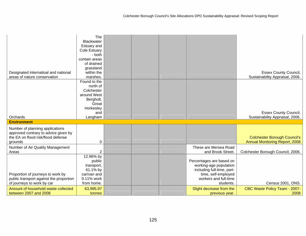
Colchester Borough Council’s Site Allocations DPD Sustainability Appraisal: Revised Scoping Report
125
Designated internatioal and national areas of nature conservation
The Blackwater
Estuary and Cole Estuary
- both contain areas
of drained grassland within the marshes.
Essex County Council, Sustainability Appraisal, 2006.
Orchards
Found to the north of
Colchester around West
Bergholt, Great
Horkesley and
Langham Essex County Council,
Sustainability Appraisal, 2006. Environment Number of planning applications approved contrary to advice given by the EA on flood risk/flood defense grounds 0
Colchester Borough Council's Annual Monitoring Report, 2008
Number of Air Quality Management Areas 2
These are Mersea Road and Brook Street. Colchester Borough Council, 2006.
Proportion of journeys to work by public transport against the proportion of journeys to work by car
12.96% by public
transport, 61.1% by
car/van and 9.11% work from home.
Percentages are based on working-age population including full-time, part-
time, self-employed workers and full-time
students. Census 2001, ONS. Amount of household waste collected between 2007 and 2008
63,995.97 tonnes
Slight decrease from the previous year.
CBC Waste Policy Team - 2007-2008

Colchester Borough Council’s Site Allocations DPD Sustainability Appraisal: Revised Scoping Report
126
% of household waste that was dry recycled 19.70%
Increase from 17.8% the previous year.
CBC Waste Policy Team - 2007-2008
% of household waste that has been green composted 12.00%
CBC Waste Policy Team - 2007-2008
Provision of recycling facilities in new development
Data not available - CBC is in the process of setting
up a working group that will look at developing
guidance for the designing in of recycling into
developments before a planning application is
submitted. In the future, developers will have to
accommodate recycling facilities in new developments.
CBC Waste Policy Team - 2005/2006
% of stretches of watercourse that are compliant with River Quality Objectives (RQO's)
Data not available - 62.28% of Colchester's river length was assessed as good biological quality and 35.23% was assessed as good chemical quality. OFWAT, 2004.
% of local street and environment cleanliness (litter) 11.0
Best Value Performace Indicators, 2005/2006.
% of local street and environment cleanliness (graffiti) 1.0
Best Value Performace Indicators, 2005/2006.
% of local street and environment cleanliness (fly-posting) 2.0
Best Value Performace Indicators, 2005/2006.
% of local street and environment cleanliness (fly-tipping) No data available
Best Value Performace Indicators, 2005/2006.
Kg of household waste collected per head 391.0
Best Value Performace Indicators, 2005/2006.
Cost per household of waste collection 51.6
Best Value Performace Indicators, 2005/2006.

Colchester Borough Council’s Site Allocations DPD Sustainability Appraisal: Revised Scoping Report
127
% of people satisfied with the cleanliness standard of their area
No data available - 68% is 2006/07 target.
Best Value Performace Indicators, 2005/2006.
% of people satisfied with household waste collection
No data available - 85% is 2006/07 target.
Best Value Performace Indicators, 2005/2006.
% of people satisfied with recycling No data available - 76% is
2006/07 target.Best Value Performace Indicators,
2005/2006. Identifying contaminated land - number of sites of potential concern 624
CBC Environmental and Protective Services, 2008.
% with sufficient information to decide whether remediation is necessary 5%
CBC Environmental and Protective Services, 2008.
% of pollution control improvements completed on time 95.0
Best Value Performace Indicators, 2005/2006.
Abandoned venhicles investigated within 24 hours 100.0
Best Value Performace Indicators, 2005/2006.
Abandoned vehicles removed within 24 hours of legal entitlement 50.0
Best Value Performace Indicators, 2005/2006.
% of developed land that is derelict 0 National Land Use Database, CBC
data, March 2006. % of relevant land and highways assessed as having combined deposits of litter and deritus. 11%
This has increased from 9% the previous year.
Audit Commission, BVPI 199, (2005-05)
% of land designated as sites of specific scientific interest (SSSI) in favourable condition 69 English Nature, 2005 Amount of Local Nature Reserve land per 1,000 people 0.6 hectares English Nature, 2005 Annual average domestic consumption of gas 18,365kWh
This is a decrease from 20,336 in 2004. DTI Energy Trends, 2005
Annual average domestic consumption of electricity 4,787kWh
This is a slight decrease from 4,875 kWh in 2004. DTI Energy Trends, 2005
Daily domestic water use (per capita consumption) 145 litres OFWAT, 2004

Colchester Borough Council’s Site Allocations DPD Sustainability Appraisal: Revised Scoping Report
128
Rivers at risk of pollution
Layer Brook, Roman
River, Colne, St Botolph's
Brook Essex County Council,
Sustainability Appraisal, 2006.
Extensive Flood Risk Areas
North coast of Mersea Island and
opposite on the mainland.
Essex County Council, Sustainability Appraisal, 2006.
High Flood Risk Areas
Abberton Reservior,
Ardleigh Reservoir,
Stour Valley and Colne
Valley Essex County Council,
Sustainability Appraisal, 2006.
Main source of NOx emissions Road traffic
emissions Essex County Council,
Sustainability Appraisal, 2006.

Colchester Borough Council’s Site Allocations DPD Sustainability Appraisal: Revised Scoping Report
129
Appendix C. International sites summaries Abberton Reservoir SPA Abberton Reservoir is a large, shallow freshwater storage reservoir and lies in the Layer Brook valley just before the Brook joins with the Roman River. It is the largest freshwater body in Essex. It is one of the most important reservoirs nationally for wintering wildfowl, with a key role as a roost for wildfowl and waders feeding in adjacent estuarine areas. The site is also important for winter feeding and autumn moulting of waterbirds. The margins of the reservoir have well developed plant communities that provide important opportunities for feeding, nesting and shelter. Site Name Abberton Reservoir
Designation Special Protection Area & Ramsar Site
Qualification The site qualifies as an SPA under Article 4.1 and 4.2 of the Birds Directive (79/409/EEC) by supporting populations of European species of importance listed on Annex 1 of the Directive and of regularly occurring migratory species and under Article 4.2 of the Birds Directive by regularly supporting at least 20,000 waterfowl. The site qualifies as a Ramsar Site under criterion 6 of the Convention on Wetlands of International Importance especially as Waterfowl Habitat.
Date designated December 1991 (SPA) and July 1981 (Ramsar)
Area 726.2 hectares
General Site Cover 90% Inland water bodies 10% Improved grassland
Soil and geology Clay, neutral
Geomorphology & landscape
Lowland, valley
Sensitivity Abberton Reservoir is a public water supply reservoir. Reduced water availability, and increased demand, in recent years has led to generally low water levels; greater numbers of waders therefore use the site, and as a result no decrease in wildfowl has been attributed to low water levels. Water entering the site has elevated nitrate levels, leading in most summers to algal blooms, but there is no evidence of impacts on wildlife. The Water Company has a consultative committee which addresses conservation issues at all its sites, and the Abberton Reservoir Committee (involving Essex Wildlife Trust and Natural England) addresses local issues.
General ecological features of Ramsar designation
Abberton Reservoir is a large storage reservoir. The main habitat type is freshwater; there are no important vegetated habitats.
Key Issues for the DPD to assess
Water resources

Colchester Borough Council’s Site Allocations DPD Sustainability Appraisal: Revised Scoping Report
130
Key Features Conservation
objectives Qualifies under
Season SPA Status Attributes Sensitivity Effects
Cormorant (sea bird) (Phalacrocorax carbo)
To maintain in favourable condition, the habitats for the populations of cormorant with particular reference to open water and surrounding marginal habitats.
Article 4.2 Breeding Abberton Reservoir is the largest inland colony for Cormorants nationally with 490 pairs representing at least 7% of the breeding national population (5 year mean 1993-7)
Numbers of the species have increased in recent years, which are thought to result from relaxation in former persecution & increased provision of food sources such as fish farms and hatcheries.
Increased recreational fishing
This DPD will allocate new land for housing, employment and other uses. New development within the Borough will result in an increase in population, which is likely to bring with it an accompanying increase in visitation and recreational pursuits such as fishing.

Colchester Borough Council’s Site Allocations DPD Sustainability Appraisal: Revised Scoping Report
131
Gadwall (waterfowl) (Anas strepera)
To maintain in favourable condition, the habitats for the populations of gadwall with particular reference to open water and surrounding marginal habitats.
Article 4.2 & criterion 6 of the Ramsar Convention
Over winter (SPA) Spring/ autumn (Ramsar)
550 representing at least 6.3% of the national population (5 year mean 1998/9- 2002/3) The latest WeBS has triggered a medium alert.
Gadwall inhabit inland, eutrophic, still waters in lowland areas, including reservoirs & flooded gravel pits as well as marshy grassland/flood meadows. In winter, they tend to concentrate locally in suitable habitats within larger wetland areas. The population has increased significantly in recent years as new habitats have been created.
Recreational disturbance
This DPD will allocate new land for housing, employment and other uses. New development within the Borough will result in an increase in population, which is likely to bring with it an accompanying increase in visitation. This can lead to habitat damage and to disturbance of feeding and roosting waterfowl. The DPD, cumulatively with the proposal to enlarge the reservoir, will likely result in an even greater number of visitors to this site.

Colchester Borough Council’s Site Allocations DPD Sustainability Appraisal: Revised Scoping Report
132
Shoveler (waterfowl) (Anas clypeata)
To maintain in favourable condition, the habitats for the populations of shoveler with particular reference to open water and surrounding marginal habitats.
Article 4.2 & criterion 6 of the Ramsar Convention
Over winter (SPA) Spring/ autumn (Ramsar)
Abberton Reservoir and the Ouse Washes are consistently the most important sites for this species, with peak counts regularly in excess of 600 and occasionally over 1,000. 654 average, representing at least 6.5% of the national population (5 year mean 1993-7). The latest WeBS has triggered a medium alert.
The distribution of Shoveler is predominantly coastal, although they also occur inland along major river systems & elsewhere where they can find suitable wetland habitats. Britain is the most northerly part of their winter range.
Cold winter weather, water levels, water quality
The in-combination effect of climate change could result in an increase to the over-wintering population if the area experiences warmer temperatures. The in-combination effect of the plan and the proposal to raise the water level at Abberton Reservoir could affect the species, which favour shallow waters. An increase in population within the Borough will result in an increase in water use, if water quality is not maintained new development could result in adverse effects on the integrity of this site.

Colchester Borough Council’s Site Allocations DPD Sustainability Appraisal: Revised Scoping Report
133
Teal (waterfowl) (Anas crecca)
To maintain in favourable condition, the habitats for the populations of teal with particular reference to open water and surrounding marginal habitats.
Article 4.2 Over winter 5,326 representing at least 3.9% of the national population (5 year mean 1993-7). The latest WeBS has triggered a high alert.
In winter the species occur across much of Europe, wherever there are suitable wetland (inland and coastal) habitats. They favour areas of shallow freshwater.
Increased water levels, pollution, cold winter weather.
The in-combination effect of the plan and the proposal to raise the water level at Abberton Reservoir could affect the species, which favour shallow waters. Pollution could affect the species if the composition of freshwater is altered dramatically. An increase in population within the Borough will result in an increase in water use, if water quality is not maintained new development could result in pollution. Additionally, an increase in motor sports could result in pollution. The in-combination effect of climate change could result in an increase to the over-wintering population if the area experiences warmer temperatures.
Coot (Fulica atra)
Article 4.2 Over winter Abberton Reservoir holds by far the largest non-breeding numbers of this species – approximately double that of any other UK site. 12,602 representing at least 11% of the national population. The latest WeBS has triggered a medium alert.
Coots favour large, slow moving, shallow water bodies.
Increased water levels, cold winter weather.
The in-combination effect of the plan and the proposal to raise the water level at Abberton Reservoir could affect the species, which favour shallow waters. The in-combination effect of climate change could result in an increase to the over-wintering population if the area experiences warmer temperatures.

Colchester Borough Council’s Site Allocations DPD Sustainability Appraisal: Revised Scoping Report
134
Tufted Duck (Aythya fuligula)
Article 4.2 Over winter 1,864 representation 3.1% of the national population. The latest WeBS has triggered a medium alert.
Tufted ducks winter in temperate climates. They prefer large freshwater lakes and feed by diving.
Cold winter weather, pollution
The in-combination effect of climate change could result in an increase to the over-wintering population if the area experiences warmer temperatures. Pollution could affect the species if the composition of freshwater is altered dramatically. An increase in population within the Borough will result in an increase in water use, if water quality is not maintained new development could result in pollution. Additionally, an increase in motor sports could result in pollution.
Goldeneye (Bucephala clangula)
Article 4.2 Over winter 463 representing 2.7% of the national population
During the winter, this species favours coastal areas in the northern part of its range and large rivers, lakes, reservoirs and coastal lagoons further south. There is some indication that during periods of harsh weather birds move from frozen inland waters to the coast. Research has shown that Goldeneye can congregate around sewerage pipelines.
Cold winter weather, reduced food numbers
The in-combination effect of climate change could result in an increase to the over-wintering population if the area experiences warmer temperatures. The proposal to raise the water level of the reservoir could reduce food numbers for this species as the composition of the reservoir will inevitably be altered.

Colchester Borough Council’s Site Allocations DPD Sustainability Appraisal: Revised Scoping Report
135
Wigeon (Anas Penelope)
Article 4.2 & criterion 6 of the Ramsar Convention
Over winter 2,888 representing 1% of the national population. The latest WeBS has triggered a high alert.
In winter, Wigeon occur in large, mobile flocks that rapidly move to other areas should conditions change for the worse. Wigeon is largely a coastal species, feeding on mud-flats, coastal flooded grassland & saltmarsh pastures. In the UK, the species is also widespread on inland flooded grassland. The use of inland sites appears to have increased in recent years, as birds have adapted their feeding habits in response to changes in the availability of food.
Cold winter weather, human disturbance
The in-combination effect of climate change could result in an increase to the over-wintering population if the area experiences warmer temperatures. This DPD will allocate new land for housing, employment and other uses. New development within the Borough will result in an increase in population, which is likely to bring with it an accompanying increase in visitation. This can lead to habitat damage and to disturbance of feeding and roosting waterfowl. The DPD, cumulatively with the proposal to enlarge the reservoir, will likely result in an even greater number of visitors to this site. Additionally, the proposal to raise the water level of the reservoir may effect the species if food availability is altered.

Colchester Borough Council’s Site Allocations DPD Sustainability Appraisal: Revised Scoping Report
136
Pochard (Aythya ferina)
Article 4.2 (& future consideration under criterion 6 of the Ramsar Conventions)
Over winter 1,901 representing 4.4% of the national population.
They are widespread in winter forming large flocks on lakes, reservoirs, brackish coastal lagoons, tidal estuaries and inshore coastal waters. They prefer water bodies less than 3 metres deep.
Increased water levels, water based recreation, eutrophication
The in-combination effect of the plan and the proposal to raise the water level at Abberton Reservoir could affect the species, which favour shallow waters. This DPD will allocate new land for housing, employment and other uses. New development within the Borough will result in an increase in population, which is likely to bring with it an accompanying increase in visitation and water based recreation. The DPD, cumulatively with the proposal to enlarge the reservoir, will likely result in an even greater number of visitors to this site. Pollution could affect the species if the composition of freshwater is altered dramatically. An increase in population within the Borough will result in an increase in water use, if water quality is not maintained new development could result in pollution. Additionally, an increase in motor sports could result in pollution.
Great crested Grebe (Podiceps cristatus)
Article 4.2 Over winter 132 representing 1.4% of the national population
Some Great Crested Grebes move immediately after breeding to large lakes & reservoirs & certain coastal areas to moult.
Cold winter weather, water based recreation
The in-combination effect of climate change could result in an increase to the over-wintering population if the area experiences warmer temperatures. This DPD will allocate new land for housing, employment and other uses. New development within the Borough will result in an increase in population, which is likely to bring with it an accompanying increase in visitation and water based recreation. The DPD, cumulatively with the proposal to enlarge the reservoir, will likely result in an even greater number of visitors to this site.

Colchester Borough Council’s Site Allocations DPD Sustainability Appraisal: Revised Scoping Report
137
Golden Plover (wader) (Pluvialis apricaria)
To maintain in favourable condition, the habitats for the populations of golden plover with particular reference to open water and surrounding marginal habitats.
Article 4.1 Over winter 3,714 individuals representing at least 1.5% of the wintering population in Great Britain (5 year peak mean 1991/2 - 1995/6) The latest WeBS has triggered a high alert.
The Golden Plover is partially migratory in Great Britain. They occur at traditional wintering grounds and are seldom found inland. Grassland and the inter-tidal zone are the most important feeding habitats.
Afforestation, predation and intensive agricultural practices
Effects from afforestation are unlikely for this site. This DPD will allocate new land for housing, employment and other uses. New development within the Borough will result in an increase in population and a population increase close to the international site will result in an increased risk of predation from domestic cats. Discharges from intensive agriculture cannot be controlled via the planning system, however they should be considered in-combination with the DPD.
39763 waterfowl (5 year peak mean 01/04/1998)
To maintain in favourable condition, the habitats for the populations of waterfowl assemblage with particular reference to open water and surrounding marginal habitats.
Article 4.2 (a wetland of international importance regularly supporting at least 20,000 waterfowl)
Over winter Species include: Podiceps cristatus , Anas penelope , Anas strepera , Anas crecca , Anas clypeata , Aythya ferina , Aythya fuligula , Bucephala clangula , Fulica atra
Changing water levels, pollution
The in-combination effect of the plan and the proposal to raise the water level at Abberton Reservoir could affect the species, which favour shallow waters. Pollution could affect the species if the composition of freshwater is altered dramatically. An increase in population within the Borough will result in an increase in water use, if water quality is not maintained new development could result in pollution. Additionally, an increase in motor sports could result in pollution.

Colchester Borough Council’s Site Allocations DPD Sustainability Appraisal: Revised Scoping Report
138
Bird assemblages of international importance
Criterion 5 of the Ramsar Convention
Over winter 23787 waterfowl (5 year peak mean 1998/99-2002/2003)
Erosion and pollution from agricultural fertilisers, run-off, pesticides
Pollution could affect the species if the composition of freshwater is altered dramatically. An increase in population within the Borough will result in an increase in water use, if water quality is not maintained new development could result in pollution. Additionally, an increase in motor sports could result in pollution. Effects from agriculture will not be able to be addressed through this DPD as they are outside the control of the LPA.
Blackwater Estuary SPA The Blackwater Estuary is the largest estuary in Essex north of the Thames and is one of the largest estuarine complexes in East Anglia. Its mudflats, fringed by saltmarsh on the upper shores, support internationally and nationally important numbers of overwintering waterfowl. Shingle and shell banks and offshore islands are also a feature of the tidal flats. The surrounding terrestrial habitats; the sea wall, ancient grazing marsh and its associated fleet and ditch systems, plus semi-improved grassland are also of high conservation interest. This rich mosaic of habitats supports an outstanding assemblage of nationally scarce plants and a nationally important assemblage of rare invertebrates. There are 16 British Red Data Book species and 94 notable and local species. Site Name Blackwater Estuary (Mid-Essex Coast Phase 4)
Designation Special Protection Area and Ramsar Site
Qualification The site qualifies as an SPA under Article 4.1 and 4.2 of the Birds Directive (79/409/EEC) by supporting populations of European species of importance listed on Annex 1 of the Directive and of regularly occurring migratory species and under Article 4.2 of the Birds Directive by regularly supporting at least 20,000 waterfowl. The site qualifies as a Ramsar Site under criteria 1, 2, 3, 5 and 6 of the Convention on Wetlands of International Importance especially as Waterfowl Habitat.
Date designated May 1995
Area 4395.15 hectares
General Site Cover 50% Tidal rivers. Estuaries. Mud flats. Sand flats. Lagoons (including saltwork basins) 33% Salt marshes. Salt pastures. Salt steppes 5% Bogs. Marshes. Water fringed vegetation. Fens 12% Humid grassland. Mesophile grassland
Soil and geology Clay, Mud, Neutral, Nutrient-rich, Sedimentary, Shingle
Geomorphology & landscape
Coastal, Estuary, Intertidal sediments (including sandflat/mudflat), Islands, Lowland, Shingle bar, Subtidal sediments (including sandbank/mudbank)

Colchester Borough Council’s Site Allocations DPD Sustainability Appraisal: Revised Scoping Report
139
Sensitivity Coastal erosion The main threat to the site is erosion of intertidal habitats due to a combination of sea level rise and isostatic forces operating on the land mass of Great Britain. The situation is worsened with increasing winter storm events, whilst the hard sea walls along this coastline are preventing the saltmarsh and intertidal areas from migrating inland. This situation is starting to be addressed by alternative flood defence techniques. A shoreline management plan has been prepared for the Essex coast which seeks to provide a blueprint for managing the coastline sustainably. Nutrient enrichment Nutrient enrichment occurs from agricultural run-off and treated sewage effluent. This problem will be addressed through the Essex Estuaries SAC scheme of management as well as review of discharge consents under the Habitats Regulations. Water-based recreation The control of motorised craft (with particular reference to jet-skis) is being addressed through the Blackwater Estuary Management Plan. Enforcement of speed limits should ensure that roosting birds are not subjected to disturbance and saltmarsh habitats are protected from damage by jet-skis. Drought The droughts over the last five years have resulted in lowered water tables in grazing marshes. Attempts are being made to restore this by pumping water from adjacent ditches and use of tertiary treated sewage effluent.
General ecological features of Ramsar designation
At low tide a vast expanse of intertidal mud is exposed from shore to shore. This enriched mud is a feeding ground for variety of molluscs, crustaceans and worms, and encourages the growth of the green algae Enteromorpha, and eelgrass Zostera spp. at the seaward edges of the saltings. Wildfowl and waders amass to exploit this rich food supply in numbers over twice the maximum required to confer international status to the site. On arrival in October, brent geese feed in the estuary on Enteromorpha and Zostera. All three species, Zostera marina, Z. angustifolia, Z. noltei, once formed large beds in the estuary but are now scarce. This decline in eelgrasses combined with a recovery in brent geese numbers in the 1970s, prompted a change in feeding habits and the geese now spend more time landward of the sea wall grazing on arable crops and improved grassland. Areas of improved, reseeded grassland are managed for brent geese at Old Hall, Goldhanger, Steeple, and Osea and Northey Islands. The inclusion of these established grassland feeding areas within the SSSI will continue to help ease the pressure on arable land. The Blackwater Estuary contains the largest area of saltmarsh in Essex (1,102.85 ha), representing the fifth-largest area in Great Britain; though, like other saltmarshes on this coastline, much of it is eroding at a rate of between 0.3-1 m each year. The saltings serve as important high tide wader roosts and support a specialised flora grazed by wigeon and brent geese. Large expanses of saltings exist at Tollesbury and Old Hall and along the northern shore of the Salcott Channel. At high tide, they accommodate large roosting populations of dunlin, grey plover and curlew. The inlet marshes of Gor Saltings, Cooper's and Steeple Creeks, and the saltings associated with Northey and Osea Islands, also act as high tide refuges for dense populations of waders. Ray Island, in the Strood Channel, is one of the few sites in Essex where the transition from saltmarsh to grassland has not been truncated by the imposition of a sea wall. However, elsewhere, the saltings fronting the sea wall also show distinct zones of vegetation. The lower marsh is comprised of the primary colonisers of mud - glassworts Salicornia spp., including the nationally scarce S. perennis and S. pusilla and the invasive common cord-grass Spartina anglica. The scarce native small cordgrass Spartina maritima can still be found in places, despite the incursions of the more vigorous hybrid form. Further up the marsh, where tidal immersions are less frequent, sea purslane Atriplex portulacoides and common saltmarsh-grass Puccinellia maritima predominate, with sea aster Aster tripolium and common sea lavender Limonium vulgare. The nationally scarce lax-flowered sea lavender Limonium humile is sometimes interspersed among the more common species, but the main site for this is at Old Hall. Scarce saltmarsh grasses usually associated with the higher zone of the marsh, such as stiff saltmarsh-grass Puccinellia rupestris and Borrer's saltmarsh grass Puccinellia fasciculata, are encountered growing behind the sea wall in wheel-ruts along the folding. Two Mediterranean plants at the northerly limit of their distributions, golden-samphire Inula crithmoides and shrubby sea blite Suaeda vera, in the absence of high marsh, having adapted to growing at the base and outer face of the sea wall. Shrubby sea-blite is also able to colonise unstable shingle along the drift line and large populations are present at West Mersea and Osea Island. The higher wave energies at creek mouths and the upper reaches of the estuary promote the deposition of shingle and sand. Where this has occurred on the foreshore at West Mersea the county rarity, sea spurge Euphorbia paralias, has been discovered along with sea mayweed Tripleurospermum maritimum, which has a limited distribution in Essex. The sandy parts of the beach have a typical plant community of sand couch Elytrigia juncea, marram Ammophila arenaria and the very local sea-holly Eryngium maritimum, while frosted orache Atriplex laciniata occurs on the drift line. This section of coastline shows a transition from saltmarsh to freshwater marsh backed by a sandy cliff face. The clay sea wall surrounding the estuary, as well as harbouring many of the species which would otherwise have colonised the sheltered, high-level marsh, also contains plants more typically associated with grazing marsh. This type of community develops where the topography and management of the grassland mimic conditions of the grazing marshes beyond - well-drained, grazed slopes and/or areas of disturbed ground. The nationally scarce slender hare's-ear Bupleurum tenuissimum is frequent along the footpath edge, and the uncommon strawberry clover Trifolium fragiferum is present in the close-cropped sward. The brackish-water borrow dykes also contain a similar species complement to the ditches of the land-claimed estuarine marsh. The

Colchester Borough Council’s Site Allocations DPD Sustainability Appraisal: Revised Scoping Report
140
extensive unmown stretches of the sea wall are dominated largely by sea couch Elytrigia atherica, common couch E. repens, with herbs such as wild carrot and the regionally notable grass vetchling and the nationally uncommon dittander Lepidium latifolium. The tall grasslands of the Essex coast are the British stronghold of the nationally uncommon Roesel's bush-cricket Metrioptera roeselli, whilst two other characteristic species, the short-winged conehead Conocephalus dorsalis, another bush-cricket, and the Essex skipper butterfly Thymelicus lineola are also abundant. Landward of the sea wall, extensive areas of grazing marsh have survived at Old Hall and Tollesbury, while, elsewhere, only fragments remain among the arable land and patches of improved, leveled pasture. Grazing of these ancient marshes since their enclosure in the Middle Ages, have created a characteristic undulating landscape, with the channels of the old saltmarsh creeks still evident. The ant hills of the yellow meadow ant Lasius flavus give credence to the antiquity of the landscape, their dry mounds of spoil providing a micro-habitat for common whitlowgrass Erophila verna and the nationally scarce upright chickweed Moenchia erecta. The grassy sward is dominated by creeping bent Agrostis stolonifera, perennial rye-grass Lolium perenne and, red fescue Festuca rubra, with abundant meadow barley Hordeum secalinum and meadow foxtail Alopecurus pratensis. Crested dog's-tail Cynosurus cristatus and yellow oat-grass Trisetum flavescens, grasses indicative of relict grassland, have a frequent distribution while marsh foxtail Alopecurus geniculatus is locally abundant in the wetter low-ways. Traditional plants of estuarine grazing marsh occur within the turf including hairy buttercup Ranunculus sardous and the nationally scarce divided sedge Carex divisa and a variety of leguminous species: spiny rest-harrow Ononis spinosa, narrow-leaved bird's-foot-trefoil Lotus tenuis and common bird's-foot-trefoil Lotus corniculatus, plus the nationally scarce sea clover Trifolium squamosum and bird's-foot clover T. ornithopodioides. Two further nationally scarce species, mouse-tail Myosurus minimus and red goosefoot Chenopodium botryoides occur on disturbed ground, the former frequently colonising sheep tracks and gateways. The ditch systems of the Blackwater's coastal marshes have a diverse range of plant species that mark the transition from saline to freshwater. A saline influence is indicated by stands of the saltmarsh rush Juncus gerardii, and the tasselweeds, beaked tasselweed Ruppia maritima and the nationally scarce spiral tasselweed Ruppia cirrhosa. Where the water is less saline, sea club-rush Bolboschoenus maritimus becomes the dominant emergent species, along with several aquatics including two nationally scarce species, brackish water-crowfoot Ranunculus baudotii and soft hornwort Ceratophyllum submersum, which occur among the more frequent fennel pondweed Potamogeton pectinatus and spiked water-millfoil Myriophyllum spicatum. The transition to freshwater is demarcated by stands of common reed Phragmites australis and reedmace Typha spp. Farther inland, species characteristic of the swamp-fed community are encountered, such as reed sweet-grass Glyceria maxima and branched bur-reed Sparganium erectum.
Key Issues for the DPD to assess
Physical disturbance (including water based recreation), water quality and coastal squeeze
Key Features Conservation
objectives Qualifies under
Season SPA Status Attributes Sensitivity Effects
Little Tern (Sterna albatross)
To maintain in favourable condition the habitats for the populations of little tern, with particular reference to: - Semi-improved grassland - Unimproved
Article 4.1 Breeding 36 pairs representing at least 1.5% of the breeding population in Great Britain (5 year mean 1992-6)
Little Terns nest on the coast, utilising sand and shingle beaches and spits, as well as tiny islets of sand or rock close inshore. Feeding takes place close to
Human disturbance, predation and flooding
This DPD will allocate new land for housing, employment and other uses. New development within the Borough will result in an increase in population, which is likely to bring with it an accompanying increase in visitation. This can lead to habitat damage (particularly to salt marshes and sand dunes) and to disturbance of feeding and roosting waterfowl. An increase in population close to the site will result in an increased risk of predation from domestic cats.

Colchester Borough Council’s Site Allocations DPD Sustainability Appraisal: Revised Scoping Report
141
grazing marsh inc. ditches - Semi- improved grazing marsh - London clay with deep water fish fauna inc cliffs - Swamp with open water - Intertidal mud and saltmarsh - Intertidal mud - Intertidal mud with shingle and sand - Sand - Shingle - Saltmarsh - Saltmarsh and shingle - Coastal lagoon and sea wall with borrow dyke
the colony, no more than 1.5km offshore.
Whilst flooding of nests is not likely to be a direct effect of the DPD, any increase in flooding could cumulatively, with the other effects, adversely effect the species. The DPD allocates land for further development and more urban development has the potential to increase the risk of flooding by introducing more water users and reducing the amount of Greenfield land.
Hen Harrier (bird of prey) (Circus cyaneus)
To maintain in favourable condition the habitats for the populations of hen harrier, with particular reference to: - Semi-improved grassland - Unimproved grazing marsh inc. ditches - Semi- improved grazing marsh - London clay with deep water fish
Article 4.1 Over winter 4 individuals representing at least 05.% and up to 2.5% of the wintering population in Great Britain (5 year mean 1994/5 - 1998/9) The adjacent sites of the Colne Estuary, Dengie and Foulness also contain a high number of Hen Harriers.
The winter distribution of Hen Harriers significantly differs from that during the breeding season. Hen Harriers hunt especially over saltmarshes taking small passerines, small mammals and waders.
Disturbance, nutrient enrichment
This DPD will allocate new land for housing, employment and other uses. New development within the Borough will result in an increase in population, which is likely to bring with it an accompanying increase in visitation. This can lead to habitat damage (particularly to salt marshes and sand dunes) and to disturbance of species, which will affect Hen Harriers who feed on species present on saltmarsh. An increase in population within the Borough will also result in an increase in water use, if water quality is not maintained new development could result in damage to saltmarsh, which will affect the species for the reasons above.

Colchester Borough Council’s Site Allocations DPD Sustainability Appraisal: Revised Scoping Report
142
fauna inc cliffs - Swamp with open water - Intertidal mud and saltmarsh - Intertidal mud - Intertidal mud with shingle and sand - Sand - Shingle - Saltmarsh - Saltmarsh and shingle - Coastal lagoon and sea wall with borrow dyke
Black-tailed Godwit (Limosa limosa islandica)
To maintain in favourable condition the habitats for the populations of regulatory occurring migratory black tailed godwit, with particular reference to: - Semi-improved grassland - Unimproved grazing marsh inc. ditches - Semi- improved grazing marsh - London clay with deep water fish fauna inc cliffs - Swamp with open water - Intertidal mud and saltmarsh
Article 4.2 & criterion 6 of the Ramsar convention
1,280 individuals representing at least 17.3% of the national population (5 yr peak mean 1991/2 – 1995/6) (SPA designation) 2174 individuals, representing an average of 6.2% of the population (5 year peak mean 1998/9- 2002/3) (Ramsar designation)
Over winter The main concentrations are on the muddy estuaries of the south coasts of Ireland and England, inland in the Shannon valley, on the Stour and Hamford Water in eastern England and on the Ribble and Dee in NW England. They feed on worms whilst the tide is out and normally roost on damp pasture, often inland. Peak numbers occur in the period from mid
Wetland drainage, intensive agricultural practices, erosion, disturbance, sea level rise
This DPD will allocate new land for housing, employment and other uses. New development within the Borough will result in an increase in population, which is likely to bring with it an accompanying increase in visitation. This can lead to habitat damage (particularly to salt marshes and sand dunes) and to disturbance of feeding and roosting waterfowl. The DPD is unlikely to have an effect in regards to wetland drainage/ land reclamation as it does not propose either. Discharges from intensive agriculture cannot be controlled via the planning system, however they should be considered in-combination with the DPD. If the DPD does not tackle climate change it could, cumulatively with other land use plans, lead to a rise in sea levels, which will affect this species who feed on worms when the tide is out.

Colchester Borough Council’s Site Allocations DPD Sustainability Appraisal: Revised Scoping Report
143
- Intertidal mud - Intertidal mud with shingle and sand - Sand - Shingle - Saltmarsh - Saltmarsh and shingle - Coastal lagoon and sea wall with borrow dyke
August to mid September. Nests in dispersed colonies to avoid predators.
Grey Plover (Pluvialis squatarola)
To maintain in favourable condition the habitats for the populations of regulatory occurring migratory grey plover, with particular reference to: - Semi-improved grassland - Unimproved grazing marsh inc. ditches - Semi- improved grazing marsh - London clay with deep water fish fauna inc cliffs - Swamp with open water - Intertidal mud and saltmarsh - Intertidal mud - Intertidal mud with shingle and sand - Sand
Article 4.2 & Ramsar criterion 6
Over winter 5,090 individuals representing 11.8% of the national population (SPA designation) 4215 individuals, representing an average of 1.7% of the population (5 year peak mean 1998/9-2002/3) (Ramsar designation) The latest WeBS has triggered a medium alert.
Their over-winter habitat is principally the larger, muddier, estuaries and other soft-sediment coastlines. In Britain they occur on most coasts, with concentrations in the south-east and north-west.
Disturbance, erosion, pollution
This DPD will allocate new land for housing, employment and other uses. New development within the Borough will result in an increase in population, which is likely to bring with it an accompanying increase in visitation. This can lead to habitat damage (particularly to salt marshes and sand dunes) and to disturbance of feeding and roosting waterfowl. An increase in population within the Borough will result in an increase in water use, if water quality is not maintained new development could result in pollution. Additionally, development of Greenfield land that does not include sustainable urban drainage systems (SuDS) could result in polluted surface water running off into drains and eventually ending up in rivers. Finally, an increase in motor sports could result in pollution.

Colchester Borough Council’s Site Allocations DPD Sustainability Appraisal: Revised Scoping Report
144
- Shingle - Saltmarsh - Saltmarsh and shingle - Coastal lagoon and sea wall with borrow dyke
Ringed Plover (Charadrius hiaticula)
Article 4.2 Over winter (SPA) Spring/ autumn (Ramsar)
955 individuals representing at least 3.2% of the wintering European/ Northern Africa wintering population (SPA designation).
Ringed Plovers migrate through Britain and Ireland in spring and autumn either to stay over winter or migrate to breeding grounds. Ringed Plovers are found on almost all coasts in Britain and there is evidence that they show fidelity to their wintering sites on British estuaries. They feed on invertebrates on sand and shingle shores,
Erosion, disturbance, predation
This DPD will allocate new land for housing, employment and other uses. New development within the Borough will result in an increase in population, which is likely to bring with it an accompanying increase in visitation. This can lead to habitat damage (particularly to salt marshes and sand dunes) and to disturbance of feeding and roosting waterfowl. A population increase close to the international site will result in an increased risk of predation from domestic cats.

Colchester Borough Council’s Site Allocations DPD Sustainability Appraisal: Revised Scoping Report
145
sandbanks and mudflats, saltmarshes, short grassland and flooded fields.
Dark-bellied Brent Goose (Branta bernicla bernicla)
To maintain in favourable condition the habitats for the populations of regulatory occurring migratory dark- bellied brent goose, with particular reference to: - Semi-improved grassland - Unimproved grazing marsh inc. ditches - Semi- improved grazing marsh - London clay with deep water fish fauna inc cliffs - Swamp with open water - Intertidal mud and saltmarsh - Intertidal mud - Intertidal mud with shingle and sand - Sand - Shingle - Saltmarsh - Saltmarsh and shingle - Coastal lagoon and sea
Article 4.2 & Criteria 6 of the Ramsar Convention
Over winter 15,392 individuals representing at least 14.9% of the national population (SPA designation) 8689 individuals, representing an average of 4% of the population (5 year peak mean 1998/9-2002/3) (Ramsar designation) The latest WeBS has triggered a medium alert.
The traditional wintering habitat is mostly shallow coasts and estuaries with extensive mudflats and intertidal areas, as Dark-bellied Brent Geese rarely occur far from the sea and feed on intertidal plants and a small range of littoral plants. Population growth during the 1980s resulted in more rapid seasonal depletion of natural food sources. Thus, since the late 1970s, the geese have adapted to use coastal grasslands and the early growth of cultivated cereal crops.
Erosion and pollution from agricultural fertilisers, run-off, pesticides, coastal squeeze
Discharges from intensive agriculture cannot be controlled via the planning system, however they should be considered in-combination with the DPD. Brent geese graze on arable crops and improved grassland landward of the sea wall, as sea levels rise if the DPD does not preserve land further inland this species will lose its habitat.

Colchester Borough Council’s Site Allocations DPD Sustainability Appraisal: Revised Scoping Report
146
wall with borrow dyke
Dunlin (Calidris alpina alpina)
To maintain in favourable condition the habitats for the populations of regulatory occurring migratory dunlin, with particular reference to: - Semi-improved grassland - Unimproved grazing marsh inc. ditches - Semi- improved grazing marsh - London clay with deep water fish fauna inc cliffs - Swamp with open water - Intertidal mud and saltmarsh - Intertidal mud - Intertidal mud with shingle and sand - Sand - Shingle - Saltmarsh - Saltmarsh
Article 4.2 & criterion 6 of the Ramsar convention
Over winter 33,267 individuals representing 6.3% of the national population (SPA designation) 27655 individuals, representing an average of 2% of the population (5 year peak mean 1998/9-2002/3) (Ramsar designation) The latest WeBS has triggered a medium alert.
After Lapwings, Dunlins are the most numerous wader in the UK in winter and are found on estuaries and open coasts throughout the country. They occur in particularly high densities in estuaries. They are loyal to their sites and move little within and between winters. Numbers have increased rapidly in the south and east over recent years, but have fell in the rest of the country.
Land reclamation disturbance, erosion, pollution
The spread of Common Cord-grass (Spartina anglica) on upper mud-flats has resulted in localised loss of habitat, which should be considered cumulatively with the DPD. Discharges from intensive agriculture cannot be controlled via the planning system, however they should be considered in-combination with the DPD. Effects from land reclamation are unlikely as this DPD does not propose any. This DPD will allocate new land for housing, employment and other uses. New development within the Borough will result in an increase in population, which is likely to bring with it an accompanying increase in visitation. This can lead to habitat damage (particularly to salt marshes and sand dunes) and to disturbance of feeding and roosting waterfowl.

Colchester Borough Council’s Site Allocations DPD Sustainability Appraisal: Revised Scoping Report
147
and shingle - Coastal lagoon and sea wall with borrow dyke
109,964 waterfowl (5 year peak mean 01/04/1998)
To maintain in favourable condition the habitats for the populations of waterfowl that contribute to the wintering waterfowl assessmblage, with particular reference to: - Semi-improved grassland - Unimproved grazing marsh inc. ditches - Semi- improved grazing marsh - London clay with deep water fish fauna inc cliffs - Swamp with open water - Intertidal mud and saltmarsh - Intertidal mud - Intertidal mud with shingle and sand - Sand - Shingle - Saltmarsh
Article 4.2 (a wetland of international importance regularly supporting at least 20,000 waterfowl)
Over winter Species include: Branta bernicla bernicla , Charadrius hiaticula , Pluvialis squatarola , Calidris alpina alpina , Limosa limosa Islandica.
Pollution, erosion
Natural coastal processes are being exacerbated by sea defences and port development, which will affect waterfowl by changing their habitat. If the DPD proposes sea defences or port development effects on waterfowl at this site are likely. Discharges from intensive agriculture cannot be controlled via the planning system, however they should be considered in-combination with the DPD.

Colchester Borough Council’s Site Allocations DPD Sustainability Appraisal: Revised Scoping Report
148
- Saltmarsh and shingle - Coastal lagoon and sea wall with borrow dyke
The extent and diversity of saltmarsh habitat present.
Ramsar criterion 1
N/A This site, and the four others in the Mid-Essex Coast complex, includes a total of 3,237 ha that represent 70% of the saltmarsh habitat in Essex and 7% of the total area of saltmarsh in Britain.
Pollution, erosion
Natural coastal processes are being exacerbated by sea defences and port development, which will cause erosion of the saltmarsh. If the DPD proposes sea defences or port development effects on saltmarsh at this site are likely. Discharges from intensive agriculture cannot be controlled via the planning system, however they should be considered in-combination with the DPD.

Colchester Borough Council’s Site Allocations DPD Sustainability Appraisal: Revised Scoping Report
149
The invertebrate fauna is well represented and includes at least 16 British Red Data Book species.
Ramsar criterion 2
N/A In descending order of rarity these are: Endangered: a water beetle Paracymus aeneus; Vulnerable: a damselfly Lestes dryas, the flies Aedes flavescens, Erioptera bivittata, Hybomitra expollicata and the spiders Heliophanus auratus and Trichopterna cito; Rare: the beetles Baris scolopacea, Philonthus punctus, Graptodytes bilineatus and Malachius vulneratus, the flies Campsicemus magius and Myopites eximia, the moths Idaea ochrata and Malacosoma castrensis and the spider Euophrys.
Pollution, erosion
Natural coastal processes are being exacerbated by sea defences and port development, which will affect invertebrates by changing their habitat. If the DPD proposes sea defences or port development effects on invertebrates at this site are likely. Discharges from intensive agriculture cannot be controlled via the planning system, however they should be considered in-combination with the DPD.

Colchester Borough Council’s Site Allocations DPD Sustainability Appraisal: Revised Scoping Report
150
This site supports a full and representative sequences of saltmarsh plant communities covering the range of variation in Britain.
Ramsar criterion 3
N/A Pollution, erosion
Natural coastal processes are being exacerbated by sea defences and port development, which will affect plant communities through the erosion of saltmarsh. If the DPD proposes sea defences or port development effects on plant communities at this site are likely. Discharges from intensive agriculture cannot be controlled via the planning system, however they should be considered in-combination with the DPD.
Assemblage of species of international importance
Ramsar criterion 5
Over winter 105061 waterfowl (5 year peak mean 1998/99-2002/2003)
Pollution, erosion
Natural coastal processes are being exacerbated by sea defences and port development, which will affect species by changing their habitat. If the DPD proposes sea defences or port development effects on species at this site are likely. Discharges from intensive agriculture cannot be controlled via the planning system, however they should be considered in-combination with the DPD.
Shelduck (Tadorna tadorna)
Possible designation under Ramsar criterion 6
Over winter 3141 individuals, representing an average of 1% of the population (5 year peak mean 1998/9- 2002/3) The latest WeBS has triggered a medium alert.
Shelduck wintering in the UK are found at the coast and favour muddy estuaries.
Habitat loss If the DPD allocates land for development on the international site this will result in habitat loss, which will effect this species.

Colchester Borough Council’s Site Allocations DPD Sustainability Appraisal: Revised Scoping Report
151
Golden Plover (wader) (Pluvialis apricaria)
Possible designation under Ramsar criterion 6
Over winter 16083 individuals, representing an average of 1.7% of the population (5 year peak mean 1998/9-2002/3)
The Golden Plover is partially migratory in Great Britain. They occur at traditional wintering grounds and are seldom found inland. Grassland and the inter-tidal zone are the most important feeding habitats.
Afforestation, predation and intensive agricultural practices
Effects from afforestation are unlikely for this site. This DPD will allocate new land for housing, employment and other uses. New development within the Borough will result in an increase in population and a population increase close to the international site will result in an increased risk of predation from domestic cats. Discharges from intensive agriculture cannot be controlled via the planning system, however they should be considered in-combination with the DPD.
Redshank (wader) (Tringa totanus)
Possible designation under Ramsar criterion 6
Over winter 4169 individuals, representing an average of 1.6% of the population (5 year peak mean 1998/9-2002/3)
Over winter Redshank appear at most coastal areas and some inland wet grassland. Approximately 70% occur at estuaries.
Loss of wetlands, agricultural intensification
The DPD is unlikely to have an effect in regards to wetland drainage/ land reclamation as it does not propose either. Discharges from intensive agriculture cannot be controlled via the planning system, however they should be considered in-combination with the DPD.
Colne Estuary SPA The catchment area of the River Colne is approximately 250 km2 to the tidal limit. Being a long and narrow catchment it has few tributaries, with most contributions being from field drains or minor watercourses. The Colne Estuary is located in the southern end of Colchester’s coastal area. It is a comparatively short and branching estuary, with five tidal arms that flow into the main channel of the River Colne. The estuary has a narrow intertidal zone predominantly composed of flats of fine silt with mud-flat communities typical of southeastern English estuaries. The estuary is of importance for a range of wintering wildfowl and waders, in addition to breeding Little Tern which nest on shell, sand and shingle spits. There is a wide variety of coastal habitats which include mudflat, saltmarsh, grazing marsh, sand and shingle spits, disused gravel pits and reedbeds which provide feeding and roosting opportunities for the large numbers of waterbirds that use the site (JNCC, 2008). Site Name Colne Estuary (Mid Essex Coast Phase 2)
Designation Special Protection Area and Ramsar Site

Colchester Borough Council’s Site Allocations DPD Sustainability Appraisal: Revised Scoping Report
152
Qualification The site qualifies as an SPA under Article 4.1 and 4.2 of the Birds Directive (79/409/EEC) by supporting populations of European species of importance listed on Annex 1 of the Directive and of regularly occurring migratory species and under Article 4.2 of the Birds Directive by regularly supporting at least 20,000 waterfowl. The site qualifies as a Ramsar Site under criterion 6 of the Convention on Wetlands of International Importance especially as Waterfowl Habitat.
Date designated July 1994
Area 2719.93 hectares
General Site Cover 52% Tidal rivers, estuaries, mudflats, sandflats, lagoons 25% salt marshes, salt pastures, salt steppes 15% humid grassland, mesophile grassland 5% improved grassland 2% shingle, sea cliffs islets 1% coastal sand dunes, sand beaches
Soil and geology Allovium, clay, gravel, mud, sand, shingle
Geomorphology & landscape
Coastal, Estuary, Intertidal sediments (including sandflat/mudflat), Islands, Lagoon, Lowland, Open coast (including bay), Shingle bar, Subtidal sediments (including sandbank/mudbank), Valley
Sensitivity The Colne Estuary encompasses a diversity of soft coastal habitats, dependent upon natural coastal processes. The vulnerability of these habitats is linked to changes in the physical environment: the intertidal zone is threatened by coastal squeeze and changes to the sediment budget, especially up drift of the site. Limited beach feeding is under way to alleviate the sediment problem. The site is vulnerable to recreational pressures which can lead to habitat damage (saltmarsh and sand dunes) and to disturbance of feeding and roosting waterfowl. Pressures for increased use and development of recreational facilities are being addressed through the planning system and under the provisions of the Habitat Regulations. Jet and water-skiing are largely contained by the Harbour Authorities. Most grazing marshes are managed under ESA/ Countryside Stewardship Agreements, but low water levels are of great concern, and low freshwater flows into the estuary, may be affecting bird numbers and/or distribution. This is being addressed through reviews of consents under the Habitats Regulations. Unregulated samphire harvesting is being addressed by notifying all pickers of the legal implications of uprooting plants without the consent of landowners. To secure protection of the site, an Estuarine Management Plan is in preparation, which will work alongside the Essex Shoreline Management Plan and the emerging Marine Scheme of Management. The Environment Agency's Local Plan aims to reduce the nutrient enrichment arising from sewage and fertiliser run-off.

Colchester Borough Council’s Site Allocations DPD Sustainability Appraisal: Revised Scoping Report
153
General ecological features of Ramsar designation
The Colne Estuary has a narrow intertidal zone predominantly composed of flats of fine silt with mudflat communities typical of south-eastern estuaries. The fauna is dominated by Hydrobia ulvae with Macoma balthica, Scrobicularia plana, Hediste diversicolor, and Nephtys hombergii. Towards the mouth of the estuary the substratum becomes more sandy; Zostera noltei and Zostera marina have been recorded at Sandy Point. Saltmarsh has colonised a large proportion of the estuary at Geedon Saltings, Colne Point and the Strood. The majority of this is high-level marsh dominated by saltmarsh grass Puccinellia maritima, sea purslane Atriplex portulacoides and annual seablite Suaeda maritima while the creek edges and disused oyster pits have been colonised by glasswort Salicornia spp, sea aster Aster tripolium, and cord grass Spartina spp. There are extensive saltpans on Geedon Saltings and Colne Point where there is a shorter sward of saltmarsh grass, thrift Armeria maritima and common sea-lavender Limonium vulgare. Nationally uncommon species such as golden samphire Inula crithmoides and shrubby sea blite Suaeda vera occur frequently in the upper marsh and at the foot of the sea-walls. Shrubby sea blite is particularly extensive at Colne Point where there is a transition from saltmarsh to sand dune and shingle. This transition habitat is also important for the nationally uncommon rock sea-lavender Limonium binervosum and is one of the few East Anglian sites for sea heath Frankenia laevis.
Key Issues for the DPD to assess
Water resources, water quality, physical disturbance, coastal squeeze
Key Features Conservation
objectives Qualifies under
Season SPA Status Attributes Sensitivity Effects

Colchester Borough Council’s Site Allocations DPD Sustainability Appraisal: Revised Scoping Report
154
Little Tern (Sterna albatross)
Subject to natural change, maintain the habitats for the internationally important populations of the regularly occurring Annex 1 bird species in favourable conditions, in particular: - Sand & gravel shores - Shallow coastal waters
Article 4.1 Breeding 38 pairs representing at least 1.6% of the breeding population in Great Britain (5 year mean 1992-6)
Little Terns nest on the coast, utilising sand and shingle beaches and spits, as well as tiny islets of sand or rock close inshore. Feeding takes place close to the colony, no more than 1.5km offshore.
Human disturbance, predation and flooding
This DPD will allocate new land for housing, employment and other uses. New development within the Borough will result in an increase in population, which is likely to bring with it an accompanying increase in visitation. This can lead to habitat damage (particularly to salt marshes and sand dunes) and to disturbance of feeding and roosting waterfowl. A population increase close to the international site will result in an increased risk of predation from domestic cats. Whilst flooding of nests is not likely to be a direct effect of the Core Strategy, any increase in flooding could cumulatively, with the other effects, adversely effect the species.
Hen Harrier (bird of prey) (Circus cyaneus)
Subject to natural change, maintain the habitats for the internationally important populations of the regularly occurring Annex 1 bird species in favourable conditions, in particular: - Sand & gravel shores - Shallow coastal waters
Article 4.1 Over winter 4 individuals representing at least 05.% and up to 2.5% of the wintering population in Great Britain (5 year mean 1994/5 - 1998/9) The adjacent sites of the Blackwater Estuary, Dengie and Foulness also contain a high number of Hen Harriers.
The winter distribution of Hen Harriers significantly differs from that during the breeding season. Hen Harriers hunt especially over saltmarshes taking small passerines, small mammals and waders.
Disturbance This DPD will allocate new land for housing, employment and other uses. New development within the Borough will result in an increase in population, which is likely to bring with it an accompanying increase in visitation. This can lead to habitat damage (particularly to salt marshes and sand dunes) and to disturbance of species, which will affect Hen Harriers who feed on species present on saltmarsh.

Colchester Borough Council’s Site Allocations DPD Sustainability Appraisal: Revised Scoping Report
155
Avocet (wader) (Recurvirostra avosetta)
Subject to natural change, maintain the habitats for the internationally important populations of the regularly occurring Annex 1 bird species in favourable conditions, in particular: - Sand & gravel shores - Shallow coastal waters
Article 4.1 Over winter 75 individuals representing at least 5.9% of the wintering population in Great Britain (5 year peak mean 1991/2 - 1995/6)
The over-wintering population has increased over recent decades. The preferred non-breeding habitat is estuaries where the substrate is largely composed of fine silt.
Cold winter weather, changes to the sediment budget and coastal squeeze
The in-combination effect of climate change could result in an increase to the over-wintering population if the area experiences warmer temperatures. Development on adjacent land may result in habitat fragmentation as species will not be able to move in order to adapt and may find themselves isolated. This may occur if the DPD allocates land for development adjacent to this site.
Golden Plover (wader) (Pluvialis apricaria)
Subject to natural change, maintain the habitats for the internationally important populations of the regularly occurring Annex 1 bird species in favourable conditions, in particular: - Sand & gravel shores - Shallow coastal waters
Article 4.1 Over winter 2,530 individuals representing at least 1.0% of the wintering population in Great Britain (5 year peak mean 1991/2 - 1995/6)
The Golden Plover is partially migratory in Great Britain. They occur at traditional wintering grounds and are seldom found inland. Grassland and the inter-tidal zone are the most important feeding habitats.
Afforestation, predation and intensive agricultural practices
This DPD will allocate new land for housing, employment and other uses. New development within the Borough will result in an increase in population and a population increase close to the international site will result in an increased risk of predation from domestic cats. Discharges from intensive agriculture cannot be controlled via the planning system, however they should be considered in-combination with the DPD. Effects from afforestation are unlikely for this site.

Colchester Borough Council’s Site Allocations DPD Sustainability Appraisal: Revised Scoping Report
156
Dark-bellied Brent Goose (Branta bernicla bernicla)
Subject to natural change, maintain the habitats for the internationally important populations of regularly occurring migratory bird species in favourable conditions, in particular: - Saltmarsh - Intertidal mudflats & sand flats - Boulder and cobble shores
Article 4.2 & Criteria 6 of the Ramsar Convention
Over winter 4,907 individuals representing at least 1.6% of the wintering Western Siberia/ Western Europe population (5 year peak mean 1991/2 - 1995/6) The latest WeBS has triggered a medium alert.
The traditional wintering habitat is mostly shallow coasts and estuaries with extensive mudflats and intertidal areas. Dark-bellied Brent Geese rarely occur far from the sea and feed on intertidal plants such as Zostera, Enteromorpha and a small range of littoral plants.
Disturbance, sea level rise, coastal squeeze
This DPD will allocate new land for housing, employment and other uses. New development within the Borough will result in an increase in population, which is likely to bring with it an accompanying increase in visitation. This can lead to habitat damage (particularly to salt marshes and sand dunes) and to disturbance of feeding and roosting waterfowl. Brent geese graze on arable crops and improved grassland landward of the sea wall, as sea levels rise if the DPD does not preserve land further inland this species will lose its habitat.
Redshank (wader) (Tringa totanus)
Subject to natural change, maintain the habitats for the internationally important populations of regularly occurring migratory bird species in favourable conditions, in particular: - Saltmarsh - Intertidal mudflats & sand flats - Boulder and cobble shores
Article 4.2 Over winter 2,077 individuals representing at least 1.2% of the wintering Eastern Atlantic wintering population (5 year peak mean 1991/2 - 1995/6)
Over winter Redshank appear at most coastal areas and some inland wet grassland. Approximately 70% occur at estuaries.
Loss of wetlands, agricultural intensification
The DPD is unlikely to have an effect in regards to wetland drainage/ land reclamation as it does not propose either. Discharges from intensive agriculture cannot be controlled via the planning system, however they should be considered in-combination with the DPD.

Colchester Borough Council’s Site Allocations DPD Sustainability Appraisal: Revised Scoping Report
157
Ringed Plover (Charadrius hiaticula)
Subject to natural change, maintain the habitats for the internationally important populations of regularly occurring migratory bird species (including the nationally important breeding populations) in favourable conditions, in particular: - Saltmarsh - Intertidal mudflats & sand flats - Boulder and cobble shores
Article 4.2 Over winter The latest WeBS has triggered a medium alert.
Ringed Plovers migrate through Britain and Ireland in spring and autumn either to stay over winter or migrate to breeding grounds. Ringed Plovers are found on almost all coasts in Britain and there is evidence that they show fidelity to their wintering sites on British estuaries. They feed on invertebrates on sand and shingle shores, sandbanks and mudflats, saltmarshes, short grassland and flooded fields.
Disturbance, predation, sea level rise
This DPD will allocate new land for housing, employment and other uses. New development within the Borough will result in an increase in population, which is likely to bring with it an accompanying increase in visitation. This can lead to habitat damage (particularly to salt marshes and sand dunes) and to disturbance of feeding and roosting waterfowl. A population increase close to the international site will result in an increased risk of predation from domestic cats. The DPD will not directly result in a rise in sea levels. However, it may indirectly contribute through an increase in population and an increase in greenhouse gas emissions, which will exacerbate the effects of global warming.

Colchester Borough Council’s Site Allocations DPD Sustainability Appraisal: Revised Scoping Report
158
38,548 waterfowl
Subject to natural change, maintain the habitats for the internationally important assemblage of waterfowl in favourable condition, in particular: - Saltmarsh - Intertidal mudflats & sand flats - Boulder and cobble shores - Shallow coastal waters
Article 4.2 (a wetland of international importance regularly supporting at least 20,000 waterfowl)
Over winter Species include: Black-tailed Godwit Limosa limosa islandica, Dunlin Calidris alpina alpina, Lapwing Vanellus vanellus, Grey Plover Pluvialis squatarola, Ringed Plover Charadrius hiaticula, Shelduck Tadorna tadorna, Cormorant Phalacrocorax carbo, Great Crested Grebe Podiceps cristatus, Redshank Tringa totanus, Dark-bellied Brent Goose Branta bernicla bernicla, Golden Plover Pluvialis apricaria, Avocet Recurvirostra avosetta The latest WeBS has triggered a medium alert for brent geese, shelduck, ringed plover and dunlin.
Physical and non-physical disturbance, water resources, water quality
This DPD will allocate new land for housing, employment and other uses. New development within the Borough will result in an increase in population, which is likely to bring with it an accompanying increase in visitation. This can lead to habitat damage (particularly to salt marshes and sand dunes) and to disturbance of feeding and roosting waterfowl. An increase in population within the Borough will result in an increase in demand for water to serve new development. Water shortages could have a detrimental impact on the integrity of fresh water habitats/species designated under Birds Directive/Habitats Directive. An increase in population within the Borough will result in an increase in water use, if water quality is not maintained new development could result in adverse effects on the integrity of this site.

Colchester Borough Council’s Site Allocations DPD Sustainability Appraisal: Revised Scoping Report
159
Extent and diversity of saltmarsh
Criteria 1 of the Ramsar Convention
N/A The site is important due to the extent and diversity of saltmarsh present. This site, and the four other sites in the Mid-Essex Coast complex, includes a total of 3,237 ha, that represent 70% of the saltmarsh habitat in Essex and 7% of the total saltmarsh in Britain.
Disturbance, erosion and pollution from agricultural fertilisers, run-off, pesticides
The site supports 12 species of nationally scarce plants and at least 38 British Red Data Book invertebrate species.
Criteria 2 of the Ramsar Convention
N/A Erosion and pollution from agricultural fertilisers, run-off, pesticides
This site supports a full and representative sequences of saltmarsh plant communities covering the range of variation in Britain.
Criteria 3 of the Ramsar Convention
N/A Erosion and pollution from agricultural fertilisers, run-off, pesticides
This DPD will allocate new land for housing, employment and other uses. New development within the Borough will result in an increase in population, which is likely to bring with it an accompanying increase in visitation. This can lead to habitat damage (particularly to salt marshes and sand dunes) and to disturbance of feeding and roosting waterfowl. Natural coastal processes are being exacerbated by sea defences and port development, which will result in adverse effects to this site. Discharges from intensive agriculture cannot be controlled via the planning system, however they should be considered in-combination with the DPD.

Colchester Borough Council’s Site Allocations DPD Sustainability Appraisal: Revised Scoping Report
160
Bird assemblages of international importance
Criteria 5 of the Ramsar Convention
Over winter 32041 waterfowl (5 year peak mean 1998/99-2002/2003)
Erosion and pollution from agricultural fertilisers, run-off, pesticides
Common Redshank
Criteria 6 of the Ramsar Convention
Over winter 1624 individuals, representing an average of 1.3% of the GB population (5 year peak mean 1998/9-2002/3)
Erosion and pollution from agricultural fertilisers, run-off, pesticides
Essex Estuaries SAC Site Name Essex Estuaries
Designation Special Area of Conservation
Date designated April 2005
Area 46140.82 hectares
General Site Cover Tidal rivers. Estuaries. Mud flats. Sand flats. Lagoons (including saltwork basins) (56.5%) Marine areas. Sea inlets (30%) Salt marshes. Salt pastures. Salt steppes (11%) Shingle. Sea cliffs. Islets (0.5%) Improved grassland (2%)
Soil and geology Clay, Cobble, Mud, Neutral, Nutrient-rich, Pebble, Sand, Sedimentary, Shingle
Geomorphology & landscape
Coastal, Estuary, Floodplain, Intertidal sediments (including sandflat/mudflat), Islands, Lowland, Open coast (including bay), Subtidal sediments (including sandbank/mudbank)
Sensitivity The saltmarshes and mudflats are under threat from coastal squeeze, man-made sea defences prevent landward migration of these habitats in response to sea-level rise. These habitats are also vulnerable to plans or projects (onshore and offshore) which have impacts on sediment transport. A scheme of management is being established with the aim of addressing such problems.

Colchester Borough Council’s Site Allocations DPD Sustainability Appraisal: Revised Scoping Report
161
Key Issues for the DPD to assess
Water resources, water quality, physical disturbance, non-physical disturbance, coastal squeeze and predation.
Key Features/ conservation objectives
Qualifies under
SAC Status % cover
Attributes Sensitivity
Estuaries Annex 1 habitats (primary reason)
One of the best areas in the UK
40.93 This is a large estuarine site in south-east England, and is a typical, undeveloped, coastal plain estuarine system with associated open coast mudflats and sandbanks. The site comprises the major estuaries of the Colne, Blackwater, Crouch and Roach rivers and is important as an extensive area of contiguous estuarine habitat. Essex Estuaries contains a very wide range of characteristic marine and estuarine sediment communities and some diverse and unusual marine communities in the lower reaches, including rich sponge communities on mixed, tide-swept substrates. Sublittoral areas have a very rich invertebrate fauna, including the reef-building worm Sabellaria spinulosa, the brittlestar Ophiothrix fragilis, crustaceans and ascidians. The site also has large areas of saltmarsh and other important coastal habitats.
Coastal squeeze, changes to sediment budget, sea level rise (sabellaria spinulosa require exposed areas), physical disturbance
Effects Development on adjacent land may result in habitat fragmentation as species will not be able to move in order to adapt and may find themselves isolated. This may occur if the DPD allocates land for development adjacent to this site. New development within the Borough will result in an increase in population, which is likely to bring with it an accompanying increase in visitation. This can lead to habitat damage and to disturbance of feeding and roosting waterfowl. The DPD will not directly result in a rise in sea levels. However, it may indirectly contribute through an increase in population and an increase in greenhouse gas emissions, which will exacerbate the effects of global warming (in-combination effect). This DPD will allocate new land for housing,

Colchester Borough Council’s Site Allocations DPD Sustainability Appraisal: Revised Scoping Report
162
Mudflats and sandflats not covered by sea water at low tide
Annex 1 habitats (primary reason)
One of the best areas in the UK
51.16 Essex Estuaries represents the range of variation of this habitat type found in south-east England and includes the extensive intertidal mudflats and sandflats of the Colne, Blackwater, Roach and Crouch estuaries, Dengie Flats and Maplin Sands. The area includes a wide range of sediment flat communities, from estuarine muds, sands and muddy sands to fully saline, sandy mudflats with extensive growths of eelgrass Zostera spp. on the open coast. The open coast areas of Maplin Sands and Dengie Flats have very extensive mudflats and an unusually undisturbed nature. Maplin Sands is particularly important for its large, nationally-important beds of dwarf eelgrass Zostera noltei and associated animal communities.
Coastal squeeze, physical disturbance, sea level rise, land reclamation, sea defence or coastal protection works, pollution, dredging, fishing, invasion from non-native species
employment and other uses. New development within the Borough will result in an increase in population, which is likely to bring with it an accompanying increase in visitation. This can lead to habitat damage (particularly to salt marshes and sand dunes) and to disturbance of feeding and roosting waterfowl. An increase in population within the Borough will result in an increase in water use, if water quality is not maintained new development could result in pollution. Additionally, development of Greenfield land that does not include sustainable urban drainage systems (SuDS) could result in polluted surface water running off into drains and eventually ending up in rivers. Finally, an increase in motor sports could result in pollution. Whilst flooding of nests is not likely to be a direct effect of the DPD, any increase in flooding could cumulatively, with the other effects, adversely affect the species. More urban development has the potential to increase the risk of flooding by introducing more water users and reducing the amount of Greenfield land. The DPD will not directly result in a rise in sea levels. However, it may indirectly contribute through an increase in population and an increase in greenhouse gas emissions, which will exacerbate the effects of global warming. This, cumulatively with building adjacent to the site, will result in coastal squeeze. Natural coastal processes are being exacerbated by sea defences and port

Colchester Borough Council’s Site Allocations DPD Sustainability Appraisal: Revised Scoping Report
163
Salicornia and other annuals colonising mud and sand
Annex 1 habitats (primary reason)
One of the best areas in the UK
0.72 Glasswort Salicornia spp. saltmarsh in the Essex estuaries on the east coast of England forms an integral part of the transition from the extensive and varied intertidal mud and sandflats through to upper saltmeadows. Although the saltmarshes in this area are generally eroding, secondary pioneer communities appear as a precursor to erosion on the seaward edge of degraded mid-marsh communities. The area of pioneer marsh includes gradation into extensive cord-grass Spartina spp. swards.
Erosion , physical disturbance, pollution, flooding, climate change, discharge, military manoeuvres, land reclamation, modification of marine currents, competition
Spartina swards (Spartinion maritimae)
Annex 1 habitats (primary reason)
1 of only 2 known outstanding localities in the UK
0.04 The most extensive remaining stand of the native small cord-grass Spartina maritima in the UK and possibly in Europe is found in the Essex Estuaries. The stand is located at Foulness Point and covers approximately 0.17 ha. Other smaller stands are found elsewhere in the estuary complex, notably in the Colne estuary, where it forms a major component of the upper marsh areas.
Coastal squeeze, sea level rise, discharges, pollution, military manoeuvres, land reclamation, flooding, sea defense or coast protection works, erosion, competition
Atlantic salt meadows (Glauco-Puccinellietalia maritime)
Annex 1 habitats (primary reason)
One of the best areas in the UK
7.37 Although the saltmarshes in this area are generally eroding, extensive salt meadows remain and Essex Estuaries represents Atlantic salt meadows in south-east England, with floristic features typical of this part of the UK. Golden samphire Inula crithmoides is a characteristic species of these marshes, occurring both on the lower marsh and on the drift-line. It represents a community of south-east England also found to the south in mainland Europe.
Grazing, discharges, pollution, military Manoeuvres, land reclamation, drainage, flooding, modification of marine currents, sea defense or coast protection works, erosion, competition
development, which will affect waterfowl by changing their habitat. If the DPD proposes sea defences or port development effects on waterfowl at this site are likely. Discharges from intensive agriculture cannot be controlled via the planning system, however they should be considered in-combination with the DPD. The DPD is unlikely to have an effect in regards to wetland drainage/ land reclamation as it does not propose either.

Colchester Borough Council’s Site Allocations DPD Sustainability Appraisal: Revised Scoping Report
164
Mediterranean and thermo-Atlantic halophilous scrubs (Sarcocornetea fruticosi)
Annex 1 habitats (primary reason)
1 of only 4 known outstanding localities in the UK
0.05 In this complex of estuarine marshes on the east coast of England the occurrence of Mediterranean and thermo-Atlantic halophilous scrubs is currently artificially restricted by sea-walls. It now occurs principally as a strandline community or at the foot of sea-walls. Recent managed retreat schemes offer the prospect of future expansion of the habitat type. The local variant of this vegetation, which features sea-lavenders Limonium spp. and sea-heath Frankenia laevis, occurs at one location, Colne Point.
Grazing, discharges, pollution, military Manoeuvres, land reclamation, drainage, flooding, modification of marine currents, sea defense or coast protection works, erosion
Sandbanks which are slightly covered by sea water all the time
Annex 1 habitats (qualifying feature)
The area is considered to support a significant presence
3.89 Sandbanks which are slightly covered by sea water all the time consist of sandy sediments that are permanently covered by shallow sea water, typically at depths of less than 20 m. The habitat comprises distinct banks (i.e. elongated, rounded or irregular ‘mound’ shapes) which may arise from horizontal or sloping plains of sandy sediment. The diversity and types of community associated with this habitat are determined particularly by sediment type together with a variety of other physical, chemical and hydrographic factors. These include geographical location (influencing water temperature), the relative exposure of the coast (from wave-exposed open coasts to tide-swept coasts or sheltered inlets and estuaries), the topographical structure of the habitat, and differences in the depth, turbidity and salinity of the surrounding water.
Fishing, sand and gravel extraction, human habitation, discharges, port development, pollution, modification of marine currents, sea defense or coast protection works, erosion, drier climate, changes to sediment budget, sea level rise, species invasion

Colchester Borough Council’s Site Allocations DPD Sustainability Appraisal: Revised Scoping Report
165
Appendix D. In-combination assessment Regional Spatial Strategy (adopted) Policy/ies
Site Reason for likely significant effect & inclusion in appropriate assessment
Avoidance measures/ mitigation Likely in-combination effects
SS3 H1 T10 ETG1 ETG4 ETG5 CH1
Essex Estuaries SAC
Coastal management/ recreation Development in the area, including an increased number of homes, would be expected to give rise to an increase in visitors. Increased boat ownership may also result from new residential development in the surrounding area. There are many facilities for mooring boats, marinas and accessible slipways along the Blackwater. There is the potential for habitat damage from water based leisure activities using the Essex estuaries, including boat wash and wash created by jet skiing and water skiing.
The Essex Estuaries SAC is covered by the Essex Coast and Estuaries Coastal Habitat Management Plan (CHaMP), which was prepared for the Environment Agency and English Nature and published in 2002. The purpose of the CHaMP was to provide a long-term strategic view on how to manage habitat change in the light of rising sea levels and flood defence measures. It concluded that changes to the extent and distribution of the protected habitats are inevitable if flood defences are largely maintained as set out in the current Essex Shoreline Management Plan. The Essex Estuaries Initiative was set up to “promote responsible use and management of the coast”. It comprises a management group of relevant authorities and advisory groups who have developed a draft management scheme for the Essex Estuaries. That plan identifies a number of actions to address the effects of human activity on those features identified as being moderately or highly vulnerable. These include physical damage to saltmarsh as a result of boat wave action; bird disturbance resulting from leisure boat related development, and bird disturbance as a result of human activity on seawalls and foreshore. The pressures on this site from increased recreation as a result of the proposed housing and leisure development policies are not likely to give rise to significant effects in addition to those already identified and for which plans are in place or proposed.
The increase in population referred to in the RSS is fed down into this DPD, it does not provide for a further increase in population. Therefore no in-combination effects are likely as the AA of the RSS concluded no significant adverse effects.

Colchester Borough Council’s Site Allocations DPD Sustainability Appraisal: Revised Scoping Report
166
SS3 H1 HG1
Colne Estuary (Mid Essex Coast Phase 2) SPA/ Ramsar
Coastal management/ recreation Policy SS3 identifies Colchester as a key centre for development and change and Policy H1 sets out a minimum total target of 25,600 new dwellings in Tendring and Colchester local authority areas. Policy HG1 relates to the strategy for the Haven Gateway sub-region including housing growth in Colchester and expansion of the tourism sector. There is the potential for habitat damage due to wash from leisure craft using the Colne Estuary, and disturbance to wildfowl and waders from shore based recreation including dog walking.
Management measures are already in place for the Essex coast, including this site, and in addition the Colne Estuary project is taking forward site specific initiatives. Thus the AA of the RSS concluded that the increased recreation as a result of the proposed housing and leisure development policies would not give rise to any additional adverse effects on the site.
As above.
SS3 H1 HG1
Blackwater Estuary (Mid Essex Coast Phase 4) SPA/ Ramsar
Coastal management/ recreation Policy SS3 identifies Chelmsford as a key centre for development and change, the strategy for which, including residential development, is set out in Policy CH1. Policy H1 sets out a minimum total target of 18,400 new dwellings in the Chelmsford and Maldon local authority areas. There is the potential for habitat damage due to wash from leisure craft using the Colne Estuary, and disturbance to wildfowl and waders from shore based recreation including dog walking.
Management measures are already in place for the Essex coast including this site and in addition, following on from the Blackwater Estuary Project, coastal management of the Blackwater is being delivered by a designated team within Maldon District Council. Thus the AA of the RSS concluded that increased recreation as a result of the proposed housing and leisure development policies would not give rise to any additional adverse effects on the site.
As above.

Colchester Borough Council’s Site Allocations DPD Sustainability Appraisal: Revised Scoping Report
167
SS3 H1 WAT2
Abberton Reservoir SPA/ Ramsar
Water supply It is intended that the increase in water demand from housing growth in the supply zone of Abberton Reservoir will be met by increasing the water storage capacity of the reservoir. This will have short term adverse effects during construction and long term there is an increased risk of the reservoir switching to an algal dominated plant community.
Studies and proposals in advance of a published appropriate assessment for the enlargement of the reservoir indicate that adverse effects can be removed though a series of design and mitigation actions.
Information to support the planning application for the scheme to increase capacity of Abberton Reservoir demonstrates that there will be no adverse effects on site integrity and the competent authorities concluded this and granted permission. There will be no adverse in-combination effects and the scheme may even reduce pressure on other international sites as recreational opportunities at Abberton will increase.
Chelmsford Borough’s Core Strategy and Development Policies DPD (adopted) Policy Site Reason for likely significant effect &
inclusion in appropriate assessment Avoidance measures/ mitigation In-combination effects
DC3: Managing development density in different locations
Crouch and Roach Estuaries SPA/ Ramsar Site and Essex Estuaries SAC
The area of concern for this policy is the high density housing levels proposed for South Woodham Ferrers Town Centre due to its proximity to the Crouch and Roach Estuaries SPA/ Ramsar Site and Essex Estuaries SAC. High density housing in this area could potentially result in increased recreational pressure that could in turn impact upon the adjacent European Site.
Inclusion of the following additional paragraph to Policy DC3: “Development proposals must avoid any significant adverse environmental impacts and where possible enhance the biodiversity interest of neighbouring internationally designated sites for nature conservation.”
The in-combination effect of an increased population in Chelmsford and Colchester will result in more people using the Essex Estuaries SAC for recreational purposes. However, the area identified as being under pressure in Chelmsford Borough is different from the areas under pressure in Colchester and so no in-combination effect is likely.

Colchester Borough Council’s Site Allocations DPD Sustainability Appraisal: Revised Scoping Report
168
DC54: Promotion of employment clusters
Crouch and Roach Estuaries SPA/ Ramsar Site and Essex Estuaries SAC
The policy is promoting new development of employment clusters in a number of sectors. Eight specific locations have been outlined, the majority being within the urban area of Chelmsford, and hence not considered to result in adverse effects upon European Sites. However, Ferrers Road Industrial Area, South Woodham Ferrers has been identified as a potential site and this area is located within close proximity to the Essex Estuaries SAC and Crouch and Roach Estuaries SPA/Ramsar Site. Specifics of the location of any new development has not been provided but there is certainly potential for adverse effects to occur as a result of new development in this area.
Inclusion of the following additional paragraph to Policy DC54: “Development proposals must avoid any significant adverse environmental impacts and where possible enhance the biodiversity interest of neighbouring internationally designated sites for nature conservation.”
As above
DC55: Location of business development
Crouch and Roach Estuaries SPA/ Ramsar Site and Essex Estuaries SAC
This policy explicitly identifies employment areas where new development will be permitted. The majority of locations identified, as with policy DC54 are within Chelmsford however, the Ferrers Road Industrial Area is identified as a potential site for the focus of this new development. This industrial estate is in close proximity to a European Site and no consideration has been made within the policy text to ensure that new development does not result in adverse effects upon European Sites.
Inclusion of the following additional paragraph to Policy DC55: “Development proposals must avoid any significant adverse environmental impacts and where possible enhance the biodiversity interest of neighbouring internationally designated sites for nature conservation.”
As above

Colchester Borough Council’s Site Allocations DPD Sustainability Appraisal: Revised Scoping Report
169
DC56: Industrial and warehouse development
Crouch and Roach Estuaries SPA/ Ramsar Site and Essex Estuaries SAC
As with policies D54 and D55, proposals for new development in the area of South Woodham Ferrers could potentially lead to significant effects upon European Sites within the vicinity. Furthermore, rural proposals for industrial/warehouse development include a location at Mayphil Industrial Estate, Battlesbridge. This area is also within close proximity to and upstream of the Essex Estuaries SAC and Roach and Crouch SPA/Ramsar Site. As such, proposals at this site could result in adverse effects upon the European Sites within the vicinity.
Inclusion of the following additional paragraph to Policy DC56: “Development proposals must avoid any significant adverse environmental impacts and where possible enhance the biodiversity interest of neighbouring internationally designated sites for nature conservation.”
As above
Maldon District’s Core Strategy Issues and Options paper Policy Site Reason for likely significant effect &
inclusion in appropriate assessment Avoidance measures/ mitigation In-combination effects
The spatial objectives include increasing number of visitors by 50% by 2015.
Colne SPA/ Ramsar, Blackwater SPA/ Ramsar and Essex Estuaries SAC
Increasing the number of visitors to the area could lead to increased pressure from recreational activities. This has been identified as one of the vulnerabilities of the designated sites due to the potential disturbance to waterfowl caused by use of the sea wall footpaths by dog walkers, bird watchers and tourists. There is also the potential for damage to valuable habitats through the use of motorised craft such as jet skis, however this is largely controlled. Overall, an increase in visitors is considered to have a significant effect on the designated sites as it could cause disturbance to qualifying species.
The in-combination effect of more visitors in Maldon accessing the Colne SPA/ Ramsar, Blackwater SPA/ Ramsar and Essex Estuaries SAC for recreational purposes could, in-combination with the increase in population/ visitors in Colchester, result in an adverse impact on the integrity of these sites.

Colchester Borough Council’s Site Allocations DPD Sustainability Appraisal: Revised Scoping Report
170
Urban regeneration of key sites such as the Causeway area of Maldon/ Heybridge
Blackwater Estuary SPA/ Ramsar and Essex Estuaries SAC
The Causeway area occupies land adjacent to the Blackwater Estuary SPA/ Ramsar and Essex Estuaries SAC. Whilst development here would meet the criteria of using previously developed land, regeneration may require improvements to flood defences. Man-made defences can lead to coastal squeeze where the inland migration of saltmarsh and mudflats in response to rising sea levels is prevented. If this option is pursued then there could be loss of saltmarsh and mudflat habitats, which would be contrary to the conservation objectives of the designated sites, which state that the favourable conservation status of these habitats should be maintained. This would therefore represent a significant effect.
Coastal squeeze in this location may impact on the areas of the designated sites within Colchester as species may be forced to move along the coast, thus potentially upsetting the balance of micro-habitats and causing habitat fragmentation.
Linear transport corridor – development at points along communication routes e.g. Crouch Valley Branch Line or a bus route that can develop with the extra housing.
Blackwater Estuary SPA/ Ramsar and Essex Estuaries SAC
The Crouch Valley Branch Line runs to the immediate north of the Crouch and Roach Estuary. The protection afforded to the designated sites should prevent any new developments being located within the sites themselves and therefore there would not be direct effects from habitat loss. However, the railway line skirts the coast for a distance of approximately 15km. Development along this route corridor could lead to significant effects on the designated sites due to increased disturbance over a considerable area. Overall, the potential effect of this option is considered to be significant for the integrity of species for which the sites are designated.
As this railway is some distance from the Borough it is not considered that there will be any in-combination effects.

Colchester Borough Council’s Site Allocations DPD Sustainability Appraisal: Revised Scoping Report
171
Focus on existing urbanised areas and seek their effective protection from the effects of climate change.
Blackwater Estuary SPA/ Ramsar and Essex Estuaries SAC
Man-made defences can lead to coastal squeeze where the inland migration of saltmarsh and mudflats in response to rising sea levels is prevented. If this option is pursued then there could be loss of saltmarsh and mudflat habitats, which would be contrary to the conservation objectives of the designated sites, which state that the favourable conservation status of these habitats should be maintained. This would therefore represent a significant effect.
Coastal squeeze in this location may impact on the areas of the designated sites within Colchester as species may be forced to move along the coast, thus potentially upsetting the balance of micro-habitats and causing habitat fragmentation.
Marina development
Blackwater Estuary SPA/ Ramsar and Essex Estuaries SAC
Further marina proposals could lead to disruption to sediment transport mechanisms, which could potentially affect the qualifying habitats of the designated sites. In addition, extensions to the marina could lead to increased recreational activities which have the potential to cause disturbance to the qualifying species of the designated sites. This therefore represents a potentially significant effect.
This predicted disturbance, coupled with disturbance likely from an increase in population in Colchester, is likely to result in significant adverse affects to international sites.

Colchester Borough Council’s Site Allocations DPD Sustainability Appraisal: Revised Scoping Report
172
Improve access to the countryside by the introduction of additional footpaths, cycleways and bridleways and other associated recreational infrastructure facilities
Blackwater Estuary SPA/ Ramsar and Essex Estuaries SAC
Some disturbance to waterfowl is likely to be caused by recreational use of the sea wall footpaths by dog walkers, bird watchers etc. An increase in visitors is considered to have a significant effect on the designated sites as it could cause disturbance to qualifying species.
This predicted disturbance, coupled with disturbance likely from an increase in population in Colchester, is likely to result in significant adverse affects to international sites.
Large scale renewable energy infrastructure
Blackwater Estuary SPA/ Ramsar and Essex Estuaries SAC
The possibility of developing offshore wind farms, wave and tidal energy schemes could potentially impact upon the qualifying species and habitats of the designated sites through direct habitat loss or indirect effects from changes to sediment transfer processes.
Significant affects to international sites are likely if habitat is lost, this DPD does not propose habitat loss and it is therefore unlikely that this option from the Maldon Issues and Options paper, in-combination with this DPD would result in adverse effects to site integrity.

Colchester Borough Council’s Site Allocations DPD Sustainability Appraisal: Revised Scoping Report
173
New nuclear power station
Blackwater Estuary SPA/ Ramsar and Essex Estuaries SAC
The provision of a new nuclear power plant in the District to replace Bradwell nuclear power station which has been decommissioned and is being dismantled. Provision of a nuclear power plant would have the potential to cause significant effects to the designated sites if located on the coast. This could be as a result of direct land-take, disturbance to birds during construction and operation and changes to the temperature of the estuary from the release of warm water. These would represent a significant effect.
Although this proposal would be likely to have significant effects alone, it is unlikely that there would be any additional significant effects in-combination with this DPD.
Colchester’s Core Strategy (adopted) Policy Site Reason for likely significant effect &
inclusion in appropriate assessment Avoidance measures/ mitigation In-combination effects
SD1 – Sustainable Development Locations
Colne SPA/ Ramsar, Blackwater SPA/ Ramsar, Essex Estuaries, Abberton Reservoir SPA/ Ramsar
Policy SD1 fundamentally seeks to provide sustainable patterns of development within the Borough. The policy provides strategic guidance relating to patterns of development, but does not offer any degree of site specifics, beyond the provision of a settlement hierarchy. Clearly, with increased development and an increase in population, increased visitation and disturbance to nearby international sites cannot be ruled out. Even with the provision of open space to support this development, international sites will continue to offer an attractive recreational resource for walking etc. For these reasons, there is a need to support this policy with avoidance measures to ensure that in the implementation of this core policy, effects on international sites are prevented.
Survey and monitoring, site management and mitigation green space.
There is unlikely to be an in-combination effect as this DPD provides further detail to supplement the Core Strategy. It does not provide for additional levels of growth to that set out in the Core Strategy.

Colchester Borough Council’s Site Allocations DPD Sustainability Appraisal: Revised Scoping Report
174
H1 – Housing Delivery
Colne SPA/ Ramsar, Blackwater SPA/ Ramsar, Essex Estuaries, Abberton Reservoir SPA/ Ramsar
This policy provides the strategic framework and specifies the levels of housing growth in the Borough. This is supported by indicative figures relating to areas where development will be encouraged. Whilst the policy specifies a preference for development on previously developed land, this does not preclude development in locations that will lead to increased levels of disturbance relating to international sites.
Survey and monitoring, site management and mitigation green space.
As above.
PR2 Open Space and TA2 Walking and Cycling
Colne SPA/ Ramsar, Blackwater SPA/ Ramsar, Essex Estuaries, Abberton Reservoir SPA/ Ramsar
Policy PR2 simply provides the recognition of the role of open space, and supports this with guidance relating to levels and types of space required. Policy TA2 is specific to the beneficial role of sustainable walking and cycling routes in the Borough. The effects on international sites are very limited here, however, any enhancement of a network of green links or corridors has the potential to make international sites more accessible to walkers, dog walkers and cyclists etc. This increased visitation and resulting disturbance cannot be discounted and for this reason, there is a need for the council to monitor and respond to any localised levels of disturbance that may arise.
Site management As above.

Colchester Borough Council’s Site Allocations DPD Sustainability Appraisal: Revised Scoping Report
175
NE2 – Rural Communities
Colne SPA/ Ramsar, Blackwater SPA/ Ramsar, Essex Estuaries, Abberton Reservoir SPA/ Ramsar
This policy provides direction in regard to types and patterns of rural development which are considered to be appropriate in the Borough. This does provide the potential for increased levels of development in rural areas, which may be in close proximity to international sites. Whilst the actual level of development will be of a lower order of magnitude in comparison with urban areas, the effect of this development on international sites is not known.
Survey and monitoring, site management and mitigation green space.
As above.
The in-combination effect of the plan and the proposal to raise the water level at Abberton Reservoir could affect species, which favour shallow waters. The Haven Gateway Green Infrastructure Strategy and Colchester’s local strategy will relieve sites of visitor pressure and avoid adverse impacts from disturbance.

Colchester Borough Council’s Site Allocations DPD Sustainability Appraisal: Revised Scoping Report
176
Page left blank

Colchester Borough Council’s Site Allocations DPD Sustainability Appraisal: Revised Scoping Report
177
Appendix E. Flood risk vulnerability classification This table forms part of Colchester Borough Council’s flood risk sequential test. As an initial part of this test all sites that fall within flood zones 2 and 3 have been looked at to ascertain the proposed land use and vulnerability. This information was used to discount sites and to support the next stage of the sequential test. Key Red = development should not be permitted Amber = exceptions test required Green = development is appropriate P = proposed use
Ref
eren
ce
Loca
tion
Prop
osed
us
e
Floo
d ris
k zo
ne
Com
men
ts Es
sent
ial
Infr
astr
uct
Hig
hly
Vuln
erab
l
Mor
e vu
lner
able
Less
vu
lner
able
Wat
er
com
patib
l
S003 Waldergraves Holiday Park BOROUGH
Caravan park 3a Part of the site is located within flood zone 3a. Development should be restricted to the non flood affected areas. Within flood zone 3a development will only be acceptable if it can be demonstrated that there are no suitable alternative sites within flood zones 1 & 2 and the exceptions test is passed. Furthermore, a specific warning and evacuation plan will be necessary.
P
15b Land north of A120 and abutting Great Tey Road and Church Lane, Marks Tey BOROUGH
Residential 3a Part of the site is located within flood zone 3a. Development should be restricted to the non flood affected areas. Within flood zone 3a development will only be acceptable if it can be demonstrated that there are no suitable alternative sites within flood zones 1 & 2 and for residential development that the exceptions test is passed.
P
S026 Coopers Beach Holiday Park, East Mersea BOROUGH
Caravan park 3a Part of the site is located within flood zone 3a. Development should be restricted to the non flood affected areas. Within flood zone 3a development will only be acceptable if it can be demonstrated that there are no suitable alternative sites within flood zones 1 & 2 and the exceptions test is passed. Furthermore, a specific warning and evacuation plan will be necessary.
P
S074 Land off New Road,
Employment 2/ 3a Almost the entire site is located within flood zone 3a, with the
P

Colchester Borough Council’s Site Allocations DPD Sustainability Appraisal: Revised Scoping Report
178
Aldham BOROOUGH
remainder located in flood zone 2. Development will only be acceptable if it can be demonstrated that there are no suitable alternative sites within flood zone 1.
S083 Land off Church Lane, Marks Tey BOROUGH
Residential, commercial, recreation
3a Part of the site is located within flood zone 3a. Development should be restricted to the non flood affected areas. Within flood zone 3a development will only be acceptable if it can be demonstrated that there are no suitable alternative sites within flood zones 1 & 2 and for residential development that the exceptions test is passed.
P P
S107 & HLAA 181
Land between University of Essex & Wivenhoe BOROUGH
University extension & residential
3a A very small part of the site is located within flood zone 3a. Development should be restricted to the non flood affected areas. Within flood zone 3a development will only be acceptable if it can be demonstrated that there are no suitable alternative sites within flood zones 1 & 2 and for residential development that the exceptions test is passed.
P P
S151 Land at Colchester Road, West Bergholt BOROUGH
Mixed use residential and employment
1 (overlaps with 2)
The boundary of this site overlaps with the boundary for flood zone 2. The site itself is actually located in flood zone 1. This site does not need to be subject to the sequential test.
P P
S250 Land at Copford Place, London Road BOROUGH
Retirement campus with community facilities
3a Approximately a third of the site is located within flood zone 3a. Within flood zone 3a development will only be acceptable if it can be demonstrated that there are no suitable alternative sites within flood zones 1 & 2 and for residential development that the exceptions test is passed.
P P
S116 Land at Place Farm BOROUGH
Residential and commercial
3a A small part of the site is located within flood zone 3a. Development should be restricted to the non flood affected areas. Within flood zone 3a development will only be acceptable if it can be demonstrated that there are no suitable alternative sites within flood zones 1 & 2 and for residential development that the exceptions test is passed.
P P
S044 & HLAA 167
Colchester North NORTH
Residential 3a A very small part of this large site is located within flood zone 3a. Development should be restricted to the non flood affected areas and areas of
P

Colchester Borough Council’s Site Allocations DPD Sustainability Appraisal: Revised Scoping Report
179
flood risk developed as open space. Alternatively the boundary of this site could be re-drawn to exclude the small area of flood risk.
S064 St Botolph’s Farm, Braiswick NORTH
Residential 3a Part of the site is located within flood zone 3a. Development should be restricted to the non flood affected areas. Within flood zone 3a development will only be acceptable if it can be demonstrated that there are no suitable alternative sites within flood zones 1 & 2 and the exceptions test is passed.
P
S077 Land at Watch House Field BOROUGH
Residential 3a The whole site is located within flood zone 3a, within this flood zone development will only be acceptable if it can be demonstrated that there are no suitable alternative sites within flood zones 1 & 2 and the exceptions test is passed.
P
S082 Land at Church Lane, Marks Tey BOROUGH
Residential and recreation
3a Part of the site is located within flood zone 3a. Development should be restricted to the non flood affected areas. Within flood zone 3a development will only be acceptable if it can be demonstrated that there are no suitable alternative sites within flood zones 1 & 2 and the exceptions test is passed.
P P
S112 Disused Haven Road Travellers Site EAST
Residential 3a Almost the entire site is located within flood zone 3a, within this flood zone development will only be acceptable if it can be demonstrated that there are no suitable alternative sites within flood zones 1 & 2 and the exceptions test is passed.
P
S117 Land at Marks Tey Station BOROUGH
Residential 3a Part of the site is located within flood zone 3a. Development should be restricted to the non flood affected areas. Within flood zone 3a development will only be acceptable if it can be demonstrated that there are no suitable alternative sites within flood zones 1 & 2 and the exceptions test is passed.
P
S119 Land at Marks Tey Station BOROUGH
Residential 3a Part of the site is located within flood zone 3a. Development should be restricted to the non flood affected areas. Within flood zone 3a development will only be acceptable if it can be demonstrated that there are no suitable alternative sites within flood zones 1 & 2 and the exceptions test is passed.
P
S156 Land at The Residential 3a Almost the entire site is located P

Colchester Borough Council’s Site Allocations DPD Sustainability Appraisal: Revised Scoping Report
180
Street, Salcott BOROUGH
within flood zone 3a, within this flood zone development will only be acceptable if it can be demonstrated that there are no suitable alternative sites within flood zones 1 & 2 and the exceptions test is passed.
S258 Great Horkesley Manor Plot 3 BOROUGH
Residential 3a A very small part of this large site is located within flood zone 3a. Development should be restricted to the non flood affected areas and areas of flood risk developed as open space. Alternatively the boundary of this site could be re-drawn to exclude the small area of flood risk.
P
S094 Abberton Reservoir BOROUGH
Future plans for the reservoir
3a The proposals to raise the water level of Abberton Reservoir and create new habitats is water compatible and as there are no alternative sites for the proposed use the sequential test is passed.
P
S178 Westerley Projection of Myland – North of A12 NORTH
Retention of Greenfield land
3a The proposal to retain this area of land as Greenfield land will not lead to the development of land. Amenity space is water compatible and so the sequential test is passed.
P
S189 A12 Crossing NORTH
Creation of a safe crossing over the A12
3a A small part of the land proposed for a safe crossing over the A12 is located within flood zone 3a. It is considered that this use is classed as essential infrastructure and development will only be acceptable if it can be demonstrated that there are no alternative locations for a crossing and the exceptions test is passed.
P
S264 Land between A12 and main line rail NORTH
Creation of a new public right of way
3a A small part of the land proposed for a public right of way is located in flood zone 3a. This use is classed as amenity space and so is water compatible, therefore it is considered that the sequential test is passed.
P
S284 Land at Colchester Quarry STANWAY
Quarry expansion
3a A very small part of this large site is located within flood zone 3a. Sand and gravel workings are classed as water compatible development and as a quarry can only expand onto adjacent land it is considered that the sequential test is passed.
P
HLAA 201
Copford and West Stanway
Residential 2 A very small part of this site is located within flood zone 2. Development should be
P

Colchester Borough Council’s Site Allocations DPD Sustainability Appraisal: Revised Scoping Report
181
STANWAY
restricted to the non flood affected areas. Within flood zone 2 development will only be acceptable if it can be demonstrated that there are no suitable alternative sites within flood zone 1.
HLAA 46
Copford Place, London Road STANWAY
Residential 3a A very small part of the site is located within flood zone 3a. Development should be restricted to the non flood affected areas. Within flood zone 3a development will only be acceptable if it can be demonstrated that there are no suitable alternative sites within flood zones 1 & 2 and the exceptions test is passed.
P
HLAA 8
Derelict Depot, Hythe Station Road (between railway line and River Colne) EAST
Residential 3a The whole site is located within flood zone 3a, within this flood zone development will only be acceptable if it can be demonstrated that there are no suitable alternative sites within flood zones 1 & 2 and the exceptions test is passed.
P
HLAA 1,265
26 Hythe Quay EAST
Residential 3a The whole site is located within flood zone 3a, within this flood zone development will only be acceptable if it can be demonstrated that there are no suitable alternative sites within flood zones 1 & 2 and the exceptions test is passed.
P
HLAA 740
Scrubland between River Colne and Hythe Quay EAST
Residential 3a The whole site is located within flood zone 3a, within this flood zone development will only be acceptable if it can be demonstrated that there are no suitable alternative sites within flood zones 1 & 2 and the exceptions test is passed.
P
HLAA 3
Warehouse buildings between River Colne and Hawkins Road EAST
Residential 3a The whole site is located within flood zone 3a, within this flood zone development will only be acceptable if it can be demonstrated that there are no suitable alternative sites within flood zones 1 & 2 and the exceptions test is passed.
P
HLAA 6
Ballantyne Centre and land off Hawkins Road EAST
Residential 3a The whole site is located within flood zone 3a, within this flood zone development will only be acceptable if it can be demonstrated that there are no suitable alternative sites within flood zones 1 & 2 and the exceptions test is passed.
P
HLAA 5
Phase 3, Hythe Quays, off Lighthouse
Residential 3a The whole site is located within flood zone 3a, within this flood zone development will only be
P

Colchester Borough Council’s Site Allocations DPD Sustainability Appraisal: Revised Scoping Report
182
Way EAST
acceptable if it can be demonstrated that there are no suitable alternative sites within flood zones 1 & 2 and the exceptions test is passed.
HLAA 99
Scrapyard Site, land off Haven Road and Distillary Lane EAST
Residential 3a A small part of the site is located within flood zone 3a. Development should be restricted to the non flood affected areas. Within flood zone 3a development will only be acceptable if it can be demonstrated that there are no suitable alternative sites within flood zones 1 & 2 and the exceptions test is passed.
P
HLAA 65
Warehouse/ offices/ workshops bounded by Haven Road and River Colne EAST
Residential 3a The whole site is located within flood zone 3a, within this flood zone development will only be acceptable if it can be demonstrated that there are no suitable alternative sites within flood zones 1 & 2 and the exceptions test is passed.
P
HLAA 68
Warehousing adjacent River Colne, Haven Quay EAST
Residential 3a Part of the site is located within flood zone 3a. Development should be restricted to the non flood affected areas. Within flood zone 3a development will only be acceptable if it can be demonstrated that there are no suitable alternative sites within flood zones 1 & 2 and the exceptions test is passed.
P
HLAA 29
Car park between Sheepen Road & Westway TOWN CENTRE
Residential 2 The whole site is located within flood zone 2. Within flood zone 2 development will only be acceptable if it can be demonstrated that there are no suitable alternative sites within flood zone 1.
P
HLAA 425
Allotments south of 65-79 Sheepen Road TOWN CENTRE
Residential 2 Almost the entire site is located within flood zone 2. Within flood zone 2 development will only be acceptable if it can be demonstrated that there are no suitable alternative sites within flood zone 1.
P
HLAA 36
Car park between Sheepen Place & River Colne TOWN CENTRE
Residential 3a Almost the entire site is located within flood zone 3a, within this flood zone development will only be acceptable if it can be demonstrated that there are no suitable alternative sites within flood zones 1 & 2 and the exceptions test is passed.
P
HLAA 410
Land north of 5 Middle Mill TOWN
Residential 3a Over half of the site is located within flood zone 3a. Development should be restricted to the non flood
P

Colchester Borough Council’s Site Allocations DPD Sustainability Appraisal: Revised Scoping Report
183
CENTRE affected areas. Within this flood zone development will only be acceptable if it can be demonstrated that there are no suitable alternative sites within flood zones 1 & 2 and the exceptions test is passed.
HLAA 35
Depot/ workshops north side of Sportsway TOWN CENTRE
Residential 2/ 3a This site is located within flood zones 2 and 3a. Development will only be acceptable if it can be demonstrated that there are no suitable alternative sites within flood zones 1 & 2 and the exceptions test is passed.
P
HLAA 34
Allotments on south side Cowdray Avenue TOWN CENTRE
Residential 2 Approximately half of this site is located within flood zone 2. Development should be restricted to the non flood affected areas. Within flood zone 2 development will only be acceptable if it can be demonstrated that there are no suitable alternative sites within flood zone 1.
P
HLAA 27
BT site north of Cowdray Avenue TOWN CENTRE
Residential 3a Approximately half of the site is located within flood zone 3a. Development should be restricted to the non flood affected areas. Within this flood zone development will only be acceptable if it can be demonstrated that there are no suitable alternative sites within flood zones 1 & 2 and the exceptions test is passed.
P
HLAA 33
Playing field, St James Primary School, Guildford Road TOWN CENTRE
Residential 2/ 3a The whole site is located within the flood zone, with the majority located in flood zone 3a. Within this flood zone development will only be acceptable if it can be demonstrated that there are no suitable alternative sites within flood zones 1 & 2 and the exceptions test is passed.
P
HLAA 433
Frontage of properties 1 – 15 East Bay TOWN CENTRE
Residential 2 The whole site is located within flood zone 2. Within flood zone 2 development will only be acceptable if it can be demonstrated that there are no suitable alternative sites within flood zone 1.
P
HLAA 30
Allotments adjacent River Colne off East Bay TOWN CENTRE
Residential 2/ 3a The site is located partially within flood zone 2 and 3a. Within this flood zone development will only be acceptable if it can be demonstrated that there are no suitable alternative sites within flood zones 1 & 2 and the exceptions test is passed.
P
HLAA Garden land Residential 2 A small part of the site is P

Colchester Borough Council’s Site Allocations DPD Sustainability Appraisal: Revised Scoping Report
184
431 at 62 Brook Street TOWN CENTRE
located within flood zone 2. Development should be restricted to the non flood affected areas. Within flood zone 2 development will only be acceptable if it can be demonstrated that there are no suitable alternative sites within flood zone 1.
HLAAA 31
Garages and land at East Bay Mill TOWN CENTRE
Residential 2 The whole site is located within flood zone 2. Within flood zone 2 development will only be acceptable if it can be demonstrated that there are no suitable alternative sites within flood zone 1.
P
HLAA 1,400
25 The Lane, West Mersea BOROUGH
Residential 3a Part of the site is located within flood zone 3a. Development should be restricted to the non flood affected areas. Within this flood zone development will only be acceptable if it can be demonstrated that there are no suitable alternative sites within flood zones 1 & 2 and the exceptions test is passed.
P
HLAA 1,098
86 Coast Road, West Mersea BOROUGH
Residential 3a A very small part of the site is located within flood zone 3a. Development should be restricted to the non flood affected areas. Within this flood zone development will only be acceptable if it can be demonstrated that there are no suitable alternative sites within flood zones 1 & 2 and the exceptions test is passed.
P
HLAA 144
7 Waldergraves Lane, West Mersea BOROUGH
Residential 3a A very small part of the site is located within flood zone 3a. Development should be restricted to the non flood affected areas. Within this flood zone development will only be acceptable if it can be demonstrated that there are no suitable alternative sites within flood zone 1 and the exceptions test is passed.
P
HLAA 148
Warehouse & Station Car Park, Station Road, Wivenhoe BOROUGH
Residential 3a The whole site is located within flood zone 3a. Within flood zone 3a development will only be acceptable if it can be demonstrated that there are no suitable alternative sites within flood zones 1 & 2 and the exceptions test is passed.
P
HLAA 1,222
1/ 2 Marine Row, Wivenhoe BOROUGH
Residential 3a The whole site is located within flood zone 3a. Within flood zone 3a development will only be acceptable if it can be demonstrated that there are no suitable alternative sites within
P

Colchester Borough Council’s Site Allocations DPD Sustainability Appraisal: Revised Scoping Report
185
flood zones 1 & 2 and the exceptions test is passed.
HLAA 150
Former Cooks Shipyard & Gasworks site, Walter Radcliffe Way, Wivenhoe BOROUGH
Residential 3a The whole site is located within flood zone 3a. Within flood zone 3a development will only be acceptable if it can be demonstrated that there are no suitable alternative sites within flood zones 1 & 2 and the exceptions test is passed.
P
HLAA 267
Rowhedge Port BOROUGH
Residential 3a Part of the site is located within flood zone 3a. Development should be restricted to the non flood affected areas. Within this flood zone development will only be acceptable if it can be demonstrated that there are no suitable alternative sites within flood zones 1 & 2 and the exceptions test is passed.
P
HLAA 574
Land south of 168 Rowhedge Road BOROUGH
Residential 3a The whole site is located within flood zone 3a. Within flood zone 3a development will only be acceptable if it can be demonstrated that there are no suitable alternative sites within flood zones 1 & 2 and the exceptions test is passed.
P
HLAA 577
Land at end of & adjacent 23 Hillview Close, Rowhedge BOROUGH
Residential 3a A very small part of the site is located within flood zone 3a. Development should be restricted to the non flood affected areas. Within this flood zone development will only be acceptable if it can be demonstrated that there are no suitable alternative sites within flood zones 1 & 2 and the exceptions test is passed.
P

Colchester Borough Council’s Site Allocations DPD Sustainability Appraisal: Revised Scoping Report
186
Appendix F. Summary of available sites in the Town Centre and East Colchester Town Centre
Site ref. Site description
Flood zone Site area Site use Site constraints
Planning history
Ownership Current designation
Comments
37 Bus station site
1 1.75ha Under construction
Conservation area
Visual Arts Facility under construction in the northern part
Unknown Major increase in retail
Inappropriate due to competing site uses and regeneration expectation
38 Car park and offices land north of Runwald Street
1 1.09ha Mixed use Conservation area
No alternative proposals
BT, CBC and others
None Inappropriate due to competing land use and multiple ownership
445 19-29 Queen Street
1 0.14ha Vacant former department store
Conservation area
No alternative proposals
Unknown Redevelopment for predominantly commercial uses as part of regeneration area
Inappropriate due to competing site uses and regeneration expectation
453 George Hotel car park
1 0.12ha Customer car park
Conservation area
No alternative proposals
George Hotel
Mixed use area group A
Inappropriate due to competing land use
460 Car park off Northgate Street
1 0.11ha Car park Conservation area
Housing under construction
Unknown Public car park
Inappropriate as construction work is in

Colchester Borough Council’s Site Allocations DPD Sustainability Appraisal: Revised Scoping Report
187
progress 462 Land at
Middleborough
1 0.12ha Sixth Form College Car park
Conservation area
No alterative proposals submitted
Sixth Form College
Mixed use area group B
Inappropriate due to competing land use
464 Buildings part of Sixth Form College, Greens Yard
1 0.20ha Sixth Form College
Conservation area
Planning permission granted (03/1966) for new hall and teaching accommodation
Sixth Form College
None Inappropriate as construction already underway
467 Car park south side of Nunns Road
1 0.27ha Public car park
Conservation area
Unknown NPC Ltd Public car park
Inappropriate due to competing land use
1330 The Stock Exchange & land rear of Scheregate Hotel, Osborne Street
1 0.13ha Car park Conservation area
Sheregate Hotel
Unknown Mixed use area group A
Inappropriate due to competing land use
n/a Colne Bank House, St Peters St
Predominantly 1
0.25ha Unknown Flood risk Unknown Unknown Employment Inappropriate due to conflicting proposed use
433 Frontage 1 – 15 East Bay
Whole site within zone 2
0.15ha White land Flood risk Mixed Use Group B
31 Garages and land at East Bay Mill
Whole site is in the flood zone, mostly zone 2 but
0.5ha Allotments Flood risk, current use as allotments
SINC & Mixed Use Group B
Inappropriate due to existing land use and

Colchester Borough Council’s Site Allocations DPD Sustainability Appraisal: Revised Scoping Report
188
part zone 3a and SINC SINC n/a 21 St Peters
St 2/ 3a defended
0.56ha Unknown Flood risk Planning consent for 12 flats & 5 houses
Unknown White land Inappropriate due to extant planning consent
27 BT site, Cowdray Avenue
Approximately half in 3a
1.4ha Employment Flood risk and existing employment use
BT Predominantly residential
Site is designated as predominantly residential, however it is currently used for employment purposes
410 Land north of 5 Middle Mill
3a – defended
0.13ha Corporation Depot
Conservation area and flood risk
Council produced a brief for the site and site has planning permission for residential development
Residential As part of the planning application the sequential test was passed. This sequential test, an FRA and drainage plan were accepted by the Environment Agency
East Colchester

Colchester Borough Council’s Site Allocations DPD Sustainability Appraisal: Revised Scoping Report
189
Site ref. Site
description Flood zone Site area Site use Site
constraints Planning history
Ownership Current designation
Comments
99 Scrapyard The majority of the site is located in flood zone 1, a very small part of the site is located in flood zone 3a
3.9ha Scrapyard Contamination, allotments, existing use, proposed use
Pre-application discussions regarding open space on the site
Colchester Borough Council
Allotments Inappropriate due to allotments and proposed open space
- Land adjacent gas works
1 0.91ha Employment Existing uses, contamination
Regeneration area
Inappropriate due to existing employment uses on site
68 Warehousing adjacent River Colne, Haven Quay
The majority of the site is located in zone 1, however part of the site is located with flood zone 3a (approximately a quarter)
1.59ha Employment Flood risk Employment zone and SINC
Site inappropriate for residential development owing to employment designation and SINC
(part of HLAA site 3)
Aim Hire site 3a 0.34ha Formerly employment
Flood risk Has received planning permission for residential
Regeneration area/ SINC
Site has planning permission for residential developmen

Colchester Borough Council’s Site Allocations DPD Sustainability Appraisal: Revised Scoping Report
190
development
t, as part of this the sequential test and exception test have been passed
3 Warehouses between River Colne and Hawkins Road
3a 3.47ha Formerly employment
Flood risk, listed buildings, multiple ownership
Pre-application discussions
Multiple ownership
Regeneration area/ SINC
Site incorporates Victorian warehouses and listed buildings and is in multiple ownership
5 Phase 3, Hythe Quays, off Lighthouse Way
3a 2.46ha Flood risk Development has taken place on part of the site and the remainder of the site has planning permission for residential development
Regeneration area/ SINC
Development has taken place on the site and the remainder of the site has planning permission for residential development, although work has not commenced
6 Ballantyne Centre
3a 1.61ha Flood risk Site has planning permission for residential developmen
Regeneration area/ SINC
Development has commenced and so site is not reasonably

Colchester Borough Council’s Site Allocations DPD Sustainability Appraisal: Revised Scoping Report
191
t available 8 Derelict
Depot, Hythe Station Rd between railway line and River Colne
3a 0.73ha Formerly employment
Flood risk, contamination
Regeneration area
Contamination issues may make it difficult to bring development forward
65 King Edward Quay
3a 7ha Employment, former travellers site
Flood risk, existing uses, contamination
Pre-applications discussions
Multiple ownership
Regeneration area, SINC
Multiple ownerships, nature conservation issues and the existing uses on site may make it difficult to bring development forward
S112 Haven Road Travellers site
3a 0.64ha Former travellers site
Flood risk Pre-application discussions
Essex County Council
Regeneration area
No known issues other than flood risk
740 Scrubland between River Colne and Hythe
3a 0.3ha Flood risk Regeneration area, SINC
Inappropriate due to nature conservation issues and size/ shape of site
1265 26 Hythe Quay
3a 0.15ha Formerly employment
Flood risk, shape of site, contamination
Regeneration area
Unlikely to come forward for development in the near

Colchester Borough Council’s Site Allocations DPD Sustainability Appraisal: Revised Scoping Report
192
future owing to contamination and awkward size/ shape. River wall needs reinstating along entire length.
- Land south of Maudlyn Road
3a 0.56ha Employment Flood risk, site in use
Regeneration area
Unlikely to come forward in the near future owing to existing two businesses on site
- Land south of Ventura Drive (redundant gas holder)
3a 1.98ha Vacant Flood risk, contamination
Regeneration area
Unlikely to come forward in the near future owing to the risk of contamination, gas pipelines on site, steep bank requiring new retaining wall

Colchester Borough Council’s Site Allocations DPD Sustainability Appraisal: Revised Scoping Report
193
Appendix G. List of Consultees Sustainability Appraisal Consultation Organisations The following organisations should be consulted for a sustainability appraisal under the Environmental Assessment of Plans and Programmes Regulations 2004. • Natural England • The Environment Agency • The Historic Buildings & Monuments Commission for England (English Heritage) Specific Consultation Organisations The Town and Country Planning (Local Development) (England) Regulations 2004 specify that the following organisations must be consulted if the council considers that they may be affected by what is proposed to be covered in a DPD. The following organisations are those the Council believe may be affected by the LDF. • Regional Planning Body (East of England Regional Assembly) • Regional Development Agency (EEDA) • Essex County Council • Adjoining Local Planning Authorities (Tendring District Council, Maldon
District Council, Babergh District Council and Braintree District Council). This also includes adjoining parish councils.
• The Highways Agency • The Strategic Rail Authority • Essex Strategic Health Authority • Mono Consultants (on behalf of the Mobile Operators Association) • Relevant electricity and gas companies • Relevant sewerage and water undertakers Government Departments Under the Town and Country Planning (Local Development) (England) Regulations, 2004, local planning authorities are strongly advised to consult any Government Departments or agencies where those departments or agencies have large land holdings in the area covered by a local development document. • Home Office • Department for Education and Skills (through Government Offices) • Department for Environment, Food and Rural Affairs • Department for Transport (through Government Offices) • Department of Health (through relevant Regional Public Health Group) • Department of Trade and Industry (through Government Offices) • Ministry of Defence

Colchester Borough Council’s Site Allocations DPD Sustainability Appraisal: Revised Scoping Report
194
• Department of Work and Pensions • Department of Constitutional Affairs • Department for Culture, Media and Sport • Office of Government Commerce (Property Advisers to the Civil Estate) • Primary Care Trust The information will also be publicly available on Colchester’s Borough Council’s website on www.colchester.gov.uk.
Colchester Borough Council’s Site Allocations DPD Sustainability Appraisal: Revised Scoping Report
195
Appendix H. Glossary Affordable Housing (or sub-market housing) - This breaks down into 2 subcategories: social housing where rent levels are set in line with the Governments rent influencing regime. And intermediate housing: a mix of low cost home ownership products (e.g. shared ownership) and other reduced cost rental products primarily in the form of key worker housing. Appropriate Assessment - An assessment of a plan or project under the Habitats Regulations. This assessment relates to the integrity of Special Areas of Conservation and Special Protection Areas and is conducted specifically and solely in relation to the features for which they were designated and any supporting habitats, species or processes. Only projects determined as having no significant effect on site integrity may proceed. Area Action Plan (AAP) - These are Development Plan Documents that will be used to provide the planning framework for areas where significant change or conservation is needed. They can be used in many ways to help deliver planned growth areas, stimulate regeneration, protect areas that are sensitive to change, resolve conflicting objectives in areas subject to development pressures and/or focus the delivery of area based regeneration initiative. They will also focus on the implementation of policies and proposals and will provide an important way of ensuring development of an appropriate scale, mix and quality for key areas of opportunity, change and conservation in the Borough. Brownfield Site (also known as Previously Developed Land) - Previously developed land that is unused or may be available for development. It includes both vacant and derelict land and land currently in use with known potential for redevelopment. It excludes land that was previously developed where the remains have blended into the landscape over time. Community Facilities – Developments which enable a variety of local activities to take place including, but not limited to, the following:
- Schools, Universities and other educational facilities - Libraries and community centres - Doctors surgeries, medical centres and hospitals - Museums and art galleries - Child care centres - Sport and recreational facilities - Youth clubs - Playgrounds - Places of worship - Emergency services
Some community activities can also be provided via privately run facilities (eg pubs and village shops).

Colchester Borough Council’s Site Allocations DPD Sustainability Appraisal: Revised Scoping Report
196
Community Strategy - All local planning authorities have a duty to prepare community strategies under the Local Government Act 2000 in conjunction with other public, private and community sector organisations. Community Strategies should promote the economic, social and environmental well being of their areas and contribute to the achievement of sustainable development. The intention is that Local Development Frameworks will provide the spatial expression to those elements of the Community Strategy that relate to the use and development of land. Copies of the Colchester Community Strategy can be viewed at www.colchester2020.com Core Strategy - The Core Strategy will set out the long-term vision for Colchester and the strategic policies required to deliver that vision. Its main aim is to promote sustainable development. It will also seek to protect and enhance the environment, as well as defining the general locations for delivering strategic development including housing, employment, retail, leisure, community and transport. Countryside Stewardship Schemes - UK Government grant scheme offering payments to farmers and other land managers in England to carry out management that enhances and conserves landscapes, habitats and wildlife, and (where appropriate) to improve access to them. It aims to make conservation part of farming and land management practice. Development Plan Document (DPD) - Development Plan Documents that the council are required to prepare include the core strategy, site specific allocations of land and area action plans. There will also be a proposals map, which will illustrate the spatial extent of policies that must be prepared and maintained to accompany all development plan documents. All Development Plan Documents must be subject to rigorous procedures of community involvement, consultation and independent examination, and adopted after receipt of the inspector’s binding report. Development Policies DPD – A document that the council have produced to guide future development of the Borough. The Policies contained within this DPD will eventually replace the Local Plan Policies and be used to determine planning applications in the future. The Development Policies DPD is currently at Issues and Options Stage. East of England Plan (also known as Regional Spatial Strategy/RSS) - A strategy formerly known as Regional Planning Guidance (RPG), for how a region should look in 15-20 years time and possibly longer. It identifies the scale and distribution of new housing in the region, indicates areas for regeneration, expansion or sub-regional planning and specifies priorities for the environment, transport, infrastructure, economic development, agriculture, minerals and waste treatment and disposal.

Colchester Borough Council’s Site Allocations DPD Sustainability Appraisal: Revised Scoping Report
197
Green Links (also known as Green Infrastructure) – Green links are open spaces or links between open spaces that provide for walking and cycling and/or the movement of biodiversity. These areas of land are vital parts of the public realm and encourage sustainable travel behaviour. Green links provide attractive, safe and accessible spaces which contribute to positive social, economic and environmental benefits, improving public health, well being and quality of life. Strategic green links are shown on the Core Strategy Key Diagrams. Greenfield Site - Land which has never been built on before or where the remains of any structure or activity have blended into the landscape over time. Industrial Sites – Sites within the Borough that are considered appropriate for uses which fall within the B1, B2 and B8 Class. Lifetime Homes - Lifetime Homes make life as easy as possible, for as long as possible because they are thoughtfully designed. They are homes for everyone and bring benefits to anyone who lives in them because of the individual choices that they make possible. The flexibility and adaptability of Lifetime Homes accommodate life events quickly, cost effectively and without upheaval. (www.lifetimehomes.org.uk). Local Development Framework (LDF) - This is the term given to the portfolio of Local Development Documents (see above), which will provide the framework for delivering the spatial planning strategy for the area. Local Development Scheme (LDS) - This is the project plan for a three year period for the production of all documents that will comprise the Local Development Framework. It identifies each Local Development Document stating which are to be Development Plan Documents (see above) and which are to be Supplementary Planning Documents, and establishes a timetable for preparing each. Mixed Use Development - A well integrated mix of land uses (retail, employment, leisure and other service uses) with decent homes of different types and tenures to support a range of household sizes, ages and incomes. Neighbourhood Centre - Centres are mixed use places where we shop, work, learn, relax and live. A Neighbourhood Centre is a collection of local shops, services and community facilities at the centre of both villages and urban neighbourhoods. Neighbourhood Centres could range from a small parade of shops through to larger commercial areas providing a variety of services and facilities.

Colchester Borough Council’s Site Allocations DPD Sustainability Appraisal: Revised Scoping Report
198
Planning Gain – the principle of a developer agreeing to provide additional benefits or safeguards, often for the benefit of the community, usually in the form of related development supplied at the developer's expense. Planning Policy Guidance Notes (PPG) – Guidance notes issued by Government setting out planning policy and main land uses. They provide guidance and advice on the application of national policy. Planning Policy Statements (PPS) - Statements issued by Government setting out planning policy and the main land uses. They are supported by a range of good practice and other documents providing guidance and advice on the application of policy. Planning Policy Statements are the replacements for the Planning Policy Guidance Notes. Previously Developed Land (PDL) (also known as Brownfield land) - Previously developed land that is unused or may be available for development. It includes both vacant and derelict land and land currently in use with known potential for redevelopment. It excludes land that was previously developed where the remains have blended into the landscape over time. Ramsar Sites - Ramsar sites are wetlands of international importance designated under the Ramsar Convention. Regeneration Areas – An area in the Borough identified on the basis of potential for brownfield land redevelopment, economic and social need and proximity to the town centre. The Regeneration Areas are key elements in the aim of Colchester becoming a prestigious regional centre. Five Regeneration Areas have been identified across the Borough; St Botolph’s, North Station, East Colchester, North Colchester and Garrison. Regional Spatial Strategy (RSS) - see East of England Plan. Retail Frontages – A term given to areas within the Town Centre where shopping is the primary function. The front of the shopping facing the street is used to calculate the retail frontages within the Development Policies DPD. Rural Diversification (also known as Farm Diversification) – The alternative use of land or buildings which were once used for farming purposes or rural activity such as grain store, stables or poultry shed. The Local Plan definition is “alternative use of land or buildings that remains within the farming unit in the ownership of the farmer and run from the existing house”. Site Specific Allocations - Land allocated for specific uses will be identified in specific Development Plan Documents. Specific policies that relate to these designations will be set out in a Development Plan Document and will cover principles such as design or specific requirements for implementation. Policies
Colchester Borough Council’s Site Allocations DPD Sustainability Appraisal: Revised Scoping Report
199
relating to the delivery of the Site Specific Allocations, such as any critical access requirements, any broad design principles or any planning obligations, which may be sought, must be set out in a development plan document. Spatial Planning – Spatial planning goes beyond traditional land use planning to bring together and integrate policies for the development and use of land with other policies and programmes which influence the nature of places and how they function. This will include policies which can impact on land use, for example, by influencing the demands on or needs for development, but which are not capable of being delivered solely or mainly through the granting of planning permission and may be delivered through other means.” (PPS 1 ODPM, 2004, pp3). Special Areas of Conservation - Special Areas of Conservation are strictly protected sites designated under Article 3 of the EC Habitats Directive. Article 3 requires the establishment of a European network of important high-quality conservation sites that will make a significant contribution to conserving the 189 habitat types and 788 species identified in Annexes I and II of the Directive (as amended). The listed habitat types and species are those considered to be most in need of conservation at a European level (excluding birds). Of the Annex I habitat types, 78 are believed to occur in the UK. Of the Annex II species, 43 are native to, and normally resident in, the UK. Special Protection Areas - Special Protection Areas are strictly protected sites classified in accordance with Article 4 of the EC Directive on the conservation of wild birds (the Birds Directive). They are classified for rare and vulnerable birds, listed in Annex I to the Birds Directive, and for regularly occurring migratory species. Statement of Community Involvement (SCI) - This will set out the standards that the council intend to achieve in relation to involving the community and all stakeholders in the preparation, alteration and continuing review of all Local Development Plan Documents and in significant planning applications, and also how the local planning authority intends to achieve those standards. The Statement of Community Involvement will not be a Development Plan Document (see above) but will be subject to independent examination. A consultation statement showing how the council has complied with its Statement of Community Involvement should accompany all Local Development Documents. Strategic Environmental Assessment (SEA) - This is an assessment that is required (by a European Directive) to provide for a high level of protection of the environment and to contribute to the integration of environmental considerations into the preparation and adaption of plans with a view to promoting sustainable development.

Colchester Borough Council’s Site Allocations DPD Sustainability Appraisal: Revised Scoping Report
200
Supplementary Planning Document (SPD) – A document produced by the Council to add further detailed guidance and information on a particular subject such as Sustainable Construction or Open Space, Sport and Recreational Facilities. An SPD is subject to a formal consultation period and then is used as a material consideration when determining planning applications. Sustainability Appraisal (SA) - An appraisal of the economic, social and environmental effects of a plan from the outset of the preparation process, so that decisions can be made that accord with sustainable development. Sustainable Communities - are places where people want to live and work, now and in the future. They meet the diverse needs of existing and future residents, are sensitive to their environment, and contribute to a high quality of life. They are safe and inclusive, well planned, built and run, and offer equality of opportunity and good services for all. Sustainable Construction – is the name given to building in an energy efficient way. The incorporation of many new technologies and energy saving techniques into a building can dramatically reduce the CO2 emissions and carbon foot print of a building. Initiatives include grey water recycling systems, solar panels, home recycling, wind turbines and ground water heating systems. Full details can be found in the Council’s Sustainable Construction SPD. Sustainable Development - Development which meets the needs of the present without compromising the ability of future generations to meet their own needs. Sustainable Transportation - Sustainable transportation refers to walking, cycling and public transport, including train and bus. Sustainable transportation is transport that makes efficient use of natural resources and minimises pollution. In particular, Sustainable Transportation seeks to minimise the emissions of carbon dioxide – a greenhouse gas associated with climate change – as well as nitrogen oxides, sulphur oxides, carbon monoxide and particulates, all of which affect local air quality. Sustainable Urban Drainage Systems (SuDS) - A sequence of management practices, techniques and control structures designed to drain surface water in a more sustainable fashion than some conventional piped drainage techniques. Town Centre - The Town Centre is cultural and commercial heart of the Borough. Colchester’s Town Centre includes the historic core of Colchester, as well as the surrounding fringe areas that are characterised by a mix of retail, residential, office, community facilities and other uses often found in other Centres. North Station and Hythe Station will be major gateways to Colchester and are therefore considered to be another important element of the Town Centre.

Colchester Borough Council’s Site Allocations DPD Sustainability Appraisal: Revised Scoping Report
201
Transit Corridor - A rapid transit corridor provides a corridor for the fast and frequent movement of high quality public transport. Colchester’s rapid transport corridors will provide unimpeded travel for express buses to bypass traffic congestion and link key facilities, centres, transport nodes and neighbourhoods. These corridors will also provide quality walking and cycle ways. Urban Renaissance - Urban Renaissance is about renewing towns and cities in a sustainable way. It aims to make towns and cities vibrant and successful and, in doing so, protect the countryside from development pressure. It is about offering a high quality of life to people by:
• enabling them to shape the future of their community • providing attractive places to live that use space and buildings well • encouraging good design and planning to support a more environmentally
sustainable way of life • meeting people’s needs with good quality services.

Colchester Borough Council’s Site Allocations DPD Sustainability Appraisal: Revised Scoping Report
202
Appendix I. References European Guidance European Commission, Assessment of Plans and Projects Significantly Affecting Natura 2000 Sites: Methodological Guidance on the Provisions of Article 6 (3) and (4) of the Habitats Directive 92/43/EEC, 2001 National Planning Guidance Planning Policy Guidance and Statements: 1 – Sustainable Development February 2005 3 – Housing (November 2006 4 – Industrial, commercial development and small firms November 1992 6 – Town centres March 2005 7 – Sustainable development in rural areas August 2004 9 – Biodiversity & Geological Conservation August 2005 12 – Local Development Frameworks September 2004 13 – Transport (March 2001 15 – Planning and the historic environment (September 1994) 16 – Archaeology and planning (November 1990) 17 – Planning for open space, sport and recreation July 2002 20 – Coastal planning September 1992 23 – Planning and pollution control November 2004 24 – Planning and noise September 1994 25 – Development and flood risk July 2001 Other policy documents from Government departments and national agencies: Commission for Architecture and the Built Environment (CABE), Spatial planning by design, July 2005 CABE, Transforming our Streets, 2006 Countryside Agency, Are Villages Sustainable? A review of the literature, December 2002 Countryside Agency, Planning Tomorrow’s Countryside, 2000 Department for Communities and Local Government, Planning for the Protection of European Sites: Appropriate Assessment, Guidance for Regional Spatial Strategies and Local Development Plan Documents, 2006 Department for Transport, Manual for Streets March 2007 English Nature (now Natural England), Essex Estuaries European Marine Site: English Nature’s Advice given under Regulation 33(2) of the Conservation (Natural Habitats & c) Regulations 1994, 2000 English Nature (now Natural England), Habitats Regulations Guidance Notes 1 to 6. English Nature, 1997 - 2000 Joint Nature Conservation Committee, UK Ramsar Sites, Available online at http://www.jncc.gov.uk/page-1389

Colchester Borough Council’s Site Allocations DPD Sustainability Appraisal: Revised Scoping Report
203
Joint Nature Conservation Committee, UK Special Protection Areas Review – site accounts. Available online at http://www.jncc.gov.uk/page-1400 Joint Nature Conservation Committee UK Special Area of Conservation. Available online at http://www.jncc.gov.uk/page-1456 Office of the Deputy Prime Minister (ODPM), Government Circular (ODPM Circular 6/2005 and Defra Circular 1/2005) Biodiversity and Geological Conservation – Statutory Obligations and their Impact within the Planning System, 2005 ODPM, Planning Policy Statement 9: Biodiversity and Geological Conservation: Statutory Obligations and their Impact within the Planning System (PPS9), 2005 ODPM, Sustainability Appraisal of Regional Spatial Strategies and Local Development Documents, November 2005 Sport England, Active Design April 2007 The World Commission on Environment and Development: Brundtland Report, 1987 Regional Policy and Studies East of England Regional Assembly, East of England Plan, May 2008 East of England Regional Assembly, Review of Gypsy and Traveller Policies, Issues and Options Consultation Report, May 2007 GO-East, Secretary of State’s Proposed Changes to the Draft Revision to the Regional Spatial Strategy, December 2006 Halcrow Group Limited, East of England Capacity delivery Strategy Study: Phase One Final Report, December 2006 NHS East of England, Looking to the Future: Development of hospital services in the East of England, December 2006 Regional Cities East, Business Case, July 2006) Haven Gateway Studies DTZ Pieda Consulting, Haven Gateway Employment Land Study, December 2005 Roger Tym and Partners, Strategic Residential and Infrastructure Study, November 2005 Royal Haskoning and GHK, Haven Gateway Regeneration Study, November 2005 Essex County Plans Essex County Council and Southend Borough Council, Adopted Structure Plan, 2001 Essex County Council, Local Transport Plan, 2006-11 Essex County Council, Essex Schools Organisation Plan 2006-11 Essex Design Initiative, Urban Place Supplement, May 2007 Essex Rural Partnership, Essex Rural Strategy, July 2005 Colchester Policy Documents Colchester 2020, Community Strategy, December 2003
Colchester Borough Council’s Site Allocations DPD Sustainability Appraisal: Revised Scoping Report
204
Adopted Local Plan, March 2004 Supplementary Planning Documents – Provision of Open Space, Sport and Recreation Facilities (July 2006) Supplementary Planning Guidance Affordable Housing – March 2004 Community Facilities – March 2004 Essex Design Guide – 1997 Vehicle Parking Standards – 2001 Core Strategy Issues and Options, March 2006 Core Strategy Preferred Options, November 2006 Strategic Environmental Assessment and Sustainability Appraisal of the Preferred Options, November 2006 Draft Parks and Green Spaces Strategy, 2007 Colchester Studies Chris Blandford Associates, Landscape Character Assessment, November 2005 Chris Blandford Associates, Townscape Character Assessment, June 2006 Fordham Associates, Strategic Housing Market Assessment Topic Papers, September 2007 GVA Grimley, North Essex Retail Study, Stage Two Report, Colchester Borough, February 2007 Humberts Leisure, Hotel Market Demand Appraisal and Sequential Site Assessment, April 2007 Lambert Smith Hampton, Employment Land Study, May 2007 PMP Consultants, Colchester Open Space, Sport and Recreation Study, November 2007 Roger Tym and Partners, Housing Land Availability Study, March 2007 Royal Haskoning, Colchester Appropriate Assessment, November 2007 Scott Wilson, Strategic Flood Risk Assessment, November 2007 Neighbouring authorities ARUP, Maldon District Core Strategy Issues and Options Information for Appropriate Assessment Screening, 2007 Entec UK Limited, Appropriate Assessment of the Chelmsford Core Strategy and Development Control Policies Submission Document DPD, 2006 Royal Haskoning, Tendring District Replacement Local Plan Advisory Appropriate Assessment Report, 2006