site plan application coversheet
TRANSCRIPT

TOWN OF CLAYTONPlanning Department
111 E. Second St., P.O. Box 879 Clayton, NC 27528
Phone: 919-553-5002 Fax: 919-553-1720
Name of Project: Date:
Applicant Name:
The following checklist to be completed by applicant:
[ ] Pre-Application Meeting on: __________________ [ ] Review Fee [ ] Copy of plan sets in PDF on USB
Submit 11 hardcopies of the following:
[ ] Completed Application [ ] Owner’s Consent Form [ ] Wastewater Allocation Request Form (if applicable) [ ] Stormwater Management Statement [ ] Signed/Sealed Traffic Impact Analysis (if applicable)
All site plans will need 11 copies of the plan set which includes the following: [ ] Cover Sheet [ ] Preliminary Engineering Plan Set [ ] Site Plan [ ] Landscaping Plan Sheet [ ] Signed and Sealed Boundary Survey [ ] Architectural Elevations Sheet (if applicable) [ ] Existing Conditions Sheet [ ] Lighting Plan Sheet [ ] Preliminary Grading Plan Sheet
Neighborhood Meetings are required for site plans greater than 10,000sq ft. and should submit 1 Copy of the following: [ ] Adjacent Property Owner’s List [ ] Neighborhood Meeting Letter Notice Letter
Reviewed by: _
SITE PLAN APPLICATION COVERSHEET

Site Plan Application Fee: $500.00 + $5 per acre
Modification to an approved site plan?
Permit Modified: ______________________
TOWN OF CLAYTONPlanning Department
111 E. Second St., P.O. Box 879 Clayton, NC 27528
Phone: 919-553-5002 Fax: 919-553-1720
Name of Project:
Acreage of Property: Zoning District:
County Tag #: NC Pin #:
Address/Location:
Existing Use: Proposed Use:
Is project within a Planned Development? Yes No If yes, which:
Is project within an Overlay District? Yes No If yes, which:
Is a site plan being concurrently submitted? Yes No
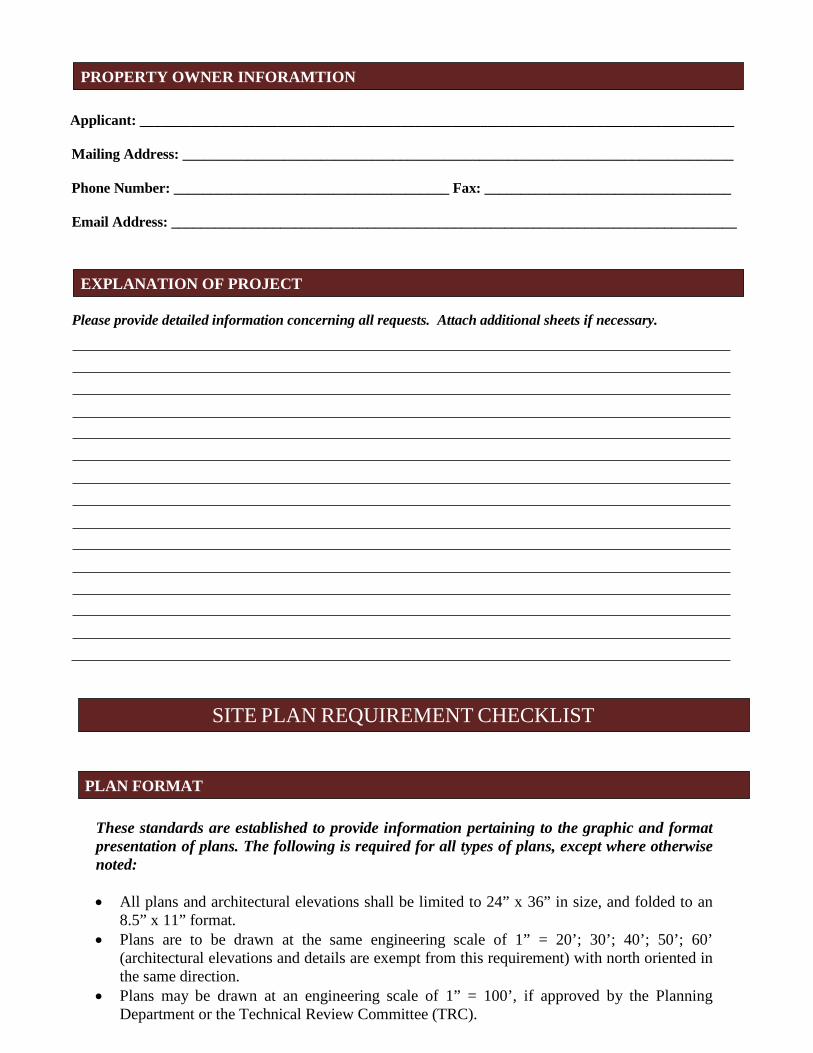
Applicant: __________________________________________________________________________________
Mailing Address: ____________________________________________________________________________
Phone Number: ______________________________________ Fax: __________________________________
Email Address: ______________________________________________________________________________
OFFICE USE ONLY
Date Received: Amount Paid: File Number:
SITE INFORMATION
APPLICANT INFORMATION
SITE PLAN APPLICATION
Applicant: __________________________________________________________________________________
Mailing Address: ____________________________________________________________________________
Phone Number: ______________________________________ Fax: __________________________________
Email Address: ______________________________________________________________________________
Please provide detailed information concerning all requests. Attach additional sheets if necessary.
These standards are established to provide information pertaining to the graphic and format presentation of plans. The following is required for all types of plans, except where otherwise noted:
• All plans and architectural elevations shall be limited to 24” x 36” in size, and folded to an8.5” x 11” format.
• Plans are to be drawn at the same engineering scale of 1” = 20’; 30’; 40’; 50’; 60’(architectural elevations and details are exempt from this requirement) with north oriented inthe same direction.
• Plans may be drawn at an engineering scale of 1” = 100’, if approved by the PlanningDepartment or the Technical Review Committee (TRC).
PROPERTY OWNER INFORAMTION
EXPLANATION OF PROJECT
SITE PLAN REQUIREMENT CHECKLIST
PLAN FORMAT

• Architectural plans and elevations shall be drawn at an architectural scale of 1” = 3/32’, 3/16’,1/8’, 1/4’, or 3/8’.
• All drawings, except elevations, isometric drawings, and renderings, shall be in twodimensional plan views.
• All text shall be clear and legible.• Line weight hierarchy on all plans shall be consistent with common drafting standards.• Multiple sheets shall be consecutively numbered (e.g. Sheet 1 of 4).• All numerical references shall be rounded up to a maximum of two decimal points.
The following items include general and project information. This information is required to be present on all plans, except where otherwise noted.
Provided Yes N/A
Consultant Logo Box (name, address, phone number, fax, email, firm and license number) Project/Application Name
Type of plan Signature and Professional Seal with date (landscape plans, engineering plans and surveys) Original/Submittal Date and Revision Date
Sheet Number
Vicinity Map
North Arrow with NC Grid System
Graphic Scale (engineering or architectural graphic and written scale)
Provided Yes N/A
A signed and sealed boundary survey (not more than a year old unless otherwise approved by the Planning Department) with the bearings and distances of every property line shown. Distances shall be in feet or meters and decimals thereof. The number of decimal places shall be appropriate to the class of survey required. The survey must include any and all easements of record (referenced by Deed Book and Page) and must be prepared by a surveyor registered in the State of North Carolina.
PLAN ELEMENTS AND GRAPHIC DATA
SURVEY

Provided Yes N/A
The existing topographical conditions of the property with a two foot contour interval. The existing streets and roadway improvements (medians, landscaping, signage, driveways, etc.) within 100 feet of project boundary. The existing structures located on the subject property.
The existing structures within 100 feet of project boundary. The existing utilities (including inverts of pipes, rim elevations, wells and septic tanks, etc.) within 100 feet of project site.
The items listed below are required to be delineated (in tabular format) on the site plan.
Provided Yes N/A
Site data table
Name of project (AKA names if applicable)
Parcel identification number (and/or Tag number)
Property size (acres and square feet)
Property location (Town limits or ETJ)
Existing zoning district
Proposed zoning district (if applicable)
Overlay (if applicable)
Existing use
Proposed use
Number of seats/students/fueling positions (as applicable).
Number of housing units proposed, per housing unit type.
Existing density (number of units per acre)
Proposed density (number of units per acre)
Existing intensity (gross floor area)
Proposed intensity (gross floor area)
Floor area ratio
Building coverage (as percentage of total site)
EXISTING CONDITIONS SHEET
SITE PLAN

Provided Yes N/A
Pervious surface area (square feet and as percentage of total site)
Impervious surface area (square feet and as percentage of total site)
Building height (number of stories and in feet)
Required parking (list requirement i.e. 1 space per 300 SF)
Proposed parking
Required/proposed handicap accessible parking
Required loading space(s)
Provide name of Electric Provider.
Provide name of Water Provider.
Provide name of Sewer Provider.
Other site plan elements: Provided Yes N/A
Identify adjacent property owners, their parcel ID number, current zoning and present use. Identify the affected area for amendments to previously approved projects. Identify the location of lots, buildings and structures with finished floor elevations and applicable setbacks. Identify existing right of ways.
Identify Watershed Protection Areas.
Identify existing (public and private) easements.
Identify proposed (public and private) easements.
Identify Open Space/Common Areas.
Identify and dimension clear sight triangle at project ingress/egress points.
Identify driveways, curb and gutter, cross section with ROW. Provide boundaries of Resource Conservation Areas (see UDC Section 155.500). Provide an off-street parking and loading layout (with details, dimensions and access location). Accessible parking requirements are listed in NCSBC Volume 1C, 1999 edition. Show traffic circulation arrows. Provide queuing details for drive-up/drive-thru facilities (if applicable).
Provide the locations and dimensions of existing and proposed sidewalks.
Provide the location and details of refuse collection areas.
Provide the location, size and orientation of freestanding signs.
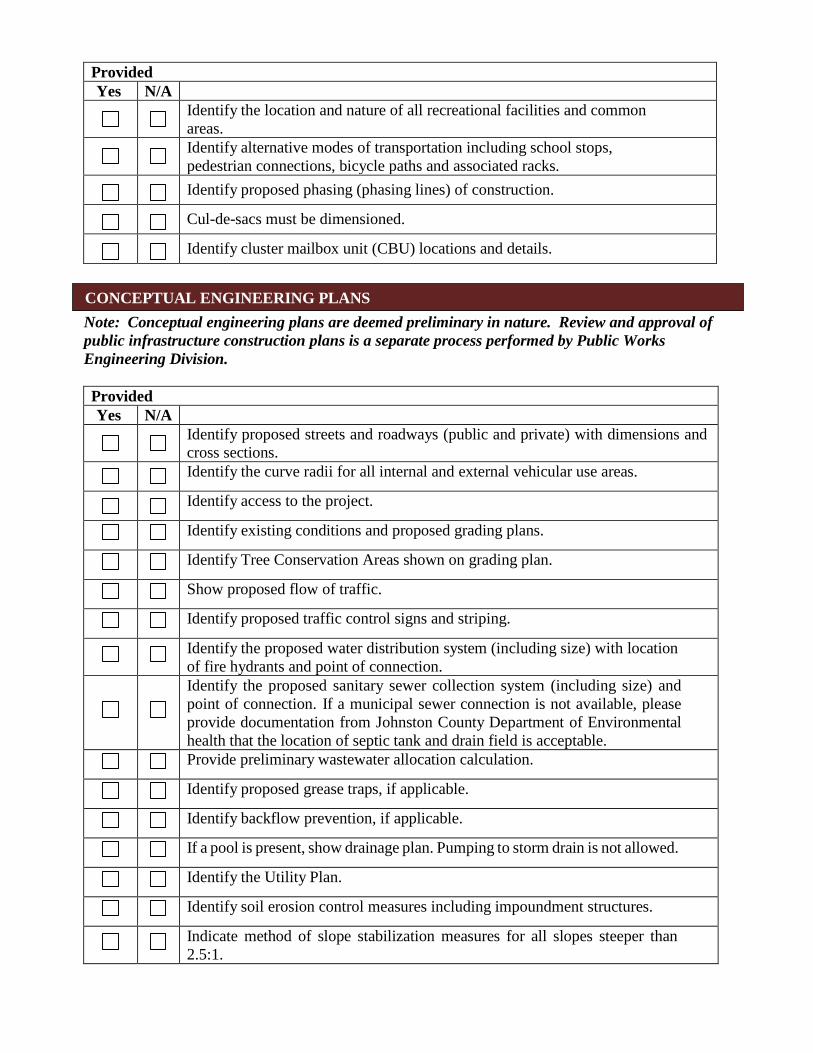
Provided Yes N/A
Identify the location and nature of all recreational facilities and common areas. Identify alternative modes of transportation including school stops, pedestrian connections, bicycle paths and associated racks. Identify proposed phasing (phasing lines) of construction.
Cul-de-sacs must be dimensioned.
Identify cluster mailbox unit (CBU) locations and details.
Note: Conceptual engineering plans are deemed preliminary in nature. Review and approval of public infrastructure construction plans is a separate process performed by Public Works Engineering Division.
Provided Yes N/A
Identify proposed streets and roadways (public and private) with dimensions and cross sections. Identify the curve radii for all internal and external vehicular use areas.
Identify access to the project.
Identify existing conditions and proposed grading plans.
Identify Tree Conservation Areas shown on grading plan.
Show proposed flow of traffic.
Identify proposed traffic control signs and striping.
Identify the proposed water distribution system (including size) with location of fire hydrants and point of connection. Identify the proposed sanitary sewer collection system (including size) and point of connection. If a municipal sewer connection is not available, please provide documentation from Johnston County Department of Environmental health that the location of septic tank and drain field is acceptable. Provide preliminary wastewater allocation calculation.
Identify proposed grease traps, if applicable.
Identify backflow prevention, if applicable.
If a pool is present, show drainage plan. Pumping to storm drain is not allowed.
Identify the Utility Plan.
Identify soil erosion control measures including impoundment structures.
Indicate method of slope stabilization measures for all slopes steeper than 2.5:1.
CONCEPTUAL ENGINEERING PLANS

Identify the proposed storm water management system with location of inlets, piping and positive outfall along with typical section and top surface area of storm water retention/detention pond, including soil types, slope, bottom and top elevations, and finish floor elevations.
Fire Rescue (information to be shown on conceptual engineering plans) Provided Yes N/A
Identify fire hydrant distribution (distance of hose lay).
Identify the sprinkler connection locations and size, if applicable. Identify fire lane designations and circulation around buildings (stripe fire lanes and show minimum stabilized access around all structures). Identify the emergency evacuation route (access in and out of the property).
Identify fire apparatus turning radius, including streets and cul-de-sacs. Verify the location of fire hydrants is not interfering with required landscaping (must be 24” clearance of landscaping from bottom of steam fitting). Identify the Lock Box/Knox Box locations.
Identify placard locations for hazardous materials.
Provided Yes N/A
Provide a landscape plan identifying the location of all proposed landscaping (must be prepared by a landscape architect registered in North Carolina). Indicate the location, width and type of all required buffers.
Indicate the location, width and type of landscaping within vehicular use areas. Indicate the location, width and type of landscaping used to screen drive-thru areas, service areas, loading areas, mechanical equipment and above ground utilities. Provide a plant list summary table which includes:
1. A planting key identifying the various planting elements2. The quantity of each type of plant material proposed3. The size, height, caliper and spacing of plant material proposed4. The Botanical and common names of plant material proposed
Verify/identify clear sight distances at project ingress/egress points. Provide an irrigation note to read as follows: “All landscaped areas shall be provided with an automatically operated irrigation system that will adequately cover all living plant material, such system shall include a rain sensor.” (If irrigation will not be utilized, drought-tolerant species must be used).
LANDSCAPE PLAN
Provided Yes N/A
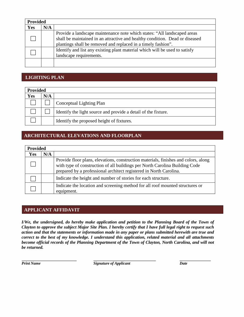
Provide a landscape maintenance note which states: “All landscaped areas shall be maintained in an attractive and healthy condition. Dead or diseased plantings shall be removed and replaced in a timely fashion”. Identify and list any existing plant material which will be used to satisfy landscape requirements.
Provided Yes N/A
Conceptual Lighting Plan
Identify the light source and provide a detail of the fixture.
Identify the proposed height of fixtures.
Provided Yes N/A
Provide floor plans, elevations, construction materials, finishes and colors, along with type of construction of all buildings per North Carolina Building Code prepared by a professional architect registered in North Carolina. Indicate the height and number of stories for each structure. Indicate the location and screening method for all roof mounted structures or equipment.
I/We, the undersigned, do hereby make application and petition to the Planning Board of the Town of Clayton to approve the subject Major Site Plan. I hereby certify that I have full legal right to request such action and that the statements or information made in any paper or plans submitted herewith are true and correct to the best of my knowledge. I understand this application, related material and all attachments become official records of the Planning Department of the Town of Clayton, North Carolina, and will not be returned.
Print Name Signature of Applicant Date
LIGHTING PLAN
ARCHITECTURAL ELEVATIONS AND FLOORPLAN
APPLICANT AFFIDAVIT
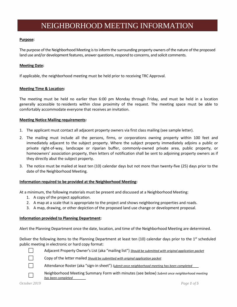
Purpose:
The purpose of the Neighborhood Meeting is to inform the surrounding property owners of the nature of the proposed land use and/or development features, answer questions, respond to concerns, and solicit comments.
Meeting Date:
If applicable, the neighborhood meeting must be held prior to receiving TRC Approval.
Meeting Time & Location:
The meeting must be held no earlier than 6:00 pm Monday through Friday, and must be held in a location generally accessible to residents within close proximity of the request. The meeting space must be able to comfortably accommodate everyone that receives an invitation.
Meeting Notice Mailing requirements:
1. The applicant must contact all adjacent property owners via first class mailing (see sample letter).
2. The mailing must include all the persons, firms, or corporations owning property within 100 feet andimmediately adjacent to the subject property. Where the subject property immediately adjoins a public orprivate right-of-way, landscape or riparian buffer, commonly-owned private area, public property, orhomeowners’ association property, then letters of notification shall be sent to adjoining property owners as ifthey directly abut the subject property.
3. The notice must be mailed at least ten (10) calendar days but not more than twenty-five (25) days prior to thedate of the Neighborhood Meeting.
Information required to be provided at the Neighborhood Meeting:
At a minimum, the following materials must be present and discussed at a Neighborhood Meeting: 1. A copy of the project application.2. A map at a scale that is appropriate to the project and shows neighboring properties and roads.3. A map, drawing, or other depiction of the proposed land use change or development proposal.
Information provided to Planning Department:
Alert the Planning Department once the date, location, and time of the Neighborhood Meeting are determined.
Deliver the following items to the Planning Department at least ten (10) calendar days prior to the 1st scheduled public meeting in electronic or hard copy format:
Adjacent Property Owner’s List (aka “mailing list”) Should be submitted with original application packet
Copy of the letter mailed Should be submitted with original application packet
Attendance Roster (aka “sign-in sheet”) Submit once neighborhood meeting has been completed
Neighborhood Meeting Summary Form with minutes (see below) Submit once neighborhood meeting has been completed
October 2019 Page 1 of 5
NEIGHBORHOOD MEETING INFORMATION

Project Name:
The following are all the persons, firms, or corporations owning property within 100 feet and immediately adjacent to the property (including across street rights of way) subject to this request. Where the subject property immediately adjoins a public or private right-of-way, landscape or riparian buffer, commonly-owned private area, public property, or homeowners’ association property, then letters of notification shall be sent to adjoining property owners as if they directly abut the subject property. Please use a separate sheet if necessary
It is the responsibility of the applicant to correctly identify the current owner, based upon records in the Johnston County GIS Office, for all property owners of land within the required public notice radius.
PARCEL NUMBER NAME ADDRESS
October 2019 Page 2 of 5
ADJACENT PROPERTY OWNERS LIST

<Date>
Dear Clayton Area Property Owner:
The purpose of this letter is to notify you of an application filed with the Town of Clayton for a land use change or development proposal involving property adjacent to, or in close proximity to, property shown in your ownership by Johnston County tax records. Per Town of Clayton regulations, a Neighborhood Meeting will be held to provide information to area residents about the proposal. A representative of the applicant will be present to explain their application, answer questions, and solicit comments.
Meeting Date: Meeting Time:
Meeting Location:
Type of Application:
Project/proposal property address:
Description of project/proposal:
At a minimum, the following will be available for your inspection at the Neighborhood Meeting: 1. A copy of the project application.2. A map at a scale that is appropriate to the project and shows neighboring properties and roads.3. A map, drawing, or other depiction of the proposed land use change or development proposal.
A map is enclosed with this letter showing the location of the property that is subject to this application for land use change and/or development proposal.
If you have any questions prior to or after this meeting, you may contact us at <Insert phone number of applicant>. You may also contact the Town of Clayton Planning Department at 919-553-5002.
Sincerely,
<Applicant>
Cc: Town of Clayton Planning Department October 2019 Page 3 of 5
SAMPLE NEIGHBORHOOD MEETING LETTER (PLACE ON AGENT’S OR OWNER’S LETTERHEAD)
Project:
Application:
Location/Date:
NAME ADDRESS 1
2
3
4
5
6
7
8
9
10
11
12
13
14
15
16
17
18
19
20
October 2019 Page 4 of 5
NEIGHBORHOOD MEETING ATTENDANCE ROSTER

FILL OUT THE FOLLOWING:
Application:
Date of Mailing:
Date of Meeting: Time of Meeting:
Location of Meeting:
I hereby attest that letters were mailed to the addresses listed on the Adjacent Property Owners List (attached) ten days prior to the Neighborhood Meeting, and that all required information was presented at the Meeting:
Printed Name: Signature:
Meeting Summary/Minutes: provide a summary of the discussion held at the meeting, including issues raised and any resolution discussed, and any changes made to the application as a result of the meeting.
Please write clearly (or submit a typed summary). Use additional sheets if necessary.
October 2019 Page 5 of 5
NEIGHBORHOOD MEETING SUMMARY FORM