skamania county planning commission€¦ · · 2018-03-27170 nw vancouver avenue, stevenson, wa...
TRANSCRIPT
SKAMANIA COUNTY PLANNING COMMISSION
SKAMANIA COUNTY COMMUNITY DEVELOPMENT DEPARTMENT PO BOX 790 ▪ 170 NW VANCOUVER AVENUE, STEVENSON, WA 98648
PHONE: (509) 427-3900 FAX: (866) 266-1534 EMAIL: [email protected]
AGENDA
Tuesday, April 3, 2018 @ 6:00 PM SKAMANIA COUNTY COURTHOUSE ANNEX, LOWER MEETING ROOM
170 NW VANCOUVER AVENUE, STEVENSON, WA 98648 I. CALL TO ORDER
II. ROLL CALL
III. AGENDA ITEMS
1. Approval of minutes from the March 20, 2018, Planning Commission Meeting.
2. PUBLIC HEARING, CONSIDERATION, AND RECOMMENDATION on proposed amendments to the Swift Comprehensive Subarea Plan and Swift Subarea Zoning Map.
IV. PLANNING COMMISSION BUSINESS
V. ADJOURN

Skamania County Planning Commission
PLANNING COMMISSION MEETING MINUTES
Tuesday, March 20, 2018 Hegewald Center
710 SW Rock Creek Drive, West Meeting Room Stevenson, WA 98648
Planning Commission Members: Present: Lesley Haskell, John Prescott, Cyndi Soliz, Dee Bajema
Community Development Department Staff Present: Alan Peters, Andrew Lembrick Teri Wyckoff
Absent: Paul Hendricks, Tony Coates, Cliff Nutting
AUDIENCE See attached sign-in sheet. PROCEEDINGS Meeting was called to order at 6:00 P.M. by Chair, Lesley Haskell. Quorum was met. AGENDA ITEMS 1. Approve Minutes from the March 6, 2018 meeting.
a. Motion was made by John Prescott and seconded by Cyndi Soliz to approve the Minutes of the March 6, 2018. Motion passed 4-0.
2. Public Workshop on review of zoning in the Stabler/Wind River area. The Planning
Commission is reviewing the possibility of rezoning privately owned parcels within the Unmapped (UNM) zone. Alan Peters, Assistant Planning Director, presented information outlining property owners and the current zoning of parcels of lands that could possibly be affected by the proposed change and presented an initial draft zoning-initial staff recommendation.

3. Discussion by the Commission Members included:
a. Input from the public was both verbal and written communication. b. Process and criteria for the review process
4. Public comments were received from property owners:
a. Joe Birkenfeld b. Bradley Christie c. Patrick Pinson d. Michelle Adams e. Angie Hollis f. Tom Linde g. Michael & Tori Haeder
5. Written comments were received from:
a. Ann Lueders b. Joe Birkenfeld c. Columbia Land Trust
6. Comments were received regarding the purpose of the review, confusing information mailed
to affected property owners, how this would affect the Wind River Business Park, and the
need for better outreach. The Planning Commission discussed the need to solicit additional
public input and host a second workshop. Staff agreed to mail a notice to the property
owners and interested parties about a follow-up meeting with additional information
abouthe the Comprehensive Plan and an invitation to provide written comment prior to the
next workshop. The workshop was tentatively scheduled for Tuesday, April 17, 2018.
7. MEETING ADJOURNED
Meeting adjourned at 7:40 PM ATTEST
Planning Commission Chair Secretary

1
STAFF REPORT
TO: Skamania County Planning Commission FROM: Alan Peters, Assistant Planning Director REPORT DATE: March 27, 2018 HEARING DATE: April 3, 2018 PROPOSAL: County-initiated text and map amendments to land use designations in
the Swift Comprehensive Subarea Plan and map amendments to the Swift Subarea zoning map.
This Staff Report addresses the following two proposals: 1. Proposed, County-initiated legislative text and map amendments to land use designations in the Swift Reservoir Comprehensive Subarea Plan The County proposes text and map amendments to the Swift Subarea Plan (Subarea Plan) in order to streamline zoning changes to facilitate and focus growth in areas that have been planned to accommodate development. The proposed Subarea Plan amendments include map and text amendments that would consolidate the land use sub-designations of Mountain Recreational 5 (MR5), Mountain Recreational 10 (MR10), and Mountain Recreational 20 (MR20) into one land use designation of “Mountain Recreational (MR).” This change affects all lands with a Mountain Recreational designation in the Subarea Plan, however it does not affect any zoning, but is instead intended to simplify the Subarea Plan. Minor text amendments are proposed to consolidate the list of uses permitted in the MR designations. Detailed information on the proposed text and map amendments are provided in the following sections: General Information and History/Background. 2. Proposed, County-initiated legislative zoning changes The proposed zoning map amendments would rezone two areas in the Swift Subarea. Approximately 152 acres located at the west end of the Swift Reservoir and east of Glacier View Drive are proposed to be rezoned from MR20 to MR5. Approximately 380 acres located at the east end of the Swift Reservoir near Pine Creek and USFS 25 are proposed to be rezoned from MR10 to MR5. No other areas are proposed for rezoning. As discussed below, the proposed rezoning is consistent with the applicable County Comprehensive Plan, Swift Subarea Plan, and Skamania County Code (Title 21, Zoning).
Skamania County Community Development Department Building/Fire Marshal Environmental Health Planning
Skamania County Courthouse Annex
Post Office Box 1009
Stevenson, Washington 98648
Phone: 509-427-3900 Inspection Line: 509-427-3922

2
Detailed information on the proposed legislative zoning changes is provided in the following sections: General Information and History/Background. I. GENERAL INFORMATION 1. Proposed Subarea Plan land use designation text and map amendments: The proposed revised Subarea Plan text is provided in Attachment A. The proposed text changes will revise the following sections of the Subarea Plan: Chapter 2: Land Use Element
• The description of the land use designations MR5, MR10, and MR20 will be consolidated into one land use designation, Mountain Recreational (MR).
The proposed map amendment showing MR consolidation is provided in Attachment B. The proposed map changes will revise the following figure in the Subarea Plan: Figure 2-1: Swift Subarea Plan Land Use Designation map
• MR5, MR10, and MR20 will be designated and illustrated as “Mountain Recreational (MR).”
2. Proposed legislative zone changes: The details of the proposed legislative zone changes are listed below. A list of the parcels proposed for zoning changes and a map of the proposed zoning changes is provided in Attachment C. II. HISTORY/BACKGROUND: 1. Proposed, County-initiated legislative text and map amendments to the Swift Subarea Plan. The existing Subarea Plan land use designations (text and map) establish a Mountain Recreational land use designation with three distinct sub-designations: Mountain Recreational 5, 10, and 20 (MR5, MR10, MR20). These designations each correspond with a zoning designation of the same type. Policy LU.4.1 of the Skamania County Comprehensive Plan states: Land use permitting processes should be simplified and streamlined to the maximum extent possible. To simplify and streamline the process for zone changes in the Mountain Recreational designations, the County seeks to consolidate all Mountain Recreational land use designations (MR5, MR10, MR20) into a single land use designation (MR). If approved, the single comprehensive plan designation would allow property owners to apply for a zone change from one Mountain Recreational zone to another without the additional burden of a Comprehensive Plan amendment. To create one MR designation, individual lists of “Appropriate Uses” for MR5, MR10, and MR20 are proposed to be combined into one list in the text of the Subarea Plan. The consolidation of this list in the Subarea Plan will not change the zoning regulations for MR5, MR10, and MR20. If the proposed text amendment is approved, the County will update the Land Use Designation map for the Subarea Plan to reflect the consolidation of the land use designations.

3
According to RCW 36.70.440, the Board of County Commissioners (Board) has specific authority to amend the County’s Comprehensive Plan after the receipt of the Planning Commission’s recommendation. The Subarea Plan is an element of the County’s Comprehensive Plan that supplements the Plan with more specific policies and therefore must be amended using the same process. RCW 36.70.410 gives the Planning Commission the authority to consider changes to the Comprehensive Plan through demonstration of a change in conditions. 2. Proposed, County-initiated legislative zoning changes After hearing public comment from landowners requesting that the County change the land use designation and zoning of their properties, the Board of County Commissioners at its March 15, 2016, meeting, directed the Planning Division to prepare the proposed map and text amendments. As Swift Reservoir experiences residential growth, there is a need to maintain the rural and natural character of the community. Doing so will require that growth be appropriately directed to areas already partially developed, as opposed to areas with larger lot sizes or forest lands where it would be less compatible. The proposed zoning map amendments would rezone two areas in the Swift Subarea. Approximately 152 acres located at the west end of the Swift Reservoir and east of Glacier View Drive are proposed to be rezoned from MR20 to MR5.
Figure 1. Proposed MR-20 to MR-5 rezoning.
4
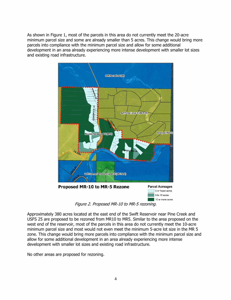
As shown in Figure 1, most of the parcels in this area do not currently meet the 20-acre minimum parcel size and some are already smaller than 5 acres. This change would bring more parcels into compliance with the minimum parcel size and allow for some additional development in an area already experiencing more intense development with smaller lot sizes and existing road infrastructure.
Figure 2. Proposed MR-10 to MR-5 rezoning.
Approximately 380 acres located at the east end of the Swift Reservoir near Pine Creek and USFS 25 are proposed to be rezoned from MR10 to MR5. Similar to the area proposed on the west end of the reservoir, most of the parcels in this area do not currently meet the 10-acre minimum parcel size and most would not even meet the minimum 5-acre lot size in the MR 5 zone. This change would bring more parcels into compliance with the minimum parcel size and allow for some additional development in an area already experiencing more intense development with smaller lot sizes and existing road infrastructure. No other areas are proposed for rezoning.

5
The authority and process for legislative zoning map amendments, initiated by the County, are outlined at both the state and county levels (Skamania County Code [SCC] 21.18 and the Revised Code of Washington [RCW]), and compliance with these provisions is addressed in below. Because the proposed zone change would be within the same land use designation (Mountain Recreational) if the proposed Subarea Plan text amendments are approved, there would be no amendment to either the County or Subarea comprehensive plans because of the proposed zoning amendment. That is, the lands will already be designated MR, and only a zoning map change would be needed. Therefore, the proposed legislative rezone for the Swift Subarea is deemed compliant with these plans, and is not discussed in sections that address compliance with policies from the comprehensive plans. III. SEPA THRESHOLD DETERMINATION: A Determination of Non-significance (DNS) was published on January 17, 2018. The DNS was published in the Skamania County Pioneer, the County’s website, and sent to interested parties and owners of properties within any current Mountain Recreational designation. Several comments were received in response to the DNS within the 14-day comment period: Jan 22, 2018: Mike and Brenda Hayden commented on road access being limited to the public. Jan 23, 2018: Bonnie Bielas commented “Swift subarea should not be allowed to pass. I say no.” Jan 29, 2018: Richard Lonergan commented on the vision statement for the Swift Subarea comprehensive plan, the environmental impacts of the rezone, specifically stormwater, septic, traffic, air pollution, and negative aesthetics. Jan 30, 2018: Tom Sawtell commented on the impacts to surface water quality, ground water quality, in-stream water quality, aquatic habitat, fish habitat, and fish migration within the involved watersheds. Jan 31, 2018: Zach and Emily McCarty commented on combining the zoning designation having an effect of eliminating minimum lot sizes in Mountain Recreational. After consideration of these comments, the DNS was rescinded on February 14, 2018, and a Mitigated DNS (Attachment D) was noticed that same day. The Mitigated DNS included 41 mitigations to add additional protections to Pine Creek, the Lewis and Muddy Rivers, wildlife species including Elk, Bald Eagle and Bull Trout. The following comments were received in response to the Mitigated DNS within the 14-day comment period: February 27, 2018: Richard Lonergan commented on the reduction in lot sizes, the vision of the Swift Subarea and the effect on the environment that a reduction in lot sizes would produce. February 28, 2018: Bill Baumen commented on decreasing lot sizes influencing existing infrastructure.

6
February 28, 2018: Jerry Sauer commented on the MDNS, disagreeing with the additional conditions being considered as part of the zoning revisions. The Mitigated DNS is retained with the 41 mitigations. IV. PUBLIC HEARING NOTICE: The Community Development Department published a Notice of the Public Hearing on March 21, 2018, in the Skamania County Pioneer, the County’s official paper of record. Interested parties and owners of properties within any current Mountain Recreational designation were also notified of the Public Hearing by notice sent on March 22, 2018, and published on the County’s website that same day. As of the date of this report, one comment has been received in response to this notice: February 16, 2018: Frank Yela, Skamania County Fire District 6 Chief (Attachment E) (While this letter was received prior to the public hearing notice, it was addressed to the Planning Commission. Marlon Morat, Fire Marshal, provided a memo to the Planning Department stating that “the Swift subarea rezone as proposed would not trigger or our Fire Protection ordinance (hydrants). Of course all development must meet Ska Co Ord. 2008-02 which is our private road standards.” V. CRITERIA FOR APPROVAL: COMPLIANCE WITH STATE STATUTES FOR COMPREHENSIVE PLAN AMENDMENTS [RCW]
RCW 36.70.380 Comprehensive Plan – Public hearing required Notice of the time, place and purpose of any public hearing shall be given by one publication in a newspaper of general circulation in the county and in the official gazette, if any, of the county, at least ten days before the hearing. RCW 36.70.390 Comprehensive Plan – Notice of Hearing Notice of the time, place and purpose of any public hearing shall be given by one publication in a newspaper of general circulation in the county and in the official gazette, if any, of the county, at least ten days before the hearing.
Findings: The Community Development Department published a Notice of the Public Hearing on March 21, 2018, in the Skamania County Pioneer, the County’s official paper of record. Interested parties and owners of properties within any current Mountain Recreational designation were also notified of the Public Hearing by notice sent on March 22, 2018, and published on the County’s website that same day. This was over ten days before the Planning Commission public hearing. The public notice and hearing addressed both the proposed text and map changes to the Swift Subarea Plan, as well as the proposed zoning change.
RCW 36.70.400 Comprehensive Plan – Approval- Required vote – Record The approval of the comprehensive plan, or of any amendment, extension or addition thereto, shall be by the affirmative vote of not less than a majority of the total members

7
of the commission. Such approval shall be by a recorded motion which shall incorporate the findings of fact of the commission and the reasons for its action and the motion shall refer expressly to the maps, descriptive, and other matters intended by the commission to constitute the plan or amendment, addition or extension thereto. The indication of approval by the commission shall be recorded on the map and descriptive matter by the signatures of the chair and the secretary of the commission and of such others as the commission in its rules may designate.
Findings: If approved by a majority of the Planning Commission, the proposed text and map changes to the Swift Subarea Plan shall be handled in accordance with all above-stated provisions of RCW 36.70.400.
RCW 36.70.410 Comprehensive Plan – Amendment When changed conditions or further studies by the planning agency indicate a need, the commission may amend, extend or add to all or part of the comprehensive plan in the manner provided herein for approval in the first instance. RCW 36.70.420 Comprehensive Plan – Referral to board A copy of a comprehensive plan or any part, amendment, extension of or addition thereto, together with the motion of the planning agency approving the same, shall be transmitted to the board for the purpose of being approved by motion and certified as provided in this chapter.
Findings: Per the Planning Division, the Planning Commission can streamline the zoning process for owners in the subarea by consolidating land use designations. The above statutes are met as documented by the need to amend the plan for streamlining. The Planning Commission will consider the proposed changes and make a recommendation to the Board in accordance with the above-stated provisions of RCW 36.70.420.
RCW 36.70.430 Comprehensive Plan – Board may initiate or change – Notice When it deems it to be for the public interest, or when it considers a change in the recommendations of the planning agency to be necessary, the board may initiate consideration of a comprehensive plan, or any element or part thereof, or any change in or addition to such plan or recommendation. The board shall first refer the proposed plan, change or addition to the planning agency for a report and recommendation. Before making a report and recommendation, the commission shall hold at least one public hearing on the proposed plan, change or addition. Notice of the time and place and purpose of the hearing shall be given by one publication in a newspaper of general circulation in the county and in the official gazette, if any, of the county, at least ten days before the hearing. RCW 36.70.440 Comprehensive Plan – Board may approve or change –Notice After the receipt of the report and recommendations of the planning agency on the matters referred to in RCW 36.70.430, or after the lapse of the prescribed time for the rendering of such report and recommendation by the commission, the board may approve by motion and certify such plan, change or addition without further reference to the commission: PROVIDED, That the plan, change or addition conforms either to the

8
proposal as initiated by the county or the recommendation thereon by the commission: PROVIDED FURTHER, That if the planning agency has failed to report within a ninety day period, the board shall hold at least one public hearing on the proposed plan, change or addition. Notice of the time, place and purpose of the hearing shall be given by one publication in a newspaper of general circulation in the county and in the official gazette, if any, of the county, at least ten days before the hearing. Thereafter, the board may proceed to approve by motion and certify the proposed comprehensive plan or any part, amendment or addition thereto.
Findings: At the Board meeting on March 15, 2016, the Board discussed the proposed comprehensive plan amendments contained in this staff report and deemed the consolidation of the three MR subarea map designations (MR5, MR10, and MR20) to be in the public interest. The Board directed staff to move forward with the legislative process for addressing the amendments. Additionally, the Board reviewed the proposal at a July 15, 2017, workshop with the Planning Department. In compliance with RCW 36.70.430, the Board referred the proposed changes to the planning agency (Community Development Department, Planning Division) for a report and recommendation (contained herein). The Planning Division has provided its report to the Planning Commission for consideration in a public hearing. The Planning Commission provided notice of a public hearing to the proposed text and map amendments to the Swift Subarea Plan. Therefore, this statute is met. Subsequent to its public hearing, the Planning Commission will be required to transmit a report of its findings and recommendations on the Subarea Plan text and map amendments to the Board. Therefore, the above statutes are met. VII. CRITERIA FOR APPROVAL: SKAMANIA COUNTY ZONING CODE The following sections of the Skamania County Zoning Code (Title 21 of the County Code) are applicable to the proposed legislative zoning changes.
21.18.030 County initiated map amendments. County initiated map amendments are amendments to the official zoning map that are not proposed for specific parcels by the landowners of the parcels. Rather, the amendments are generally countywide in nature. These legislative actions usually occur when a new zone classification is created, when the board of county commissioners has adopted an amendment to the land use maps in the comprehensive plan, or when it is determined that the existing zone classification is out of character with the surrounding area. Such action shall occur in accordance with the procedures set forth in RCW 36.70. County initiated map amendments may only be initiated by the board of county commissioners or the planning commission. (Ord. 2005-02 (part))
Findings: The County-proposed zoning map amendments were initiated by the Board at its March 15, 2016 meeting. The proposed rezone will change 380 acres from MR10 to MR5, with the lots located along Lodgepole Lane and Pine Creek, in an area of Swift Reservoir that is currently developing into single-family housing. Approximately half of the parcels in this area are already

9
less than 5 acres, with many of these developed as single-family homes. The existing zone classification (MR10), which requires minimum lots sizes of 10 acres or more, is uncharacteristic with the existing parcels that are less than 5 acres. In addition, lots within the proposed area to be rezoned that are larger than 5 acres are better-suited for future growth and land divisions than other areas of the community because they are located adjacent to lots 5 acres or less in size and are in close proximity to U.S. Forest Service (USFS) roads 25 and 90. Approximately 152 acres located at the west end of the Swift Reservoir and east of Glacier View Drive are proposed to be rezoned from MR20 to MR5. Most of the parcels in this area do not currently meet the 20-acre minimum parcel size and some are already smaller than 5 acres. This change would bring more parcels into compliance with the minimum parcel size and allow for some additional development in an area already experiencing more intense development with smaller lot sizes and existing road infrastructure. VIII. CRITERIA FOR APPROVAL: COMPLIANCE WITH SKAMANIA COUNTY COMPREHENSIVE PLAN The following Goals and Policies of the 2007 Skamania County Comprehensive Plan are applicable to the proposed text and map amendments to the Swift Subarea Plan.
Legislative Amendments to this Comprehensive Plan (reassessment or update): Comprehensive Plans and subarea plans are not written for all time. They are living documents designed to be at once rigid enough to hold a chosen course over an extended period of new growth and development, yet flexible enough to accommodate a wide variety of anticipated and unforeseen conditions. A fundamentally good plan can do this for a relatively short period of time (20 years), during which monitoring, data gathering and analysis for the purposes of “fine tuning” and improving the plan by amendment should be an ongoing process. At the end of this period Skamania County should conduct a major reassessment of the plan. Typically, at least every seven years the county is required to review the Critical Areas portion of the Comprehensive Plan to determine the need for a legislative update.
Findings: The Subarea Plan map and text were adopted in 2007. Comprehensive plans and subarea plans are living documents, improved by amendments made over time to address changing conditions. The proposed text and map changes to the land use designations of the Subarea Plan would consolidate the various MR plan designations into a single category making rezone requests without Subarea Plan amendments possible, thereby streamlining the rezone process and helping to facilitate growth in the community. Individual applicants for rezones will continue to need to demonstrate compliance with the County’s Comprehensive Plan per the requirements of SCC 21.18.070. Therefore, such rezones would continue to be compliant with the Comprehensive Plan.
Goal LU.1: To integrate long-range considerations (comprehensive planning) into the determinations of short-term action (individual development applications). Policy LU.1.3: The comprehensive planning policies set out herein and all land use

10
designations and land use regulations undertaken pursuant hereto should provide clear and objective standards to govern future development. These policies, designations and regulations should not be varied or amended without proof of a substantial change in circumstances.
Findings: The Subarea Plan is an element of the County Comprehensive Plan. It has been 11 years since the Subarea Plan’s adoption in 2007. Since that time the County has received requests to amend the both the land use designations and zoning within the Swift Subarea. The County’s desire to streamline this process furthers Policy LU.4.1 of the Skamania County Comprehensive Plan, which stipulates that “Land use permitting processes should be simplified and streamlined to the maximum extent possible.” The text amendments do introduce new policies that identify under what circumstances zone changes within the MR designation would be appropriate. Therefore, this criterion is met.
Goal LU.2: To provide for orderly future physical development of Skamania County. Policy LU.2.2: All land in unincorporated Skamania County shall be classified with a land use designation as shown on the 2007 Comprehensive Plan Land Use Map (Figure 2-2), or the specific Subarea Plan map designations (Columbia River Gorge National Scenic Area Subarea, Carson Subarea, Westend Subarea, or Swift Subarea [pending adoption]). Any unincorporated area within Skamania County that was not designated with a 1977 designation of Rural I or Rural II; or with a specific adopted Subarea Plan designation is designated as Conservancy, except the Wind River Nursery site is designated as Rural I.
Findings: The consolidation of the MR land use designations will promote orderly development of the county by continuing to direct growth in the Swift Reservoir area to lands already designated under one of the existing MR designations. The consolidation of map categories is a change in designation only. Future rezone requests would continue to need to be compliant with the Subarea Plan and the proposes new policies regarding zone changes within the MR designation would be appropriate. As previously discussed, the proposed text updates to consolidate the land use designations for Swift Reservoir will be reflected in an updated land use designation map for the subarea. If recommended for approval by the Planning Commission and adopted by the Board, the land will be classified with a land use designation as shown on the subarea map. Therefore, the above goal and policy are met.
Policy LU.2.5: Land use patterns should follow along roads, rivers, township lines, range lines, section lines or quarter section lines rather than individual parcel lines to provide for uniform regular boundaries between land use designations.
Findings: The proposed text amendments for the MR designations are consolidations of existing land use designations and will not alter existing land use patterns. Residential growth will continue to be directed to the areas already designated under one of the three existing MR designations (MR5, MR10, and MR20), but would occur under a new consolidated designation. This policy is

11
inapplicable because proposed text amendments to the Subarea Plan will not alter existing MR land use patterns as currently shown on the subarea maps.
Goal LU.4: To promote interagency cooperation and effective planning and scheduling of improvements and activities so as to avoid conflicts, duplication and waste. Policy LU.4.1: Land use permitting processes should be simplified and streamlined to the maximum extent possible.
Findings: Consolidation of land use designations will streamline the process for applicants seeking zoning amendments within Mountain Recreational zones, because they will no longer need to seek compatible comprehensive plan amendments. Therefore, the proposed text amendments to the Subarea Plan further the above goal and policy. The text amendments do introduce new policies that identify under what circumstances zone changes within the MR designation would be appropriate.
Policy LU.4.3: Land use patterns, which minimize the cost of providing adequate levels of public services and infrastructure, should be encouraged.
Findings: The proposed text amendments are compliant with the above policy for the Swift Subarea because they will not change the existing land use pattern. The existing land uses of MR5, MR10, and MR20 will be consolidated into a single MR designation implemented by zoning for the MR5, MR10, and MR 20. The total land area designated collectively as MR is not proposed to change. In addition, growth and smaller lot sizes will continue to be focused near the Reservoir with larger lot sizes and forest and resource lands located further away from the Reservoir in the northern part of the Subarea. Consolidation of the MR sub-designations will not allow for increased development and related public services and infrastructure (roads, utilities, services) beyond the demands of current zoning. Residential growth will continue to be directed toward areas already designated under one of the three MR land use categories, but would occur under the newly proposed, consolidated MR designation. Public services in the Swift Reservoir area are minimal. There are no County roads in the area, and consolidating development along existing USFS roads will reduce the need for additional roads. Because residential growth would continue to be directed toward these same Mountain Recreational areas for which it is already planned, public service costs associated with growth will be minimized as compared to the potential conversion of large lot areas or forest lands to higher density development. Therefore, this requirement is met.
Goal LU.5: To promote improvements which make our communities more livable, healthy, safe and efficient. Policy LU.5.9: The Board of County Commissioners, as legislative authority, shall consult this Plan on any matters concerning physical development of the County, and in dealing with matters coming before it with regard to this Plan.
Findings: The Subarea Plan text amendments and associated map changes, if adopted, will continue to direct new residential growth to areas already planned to accommodate it and away from forest

12
lands, thereby preserving the rural and natural character of the area. Focusing growth away from forest and resource lands will promote development and improvements that make the Swift Subarea more livable, healthy, safe, and efficient by:
• Preserving forest and resource lands for long-term use for the forest products industry, as open space, and as critical areas thereby making the Swift Subarea more liveable. Focused growth would also concentrate the negative impacts of growth (pollution from stormwater runoff, traffic, and new septic systems and resource demands from new wells) where they can be more easily addressed by increases in existing public system capacities (e.g., road expansions) or provision of new public/community systems, rather than dispersing these impacts across the landscape. Thus, the map changes would make it more possible to address public health and safety concerns associated with negative land growth impacts.
• Making more efficient use of existing public infrastructure such as area roads by focusing growth.
The Swift Subarea Plan, an element of the County’s Comprehensive Plan, seeks to focus new growth near to Swift Reservoir. The proposed text changes and associated map amendments would continue to focus growth near the reservoir and preserve forest and resource lands in the northern part of the Subarea. Because the text and map changes are compliant with the Subarea and Comprehensive Plan, the Board and Planning Commission will have adequately consulted the Comprehensive Plan if they choose to approve them. Therefore, this goal and policy area met.
Goal LU.6: To provide opportunities for citizen participation in the government decision process and in planning activities regarding land development.
Findings: Proposed text amendments have been duly advertised to notify the public, and a public hearing has been scheduled. Therefore, this goal has been met. IX. CRITERIA FOR APPROVAL: COMPLIANCE WITH SWIFT SUBAREA PLAN The following Goals and Policies of the Swift Subarea Plan are applicable to the proposed Subarea Plan text and map amendments (consolidation of Mountain Recreational sub-designations [MR]). The goals and policies are not considered applicable to the Proposed Swift Reservoir Rezone as that amendment does not propose any changes to land use designations.
Goal LU.1: The peace, solitude and natural beauty of the Swift Subarea should be maintained into the future. The sense of community should be preserved and fostered into the future. Any development allowed should be well-planned and well-placed within the landscape to allow people to enjoy what the area has to offer but not overwhelm its defining characteristics. Some additional development is tolerable to most people, as long as it meets the above criteria. Urban and suburban development is not desired.
Findings: White the proposed text amendments consolidate the existing MR sub-designations (MR5, MR10, MR20), they leave the stated intent and purpose of the MR designation intact and

13
identical. The stated intent of the existing three MR zones, which will remain the same after the proposed Subarea Plan text amendments, is: The mountain recreational…zone classification is intended to provide areas of recreational uses at very low density to preserve the primitive recreational character of the area and to provide opportunities for limited small-scale commercial uses related to recreational activities. Therefore, combining the designations will maintain the intent of the MR designation, which will allow the Swift Subarea to continue its current, desired land use pattern. Growth will continue to be directed toward these same MR areas for which it is already planned. Focused growth near Swift Reservoir will help foster a sense of community in the southern part of the subarea while helping to preserve the peace, solitude and natural beauty of the northern part of the community. Area residents and visitors will continue to be able to enjoy recreational activities on Swift Reservoir such as boating, camping, and fishing, as well as the recreational activities typical of the northern part of the subarea such as hiking. Recreational opportunities will be preserved with the proposed text and associated map amendments, meeting the central intent of the Subarea Plan. Therefore, this goal is promoted by the proposed text and map amendments.
Policy LU.1.1.b: Techniques suggested to maintain the area’s look and feel include: Incorporating a range of minimum lot sizes in the landscape perhaps using graduated zoning/Comprehensive Plan designations with lot sizes generally getting larger the further they are from the Reservoir;
Findings: The proposed text amendments are compliant with the above policy for the Swift Subarea because they will not change the existing land use pattern. The existing land uses of MR5, MR10, and MR20 will be consolidated into a single Mountain Recreational designation implemented by zoning for MR5, MR10, and MR 20. The total land area designated collectively as MR is not proposed to change. In addition, growth and smaller lot sizes will continue to be focused near the Reservoir with larger lot sizes, preserving forest and resource lands further way from the Reservoir in the northern part of the subarea.
Policy LU.1.2: All land uses in the Swift Planning Area are classified with a land use designation and shown on the Comprehensive Subarea Plan map (Figure 2-1) and all implementing ordinances shall be in conformance with such map and Plan policies.
Findings: Proposed Subarea Plan text updates consolidate the land use designations for Swift Reservoir and are shown on the updated Swift Subarea Plan map. Once adopted, the proposed text and map amendments will be compliant with the above-stated goal and policy.
Policy LU.1.4: Recognize that the Swift Subarea is a rugged primitive mountainous environment and where the level of county service will also be primitive.
Findings: The level of public services in the Swift Subarea is limited. The consolidation of the MR land use designation will continue to focus growth in the southern part of the subarea where it has been intended to be directed since the Subarea Plan’s adoption. Consolidation of three MR

14
designations into a single designation may facilitate future zone changes from lower density MR20 and MR10 zones to the MR5 zone, increasing residential density and growth in the subarea. However, new residential growth would occur at a maximum density of one unit per 5 acres, thereby maintaining the overall rural character of the area and limiting demand for County services. X. CONCLUSIONS AND RECOMMENDATIONS: The proposed text amendments address the desire to streamline the zoning process in the Swift Reservoir community. Additionally, by streamlining the process to allow zoning changes from one MR designation to another without a subsequent change to the Comprehensive Plan, the County will be compliant with Policy LU.4.1 of the Skamania County Comprehensive Plan: “Land use permitting processes should be simplified and streamlined to the maximum extent possible.” The County seeks to streamline the process for zone changes from one MR category to another for the purposes of facilitating growth, while still maintaining overall consistency with the Subarea Plan and Comprehensive Plan to maintain the rural character of the Swift Reservoir community. The zoning map amendments will allow for increased development potential in areas already partially-developed that has access to major roads and which already contains lots less than the proposed minimum lot sizes of 10-acres and 5-acres. Furthermore, the proposed zone will allow for residential density that maintains the rural and natural character of the Swift Reservoir community, the central intent of the Swift Subarea Plan. Recommendation 1: Based on the above Findings of Fact demonstrating compliance with state statutes, the Comprehensive Plan, and the Subarea Plan, staff recommends that the proposed Subarea Plan text and map amendments for Swift Subarea be reviewed by the Planning Commission and forwarded to the Board for approval. Recommendation 2: Based on the above Findings of Fact, demonstrating compliance with the Zoning Code (SCC Title 21) for legislative map amendments, staff recommends the proposed Swift Subarea zoning map amendments be reviewed by the Planning Commission and forwarded to the Board of County Commissioners for approval. XI. EXHIBITS Attachment A Proposed text amendments to the Swift Subarea Plan Attachment B Proposed land use designation map amendments to the Subarea Plan Attachment C Proposed Swift Subarea zoning changes Attachment D SEPA Mitigated Determination of Non-significance Attachment E Frank Yela letter Attachment F Marlon Morat letter

1
CHAPTER 2: LAND USE ELEMENT 1
2
. . . 3
4
Land Use Designations 5
6
Four land use types are designated in this subarea plan and are differentiated from each 7
other by the intensity and type of use that may occur in each area. Figure 2-1 shows the 8
location of the land use designations within the Swift Subarea. When the term “land 9
division” is used, it shall refer to the creation of new lots through subdivision, short 10
subdivision, deed process (conveyance), or through other exempt processes. 11
12
. . . 13
14
Mountain Recreational: 15
The purpose of the Mountain Recreational designation is to provide areas of 16
recreational uses at very low density to preserve the primitive recreational character of 17
the area. Typically, mMountain rRecreational designations are used to accommodate 18
demands for very low-density recreational cabins in a remote recreational area, and to 19
provide opportunities for limited small-scale commercial uses related to recreational 20
activities. 21
22
The Mountain Recreational Designation is separated into 3 subcategories based on 23
minimum lot size. The subcategories are Mountain Recreational 5 (MR5), Mountain 24
Recreational 10 (MR10), and Mountain Recreational 20 (MR20). The following list 25
provides examples of appropriate land uses common policies should govern development 26
in all the Mountain Recreational designations: 27
28
a. Single-family dwellings should be allowed; 29
b. Public, semi-public, and private water facilities and utility systems should be 30
allowed; 31
c. Accessory uses normally associated with an allowable use should be 32
allowed. 33
d. New telecommunication tower facilities and co-location of communication 34
tower facilities should be listed as a conditional use with specific 35
development requirements; 36
e. Co-location of new telecommunication antennas on non-BPA towers 37
should be listed as an administrative review use with specific development 38
requirements; 39
f. Co-location of new telecommunication antennas located on BPA towers 40
should be allowed; 41
g. Meeting halls such as, but not limited to civic, social and fraternal 42
organizations should be listed as a conditional use permit; 43

2
h. Cottage Occupations, Light Home Industry, and Professional Services should 1
be allowed, subject to standards protecting Mountain Recreational values; 2
i. Forest practices and associated management activities of any forest crop, 3
including but not limited to timber harvest, harvesting of forest resources 4
(mushrooms, bear grass, boughs, berries, etc.), Christmas trees, and 5
nursery stock should be allowed; 6
j. Industrial uses should be prohibited, unless specifically listed; 7
k. New mobile home parks should be prohibited; 8
l. New recreational vehicle parks, campgrounds, and camping cabin facilities 9
should be listed as a conditional use permit; 10
m. Duplexes and multi-family (3 or more units) dwelling units should be 11
prohibited; 12
n. Cluster Developments should be encouraged and should be allowed 13
provided the criteria for cluster developments listed in the official controls is 14
met, as detailed in Policy LU.1.3;. However, any land division utilizing the 15
cluster development concept should not be allowed to be granted a change 16
of Comprehensive Plan designation or zoning classification for a minimum of 17
ten (10) years from the date of recording the land division. All clustered lots 18
within the land division should be at least a minimum of two (2) acres in size 19
and the total number of allowable lots within the land division should not 20
exceed the overall density set by the comprehensive plan designation and 21
the zoning classification. Additionally, all open space/common areas 22
should be owned in common by all landowners within the land division, 23
with each landowner listed on the deed; 24
o. New extraction or processing of mineral resources should be prohibited. 25
However, existing legally established mineral resource extraction and/or 26
processing sites may continue to operate and may apply to expand by 27
conditional use permit; 28
p. Scout camps, church camps, and/or youth camps should be permitted as 29
conditional uses: and, 30
q. Limited small-scale commercial uses related to recreational activities should 31
be listed as a Conditional Use with specific development criteria. 32
33
The above list is a representative sample of uses permitted in the Mountain Recreational 34
designation, and only serves to illustrate the purpose of the designation. The zoning code 35
must be consulted for a complete and authoritative list of permitted and prohibited uses. 36
37
In the zoning code, the Mountain Recreational Designation is divided into three 38
subcategories based on minimum lot size: Mountain Recreational 5 (MR5), Mountain 39
Recreational 10 (MR10), and Mountain Recreational 20 (MR20). Zoning changes within the 40
Mountain Recreational designation are subject to standards to maintain the above stated 41
intent and purpose of the designation. Applicants may apply for a zoning change from one 42
Mountain Recreational zoning category to another if the following conditions are met: 43
44

3
For a zoning change from Mountain Recreation 10 (MR10) to Mountain Recreational 5 1
(MR5): 2
- At least two of the following conditions must be met for a zone change to 3
occur: 4
a. The parcel(s) is/are located adjacent to or within 1 mile of Swift Reservoir or 5
the Lewis River or is under the same ownership and is contiguous to parcels 6
with these characteristics. 7
b. Lands are currently zoned as MR10 and are contiguous along a shared 8
boundary to lands designated MR5 by at least 100 feet or 25% of the width 9
of the property proposed to change, whichever is greater. 10
c. Parcels are adjacent to the area’s Primary Access Road, Highway 90 (NF-11
90), or Highway 25 with primary access from these roadways, or from a 12
lesser classification roadway connecting to these highways. 13
14
For a zoning change from Mountain Recreation 20 or Swift Forest Lands 20 (SW-FL20) to 15
Mountain Recreational 10 (MR10): 16
- At least two of the following conditions must be met for a zone change to 17
occur: 18
a. The parcel(s) is/are located adjacent to or within 2 miles of Swift Reservoir 19
or Lewis River. 20
b. The parcel(s) is/are adjacent to the area’s Primary Access Road, Highway 90 21
(NF-90), or with primary access from this roadway or from Highways 83 or 22
25, or from Forest Service Roads 7963, 9015, 30, or 10 or from a lesser 23
classification roadway connecting to these roads. 24
c. The land is currently zoned as MR20 or Swift Forest Lands 20 and is 25
contiguous along a shared boundary to lands designated MR10 by at least 26
100 feet or 25% of the width of the property proposed to change, 27
whichever is greater. 28
29
For a zoning change from Swift Forest Lands 20 (SW-FL20) to Mountain Recreational 20 30
(MR20): 31
- At least two of the following conditions must be met for a zone change to 32
occur: 33
a. The parcel(s) is/are between 20-40 acres in size. 34
b. The land is contiguous along a shared boundary to lands designated MR5, 35
MR10, or MR20 by at least 100 feet or 25% of the width of the property 36
proposed to change, whichever is greater. 37
c. In the case of lands now designated SW-FL20, lands that no longer serve to 38
buffer land designated Mountain Recreational from commercial forestry uses 39
and activities. 40
41
42

4
In addition to the common policies mentioned above, the following policies should govern 1
development in the Mountain Recreational 5 (MR5) designation: 2
3
a. A minimum of five acres is required for each lot within a new land division, 4
unless the Local Health Department Authority requires greater lot size; 5
b. If more than one single family dwelling is constructed or placed on a parcel, 6
the total parcel size (acreage) is required to be at least five times the 7
number of units; and, 8
c. Other uses that are similar to the uses listed here should be allowable uses, 9
review uses or conditional uses, only if the use is specifically listed in the 10
official controls of Skamania County for that particular land use designation. 11
12
In addition to the common policies mentioned above, the following policies should govern 13
development in the Mountain Recreational 10 (MR10) designation: 14
15
a. A minimum of ten acres is required for each lot within a new land division, 16
unless the Local Health Department Authority requires greater lot size; 17
b. If more than one single family dwelling is constructed or placed on a parcel, 18
the total parcel size (acreage) is required to be at least ten times the 19
number of units; and, 20
c. Other uses that are similar to the uses listed here should be allowable uses, 21
review uses or conditional uses, only if the use is specifically listed in the 22
official controls of Skamania County for that particular land use designation. 23
24
In addition to the common policies mentioned above, the following policies should govern 25
development in the Mountain Recreational 20 (MR20) designation: 26
27
a. A minimum of twenty acres is required for each lot within a new land 28
division, unless the Local Health Department Authority requires greater lot 29
size; 30
b. If more than one single family dwelling is constructed or placed on a parcel, 31
the total parcel size (acreage) is required to be at least twenty times the 32
number of units; and, 33
c. Other uses that are similar to the uses listed here should be allowable uses, 34
review uses or conditional uses, only if the use is specifically listed in the 35
official controls of Skamania County for that particular land use designation. 36
37

Swift Commercial Resource Lands 40 (SW-CRL40)
Mountain Recreational 20 (MR20)
Swift Recreational (SR)
Unmapped (SkaCo)
Swift Forest Lands 20 (SW-FL20)
Mountain Recreational 10 (MR10)Mountain Recreational 5 (MR5)
Proposed Comprehensive Subarea Plan Consolidation of Mountain Recreation Land Use Designations
SKAMANIA COUNTYCommunity Development Department
Swift Reservoir
The proposed Subarea Plan amendments would consolidate the land use sub-designations of Mountain Recreational 5(MR5), Mountain Recreational 10 (MR10), and Mountain Recreational 20 (MR20) into one land use designation of“Mountain Recreational (MR).” This change affects all lands with a Mountain Recreational designation in the Subarea Plan,however it does not affect any zoning, but is instead intended to simplify the Subarea Plan. For example, a property thatis currently within the MR20 zone and the MR20 land use designation would retain its MR20 zoning. However, the land usedesignation would be changed to MR in the Comprehensive Plan.The affected areas are outlined in red.

Swift Commercial Resource Lands 40 (SW-CRL40)
Mountain Recreational 20 (MR20)
Swift Recreational (SR)
Unmapped (SkaCo)
Swift Forest Lands 20 (SW-FL20)
Mountain Recreational 10 (MR10)Mountain Recreational 5 (MR5)
Proposed Zone Changes
SKAMANIA COUNTYCommunity Development Department
Swift Reservoir
The proposed zoning map amendments would rezone two areas in the Swift Subarea. Approximately 152 acres located atthe west end of the Swift Reservoir and east of Glacier View Drive are proposed to be rezoned from MR20 to MR5.Approximately 380 acres located at the east end of the Swift Reservoir near Pine Creek and USFS 25 are proposed to berezoned from MR10 to MR5. No other areas are proposed for rezoning.
The affected areas are outlined in red.

Swift Recreational (SR)Mountain Recreational 20 (MR20)
Swift Forest Lands 20 (SW-FL20)
Swift Commercial Resource Lands 40 (SW-CRL40)
Mountain Recreational 10 (MR10)USFS 90
USFS
83
EASY ST
Proposed Zone Change (MR20 to MR5)
SKAMANIA COUNTYCommunity Development Department
PacifiCorp parcelonly partially in MR-10
Swift Forest Lands 20 (SW-FL20)
Mountain Recreational 10 (MR10)
Swift Recreational (SR)
Unmapped (SkaCo)
Swift Commercial Resource Lands 40 (SW-CRL40)
USFS
25
FS 2592
LOOWIT LN
LODG
EPOL
E LN
Proposed Zone Change (MR10 to MR5)
Approximately 152acres located at thewest end of the SwiftReservoir and east ofGlacier View Drive areproposed to berezoned from MR20 toMR5.
The affected area isoutlined in red.
Approximately 380acres located at theeast end of the SwiftReservoir near PineCreek and USFS 25are proposed to berezoned from MR10 toMR5.
The affected area isoutlined in red.
n+
STATE ENVIRONMENTAL POLICY ACT
MITIGATED DETERMINATION OF NONSIGNIFICANCE AND NOTICE OF WITHDRAWAL OF DETERMINATION OF NONSIGNFICANCE
FILE NUMBER: SEP-17-10
DESCRIPTION OF PROPOSAL:
Proposed amendments to the Swift Comprehensive Subarea Plan and Swift Subarea Zoning Map. The proposed Subarea Plan amendments include map and text amendments that would consolidate the land use sub-designations of Mountain Recreational 5 (MR5), Mountain Recreational 10 (MR10), and Mountain Recreational 20 (MR20) into one land use designation of “Mountain Recreational (MR).” This change affects all lands with a Mountain Recreational designation in the Subarea Plan, however it does not affect any zoning, but is instead intended to simplify the Subarea Plan. The proposed zoning map amendments would rezone two areas in the Swift Subarea. Approximately 152 acres located at the west end of the Swift Reservoir and east of Glacier View Drive are proposed to be rezoned from MR20 to MR5. Approximately 380 acres located at the east end of the Swift Reservoir near Pine Creek and USFS 25 are proposed to be rezoned from MR10 to MR5. No other areas are proposed for rezoning.
LOCATION: All Swift Mountain Recreational land use designations within Township 6 North, Range 6 East; Township 7 North, Range 5 East; and Township 7 North, Range 6 East.
PARCEL NO.: Parcels within the Swift Mountain Recreational land use designations within Township 6 North, Range 6 East; Township 7 North, Range 5 East; and Township 7 North, Range 6 East.
PROPONENT: Skamania County Community Development Department PO Box 1009 Stevenson, WA 98648
The lead agency is withdrawing the SEPA threshold determination of NonSignificance issued on January 17, 2018. The lead agency has determined that this proposal will not have a probable significant adverse impact on the environment. Pursuant to WAC 197-11-350(3), the proposal has been clarified, changed, and
Skamania County Community Development Department Building/Fire Marshal Environmental Health Planning
Skamania County Courthouse Annex Post Office Box 1009
Stevenson, Washington 98648 Phone: 509-427-3900 Inspection Line: 509-427-3922

conditioned to include necessary mitigation measures to avoid, minimize or compensate for probable significant impacts. An environmental impact statement (EIS) is not required under RCW 43.21C.030(2)(c). This decision was made after review of a completed environmental checklist and other information on file with the lead agency. This information is available to the public on request. The necessary mitigation measures are listed below: A. WATERCOURSES
1. PINE CREEK 1. Establish and maintain a minimum buffer of 150-feet between the OHWM and any
development along Pine Creek (cabins, roads, etc.). Clearly mark buffer limits on ground prior to construction. No vegetation removal is allowed within buffer areas, unless it is a mitigated noxious or invasive species.
2. Selectively spray noxious and invasive vegetation (Thistle and Scotch Broom) throughout the subject site with approved herbicides. Wick apply herbicides in areas immediately adjacent to watercourses.
3. Outdoor lighting should be pointed back onto the cabin site property or have protective shields to cast down the light.
4. Allow areas that have been logged in accordance with Forest Practices Act to regenerate naturally from the existing seed bank. Supplement native seed bank with native upland seed mix.
5. Apply jute mats to the major road cuts, fills, and steep slopes (steep slope along Sasquatch Way). Hydroseed with organic mulch or Rexius Microblend to a depth of l-2" for moisture retention and seed germination (seed mix to be Washington Department of Transportation (WSDOT) Erosion Control Mix or other as approved by Skamania County). Provide a source of irrigation water (water truck with pump, or other means) to keep seed bank wet until fully germinated. All other slopes need to be planted if showing signs of erosion. RipRap could be used to protect slopes as an alternative.
6. Hydroseed roadside ditches, minor cuts, and fills with approved elk forage mix. Jute mat application is not deemed necessary provided plants are fully established prior to October l, 2005.
7. Site septic systems based on "best available science" for this type of site in accordance with DOE guidelines and permitting by Skamania County. Implement and enforce maintenance covenants to protect sensitive areas from septic failure.
8. Discharge roof drains into dry wells, flow spreaders, or other discharge point as per Skamania County review. Place discharge points at a distance from the top of the steep slopes (especially along the east side of Pine Creek) a distance equal to three times the height of the adjacent slope (i.e. to first bench or Toe of Slope) or maximum distance allowed by lot configuration.
9. Maintain existing skid roads for wildlife corridors from riparian areas to upland. Block skid roads with boulders or other means to prevent motorized vehicle incursions into buffers. Maintain naturally vegetated corridor between cabin sites (50-feet minimum recommended) at nearest lot line to upper end of skid road for travel corridor extension. Covenants to be put in place to prevent any vegetation manipulation or impacts in these areas.
10. Post informative signage at the top of pedestrian access points along the buffer of Pine Creek. Language should address information on bull trout and elk, their presence and status, along with importance of the riparian buffer. Pictures of bull trout on the signs and WDFW threatened species law may be additional useful information. Access points approximately every 0.5 miles or further. See suggested signage text under the bull trout section.

11. Allow selective pruning on trees out of the mitigated buffers for views from cabin sites. The top 30% of the tree must be left intact as to not adversely affect the survival of the trees. Removal of vegetation within geotechnical setbacks should be prohibited.
12. Revegetate areas where trees and vegetation have recently been removed within geotechnical critical areas per recommendations of the Geotechnical Engineer. This does not include trees removed during approved logging operations.
2. LEWIS AND MUDDY RIVER 1. Establish and maintain a minimum buffer of 250-feet along the Lewis River between the
OHWM and any development (cabins, roads, etc.) along the Lewis River. With additional buffer width if required for slope stability upon the recommendation of a geotechnical engineer.
2. Establish and maintain a mm1mum 150-foot buffer along the Muddy River between the OHWM and any development (cabins, roads, etc.) along the Muddy River. With additional buffer width if required for slope stability upon the recommendation of a geotechnical engineer.
3. Vegetate minor cuts, fills, and slopes with Alnus rubra (Red Alder), Symphoricwpos albus (Snowberry), and elk forage (native forbs to the area) approved by Skamania County to prevent erosion.
4. Apply jute mats to the major road cuts, fills, and steep slopes (steep slope along Loowit Lane). Hydroseed with organic mulch or Rexius Microblend to a depth of l-2" for moisture retention and seed germination (seed mix to be WSDOT Erosion Control Mix or other as approved by Skamania County). Provide a source of irrigation water (water truck with pump, or other means) to keep seed bank wet until fully germinated. All other slopes need to be planted if showing signs of erosion. Rip Rap could be used to protect slopes as an alternative.
5. Revegetate in buffers that have already been cleared with native woody species (especially on slopes). Revegetate with species such as Thuja heterophylla (Western Hemlock), Pseudotsuga menziessi (Douglas-fir), and Abies grandis (Grand Fir).
6. Allow selective pruning on trees out of the mitigated buffers for views from cabin sites. The top 30% of the trees must be left intact so the survival of the trees is not adversely affected. Removal of vegetation within geotechnical setbacks should be prohibited.
7. Outdoor lighting should be pointed back onto the cabin site property or have protective shields to cast down the light.
8. All windows facing south, east, and west should be glare resistant, or shaded by 6'-8' eaves/overhangs, or shaded by natural vegetation. No direct sunlight should fall on window surfaces (unless glare resistant). Building covenants and permit restrictions should be in place to insure compliance.
9. Provide common access pedestrian trails to homeowners down to the rivers. Utilize existing skid roads.
10. Block off f1oodplain access roads and trails with large boulders to prevent off road vehicle use along the f1oodplains.
11. Post signage at the top of all trailheads leading down to the waterways informing the homeowner of the protected habitat area. Language should address information on bull trout, elk, and bald eagles, their presence and status, along with the importance of the riparian buffer. Pictures of bull trout on the signs and WDFW threatened species law may be additional useful information. See suggested sign format under Bull Trout section.
B. WILDLIFE SPECIES
1. ELK 1. Plant all disturbed areas along the new roadways, ditches, and minor cut/fill slopes with
elk forage (native grass forb mix designed specifically for elk grazing).

2. Establish elk forage plots in areas primarily devoid of vegetation or in areas of noxious or invasive plant removal. On benches and along Pine Creek CMZ within buffer areas. Homeowners association to maintain these areas through covenants.
3. Re-vegetate or keep natural, forested, 100-foot wide travel corridor of conifers along Pine Squirrel short plat and Pine Needle short plat. This can be utilized from ORM private forestland to Pine Creek.
4. Add notifications to deeds or plat maps informing owners or potential buyers that the property is within big game winter range. The property could be damaged and the owners are liable for the repairs. Any vegetation planted on the subject site should be native to the area.
5. Establish covenants that limit off road vehicles and snowmobiles to established roads on the subject site. Install signs that inform the homeowners of this requirement.
6. Conform with "no fence" language of protective covenants. 7. Keep all dogs on leashes or controlled. Dogs should not be allowed to roam freely and
unmanaged on the subject site. All barking should be controlled and not allowed by the owner (control barking by removing the dog from outside).
8. Revegetate approximately 10 acres of forage plots in mitigated areas. 9. Forage plots need to be established to compensate at a ratio of l: 1 for habitat
conversion. Suggested forage mix specifications for upland areas are as follows: Sunmark Seed (native mix)"Prairie" preferred; or Sunmark Seed (native/introduced) "Rangeland" or (introduced) "Foothills" per agency authorization. Riparian plot preferred mix is Sunmark "Wetland Prairie". Nonnative seed mixes can only be used if authorized or specified by Skamania County Planning Department. See Appendix for seed specifications. NOTE: Additional forage plots to be added based on future land division impacts beyond current development applications as appended in this document.
2. BALD EAGLE
1. Establish a minimum buffer of 800-feet between cabin sites and the eagle communal roosts as measured from the edge of the WDFW polygon.
2. Maintain and protect all communal roosts and nests outside the riparian habitat areas/stream buffers, as required by the law.
3. All windows must have no glare, or 6'-8'eaves/overhangs, or be shaded by natural vegetation. No direct sunlight should fall on window surfaces (unless glare resistant). Building covenants and permit restrictions should be in place to insure compliance.
4. Sections of Island short plat and Two Rivers short plat should remain undeveloped and should be protected in perpetuity by a covenant that runs with the land.
5. Post signage at the top of all trailheads leading down to the waterways informing the homeowner of the protected habitat area. Language should address information on bull trout, elk, and bald eagles their presence and status along with importance of the riparian buffer. Pictures of bull trout on the signs and WDFW threatened species law may be additional useful information. See suggested signage text under the bull trout section.
3. BULL TROUT
1. Post signs at the top of trailheads along all the watercourses to inform owners about the presence of Bull Trout, and their protected status.
2. Provide covenants that run with the land protecting Bull Trout habitat and the prohibition of taking the species unless it status as a protected species is changed.
3. No in stream habitat modification is deemed necessary or warranted at this time per documentation by agency studies and recommendations (See Lower Columbia River Salmon Recovery and Fish and Wildlife Subbasin Plan).
C. SUGGESTED SIGN LANGUAGE

1. "THE STREAMS ON THIS PROPERTY ARE UTILIZED BY PROTECTED FISH SPECIES. BULL TROUT ARE A FEDERAL THREATED SPECIES AND ANY POACHING OF THIS SPECIES IS PUNISHABLE BY LAW. REFER TO THE WASHINGTON DEPT. OF FISH AND WILDLIFE FISHING REGULATIONS PRIOR TO FISHING IN THESE WATERS. THIS PROPERTY IS WITHIN ELK WINTER RANGE AND A BALD EAGLE (STATE THREATENED SPECIES) COMMUNAL ROOST IS IN THE VICINITY. BOTH SPECIES MAY BE ENCOUNTERED IN THIS AREA, PLEASE DO NOT APPROACH OR HARRASS THEM IN ANY MANNER. PLEASE BE A GOOD NEIGHBOR AND DO NOT DISTURB THE HABITAT OR WILDLIFE.”
This sign format, or one of a similar nature, should be placed at all entrance points to the development, at all pedestrian access points to stream and buffer areas, and at other strategic locations within the development (intersections etc.). Visual enhancements and species and habitat information on the signs in selected areas (entrance and pedestrian access points) in a Kiosk style presentation would enhance the effectiveness of the sign program.
This MDNS is issued under WAC 197-11-340(2) and the lead agency will not act on this proposal for 14 days from the date below. Comments must be submitted to the Community Development Department within 14 days from the date listed below, by 5:30 p.m. Responsible Official: Alan Peters, AICP, Assistant Planning Director Address: Skamania County Community Development Department PO Box 1009 Stevenson, WA 98648 [email protected] February 7, 2018 ______________________________ Date Alan Peters, AICP Assistant Planning Director APPEALS: There shall be no administrative appeals of environmental threshold determinations. Failure to comment on this Notice of Intent shall be determined to deny a party standing to appeal the final determination with the underlying government action to a court of competent jurisdiction.

1
Alan Peters
From: Frank Yela <[email protected]>Sent: Friday, February 16, 2018 11:37 AMTo: planningcommissionCc: [email protected]; [email protected]; [email protected];
[email protected]; Marlon Morat; [email protected]; [email protected]: re zoning of MR areas east of Swift Reservoir
Follow Up Flag: Follow upFlag Status: Completed
Dear Commissioners I ask that you NOT change any MR20 and MR10 zoning to MR5 or smaller. Moving land designations to smaller size increase the future population without considerations of critical fire protection infrastructure. The local fire authority, Skamania County Fire Protection District 6, currently operates with no certified fire hydrants within its district and current developers have not been required to install adequate hydrant systems within their developments. These systems are vital for the Fire District to perform fire suppression tasks. Several mitigating circumstances make this issue more critical:
The hydrant system in The Northwoods (204 homes) is substandard in installed equipment, water flow and pressure.
The hydrant system in Swift Estates (48 homes) is substandard in hydrants, water flow, water storage and pressure.
There is no hydrant system in Swift View (13+ homes) and roads are not to County grade standards.
The newly developed areas of Three Rivers (29+ homes) offer no fire service water resources of any kind.
The 93 unit Swift Creek Campground has no fire water resources.
USFS Pine Creek Information Station has adequate fire water resources but are activated only in the summer months.
Mobile water resources from adjacent fire districts are more than 1 hour away. The Skamania County Fire Protection District 6 Commission and its staff ask that you not allow any expanded sub division or development in the area until proper infrastructure, specifically fire hydrant system with adequate storage and distribution are installed and operational. Performance specifications of these systems should be in compliance with County standards as well as NFPA and WSRB. Best Regards, Frank
Franklin L. Yela, Chief PO Box 98

2
Cougar, Washington 98616 360 600.3519

1
Alan Peters
From: Marlon MoratSent: Tuesday, March 27, 2018 10:01 AMTo: Alan PetersSubject: Swift Area Rezone
Alan The Swift subarea rezone as proposed would not trigger or our Fire Protection ordinance ( hydrants ). Of course all development must meet Ska Co Ord.2008‐02 which is our private road standards. Marlon

MEMO
TO: Planning Commission
FROM: Alan Peters, Assistant Planning Director
DATE: March 27, 2018
RE: Stabler/Wind River Zoning Review Comment Letters
To date, Staff has received three comment letters regarding the Stabler/Wind River Zoning Review. These letters are all from affected property owners and are attached to this memo. Staff has invited the public to provide additional public comment prior to the next workshop on April 17, 2018. Any letters received by April 9, 2018, will be forwarded to the Planning Commission in that workshop’s meeting packet.
Skamania County Community Development Department Building/Fire Marshal Environmental Health Planning
Skamania County Courthouse Annex
Post Office Box 1009
Stevenson, Washington 98648
Phone: 509-427-3900 Inspection Line: 509-427-3922


