soil and bedrock conditions to be … and bedrock conditions to be expected in tallinn – helsinki...
TRANSCRIPT

SOIL AND BEDROCK CONDITIONS TO BE EXPECTED
IN TALLINN – HELSINKI TUNNEL CONSTRUCTION
Strait Crossing 2013, Bergen
Geological Survey of Finland Ossi Ikävalko

•Based on compilation and analysis of existing geological data in tunnel area
in Estonia, the work is done by Geological Survey of Estonia, 2012
•Commissioned by Geotechnical Division of the City of Helsinki and
Geological Survey of Finland
•Main objective was to create a preliminary 3D –model of the geological
main units near the coast of Tallinn for tunnel construction suitability
estimation of the bedrock

The Helsinki-Tallinn railway tunnel
• The idea of a rail tunnel was created at the Finnish Geotechnical
Society in 1992
• first preliminary feasibility study by Usko Anttikoski in 2007
• The debate about the tunnel construction has been intensive (2011 –
2013), critical voices have been strong, but the tunnel has got more and
more acceptance.
• The political acceptance of the idea by decision makers is also growing,
and the idea has developed from fantasy to vision.
• on the basis of the meeting of the mayors of the cities of Helsinki and
Tallinn a Feasibility Study Working Group was established
• Helsinki -Tallinn Transport and Planning Scenarios Project (H-
TTransPlan), final report 2012
• Only a few geological investigations have been done in the sea area


83 km
1.4 milj
0.5 milj
6 million yearly passangers
12 000 weakly commuters from Estonia
20 daily connection
TWIN CITY TALSINKI

Reference: Usko Anttikoski, 2007

Ossi Ikävalko 2011
Technical overview
•Shallows on both coasts will be used
(artificial islands) to build access
tunnels service shafts and ventilation
exhaust
•The construction costs of the tunnel
have been estimated to be €2 .3 – 2.7
billion (preliminary feasibility study,
Anttikoski, 2007)
•The world’s longest undersea tunnel (vision, “extreme
grossing”)
•Two alternatives: 70 km long (58 km undersea)
Kirkkonummi-Tallinn tunnel and 85 km long (73 km
undersea) Helsinki – Tallinn tunnel
•The type of tunnel system would be two track tunnels (2 x 70 square
metres) and a separate service tunnel (30-40 square metres)
•The lowest point of the tunnels is estimated to be about 220 meters below
the sea, maximum tunnel longitudinal inclination about 1.2 – 2.0 %.

The 1.5 Million International Geological Map of Europe And Adjacent Areas – IGME 5000
East European Craton
Fennoscandian Shield
East Europan Platform
http://www.bgr.de/karten/igme5000/igme5000_finalversion2005_g.jpg


Bathymetric map
Ossi Ikävalko 17.11.2008
Helsinki
Tallin T. Seifert, F. Tauber, B. Kayser: 2001: "A high resolution
spherical grid topography of the Baltic Sea - 2nd edition"
Possible tunnel lines according to U. Anttikoski, 2007

Muug
a
Porkkala
Helsinki, Pasila
Tallin
n
Possible tunnel lines according to U. Anttikoski, 2007

Ossi Ikävalko 17.11.2008
Build rock tunnells in Helsinki district
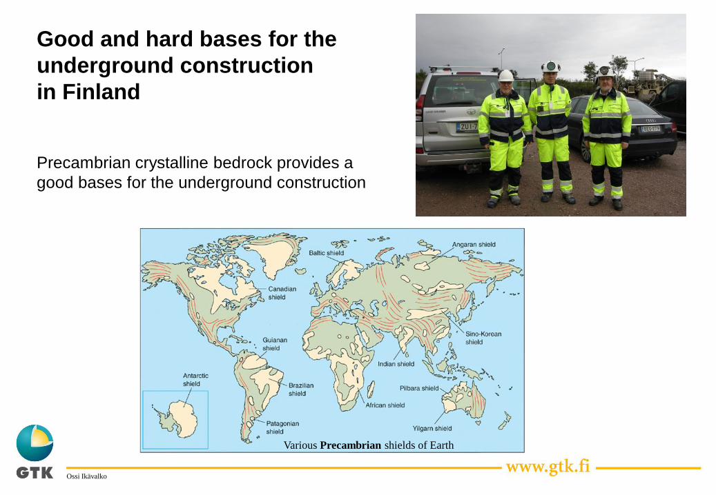
Good and hard bases for the
underground construction
in Finland
Ossi Ikävalko
Precambrian crystalline bedrock provides a
good bases for the underground construction
Various Precambrian shields of Earth

Schematic cross-section trough the Gulf of Finland
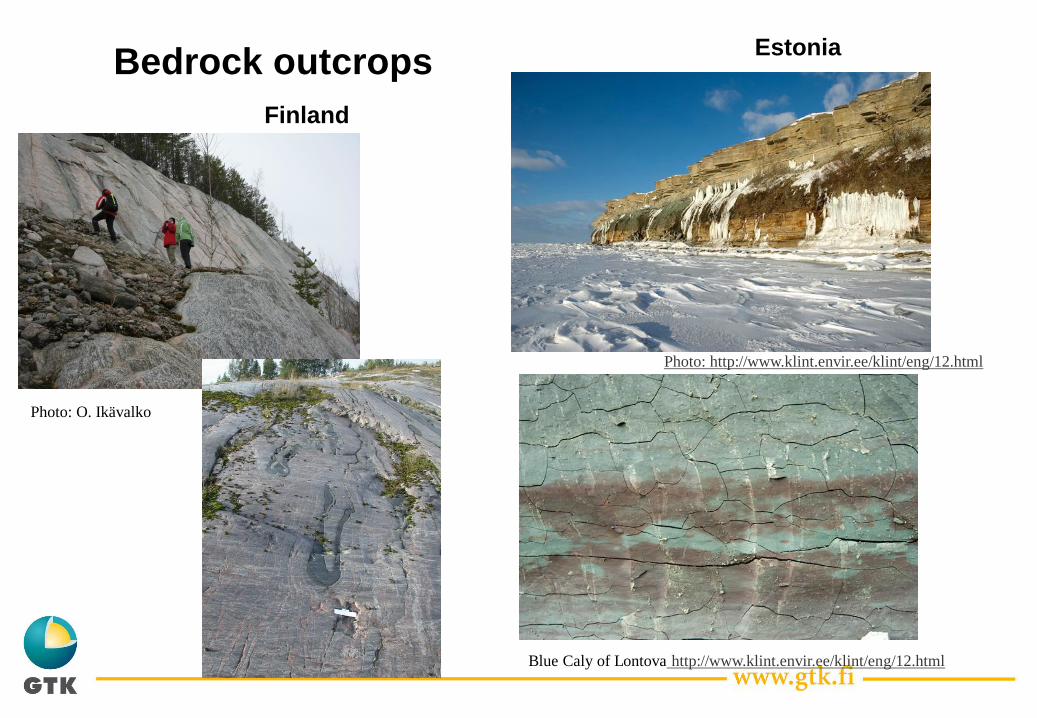
Bedrock outcrops Estonia
Finland
Blue Caly of Lontova http://www.klint.envir.ee/klint/eng/12.html
Photo: http://www.klint.envir.ee/klint/eng/12.html
Photo: O. Ikävalko

Geology of Estonian coast, Baltic klint and buried valleys
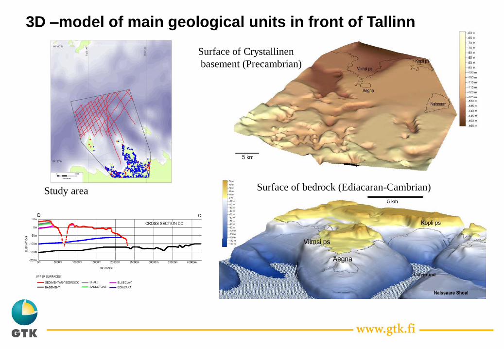
3D –model of main geological units in front of Tallinn
Study area
Surface of Crystallinen
basement (Precambrian)
Surface of bedrock (Ediacaran-Cambrian)

Cross-section of the Gulf of Finland based on
the 3D -model
1.5 %

1 2 3 4 5
G/Cm3 Mpa % m/2 m
Precambrian gneisses A 2.65 - 2.75 110 - 240 0.1 - 0.2 6000 - 6300
Rapakivi granites B 2.65 100 - 200 0.1 6000 - 6500
Weathered crystalline besement C 2.0 - 2.6 1 - 100 1 - 20 2000 - 5000 1 - 20
Sandstones D 2.0 - 2.3 1 - 25 10 - 20 2000 - 3000 n. 60
Siltstone E 2.25 - 2.35 5 - 25 10- 15 2500 - 3500 1 - 2
Sandstones F 2.1 - 2.2 1 - 5 Mpa 20 - 25 2500 - 3000 15
Blue clay G 2.3 - 2.4 2 - 4 Mpa 8 - 10 2000 - 2500 45
Limestone H 2.55 - 2.65 100 - 150 0.1 - 5.5 4000- 5500 20
Glauconite sandstone I 1.95 - 2.1 1 - 20 1 - 10 2500 - 3000 2
Alum shale J 1.9 - 2.0 40 - 50 1 - 10 3500 - 4000 3.5
Sandstones K 2.1 - 2.8 1 - 40 1 - 20 2500 - 3500 3- 8
Quaternary loose sediments L 1.5 - 2.2 < 1 10 - 30 1500 - 2000 0 - 60
A= Rocks of Jägala complex, B= Naissaar and Neeme rapakivi, C= Weathered crystalline rocks. D= Ediacaran
sandstones, E= Ediacaran siltstone, F= Cambrian quartzose sandstones of the Tiskre formation, G= Cambrian
blue clay of the Lontova formation, H= Ordovician limestone, I= Ordovician glauconite sandstone of the
Leetse formation, J= Ordovician alum shale of the Türisalu formation, K= Ordovician sandstones of the
Kallavere and Ülgase formations, L= Quaternary deposits
Physical‐mechanical properties of different formations
along the Tallinn-Helsinki tunnel
1= volumetric weight, 2= compressive strength, 3= porosity,
4= P‐wave velocity ca. 6000‐6500 m/s, 5= thickness of formation.
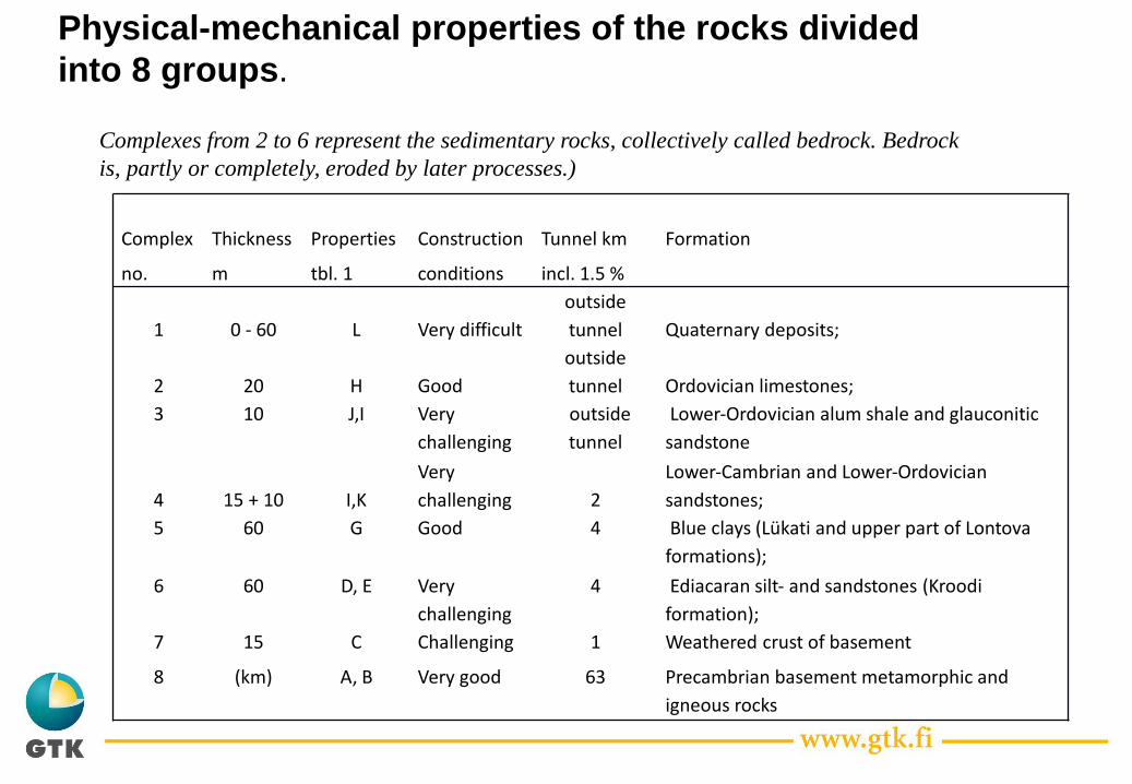
Complex Thickness Properties Construction Tunnel km Formation
no. m tbl. 1 conditions incl. 1.5 %
1 0 - 60 L Very difficult
outside
tunnel Quaternary deposits;
2 20 H Good
outside
tunnel Ordovician limestones;
3 10 J,I Very
challenging
outside
tunnel
Lower‐Ordovician alum shale and glauconitic
sandstone
4 15 + 10 I,K
Very
challenging 2
Lower‐Cambrian and Lower‐Ordovician
sandstones;
5 60 G Good 4 Blue clays (Lükati and upper part of Lontova
formations);
6 60 D, E Very
challenging
4 Ediacaran silt‐ and sandstones (Kroodi
formation);
7 15 C Challenging 1 Weathered crust of basement
8 (km) A, B Very good 63 Precambrian basement metamorphic and
igneous rocks
Physical-mechanical properties of the rocks divided
into 8 groups.
Complexes from 2 to 6 represent the sedimentary rocks, collectively called bedrock. Bedrock
is, partly or completely, eroded by later processes.)
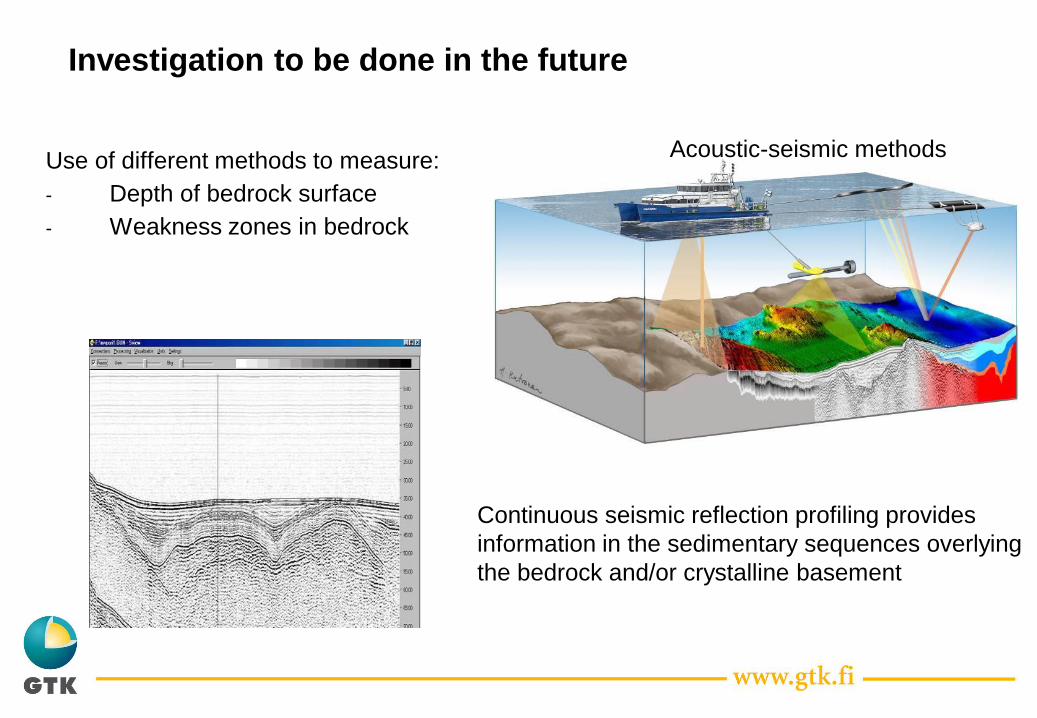
Acoustic-seismic methods Use of different methods to measure:
- Depth of bedrock surface
- Weakness zones in bedrock
Continuous seismic reflection profiling provides
information in the sedimentary sequences overlying
the bedrock and/or crystalline basement
Investigation to be done in the future

Ossi Ikävalko
Thank you for Your attention !
Ossi Ikävalko
Geological Survey of Finland (GTK)
E-mail: [email protected]
7.8.2012 22