soil erosion-a serious problem in central germany · 194 fig. 1 potential mean annual soil erosion...
TRANSCRIPT

12th ISCO Conference Beijing 2002
Soil Erosion-a Serious Problem in Central Germany
Heidrun Mühle, Burghard Christian Meyer and Ralf Grabaum1
UFZ Centre for Environmental Research Leipzig-Halle
P.O.Box 500135 -04301 Leipzig Germany
1 OLANIS Expert Systems Ltd. Permoserstr. 15 D-04318 Leipzig Germany
1 Introduction Soil erosion is a serious worldwide problem. It leads to a particular form of degradation in which
land loses its productive capacity. Soil erosion is also considerable in central Germany. Since this region is characterized by highly fertile black soils, agriculture is very important there. The land is covered by large fields with only few structural elements like hedges, small forests, copses and field edges, exposing it to the risk of soil erosion. However, it is important that farmers, landscape planners, environmental and local authorities take steps to combat soil erosion, while simultaneously taking into account other landscape functions such as water discharge regulation and the crop production capacity. After all, only if production capacity is regarded as the basis of their income will farmers be willing to take action to ensure higher biodiversity in their fields. This involves giving up part of their fertile farmland by changing it into hedges, copses or extensive meadows. Therefore a suitable approach was developed which includes various landscape functions and is geared to the specific landscape involved. This approach is based on the assessment of different functions with subsequent multicriteria optimization. A draft landscape plan is added. The approach and the results are introduced and discussed in the following paper.
2 Material and methods
The preservation and protection of species as well as of soil, the atmosphere and water are important
targets of countryside and environmental authorities, not to mention society as a whole. Because about 50% of the area of Germany is devoted to agriculture, these areas are regarded as a source for increasing seminatural parts of a landscape and hence also for increasing biodiversity. The protection of biodiversity and the better protection of water and soil resources combined with taking into account farmers’ income would lead to higher sustainability.
This idea has discussed since the early Seventies. HABER developed the concept of differentiated land use and explained this theory in presentations and papers (1971, 1972, 1981). The author argued for sustainable protection against disturbances or damage to the environment as an important condition for a landscape’s stability. He gave reasons for this target and proposed a multifunctional land use.
The authors of this paper adopted his proposals and developed an approach based on the assessment of different functions and multifunctional optimization with the aim of developing various land use scenarios (Mühle et al.,2001, Grabaum & Meyer 1998, Grabaum et al.,1999, Meyer 1997, Mühle et al.,1999).
This approach is described below. The various steps of assessment and optimization are as follows: (1) Defining the problem of generating a model; (2) Selecting environmental quality objectives; (3) Selecting land-use types and specifying an estimated part of arable land whose use can be
changed; (4) Functional assessment of landscape elements/functions (e.g. soil erosion, water discharge
regulation, and production capability) , maximizing the performance of the functions, optimizing the compromises between the functions, optimizing land use, scenarios.
193
(5) Developing a landscape plan integrating structures (not areas) and information of the cultural landscape;
(6) Second assessment to measure the changes between planned and actual improvement ; (7) Recommendations for action with land-use scenarios to enable the area to achieve a higher
number of plant and animal species; maps. (A) At first the authors of this paper chose an area (core region, about 4,200 ha arable land belonging
to Barnstädt farm) in the Querfurter Platte district in Saxony-Anhalt (one of Germany’s federal states) with highly fertile soils and large fields, and applied the method developed. The new method involves earmarking a certain part of the arable land and changing it into “natural” structures. In agreement with farmers and the local authorities, a scenario involving the conversion of 7.5% arable land in the core region of Saxony-Anhalt was selected.
Then the functions soil erosion water discharge regulation production capability of arable land
were chosen because they are the most important for this area. The functions were assessed for the whole arable land and the limits fixed: Extensive grassland and small forests and copses: about 7%—8% arable land: about 92%—93%.
Since the land chosen contained about 1% copses and grassland, no more than 7% arable land needed to be changed into seminatural areas.
To quantify and assess the economic consequences, a calculation model was designed to estimate the changes in the annual work programme, in the production costs, and in the revenues from typical arable production methods (v. Baillou, 2001).
(B) In the second part of this project, we chose a new core region situated in Saxony (another German state). The new core region has an area of about 3,500 ha. We wanted to test the application of the developed approach in another region. Now that this new part of the project has already been started, we have already obtained the initial results of assessment.
3 Results
(A) At first the landscape functions were assessed. The land quality served as an indicator for the
production capability of arable land (Table 1). More than 70% belongs to classes with an index of more than 80 (lines 9 and 10), meaning this farmland is highly fertile.
Table 1 The land quality index in the core region of querfurter platte
Line Index Area (ha) Area (%) 1 1—10 0 0 2 11—20 0 0 3 21—30 5,6 0.1 4 31—40 8,5 0.2 5 41—50 16 0.4 6 51—60 43 1.0 7 61—70 249 5.9 8 71—80 301 7.1 9 81—90 1.363 32.2 10 91—100 1.723 40.6 11 No data available 531 12.5 12 Total 4,240.1 100
194
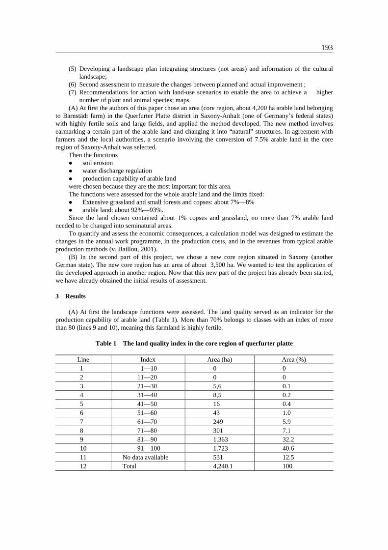
Fig. 1 Potential mean annual soil erosion risk the core region A (Saxony-Anhalt) The water discharge regulation calculated in the core region proved to be slow because of low
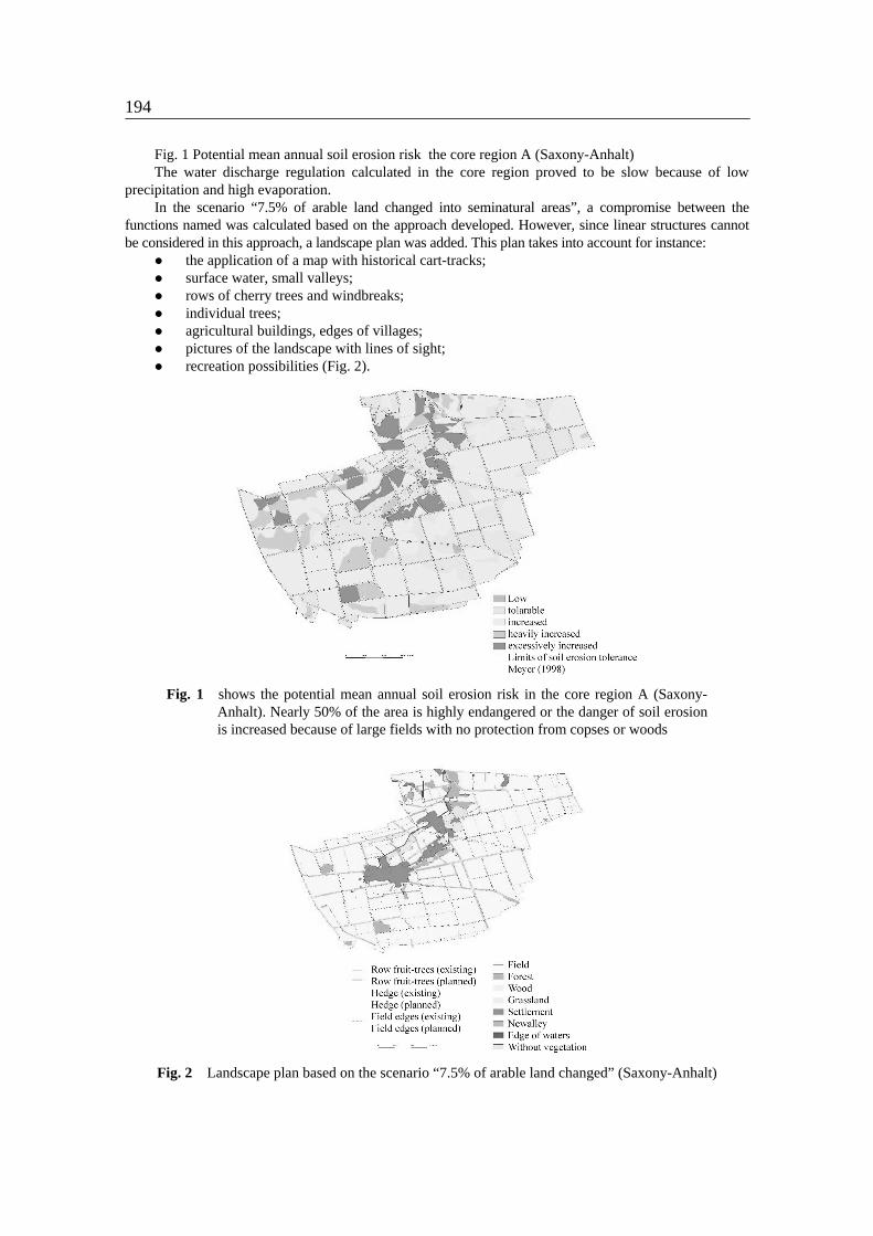
precipitation and high evaporation. In the scenario “7.5% of arable land changed into seminatural areas”, a compromise between the
functions named was calculated based on the approach developed. However, since linear structures cannot be considered in this approach, a landscape plan was added. This plan takes into account for instance:
the application of a map with historical cart-tracks; surface water, small valleys; rows of cherry trees and windbreaks; individual trees; agricultural buildings, edges of villages; pictures of the landscape with lines of sight; recreation possibilities (Fig. 2).
Fig. 1 shows the potential mean annual soil erosion risk in the core region A (Saxony-
Anhalt). Nearly 50% of the area is highly endangered or the danger of soil erosion is increased because of large fields with no protection from copses or woods
Fig. 2 Landscape plan based on the scenario “7.5% of arable land changed” (Saxony-Anhalt)
195
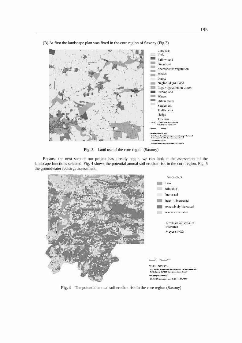
(B) At first the landscape plan was fixed in the core region of Saxony (Fig.3)
Fig. 3 Land use of the core region (Saxony)
Because the next step of our project has already begun, we can look at the assessment of the landscape functions selected. Fig. 4 shows the potential annual soil erosion risk in the core region, Fig. 5 the groundwater recharge assessment.
Fig. 4 The potential annual soil erosion risk in the core region (Saxony)

196
Fig. 5 Groundwater recharge assessment in the core region (Saxony)
4 Discussion (A) On several parts of Querfurter Platte, the very fertile black soil has been eroded, and the yellow
loam can be seen to emerge. The index of land quality there has been diminished from 90 to 70. This is a serious problem, and unless it is solved in the near future, farmers will lose the basis of production and part of their income. Therefore, farmers in the core region of Saxony-Anhalt are understandably worried about the soil erosion on their fields. They are willing to protect their fields and to change part of their arable land. The approach developed connects protection against soil erosion with the preservation of productive capability, as well as an increase in biological diversity. The “key species” in this region are the hamster (cricetus cricetus) and the kite (Milvus milvus). Should our proposal be implemented, protection would favour these key species, along with other species of plants and animals.
However, these management tasks entail work and money. Laying out small woods, hedges or copses and looking after them are expensive.
Moreover, reducing the farmers’ arable land curtails their income. In core region A (Saxony-Anhalt), the financial consequences for the farmers amounted to about 11% of their current annual income owing to:
the decrease in arable land; the increase in headland and side strips due to changed field areas; a yield depression of about 20% on the headlands; higher labour expenditure (v. Baillou 2001).
The farmers are not keen to shoulder these costs alone, and would like society to pay a share of the financial burden. Society must therefore decide whether it wants to boost biodiversity with the farmers’ cooperation. If so, society will have to make a major contribution to the costs involved.
(B) Some landscape functions were chosen to take into account into the approach of optimization, for instance the productivity capability. Potential soil erosion often plays a great role in eastern Germany because of the large fields predominating broken up by few structural landscape elements (owing to the amalgamation of small fields into large fields in the Sixties and Seventies, and the associated destruction of hedges, field edges and copses). In this paper the authors demonstrate the course of the optimization approach, beginning with the selection of the most important landscape function within the core region. In the case of the core region in Saxony, the landscape functions potential annual soil erosion, production capability of soils, and new formation of groundwater were selected and assessed. The next step will be to optimize them (along with other functions such as the protection of groundwater against pollution, the recreation potential of the landscape, fragmentation). We want to determine the best living conditions of the lepus (Lepus europaeus), and the kite (Milvus milvus) as key species, and to make proposals for protecting the soil accordingly.

197
References
von Ballou, J. 2001: Einfluss der Landnutzung auf Landschaftshaushalt und Biodiversität in agrarisch
dominierten Räumen. UFZ-Bericht 16/2001, p. 31 - 47. Grabaum, R, Meyer, B. C. & H. Mühle 1999: Landschaftsbewertung und –optimierung. Ein integratives
Konzept zur Landschaftsentwicklung. UFZ-Bericht 32/1999, 109 p. Grabaum, R. & B.C. Meyer 1998: Multicriteria optimization of landscapes using GIS-based functional
assessments. Landscape and Urban Planning 554 (1998) p.1-14 . Haber, W. 1971: Künftige Nutzung agrarischer Problemgebiete aus der Sicht der Landschaftspflege.
Vortrag auf der Sitzung des Beirates der Gesellschaft für Landeskultur GmbH am 25.Mai 1971 in St. Englmar (Bayr. Wald).
Haber, W. 1972: Grundzüge einer ökologischen Theorie der Landnutzungsplanung. In: Innere Kolonisation 21, p. 294-298. Landschriften-Verlag Bonn.
Haber, W. 1981: Zur ökologischen Bedeutung der Vegetation für den Menschen. In J. Cramer in der A.R. Gantner Verlag Kommanditgesellschaft: Berichte der Internationalen Symposien der Internationalen Vereinigung für Vegetationskunde, p. 49-64.
Meyer, B.C. 1997: Landschaftsstrukturen und Regulationsfunktionen in Intensivagrarlandschaften im Raum Leipzig-Halle. Regionalisierte Umweltqualitätsziele - Funktionsbewertungen - Multikriterielle Landschaftsoptimierung unter Verwendung von GIS. Dissertation Köln und UFZ-Bericht Nr 24/97, p. 225.
Mühle, H. Ed. 2001: Einfluß der Landnutzung auf Landschaftshaushalt und Biodiversität in agrarisch dominierten Räumen. UFZ-Bericht 16/2001, p.317.
Mühle, H., Grabaum, R. & B.C. Meuer 1999: Sustainable Agricultural Development in the Central Region of Germany – Ideas, Methods and Results – Int. Soil Conserv. Organization Conf. May 23-28, Purdue University, Indiana, USA (in press).