soil map units with nutrient management standard 590 restrictions … · 590 tech note appendix 1...
TRANSCRIPT

590 Tech Note Appendix 1 2015
Soil Map Units with Nutrient Management Standard 590 Restrictions Due to Potential
for Nitrate Leaching to Groundwater, July 2015Soils with restrictions are listed alphabetically by county in the Appendix 1 Table followed by map unit name and
590 restriction code. Soils not listed here are less likely to have NR590 restrictions for wetness, rock, or
permeability.
Potential for nitrate leaching restriction codes:
p = High permeability
r = Depth to bedrock (lithic or paralithic) 20 inches or less
w = Apparent water table at 12 inches or less anytime of year
A + sign indicates the map unit may have any of the restrictions, however an on-site investigation is needed to ID
which restrictions may actually be present.
Soils not listed here with an entry in the restrictions column are less likely to have NR590 restrictions for wetness,
rock, or permeability (leaching)
Code definitions from Nutrient Management Standard 590
High Permeability Soils (P) – Are equivalent to drained hydrologic group A meeting both of the following
criteria:
1. Permeability = 6 inches/hour or more in all parts of the upper 20 inches and
2. Permeability = 0.6 inches/hour or more in all parts of the upper 40 inches.
Use the lowest permeability listed for each layer when evaluating a soil. For a multi-component map
unit (complex), evaluate each component separately. If the high permeability components meet the criteria
and cannot be separated, the entire map unit should be considered as high permeability.
Wet soils (W) have an Apparent Water Table within 12 inches of the surface at any time of the year. The
apparent water table is a continuous saturated zone in the soil to a depth of at least 6 feet without an
unsaturated zone below it.
County
Map Unit
Symbol Map Unit Name
590 Fall
N rest.
code
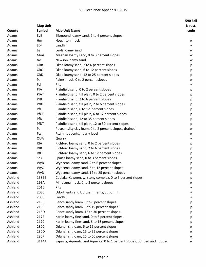
Adams Ad Adrian muck w
Adams AlA Algansee loamy sand, 0 to 3 percent slopes w
Adams An Aquents, sandy w
Adams Au Au Gres loamy sand w
Adams BlA Billett sandy loam, 0 to 3 percent slopes p
Adams BnB Boone sand, 2 to 6 percent slopes p
Adams BnC Boone sand, 6 to 12 percent slopes p
Adams BnD Boone sand, 12 to 25 percent slopes p
Adams BpF Boone-Rock outcrop complex, 25 to 45 percent slopes pr
Adams BrA Brems loamy sand, 0 to 3 percent slopes p
Adams BsA Brems-Newson loamy sands, 0 to 3 percent slopes p
Adams CoB Coloma sand, 2 to 6 percent slopes p
Adams CoC Coloma sand, 6 to 12 percent slopes p
Adams CoD Coloma sand, 12 to 25 percent slopes p
Page 1
590 Tech Note Appendix 1 2015
County
Map Unit
Symbol Map Unit Name
590 Fall
N rest.
code
Adams EvB Elkmound loamy sand, 2 to 6 percent slopes r
Adams Hm Houghton muck w
Adams LDF Landfill +
Adams Le Leola loamy sand w
Adams MoA Meehan loamy sand, 0 to 3 percent slopes w
Adams Ne Newson loamy sand w
Adams OkB Okee loamy sand, 2 to 6 percent slopes p
Adams OkC Okee loamy sand, 6 to 12 percent slopes p
Adams OkD Okee loamy sand, 12 to 25 percent slopes p
Adams Pa Palms muck, 0 to 2 percent slopes w
Adams Pd Pits +
Adams PfA Plainfield sand, 0 to 2 percent slopes p
Adams PfAT Plainfield sand, till plain, 0 to 2 percent slopes p
Adams PfB Plainfield sand, 2 to 6 percent slopes p
Adams PfBT Plainfield sand, till plain, 2 to 6 percent slopes p
Adams PfC Plainfield sand, 6 to 12 percent slopes p
Adams PfCT Plainfield sand, till plain, 6 to 12 percent slopes p
Adams PfD Plainfield sand, 12 to 35 percent slopes p
Adams PfDT Plainfield sand, till plain, 12 to 30 percent slopes p
Adams Ps Poygan silty clay loam, 0 to 2 percent slopes, drained w
Adams Pw Psammaquents, nearly level w
Adams QUA Quarry +
Adams RfA Richford loamy sand, 0 to 2 percent slopes p
Adams RfB Richford loamy sand, 2 to 6 percent slopes p
Adams RfC Richford loamy sand, 6 to 12 percent slopes p
Adams SpA Sparta loamy sand, 0 to 3 percent slopes p
Adams WyB Wyocena loamy sand, 2 to 6 percent slopes p
Adams WyC Wyocena loamy sand, 6 to 12 percent slopes p
Adams WyD Wyocena loamy sand, 12 to 25 percent slopes p
Ashland 1385B Cublake-Keweenaw, stony complex, 0 to 6 percent slopes p
Ashland 193A Minocqua muck, 0 to 2 percent slopes w
Ashland 2015 Pits +
Ashland 2030 Udorthents and Udipsamments, cut or fill +
Ashland 2050 Landfill +
Ashland 215B Pence sandy loam, 0 to 6 percent slopes p
Ashland 215C Pence sandy loam, 6 to 15 percent slopes p
Ashland 215D Pence sandy loam, 15 to 30 percent slopes p
Ashland 217B Karlin loamy fine sand, 0 to 6 percent slopes p
Ashland 217C Karlin loamy fine sand, 6 to 15 percent slopes p
Ashland 280C Odanah silt loam, 6 to 15 percent slopes w
Ashland 280D Odanah silt loam, 15 to 25 percent slopes w
Ashland 280F Odanah silt loam, 25 to 60 percent slopes w
Ashland 3114A Saprists, Aquents, and Aquepts, 0 to 1 percent slopes, ponded and flooded w
Page 2

590 Tech Note Appendix 1 2015
County
Map Unit
Symbol Map Unit Name
590 Fall
N rest.
code
Ashland 3276A Au Gres loamy sand, 0 to 3 percent slopes w
Ashland 339B Rousseau loamy fine sand, 0 to 6 percent slopes p
Ashland 339C Rousseau loamy fine sand, 6 to 15 percent slopes p
Ashland 339D Rousseau loamy fine sand, 15 to 30 percent slopes p
Ashland 3403A Loxley, Beseman, and Dawson soils, 0 to 1 percent slopes w
Ashland 3423A Rifle peat, 0 to 1 percent slopes w
Ashland 3454B Odanah-Cornucopia complex, 2 to 6 percent slopes w
Ashland 3608B Deerton-Brownstone complex, 0 to 6 percent slopes, very stony p
Ashland 3608C Deerton-Brownstone complex, 6 to 15 percent slopes, very stony p
Ashland 375A Robago fine sandy loam, lake terrace, 0 to 3 percent slopes w
Ashland 384B Springstead sandy loam, 1 to 6 percent slopes, stony p
Ashland 388B Pelkie, occasionally flooded-Dechamps, frequently flooded complex, 0 to 4 percent
slopes
wp
Ashland 405A Lupton, Cathro, and Tawas soils, 0 to 1 percent slopes w
Ashland 408A Lupton and Cathro soils, 0 to 1 percent slopes w
Ashland 414A Loxley and Beseman soils, 0 to 1 percent slopes w
Ashland 445A Kinross muck, 0 to 2 percent slopes w
Ashland 461A Bowstring muck, 0 to 1 percent slopes, frequently flooded w
Ashland 475C Rubicon-Sayner complex, 6 to 15 percent slopes p
Ashland 500B Croswell sand, 0 to 6 percent slopes p
Ashland 5140A Dawson, Greenwood, and Loxley soils, 0 to 1 percent slopes w
Ashland 5141A Lupton-Pleine-Cathro complex, 0 to 1 percent slopes w
Ashland 5146C Amasa-Karlin complex, esker, 2 to 18 percent slopes p
Ashland 514B Iosco loamy sand, 0 to 4 percent slopes w
Ashland 5170A Minocqua-Pleine-Cathro complex, 0 to 2 percent slopes w
Ashland 5172B Gogebic, very stony-Pence, very stony-Cathro complex, 0 to 6 percent slopes p
Ashland 5172C Gogebic, very stony-Pence, very stony-Cathro complex, 0 to 18 percent slopes p
Ashland 5172D Gogebic, very stony-Pence, very stony-Cathro complex, 0 to 35 percent slopes p
Ashland 5173D Gogebic-Pence complex, 18 to 35 percent slopes, very stony p
Ashland 520A Annriver silt loam, 0 to 2 percent slopes w
Ashland 5369D Dishno-Gogebic-Peshekee-Rock outcrop complex, 18 to 35 percent slopes, very
stony
r
Ashland 5369E Michigamme-Schweitzer-Peshekee-Rock outcrop complex, 35 to 55 percent slopes,
very stony
r
Ashland 5369F Michigamme-Schweitzer-Peshekee-Rock outcrop complex, 55 to 75 percent slopes,
very stony
r
Ashland 5373A Cathro muck, drainageway, 0 to 1 percent slopes w
Ashland 5374A Bowstring-Arnheim complex, 0 to 1 percent slopes, frequently flooded w
Ashland 5425A Foxpaw-Gay, stony complex, 0 to 2 percent slopes w
Ashland 5504A Moquah-Arnheim complex, 0 to 3 percent slopes, frequently flooded wp
Ashland 5519B Pence-Gogebic complex, 2 to 6 percent slopes, stony p
Page 3

590 Tech Note Appendix 1 2015
County
Map Unit
Symbol Map Unit Name
590 Fall
N rest.
code
Ashland 5519C Pence-Gogebic complex, 6 to 18 percent slopes, stony p
Ashland 5519D Pence-Gogebic complex, 18 to 35 percent slopes, stony p
Ashland 555A Fordum silt loam, 0 to 2 percent slopes, frequently flooded w
Ashland 571C Pelissier gravelly sandy loam, 6 to 15 percent slopes p
Ashland 571E Pelissier gravelly sandy loam, 15 to 45 percent slopes p
Ashland 582D Padus-Pence-Keweenaw complex, 15 to 30 percent slopes, stony p
Ashland 591A Croswell-Chinwhisker complex, 0 to 3 percent slopes p
Ashland 594B Vilas-Lindquist complex, 0 to 6 percent slopes p
Ashland 594C Vilas-Lindquist complex, 6 to 15 percent slopes p
Ashland 594D Vilas-Lindquist complex, 15 to 30 percent slopes p
Ashland 597A Meehan sand, beaches, 0 to 2 percent slopes w
Ashland 598A Wurtsmith sand, beaches, 0 to 3 percent slopes p
Ashland 599C Grayling sand, beaches, 2 to 12 percent slopes p
Ashland 5A Arnheim mucky silt loam, 0 to 1 percent slopes, frequently flooded w
Ashland 603B Redrim very cobbly sand, 0 to 6 percent slopes, very stony r
Ashland 639A Neconish loamy fine sand, 0 to 3 percent slopes p
Ashland 670B Keweenaw-Pence complex, 0 to 6 percent slopes, stony p
Ashland 670C Keweenaw-Pence complex, 6 to 15 percent slopes, stony p
Ashland 670E Keweenaw-Pence complex, 15 to 45 percent slopes, stony p
Ashland 674B Sultz sand, 0 to 6 percent slopes p
Ashland 674C Sultz sand, 6 to 15 percent slopes p
Ashland 674E Sultz sand, 15 to 45 percent slopes p
Ashland 675A Robago fine sandy loam, 0 to 3 percent slopes w
Ashland 69B Keweenaw-Sayner-Vilas complex, 2 to 6 percent slopes, stony p
Ashland 69C Keweenaw-Sayner-Vilas complex, 6 to 15 percent slopes, stony p
Ashland 69E Keweenaw-Sayner-Vilas complex, 15 to 45 percent slopes, stony p
Ashland 701A Whisklake silt loam, 0 to 3 percent slopes w
Ashland 705B Cublake-Croswell-Ashwabay complex, 0 to 6 percent slopes p
Ashland 705C Cublake-Croswell-Ashwabay complex, 6 to 15 percent slopes p
Ashland 713B Kellogg-Allendale-Ashwabay complex, 2 to 6 percent slopes p
Ashland 713C Kellogg-Allendale-Ashwabay complex, 0 to 15 percent slopes p
Ashland 74B Vilas loamy sand, 0 to 6 percent slopes p
Ashland 74C Vilas loamy sand, 6 to 15 percent slopes p
Ashland 755A Moppet, occasionally flooded-Fordum, frequently flooded complex, 0 to 3 percent
slopes
w
Ashland 770B Shanagolden-Pence complex, 2 to 6 percent slopes, stony p
Ashland 770C Shanagolden-Pence complex, 6 to 15 percent slopes, stony p
Ashland 770D Shanagolden-Pence complex, 15 to 30 percent slopes, stony p
Ashland 805E Sultz-Ashwabay-Rubicon complex, 15 to 45 percent slopes p
Ashland 809C Gogebic-Metonga-Rock outcrop complex, 6 to 18 percent slopes, very stony r
Ashland 809D Gogebic-Metonga-Rock outcrop complex, 10 to 35 percent slopes, very stony r
Ashland 813E Manistee-Kellogg-Ashwabay complex, 15 to 45 percent slopes p
Page 4

590 Tech Note Appendix 1 2015
County
Map Unit
Symbol Map Unit Name
590 Fall
N rest.
code
Ashland 815A Wormet sandy loam, 0 to 3 percent slopes w
Ashland 852C Pence-Padus complex, 6 to 15 percent slopes, stony p
Ashland 852D Pence-Padus complex, 15 to 30 percent slopes, stony p
Ashland 874B Keweenaw, stony-Rubicon complex, 0 to 6 percent slopes p
Ashland 874C Keweenaw, stony-Rubicon complex, 6 to 15 percent slopes p
Ashland 9012B Sayner-Lindquist complex, 0 to 6 percent slopes p
Ashland 9012C Sayner-Lindquist complex, 6 to 15 percent slopes p
Ashland 9012D Sayner-Lindquist complex, 15 to 30 percent slopes p
Ashland 9050A Fordum, Totagatic, and Bowstring soils, 0 to 1 percent slopes, frequently flooded w
Ashland 905A Cublake loamy sand, 0 to 3 percent slopes p
Ashland 9113B Padus-Karlin complex, 0 to 6 percent slopes p
Ashland 9113C Padus-Karlin complex, 6 to 15 percent slopes p
Ashland 9113D Padus-Karlin complex, 15 to 30 percent slopes p
Ashland 9155A Haplosaprists, Peats and Mucks, 0 to 1 percent slopes w
Ashland 925C Rock outcrop-Ishpeming complex, 0 to 15 percent slopes r
Ashland 974B Sayner-Pence-Vilas complex, 0 to 6 percent slopes p
Ashland 974C Sayner-Pence-Vilas complex, 6 to 15 percent slopes p
Ashland 974D Sayner-Pence-Vilas complex, 15 to 30 percent slopes p
Barron AmD Amery-Greenwood complex, 0 to 35 percent slopes w
Barron Be Beseman peat, 0 to 1 percent slopes w
Barron CsC Cress-Mahtomedi complex, 6 to 15 percent slopes p
Barron CsD Cress-Mahtomedi complex, 15 to 25 percent slopes p
Barron Fm Fordum silt loam, 0 to 2 percent slopes w
Barron FrA Friendship loamy sand, 0 to 3 percent slopes p
Barron Gr Greenwood peat, 0 to 1 percent slopes w
Barron HzF Hayriver-Twinmound complex, 20 to 50 percent slopes p
Barron Me Markey muck, 0 to 1 percent slopes w
Barron Mh Meehan loamy sand, 0 to 2 percent slopes w
Barron MnA Menahga loamy sand, 0 to 2 percent slopes p
Barron MnB Menahga loamy sand, 2 to 6 percent slopes p
Barron MnC Menahga loamy sand, 6 to 12 percent slopes p
Barron MnD Menahga loamy sand, 12 to 25 percent slopes p
Barron Ns Newson loamy sand, 0 to 2 percent slopes w
Barron Oe Oesterle sandy loam, 0 to 2 percent slopes w
Barron Pc Pits, gravel +
Barron PdB Plainbo loamy sand, 2 to 6 percent slopes p
Barron PdC Plainbo loamy sand, 6 to 12 percent slopes p
Barron PdD Plainbo loamy sand, 12 to 20 percent slopes p
Barron Px Poskin silt loam, 0 to 2 percent slopes w
Barron Rb Rib silt loam, 0 to 2 percent slopes w
Barron Sm Seelyeville and Cathro mucks, 0 to 1 percent slopes w
Barron Va Vancecreek silt loam, 0 to 2 percent slopes w
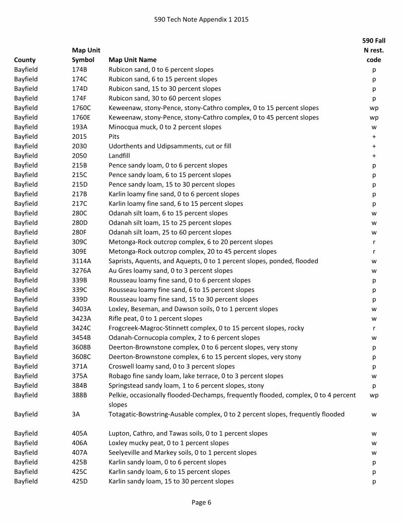
Bayfield 1385B Cublake-Keweenaw, stony, complex, 0 to 6 percent slopes p
Page 5
590 Tech Note Appendix 1 2015
County
Map Unit
Symbol Map Unit Name
590 Fall
N rest.
code
Bayfield 174B Rubicon sand, 0 to 6 percent slopes p
Bayfield 174C Rubicon sand, 6 to 15 percent slopes p
Bayfield 174D Rubicon sand, 15 to 30 percent slopes p
Bayfield 174F Rubicon sand, 30 to 60 percent slopes p
Bayfield 1760C Keweenaw, stony-Pence, stony-Cathro complex, 0 to 15 percent slopes wp
Bayfield 1760E Keweenaw, stony-Pence, stony-Cathro complex, 0 to 45 percent slopes wp
Bayfield 193A Minocqua muck, 0 to 2 percent slopes w
Bayfield 2015 Pits +
Bayfield 2030 Udorthents and Udipsamments, cut or fill +
Bayfield 2050 Landfill +
Bayfield 215B Pence sandy loam, 0 to 6 percent slopes p
Bayfield 215C Pence sandy loam, 6 to 15 percent slopes p
Bayfield 215D Pence sandy loam, 15 to 30 percent slopes p
Bayfield 217B Karlin loamy fine sand, 0 to 6 percent slopes p
Bayfield 217C Karlin loamy fine sand, 6 to 15 percent slopes p
Bayfield 280C Odanah silt loam, 6 to 15 percent slopes w
Bayfield 280D Odanah silt loam, 15 to 25 percent slopes w
Bayfield 280F Odanah silt loam, 25 to 60 percent slopes w
Bayfield 309C Metonga-Rock outcrop complex, 6 to 20 percent slopes r
Bayfield 309E Metonga-Rock outcrop complex, 20 to 45 percent slopes r
Bayfield 3114A Saprists, Aquents, and Aquepts, 0 to 1 percent slopes, ponded, flooded w
Bayfield 3276A Au Gres loamy sand, 0 to 3 percent slopes w
Bayfield 339B Rousseau loamy fine sand, 0 to 6 percent slopes p
Bayfield 339C Rousseau loamy fine sand, 6 to 15 percent slopes p
Bayfield 339D Rousseau loamy fine sand, 15 to 30 percent slopes p
Bayfield 3403A Loxley, Beseman, and Dawson soils, 0 to 1 percent slopes w
Bayfield 3423A Rifle peat, 0 to 1 percent slopes w
Bayfield 3424C Frogcreek-Magroc-Stinnett complex, 0 to 15 percent slopes, rocky r
Bayfield 3454B Odanah-Cornucopia complex, 2 to 6 percent slopes w
Bayfield 3608B Deerton-Brownstone complex, 0 to 6 percent slopes, very stony p
Bayfield 3608C Deerton-Brownstone complex, 6 to 15 percent slopes, very stony p
Bayfield 371A Croswell loamy sand, 0 to 3 percent slopes p
Bayfield 375A Robago fine sandy loam, lake terrace, 0 to 3 percent slopes w
Bayfield 384B Springstead sandy loam, 1 to 6 percent slopes, stony p
Bayfield 388B Pelkie, occasionally flooded-Dechamps, frequently flooded, complex, 0 to 4 percent
slopes
wp
Bayfield 3A Totagatic-Bowstring-Ausable complex, 0 to 2 percent slopes, frequently flooded w
Bayfield 405A Lupton, Cathro, and Tawas soils, 0 to 1 percent slopes w
Bayfield 406A Loxley mucky peat, 0 to 1 percent slopes w
Bayfield 407A Seelyeville and Markey soils, 0 to 1 percent slopes w
Bayfield 425B Karlin sandy loam, 0 to 6 percent slopes p
Bayfield 425C Karlin sandy loam, 6 to 15 percent slopes p
Bayfield 425D Karlin sandy loam, 15 to 30 percent slopes p
Page 6
590 Tech Note Appendix 1 2015
County
Map Unit
Symbol Map Unit Name
590 Fall
N rest.
code
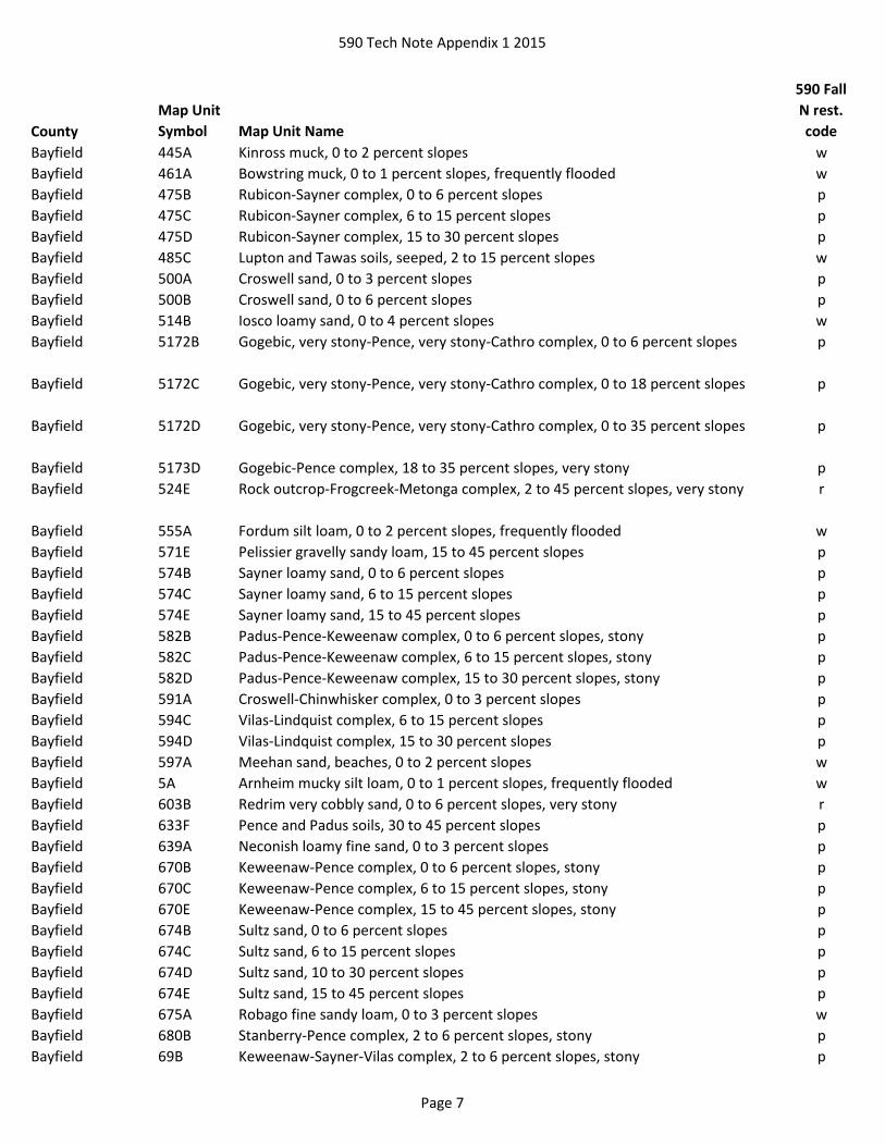
Bayfield 445A Kinross muck, 0 to 2 percent slopes w
Bayfield 461A Bowstring muck, 0 to 1 percent slopes, frequently flooded w
Bayfield 475B Rubicon-Sayner complex, 0 to 6 percent slopes p
Bayfield 475C Rubicon-Sayner complex, 6 to 15 percent slopes p
Bayfield 475D Rubicon-Sayner complex, 15 to 30 percent slopes p
Bayfield 485C Lupton and Tawas soils, seeped, 2 to 15 percent slopes w
Bayfield 500A Croswell sand, 0 to 3 percent slopes p
Bayfield 500B Croswell sand, 0 to 6 percent slopes p
Bayfield 514B Iosco loamy sand, 0 to 4 percent slopes w
Bayfield 5172B Gogebic, very stony-Pence, very stony-Cathro complex, 0 to 6 percent slopes p
Bayfield 5172C Gogebic, very stony-Pence, very stony-Cathro complex, 0 to 18 percent slopes p
Bayfield 5172D Gogebic, very stony-Pence, very stony-Cathro complex, 0 to 35 percent slopes p
Bayfield 5173D Gogebic-Pence complex, 18 to 35 percent slopes, very stony p
Bayfield 524E Rock outcrop-Frogcreek-Metonga complex, 2 to 45 percent slopes, very stony r
Bayfield 555A Fordum silt loam, 0 to 2 percent slopes, frequently flooded w
Bayfield 571E Pelissier gravelly sandy loam, 15 to 45 percent slopes p
Bayfield 574B Sayner loamy sand, 0 to 6 percent slopes p
Bayfield 574C Sayner loamy sand, 6 to 15 percent slopes p
Bayfield 574E Sayner loamy sand, 15 to 45 percent slopes p
Bayfield 582B Padus-Pence-Keweenaw complex, 0 to 6 percent slopes, stony p
Bayfield 582C Padus-Pence-Keweenaw complex, 6 to 15 percent slopes, stony p
Bayfield 582D Padus-Pence-Keweenaw complex, 15 to 30 percent slopes, stony p
Bayfield 591A Croswell-Chinwhisker complex, 0 to 3 percent slopes p
Bayfield 594C Vilas-Lindquist complex, 6 to 15 percent slopes p
Bayfield 594D Vilas-Lindquist complex, 15 to 30 percent slopes p
Bayfield 597A Meehan sand, beaches, 0 to 2 percent slopes w
Bayfield 5A Arnheim mucky silt loam, 0 to 1 percent slopes, frequently flooded w
Bayfield 603B Redrim very cobbly sand, 0 to 6 percent slopes, very stony r
Bayfield 633F Pence and Padus soils, 30 to 45 percent slopes p
Bayfield 639A Neconish loamy fine sand, 0 to 3 percent slopes p
Bayfield 670B Keweenaw-Pence complex, 0 to 6 percent slopes, stony p
Bayfield 670C Keweenaw-Pence complex, 6 to 15 percent slopes, stony p
Bayfield 670E Keweenaw-Pence complex, 15 to 45 percent slopes, stony p
Bayfield 674B Sultz sand, 0 to 6 percent slopes p
Bayfield 674C Sultz sand, 6 to 15 percent slopes p
Bayfield 674D Sultz sand, 10 to 30 percent slopes p
Bayfield 674E Sultz sand, 15 to 45 percent slopes p
Bayfield 675A Robago fine sandy loam, 0 to 3 percent slopes w
Bayfield 680B Stanberry-Pence complex, 2 to 6 percent slopes, stony p
Bayfield 69B Keweenaw-Sayner-Vilas complex, 2 to 6 percent slopes, stony p
Page 7
590 Tech Note Appendix 1 2015
County
Map Unit
Symbol Map Unit Name
590 Fall
N rest.
code
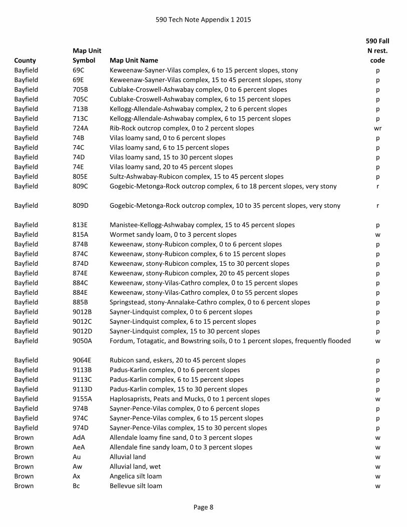
Bayfield 69C Keweenaw-Sayner-Vilas complex, 6 to 15 percent slopes, stony p
Bayfield 69E Keweenaw-Sayner-Vilas complex, 15 to 45 percent slopes, stony p
Bayfield 705B Cublake-Croswell-Ashwabay complex, 0 to 6 percent slopes p
Bayfield 705C Cublake-Croswell-Ashwabay complex, 6 to 15 percent slopes p
Bayfield 713B Kellogg-Allendale-Ashwabay complex, 2 to 6 percent slopes p
Bayfield 713C Kellogg-Allendale-Ashwabay complex, 6 to 15 percent slopes p
Bayfield 724A Rib-Rock outcrop complex, 0 to 2 percent slopes wr
Bayfield 74B Vilas loamy sand, 0 to 6 percent slopes p
Bayfield 74C Vilas loamy sand, 6 to 15 percent slopes p
Bayfield 74D Vilas loamy sand, 15 to 30 percent slopes p
Bayfield 74E Vilas loamy sand, 20 to 45 percent slopes p
Bayfield 805E Sultz-Ashwabay-Rubicon complex, 15 to 45 percent slopes p
Bayfield 809C Gogebic-Metonga-Rock outcrop complex, 6 to 18 percent slopes, very stony r
Bayfield 809D Gogebic-Metonga-Rock outcrop complex, 10 to 35 percent slopes, very stony r
Bayfield 813E Manistee-Kellogg-Ashwabay complex, 15 to 45 percent slopes p
Bayfield 815A Wormet sandy loam, 0 to 3 percent slopes w
Bayfield 874B Keweenaw, stony-Rubicon complex, 0 to 6 percent slopes p
Bayfield 874C Keweenaw, stony-Rubicon complex, 6 to 15 percent slopes p
Bayfield 874D Keweenaw, stony-Rubicon complex, 15 to 30 percent slopes p
Bayfield 874E Keweenaw, stony-Rubicon complex, 20 to 45 percent slopes p
Bayfield 884C Keweenaw, stony-Vilas-Cathro complex, 0 to 15 percent slopes p
Bayfield 884E Keweenaw, stony-Vilas-Cathro complex, 0 to 55 percent slopes p
Bayfield 885B Springstead, stony-Annalake-Cathro complex, 0 to 6 percent slopes p
Bayfield 9012B Sayner-Lindquist complex, 0 to 6 percent slopes p
Bayfield 9012C Sayner-Lindquist complex, 6 to 15 percent slopes p
Bayfield 9012D Sayner-Lindquist complex, 15 to 30 percent slopes p
Bayfield 9050A Fordum, Totagatic, and Bowstring soils, 0 to 1 percent slopes, frequently flooded w
Bayfield 9064E Rubicon sand, eskers, 20 to 45 percent slopes p
Bayfield 9113B Padus-Karlin complex, 0 to 6 percent slopes p
Bayfield 9113C Padus-Karlin complex, 6 to 15 percent slopes p
Bayfield 9113D Padus-Karlin complex, 15 to 30 percent slopes p
Bayfield 9155A Haplosaprists, Peats and Mucks, 0 to 1 percent slopes w
Bayfield 974B Sayner-Pence-Vilas complex, 0 to 6 percent slopes p
Bayfield 974C Sayner-Pence-Vilas complex, 6 to 15 percent slopes p
Bayfield 974D Sayner-Pence-Vilas complex, 15 to 30 percent slopes p
Brown AdA Allendale loamy fine sand, 0 to 3 percent slopes w
Brown AeA Allendale fine sandy loam, 0 to 3 percent slopes w
Brown Au Alluvial land w
Brown Aw Alluvial land, wet w
Brown Ax Angelica silt loam w
Brown Bc Bellevue silt loam w
Page 8

590 Tech Note Appendix 1 2015
County
Map Unit
Symbol Map Unit Name
590 Fall
N rest.
code
Brown Bd Bellevue silty clay loam, mottled subsoil variant w
Brown BnA Bonduel loam, 0 to 3 percent slopes w
Brown Bp Borrow pits +
Brown BrB Boyer loamy fine sand, 2 to 6 percent slopes p
Brown BrC2 Boyer loamy fine sand, 6 to 12 percent slopes, eroded p
Brown BrD2 Boyer loamy fine sand, 12 to 20 percent slopes, eroded p
Brown BrE Boyer loamy fine sand, 20 to 30 percent slopes p
Brown Ca Carbondale muck w
Brown CdE2 Casco-Rodman complex, 12 to 20 percent slopes, eroded p
Brown Cm Cathro muck w
Brown Fa Fabius silt loam w
Brown Fd Fill land w
Brown Gp Gravel pits +
Brown Ke Keowns silt loam w
Brown KnA Kibbie silt loam, 1 to 3 percent slopes w
Brown MeB Manistee loamy fine sand, 2 to 6 percent slopes p
Brown MeC2 Manistee loamy fine sand, 6 to 14 percent slopes, eroded p
Brown Mk Markey muck w
Brown Mr Marsh w
Brown NaB Namur silt loam, 1 to 6 percent slopes r
Brown NaD Namur silt loam, 6 to 20 percent slopes r
Brown Ne Namur silt loam, wet variant wr
Brown Od Ogden muck w
Brown Pe Pella silt loam, 0 to 2 percent slopes w
Brown Po Poygan silty clay loam, 0 to 2 percent slopes, drained w
Brown Qu Quarries +
Brown Rs Roscommon muck w
Brown Ru Ruse silt loam wr
Brown Sb Sebewa silt loam w
Brown SeC Shawano fine sand, rolling p
Brown SeD Shawano fine sand, hilly p
Brown SfB Shawano loamy fine sand, 2 to 6 percent slopes p
Brown SfC Shawano loamy fine sand, 6 to 12 percent slopes p
Brown SgB Shullsburg silt loam, wet variant, 2 to 6 percent slopes w
Brown SoA Solona sandy loam, 1 to 3 percent slopes w
Brown SpA Solona loam, 1 to 3 percent slopes w
Brown SuB Summerville loam, 1 to 6 percent slopes r
Brown SuD2 Summerville loam, 6 to 20 percent slopes, eroded r
Brown SvB Summerville silt loam, clayey subsoil variant, 1 to 6 percent slopes r
Buffalo 1145F Gaphill-Rockbluff complex, 30 to 60 percent slopes p
Buffalo 1155F Brodale-Bellechester-Rock outcrop complex, 60 to 90 percent slopes pr
Buffalo 11A Markey muck, 0 to 1 percent slopes, frequently flooded w
Buffalo 1224F Boone-Elevasil complex, 15 to 50 percent slopes p
Buffalo 1233F Boone-Tarr sands, 15 to 50 percent slopes p
Page 9

590 Tech Note Appendix 1 2015
County
Map Unit
Symbol Map Unit Name
590 Fall
N rest.
code
Buffalo 1648A Northbend-Ettrick silt loams, 0 to 3 percent slopes, frequently flooded w
Buffalo 1658A Algansee-Kalmarville complex, 0 to 3 percent slopes, frequently flooded w
Buffalo 2013 Pits, gravel +
Buffalo 2014 Pits, quarry, hard bedrock +
Buffalo 2016 Pits, quarry, soft bedrock +
Buffalo 2022 Pits, siliceous sand +
Buffalo 2030 Udorthents and Udipsamments, cut or fill +
Buffalo 2040 Udipsamments, dredge material +
Buffalo 2050 Landfill +
Buffalo 20A Palms and Houghton mucks, 0 to 1 percent slopes w
Buffalo 21A Palms muck, 0 to 1 percent slopes, frequently flooded w
Buffalo 233B Boone sand, 1 to 6 percent slopes p
Buffalo 233C Boone sand, 6 to 15 percent slopes p
Buffalo 233E Boone sand, 15 to 30 percent slopes p
Buffalo 244C2 Elkmound loam, 6 to 12 percent slopes, moderately eroded r
Buffalo 244D2 Elkmound loam, 12 to 20 percent slopes, moderately eroded r
Buffalo 245C2 Hesch sandy loam, deep, 6 to 12 percent slopes, moderately eroded p
Buffalo 245D2 Hesch sandy loam, deep, 12 to 20 percent slopes, moderately eroded p
Buffalo 245E2 Hesch sandy loam, deep, 20 to 30 percent slopes, moderately eroded p
Buffalo 265B Garne loamy sand, 2 to 6 percent slopes p
Buffalo 265C Garne loamy sand, 6 to 12 percent slopes p
Buffalo 30A Adder muck, 0 to 1 percent slopes, frequently flooded w
Buffalo 40A Markey and Seelyeville mucks, 0 to 1 percent slopes w
Buffalo 413A Rasset sandy loam, 0 to 3 percent slopes p
Buffalo 413B Rasset sandy loam, 2 to 6 percent slopes p
Buffalo 429A Lows loam, 0 to 2 percent slopes, rarely flooded w
Buffalo 432A Kevilar sandy loam, 0 to 3 percent slopes p
Buffalo 432B Kevilar sandy loam, 2 to 6 percent slopes p
Buffalo 432C2 Kevilar sandy loam, 6 to 12 percent slopes, moderately eroded p
Buffalo 433A Forkhorn sandy loam, 0 to 3 percent slopes p
Buffalo 433B Forkhorn sandy loam, 2 to 6 percent slopes p
Buffalo 433C2 Forkhorn sandy loam, 6 to 12 percent slopes, moderately eroded p
Buffalo 433D2 Forkhorn sandy loam, 12 to 20 percent slopes, moderately eroded p
Buffalo 434B Bilson sandy loam, 1 to 6 percent slopes p
Buffalo 434C2 Bilson sandy loam, 6 to 12 percent slopes, moderately eroded p
Buffalo 436A Rusktown sandy loam, 0 to 3 percent slopes p
Buffalo 453A Burkhardt sandy loam, 0 to 3 percent slopes p
Buffalo 453B Burkhardt sandy loam, 2 to 6 percent slopes p
Buffalo 456A Bilmod sandy loam, 0 to 3 percent slopes p
Buffalo 501A Finchford loamy sand, 0 to 3 percent slopes p
Buffalo 501B Finchford loamy sand, 2 to 6 percent slopes p
Buffalo 502B2 Chelsea fine sand, 2 to 6 percent slopes, moderately eroded p
Buffalo 502C2 Chelsea fine sand, 6 to 15 percent slopes, moderately eroded p
Buffalo 510B Boplain sand, 0 to 6 percent slopes p
Page 10

590 Tech Note Appendix 1 2015
County
Map Unit
Symbol Map Unit Name
590 Fall
N rest.
code
Buffalo 511A Plainfield sand, 0 to 3 percent slopes p
Buffalo 511B Plainfield sand, 2 to 6 percent slopes p
Buffalo 511C Plainfield sand, 6 to 15 percent slopes p
Buffalo 511F Plainfield sand, 15 to 60 percent slopes p
Buffalo 512B Drammen loamy sand, 1 to 6 percent slopes p
Buffalo 512C Drammen loamy sand, 6 to 12 percent slopes p
Buffalo 512D Drammen loamy sand, 12 to 20 percent slopes p
Buffalo 546A Prissel loamy sand, 0 to 3 percent slopes p
Buffalo 546B Prissel loamy sand, 2 to 6 percent slopes p
Buffalo 551A Impact sand, 0 to 3 percent slopes p
Buffalo 551B Impact sand, 2 to 6 percent slopes p
Buffalo 561B Tarr sand, 1 to 6 percent slopes p
Buffalo 561C Tarr sand, 6 to 15 percent slopes p
Buffalo 561F Tarr sand, 15 to 60 percent slopes p
Buffalo 562B Gosil loamy sand, 1 to 6 percent slopes p
Buffalo 562C Gosil loamy sand, 6 to 12 percent slopes p
Buffalo 569A Newlang muck, 0 to 2 percent slopes, occasionally flooded w
Buffalo 576B Tintson sand, 1 to 6 percent slopes p
Buffalo 629A Ettrick silt loam, 0 to 2 percent slopes, frequently flooded w
Buffalo 646A Dunnbot fine sandy loam, 0 to 3 percent slopes, occasionally flooded p
Buffalo 649A Wallkill silt loam, 0 to 2 percent slopes, frequently flooded w
Buffalo 656A Scotah loamy fine sand, 0 to 3 percent slopes, occasionally flooded p
Buffalo 666A Absco loamy sand, 0 to 3 percent slopes, occasionally flooded p
Buffalo 679A Ettrick silt loam, 0 to 2 percent slopes, shallow, frequently flooded w
Buffalo CP Coal piles +
Buffalo DAM Dam, concrete +
Burnett 100B Menahga sand, 0 to 6 percent slopes p
Burnett 100C Menahga sand, 6 to 12 percent slopes p
Burnett 100D Menahga sand, 12 to 30 percent slopes p
Burnett 1070C Fremstadt, stony-Cress complex, 6 to 15 percent slopes p
Burnett 1070D Fremstadt, stony-Cress complex, 15 to 30 percent slopes p
Burnett 120B Kost fine sand, 0 to 6 percent slopes p
Burnett 12A Makwa stony muck, 0 to 1 percent slopes, extremely stony, frequently flooded w
Burnett 151A Bluffton loam, 0 to 2 percent slopes w
Burnett 152A Alstad loam, 0 to 3 percent slopes w
Burnett 165B Elderon sandy loam, 2 to 6 percent slopes p
Burnett 193A Minocqua muck, 0 to 2 percent slopes w
Burnett 2015 Pits +
Burnett 2050 Landfill +
Burnett 3082E Braham-Shawano complex, 12 to 35 percent slopes p
Burnett 3114A Saprists, Aquents, and Aquepts, 0 to 1 percent slopes, ponded, flooded w
Burnett 3126A Wurtsmith loamy sand, 0 to 3 percent slopes p
Burnett 3403A Loxley, Beseman, and Dawson soils, 0 to 1 percent slopes w
Page 11

590 Tech Note Appendix 1 2015
County
Map Unit
Symbol Map Unit Name
590 Fall
N rest.
code
Burnett 3446A Newson muck, 0 to 2 percent slopes w
Burnett 3448B Grettum loamy sand, 0 to 6 percent slopes p
Burnett 3448C Grettum loamy sand, 6 to 12 percent slopes p
Burnett 3510B Pomroy-Fremstadt-Fremstadt, stony, complex, 1 to 6 percent slopes p
Burnett 3510C Pomroy-Fremstadt-Fremstadt, stony, complex, 6 to 15 percent slopes p
Burnett 3625A Lino loamy fine sand, 0 to 2 percent slopes w
Burnett 3629B Perida loamy sand, 0 to 4 percent slopes p
Burnett 3636B Plainbo sand, 2 to 6 percent slopes p
Burnett 3636C Plainbo sand, 6 to 12 percent slopes p
Burnett 368B Mahtomedi-Cress complex, 2 to 6 percent slopes p
Burnett 368C Mahtomedi-Cress complex, 6 to 12 percent slopes p
Burnett 368D Mahtomedi-Cress complex, 12 to 25 percent slopes p
Burnett 368E Mahtomedi-Cress complex, 25 to 35 percent slopes p
Burnett 383B Mahtomedi loamy sand, 0 to 6 percent slopes p
Burnett 383C Mahtomedi loamy sand, 6 to 12 percent slopes p
Burnett 383D Mahtomedi loamy sand, 12 to 30 percent slopes p
Burnett 392C Rockmarsh-Dairyland-Makwa, seeped, complex, 2 to 20 percent slopes, very stony p
Burnett 396B Friendship-Wurtsmith-Grayling complex, 0 to 6 percent slopes p
Burnett 397A Perchlake loamy fine sand, 0 to 2 percent slopes w
Burnett 399B Grayling sand, 0 to 6 percent slopes p
Burnett 399C Grayling sand, 6 to 12 percent slopes p
Burnett 399D Grayling sand, 12 to 30 percent slopes p
Burnett 3A Totagatic-Bowstring-Ausable complex, 0 to 2 percent slopes, frequently flooded w
Burnett 406A Loxley mucky peat, 0 to 1 percent slopes w
Burnett 407A Seelyeville and Markey soils, 0 to 1 percent slopes w
Burnett 410A Seelyeville and Cathro soils, 0 to 1 percent slopes w
Burnett 419A Seelyeville, Cathro, and Markey soils, 0 to 1 percent slopes w
Burnett 422A Seelyeville, Cathro, and Rondeau soils, 0 to 1 percent slopes w
Burnett 426B Emmert-Mahtomedi-Menahga complex, 2 to 6 percent slopes p
Burnett 426C Emmert-Mahtomedi-Menahga complex, 6 to 12 percent slopes p
Burnett 426D Emmert-Mahtomedi-Menahga complex, 12 to 30 percent slopes p
Burnett 439B Graycalm-Menahga complex, 0 to 6 percent slopes p
Burnett 439C Graycalm-Menahga complex, 6 to 12 percent slopes p
Burnett 439D Graycalm-Menahga complex, 12 to 30 percent slopes p
Burnett 443D Amery, very stony-Greenwood complex, 0 to 35 percent slopes w
Burnett 459A Loxley, Daisybay, and Dawson soils, 0 to 1 percent slopes w
Burnett 461A Bowstring muck, 0 to 1 percent slopes, frequently flooded w
Burnett 465A Newson-Meehan complex, 0 to 3 percent slopes w
Burnett 469E Bigisland-Milaca complex, 15 to 45 percent slopes, very stony p
Burnett 471B Dairyland-Emmert complex, 0 to 6 percent slopes, very stony p
Burnett 471C Dairyland-Emmert complex, 6 to 15 percent slopes, very stony p
Burnett 473A Dairyland-Skog complex, 0 to 3 percent slopes, very stony, rarely flooded p
Page 12

590 Tech Note Appendix 1 2015
County
Map Unit
Symbol Map Unit Name
590 Fall
N rest.
code
Burnett 484A Greenwood and Beseman soils, 0 to 1 percent slopes w
Burnett 485C Lupton and Tawas soils, seeped, 2 to 15 percent slopes w
Burnett 495B Karlsborg-Grettum-Perida complex, 1 to 6 percent slopes p
Burnett 495C Karlsborg-Grettum-Perida complex, 6 to 12 percent slopes p
Burnett 495D Karlsborg-Grettum-Perida complex, 12 to 30 percent slopes p
Burnett 529B Perida sand, 0 to 4 percent slopes p
Burnett 544F Menahga and Mahtomedi soils, 30 to 45 percent slopes p
Burnett 555A Fordum silt loam, 0 to 2 percent slopes, frequently flooded w
Burnett 557B Shawano fine sand, 0 to 6 percent slopes p
Burnett 557C Shawano fine sand, 6 to 12 percent slopes p
Burnett 557D Shawano fine sand, 12 to 30 percent slopes p
Burnett 600A Haplosaprists and Psammaquents, 0 to 2 percent slopes w
Burnett 620C Lundeen-Haustrup-Rock outcrop complex, 2 to 12 percent slopes, very stony r
Burnett 634C Drylanding-Beartree complex, 0 to 12 percent slopes, rocky wr
Burnett 635C Drylanding-Beartree complex, 0 to 12 percent slopes, rocky, rarely flooded wr
Burnett 64A Totagatic-Winterfield complex, 0 to 2 percent slopes, frequently flooded w
Burnett 669D Fremstadt, stony-Pomroy complex, 15 to 30 percent slopes p
Burnett 69C Keweenaw-Sayner-Vilas complex, 6 to 15 percent slopes, stony p
Burnett 69E Keweenaw-Sayner-Vilas complex, 15 to 45 percent slopes, stony p
Burnett 706A Winterfield-Totagatic complex, 0 to 2 percent slopes, frequently flooded w
Burnett 720F Haustrup-Lundeen-Rock outcrop complex, 12 to 65 percent slopes, very stony r
Burnett 726B Sissabagama loamy sand, 0 to 6 percent slopes p
Burnett 755A Moppet, occasionally flooded-Fordum, frequently flooded, complex, 0 to 3 percent
slopes
w
Burnett 771A Lenroot loamy sand, 0 to 3 percent slopes p
Burnett 82B Cutaway-Branstad complex, 1 to 6 percent slopes p
Burnett 82C Cutaway-Branstad complex, 6 to 12 percent slopes p
Burnett 896A Wurtsmith sand, 0 to 3 percent slopes p
Calumet Ac Adrian muck w
Calumet BcA Bellevue silt loam, 0 to 3 percent slopes w
Calumet BrB Boyer sandy loam, 2 to 6 percent slopes p
Calumet BrC2 Boyer sandy loam, 6 to 12 percent slopes, eroded p
Calumet BsB Boyer sandy loam, loamy substratum, 2 to 6 percent slopes p
Calumet Bu Brookston silt loam w
Calumet CnB Channahon loam, 2 to 6 percent slopes r
Calumet CnC Channahon loam, 6 to 12 percent slopes r
Calumet Fu Fluvaquents w
Calumet Gb Granby fine sandy loam w
Calumet HnB Hochheim-Nichols-Boyer complex, 2 to 6 percent slopes p
Calumet HnC2 Hochheim-Nichols-Boyer complex, 6 to 12 percent slopes, eroded p
Calumet HnD Hochheim-Boyer-Nichols complex, 12 to 25 percent slopes p
Page 13

590 Tech Note Appendix 1 2015
County
Map Unit
Symbol Map Unit Name
590 Fall
N rest.
code
Calumet Hu Houghton muck w
Calumet Ke Keowns very fine sandy loam w
Calumet KpB Kewaunee-Boyer-Nichols complex, 2 to 6 percent slopes p
Calumet KpC2 Kewaunee-Boyer-Nichols complex, 6 to 12 percent slopes, eroded p
Calumet KpD Kewaunee-Boyer-Nichols complex, 12 to 20 percent slopes p
Calumet MuA Mundelein silt loam, 0 to 3 percent slopes w
Calumet OaB Oakville loamy fine sand, 2 to 6 percent slopes p
Calumet OaC Oakville loamy fine sand, 6 to 12 percent slopes p
Calumet OgB Oakville-Granby complex, 0 to 4 percent slopes wp
Calumet Pa Palms muck, 0 to 2 percent slopes w
Calumet Pe Pella silt loam, 0 to 2 percent slopes w
Calumet Pg Pits, gravel +
Calumet Ph Pits, quarries +
Calumet PlBT Plainfield loamy sand, till plain, 2 to 6 percent slopes p
Calumet PlCT Plainfield loamy sand, till plain, 6 to 12 percent slopes p
Calumet PlDT Plainfield loamy sand, till plain, 12 to 30 percent slopes p
Calumet Po Poygan silty clay loam, 0 to 2 percent slopes, drained w
Calumet ShA Shiocton very fine sandy loam, 0 to 3 percent slopes w
Calumet Wt Willette muck, 0 to 2 percent slopes w
Calumet WvB Wyocena variant sandy loam, 2 to 6 percent slopes p
Calumet WvC2 Wyocena variant sandy loam, 6 to 12 percent slopes, eroded p
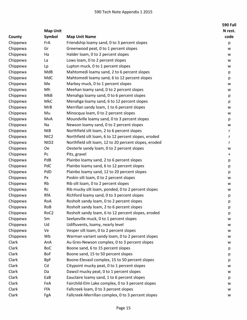
Chippewa Au Auburndale silt loam, 0 to 2 percent slopes w
Chippewa Be Beseman muck, 0 to 1 percent slopes w
Chippewa BlA Billett sandy loam, 0 to 2 percent slopes p
Chippewa BlB Billett sandy loam, 2 to 6 percent slopes p
Chippewa BlC2 Billett sandy loam, 6 to 12 percent slopes, eroded p
Chippewa BmA Billett sandy loam, moderately well drained, 0 to 3 percent slopes p
Chippewa BoE Boone fine sand, 20 to 45 percent slopes p
Chippewa BuA Burkhardt sandy loam, 0 to 3 percent slopes p
Chippewa Cb Cable silt loam, 0 to 2 percent slopes w
Chippewa CeA Caryville sandy loam, 0 to 3 percent slopes p
Chippewa CkD2 Chetek-Mahtomedi complex, 12 to 25 percent slopes, eroded p
Chippewa CkE Chetek-Mahtomedi complex, 25 to 40 percent slopes p
Chippewa DAM Dam, concrete +
Chippewa ElB Eleva sandy loam, 2 to 6 percent slopes p
Chippewa ElC2 Eleva sandy loam, 6 to 12 percent slopes, eroded p
Chippewa ElD2 Eleva sandy loam, 12 to 20 percent slopes, eroded p
Chippewa EmB Elkmound loam, 2 to 6 percent slopes r
Chippewa EmC2 Elkmound loam, 6 to 12 percent slopes, eroded r
Chippewa EmD2 Elkmound loam, 12 to 20 percent slopes, eroded r
Chippewa EmE Elkmound loam, 20 to 45 percent slopes r
Chippewa Eo Elm Lake loamy sand, 0 to 2 percent slopes w
Chippewa FaB Fallcreek sandy loam, 2 to 6 percent slopes w
Chippewa Fm Fordum loam, 0 to 2 percent slopes w
Page 14
590 Tech Note Appendix 1 2015
County
Map Unit
Symbol Map Unit Name
590 Fall
N rest.
code
Chippewa FrA Friendship loamy sand, 0 to 3 percent slopes p
Chippewa Gr Greenwood peat, 0 to 1 percent slopes w
Chippewa Ha Halder loam, 0 to 2 percent slopes w
Chippewa La Lows loam, 0 to 2 percent slopes w
Chippewa Lp Lupton muck, 0 to 1 percent slopes w
Chippewa MdB Mahtomedi loamy sand, 2 to 6 percent slopes p
Chippewa MdC Mahtomedi loamy sand, 6 to 12 percent slopes p
Chippewa Me Markey muck, 0 to 1 percent slopes w
Chippewa Mh Meehan loamy sand, 0 to 2 percent slopes w
Chippewa MkB Menahga loamy sand, 0 to 6 percent slopes p
Chippewa MkC Menahga loamy sand, 6 to 12 percent slopes p
Chippewa MrB Merrillan sandy loam, 1 to 6 percent slopes w
Chippewa Mu Minocqua loam, 0 to 2 percent slopes w
Chippewa MvA Moundville loamy sand, 0 to 3 percent slopes p
Chippewa Na Newson loamy sand, 0 to 2 percent slopes w
Chippewa NtB Northfield silt loam, 2 to 6 percent slopes r
Chippewa NtC2 Northfield silt loam, 6 to 12 percent slopes, eroded r
Chippewa NtD2 Northfield silt loam, 12 to 20 percent slopes, eroded r
Chippewa Oe Oesterle sandy loam, 0 to 2 percent slopes w
Chippewa Pc Pits, gravel +
Chippewa PdB Plainbo loamy sand, 2 to 6 percent slopes p
Chippewa PdC Plainbo loamy sand, 6 to 12 percent slopes p
Chippewa PdD Plainbo loamy sand, 12 to 20 percent slopes p
Chippewa Px Poskin silt loam, 0 to 2 percent slopes w
Chippewa Rb Rib silt loam, 0 to 2 percent slopes w
Chippewa Rc Rib mucky silt loam, ponded, 0 to 2 percent slopes w
Chippewa RfA Richford loamy sand, 0 to 3 percent slopes p
Chippewa RoA Rosholt sandy loam, 0 to 2 percent slopes p
Chippewa RoB Rosholt sandy loam, 2 to 6 percent slopes p
Chippewa RoC2 Rosholt sandy loam, 6 to 12 percent slopes, eroded p
Chippewa Sm Seelyeville muck, 0 to 1 percent slopes w
Chippewa Ud Udifluvents, loamy, nearly level w
Chippewa Ve Vesper silt loam, 0 to 2 percent slopes w
Chippewa Wb Warman variant sandy loam, 0 to 2 percent slopes w
Clark AnA Au Gres-Newson complex, 0 to 3 percent slopes w
Clark BoC Boone sand, 6 to 15 percent slopes p
Clark BoF Boone sand, 15 to 50 percent slopes p
Clark BpF Boone-Elevasil complex, 15 to 50 percent slopes p
Clark Cd Citypoint mucky peat, 0 to 1 percent slopes w
Clark Da Dawsil mucky peat, 0 to 1 percent slopes w
Clark EaB Eauclaire loamy sand, 1 to 6 percent slopes p
Clark FeA Fairchild-Elm Lake complex, 0 to 3 percent slopes w
Clark FfA Fallcreek loam, 0 to 3 percent slopes w
Clark FgA Fallcreek-Merrillan complex, 0 to 3 percent slopes w
Page 15

590 Tech Note Appendix 1 2015
County
Map Unit
Symbol Map Unit Name
590 Fall
N rest.
code
Clark Fm Fordum silt loam, 0 to 2 percent slopes w
Clark IxA Ironrun-Ponycreek complex, 0 to 3 percent slopes w
Clark IzB Ironrun-Ponycreek-Arbutus complex, 0 to 6 percent slopes p
Clark Lk Loxley peat, 0 to 1 percent slopes w
Clark Lm Loxley, Beseman, and Dawson peats 0 to 1 percent slopes w
Clark LuB Ludington sand, 1 to 6 percent slopes p
Clark LuC Ludington sand, 6 to 12 percent slopes p
Clark LxB Ludington-Fairchild sands, 0 to 6 percent slopes p
Clark LyD Ludington-Humbird complex, 12 to 20 percent slopes p
Clark MbB Mahtomedi loamy sand, 0 to 6 percent slopes p
Clark MbC Mahtomedi loamy sand, 6 to 12 percent slopes p
Clark McA Maplehurst silt loam, 0 to 3 percent slopes w
Clark Me Markey-Newson mucks, 0 to 2 percent slopes w
Clark MgB Menahga loamy sand, 0 to 6 percent slopes p
Clark MpA Merrillan fine sandy loam, 0 to 3 percent slopes w
Clark MrA Merrillan-Veedum complex, 0 to 3 percent slopes w
Clark MxA Moppet-Fordum complex, 0 to 3 percent slopes w
Clark NrF Northmound-Rock outcrop complex, 15 to 50 percent slopes, very stony r
Clark OeA Oesterle loam, 0 to 3 percent slopes w
Clark PeA Pelkie-Winterfield loamy fine sands, 0 to 3 percent slopes w
Clark Pg Pits p
Clark Pv Ponycreek-Dawsil complex, 0 to 2 percent slopes w
Clark PxA Poskin silt loam, 0 to 3 percent slopes w
Clark Py Psammaquents, nearly level w
Clark Rb Rib silt loam, 0 to 2 percent slopes w
Clark RkA Rockdam sand, 0 to 3 percent slopes p
Clark RoA Rosholt loamy sand, 0 to 2 percent slopes p
Clark RoB Rosholt sandy loam, 2 to 6 percent slopes p
Clark RoC Rosholt sandy loam, 6 to 12 percent slopes p
Clark ScA Simescreek sand, 0 to 3 percent slopes p
Clark TrB Tarr sand, 0 to 6 percent slopes p
Clark Ve Veedum silt loam, 0 to 2 percent slopes w
Clark Vs Veedum-Elm Lake mucks, 0 to 2 percent slopes w
Columbia Ad Adrian muck w
Columbia Af Alluvial land, sandy, wet w
Columbia Ah Alluvial land, loamy, wet w
Columbia BbA Barry loam, 0 to 3 percent slopes w
Columbia BnC Boone loamy fine sand, 6 to 12 percent slopes p
Columbia BnE Boone loamy fine sand, 12 to 45 percent slopes p
Columbia Bo Boots muck w
Columbia BpA Boyer loamy sand, 0 to 2 percent slopes p
Columbia BpB Boyer loamy sand, 2 to 6 percent slopes p
Columbia BpC2 Boyer loamy sand, 6 to 12 percent slopes, eroded p
Columbia BpD2 Boyer loamy sand, 12 to 30 percent slopes, eroded p
Page 16

590 Tech Note Appendix 1 2015
County
Map Unit
Symbol Map Unit Name
590 Fall
N rest.
code
Columbia BrA Boyer fine sandy loam, 0 to 2 percent slopes p
Columbia BrB Boyer fine sandy loam, 2 to 6 percent slopes p
Columbia ChB Chelsea loamy fine sand, 1 to 6 percent slopes p
Columbia ChC Chelsea loamy fine sand, 6 to 12 percent slopes p
Columbia CoA Colwood fine sandy loam, 0 to 3 percent slopes w
Columbia CP Coal pit +
Columbia DAM Dam concrete +
Columbia GaA Gilford fine sandy loam, stratified substratum, 0 to 3 percent slopes w
Columbia Gb Granby loamy sand w
Columbia GP Gravel pit +
Columbia Ho Houghton muck w
Columbia LDF Landfill +
Columbia Mb Marsh w
Columbia Mc Marshan loam w
Columbia NoB Northfield sandy loam, 2 to 6 percent slopes r
Columbia NoC Northfield sandy loam, 6 to 12 percent slopes r
Columbia NoE Northfield sandy loam, 12 to 30 percent slopes r
Columbia OkB Okee loamy fine sand, 2 to 6 percent slopes p
Columbia OkC Okee loamy fine sand, 6 to 12 percent slopes p
Columbia OmA Oshtemo loamy sand, 0 to 2 percent slopes p
Columbia OmB Oshtemo loamy sand, 2 to 6 percent slopes p
Columbia OmC2 Oshtemo loamy sand, 6 to 12 percent slopes, eroded p
Columbia OmD2 Oshtemo loamy sand, 12 to 20 percent slopes, eroded p
Columbia OsA Ossian silt loam, 0 to 3 percent slopes w
Columbia Ot Otter silt loam w
Columbia Pa Palms muck, 0 to 2 percent slopes w
Columbia PeC2 Plainfield sand, 2 to 12 percent slopes, eroded p
Columbia PfA Plainfield Loamy fine sand, 0 to 2 percent slopes p
Columbia PfB Plainfield Loamy fine sand, 2 to 6 percent slopes p
Columbia PfC Plainfield Loamy fine sand, 6 to12 percent slopes p
Columbia PfD Plainfield loamy fine sand, 12 to 25 percent slopes p
Columbia PkB Plainfield loamy fine sand, loamy substratum, 2 to 6 percent slopes p
Columbia PkC Plainfield loamy fine sand, loamy substratum, 6 to 12 percent slopes p
Columbia PkD Plainfield loamy fine sand, loamy substratum, 12 to 25 percent slopes p
Columbia PoA Poygan silt loam, 0 to 3 percent slopes w
Columbia QUA Quarry +
Columbia Rk Rock land r
Columbia RoC Rodman gravelly loam, 2 to 12 percent slopes p
Columbia RoD Rodman gravelly loam, 12 to 20 percent slopes p
Columbia RoE Rodman gravelly loam, 20 to 45 percent slopes p
Columbia SpB Sparta loamy fine sand, 1 to 6 percent slopes p
Columbia Wa Wacousta mucky silt loam w
Columbia Wb Wallkill silt loam w
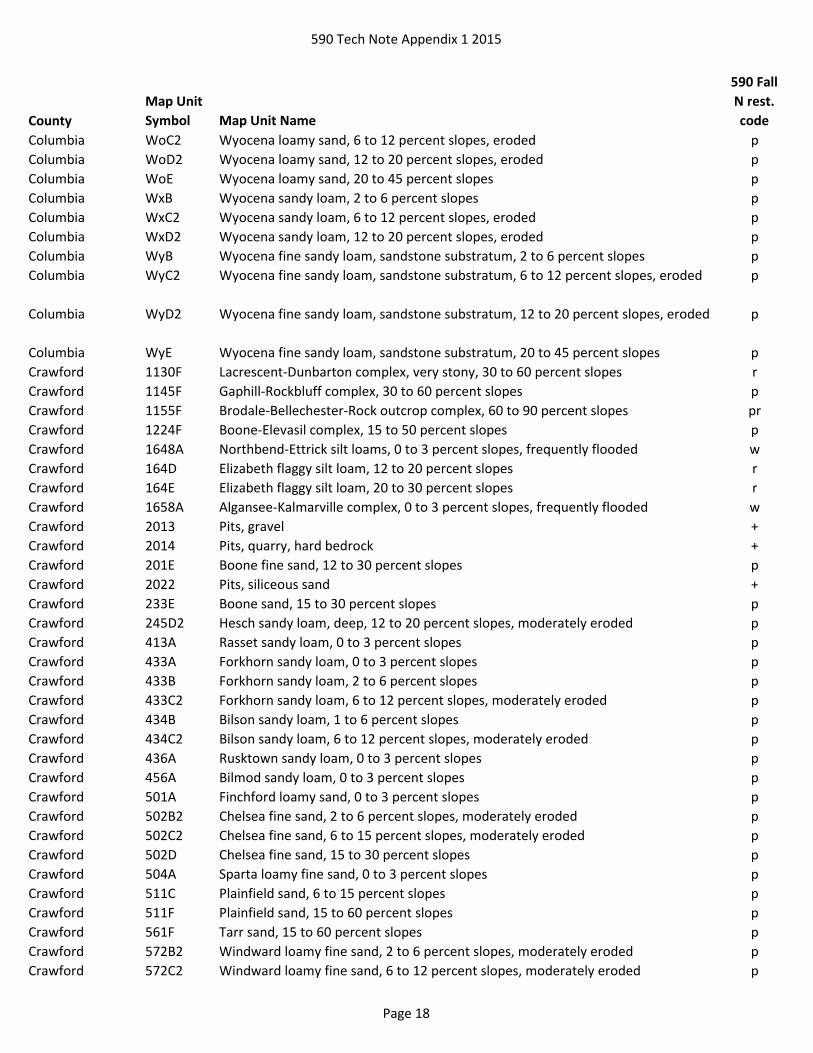
Columbia WoB Wyocena loamy sand, 2 to 6 percent slopes p
Page 17
590 Tech Note Appendix 1 2015
County
Map Unit
Symbol Map Unit Name
590 Fall
N rest.
code
Columbia WoC2 Wyocena loamy sand, 6 to 12 percent slopes, eroded p
Columbia WoD2 Wyocena loamy sand, 12 to 20 percent slopes, eroded p
Columbia WoE Wyocena loamy sand, 20 to 45 percent slopes p
Columbia WxB Wyocena sandy loam, 2 to 6 percent slopes p
Columbia WxC2 Wyocena sandy loam, 6 to 12 percent slopes, eroded p
Columbia WxD2 Wyocena sandy loam, 12 to 20 percent slopes, eroded p
Columbia WyB Wyocena fine sandy loam, sandstone substratum, 2 to 6 percent slopes p
Columbia WyC2 Wyocena fine sandy loam, sandstone substratum, 6 to 12 percent slopes, eroded p
Columbia WyD2 Wyocena fine sandy loam, sandstone substratum, 12 to 20 percent slopes, eroded p
Columbia WyE Wyocena fine sandy loam, sandstone substratum, 20 to 45 percent slopes p
Crawford 1130F Lacrescent-Dunbarton complex, very stony, 30 to 60 percent slopes r
Crawford 1145F Gaphill-Rockbluff complex, 30 to 60 percent slopes p
Crawford 1155F Brodale-Bellechester-Rock outcrop complex, 60 to 90 percent slopes pr
Crawford 1224F Boone-Elevasil complex, 15 to 50 percent slopes p
Crawford 1648A Northbend-Ettrick silt loams, 0 to 3 percent slopes, frequently flooded w
Crawford 164D Elizabeth flaggy silt loam, 12 to 20 percent slopes r
Crawford 164E Elizabeth flaggy silt loam, 20 to 30 percent slopes r
Crawford 1658A Algansee-Kalmarville complex, 0 to 3 percent slopes, frequently flooded w
Crawford 2013 Pits, gravel +
Crawford 2014 Pits, quarry, hard bedrock +
Crawford 201E Boone fine sand, 12 to 30 percent slopes p
Crawford 2022 Pits, siliceous sand +
Crawford 233E Boone sand, 15 to 30 percent slopes p
Crawford 245D2 Hesch sandy loam, deep, 12 to 20 percent slopes, moderately eroded p
Crawford 413A Rasset sandy loam, 0 to 3 percent slopes p
Crawford 433A Forkhorn sandy loam, 0 to 3 percent slopes p
Crawford 433B Forkhorn sandy loam, 2 to 6 percent slopes p
Crawford 433C2 Forkhorn sandy loam, 6 to 12 percent slopes, moderately eroded p
Crawford 434B Bilson sandy loam, 1 to 6 percent slopes p
Crawford 434C2 Bilson sandy loam, 6 to 12 percent slopes, moderately eroded p
Crawford 436A Rusktown sandy loam, 0 to 3 percent slopes p
Crawford 456A Bilmod sandy loam, 0 to 3 percent slopes p
Crawford 501A Finchford loamy sand, 0 to 3 percent slopes p
Crawford 502B2 Chelsea fine sand, 2 to 6 percent slopes, moderately eroded p
Crawford 502C2 Chelsea fine sand, 6 to 15 percent slopes, moderately eroded p
Crawford 502D Chelsea fine sand, 15 to 30 percent slopes p
Crawford 504A Sparta loamy fine sand, 0 to 3 percent slopes p
Crawford 511C Plainfield sand, 6 to 15 percent slopes p
Crawford 511F Plainfield sand, 15 to 60 percent slopes p
Crawford 561F Tarr sand, 15 to 60 percent slopes p
Crawford 572B2 Windward loamy fine sand, 2 to 6 percent slopes, moderately eroded p
Crawford 572C2 Windward loamy fine sand, 6 to 12 percent slopes, moderately eroded p
Page 18

590 Tech Note Appendix 1 2015
County
Map Unit
Symbol Map Unit Name
590 Fall
N rest.
code
Crawford 572D Windward loamy fine sand, 12 to 30 percent slopes p
Crawford 601C Beavercreek cobbly fine sandy loam, 3 to 12 percent slopes, occasionally flooded p
Crawford 629A Ettrick silt loam, 0 to 2 percent slopes, frequently flooded w
Crawford 646A Dunnbot fine sandy loam, 0 to 3 percent slopes, occasionally flooded p
Crawford 656A Scotah loamy fine sand, 0 to 3 percent slopes, occasionally flooded p
Dane 1130F Lacrescent-Dunbarton complex, very stony, 30 to 60 percent slopes r
Dane 1145F Gaphill-Rockbluff complex, 30 to 60 percent slopes p
Dane 1180B2 Dubuque, clayey substratum-Dunbarton complex, 2 to 6 percent slopes, moderately
eroded
r
Dane 1180C2 Dubuque, clayey substratum-Dunbarton complex, 6 to 12 percent slopes,
moderately eroded
r
Dane 1180D2 Dubuque, clayey substratum-Dunbarton complex, 12 to 20 percent slopes,
moderately eroded
r
Dane 1180E Dubuque-Dunbarton, very stony, complex, 20 to 30 percent slopes, very rocky r
Dane 1180F Dubuque-Dunbarton, very stony, complex, 30 to 45 percent slopes, very rocky r
Dane 1195F Elkmound-Northfield complex, 30 to 60 percent slopes, very rocky r
Dane Ad Adrian muck w
Dane Af Alluvial land, wet w
Dane BoB Boyer sandy loam, 2 to 6 percent slopes p
Dane BoC2 Boyer sandy loam, 6 to 12 percent slopes, eroded p
Dane BoD2 Boyer sandy loam, 12 to 20 percent slopes, eroded p
Dane BrA Brems loamy sand p
Dane Co Colwood silt loam, 0 to 2 percent slopes w
Dane DkA Dickinson sandy loam, 0 to 2 percent slopes p
Dane DkB Dickinson sandy loam, 2 to 6 percent slopes p
Dane DkC Dickinson sandy loam, 6 to 12 percent slopes p
Dane DmA Dickinson loamy fine sand, sandy variant, 1 to 4 percent slopes p
Dane DuB2 Dunbarton silt loam, 2 to 6 percent slopes, eroded r
Dane DuC2 Dunbarton silt loam, 6 to 12 percent slopes, eroded r
Dane DuD2 Dunbarton silt loam, 12 to 20 percent slopes, eroded r
Dane DuE2 Dunbarton silt loam, 20 to 30 percent slopes, eroded r
Dane EdB2 Edmund silt loam, 2 to 6 percent slopes, eroded r
Dane EdC2 Edmund silt loam, 6 to 12 percent slopes, eroded r
Dane EdD2 Edmund silt loam, 12 to 20 percent slopes, eroded r
Dane EmC2 Elkmound sandy loam, 6 to 12 percent slopes, eroded r
Dane EmD2 Elkmound sandy loam, 12 to 20 percent slopes, eroded r
Dane EmE2 Elkmound sandy loam, 20 to 30 percent slopes, eroded r
Dane EmF Elkmound sandy loam, 30 to 60 percent slopes r
Dane Ev Elvers silt loam w
Dane Gn Granby loamy sand w
Dane GP Gravel pit +
Page 19
590 Tech Note Appendix 1 2015
County
Map Unit
Symbol Map Unit Name
590 Fall
N rest.
code
Dane Ho Houghton muck w
Dane LDF Landfill +
Dane Mb Marsh w
Dane Mc Marshan silt loam w
Dane MoA Montgomery silty clay loam, 0 to 3 percent slopes w
Dane Os Orion silt loam, wet w
Dane Ot Otter silt loam w
Dane Pa Palms muck, 0 to 2 percent slopes w
Dane PfB Plainfield sand, 1 to 6 percent slopes p
Dane QUA Quarry +
Dane RpE Rodman sandy loam, 12 to 35 percent slopes p
Dane SaA Sable silty clay loam, 0 to 2 percent slopes w
Dane SoD Sogn silt loam, 2 to 20 percent slopes r
Dane SoE Sogn silt loam, 20 to 35 percent slopes r
Dane SpB Spinks and Plainfield loamy sands, 2 to 6 percent slopes p
Dane SpC Spinks and Plainfield loamy sands, 6 to 12 percent slopes p
Dane SpD Spinks and Plainfield loamy sands, 12 to 25 percent slopes p
Dane Wa Wacousta silty clay loam, 0 to 2 percent slopes w
Dane Wt Watseka loamy sand p
Dodge Ar Adrian variant muck w
Dodge BsA Brookston silt loam, 0 to 3 percent slopes w
Dodge CdB Channahon silt loam, 1 to 6 percent slopes r
Dodge ChB Chelsea loamy fine sand, 2 to 6 percent slopes p
Dodge ChC Chelsea loamy fine sand, 6 to 18 percent slopes p
Dodge Co Colwood silty clay loam w
Dodge Ev Elvers silt loam w
Dodge Fu Fluvaquents w
Dodge Gb Granby variant fine sandy loam w
Dodge Hu Houghton muck w
Dodge Hw Houghton muck, ponded w
Dodge Ke Keowns silt loam w
Dodge LDF Landfill +
Dodge Ot Otter silt loam w
Dodge Pa Palms muck, 0 to 2 percent slopes w
Dodge Ph Pella silty clay loam, cool, 0 to 2 percent slopes w
Dodge Pn Pits +
Dodge RcE Rock outcrop-Channahon complex, 5 to 30 percent slopes r
Dodge RxC2 Rodman-Casco complex, 6 to 12 percent slopes, eroded p
Dodge RxD2 Rodman-Casco complex, 12 to 30 percent slopes, eroded p
Dodge Sk Saprists and Aquents w
Dodge Sm Sebewa silt loam w
Door AdA Allendale loamy sand, 0 to 3 percent slopes w
Door ApC Alpena gravelly sandy loam, 0 to 12 percent slopes p
Door Ax Angelica loam w
Page 20

590 Tech Note Appendix 1 2015
County
Map Unit
Symbol Map Unit Name
590 Fall
N rest.
code
Door Be Beaches w
Door Bn Bonduel loam w
Door Bo Bonduel variant fine sandy loam, shallow wr
Door Bp Bonduel variant loam, wet w
Door BrB Boyer loamy sand, 2 to 6 percent slopes p
Door BrC Boyer loamy sand, 6 to 12 percent slopes p
Door BrD Boyer loamy sand, 12 to 20 percent slopes p
Door Ca Carbondale muck w
Door Cm Cathro muck w
Door Cp Chippeny muck w
Door De Deford loamy fine sand w
Door DuB Duel loamy sand, 1 to 6 percent slopes p
Door Dv Duel variant sandy loam w
Door Fa Fabius silt loam w
Door Fu Fluvaquents w
Door Gp Gravel pits +
Door KvB Kolberg variant loam, 1 to 6 percent slopes r
Door KvC2 Kolberg variant loam, 6 to 12 percent slopes, eroded r
Door LDF Landfill +
Door MeB Manistee loamy sand, 2 to 6 percent slopes p
Door Mk Markey muck w
Door NaB Namur loam, 0 to 6 percent slopes r
Door NaC Namur loam, 6 to 12 percent slopes r
Door Nv Namur variant loam r
Door Pn Pinconning loamy fine sand w
Door Po Poygan silty clay loam, 0 to 2 percent slopes, drained w
Door QUA Quarry +
Door Ra Rock outcrop r
Door Rb Rock outcrop-Namur complex, 6 to 20 percent slopes r
Door Rn Rondeau muck w
Door RoB Rousseau fine sand, 2 to 6 percent slopes p
Door RoC Rousseau fine sand, 6 to 12 percent slopes p
Door RpC Rousseau-Shawano fine sands, 2 to 12 percent slopes p
Door RpD Rousseau-Shawano fine sands, 12 to 35 percent slopes p
Door RrB Rousseau-Deford fine sands, 2 to 6 percent slopes wp
Door Sa Saprists w
Door SoA Solona loam, 0 to 3 percent slopes w
Door Su Suamico muck w
Door SvA Summerville loam, 0 to 2 percent slopes r
Door SvB Summerville loam, 2 to 6 percent slopes r
Door SvC Summerville loam, 6 to 12 percent slopes r
Door SvD Summerville loam, 12 to 20 percent slopes r
Door Ud Udipsamments p
Door Uo Udorthents, cobbly p
Page 21

590 Tech Note Appendix 1 2015
County
Map Unit
Symbol Map Unit Name
590 Fall
N rest.
code
Door Yv Yahara variant silt loam w
Douglas 100B Menahga sand, 0 to 6 percent slopes p
Douglas 100C Menahga sand, 6 to 12 percent slopes p
Douglas 100D Menahga sand, 12 to 30 percent slopes p
Douglas 12A Makwa stony muck, 0 to 1 percent slopes, extremely stony, frequently flooded w
Douglas 1670C Keweenaw, stony-Newood, stony-Cathro complex, 0 to 15 percent slopes p
Douglas 174B Rubicon sand, 0 to 6 percent slopes p
Douglas 174C Rubicon sand, 6 to 15 percent slopes p
Douglas 174D Rubicon sand, 15 to 30 percent slopes p
Douglas 174F Rubicon sand, 30 to 60 percent slopes p
Douglas 1884B Springstead, stony-Markey complex, 0 to 6 percent slopes p
Douglas 1885B Springstead, stony-Cathro complex, 0 to 6 percent slopes p
Douglas 193A Minocqua muck, 0 to 2 percent slopes w
Douglas 2014 Pits, quarry, hard bedrock +
Douglas 2015 Pits +
Douglas 2030 Udorthents and Udipsamments, cut or fill +
Douglas 2050 Landfill +
Douglas 205C Keweenaw loamy sand, 6 to 15 percent slopes, stony p
Douglas 205D Keweenaw loamy sand, 15 to 30 percent slopes, stony p
Douglas 205E Keweenaw loamy sand, 30 to 45 percent slopes, stony p
Douglas 215B Pence sandy loam, 0 to 6 percent slopes p
Douglas 215C Pence sandy loam, 6 to 15 percent slopes p
Douglas 215D Pence sandy loam, 15 to 30 percent slopes p
Douglas 217B Karlin loamy fine sand, 0 to 6 percent slopes p
Douglas 309C Metonga-Rock outcrop complex, 6 to 20 percent slopes r
Douglas 309E Metonga-Rock outcrop complex, 20 to 45 percent slopes r
Douglas 3114A Saprists, aquents, and aquepts, 0 to 1 percent slopes, ponded, flooded w
Douglas 3126A Wurtsmith loamy sand, 0 to 3 percent slopes p
Douglas 3244A Brimley fine sandy loam, 0 to 3 percent slopes w
Douglas 3247A Bruce silt loam, 0 to 2 percent slopes w
Douglas 3276A Au Gres loamy sand, 0 to 3 percent slopes w
Douglas 339B Rousseau loamy fine sand, 0 to 6 percent slopes p
Douglas 339C Rousseau loamy fine sand, 6 to 15 percent slopes p
Douglas 339D Rousseau loamy fine sand, 15 to 30 percent slopes p
Douglas 3403A Loxley, Beseman, and Dawson soils, 0 to 1 percent slopes w
Douglas 3423A Rifle peat, 0 to 1 percent slopes w
Douglas 3424C Frogcreek-Magroc-Stinnett complex, 0 to 15 percent slopes, very stony, rocky r
Douglas 3446A Newson muck, 0 to 2 percent slopes w
Douglas 3448B Grettum loamy sand, 0 to 6 percent slopes p
Douglas 3448C Grettum loamy sand, 6 to 12 percent slopes p
Douglas 3454B Odanah-Cornucopia complex, 2 to 6 percent slopes w
Douglas 3510B Pomroy-Fremstadt-Fremstadt, stony complex, 1 to 6 percent slopes p
Page 22

590 Tech Note Appendix 1 2015
County
Map Unit
Symbol Map Unit Name
590 Fall
N rest.
code
Douglas 3510C Pomroy-Fremstadt-Fremstadt, stony complex, 6 to 15 percent slopes p
Douglas 3547B Newood-Pence complex, 1 to 6 percent slopes, very stony p
Douglas 3601C Ishpeming-Rock outcrop complex, 5 to 20 percent slopes, very stony pr
Douglas 3676A Au Gres sand, 0 to 3 percent slopes w
Douglas 371A Croswell loamy sand, 0 to 3 percent slopes p
Douglas 375A Robago fine sandy loam, lake terrace, 0 to 3 percent slopes w
Douglas 383B Mahtomedi loamy sand, 0 to 6 percent slopes p
Douglas 383C Mahtomedi loamy sand, 6 to 12 percent slopes p
Douglas 383D Mahtomedi loamy sand, 12 to 30 percent slopes p
Douglas 384B Springstead sandy loam, 1 to 6 percent slopes, stony p
Douglas 385B Springstead loamy sand, 1 to 6 percent slopes, stony p
Douglas 388B Pelkie, occasionally flooded-Dechamps, frequently flooded complex, 0 to 4 percent
slopes
wp
Douglas 392C Rockmarsh-Dairyland-Makwa, seeped, complex, 2 to 20 percent slopes, very stony p
Douglas 396B Friendship-Wurtsmith-Grayling complex, 0 to 6 percent slopes p
Douglas 399B Grayling sand, 0 to 6 percent slopes p
Douglas 399C Grayling sand, 6 to 12 percent slopes p
Douglas 399D Grayling sand, 12 to 30 percent slopes p
Douglas 3A Totagatic-Bowstring-Ausable complex, 0 to 2 percent slopes, frequently flooded w
Douglas 405A Lupton, Cathro, and Tawas soils, 0 to 1 percent slopes w
Douglas 406A Loxley mucky peat, 0 to 1 percent slopes w
Douglas 407A Seelyeville and Markey soils, 0 to 1 percent slopes w
Douglas 419A Seelyeville, Cathro, and Markey soils, 0 to 1 percent slopes w
Douglas 426B Emmert-Mahtomedi-Menahga complex, 2 to 6 percent slopes p
Douglas 426C Emmert-Mahtomedi-Menahga complex, 6 to 12 percent slopes p
Douglas 426D Emmert-Mahtomedi-Menahga complex, 12 to 30 percent slopes p
Douglas 439B Graycalm-Menahga complex, 0 to 6 percent slopes p
Douglas 439C Graycalm-Menahga complex, 6 to 12 percent slopes p
Douglas 439D Graycalm-Menahga complex, 12 to 30 percent slopes p
Douglas 445A Kinross muck, 0 to 2 percent slopes w
Douglas 461A Bowstring muck, 0 to 1 percent slopes, frequently flooded w
Douglas 469E Bigisland-Milaca complex, 15 to 45 percent slopes, very stony p
Douglas 471B Dairyland-Emmert complex, 0 to 6 percent slopes, very stony p
Douglas 471C Dairyland-Emmert complex, 6 to 15 percent slopes, very stony p
Douglas 473A Dairyland-Skog complex, 0 to 3 percent slopes, very stony, rarely flooded p
Douglas 475B Rubicon-Sayner complex, 0 to 6 percent slopes p
Douglas 475C Rubicon-Sayner complex, 6 to 15 percent slopes p
Douglas 475D Rubicon-Sayner complex, 15 to 30 percent slopes p
Douglas 485C Lupton and Tawas soils, seeped, 2 to 15 percent slopes w
Douglas 495B Karlsborg-Grettum-Perida complex, 1 to 6 percent slopes p
Douglas 495C Karlsborg-Grettum-Perida complex, 6 to 12 percent slopes p
Douglas 500A Croswell sand, 0 to 3 percent slopes p
Page 23

590 Tech Note Appendix 1 2015
County
Map Unit
Symbol Map Unit Name
590 Fall
N rest.
code
Douglas 500B Croswell sand, 0 to 6 percent slopes p
Douglas 514B Iosco loamy sand, 0 to 4 percent slopes w
Douglas 524E Rock outcrop-Frogcreek-Metonga complex, 2 to 45 percent slopes, very stony r
Douglas 544F Menahga and Mahtomedi soils, 30 to 45 percent slopes p
Douglas 555A Fordum silt loam, 0 to 2 percent slopes, frequently flooded w
Douglas 574B Sayner loamy sand, 0 to 6 percent slopes p
Douglas 574C Sayner loamy sand, 6 to 15 percent slopes p
Douglas 574E Sayner loamy sand, 15 to 45 percent slopes p
Douglas 591A Croswell-Chinwhisker complex, 0 to 3 percent slopes p
Douglas 5A Arnheim mucky silt loam, 0 to 1 percent slopes, frequently flooded w
Douglas 600A Haplosaprists and Psammaquents, 0 to 2 percent slopes w
Douglas 604C Amnicon-Rock outcrop complex, 2 to 15 percent slopes r
Douglas 634C Drylanding-Beartree complex, 0 to 12 percent slopes, rocky wr
Douglas 635C Drylanding-Beartree complex, 0 to 12 percent slopes, rocky, rarely flooded wr
Douglas 639A Neconish loamy fine sand, 0 to 3 percent slopes p
Douglas 64A Totagatic-Winterfield complex, 0 to 2 percent slopes, frequently flooded w
Douglas 669D Fremstadt, stony-Pomroy complex, 15 to 30 percent slopes p
Douglas 670C Keweenaw-Pence complex, 6 to 15 percent slopes, stony p
Douglas 670E Keweenaw-Pence complex, 15 to 45 percent slopes, stony p
Douglas 674B Sultz sand, 0 to 6 percent slopes p
Douglas 674C Sultz sand, 6 to 15 percent slopes p
Douglas 674E Sultz sand, 15 to 45 percent slopes p
Douglas 675A Robago fine sandy loam, 0 to 3 percent slopes w
Douglas 678B Springstead-Parkfalls complex, 0 to 6 percent slopes, very stony p
Douglas 69B Keweenaw-Sayner-Vilas complex, 2 to 6 percent slopes, stony p
Douglas 69C Keweenaw-Sayner-Vilas complex, 6 to 15 percent slopes, stony p
Douglas 69E Keweenaw-Sayner-Vilas complex, 15 to 45 percent slopes, stony p
Douglas 705B Cublake-Croswell-Ashwabay complex, 0 to 6 percent slopes p
Douglas 706A Winterfield-Totagatic complex, 0 to 2 percent slopes, frequently flooded w
Douglas 713B Kellogg-Allendale-Ashwabay complex, 2 to 6 percent slopes p
Douglas 713C Kellogg-Allendale-Ashwabay complex, 6 to 15 percent slopes p
Douglas 724A Rib-Rock outcrop complex, 0 to 2 percent slopes wr
Douglas 728C Springstead-Parkfalls-Metonga complex, 0 to 15 percent slopes, very stony p
Douglas 74B Vilas loamy sand, 0 to 6 percent slopes p
Douglas 74C Vilas loamy sand, 6 to 15 percent slopes p
Douglas 74D Vilas loamy sand, 15 to 30 percent slopes p
Douglas 771A Lenroot loamy sand, 0 to 3 percent slopes p
Douglas 805E Sultz-Ashwabay-Rubicon complex, 15 to 45 percent slopes p
Douglas 813E Manistee-Kellogg-Ashwabay complex, 15 to 45 percent slopes p
Douglas 815A Wormet sandy loam, 0 to 3 percent slopes w
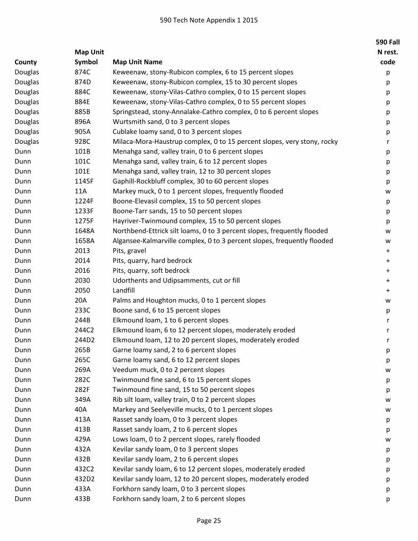
Douglas 874B Keweenaw, stony-Rubicon complex, 0 to 6 percent slopes p
Page 24
590 Tech Note Appendix 1 2015
County
Map Unit
Symbol Map Unit Name
590 Fall
N rest.
code
Douglas 874C Keweenaw, stony-Rubicon complex, 6 to 15 percent slopes p
Douglas 874D Keweenaw, stony-Rubicon complex, 15 to 30 percent slopes p
Douglas 884C Keweenaw, stony-Vilas-Cathro complex, 0 to 15 percent slopes p
Douglas 884E Keweenaw, stony-Vilas-Cathro complex, 0 to 55 percent slopes p
Douglas 885B Springstead, stony-Annalake-Cathro complex, 0 to 6 percent slopes p
Douglas 896A Wurtsmith sand, 0 to 3 percent slopes p
Douglas 905A Cublake loamy sand, 0 to 3 percent slopes p
Douglas 928C Milaca-Mora-Haustrup complex, 0 to 15 percent slopes, very stony, rocky r
Dunn 101B Menahga sand, valley train, 0 to 6 percent slopes p
Dunn 101C Menahga sand, valley train, 6 to 12 percent slopes p
Dunn 101E Menahga sand, valley train, 12 to 30 percent slopes p
Dunn 1145F Gaphill-Rockbluff complex, 30 to 60 percent slopes p
Dunn 11A Markey muck, 0 to 1 percent slopes, frequently flooded w
Dunn 1224F Boone-Elevasil complex, 15 to 50 percent slopes p
Dunn 1233F Boone-Tarr sands, 15 to 50 percent slopes p
Dunn 1275F Hayriver-Twinmound complex, 15 to 50 percent slopes p
Dunn 1648A Northbend-Ettrick silt loams, 0 to 3 percent slopes, frequently flooded w
Dunn 1658A Algansee-Kalmarville complex, 0 to 3 percent slopes, frequently flooded w
Dunn 2013 Pits, gravel +
Dunn 2014 Pits, quarry, hard bedrock +
Dunn 2016 Pits, quarry, soft bedrock +
Dunn 2030 Udorthents and Udipsamments, cut or fill +
Dunn 2050 Landfill +
Dunn 20A Palms and Houghton mucks, 0 to 1 percent slopes w
Dunn 233C Boone sand, 6 to 15 percent slopes p
Dunn 244B Elkmound loam, 1 to 6 percent slopes r
Dunn 244C2 Elkmound loam, 6 to 12 percent slopes, moderately eroded r
Dunn 244D2 Elkmound loam, 12 to 20 percent slopes, moderately eroded r
Dunn 265B Garne loamy sand, 2 to 6 percent slopes p
Dunn 265C Garne loamy sand, 6 to 12 percent slopes p
Dunn 269A Veedum muck, 0 to 2 percent slopes w
Dunn 282C Twinmound fine sand, 6 to 15 percent slopes p
Dunn 282F Twinmound fine sand, 15 to 50 percent slopes p
Dunn 349A Rib silt loam, valley train, 0 to 2 percent slopes w
Dunn 40A Markey and Seelyeville mucks, 0 to 1 percent slopes w
Dunn 413A Rasset sandy loam, 0 to 3 percent slopes p
Dunn 413B Rasset sandy loam, 2 to 6 percent slopes p
Dunn 429A Lows loam, 0 to 2 percent slopes, rarely flooded w
Dunn 432A Kevilar sandy loam, 0 to 3 percent slopes p
Dunn 432B Kevilar sandy loam, 2 to 6 percent slopes p
Dunn 432C2 Kevilar sandy loam, 6 to 12 percent slopes, moderately eroded p
Dunn 432D2 Kevilar sandy loam, 12 to 20 percent slopes, moderately eroded p
Dunn 433A Forkhorn sandy loam, 0 to 3 percent slopes p
Dunn 433B Forkhorn sandy loam, 2 to 6 percent slopes p
Page 25

590 Tech Note Appendix 1 2015
County
Map Unit
Symbol Map Unit Name
590 Fall
N rest.
code
Dunn 433C2 Forkhorn sandy loam, 6 to 12 percent slopes, moderately eroded p
Dunn 433D2 Forkhorn sandy loam, 12 to 20 percent slopes, moderately eroded p
Dunn 434B Bilson sandy loam, 1 to 6 percent slopes p
Dunn 436A Rusktown sandy loam, 0 to 3 percent slopes p
Dunn 453A Burkhardt sandy loam, 0 to 3 percent slopes p
Dunn 453B Burkhardt sandy loam, 2 to 6 percent slopes p
Dunn 454B Chetek sandy loam, kame terrace, 2 to 6 percent slopes p
Dunn 454C2 Chetek sandy loam, kame terrace, 6 to 12 percent slopes, moderately eroded p
Dunn 454D2 Chetek sandy loam, kame terrace, 12 to 20 percent slopes, moderately eroded p
Dunn 454E Chetek sandy loam, kame terrace, 20 to 35 percent slopes p
Dunn 45A Seelyeville and Cathro mucks, valley train, 0 to 1 percent slopes w
Dunn 501A Finchford loamy sand, 0 to 3 percent slopes p
Dunn 501B Finchford loamy sand, 2 to 6 percent slopes p
Dunn 502B2 Chelsea fine sand, 2 to 6 percent slopes, moderately eroded p
Dunn 502C2 Chelsea fine sand, 6 to 15 percent slopes, moderately eroded p
Dunn 506A Komro loamy sand, 0 to 3 percent slopes p
Dunn 510B Boplain sand, 0 to 6 percent slopes p
Dunn 510C Boplain sand, 6 to 15 percent slopes p
Dunn 511A Plainfield sand, 0 to 3 percent slopes p
Dunn 511B Plainfield sand, 2 to 6 percent slopes p
Dunn 511C Plainfield sand, 6 to 15 percent slopes p
Dunn 511F Plainfield sand, 15 to 60 percent slopes p
Dunn 512B Drammen loamy sand, 1 to 6 percent slopes p
Dunn 512C Drammen loamy sand, 6 to 12 percent slopes p
Dunn 512D Drammen loamy sand, 12 to 20 percent slopes p
Dunn 516A Aldo sand, 0 to 3 percent slopes p
Dunn 546A Prissel loamy sand, 0 to 3 percent slopes p
Dunn 546B Prissel loamy sand, 2 to 6 percent slopes p
Dunn 546C Prissel loamy sand, 6 to 15 percent slopes p
Dunn 546F Prissel loamy sand, 15 to 60 percent slopes p
Dunn 555A Fordum silt loam, 0 to 2 percent slopes, frequently flooded w
Dunn 561B Tarr sand, 1 to 6 percent slopes p
Dunn 566A Tint sand, 0 to 3 percent slopes p
Dunn 573B Plainbo sand, sand sheet, 0 to 6 percent slopes p
Dunn 573C Plainbo sand, sand sheet, 6 to 15 percent slopes p
Dunn 589A Newson mucky loamy sand, 0 to 2 percent slopes w
Dunn 601C Beavercreek cobbly fine sandy loam, 3 to 12 percent slopes, occasionally flooded p
Dunn 619A Vancecreek silt loam, 0 to 2 percent slopes, frequently flooded w
Dunn 629A Ettrick silt loam, 0 to 2 percent slopes, frequently flooded w
Dunn 646A Dunnbot fine sandy loam, 0 to 3 percent slopes, occasionally flooded p
Dunn 656A Scotah loamy fine sand, 0 to 3 percent slopes, occasionally flooded p
Page 26

590 Tech Note Appendix 1 2015
County
Map Unit
Symbol Map Unit Name
590 Fall
N rest.
code
Eau Claire Ad Adrian muck w
Eau Claire Af Alluvial land, wet w
Eau Claire Au Au Gres loamy sand w
Eau Claire BlB Billett sandy loam, 1 to 6 percent slopes p
Eau Claire BlC2 Billett sandy loam, 6 to 12 percent slopes, eroded p
Eau Claire BlD2 Billett sandy loam, 12 to 20 percent slopes, eroded p
Eau Claire BmA Billett sandy loam, moderately well drained, 0 to 3 percent slopes p
Eau Claire BoB Boone-Plainbo complex, 2 to 6 percent slopes p
Eau Claire BoC Boone-Plainbo complex, 6 to 12 percent slopes p
Eau Claire BoE Boone-Plainbo complex, 12 to 45 percent slopes p
Eau Claire BP Borrow pit +
Eau Claire BuA Burkhardt sandy loam, 0 to 3 percent slopes p
Eau Claire CeA Caryville loam, 0 to 3 percent slopes p
Eau Claire DuA Dunnville sandy loam, 0 to 3 percent slopes p
Eau Claire EmB Elkmound loam, 2 to 6 percent slopes r
Eau Claire EmC2 Elkmound loam, 6 to 12 percent slopes, eroded r
Eau Claire EmD2 Elkmound loam, 12 to 20 percent slopes, eroded r
Eau Claire EmE Elkmound loam, 20 to 45 percent slopes r
Eau Claire Eo Elm Lake loamy sand w
Eau Claire Er Ettrick silt loam w
Eau Claire FrA Friendship loamy sand, 0 to 3 percent slopes p
Eau Claire GoB Gotham loamy sand, 1 to 6 percent slopes p
Eau Claire GoC2 Gotham loamy sand, 6 to 12 percent slopes, eroded p
Eau Claire GP Gravel pit +
Eau Claire GsB Gotham loamy sand, sandstone substratum, 2 to 6 percent slopes p
Eau Claire GsC2 Gotham loamy sand, sandstone substratum, 6 to 12 percent slopes, eroded p
Eau Claire Ho Houghton muck w
Eau Claire La Lows loam w
Eau Claire LDF Landfill +
Eau Claire LuB Ludington and Humbird soils, 2 to 6 percent slopes p
Eau Claire LuC Ludington and Humbird soils, 6 to 12 percent slopes p
Eau Claire Ma Markey muck w
Eau Claire Mc Marshan loam w
Eau Claire MdB Menahga sand, 1 to 6 percent slopes p
Eau Claire MdC Menahga sand, 6 to 12 percent slopes p
Eau Claire Na Newson loamy sand w
Eau Claire NtB Northfield silt loam, 2 to 6 percent slopes r
Eau Claire NtC2 Northfield silt loam, 6 to 12 percent slopes, eroded r
Eau Claire NtD2 Northfield silt loam, 12 to 20 percent slopes, eroded r
Eau Claire NtE2 Northfield silt loam, 20 to 30 percent slopes, eroded r
Eau Claire NtF Northfield silt loam, 30 to 45 percent slopes r
Eau Claire Or Otter silt loam, overwash w
Eau Claire PdB Plainbo loamy sand, 2 to 6 percent slopes p
Page 27

590 Tech Note Appendix 1 2015
County
Map Unit
Symbol Map Unit Name
590 Fall
N rest.
code
Eau Claire PdC2 Plainbo loamy sand, 6 to 12 percent slopes, eroded p
Eau Claire PfB Plainfield loamy sand, 1 to 6 percent slopes p
Eau Claire PfC2 Plainfield loamy sand, 6 to 12 percent slopes, eroded p
Eau Claire PlB Plainfield loamy sand, loamy substratum, 1 to 6 percent slopes p
Eau Claire PlC2 Plainfield loamy sand, loamy substratum, 6 to 12 percent slopes, eroded p
Eau Claire Pw Psammaquents w
Eau Claire QUA Quarry +
Eau Claire Re Riverwash w
Eau Claire SpB Sparta loamy sand, 1 to 6 percent slopes p
Eau Claire SPO Spoil area +
Eau Claire Tn Terrace escarpments, sandy p
Eau Claire TrB Trempe loamy sand, 1 to 6 percent slopes p
Eau Claire Vd Veedum silt loam w
Eau Claire Ve Vesper loam w
Eau Claire VlB Vilas sand, 1 to 6 percent slopes p
Florence Au Au Gres loamy sand, 0 to 2 percent slopes w
Florence CrA Croswell loamy sand, 0 to 3 percent slopes p
Florence EnC Ellwood-Iosco-Vilas complex, 0 to 15 percent slopes p
Florence EoD Ellwood-Vilas-Padus complex, 10 to 30 percent slopes p
Florence Fm Fordum loam, 0 to 2 percent slopes w
Florence IsA Iosco loamy fine sand, 0 to 3 percent slopes w
Florence Kr Kinross muck, 0 to 2 percent slopes w
Florence Lo Loxley, Beseman, and Dawson peats, 0 to 1 percent slopes w
Florence Lu Lupton and Cathro soils, 0 to 1 percent slopes w
Florence Mn Minocqua muck, 0 to 2 percent slopes w
Florence PeB Padus-Pence sandy loams, 0 to 6 percent slopes p
Florence PeC Padus-Pence sandy loams, 6 to 15 percent slopes p
Florence PeD Padus-Pence sandy loams, 15 to 35 percent slopes p
Florence PnB Pence sandy loam, 0 to 6 percent slopes p
Florence PnC Pence sandy loam, 6 to 15 percent slopes p
Florence PnD Pence sandy loam, 15 to 35 percent slopes p
Florence PsB Pence-Vilas complex, 0 to 6 percent slopes p
Florence PsC Pence-Vilas complex, 6 to 15 percent slopes p
Florence PsD Pence-Vilas complex, 15 to 35 percent slopes p
Florence Pt Pits, gravel +
Florence Px Pits, mine +
Florence Rb Robago fine sandy loam, 0 to 2 percent slopes w
Florence RkC Rock outcrop-Ishpeming-Vilas complex, 1 to 15 percent slopes pr
Florence RkD Rock outcrop-Ishpeming-Vilas complex, 15 to 35 percent slopes pr
Florence RmC Rock outcrop-Metonga-Sarona complex, 1 to 15 percent slopes r
Florence RmD Rock outcrop-Metonga-Sarona complex, 15 to 35 percent slopes r
Florence RsB Rousseau loamy fine sand, 0 to 6 percent slopes p
Florence RsC Rousseau loamy fine sand, 6 to 15 percent slopes p
Florence SlB Sarona-Vilas complex, 0 to 6 percent slopes, very stony p
Page 28

590 Tech Note Appendix 1 2015
County
Map Unit
Symbol Map Unit Name
590 Fall
N rest.
code
Florence SlC Sarona-Vilas complex, 6 to 15 percent slopes, very stony p
Florence SlD Sarona-Vilas complex, 15 to 30 percent slopes, very stony p
Florence SnB Sayner loamy sand, 0 to 6 percent slopes p
Florence SnC Sayner loamy sand, 6 to 15 percent slopes p
Florence SnD Sayner loamy sand, 15 to 30 percent slopes p
Florence VsB Vilas loamy sand, 0 to 6 percent slopes p
Florence VsC Vilas loamy sand, 6 to 15 percent slopes p
Florence VsD Vilas loamy sand, 15 to 30 percent slopes p
Florence WrA Worcester sandy loam, 0 to 3 percent slopes w
Fond du Lac Ak Adrian mucky peat w
Fond du Lac Am Alluvial land w
Fond du Lac An Alluvial land, wet w
Fond du Lac AtA Ashkum silty clay loam, 0 to 3 percent slopes w
Fond du Lac BP Borrow area +
Fond du Lac BsA Brookston silt loam, 0 to 3 percent slopes w
Fond du Lac BtA Brookston stony silt loam, 0 to 3 percent slopes w
Fond du Lac BuA Brookston silty clay loam, 0 to 3 percent slopes w
Fond du Lac Ca Carbondale mucky peat w
Fond du Lac CpC2 Casco-Rodman loams, 6 to 12 percent slopes, eroded p
Fond du Lac CpE Casco-Rodman loams, 12 to 30 percent slopes p
Fond du Lac CpE3 Casco-Rodman loams, 12 to 30 percent slopes, severely eroded p
Fond du Lac CpF Casco-Rodman loams, 30 to 45 percent slopes p
Fond du Lac DcA Depere silty clay loam, 0 to 3 percent slopes w
Fond du Lac DdA Dodge silt loam, 0 to 2 percent slopes w
Fond du Lac GP Gravel pit +
Fond du Lac Hu Houghton mucky peat w
Fond du Lac IoA Ionia silt loam, 0 to 2 percent slopes w
Fond du Lac JuA Juneau silt loam, 0 to 2 percent slopes w
Fond du Lac JuB Juneau silt loam, 2 to 6 percent slopes w
Fond du Lac Km Keowns silt loam w
Fond du Lac LDF Landfill +
Fond du Lac LvA Lomira silt loam, 0 to 2 percent slopes w
Fond du Lac LwA Lomira-Knowles silt loams, 0 to 2 percent slopes w
Fond du Lac Mf Marsh w
Fond du Lac ML Made land +
Fond du Lac Od Ogden mucky peat w
Fond du Lac Pa Palms muck, 0 to 2 percent slopes w
Fond du Lac Pc Palms mucky peat, 0 to 2 percent slopes w
Fond du Lac PhA Pella silt loam, 0 to 2 percent slopes w
Fond du Lac PnA Pella silty clay loam, cool, 0 to 2 percent slopes w
Fond du Lac Py Poygan silty clay loam, 0 to 2 percent slopes, drained w
Fond du Lac QUA Quarry +
Fond du Lac Rm Rock land r
Fond du Lac RnD2 Rodman gravelly sand, 6 to 20 percent slopes, eroded p
Page 29

590 Tech Note Appendix 1 2015
County
Map Unit
Symbol Map Unit Name
590 Fall
N rest.
code
Fond du Lac RnE2 Rodman gravelly sand, 20 to 30 percent slopes, eroded p
Fond du Lac RoD2 Rodman gravelly loam, 12 to 20 percent slopes, eroded p
Fond du Lac RoF2 Rodman gravelly loam, 20 to 45 percent slopes, eroded p
Fond du Lac Rw Rollin mucky peat w
Fond du Lac SmA Sebewa silt loam, 0 to 2 percent slopes w
Fond du Lac SnA Sebewa silt loam, deep, 0 to 2 percent slopes w
Fond du Lac SpA Sebewa silt loam, loamy subsoil variant, 0 to 3 percent slopes w
Fond du Lac SwB Sogn stony silt loam, 0 to 6 percent slopes r
Fond du Lac Wa Wallkill silt loam w
Fond du Lac WsA Washtenaw silt loam, 0 to 2 percent slopes w
Fond du Lac Wt Wauseon loam w
Fond du Lac Wu Wauseon silt loam w
Forest Au Au Gres loamy sand, 0 to 2 percent slopes w
Forest CrA Croswell loamy sand, 0 to 3 percent slopes p
Forest Fm Fordum loam, 0 to 2 percent slopes w
Forest Kr Kinross muck, 0 to 2 percent slopes w
Forest Lo Loxley, Beseman, and Dawson peats, 0 to 1 percent slopes w
Forest Lu Lupton and Cathro soils, 0 to 1 percent slopes w
Forest MeD Metonga-Rock outcrop complex, 4 to 60 percent slopes, very stony r
Forest Mn Minocqua muck, 0 to 2 percent slopes w
Forest PeB Padus-Pence sandy loams, 0 to 6 percent slopes p
Forest PeC Padus-Pence sandy loams, 6 to 15 percent slopes p
Forest PeD Padus-Pence sandy loams, 15 to 35 percent slopes p
Forest PkE Pelissier gravelly sandy loam, 20 to 45 percent slopes, stony p
Forest PnB Pence sandy loam, 0 to 6 percent slopes p
Forest PnC Pence sandy loam, 6 to 15 percent slopes p
Forest PnD Pence sandy loam, 15 to 35 percent slopes p
Forest PsB Pence-Vilas complex, 0 to 6 percent slopes p
Forest PsC Pence-Vilas complex, 6 to 15 percent slopes p
Forest PsD Pence-Vilas complex, 15 to 35 percent slopes p
Forest Pt Pits, gravel +
Forest RuD Rubicon loamy sand, 15 to 35 percent slopes p
Forest VsB Vilas loamy sand, 0 to 6 percent slopes p
Forest VsC Vilas loamy sand, 6 to 15 percent slopes p
Forest WhA Whisklake silt loam, 0 to 3 percent slopes w
Forest WrA Worcester sandy loam, 0 to 3 percent slopes w
Forest WtA Wormet sandy loam, 0 to 3 percent slopes w
Grant 1130F Lacrescent-Dunbarton complex, very stony, 30 to 60 percent slopes r
Grant 1145F Gaphill-Rockbluff complex, 30 to 60 percent slopes p
Grant 1155F Brodale-Bellechester-Rock outcrop complex, 60 to 90 percent slopes pr
Grant 1177F Derinda-Rock outcrop-Elizabeth complex, 30 to 60 percent slopes, rubbly r
Grant 1195F Elkmound-Northfield complex, 30 to 60 percent slopes, very rocky r
Grant 1648A Northbend-Ettrick silt loams, 0 to 3 percent slopes, frequently flooded w
Grant 1658A Algansee-Kalmarville complex, 0 to 3 percent slopes, frequently flooded w
Page 30

590 Tech Note Appendix 1 2015
County
Map Unit
Symbol Map Unit Name
590 Fall
N rest.
code
Grant 2013 Pits, gravel +
Grant 2014 Pits, quarry, hard bedrock +
Grant 21A Palms muck, 0 to 1 percent slopes, frequently flooded w
Grant 511F Plainfield sand, 15 to 60 percent slopes p
Grant 601C Beavercreek cobbly fine sandy loam, 3 to 12 percent slopes, occasionally flooded p
Grant 629A Ettrick silt loam, 0 to 2 percent slopes, frequently flooded w
Grant CP Coal pit +
Grant CsB2 Chelsea fine sand, 0 to 6 percent slopes, moderatley eroded p
Grant CsC2 Chelsea fine sand, 6 to 10 percent slopes, moderately eroded p
Grant CsD2 Chelsea fine sand, 10 to 15 percent slopes, moderately eroded p
Grant DaA Dakota fine sandy loam, 0 to 2 percent slopes p
Grant DaB Dakota fine sandy loam, 2 to 6 percent slopes p
Grant DaC2 Dakota fine sandy loam, 6 to 10 percent slopes, moderately eroded p
Grant Gw Garwin silty clay loam w
Grant HcC2 Hesch fine sandy loam, 2 to 10 percent slopes, moderately eroded p
Grant HcD2 Hesch fine sandy loam, 10 to 15 percent slopes, moderately eroded p
Grant HcE2 Hesch fine sandy loam, 15 to 20 percent slopes, moderately eroded p
Grant HcF2 Hesch fine sandy loam, 20 to 45 percent slopes, moderately eroded p
Grant LaB2 Lamont fine sandy loam, 0 to 10 percent slopes, moderately eroded p
Grant LaD2 Lamont fine sandy loam, 10 to 15 percent slopes, moderately eroded p
Grant LaE Lamont fine sandy loam, 15 to 20 percent slopes p
Grant LaE2 Lamont fine sandy loam, 15 to 20 percent slopes, moderately eroded p
Grant MfA Meridian fine sandy loam, 0 to 2 percent slopes p
Grant MfB Meridian fine sandy loam, 2 to 6 percent slopes p
Grant MfB2 Meridian fine sandy loam, 2 to 6 percent slopes, moderately eroded p
Grant MfC2 Meridian fine sandy loam, 6 to 10 percent slopes, moderately eroded p
Grant MfD2 Meridian fine sandy loam, 10 to 15 percent slopes, moderately eroded p
Grant SnD2 Sogn loam, 10 to 15 percent slopes, moderately eroded r
Grant SnE2 Sogn loam, 15 to 20 percent slopes, moderately eroded r
Grant SoB2 Sogn silt loam, 2 to 10 percent slopes, moderately eroded r
Grant SoD2 Sogn silt loam, 10 to 15 percent slopes, moderately eroded r
Grant SoE2 Sogn silt loam, 15 to 20 percent slopes, moderately eroded r
Grant SpC Sparta fine sand and Blown-out land, 6 to 15 percent slopes p
Grant SrC Sparta fine sand and Dune land, 6 to 15 percent slopes p
Grant SsA Sparta loamy fine sand, 0 to 2 percent slopes p
Grant SsA2 Sparta loamy fine sand, 0 to 2 percent slopes, moderately eroded p
Grant SsB Sparta loamy fine sand, 2 to 6 percent slopes p
Grant SsB2 Sparta loamy fine sand, 2 to 6 percent slopes, moderately eroded p
Grant SsC Sparta loamy fine sand, 6 to 15 percent slopes p
Grant StA Sparta loamy fine sand and Blown-out land, 0 to 2 percent slopes p
Green 1130F Lacrescent-Dunbarton complex, very stony, 30 to 60 percent slopes r
Green 1180B2 Dubuque, clayey substratum-Dunbarton complex, 2 to 6 percent slopes, moderately
eroded
r
Page 31
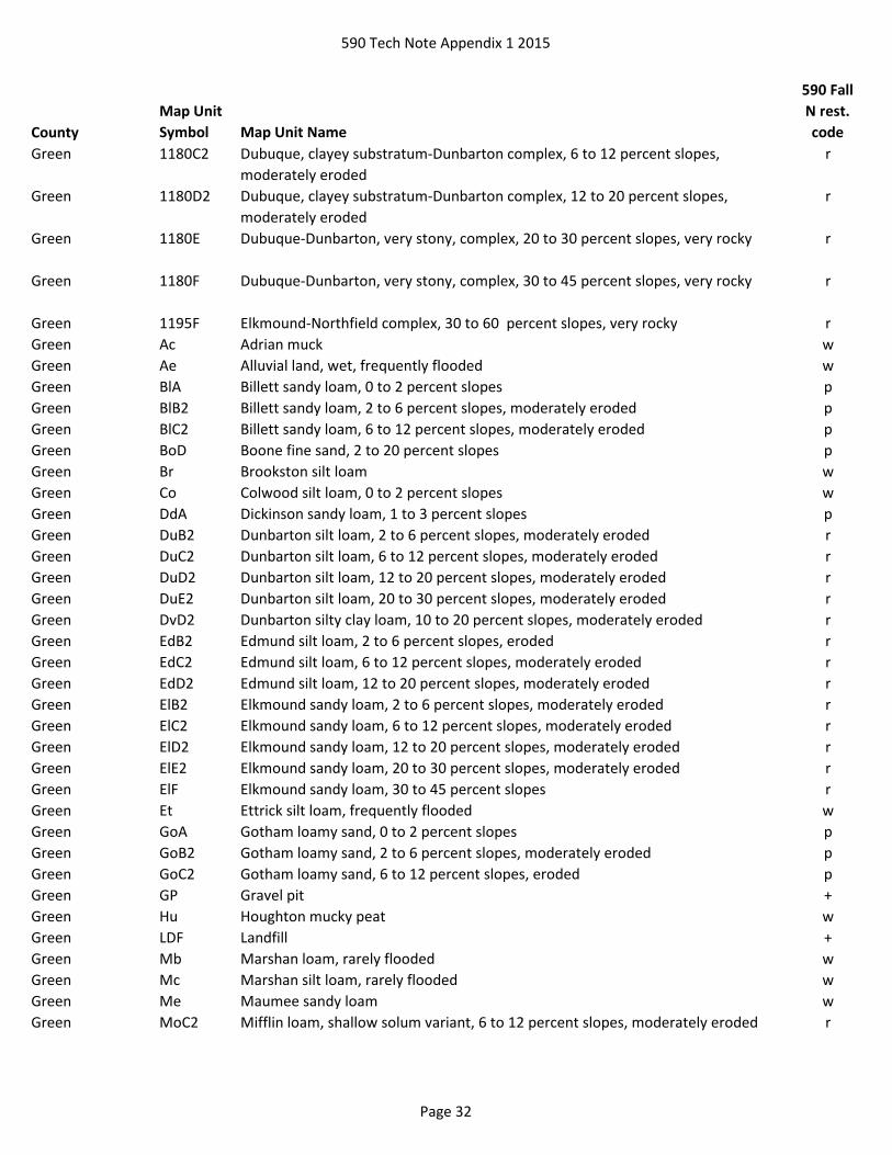
590 Tech Note Appendix 1 2015
County
Map Unit
Symbol Map Unit Name
590 Fall
N rest.
code
Green 1180C2 Dubuque, clayey substratum-Dunbarton complex, 6 to 12 percent slopes,
moderately eroded
r
Green 1180D2 Dubuque, clayey substratum-Dunbarton complex, 12 to 20 percent slopes,
moderately eroded
r
Green 1180E Dubuque-Dunbarton, very stony, complex, 20 to 30 percent slopes, very rocky r
Green 1180F Dubuque-Dunbarton, very stony, complex, 30 to 45 percent slopes, very rocky r
Green 1195F Elkmound-Northfield complex, 30 to 60 percent slopes, very rocky r
Green Ac Adrian muck w
Green Ae Alluvial land, wet, frequently flooded w
Green BlA Billett sandy loam, 0 to 2 percent slopes p
Green BlB2 Billett sandy loam, 2 to 6 percent slopes, moderately eroded p
Green BlC2 Billett sandy loam, 6 to 12 percent slopes, moderately eroded p
Green BoD Boone fine sand, 2 to 20 percent slopes p
Green Br Brookston silt loam w
Green Co Colwood silt loam, 0 to 2 percent slopes w
Green DdA Dickinson sandy loam, 1 to 3 percent slopes p
Green DuB2 Dunbarton silt loam, 2 to 6 percent slopes, moderately eroded r
Green DuC2 Dunbarton silt loam, 6 to 12 percent slopes, moderately eroded r
Green DuD2 Dunbarton silt loam, 12 to 20 percent slopes, moderately eroded r
Green DuE2 Dunbarton silt loam, 20 to 30 percent slopes, moderately eroded r
Green DvD2 Dunbarton silty clay loam, 10 to 20 percent slopes, moderately eroded r
Green EdB2 Edmund silt loam, 2 to 6 percent slopes, eroded r
Green EdC2 Edmund silt loam, 6 to 12 percent slopes, moderately eroded r
Green EdD2 Edmund silt loam, 12 to 20 percent slopes, moderately eroded r
Green ElB2 Elkmound sandy loam, 2 to 6 percent slopes, moderately eroded r
Green ElC2 Elkmound sandy loam, 6 to 12 percent slopes, moderately eroded r
Green ElD2 Elkmound sandy loam, 12 to 20 percent slopes, moderately eroded r
Green ElE2 Elkmound sandy loam, 20 to 30 percent slopes, moderately eroded r
Green ElF Elkmound sandy loam, 30 to 45 percent slopes r
Green Et Ettrick silt loam, frequently flooded w
Green GoA Gotham loamy sand, 0 to 2 percent slopes p
Green GoB2 Gotham loamy sand, 2 to 6 percent slopes, moderately eroded p
Green GoC2 Gotham loamy sand, 6 to 12 percent slopes, eroded p
Green GP Gravel pit +
Green Hu Houghton mucky peat w
Green LDF Landfill +
Green Mb Marshan loam, rarely flooded w
Green Mc Marshan silt loam, rarely flooded w
Green Me Maumee sandy loam w
Green MoC2 Mifflin loam, shallow solum variant, 6 to 12 percent slopes, moderately eroded r
Page 32

590 Tech Note Appendix 1 2015
County
Map Unit
Symbol Map Unit Name
590 Fall
N rest.
code
Green MoD2 Mifflin loam, shallow solum variant, 12 to 20 percent slopes, moderately eroded r
Green Na Navan silt loam, rarely flooded w
Green NoB2 Northfield loam, 2 to 6 percent slopes, moderately eroded r
Green NoC2 Northfield loam, 6 to 12 percent slopes, moderately eroded r
Green NoD2 Northfield loam, 12 to 20 percent slopes, moderately eroded r
Green NoE2 Northfield loam, 20 to 30 percent slopes, moderately eroded r
Green Or Orion silt loam, wet variant, frequently flooded w
Green OsA Oshtemo loamy sand, 0 to 2 percent slopes p
Green OsB2 Oshtemo loamy sand, 2 to 6 percent slopes, moderately eroded p
Green OsC2 Oshtemo loamy sand, 6 to 12 percent slopes, moderately eroded p
Green Ot Ossian silt loam, occasionally flooded w
Green Ou Otter silt loam, frequently flooded w
Green Pa Palms muck, 0 to 2 percent slopes w
Green PrB2 Plainfield loamy sand, 0 to 6 percent slopes, moderately eroded p
Green QUA Quarry +
Green Rh Riverwash w
Green RoC2 Rodman gravelly loam, 2 to 12 percent slopes, moderately eroded p
Green RoE2 Rodman gravelly loam, 12 to 30 percent slopes, moderately eroded p
Green Se Sebewa silt loam w
Green SoC2 Sogn silt loam, 2 to 12 percent slopes, moderately eroded r
Green SoE2 Sogn silt loam, 12 to 30 percent slopes, moderately eroded r
Green Wa Wallkill silt loam, frequently flooded w
Green Lake Ad Adrian muck w
Green Lake An Alluvial land, wet w
Green Lake Bb Barry loam w
Green Lake BpB Boyer loamy fine sand, 1 to 6 percent slopes p
Green Lake BpC2 Boyer loamy fine sand, 6 to 12 percent slopes, eroded p
Green Lake BpD Boyer loamy fine sand, 12 to 25 percent slopes p
Green Lake BrB Brems loamy fine sand, 0 to 6 percent slopes w
Green Lake BsA Briggsville silt loam, 0 to 2 percent slopes w
Green Lake Co Colwood silt loam, 0 to 2 percent slopes w
Green Lake Ed Edwards muck w
Green Lake FoA Friesland loam, 0 to 2 percent slopes w
Green Lake GaB Gotham loamy fine sand, 1 to 6 percent slopes p
Green Lake GaC Gotham loamy fine sand, 6 to 12 percent slopes p
Green Lake Gf Granby loamy fine sand w
Green Lake GhA Granby loamy fine sand, loamy subsoil variant, 0 to 3 percent slopes w
Green Lake GkA Granby loamy fine sand, clayey subsoil variant, 0 to 3 percent slopes w
Green Lake GP Gravel pit +
Green Lake Ho Houghton muck w
Green Lake LDF Landfill +
Green Lake Mf Marsh w
Green Lake Mh Marshan silt loam w
Page 33

590 Tech Note Appendix 1 2015
County
Map Unit
Symbol Map Unit Name
590 Fall
N rest.
code
Green Lake MnB Mecan loamy fine sand, 2 to 6 percent slopes p
Green Lake MnC2 Mecan loamy fine sand, 6 to 12 percent slopes, eroded p
Green Lake OaB Oakville fine sand, 1 to 6 percent slopes p
Green Lake OaC Oakville fine sand, 6 to 12 percent slopes p
Green Lake OaD Oakville fine sand, 12 to 35 percent slopes p
Green Lake OkB Okee loamy fine sand, 1 to 6 percent slopes p
Green Lake OkC Okee loamy fine sand, 6 to 15 percent slopes p
Green Lake OmB Oshtemo loamy fine sand, 1 to 6 percent slopes p
Green Lake OmC2 Oshtemo loamy fine sand, 6 to 12 percent slopes, eroded p
Green Lake Os Ossian silt loam w
Green Lake Pa Palms muck, 0 to 2 percent slopes w
Green Lake Pr Poy silty clay loam w
Green Lake Py Poygan silty clay loam, 0 to 2 percent slopes, drained w
Green Lake QUA Quarry +
Green Lake RaB Richford loamy sand, 1 to 6 percent slopes p
Green Lake RaC Richford loamy sand, 6 to 15 percent slopes p
Green Lake RhB2 Ritchey silt loam, 2 to 6 percent slopes, eroded r
Green Lake RhC2 Ritchey silt loam, 6 to 12 percent slopes, eroded r
Green Lake RhD2 Ritchey silt loam, 12 to 20 percent slopes, eroded r
Green Lake RkE Rock land and Ritchey soils, 6 to 45 percent slopes r
Green Lake Ro Rock outcrop r
Green Lake RsD Rodman gravelly sandy loam, 6 to 20 percent slopes p
Green Lake RsE Rodman gravelly sandy loam, 20 to 35 percent slopes p
Green Lake We Willette muck, 0 to 2 percent slopes w
Iowa 1130F Lacrescent-Dunbarton complex, very stony, 30 to 60 percent slopes r
Iowa 1145F Gaphill-Rockbluff complex, 30 to 60 percent slopes p
Iowa 1177E Derinda-Rock outcrop-Elizabeth complex, 20 to 30 percent slopes, rubbly r
Iowa 1177F Derinda-Rock outcrop-Elizabeth complex, 30 to 60 percent slopes, rubbly r
Iowa 1180F Dubuque-Dunbarton, very stony, complex, 30 to 45 percent slopes, very rocky r
Iowa 1195F Elkmound-Northfield complex, 30 to 60 percent slopes, very rocky r
Iowa 1505C2 Sparta-Blownout land complex, 0 to 15 percent slopes p
Iowa 1648A Northbend-Ettrick silt loams, 0 to 3 percent slopes, frequently flooded w
Iowa 1658A Algansee-Kalmarville complex, 0 to 3 percent slopes, frequently flooded w
Iowa 2013 Pits, gravel +
Iowa 2014 Pits, quarry, hard bedrock +
Iowa 2019 Dumps, mine +
Iowa 2050 Landfill +
Iowa 20A Palms and Houghton mucks, 0 to 1 percent slopes w
Iowa 21A Palms muck, 0 to 1 percent slopes, frequently flooded w
Iowa 245E2 Hesch sandy loam, deep, 20 to 30 percent slopes, moderately eroded p
Iowa 284C2 Gillingham loamy fine sand, 6 to 12 percent slopes, moderately eroded p
Iowa 284D2 Gillingham loamy fine sand, 12 to 20 percent slopes, moderately eroded p
Iowa 413A Rasset sandy loam, 0 to 3 percent slopes p
Page 34

590 Tech Note Appendix 1 2015
County
Map Unit
Symbol Map Unit Name
590 Fall
N rest.
code
Iowa 413B Rasset sandy loam, 2 to 6 percent slopes p
Iowa 433A Forkhorn sandy loam, 0 to 3 percent slopes p
Iowa 433B Forkhorn sandy loam, 2 to 6 percent slopes p
Iowa 433C2 Forkhorn sandy loam, 6 to 12 percent slopes, moderately eroded p
Iowa 436A Rusktown sandy loam, 0 to 3 percent slopes p
Iowa 456A Bilmod sandy loam, 0 to 3 percent slopes p
Iowa 502B2 Chelsea fine sand, 2 to 6 percent slopes, moderately eroded p
Iowa 504A Sparta loamy fine sand, 0 to 3 percent slopes p
Iowa 511C Plainfield sand, 6 to 15 percent slopes p
Iowa 511F Plainfield sand, 15 to 60 percent slopes p
Iowa 572C2 Windward loamy fine sand, 6 to 12 percent slopes, moderately eroded p
Iowa 572D Windward loamy fine sand, 12 to 30 percent slopes p
Iowa 601C Beavercreek cobbly fine sandy loam, 3 to 12 percent slopes, occasionally flooded p
Iowa 629A Ettrick silt loam, 0 to 2 percent slopes, frequently flooded w
Iowa BoC2 Boone fine sand, 6 to 12 percent slopes, moderately eroded p
Iowa BoD2 Boone fine sand, 12 to 30 percent slopes,moderately eroded p
Iowa Df Dillon loamy fine sand w
Iowa DlB2 Dodgeville silt loam, shallow, 2 to 6 percent slopes, moderately eroded r
Iowa DlC2 Dodgeville silt loam, shallow, 6 to 12 percent slopes, moderately eroded r
Iowa DlD2 Dodgeville silt loam, shallow, 12 to 20 percent slopes, moderately eroded r
Iowa HtB2 Hixton sandy loam, 2 to 6 percent slopes, moderately eroded p
Iowa HtC2 Hixton sandy loam, 6 to 12 percent slopes, moderately eroded p
Iowa HtD2 Hixton sandy loam, 12 to 20 percent slopes, moderately eroded p
Iowa HtE2 Hixton sandy loam, 20 to 30 percent slopes, moderately eroded p
Iowa Mm Millsdale silty clay loam, shale variant w
Iowa NsD2 Northfield stony loam, 12 to 20 percent slopes, moderately eroded r
Iowa NsE2 Northfield stony loam, 20 to 30 percent slopes, moderately eroded r
Iowa PgB Plainfield loamy fine sand, 2 to 6 percent slopes p
Iowa Pm Plainfield loamy fine sand, mottled substratum variant p
Iowa SoB2 Sogn and Dodgeville silt loams, shallow, 2 to 6 percent slopes, moderately eroded r
Iowa SoC2 Sogn and Dodgeville silt loams, shallow, 6 to 12 percent slopes, moderately eroded r
Iowa SoD2 Sogn and Dodgeville silt loams, shallow, 12 to 20 percent slopes, moderately eroded r
Iowa SoE2 Sogn and Dodgeville silt loams, shallow, 20 to 30 percent slopes, moderately eroded r
Iowa SpB2 Sparta loamy fine sand, 2 to 6 percent slopes, moderately eroded p
Iowa Sr Sparta loamy fine sand, moderately well drained variant p
Iowa Wa Wallkill silt loam w
Iron 1385B Cublake-Keweenaw, stony complex, 0 to 6 percent slopes p
Iron 174B Rubicon sand, 0 to 6 percent slopes p
Iron 174C Rubicon sand, 6 to 15 percent slopes p
Page 35

590 Tech Note Appendix 1 2015
County
Map Unit
Symbol Map Unit Name
590 Fall
N rest.
code
Iron 174D Rubicon sand, 15 to 30 percent slopes p
Iron 1884B Springstead, stony-Markey complex, 0 to 6 percent slopes p
Iron 193A Minocqua muck, 0 to 2 percent slopes w
Iron 2015 Pits +
Iron 2025 Pits and dumps, mine +
Iron 2030 Udorthents and Udipsamments, cut or fill +
Iron 215B Pence sandy loam, 0 to 6 percent slopes p
Iron 215C Pence sandy loam, 6 to 15 percent slopes p
Iron 215D Pence sandy loam, 15 to 30 percent slopes p
Iron 217B Karlin loamy fine sand, 0 to 6 percent slopes p
Iron 217C Karlin loamy fine sand, 6 to 15 percent slopes p
Iron 3114A Saprists, aquents, and aquepts, 0 to 1 percent slopes, ponded and flooded w
Iron 3276A Au Gres loamy sand, 0 to 3 percent slopes w
Iron 339B Rousseau loamy fine sand, 0 to 6 percent slopes p
Iron 339C Rousseau loamy fine sand, 6 to 15 percent slopes p
Iron 339D Rousseau loamy fine sand, 15 to 30 percent slopes p
Iron 3403A Loxley, Beseman, and Dawson soils, 0 to 1 percent slopes w
Iron 375A Robago fine sandy loam, lake terrace, 0 to 3 percent slopes w
Iron 388B Pelkie, occasionally flooded-Dechamps, frequently flooded complex, 0 to 4 percent
slopes
wp
Iron 3A Totagatic-Bowstring-Ausable complex, 0 to 2 percent slopes, frequently flooded w
Iron 405A Lupton, Cathro, and Tawas soils, 0 to 1 percent slopes w
Iron 407A Seelyeville and Markey soils, 0 to 1 percent slopes w
Iron 408A Lupton and Cathro soils, 0 to 1 percent slopes w
Iron 414A Loxley and Beseman soils, 0 to 1 percent slopes w
Iron 418A Loxley and Dawson soils, 0 to 1 percent slopes w
Iron 445A Kinross muck, 0 to 2 percent slopes w
Iron 455A Kinross-Au Gres-Markey complex, 0 to 3 percent slopes w
Iron 461A Bowstring muck, 0 to 1 percent slopes, frequently flooded w
Iron 475B Rubicon-Sayner complex, 0 to 6 percent slopes p
Iron 475C Rubicon-Sayner complex, 6 to 15 percent slopes p
Iron 475D Rubicon-Sayner complex, 15 to 30 percent slopes p
Iron 500A Croswell sand, 0 to 3 percent slopes p
Iron 5140A Dawson, Greenwood, and Loxley soils, 0 to 1 percent slopes w
Iron 5141A Lupton-Pleine-Cathro complex, 0 to 1 percent slopes w
Iron 5146C Amasa-Karlin complex, esker, 2 to 18 percent slopes p
Iron 5146D Amasa-Karlin complex, esker, 18 to 35 percent slopes p
Iron 5146E Amasa-Karlin complex, esker, 35 to 55 percent slopes p
Iron 514B Iosco loamy sand, 0 to 4 percent slopes w
Iron 5170A Minocqua-Pleine-Cathro complex, 0 to 2 percent slopes w
Iron 5172B Gogebic, very stony-Pence, very stony-Cathro complex, 0 to 6 percent slopes p
Page 36

590 Tech Note Appendix 1 2015
County
Map Unit
Symbol Map Unit Name
590 Fall
N rest.
code
Iron 5172C Gogebic, very stony-Pence, very stony-Cathro complex, 0 to 18 percent slopes p
Iron 5172D Gogebic, very stony-Pence, very stony-Cathro complex, 0 to 35 percent slopes p
Iron 5173D Gogebic-Pence complex, 18 to 35 percent slopes, very stony p
Iron 5175C Gogebic, very stony-Pence, very stony-Cathro complex, 0 to 18 percent slopes,
rocky
p
Iron 5175D Gogebic, very stony-Pence, very stony-Cathro complex, 0 to 35 percent slopes,
rocky
p
Iron 520A Annriver silt loam, 0 to 2 percent slopes w
Iron 5369D Dishno-Gogebic-Peshekee-Rock outcrop complex, 18 to 35 percent slopes, very
stony
r
Iron 5369E Michigamme-Schweitzer-Peshekee-Rock outcrop complex, 35 to 55 percent slopes,
very stony
r
Iron 5369F Michigamme-Schweitzer-Peshekee-Rock outcrop complex, 55 to 75 percent slopes,
very stony
r
Iron 5373A Cathro muck, drainageway, 0 to 1 percent slopes w
Iron 5374A Bowstring-Arnheim complex, 0 to 1 percent slopes, frequently flooded w
Iron 5425A Foxpaw-Gay, stony complex, 0 to 2 percent slopes w
Iron 5429B Gogebic-Peshekee complex, 2 to 6 percent slopes, very stony, very rocky r
Iron 5429C Gogebic-Peshekee complex, 6 to 18 percent slopes, very stony, very rocky r
Iron 5429D Gogebic-Peshekee complex, 18 to 35 percent slopes, very stony, very rocky r
Iron 5432C Gogebic-Michigamme-Rock outcrop complex, 6 to 18 percent slopes, very stony r
Iron 5432D Gogebic-Michigamme-Rock outcrop complex, 6 to 35 percent slopes, very stony r
Iron 5432E Schweitzer-Michigamme-Rock outcrop complex, very stony, 18 to 55 percent slopes r
Iron 5504A Moquah-Arnheim complex, 0 to 3 percent slopes, frequently flooded wp
Iron 5509A Cathro-Minocqua complex, drainageway, 0 to 1 percent slopes w
Iron 5519B Pence-Gogebic complex, 2 to 6 percent slopes, stony p
Iron 5519C Pence-Gogebic complex, 6 to 18 percent slopes, stony p
Iron 5519D Pence-Gogebic complex, 18 to 35 percent slopes, stony p
Iron 5527B Wakefield loam, 1 to 6 percent slopes, stony r
Iron 5527C Wakefield loam, 6 to 18 percent slopes, stony r
Iron 5527D Wakefield loam, 18 to 35 percent slopes, stony r
Iron 555A Fordum silt loam, 0 to 2 percent slopes, frequently flooded w
Iron 571B Pelissier gravelly sandy loam, 2 to 6 percent slopes p
Iron 571C Pelissier gravelly sandy loam, 6 to 15 percent slopes p
Iron 571E Pelissier gravelly sandy loam, 15 to 45 percent slopes p
Iron 574B Sayner loamy sand, 0 to 6 percent slopes p
Iron 574C Sayner loamy sand, 6 to 15 percent slopes p
Page 37

590 Tech Note Appendix 1 2015
County
Map Unit
Symbol Map Unit Name
590 Fall
N rest.
code
Iron 574E Sayner loamy sand, 15 to 45 percent slopes p
Iron 582C Padus-Pence-Keweenaw complex, 6 to 15 percent slopes, stony p
Iron 582D Padus-Pence-Keweenaw complex, 15 to 30 percent slopes, stony p
Iron 591A Croswell-Chinwhisker complex, 0 to 3 percent slopes p
Iron 594B Vilas-Lindquist complex, 0 to 6 percent slopes p
Iron 594C Vilas-Lindquist complex, 6 to 15 percent slopes p
Iron 594D Vilas-Lindquist complex, 15 to 30 percent slopes p
Iron 5A Arnheim mucky silt loam, 0 to 1 percent slopes, frequently flooded w
Iron 600A Haplosaprists and Psammaquents, 0 to 2 percent slopes w
Iron 617C Sedgwick-Rock outcrop complex, 2 to 15 percent slopes r
Iron 639A Neconish loamy fine sand, 0 to 3 percent slopes p
Iron 670B Keweenaw-Pence complex, 0 to 6 percent slopes, stony p
Iron 670C Keweenaw-Pence complex, 6 to 15 percent slopes, stony p
Iron 670E Keweenaw-Pence complex, 15 to 45 percent slopes, stony p
Iron 672B Springstead loamy sand, 1 to 6 percent slopes, very stony p
Iron 674B Sultz sand, 0 to 6 percent slopes p
Iron 674C Sultz sand, 6 to 15 percent slopes p
Iron 674E Sultz sand, 15 to 45 percent slopes p
Iron 675A Robago fine sandy loam, 0 to 3 percent slopes w
Iron 69B Keweenaw-Sayner-Vilas complex, 2 to 6 percent slopes, stony p
Iron 69C Keweenaw-Sayner-Vilas complex, 6 to 15 percent slopes, stony p
Iron 69E Keweenaw-Sayner-Vilas complex, 15 to 45 percent slopes, stony p
Iron 701A Whisklake silt loam, 0 to 3 percent slopes w
Iron 705B Cublake-Croswell-Ashwabay complex, 0 to 6 percent slopes p
Iron 705C Cublake-Croswell-Ashwabay complex, 6 to 15 percent slopes p
Iron 713B Kellogg-Allendale-Ashwabay complex, 2 to 6 percent slopes p
Iron 713C Kellogg-Allendale-Ashwabay complex, 0 to 15 percent slopes p
Iron 74B Vilas loamy sand, 0 to 6 percent slopes p
Iron 74C Vilas loamy sand, 6 to 15 percent slopes p
Iron 74D Vilas loamy sand, 15 to 30 percent slopes p
Iron 755A Moppet, occasionally flooded-Fordum, frequently flooded complex, 0 to 3 percent
slopes
w
Iron 770B Shanagolden-Pence complex, 2 to 6 percent slopes, stony p
Iron 770C Shanagolden-Pence complex, 6 to 15 percent slopes, stony p
Iron 770D Shanagolden-Pence complex, 15 to 30 percent slopes, stony p
Iron 772B Springstead sandy loam, 1 to 6 percent slopes, very stony p
Iron 805E Sultz-Ashwabay-Rubicon complex, 15 to 45 percent slopes p
Iron 813E Manistee-Kellogg-Ashwabay complex, 15 to 45 percent slopes p
Iron 815A Wormet sandy loam, 0 to 3 percent slopes w
Iron 852C Pence-Padus complex, 6 to 15 percent slopes, stony p
Iron 852D Pence-Padus complex, 15 to 30 percent slopes, stony p
Iron 884C Keweenaw, stony-Vilas-Cathro complex, 0 to 15 percent slopes p
Iron 885B Springstead, stony-Annalake-Cathro complex, 0 to 6 percent slopes p
Page 38

590 Tech Note Appendix 1 2015
County
Map Unit
Symbol Map Unit Name
590 Fall
N rest.
code
Iron 9050A Fordum, Totagatic, and Bowstring soils, 0 to 1 percent slopes, frequently flooded w
Iron 905A Cublake loamy sand, 0 to 3 percent slopes p
Iron 9155A Haplosaprists, Peats, and Mucks, 0 to 1 percent slopes w
Iron 974B Sayner-Pence-Vilas complex, 0 to 6 percent slopes p
Iron 974C Sayner-Pence-Vilas complex, 6 to 15 percent slopes p
Iron 974D Sayner-Pence-Vilas complex, 15 to 30 percent slopes p
Jackson 11A Markey muck, 0 to 1 percent slopes, frequently flooded w
Jackson 1218A Ironrun-Ponycreek complex, 0 to 3 percent slopes wp
Jackson 1224F Boone-Elevasil complex, 15 to 50 percent slopes p
Jackson 1233F Boone-Tarr sands, 15 to 50 percent slopes p
Jackson 1234B Bilson-Silverhill sandy loams, 1 to 6 percent slopes p
Jackson 1269A Veedum-Elm Lake mucks, 0 to 2 percent slopes w
Jackson 1288A Merrillan-Veedum complex, 0 to 3 percent slopes w
Jackson 1296B Ludington-Fairchild sands, 0 to 6 percent slopes p
Jackson 1298A Fairchild-Elm Lake complex, 0 to 3 percent slopes w
Jackson 1358A Moppet-Fordum complex, 0 to 3 percent slopes, frequently flooded w
Jackson 1388B Ironrun-Ponycreek-Arbutus complex, 0 to 6 percent slopes p
Jackson 1519A Ponycreek-Dawsil complex, 0 to 2 percent slopes w
Jackson 1548A Majik-Ponycreek complex, lake terrace, 0 to 3 percent slopes w
Jackson 1599A Ponycreek-Dawsil complex, lake terrace, 0 to 2 percent slopes w
Jackson 15A Loxley peat, 0 to 1 percent slopes w
Jackson 1658A Algansee-Kalmarville complex, 0 to 3 percent slopes, frequently flooded w
Jackson 17A Dawsil mucky peat, lake terrace, 0 to 1 percent slopes w
Jackson 2013 Pits, gravel +
Jackson 2016 Pits, quarry, soft bedrock +
Jackson 2019 Dumps, mine +
Jackson 2022 Pits, siliceous sand +
Jackson 2050 Landfill +
Jackson 218A Ironrun sand, 0 to 3 percent slopes p
Jackson 233C Boone sand, 6 to 15 percent slopes p
Jackson 25A Dawsil mucky peat, 0 to 1 percent slopes w
Jackson 296B Ludington sand, 1 to 6 percent slopes p
Jackson 299A Elm Lake mucky sand, 0 to 2 percent slopes w
Jackson 30A Adder muck, 0 to 1 percent slopes, frequently flooded w
Jackson 37A Loxley peat, lake terrace, 0 to 1 percent slopes w
Jackson 383B Mahtomedi loamy sand, 0 to 6 percent slopes p
Jackson 433B Forkhorn sandy loam, 2 to 6 percent slopes p
Jackson 434B Bilson sandy loam, 1 to 6 percent slopes p
Jackson 436A Rusktown sandy loam, 0 to 3 percent slopes p
Jackson 456A Bilmod sandy loam, 0 to 3 percent slopes p
Jackson 501A Finchford loamy sand, 0 to 3 percent slopes p
Jackson 511B Plainfield sand, 2 to 6 percent slopes p
Jackson 511C Plainfield sand, 6 to 15 percent slopes p
Page 39

590 Tech Note Appendix 1 2015
County
Map Unit
Symbol Map Unit Name
590 Fall
N rest.
code
Jackson 511F Plainfield sand, 15 to 60 percent slopes p
Jackson 518A Rockdam sand, 0 to 3 percent slopes p
Jackson 519A Ponycreek muck, 0 to 2 percent slopes wp
Jackson 551A Impact sand, 0 to 3 percent slopes p
Jackson 561B Tarr sand, 1 to 6 percent slopes p
Jackson 561C Tarr sand, 6 to 15 percent slopes p
Jackson 561F Tarr sand, 15 to 60 percent slopes p
Jackson 562B Gosil loamy sand, 1 to 6 percent slopes p
Jackson 562C Gosil loamy sand, 6 to 12 percent slopes p
Jackson 566A Tint sand, 0 to 3 percent slopes p
Jackson 569A Newlang muck, 0 to 2 percent slopes, occasionally flooded w
Jackson 576B Tintson sand, 1 to 6 percent slopes p
Jackson 629A Ettrick silt loam, 0 to 2 percent slopes, frequently flooded w
Jackson 646A Dunnbot fine sandy loam, 0 to 3 percent slopes, occasionally flooded p
Jackson 656A Scotah loamy fine sand, 0 to 3 percent slopes, occasionally flooded p
Jackson 666A Absco loamy sand, 0 to 3 percent slopes, occasionally flooded p
Jackson 679A Ettrick silt loam, 0 to 2 percent slopes, shallow, frequently flooded w
Jackson 99A Citypoint mucky peat, 0 to 1 percent slopes w
Jackson 9A Houghton and Palms mucks, 0 to 1 percent slopes, frequently flooded w
Jefferson Ad Adrian muck w
Jefferson BaA Barry silt loam, 0 to 3 percent slopes w
Jefferson BoC Boyer loamy sand, 6 to 12 percent slopes p
Jefferson BpB Boyer sandy loam, 1 to 6 percent slopes p
Jefferson CrD2 Casco-Rodman complex, 12 to 20 percent slopes, eroded p
Jefferson CrE Casco-Rodman complex, 30 to 45 percent slopes p
Jefferson CtB Chelsea loamy fine sand, 1 to 6 percent slopes p
Jefferson CtC Chelsea loamy fine sand, 6 to 20 percent slopes p
Jefferson Ed Edwards muck w
Jefferson Ev Elvers silt loam w
Jefferson Fn Fluvaquents w
Jefferson Gd Gilford sandy loam w
Jefferson Ht Houghton muck w
Jefferson Kb Keowns silt loam w
Jefferson LyB Lorenzo sandy loam, 2 to 6 percent slopes p
Jefferson Mr Milford silty clay loam w
Jefferson MvB Moundville loamy sand, 1 to 6 percent slopes p
Jefferson Ot Otter silt loam w
Jefferson Pa Palms muck, 0 to 2 percent slopes w
Jefferson Pb Palms muck, ponded, 0 to 2 percent slopes w
Jefferson Pg Pits, gravel +
Jefferson Sm Sebewa silt loam w
Jefferson Sn Sebewa silt loam, clayey substratum w
Jefferson Wa Wacousta silty clay loam, 0 to 2 percent slopes w
Jefferson WtA Watseka variant loamy sand, 0 to 3 percent slopes p
Page 40
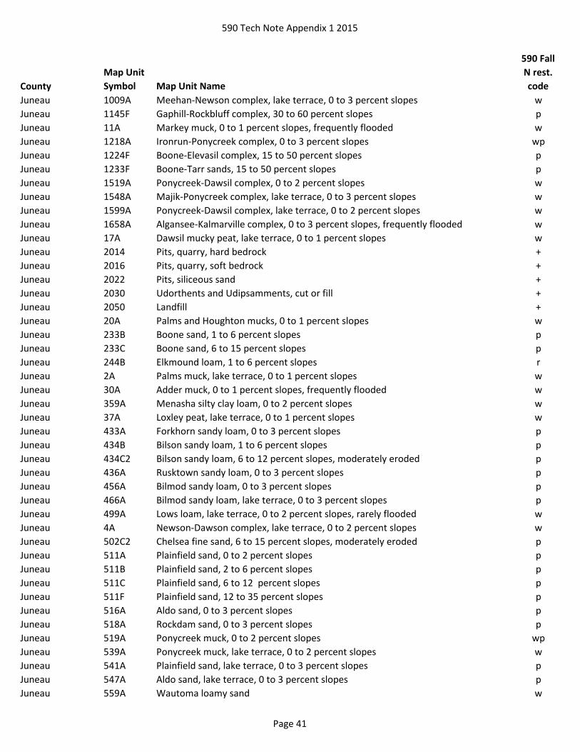
590 Tech Note Appendix 1 2015
County
Map Unit
Symbol Map Unit Name
590 Fall
N rest.
code
Juneau 1009A Meehan-Newson complex, lake terrace, 0 to 3 percent slopes w
Juneau 1145F Gaphill-Rockbluff complex, 30 to 60 percent slopes p
Juneau 11A Markey muck, 0 to 1 percent slopes, frequently flooded w
Juneau 1218A Ironrun-Ponycreek complex, 0 to 3 percent slopes wp
Juneau 1224F Boone-Elevasil complex, 15 to 50 percent slopes p
Juneau 1233F Boone-Tarr sands, 15 to 50 percent slopes p
Juneau 1519A Ponycreek-Dawsil complex, 0 to 2 percent slopes w
Juneau 1548A Majik-Ponycreek complex, lake terrace, 0 to 3 percent slopes w
Juneau 1599A Ponycreek-Dawsil complex, lake terrace, 0 to 2 percent slopes w
Juneau 1658A Algansee-Kalmarville complex, 0 to 3 percent slopes, frequently flooded w
Juneau 17A Dawsil mucky peat, lake terrace, 0 to 1 percent slopes w
Juneau 2014 Pits, quarry, hard bedrock +
Juneau 2016 Pits, quarry, soft bedrock +
Juneau 2022 Pits, siliceous sand +
Juneau 2030 Udorthents and Udipsamments, cut or fill +
Juneau 2050 Landfill +
Juneau 20A Palms and Houghton mucks, 0 to 1 percent slopes w
Juneau 233B Boone sand, 1 to 6 percent slopes p
Juneau 233C Boone sand, 6 to 15 percent slopes p
Juneau 244B Elkmound loam, 1 to 6 percent slopes r
Juneau 2A Palms muck, lake terrace, 0 to 1 percent slopes w
Juneau 30A Adder muck, 0 to 1 percent slopes, frequently flooded w
Juneau 359A Menasha silty clay loam, 0 to 2 percent slopes w
Juneau 37A Loxley peat, lake terrace, 0 to 1 percent slopes w
Juneau 433A Forkhorn sandy loam, 0 to 3 percent slopes p
Juneau 434B Bilson sandy loam, 1 to 6 percent slopes p
Juneau 434C2 Bilson sandy loam, 6 to 12 percent slopes, moderately eroded p
Juneau 436A Rusktown sandy loam, 0 to 3 percent slopes p
Juneau 456A Bilmod sandy loam, 0 to 3 percent slopes p
Juneau 466A Bilmod sandy loam, lake terrace, 0 to 3 percent slopes p
Juneau 499A Lows loam, lake terrace, 0 to 2 percent slopes, rarely flooded w
Juneau 4A Newson-Dawson complex, lake terrace, 0 to 2 percent slopes w
Juneau 502C2 Chelsea fine sand, 6 to 15 percent slopes, moderately eroded p
Juneau 511A Plainfield sand, 0 to 2 percent slopes p
Juneau 511B Plainfield sand, 2 to 6 percent slopes p
Juneau 511C Plainfield sand, 6 to 12 percent slopes p
Juneau 511F Plainfield sand, 12 to 35 percent slopes p
Juneau 516A Aldo sand, 0 to 3 percent slopes p
Juneau 518A Rockdam sand, 0 to 3 percent slopes p
Juneau 519A Ponycreek muck, 0 to 2 percent slopes wp
Juneau 539A Ponycreek muck, lake terrace, 0 to 2 percent slopes w
Juneau 541A Plainfield sand, lake terrace, 0 to 3 percent slopes p
Juneau 547A Aldo sand, lake terrace, 0 to 3 percent slopes p
Juneau 559A Wautoma loamy sand w
Page 41

590 Tech Note Appendix 1 2015
County
Map Unit
Symbol Map Unit Name
590 Fall
N rest.
code
Juneau 561B Tarr sand, 1 to 6 percent slopes p
Juneau 561C Tarr sand, 6 to 15 percent slopes p
Juneau 566A Tint sand, 0 to 3 percent slopes p
Juneau 569A Newlang muck, 0 to 2 percent slopes, occasionally flooded w
Juneau 572C2 Windward loamy fine sand, 6 to 12 percent slopes, moderately eroded p
Juneau 572D Windward loamy fine sand, 12 to 30 percent slopes p
Juneau 587B Tintson sand, lake terrace, 1 to 6 percent slopes p
Juneau 596A Tint sand, lake terrace, 0 to 3 percent slopes p
Juneau 629A Ettrick silt loam, 0 to 2 percent slopes, frequently flooded w
Juneau 646A Dunnbot fine sandy loam, 0 to 3 percent slopes, occasionally flooded p
Juneau 656A Scotah loamy fine sand, 0 to 3 percent slopes, occasionally flooded p
Juneau 699A Ettrick silt loam, lake terrace, 0 to 2 percent slopes, rarely flooded w
Kenosha Ac Adrian muck w
Kenosha Am Alluvial land w
Kenosha AtA Ashkum silty clay loam, 0 to 2 percent slopes w
Kenosha BmB Boyer loamy sand, 1 to 6 percent slopes p
Kenosha BmC2 Boyer loamy sand, 6 to 12 percent slopes, eroded p
Kenosha BnB Boyer sandy loam, 2 to 6 percent slopes p
Kenosha BP Borrow pit +
Kenosha CP Coal pile +
Kenosha CrC Casco-Rodman complex, 6 to 12 percent slopes p
Kenosha CrD2 Casco-Rodman complex, 12 to 20 percent slopes, eroded p
Kenosha CrE Casco-Rodman complex, 20 to 30 percent slopes p
Kenosha Cw Colwood silt loam, 0 to 2 percent slopes w
Kenosha Dh Dorchester silt loam w
Kenosha Dt Drummer silt loam, gravelly substratum w
Kenosha Gf Granby fine sandy loam w
Kenosha Gm Granby fine sandy loam, loamy substratum w
Kenosha GP Gravel pit +
Kenosha Ht Houghton muck w
Kenosha LDF Landfill +
Kenosha Mf Marsh w
Kenosha Mzc Montgomery silty clay w
Kenosha MzfA Mundelein silt loam, 1 to 3 percent slopes w
Kenosha Mzg Muskego muck w
Kenosha Mzk Mussey loam w
Kenosha Na Navan silt loam w
Kenosha Oc Ogden muck w
Kenosha Pa Palms muck, 0 to 2 percent slopes w
Kenosha Ph Pella silt loam, 0 to 2 percent slopes w
Kenosha QUA Quarry +
Kenosha Rt Rollin muck w
Kenosha Sfb Sandy lake beaches w
Kenosha Sg Sawmill silt loam, calcareous variant w
Page 42
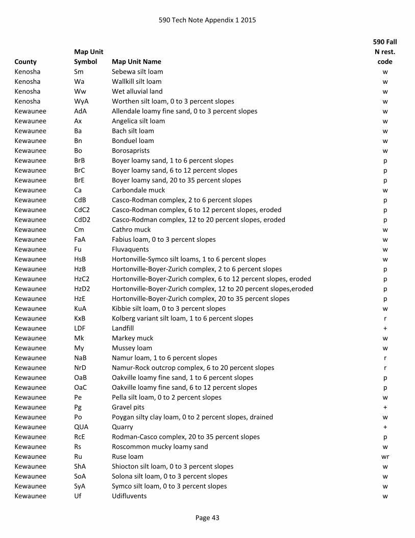
590 Tech Note Appendix 1 2015
County
Map Unit
Symbol Map Unit Name
590 Fall
N rest.
code
Kenosha Sm Sebewa silt loam w
Kenosha Wa Wallkill silt loam w
Kenosha Ww Wet alluvial land w
Kenosha WyA Worthen silt loam, 0 to 3 percent slopes w
Kewaunee AdA Allendale loamy fine sand, 0 to 3 percent slopes w
Kewaunee Ax Angelica silt loam w
Kewaunee Ba Bach silt loam w
Kewaunee Bn Bonduel loam w
Kewaunee Bo Borosaprists w
Kewaunee BrB Boyer loamy sand, 1 to 6 percent slopes p
Kewaunee BrC Boyer loamy sand, 6 to 12 percent slopes p
Kewaunee BrE Boyer loamy sand, 20 to 35 percent slopes p
Kewaunee Ca Carbondale muck w
Kewaunee CdB Casco-Rodman complex, 2 to 6 percent slopes p
Kewaunee CdC2 Casco-Rodman complex, 6 to 12 percent slopes, eroded p
Kewaunee CdD2 Casco-Rodman complex, 12 to 20 percent slopes, eroded p
Kewaunee Cm Cathro muck w
Kewaunee FaA Fabius loam, 0 to 3 percent slopes w
Kewaunee Fu Fluvaquents w
Kewaunee HsB Hortonville-Symco silt loams, 1 to 6 percent slopes w
Kewaunee HzB Hortonville-Boyer-Zurich complex, 2 to 6 percent slopes p
Kewaunee HzC2 Hortonville-Boyer-Zurich complex, 6 to 12 percent slopes, eroded p
Kewaunee HzD2 Hortonville-Boyer-Zurich complex, 12 to 20 percent slopes,eroded p
Kewaunee HzE Hortonville-Boyer-Zurich complex, 20 to 35 percent slopes p
Kewaunee KuA Kibbie silt loam, 0 to 3 percent slopes w
Kewaunee KxB Kolberg variant silt loam, 1 to 6 percent slopes r
Kewaunee LDF Landfill +
Kewaunee Mk Markey muck w
Kewaunee My Mussey loam w
Kewaunee NaB Namur loam, 1 to 6 percent slopes r
Kewaunee NrD Namur-Rock outcrop complex, 6 to 20 percent slopes r
Kewaunee OaB Oakville loamy fine sand, 1 to 6 percent slopes p
Kewaunee OaC Oakville loamy fine sand, 6 to 12 percent slopes p
Kewaunee Pe Pella silt loam, 0 to 2 percent slopes w
Kewaunee Pg Gravel pits +
Kewaunee Po Poygan silty clay loam, 0 to 2 percent slopes, drained w
Kewaunee QUA Quarry +
Kewaunee RcE Rodman-Casco complex, 20 to 35 percent slopes p
Kewaunee Rs Roscommon mucky loamy sand w
Kewaunee Ru Ruse loam wr
Kewaunee ShA Shiocton silt loam, 0 to 3 percent slopes w
Kewaunee SoA Solona silt loam, 0 to 3 percent slopes w
Kewaunee SyA Symco silt loam, 0 to 3 percent slopes w
Kewaunee Uf Udifluvents w
Page 43

590 Tech Note Appendix 1 2015
County
Map Unit
Symbol Map Unit Name
590 Fall
N rest.
code
La Crosse 1145F Gaphill-Rockbluff complex, 30 to 60 percent slopes p
La Crosse 1155F Brodale-Bellechester-Rock outcrop complex, 60 to 90 percent slopes pr
La Crosse 1233F Boone-Tarr sands, 15 to 50 percent slopes p
La Crosse 1658A Algansee-Kalmarville complex, 0 to 3 percent slopes, frequently flooded w
La Crosse 2013 Pits, gravel +
La Crosse 2014 Pits, quarry, hard bedrock +
La Crosse 2030 Udorthents and Udipsamments, cut or fill +
La Crosse 2040 Udipsamments, dredge material +
La Crosse 2050 Landfill +
La Crosse 20A Palms and Houghton mucks, 0 to 1 percent slopes w
La Crosse 21A Palms muck, 0 to 1 percent slopes, frequently flooded w
La Crosse 233C Boone sand, 6 to 15 percent slopes p
La Crosse 296B Ludington sand, 1 to 6 percent slopes p
La Crosse 30A Adder muck, 0 to 1 percent slopes, frequently flooded w
La Crosse 413A Rasset sandy loam, 0 to 3 percent slopes p
La Crosse 433B Forkhorn sandy loam, 2 to 6 percent slopes p
La Crosse 434B Bilson sandy loam, 1 to 6 percent slopes p
La Crosse 434C2 Bilson sandy loam, 6 to 12 percent slopes, moderately eroded p
La Crosse 456A Bilmod sandy loam, 0 to 3 percent slopes p
La Crosse 483B2 Brice loamy fine sand, 2 to 6 percent slopes, moderately eroded p
La Crosse 501A Finchford loamy sand, 0 to 3 percent slopes p
La Crosse 502B2 Chelsea fine sand, 2 to 6 percent slopes, moderately eroded p
La Crosse 502C2 Chelsea fine sand, 6 to 15 percent slopes, moderately eroded p
La Crosse 511B Plainfield sand, 2 to 6 percent slopes p
La Crosse 511C Plainfield sand, 6 to 15 percent slopes p
La Crosse 511F Plainfield sand, 15 to 60 percent slopes p
La Crosse 551A Impact sand, 0 to 3 percent slopes p
La Crosse 556A Mindoro sand, 0 to 3 percent slopes p
La Crosse 561B Tarr sand, 1 to 6 percent slopes p
La Crosse 561C Tarr sand, 6 to 15 percent slopes p
La Crosse 561F Tarr sand, 15 to 60 percent slopes p
La Crosse 562B Gosil loamy sand, 1 to 6 percent slopes p
La Crosse 562C Gosil loamy sand, 6 to 12 percent slopes p
La Crosse 566A Tint sand, 0 to 3 percent slopes p
La Crosse 569A Newlang muck, 0 to 2 percent slopes, occasionally flooded w
La Crosse 576B Tintson sand, 1 to 6 percent slopes p
La Crosse 601C Beavercreek cobbly fine sandy loam, 3 to 12 percent slopes, occasionally flooded p
La Crosse 609A Otter silt loam, 0 to 2 percent slopes, frequently flooded w
La Crosse 629A Ettrick silt loam, 0 to 2 percent slopes, frequently flooded w
La Crosse 656A Scotah loamy fine sand, 0 to 3 percent slopes, occasionally flooded p
La Crosse 666A Absco loamy sand, 0 to 3 percent slopes, occasionally flooded p
La Crosse 739A Root loam, 0 to 2 percent slopes, frequently flooded w
Lafayette 1130E Lacrescent-Dunbarton complex, 20 to 30 percent slopes, very stony r
Page 44

590 Tech Note Appendix 1 2015
County
Map Unit
Symbol Map Unit Name
590 Fall
N rest.
code
Lafayette 1130F Lacrescent-Dunbarton complex, very stony, 30 to 60 percent slopes r
Lafayette 1177E Derinda-Rock outcrop-Elizabeth complex, 20 to 30 percent slopes, rubbly r
Lafayette 1177F Derinda-Rock outcrop-Elizabeth complex, 30 to 60 percent slopes, rubbly r
Lafayette 1180B2 Dubuque, clayey substratum-Dunbarton complex, 2 to 6 percent slopes, moderately
eroded
r
Lafayette 1180C2 Dubuque, clayey substratum-Dunbarton complex, 6 to 12 percent slopes,
moderately eroded
r
Lafayette 1180D2 Dubuque, clayey substratum-Dunbarton complex, 12 to 20 percent slopes,
moderately eroded
r
Lafayette 1180E Dubuque-Dunbarton, very stony, complex, 20 to 30 percent slopes, very rocky r
Lafayette 1180F Dubuque-Dunbarton, very stony, complex, 30 to 45 percent slopes, very rocky r
Lafayette 1195E Elkmound-Northfield complex, 20 to 30 percent slopes, very rocky r
Lafayette 1195F Elkmound-Northfield complex, 30 to 60 percent slopes, very rocky r
Lafayette Ad Alluvial land w
Lafayette BoD2 Boone fine sand, 6 to 20 percent slopes, moderately eroded p
Lafayette CaA Calamine silt loam, 0 to 2 percent slopes w
Lafayette CaB Calamine silt loam, 2 to 6 percent slopes w
Lafayette CaC2 Calamine silt loam, 6 to 12 percent slopes, moderately eroded w
Lafayette DuF Dunbarton silt loam, 30 to 45 percent slopes r
Lafayette EdB2 Edmund silt loam, 2 to 6 percent slopes, moderately eroded r
Lafayette EdC2 Edmund silt loam, 6 to 12 percent slopes, moderately eroded r
Lafayette EdD2 Edmund silt loam, 12 to 20 percent slopes, moderately eroded r
Lafayette GoB2 Gotham loamy fine sand, 2 to 6 percent slopes, moderately eroded p
Lafayette GoC2 Gotham loamy fine sand, 6 to 20 percent slopes, moderately eroded p
Lafayette Hu Houghton mucky peat w
Lafayette LDF Landfill +
Lafayette Ma Marsh w
Lafayette Mb Marshan silt loam w
Lafayette MeA Meridian sandy loam, 0 to 2 percent slopes p
Lafayette MeB Meridian sandy loam, 2 to 6 percent slopes p
Lafayette NfC2 Northfield loam, 6 to 12 percent slopes, moderately eroded r
Lafayette NfD2 Northfield loam, 12 to 20 percent slopes, moderately eroded r
Lafayette NfE2 Northfield loam, 20 to 30 percent slopes, moderately eroded r
Lafayette NoB2 Northfield sandy loam, 2 to 6 percent slopes, moderately eroded r
Lafayette NoC2 Northfield sandy loam, 6 to 12 percent slopes, moderately eroded r
Lafayette NoD2 Northfield sandy loam, 12 to 20 percent slopes, moderately eroded r
Lafayette NoE2 Northfield sandy loam, 20 to 30 percent slopes, moderately eroded r
Lafayette NoF Northfield sandy loam, 30 to 45 percent slopes r
Lafayette Ow Orion silt loam, wet variant w
Lafayette QUA Quarry +
Lafayette Sa Sable silt loam w
Lafayette Sb Sable silt loam, benches w
Page 45

590 Tech Note Appendix 1 2015
County
Map Unit
Symbol Map Unit Name
590 Fall
N rest.
code
Lafayette SoC2 Sogn silt loam, 2 to 12 percent slopes, moderately eroded r
Lafayette SoD2 Sogn silt loam, 12 to 20 percent slopes, moderately eroded r
Lafayette SoE2 Sogn silt loam, 20 to 30 percent slopes, moderately eroded r
Lafayette SoF Sogn silt loam, 30 to 45 percent slopes r
Langlade As Au Gres loamy sand w
Langlade Cs Croswell loamy sand p
Langlade Fm Fordum mucky silt loam w
Langlade HyB Hatley silt loam, 2 to 6 percent slopes, stony w
Langlade Ig Ingalls loamy sand w
Langlade LDF Landfill +
Langlade Lx Loxley peat w
Langlade MnB Menominee loamy sand, 0 to 6 percent slopes p
Langlade MoB Milladore silt loam, 0 to 4 percent slopes w
Langlade Ms Minocqua, Cable, and Sherry mucks w
Langlade MyB Mylrea silt loam, 0 to 4 percent slopes w
Langlade Os Oesterle silt loam w
Langlade PsB Pence sandy loam, 0 to 6 percent slopes p
Langlade PsC Pence sandy loam, 6 to 15 percent slopes p
Langlade PsD Pence sandy loam, 15 to 45 percent slopes p
Langlade Sy Lupton and Cathro soils, 0 to 1 percent slopes w
Langlade VsB Vilas loamy sand, 0 to 6 percent slopes p
Langlade VsC Vilas loamy sand, 6 to 15 percent slopes p
Lincoln AuA Au Gres loamy sand, 0 to 3 percent slopes w
Lincoln CrB Croswell loamy sand, 1 to 6 percent slopes p
Lincoln CsB Croswood loamy sand, 1 to 6 percent slopes p
Lincoln Fh Fordum loam, 0 to 2 percent slopes w
Lincoln HyB Hatley silt loam, 0 to 4 percent slopes w
Lincoln Lo Loxley and Dawson peats, 0 to 1 percent slopes w
Lincoln Lu Lupton and Cathro soils, 0 to 1 percent slopes w
Lincoln MxB Moodig sandy loam, 0 to 4 percent slopes w
Lincoln NpC Newood-Pence sandy loams, 6 to 15 percent slopes p
Lincoln OsA Ossmer silt loam, 0 to 3 percent slopes w
Lincoln PcC Pence-Antigo complex, 6 to 15 percent slopes p
Lincoln PeB Pence-Padus sandy loams, 1 to 6 percent slopes p
Lincoln PeC Pence-Padus sandy loams, 6 to 15 percent slopes p
Lincoln PeD Pence-Padus sandy loams, 15 to 35 percent slopes p
Lincoln Pt Gravel pit +
Lincoln SaC Sarona-Pence sandy loams, 6 to 15 percent slopes p
Lincoln SaD Sarona-Pence sandy loams, 15 to 35 percent slopes p
Lincoln VsB Vilas-Sayner loamy sands, 1 to 6 percent slopes p
Lincoln VsC Vilas-Sayner loamy sands, 6 to 15 percent slopes p
Lincoln VsD Vilas-Sayner loamy sands, 15 to 35 percent slopes p
Lincoln WoA Worcester sandy loam, 0 to 3 percent slopes w
Manitowoc Ac Adrian muck w
Page 46
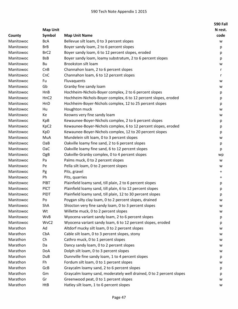
590 Tech Note Appendix 1 2015
County
Map Unit
Symbol Map Unit Name
590 Fall
N rest.
code
Manitowoc BcA Bellevue silt loam, 0 to 3 percent slopes w
Manitowoc BrB Boyer sandy loam, 2 to 6 percent slopes p
Manitowoc BrC2 Boyer sandy loam, 6 to 12 percent slopes, eroded p
Manitowoc BsB Boyer sandy loam, loamy substratum, 2 to 6 percent slopes p
Manitowoc Bu Brookston silt loam w
Manitowoc CnB Channahon loam, 2 to 6 percent slopes r
Manitowoc CnC Channahon loam, 6 to 12 percent slopes r
Manitowoc Fu Fluvaquents w
Manitowoc Gb Granby fine sandy loam w
Manitowoc HnB Hochheim-Nichols-Boyer complex, 2 to 6 percent slopes p
Manitowoc HnC2 Hochheim-Nichols-Boyer complex, 6 to 12 percent slopes, eroded p
Manitowoc HnD Hochheim-Boyer-Nichols complex, 12 to 25 percent slopes p
Manitowoc Hu Houghton muck w
Manitowoc Ke Keowns very fine sandy loam w
Manitowoc KpB Kewaunee-Boyer-Nichols complex, 2 to 6 percent slopes p
Manitowoc KpC2 Kewaunee-Boyer-Nichols complex, 6 to 12 percent slopes, eroded p
Manitowoc KpD Kewaunee-Boyer-Nichols complex, 12 to 20 percent slopes p
Manitowoc MuA Mundelein silt loam, 0 to 3 percent slopes w
Manitowoc OaB Oakville loamy fine sand, 2 to 6 percent slopes p
Manitowoc OaC Oakville loamy fine sand, 6 to 12 percent slopes p
Manitowoc OgB Oakville-Granby complex, 0 to 4 percent slopes wp
Manitowoc Pa Palms muck, 0 to 2 percent slopes w
Manitowoc Pe Pella silt loam, 0 to 2 percent slopes w
Manitowoc Pg Pits, gravel +
Manitowoc Ph Pits, quarries +
Manitowoc PlBT Plainfield loamy sand, till plain, 2 to 6 percent slopes p
Manitowoc PlCT Plainfield loamy sand, till plain, 6 to 12 percent slopes p
Manitowoc PlDT Plainfield loamy sand, till plain, 12 to 30 percent slopes p
Manitowoc Po Poygan silty clay loam, 0 to 2 percent slopes, drained w
Manitowoc ShA Shiocton very fine sandy loam, 0 to 3 percent slopes w
Manitowoc Wt Willette muck, 0 to 2 percent slopes w
Manitowoc WvB Wyocena variant sandy loam, 2 to 6 percent slopes p
Manitowoc WvC2 Wyocena variant sandy loam, 6 to 12 percent slopes, eroded p
Marathon Ad Altdorf mucky silt loam, 0 to 2 percent slopes w
Marathon CbA Cable silt loam, 0 to 3 percent slopes, stony w
Marathon Ch Cathro muck, 0 to 1 percent slopes w
Marathon Da Dancy sandy loam, 0 to 2 percent slopes w
Marathon DoA Dolph silt loam, 0 to 3 percent slopes w
Marathon DuB Dunnville fine sandy loam, 1 to 4 percent slopes p
Marathon Fh Fordum silt loam, 0 to 1 percent slopes w
Marathon GcB Graycalm loamy sand, 2 to 6 percent slopes p
Marathon Gm Graycalm loamy sand, moderately well drained, 0 to 2 percent slopes p
Marathon Gr Greenwood peat, 0 to 1 percent slopes w
Marathon HtB Hatley silt loam, 1 to 6 percent slopes w
Page 47
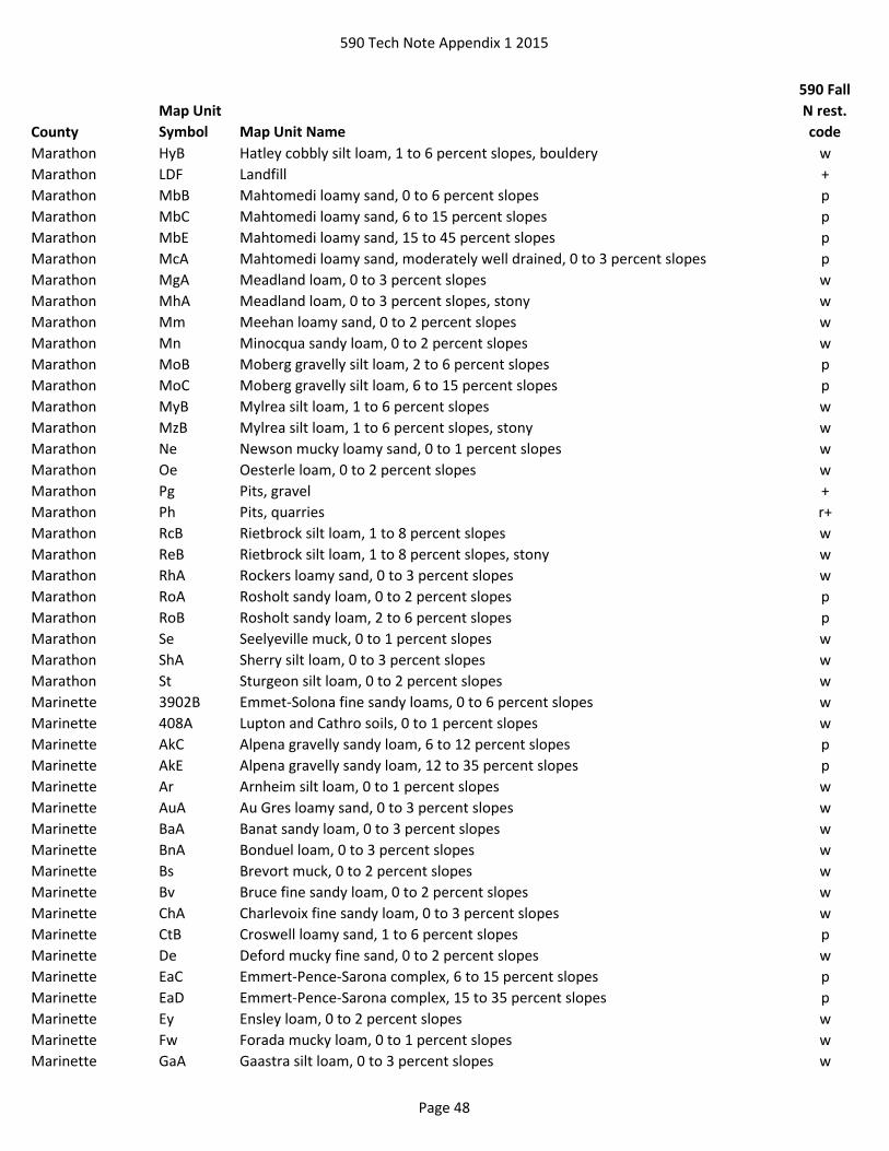
590 Tech Note Appendix 1 2015
County
Map Unit
Symbol Map Unit Name
590 Fall
N rest.
code
Marathon HyB Hatley cobbly silt loam, 1 to 6 percent slopes, bouldery w
Marathon LDF Landfill +
Marathon MbB Mahtomedi loamy sand, 0 to 6 percent slopes p
Marathon MbC Mahtomedi loamy sand, 6 to 15 percent slopes p
Marathon MbE Mahtomedi loamy sand, 15 to 45 percent slopes p
Marathon McA Mahtomedi loamy sand, moderately well drained, 0 to 3 percent slopes p
Marathon MgA Meadland loam, 0 to 3 percent slopes w
Marathon MhA Meadland loam, 0 to 3 percent slopes, stony w
Marathon Mm Meehan loamy sand, 0 to 2 percent slopes w
Marathon Mn Minocqua sandy loam, 0 to 2 percent slopes w
Marathon MoB Moberg gravelly silt loam, 2 to 6 percent slopes p
Marathon MoC Moberg gravelly silt loam, 6 to 15 percent slopes p
Marathon MyB Mylrea silt loam, 1 to 6 percent slopes w
Marathon MzB Mylrea silt loam, 1 to 6 percent slopes, stony w
Marathon Ne Newson mucky loamy sand, 0 to 1 percent slopes w
Marathon Oe Oesterle loam, 0 to 2 percent slopes w
Marathon Pg Pits, gravel +
Marathon Ph Pits, quarries r+
Marathon RcB Rietbrock silt loam, 1 to 8 percent slopes w
Marathon ReB Rietbrock silt loam, 1 to 8 percent slopes, stony w
Marathon RhA Rockers loamy sand, 0 to 3 percent slopes w
Marathon RoA Rosholt sandy loam, 0 to 2 percent slopes p
Marathon RoB Rosholt sandy loam, 2 to 6 percent slopes p
Marathon Se Seelyeville muck, 0 to 1 percent slopes w
Marathon ShA Sherry silt loam, 0 to 3 percent slopes w
Marathon St Sturgeon silt loam, 0 to 2 percent slopes w
Marinette 3902B Emmet-Solona fine sandy loams, 0 to 6 percent slopes w
Marinette 408A Lupton and Cathro soils, 0 to 1 percent slopes w
Marinette AkC Alpena gravelly sandy loam, 6 to 12 percent slopes p
Marinette AkE Alpena gravelly sandy loam, 12 to 35 percent slopes p
Marinette Ar Arnheim silt loam, 0 to 1 percent slopes w
Marinette AuA Au Gres loamy sand, 0 to 3 percent slopes w
Marinette BaA Banat sandy loam, 0 to 3 percent slopes w
Marinette BnA Bonduel loam, 0 to 3 percent slopes w
Marinette Bs Brevort muck, 0 to 2 percent slopes w
Marinette Bv Bruce fine sandy loam, 0 to 2 percent slopes w
Marinette ChA Charlevoix fine sandy loam, 0 to 3 percent slopes w
Marinette CtB Croswell loamy sand, 1 to 6 percent slopes p
Marinette De Deford mucky fine sand, 0 to 2 percent slopes w
Marinette EaC Emmert-Pence-Sarona complex, 6 to 15 percent slopes p
Marinette EaD Emmert-Pence-Sarona complex, 15 to 35 percent slopes p
Marinette Ey Ensley loam, 0 to 2 percent slopes w
Marinette Fw Forada mucky loam, 0 to 1 percent slopes w
Marinette GaA Gaastra silt loam, 0 to 3 percent slopes w
Page 48
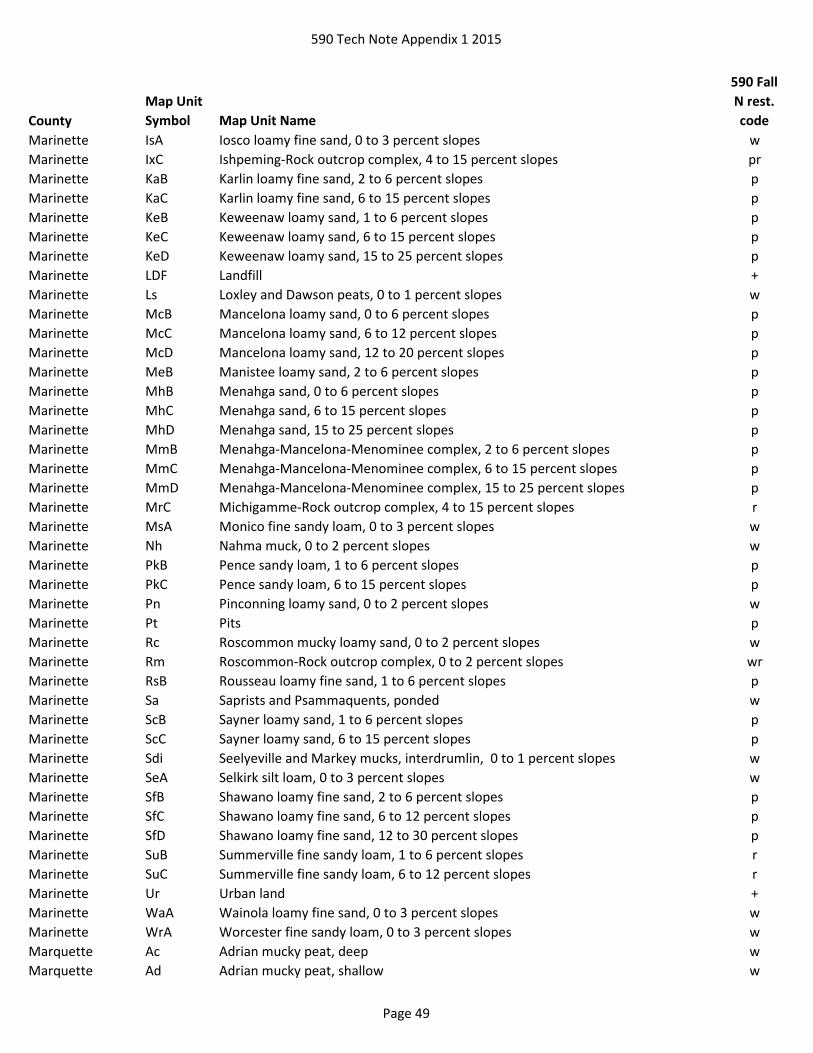
590 Tech Note Appendix 1 2015
County
Map Unit
Symbol Map Unit Name
590 Fall
N rest.
code
Marinette IsA Iosco loamy fine sand, 0 to 3 percent slopes w
Marinette IxC Ishpeming-Rock outcrop complex, 4 to 15 percent slopes pr
Marinette KaB Karlin loamy fine sand, 2 to 6 percent slopes p
Marinette KaC Karlin loamy fine sand, 6 to 15 percent slopes p
Marinette KeB Keweenaw loamy sand, 1 to 6 percent slopes p
Marinette KeC Keweenaw loamy sand, 6 to 15 percent slopes p
Marinette KeD Keweenaw loamy sand, 15 to 25 percent slopes p
Marinette LDF Landfill +
Marinette Ls Loxley and Dawson peats, 0 to 1 percent slopes w
Marinette McB Mancelona loamy sand, 0 to 6 percent slopes p
Marinette McC Mancelona loamy sand, 6 to 12 percent slopes p
Marinette McD Mancelona loamy sand, 12 to 20 percent slopes p
Marinette MeB Manistee loamy sand, 2 to 6 percent slopes p
Marinette MhB Menahga sand, 0 to 6 percent slopes p
Marinette MhC Menahga sand, 6 to 15 percent slopes p
Marinette MhD Menahga sand, 15 to 25 percent slopes p
Marinette MmB Menahga-Mancelona-Menominee complex, 2 to 6 percent slopes p
Marinette MmC Menahga-Mancelona-Menominee complex, 6 to 15 percent slopes p
Marinette MmD Menahga-Mancelona-Menominee complex, 15 to 25 percent slopes p
Marinette MrC Michigamme-Rock outcrop complex, 4 to 15 percent slopes r
Marinette MsA Monico fine sandy loam, 0 to 3 percent slopes w
Marinette Nh Nahma muck, 0 to 2 percent slopes w
Marinette PkB Pence sandy loam, 1 to 6 percent slopes p
Marinette PkC Pence sandy loam, 6 to 15 percent slopes p
Marinette Pn Pinconning loamy sand, 0 to 2 percent slopes w
Marinette Pt Pits p
Marinette Rc Roscommon mucky loamy sand, 0 to 2 percent slopes w
Marinette Rm Roscommon-Rock outcrop complex, 0 to 2 percent slopes wr
Marinette RsB Rousseau loamy fine sand, 1 to 6 percent slopes p
Marinette Sa Saprists and Psammaquents, ponded w
Marinette ScB Sayner loamy sand, 1 to 6 percent slopes p
Marinette ScC Sayner loamy sand, 6 to 15 percent slopes p
Marinette Sdi Seelyeville and Markey mucks, interdrumlin, 0 to 1 percent slopes w
Marinette SeA Selkirk silt loam, 0 to 3 percent slopes w
Marinette SfB Shawano loamy fine sand, 2 to 6 percent slopes p
Marinette SfC Shawano loamy fine sand, 6 to 12 percent slopes p
Marinette SfD Shawano loamy fine sand, 12 to 30 percent slopes p
Marinette SuB Summerville fine sandy loam, 1 to 6 percent slopes r
Marinette SuC Summerville fine sandy loam, 6 to 12 percent slopes r
Marinette Ur Urban land +
Marinette WaA Wainola loamy fine sand, 0 to 3 percent slopes w
Marinette WrA Worcester fine sandy loam, 0 to 3 percent slopes w
Marquette Ac Adrian mucky peat, deep w
Marquette Ad Adrian mucky peat, shallow w
Page 49

590 Tech Note Appendix 1 2015
County
Map Unit
Symbol Map Unit Name
590 Fall
N rest.
code
Marquette Ae Adrian mucky peat, deep, stratified subsoil variant w
Marquette Ak Adrian mucky peat, shallow, stratified subsoil variant w
Marquette Am Alluvial land w
Marquette An Alluvial land, wet w
Marquette Ao Ankeny fine sandy loam w
Marquette BmB Boyer loamy fine sand, 2 to 6 percent slopes p
Marquette BmC2 Boyer loamy fine sand, 6 to 12 percent slopes, eroded p
Marquette BmD2 Boyer loamy fine sand, 12 to 20 percent slopes, eroded p
Marquette BmE2 Boyer loamy fine sand, 20 to 30 percent slopes, eroded p
Marquette BnB Boyer fine sandy loam, 2 to 6 percent slopes p
Marquette BnC2 Boyer fine sandy loam, 6 to 12 percent slopes, eroded p
Marquette BnD2 Boyer fine sandy loam, 12 to 20 percent slopes, eroded p
Marquette BoA Boyer fine sandy loam, dark surface variant, 0 to 2 percent slopes w
Marquette BrB Boyer-Oshtemo loamy sands, 2 to 6 percent slopes p
Marquette BrC2 Boyer-Oshtemo loamy sands, 6 to 12 percent slopes, eroded p
Marquette BsA Briggsville loam, 0 to 2 percent slopes w
Marquette BvA Briggsville silt loam, 0 to 2 percent slopes w
Marquette Co Colwood fine sandy loam w
Marquette GlA Gotham loamy fine sand, 0 to 2 percent slopes p
Marquette GlB Gotham loamy fine sand, 2 to 6 percent slopes p
Marquette GlC Gotham loamy fine sand, 6 to 12 percent slopes p
Marquette GlD Gotham loamy fine sand, 12 to 20 percent slopes p
Marquette GmA Gotham loamy fine sand, loamy substratum, 0 to 2 percent slopes p
Marquette GmB Gotham loamy fine sand, loamy substratum, 2 to 6 percent slopes p
Marquette GmC2 Gotham loamy fine sand, loamy substratum, 6 to 12 percent slopes, eroded p
Marquette GmD2 Gotham loamy fine sand, loamy substratum, 12 to 20 percent slopes, eroded p
Marquette GnA Gotham fine sandy loam, 0 to 2 percent slopes p
Marquette GnB Gotham fine sandy loam, 2 to 6 percent slopes p
Marquette GoA Gotham fine sandy loam, loamy substratum, 1 to 3 percent slopes p
Marquette GP Gravel pit +
Marquette Gr Granby loamy fine sand w
Marquette Gs Granby fine sandy loam w
Marquette Gt Granby fine sandy loam, loamy substratum w
Marquette Hm Houghton mucky peat w
Marquette Hp Houghton peat, acid variant w
Marquette Ke Keowns fine sandy loam w
Marquette Ma Marsh w
Marquette McD2 Mecan loamy fine sand, 12 to 20 percent slopes, eroded p
Marquette McE2 Mecan loamy fine sand, 20 to 30 percent slopes, eroded p
Marquette MeB Mecan fine sandy loam, 2 to 6 percent slopes p
Marquette MeC2 Mecan fine sandy loam, 6 to 12 percent slopes, eroded p
Marquette MfB Metea loamy fine sand, 2 to 6 percent slopes p
Page 50

590 Tech Note Appendix 1 2015
County
Map Unit
Symbol Map Unit Name
590 Fall
N rest.
code
Marquette MfC2 Metea loamy fine sand, 6 to 12 percent slopes, eroded p
Marquette MfD Metea loamy fine sand, 12 to 20 percent slopes p
Marquette MvA Moundville loamy fine sand, 0 to 3 percent slopes p
Marquette MwA Moundville fine sandy loam, 0 to 3 percent slopes p
Marquette OsA Oshtemo loamy fine sand, 0 to 2 percent slopes p
Marquette OsB Oshtemo loamy fine sand, 2 to 6 percent slopes p
Marquette OsC2 Oshtemo loamy fine sand, 6 to 12 percent slopes, eroded p
Marquette OsD2 Oshtemo loamy fine sand, 12 to 20 percent slopes, eroded p
Marquette OtA Oshtemo fine sandy loam, 0 to 2 percent slopes p
Marquette OtB Oshtemo fine sandy loam, 2 to 6 percent slopes p
Marquette OtC2 Oshtemo fine sandy loam, 6 to 12 percent slopes, eroded p
Marquette Pa Palms mucky peat, 0 to 2 percent slopes w
Marquette Pc Palms mucky peat, shallow w
Marquette PfC2 Plainfield sand, 0 to 12 percent slopes, eroded p
Marquette PfD2 Plainfield sand, 12 to 20 percent slopes, eroded p
Marquette PlA Plainfield Loamy fine sand, 0 to 2 percent slopes p
Marquette PlB Plainfield Loamy fine sand, 2 to 6 percent slopes p
Marquette PlC Plainfield Loamy fine sand, 6 to12 percent slopes p
Marquette PlD2 Plainfield loamy fine sand, 12 to 20 percent slopes, eroded p
Marquette PnB Plainfield-Wyocena complex, 2 to 6 percent slopes p
Marquette PnC Plainfield-Wyocena complex, 6 to 12 percent slopes p
Marquette PnE Plainfield-Wyocena complex, 12 to 30 percent slopes p
Marquette Po Poygan fine sandy loam w
Marquette Ps Poygan silty clay loam, 0 to 2 percent slopes, drained w
Marquette QUA Quarry +
Marquette Ro Rollin mucky peat w
Marquette W Water w
Marquette WoB Wyocena loamy fine sand, 2 to 6 percent slopes p
Marquette WoC Wyocena loamy fine sand, 6 to 12 percent slopes p
Marquette WoD Wyocena loamy fine sand, 12 to 20 percent slopes p
Marquette WoE Wyocena loamy fine sand, 20 to 30 percent slopes p
Marquette WyB Wyocena fine sandy loam, 2 to 6 percent slopes p
Marquette WyC2 Wyocena fine sandy loam, 6 to 12 percent slopes, eroded p
Menominee AuA Au Gres loamy sand, 0 to 3 percent slopes w
Menominee CmA Crex fine sand, 0 to 3 percent slopes p
Menominee CrB Cromwell sandy loam, 0 to 6 percent slopes p
Menominee CrC Cromwell sandy loam, 6 to 15 percent slopes p
Menominee CrD Cromwell sandy loam, 15 to 35 percent slopes p
Menominee CsA Croswell loamy sand, 0 to 3 percent slopes p
Menominee GaB Grayling loamy sand, 0 to 6 percent slopes p
Menominee GaC Grayling loamy sand, 6 to 15 percent slopes p
Menominee GaD Grayling loamy sand, 15 to 35 percent slopes p
Menominee GyB Grayling sand, 0 to 6 percent slopes p
Menominee GyC Grayling sand, 6 to 15 percent slopes p
Page 51

590 Tech Note Appendix 1 2015
County
Map Unit
Symbol Map Unit Name
590 Fall
N rest.
code
Menominee GyD Grayling sand, 15 to 35 percent slopes p
Menominee IgA Ingalls loamy sand, 0 to 3 percent slopes w
Menominee IsB Iosco loamy sand, 0 to 4 percent slopes w
Menominee IxB Ishpeming-Rock outcrop complex, 0 to 6 percent slopes pr
Menominee IxC Ishpeming-Rock outcrop complex, 6 to 15 percent slopes pr
Menominee KaB Karlin sandy loam, 0 to 6 percent slopes p
Menominee KaC Karlin sandy loam, 6 to 15 percent slopes p
Menominee KaD Karlin sandy loam, 15 to 35 percent slopes p
Menominee LDF Landfill +
Menominee LoA Loxley peat, 0 to 1 percent slopes w
Menominee LuA Lupton, Markey, and Cathro mucks, 0 to 1 percent slopes w
Menominee MaB Mahtomedi loamy sand, 0 to 6 percent slopes p
Menominee MaC Mahtomedi loamy sand, 6 to 15 percent slopes p
Menominee MaD Mahtomedi loamy sand, 15 to 35 percent slopes p
Menominee MqB Mequithy-Rock outcrop complex, 0 to 6 percent slopes r
Menominee MqC Mequithy-Rock outcrop complex, 6 to 15 percent slopes r
Menominee MuA Minocqua muck, 0 to 2 percent slopes w
Menominee MxB Morganlake loamy fine sand, 0 to 6 percent slopes p
Menominee NeA Neconish fine sand, 0 to 3 percent slopes p
Menominee PnB Pence sandy loam, 0 to 6 percent slopes p
Menominee PnC Pence sandy loam, 6 to 15 percent slopes p
Menominee PnD Pence sandy loam, 15 to 35 percent slopes p
Menominee Pt Pits, gravel +
Menominee RbA Robago fine sandy loam, 0 to 3 percent slopes w
Menominee RcA Roscommon muck, 0 to 2 percent slopes w
Menominee RoB Rosholt fine sandy loam, 0 to 6 percent slopes p
Menominee RoC Rosholt fine sandy loam, 6 to 15 percent slopes p
Menominee RoD Rosholt fine sandy loam, 15 to 35 percent slopes p
Menominee RsB Rousseau fine sand, 0 to 6 percent slopes p
Menominee RsC Rousseau fine sand, 6 to 15 percent slopes p
Menominee RsD Rousseau fine sand, 15 to 35 percent slopes p
Menominee SfB Shawano fine sand, 0 to 6 percent slopes p
Menominee SfC Shawano fine sand, 6 to 15 percent slopes p
Menominee SfD Shawano fine sand, 15 to 35 percent slopes p
Menominee ToB Tourtillotte loamy sand, 0 to 6 percent slopes p
Menominee ToC Tourtillotte loamy sand, 6 to 15 percent slopes p
Menominee UdD Udipsamments, moderately steep or steep (earthen dam) p
Menominee VsB Vilas loamy sand, 0 to 6 percent slopes p
Menominee VsC Vilas loamy sand, 6 to 15 percent slopes p
Menominee VsD Vilas loamy sand, 15 to 35 percent slopes p
Menominee WaA Wainola loamy fine sand, 0 to 3 percent slopes w
Menominee WkB Wayka-Rock outcrop complex, 0 to 4 percent slopes r
Menominee WrA Worcester fine sandy loam, 0 to 3 percent slopes w
Menominee WuA Wurtsmith sand, 0 to 3 percent slopes p
Page 52

590 Tech Note Appendix 1 2015
County
Map Unit
Symbol Map Unit Name
590 Fall
N rest.
code
Milwaukee Ac Adrian muck w
Milwaukee AsA Ashkum silty clay loam, 0 to 2 percent slopes w
Milwaukee BmB Boyer loamy sand, 1 to 6 percent slopes p
Milwaukee BmC2 Boyer loamy sand, 6 to 12 percent slopes, eroded p
Milwaukee BnB Boyer sandy loam, 1 to 6 percent slopes p
Milwaukee BP Borrow pit +
Milwaukee BsA Brookston silt loam, 0 to 3 percent slopes w
Milwaukee CP Coal pit +
Milwaukee CrC2 Casco-Rodman complex, 6 to 12 percent slopes, eroded p
Milwaukee CrD Casco-Rodman complex, 12-20 percent slopes p
Milwaukee CrE Casco-Rodman complex, 20 to 30 percent slopes p
Milwaukee CrF Casco-Rodman complex, 30 to 45 percent slopes p
Milwaukee CtB Chelsea fine sand, 1 to 6 percent slopes p
Milwaukee CtD Chelsea fine sand, 6 to 20 percent slopes p
Milwaukee Cw Colwood silt loam, 0 to 2 percent slopes w
Milwaukee Dt Drummer silt loam, gravelly substratum w
Milwaukee Gd Gilford loam w
Milwaukee Gf Granby fine sandy loam w
Milwaukee GP Gravel pit +
Milwaukee HtA Houghton muck, 0 to 2 percent slopes w
Milwaukee HtB Houghton muck, 2 to 6 percent slopes w
Milwaukee LDF Landfill +
Milwaukee Mf Marsh w
Milwaukee Mzb Montgomery silty clay loam w
Milwaukee Mzg Muskego muck w
Milwaukee Mzk Mussey loam w
Milwaukee Na Navan silt loam w
Milwaukee Oc Ogden muck w
Milwaukee OmB Oshtemo loamy sand, 1 to 6 percent slopes p
Milwaukee OnB Oshtemo sandy loam, 1 to 6 percent slopes p
Milwaukee Pa Palms muck, 0 to 2 percent slopes w
Milwaukee Ph Pella silt loam, 0 to 2 percent slopes w
Milwaukee Pm Pella silt loam, moderately shallow variant w
Milwaukee QUA Quarry +
Milwaukee RkB Ritchey silt loam, 1 to 6 percent slopes r
Milwaukee RkC2 Ritchey silt loam, 6 to 12 percent slopes, eroded r
Milwaukee RkE Ritchey silt loam, 12 to 30 percent slopes r
Milwaukee Ru Rollin muck, deep w
Milwaukee Rv Rollin muck, shallow w
Milwaukee Sg Sawmill silt loam, calcareous variant w
Milwaukee Sm Sebewa silt loam w
Milwaukee UA Unmapped area +
Milwaukee Wa Wallkill silt loam w
Milwaukee Ww Wet alluvial land w
Page 53

590 Tech Note Appendix 1 2015
County
Map Unit
Symbol Map Unit Name
590 Fall
N rest.
code
Monroe 1145F Gaphill-Rockbluff complex, 30 to 60 percent slopes p
Monroe 1203F Boone-Rock outcrop complex, 30 to 70 percent slopes pr
Monroe 1218A Ironrun-Ponycreek complex, 0 to 3 percent slopes wp
Monroe 1224F Boone-Elevasil complex, 15 to 50 percent slopes p
Monroe 1233F Boone-Tarr sands, 15 to 50 percent slopes p
Monroe 1519A Ponycreek-Dawsil complex, 0 to 2 percent slopes w
Monroe 1548A Majik-Ponycreek complex, lake terrace, 0 to 3 percent slopes w
Monroe 1599A Ponycreek-Dawsil complex, lake terrace, 0 to 2 percent slopes w
Monroe 15A Loxley peat, 0 to 1 percent slopes w
Monroe 1648A Northbend-Ettrick silt loams, 0 to 3 percent slopes, frequently flooded w
Monroe 164E Elizabeth flaggy silt loam, 20 to 30 percent slopes r
Monroe 1658A Algansee-Kalmarville complex, 0 to 3 percent slopes, frequently flooded w
Monroe 17A Dawsil mucky peat, lake terrace, 0 to 1 percent slopes w
Monroe 2014 Pits, quarry, hard bedrock +
Monroe 2016 Pits, quarry, soft bedrock +
Monroe 2022 Pits, siliceous sand +
Monroe 2030 Udorthents and Udipsamments, cut or fill +
Monroe 2050 Landfill +
Monroe 20A Palms and Houghton mucks, 0 to 1 percent slopes w
Monroe 218A Ironrun sand, 0 to 3 percent slopes p
Monroe 233C Boone sand, 6 to 15 percent slopes p
Monroe 25A Dawsil mucky peat, 0 to 1 percent slopes w
Monroe 2A Palms muck, lake terrace, 0 to 1 percent slopes w
Monroe 30A Adder muck, 0 to 1 percent slopes, frequently flooded w
Monroe 359A Menasha silty clay loam, 0 to 2 percent slopes w
Monroe 37A Loxley peat, lake terrace, 0 to 1 percent slopes w
Monroe 434B Bilson sandy loam, 1 to 6 percent slopes p
Monroe 434C2 Bilson sandy loam, 6 to 12 percent slopes, moderately eroded p
Monroe 434D2 Bilson sandy loam, 12 to 20 percent slopes, moderately eroded p
Monroe 456A Bilmod sandy loam, 0 to 3 percent slopes p
Monroe 466A Bilmod sandy loam, lake terrace, 0 to 3 percent slopes p
Monroe 499A Lows loam, lake terrace, 0 to 2 percent slopes, rarely flooded w
Monroe 501A Finchford loamy sand, 0 to 3 percent slopes p
Monroe 501B Finchford loamy sand, 2 to 6 percent slopes p
Monroe 511F Plainfield sand, 15 to 60 percent slopes p
Monroe 518A Rockdam sand, 0 to 3 percent slopes p
Monroe 519A Ponycreek muck, 0 to 2 percent slopes wp
Monroe 551A Impact sand, 0 to 3 percent slopes p
Monroe 551B Impact sand, 2 to 6 percent slopes p
Monroe 556A Mindoro sand, 0 to 3 percent slopes p
Monroe 559A Wautoma loamy sand w
Monroe 561B Tarr sand, 1 to 6 percent slopes p
Monroe 561C Tarr sand, 6 to 15 percent slopes p
Monroe 561F Tarr sand, 15 to 60 percent slopes p
Page 54

590 Tech Note Appendix 1 2015
County
Map Unit
Symbol Map Unit Name
590 Fall
N rest.
code
Monroe 562B Gosil loamy sand, 1 to 6 percent slopes p
Monroe 562C Gosil loamy sand, 6 to 12 percent slopes p
Monroe 562D2 Gosil loamy sand, 12 to 20 percent slopes p
Monroe 566A Tint sand, 0 to 3 percent slopes p
Monroe 569A Newlang muck, 0 to 2 percent slopes, occasionally flooded w
Monroe 596A Tint sand, lake terrace, 0 to 3 percent slopes p
Monroe 601C Beavercreek cobbly fine sandy loam, 3 to 12 percent slopes, occasionally flooded p
Monroe 629A Ettrick silt loam, 0 to 2 percent slopes, frequently flooded w
Monroe 656A Scotah loamy fine sand, 0 to 3 percent slopes, occasionally flooded p
Monroe 679A Ettrick silt loam, 0 to 2 percent slopes, shallow, frequently flooded w
Monroe 699A Ettrick silt loam, lake terrace, 0 to 2 percent slopes, rarely flooded w
Oconto 408A Lupton and Cathro soils, 0 to 1 percent slopes w
Oconto AaE Alpena gravelly sandy loam, 20 to 35 percent slopes p
Oconto Bs Brevort mucky loamy sand, 0 to 2 percent slopes w
Oconto Co Cormant loamy fine sand, 0 to 1 percent slopes w
Oconto Es Ensley mucky loam, 0 to 2 percent slopes w
Oconto KeB Keweenaw loamy fine sand, 2 to 6 percent slopes p
Oconto KeC Keweenaw loamy fine sand, 6 to 15 percent slopes p
Oconto KeD Keweenaw loamy fine sand, 15 to 35 percent slopes p
Oconto LDF Landfill +
Oconto Lx Loxley mucky peat, 0 to 1 percent slopes w
Oconto McB Mancelona loamy sand, 1 to 6 percent slopes p
Oconto McC Mancelona loamy sand, 6 to 15 percent slopes p
Oconto MnB Menahga sand, 0 to 6 percent slopes p
Oconto MnC Menahga sand, 6 to 15 percent slopes p
Oconto MnD Menahga sand, 15 to 35 percent slopes p
Oconto Mu Minocqua mucky fine sandy loam, 0 to 2 percent slopes w
Oconto OvC Onaway-Kiva-Menahga complex, 4 to 15 percent slopes p
Oconto OvD Onaway-Kiva-Menahga complex, 15 to 35 percent slopes p
Oconto PeA Pelkie loamy fine sand, 1 to 3 percent slopes p
Oconto PkB Pence sandy loam, 1 to 6 percent slopes p
Oconto PkC Pence sandy loam, 6 to 15 percent slopes p
Oconto PkD Pence sandy loam, 15 to 35 percent slopes p
Oconto PsD Peshekee-Rock outcrop complex, 4 to 30 percent slopes r
Oconto Pt Pits +
Oconto RsB Rousseau fine sand, 1 to 6 percent slopes p
Oconto Sb Saprists and Aquents, ponded w
Oconto Sdi Seelyeville and Markey mucks, interdrumlin, 0 to 1 percent slopes w
Oconto SfB Shawano fine sand, 2 to 6 percent slopes p
Oconto SfC Shawano fine sand, 6 to 12 percent slopes p
Oconto SfD Shawano fine sand, 12 to 30 percent slopes p
Oconto SuB Summerville fine sandy loam, 2 to 8 percent slopes r
Oconto SuE Summerville fine sandy loam, 20 to 45 percent slopes r
Page 55

590 Tech Note Appendix 1 2015
County
Map Unit
Symbol Map Unit Name
590 Fall
N rest.
code
Oconto Wd Waupaca very fine sandy loam, 0 to 2 percent slopes w
Oneida Au Au Gres loamy sand, 0 to 2 percent slopes w
Oneida CaA Cable muck, 0 to 3 percent slopes, stony w
Oneida Cb Carbondale, Lupton, and Markey mucks, 0 to 1 percent slopes w
Oneida CrA Croswell sand, 0 to 3 percent slopes p
Oneida CsA Croswell loamy sand, loamy substratum, 0 to 3 percent slopes p
Oneida EmE Emmert very gravelly sand, 20 to 45 percent slopes p
Oneida Fh Fordum mucky very fine sandy loam, 0 to 2 percent slopes w
Oneida Gr Greenwood, Loxley, and Dawson peats, 0 to 1 percent slopes w
Oneida KaB Karlin loamy fine sand, 0 to 6 percent slopes p
Oneida KnB Keweenaw-Vilas complex, 1 to 6 percent slopes, stony p
Oneida KnC Keweenaw-Vilas complex, 6 to 15 percent slopes, stony p
Oneida KrD Keweenaw-Sayner complex, 15 to 30 percent slopes, stony p
Oneida Ks Kinross muck, 0 to 2 percent slopes w
Oneida Mc Minocqua silt loam, 0 to 2 percent slopes w
Oneida MoB Monico loam, 1 to 6 percent slopes, stony w
Oneida PeB Padus-Pence sandy loams, 1 to 6 percent slopes p
Oneida PeC Padus-Pence sandy loams, 6 to 15 percent slopes p
Oneida PeD Padus-Pence sandy loams, 15 to 45 percent slopes p
Oneida PrB Pequaming loamy sand, 1 to 3 percent slopes, stony w
Oneida Pt Pits, gravel +
Oneida RsB Rousseau loamy fine sand, 0 to 6 percent slopes p
Oneida RsC Rousseau loamy fine sand, 6 to 15 percent slopes p
Oneida SaB Sayner loamy sand, 0 to 6 percent slopes p
Oneida SaC Sayner loamy sand, 6 to 15 percent slopes p
Oneida SaD Sayner loamy sand, 15 to 45 percent slopes p
Oneida VsB Vilas loamy sand, 0 to 6 percent slopes p
Oneida VsC Vilas loamy sand, 6 to 15 percent slopes p
Oneida VsD Vilas loamy sand, 15 to 25 percent slopes p
Oneida WoA Worcester sandy loam, 0 to 3 percent slopes w
Outagamie AdA Allendale loamy fine sand, 0 to 3 percent slopes w
Outagamie Ax Angelica silt loam w
Outagamie Bc Bellevue silt loam w
Outagamie BnA Bonduel silt loam, 0 to 3 percent slopes w
Outagamie BrB Boyer loamy sand, 2 to 6 percent slopes p
Outagamie BrC2 Boyer loamy sand, 6 to 12 percent slopes, eroded p
Outagamie BrD2 Boyer loamy sand, 12 to 20 percent slopes, eroded p
Outagamie Ca Carbondale muck w
Outagamie Cm Cathro muck w
Outagamie CnB Channahon silt loam, 2 to 6 percent slopes r
Outagamie De Deford loamy fine sand w
Outagamie Fu Fluvaquents w
Outagamie Gp Gravel pits +
Outagamie HtB Hortonville-Symco silt loams, 1 to 6 percent slopes w
Page 56

590 Tech Note Appendix 1 2015
County
Map Unit
Symbol Map Unit Name
590 Fall
N rest.
code
Outagamie KaA Kaukauna silty clay loam, 0 to 3 percent slopes w
Outagamie Ke Keowns silt loam w
Outagamie LDF Landfill +
Outagamie Ln Limestone quarries r
Outagamie Lo Lobo peat w
Outagamie MeB Manistee loamy fine sand, 2 to 6 percent slopes p
Outagamie MeC2 Manistee loamy fine sand, 6 to 12 percent slopes, eroded p
Outagamie Mk Markey muck w
Outagamie MuA Mundelein silt loam, 0 to 3 percent slopes w
Outagamie NaB Namur silt loam, 1 to 6 percent slopes r
Outagamie Pe Pella silt loam, 0 to 2 percent slopes w
Outagamie Po Poygan silty clay loam, 0 to 2 percent slopes, drained w
Outagamie Ra Rock outcrop r+
Outagamie Rd Rondeau muck w
Outagamie RoB Rousseau loamy fine sand, 2 to 6 percent slopes p
Outagamie SeC Shawano fine sand, rolling p
Outagamie SeD Shawano fine sand, hilly p
Outagamie ShA Shiocton silt loam, 0 to 3 percent slopes w
Outagamie SkA Shiocton silt loam, clayey substratum, 0 to 3 percent slopes w
Outagamie SnB Shiocton-Nichols complex, 2 to 6 percent slopes w
Outagamie SoA Solona silt loam, 1 to 3 percent slopes w
Outagamie SP Sand pit p
Outagamie Su Suamico muck w
Outagamie SyA Symco silt loam, 1 to 3 percent slopes w
Outagamie SzA Symco variant, 0 to 3 percent slopes w
Outagamie Uf Udifluvents w
Outagamie Wb Will silt loam w
Ozaukee Ak Adrian mucky peat w
Ozaukee Am Alluvial land w
Ozaukee As Ashkum silt loam w
Ozaukee BmB2 Boyer loamy sand, 1 to 6 percent slopes, eroded p
Ozaukee BmD2 Boyer loamy sand, 6 to 20 percent slopes, eroded p
Ozaukee BnA Boyer sandy loam, 0 to 3 percent slopes w
Ozaukee BoB Boyer sandy loam, loamy substratum, 1 to 6 percent slopes p
Ozaukee BsA Brookston silt loam, 0 to 3 percent slopes w
Ozaukee CrD2 Casco-Rodman complex, 12 to 20 percent slopes, eroded p
Ozaukee CrE2 Casco-Rodman complex, 20 to 30 percent slopes, eroded p
Ozaukee Cw Colwood silt loam, 0 to 2 percent slopes w
Ozaukee Ge Granby loamy sand, loamy substratum w
Ozaukee GP Gravel pit +
Ozaukee Hu Houghton mucky peat w
Ozaukee Km Keowns silt loam w
Ozaukee LDF Landfill +
Ozaukee Mf Marsh w
Page 57
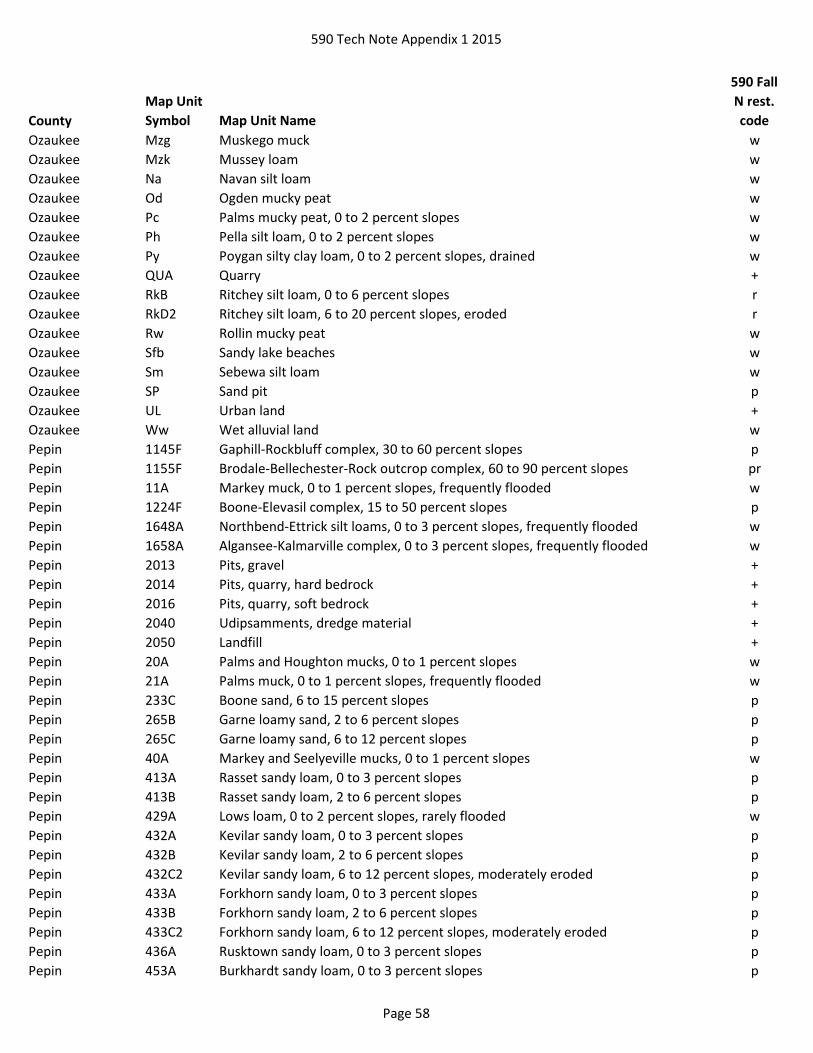
590 Tech Note Appendix 1 2015
County
Map Unit
Symbol Map Unit Name
590 Fall
N rest.
code
Ozaukee Mzg Muskego muck w
Ozaukee Mzk Mussey loam w
Ozaukee Na Navan silt loam w
Ozaukee Od Ogden mucky peat w
Ozaukee Pc Palms mucky peat, 0 to 2 percent slopes w
Ozaukee Ph Pella silt loam, 0 to 2 percent slopes w
Ozaukee Py Poygan silty clay loam, 0 to 2 percent slopes, drained w
Ozaukee QUA Quarry +
Ozaukee RkB Ritchey silt loam, 0 to 6 percent slopes r
Ozaukee RkD2 Ritchey silt loam, 6 to 20 percent slopes, eroded r
Ozaukee Rw Rollin mucky peat w
Ozaukee Sfb Sandy lake beaches w
Ozaukee Sm Sebewa silt loam w
Ozaukee SP Sand pit p
Ozaukee UL Urban land +
Ozaukee Ww Wet alluvial land w
Pepin 1145F Gaphill-Rockbluff complex, 30 to 60 percent slopes p
Pepin 1155F Brodale-Bellechester-Rock outcrop complex, 60 to 90 percent slopes pr
Pepin 11A Markey muck, 0 to 1 percent slopes, frequently flooded w
Pepin 1224F Boone-Elevasil complex, 15 to 50 percent slopes p
Pepin 1648A Northbend-Ettrick silt loams, 0 to 3 percent slopes, frequently flooded w
Pepin 1658A Algansee-Kalmarville complex, 0 to 3 percent slopes, frequently flooded w
Pepin 2013 Pits, gravel +
Pepin 2014 Pits, quarry, hard bedrock +
Pepin 2016 Pits, quarry, soft bedrock +
Pepin 2040 Udipsamments, dredge material +
Pepin 2050 Landfill +
Pepin 20A Palms and Houghton mucks, 0 to 1 percent slopes w
Pepin 21A Palms muck, 0 to 1 percent slopes, frequently flooded w
Pepin 233C Boone sand, 6 to 15 percent slopes p
Pepin 265B Garne loamy sand, 2 to 6 percent slopes p
Pepin 265C Garne loamy sand, 6 to 12 percent slopes p
Pepin 40A Markey and Seelyeville mucks, 0 to 1 percent slopes w
Pepin 413A Rasset sandy loam, 0 to 3 percent slopes p
Pepin 413B Rasset sandy loam, 2 to 6 percent slopes p
Pepin 429A Lows loam, 0 to 2 percent slopes, rarely flooded w
Pepin 432A Kevilar sandy loam, 0 to 3 percent slopes p
Pepin 432B Kevilar sandy loam, 2 to 6 percent slopes p
Pepin 432C2 Kevilar sandy loam, 6 to 12 percent slopes, moderately eroded p
Pepin 433A Forkhorn sandy loam, 0 to 3 percent slopes p
Pepin 433B Forkhorn sandy loam, 2 to 6 percent slopes p
Pepin 433C2 Forkhorn sandy loam, 6 to 12 percent slopes, moderately eroded p
Pepin 436A Rusktown sandy loam, 0 to 3 percent slopes p
Pepin 453A Burkhardt sandy loam, 0 to 3 percent slopes p
Page 58
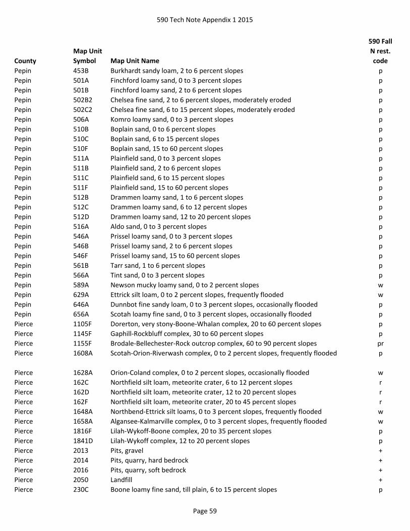
590 Tech Note Appendix 1 2015
County
Map Unit
Symbol Map Unit Name
590 Fall
N rest.
code
Pepin 453B Burkhardt sandy loam, 2 to 6 percent slopes p
Pepin 501A Finchford loamy sand, 0 to 3 percent slopes p
Pepin 501B Finchford loamy sand, 2 to 6 percent slopes p
Pepin 502B2 Chelsea fine sand, 2 to 6 percent slopes, moderately eroded p
Pepin 502C2 Chelsea fine sand, 6 to 15 percent slopes, moderately eroded p
Pepin 506A Komro loamy sand, 0 to 3 percent slopes p
Pepin 510B Boplain sand, 0 to 6 percent slopes p
Pepin 510C Boplain sand, 6 to 15 percent slopes p
Pepin 510F Boplain sand, 15 to 60 percent slopes p
Pepin 511A Plainfield sand, 0 to 3 percent slopes p
Pepin 511B Plainfield sand, 2 to 6 percent slopes p
Pepin 511C Plainfield sand, 6 to 15 percent slopes p
Pepin 511F Plainfield sand, 15 to 60 percent slopes p
Pepin 512B Drammen loamy sand, 1 to 6 percent slopes p
Pepin 512C Drammen loamy sand, 6 to 12 percent slopes p
Pepin 512D Drammen loamy sand, 12 to 20 percent slopes p
Pepin 516A Aldo sand, 0 to 3 percent slopes p
Pepin 546A Prissel loamy sand, 0 to 3 percent slopes p
Pepin 546B Prissel loamy sand, 2 to 6 percent slopes p
Pepin 546F Prissel loamy sand, 15 to 60 percent slopes p
Pepin 561B Tarr sand, 1 to 6 percent slopes p
Pepin 566A Tint sand, 0 to 3 percent slopes p
Pepin 589A Newson mucky loamy sand, 0 to 2 percent slopes w
Pepin 629A Ettrick silt loam, 0 to 2 percent slopes, frequently flooded w
Pepin 646A Dunnbot fine sandy loam, 0 to 3 percent slopes, occasionally flooded p
Pepin 656A Scotah loamy fine sand, 0 to 3 percent slopes, occasionally flooded p
Pierce 1105F Dorerton, very stony-Boone-Whalan complex, 20 to 60 percent slopes p
Pierce 1145F Gaphill-Rockbluff complex, 30 to 60 percent slopes p
Pierce 1155F Brodale-Bellechester-Rock outcrop complex, 60 to 90 percent slopes pr
Pierce 1608A Scotah-Orion-Riverwash complex, 0 to 2 percent slopes, frequently flooded p
Pierce 1628A Orion-Coland complex, 0 to 2 percent slopes, occasionally flooded w
Pierce 162C Northfield silt loam, meteorite crater, 6 to 12 percent slopes r
Pierce 162D Northfield silt loam, meteorite crater, 12 to 20 percent slopes r
Pierce 162F Northfield silt loam, meteorite crater, 20 to 45 percent slopes r
Pierce 1648A Northbend-Ettrick silt loams, 0 to 3 percent slopes, frequently flooded w
Pierce 1658A Algansee-Kalmarville complex, 0 to 3 percent slopes, frequently flooded w
Pierce 1816F Lilah-Wykoff-Boone complex, 20 to 35 percent slopes p
Pierce 1841D Lilah-Wykoff complex, 12 to 20 percent slopes p
Pierce 2013 Pits, gravel +
Pierce 2014 Pits, quarry, hard bedrock +
Pierce 2016 Pits, quarry, soft bedrock +
Pierce 2050 Landfill +
Pierce 230C Boone loamy fine sand, till plain, 6 to 15 percent slopes p
Page 59
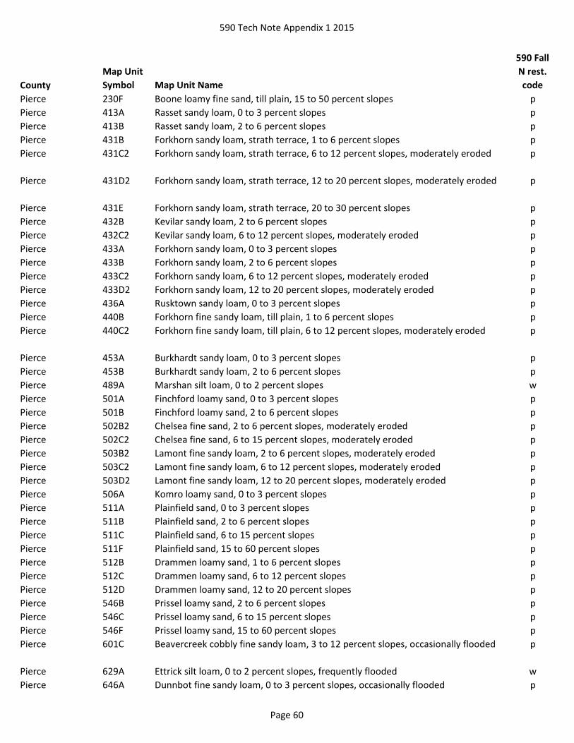
590 Tech Note Appendix 1 2015
County
Map Unit
Symbol Map Unit Name
590 Fall
N rest.
code
Pierce 230F Boone loamy fine sand, till plain, 15 to 50 percent slopes p
Pierce 413A Rasset sandy loam, 0 to 3 percent slopes p
Pierce 413B Rasset sandy loam, 2 to 6 percent slopes p
Pierce 431B Forkhorn sandy loam, strath terrace, 1 to 6 percent slopes p
Pierce 431C2 Forkhorn sandy loam, strath terrace, 6 to 12 percent slopes, moderately eroded p
Pierce 431D2 Forkhorn sandy loam, strath terrace, 12 to 20 percent slopes, moderately eroded p
Pierce 431E Forkhorn sandy loam, strath terrace, 20 to 30 percent slopes p
Pierce 432B Kevilar sandy loam, 2 to 6 percent slopes p
Pierce 432C2 Kevilar sandy loam, 6 to 12 percent slopes, moderately eroded p
Pierce 433A Forkhorn sandy loam, 0 to 3 percent slopes p
Pierce 433B Forkhorn sandy loam, 2 to 6 percent slopes p
Pierce 433C2 Forkhorn sandy loam, 6 to 12 percent slopes, moderately eroded p
Pierce 433D2 Forkhorn sandy loam, 12 to 20 percent slopes, moderately eroded p
Pierce 436A Rusktown sandy loam, 0 to 3 percent slopes p
Pierce 440B Forkhorn fine sandy loam, till plain, 1 to 6 percent slopes p
Pierce 440C2 Forkhorn fine sandy loam, till plain, 6 to 12 percent slopes, moderately eroded p
Pierce 453A Burkhardt sandy loam, 0 to 3 percent slopes p
Pierce 453B Burkhardt sandy loam, 2 to 6 percent slopes p
Pierce 489A Marshan silt loam, 0 to 2 percent slopes w
Pierce 501A Finchford loamy sand, 0 to 3 percent slopes p
Pierce 501B Finchford loamy sand, 2 to 6 percent slopes p
Pierce 502B2 Chelsea fine sand, 2 to 6 percent slopes, moderately eroded p
Pierce 502C2 Chelsea fine sand, 6 to 15 percent slopes, moderately eroded p
Pierce 503B2 Lamont fine sandy loam, 2 to 6 percent slopes, moderately eroded p
Pierce 503C2 Lamont fine sandy loam, 6 to 12 percent slopes, moderately eroded p
Pierce 503D2 Lamont fine sandy loam, 12 to 20 percent slopes, moderately eroded p
Pierce 506A Komro loamy sand, 0 to 3 percent slopes p
Pierce 511A Plainfield sand, 0 to 3 percent slopes p
Pierce 511B Plainfield sand, 2 to 6 percent slopes p
Pierce 511C Plainfield sand, 6 to 15 percent slopes p
Pierce 511F Plainfield sand, 15 to 60 percent slopes p
Pierce 512B Drammen loamy sand, 1 to 6 percent slopes p
Pierce 512C Drammen loamy sand, 6 to 12 percent slopes p
Pierce 512D Drammen loamy sand, 12 to 20 percent slopes p
Pierce 546B Prissel loamy sand, 2 to 6 percent slopes p
Pierce 546C Prissel loamy sand, 6 to 15 percent slopes p
Pierce 546F Prissel loamy sand, 15 to 60 percent slopes p
Pierce 601C Beavercreek cobbly fine sandy loam, 3 to 12 percent slopes, occasionally flooded p
Pierce 629A Ettrick silt loam, 0 to 2 percent slopes, frequently flooded w
Pierce 646A Dunnbot fine sandy loam, 0 to 3 percent slopes, occasionally flooded p
Page 60

590 Tech Note Appendix 1 2015
County
Map Unit
Symbol Map Unit Name
590 Fall
N rest.
code
Pierce 656A Scotah loamy fine sand, 0 to 3 percent slopes, occasionally flooded p
Pierce 657A Dunnbot silt loam, 0 to 3 percent slopes, occasionally flooded p
Pierce 819A Clyde silt loam, 0 to 3 percent slopes w
Polk 1070C Fremstadt, stony-Cress complex, 6 to 15 percent slopes p
Polk 1070D Fremstadt, stony-Cress complex, 15 to 30 percent slopes p
Polk 109B Graycalm-Menahga complex, ice margin complex, 0 to 6 percent slope p
Polk 109C Graycalm-Menahga complex, ice margin complex, 6 to 12 percent slope p
Polk 109D Graycalm-Menahga complex, ice margin complex, 12 to 30 percent slope p
Polk 119B Hubbard-Mosford complex, 0 to 6 percent slopes p
Polk 13B Centuria-Grettum-Trade River complex, 0 to 4 percent slopes, stony p
Polk 149D2 Branstad-Chetek complex, 12 to 20 percent slopes, eroded p
Polk 160A Poskin silt loam, ice margin complex, 0 to 3 percent slopes w
Polk 193A Minocqua muck, 0 to 2 percent slopes w
Polk 2013 Pits, gravel +
Polk 23B Caryville loamy sand, 0 to 4 percent slopes, occasionally flooded p
Polk 24A Poskin silt loam, 0 to 3 percent slopes w
Polk 26B Dechamps-Fordum-Caryville complex, 0 to 6 percent slopes, commonly flooded wp
Polk 3082E Braham-Shawano complex, 12 to 35 percent slopes p
Polk 3126A Wurtsmith loamy sand, 0 to 3 percent slopes p
Polk 321A Pierz loam, 0 to 2 percent slopes p
Polk 33B Chetek sandy loam, 2 to 6 percent slopes p
Polk 3446A Newson muck, 0 to 2 percent slopes w
Polk 3448B Grettum loamy sand, 0 to 6 percent slopes p
Polk 3510B Pomroy-Fremstadt complex, 1 to 6 percent slopes, stony p
Polk 3510C Pomroy-Fremstadt complex, 6 to 15 percent slopes, stony p
Polk 3625A Lino loamy fine sand, 0 to 2 percent slopes w
Polk 3636B Plainbo sand, 2 to 6 percent slopes p
Polk 383B Mahtomedi loamy sand, 0 to 6 percent slopes p
Polk 383D Mahtomedi loamy sand, 12 to 30 percent slopes p
Polk 395A Meehan-Perchlake complex, ice margin complex, 0 to 2 percent slopes w
Polk 396B Friendship-Wurtsmith-Grayling complex, 0 to 6 percent slopes p
Polk 397A Perchlake loamy fine sand, 0 to 2 percent slopes w
Polk 399B Grayling sand, 0 to 6 percent slopes p
Polk 399C Grayling sand, 6 to 12 percent slopes p
Polk 399D Grayling sand, 12 to 30 percent slopes p
Polk 3A Totagatic-Bowstring-Ausable complex, 0 to 2 percent slopes, frequently flooded w
Polk 405A Lupton, Cathro, and Tawas soils, 0 to 1 percent slopes w
Polk 407A Seelyeville and Markey soils, 0 to 1 percent slopes w
Polk 410A Seelyeville and Cathro soils, 0 to 1 percent slopes w
Polk 439B Graycalm-Menahga complex, 0 to 6 percent slopes p
Polk 439C Graycalm-Menahga complex, 6 to 12 percent slopes p
Polk 439D Graycalm-Menahga complex, 12 to 30 percent slopes p
Page 61

590 Tech Note Appendix 1 2015
County
Map Unit
Symbol Map Unit Name
590 Fall
N rest.
code
Polk 461A Bowstring muck, 0 to 1 percent slopes, frequently flooded w
Polk 465A Newson-Meehan complex, 0 to 3 percent slopes w
Polk 469E Bigisland-Milaca complex, 15 to 45 percent slopes, very stony p
Polk 471B Dairyland-Emmert complex, 0 to 6 percent slopes, very stony p
Polk 471C Dairyland-Emmert complex, 6 to 15 percent slopes, very stony p
Polk 473A Dairyland-Skog complex, 0 to 3 percent slopes, very stony, rarely flooded p
Polk 485C Lupton and Tawas soils, seeped, 2 to 15 percent slopes w
Polk 544F Menahga and Mahtomedi soils, 30 to 45 percent slopes p
Polk 5555A Fordum-Ausable complex, 0 to 2 percent slopes, frequently flooded w
Polk 555A Fordum silt loam, 0 to 2 percent slopes, frequently flooded w
Polk 557B Shawano fine sand, 0 to 6 percent slopes p
Polk 557C Shawano fine sand, 6 to 12 percent slopes p
Polk 557D Shawano fine sand, 12 to 30 percent slopes p
Polk 620C Lundeen-Haustrup-Rock outcrop complex, 2 to 12 percent slopes, very stony r
Polk 64A Totagatic-Winterfield complex, 0 to 2 percent slopes, frequently flooded w
Polk 655B Cress-Graycalm, 0 to 6 percent slopes p
Polk 655C Cress-Graycalm, 6 to 12 percent slopes p
Polk 655D Cress-Graycalm, 12 to 30 percent slopes p
Polk 65B Cromwell sandy loam, 0 to 6 percent slopes p
Polk 65C Cromwell sandy loam, 6 to 12 percent slopes p
Polk 65D Cromwell sandy loam, 12 to 20 percent slopes p
Polk 669D Fremstadt, stony-Pomroy complex, 15 to 30 percent slopes p
Polk 720F Haustrup-Lundeen-Rock outcrop complex, 12 to 65 percent slopes, very stony r
Polk 82B Cutaway-Branstad complex, 1 to 6 percent slopes p
Polk 82C Cutaway-Branstad complex, 6 to 12 percent slopes p
Polk 8F Grayling-Trade River-Seep complex, 20 to 80 percent slopes p
Polk Ag Alstad loam, 0 to 3 percent slopes w
Polk AoC Amery complex, 6 to 12 percent slopes p
Polk AoD Amery complex, 12 to 20 percent slopes p
Polk AoE Amery complex, 20 to 30 percent slopes p
Polk ArC Amery-Rock outcrop complex, 2 to 12 percent slopes r
Polk ArD Amery-Rock outcrop complex, 12 to 45 percent slopes r
Polk Bf Bluffton loam w
Polk BpA Burkhardt sandy loam, 0 to 2 percent slopes p
Polk BpB Burkhardt sandy loam, 2 to 6 percent slopes p
Polk BpC2 Burkhardt sandy loam, 6 to 12 percent slopes, eroded p
Polk Cc Cathro muck w
Polk CsA Cromwell variant sandy loam, 0 to 3 percent slopes w
Polk CtA Croswell loamy sand, 0 to 3 percent slopes p
Polk CxB Cushing complex, 2 to 6 percent slopes p
Polk CxC2 Cushing complex, 6 to 12 percent slopes, eroded p
Polk CxD2 Cushing complex, 12 to 20 percent slopes, eroded p
Page 62

590 Tech Note Appendix 1 2015
County
Map Unit
Symbol Map Unit Name
590 Fall
N rest.
code
Polk DvA Dakota variant silt loam, 0 to 3 percent slopes w
Polk EmD Emmert gravelly sandy loam, 12 to 35 percent slopes p
Polk Fe Fluvaquents, wet w
Polk HrB Hubbard loamy sand, 0 to 6 percent slopes p
Polk LnA Lino loamy fine sand, 0 to 3 percent slopes w
Polk Mk Markey muck w
Polk MnB Menahga loamy sand, 1 to 6 percent slopes p
Polk MnC Menahga loamy sand, 6 to 12 percent slopes p
Polk MnD Menahga loamy sand, 12 to 25 percent slopes p
Polk Ns Newson loamy fine sand w
Polk NyA Nymore fine sand, 0 to 3 percent slopes p
Polk OgB Omega fine sand, 2 to 6 percent slopes p
Polk OgC Omega fine sand, 6 to 12 percent slopes p
Polk OgD Omega fine sand, 12 to 20 percent slopes p
Polk Pg Pits, gravel +
Polk PxA Poskin silt loam, 0 to 3 percent slopes w
Polk QUA Quarry +
Polk Rf Rifle muck w
Polk Se Saprists and Aquents w
Polk Sm Seelyeville muck w
Polk Us Udorthents, sandy p
Polk Wv Warman variant sandy loam w
Portage Ab Alluvial land, wet w
Portage Af Altdorf silt loam w
Portage Bt Billett sandy loam, 0 to 2 percent slopes p
Portage Ca Cathro muck w
Portage CoB Coloma loamy sand, 2 to 6 percent slopes p
Portage CoC Coloma loamy sand, 6 to 12 percent slopes p
Portage Da Dancy sandy loam w
Portage DoA Dolph silt loam, 1 to 3 percent slopes w
Portage DuB Dunnville very fine sandy loam, 2 to 6 percent slopes p
Portage DxA Dunnville very fine sandy loam, mottled subsoil variant, 1 to 3 percent slopes p
Portage FrA Friendship loamy sand, 0 to 3 percent slopes p
Portage GP Gravel pit +
Portage KeA Kert silt loam, 1 to 3 percent slopes w
Portage KrB Kranski loamy sand, 2 to 6 percent slopes p
Portage KrC Kranski loamy sand, 6 to 12 percent slopes p
Portage KrD Kranski loamy sand, 12 to 20 percent slopes p
Portage LDF Landfill +
Portage LeA Leola loamy sand, 0 to 3 percent slopes w
Portage Lu Lupton muck w
Portage Ma Markey muck w
Portage Mb Markey muck, shallow w
Page 63
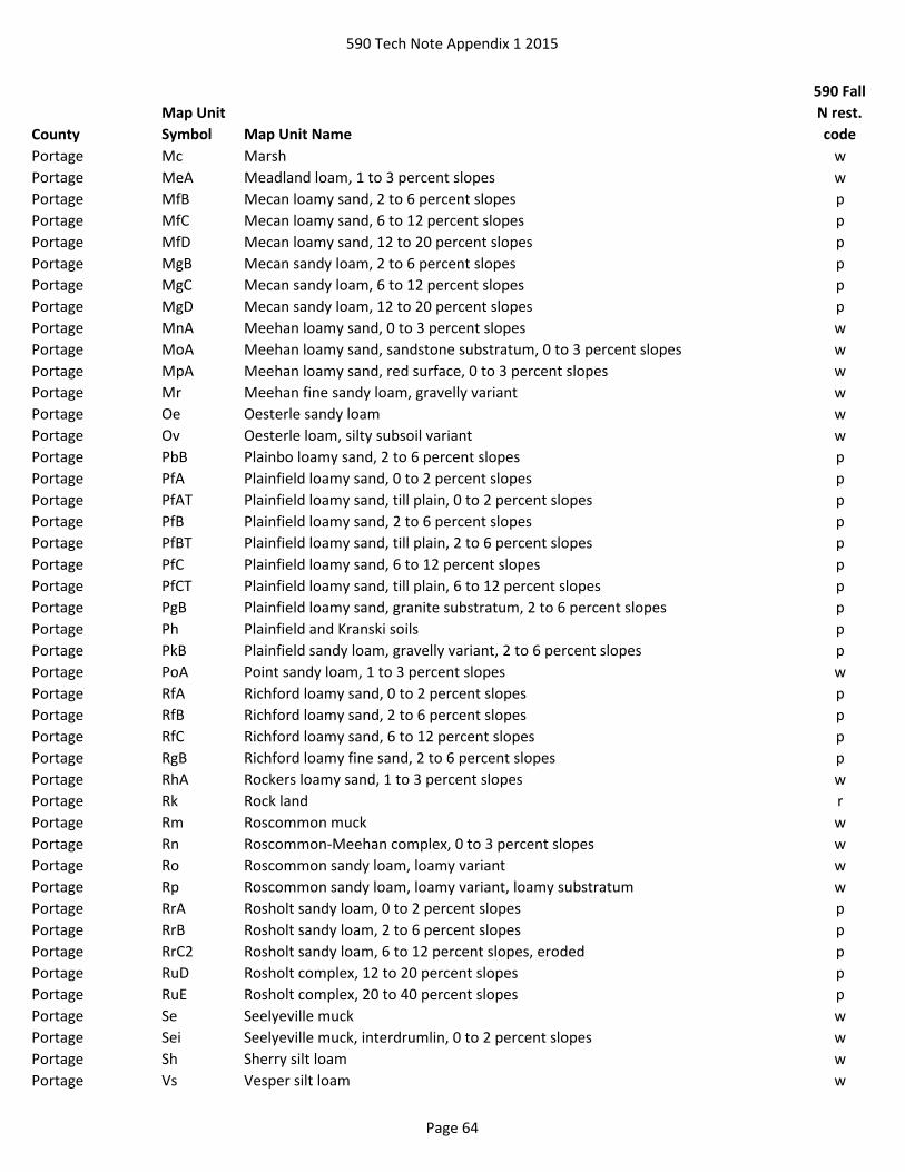
590 Tech Note Appendix 1 2015
County
Map Unit
Symbol Map Unit Name
590 Fall
N rest.
code
Portage Mc Marsh w
Portage MeA Meadland loam, 1 to 3 percent slopes w
Portage MfB Mecan loamy sand, 2 to 6 percent slopes p
Portage MfC Mecan loamy sand, 6 to 12 percent slopes p
Portage MfD Mecan loamy sand, 12 to 20 percent slopes p
Portage MgB Mecan sandy loam, 2 to 6 percent slopes p
Portage MgC Mecan sandy loam, 6 to 12 percent slopes p
Portage MgD Mecan sandy loam, 12 to 20 percent slopes p
Portage MnA Meehan loamy sand, 0 to 3 percent slopes w
Portage MoA Meehan loamy sand, sandstone substratum, 0 to 3 percent slopes w
Portage MpA Meehan loamy sand, red surface, 0 to 3 percent slopes w
Portage Mr Meehan fine sandy loam, gravelly variant w
Portage Oe Oesterle sandy loam w
Portage Ov Oesterle loam, silty subsoil variant w
Portage PbB Plainbo loamy sand, 2 to 6 percent slopes p
Portage PfA Plainfield loamy sand, 0 to 2 percent slopes p
Portage PfAT Plainfield loamy sand, till plain, 0 to 2 percent slopes p
Portage PfB Plainfield loamy sand, 2 to 6 percent slopes p
Portage PfBT Plainfield loamy sand, till plain, 2 to 6 percent slopes p
Portage PfC Plainfield loamy sand, 6 to 12 percent slopes p
Portage PfCT Plainfield loamy sand, till plain, 6 to 12 percent slopes p
Portage PgB Plainfield loamy sand, granite substratum, 2 to 6 percent slopes p
Portage Ph Plainfield and Kranski soils p
Portage PkB Plainfield sandy loam, gravelly variant, 2 to 6 percent slopes p
Portage PoA Point sandy loam, 1 to 3 percent slopes w
Portage RfA Richford loamy sand, 0 to 2 percent slopes p
Portage RfB Richford loamy sand, 2 to 6 percent slopes p
Portage RfC Richford loamy sand, 6 to 12 percent slopes p
Portage RgB Richford loamy fine sand, 2 to 6 percent slopes p
Portage RhA Rockers loamy sand, 1 to 3 percent slopes w
Portage Rk Rock land r
Portage Rm Roscommon muck w
Portage Rn Roscommon-Meehan complex, 0 to 3 percent slopes w
Portage Ro Roscommon sandy loam, loamy variant w
Portage Rp Roscommon sandy loam, loamy variant, loamy substratum w
Portage RrA Rosholt sandy loam, 0 to 2 percent slopes p
Portage RrB Rosholt sandy loam, 2 to 6 percent slopes p
Portage RrC2 Rosholt sandy loam, 6 to 12 percent slopes, eroded p
Portage RuD Rosholt complex, 12 to 20 percent slopes p
Portage RuE Rosholt complex, 20 to 40 percent slopes p
Portage Se Seelyeville muck w
Portage Sei Seelyeville muck, interdrumlin, 0 to 2 percent slopes w
Portage Sh Sherry silt loam w
Portage Vs Vesper silt loam w
Page 64

590 Tech Note Appendix 1 2015
County
Map Unit
Symbol Map Unit Name
590 Fall
N rest.
code
Portage WyB Wyocena sandy loam, 2 to 6 percent slopes p
Portage WyC Wyocena sandy loam, 6 to 12 percent slopes p
Portage WyD Wyocena sandy loam, 12 to 20 percent slopes p
Portage WyE Wyocena sandy loam, 20 to 30 percent slopes p
Price 193A Minocqua muck, 0 to 2 percent slopes w
Price 2015 Pits +
Price 2030 Udorthents and udipsamments, cut or fill +
Price 2050 Landfill +
Price 215B Pence sandy loam, 0 to 6 percent slopes p
Price 215C Pence sandy loam, 6 to 15 percent slopes p
Price 215D Pence sandy loam, 15 to 30 percent slopes p
Price 217B Karlin loamy fine sand, 0 to 6 percent slopes p
Price 217C Karlin loamy fine sand, 6 to 15 percent slopes p
Price 3114A Saprists, Aquents, and Aquepts, 0 to 1 percent slopes, ponded, flooded w
Price 3276A Au Gres loamy sand, 0 to 3 percent slopes w
Price 3403A Loxley, Beseman, and Dawson soils, 0 to 1 percent slopes w
Price 346E Newot-Pence complex, 15 to 45 percent slopes, very stony p
Price 3546B Newood-Pence complex, 2 to 6 percent slopes, very stony p
Price 3546C Newood-Pence complex, 6 to 15 percent slopes, very stony p
Price 3546D Newood-Pence complex, 15 to 30 percent slopes, very stony p
Price 384B Springstead sandy loam, 1 to 6 percent slopes, stony p
Price 405A Lupton, Cathro, and Tawas soils, 0 to 1 percent slopes w
Price 407A Seelyeville and Markey soils, 0 to 1 percent slopes w
Price 408A Lupton and Cathro soils, 0 to 1 percent slopes w
Price 414A Loxley and Beseman soils, 0 to 1 percent slopes w
Price 418A Loxley and Dawson soils, 0 to 1 percent slopes w
Price 425B Karlin sandy loam, 0 to 6 percent slopes p
Price 425C Karlin sandy loam, 6 to 15 percent slopes p
Price 425D Karlin sandy loam, 15 to 30 percent slopes p
Price 445A Kinross muck, 0 to 2 percent slopes w
Price 461A Bowstring muck, 0 to 1 percent slopes, frequently flooded w
Price 475D Rubicon-Sayner complex, 15 to 30 percent slopes p
Price 520A Annriver silt loam, 0 to 2 percent slopes w
Price 555A Fordum silt loam, 0 to 2 percent slopes, frequently flooded w
Price 571B Pelissier gravelly sandy loam, 2 to 6 percent slopes p
Price 571C Pelissier gravelly sandy loam, 6 to 15 percent slopes p
Price 571E Pelissier gravelly sandy loam, 15 to 45 percent slopes p
Price 591A Croswell-Chinwhisker complex, 0 to 3 percent slopes p
Price 594B Vilas-Lindquist complex, 0 to 6 percent slopes p
Price 594C Vilas-Lindquist complex, 6 to 15 percent slopes p
Price 594D Vilas-Lindquist complex, 15 to 30 percent slopes p
Price 600A Haplosaprists and Psammaquents, 0 to 2 percent slopes w
Price 670B Keweenaw-Pence complex, 0 to 6 percent slopes, stony p
Price 670C Keweenaw-Pence complex, 6 to 15 percent slopes, stony p
Page 65

590 Tech Note Appendix 1 2015
County
Map Unit
Symbol Map Unit Name
590 Fall
N rest.
code
Price 670E Keweenaw-Pence complex, 15 to 45 percent slopes, stony p
Price 675A Robago fine sandy loam, 0 to 3 percent slopes w
Price 701A Whisklake silt loam, 0 to 3 percent slopes w
Price 755A Moppet, occasionally flooded-Fordum, frequently flooded complex, 0 to 3 percent
slopes
w
Price 770B Shanagolden-Pence complex, 2 to 6 percent slopes, stony p
Price 770C Shanagolden-Pence complex, 6 to 15 percent slopes, stony p
Price 770D Shanagolden-Pence complex, 15 to 30 percent slopes, stony p
Price 815A Wormet sandy loam, 0 to 3 percent slopes w
Price 852C Pence-Padus complex, 6 to 15 percent slopes, stony p
Price 852D Pence-Padus complex, 15 to 30 percent slopes, stony p
Price 864E Crystal Lake-Newot, very stony-Pence complex, 15 to 35 percent slopes p
Price 9012B Sayner-Lindquist complex, 0 to 6 percent slopes p
Price 9012C Sayner-Lindquist complex, 6 to 15 percent slopes p
Price 9012D Sayner-Lindquist complex, 15 to 30 percent slopes p
Price 9050A Fordum, Totagatic, and Bowstring soils, 0 to 1 percent slopes, frequently flooded w
Price 905A Cublake loamy sand, 0 to 3 percent slopes p
Price 9060D Pelissier sandy loam, 20 to 45 percent slopes p
Price 9113B Padus-Karlin complex, 0 to 6 percent slopes p
Price 9113C Padus-Karlin complex, 6 to 15 percent slopes p
Price 9113D Padus-Karlin complex, 15 to 30 percent slopes p
Price 9155A Haplosaprists, Peats, and Mucks, 0 to 1 percent slopes w
Price 974B Sayner-Pence-Vilas complex, 0 to 6 percent slopes p
Price 974C Sayner-Pence-Vilas complex, 6 to 15 percent slopes p
Price 974D Sayner-Pence-Vilas complex, 15 to 30 percent slopes p
Racine Ac Adrian muck w
Racine Am Alluvial land w
Racine AtA Ashkum silty clay loam, 0 to 2 percent slopes w
Racine BmB Boyer loamy sand, 1 to 6 percent slopes p
Racine BmC2 Boyer loamy sand, 6 to 12 percent slopes, eroded p
Racine BnB Boyer sandy loam, 2 to 6 percent slopes p
Racine BP Borrow pit +
Racine CP Coal pile +
Racine CrC Casco-Rodman complex, 6 to 12 percent slopes p
Racine CrD2 Casco-Rodman complex, 12 to 20 percent slopes, eroded p
Racine CrE Casco-Rodman complex, 20 to 30 percent slopes p
Racine Cw Colwood silt loam, 0 to 2 percent slopes w
Racine Dh Dorchester silt loam w
Racine Dt Drummer silt loam, gravelly substratum w
Racine Gf Granby fine sandy loam w
Racine Gm Granby fine sandy loam, loamy substratum w
Racine GP Gravel pit +
Racine Ht Houghton muck w
Page 66
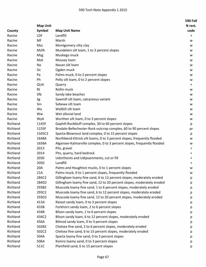
590 Tech Note Appendix 1 2015
County
Map Unit
Symbol Map Unit Name
590 Fall
N rest.
code
Racine LDF Landfill +
Racine Mf Marsh w
Racine Mzc Montgomery silty clay w
Racine MzfA Mundelein silt loam, 1 to 3 percent slopes w
Racine Mzg Muskego muck w
Racine Mzk Mussey loam w
Racine Na Navan silt loam w
Racine Oc Ogden muck w
Racine Pa Palms muck, 0 to 2 percent slopes w
Racine Ph Pella silt loam, 0 to 2 percent slopes w
Racine QUA Quarry +
Racine Rt Rollin muck w
Racine Sfb Sandy lake beaches w
Racine Sg Sawmill silt loam, calcareous variant w
Racine Sm Sebewa silt loam w
Racine Wa Wallkill silt loam w
Racine Ww Wet alluvial land w
Racine WyA Worthen silt loam, 0 to 3 percent slopes w
Richland 1145F Gaphill-Rockbluff complex, 30 to 60 percent slopes p
Richland 1155F Brodale-Bellechester-Rock outcrop complex, 60 to 90 percent slopes pr
Richland 1505C2 Sparta-Blownout land complex, 0 to 15 percent slopes p
Richland 1648A Northbend-Ettrick silt loams, 0 to 3 percent slopes, frequently flooded w
Richland 1658A Algansee-Kalmarville complex, 0 to 3 percent slopes, frequently flooded w
Richland 2013 Pits, gravel +
Richland 2014 Pits, quarry, hard bedrock +
Richland 2030 Udorthents and Udipsamments, cut or fill +
Richland 2050 Landfill +
Richland 20A Palms and Houghton mucks, 0 to 1 percent slopes w
Richland 21A Palms muck, 0 to 1 percent slopes, frequently flooded w
Richland 284C2 Gillingham loamy fine sand, 6 to 12 percent slopes, moderately eroded p
Richland 284D2 Gillingham loamy fine sand, 12 to 20 percent slopes, moderately eroded p
Richland 293B2 Muscoda loamy fine sand, 1 to 6 percent slopes, moderately eroded p
Richland 293C2 Muscoda loamy fine sand, 6 to 12 percent slopes, moderately eroded p
Richland 293D2 Muscoda loamy fine sand, 12 to 20 percent slopes, moderately eroded p
Richland 413A Rasset sandy loam, 0 to 3 percent slopes p
Richland 433B Forkhorn sandy loam, 2 to 6 percent slopes p
Richland 434B Bilson sandy loam, 1 to 6 percent slopes p
Richland 434C2 Bilson sandy loam, 6 to 12 percent slopes, moderately eroded p
Richland 456A Bilmod sandy loam, 0 to 3 percent slopes p
Richland 502B2 Chelsea fine sand, 2 to 6 percent slopes, moderately eroded p
Richland 502C2 Chelsea fine sand, 6 to 15 percent slopes, moderately eroded p
Richland 504A Sparta loamy fine sand, 0 to 3 percent slopes p
Richland 506A Komro loamy sand, 0 to 3 percent slopes p
Richland 511C Plainfield sand, 6 to 15 percent slopes p
Page 67

590 Tech Note Appendix 1 2015
County
Map Unit
Symbol Map Unit Name
590 Fall
N rest.
code
Richland 511F Plainfield sand, 15 to 60 percent slopes p
Richland 572B2 Windward loamy fine sand, 2 to 6 percent slopes, moderately eroded p
Richland 572C2 Windward loamy fine sand, 6 to 12 percent slopes, moderately eroded p
Richland 576B Tintson sand, 1 to 6 percent slopes p
Richland 601C Beavercreek cobbly fine sandy loam, 3 to 12 percent slopes, occasionally flooded p
Richland 629A Ettrick silt loam, 0 to 2 percent slopes, frequently flooded w
Richland 656A Scotah loamy fine sand, 0 to 3 percent slopes, occasionally flooded p
Rock Ad Adrian muck w
Rock Aw Alluvial land, wet w
Rock BlA Billett sandy loam, 0 to 2 percent slopes p
Rock BlB Billett sandy loam, 2 to 6 percent slopes p
Rock BmA Billett sandy loam, mottled subsoil variant, 0 to 3 percent slopes w
Rock BP Borrow pit +
Rock Br Brookston silt loam w
Rock Co Colwood silt loam, 0 to 2 percent slopes w
Rock DcA Dickman sandy loam, 0 to 2 percent slopes p
Rock DcB Dickman sandy loam, 2 to 6 percent slopes p
Rock DcC2 Dickman sandy loam, 6 to 12 percent slopes, eroded p
Rock EdB2 Edmund loam, 2 to 6 percent slopes, eroded r
Rock EdC2 Edmund loam, 6 to 12 percent slopes, eroded r
Rock EdD2 Edmund loam, 12 to 20 percent slopes, eroded r
Rock EdE Edmund loam, 20 to 35 percent slopes r
Rock GoA Gotham loamy sand, 0 to 2 percent slopes p
Rock GoB Gotham loamy sand, 2 to 6 percent slopes p
Rock GoC2 Gotham loamy sand, 6 to 12 percent slopes, eroded p
Rock GoD Gotham loamy sand, 12 to 20 percent slopes p
Rock GP Gravel pit +
Rock Ho Houghton muck w
Rock JuA Juneau silt loam, 0 to 3 percent slopes w
Rock Ma Mahalasville silt loam w
Rock Mb Mahalasville silt loam, overwash w
Rock Mc Marsh w
Rock Md Marshan loam w
Rock Me Maumee loamy sand w
Rock Mf Millington silt loam w
Rock Na Navan silt loam w
Rock OoA Oshtemo sandy loam, 0 to 2 percent slopes p
Rock OoB Oshtemo sandy loam, 2 to 6 percent slopes p
Rock OoC2 Oshtemo sandy loam, 6 to 12 percent slopes, eroded p
Rock OoD2 Oshtemo sandy loam, 12 to 25 percent slopes, eroded p
Rock OsA Oshtemo sandy loam, dark variant, 0 to 2 percent slopes p
Rock OsB Oshtemo sandy loam, dark variant, 2 to 6 percent slopes p
Rock OsC2 Oshtemo sandy loam, dark variant, 6 to 12 percent slopes, eroded p
Page 68

590 Tech Note Appendix 1 2015
County
Map Unit
Symbol Map Unit Name
590 Fall
N rest.
code
Rock Ot Otter silt loam w
Rock Pa Palms muck, 0 to 2 percent slopes w
Rock QUA Quarry +
Rock Ro Rock land r
Rock RrC2 Rodman-Lorenzo complex, 6 to 12 percent slopes, eroded p
Rock RrE Rodman-Lorenzo complex, 20 to 30 percent slopes p
Rock RrF Rodman-Lorenzo complex, 30 to 45 percent slopes p
Rock Rs Rollin muck w
Rock Se Sebewa silt loam w
Rock SoB Sogn loam, 2 to 6 percent slopes r
Rock SoC2 Sogn loam, 6 to 12 percent slopes, eroded r
Rock SoD Sogn loam, 12 to 20 percent slopes r
Rock SoF Sogn loam, 30 to 45 percent slopes r
Rock TrA Troxel silt loam, 0 to 3 percent slopes w
Rock WoA Worthen silt loam, 0 to 3 percent slopes w
Rusk 193A Minocqua muck, 0 to 2 percent slopes w
Rusk 2015 Pits +
Rusk 2030 Udorthents and udipsamments, cut or fill +
Rusk 2050 Landfill +
Rusk 215B Pence sandy loam, 0 to 6 percent slopes p
Rusk 215C Pence sandy loam, 6 to 15 percent slopes p
Rusk 215D Pence sandy loam, 15 to 30 percent slopes p
Rusk 24A Poskin silt loam, 0 to 3 percent slopes w
Rusk 3114A Saprists, Aquents, and Aquepts, 0 to 1 percent slopes, ponded, flooded w
Rusk 3126A Wurtsmith loamy sand, 0 to 3 percent slopes p
Rusk 315A Rib silt loam, 0 to 2 percent slopes w
Rusk 324A Maplehurst silt loam, 0 to 3 percent slopes w
Rusk 3276A Au Gres loamy sand, 0 to 3 percent slopes w
Rusk 33B Chetek sandy loam, 1 to 6 percent slopes p
Rusk 3446A Newson muck, 0 to 2 percent slopes w
Rusk 346E Newot-Pence complex, 15 to 45 percent slopes, very stony p
Rusk 3546C Newood-Pence complex, 6 to 15 percent slopes, very stony p
Rusk 383B Mahtomedi loamy sand, 0 to 6 percent slopes p
Rusk 383C Mahtomedi loamy sand, 6 to 12 percent slopes p
Rusk 383D Mahtomedi loamy sand, 12 to 30 percent slopes p
Rusk 406A Loxley mucky peat, 0 to 1 percent slopes w
Rusk 407A Seelyeville and Markey soils, 0 to 1 percent slopes w
Rusk 408A Lupton and Cathro soils, 0 to 1 percent slopes w
Rusk 412A Rifle and Tacoosh soils, 0 to 1 percent slopes w
Rusk 414A Loxley and Beseman soils, 0 to 1 percent slopes w
Rusk 415A Greenwood mucky peat, 0 to 1 percent slopes w
Rusk 425B Karlin sandy loam, 0 to 6 percent slopes p
Rusk 425C Karlin sandy loam, 6 to 15 percent slopes p
Rusk 439B Graycalm-Menahga complex, 0 to 6 percent slopes p
Page 69
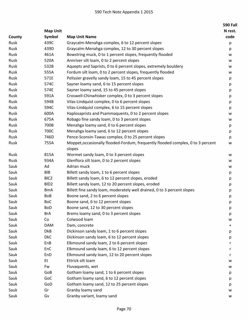
590 Tech Note Appendix 1 2015
County
Map Unit
Symbol Map Unit Name
590 Fall
N rest.
code
Rusk 439C Graycalm-Menahga complex, 6 to 12 percent slopes p
Rusk 439D Graycalm-Menahga complex, 12 to 30 percent slopes p
Rusk 461A Bowstring muck, 0 to 1 percent slopes, frequently flooded w
Rusk 520A Annriver silt loam, 0 to 2 percent slopes w
Rusk 532B Aquepts and Saprists, 0 to 6 percent slopes, extremely bouldery w
Rusk 555A Fordum silt loam, 0 to 2 percent slopes, frequently flooded w
Rusk 571E Pelissier gravelly sandy loam, 15 to 45 percent slopes p
Rusk 574C Sayner loamy sand, 6 to 15 percent slopes p
Rusk 574E Sayner loamy sand, 15 to 45 percent slopes p
Rusk 591A Croswell-Chinwhisker complex, 0 to 3 percent slopes p
Rusk 594B Vilas-Lindquist complex, 0 to 6 percent slopes p
Rusk 594C Vilas-Lindquist complex, 6 to 15 percent slopes p
Rusk 600A Haplosaprists and Psammaquents, 0 to 2 percent slopes w
Rusk 675A Robago fine sandy loam, 0 to 3 percent slopes w
Rusk 700B Menahga loamy sand, 0 to 6 percent slopes p
Rusk 700C Menahga loamy sand, 6 to 12 percent slopes p
Rusk 746D Pence-Sconsin-Tawas complex, 0 to 25 percent slopes p
Rusk 755A Moppet,occasionally flooded-Fordum, frequently flooded complex, 0 to 3 percent
slopes
w
Rusk 815A Wormet sandy loam, 0 to 3 percent slopes w
Rusk 934A Glenflora silt loam, 0 to 2 percent slopes w
Sauk Ad Adrian muck w
Sauk BlB Billett sandy loam, 1 to 6 percent slopes p
Sauk BlC2 Billett sandy loam, 6 to 12 percent slopes, eroded p
Sauk BlD2 Billett sandy loam, 12 to 20 percent slopes, eroded p
Sauk BmA Billett fine sandy loam, moderately well drained, 0 to 3 percent slopes p
Sauk BoB Boone sand, 2 to 6 percent slopes p
Sauk BoC Boone sand, 6 to 12 percent slopes p
Sauk BoD Boone sand, 12 to 30 percent slopes p
Sauk BrA Brems loamy sand, 0 to 3 percent slopes p
Sauk Co Colwood loam w
Sauk DAM Dam, concrete +
Sauk DkB Dickinson sandy loam, 1 to 6 percent slopes p
Sauk DkC Dickinson sandy loam, 6 to 12 percent slopes p
Sauk EnB Elkmound sandy loam, 2 to 6 percent slopes r
Sauk EnC Elkmound sandy loam, 6 to 12 percent slopes r
Sauk EnD Elkmound sandy loam, 12 to 20 percent slopes r
Sauk Et Ettrick silt loam w
Sauk Fw Fluvaquents, wet w
Sauk GoB Gotham loamy sand, 1 to 6 percent slopes p
Sauk GoC Gotham loamy sand, 6 to 12 percent slopes p
Sauk GoD Gotham loamy sand, 12 to 25 percent slopes p
Sauk Gr Granby loamy sand w
Sauk Gv Granby variant, loamy sand w
Page 70
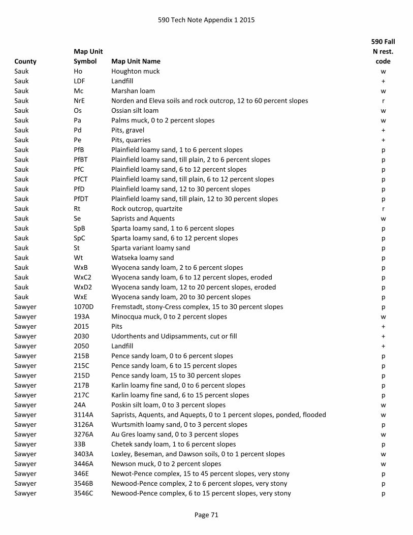
590 Tech Note Appendix 1 2015
County
Map Unit
Symbol Map Unit Name
590 Fall
N rest.
code
Sauk Ho Houghton muck w
Sauk LDF Landfill +
Sauk Mc Marshan loam w
Sauk NrE Norden and Eleva soils and rock outcrop, 12 to 60 percent slopes r
Sauk Os Ossian silt loam w
Sauk Pa Palms muck, 0 to 2 percent slopes w
Sauk Pd Pits, gravel +
Sauk Pe Pits, quarries +
Sauk PfB Plainfield loamy sand, 1 to 6 percent slopes p
Sauk PfBT Plainfield loamy sand, till plain, 2 to 6 percent slopes p
Sauk PfC Plainfield loamy sand, 6 to 12 percent slopes p
Sauk PfCT Plainfield loamy sand, till plain, 6 to 12 percent slopes p
Sauk PfD Plainfield loamy sand, 12 to 30 percent slopes p
Sauk PfDT Plainfield loamy sand, till plain, 12 to 30 percent slopes p
Sauk Rt Rock outcrop, quartzite r
Sauk Se Saprists and Aquents w
Sauk SpB Sparta loamy sand, 1 to 6 percent slopes p
Sauk SpC Sparta loamy sand, 6 to 12 percent slopes p
Sauk St Sparta variant loamy sand p
Sauk Wt Watseka loamy sand p
Sauk WxB Wyocena sandy loam, 2 to 6 percent slopes p
Sauk WxC2 Wyocena sandy loam, 6 to 12 percent slopes, eroded p
Sauk WxD2 Wyocena sandy loam, 12 to 20 percent slopes, eroded p
Sauk WxE Wyocena sandy loam, 20 to 30 percent slopes p
Sawyer 1070D Fremstadt, stony-Cress complex, 15 to 30 percent slopes p
Sawyer 193A Minocqua muck, 0 to 2 percent slopes w
Sawyer 2015 Pits +
Sawyer 2030 Udorthents and Udipsamments, cut or fill +
Sawyer 2050 Landfill +
Sawyer 215B Pence sandy loam, 0 to 6 percent slopes p
Sawyer 215C Pence sandy loam, 6 to 15 percent slopes p
Sawyer 215D Pence sandy loam, 15 to 30 percent slopes p
Sawyer 217B Karlin loamy fine sand, 0 to 6 percent slopes p
Sawyer 217C Karlin loamy fine sand, 6 to 15 percent slopes p
Sawyer 24A Poskin silt loam, 0 to 3 percent slopes w
Sawyer 3114A Saprists, Aquents, and Aquepts, 0 to 1 percent slopes, ponded, flooded w
Sawyer 3126A Wurtsmith loamy sand, 0 to 3 percent slopes p
Sawyer 3276A Au Gres loamy sand, 0 to 3 percent slopes w
Sawyer 33B Chetek sandy loam, 1 to 6 percent slopes p
Sawyer 3403A Loxley, Beseman, and Dawson soils, 0 to 1 percent slopes w
Sawyer 3446A Newson muck, 0 to 2 percent slopes w
Sawyer 346E Newot-Pence complex, 15 to 45 percent slopes, very stony p
Sawyer 3546B Newood-Pence complex, 2 to 6 percent slopes, very stony p
Sawyer 3546C Newood-Pence complex, 6 to 15 percent slopes, very stony p
Page 71

590 Tech Note Appendix 1 2015
County
Map Unit
Symbol Map Unit Name
590 Fall
N rest.
code
Sawyer 383B Mahtomedi loamy sand, 0 to 6 percent slopes p
Sawyer 383C Mahtomedi loamy sand, 6 to 12 percent slopes p
Sawyer 383D Mahtomedi loamy sand, 12 to 30 percent slopes p
Sawyer 384B Springstead sandy loam, 1 to 6 percent slopes, stony p
Sawyer 3A Totagatic-Bowstring-Ausable complex, 0 to 2 percent slopes, frequently flooded w
Sawyer 405A Lupton, Cathro, and Tawas soils, 0 to 1 percent slopes w
Sawyer 406A Loxley mucky peat, 0 to 1 percent slopes w
Sawyer 407A Seelyeville and Markey soils, 0 to 1 percent slopes w
Sawyer 408A Lupton and Cathro soils, 0 to 1 percent slopes w
Sawyer 412A Rifle and Tacoosh soils, 0 to 1 percent slopes w
Sawyer 414A Loxley and Beseman soils, 0 to 1 percent slopes w
Sawyer 415A Greenwood mucky peat, 0 to 1 percent slopes w
Sawyer 425B Karlin sandy loam, 0 to 6 percent slopes p
Sawyer 425C Karlin sandy loam, 6 to 15 percent slopes p
Sawyer 439B Graycalm-Menahga complex, 0 to 6 percent slopes p
Sawyer 439C Graycalm-Menahga complex, 6 to 12 percent slopes p
Sawyer 439D Graycalm-Menahga complex, 12 to 30 percent slopes p
Sawyer 443D Amery, very stony-Greenwood complex, 0 to 35 percent slopes w
Sawyer 445A Kinross muck, 0 to 2 percent slopes w
Sawyer 461A Bowstring muck, 0 to 1 percent slopes, frequently flooded w
Sawyer 520A Annriver silt loam, 0 to 2 percent slopes w
Sawyer 532B Aquepts and Saprists, 0 to 6 percent slopes, extremely bouldery w
Sawyer 555A Fordum silt loam, 0 to 2 percent slopes, frequently flooded w
Sawyer 571C Pelissier gravelly sandy loam, 6 to 15 percent slopes p
Sawyer 571E Pelissier gravelly sandy loam, 15 to 45 percent slopes p
Sawyer 574B Sayner loamy sand, 0 to 6 percent slopes p
Sawyer 574C Sayner loamy sand, 6 to 15 percent slopes p
Sawyer 574E Sayner loamy sand, 15 to 45 percent slopes p
Sawyer 582B Padus-Pence-Keweenaw complex, 0 to 6 percent slopes, stony p
Sawyer 582C Padus-Pence-Keweenaw complex, 6 to 15 percent slopes, stony p
Sawyer 582D Padus-Pence-Keweenaw complex, 15 to 30 percent slopes, stony p
Sawyer 591A Croswell-Chinwhisker complex, 0 to 3 percent slopes p
Sawyer 594B Vilas-Lindquist complex, 0 to 6 percent slopes p
Sawyer 594C Vilas-Lindquist complex, 6 to 15 percent slopes p
Sawyer 594D Vilas-Lindquist complex, 15 to 30 percent slopes p
Sawyer 600A Haplosaprists and Psammaquents, 0 to 2 percent slopes w
Sawyer 633F Pence and Padus soils, 30 to 45 percent slopes p
Sawyer 670B Keweenaw-Pence complex, 0 to 6 percent slopes, stony p
Sawyer 670C Keweenaw-Pence complex, 6 to 15 percent slopes, stony p
Sawyer 670E Keweenaw-Pence complex, 15 to 45 percent slopes, stony p
Sawyer 675A Robago fine sandy loam, 0 to 3 percent slopes w
Sawyer 680B Stanberry-Pence complex, 2 to 6 percent slopes, stony p
Sawyer 69B Keweenaw-Sayner-Vilas complex, 2 to 6 percent slopes, stony p
Page 72

590 Tech Note Appendix 1 2015
County
Map Unit
Symbol Map Unit Name
590 Fall
N rest.
code
Sawyer 69C Keweenaw-Sayner-Vilas complex, 6 to 15 percent slopes, stony p
Sawyer 69E Keweenaw-Sayner-Vilas complex, 15 to 45 percent slopes, stony p
Sawyer 755A Moppet, occasionally flooded-Fordum, frequently flooded complex, 0 to 3 percent
slopes
w
Sawyer 770B Shanagolden-Pence complex, 2 to 6 percent slopes, stony p
Sawyer 770C Shanagolden-Pence complex, 6 to 15 percent slopes, stony p
Sawyer 770D Shanagolden-Pence complex, 15 to 30 percent slopes, stony p
Sawyer 771A Lenroot loamy sand, 0 to 3 percent slopes p
Sawyer 815A Wormet sandy loam, 0 to 3 percent slopes w
Sawyer 874E Keweenaw, stony-Rubicon complex, 20 to 45 percent slopes p
Sawyer 9012B Sayner-Lindquist complex, 0 to 6 percent slopes p
Sawyer 9012C Sayner-Lindquist complex, 6 to 15 percent slopes p
Sawyer 9012D Sayner-Lindquist complex, 15 to 30 percent slopes p
Sawyer 9050A Fordum, Totagatic, and Bowstring soils, 0 to 1 percent slopes, frequently flooded w
Sawyer 905A Cublake loamy sand, 0 to 3 percent slopes p
Sawyer 9113B Padus-Karlin complex, 0 to 6 percent slopes p
Sawyer 9113C Padus-Karlin complex, 6 to 15 percent slopes p
Sawyer 9113D Padus-Karlin complex, 15 to 30 percent slopes p
Sawyer 9155A Haplosaprists, Peats, and Mucks, 0 to 1 percent slopes w
Sawyer 925C Rock outcrop-Ishpeming complex, 0 to 15 percent slopes r
Sawyer 970C Keweenaw, stony-Pence, stony-Greenwood complex, 0 to 15 percent slopes wp
Sawyer 970E Keweenaw, stony-Pence, stony-Greenwood complex, 0 to 45 percent slopes wp
Sawyer 974C Sayner-Pence-Vilas complex, 6 to 15 percent slopes p
Sawyer 974D Sayner-Pence-Vilas complex, 15 to 30 percent slopes p
Shawano Ah Angelica silt loam w
Shawano AuA Au Gres loamy sand, 0 to 3 percent slopes w
Shawano AxA Au Gres variant loamy fine sand, 0 to 3 percent slopes w
Shawano Ba Bach silt loam w
Shawano BrB Boyer sandy loam, 1 to 6 percent slopes p
Shawano Bs Brevort mucky loamy sand w
Shawano Co Cormant mucky loamy fine sand w
Shawano CtA Croswell loamy sand, 0 to 3 percent slopes p
Shawano EcD Elderon-Rosholt complex, 12 to 20 percent slopes p
Shawano EcE Elderon-Rosholt complex, 20 to 35 percent slopes p
Shawano Fu Fordum loam w
Shawano IsA Iosco loamy sand, 0 to 3 percent slopes w
Shawano Lx Loxley mucky peat w
Shawano MaA Mahtomedi-Menahga loamy sands, 0 to 2 percent slopes p
Shawano MaB Mahtomedi-Menahga loamy sands, 2 to 6 percent slopes p
Shawano MaC Mahtomedi-Menahga loamy sands, 6 to 12 percent slopes p
Shawano MaD Mahtomedi-Menahga loamy sands, 12 to 30 percent slopes p
Page 73
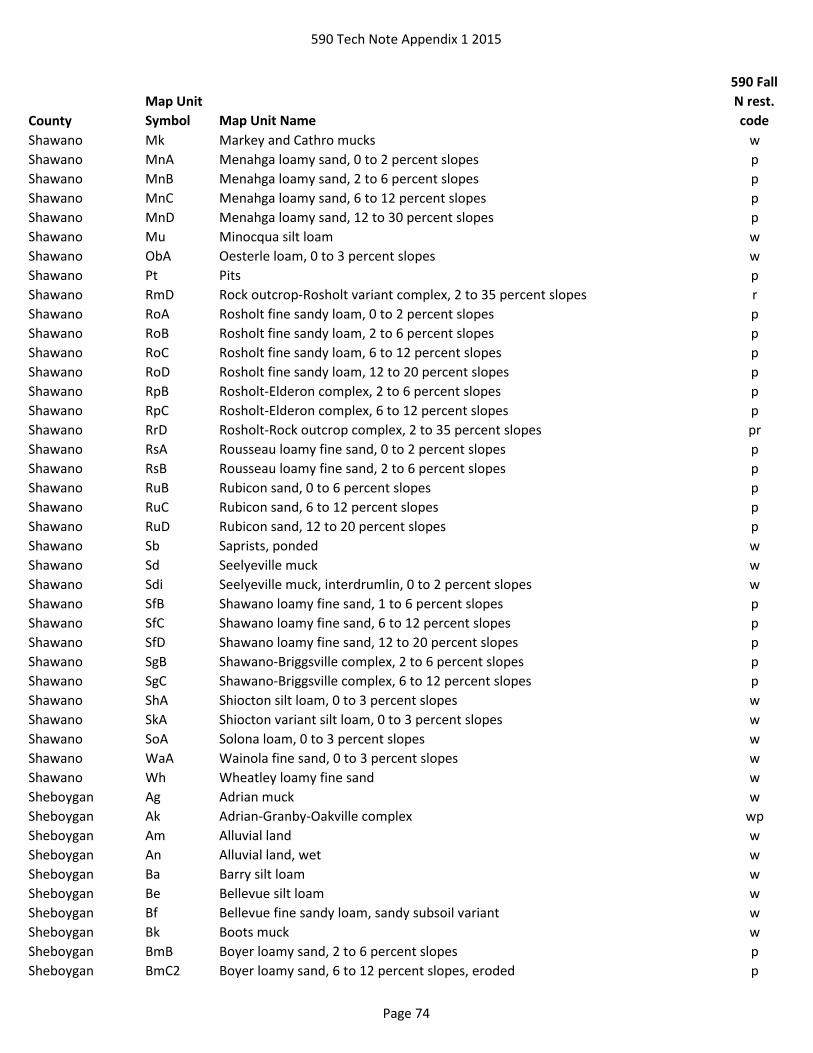
590 Tech Note Appendix 1 2015
County
Map Unit
Symbol Map Unit Name
590 Fall
N rest.
code
Shawano Mk Markey and Cathro mucks w
Shawano MnA Menahga loamy sand, 0 to 2 percent slopes p
Shawano MnB Menahga loamy sand, 2 to 6 percent slopes p
Shawano MnC Menahga loamy sand, 6 to 12 percent slopes p
Shawano MnD Menahga loamy sand, 12 to 30 percent slopes p
Shawano Mu Minocqua silt loam w
Shawano ObA Oesterle loam, 0 to 3 percent slopes w
Shawano Pt Pits p
Shawano RmD Rock outcrop-Rosholt variant complex, 2 to 35 percent slopes r
Shawano RoA Rosholt fine sandy loam, 0 to 2 percent slopes p
Shawano RoB Rosholt fine sandy loam, 2 to 6 percent slopes p
Shawano RoC Rosholt fine sandy loam, 6 to 12 percent slopes p
Shawano RoD Rosholt fine sandy loam, 12 to 20 percent slopes p
Shawano RpB Rosholt-Elderon complex, 2 to 6 percent slopes p
Shawano RpC Rosholt-Elderon complex, 6 to 12 percent slopes p
Shawano RrD Rosholt-Rock outcrop complex, 2 to 35 percent slopes pr
Shawano RsA Rousseau loamy fine sand, 0 to 2 percent slopes p
Shawano RsB Rousseau loamy fine sand, 2 to 6 percent slopes p
Shawano RuB Rubicon sand, 0 to 6 percent slopes p
Shawano RuC Rubicon sand, 6 to 12 percent slopes p
Shawano RuD Rubicon sand, 12 to 20 percent slopes p
Shawano Sb Saprists, ponded w
Shawano Sd Seelyeville muck w
Shawano Sdi Seelyeville muck, interdrumlin, 0 to 2 percent slopes w
Shawano SfB Shawano loamy fine sand, 1 to 6 percent slopes p
Shawano SfC Shawano loamy fine sand, 6 to 12 percent slopes p
Shawano SfD Shawano loamy fine sand, 12 to 20 percent slopes p
Shawano SgB Shawano-Briggsville complex, 2 to 6 percent slopes p
Shawano SgC Shawano-Briggsville complex, 6 to 12 percent slopes p
Shawano ShA Shiocton silt loam, 0 to 3 percent slopes w
Shawano SkA Shiocton variant silt loam, 0 to 3 percent slopes w
Shawano SoA Solona loam, 0 to 3 percent slopes w
Shawano WaA Wainola fine sand, 0 to 3 percent slopes w
Shawano Wh Wheatley loamy fine sand w
Sheboygan Ag Adrian muck w
Sheboygan Ak Adrian-Granby-Oakville complex wp
Sheboygan Am Alluvial land w
Sheboygan An Alluvial land, wet w
Sheboygan Ba Barry silt loam w
Sheboygan Be Bellevue silt loam w
Sheboygan Bf Bellevue fine sandy loam, sandy subsoil variant w
Sheboygan Bk Boots muck w
Sheboygan BmB Boyer loamy sand, 2 to 6 percent slopes p
Sheboygan BmC2 Boyer loamy sand, 6 to 12 percent slopes, eroded p
Page 74

590 Tech Note Appendix 1 2015
County
Map Unit
Symbol Map Unit Name
590 Fall
N rest.
code
Sheboygan CrC Casco-Rodman complex, 6 to 12 percent slopes p
Sheboygan CrD2 Casco-Rodman complex, 12 to 20 percent slopes, eroded p
Sheboygan CrE Casco-Rodman complex, 20 to 30 percent slopes p
Sheboygan CrF Casco-Rodman complex, 30 to 45 percent slopes p
Sheboygan Cw Colwood silt loam, 0 to 2 percent slopes w
Sheboygan Dn Dune land p
Sheboygan Ed Edwards muck w
Sheboygan Ev Elvers silt loam w
Sheboygan Gb Granby loamy fine sand w
Sheboygan Gg Granby silt loam, gravelly variant w
Sheboygan Gp Gravel pit +
Sheboygan Hu Houghton muck w
Sheboygan JuA Juneau silt loam, 0 to 3 percent slopes w
Sheboygan LDF Landfill +
Sheboygan Lo Loamy land, seeped w
Sheboygan Ma Made land +
Sheboygan Mf Marsh w
Sheboygan Mo Montgomery silty clay loam w
Sheboygan Mz Muskego muck w
Sheboygan Na Navan loam w
Sheboygan OaB Oakville loamy fine sand, 0 to 6 percent slopes p
Sheboygan OaC Oakville loamy fine sand, 6 to 12 percent slopes p
Sheboygan Ot Otter silt loam w
Sheboygan Pa Palms muck, 0 to 2 percent slopes w
Sheboygan Ph Pella silt loam, 0 to 2 percent slopes w
Sheboygan Py Poygan silty clay loam, 0 to 2 percent slopes, drained w
Sheboygan Sm Sebewa silt loam w
Sheboygan We Willette muck, 0 to 2 percent slopes w
St. Croix BnB Boone loamy fine sand, 2 to 6 percent slopes p
St. Croix BnC Boone loamy fine sand, 6 to 12 percent slopes p
St. Croix BnD Boone loamy fine sand, 12 to 20 percent slopes p
St. Croix BrB Burkhardt sandy loam, 1 to 6 percent slopes p
St. Croix BrC2 Burkhardt sandy loam, 6 to 12 percent slopes, eroded p
St. Croix BxB Burkhardt-Sattre complex, 2 to 6 percent slopes p
St. Croix BxC2 Burkhardt-Sattre complex, 6 to 12 percent slopes, eroded p
St. Croix BxD2 Burkhardt-Sattre complex, 12 to 30 percent slopes, eroded p
St. Croix CyA Clyde silt loam, 0 to 3 percent slopes w
St. Croix DkB Dickman sandy loam, 2 to 6 percent slopes p
St. Croix Du Duelm loamy sand w
St. Croix EmE Emmert loamy sand, 12 to 35 percent slopes p
St. Croix FdA Floyd silt loam, 0 to 3 percent slopes w
St. Croix Fm Fluvaquents, wet w
St. Croix GoB Gotham loamy fine sand, 2 to 6 percent slopes p
St. Croix GoC Gotham loamy fine sand, 6 to 12 percent slopes p
Page 75

590 Tech Note Appendix 1 2015
County
Map Unit
Symbol Map Unit Name
590 Fall
N rest.
code
St. Croix Gp Gravel pits +
St. Croix HaA Halder silt loam, 0 to 3 percent slopes w
St. Croix HrB Hubbard loamy sand, 0 to 6 percent slopes p
St. Croix HsB Hubbard loamy sand, loamy substratum, 0 to 6 percent slopes p
St. Croix HsC Hubbard loamy sand, loamy substratum, 6 to 12 percent slopes p
St. Croix LcA Lawler silt loam, 0 to 3 percent slopes w
St. Croix PmB Plainfield loamy sand, 2 to 6 percent slopes p
St. Croix PmC Plainfield loamy sand, 6 to 12 percent slopes p
St. Croix PmD Plainfield loamy sand, 12 to 20 percent slopes p
St. Croix QUA Quarry +
St. Croix RhA Rib silt loam, 0 to 3 percent slopes w
St. Croix RnB Ritchey silt loam, 2 to 6 percent slopes r
St. Croix RnC2 Ritchey silt loam, 6 to 12 percent slopes, eroded r
St. Croix RnD2 Ritchey silt loam, 12 to 20 percent slopes, eroded r
St. Croix RoE Ritchey soils and rock outcrop, 20 to 35 percent slopes r
St. Croix Se Saprists and aquents w
St. Croix Sm Seelyeville muck w
St. Croix SrA Skyberg silt loam, 0 to 3 percent slopes w
Taylor 193A Minocqua muck, 0 to 2 percent slopes w
Taylor 2015 Pits +
Taylor 215B Pence sandy loam, 0 to 6 percent slopes p
Taylor 215C Pence sandy loam, 6 to 15 percent slopes p
Taylor 215D Pence sandy loam, 15 to 30 percent slopes p
Taylor 24A Poskin silt loam, 0 to 3 percent slopes w
Taylor 315A Rib silt loam, 0 to 2 percent slopes w
Taylor 324A Maplehurst silt loam, 0 to 3 percent slopes w
Taylor 346E Newot-Pence complex, 15 to 45 percent slopes, very stony p
Taylor 3546C Newood-Pence complex, 6 to 15 percent slopes, very stony p
Taylor 408A Lupton and Cathro soils, 0 to 1 percent slopes w
Taylor 414A Loxley and Beseman soils, 0 to 1 percent slopes w
Taylor 555A Fordum silt loam, 0 to 2 percent slopes w
Taylor 571E Pelissier gravelly sandy loam, 15 to 45 percent slopes p
Taylor 755A Moppet-Fordum complex, 0 to 3 percent slopes w
Taylor 9055A Loxley peat, 0 to 1 percent slopes w
Taylor 9060D Pelissier sandy loam, 20 to 45 percent slopes p
Taylor 9093C Pence-Padus complex, 10 to 30 percent slopes p
Taylor 9197C Pelissier very cobbly sandy loam, 10 to 30 percent slopes p
Trempealeau 1145F Gaphill-Rockbluff complex, 30 to 60 percent slopes p
Trempealeau 11A Markey muck, 0 to 1 percent slopes, frequently flooded w
Trempealeau 1224F Boone-Elevasil complex, 15 to 50 percent slopes p
Trempealeau 1648A Northbend-Ettrick silt loams, 0 to 3 percent slopes, frequently flooded w
Trempealeau 1658A Algansee-Kalmarville complex, 0 to 3 percent slopes, frequently flooded w
Trempealeau 2013 Pits, gravel +
Trempealeau 2014 Pits, quarry, hard bedrock +
Page 76

590 Tech Note Appendix 1 2015
County
Map Unit
Symbol Map Unit Name
590 Fall
N rest.
code
Trempealeau 2016 Pits, quarry, soft bedrock +
Trempealeau 2022 Pits, siliceous sand +
Trempealeau 2030 Udorthents and Udipsamments, cut or fill +
Trempealeau 20A Palms and Houghton mucks, 0 to 1 percent slopes w
Trempealeau 21A Palms muck, 0 to 1 percent slopes, frequently flooded w
Trempealeau 233B Boone sand, 1 to 6 percent slopes p
Trempealeau 233C Boone sand, 6 to 15 percent slopes p
Trempealeau 233E Boone sand, 15 to 30 percent slopes p
Trempealeau 30A Adder muck, 0 to 1 percent slopes, frequently flooded w
Trempealeau 379A Zwingle silt loam, 0 to 2 percent slopes w
Trempealeau 400A Kato loam, 0 to 2 percent slopes, frequently flooded w
Trempealeau 40A Markey and Seelyeville mucks, 0 to 1 percent slopes w
Trempealeau 420A Bilson fine sandy loam, 0 to 2 percent slopes p
Trempealeau 420B Bilson fine sandy loam, 2 to 6 percent slopes p
Trempealeau 420C Bilson fine sandy loam, 6 to 12 percent slopes p
Trempealeau 429A Lows loam, 0 to 2 percent slopes, rarely flooded w
Trempealeau 433A Forkhorn sandy loam, 0 to 3 percent slopes p
Trempealeau 433B Forkhorn sandy loam, 2 to 6 percent slopes p
Trempealeau 433C2 Forkhorn sandy loam, 6 to 12 percent slopes, moderately eroded p
Trempealeau 433D2 Forkhorn sandy loam, 12 to 20 percent slopes, moderately eroded p
Trempealeau 434B Bilson sandy loam, 1 to 6 percent slopes p
Trempealeau 434C2 Bilson sandy loam, 6 to 12 percent slopes, moderately eroded p
Trempealeau 434D2 Bilson sandy loam, 12 to 20 percent slopes, moderately eroded p
Trempealeau 456A Bilmod sandy loam, 0 to 3 percent slopes p
Trempealeau 474A Dickinson fine sandy loam, 0 to 2 percent slopes p
Trempealeau 474B Dickinson fine sandy loam, 2 to 6 percent slopes p
Trempealeau 490A Dickinson loam, 0 to 3 percent slopes p
Trempealeau 501A Finchford loamy sand, 0 to 3 percent slopes p
Trempealeau 501B Finchford loamy sand, 2 to 6 percent slopes p
Trempealeau 502B2 Chelsea fine sand, 2 to 6 percent slopes, moderately eroded p
Trempealeau 502C2 Chelsea fine sand, 6 to 15 percent slopes, moderately eroded p
Trempealeau 502D Chelsea fine sand, 15 to 30 percent slopes p
Trempealeau 506A Komro loamy sand, 0 to 3 percent slopes p
Trempealeau 511C Plainfield sand, 6 to 15 percent slopes p
Trempealeau 511F Plainfield sand, 15 to 60 percent slopes p
Trempealeau 551A Impact sand, 0 to 3 percent slopes p
Trempealeau 551B Impact sand, 2 to 6 percent slopes p
Trempealeau 556A Mindoro sand, 0 to 3 percent slopes p
Trempealeau 561B Tarr sand, 1 to 6 percent slopes p
Trempealeau 561C Tarr sand, 6 to 15 percent slopes p
Trempealeau 561F Tarr sand, 15 to 60 percent slopes p
Trempealeau 562B Gosil loamy sand, 1 to 6 percent slopes p
Trempealeau 566A Tint sand, 0 to 3 percent slopes p
Trempealeau 569A Newlang muck, 0 to 2 percent slopes, occasionally flooded w
Page 77

590 Tech Note Appendix 1 2015
County
Map Unit
Symbol Map Unit Name
590 Fall
N rest.
code
Trempealeau 629A Ettrick silt loam, 0 to 2 percent slopes, frequently flooded w
Trempealeau 649A Wallkill silt loam, 0 to 2 percent slopes, frequently flooded w
Trempealeau 656A Scotah loamy fine sand, 0 to 3 percent slopes, occasionally flooded p
Trempealeau 666A Absco loamy sand, 0 to 3 percent slopes, occasionally flooded p
Trempealeau 679A Ettrick silt loam, 0 to 2 percent slopes, shallow, frequently flooded w
Trempealeau 9A Houghton and Palms mucks, 0 to 1 percent slopes, frequently flooded w
Vernon 1130F Lacrescent-Dunbarton complex, very stony, 30 to 60 percent slopes r
Vernon 1145F Gaphill-Rockbluff complex, 30 to 60 percent slopes p
Vernon 1155F Brodale-Bellechester-Rock outcrop complex, 60 to 90 percent slopes pr
Vernon 1648A Northbend-Ettrick silt loams, 0 to 3 percent slopes, frequently flooded w
Vernon 164D Elizabeth flaggy silt loam, 12 to 20 percent slopes r
Vernon 164E Elizabeth flaggy silt loam, 20 to 30 percent slopes r
Vernon 1658A Algansee-Kalmarville complex, 0 to 3 percent slopes, frequently flooded w
Vernon 2013 Pits, gravel +
Vernon 2014 Pits, quarry, hard bedrock +
Vernon 2016 Pits, quarry, soft bedrock +
Vernon 201E Boone fine sand, 12 to 30 percent slopes p
Vernon 2030 Udorthents and Udipsamments, cut or fill +
Vernon 2050 Landfill +
Vernon 20A Palms and Houghton mucks, 0 to 1 percent slopes w
Vernon 21A Palms muck, 0 to 1 percent slopes, frequently flooded w
Vernon 413A Rasset sandy loam, 0 to 3 percent slopes p
Vernon 413B Rasset sandy loam, 2 to 6 percent slopes p
Vernon 433C2 Forkhorn sandy loam, 6 to 12 percent slopes, moderately eroded p
Vernon 434B Bilson sandy loam, 1 to 6 percent slopes p
Vernon 434C2 Bilson sandy loam, 6 to 12 percent slopes, moderately eroded p
Vernon 501A Finchford loamy sand, 0 to 3 percent slopes p
Vernon 501B Finchford loamy sand, 2 to 6 percent slopes p
Vernon 502B2 Chelsea fine sand, 2 to 6 percent slopes, moderately eroded p
Vernon 502C2 Chelsea fine sand, 6 to 15 percent slopes, moderately eroded p
Vernon 506A Komro loamy sand, 0 to 3 percent slopes p
Vernon 511C Plainfield sand, 6 to 15 percent slopes p
Vernon 511F Plainfield sand, 15 to 60 percent slopes p
Vernon 561F Tarr sand, 15 to 60 percent slopes p
Vernon 562B Gosil loamy sand, 1 to 6 percent slopes p
Vernon 562C Gosil loamy sand, 6 to 12 percent slopes p
Vernon 572B2 Windward loamy fine sand, 2 to 6 percent slopes, moderately eroded p
Vernon 572C2 Windward loamy fine sand, 6 to 12 percent slopes, moderately eroded p
Vernon 572D Windward loamy fine sand, 12 to 30 percent slopes p
Vernon 601C Beavercreek cobbly fine sandy loam, 3 to 12 percent slopes, occasionally flooded p
Vernon 629A Ettrick silt loam, 0 to 2 percent slopes, frequently flooded w
Vernon 656A Scotah loamy fine sand, 0 to 3 percent slopes, occasionally flooded p
Vernon 739A Root loam, 0 to 2 percent slopes, frequently flooded w
Page 78

590 Tech Note Appendix 1 2015
County
Map Unit
Symbol Map Unit Name
590 Fall
N rest.
code
Vernon CP Coal piles +
Vilas Au Au Gres sand, 0 to 2 percent slopes w
Vilas CaA Cable silt loam, 0 to 3 percent slopes w
Vilas CrA Croswell sand, 0 to 3 percent slopes p
Vilas CsA Croswell sand, loamy substratum, 0 to 3 percent slopes p
Vilas Fh Fluvaquents, sandy, nearly level w
Vilas Ga Gaastra silt loam, 0 to 2 percent slopes w
Vilas GoB Gogebic-Fence-Pence complex, 0 to 6 percent slopes p
Vilas GoC Gogebic-Fence-Pence complex, 3 to 15 percent slopes p
Vilas GpD Gogebic-Pence complex, 15 to 30 percent slopes p
Vilas Hp Histosols, ponded w
Vilas KaB Karlin loamy fine sand, 0 to 6 percent slopes p
Vilas KaC Karlin loamy fine sand, 6 to 15 percent slopes p
Vilas KeB Keweenaw-Karlin complex, 0 to 6 percent slopes p
Vilas KeC Keweenaw-Karlin complex, 6 to 15 percent slopes p
Vilas KnD Keweenaw-Sayner complex, 15 to 30 percent slopes p
Vilas Kr Kinross mucky sand, 0 to 2 percent slopes w
Vilas Lo Loxley and Dawson peats, 0 to 1 percent slopes w
Vilas MoA Monico silt loam, 0 to 3 percent slopes w
Vilas PeC Padus-Pence complex, 6 to 15 percent slopes p
Vilas PeD Padus-Pence complex, 15 to 35 percent slopes p
Vilas PnB Pence sandy loam, 0 to 6 percent slopes p
Vilas PnC Pence sandy loam, 6 to 15 percent slopes p
Vilas PnD Pence sandy loam, 15 to 25 percent slopes p
Vilas Pt Pits, gravel +
Vilas RoB Rubicon sand, 0 to 6 percent slopes p
Vilas RoC Rubicon sand, 6 to 15 percent slopes p
Vilas RoD Rubicon sand, 15 to 30 percent slopes p
Vilas SaB Sayner-Rubicon complex, 0 to 6 percent slopes p
Vilas SaC Sayner-Rubicon complex, 6 to 15 percent slopes p
Vilas SaD Sayner-Rubicon complex, 15 to 35 percent slopes p
Vilas Se Seelyeville and Markey mucks, 0 to 1 percent slopes w
Vilas Wv Worcester variant sandy loam, 0 to 2 percent slopes w
Walworth Ac Adrian muck w
Walworth Am Alluvial land w
Walworth BP Borrow pit +
Walworth BpB Boyer complex, 2 to 6 percent slopes p
Walworth BpC2 Boyer complex, 6 to 12 percent slopes, eroded p
Walworth CrD2 Casco-Rodman complex, 12 to 20 percent slopes, eroded p
Walworth CrE2 Casco-Rodman complex, 20 to 30 percent slopes, eroded p
Walworth CtB Chelsea fine sand, 1 to 6 percent slopes p
Walworth CtE Chelsea fine sand, 6 to 30 percent slopes p
Walworth Cw Colwood silt loam, 0 to 2 percent slopes w
Walworth Dt Drummer silt loam, gravelly substratum w
Page 79

590 Tech Note Appendix 1 2015
County
Map Unit
Symbol Map Unit Name
590 Fall
N rest.
code
Walworth GP Gravel pit +
Walworth Ht Houghton muck w
Walworth JuA Juneau silt loam, 1 to 3 percent slopes w
Walworth LDF Landfill +
Walworth LzD2 Lorenzo-Rodman complex, 12 to 20 percent slopes, eroded p
Walworth MDL Made land +
Walworth Mf Marsh w
Walworth MzfA Mundelein silt loam, 1 to 3 percent slopes w
Walworth Na Navan silt loam w
Walworth Pa Palms muck, 0 to 2 percent slopes w
Walworth Ph Pella silt loam, 0 to 2 percent slopes w
Walworth QUA Quarry +
Walworth RsF Rodman-Casco complex, 30 to 45 percent slopes p
Walworth Ru Rollin muck, deep w
Walworth Rv Rollin muck, shallow w
Walworth Sfb Sandy lake beaches w
Walworth Sm Sebewa silt loam w
Walworth TxA Troxel silt loam, 0 to 3 percent slopes w
Walworth Wa Wallkill silt loam w
Walworth Ww Wet alluvial land w
Washburn 100B Menahga sand, 0 to 6 percent slopes p
Washburn 100C Menahga sand, 6 to 12 percent slopes p
Washburn 100D Menahga sand, 12 to 30 percent slopes p
Washburn 1070C Fremstadt, stony-Cress complex, 6 to 15 percent slopes p
Washburn 1070D Fremstadt, stony-Cress complex, 15 to 30 percent slopes p
Washburn 193A Minocqua muck, 0 to 2 percent slopes w
Washburn 2015 Pits +
Washburn 2050 Landfill +
Washburn 215B Pence sandy loam, 0 to 6 percent slopes p
Washburn 215C Pence sandy loam, 6 to 15 percent slopes p
Washburn 215D Pence sandy loam, 15 to 30 percent slopes p
Washburn 24A Poskin silt loam, 0 to 3 percent slopes w
Washburn 3126A Wurtsmith loamy sand, 0 to 3 percent slopes p
Washburn 315A Rib silt loam, 0 to 2 percent slopes w
Washburn 3276A Au Gres loamy sand, 0 to 3 percent slopes w
Washburn 33B Chetek sandy loam, 1 to 6 percent slopes p
Washburn 3403A Loxley, Beseman, and Dawson soils, 0 to 1 percent slopes w
Washburn 3424C Frogcreek-Magroc-Stinnett complex, 0 to 15 percent slopes, very stony, rocky r
Washburn 3446A Newson muck, 0 to 2 percent slopes w
Washburn 3448B Grettum loamy sand, 0 to 6 percent slopes p
Washburn 3448C Grettum loamy sand, 6 to 12 percent slopes p
Washburn 3629B Perida loamy sand, 0 to 4 percent slopes p
Washburn 368B Mahtomedi-Cress complex, 2 to 6 percent slopes p
Page 80
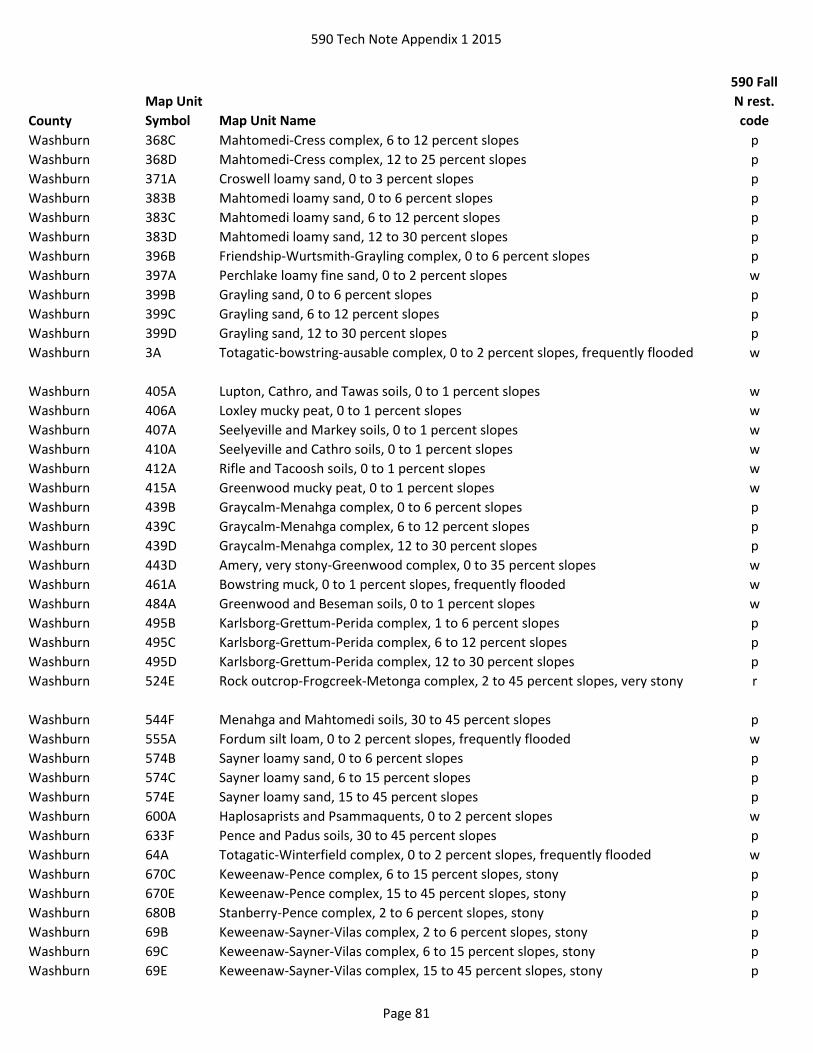
590 Tech Note Appendix 1 2015
County
Map Unit
Symbol Map Unit Name
590 Fall
N rest.
code
Washburn 368C Mahtomedi-Cress complex, 6 to 12 percent slopes p
Washburn 368D Mahtomedi-Cress complex, 12 to 25 percent slopes p
Washburn 371A Croswell loamy sand, 0 to 3 percent slopes p
Washburn 383B Mahtomedi loamy sand, 0 to 6 percent slopes p
Washburn 383C Mahtomedi loamy sand, 6 to 12 percent slopes p
Washburn 383D Mahtomedi loamy sand, 12 to 30 percent slopes p
Washburn 396B Friendship-Wurtsmith-Grayling complex, 0 to 6 percent slopes p
Washburn 397A Perchlake loamy fine sand, 0 to 2 percent slopes w
Washburn 399B Grayling sand, 0 to 6 percent slopes p
Washburn 399C Grayling sand, 6 to 12 percent slopes p
Washburn 399D Grayling sand, 12 to 30 percent slopes p
Washburn 3A Totagatic-bowstring-ausable complex, 0 to 2 percent slopes, frequently flooded w
Washburn 405A Lupton, Cathro, and Tawas soils, 0 to 1 percent slopes w
Washburn 406A Loxley mucky peat, 0 to 1 percent slopes w
Washburn 407A Seelyeville and Markey soils, 0 to 1 percent slopes w
Washburn 410A Seelyeville and Cathro soils, 0 to 1 percent slopes w
Washburn 412A Rifle and Tacoosh soils, 0 to 1 percent slopes w
Washburn 415A Greenwood mucky peat, 0 to 1 percent slopes w
Washburn 439B Graycalm-Menahga complex, 0 to 6 percent slopes p
Washburn 439C Graycalm-Menahga complex, 6 to 12 percent slopes p
Washburn 439D Graycalm-Menahga complex, 12 to 30 percent slopes p
Washburn 443D Amery, very stony-Greenwood complex, 0 to 35 percent slopes w
Washburn 461A Bowstring muck, 0 to 1 percent slopes, frequently flooded w
Washburn 484A Greenwood and Beseman soils, 0 to 1 percent slopes w
Washburn 495B Karlsborg-Grettum-Perida complex, 1 to 6 percent slopes p
Washburn 495C Karlsborg-Grettum-Perida complex, 6 to 12 percent slopes p
Washburn 495D Karlsborg-Grettum-Perida complex, 12 to 30 percent slopes p
Washburn 524E Rock outcrop-Frogcreek-Metonga complex, 2 to 45 percent slopes, very stony r
Washburn 544F Menahga and Mahtomedi soils, 30 to 45 percent slopes p
Washburn 555A Fordum silt loam, 0 to 2 percent slopes, frequently flooded w
Washburn 574B Sayner loamy sand, 0 to 6 percent slopes p
Washburn 574C Sayner loamy sand, 6 to 15 percent slopes p
Washburn 574E Sayner loamy sand, 15 to 45 percent slopes p
Washburn 600A Haplosaprists and Psammaquents, 0 to 2 percent slopes w
Washburn 633F Pence and Padus soils, 30 to 45 percent slopes p
Washburn 64A Totagatic-Winterfield complex, 0 to 2 percent slopes, frequently flooded w
Washburn 670C Keweenaw-Pence complex, 6 to 15 percent slopes, stony p
Washburn 670E Keweenaw-Pence complex, 15 to 45 percent slopes, stony p
Washburn 680B Stanberry-Pence complex, 2 to 6 percent slopes, stony p
Washburn 69B Keweenaw-Sayner-Vilas complex, 2 to 6 percent slopes, stony p
Washburn 69C Keweenaw-Sayner-Vilas complex, 6 to 15 percent slopes, stony p
Washburn 69E Keweenaw-Sayner-Vilas complex, 15 to 45 percent slopes, stony p
Page 81

590 Tech Note Appendix 1 2015
County
Map Unit
Symbol Map Unit Name
590 Fall
N rest.
code
Washburn 706A Winterfield-Totagatic complex, 0 to 2 percent slopes, frequently flooded w
Washburn 724A Rib-Rock outcrop complex, 0 to 2 percent slopes wr
Washburn 726B Sissabagama loamy sand, 0 to 6 percent slopes p
Washburn 74B Vilas loamy sand, 0 to 6 percent slopes p
Washburn 74C Vilas loamy sand, 6 to 15 percent slopes p
Washburn 74D Vilas loamy sand, 15 to 30 percent slopes p
Washburn 771A Lenroot loamy sand, 0 to 3 percent slopes p
Washburn 905A Cublake loamy sand, 0 to 3 percent slopes p
Washburn 970C Keweenaw, stony-Pence, stony-Greenwood complex, 0 to 15 percent slopes wp
Washburn 970E Keweenaw, stony-Pence, stony-Greenwood complex, 0 to 45 percent slopes wp
Washington Ak Adrian mucky peat w
Washington Am Alluvial land w
Washington AtA Ashkum silty clay loam, 0 to 2 percent slopes w
Washington BmB Boyer loamy sand, 2 to 6 percent slopes p
Washington BmC Boyer loamy sand, 6 to 12 percent slopes p
Washington BnA Boyer sandy loam, 0 to 2 percent slopes p
Washington BnB Boyer sandy loam, 2 to 6 percent slopes p
Washington BrC2 Boyer complex, 6 to 12 percent slopes, eroded p
Washington BrE2 Boyer complex, 12 to 30 percent slopes, eroded p
Washington BsA Brookston silt loam, 0 to 3 percent slopes w
Washington CrC2 Casco-Rodman complex, 6 to 12 percent slopes, eroded p
Washington CrD2 Casco-Rodman complex, 12 to 20 percent slopes, eroded p
Washington CrE Casco-Rodman complex, 20 to 30 percent slopes p
Washington Cw Colwood silt loam, 0 to 2 percent slopes w
Washington Dt Drummer silt loam, gravelly substratum w
Washington GfA Granby fine sandy loam, 0 to 3 percent slopes w
Washington GP Gravel pit +
Washington GrA Grays silt loam, 0 to 2 percent slopes w
Washington Hu Houghton mucky peat w
Washington Hv Houghton peat, acid variant w
Washington JuA Juneau silt loam, 1 to 3 percent slopes w
Washington Km Keowns silt loam w
Washington LDF Landfill +
Washington Mf Marsh w
Washington Mzb Montgomery silty clay loam w
Washington MzkA Mussey loam, 0 to 3 percent slopes w
Washington Ot Otter silt loam w
Washington Pc Palms mucky peat, 0 to 2 percent slopes w
Washington Ph Pella silt loam, 0 to 2 percent slopes w
Washington QUA Quarry +
Washington RkB Ritchey silt loam, 2 to 6 percent slopes r
Washington RkC2 Ritchey silt loam, 6 to 12 percent slopes, eroded r
Page 82
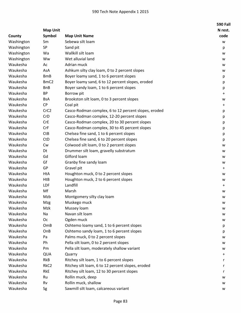
590 Tech Note Appendix 1 2015
County
Map Unit
Symbol Map Unit Name
590 Fall
N rest.
code
Washington Sm Sebewa silt loam w
Washington SP Sand pit p
Washington Wa Wallkill silt loam w
Washington Ww Wet alluvial land w
Waukesha Ac Adrian muck w
Waukesha AsA Ashkum silty clay loam, 0 to 2 percent slopes w
Waukesha BmB Boyer loamy sand, 1 to 6 percent slopes p
Waukesha BmC2 Boyer loamy sand, 6 to 12 percent slopes, eroded p
Waukesha BnB Boyer sandy loam, 1 to 6 percent slopes p
Waukesha BP Borrow pit +
Waukesha BsA Brookston silt loam, 0 to 3 percent slopes w
Waukesha CP Coal pit +
Waukesha CrC2 Casco-Rodman complex, 6 to 12 percent slopes, eroded p
Waukesha CrD Casco-Rodman complex, 12-20 percent slopes p
Waukesha CrE Casco-Rodman complex, 20 to 30 percent slopes p
Waukesha CrF Casco-Rodman complex, 30 to 45 percent slopes p
Waukesha CtB Chelsea fine sand, 1 to 6 percent slopes p
Waukesha CtD Chelsea fine sand, 6 to 20 percent slopes p
Waukesha Cw Colwood silt loam, 0 to 2 percent slopes w
Waukesha Dt Drummer silt loam, gravelly substratum w
Waukesha Gd Gilford loam w
Waukesha Gf Granby fine sandy loam w
Waukesha GP Gravel pit +
Waukesha HtA Houghton muck, 0 to 2 percent slopes w
Waukesha HtB Houghton muck, 2 to 6 percent slopes w
Waukesha LDF Landfill +
Waukesha Mf Marsh w
Waukesha Mzb Montgomery silty clay loam w
Waukesha Mzg Muskego muck w
Waukesha Mzk Mussey loam w
Waukesha Na Navan silt loam w
Waukesha Oc Ogden muck w
Waukesha OmB Oshtemo loamy sand, 1 to 6 percent slopes p
Waukesha OnB Oshtemo sandy loam, 1 to 6 percent slopes p
Waukesha Pa Palms muck, 0 to 2 percent slopes w
Waukesha Ph Pella silt loam, 0 to 2 percent slopes w
Waukesha Pm Pella silt loam, moderately shallow variant w
Waukesha QUA Quarry +
Waukesha RkB Ritchey silt loam, 1 to 6 percent slopes r
Waukesha RkC2 Ritchey silt loam, 6 to 12 percent slopes, eroded r
Waukesha RkE Ritchey silt loam, 12 to 30 percent slopes r
Waukesha Ru Rollin muck, deep w
Waukesha Rv Rollin muck, shallow w
Waukesha Sg Sawmill silt loam, calcareous variant w
Page 83

590 Tech Note Appendix 1 2015
County
Map Unit
Symbol Map Unit Name
590 Fall
N rest.
code
Waukesha Sm Sebewa silt loam w
Waukesha UA Unmapped area +
Waukesha Wa Wallkill silt loam w
Waukesha Ww Wet alluvial land w
Waupaca Ax Angelica silt loam w
Waupaca BoB Borth sandy loam, 1 to 4 percent slopes w
Waupaca BrB Borth silty clay loam, 1 to 4 percent slopes w
Waupaca Cm Cathro and Markey mucks w
Waupaca EcC Elderon-Rosholt complex, 6 to 12 percent slopes p
Waupaca EcD Elderon-Rosholt complex, 12 to 30 percent slopes p
Waupaca Fa Fordum loam w
Waupaca KrB Kranski loamy sand, 2 to 6 percent slopes p
Waupaca KrC Kranski loamy sand, 6 to 12 percent slopes p
Waupaca KrD Kranski loamy sand, 12 to 20 percent slopes p
Waupaca LDF Landfill +
Waupaca Lx Loxley mucky peat w
Waupaca MlA Meehan loamy sand, loamy substratum, 0 to 3 percent slopes w
Waupaca Mp Menasha silty clay w
Waupaca Ms Minocqua mucky fine sandy loam w
Waupaca PfA Plainfield loamy sand, 0 to 2 percent slopes p
Waupaca PfAT Plainfield loamy sand, till plain, 0 to 2 percent slopes p
Waupaca PfB Plainfield loamy sand, 2 to 6 percent slopes p
Waupaca PfBT Plainfield loamy sand, till plain, 2 to 6 percent slopes p
Waupaca PfC Plainfield loamy sand, 6 to 12 percent slopes p
Waupaca PfCT Plainfield loamy sand, till plain, 6 to 12 percent slopes p
Waupaca PfD Plainfield loamy sand, 12 to 30 percent slopes p
Waupaca PfDT Plainfield loamy sand, till plain, 12 to 30 percent slopes p
Waupaca PlB Plainfield loamy sand, loamy substratum, 2 to 6 percent slopes p
Waupaca PmA Plainfield loamy sand, wet substratum, 0 to 3 percent slopes p
Waupaca QUA Quarry +
Waupaca RfA Richford loamy sand, 0 to 2 percent slopes p
Waupaca RfB Richford loamy sand, 2 to 6 percent slopes p
Waupaca RfC Richford loamy sand, 6 to 12 percent slopes p
Waupaca Rm Roscommon loamy sand w
Waupaca RoA Rosholt sandy loam, 0 to 2 percent slopes p
Waupaca RoB Rosholt sandy loam, 2 to 6 percent slopes p
Waupaca RoC Rosholt sandy loam, 6 to 12 percent slopes p
Waupaca RoD Rosholt sandy loam, 12 to 20 percent slopes p
Waupaca RrB Rosholt-Rock outcrop complex, 2 to 10 percent slopes pr
Waupaca RsA Rousseau loamy fine sand, 0 to 3 percent slopes p
Waupaca Sb Seelyeville muck w
Waupaca Sbi Seelyeville muck, interdrumlin, 0 to 2 percent slopes w
Waupaca SfB Shawano loamy fine sand, 2 to 6 percent slopes p
Waupaca SfC Shawano loamy fine sand, 6 to 12 percent slopes p
Page 84

590 Tech Note Appendix 1 2015
County
Map Unit
Symbol Map Unit Name
590 Fall
N rest.
code
Waupaca SfD Shawano loamy fine sand, 12 to 20 percent slopes p
Waupaca UdC Udipsamments, undulating p
Waushara Ad Adrian muck, 0 to 1 percent slopes w
Waushara Be Belleville loamy sand, 0 to 2 percent slopes w
Waushara Bt Billett sandy loam, 0 to 2 percent slopes p
Waushara ByB Boyer loamy sand, 2 to 6 percent slopes p
Waushara ByC Boyer loamy sand, 6 to 12 percent slopes p
Waushara BzD Boyer-Mecosta complex, 12 to 20 percent slopes p
Waushara CoB Coloma loamy sand, 2 to 6 percent slopes p
Waushara CoC Coloma loamy sand, 6 to 12 percent slopes p
Waushara CoD Coloma loamy sand, 12 to 30 percent slopes p
Waushara Hu Houghton muck, 0 to 1 percent slopes w
Waushara Hw Houghton muck, ponded, 0 to 1 percent slopes w
Waushara Ke Keowns silt loam, 0 to 2 percent slopes w
Waushara Ks Kingsville loamy sand, 0 to 2 percent slopes w
Waushara LDF Landfill +
Waushara OkB Okee loamy sand, 2 to 6 percent slopes p
Waushara OkC Okee loamy sand, 6 to 12 percent slopes p
Waushara OkD Okee loamy sand, 12 to 20 percent slopes p
Waushara Pa Palms muck, 0 to 2 percent slopes w
Waushara PbA Pearl loamy sand, 0 to 3 percent slopes p
Waushara Pe Pits, gravel +
Waushara PfA Plainfield sand, 0 to 2 percent slopes p
Waushara PfAT Plainfield sand, till plain, 0 to 2 percent slopes p
Waushara PfB Plainfield sand, 2 to 6 percent slopes p
Waushara PfBT Plainfield sand, till plain, 2 to 6 percent slopes p
Waushara PfC Plainfield sand, 6 to 12 percent slopes p
Waushara PfCT Plainfield sand, till plain, 6 to 12 percent slopes p
Waushara PfDT Plainfield sand, till plain, 12 to 30 percent slopes p
Waushara PlB Plainfield sand, loamy substratum, 2 to 6 percent slopes p
Waushara PmA Plainfield sand, wet substratum, 0 to 3 percent slopes p
Waushara Py Poygan silty clay loam, 0 to 2 percent slopes, drained w
Waushara RfA Richford loamy sand, 0 to 2 percent slopes p
Waushara RfB Richford loamy sand, 2 to 6 percent slopes p
Waushara RfC Richford loamy sand, 6 to 12 percent slopes p
Waushara RfD Richford loamy sand, 12 to 20 percent slopes p
Waushara Sp Sparta loamy sand, 0 to 2 percent slopes p
Waushara Wm Willette muck, 0 to 2 percent slopes w
Winnebago Ak Adrian muck w
Winnebago Ed Edwards muck w
Winnebago Fn Fluvaquents w
Winnebago Hu Houghton muck w
Winnebago Hw Houghton muck, ponded w
Winnebago KaB Kaukauna silty clay loam, 1 to 4 percent slopes w
Page 85

590 Tech Note Appendix 1 2015
County
Map Unit
Symbol Map Unit Name
590 Fall
N rest.
code
Winnebago Ke Keowns silt loam w
Winnebago Ks Kingsville mucky loamy fine sand w
Winnebago LDF Landfill +
Winnebago Mn Menasha clay w
Winnebago OaB Oakville fine sand, 2 to 6 percent slopes p
Winnebago OaC Oakville fine sand, 6 to 12 percent slopes p
Winnebago Os Ossian silt loam w
Winnebago Pa Palms muck, 0 to 2 percent slopes w
Winnebago Ph Pits, quarries r
Winnebago Pu Poygan silty clay loam, 0 to 2 percent slopes, drained w
Winnebago RhB Ritchey silt loam, 2 to 6 percent slopes r
Winnebago RhC2 Ritchey silt loam, 6 to 12 percent slopes, eroded r
Winnebago RhD2 Ritchey silt loam, 12 to 30 percent slopes, eroded r
Winnebago W Water greater than 40 acres +
Winnebago Wm Willette muck, 0 to 2 percent slopes w
Wood 1009A Meehan-Newson complex, lake terrace, 0 to 3 percent slopes w
Wood 11A Markey muck, 0 to 1 percent slopes, frequently flooded w
Wood 1218A Ironrun-Ponycreek complex, 0 to 3 percent slopes wp
Wood 1519A Ponycreek-Dawsil complex, 0 to 2 percent slopes w
Wood 1548A Majik-Ponycreek complex, lake terrace, 0 to 3 percent slopes w
Wood 1599A Ponycreek-Dawsil complex, lake terrace, 0 to 2 percent slopes w
Wood 15A Loxley peat, 0 to 1 percent slopes w
Wood 1658A Algansee-Kalmarville complex, 0 to 3 percent slopes, frequently flooded w
Wood 17A Dawsil mucky peat, lake terrace, 0 to 1 percent slopes w
Wood 2022 Pits, siliceous sand +
Wood 218A Ironrun sand, 0 to 3 percent slopes p
Wood 25A Dawsil mucky peat, 0 to 1 percent slopes w
Wood 37A Loxley peat, lake terrace, 0 to 1 percent slopes w
Wood 40A Markey and Seelyeville mucks, 0 to 1 percent slopes w
Wood 4A Newson-Dawson complex, lake terrace, 0 to 2 percent slopes w
Wood 516A Aldo sand, 0 to 3 percent slopes p
Wood 518A Rockdam sand, 0 to 3 percent slopes p
Wood 519A Ponycreek muck, 0 to 2 percent slopes wp
Wood 547A Aldo sand, lake terrace, 0 to 3 percent slopes p
Wood 589A Newson mucky loamy sand, 0 to 2 percent slopes w
Wood 596A Tint sand, lake terrace, 0 to 3 percent slopes p
Wood 656A Scotah loamy fine sand, 0 to 3 percent slopes, occasionally flooded p
Wood Ab Alluvial land, wet w
Wood Af Altdorf silt loam w
Wood Ca Cathro mucky peat w
Wood Da Dancy sandy loam w
Wood Do Dolph silt loam w
Wood DvA Dunnville sandy loam, 0 to 3 percent slopes p
Wood DwA Dunnville loam, 0 to 3 percent slopes p
Page 86

590 Tech Note Appendix 1 2015
County
Map Unit
Symbol Map Unit Name
590 Fall
N rest.
code
Wood EkB Elkmound sandy loam, 2 to 6 percent slopes r
Wood EkC Elkmound sandy loam, 6 to 12 percent slopes r
Wood EkD2 Elkmound sandy loam, 12 to 20 percent slopes, eroded r
Wood Em Elm Lake loamy sand w
Wood GP Gravel pit +
Wood LDF Landfill +
Wood Ma Mann silt loam w
Wood Mc Markey mucky peat w
Wood MpA Merrillan sandy loam, 1 to 3 percent slopes w
Wood Mr Milladore silt loam w
Wood NoB Norgo silt loam, 2 to 6 percent slopes r
Wood NoC2 Norgo silt loam, 6 to 12 percent slopes, eroded r
Wood NoD2 Norgo silt loam, 12 to 20 percent slopes, eroded r
Wood NyA Nymore loamy sand, 0 to 2 percent slopes p
Wood NzA Nymore loamy sand, red subsoil, 0 to 2 percent slopes p
Wood NzB Nymore loamy sand, red subsoil, 2 to 6 percent slopes p
Wood PbB Plainbo sand, 2 to 12 percent slopes p
Wood PbD Plainbo sand, 12 to 30 percent slopes p
Wood PfA Plainfield sand, 0 to 2 percent slopes p
Wood PfB Plainfield sand, 2 to 6 percent slopes p
Wood PfC Plainfield sand, 6 to 12 percent slopes p
Wood PfE Plainfield sand, 12 to 35 percent slopes p
Wood PgA Plainfield loamy sand, 0 to 2 percent slopes p
Wood PgB Plainfield loamy sand, 2 to 6 percent slopes p
Wood PoB Point loamy sand, 2 to 6 percent slopes w
Wood Ps Poskin silt loam w
Wood Rb Rib silt loam w
Wood ReB Rietbrock silt loam, 2 to 6 percent slopes w
Wood ReC Rietbrock silt loam, 6 to 12 percent slopes w
Wood Rf Rifle mucky peat w
Wood Rg Rifle peat w
Wood Sh Sherry silt loam w
Wood Ss Sherry stony silt loam w
Wood Ve Veedum silt loam w
Wood Vs Vesper silt loam w
Page 87