sontek riversurveyor s5/m9 brochure - xylem …in moving bed or other difficult ... sontek...
TRANSCRIPT

RiverSurveyorDiSchaRge, bathymetRy anD cuRRent pRofiling
®
S5
m9

It’s a SonTek exclusive - multiple acoustic frequencies fused with precise bandwidth control make for the most robust and continuous shallow-to-deep measurements ever. A deterministic microcontroller expertly apportions the proper acoustics, pulse scheme, and cell size so you can focus on the measurement - not the instrument setup. The system even has an embedded echosounder (vertical beam) for precise channel definition - and it’s all designed to work intuitively.
Leading edge technologies such as 2.4 GHz telemetry, mobile phones, and RTK (Real-Time Kinematic) GPS are all incorporated to elevate performance and expand utility.
Upgrade and Save. Good news for RiverSurveyor M9 users who also require bathymetric data. Now you can upgrade your RiverSurveyor M9 to include the bathymetry power of the HydroSurveyor - a system designed to collect bathymetric, water column velocity profile, and acoustic bottom tracking data as part of a hydrographic survey.
The HydroSurveyor upgrade is all inclusive:
• Full water column velocity mapping, • Exclusive 5-beam depth sounding • Acoustic bottom tracking (for speed over ground when GPS is lost) • Sound speed integration and interpolation (when using with the
CastAway-CTD)
Taken to Extremes.
f e a t u r e s b e n e f i t sMultiple acoustic frequencies* Combines the highest resolution with the greatest range of depths.
Vertical acoustic beam (echosounder)* Superior channel definition, extends the maximum measurable discharge depth.
Automated cell size* Always uses the optimal resolution for channel depth – no user input required.
Automated pulse scheme and frequency hopping* Automatically adjusts the acoustic Doppler sampling (ping) scheme for channel conditions. User does not need to pre-program unit.
Microprocessor computed discharge and secure data* All discharge computations are done within the S5 or M9 unit internally (in addition to the computer). No lost data from communications drop outs.
Standard 360º compass and two-axis tilt sensor Compensates for vessel motion due to surface conditions.
Reverberation control with ping rates to 70Hz High ping rates ensure extremely robust data collection.
Pulse-coherent processing Maximizes high resolution performance in shallow water.
Bottom-tracking High precision vessel tracking and depth measurement without GPS requirement.
RTK GPS (optional) Ultra precise earth-referenced positioning as an alternative to bottom tracking in moving bed or other difficult situations.
*RiverSurveyor technology patent number 8,125,849
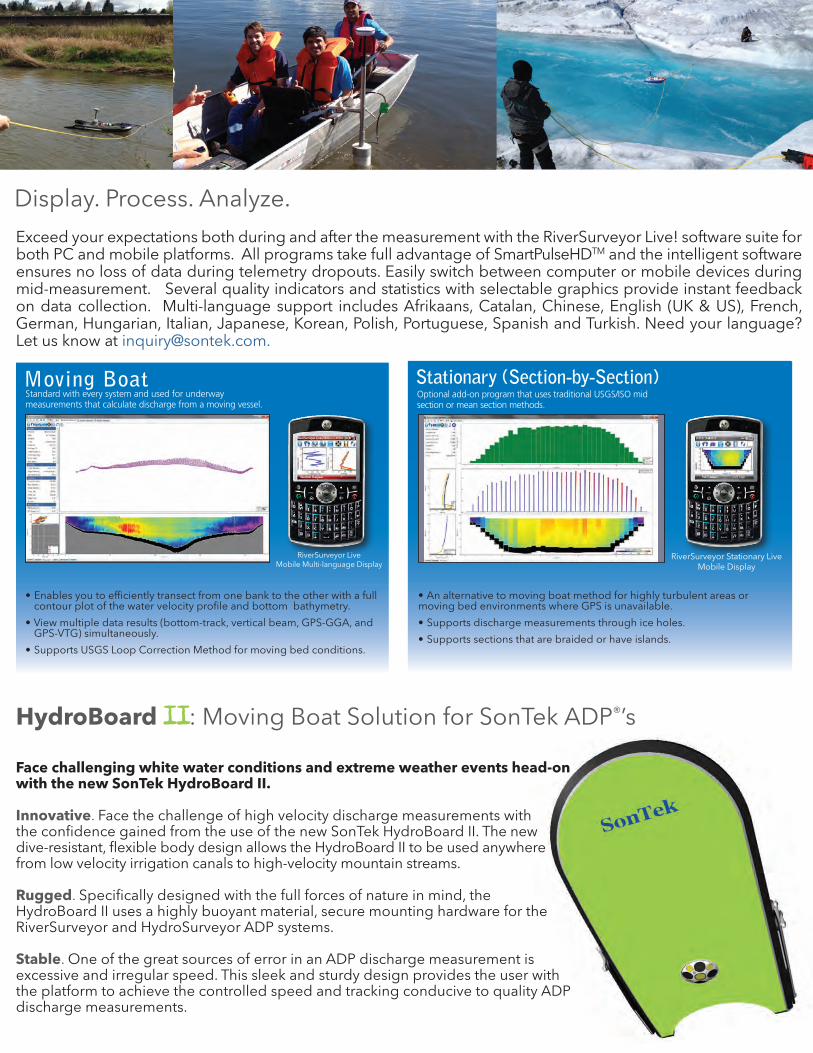
Display. Process. Analyze.
HydroBoard II: Moving Boat Solution for SonTek ADP®’s
Face challenging white water conditions and extreme weather events head-on with the new SonTek HydroBoard II.
Innovative. Face the challenge of high velocity discharge measurements with the confidence gained from the use of the new SonTek HydroBoard II. The new dive-resistant, flexible body design allows the HydroBoard II to be used anywhere from low velocity irrigation canals to high-velocity mountain streams. Rugged. Specifically designed with the full forces of nature in mind, the HydroBoard II uses a highly buoyant material, secure mounting hardware for the RiverSurveyor and HydroSurveyor ADP systems.
Stable. One of the great sources of error in an ADP discharge measurement is excessive and irregular speed. This sleek and sturdy design provides the user with the platform to achieve the controlled speed and tracking conducive to quality ADP discharge measurements.
Stationary (Section-by-Section)Moving BoatStandard with every system and used for underway measurements that calculate discharge from a moving vessel.
Optional add-on program that uses traditional USGS/ISO mid section or mean section methods.
Exceed your expectations both during and after the measurement with the RiverSurveyor Live! software suite for both PC and mobile platforms. All programs take full advantage of SmartPulseHDTM and the intelligent software ensures no loss of data during telemetry dropouts. Easily switch between computer or mobile devices during mid-measurement. Several quality indicators and statistics with selectable graphics provide instant feedback on data collection. Multi-language support includes Afrikaans, Catalan, Chinese, English (UK & US), French, German, Hungarian, Italian, Japanese, Korean, Polish, Portuguese, Spanish and Turkish. Need your language? Let us know at [email protected].
RiverSurveyor Stationary Live Mobile Display
RiverSurveyor Live Mobile Multi-language Display
• Enables you to efficiently transect from one bank to the other with a full contour plot of the water velocity profile and bottom bathymetry.
• View multiple data results (bottom-track, vertical beam, GPS-GGA, and GPS-VTG) simultaneously.
• Supports USGS Loop Correction Method for moving bed conditions.
• An alternative to moving boat method for highly turbulent areas or moving bed environments where GPS is unavailable.
• Supports discharge measurements through ice holes.
• Supports sections that are braided or have islands.
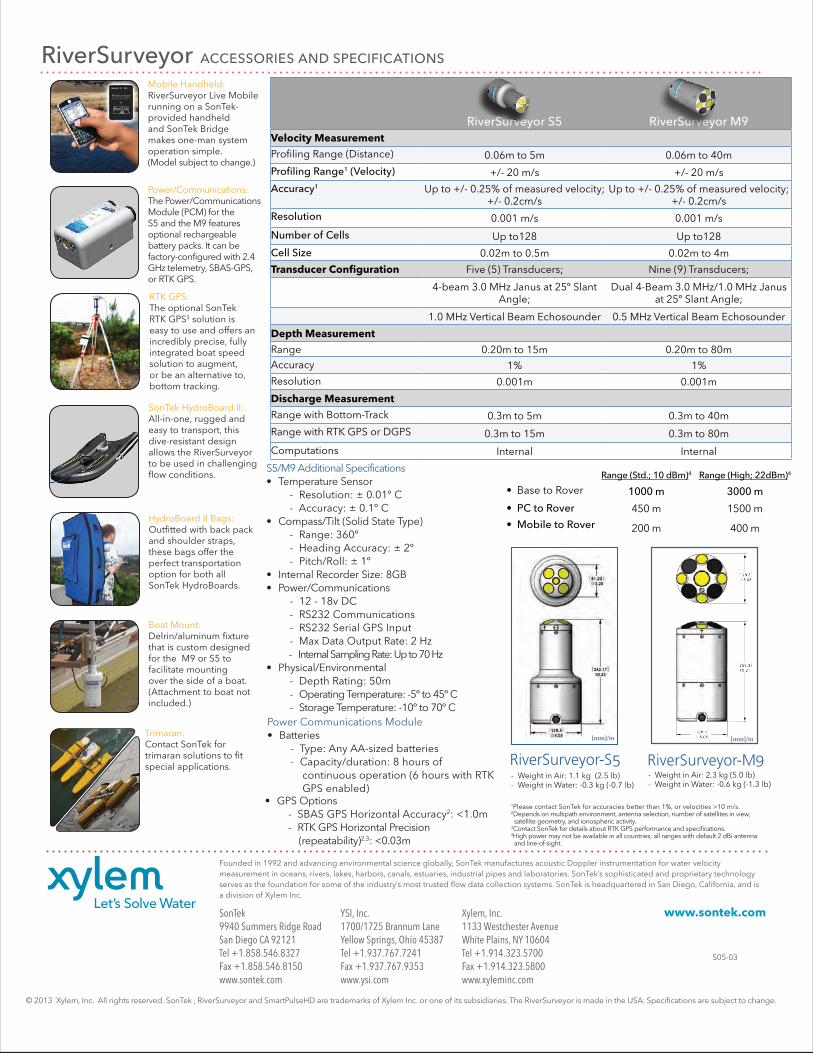
RiverSurveyor acceSSoRieS anD SpecificationS
SonTek9940 Summers Ridge RoadSan Diego CA 92121Tel +1.858.546.8327Fax +1.858.546.8150www.sontek.com
YSI, Inc.1700/1725 Brannum LaneYellow Springs, Ohio 45387Tel +1.937.767.7241Fax +1.937.767.9353www.ysi.com
Xylem, Inc.1133 Westchester AvenueWhite Plains, NY 10604Tel +1.914.323.5700Fax +1.914.323.5800www.xyleminc.com
© 2013 Xylem, Inc. All rights reserved. SonTek , RiverSurveyor and SmartPulseHD are trademarks of Xylem Inc. or one of its subsidiaries. The RiverSurveyor is made in the USA. Specifications are subject to change.
Founded in 1992 and advancing environmental science globally, SonTek manufactures acoustic Doppler instrumentation for water velocity measurement in oceans, rivers, lakes, harbors, canals, estuaries, industrial pipes and laboratories. SonTek’s sophisticated and proprietary technology serves as the foundation for some of the industry’s most trusted flow data collection systems. SonTek is headquartered in San Diego, California, and is a division of Xylem Inc.
www.sontek.com
S05-03
Mobile Handheld: RiverSurveyor Live Mobile running on a SonTek-provided handheld and SonTek Bridge makes one-man system operation simple. (Model subject to change.)
RTK GPS: The optional SonTek RTK GPS3 solution is easy to use and offers an incredibly precise, fully integrated boat speed solution to augment, or be an alternative to, bottom tracking.
SonTek HydroBoard II: All-in-one, rugged and easy to transport, this dive-resistant design allows the RiverSurveyor to be used in challenging flow conditions.
Power/Communications: The Power/Communications Module (PCM) for the S5 and the M9 features optional rechargeable battery packs. It can be factory-configured with 2.4 GHz telemetry, SBAS-GPS, or RTK GPS.
Boat Mount: Delrin/aluminum fixture that is custom designed for the M9 or S5 to facilitate mounting over the side of a boat. (Attachment to boat not included.)
HydroBoard II Bags: Outfitted with back pack and shoulder straps, these bags offer the perfect transportation option for both all SonTek HydroBoards.
Trimaran: Contact SonTek for trimaran solutions to fit special applications.
S5/M9 Additional Specifications• Temperature Sensor - Resolution: ± 0.01º C - Accuracy: ± 0.1º C• Compass/Tilt (Solid State Type) - Range: 360º - Heading Accuracy: ± 2º - Pitch/Roll: ± 1º• Internal Recorder Size: 8GB• Power/Communications - 12 - 18v DC - RS232 Communications - RS232 Serial GPS Input - Max Data Output Rate: 2 Hz - Internal Sampling Rate: Up to 70 Hz• Physical/Environmental - Depth Rating: 50m - Operating Temperature: -5º to 45º C - Storage Temperature: -10º to 70º CPower Communications Module• Batteries - Type: Any AA-sized batteries - Capacity/duration: 8 hours of continuous operation (6 hours with RTK GPS enabled)
RiverSurveyor-S5 RiverSurveyor-M9- Weight in Air: 2.3 kg (5.0 lb)- Weight in Water: -0.6 kg (-1.3 lb)
- Weight in Air: 1.1 kg (2.5 lb) - Weight in Water: -0.3 kg (-0.7 lb)
[mm]/in [mm]/in
• GPS Options - SBAS GPS Horizontal Accuracy2: <1.0m - RTK GPS Horizontal Precision (repeatability)2,3: <0.03m
1Please contact SonTek for accuracies better than 1%, or velocities >10 m/s.2Depends on multipath environment, antenna selection, number of satellites in view, satellite geometry, and ionospheric activity.3Contact SonTek for details about RTK GPS performance and specifications.4High power may not be available in all countries; all ranges with default 2 dBi antenna and line-of-sight.
RiverSurveyor S5 RiverSurveyor m9Velocity Measurement
Profiling Range (Distance) 0.06m to 5m 0.06m to 40m
profiling Range1 (Velocity) +/- 20 m/s +/- 20 m/s
accuracy1 Up to +/- 0.25% of measured velocity; +/- 0.2cm/s
Up to +/- 0.25% of measured velocity; +/- 0.2cm/s
Resolution 0.001 m/s 0.001 m/s
number of cells Up to128 Up to128
cell Size 0.02m to 0.5m 0.02m to 4m
Transducer Configuration Five (5) Transducers; Nine (9) Transducers;
4-beam 3.0 MHz Janus at 25º Slant Angle;
Dual 4-Beam 3.0 MHz/1.0 MHz Janus at 25º Slant Angle;
1.0 MHz Vertical Beam Echosounder 0.5 MHz Vertical Beam Echosounder
Depth MeasurementRange 0.20m to 15m 0.20m to 80mAccuracy 1% 1%Resolution 0.001m 0.001m
Discharge Measurement
Range with Bottom-Track 0.3m to 5m 0.3m to 40m
Range with RTK GPS or DGPS 0.3m to 15m 0.3m to 80m
Computations Internal Internal
Range (Std.; 10 dbm)4 Range (high; 22dbm)4
•BasetoRover 1000 m 3000 m
• PC to Rover 450 m 1500 m
• Mobile to Rover 200 m 400 m