southeast fire centre newsletter
DESCRIPTION
Find about happenings from the Southeast Fire Centre.TRANSCRIPT

Fires Of Note:
Fire season has arrived with 47 fires occurring in the last week. Forty‐three of those were caused by lighting and the remaining four were person‐caused. Quick response from initial attack crews, have lead to many of the 47 fires already extinguished. However, a few remain burning. None are threat‐ening any communities or structures, but some are visible to surrounding populated areas. N70252: Skimmer Horn Fire (east of Lister), is 56 hectares and 45 per cent contained. Today, 32 personnel, 6 helicopters are working on the fire. N70297: Five Mile Creek (9km NE of Nelson) has been mapped at 1.6 hectares and is now 100 per cent contained and is being mopped‐up. N50296: 14km NW Castlegar is now 100 per cent contained and is being mopped‐up. N50333: East of new Denver in the Silverton Creek area is 0.009 hectares and is currently being fought by one initial attack crew and one helicop‐ter. This is one of a few small spot‐sized fires caused by lightning to occur in the last week in this area. Fires to date: So far this season, the Southeast fire centre has seen 102 fires which have burned 296 hectares. Of those fires, 34 where person‐caused and the rest are lightning‐caused.
The 5 year average for this time of year is 268
fires. (3,245 ha’s.)
Southeast Fire Centre
2012.08.15
Resources:
There are currently 128 active personnel and 66 contractors fighting wildfires in the southeast. As the rest of the interior is experiencing similar con‐ditions, all people need to be extremely cautious and diligent when considering industrial activities or when lightning campfires.
Discovered Aug. 8, the Skimmer Horn fire was ignited by lightning. The fire is located on challenging terrain. The fire is currently 45 per cent contained and not a threat to any communities or structures however, it is highly visible to surrounding communities.
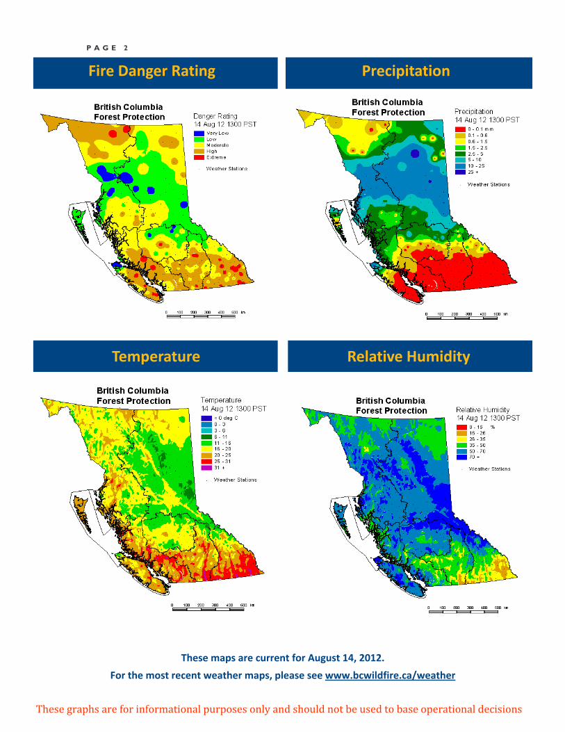
P A G E 2
Precipitation
Temperature Relative Humidity
These graphs are for informational purposes only and should not be used to base operational decisions
Fire Danger Rating
These maps are current for August 14, 2012.
For the most recent weather maps, please see www.bcwildfire.ca/weather
P A G E 3
Most recent forecast for the Southeast OUTLOOK FOR TODAY:
Variable cloud currently lingers across our SE corner as the recent upper trough exits south-eastward across Montana. Otherwise dry, mainly sunny conditions are expected today and Thursday as high pressure (building from central BC-Alberta at the surface and along the coast at upper lev-els) dominates. The pressure gradient is slackening but should still allow for moderate winds in some areas this morning and early afternoon. Tem-peratures will be slightly cooler/near seasonal in most areas today and begin to trend warmer again on Thursday. RH readings should drop into the teens in some areas each afternoon, the lower values Thursday after-noon.
An upper ridge of high pressure will gradually build eastward across southern BC for dry, sunny and progressively warmer/hotter conditions Friday and Saturday, highs temperatures Saturday afternoon ranging from 30 to 37. Overnight recoveries will diminish again. A weak south-westerly flow develops as high pressure shifts slightly east of the Rockies on Sun-day. Patchy sub-tropical moisture and isolated to scattered thunderstorms with gusty winds and very limited showers are then possible on Sunday. Otherwise sunshine, cloudy periods and very warm temperatures are an-ticipated for Sunday. SIX DAY OUTLOOK: Confidence fair on Monday, poor to fair beyond. Today’s medium range guidance is similar to yesterdays but still rather inconclusive Tuesday on-ward. A weak upper trough and its unstable air mass could linger over southern BC for cloudy periods and isolated thunderstorms again Monday afternoon. Tuesday through Friday is suggested to be dry, fairly sunny and slightly warmer than seasonal by some solutions with a westerly flow prevailing. Others suggest patchy moisture drifting north-eastward from western Oregon-northern California for a chance of afternoon thunder-storms Tuesday and Wednesday, and then more stable, less eventful conditions to follow with a westerly flow and weak area of high pressure building from the south Thursday and Friday. For now the more unsettled (Tuesday-Wednesday) solutions are preferred. BOUNDARY ZONE TODAY: Sunny with a few afternoon clouds. MAX TEMP: 28 to 31 MIN RH: 12 to 30% ARROW / KOOTENAY LAKE TODAY: Sunny with a few afternoon clouds. MAX TEMP: 26 to 30 MIN RH: 15 to 35% CRANBROOK / INVERMERE TODAY: Sunny with a few bands of cloud. Becoming a mix of sun & cloud east of the trench during the afternoon MAX TEMP: 20 to 26 MIN RH: 18 to 38% REVELSTOKE / GOLDEN TODAY: Sunny with a few afternoon clouds MAX TEMP: 24 to 27 MIN RH: 20 to 38%
Southeast Fire Centre Statistics
Totals since April 1, 2012:
Fires to date: 102
Hectares burned: 296
Person caused fires: 34
Lightning caused fires: 67
2011 at this time:
Fires to date: 83
Hectares burned: 36
Person caused fires: 33
Lightning caused fires: 49
2010 at this time:
Fires to date: 186
Hectares burned: 518
Person caused fires: 41
Lightning caused fires: 145

P A G E 4
From plotting coordinates on a map by hand to advanced technology that records real‐time information, dispatch (a standardized resource tracking system) has significantly evolved over the years. Today, the Wildfire Management Branch’s (WMB) dispatch software is an internationally recognized program, one which continues to break ground in emergency management communications.
In 1994, the Ministry of Forests undertook a general reorganization of the structure and management of WMB. This included the centralization of the airtanker program to allow for a more streamlined management process. During this time of reorganization, WMB recognized the need for a new dispatch system in order to effectively track wildfires and resources throughout the province.
FMAD (Forests, Management, Analysis and Design) approached WMB in 1994 with the opportunity to experiment with real‐time tracking. FMAD suggested using mountain top repeaters and sophisticated technology (micro meteor‐burst technology) in aircraft to send position reports to a computer‐based map. At the time, wildfire dispatch consisted of tracking resources by hand through the use of maps, string, and calculated coordinates. This proposal was an exciting opportunity for WMB.
In 1997, WMB experimented with combining satellite radios and position data in aircrafts. By merging these two systems into one, airnet radio data was significantly reduced and mountain top repeater networks were no longer needed.
WMB partnered with the US Forest Service in 1998 to develop an automated flight following (AFF) standard. This standard set out specific guidelines for packet data transmission for aircraft. In 2008, it became mandatory that all aircraft hired by WMB needed to be equipped with a tracking device that meets the AFF specifications. The AFF tracking device now automatically records location, altitude, course, and speed of an aircraft. This information is provided to dispatchers, aviation managers, and other wildfire professionals in real time.
The development of the AFF standard has proven to be very beneficial for WMB. Not only does this standard improve resource awareness, save money, and reduce radio traffic and check‐in times, AFF greatly enhances safety.
Over the years, WMB’s dispatch program has evolved into a state‐of‐the‐art system. Not only does dispatch provide real‐time information on aircraft, resource and wildfire locations, it has the capability to overlay weather station information to indicate areas at risk of wildfire.
WMB’s dispatch program is now used in Ontario, Saskatchewan, Alberta, the Northwest Territories, the Yukon, Alaska and some areas of the United States. Australia has also expressed interest in developing a system similar to WMB’s.
While WMB has made great strides with the development of dispatch, it is still important to continue improving the system. In order to better wildfire emergency communications, it is essential to keep moving forward and embrace innovative technological advancements.
Dispatch Developments
Visit www.bcwildfire.ca for more information