space situational awareness: sensing, processing, … · space situational awareness: sensing,...
TRANSCRIPT

Space Situational Awareness: Sensing, Processing, and
IntegratingIntelligent Sensors | Intelligent Software | Intelligent Solutions

Information contained within is confidential. Copyright © 2010 Neptec Design Group Ltd. All rights reserved. 2
Situational awareness
2
Describes any situation requiring perceptual information that is critical to decision-making or task execution
Data collection
Communication
AR&D
Formation flight
Inspection
Localization

Information contained within is confidential. Copyright © 2010 Neptec Design Group Ltd. All rights reserved. 3
How we do situational awareness
3
Sensing
Processing Integrating

Information contained within is confidential. Copyright © 2010 Neptec Design Group Ltd. All rights reserved. 4
Sensing: 3D sensors overview
4
Sensing signalActive
Passive
Range measureTriangulation
Time-of-flight (TOF)
Spatial measureScannerless
Scanning
E.g., stereopsis
Passive
Triangulation
Scannerless

Information contained within is confidential. Copyright © 2010 Neptec Design Group Ltd. All rights reserved. 5
Sensing: 3D metrics overview
5
Basic performance is characterized by four metrics
Range precisionRepeatability of range measurement
Triangulation: Time-of-flight:
Spatial precisionRepeatability of sampling kernel position
Scanning: depends on aim precision.Scannerless: depends on detectorpixel size.
Spatial resolutionMin. spacing providing new information
Scanning: depends on Nyquist atgiven range (i.e., ¼ kernel size).Scannerless: depends on pixel size atgiven range.
Voxel rateMeasure of 3D measurements in time
In general, longer integration times arerequired as range increases, so voxelrates decrease with range.
¾R
¾R / ¾pR2
¾R / ¾t
¾S
±S

Information contained within is confidential. Copyright © 2010 Neptec Design Group Ltd. All rights reserved. 6
Intelligent long range optical system for e.g., Earth observation or star tracking Very small form factor with accommodations to various optical mounts On-board data processing: compression, subsampling, classification, change
monitoring, centroiding
Physical Data Supports a wide variety of optical design Mass: 1.25kg Operating power 3W @ 5V Dimensions: 4.3” x 5.3” x 1.1” Radiation hardened electrical and optical components
Imaging capability Frame rate: up to 30fps Resolution of up 1024 x 1024 pixels, window support Full control over exposure time, 1/30th to 10 seconds Programmable gain, noise correction Dual slope dynamic range expansion
2D Sensing: Long Range Optical Sensor (LROS)
6

Information contained within is confidential. Copyright © 2010 Neptec Design Group Ltd. All rights reserved. 7
3D Sensing: Laser Camera System (LCS)
Autosynchronous triangulation sensor Flight qualified STS-114 to present
7
Laser Wavelength 1500nm (IR)
Laser Class Class 3B
Field of View 30º X 30º
Spatial Resolution 800µm to 1mm (1m to 5m)
Range Precision 0.8mm to 11mm (1m to 5m)
Voxel Rate ~10kpps (at 1m)
Spatial Precision 0.05mm to 0.25mm (1m to5m)
Weight < 26.5lbs
Dimensions 15.75” x 10.75” x 11.87”
Command/Data Interface Ethernet, RS422
Operating Environment -110ºC to +5ºC
Power Interface 28V DC
Power Consumption Operational: 100W max.
Relative Accuracy ~1µm at 2”

Information contained within is confidential. Copyright © 2010 Neptec Design Group Ltd. All rights reserved. 8
3D Sensing: Triangulation LiDAR (TriDAR)
Automated Rendezvous and Docking (AR&D) sensor: STS-128, STS-132 Tested as rover navigation sensor
Information contained within is confidential. Copyright © 2009 Neptec Design Group Ltd. All rights reserved. 8
Laser Class TOF: 3R, Tri: 3B
Laser Wavelength TOF: 1540nm, Tri: 1400nm
Spatial Precision 0.9mm to 0.5cm (10m to 100m)
Range Precision < 25mm
Spatial Resolution Adjustable 0.125mm to 1.5mm, 1m to 10m. 2.5mm at 100m.
Voxel Rate 8-12 kpps
Operating Environment -29ºC to 50ºC
Field Of View 30º x 30º
Power Interface 28V DC
Power Consumption ~70W
Physical Characteristics 35lbs, 10” x 10” x 8”
Command/Data Interface Ethernet, RS-422 (dual)
Range (Bearing & Range mode) 3km
Range (6 DOF Tracking mode) 400m
IR Imager Range (ISS Target) >40km w/ 12x16 degree FOV
Tracking Accuracy ~1 cm, ~1 deg

Information contained within is confidential. Copyright © 2010 Neptec Design Group Ltd. All rights reserved. 9
3D Sensing: Hawkeye
Hawkeye is a proximity sensor providing: Collision avoidance for satellites Situational awareness in formation flying Threat tracking
9
Laser Class 3B
Laser Wavelength 1064 nm
Laser Power 25mJ pulse, 0.3Hz, 4ns (208MW)
Operational Range 50m to 30km
Range Precision 45mm
Range Accuracy ±2m
Operating Environment -21ºC to +40ºC, 10-10 torr vacuum
Power Interface 28V MIL-STD-461 compliant
Power Consumption Standby 2.2W @ 28VMaximum 20W @ max fire rate
Physical Characteristics 6.6lbs (3kg), 4.9” x 5.6” x 8.2”
Command/Data Interface RS422 serial
Onboard Computing Supports on-orbit upload of operational software
Information contained within is confidential. Copyright © 2010 Neptec Design Group Ltd. All rights reserved. 10
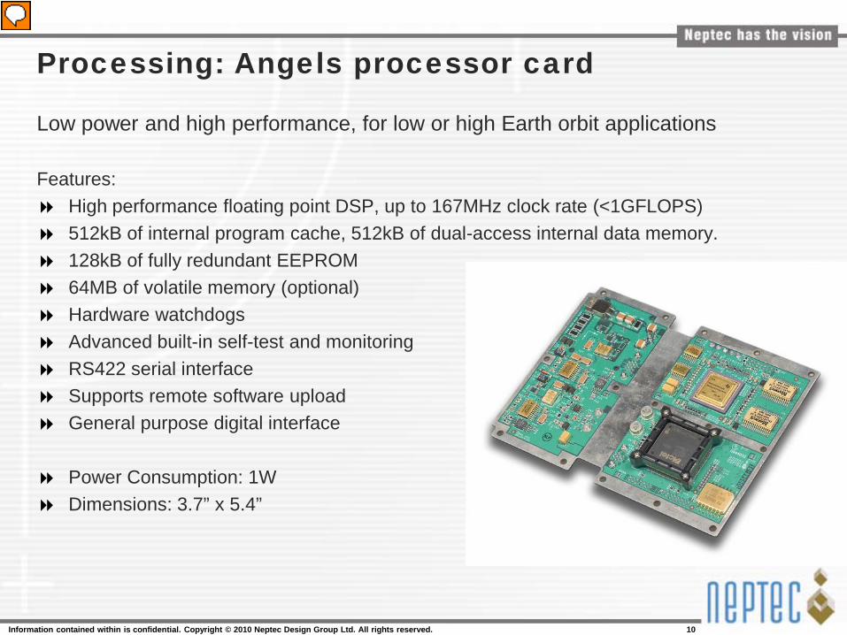
Processing: Angels processor card
Low power and high performance, for low or high Earth orbit applications
Features: High performance floating point DSP, up to 167MHz clock rate (<1GFLOPS) 512kB of internal program cache, 512kB of dual-access internal data memory. 128kB of fully redundant EEPROM 64MB of volatile memory (optional) Hardware watchdogs Advanced built-in self-test and monitoring RS422 serial interface Supports remote software upload General purpose digital interface
Power Consumption: 1W Dimensions: 3.7” x 5.4”

Information contained within is confidential. Copyright © 2010 Neptec Design Group Ltd. All rights reserved. 11
Processing: REACT processor card
High performance computer, qualified at LEO
Features: PowerPC MPC8548, 1.2GHz core clock 64kB of L1 cache, 512kB of L2 cache with parity protection 512MB of DDR2 memory with ECC protection and scrubbing 256MB of fully redundant Flash memory with Reed-Solomon FEC and double device
correction Integrated software and hardware watchdogs Advanced build in self test and monitoring Xilinx Virtex 2 Pro (XC2VP20) FPGA 2 x RS422 interface 2 x USB 2.0 interfaces 2 x 100Mbps Ethernet ports 3 x I2C Serial Interfaces Custom I/O interface
Power: 12W Dimensions: 4.8” x 10.7” x 0.9”

Information contained within is confidential. Copyright © 2010 Neptec Design Group Ltd. All rights reserved. 12
Integrating: Juno rover
ISRU rover for autonomous or teleoperated exploration and exploitation tasks
Being developed by a team of leading organizations Team leader and system integrator, also provide vision systems and hardware In conjunction with Canadian Space Agency Successful formal testing using TriDAR as navigation sensor
Met or exceeded all test objectives (Hawaii 2008, 2010; Desert Rat 2007) Regolith excavation and autonomous navigation to processing plant
Unique and flexible design can scale from Mars rover to lunar rover
Designed for harsh Martian and lunar environment
Information contained within is confidential. Copyright © 2010 Neptec Design Group Ltd. All rights reserved. 13
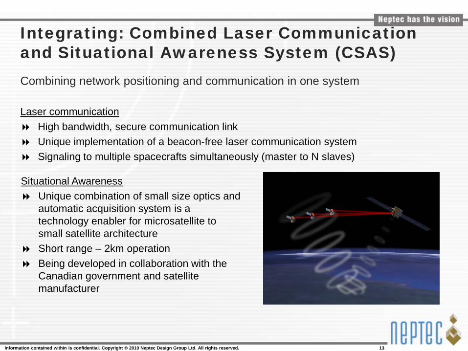
Integrating: Combined Laser Communication and Situational Awareness System (CSAS)Combining network positioning and communication in one system
Laser communication High bandwidth, secure communication link Unique implementation of a beacon-free laser communication system Signaling to multiple spacecrafts simultaneously (master to N slaves)
Situational Awareness Unique combination of small size optics and
automatic acquisition system is a technology enabler for microsatellite to small satellite architecture
Short range – 2km operation Being developed in collaboration with the
Canadian government and satellite manufacturer

Information contained within is confidential. Copyright © 2010 Neptec Design Group Ltd. All rights reserved. 14
Partners and affiliations
Government organizations OEMs and system integrators Defense research institutions Private companies Universities and colleges