spatial structure changes inside post...
TRANSCRIPT
HUMAN GEOGRAPHIES – Journal of Studies and Research in Human Geography
6.1 (2012) 79-89. ISSN-print: 1843-6587/$-see back cover; ISSN-online: 2067–2284-open access
www.humangeographies.org.ro
(c) Human Geographies – Journal of Studies and Research in Human Geography (c) The authors
SPATIAL STRUCTURE CHANGES INSIDE POST-COMMUNIST CAPITAL CITY OF BUCHAREST
Gabriel Simion*, Constantin Nistor
University of Bucharest, Faculty of Geography, Bucharest, Romania
Abstract: The paper focusses on the analyses of the recent development concerning post-socialist urban transformation of Bucharest, the Romanian country capital. The paper describes the spatial typology of metropolitan landscapes, and underlines the changes occurred inside the residential, commercial, services and industrial areas. The most noticeable occurrence is the urban sprawl and multiplication of the buildings and implicitly the diminishing of the agricultural area. It has been confirmed, at least theoretically, that spatial development of the largest cities determined a continuous decreasing of agriculture in the metropolitan area, landowners preferring selling or seeking to sell their land. The paper is empirically trying to argue the fact that post-socialist development of the land market in Bucharest metropolitan area determined a decline of agriculture in the city's proximity. It is also showing that at increasing distance from the Bucharest city agriculture still has its importance as subsistence activity - in the south-eastern part, or as market oriented - in the south-western part or in the northern border. Key words: Bucharest metropolitan area, Urban landscape, Service area, Industrial area, Agricultural landscapes. Article Info: Manuscript Received: July 15, 2011; Revised: January 15, 2012; Accepted: February 15, 2012, Online: May 29, 2012.
Introduction The spatial changes of land use in the large cities were schematically portrayed by Bryant et al. (1982). He identified the existence of four ‘zones’ around a big city. The first is 'inner fringe' were much of the land was converted to constructions or has planning permission. Secondly, the ‘outer fringe’ is characterized by rural land-uses, although there is infiltration of urban-oriented elements as single family dwelling along route ways. The third zone is 'urban shadow', where the urban influence is minimal, but is presence of non-farm residence and the non-farm ownership of land. The fourth zone is 'rural hinterland' where the metropolitan influence does not stop and are present different items such as private second homes (see a proposal related model applied to Bucharest in Figure 3).
Another proposed model of city dynamics is those of the town which has gone from a traditional industrial town (after 1850) to a Fordist city (after
1945 until 1975) and a neo-Fordist metropolis (after 1975). An example of this city evolution is the Los Angeles (Knox, Pinch, 2006: 32). This model can be used as a pattern for the city that are undergone through the similar processes, but more out of phase with time as is Bucharest.
Van den Brouke (1986) has made a schematic representation of the Montreal metropolitan area. The author point out that spatial organization may be separate in areas and spaces that perform different functions (area of urban concentration, rur-urban fringe, urban shadow, agricultural area, agro-forestry area, tourism and recreation area) and nucleus and urban poles. It can be notice large expansion of the forest-tourist areas.
Bucharest City is a particularly interesting case of spatial changes because it has been linked other phenomena of an extremely comprehensive transformation process, such as massive demographic shrinking, immigration from the others Romanian settlements and economic restructuring on a scale unprecedented in terms of speed and depth.
In this case, one crucial questions is ‘’to which extent findings on western cities evolution can be derived for the formerly ‘eastern hemisphere’?’’ This paper focusses on the spatial transformations in the
*Corresponding author: Address: University of Bucharest, Faculty of Geography, 1, Nicolae Bălcescu Avenue, 010041, Bucharest, Romania. Telephone: +4 0721.243.539 Email: [email protected]
doi:10.5719/hgeo.2012.61.79
GABRIEL SIMION, CONSTANTIN NISTOR
HUMAN GEOGRAPHIES – Journal of Studies and Research in Human Geography 6.1 (2012) 79-89 80
Bucharest Metropolitan Area (BMA) since the fall of the communist regime in 1989 and the impact of those transformations on the city hinterland. As in others metropolitan areas, we expect the growth of residential land use and this is recognized being very important for economic and ecological planning (Keys et al., 2007: 131).
Study area Bucharest City is the Romania country capital. BMA is comprised by the city of Bucharest and other ninety-four municipalities. This is the area approved by the City hall of Bucharest in 2005. The BMA occupied partially or completely 5 counties (Ilfov 100%, Călărași 35.3%, Giurgiu 27.9%, Dâmbovița 5.7%, Ialomița 1.5%). Spatial borders of BMA are corresponding approximately with the limits or rural-urban fringe, at a circle radius of 50-60 Km, but it could reach 70 Km in the south-eastern extreme region. Bucharest City is the largest Romanian settlement, with a population around 2 million people. The population of metropolitan area is about 564.000 in 2002.
For the BMA in this study were delineated several areas and landscapes. Those are a part of a proposal model, which can be supported by the fact that Claval (1966) recognised the relativity of region limits that not means the lack of their validity but only a requirement of a critical analysis. These regions are cartographic approximations needed but not definitely. The landscapes were delineated based-on a fieldwork observation in the study area.
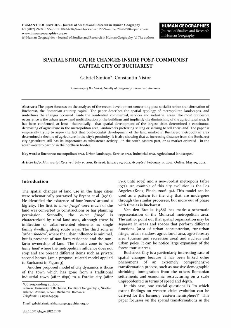
Bucharest urban landscape evolution – a brief history In the photos 1 are underlined the main phases of the Bucharest landscape, from the ending of 19
th centuries
since today. Landscape has been transformed from a mixed land use (houses with the garden, orchards,
and vineyards) to one representative for the communist period, with the large residential areas occupied by blocks. The today landscape is dominated by the suburbanization far from the city, with gated communities and transfer of the industrial activities to Bucharest metropolitan area.
The pre-modern landscape At the ending of the 19
th century and beginning of the
20th
centuries, the Bucharest City had a village landscape, with many one floor houses, deeply covered by green spaces. This landscape was spread in the central part of the city, and at the periphery it was a typically rural landscape, with the poor households, surrounded by the tomatoes garden or orchards and vineyards. The central area of the city registered the elements of a new urban evolution, due to the build-up of the two railway stations (Filaret and Gara de Nord), which facilitated the growth of the industries. The consequence was the transfer of the agricultural land to industrial, storage spaces or residential uses. In the same time, appeared the first buildings of the ministries, business, education and culture.
Parliament Palace area. In order to evaluate the landscape changes of the area we used two cartographic sources, represented by the Pappasoglu map (1871) and a satellite image from 2000 (Figure 1). On the 1871 map in the western part can be observed an area cultivated with vegetables, and continued to the south it was a land occupied with vineyards. In the same region with the Parliament Palace were present large areas with houses and military buildings. This area was in a continuous expansion at the 1871 if compared with the situation mapped on the Borroczyn map (1852) area registered a decreased of agricultural land.
Piața Unirii – Piața Alba Iulia Area. For this area are used three cartographic sources representatively for the years 1852, 1871 and 2005 in order to evaluate the evolution of urban landscape (Figure 2). This area
Photos 1. Bucharest landscape dynamic since 19th
century to present

SPATIAL STRUCTURE CHANGES INSIDE POST-COMMUNIST CAPITAL CITY OF BUCHAREST
HUMAN GEOGRAPHIES – Journal of Studies and Research in Human Geography 6.1 (2012) 79-89 81
is emblematically for Bucharest transformation during the ages of ‘8os by Nicolae Ceaușescu, the last communist president of Romania. Large parts of the territory were demolished and replaced with the big shopping mall (Unirea), the construction of the new National Library, the street were modified. In 1852, this area has a strong rural aspect. On the Borroczyn map (1852) we can easily observe the extension of vineyards, orchards, vegetable gardens, arable lands. In the eastern part, in an approximately place of today Alba Iulia Plaza, was a large area with vineyards, and in the western part were found vegetable garden. In a period of about twenty years the region was in a continued transformation. Pappasoglu map confirm this situation by increasingly number of houses mapped, in the area with vegetable were built-up houses. Based on the tendencies of new buildings, sand pot-holes have sprung in this area, some of whom, of considerable size. On the right side of Dâmbovița Valley appeared one of the first big plant of Bucharest, called Lemaître, and after the nationalization, during communist period, its name has been change with Timpuri Noi (New Ages). Presently, this area’ urban
landscape is a combination of communist architecture style and nowadays modern style. The available land, located behind the new National Library is anticipated to be used for business, houses and entertainment facilities.
The Modern Style Landscape The landscape characteristics for the end of the 19
thcentury and the beginning of the 20
thcentury have
been replaced with modern ones and partially changed. Since then, Bucharest City took on more of today urban morphology, by construction of new avenues and the old sites for informal commerce and small shops were replaced by blocks or plants. The city periphery that gone outside of the former ring roads, continued to preserve some of the aspects of the pre-modern landscape, with the poor houses, worker residential areas located close to the plants built-up before communism. In the suburban area of Bucharest, the city influence was increasingly. In this conditions appeared one of the first preoccupation about systematization from the city centre to periphery. Because many people came to Bucharest,
Figure 1. Land use details at Parliament Palace area:
a. Pappasoglu Map - 1871; b. Satellite image – 2005
Figure 2. Land use details at Piaţa Unirii – Piaţa Alba Iulia area:
a. Borroczyn Map– 1852. b. Pappasoglu Map – 1871. c. Bucharest Map- 2005

GABRIEL SIMION, CONSTANTIN NISTOR
HUMAN GEOGRAPHIES – Journal of Studies and Research in Human Geography 6.1 (2012) 79-89 82
the number of inhabitants increased and they needed more perishable foods. In this situation were passed the new regulations in constructions, urban planning and the organizing of the periurban agricultural space. Mihăilescu (2003:85) mentioned new farms for fruits, vegetable, meat, milk and the existence of the villages specialized in growing animals or cropping vegetable. The same authors discussed related to the development of a ‘’Bucharest urban region’’, a phenomena analysed by Romanian geographers since 1920.
After the WW2, Romania adopted the economic and political communist system, which created a completely new economic and social environment. First, all the factories, banks, shops were nationalized and in agriculture started the process of collectivization. This period with the communist system and its influence on urban planning of Bucharest it is known as socialist zoning. This period is characteristic for the ‘60s, ‘70s and ‘80s, when there were built-up large industrial platforms, generally located at the city border, before used as agricultural land. Bucharest urban landscape started been dominated by the appeared of socialist blocks for the industrial workers, grouped in estates with similar aspect, without identity.
Contemporary landscape of post-modern tendencies Today, Bucharest City passes through a new phase of its urban evolution, which can be named developing of new urban economy and ‘gated communities’. It makes the transition from the communist industrial city to a services city. Here are established the headquarters of the companies, both in the city centre and at peripheries through the built-up of business parks. In the suburban area located new residential areas or logistics platform that convert the land-use. The agricultural activities to produce fresh food for the city decreased but it still exist far from city.
Residential projects were developed both in the city, mainly replacing the industrial platforms, and in the suburban area, predominantly in the north. The projects of the northern part were facilitated by their location close to the one of the main road of the country - DN1 (National Road 1). Some of the projects were built-up on the agricultural land or near to a forest area. One of the representatively area is Pipera, located in the north-eastern part of the Bucharest. This agricultural area, due to the location near to the city, became after ‘90s the most attractive area for houses, used more as second-home for those living in the city centre. There has been developed an entire
quarter here, and the former agricultural land and pastoral activities were replaced or abandoned.
Another example of suburbanization is Snagov, an exclusivist area, attractive for the rich people. This area was developed mainly after 1950, when it registered investments in tourism and sportive facilities. The new residents preferred private house, built-up in the area surrounding the lake with the same name or in the former arable land. New houses built-up at the lake determined the restrictions for non-residences to the lake, a negative influence on the local tourism and a weak for lake’s flora and faunas.
Office buildings were developed until now across of two axes: Unirii Plaza – Charles de Gaulle Plaza and World Trade Center – Băneasa Airport. Thus areas were chosen by those companies which got it because the visibility and prestige of the zone. Administrative office were developed also in others areas as Pipera and Drumul Taberei, because here the land prices are cheaper and the employees lives nearby (Colliers International, 2004:40). One of the most important projects was Bucharest Business Park, located close to the Piața Presei Libere, and it attracted similarly projects in the area (S Park, Victoria Park, Băneasa Bussines & Technology Park).
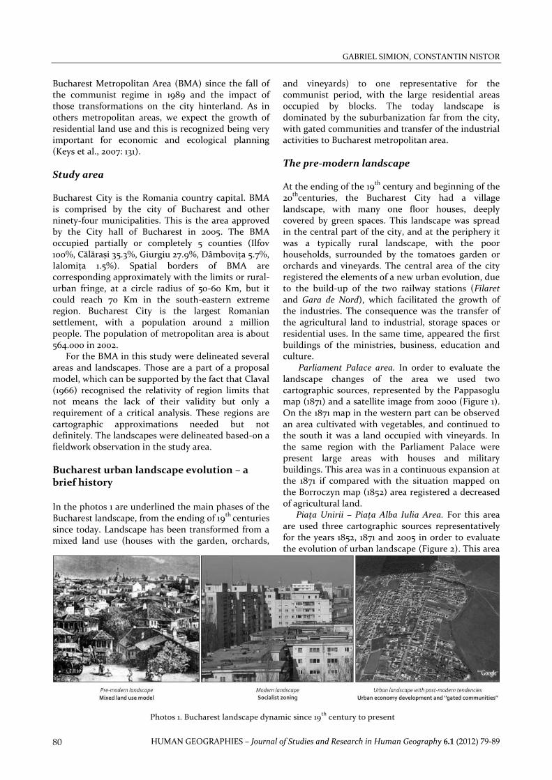
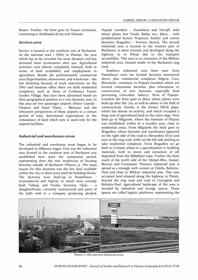
Industrial areas located in the city were converted to the others uses because of the pressure of the land prices or due to the environmental regulations that force them to close some of the polluting activities. During the industrial evolution of the city the largest plants were almost always located at the border. In photos 2 are give two examples of this situation. The first photo is Varnish and Paint Enterprise Policolor, built-up in 1965 and in the second photo is the former Glucose Factory (Fabrica de Glucoză), transformed today in company offices and hotel. We can observe that thus plants were established on the large available land at the city border, and in the Glucose factory example the contrast between the agricultural land and the factory can be easy recognise.
Today, the evolution of industrial spaces is dominated by warehouses, namely logistics platforms, which can be easy adapted for industrial or storage uses. The warehouses were built-up across the highway A1, in the western part of the city, because the availability of land, the land prices and transport facilities. For built a warehouse is required 20-25 ha, most of the time agricultural land. The southern part of the city does not register the warehouse so far. This area was a part of the new industrial project during the communist time, but the majority of the plants built-up then were closed or are in the restructuring process, due to the dismissing of the activities. There are some new plants, most of them for food and drink (beer, soft drinks, chocolates and bakery).
SPATIAL STRUCTURE CHANGES INSIDE POST-COMMUNIST CAPITAL CITY OF BUCHAREST
HUMAN GEOGRAPHIES – Journal of Studies and Research in Human Geography 6.1 (2012) 79-89 83
Photos 2. Dynamics of industrial facilities a. Fabrica de Glucoză - 1902 ; b. Policolor - 1965
Retail centres. Mihăilescu (2003) in his book about Bucharest evolution insisted about the trade role of city, situated at the cross of the roads coming from different regions of the Romania. The increased of population’s numbers, from 50,000 people end of 17 century and up to 100,000 people at the middle of 19 century determined a required of grains, meat, fruits, vine, honey, that transformed the Bucharest of the 18th century into the largest trade centre of southern Romania and probably one of the most important of south-eastern European one (Mihăilescu, 2003: 81). The spatial sprawl of Bucharest by the end of 18th century was generated by aspects related to the transport routes and the Dâmbovița river bed, with the city being located on the left side of it. The city limit of that time overlapped with some urban plazas (market places) which nowadays are a characteristic for Bucharest development, a line connecting these plazas can be considered the limit of its historical centre.
After the fall of communist regime, retail centres were one of the first elements of new urban evolution of the city, being after followed by residential or office buildings. It has a contribution in the reorganizing urban spaces surrounding, large areas of agricultural land being occupied and attracted new investment in the same area (amusement parks,
residential). One of the best examples is Băneasa-Feeria, which change entire landscape of the area. This complex is situated at the cross roads of national road DN1 with Aleea Privighetorilor, composed with Carrefour, Media Galaxy, Mobexpert-Flanco, Bricostore and Ikea. The development of this area is related with the others opportunities (airport, residential, forests, and accessibility to national road DN1).
This is the area situated in the vicinity of the administrative Bucharest border, where are establish mutual relations between the city and its surrounding area. It represent a region with an intensive urban pressure, by built-up of residential areas, location or relocations of industrial facilities and services spaces. It is a transition zone in terms of land use and social characteristics and begins to be increasingly characterized by the absence of agriculture. Not entire area is affected throughout the same intensity but its limits are extending to this space more and more.
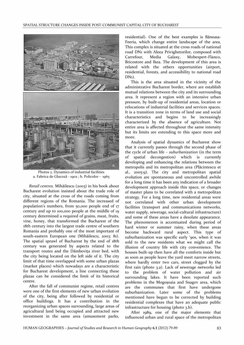
Analysis of spatial dynamics of Bucharest show that it currently passes through the second phase of the cycle of urban life – suburbanization (in the term of spatial decongestion) which is currently developing and enhancing the relations between the metropolis and its metropolitan area (Plăcintescu et al., 2005:9). The city and metropolitan spatial evolution are spontaneous and uncontrolled awhile for a long time it has been any indication of a broader development approach inside this space, or changes of master plans to be correlated with a metropolitan strategy. For a long time, new residential areas were not correlated with other urban development facilities (transport and communications networks, water supply, sewerage, social-cultural infrastructure) and some of these areas have a desolate appearance. The phenomenon is accentuated during period of hard winter or summer rainy, when these areas become backward rural aspect. This type of suburbanization was specific early ‘90s, when it was sold to the new residents what we might call the illusion of country life with city convenience. The houses built-up then have all the comforts inside but as soon as people leave the yard meet narrow streets, where hardly enter two cars, street clogged by the first rain (photo 3.a). Lack of sewerage networks led to the problem of water pollution and air surrounding lakes. It have been reported such problems in the Mogoșoaia and Snagov area, which are the communes that first have undergone suburbanization. Later some of the problems mentioned have begun to be corrected by building residential complexes that have an adequate public infrastructure for housing (photo 3.b).
After 1989, one of the major elements that influenced urban and rural space of the metropolitan
GABRIEL SIMION, CONSTANTIN NISTOR
HUMAN GEOGRAPHIES – Journal of Studies and Research in Human Geography 6.1 (2012) 79-89 84
area was the transition to the market economy, based on private investments in all economic sectors. This process was accompanied by restructuring and privatization of state industry, agriculture, and services and encouraged of private investments. Localization of the investments in the metropolitan area, mainly close to Bucharest, was facilitated by lower prices of land, affordable labour market and some tax breaks. There was a wave of urban decongestion of industry and services activities that have been relocated and received in suburban area, because they have transformed and diversifying the economy and increased household income and local budgets. The process described so far, about the relocation of economic activities in the suburban area is not necessarily recently. Old city maps revealed that it existed in the other periods of Bucharest’s evolution, where factories were settled at the periphery.
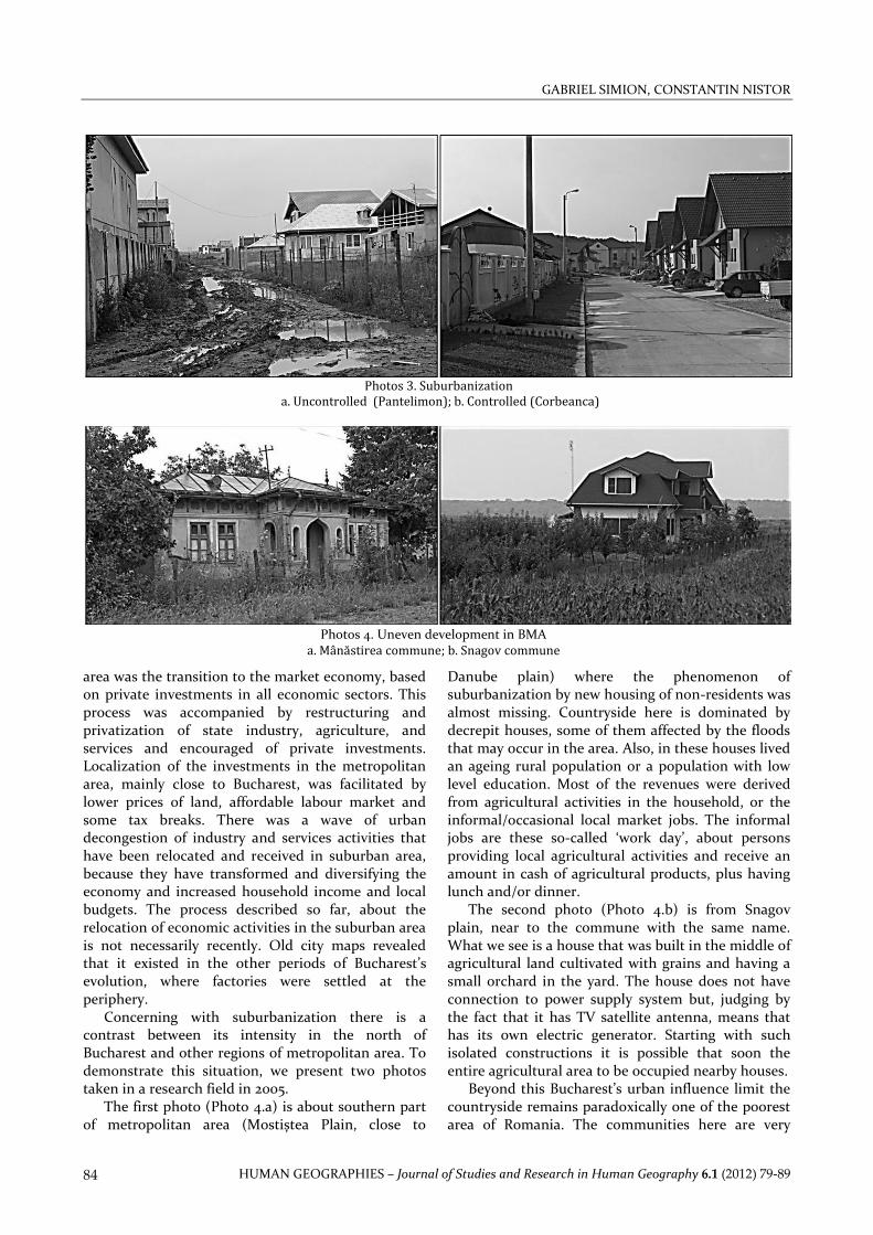
Concerning with suburbanization there is a contrast between its intensity in the north of Bucharest and other regions of metropolitan area. To demonstrate this situation, we present two photos taken in a research field in 2005.
The first photo (Photo 4.a) is about southern part of metropolitan area (Mostiștea Plain, close to
Danube plain) where the phenomenon of suburbanization by new housing of non-residents was almost missing. Countryside here is dominated by decrepit houses, some of them affected by the floods that may occur in the area. Also, in these houses lived an ageing rural population or a population with low level education. Most of the revenues were derived from agricultural activities in the household, or the informal/occasional local market jobs. The informal jobs are these so-called ‘work day’, about persons providing local agricultural activities and receive an amount in cash of agricultural products, plus having lunch and/or dinner.
The second photo (Photo 4.b) is from Snagov plain, near to the commune with the same name. What we see is a house that was built in the middle of agricultural land cultivated with grains and having a small orchard in the yard. The house does not have connection to power supply system but, judging by the fact that it has TV satellite antenna, means that has its own electric generator. Starting with such isolated constructions it is possible that soon the entire agricultural area to be occupied nearby houses.
Beyond this Bucharest’s urban influence limit the countryside remains paradoxically one of the poorest area of Romania. The communities here are very
Photos 3. Suburbanization
a. Uncontrolled (Pantelimon); b. Controlled (Corbeanca)
Photos 4. Uneven development in BMA
a. Mânăstirea commune; b. Snagov commune
SPATIAL STRUCTURE CHANGES INSIDE POST-COMMUNIST CAPITAL CITY OF BUCHAREST
HUMAN GEOGRAPHIES – Journal of Studies and Research in Human Geography 6.1 (2012) 79-89 85
much dependent on subsistence farming, with weak infrastructure and low economic performance. People were dependent on the jobs in the Bucharest’s industry but after closing of plants they return to agriculture in rural place residence. These disparities in the economic development of the region were also a specific characteristic of the 80s, when new urban settlements were awarded by the state with the rank of cities, following to mitigate the local disparities by their support.
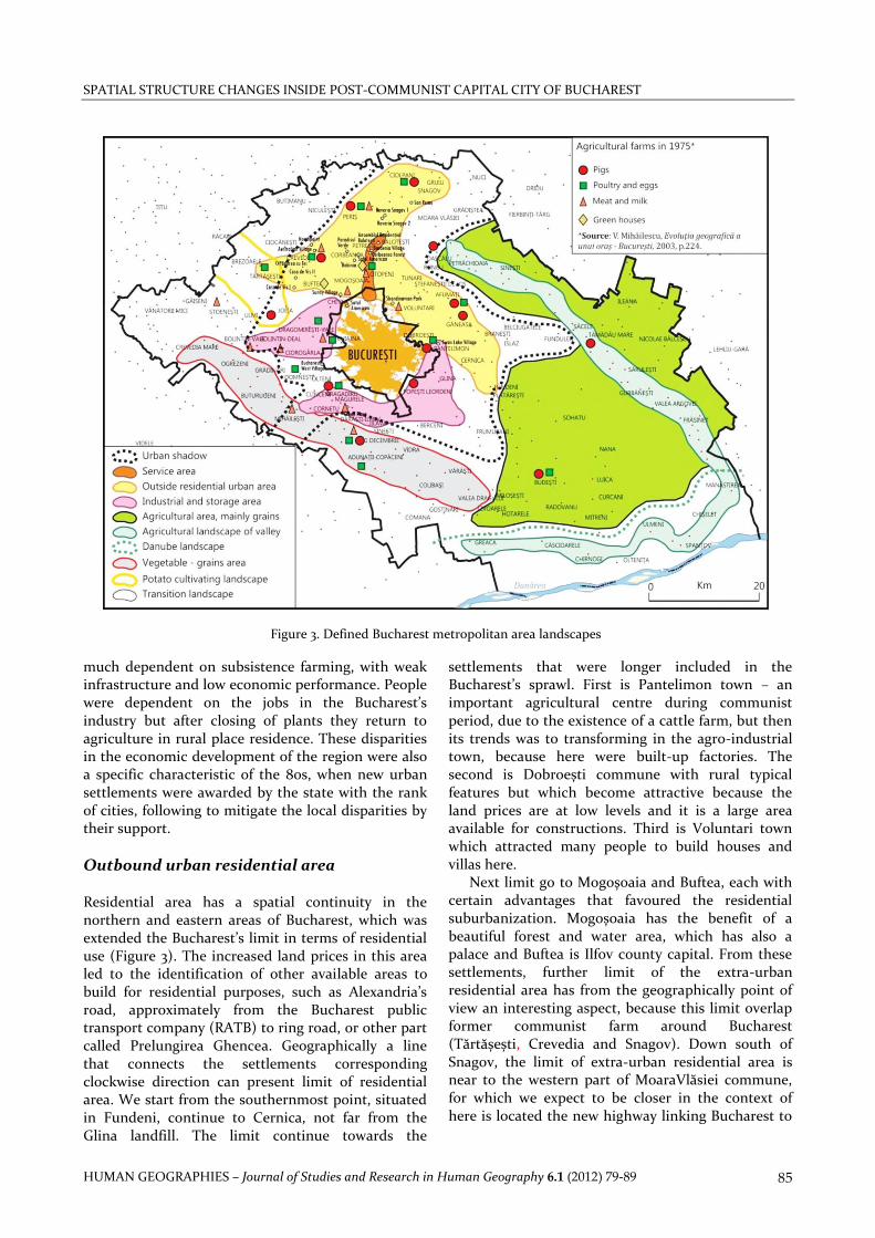
Outbound urban residential area Residential area has a spatial continuity in the northern and eastern areas of Bucharest, which was extended the Bucharest’s limit in terms of residential use (Figure 3). The increased land prices in this area led to the identification of other available areas to build for residential purposes, such as Alexandria’s road, approximately from the Bucharest public transport company (RATB) to ring road, or other part called Prelungirea Ghencea. Geographically a line that connects the settlements corresponding clockwise direction can present limit of residential area. We start from the southernmost point, situated in Fundeni, continue to Cernica, not far from the Glina landfill. The limit continue towards the
settlements that were longer included in the Bucharest’s sprawl. First is Pantelimon town – an important agricultural centre during communist period, due to the existence of a cattle farm, but then its trends was to transforming in the agro-industrial town, because here were built-up factories. The second is Dobroești commune with rural typical features but which become attractive because the land prices are at low levels and it is a large area available for constructions. Third is Voluntari town which attracted many people to build houses and villas here.
Next limit go to Mogoșoaia and Buftea, each with certain advantages that favoured the residential suburbanization. Mogoșoaia has the benefit of a beautiful forest and water area, which has also a palace and Buftea is Ilfov county capital. From these settlements, further limit of the extra-urban residential area has from the geographically point of view an interesting aspect, because this limit overlap former communist farm around Bucharest (Tărtășești, Crevedia and Snagov). Down south of Snagov, the limit of extra-urban residential area is near to the western part of MoaraVlăsiei commune, for which we expect to be closer in the context of here is located the new highway linking Bucharest to
Figure 3. Defined Bucharest metropolitan area landscapes
GABRIEL SIMION, CONSTANTIN NISTOR
HUMAN GEOGRAPHIES – Journal of Studies and Research in Human Geography 6.1 (2012) 79-89 86
Brașov. Further, the limit goes to Tunari commune, continuing to Ștefăneștii de Jos and Afumați.
Services area Service is located at the northern exit of Bucharest, on the national road 1 (DN1) to Ploiești, the area which has so far revealed the most dynamic and has attracted most investments after 90s. Agricultural activities were almost completely reduced, both in terms of land availability and employment in agriculture. Beside the predominantly commercial area (hypermarkets, showrooms, and warehouse – the last declining because of track restrictions on the DN1) and business office there are built residential complexes, such as those of Corbeanca Forest, Garden Village, that have been advertised based on their geographical position in a very dynamic area. In this area are two passenger airports (Henri Coandă - Otopeni and Aurel Vlaicu – Băneasa) and the relocation perspectives of these airports in a certain period of time, determined expectations in the redundancy of land which now is used only for the airports facilities.
Industrial and warehouses areas The industrial and warehouse areas began to be developed in different stages. First was the industrial area located in the southern part of Bucharest was established here since the communist period, representing then the new tendencies of locating factories outside of Bucharest (Photos 5). The main reason for this situation was the few land available within the city or there were used for building blocks. The factories were built-up in Pantelimon – Acumulatorul and Neferal, to which were recently built Tuborg and Franke factories; Glina – a slaughterhouse, currently restructured and parts of the halls sold to a company producing alcohol;
Popești Leordeni – Danubiana and Viscofil, with newer plants Star Foods, Baduc etc.; Jilava – with prefabricated factory Progresul, leather and cotton factories; Bragadiru – brewery factory. The second industrial area is located in the western part of Bucharest, is more recently and developed along the highway A1 to Pitești due to the transport accessibility. This area is an extension of the Militari industrial area, located inside of the Bucharest ring road.
Southern industrial area limit start from Pantelimon were are located factories mentioned above, plus commercial complexes Selgros, Cora, Bricostore, continues to Popești-Leordeni where are located communist factories plus relocations or construction of new factories, especially food processing (chocolate, bakery). West of Popești-Leordeni the limit goes to Jilava where plants were built-up after the ‘70s, as well as others in the field of constructions. Nearby is the former IMGB plant, which has almost no activity, and which occupied a large area of agricultural land on the outer edge. Next limit go to Măgurele, where the Institute of Physics was established within in a wooden area, close to residential areas. From Măgurele the limit goes to Bragadiru, where factories and warehouses appeared on the right side of the road to Alexandria (E70) and near to the ring road, while on the left side starting to take residential complexes. From Bragadiru we go back to Cornetu where is a specialization in building materials, both in stores and extraction of silt deposited from the Mihăilești Lake. Further the limit reach of the north side of the Dărăști-Ilfov, Sinești, Berceni and Frumușani. Western industrial area is spread as a triangle with corners at Chitila, Bolintin-Deal and close to Militari industrial area. This area occupied land situated along the highway to Pitesti, beyond the ring road and road to Ciorogârla and Bolintin-Deal. Agricultural landscape of the area is invaded by industrial and storage spaces. These spaces are called logistic platforms, representing the
Photos 5. Old and new industrial areas
SPATIAL STRUCTURE CHANGES INSIDE POST-COMMUNIST CAPITAL CITY OF BUCHAREST
HUMAN GEOGRAPHIES – Journal of Studies and Research in Human Geography 6.1 (2012) 79-89 87
new trend in the industrial facilities. These are halls with about 9 meters height, which can be easily divided, being rented by factories that easily adapt their work equipments. On the road from Bolintin-Deal to Ciorogârla, agricultural land were occupied by showrooms (in the vicinity of the ring road) and individual houses with high fences in the front of road. Land fields with grape-vine appear at the Bolintin-Deal peripheries, where there is a mixer and ballast, which shows that land prices are lower and make this business competitive. Also nearby is held a weekly local market.
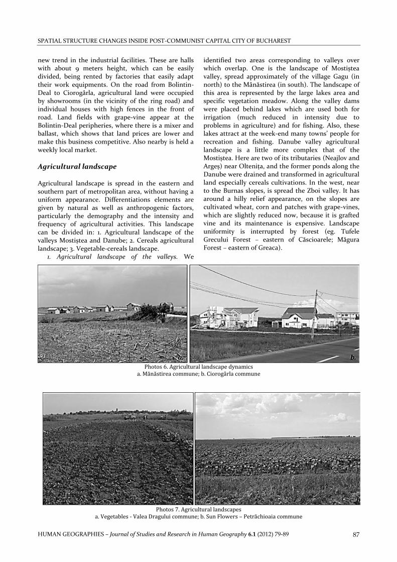
Agricultural landscape Agricultural landscape is spread in the eastern and southern part of metropolitan area, without having a uniform appearance. Differentiations elements are given by natural as well as anthropogenic factors, particularly the demography and the intensity and frequency of agricultural activities. This landscape can be divided in: 1. Agricultural landscape of the valleys Mostiștea and Danube; 2. Cereals agricultural landscape; 3. Vegetable-cereals landscape.
1. Agricultural landscape of the valleys. We
identified two areas corresponding to valleys over which overlap. One is the landscape of Mostiștea valley, spread approximately of the village Gagu (in north) to the Mânăstirea (in south). The landscape of this area is represented by the large lakes area and specific vegetation meadow. Along the valley dams were placed behind lakes which are used both for irrigation (much reduced in intensity due to problems in agriculture) and for fishing. Also, these lakes attract at the week-end many towns’ people for recreation and fishing. Danube valley agricultural landscape is a little more complex that of the Mostiștea. Here are two of its tributaries (Neajlov and Argeș) near Oltenița, and the former ponds along the Danube were drained and transformed in agricultural land especially cereals cultivations. In the west, near to the Burnas slopes, is spread the Zboi valley. It has around a hilly relief appearance, on the slopes are cultivated wheat, corn and patches with grape-vines, which are slightly reduced now, because it is grafted vine and its maintenance is expensive. Landscape uniformity is interrupted by forest (eg. Tufele Grecului Forest – eastern of Căscioarele; Măgura Forest – eastern of Greaca).
Photos 6. Agricultural landscape dynamics
a. Mănăstirea commune; b. Ciorogârla commune
Photos 7. Agricultural landscapes a. Vegetables - Valea Dragului commune; b. Sun Flowers – Petrăchioaia commune
GABRIEL SIMION, CONSTANTIN NISTOR
HUMAN GEOGRAPHIES – Journal of Studies and Research in Human Geography 6.1 (2012) 79-89 88
2. Grain agricultural landscape. This landscape is identified outside the urban shadow of Bucharest, in the eastern and southern part of metropolitan area, being a typically landscape of the Romanian Plain. It is characterised by large arable fields, whose uniformity is interrupted in places only by a few grape-vines or woods.
Parts of this landscape were covered in the past by forest (Vlăsia Forest), which were cleared and included into agricultural use as arable land. Human settlements are distributed along the rivers banks. Moreover, there is a large area between Mostiștea and Argeș rivers were settlements missing. It is a natural phenomenon, determined by the summer drought affecting the area, which leads to prolonged lack of water for potential residents.
The area is little affected by Bucharest’s suburbanization. The area few houses that were built by people from other country regions and the phenomenon of land speculations, buying agricultural land, anticipated Bucharest’s expansion, is reduced. We were surprised to found in Mostiștea Plain, near Mânăstirea, a few houses built in the middle of a field (Photos 6). This landscape can be put in contrast with other from west part of metropolitan area, in Ciorogârla, where agricultural land is occupied by large villas and houses.
3. Vegetable-cereals landscape. This landscape is spread along the Argeș-Sabar wetland, in the
settlements with a long tradition in vegetable growing. Field research in the Boltin-Vale – Ciorogârla area revealed decreasing of this activity, but the causes are different from one place to another (Photos 7). In Bolintin-Vale, after its declaration as the city, during the communist time, state makes massive investments that transformed the village into agro-industrial city. Many people have changed their jobs from agriculture to industry.
After 1989, workers, especially men specialized in construction, chose to go elsewhere in the country or abroad to work in this economic branch. Today, there are greenhouses in the village used for growing tomatoes, peppers or eggplant. Labour is predominantly female, younger 16-17 years old or retirees that work in the holyday respectively seasonally.
Diminishing of vegetable growing in the Ciorogârla – Dragomirești Vale area has other causes. These settlements are located near to the highway to Pitești, where are built-up industrial halls and warehouses, villas, or showrooms, that occupied agricultural land. Landowners does not taking agriculture at the same intensity as in the past and are awaiting the favourable moment to sell the land at the best price for them. This landscape is fragmented by the man-made lake area from Mihăilești. The construction of this lake was motivated by require to link the Bucharest to
Figure 4. Agro-forestry landscape
SPATIAL STRUCTURE CHANGES INSIDE POST-COMMUNIST CAPITAL CITY OF BUCHAREST
HUMAN GEOGRAPHIES – Journal of Studies and Research in Human Geography 6.1 (2012) 79-89 89
Danube, and by its location changed the entire landscape. Downstream of the dam, the floodplain vegetation is represented by grazing land, were appear in summer herds of cows or flocks of sheep. On the slopes are cultivated indigenous vineyards.
Vegetable-cereals landscape southern of Mihăilești is different from those described above. Here we noticed the decline of vegetables cultivated in the open fields and increasing greenhouses and solariums or growing in yards located near the villages, also, easily observed in the satellite images. The reduction of vegetable’s cultivation in the open field system has two major causes. First, is related to the agrarian reforms, which led to the return of land to the former owners and the degradation of irrigation systems. Second, is associated with the liberalization of imports in Romania.
During the summer are brought cheap vegetables from import and Romanian farmers cannot survive in this price competition. In these circumstances, become properly the cultivation of vegetables in greenhouses to ensure early production at competitive prices for producers, especially when they sell directly to the market. Landscape described above we have called vegetables-cereals landscape. He appears as vegetables cultivation among the houses, the greenhouses and solariums and cereals crops far from the houses.
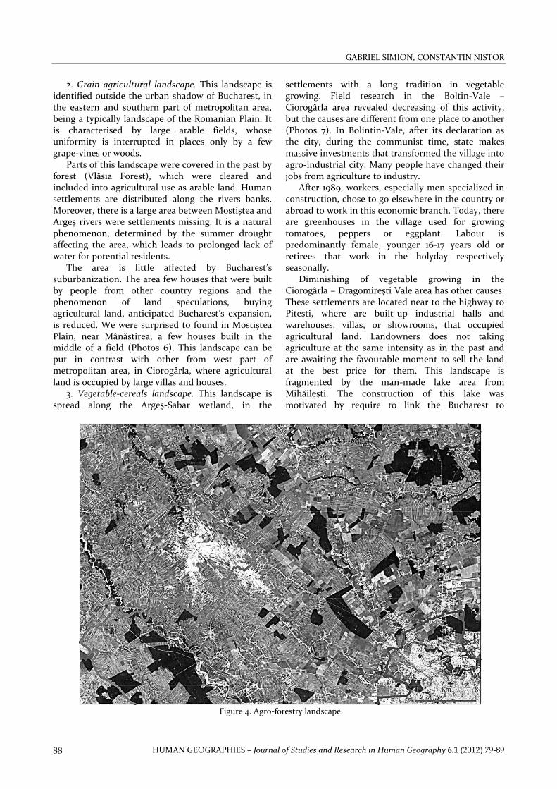
Agro-forestry landscape This landscape is extended as a strip at the outside of Bucharest’s urban shadow, mainly overlapping Vânătorii Mici, Găiseni, Stoeneşti, Ulmi, Brezoaele, Ciocăneşti, Butimanu and Niculeşti communes. The landscape is dominated by the forest areas alternating with arable land. Forestry is large spread at the landscape borders and in the central parts (Figure 4).
Final considerations The conducted research demonstrates that Bucharest city passes through it second lap of urban life, known in the literature as suburbanization. Unfortunately, this suburbanization is in many cases uncontrolled and is not related with a strategy of the entire metropolitan area. In this region are many investments, which determined the transformations of agricultural land in commercial spaces, residential or industrial uses. The main spatial problem identified is the development contrasts between northern and southern area. In the southern part, overlapping the rural settlements of Călăraşi County is a rural landscape with a low level of investments and a high level of population aeging. It was revealed a new residential area, a continuation of the present Bucharest built up area, which is located in the eastern and north-eastern part to Snagov.
References Bryant, CR, Russwurm LH & McLellan AG 1982, The City's
Countryside: Land and its Management in the Rural—Urban Fringe, Longman, London.
Colliers International 2004, 2006, 2007, Analiza pieţei imobiliare, Bucureşti.
Keys, E, Wentz, EA & Redman, CL 2007, 'The spatial structure of land use from 1970-2000 in the Phoenix, Arizona, metropolitan area', The Professional Geographer, 5.1: 131-147.
Knox, P & Pinch, S 2006, Urban social geography. An introduction, p.32.
Mihăilescu, V 2003, Evoluţia geografică a unui oraş Bucureşti, Editura Paidaea, Bucureşti.
Simion, G 2010, Zona metropolitană Bucureşti. Geografia agriculturii prin utilizarea tehnicilor GIS, Editura Universităţii din Bucureşti, Bucureşti.
van den Brouke, B 1986, 'Le système urbain / péri-urbain / rural montréalais', Cahiers nantais.