spectral and spatial processing of aster and … · visual information solutions aster mapping...
TRANSCRIPT

The information contained in this document pertains to software products and services that are subject to the controls of the Export Administration Regulations (EAR). The recipient is responsible for ensuring compliance to all applicable U.S. Export Control laws and regulations.
Joe Zamudio, Ph.D.ITT Visual Information [email protected]
Spectral and Spatial Processing of ASTER and WorldView-2 data
The information contained in this document pertains to software products and services that are subject to the controls of the Export Administration Regulations (EAR). The recipient is responsible for ensuring compliance to all applicable U.S. Export Control laws and regulations.
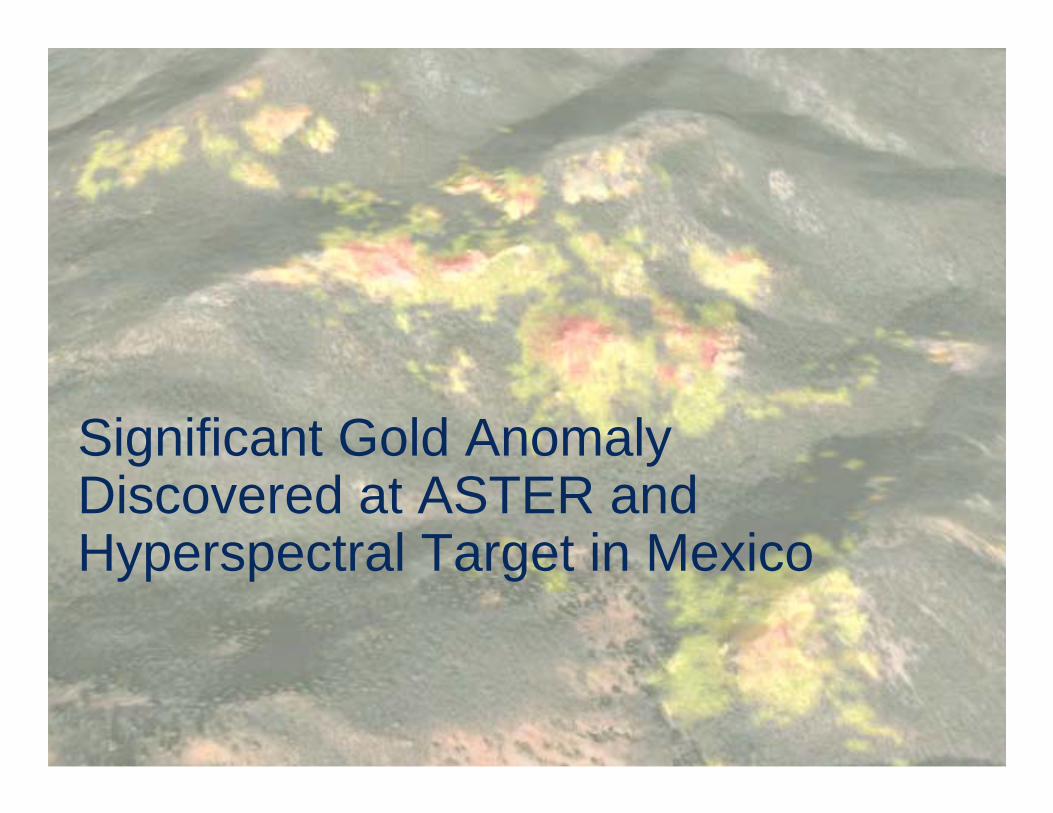
Significant Gold Anomaly Discovered at ASTER and Hyperspectral Target in Mexico

Visual Information Solutions
Kaolinite at Varying Spectral Resolutions
9 Bands ASTER
6 Bands TM
420 bands Lab Spectrum
More channels =more information
Visual Information Solutions
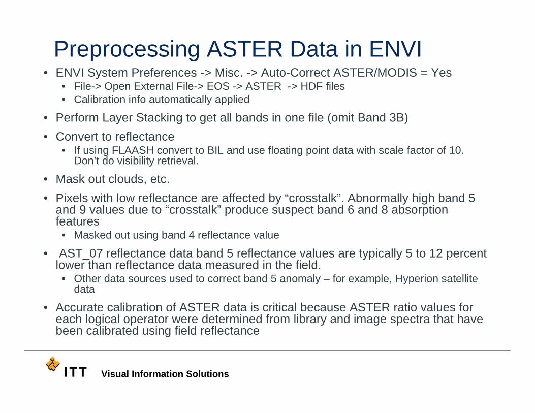
Preprocessing ASTER Data in ENVI• ENVI System Preferences -> Misc. -> Auto-Correct ASTER/MODIS = Yes
• File-> Open External File-> EOS -> ASTER -> HDF files• Calibration info automatically applied
• Perform Layer Stacking to get all bands in one file (omit Band 3B)• Convert to reflectance
• If using FLAASH convert to BIL and use floating point data with scale factor of 10. Don’t do visibility retrieval.
• Mask out clouds, etc. • Pixels with low reflectance are affected by “crosstalk”. Abnormally high band 5
and 9 values due to “crosstalk” produce suspect band 6 and 8 absorption features
• Masked out using band 4 reflectance value
• AST_07 reflectance data band 5 reflectance values are typically 5 to 12 percent lower than reflectance data measured in the field.
• Other data sources used to correct band 5 anomaly – for example, Hyperion satellite data
• Accurate calibration of ASTER data is critical because ASTER ratio values for each logical operator were determined from library and image spectra that have been calibrated using field reflectance

Visual Information Solutions
ENVI Band Math Expressions• References
• Lithologic mapping in the Mountain Pass, California area using Advanced Spaceborne Thermal Emission and Reflection Radiometer (ASTER) data -John C. Mars and Lawrence C. Rowan, 2003, Remote Sensing of Environment, v. 84, no. 3, p. 350-366.
• Regional mapping of phyllic- and argillic-altered rocks in the Zagros magmatic arc, Iran, using Advanced Spaceborne Thermal Emission and Reflection Radiometer (ASTER) data and logical operator algorithms -John C. Mars and Lawrence C. Rowan; 2006, Geosphere, v. 2, no. 3, p. 161-186.
• Mapping phyllic- and argillic-altered rocks in southeastern Afghanistan using Advanced Spaceborne Thermal Emission and Reflection Radiometer (ASTER) data - John C. Mars and Lawrence C. Rowan; 2007, USGS Open file report 2007-1006, USGS Afghanistan Project Product No. 110

Visual Information Solutions
ASTER Mapping Using ENVI’s Band Math
• Create logical expressions using Band Math - after Mars and Rowan
• Focus on a series of SWIR ratios that “map” out spectral features
• Specify ratio ranges that suggest argillic and phyllicalteration – mineral groups• Advanced Argillic alteration - alunite +/- pyrophyllite• Intermediate Argillic alteration - kaolinite group (this work)• Phyllic alteration - Al-OH bearing minerals (smectite clays,
muscovite, illite)

Visual Information Solutions
Laboratory Spectra Resampled to ASTER Bandpasses
Mars J C , Rowan L C Geosphere 2006;2:161-186
• The expression that maps phyllic-altered rocks using band ratios 4/6, 5/6, and 7/6, which define the 2.20 µm absorption feature.
• The expression that maps argillic-altered rocks using band ratios 4/5, 5/6, and 7/6, which define the 2.17 µm absorption feature.

Visual Information Solutions
ENVI Band Math Expressions – Mars and RowanMap Phyllic Alteration – muscovite, illite, smectite
Explanationfloat – convert to floating pointle – less than or equal togt – greater thange – greater than or equal to
Visual Information Solutions
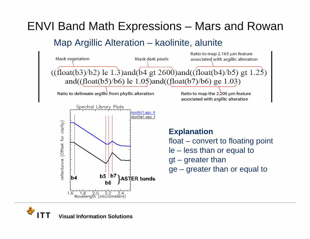
ENVI Band Math Expressions – Mars and RowanMap Argillic Alteration – kaolinite, alunite
Explanationfloat – convert to floating pointle – less than or equal togt – greater thange – greater than or equal to

Visual Information Solutions
ENVI Band Math – Mexico - Phyllic Alteration
((float(b4)/b6) gt 1.38) and ((float(b5)/b6) gt 1.05) and ((float(b7)/b6) ge 1.03)
ASTER channel

Visual Information Solutions
ENVI Band Math – Mexico - Alunite Alteration((float(b4)/b5) gt 1.38) and ((float(b5)/b6) lt 0.99) and ((float(b7)/b6) ge 1.03)
ASTER channel

Visual Information Solutions
ENVI Band Math – Mexico - Kaolinite Alteration((float(b4)/b5) gt 1.38) and ((float(b5)/b6) le 1.05) and ((float(b5)/b6) ge 0.99) and ((float(b7)/b6) ge 1.03)
ASTER channel

Visual Information Solutions
Comparison of ASTER and HyMap Results
kaolinite-dickite
alunite
advanced argillic (alunite) argillic (kaolinite)phyllic

Visual Information Solutions
WorldView-2 Vegetation Mapping in Japan

Visual Information Solutions
WorldView-2 Bandpasses and Atmospheric Gas Absorptions
O2 H20

Visual Information Solutions
WV-2 True Color NIR2,Red Edge,Coastal Blue

Visual Information Solutions
WV-2 CIR NIR2,Red Edge,Coastal Blue

Visual Information Solutions
WorldView-2 Conversion to Reflectance
• ENVI - WorldView-2 Radiance tool• Factors from .IMD file
• Radiance data includes• solar irradiance curve• atmospheric gas absorptions• atmospheric scattering (path radiance)
• FLAASH - convert to reflectance
Range of Atmospheric Scattering
Wavelength (µm)0.4 0.5 0.6 0.7 0.8 0.9 1.0
1
2
3
4
5
6
7
8
9
10
Rel
ativ
e Sc
atte
r
Range of Atmospheric Scattering
Wavelength (µm)0.4 0.5 0.6 0.7 0.8 0.9 1.0
1
2
3
4
5
6
7
8
9
10
Rel
ativ
e Sc
atte
r

Visual Information Solutions
FLAASH

Visual Information Solutions
ENVI Processing - NDVI

Visual Information Solutions
ENVI Processing – MNF Transform(non-veg masked out)
CIR MNF bands 1,2,3 as RGB

Visual Information Solutions
WorldView-2 – Vegetation Reflectance Spectra
trees trees
purple
Mean spectra from training sites based on MNF data
Visible VNIR

Visual Information Solutions
Matching Spectra using Spectral Angle MapperMNF SAM Classification
Variability in trees

Visual Information Solutions
ENVI Processing – Feature Extraction forSpatial and Spectral Mapping of Trees
Segmentation step

Visual Information Solutions
Feature Extraction – Rule-based Classification• Spatial attributes
• Segment area, length, compactness, convexity, solidity, form factor, rectangular fit, roundness, elongation, main axis direction, axes length, number of holes, hole solid ratio.
• Spectral attributes• Band minimum,
maximum, average and standard deviation
• Texture attributes• Variance, range, mean,
and entropy• Color space and band ratio
• Hue, saturation, intensity, NDVI, or other ratios
Specify thresholdsFor attributes

Visual Information Solutions
Feature Extraction - Supervised Classification
• Two classes specified• Trees• Fields
Fx automatically selectsBest attributes
Visual Information Solutions
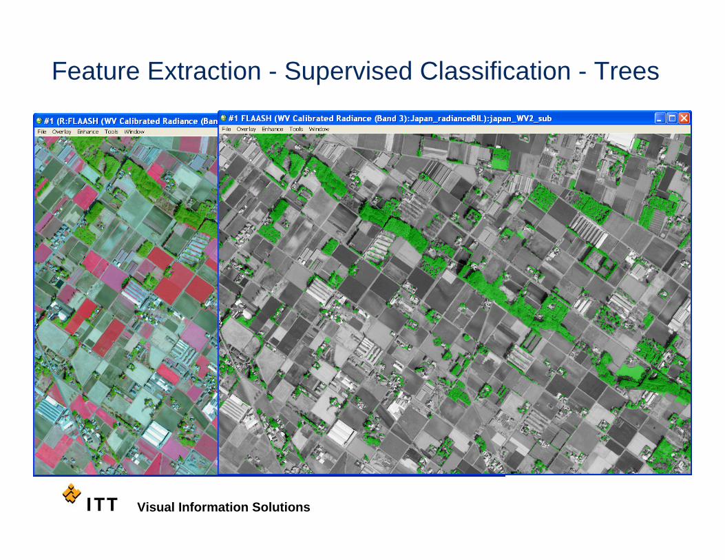
Feature Extraction - Supervised Classification - Trees

Visual Information Solutions
Questions?Questions?