spot4 (take 5) time series over 45 sites to get ready for sentinel-2
TRANSCRIPT
SPOT4 (Take 5) time series over 45 sites toget ready for Sentinel-2
O.Hagolle, M.Huc, M.Kadiri, J. Inglada, C. Marais-Sicre, G.Dedieu CESBIO ;S.Sylvander, M.Leroy, A.Meygret, V.Lonjou, J Donadieu CNES ; D.Clesse, CAP
GEMINI ; M.Claverie, NASA, U.Maryland ;
May 22th, 2014
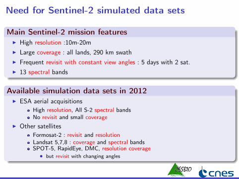
Need for Sentinel-2 simulated data sets
Main Sentinel-2 mission featuresI High resolution :10m-20mI Large coverage : all lands, 290 km swathI Frequent revisit with constant view angles : 5 days with 2 sat.I 13 spectral bands
Available simulation data sets in 2012I ESA aerial acquisitions
High resolution, All S-2 spectral bandsNo revisit and small coverage
I Other satellitesFormosat-2 : revisit and resolutionLandsat 5,7,8 : coverage and spectral bandsSPOT-5, RapidEye, DMC, resolution coverage
• but revisit with changing angles
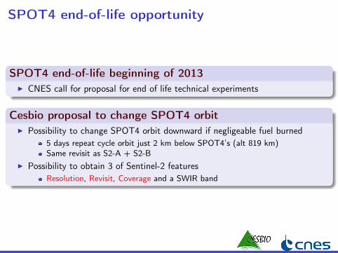
SPOT4 end-of-life opportunity
SPOT4 end-of-life beginning of 2013I CNES call for proposal for end of life technical experiments
Cesbio proposal to change SPOT4 orbitI Possibility to change SPOT4 orbit downward if negligeable fuel burned
5 days repeat cycle orbit just 2 km below SPOT4’s (alt 819 km)Same revisit as S2-A + S2-B
I Possibility to obtain 3 of Sentinel-2 featuresResolution, Revisit, Coverage and a SWIR band
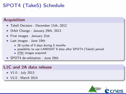
SPOT4 (Take5) Schedule
AcquisitionI Take5 Decision : December 11th, 2012I Orbit Change : January 29th, 2013I First images : January 31stI Last images : June 19th
28 cycles of 5 days during 5 monthspossibility to use LANDSAT 8 data after SPOT4 (Take5) period2781 images acquired
I SPOT4 de-orbitation : June 29th
L1C and 2A data releaseI V1.0 : July 2013I V2.0 : March 2014
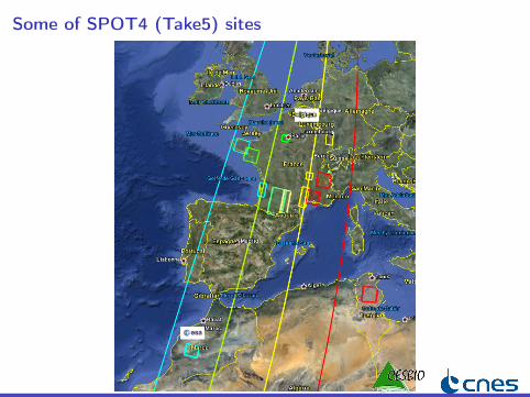
Some of SPOT4 (Take5) sites
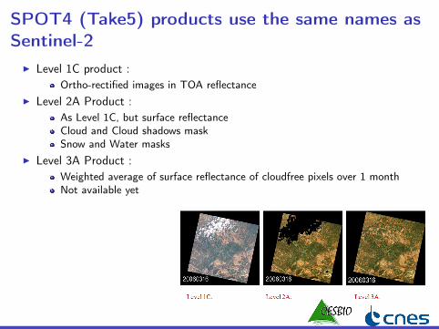
SPOT4 (Take5) products use the same names asSentinel-2
I Level 1C product :Ortho-rectified images in TOA reflectance
I Level 2A Product :As Level 1C, but surface reflectanceCloud and Cloud shadows maskSnow and Water masks
I Level 3A Product :Weighted average of surface reflectance of cloudfree pixels over 1 monthNot available yet

Data AccessData Production
I L1C and L2A Images produced at the French Land Data Center THEIA(created end of 2012)
I SPOT4 (Take5) was the first production at THEIAI Production with a prototype ground segment and a prototype processor
developped at CESBIOI CNES develops the operational version named MACCS
Data downloadI from THEIA web site : http ://www.theia-land.fr/en
Data policyI Free data download submitted to acceptation of a license ("I accept" button)
Please read it once !Data cannot be soldPublication, poster, public presentations should be sent to CNES=> [email protected], [email protected]
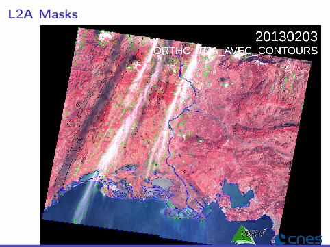
L2A Masks
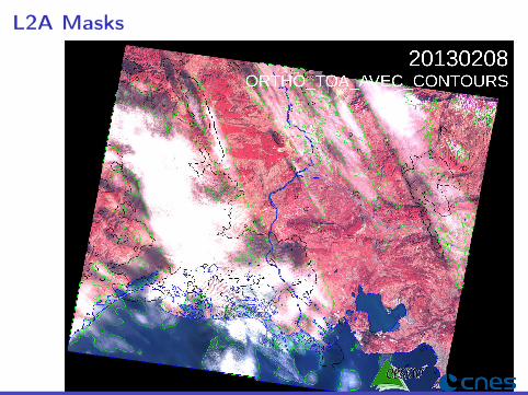
L2A Masks

L2A Masks

L2A Masks

L2A Masks

Cloud Free Observations
Morocco Tensift

Cloud Free Observations
France Midi-Pyrénées

Cloud Free Observations
Belgium

Cloud Free Observations
Congo (1)
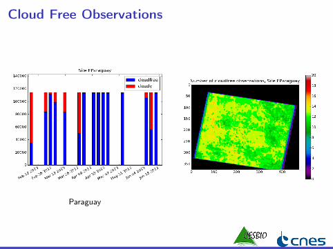
Cloud Free Observations
Paraguay

Atmospheric correction
Atmospheric correctionI takes into account :
AbsorptionScattering by molecules and aerosolsAerosol parameters are estimatedAdjacency effectsIllumination effects due to topography
Aerosol estimation method (MACCS)I No blue band in SPOT satellitesI Use of a multi-temporal method to estimate aerosol content
two successive L2A images should be similar (at 200 m resolution)I Aerosol model is constant per site
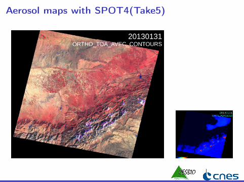
Aerosol maps with SPOT4(Take5)

Aerosol maps with SPOT4(Take5)

Atmospheric correctionAerosol Validation
I Aerosol validation sites with a cimel nearbyEurope : Arcachon, Carpentras,Seysses,Le Fauga,Palaiseau,Paris,KyivAfrica : Saada, Ouarzazate (Morocco), Ben salem(Tunisia)USA : Wallops, Cart SiteAsia : Gwangjiu, Korea
I same aerosol model for all sites (could be enhanced !)
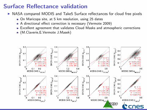
Surface Reflectance validationI NASA compared MODIS and Take5 Surface reflectances for cloud free pixels
On Maricopa site, at 5 km resolution, using 25 datesA directional effect correction is necessary (Vermote 2009)Excellent agreement that validates Cloud Masks and atmospheric corrections(M.Claverie,E.Vermote J.Masek)

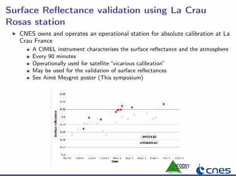
Surface Reflectance validation using La CrauRosas station
I CNES owns and operates an operational station for absolute calibration at LaCrau France
A CIMEL instrument characterises the surface reflectance and the atmosphereEvery 90 minutesOperationally used for satellite “vicarious calibration”May be used for the validation of surface reflectancesSee Aimé Meygret poster (This symposium)
Lessons learned concerning clouds
Cloud Free ObservationsI Very nice time series over a lot of sites :
Morocco, Provence, Paraguay, Angola, Maricopa, Congo...I Not far from 1 clear observation/month for most sites
Despite bad weather in Europe• Except in Belgium, Alsace, Aquitaine, or even Tunisia
And with exceptions in Equatorial regionsI Big sites always have clouds
Necessity to develop methods which are robust to data gapsComposite products should be useful (Level 3A)
MessageI With 10 days repetitivity, SPOT4(Take5) would have failed in Western
EuropeI Necessity to launch S2-B shortly after S2-AI Next generation should consider increased repetitivity
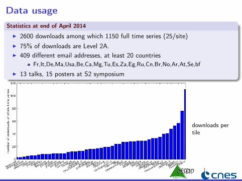
Data usageStatistics at end of April 2014
I 2600 downloads among which 1150 full time series (25/site)I 75% of downloads are Level 2A.I 409 different email addresses, at least 20 countries
Fr,It,De,Ma,Usa,Be,Ca,Mg,Tu,Es,Za,Eg,Ru,Cn,Br,No,Ar,At,Se,bfI 13 talks, 15 posters at S2 symposium
downloads pertile

Use of time series for land cover
IdeaI Vegetation types may be separated thanks to time series
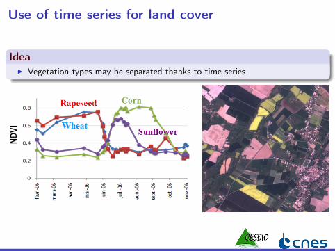
Use of time series for land cover
IdeaI Vegetation types may be separated thanks to time series
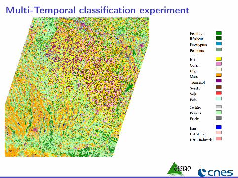
Multi-temporal classification experiment
ExperimentI Within Sentinel-2 Agri framework (UCL, CESBIO, CS (France, Romania))
13 SPOT4 (Take5) sites processed the first phase3 full countries with Sentinel-2 in 2016
I DatasetsFirst test with our site near ToulouseS4-Take5 : 9 dates, 4 bandes, 12500×9500 pixels => 7.7 GOLANDSAT 8 : 8 dates, 4 bandes, 12500×9500 pixels => 6.8 GOIn situ land cover campaigns (still waiting for France 2013 Land ParcelIdentification System)
I MethodBaseline method : Supervised classification with Random Forest from OTBVarious other strategies will be benchmarked
Multi-Temporal classification experiment
Multi-Temporal classification experiment
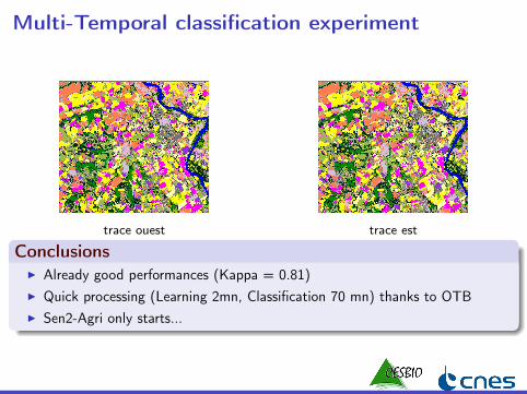
trace ouest trace est
ConclusionsI Already good performances (Kappa = 0.81)I Quick processing (Learning 2mn, Classification 70 mn) thanks to OTBI Sen2-Agri only starts...
A large variety of applications
I Pre-processing (Atmospheric correction, composites, validation, clouddetection)
NASA, CESBIO, CNES, Univ Valencia, CNRI Agriculture
Land Cover (S2-Agri, SANSA)Biophysical Variables, Biomass, Yield (INRA, CIRAD, SANSA, Univ ChouaibDoukkaly)Agro Hydrological modelling (CESBIO)Irrigation driven by satellite (CESBIO)Phenology combining Take5 with LANDSAT 8 (S2-Agri)Growth Anomalies (VITO)
I Forests : JRC, SIRS, CIRAD, SERTITI Turbidity and Bathymetry ( Geo transfert, J. Optics, Brockmann Consult)I Lake surface monitoring SERTITI Snow Melt modelling ( METEO France, CESBIO)

Conclusions 1/2
A succesful experimentI Everything worked well in a short time frame : satellite, processorsI Good quality Level 1C and 2A (with some issues to address on some cases)
aerosol detection works without a blue band thanks to multi-temporal methodsclouds and shadows are quite well detectedproof of operationality for Sentinel-2
I Great feedback from users (Thanks !)Users massively prefer Level 2A to Level 1C
I Usefull links :> News : http ://www.cesbio.ups-tlse.fr/multitemp/> Download : http ://spirit.cnes.fr/take5> THEIA web site : http ://www.theia-land.fr/
After SPOT4-(Take5)
SPOT5-(Take5)I A call for proposals for scientific experiments by a French comittee
A new proposal is being prepared (deadline end of may)If ever selected, experiment period would be April-July 2015Please send me sites/applications ideas (coordinates + 5 lines)Even if selected, CNES funding is unlikely... as for SPOT4
Future THEIA production with MACCS processorI LANDSAT L2A production above France at THEIA (cut in tiles as for
Sentinel 2)reduced repetitivity compared to Sentinel-2 and Spot 4compensated by more spectral bands and much larger coverageLANDSAT 8 already available for year 2013, and soonProduction of 2009-2011 with LANDSAT 5 and 7 before end of Junehttp ://spirit.cnes.fr/resto/
I and... starting in 2015 or 2016 : Sentinel-2 and Venµs

I Thank you
2013/03/10 2013/03/30 2013/04/09
2013/04/14 2013/04/19 2013/05/09
I from SPOT4(Take5) Paraguay site