state of vermontaccd.vermont.gov/sites/accdnew/files/documents/hp/black barn arts... · state of...
TRANSCRIPT

STATE OF VERMONT Division for Historic Preservation Montpelier, VT 05602 HISTORIC SITES & STRUCTURES SURVEY District Complex Survey Form
SURVEY NUMBER:
NEGATIVE/DIGITAL FILE REFERENCE:
UTM REFERENCES: Zone/Easting/Northing A B C D
USGS QUAD MAP:
COMPLEX INFORMATON ONLY COUNTY: Windham COMMON NAME: Jacobs/Thomas Place
TOWN: Guilford
LOCATION: 1250 Weatherhead Hollow
PRESENT FORMAL NAME: Black Barns Arts Center
ORIGINAL FORMAL NAME:
NAME OF DISTRICT: TYPE OF COMPLEX: Agricultural
TYPE OF DISTRICT:
TYPES OF STRUCTURES: Main House, Barn, Blacksmith Shop
PHYSICAL CONDITION OF STRUCTURES: Excellent % Good % Fair % Poor %
PRESENT USE: Residential/Commercial
ORIGINAL USE: Agricultural
LEVEL OF SIGNIFICANCE: Local State National
ARCHITECT/ENGINEER: unknown
HISTORIC CONTEXTS: Agriculture, Architecture BUILDER/CONTRACTOR: unknown
ACCESSIBILITY TO PUBLIC: Yes No Restricted
STATEMENT OF SIGNIFICANCE: This farm complex occupies part of what was originally a 50-acre lot (No. 64) and was occupied by Amasa Smead in 1786. Subsequent owners included Benjamin Jacobs (1808), Abner Chapin (1811), Rufus Jacobs (1815), Joseph Jacobs (1830), Henry Thomas, S. Alice Thomas (1929) and Joseph & Ada Borkowski (1936). The current owners purchased the property in 2012 from Vernon Winn. The Jacobs/Thomas Place is an excellent example of a rural farm complex containing a late-18th century main house and related 19th century agricultural outbuildings, including a large barn and blacksmith shop. The acreage directly associated with the farm has decreased to approximately 3 acres, but the surrounding area remains largely undeveloped with open fields and forested hillsides.

MAP
BOUNDARY DESCRIPTION: The boundary of the Black Barn Arts Complex is contiguous with the boundaries of parcel #666 as identified in the Town of Guilford land records. This parcel consists of approximately 2.57 acres of land on the northwest side of Weatherhead Hollow Road (containing buildings #1, 1A, 1B, 1C and 1D) and approximately .48 acres of land on the southeast side of Weatherhead Hollow Road (containing building 1E).
REFERENCES: Broad Brook Grange No. 151, ed. Official History of Guilford, Vermont, 1678-1961. Brattleboro, VT: The Vermont Printing Company, 1961.
RECORDED BY: Devin Colman
ORGANIZATION: VT Division for Historic Preservation
DATE RECORDED: 2/16/2016

OUTSTANDING COMPONENTS OF: DISTRICT COMPLEX (include individual survey numbers only if surveyed individually)
MAP NUMBER: 1 DATE BUILT: c. 1792 SURVEY NUMBER:
FUNCTIONAL TYPE: Main House NEGATIVE/DIGITAL REFERENCE:
COMMON NAME: OWNER: Patricia Guttenberg
HISTORIC CONTEXTS: Agriculture, Architecture
DESCRIPTION: The Main House is the focal point of this farm complex, and presents its gable end to Weatherhead Hollow Road. The 1.5 story, Federal style house has wood clapboard walls and a slate roof, with the ridge-line oriented east-west. A brick chimney is centered on the ridge-line and the primary entrance is located on the south elevation. Five regularly spaced 4-over-8 windows are tucked under the eaves, which features a molded cornice with dentils. The central entry is flanked by two 12-over-12 windows on each side, and features an unpedimented, entablature supported by decorative pilasters. The entry door is flanked by 2/3 length sidelights, which may be a later alteration. Corners are trimmed with plain boards. On the east gable end, facing the road, is another entry door centered on the first level, similar in design to the main entry. It is flanked by 12-over-12 windows, with two 12-over-12 windows in the gable peak. Gable eaves feature dentils and a narrow frieze board and modest cornice returns. The north elevation has three bays of regularly-spaced windows, with 4-over-8 windows under the eaves and 12-over-12 windows on the first floor. A single 6-over-6 window interrupts the symmetry on the first floor towards the rear of the north elevation. A one-story 1971 addition with a slate gable roof and wood clapboards projects from the west elevation. A brick chimney rises from the end of the ridge-line, and the cornice features dentils similar to the main house. A large, multi-light window is located on the north elevation of the addition.
MAP NUMBER: 1A DATE BUILT: c. 1832 SURVEY NUMBER:
FUNCTIONAL TYPE: Carriage Shed/Garage NEGATIVE/DIGITAL REFERENCE:
COMMON NAME: OWNER: Patricia Guttenberg
HISTORIC CONTEXTS: Agriculture, Architecture
DESCRIPTION: The Carriage Shed/Garage is located immediately south of, and perpendicular to, the Main House. The long, narrow, eaves-front building has two primary entrances for carriages, with semi-elliptical openings trimmed in narrow boards with a small keystone. Between the two openings are two large, side0hinged barn doors made of vertical planks with strap hinges. The Carriage Shed is clad with board and batten siding and has a slate roof.
MAP NUMBER: 1B DATE BUILT: c. 1835 SURVEY NUMBER:
FUNCTIONAL TYPE: Barn NEGATIVE/DIGITAL REFERENCE:
COMMON NAME: Main Barn OWNER: Patricia Guttenberg
HISTORIC CONTEXTS: Agriculture, Architecture
DESCRIPTION: Located north of the Main House, this is an excellent example of a gable-front bank barn, popularized in the 1830s (there is indication the barn was built in 1835). The ridge-line runs north-south and the roof is slate. Centered on the ridge-line is a cupola with paired, louvered vents on each side set under semi-circular hoods with decorative acorn drops. The cupola was probably added in the 1870s or 1880s based on its design. It has a pyramidal roof clad in slate. A multi-light ocular window in the gable peak lights the interior, along with four regularly spaced windows on the north elevation. The barn sits very close to the road and is accessed via two large, sliding doors made of vertical boards. At each corner of the front elevation is a man-door with a peaked lintel. The barn has vertical board siding and sits on a high concrete foundation. Rows of 4-light windows illuminate the lower level of the barn on the south elevation. The front portion of the south elevation has a lean-to addition with widely-spaced horizontal board siding. The slate roof tucks under the eaves of the Barn roof and projects beyond the wall of the lean-to, requiring support by diagonal bracing. This may have been used as a corn crib, the gaps between the boards providing ventilation and the overhanging eaves keeping out the rain.

MAP NUMBER: 1C DATE BUILT: SURVEY NUMBER:
FUNCTIONAL TYPE: Barn Annex NEGATIVE/DIGITAL REFERENCE:
COMMON NAME: OWNER: Patricia Guttenberg
HISTORIC CONTEXTS: Agriculture, Architecture
DESCRIPTION: The Barn Annex is a single-story, L-shaped structure extending from the back of the Barn and turning 90° to the south. The portion extending from the barn is fully enclosed and extends the ground-level stables in the Barn. The other portion is an open equipment shed, with four bays. The three southernmost bays have low openings with storage above, accessed by a square opening above each bay, while the opening of the fourth bay rises to the roof eaves. The southernmost bay contains a large wooden hoist to raise a carcass for butchering. The gable roof on the Barn Annex is clad with slate, and the walls are made of vertical board wood siding.
MAP NUMBER: 1D DATE BUILT: c. 1900 SURVEY NUMBER:
FUNCTIONAL TYPE: Silo NEGATIVE/DIGITAL REFERENCE:
COMMON NAME: OWNER: Patricia Guttenberg
HISTORIC CONTEXTS: Agriculture, Architecture
DESCRIPTION: At the rear gable end of the barn is a round, wooden stave silo held together with adjustable steel hoops. The silo is topper with a low, gable-roof structure with a ridge-line perpendicular to the barn. The roof is slate, with a hoist projecting from the north gable peak and a single opening with a peaked lintel board.
MAP NUMBER: 1E DATE BUILT: c. 1860 SURVEY NUMBER:
FUNCTIONAL TYPE: Blacksmith Shop NEGATIVE/DIGITAL REFERENCE:
COMMON NAME: OWNER: Patricia Guttenberg
HISTORIC CONTEXTS: Agriculture, Architecture
DESCRIPTION: Located on the east side of Weatherhead Hollow Road, opposite the rest of the buildings in the complex, is a small, 1 ½ story building that originally served as a blacksmith shop. The small upper story is accessed by a hatch in the ceiling, and has a knee wall approximately one-foot tall between the floor height and the top of the top plate upon which the rafters rest. The north slope of the roof has tin roofing, and the south slope has slate roofing. The gable end sits at the edge of the road, with a large central door opening flanked by 6-over-6 windows. A single 6-over-6 window is located in the gable peak. The building is clad with wood clapboard siding, with wood novelty siding in some areas. There are two, 6-over-6 windows on the south elevation, and a short brick chimney rises from the gable ridge-line at the rear of the building. Used as a blacksmith shop, the chimney served the forge in the building.

Photographs
Figure 1. Historic photograph showing the Carriage Barn/Garage (#1A) on the left and the Main
House (#1) on the right. View looking northwest.
Figure 2. 2012 photograph showing the Main House (#1) and Barn Annex (#1C) at the far right.
View looking northwest.

Figure 3. 2012 photograph showing the Main House (#1). View looking southwest.
Figure 4. 2012 photograph showing the Carriage Barn/Garage (#1A). View looking southwest.

Figure 5. 2013 photograph of the Main Barn (1B). View looking northwest.
Figure 6. 2013 photograph of the Main Barn (#1B). Top of silo (#1D) visible at the far right, and
Main House (#1) visible at the far left. View looking southwest.

Figure 7. 2012 photograph of the south elevation of the Main Barn (#1B), with the Silo (#1D) and
portion of the Barn Annex (#1C) at the far left. View looking northeast.
Figure 8. 2012 interior view of hay mow in Main Barn (#1B). View looking east.

Figure 9. 2012 interior view of the ground level stables in Main Barn (#1B). View looking west.
Figure 10. 2013 photograph of the Main Barn (#1B) cupola. View looking east.
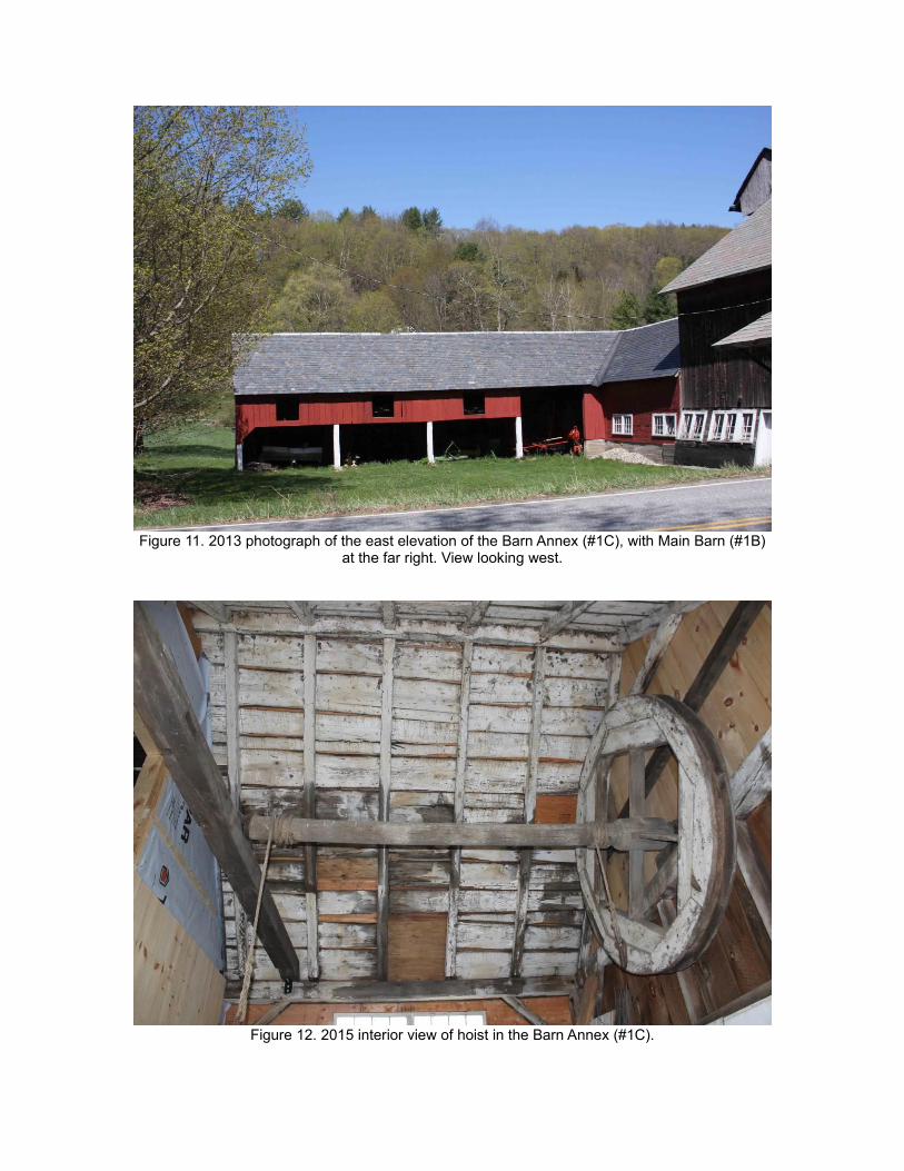
Figure 11. 2013 photograph of the east elevation of the Barn Annex (#1C), with Main Barn (#1B)
at the far right. View looking west.
Figure 12. 2015 interior view of hoist in the Barn Annex (#1C).

Figure 13. 2013 photograph of the Silo (#1D) at rear of the Main Barn (#1B).
Roof of Barn Annex (#1C) at right. View looking southwest.
Figure 14. Composite 2013 photograph showing the Main Barn (#1B) and Silo (#1D), the back of
the Barn Annex (#1C) and the Main House (#1) at the right. View looking south/southwest.

Figure 15. 2013 photograph of the Blacksmith Shop (#1E). View looking east.
Figure 16. 2013 photograph of the Blacksmith Shop (#1E) on right and Main Barn (#1B) on left.
View looking north.