state of new mexico energy, minerals and natural resources ...ocdimage.emnrd.state.nm.us › imaging...
TRANSCRIPT

State of New MexicoEnergy, Minerals and Natural Resources Department
Susana MartinezGovernor
David MartinCabinet Secretary
Brett F. Woods, Ph.D.Deputy Cabinet Secretary
David R. Catanach Division DirectorOil Conservation Division
New Mexico Oil Conservation Division approval and conditions listed below are made in accordance with OCD Rule 19.15.7.11 and are in addition
to the actions approved by BLM on the following 3160-3 APD form.
Operator Signature Date: 7/^ o //£T Well information;Operator Enc^nrx. Well Name and Number A an-2909 OJrt
API# 3o -09*i-A5705 Sections , Township ffflS, Range 09 E/ffi)
Conditions of Approval:(See the below checked and handwritten conditions)
Notify Aztec OCD 24hrs prior to casing & cement.
Hold C-104 for directional survey & “As Drilled” Plat ^ Hold C-104 f</3sL NSP, DHC
o Spacing rule vidtafion. Operator must follow up with change of status notification on other well to be shut in or abandoned
o Regarding the use of a pit, closed loop system or below grade tank, the operator must comply with the following as applicable:
• A pit requires a complete C-144 be submitted and approved prior to the construction or use of the pit, pursuant to 19.15.17.8.A
• A closed loop system requires notification prior to use, pursuant to 19.15.17.9.A
• A below grade tank requires a registration be filed prior to the construction or use of the below grade tank, pursuant to 19.15.17.8.C
o Once the well is spud, to prevent ground water contamination through whole or partial conduits from the surface, the operator shall drill without interruption through the fresh water zone or zones and shall immediately set in cement the water protection string
S
SRegarding Hydraulic Fracturing, review EPA Underground Injection Control Guidance 84
Oil base muds are not to be used until fresh water zones are cased and cemented providing isolation from the oil or diesel. This includes synthetic oils. Oil based mud, drilling fluids and solids must be contained in a steel closed loop system.
Well-bore communication is regulated under 19.15.29 NMAC. This requires well-bore Communication to be reported in accordance with 19.15.29.8.
NMOCD Approved by Signature
n-3@ -2o/s" Date ft
1220 South St. Francis Drive ■ Santa Fe, New Mexico 87505 Phone (505) 476-3460 • Fax (505) 476-3462 • www.emnrd.state.nm.us/ocd

A
Form 3160-3 (March 2012)
OIL CONS. DIV D1ST. 3
NOV 1 6 201b
F £CEIVED
Farmington Field OffiUNITED STATES
DEPARTMENT OF THE INTERIOR BUREAU OF LAND MANAGEMENT Bureau of Land Manage
APPLICATION FOR PERMIT TO DRILL OR REENTER
FORM APPROVED OMB No. 1004-0137
Expires October 31,2014
Lease Serial No.M 4958, BIA NO-G-0103-1462
6. If Indian, Allotee or Tribe Name Allotee
la. Type of work: [71 DRILL I I REENTER
lb. Type of Well: [/]Oil Well | | Gas Well | [Other | | Single Zone | | Multiple Zone
7 If Unit or CA Agreement, Name and No. Pending
8. Lease Name and Well No. Escrito D20-2409 02H
1 Name of Operator Encana Oil & Gas (USA) Inc. 9. API Well No.
3a. Address 370 17th street Sujte 1700
Denver, CO 80202
3b. Phone No. (include area code)
720-876-5919
*0-0*4$"' d SIPS’10. Field and Pool, or Exploratory
Bisti Lower-Gallup
4. Location of Well (Report location clearly and in accordance with any State requirements. *) At surfai? 1.210' FNL, 264' FWL, Section 20, T24N, R9W
At proposed prod, zone1' 1,980' FNL, 330’ FWL, Section 19, T24N, R9W
11. Sec., T. R. M. or Blk.and Survey or Area
Section 20, T24N, R9W NMPM
12. County dr Parish San Juan
14. Distance in miles and direction from nearest town or post office*+/- 34.2 miles South from the intersection of US HWY 64 & US HWY 550 in Bloomfield, NM
13. StateNM
15 ESJf^!T11SSp(>Sed* BHL is 330' FWL Section 19, location to nearestproperty or lease line, ft. T24N, R9W (Also to nearest drig. unit line, if any)
Cof acres In lease > INM 4958:1,721.01 acres
BIANO-G-0130-1462:160acres
17. Spacing Unit dedicated to this well'159.95 acres- S/2 N/2 of Sec. 19, T24N, R9W
18. Distance from proposed location* SHL is +/. 3(y North of
SSCS4!ttTl,M' °3H19. Proposed Depth
5,236' TVD; 10,271'MD
20. BLM/BIA Bond Na on file
COB-000235; Allottee Minerals: 105073453
21. Elevations (Show whether DF, KDB, RT, GL, etc.)
6,828' GL; 6,844’ KB
22 Approximate date work will start*
03/05/2016
23. Estimated duration
20 days
24. Attachments
The following, completed in accordance with the requirements of Onshore Oil and Gas Order No.l, must be attached to this form:
1. Well plat certified by a registered surveyor.2 A Drilling Plan.3. A Surface Use Plan (if the location is on National Forest System Lands, the
SUPO must be filed with the appropriate Forest Service Office).
4 Bond to cover the operations unless covered by an existing bond on file (see Item 20 above).
5. Operator certification6. Such other site specific information and/or plans as may be required by the
BLM.
‘ Wluu* V Name (PrintecUTyped)
Jillian McGrath
Title
Regulab
Title
4fm4b©
Name (Prinled/Typed) Date
Office
£Application approval does not warrant or certify that the applicant holds legal or equitable mle to those rights in the subject lease which would entitle the applicant to conduct operations thereon.Conditions of approval, if any, are attached.
: 18 U.S.C. Section 1001 and Title 43 U.S.C. Section 1212, make it a crime for any person knowingly and willfully to make to any department is any false, fictitious or fraudulent statements or representations as to any matler within its jurisdiction.
M'S APPROVALOR ACrhn A^nur
or agency of the United
!ontinued on page 2) BLM S Arn^vni, w.x —AXindrilling^operations act ion does not RELIEVE the lessee and
AUTHORIZED ARE SUBJECT TO OPFRATOR FROM OBTAINING ANY 0THE* COMPLIANCE WTHA^ACHED AUTHORiZaTION REQUIRED FOR OPERA 110NS
-GENERAL REQUIREMENTS ^ FEDERAL AND INDIAN LANDS
(Instructions on page 2)This action Is subject to technical and procedural review pursuant to 43 CFR 3165.3 and appeal pureuant u* 4g CFR 3168,4
NMOGD f\ir

DISTRICT I1620 N French Dr.. Hobba. Kit 88240
•: (676) 383-8181 far (676) 383-0720State of New Mexic
Energy, Minerals Sc Natural Resources
DISTRICT A811 S. flrat St. irtaala. Hit 88210 Phone: (676) 748-1283 Far (676) 748-8720
DISTRICT ID1000 Bio Efrazoa Rd. Aitac. Hit 87410 Phooa: (606) 334-8178 rat (606) 334-8170
DISTRICT 171220 3. St. Fronde Dr.. 8anU Fa. NX 87606 Phooa: (606) 478-3480 Fat (606) 478-3482
ent
. _I
Revised August 1, 2011RECEIVED *°rmC-102
Submit one copy to appropriate District OfficeOIL CONSERVATION DIVISION
1220 South St. Francis Dr.Santa Fe. NM 87505 Farmington Field Of0e AMENDED REPORT
Bureau of Land Management
WELL LOCATION AND ACREAGE DEDICATION PUT‘API Number 'Pool Code
5890
'Pool Name
BISTI LOWER-GALLUP
'Property Code 'Property Name •Well Number
^isGn°\ ESCRITO D20-2409 02H
’OGRID No. •Operator Name ' Elevation
282327 ENCANA OIL & GAS (USA) INC. 6827.5’
10 Surface LocationDL or lot no. Section Township Range Lot Idn Feet from the North/South line Feet from the East/West line County
D 20 24N 9W 1210’ NORTH 264* WEST SAN JUAN
11 Bottom Hole Location If Different From SurfaceUL or lot no.
ESection
19
Township
24N
Range
9W
Lot Idn
2
Feet from the
1980’North/South line
NORTHFeet from the
330’East/West line
WESTCounty
SAN JUAN“Dedicated Acre* PROJECT AREA
159.95 ACRES S/2 N/2 SEC. 19“Joint or Infill "Consolidation Code “Order No.
NO ALLOWABLE WILL BE ASSIGNED TO THIS COMPLETION UNTIL ALL INTERESTS HAVE BEEN CONSOLIDATED ie OR A NON-STANDARD UNIT HAS BEEN APPROVED BY THE DIVISION
BOTTOM HOLELAT. 36.301354- N (NAD83) LONG. 107.838092- W (NAD83) LAT. 36.301343- N (NAD27) LONG. 107.837475- W (NAD27)
ENTRY POINTLAT. 36.301360- N (NAD83) LONG. 107.822498- W (NAD83) LAT. 36.301348- N (NAD27) LONG. 107.821882' W (NAD27)
ALL CORNERS FND 2)5" BC
GLO 1933
nanLAT. 36.303474- N (NA083)LONG. 107.820488- W (NA083) LAT. 36.303462- N (NAD27)LONG. 107.819872- W (NAD27)
in w ® «n ix> io oo ^ ’<n ccn co__• ■
"sr
to v
r» oin o oo z
z
$o
N 89*59'51" W 5257.42' (M)N |89"40’ W p260.20' (R
U__L
___ [_HORIZONTAlJ i_DRILlj_ 1
. ' N r89'59'&1" W* .4596.69''. • • -
j r
S 89-35' W 5266.80' (R)
S 89-36'17" E 5255.65' (M)
S S9'59'2Q" E. , 52Z(L6£._CM)S 89-46' W 5273.39' (R
S |37"35’45" W 971.59'
—d — 20 — —
| C0A,St Div DI^T. 3
____ NQ V lT
S 89-42’ W1
258.21
NQKTlgAST CORNER SEC. .13LAT. 36.306791- N (NA083) LONG. 107.839226- W (NAD83) LAT. 36.306780- N (NAD27) LONG. 107.838609' W (NA027)
S0UH€AST CORNER SEC. 20LAT. 36.292273- N (NAD83) LONG. 107.839186- W (NA083) LAT. 36.292261' N (NA027) LONG. 107.838569- W (NAD27)
S 89'19'45" W 5249.26' (M)
NORTHWEST CORNER SEC. 19 LAT. 36.306797" N (NAD83) LONG. 107.821390- W (NAD83) LAT. 36.306785' N (NA027) LONG. 107.820774- W (NAD27)
SOUTHWEST CORNER SEC. 19LAT. 36.29218V N (NAD83) LONG. 107.821359- W (NA083) LAT. 36.29221T N (NAD27) LONG. 107.820743" W (NA027)
17 OPERATOR CERTIFICATIONI here fry certify that the information contained herein is trua and complete to the best of my knowledge and belief, and that this organization either owns a working interest or unloosed mineral interest In Hi* land including the proposed bottom hole location or has a right to drill this well at this location pursuant to a contract with an owner of such a mineral or working Merest, or to a voluntary pooling agreement or a compulsory pooling order heretofore entered by the
sture
Jillian McGrath
Date
Printed Name
[email protected] Address
SURVEYOR CERTIFICATIONI hereby certify that the well location shown on this plat was plotted from field notes of actual surveys made by me or under my supervision, and that the same is true and correct to the best of my belief.
AUGUST 27, 2014Date ol Surrey
Signature and Seal of Profeiaional Surveyor:
Sheet A
>
* ‘
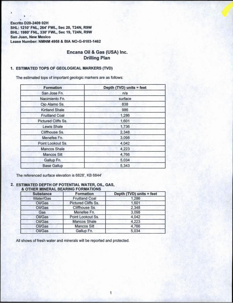
Encana Oil & Gas (USA) Inc. Drilling Plan
1. ESTIMATED TOPS OF GEOLOGICAL MARKERS (TVD)
The estimated tops of important geologic markers are as follows:
Escrito D20-2409 02HSHL: 1210’ FNL, 264' FWL, Sec 20, T24N, R9WBHL: 1980' FNL, 330’ FWL, Sec 19, T24N, R9WSan Juan, New MexicoLease Number: NMNM 4958 & BIA NO-G-0103-1462
Formation Depth (TVD) units = feet
San Jose Fn. n/a
Nacimiento Fn. surface
Ojo Alamo Ss. 838
Kirtland Shale 986Fruitland Coal 1,286
Pictured Cliffs Ss. 1,601
Lewis Shale 1,736Cliffhouse Ss. 2,348Menefee Fn. 3,098
Point Lookout Ss. 4,042
Mancos Shale 4,223
Mancos Silt 4,766
Gallup Fn. 5,034Base Gallup 5,343
The referenced surface elevation is 6828', KB 6844’
2. ESTIMATED DEPTH OF POTENTIAL WATER, OIL, GAS, & OTHER MINERAL BEARING FORMATIONS
Substance Formation Depth (TVD) units = feetWater/Gas Fruitland Coal 1,286
Oil/Gas Pictured Cliffs Ss. 1,601Oil/Gas Cliffhouse Ss. 2,348
Gas Menefee Fn. 3,098Oil/Gas Point Lookout Ss. 4,042Oil/Gas Mancos Shale 4,223Oil/Gas Mancos Silt 4,766Oil/Gas Gallup Fn. 5,034
All shows of fresh water and minerals will be reported and protected.
1
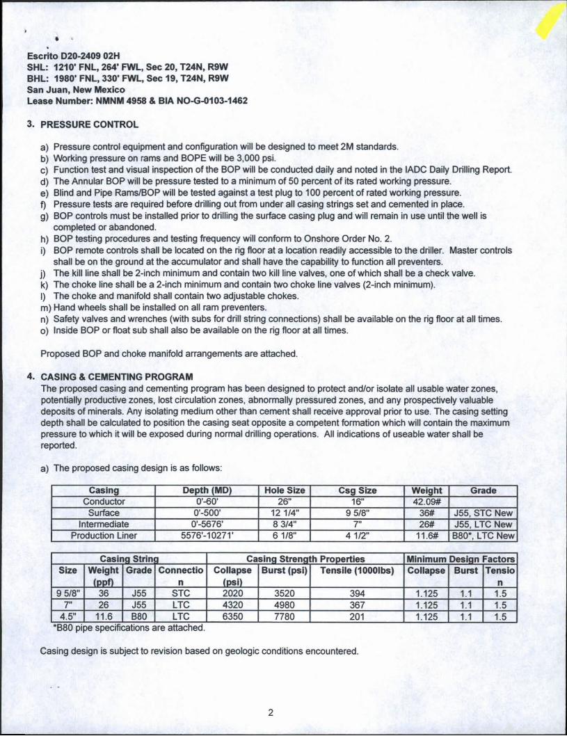
3. PRESSURE CONTROL
a) Pressure control equipment and configuration will be designed to meet 2M standards.b) Working pressure on rams and BOPE will be 3,000 psi.c) Function test and visual inspection of the BOP will be conducted daily and noted in the IADC Daily Drilling Report.d) The Annular BOP will be pressure tested to a minimum of 50 percent of its rated working pressure.e) Blind and Pipe Rams/BOP will be tested against a test plug to 100 percent of rated working pressure.f) Pressure tests are required before drilling out from under all casing strings set and cemented in place.g) BOP controls must be installed prior to drilling the surface casing plug and will remain in use until the well is
completed or abandoned.h) BOP testing procedures and testing frequency will conform to Onshore Order No. 2.i) BOP remote controls shall be located on the rig floor at a location readily accessible to the driller. Master controls
shall be on the ground at the accumulator and shall have the capability to function all preventers.j) The kill line shall be 2-inch minimum and contain two kill line valves, one of which shall be a check valve.k) The choke line shall be a 2-inch minimum and contain two choke line valves (2-inch minimum).l) The choke and manifold shall contain two adjustable chokes.m) Hand wheels shall be installed on all ram preventers.n) Safety valves and wrenches (with subs for drill string connections) shall be available on the rig floor at all times.o) Inside BOP or float sub shall also be available on the rig floor at all times.
Proposed BOP and choke manifold arrangements are attached.
4. CASING & CEMENTING PROGRAMThe proposed casing and cementing program has been designed to protect and/or isolate all usable water zones, potentially productive zones, lost circulation zones, abnormally pressured zones, and any prospectively valuable deposits of minerals. Any isolating medium other than cement shall receive approval prior to use. The casing setting depth shall be calculated to position the casing seat opposite a competent formation which will contain the maximum pressure to which it will be exposed during normal drilling operations. All indications of useable water shall be reported.
a) The proposed casing design is as follows:
Escrito D20-2409 02HSHL: 1210* FNL, 264* FWL, Sec 20, T24N, R9WBHL: 1980’ FNL, 330* FWL, Sec 19, T24N, R9WSan Juan, New MexicoLease Number: NMNM 4958 & BIA NO-G-0103-1462
Casing Depth (MD) Hole Size Csg Size Weight GradeConductor 0'-60' 26" 16" 42.09#
Surface 0-500' 12 1/4" 9 5/8" 36# J55, STC NewIntermediate 0'-5676' 8 3/4" 7" 26# J55, LTC New
Production Liner 5576-10271' 6 1/8" 4 1/2" 11.6# B80*, LTC New
Casing Strin 3 Casing Strength Properties Minimum Design FactorsSize Weight
(PPf)Grade Connectio
n
Collapse(psi)
Burst (psi) Tensile (1000lbs) Collapse Burst Tensio
n9 5/8" 36 J55 STC 2020 3520 394 1.125 1.1 1.5
7" 26 J55 LTC 4320 4980 367 1.125 1.1 1.54.5" 11.6 B80 LTC 6350 7780 201 1.125 1.1 1.5
B80 pipe specifications are attached.
Casing design is subject to revision based on geologic conditions encountered.
2
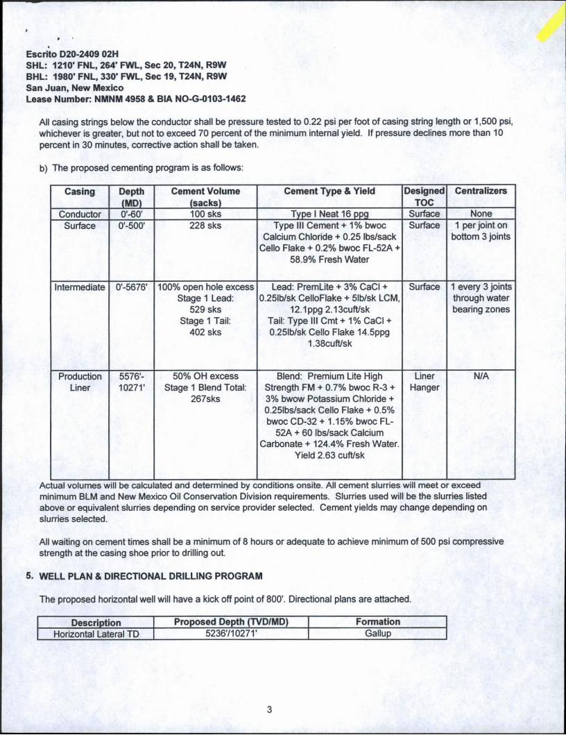
All casing strings below the conductor shall be pressure tested to 0.22 psi per foot of casing string length or 1,500 psi, whichever is greater, but not to exceed 70 percent of the minimum internal yield. If pressure declines more than 10 percent in 30 minutes, corrective action shall be taken.
b) The proposed cementing program is as follows:
Escrito D20-2409 02HSHL: 1210* FNL, 264’ FWL, Sec 20, T24N, R9WBHL: 1980’ FNL, 330' FWL, Sec 19, T24N, R9WSan Juan, New MexicoLease Number: NMNM 4958 & BIA NO-G-0103-1462
Casing Depth(MD)
Cement Volume (sacks)
Cement Type & Yield DesignedTOC
Centralizers
Conductor o*-60* 100 sks Type I Neat 16 ppg Surface NoneSurface 0'-500' 228 sks Type III Cement + 1% bwoc
Calcium Chloride + 0.25 Ibs/sack Cello Flake + 0.2% bwoc FL-52A +
58.9% Fresh Water
Surface 1 per joint on bottom 3 joints
Intermediate 0-5676* 100% open hole excess Stage 1 Lead:
529 sksStage 1 Tail:
402 sks
Lead: PremLite + 3% CaCI + 0.25lb/sk CelloFlake + 5lb/sk LCM,
12.1 ppg 2.13cuft/skTail: Type III Cmt+1% CaCI + 0.25lb/sk Cello Flake 14.5ppg
1.38cuft/sk
Surface 1 every 3 joints through water bearing zones
ProductionLiner
5576'-10271'
50% OH excess Stage 1 Blend Total:
267sks
Blend: Premium Lite High Strength FM + 0.7% bwoc R-3 + 3% bwow Potassium Chloride + 0.25lbs/sack Cello Flake + 0.5% bwoc CD-32 + 1.15% bwoc FL-
52A + 60 Ibs/sack Calcium Carbonate + 124.4% Fresh Water.
Yield 2.63 cuft/sk
LinerHanger
N/A
Actual volumes will be calculated and determined by conditions onsite. All cement slurries will meet or exceed minimum BLM and New Mexico Oil Conservation Division requirements. Slurries used will be the slurries listed above or equivalent slurries depending on service provider selected. Cement yields may change depending on slurries selected.
All waiting on cement times shall be a minimum of 8 hours or adequate to achieve minimum of 500 psi compressive strength at the casing shoe prior to drilling out.
5. WELL PLAN & DIRECTIONAL DRILLING PROGRAM
The proposed horizontal well will have a kick off point of 800'. Directional plans are attached.
Description Proposed Depth (TVD/MD) FormationHorizontal Lateral TD 5236710271* Gallup
3

Escrito D20-2409 02HSHL: 1210* FNL, 264’ FWL, Sec 20, T24N, R9W BHL: 1980' FNL, 330* FWL, Sec 19, T24N, R9W San Juan, New MexicoLease Number: NMNM 4958 & BIA NO-G-0103-1462
6. DRILLING FLUIDS PROGRAM
Surface through ntermediate Casing ^oint:
Hole Size (in) Depth (TVD/MD) Mud Type Density (ppg)Viscosity(sec/qt) Fluid Loss (cc)
30" 0-60760’ Fresh Water 8.3-9.2 38-100 4-2812 1/4" 0'-5007500' Fresh Water 8.3-10 60-70 NC8 3/4" >007500-527675676 Fresh Water LSND 8.3-10 40-50 8-10
b) Intermediate Casing Point to TD:
Hole Size (in) Depth (TVD/MD) Mud Type Density (ppg)Viscosity(sec/qt) Fluid Loss (cc)
6 1/8"527675676’-5236710271’ Fresh Water LSND 8.3-10 15-25 <15
c) There will be sufficient mud on location to control a blowout should one occur. Mud flow and volume will be monitored both visually and with electronic pit volume totalizers. Mud tests shall be performed every 24 hours after mudding up to determine, as applicable: density, viscosity, gel strength, filtration, and pH.
y d) A closed-loop system will be used to recover drilling fluid and dry cuttings in both phases of the well and on all hole intervals. Above-ground tanks will be utilized to hold cuttings and fluids for rig operations. A frac tank will be on location to store fresh water. Waste will be disposed of properly at an EPA-approved hazardous waste facility. Fresh water cuttings will be disposed of at Basin Disposal, Inc. and/or Industrial Ecosystems, Inc. The location will be lined in accordance with the Surface Use Plan of Operations.
7. TESTING, CORING, & LOGGING
a) Drill Stem Testing - None anticipated.b) Coring - None anticipated.c) Mudd Logging - Mud loggers will be on location from kick off point to TD.d) Logging - See below.
Cased Hole:CBL/CCL/GR/VDL will be run as needed for perforating control.
8. ABNORMAL PRESSURES & HYDROGEN SULFIDE
The anticipated bottom hole pressure is +/- 2469 psi based on a 9.0 ppg at 5277' TVD of the horizontal lateral target. No abnormal pressure or temperatures are anticipated.
No hydrogen sulfide gas is anticipated, however, if H2S is encountered, the guidelines in Onshore Order No. 6 will be followed.
9. ANTICIPATED START DATE AND DURATION OF OPERATIONS
Drilling is estimated to commence on March 5, 2015. It is anticipated that completion operations will begin within 30 days after the well has been drilled depending on fracture treatment schedules with various pumping service companies.
Ifris anticipated that the drilling of this well will take approximately 20 days.
4

Encana Oil & Gas (USA) Inc.
WELL SUMMARY
LOC: 1210* FNL, 264’ FWL, Sec 20, T24N, R9V county; San Juan
WELL: Escrito D20-2409 02H
ENG: 0
RIG:
GLE: 6127.5
RKBE: 6641.5
7/30/15
MWD
LWD
OPEN HOLE
LOGGING
HOLE
SIZE
CASING
SPECS
DEVIATION
INFORMATION
taka survey every stand and run anti-
collision report prior to
spud Nadmrento Fn
9 5/8" Ctg
No OH logs
Survey Every W-120". updating
anticollision report after
surveys. Stop
Ifseparation
factorapproaches
IS
Surveys every 10- through the curve
Ojo Alamo Ss. Kiniand Shale
Pictured Ckffs Ss. Lewis Shale
CMhouse Ss. Menelee Fn.
Point Lookout Ss.
Mancos Shale
838986
1,8011.738
2.3483.098
4.042
4.223
Mud logger
onsite
2616" 42.09#
100sx Type I Neat 16.0ppg cmtFresh wtr
8.1-9.2
121/4
9 5/8"36ppf J55LTC
TOC Surface with 100% OH Excess: 228 sks Type III Cement + 1% bwoc
Calcium Chloride ♦ 0.25 Ibs/sack CellcJ Flake + 0.2% bwoc FL-52A ♦ 58 9%
Fresh Water
Vertical
<1*
8 3/4
Gallup Fn
L£!2_
4.766
5.034
5,276
Surveys every stand to TD
unless directed
otherwise by Geologist
MWD
Gamma
Directional
No OH Logs
Horizontal Target TD
Base Gafcjp
5.2775,238
5.343
r 26ppf J55 LTC
TOC ©surface(100% OH excess - 70% Lead 30%
Tail)Stage 1 Total: 932sks
Stage 1 Lead 529 sks Premium Lite FM + 3% CaCI2 ♦ 0.25/sk Cello Flake ♦ 5#/sk LCM-1 ♦ 8% Bentonite + 0.4% FL-52A ♦ 0.4% Sodium Metasilicate. Mixed at 12.1 ppg. Yield 2.13 cuft/sk.
Stage 1 Tail: 402 sks Type III Cement 1% CaCI2 ♦ 0 25#/sk Cello Flake +
0,2% FL-52A. Mixed at 14 6 ppg. Yielc 1.38 cuft/sk.
Vertical
<1*
61/8 1001 overlap at (ner lop
4595' Dolled Lateral
Horz Inc/TVD 90 Sdeg/5276.511
TD* 10271.1 MD
41/r 11.6ppfSB80 LTC
TOC @ hanger (50% OH excess)
Stage 1 Total: 287sks
Stage 1 Blend: 267 sks Premium Lae High Strength FM ♦ 0.7% bwoc R-3 ♦ 3% bnow Potassium Chloride ♦ 0.25lbs/sack Cello
Flake ♦ 0.5% bwoe CD-32 ♦ 1.15% bwoc FL 52A ♦ 60 fes/sack Calcium Carbonate * 124.4% Fresh Water. Yield 2 63 cufl/sk
WBM8.3-10
NOTES:1) Drill with 26' bit to 601, set 16* 42.09ppf conductor pipe
2) Drill surface to 500\ RSC 9 5/8* casing3) N/U BOP and surface equipment4) Drill to KOP of 800'. 8 3/4 inch holesize5) Start curve at 10deg/100' build rate
6) Drill to csg point of 5676' MD7) R&C 7* csg. circ cmt to surface
8) Land at -55 deg, drill lateral to 10271' run 4 1/2 inch cemented liner
EnCana
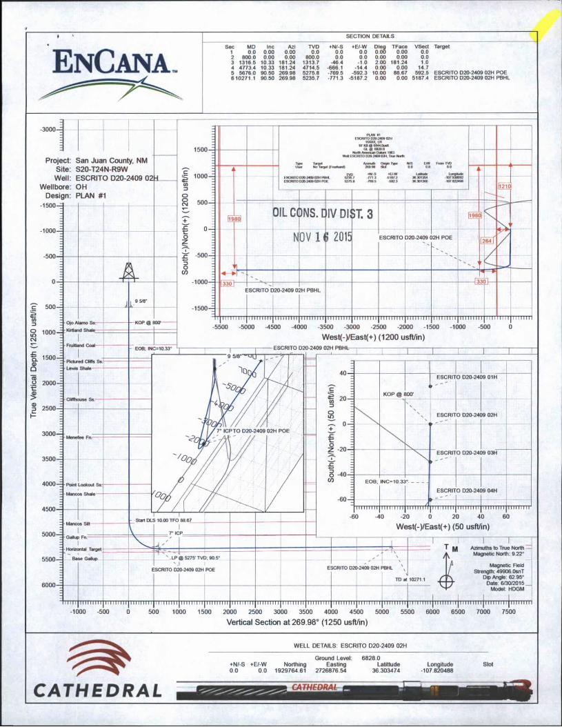
SECTION DETAILS
BC MD Inc Azi TVD ♦N/-S ♦E/-W Dleg TFace VSect1 0.0 000 000 0.0 0 0 00 0 00 0 00 0 02 800 0 000 000 800.0 0 0 0 0 000 000 0 03 1316 5 10 33 181.24 1313 7 -46 4 -10 200 181 24 1.04 47734 10 33 181 24 4714.5 -666 1 -14 4 0 00 000 14.75 56760 90 50 269 98 5275 8 -769 5 -592 3 10 00 88 67 592.5610271.1 90 50 269 98 5235 7 -771 3 -51872 0 00 000 51874
-3000—
Project: San Juan County. NM Site: S20-T24N-R9W Well: ESCRITO D20-2409 02H
Wellbore: OH Design: PLAN #1
-1500-
KOP @ J00-
ESCRITO D20-24C 9 01H
V
ESCRITO D20-24C
XCM
o2 _
O D20-24x ESCRIT )9 03H
EOB. INC-1033
ESCRIT o a ¥ N3
__ £
___
J9 04H
II I I 1 1 1 1 I I I 1 1 I 1 I 1 1
West(-)/East(+) (50 usft/in)
Magnetic Field Strength: 49906 OsnT
Dip Angle 62 95° Date 6/30/2015 _
Model HDGM
' 1111 j 1111111111 ii 11 m 111111111111 ] m 11 u 11111111 n i: i |~i 111 r 1111 j 11111 m 11 j 1111111111111' 111 t rj~T'mmTr| hti rim] i ii i i .ii | i ii m iit): i ' i : i i i i | i i i it i i i i | i m i i i i h |i i r it i riT|ii-nn~m
-1000 -500 0 500 1000 1500 2000 2500 3000 3500 4000 4500 5000 5500 6000 6500 7000 7500
Vertical Section at 269.98° (1250 usft/in)
WELL DETAILS ESCRITO D20-2409 02H
Ground Level: 6828 0+N/-S +E/-W Northing Easting Latittude Longitude0 0 0 0 1929764 61 2726876 54 36 303474 -107 820488
Slot
CATHEDRAL
Planning Report
OIL CONS. DIV DIST. 3
NOV 1 6 20)5
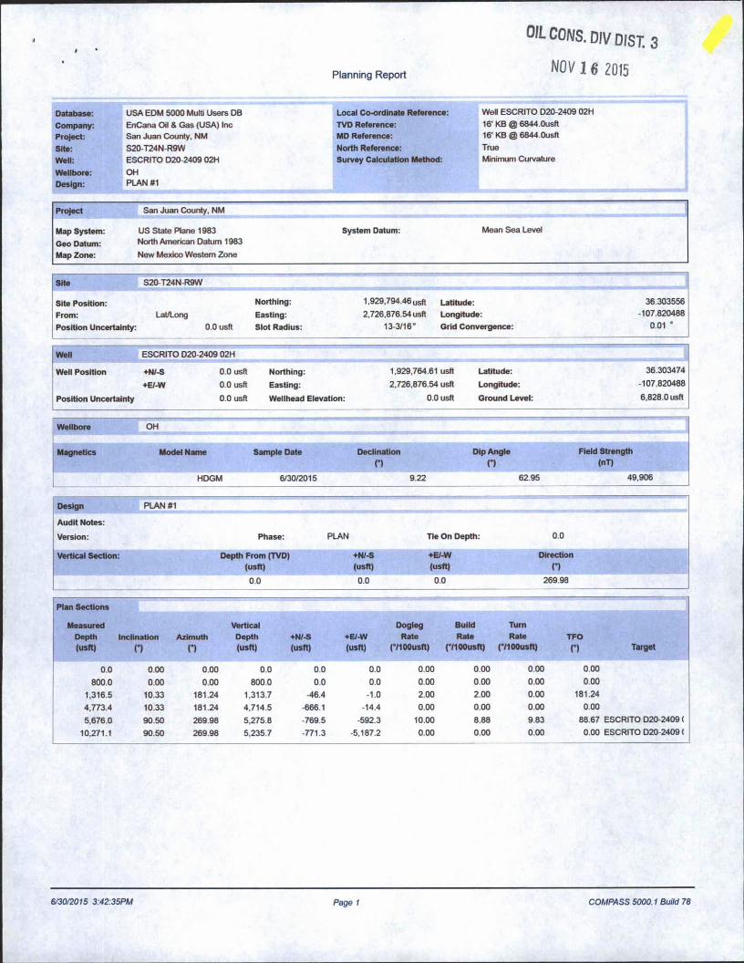
Database: USA EDM 5000 Multi Users DB Local Co-ordinate Reference: Well ESCRITO D20-2409 02H
Company: EnCana Oil & Gas (USA) Inc TVD Reference: 16‘ KB @ 6844.0usft
Project: San Juan County, NM MD Reference: 16‘ KB @ 6844.0usft
Site: S20-T24N-R9W North Reference: True
Well: ESCRITO D20-2409 02H Survey Calculation Method: Minimum Curvature
Wellbore: OHDesign: PLAN #1
Project San Juan County, NM
Map System: US State Plane 1983 System Datum: Mean Sea Level
Geo Datum: North American Datum 1983
Map Zone: New Mexico Western Zone
Site S20-T24N-R9W
Site Position:From:Position Uncertainty:
Lat/Long0.0 usft
Northing:Easting:Slot Radius:
1.929,794.46 u$ft Latitude:2,726,876.54 usft Longitude:
13-3/16" Grid Convergence:
36.303556 -107.820488
0.01 •
Well ESCRITO D20-2409 02H
Well Position
Position Uncertainty
♦N/-S+E/-W
0.0 usft
0.0 usft
0.0 usft
Northing:
Easting:
Wellhead Elevation:
1,929,764.61 usft
2.726,876.54 usft
0.0 usft
Latitude:Longitude:
Ground Level:
36.303474-107.820488
6,828.0 usft
Wellbore OH
Magnetics Model Name Sample Date Declination Dip Angleo n
Field Strength (nT)
HDGM 6/30/2015 9.22 62.95 49,906
Design PLAN #1
Audit Notes:
Version: Phase: PLAN Tie On Depth: 0.0
Vertical Section: Depth From (TVD +N/-S +E/-W Direction(usft) (usft) (usft) n
0.0 0.0 0.0 269.98
Plan Sections
Measured Vertical Dogleg Build TurnDepth Inclination Azimuth Depth +N/-S +E/-W Rate Rate Rate TFO(usft) n n (usft) (usft) (usft) (°/100usft) (°/100usft) (°/100usft) O Target
0.0 0.00 0.00 0.0 0.0 0.0 0.00 0.00 0.00 0.00
800.0 0.00 0.00 800.0 0.0 0.0 0.00 0.00 0.00 0.00
1,316.5 10.33 181.24 1,313.7 -46.4 -1.0 2.00 2.00 0.00 181.24
4,773.4 10.33 181.24 4,714.5 -666.1 -14.4 0.00 0.00 0.00 0.00
5,676.0 90.50 269.98 5,275.8 -769.5 -592.3 10.00 8.88 9.83 88.67 ESCRITO D20-2409 (
10,271.1 90.50 269.98 5,235.7 -771.3 -5,187.2 0.00 0.00 0.00 0.00 ESCRITO D20-2409 (
6/30/2015 3:42:35PM Page 1 COMPASS 5000.1 Build 78
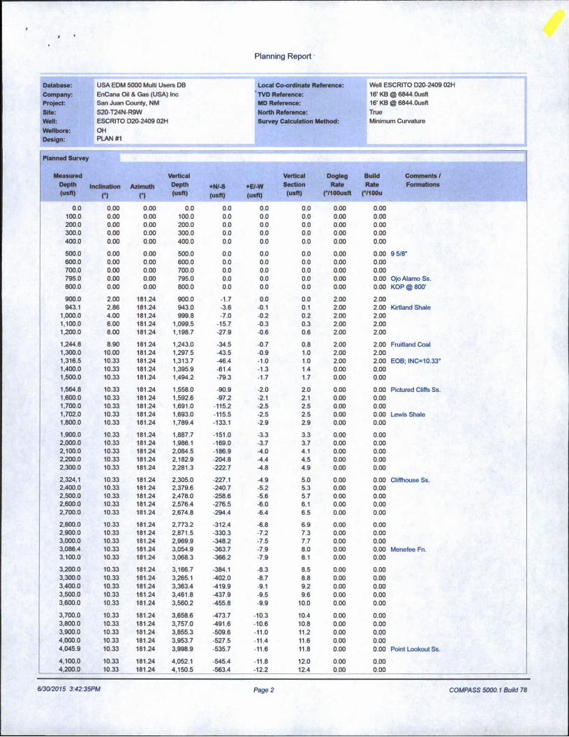
Planning Report •
Database: USA EDM 5000 Multi Users DB Local Co-ordinate Reference: Well ESCRITO D20-2409 02H
Company: EnCana Oil & Gas (USA) Inc TVD Reference: 16' KB @ 6844.0usftProject: San Juan County, NM MD Reference: 16' KB @ 6844.0usftSite: S20-T24N-R9W North Reference: TrueWell: ESCRITO D20-2409 02H Survey Calculation Method: Minimum Curvature
Wellbore: OHDesign: PLAN #1
Planned Survey
MeasuredDepth(usft)
Inclination
nAzimuth
n
VerticalDepth(usft)
+N/-S(usft)
+E/-W(usft)
VerticalSection
(usft)
DoglegRate
(*/100usft
Build Comments /Rate Formations
(°/100u
0.0 0.00 0.00 0.0 0.0 0.0 0.0 0.00 0.00100.0 0.00 0.00 100.0 0.0 0.0 0.0 0.00 0.00200.0 0.00 0.00 200.0 0.0 0.0 0.0 0.00 0.00300.0 0.00 0.00 300.0 0.0 0.0 0.0 0.00 0.00400.0 0.00 0.00 400.0 0.0 0.0 0.0 0.00 0.00
500.0 0.00 0.00 500.0 0.0 0.0 0.0 0.00 0.00 9 5/8"600.0 0.00 0.00 600.0 0.0 0.0 0.0 0.00 0.00700.0 0.00 0.00 700.0 0.0 0.0 0.0 0.00 0.00795.0 0.00 0.00 795.0 0.0 0.0 0.0 0.00 0.00 Ojo Alamo Ss.800.0 0.00 0.00 800.0 0.0 0.0 0.0 0.00 0.00 KOP @ 800'
900.0 2.00 181.24 900.0 -1.7 0.0 0.0 2.00 2.00943.1 2.86 181.24 943.0 -3.6 -0.1 0.1 2.00 2.00 Kirtland Shale
1,000.0 4.00 181.24 999.8 -7.0 -0.2 0.2 2.00 2.001.100.0 6.00 181.24 1,099.5 -15.7 -0.3 0.3 2.00 2.001,200.0 800 181.24 1,198.7 -27.9 -0.6 0.6 2.00 2.00
1,244.8 8.90 181.24 1,243.0 -34.5 -0.7 0.8 2.00 2.00 Fruitland Coal1,300.0 10.00 181.24 1,297.5 -43.5 -0.9 1.0 2.00 2.001.316.5 10.33 181.24 1,313.7 -46.4 -1.0 1.0 2.00 2.00 EOB; INC=10.33°1,400.0 10.33 181.24 1,395.9 -61.4 -1.3 1.4 0.00 0.001,500,0 10.33 181.24 1,494.2 -79.3 -1.7 1.7 0.00 0.00
1,564.8 10.33 181.24 1,558.0 -90.9 -2.0 2.0 0.00 0.00 Pictured Cliffs Ss.1.600.0 10.33 181.24 1,592.6 -97.2 -2.1 2.1 0.00 0.001,700.0 10.33 181.24 1,691.0 -115.2 -2.5 2.5 0.00 0.001,702.0 10.33 181.24 1.693.0 -115.5 -2.5 2.5 0.00 0.00 Lewis Shale1.800.0 10.33 181.24 1,789.4 -133.1 -2.9 2.9 0.00 0.00
1,900.0 10.33 181.24 1,887.7 -151.0 -3.3 3.3 0.00 0.002,000.0 10.33 181.24 1,986.1 -169.0 -3.7 3.7 0.00 0.002.100.0 10.33 181.24 2,084.5 186.9 -4.0 4.1 0.00 0.002,200.0 10.33 181.24 2,182.9 -204.8 -4.4 4.5 0.00 0.002,300.0 10.33 181.24 2,281.3 -222.7 -4.8 4.9 0.00 0.00
2,324.1 10.33 181.24 2,305.0 -227.1 -4.9 5.0 0.00 0.00 Cliffhouse Ss.2,400.0 10.33 181.24 2.379.6 -240.7 -5.2 5.3 0.00 0.002,500.0 10.33 181.24 2,478.0 -258.6 -5.6 5.7 0.00 0.002,600,0 10.33 181.24 2,576.4 -276.5 -6.0 6.1 0.00 0.002,700.0 10.33 181.24 2,674.8 -294.4 -6.4 6.5 0.00 0.00
2,800.0 10.33 181.24 2,773.2 -312.4 -6.8 6.9 0.00 0.002.900.0 10.33 181.24 2,871.5 -330.3 -7.2 7.3 0.00 0.003,000.0 10.33 181.24 2,969.9 -348.2 -7.5 7.7 0.00 0.003,086.4 10.33 181.24 3,054.9 -363.7 -7.9 8.0 0.00 0.00 Menefee Fn.3.100.0 10.33 181.24 3,068.3 -366.2 -7.9 8.1 0.00 0.00
3,200.0 10.33 181.24 3,166.7 -384.1 -8.3 8.5 0.00 0.003,300.0 10.33 181.24 3,265.1 -402.0 -8.7 8.8 0.00 0.003,400.0 10.33 181.24 3,363.4 -419.9 9.1 9.2 0.00 0.003,500.0 10.33 181.24 3,461.8 -437.9 -9.5 9.6 0.00 0.003,600.0 10.33 181.24 3,560.2 -455.8 -9.9 10.0 0.00 0.00
3.700.0 10.33 181.24 3,658.6 -473.7 -10.3 10.4 0.00 0.003,800.0 10.33 181.24 3,757.0 -491.6 -10.6 10.8 0.00 0.003,900.0 10.33 181.24 3,855.3 -509.6 -11.0 11.2 0.00 0.004,000.0 10.33 181.24 3,953.7 -527.5 -11.4 11.6 0.00 0.004,045.9 10.33 181.24 3,998.9 -535.7 -11.6 11.8 0.00 0.00 Point Lookout Ss.
4.100.0 10.33 181.24 4.052.1 -545.4 -11.8 12.0 0.00 0.004,200.0 10.33 181.24 4,150.5 -563.4 -12.2 12.4 0.00 0.00
6/30/2015 3:42:35PM Page 2 COMPASS 5000.1 Build 78
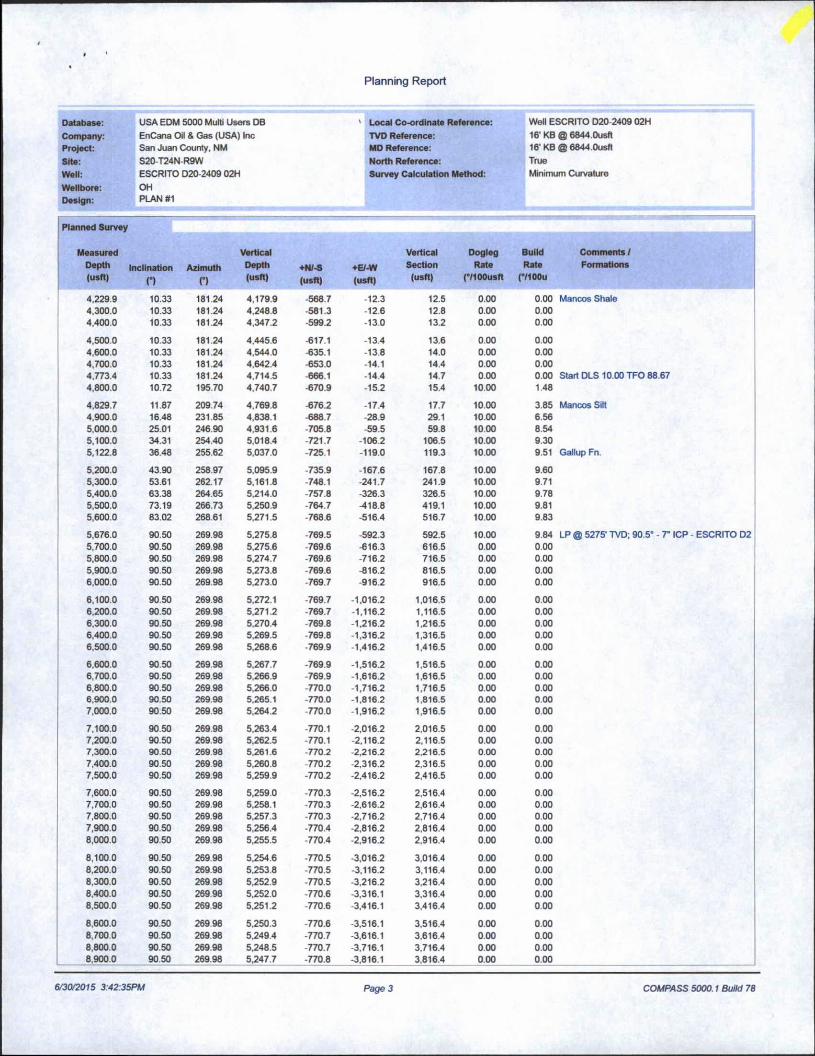
Planning Report
Oatabase: USA EDM 5000 Multi Users DB ' Local Co-ordinate Reference: Well ESCRITO D20-2409 02H
Company: EnCana Oil & Gas (USA) Inc TVD Reference: 16' KB @ 6844.0usftProject: San Juan County, NM MD Reference: 16' KB @ 6844.0usft
Site: S20-T24N-R9W North Reference: True
Well: ESCRITO D20-2409 02H Survey Calculation Method: Minimum Curvature
Wellbore: OHDesign: PLAN #1
Planned Survey
MeasuredDepth(usft)
nclination
nAzimuth
n
VerticalDepth(usft)
+N/-S(usft)
♦E/-W(usft)
VerticalSection(usft)
DoglegRate
(°/100usft
Build Comments 1Rate Formations
(°/100u
4.229.9 10.33 181.24 4.179.9 -568.7 -12.3 12.5 0.00 0.00 Mancos Shale4,300.0 10.33 181.24 4,248.8 -581.3 -12.6 12.8 0.00 0.004,400.0 10.33 181.24 4.347.2 -599.2 -13.0 13.2 0.00 0.00
4,500.0 10.33 181.24 4,445.6 -617.1 -13.4 13.6 0.00 0.004,600.0 10.33 181.24 4.544.0 -635.1 -13.8 14.0 0.00 0.004,700.0 10.33 181.24 4.642.4 -653.0 -14.1 14.4 0.00 0.004,773.4 10.33 181.24 4,714.5 -666.1 -14.4 14.7 0.00 0.00 Start DLS 10.00 TFO 88.674,800.0 10.72 195.70 4.740.7 -670.9 -15.2 15.4 10.00 1.48
4,829.7 11.87 209.74 4,769.8 -676.2 -17.4 17.7 10.00 3.85 Mancos Silt4,900.0 16.48 231.85 4.838.1 -688.7 -28.9 29.1 10.00 6.565,000.0 25.01 246.90 4.931.6 -705.8 -59.5 59.8 10.00 8.545,100.0 34.31 254.40 5,018.4 -721.7 -106.2 106.5 10.00 9.305,122.8 36.48 255.62 5.037.0 -725.1 -119.0 119.3 10.00 9.51 Gallup Fn.
5,200.0 43.90 258.97 5.095.9 -735.9 -167.6 167.8 10.00 9.605,300.0 53.61 262.17 5,161.8 -748.1 -241.7 241.9 10.00 9.715,400.0 63.38 264.65 5,214.0 -757.8 -326.3 326.5 10.00 9.785,500.0 73.19 266.73 5.250.9 -764.7 -418.8 419.1 10.00 9.815,600.0 83.02 268.61 5,271.5 -768.6 -516.4 516.7 10.00 9.83
5,676.0 90.50 269.98 5,275.8 -769.5 -592.3 592.5 10.00 9.84 LP @ 5275' TVD; 90.5° - 7" ICP - ESCRITO D25,700.0 90.50 269.98 5,275.6 -769.6 -616.3 616.5 0.00 0.005,800.0 90.50 269.98 5.274.7 -769.6 -716.2 716.5 0.00 0.005,900.0 90.50 269.98 5.273.8 -769.6 -816.2 816.5 0.00 0.006,000.0 90.50 269.98 5.273.0 -769.7 -916.2 916.5 0.00 0.00
6,100.0 90.50 269.98 5.272.1 -769.7 -1,016.2 1,016.5 0.00 0.006,200.0 90.50 269.98 5,271.2 769.7 -1,116.2 1,116.5 0.00 0.006,300.0 90.50 269.98 5.270.4 769.8 -1,216.2 1.216.5 0.00 0.006,400.0 90.50 269.98 5.269.5 -769.8 -1,316.2 1,316.5 0.00 0.006,500.0 90.50 269.98 5,268.6 -769.9 -1,416.2 1,416.5 0.00 0.00
6,600.0 90.50 269.98 5.267.7 -769.9 -1.516.2 1,516.5 0.00 0.006,700.0 90.50 269.98 5,266.9 -769.9 -1,616.2 1,616.5 0.00 0.006,800.0 90.50 269.98 5,266.0 -770.0 -1,716.2 1,716.5 0.00 0.006,900.0 90.50 269.98 5,265.1 -770.0 -1.816.2 1,816.5 0.00 0.007,000.0 90.50 269.98 5,264.2 -770.0 -1,916.2 1,916.5 0.00 0.00
7,100.0 90.50 269.98 5.263.4 -770.1 -2,016.2 2,016.5 0.00 0.007,200.0 90.50 269.98 5,262.5 -770.1 -2,116.2 2,116.5 0.00 0.007,300.0 90.50 269.98 5,261.6 -770.2 -2,216.2 2,216.5 0.00 0.007,400.0 90.50 269 98 5,260.8 -770.2 -2,316.2 2,316.5 0.00 0.007,500.0 90.50 269.98 5,259.9 -770.2 -2,416.2 2,416.5 0.00 0.00
7,600.0 90.50 269.98 5,259.0 -770.3 -2,516.2 2,516.4 0.00 0.007,700.0 90.50 269.98 5,258.1 -770.3 -2.616.2 2.616.4 0.00 0.007,800.0 90.50 269.98 5,257.3 -770.3 -2.716.2 2,716.4 0.00 0.007,900.0 90.50 269.98 5,256.4 -770.4 -2,816.2 2,816.4 0.00 0.008,000.0 90.50 269.98 5,255.5 -770.4 -2.916.2 2,916.4 0.00 0.00
8,100.0 90.50 269.98 5.254.6 -770.5 -3,016.2 3,016.4 0.00 0.008,200.0 90.50 269.98 5.253.8 -770.5 -3,116.2 3,116.4 0.00 0.008.300.0 90.50 269.98 5,252.9 -770.5 -3,216.2 3,216.4 0.00 0.008,400.0 90.50 269.98 5,252.0 -770.6 -3,316.1 3,316.4 0.00 0.008,500.0 90.50 269.98 5,251.2 -770.6 -3,416.1 3,416.4 0.00 0.00
8,600.0 90.50 269.98 5,250.3 -770.6 -3.516.1 3,516.4 0.00 0.008,700.0 90.50 269 98 5,249.4 -770.7 -3,616.1 3,616.4 0.00 0.008,800.0 90.50 269.98 5,248.5 -770.7 -3.716.1 3,716.4 0.00 0.008,900.0 90.50 269.98 5,247.7 -770.8 -3,816.1 3,816.4 0.00 0.00
6/30/2015 3:42:35PM Page 3 COMPASS 5000.1 Build 78

Planning Report
Database: USA EDM 5000 Multi Users DB Local Co-ordinate Reference: Well ESCRITO D20-2409 02H
Company: EnCana Oil & Gas (USA) Inc TVD Reference: 16- KB @ 6844.0usftProject: San Juan County, NM MD Reference: 16" KB @ 6844.0usft
Site: S20-T24N-R9W North Reference: True
Well:Wellbore:Design:
ESCRITO D20-2409 02HOHPLAN #1
Survey Calculation Method: Minimum Curvature
Planned Survey
MeasuredDepth(usft)
Inclinationn
Azimuthn
VerticalDepth(usft)
♦N/-S(usft)
♦E/-W(usft)
VerticalSection
(usft)
DoglegRate
(°/100usft
Build Comments /Rate Formations
(°/100u
9,000.0 90.50 269.98 5.246.8 -770.8 -3.916.1 3,916.4 0.00 0.00
9.100.0 90.50 269.98 5,245.9 -770.8 -4,016.1 4,016.4 0.00 0.009.200.0 90.50 269.98 5,245.0 -770.9 -4.116.1 4,116.4 0.00 0.009,300.0 90.50 269.98 5,244.2 -770.9 -4.216.1 4,216.4 0.00 0.009,400.0 90.50 269.98 5,243.3 -770.9 -4,316.1 4,316.4 0.00 0.009,500.0 90.50 269.98 5,242.4 -771.0 -4.416.1 4,416.4 0.00 0.00
9,600.0 90.50 269.98 5,241.6 -771.0 -4,516.1 4,516.4 0.00 0.009,700.0 90.50 269.98 5,240.7 -771.0 -4.616.1 4,616.4 0.00 0.009,800.0 90.50 269.98 5,239.8 -771.1 -4,716.1 4,716.4 0.00 0.009,900.0 90.50 269.98 5,238.9 -771.1 -4,816.1 4,816.4 0.00 0.00
10,000.0 90.50 269.98 5.238.1 -771.2 -4.916.1 4,916.4 0.00 0.00
10.100.0 90.50 269.98 5,237.2 -771.2 -5,016.1 5,016.4 0.00 0.0010,200.0 90.50 269.98 5,236.3 -771.2 -5,116.1 5,116.3 0.00 0.0010,271.1 90.50 269.98 5.235.7 -771.3 -5.187.2 5,187.4 0.00 0.00 TD at 10271.1 - ESCRITO D20-2409 02H PBH1
Targets
Target Name- hit/miss target Dip Angle- Shape (°)
Dip Dir.n
TVD(usft)
il ♦E/-W(usft)
Northing(usft)
Easting(usft) Latitude
ESCRITO D20-2409 021- plan hits target center- Point
0.00 0.00 5,235.7 -771.3 -5,187.2 1,928.992.66 2,721.689.49 36.301354 -107.838092
ESCRITO D20-2409 021- plan hits target center- Point
0.00 0.00 5.275.8 -769.5 -592.3 1.928,994.99 2,726.284.38 36.301360 -107.822498
Casing Points
Measured Vertical Casing HoleDepth Depth Diameter Diameter(usft) (usft) Name n n
500.0 500.0 9 5/8’ 0 0
5,676.0 5,275.8 r ICP 0 0
6/30/2015 3:42:35PM Page 4 COMPASS 5000.1 Build 78

Planning Report
Database: USA EDM 5000 Multi Users DB Local Co-ordinate Reference: Well ESCRITO D20-2409 02H
Company: EnCana Oil & Gas (USA) Inc TVD Reference: 16' KB @ 6844.0usft
Project: San Juan County, NM MD Reference: 16' KB @ 6844.0usft
Site: S20-T24N-R9W North Reference: True
Well: ESCRITO D20-2409 02H Survey Calculation Method: Minimum Curvature
Wellbore: OHDesign: PLAN#1
Plan Annotations
Measured Vertical Local CoordinatesDepth Depth ♦N/-S +E/-W(usft) (usft) (usft) (usft) Comment
800.0 800.0 0.0 0.0 KOP @ 800'1,316.5 1,313.7 -46.4 -1.0 EOB: INC=10.33°4,773.4 4,714.5 -666.1 -14.4 Start DLS 10.00 TFO 88.675,676.0 5,275.8 -769.5 -592.3 LP @ 5275’ TVD; 90.5°
10,271.1 5,235.7 -771.3 -5,187.2 TD at 10271.1
fi/30/2015 3:42:35PM Page 5 COMPASS 5000.1 Build 78

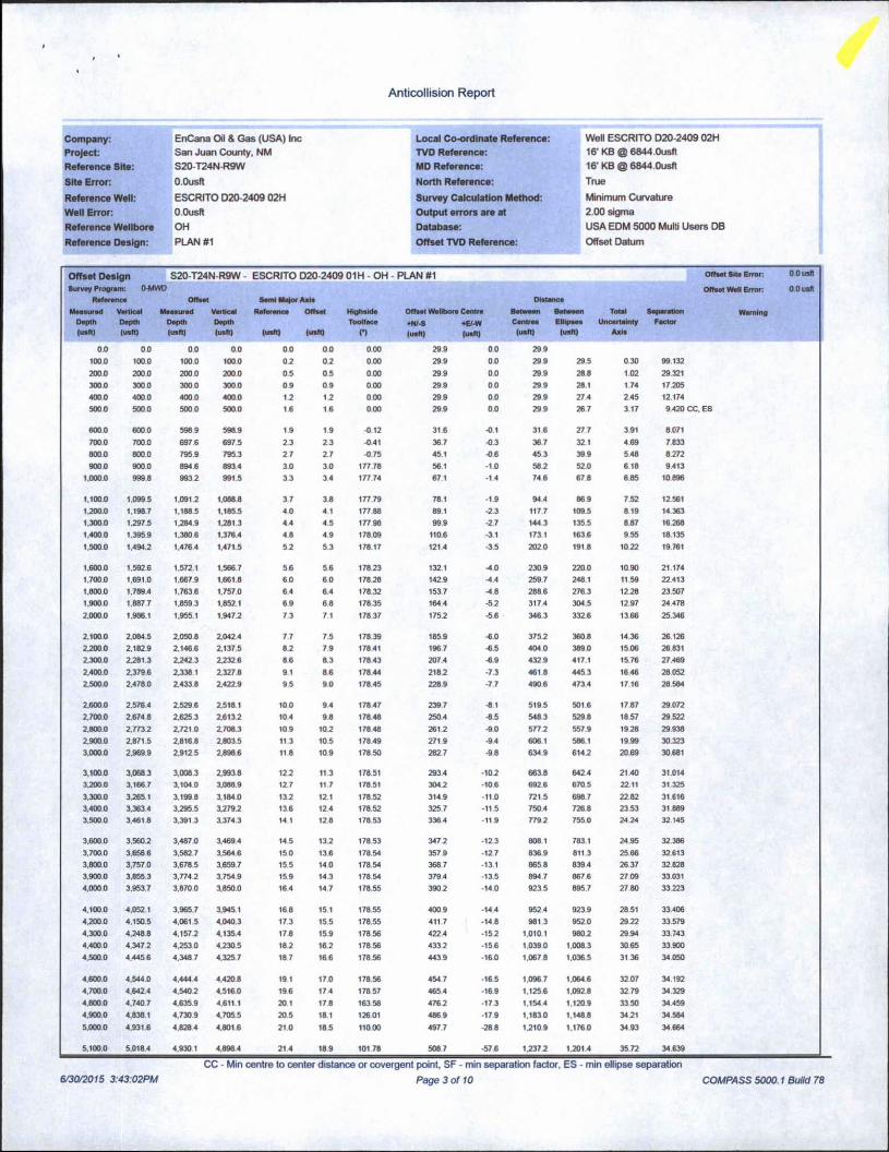
EnCana Oil & Gas (USA) IncSan Juan County, NM S20-T24N-R9W ESCRITO D20-2409 02H OHPLAN #1
Anticollision Report
30 June, 2015

Anticollision Report
Company: EnCana Oil & Gas (USA) Inc Local Co-ordinate Reference: Well ESCRITO D20-2409 02H
Project: San Juan County, NM TVD Reference: 16' KB @ 6844.0usft
Reference Site: S20-T24N-R9W MD Reference: 16’ KB @ 6844.0usft
Site Error: O.Ousft North Reference: True
Reference Well: ESCRITO D20-2409 02H Survey Calculation Method: Minimum Curvature
Well Error: O.Ousft Output errors are at 2.00 sigma
Reference Wellbore OH Database: USA EDM 5000 Multi Users DB
Reference Design: PLAN #1 Offset TVD Reference: Offset Datum
Reference PLAN #1
Filter type: NO GLOBAL FILTER: Using user defined selection & filtering criteria
Interpolation Method: MD Interval 100.0usft Error Model: Systematic Ellipse
Depth Range: Unlimited Scan Method: Closest Approach 3D
Results Limited by: Maximum center-center distance of 1,500.0usft Error Surface: Elliptical ConicWarning Levels Evaluated at: 2.00 Sigma
Survey Tool Program
From(usft)
To(usft)
Date 6/30/2015
Survey (Wellbore) Tool Name Description
0.0 10.271.1 PLAN #1 (OH) MWD MWD - Standard
Summary
Site NameOffset Well - Wellbore - Design
ReferenceMeasured
Depth(usft)
OffsetMeasured
Depth(usft)
DistanceBetween BetweenCentres Ellipses
(usft) (usft)
SeparationFactor
Warning
S20-T24N-R9WESCRITO D20-2409 01H - OH - PLAN #1 500.0 500.0 29.9 26.7 9.420 CC. ESESCRITO D20-2409 01H - OH - PLAN #1 10,271.1 10,211.9 1,319.6 1,003.9 4.179 SFESCRITO D20-2409 03H - OH - PLAN #1 832.9 833.5 24.0 18.4 4.314 CC, ESESCRITO D20-2409 03H - OH - PLAN #1 900.0 899.7 25.3 19.2 4.160 SFESCRITO D20-2409 04H - OH - PLAN #1 500.0 500.0 60.1 56.9 18.954 CCESCRITO D20-2409 04H - OH - PLAN #1 5,381.1 5.350.9 71.7 31.3 1.775 ES. SF
6/30/2015 3:43:02PM
CC - Min centre to center distance or covergent point, SF - min separation factor, ES - min ellipse separation
Page 2 of 10 COMPASS 5000.1 Build 78
Anticollision Report
Company: EnCana Oil & Gas (USA) Inc Local Co-ordinate Reference: Well ESCRITO D20-2409 02HProject: San Juan County, NM TVD Reference: 16‘ KB @ 6844.0usftReference Site: S20-T24NR9W MD Reference: 16- KB @ 6844.0usft
Site Error: O.Ousft North Reference: True
Reference Well: ESCRITO D20-2409 02H Survey Calculation Method: Minimum Curvature
Well Error: O.Ousft Output errors are at 2.00 sigma
Reference Wellbore OH Database: USA EDM 5000 Multi Users DB
Reference Design: PLAN #1 Offset TVD Reference: Offset Datum
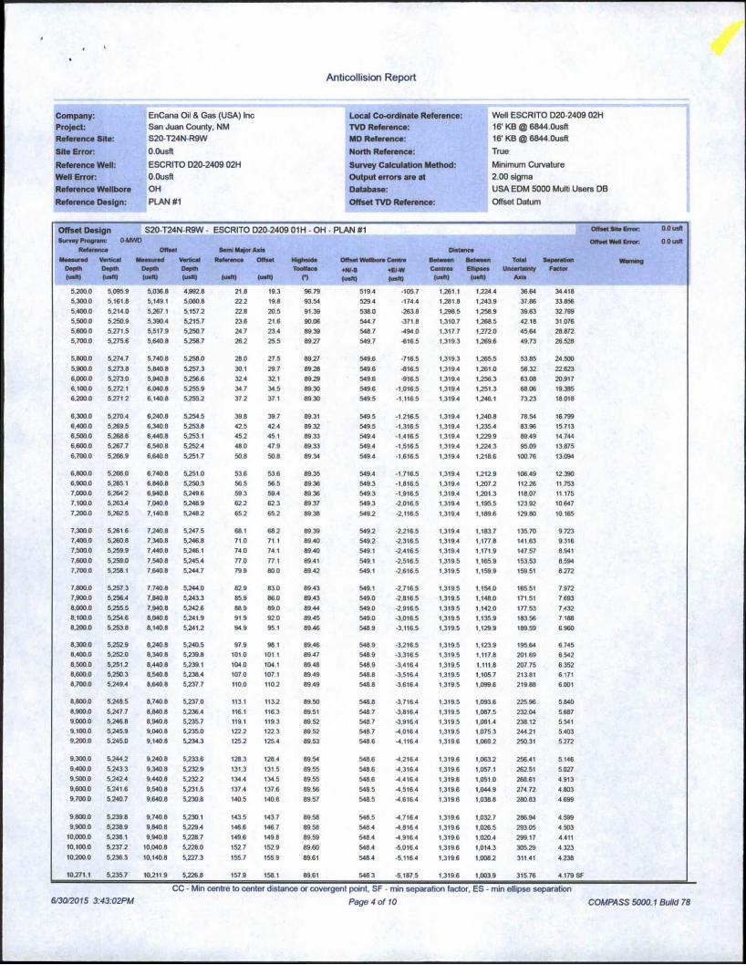
Offset Design S20-T24N-R9W - ESCRITO D20-2409 01H - OH - PLAN #1Survey Program: 0-MWD
Reference Offset Somi Ma)or Alls
MeasuredDepth(uafll
VerticalDepthlusft)
MeasuredDepth(usfl)
Vertical Reference OffsetDepthdraft) (usfl) (usft)
HrghsldeToolface
o
Offset Wellbore Centre
+N/-S +E/-W(usfl) (usft)
Between Between Total SeparationCentres Ellipses Uncertainty Factor
(usft) (usft) Axis
0.0 0.0 0.0 0.0 00 0.0 0.00 29.9 0.0 299100.0 100.0 1000 1000 0 2 07 0.00 29.9 0.0 299 29.5 0.30 99.1322000 200.0 2000 2000 0.5 0.5 000 299 0.0 29.9 288 1.02 29.321300.0 3000 3000 3000 09 0.9 000 299 0.0 29.9 28.1 1.74 17 2054000 4000 400 0 4000 1.2 17 000 299 00 29.9 27.4 245 121745000 500.0 5000 500.0 16 1.6 000 29.9 0.0 299 267 3.17 9 420 CC. ES
600.0 600.0 598 9 5989 1.9 1.9 -0.12 31.6 •0.1 316 27.7 3.91 8071700.0 700 0 6976 6975 2.3 23 -041 367 -0.3 367 321 4 69 7 8338000 8000 7959 795.3 27 Z7 ■0.75 45.1 -06 453 399 548 8.2729000 900 0 8946 8934 3.0 3.0 177.78 561 -10 58.2 520 618 9413
1.000.0 999.8 993 2 991.5 3.3 34 17774 671 -1.4 746 67.8 685 10 896
1.100.0 1,099 5 1.0912 1.0888 3.7 3.8 177.79 78.1 -1.9 94.4 869 7.52 12.5611.200.0 1.1987 1.1885 1.185.5 4.0 4.1 177 88 891 -23 117.7 1095 819 14 3631.3000 1.297 5 1.284.9 1.281.3 44 4.5 177 98 999 -2.7 1443 135.5 887 16 2681.400 0 1.395.9 1.3806 1.376.4 4.8 49 178 09 110.6 -3.1 173.1 163.6 955 18.1351,500.0 1.494.2 1,476 4 1.471.5 57 5.3 178.17 121.4 -3.5 2020 191.8 1022 19761
1.600.0 1.592.6 1,5721 1,5667 5.6 5.6 178.23 132.1 -4.0 2309 2200 1090 21 1741.700.0 1.691.0 1.667 9 1.661.8 60 60 17828 1429 -4.4 2597 248 1 11 59 224131.800.0 1,789.4 1,763.6 1.757.0 6.4 6.4 178.32 153.7 -4.8 2886 276.3 1278 23 5071,900 0 1.887 7 1,859 3 1,852.1 69 68 178 35 1644 -57 317.4 304.5 12.97 244782.0000 1.986.1 1.955.1 1,947.2 7.3 7.1 178 37 175.2 ■5.6 3463 332.6 13 66 25 346
2.1000 2,0845 2.0508 Z0424 7.7 7.5 178 39 1859 -6.0 375.2 3608 1436 261262.2000 2.182.9 2.146.6 Z137.5 8.2 7.9 17841 1967 6.5 404 0 3890 15 06 26 8312.300.0 2.281.3 2.242.3 Z232 6 86 8.3 178.43 2074 6.9 4329 417.1 15.76 27 4692.400.0 2.3796 2,3381 2,327 8 9.1 86 178 44 218.2 -7.3 4618 445 3 1646 280522.5000 2.4780 2.433.8 Z42Z9 95 90 178.45 228.9 -7.7 490 6 473.4 17.16 28 584
2.6000 2.5764 2.5296 2.518 1 100 9.4 17847 2397 6 1 5195 5016 17.87 29.0722.700.0 2.674 8 2.625.3 Z6137 104 9.8 178.48 2504 6.5 548 3 529.8 18.57 29 5222.8000 2.773.2 2.721.0 2.708 3 109 107 178 48 2612 -9.0 5777 557 9 1978 29 9382.900.0 2,8715 2,8168 2.803.5 11.3 105 178 49 271 9 -9.4 606 1 586 1 19.99 30 3233,0000 2.969.9 2.9125 2.8986 11 8 109 17850 282 7 -98 6349 6147 20.69 30 681
3.100 0 3.0683 3.008 3 29938 127 11.3 178 51 2934 -10.2 6638 642 4 2140 31.0143.200.0 3.166.7 3,1040 3,0889 1Z7 117 17851 3042 -106 6926 670.5 22.11 31.3253.3000 3.265.1 3.1998 3.184 0 137 1Z1 178 52 3149 -11.0 7215 6987 2282 31.6163.400.0 3,3634 3.295.5 37792 136 12.4 178.52 3257 -11.5 7504 7268 23.53 318893.500.0 3.461 8 3.391 3 3.374.3 14 1 128 178.53 3364 -11.9 779.2 755.0 2474 32.145
3.600.0 3,5602 3,4870 3.4694 145 137 178.53 347 2 -1Z3 808 1 783.1 24.95 32 3863.700.0 3,6586 3.5827 3,5646 15.0 13.6 178.54 357.9 -127 8369 811.3 25 66 32 6133.800.0 3,757.0 3,678.5 3.659.7 15.5 140 178 54 3687 -13.1 865 8 8394 26 37 32.8283.900.0 3,855.3 3,774 2 3,7549 15.9 14.3 178 54 3794 -135 894 7 8676 27 09 33.0314,0000 3,9537 3.8700 3.850.0 164 14.7 178.55 3902 -140 9235 8957 27 80 33 223
4.100.0 4,0521 3.9657 3,9451 168 15 1 178 55 400 9 -144 952 4 923.9 28 51 33.4064.2000 4.150.5 4.061 5 4.0403 17.3 155 178.55 411.7 -14 8 981 3 952.0 2922 33 5794.300.0 4,248 8 4,157.2 4.1354 178 159 178 56 4224 -15.2 1.010.1 9807 29 94 33.7434.400.0 4.347.2 4,253 0 4.2305 187 167 178 56 4332 -15.6 1.039.0 1.008 3 30 65 33 9004.5000 4.445 6 4,348 7 4,325.7 187 166 178 56 443.9 -16.0 1.067 8 1.036 5 31 36 34.050
4.6000 4,544.0 4,444 4 4,4208 191 17.0 178 56 454 7 -165 1.096.7 1.064 6 3207 34 1924.700.0 4.642.4 4.540 2 4.516.0 196 174 178 57 4654 -169 1.1256 1.092.8 32 79 34 3294.8000 4.740 7 4,6359 4.611.1 201 178 163 58 4762 -173 1,154.4 1.1209 33 50 34 4594.900.0 4.8381 4,730 9 4,7055 205 18.1 12601 4869 -17.9 1.1830 1.1488 34.21 34 5845,000.0 4.931.6 4,828 4 4,8016 210 185 11000 4977 -288 1.210.9 1.176.0 34.93 34 664
5.100.0 5.018.4 4,9301 4,8984 214 189 10178 5087 -57.6 17377 17014 35.72 34 639
Offset Site Error:
Offset Well Error:
Warning
0 0 usfl
oousn
CC - Min centre to center distance or covergent point, SF - min separation factor, ES - min ellipse separation
Page 3 of 10V30K01S 3:43:02PM COMPASS 5000.1 Build 78
Anticollision Report
Company: EnCana Oil & Gas (USA) Inc Local Co-ordinate Reference: Well ESCRITO D20-2409 02HProject: San Juan County, NM TVD Reference: 16' KB @ 6844.0usftReference Site: S20-T24N-R9W MD Reference: 16' KB @ 6844.0usft
Site Error: O.Ousft North Reference: True
Reference Well: ESCRITO D20-2409 02H Survey Calculation Method: Minimum CurvatureWell Error: O.Ousft Output errors are at 2.00 sigmaReference Wellbore OH Database: USA EDM 5000 Multi Users DB
Reference Design: PLAN #1 Offset TVD Reference: Offset Datum
Offset Design S20-T24N-R9W - ESCRITO D20-2409 01H - OH - PLAN #1 <*»••< s.t« Error. O.Ousft
Survey Program: 0-MWD Offsot Well Error O.OusftReference Offvet Semi Major Axle Distance
MeasuredDepth<u»m
VerticalOapih(usft)
MeasuredDepthluaft)
VerticalDepth(usfl)
Reference
(ueft)
Offset
(u«fl)
HighsideToolface
O
Offset WeUbore Centre
♦NIS *E/-W(usft) (ueft)
BetweenCentres
(usfl)
BetweenEllipses
(usft)
TotalUncertainty
Axis
SeparationFactor
5.200 0 5.0959 5.0368 4.992.8 218 19.3 96 79 519.4 -1057 1.261 1 1.224.4 36 64 34 4185.300.0 5.161.8 5.149 1 5,080.8 222 198 93.54 5294 -174 4 1,2818 1.243.9 37.86 33.8565.4000 5.2140 5.267 1 5.1575 228 205 91.39 5380 -2638 1.298 5 1.258 9 39 63 32 7695,5000 5.250.9 5.3904 5515.7 23.6 216 90 06 5447 -3718 1.310.7 1.268.5 4218 31.0765.6000 5271.5 5.517.9 5550.7 24.7 234 89 39 5487 -494 0 1.317.7 1272.0 4564 28 8725.7000 5.275.6 5.640 8 5558.7 26.2 23.5 8957 5497 ■616.5 1.319.3 1.269.6 4973 26.528
5.800 0 5.274.7 5,7408 5558.0 280 27.5 89.27 549.6 -716.5 1,319.3 1.265.5 53 85 24.5005.900 0 5.273.8 5.840 8 5557.3 30.1 29.7 8958 549 6 -816.5 1.3194 1,261.0 58.32 22.6236.000.0 5.2730 5.9408 5556.6 324 351 89 29 5496 -9165 1.319.4 1256.3 6308 20.9176.1000 5572.1 6.040 8 55559 34.7 345 89.30 5496 -1.0165 1.319.4 1251.3 68 06 19 3856.200 0 55712 6.1408 5555.2 375 37 1 89 30 5495 -1.116.5 1.319 4 1.246.1 73.23 18018
6,300.0 5,270.4 65408 55545 39.8 39.7 89.31 549 5 -1,2165 1.319.4 1240.8 7854 16.7996.400 0 5.269.5 6,340 8 5.253.8 425 424 89 32 549.5 -1.316.5 1,319.4 1,235 4 83 96 15.7136.500.0 5,2686 6,440 8 5553.1 455 45 1 89 33 5494 -1.416.5 1.3194 1.229.9 89 49 14 7446.600 0 5567.7 6.5408 55524 480 479 89.33 5494 -1.5165 1.319.4 1.224 3 95 09 13 8756.7000 5.266.9 6.6408 55517 508 508 89 34 5494 -1.616.5 1.3194 1.218.6 100 76 13094
6.8000 5.266.0 6.7408 5,251.0 536 53.6 89.35 549.4 -1.716.5 1.3194 1,212.9 10649 12 3906.9000 5.2651 6.8408 5,250.3 56.5 565 89.36 549.3 -1.816.5 1.3194 1.207.2 112.26 11 7537,0000 5.2842 6.940 8 5549.6 59.3 594 89 36 5493 -1.9165 1.3194 1.201.3 118.07 11.1757.1000 5,2634 7,040 8 55489 622 623 89 37 5493 -2.0165 1.319.4 1.195.5 123 92 1064772000 5,2625 7,1408 5548.2 65.2 652 89 38 549.2 -2.116 5 1.319.4 1,189.6 129 80 10165
7.3000 5.261 6 7.240.8 5.247.5 681 682 89 39 549.2 -22165 1.319.4 1,183.7 135.70 97237,4000 5.2608 7,340 8 5.246.8 71.0 71.1 89.40 549.2 -2,316.5 1.319.4 1.177.8 141.63 9.3167,500.0 5.259.9 7,440 8 5.246 1 740 74.1 89.40 5491 -2.4165 1,3194 1,171.9 147 57 8.9417.6000 5.259.0 7,540 8 55454 770 77.1 89 41 5491 -2.516.5 1.319.5 1.165.9 153.53 8 5947.7000 5.258 1 7.640 8 5544.7 799 800 8942 549.1 -2.6165 1,319 5 1.159.9 159 51 8272
7.800.0 5557.3 7,740.8 5544.0 829 830 8943 549.1 -2,7165 1.319.5 1.154.0 165.51 7.9727,900 0 5556.4 7,8408 5543.3 85.9 86.0 8943 5490 -2,816.5 1,319.5 1.148.0 171.51 7.6938.0000 5,255.5 7,9408 5542.6 88.9 890 89.44 549.0 -2,916.5 1.319.5 1.142.0 177.53 7.4328.100.0 5.2546 8.040 8 5541.9 91.9 920 89 45 549.0 -3.0165 1.319.5 1.135.9 18356 71888.200 0 5553.8 8.140 8 55415 949 951 8946 548 9 -3,116.5 1.319.5 1.129.9 189 59 6.960
8.3000 5.252.9 8,240.8 5540.5 97.9 981 89 46 548 9 -3216.5 1.319.5 1.123.9 195 64 67458,400.0 55520 8,3408 5.239 8 101.0 101.1 89 47 548 9 -3.316.5 1.319.5 1.117.8 20169 65428.5000 5.2515 8.440 8 5539.1 104.0 104.1 89.48 548 9 -3.4164 1,319.5 1.111.8 207 75 6 3528.600.0 5.2503 8.540 8 5538.4 107.0 107.1 89 49 548 8 -3.516.4 1.319.5 1.105.7 21381 6.1718.700.0 5549.4 8,640 8 5537.7 110.0 110.2 89 49 548 8 -3.6164 1.319.5 1.099.6 21988 6.001
8.800.0 5548.5 8,740 8 55370 113.1 1135 89 50 548 8 -3.7164 1,319.5 1.093 6 225 96 5.8408.9000 55477 8.840 8 5.236 4 1161 116.3 89.51 548 7 -3,816.4 1,319.5 1,087.5 232 04 5 6879.0000 5,246.8 8.940.8 5.235.7 1191 1193 89 52 548 7 -3,916.4 1,319.5 1.081.4 238 12 5 5419.1000 5.245.9 9.040 8 5.235.0 1222 1223 89 52 548 7 -4.0164 1,319.5 1,075.3 244 21 5.4039.2000 5545.0 9.1408 5534.3 1255 1254 89.53 5486 -4.1164 1.319.6 1.069.2 25031 5.272
9.300.0 5.2445 95408 5533.6 128.3 1284 89 54 5486 -4.2164 1.319.6 1.0632 25641 51469.400 0 5543.3 9.340 8 55329 131.3 1315 89 55 548 6 -4.316.4 1.319.6 1.057.1 262 51 5.0279,500 0 55424 9.440 8 5532.2 1344 1345 89 55 5486 -4.416 4 1.319.6 1,051.0 26861 4 9139,600.0 55416 9.540 8 5531.5 137.4 137.6 89.56 548 5 -4.5164 1,319.6 1.044 9 274 72 4.8039.700.0 55407 9.6408 5530.8 140.5 1406 89 57 548 5 -4.6164 1,3196 1.038 8 280 83 4 699
9.800 0 55398 9.740 8 5530.1 143.5 1437 89 58 5485 -4.7164 1.319 6 1.0327 286 94 4 5999.900.0 5538.9 9.8408 55294 146.6 1467 89 58 548 4 -4,816 4 1,319.6 1.026.5 293 05 4 503
10.0000 5538.1 9,9408 5.228.7 149.6 1498 89 59 548 4 -4.9164 1.319.6 1.020.4 299 17 4.41110,1000 5,237.2 10.0408 5,228.0 152.7 1529 89.60 548 4 -5.0164 1,3196 1.014.3 305.29 4.32310.200 0 5.236.3 10,1408 5.227.3 155 7 155.9 89.61 5484 •5.116.4 1.319.6 1.008 2 311.41 4 238
10.271.1 5.235.7 10,2119 5526.8 157.9 158.1 8961 5483 -5.187.5 1.319.6 1.003.9 31576 4 179
CC - Min centre to center distance or covergent point, SF - min separation factor, ES - min ellipse separation6/30/2015 3:43:02PM Page 4 of 10 COMPASS 5000.1 Build 78

Anticollision Report
p . 1 r rojoci.Reference Site:Site Error:
Reference Well:Well Error:Reference WellboreReference Design:
EnCana Oil & Gas (USA) IncSan Juan County, NMS20-T24N-R9WO.Ousft
ESCRITO D20-2409 02HO.OusftOHPLAN #1
Local Co-ordinate Reference:TVD Reference:MD Reference:North Reference:Survey Calculation Method:Output errors are atDatabase:Offset TVD Reference:
Well ESCRITO D20-2409 02H16' KB @ 6844.0usft16' KB @ 6844.0usft
True
Minimum Curvature2.00 sigmaUSA EDM 5000 Multi Users DB
Offset Datum
1 - ■ 1
6/30/2015 3:43:02PM
CC - Min centre to center distance or covergent point, SF - min separation factor, ES - min ellipse separation
Page 5 of 10 COMPASS 5000.1 Build 78

Anticollision Report
Company: EnCana CHI & Gas (USA) Inc Local Co-ordinate Reference: Well ESCRITO D20-2409 02H
Project: San Juan County, NM TVD Reference: 16' KB @ 6844.0usft
Reference Site: S20-T24N-R9W MD Reference: 16' KB @ 6844.0usft
Site Error: O.Ousft North Reference: True
Reference Well: ESCRITO D20-2409 02H Survey Calculation Method: Minimum Curvature
Well Error: O.Ousft Output errors are at 2.00 sigma
Reference Wellbore OH Database: USA EDM 5000 Multi Users DB
Reference Design: PLAN #1 Offset TVD Reference: Offset Datum
S20-T24N-R9W - ESCRITO D20-2409 03H - OH PLAN #1 Offset Site Error. O.Ousft
Survey Program: 0-MWO OHset Well Error: 0 0 usftReference onset Sami Major Axis Distance
Measured Vortical Measured Vortical Reference Offset Hlghsido Offset Wellbore Centre Between Between Total Separation WarningDepth Depth Depth Depth Toolface +MI-S ♦e-w CofltfM Ellipses Uncertainty Factor(usft) (usft) (usft) (usft) (usft) (usft) n (usft) (usK) (usft) (usft) Axis
0.0 0.0 0.0 0.0 0.0 0.0 -180.00 -29.9 0.0 299
100.0 1000 100 0 1000 02 02 -180.00 -29.9 0.0 299 29.5 030 99.132
200.0 2000 200 0 2000 0.5 0.5 -180.00 -299 0.0 29.9 288 1.02 29.321
300.0 3000 3000 3000 0.9 0.9 -180.00 -299 0.0 299 28.1 1.74 17.205
400.0 4000 4000 400.0 1.2 1.2 -180 00 -29.9 0.0 299 274 245 12.174
5000 500.0 5000 5000 1.6 1.6 -180.00 -29.9 0.0 29.9 267 3.17 9.420
600.0 600.0 600.6 600.6 1.9 1.9 -177.17 -28.8 -1.4 288 25.0 389 7.407
700.0 7000 700 9 700.7 2.3 2.3 -167 54 -25.7 -5.7 26.3 21.7 462 5698
800.0 8000 800 8 8002 2.7 2.7 -148 21 -20.5 -127 24.1 18.8 5.32 4.533
832.9 832.9 833 5 8327 28 2.8 39.42 -18.4 -15.6 24.0 18.4 5.56 4.314 CC. ES
900.0 9000 8997 898.4 3.0 3.0 6124 -134 -224 25.3 19.2 608 4.160 SF
1.000.0 999.8 9978 995.4 3.3 3.4 92.06 -4.7 -34.2 34.4 27.5 689 4.997
1.100.0 1,0995 1.095 5 1,092 0 3.7 3.8 111.14 4.1 -461 504 42.8 760 6 633
1.200.0 1.1987 1.1926 1.187.9 4.0 4.2 122.77 12.8 -580 71.1 628 828 8 5861.300.0 1.297.5 12888 1.283.1 4.4 4.6 130 50 21.4 -69.7 957 867 8.97 10 667
1.400 0 1.395.9 1.384 5 1.377 7 4.8 5.0 135.98 300 -814 1228 1132 966 12718
1.500.0 1,4942 1,4802 1.4723 5.2 5.4 139.53 38.5 -93.1 150.7 1404 1035 14.557
1.600.0 1,592 6 1.575.9 1.566 9 5.6 5.8 141.97 47.1 -1048 1790 167.9 11.06 16.186
1.7000 1.6910 1,6716 1.661.4 6.0 6.2 143.74 557 -1164 2075 195.7 11.77 17.6271.800.0 1.789 4 1,767.3 1.756.0 6.4 6.6 145.09 643 -128.1 2361 223.6 1249 18906
1.900.0 1.887.7 1.863 0 1.850.6 6.9 7.0 146 14 72.9 -1398 2648 251.6 13.21 20 046
2.000.0 1.986.1 1.958.6 1.945.2 7.3 7.4 146.99 814 -1514 2936 279.7 13.94 21 066
2.100.0 2.0845 2.0543 2.039.8 7.7 7.8 147 69 900 -163.1 3224 307.8 14.67 21.984
2.200.0 2.1829 2.1500 2134.3 82 63 148.27 98.6 -174.8 351.3 335.9 1540 22 813
2.3000 2281.3 22457 22289 8.6 8.7 148.76 1072 -186.5 3802 364 1 1613 23 565
2.400.0 2.3796 2.3414 2.323.5 9.1 9.1 149.19 115.7 -1981 4091 392.3 1687 24 250
2.500.0 2.478.0 2.437.1 2.418.1 9.5 9.5 149.56 124.3 -209.8 438 1 420.5 17.61 24.876
2.600.0 2.5764 2.532 8 2,512.7 10.0 9.9 149.88 1329 -221.5 4670 448.7 18.35 25.450
2.700.0 2.674.8 2.628.4 2.607.3 104 10.3 150.17 141.5 -233.2 4960 476.9 1909 25.9782.800.0 2,773.2 2.724.1 2701.8 10.9 10.7 150.42 150.0 -244.8 525 0 505.1 1984 26.4662.900.0 2,871.5 2.8198 2,796.4 11.3 11.1 150 65 158 6 -256.5 554.0 533.4 20 58 26.917
3.000.0 2,969.9 2.915.5 2.891.0 11.8 11.5 150.85 167.2 -2682 582.9 561.6 21.32 27.3363,100.0 3.0683 3.0112 2985.6 12.2 12.0 151.04 175.8 -279.9 611.9 589.9 22 07 27.726
3.200.0 3,166.7 3.106.9 3,0802 12.7 12.4 151.21 184.4 -291 5 640.9 618.1 22 82 28.090
3.300.0 3,265 1 3.202 6 3.1748 132 12.8 151.36 192.9 -3032 670 0 646.4 23 56 28.4303.400.0 3,363.4 3.2982 3.2693 13 6 13.2 151.50 201.5 -314.9 699.0 674.7 24.31 28749
3,500.0 3,461.8 3.3939 3.363 9 14.1 13.6 151.63 210.1 -3266 728.0 7029 25.06 29.048
3.600.0 3,5602 3,489 6 3.458.5 145 14.0 151.75 218.7 -3382 757.0 7312 25.81 29.3293,7000 3,6586 3.585.3 3,553.1 15.0 14.4 151.86 227.2 -349.9 7860 759.5 26.56 29.5943,800.0 3,757.0 3.681.0 3.647.7 15.5 14.9 151.96 2358 -361.6 815 0 787.7 27.31 29.8443.900.0 3.855.3 3.7767 3.742.3 15.9 15.3 152.06 244 4 -3732 844 1 816.0 28 06 30.080
4,000.0 3.953.7 3.872.4 3.836.8 16.4 15.7 15215 2530 -384.9 8731 844 3 2881 30.304
4.1000 4.052.1 3,968 0 3.9314 16.8 16.1 15223 261.6 -396.6 9021 8726 29 56 30.5164.200.0 4.150.5 4.063 7 4.026.0 173 16.5 15231 270.1 -408 3 9312 900.8 30 31 30717
4.300.0 4.248.8 4.159.4 4.1206 17.8 16.9 152.39 2787 •419.9 960 2 929 1 31.07 30.908
4.400.0 4.3472 4,255.1 4.2152 18.2 174 152.46 2873 -4316 989 2 957.4 3182 31.090
4.500.0 4.445.6 4,3508 4.309.7 187 17.8 152.52 2959 -443 3 1,018.3 985.7 3257 31.263
4.600.0 4.544.0 4,446 5 4.404.3 19.1 182 152.58 3044 -4550 1,047 3 1.014.0 33.32 31.429
4,700.0 4.6424 4,542 2 4.498.9 19.6 18.6 152 64 313.0 -466.6 1,076 3 1.042.3 34 08 31.587
4,800.0 4.7407 4,6379 4,593.6 20.1 19.0 137 81 321.6 -4783 1,105.1 1.070 3 34 83 31.729
4.900.0 4.838.1 4.7342 4.688.7 20.5 19.4 101.11 3302 -490.1 1,1284 1.092.7 3561 31 682
5.000.0 4,931.6 4.8978 4.850.7 21.0 20.0 89.19 3489 -487.7 1,141.1 1,104.3 3681 31.001
CC - Min centre to center distance or covergent point, SF - min separation factor, ES - min ellipse separation
Page 6 of 106/30/2015 3:43:02PM COMPASS 5000.1 Build 78

Anticollision Report
Company: EnCana Oil & Gas (USA) Inc Local Co-ordinate Reference: Well ESCRITO D20-2409 02HProject: San Juan County, NM TVD Reference: 16' KB @ 6844.0usftReference Site: S20-T24N-R9W MD Reference: 161 KB @ 6844.0usft
Site Error: O.Ousft North Reference: True
Reference Well: ESCRITO D20 2409 02H Survey Calculation Method: Minimum CurvatureWell Error: O.Ousft Output errors are at 2.00 sigmaReference Wellbore OH Database: USA EDM 5000 Multi Users DB
Reference Design: PLAN #1 Offset TVD Reference: Offset Datum
Offset Design S20-T24N R9W - ESCRITO D20-2409 03H - OH - PLAN #1Survey Program: O-MWD
Rotor once Offset Semi Major Axis
leasuredDepth(usft)
VerticalDepth(tiefl)
MeasuredDepth(usft)
VerticalDepth(urt)
Reference
lush)
Offset
(usft|
HlgluldeToolface
n
Offset Wellbore Centre
♦Nf-S *E/-W(usftj (usft)
Centres(usftj
BetweenEllipses
(usft)
TotalUncertainty
Axis
SeparationFactor
5.1000 5.018 4 5.0061 4.9542 214 202 8613 365.3 -461 2 1.1452 1.107.7 37 56 304935.200.0 5.095.9 5.063.5 5.006.4 21.8 20 3 84.94 375.0 -4394 1.1472 1.109.1 38.13 30 0905.300.0 5.1618 5.087 7 5,027.7 22.2 204 83.67 379.3 -428.7 1.1506 1,112.0 38 64 29.7765.400.0 5.214 0 5.091 5 5.030.9 228 204 81.98 3800 -4269 1.1568 1.117.5 39.22 294955.500.0 5.2509 5.062 3 5.023.0 23.6 204 79.92 3783 -431.2 1.1656 1.125.6 39 96 29.1705.600.0 5.271.5 5.064.7 5.007.5 247 203 77 68 3752 -4389 1.176.5 1.135.6 40 92 28 753
5.700.0 5,2756 5.050.0 4.994.4 262 20.3 76.10 372.7 -445.0 1.1887 1.146.6 42 16 28.1945.800.0 5.274.7 5.0202 4.967.3 280 20.3 74 76 367.6 -4564 1206 3 1.163.0 4336 27 8215.900.0 5.273 8 5.000 0 4.946.6 301 202 73.85 364 3 -4632 1231.3 1.1867 44 65 27 5786.000.0 5.2730 5.0000 4.948.6 324 202 73.85 3643 -4632 1263 4 1217.3 46 10 27.4076.100.0 52721 4.9735 4.9237 347 202 72 64 3600 -471.3 1.301.8 1254.7 4715 27 609
6.200.0 5271.2 4,9500 4,901.3 372 201 71.56 3564 -4774 1.346.6 1.298.4 4811 27 9906.300.0 52704 4.950.0 4.901.3 398 201 71.56 356.4 -477.4 1.396.6 1.347.4 49.22 28.3776.400.0 5.269.5 4.950.0 4.901.3 42.5 201 71.56 356.4 -4774 1.451.8 1.401.6 5019 28 927
Ottaet Site Error
Offset Well Error:
Warning
O.Ousft
O.Ousft
6/30/2015 3:43:02PM
CC - Min centre to center distance or covergent point, SF - min separation factor, ES - min ellipse separation
Page 7 of 10 COMPASS 5000.1 Build 78

Anticollision Report
Company: EnCana Oil & Gas (USA) Inc Local Co-ordinate Reference: Well ESCRITO D20-2409 02H
Project: San Juan County, NM TVD Reference: 16' KB @ 6844.0usft
Reference Site: S20-T24N-R9W MD Reference: 16' KB @ 6844.0usft
Site Error: O.Ousft North Reference: True
Reference Well: ESCRITO D20-2409 02H Survey Calculation Method: Minimum Curvature
Well Error: O.Ousft Output errors are at 2.00 sigma
Reference Wellbore OH Database: USA EDM 5000 Multi Users DB
Reference Design: PLAN #1 Offset TVD Reference: Offset Datum
Offset Design S20-T24N-R9W - ESCRITO D20-2409 04H - OH - PLAN #1Survey Program: 0-MWD
Reference Offset Semi Mafor Axis
MeasuredOeplh(uafl)
Vertical MeasuredDopth Oeplh(usfl| (usft)
Vertical Reference OffsetDepth(usft) (usft) (usft)
HighsideToolface
n
Offset Wellbore Centre Between Between Total Separation+N/-S +E/-W Centres Ellipses Uncertainty Factor(usft) (usft) (***•') A*'»
0.0 0.0 0.0 0.0 00 0.0 -180.00 -601 0.0 60.1
100.0 100.0 1000 100.0 02 02 -180 00 -601 0.0 60.1 59.8 0.30 199.472
200.0 200.0 2000 200.0 0.5 0.5 -180 00 -601 0.0 60.1 59.0 102 58 999
300.0 3000 300.0 300.0 0.9 09 -180 00 -60.1 0.0 60.1 58.3 1.74 34.619
400.0 400.0 4000 400.0 1.2 12 -180 00 -60.1 0.0 60 1 57.6 245 24 497
500 0 500.0 5000 500.0 1.6 1.6 -180 00 601 0.0 60.1 569 3.17 18.954 CC
6000 600.0 598 4 598.4 1.9 1.9 -178.93 61.3 -1.1 61.3 57.5 388 15 796
700.0 700,0 696 7 6965 23 Z3 -175.96 650 -4.6 653 60.7 462 14.142
800.0 800.0 794.4 793.9 27 26 -171.78 -71.2 -10.3 72.1 66.8 5.37 13428
900.0 900.0 891.6 890.4 3.0 3.0 11.82 -79.7 -18.2 80.6 74.4 6.13 13.144
1.000.0 9998 988.4 986.0 3.3 3.3 17.19 -90.5 -28 2 89.2 82.3 689 12 954
1,100.0 1.099.5 1.086.5 1,082.6 3.7 3.7 22.89 -103.4 -40.2 97.8 90.3 7.59 12.894
1.200.0 1.198.7 1,185.8 1,180.2 4.0 4.1 28 59 -116.7 -52.4 104.5 96.2 8.27 12.635
1.300.0 1.297.5 1.285.0 1,277.8 4.4 4.6 34 56 -129.9 64.7 109.1 100.2 896 12.185
1,400.0 1.395.9 1.384.2 1,375.3 4.8 5.0 40.76 -143.1 -769 113.2 103.5 9.66 11.712
1.500.0 1,494.2 1.483.4 1.472 8 5.2 5.5 46 50 -1563 69.2 118 4 1080 1039 11395
1.600.0 1,592.6 1.582.6 1.570.4 5.6 5.9 5171 -169.5 -1014 1248 113.6 11.15 11.191
1.700.0 1.691.0 1.681.7 1.667.9 6.0 6.3 56 38 -182.7 -113.7 132.1 120.2 11.93 11068
1,800.0 1.789.4 1.780.9 1.7654 6.4 6.8 60.55 -195.9 -1259 140.2 127.4 12.74 11.002
1.900.0 1.887.7 1.880.1 1.863.0 69 7 2 64.25 -209.1 -138 1 148.9 135.3 13.57 10.976
2,000.0 1,986.1 1.979.3 1.960.5 7.3 7.7 67.53 -222.3 -150.4 158.2 143.8 14.41 10.978
2.100.0 2,084.5 2,078.5 2.058.0 7.7 82 70 44 -235.5 -162.6 167.9 152.7 15.27 11.000
2.200.0 2,182.9 2.177.6 2.155.6 8.2 86 73.02 -248.7 -1748 178.1 1619 16.14 11.036
2.300.0 2.281.3 2.276.8 2,253.1 8.6 9.1 75.33 -2619 -187.1 188.5 171.5 17.01 11.082
2.400.0 2.379.6 2,376.0 2.350.6 9.1 9.5 77.39 -275.1 -199.3 1993 181.4 17.90 11.135
2,5000 2,4780 2.475.2 2,448.2 9.5 100 79.24 -288 3 -2116 2102 191.4 18.79 11.191
2.600.0 2,5764 2.574.4 2.545.7 100 104 80.91 -301.5 -223 8 2214 201.7 1968 11250
2.700.0 2.674.8 2,673.5 2.643.2 10.4 10.9 82.41 -314.7 -2360 232.7 212.1 20.58 11.310
2.800.0 2,773.2 2,772.7 2.740.7 10.9 11.4 83.78 -327.9 -248 3 244.2 222.7 21.47 11.370
2.900.0 2.871.5 2,871.9 2.838.3 11.3 118 85.02 -341.2 -260.5 255.8 233.4 22.38 11430
3,000.0 2,969.9 2,971.1 2,935.8 11.8 12.3 86 16 -3544 -272.8 267.5 244 2 23.28 11.490
3,100.0 3.068 3 3,070.3 3,033.3 12.2 12.7 87 20 -3676 -285.0 279.3 255.1 24.18 11.548
3.200.0 3,166.7 3,1694 3.130.9 12.7 13.2 88 15 -3808 -297.2 291.1 266.1 25.09 11.604
3,300 0 3.265.1 3.268.6 3,228.4 13.2 13.7 89.03 -394.0 -309 5 303.1 277.1 26.00 11.660
3,400.0 3.363.4 3,3678 3.325.9 136 14.1 89.85 -407.2 -321.7 315.1 288.2 26.90 11.713
3.500.0 3.461.8 3.467.0 3.423.5 14.1 146 90.60 -420.4 -334.0 327.2 299.4 27.81 11.765
3.600.0 3.560 2 3.566.2 3.521.0 14.5 15.1 91.30 -433.6 -3462 339.3 310.6 28.72 11.815
3.700.0 3,658.6 3.665.3 3,618.5 15.0 15.5 91.95 -446.8 -358 4 351.5 321.9 29 63 11.864
3.800.0 3,757.0 3,764.5 3.716.1 15.5 16.0 92 56 -460.0 -370.7 363.7 333.2 30.54 11.9113.900.0 3.855.3 3,863.7 3.813.6 15.9 165 9313 -4732 -3829 3760 344 5 31.45 11.956
4.000.0 3.953.7 3,962.9 3.911.1 164 16.9 93 66 -486.4 -395.1 388.3 355.9 32.36 12.000
4,100.0 4,052.1 4,062.1 4,008.7 16.8 174 94.16 -4996 -4074 400.6 367.3 3327 12 042
4.2000 4.150.5 4.161.2 4.106.2 17.3 17 8 94 63 -512.8 -419.6 4129 378.7 34.18 12.083
4.300.0 4.2488 4.260.4 4.203.7 178 183 95 07 -526.0 -4319 425.3 390.2 35.09 12.122
4.400.0 4.347.2 4.359.6 4.301.2 18.2 188 95.49 -539.2 -444.1 437.7 401.7 36.00 12.160
4.500.0 4,445.6 4.458.8 4.398.8 18.7 19.2 95 89 -5524 -4563 450.1 413.2 36 91 12196
4.600.0 4,544.0 4,557.9 4.496.3 19.1 19.7 96 26 -565.6 -468.6 462 6 424.7 37.82 12.232
4.700.0 4.642.4 4.657.1 4.593.8 19.6 202 96 61 -5789 -480.8 475.0 436.3 38 73 12266
4,800.0 4.740.7 4.756.4 4,691.4 201 206 82 70 -592 1 -493.1 486 9 447.2 39.64 12.283
4.900.0 4.838 1 5,150.0 5.068.1 205 21.8 5189 6527 -432.4 4659 430 3 35.58 13.094
5.000.0 4.931.6 5.359.2 5,226.3 210 21.9 57.66 687.5 -301.8 382 0 355.2 26 71 14 298
5.100 0 5.018.4 5.402.8 5.252.5 21.4 220 97.81 694.4 -267.8 2858 2609 24.91 11.474
Offset Site Error:
Offset Well Error.
Warning
O.Ousft
O.Ousft
CC - Min centre to center distance or covergent point, SF - min separation factor, ES - min ellipse separation
Page 8 of 106/30/2015 3:43:02PM COMPASS 5000.1 Build 78

Anticollision Report
Company: EnCana Oil & Gas (USA) Inc Local Co-ordinate Reference: Well ESCRITO D20-2409 02H
Project: San Juan County, NM TVD Reference: 16' KB @ 6844.0usft
Reference Site: S20-T24N-R9W MD Reference: 16‘ KB @ 6844.0usfl
Site Error: O.Ousfl North Reference: True
Reference Well: ESCRITO D20-2409 02H Survey Calculation Method: Minimum Curvature
Well Error: O.Ousfl Output errors are at 2.00 sigma
Reference Wellbore OH Database: USA EDM 5000 Multi Users DB
Reference Design: PLAN #1 Offset TVD Reference: Offset Datum
Offset Design S20-T24N-R9W - ESCRITO D20-2409 04H - OH - PLAN #1Survey Program: O-MWD
Rafaranca Offset Sami Major Axis
MeasuredDopth(usft)
VerticalDepth(usfll
MeasuredDepth(usft)
VerticalDepth(usft)
Rafaranca
(usft)
Offset
(usft)
HighsidsToolface
n
Offset Wellbore Centra
*HI-S +E/-W(usft) (usft)
BetweenCentres
(usft)
BetweenEllipses
(usft)
TotalUncertainty
Axis
SeparationFactor
5.200.0 5.095.9 5.398.8 5.250.3 218 220 123.00 -6937 -2709 1905 163.9 26.57 7169
5.300.0 5,161 8 5.376.2 5,236.8 222 220 120 38 -690.2 -288 8 1058 73.0 32 80 3.227
5.381.1 5.2052 5.350.9 5.221.0 22.7 21.9 104 47 -686.1 -308.1 71.7 31.3 40.41 1 775 ES. SF
5.400.0 5.2140 5.344.4 5.216.8 228 219 99 20 -6851 -3129 739 34.2 39.72 1.861
5.500.0 5.250.9 5.307.6 5,191.9 23.6 219 6831 -6791 -3394 1308 986 32 24 4 058
5.600 0 5.271.5 52676 5.163.0 24.7 21.9 46 04 -672.5 -366.2 2088 177.5 3129 6.673
5.700.0 5.275 6 52259 5.130.9 262 21.9 35 35 -665.5 -391.9 286 5 254 2 32.31 8 868
5.800.0 5.274 7 5.189.0 5.101.0 280 21.8 3201 -6593 -412.7 3668 333.2 33 56 10 930
5.9000 5.273 8 5.150.0 5.068.1 301 218 2919 -652.7 •432 4 4510 4168 3421 13.183
6.0000 5.273.0 5.132.1 5.052.5 324 21.8 28 08 -6497 -4406 5378 502 2 35.54 15.130
6,100.0 5.272 1 5.100.0 5.0239 34.7 217 26 33 -6443 -454 3 6270 591.1 35 93 17.452
6.200.0 5.2712 5.1000 5.023.9 372 21.7 26.33 -6443 -454 3 717.7 6805 37.15 19.3196,300.0 5270.4 5,074.6 5,000.8 398 21.7 2513 -6400 -4639 809 6 772.2 37 39 21.653
6.400.0 5.2695 5.050.0 4.9780 425 216 24 09 -6359 -472.2 9029 8653 37.58 24.025
6.500.0 5.268.6 5.050.0 4.9780 452 216 24 09 -6359 -472.2 9968 958.6 38 21 26 087
6.600.0 5267.7 5.0500 4.978.0 480 216 24 09 -6359 -472.2 1.091.7 1.053.0 38 70 28210
6.700.0 5.266.9 5.026 5 4.955.9 508 216 23.19 -632 1 -479.2 1,1868 1.148.1 38 72 30.648
6.8000 5.266.0 5.017.6 4.947.5 53.6 216 2287 -630.6 -481.6 1.282.6 1.243.7 38 95 32.9326.900.0 5.265.1 5.000.0 4.930.7 565 21.5 2228 -6278 -4860 1,379.0 1.340.0 39.02 35.343
7.000.0 5.264.2 5,000.0 4.930.7 59.3 215 22 28 -6278 -486.0 1,475.5 1.436.2 39 29 37.552
Offsat Site Error:
Offset Watt Error:
Warning
O.Ousfl
OOusfl
6/30/2015 3:43:02PM
CC - Min centre to center distance or covergent point, SF - min separation factor, ES - min ellipse separation
Page 9 of 10 COMPASS 5000.1 Build 78
Anticollision Report
Company: EnCana Oil & Gas (USA) Inc Local Co-ordinate Reference: Well ESCRITO D20-2409 02HProject: San Juan County, NM TVD Reference: 16' KB @ 6844 0usftReference Site: S20-T24N R9W MD Reference: 16' KB @ 6844 Ousft
Site Error: O.Ousft North Reference: True
Reference Well: ESCRITO D20-2409 02H Survey Calculation Method: Minimum Curvature
Well Error: O.Ousft Output errors are at 2.00 sigma
Reference Wellbore OH Database: USA EDM 5000 Multi Users DB
Reference Design: PLAN #1 Offset TVD Reference: Offset Datum
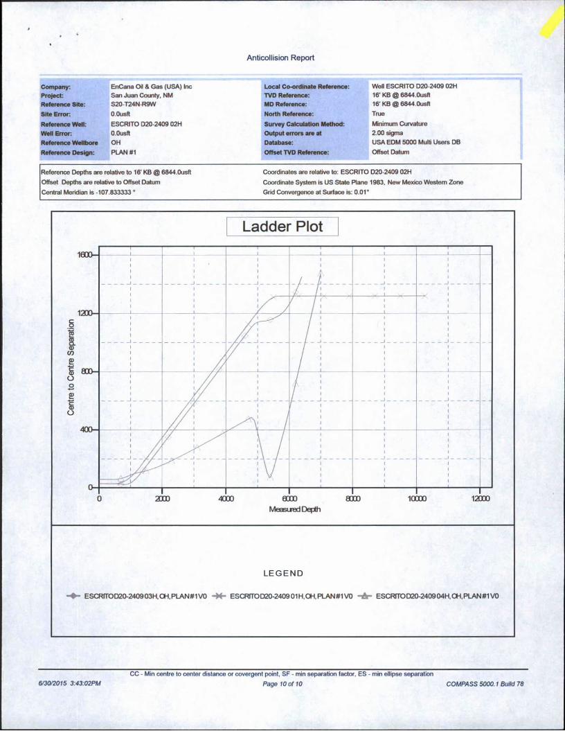
Reference Depths are relative to 16' KB @ 6844.0usft Coordinates are relative to: ESCRITO D20-2409 02H
Offset Depths are relative to Offset Datum Coordinate System is US State Plane 1983, New Mexico Western Zone
Central Meridian is -107.833333 ° Grid Convergence at Surface is: 0.01*
Ladder Plot
LEGEND
ESCRfTOD20-240903H,CH,PLAN#1 VO ESCRfTOD20-2409 01H,OH, PLAN #1 VO -A- ESCRfTOD20-2409 04H,CH,PLAN#1 VO
6/30/2015 3:43:02PM
CC - Min centre to center distance or covergent point, SF - min separation factor. ES - min ellipse separation
Page 10 of 10 COMPASS 5000.1 Build 78
Escrito D20-2409 02H SHL: NWNW Section 20, T24N, R9W
1,210’ FNL and 264’ FWL BHL: SWNW Section 19, T24N, R9W
1,980’ FNL and 330’ FWL San Juan County, New Mexico Lease Number: NMNM 4958 and BIA N0-G-0103-1462
If the location becomes prone to wind or water erosion, Encana will take appropriate measures to prevent topsoil loss from wind. Such measures may include using tackifiers or water to wet the topsoil stockpile so that a crust is created across the exposed soil to prevent soil loss.
3. All construction materials for the well pad will consist of native borrow and subsoil accumulated during well pad construction. If additional fill or surfacing material is required, it will be obtained from existing permitted or private sources and will be hauled in by trucks over existing access roads.
The maximum cut will be approximately 14.4 feet on corner 2 and the maximum fill will be approximately 12.8 feet on corner 6.
4. As determined during the onsite on April 01, 2015, the following best management practices will be implemented:a. Water will be diverted around the pad from corner 2 toward corner 6. Water will be
diverted around the pad from comer 2 toward comer 3 and around to comer 5. Water will naturally fan out between corner 5 and corner 6.
b. One silt trap will be installed in EOD at corner 3.
5. Construction equipment may include chain saws, a brush hog, scraper, maintainer, excavator, and dozer. Construction for the access road and well pad will take approximately 2 to 4 weeks.
C. PipelineSee the Plan of Development submitted with the final modifications to the Standard Form 299 Application for authorization to construct, operate, maintain and terminate a 5,740 foot, up to 6- inch buried, steel well connect pipeline that was submitted to the Bureau of Land Management concurrently with this APD.
7. METHODS FOR HANDLING WASTEA. Cuttings
1. A closed-loop system will be used. Cuttings will be moved through a shaker system on the drill rig that separates drilling fluids from the cuttings. Cuttings will be stored onsite in aboveground storage tanks. Cuttings will be pulled from the storage tanks, mixed with saw dust or similar absorbent material, and disposed of at the Envirotech, Inc. and/or Industrial Ecosystem, Inc. waste disposal facilities.
2. The closed-loop system storage tanks will be adequately sized to ensure confinement of all fluids and will provide sufficient freeboard to prevent uncontrolled releases.
3. A 20-mil liner will be installed under tanks, pumps, ancillary facilities, and truck loading/unloading areas associated with the closed-loop system.
B. Drilling Fluids1. A closed-loop system will be used. Drilling fluids will be stored onsite in above-ground
storage tanks. Upon termination of drilling operations, the drilling fluids will be recycled and transferred to other permitted closed-loop systems or returned to the vendor for reuse, as practical. Residual fluids will be vacuumed from the storage tanks and disposed of at Basin Disposal, Inc. and/or Industrial Ecosystem, Inc. waste disposal facilities.
-6-

A
ENCANA OIL & GAS (USA) INC.ESCRITO D20-2409 #02H
1210' FNL&264’ FWLLOCATED IN THE NW/4 NW/4 OF SECTION 20, T24N, R9W, N.M.P.M.,
SAN JUAN COUNTY, NEW MEXICO
DIRECTIONS
1) FROM THE INTERSECTION OF HWY 64 & HWY 550 IN BLOOMFIELD, TRAVEL SOUTH FOR 28.2 MILES TO HWY 57. (BLANCO TRADING POST, M.P. 123.4).
2) TURN RIGHT ONTO HWY 57 AND GO 2.3 MILES TO DIRT ROAD.3) TURN LEFT ONTO DIRT ROAD AND GO 1.7 MILES TO PIPELINE CORRIDOR.4) TURN RIGHT AND GO 1.7 MILES.5) TURN RIGHT AND GO 0.3 MILES WHERE ACCESS IS STAKED ON RIGHT SIDE OF ROAD.
WELL FLAG LOCATED AT LAT. 36.303474° N, LONG.107.820488° W (NAD 83).
CCI
CHENAULT CONSULTING INC.4«00 COUEGE BLVD.
SUITE 201rAPMINGION, NM 67AOZ
(505)325-7707
JOB No.: ENC210 DATE: 10/01/2014 DRAWN BY: TWT Sheet C

WELLHEAD BLOWOUT CONTROL SYSTEM
encana Well Name and Number: Escrito D20-2409 02H
t- 11” 3K Rotating Head
11” 3K Annular
3K Double Ram Top: Pipe Ram
Bottom: Blind Ram 3” Outlets B&JUm Ram
3K Mud Cross 3” gate valves
AOMtULiOOC