state of new mexico energy, minerals and natural resources...
TRANSCRIPT

State of New MexicoEnergy, Minerals and Natural Resources Department
Susana MartinezGovernor
Tony DelfinActing Cabinet Secretary
David R. Catanach, Division DirectorOil Conservation Division
New Mexico Oil Conservation Division approval and conditions listed below are made in accordance with OCD Rule 19.15.7.11 and are in addition to the
actions approved by BLM on the following 3160-3 APD form.
Operator Signature Date: \ V* \ VcWell informations |Operator XjoV*Well Name and Number \ V ^Ym V l V\
API#*,t>cM5V gffigCQ. Section*^ . Township^^^6, Range
Conditions of Approval: (See the below checked and handwritten conditions)
Notify Aztec OCD 24hrs prior to casing & cement.
/K Hold C-104 for directional survey & “As Drilled” Plat
X Hold C-104 fo^NSl) NSP, DHC
o Spacing rule violation. Operator must follow up with change of status notification on other well to be shut in or abandoned
o Regarding the use of a pit, closed loop system or below grade tank, the operator must comply with the following as applicable:
• A pit requires a complete C-144 be submitted and approved prior to the construction or use of the pit, pursuant to 19.15.17.8.A
• A closed loop system requires notification prior to use, pursuant to 19.15.17.9.A
• A below grade tank requires a registration be filed prior to the construction or use of the below grade tank, pursuant to 19.15.17.8.C
o Once the well is spud, to prevent ground water contamination through whole or partial conduits from the surface, the operator shall drill without interruption through the fresh water zone or zones and shall immediately set in cement the water protection string
o Submit Gas Capture Plan form prior to spudding or initiating recompletion operations^Regarding Hydraulic Fracturing, review EPA Underground Injection Control Guidance 84
^Oil base muds are not to be used until fresh water zones are cased and cemented providing
isolation from the oil or diesel. This includes synthetic oils. Oil based mud, drilling fluids and solids must be contained in a steel closed loop system.
^Well-bore communication is regulated under 19.15.29 NMAC. This requires well-bore
Communication to be reported in accordance with 19.15.29.8.
Date
1220 South St Francis Drive ■ Santa Fe. New Mexico 87505 Phone (505) 476-3460 • Fax (505) 476-3462 ■ www.emnrd.state.nm.us/ocd

& If Indian, Allotec
INITAL
r’ U __ j n__i__i\-»____*____ricia ana root, or txjMoraiory
BROOK MANCOS W / LYBROOK MA
21. Elevations (Show whether DF, KDB, RT, GL, etc.)
Permitting T(
Fonn3160-3 (March 2012)
OIL CONS. DIV DIST.
DEC 08 2016UNITED STATES
DEPARTMENT OF THE INTERIOR
BUREAU OF LAND MANAGEMENT
APPLICATION FOR PERMIT TO DRILL OR REENTER
FORM APPROVED OMB Wo, 1004-0137
^^mer31.20M
la. Type of work: 0DRILL DREENTER
lb. Type of WcB: 0OilWcH □GhWcII □otha
1 Name of Operator
□Single Zone 0 Multiple Zone
WPX ENERGY LLC
3a. Address720 S Main Aztec NM 87410
3b. Phone No. (mchde ana code)
(505)333-1822
4. Location of Well (Rtpon location ckarty and m accordance with any Site nqmmeris. ’)At surfi^ SESW /1205 FSL /1327 FWL / LAT 36.237645 / LONG -107.709055
JSSSWSW /1012 FSL / 824 FWL / LAT 36251751 / Li
14. Distance in miles and direction from nearest town or pod office* 37,8 miles ' ______________
15 Distance from proposed*i to nearest 20 feet
r lease line, 11lime, if any)
18.1205 feet
The following, completed in accordance with the
1. Well plat certified by a registered surveyor.
1 A Drilling Plan.
3. A Surface Use Plan Of the location is on Natiooal SUPO must be filed with the
23. Signature
Title
Approved by
rule
160
Lands, the
Earns October 31
5. Lease Serial No. N0G14031908
11. Sec., T. R.M. or Blk. and Survey or Area
SEC 8 / T23N / R8W / NMP
12. County or Parish
SAN JUAN
13. State
NM
Spacing Unit dedicated to this well
367.16
20. BLM/B1A Bond Na on file
IND: B001576
23 Estimated duration
30 days
Gas Order No. 1, must be attached to this form:
4. Bond to cover (he operations unless covered by an existing bond on file (sec Item 20 above).
5. Operator certification
6. Such other site specific information and/or plans as may be required by the
Name (PrinledfTypcd)
Lacey Granillo / Ph: (505)333-1816
Dale11/03/2016
Name (Printed/Typed)
Office
FARMINGTON
the applicant holds legal or equitable title to those rights m
Title 18States any Use, fictitious or fraudulent
and Tale 43 U.S.G Section 1212, make it a crime for anyor representations as to tny matter within its
and willfully to make to any department or agency of the United
(Continued on page 2)
This action is subject to technical and procedural review pursuant to43 CFR 3165.3 and appeal
pursuant to 43 CFR 3165.4
Bl M'S APPROVAL OR ACCEPTANCE OF THIS
ACTION DOES NOT RELIEVE THE LESSEE AND
OPERATOR FROM OBTAINING ANY OTI1ER
AUTHORIZATION REQUIRED FOR OPERATIONS
ON FEDERAL AND INDIAN LANDS
“(Instructions on page 2)
DRILLING OPERATIONS AUTHORIZED ARE SUBJECT TO
COMPLIANCE WITH ATTACHED
"GENERAL REQUIREMENTS"
NMOCD

District I1625 n. French Drive, hoops. nm 88240 Phone: <575) 393-6161 Fax: (575) 393-0720
District II811 S. First Street. Antesia. m 88210 Phone (575) 748-1283 Fax: (575) 748-9720
District III1000 Rio Brazos Road. Aztec, nw 87410 Phone (505) 334-6178 Fax (505) 334-6170
District IV1220 S. St Francis Drive. Santa Fe. NM 87505 Phone: (505) 476-3460 Fax: (505) 476-3462
State of New MexicoEnergy. Minerals £ Natural Resources Department
OIL CONSERVATION DIVISION1220 South St. Francis Drive
Santa Fe. NM 87505
Form C-102 Revised August 1. 2011
Submit one copy to Appropriate (District Office
□ AMENDEO REPORT
“ ‘API Number j 'Pool Codego-a\5-358Chl <1215-1
WELL LOCATION AND ACREAGE DEDICATION PLAT---------------------------------------------- ’Pool TSk
LYBROOK MANCOS W‘Property Code
3JS<?ST>’Property Name
W LYBROOK UNIT‘Well Number
711H'oGRID NO.
120782'Operator Name
WPX ENERGY PRODUCTION. LLC•Elevation
6823‘
10 Surfacea or lot no. Section ToMwnto Lot br Feet from the Mortn/Sauth line Feet from tne Eeet/weet line --------(SSt?
N 8 23N BW 1205 SOUTH 1327 WEST SAN JJAN
Location
11 Bottom Hole Location If Different From Surfacea ar lot no.
MSection
6Teems®
23N BWtot Ur
10Feet free tfe
1012KrWSnutn lire
SOUTHFeet free the
824Eeet/weet line
WESTCanty
SAN JUAN
“““T* s/2 SW/4 - Section 6NE/4 NW/4 NW/4 ^/A
“joint or Infill “ Coneolioetion Cadi “Me- ND
R-14051 - 12,807 2.A Acres
W/2 SW/4 - Section 8
(RECORD)SS932W 265432
S99 "2751V 2653.43
(RECORD)NB9"57V 265135'
S»‘SB*43V 265036NB9 "57 V 2651.55
S89‘5B24'W 265023 PCASLRED)
1 __5 —
OCASLRED)sea "2136V 262239
NB937V 260135 SS9 "59 OQV 2630.T3
0€A9J€D)
NO ALLOWABLE WILL BE ASSI&CD TO THIS COMPLETION UNTIL ALL
INTERESTS HAVE BEEN CONSOLIDATED OR A NON-STANDARD UNIT HAS
BEEN APPROVED BY THE DIVISION
BC-DF-LATERAL 1012 FSL 824 FVL
SEC 6 TZ3H RSW LAT: 36251730 "N
LONG: 107726 774 V OATIM NA01927
LAT: 36251751 "N LONS: 107.729307 V
OATIM NAD 1963(P€ASJ€OI
sea "20 06-W 262422
SB9"24V
POINT-OF-ENTRY 769 FSL 883' FML SEC & T23i PBV LAT: 36.236422 "N
LONG- 107.709948 V DATUM NAD 1927
LAT: 36236435 "N LONG 107.710360 V
OATIM NAD 1983
04
M955 43V 263064 NB932V 2632.74‘
(RECORD)
MEASWED) SB9m16 40V 2635.30
S89"26V 2634.06' (RECORD)
OCAStRET)/’S89 "2100 V 264329"
S89"25V 2646.93 (RECORD)
0CASUPEO) S89"16 41V 264606
S09"25V 2646.93 (RECORD)
17 OPERATOR CERTIFICATION1 hereby certify that the information contained herein is true and complete to tne beat of ay knowledge end belief, and that this orgenuation either owns a working interest or isUeasea
land inciting the i a nsrt [xrsuant
of suer a mineral
tne '
“SURVEYOR CERTIFICATIONt nsraby certify that tne well location
plat was 1 sweys
ahom on this of
plotted froa field Mde by m or mar
anc tnat the sane is true correct to the best of ey belief.
Date Revised: NOVEMBER Z 2016 Survey Date: OCTOBER 24. 2016
Jason C. EdwardsCertificate Nutter 15269
WPXENERGY
WPX Energy
Operations Plan
(Note: This procedure will be adjusted onsite based upon actual conditions)
Date: November 2,2016 Field: Lvbrook Mancos W
Well Name: W Lybrook #711H Surface:
SH Location: SESW Sec 8 23N-08W Elevation: 6823' GR
BH Location: SWSW Sec 6 23N-08W Minerals:
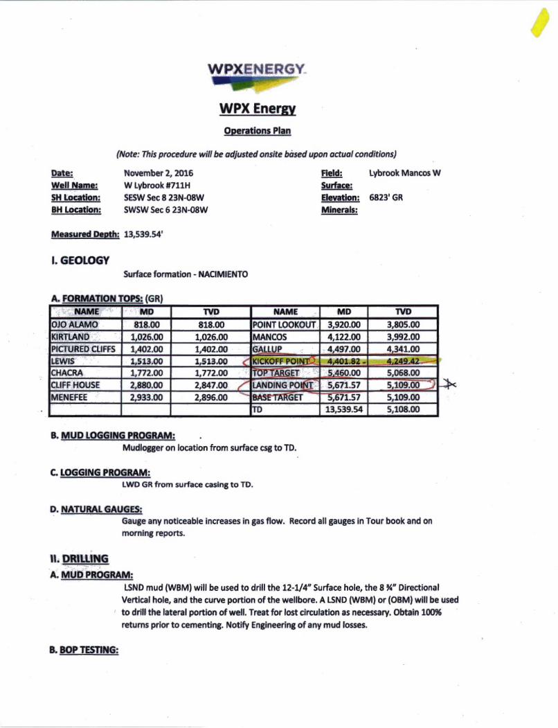
Measured Depth: 13,539.54'
I. GEOLOGY
Surface formation - NACIMIENTO
A. FORMATION TOPS: (GR)
NAME ^MD TVD NAME MD TVD
OJO ALAMO 818.00 818.00 POINT LOOKOUT 3,920.00 3,805.00
KIRTLAND 1,026.00 1,026.00 MANCOS 4,122.00 3,992.00
PICTURED CLIFFS 1,402.00 1,402.00 GALLUP 4,497.00 4,341.00
LEWIS 1,513.00 1,513.00 KICKOFF POINT l 4,401.82 - 4,249.42CHACRA 1,772.00 1,772.00 toptarget 5,460.00 5,068.00CLIFF HOUSE 2,880.00 2,847.00 LANDING POINT 5,671.57 5,109.00
MENEFEE 2,933.00 2,896.00 BASFTARGET 5,671.57 5,109.00
TD 13,539.54 5,108.00
B. MUD LOGGING PROGRAM:Mudlogger on location from surface csg to TD.
C. LOGGING PROGRAM:LWD GR from surface casing to TD.
D. NATURAL GAUGES:Gauge any noticeable increases in gas flow. Record all gauges in Tour book and on
morning reports.
It. DRILLING
A. MUD PROGRAM:LSND mud (WBM) will be used to drill the 12-1/4" Surface hole, the 8 %" Directional
Vertical hole, and the curve portion of the wellbore. A LSND (WBM) or (OBM) will be used
to drill the lateral portion of well. Treat for lost circulation as necessary. Obtain 100%
returns prior to cementing. Notify Engineering of any mud fosses.
B. BOP TESTING:

While drill pipe is in use, the pipe rams and the blind rams will be function tested once
each trip. The BOPE will be tested to 2,000 psi (High) for 10 minutes and the annular tested to 1,500 psi for 10 minutes. Pressure test surface casing to 1,500 psi for 30 minutes
and intermediate casing to 1,500 psi for 30 minutes. Utilize a BOPE Testing Unit with a recording chart and appropriate test plug for testing. All tests and inspections will be
recorded in the tour book as to time and results.
111. MATERIALS
A.
CASING TYPE DEPTH (MD) CSG SIZE WEIGHT GRADE [£1M
SURFACE 12.25" 320.00' 9.625" 36 LBS J-55 or equiv STC
INTERMEDIATE 8.75" 5,671.57' r 23 LBS J-55 or equiv LTC
PRODUCTION 6.125" 5521.57' -13,539.54 4.5" 11.6 LBS P-110 or equiv LTC
TIE BACK 6.125" Surf. - 5521.57’ 4.5" 11.6 LBS P-110 or equiv LTC
B. FLOAT EQUIPMENT:1. SURFACE CASING:
9-5/8“ notched regular pattern guide shoe. Run (1) standard centralizer on each of
the bottom (4) joints of Surface Casing.
2. INTERMEDIATE CASING:
7" cement nose guide shoe with a self-fill insert float. Place float collar one joint above the shoe. Install (1) centralizer on each of the bottom (3) joints and one
standard centralizer every (3) joints to 2,500 ft. Run (1) centralizer at 2,500 ft.,
2,300ft., 2,000ft., 1,500 ft, and 1,000 ft. If losses are encountered during the drilling
of the intermediate section a DV tool will be utalized and a 2 stage cement job may be planned to ensure cement circ back to surface. The DV tool will be placed 100'
above the top of the Chacra formation. If cement is circulated back to surface on the first stage, a cancelation device will be dropped to shift the dv tool closed and the
2nd stage cement job will be aborted at that time, if no cement is seen at surface on
the 1st stage the stage tool will be opend and a 2nd stage cement job will be
pumped.
3. PRODUCTION LINER:
Run 4-1/2* Liner with cement nose guide Float Shoe + 2jts. of 4-1/2* casing + Landing
Collar + 4-1/2* pup joint + 1 RSI (Sliding Sleeve) positioned inside the 330ft Hard line.
Centralizer program will be determined by Wellbore condition and when Lateral is
evaluated by Geoscientists and Reservoir Engineers. Set seals on Liner Hanger. Test TOL to 1500 psi for 15 minutes.
C. CEMENT: (Note: Volumes may be adjusted onsite due to actual conditions)
1. Surface:5 bbl Fresh Water Spacer, 100 sx (160 cu.ft.) of 14.5 ppg Type l-ll (Neat G) + 20% Fly Ash cement w/ 7.41 gal/sack mix water ratio @ 1.61 cu ft/sx yield. Calculated @
volume + 50% excess. WOC12 hours. Test csg to 600psi. Total Volume: (160 cu-
ft/100 sx/ Bbls).TOC at Surface.
2. Intermediate:
Spacer #1:20 bbl (112 cuft) Chemwash. Lead Cement: 108 bbls, 308 sks, (607 cuft),
12.3 ppg @ 1.97 cuft/sk yield. Tail Cement: 59 bbls, 254 sks, (331 cuft), 13.5 ppg @
1.3 cuft/sk yield. Displacement: Displace w/ +/- 223 bbl Drilling mud or water.
Total Cement: 167 bbls, 563 sks, (938 cuft)
3. Prod Liner:

Spacer 1(1:10 bbl (56.cu-ft) Water Spacer. Spacer 02: 40 bbl 9.5 ppg (224.6 cu-ft)
Tuned Spacer III. Spacer 03:10 bbl Water Spacer. Lead Cement: Extencem " System. Yield 1.36 cuft/sk 13.3 ppg (786 sx /1068 cuft /190 bbls). Tail Spacer: 20 BBL of
MMCR. Displacement: Displace w/ +/-182bbl Fr Water. Total Cement (786 sx
/1068bbls).
D. COMPLETION:Run CCL for perforating
A. PRESSURE TEST:1. Pressure test 4-1/2" casing to 4500 psi max, hold at 1500 psi for 30 minutes.
Increase pressure to Open RSI sleeves.
B. STIMULATION;1. Stimulate with approximately 2,805,0000 20/40 mesh sand and 340,000016/30
mesh sand in 619,113 gallons water with 42,696 mscf N2 for 17 stages.
2. Isolate stages with flow through frac plug.
3. Drill out frac plugs and flowback lateral.
C RUNNING TUBING:1. Production Tubing: Run 2-7/8", 6.50, J-55, EUE tubing with a SN on top of bottom
joint. Land tubing near Top of Liner.
If this horizontal well is drilled past the applicable setbacks, an unorthodox location application is not
required because the completed interval in this well, as defined by 19.15.16.7 B(l) NMAC,will be entirely within the applicable setbacks . This approach complies with all applicable rules, including 19.15.16.14 A(3)
NMAC, 19.15.16.14 B(2) NMAC, 19.15.16.15 B(2)NMAC, and 19.15.16.15. B(4) NMAC.
NOTES:A 4-1/2" 11.6# P-110 Liner will be run to TD and landed +/-150 ft. into the 7" 23# J-55
Intermediate casing with a Liner Hanger and pack-off assembly then cemented to top of
liner hanger.
After cementing and TOL clean up operations are complete, the TOL will be tested to 1500
psi (per BLM).
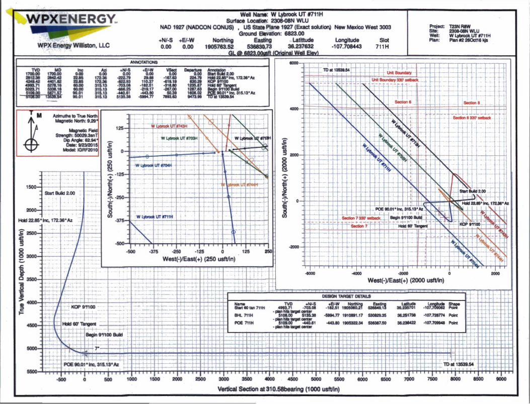
WPXENERGY.
WPX Energy Williston, LLC
Well Name: W Lybrook UT #711H Surface Location: 2308-08N WLU
NAD 1927 (NADCON CONUS) , US State Plane 1927 (Exact solution) New Mexico West 3003Ground Elevation: 6823.00
+N/-S +E/-W Northing Easting .Latrttude Longitude Slot0.00 0.00 1905763.52 536830.73 36.237632 -107.708443 711H
310 M23,0Q«n (Original m\ Htvl
ANNOTATIONS
Project:Site:Well:Plan:
T23N RaW 2308-08N WLU W Lybrook UT #711H Plan #2 260ct16 kjs
9000
Vertical Section at 310.58bearing (1000 usft/in)
♦N/-S -EAWa oo 0.00
-222.79 29.66-822.93 110.37-703 08 -182.51-666.25 -219.17440.61 -443.80
5135.38 -5994.77
VSect0.00
-167.63-619.19-318.80-267.00
50.397893.63
Departure■■■000 Start BuId 2.00
224.79 830.29
1235.67 1287.63 1606 02 9473 99
Hold 22.85" Inc, 172.36*Az KOP 9 7100 Hold 80 Tangent Begin 97100 Bj M TOE 90.01* Inc. 315.13* Az
TD*1 13539.54
M Azimuths to True North / ^ Magnetic North: 929*
Magnetic Field th: 50029.3snT
a/2a^oi5 Model: IGRF2010
West(-)/East(+) (2000 usft/in)
Azi 0.00
172 36 172.36 315 13 316.13 316.13 316.13

WPXENERGY.
WPX EnergyT23N R8W 2308-08N WLUW Lybrook UT #711H - Slot 711H
Wellbore #1
Plan: Plan #2 260ct16 kjs
Standard Planning Report - Geographic
28 October, 2016
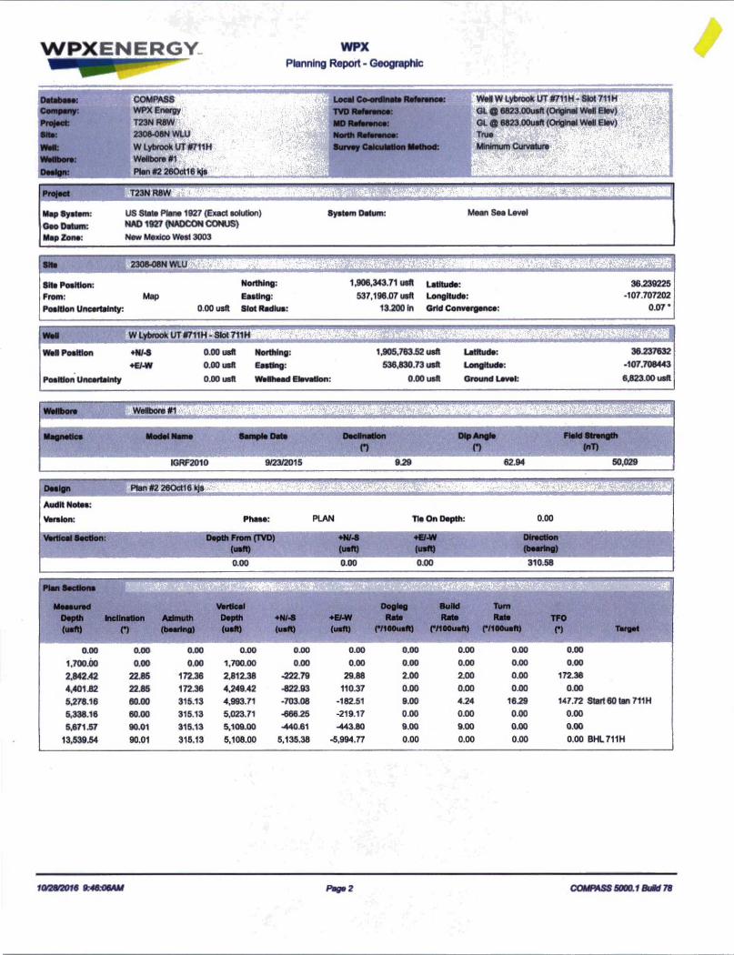
WPXENERGY WPXPlanning Report - Geographic
/Database: COMPASS ' Local Co-ordinate Reference:
Company: WPX Energy TVD Reference:
Project:
Site:
1 T23N R8W
2308-08N WLU
| MO Reference:
North Reference:
Wall: W Lybrook UT #711H 'l Survey Calculation Method:
Wallbora:
Design:
1 Wellbore «1 ^
Plan #2 260ct16 kjs
WelW Lybrook UT#711H-8lot711HOL ® 6823.00usft (Original Well Elev) |
GL ® 6823.00usft (Original Well Elev)Trua £
Minimum Curvature
rS f .'Vi-vIVK:
US State Plane 1927 (Exact solution) NAD 1927 (NADCON CONUS)
New Mexico West 3003
System Datum: Mean Sea Level
Site 2308-08N' mm
Site Position:
From:
Position Uncertainty:
Map
Northing:
Easting:
0.00 usft Slot Radius:
1,906,343.71 usft
537,196.07 usft
13.200 In
Latitude:
Longitude:
Grid Convergence:
36.239225
-107.707202
0.07*
Well W Lybrook UT4711H - Slot 711H
Wall Position +N/-5 0.00 usft Northing: 1,905,763.52 usft Latitude: 36 237632
e€AW 0.00 usft Easting: 536,630.73 usft Longitude: -107.708443
Position Uncertainty 0.00 usft Wellhead Elevation: 0.00 usft Ground Level: 6,823.00 usft
10/28/2016 9 46V6AM Page 2 COMPASS 5000.1 BuM 78
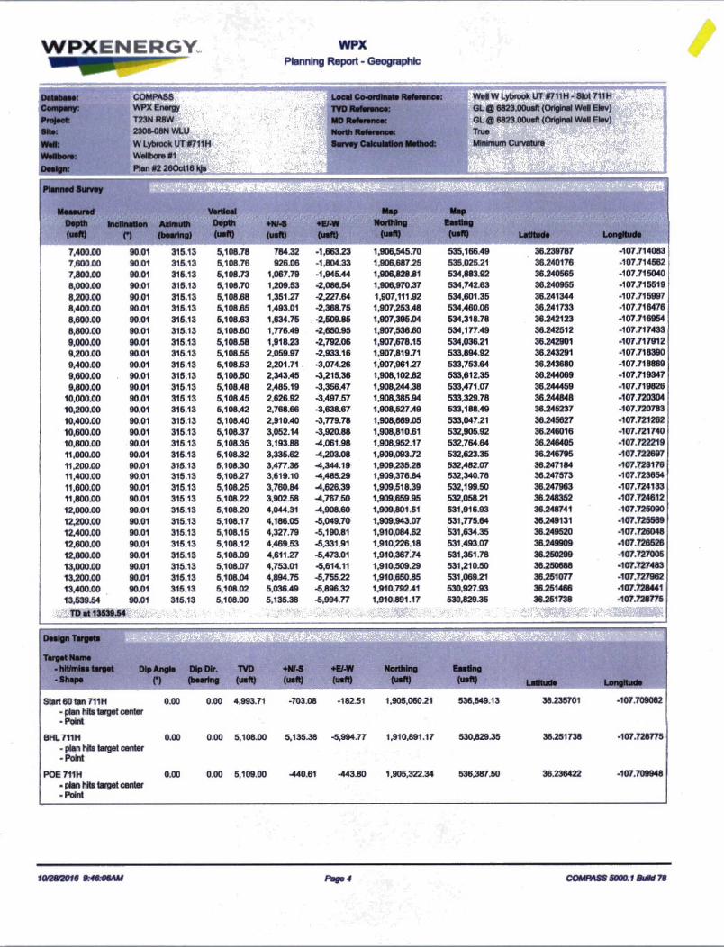
WPXENERGY WPXPlanning Report - Geographic
Company:
Pro)>et
Wellbore:
COMPASS
T23NR8W|^> '
2308-08N WLU WLybrookUTHfJgpS Wellbore #l|§
PtaMMOctMil _
Local Co-ordinate Reference
TVD Reference:
MO Reference:
North Reference:
Survey Calculation Method:
WeH W Lybrook JT S711H - Slot 711H
GL © 6823.00usft (Original We« Elev)
GL © 6823.00usfl (Original WeH Elev) True mm
Measured
Depth Inclination Azimuth
Vertical
Depth ♦N/-S ♦El-W
Map
Northing
Map
Easting
(usft) n (bearing) (usft) (usft) (usft) (usft) (usft) Latitude Longitude
7,400.00 90.01 315.13 5,108.78 784.32 -1,663.23 1,906.545.70 535,166.49 36.239787 -107.714083
7,600.00 90.01 315.13 5,108.76 926.06 -1.804.33 1,906.687.25 535,025.21 36.240176 -107.714562
7,800.00 90.01 315.13 5,108.73 1,067.79 -1,945.44 1,906,828.81 534.883.92 36.240565 -107.715040
8,000.00 90.01 315.13 5,108.70 1.209.53 -2,086.54 1,906,970.37 534.742.63 36.240955 -107.715519
8.200.00 90.01 315.13 5.108.68 1.351.27 -2.227.64 1.907,111.92 534.601.35 36.241344 -107.715997
8,400.00 90.01 315.13 5,108.65 1,493.01 -2,368.75 1,907,253.48 534,460.06 36.241733 -107.716476
8,600.00 90.01 315.13 5,108.63 1.634.75 -2,509.85 1,907,395.04 534,318.78 36.242123 -107.716954
8.800.00 90.01 315.13 5,108.60 1,776.49 -2.650.95 1,907,536.60 534.177.49 36.242512 -107.717433
9,000.00 90.01 315.13 5,108.58 1,918.23 -2,792.06 1,907,678.15 534,036.21 36.242901 -107.717912
9,200.00 90.01 315.13 5,108.55 2,059.97 -2,933.16 1,907,819.71 533.894.92 36.243291 -107.718390
9,400.00 90.01 315.13 5,108.53 2,201.71 -3,074.26 1,907,961.27 533,753.64 36.243680 -107.718869
9,600.00 90.01 315.13 5,108.50 2,343.45 -3,215.36 1,908,102.82 533,612.35 36.244069 -107.719347
9,800.00 90.01 315.13 5,108.48 2,485.19 -3.356.47 1.908,244.38 533,471.07 36.244459 -107.719826
10,000.00 90.01 315.13 5,108.45 2,626.92 -3,497.57 1,908,385.94 533,329.78 36.244848 -107.720304
10,200.00 90.01 315.13 5,108.42 2,768 66 -3,638.67 1,908,527.49 533,188.49 36.245237 -107.720783
10,400.00 90.01 315.13 5,108.40 2,910.40 -3,779.78 1,908,669.05 533,047.21 36.245627 -107.721262
10,600.00 90.01 315.13 5,108.37 3,052.14 -3,920.88 1,908,810.61 532,905.92 36.246016 -107.721740
10,800.00 90.01 315.13 5,108.35 3,193.88 -4,061.98 1,908,952.17 532,764.64 36.246405 -107.722219
11,000.00 90.01 315.13 5,108.32 3,335.62 -4,203.08 1,909,093.72 532,623.35 36.246795 -107.722697
11,200.00 90.01 315.13 5,108.30 3,477.36 -1,344.19 1,909,235.28 632,482.07 36.247184 -107.723176
11.400.00 90.01 315.13 5,108.27 3,819.10 -4,485.29 1,909,376.84 532,340.78 36.247573 -107.723854
11,600.00 90.01 315.13 5,108.25 3,760.84 -4,626.39 1,909,518.39 532,199.50 36.247963 -107.724133
11,800.00 90.01 315.13 5,108.22 3,902.58 -4,767.50 1,909,659.95 532,058.21 36.248352 -107.724612
12,000.00 90.01 315.13 5,108.20 4,044.31 -4,908.60 1,909,801.51 531,916.93 36.248741 -107.725090
12,200.00 90.01 315.13 5,108.17 4.186.05 -5,049.70 1,909,943.07 531,775.64 36.249131 -107.725569
12,400.00 90.01 315.13 5,108.15 4,327.79 -5,190.81 1,910,084.62 531,634.35 36.249520 -107.726048
12.600.00 90.01 315.13 5,108.12 4,469.53 -5,331.91 1,910,226.18 531,493.07 36.249909 -107.726526
12,800.00 90.01 315.13 5,108.09 4,611.27 -5,473.01 1,910,367.74 531,351.78 36 250299 -107.727005
13,000.00 90.01 315.13 5,108.07 4,753.01 -5,614.11 1,910,509.29 531,210.50 36.250688 -107.727483
13,200.00 90.01 315.13 5,108.04 4,894.75 -5,755.22 1,910,650.85 531.069.21 36.251077 -107.727962
13,400.00 90.01 315.13 5,108.02 5,036.49 -5,896.32 1,910,792.41 530,927.93 36.251466 -107.728441
13,539.54 90.01 315.13 5,108.00 5,135 38 -5,994.77 1,910,891.17 530,829.35 36.251738 -107.728775
m TD at 13539.54- i MW
Design Targets
Target Name- hit/mlas target Dip Angle Dip Dir. TVD +N/-S +E7-W Northing Easting
-Shape o (bearing (usft) (usft) (usft) (usft) (usft) Latitude Longitude
Start 60 tan 711H 0.00 0.00 4.993.71 -703.08 -182.51 1,905,060.21 536,649.13 36.235701 -107.709062
- plan hits target center -Point
BHL711H 0.00 0.00 5,108.00 5,135.38 -5,994.77 1,910,891.17 530,829.35 36.251738 -107.728775
- plan hits target center -Point
POE 711H 0.00 0.00 5,109.00 -440.61 -443.80 1.905,322.34 536,387.50 36.236422 -107.709948
- plan hits target center -Point
10^2872010 9 46V6AU Page4 COMPASS 5000.1 BuOd 78
WPXENERGY WPXPlanning Report - Geographic
Database: COMPASS Local Co-ordinate Rafaranca: Well W Lybrook ITT
Company: WPX Energy TVD Rafaranca: OL ® 6823.00uaft (Original Well Elev)
Project: T23N R8W MO Rafaranca: OL 0 6823.00uaft (Original Well Elev)
She: 2308-08N WLU North Rafaranca: Trua ;
WMfc
Wellbore
W Lytorook UT #711H
Wellbore #1
Survey Calculation Method: Minimum Curvature
Dwlgn: Ran #2 260cl16 kjs ',rr
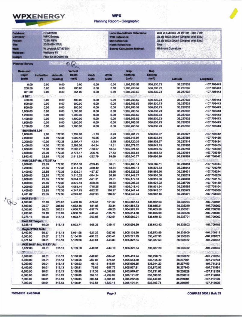
Planned Survey(TiO
Measured Vertical Map Map
Depth Inclination Azimuth Depth ♦N/-S ♦E/-W Northing Easting
(ueft) n (bearing) <uen> (uaft) (uaft) (uaft) (uaft) Latitude Longitude
0.00 0.00 0.00 0.00 0.00 0.00 1.905,763.52 536.830.73 36.237632 -107.708443
200.00 0.00 0.00 200.00 0.00 0.00 1.905,763.52 536.830 73 36.237632 -107.708443
351.00 0.00 0.00 351.00 0.00 0.00 1,905,763.52 536,830.73 36.237632 -107.708443
85/8“400.00 0.00 0.00 400.00 0.00 0.00 1,905,763.52 536,830.73 36.237632 -107.708443
600.00 0.00 0.00 600.00 0.00 0.00 1,905,763.52 536.830.73 36.237632 -107.708443
800.00 0.00 0.00 800.00 000 0.00 1.905,763.52 536.830 73 36 237632 -107.706443
1.000.00 0.00 0.00 1,000.00 0.00 0.00 1.905.763.52 536.830 73 36.237632 -107.708443
1.200.00 0.00 0.00 1,200.00 000 0.00 1.905.76382 536830.73 36 237632 -107.708443
1.400.00 0.00 0.00 1,400.00 0.00 0.00 1.905,76382 536,830 73 36.237632 -107.708443
1.600 00 0.00 0.00 1.600.00 0.00 0.00 1.905.763.52 536.830.73 36.237632 -107.706443
1.700.00 0.00 0.00 1,700.00 000 0.00 1,905.76382 536,830 73 36 237632 -107.706443
Start Sul Id 2.001.800.00 2.00 172.36 1,799.98 -1.73 0.23 1,905,761.79 536.830.97 36.237627 -107.708442
2.000.00 6.00 172.36 1,999 45 -15.55 2.09 1.905,747.97 536,832.84 36.237589 -107.708436
2,200.00 10.00 172.36 2,197.47 -43.14 5.79 1,905,720.39 536,836.57 38.237514 -107.708424
2.400.00 14.00 172.36 2,393 06 -84 34 11.31 1,905.679 20 536.842.15 36.237400 -107.708405
2,600.00 18.00 172.36 2,585.27 -138.97 18.64 1,905,624.58 536,849.55 36.237250 -107.708380
2.800.00 22.00 172.36 2.773.17 -206.75 27.73 1,905,556.81 536,858.73 36.237064 -107.708349
2.84242 22.86 172.36 2412.38 -222.79 29.88 1.908.640.77 636860.90 36.237020 -107.708342
Hold 22.85* Inc. 172.36* Az ■ 5 jj,
3.000.00 22.85 172.36 2,957.60 -283.43 38.01 1,905,480.14 536,869.11 36.236853 -107.708314
3,200.00 22.85 172.36 3.141.90 -360.40 48.34 1,905,403.18 536.879.53 36.236642 -107.706279
3.400.00 22.85 172.36 3,326.21 -437.37 58.66 1,905,326.22 536,889.96 36.236431 -107.708244
3.600.00 22.85 172.36 3,510.52 -514.34 68.98 1,905,249.27 536.900.38 36.236219 -107.708209
3.800.00 22.85 172.36 3.694.82 -591.31 79.31 1,905,172.31 536,910.80 36.236008 -107.708174
4,000.00 22.85 172.36 3,879.13 -668.28 89.63 1,905,095 35 536,921 22 36.235796 -107.708139
4,200.00 22.85 172.36 4.063 44 -745 25 99.95 1,905,018.40 536,931.64 36.235585 -107.708104
4,400.00 22.85 172.36 4,247.75 -82222 110.27 1.904,941.44 536,942.07 36.235373 -107.708069
4.401.82 22.85 172.36 4.249.42 -822.93 110.37 1,904,940.74 536.942 16 36.235371 -107.708069
KOP9*/100*v
4.600.00
4.800.00
12.10 22367 4.439.16 -876.51 101.07 1,904,887.14 536,932.93 36.235224 -107.708101
20.07 286 69 4,63246 -881.86 53.34 1,904,881.73 536.885.21 36.235210 -107.708262
5.000.00 36.02 30521 4,808.73 -837.74 -2825 1,904,925.75 536.803.56 36.235331 -107.708539
5.200.00 53.19 313.03 4,950.70 -748.47 -135.70 1,905,014.88 536.695.99 36.235576 -107.708903
5,278.16 60.00 315.13 4,993.71 -703.08 -182.51 1,905,060.21 536.649.13 36.235701 -107.709062
^ Hold 60' rangent5,338.18 60.00 315.13 5,023.71 -666.25 -219.17 1,905,096.99 536,612.42 36.235802 -107.709186
Begin 9*/100 Build5,400.00 65.57 315.13 5,051.98 -627.29 -257.95 1,905,135.90 536,573.59 36.235909 -107.709318
5,600.00 83.57 315.13 5,104.99 -491.23 -393.41 1.905,271.79 536,437.95 36.236283 -107.709777
5,67157 90.01 315.13 5,109.00 -440.61 -443.80 1,905,322.34 536.387.50 36.238422 -107.709948
POE 80.01* Inc. 315.13* A*5,672.00 90.01 315.13 5.109.00 -440.31 -444.10 1,905,322.64 536,387.20 36.236422 -107.709949
5,800.00 90.01 315.13 5,108.98 -349.60 -534.41 1.905.41324 536,296 78 36.236672 -107.710255
6,000.00 90.01 315.13 5,108.96 -207.86 -67581 1,905,554.80 536,155.49 36.237061 -107.710734
6,200.00 90.01 315.13 5,108.93 -66.12 -816.61 1,905,696.35 536,01420 38.237450 -107.711212
6,400.00 90.01 315.13 5,106.91 75.62 -957.72 1,905,837.91 535,872.92 36.237840 -107.711691
6,600.00 90.01 315.13 5,108.88 217.36 -1,098.82 1,905,979.47 535,731.63 36.238229 -107.712169
6,800.00 90.01 315.13 5.108.86 359.10 -1.239.92 1.906.121.02 535.590.35 36.238619 -107.712648
7,000.00 90.01 315.13 5,108.83 50084 -1,381.03 1.90626288 535,449.06 36 239006 -107.713126
7,200.00 90.01 315.13 5.108.81 642 58 -1,522.13 1.906.404.14 535,307.78 36 239397 -107.713605
hk
10/28/2016 9 46.V6AU Pag*3 COMPASS 5000.1 BuM 78
WPXENERGY WPXPlanning Report - Geographic
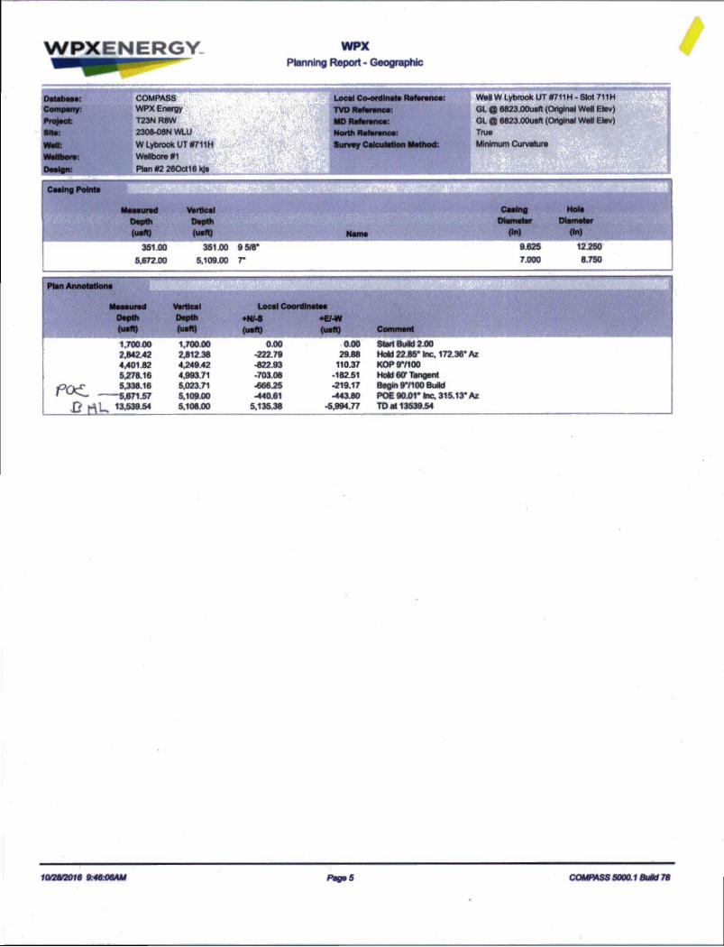
/
351.00 351.00 9 5/8* 9 625 12250
5,672.00 5,109.00 r 7.000 8.750
Plan Annotations
Moaaurad Local Coordinates
Depth(uaft)
Depth(uaft)
♦N/-8(uaft)
♦e-w(uaft) Comment
1.700.00 1.70000 0.00 -0.00 Start Build 2.002,842.42 2.812.38 -222.79 29.88 Hold 22.85* Inc. 172.36* Az4,401.82 4,249.42 -822 93 110.37 KOP 971005,278.16 4.99371 -703.08 -182.51 Hold 60- Tangent5,338.16 5,023.71 -666.25 -219.17 Begin 97100 Build
• ------- 5.671.57 5.109 00 -440.61 -443.80 POE 90.01* he. 315.13* AzJDrtk. 13,539.54 5,108.00 5.135.38 -5,994.77 TO at 13539.54
10/28/2016 9:46:06AM Pages COMPASS 5000.1 Build 78

WPXENERGY
WPX Energy
Operations Plan
(Note: This procedure will be adjusted onsite based upon actual conditions)
Date: November 2,2016 r;.u.rieto. Lybrook Mancos WWell Name: W Lybrook #711H Surface:SH Location: SESW Sec 8 23N-08W Elevation: 6823' GRBH Location: SWSW Sec 6 23N-08W Minerals:
Measured Depth: 13,539.54'
I. GEOLOGY
Surface formation - NACIMIENTO
A. FORMATION TOPS: (GR)
NAME MD TVD NAME MD TVD
OJO ALAMO 818.00 818.00 POINT LOOKOUT 3,920.00 3,805.00KIRTLAND 1,026.00 1,026.00 MANCOS 4,122.00 - 3,992.00PICTURED CLIFFS 1,402.00 1,402.00 GALLUP 4,497.00 4,341.00LEWIS 1,513.00 1,513.00 KICKOFF POINT 4,401.82 - 4,249.42CHACRA 1,772.00 1,772.00 TOP TARGET 5,460.00 5,068.00CLIFF HOUSE 2,880.00 2,847.00 LANDING POINT 5,671.57 5,109.00
MENEFEE 2,933.00 2,896.00 BASE TARGET 5,671.57 5,109.00
TD 13,539.54 5,108.00
B. MUD LOGGING PROGRAM:Mudlogger on location from surface csg to TD.
C. LOGGING PROGRAM:
LWD GR from surface casing to TD.
D. NATURAL GAUGES:Gauge any noticeable increases in gas flow. Record all gauges in Tour book and on
morning reports.
II. DRILLING
A. MUD PROGRAM;LSND mud (WBM) will be used to drill the 12-1/4" Surface hole, the 8 96" Directional
Vertical hole, and the curve portion of the wellbore. A LSND (WBM) or (OBM) will be used
to drill the lateral portion of well. Treat for lost circulation as necessary. Obtain 10096
returns prior to cementing. Notify Engineering of any mud losses.
B. BOP TESTING:

Surface Use Plan of Operations
Once the bore is completed and cased, the anode is installed in accordance with the manufacturer's specifications. The bore is then backfilled with Conducrete using a tremie tube technique starting from TD of the bore. The casing will be cut and capped 12 inches below the surface. The specified flush grade valve box is then installed directly over the bed. The bed location (Lat/Long) is recorded and full drill log report is completed and filed with WPX. The bed will not be energized for a minimum of 45 days.
After the completion phases and pipeline installation, portions of the project areas not needed for operation will be reclaimed. When the well is plugged, final reclamation will occur within the remainder of the project areas. Reclamation is described in detail in the Surface Use Reclamation Plan (Appendix A).
7.0 Methods for Handling Waste
A. Cuttings1. Drilling operations will utilize a closed-loop system. Drilling of the horizontal laterals will be
accomplished with water-based mud. All cuttings will be placed in roll-ofTbins and hauled to acommercial disposal facility or a land farm. WPX will follow Onshore Oil and Gas Order No. 1regarding the placement, operation, and removal of closed-loop systems. No blow pit will be used.
2. Closed-loop tanks will be adequately sized for containment of all fluids.B. Drilling Fluids
1. Drilling fluids will be stored onsite in above-ground storage tanks. Upon termination of drilling operations, the drilling fluids will be recycled and transferred to other permitted closed-loop systems or returned to the vendor for reuse, as practical. All residual fluids will be hauled to a commercial disposal facility.
C. Spills1. Any spills of non-freshwater fluids will be immediately cleaned up and removed to an approved
disposal site.D. Sewage
1. Portable toilets will be provided and maintained during construction, as needed (see Figure 3 in Appendix B for the location of toilets).
E. Garbage and other water material1. All garbage and trash will be placed in a metal trash basket. The trash and garbage will be hauled
off site and dumped in an approved landfill, as needed.F. Hazardous Waste
1. No chemicals subject to reporting under Superfund Amendments and Reauthorization Act Title IH in an amount equal to or greater than 10,000 pounds will be used, produced, stored, transported, or disposed of annually in association with the drilling, testing, or completing of these wells.
2. No extremely hazardous substances, as defined in 40 CFR 355, in threshold planning quantities will be used, produced, stored, transported, or disposed of annually in association with the drilling, testing, or completing of these wells.
3. All fluids (i.e., scrubber cleaners) used during washing of production equipment will be properly disposed of to avoid ground contamination or hazard to livestock or wildlife.
G. Produced Water:1. WPX Energy will dispose of produced water from this well at one of the following facilities:
a. Lybrook Yard WDW #1, API #30-039-27533, NMOCD permit #SWD-907, operated by Elm Ridge Resources, located in NE %, Section 14, Township 23 North, Range 7 West
b. Jillson Federal #1, NMOCD order #R-10168, operated by ConocoPhillips, located in NW 'A, Section 8, Township 24 North, Range 3 West
c. Basin Disposal, permit #NM-01-005, located in the NW !4, Section 3, Township 29 North, Range 11 West
d. Sunco SWD #001, API #30-045-28653, NMOCD permit SWD-457, operated by Key Energy, located in NW Vi, Section 2, Township 29 North, Range 12 West
2. Water will be hauled by truck. Some produced water may also be used in drilling and completion operations as an alternative disposal method.
W Lybrook Unit 711H & 713H Oil and Natural Gas WeKs Project October 2016

AdjustableChoke
AdjustableChoke

ROTATINGHEAD
Romt
11" 3M PIPE RAMS
1 1
11"3M BLIND RAMS
I
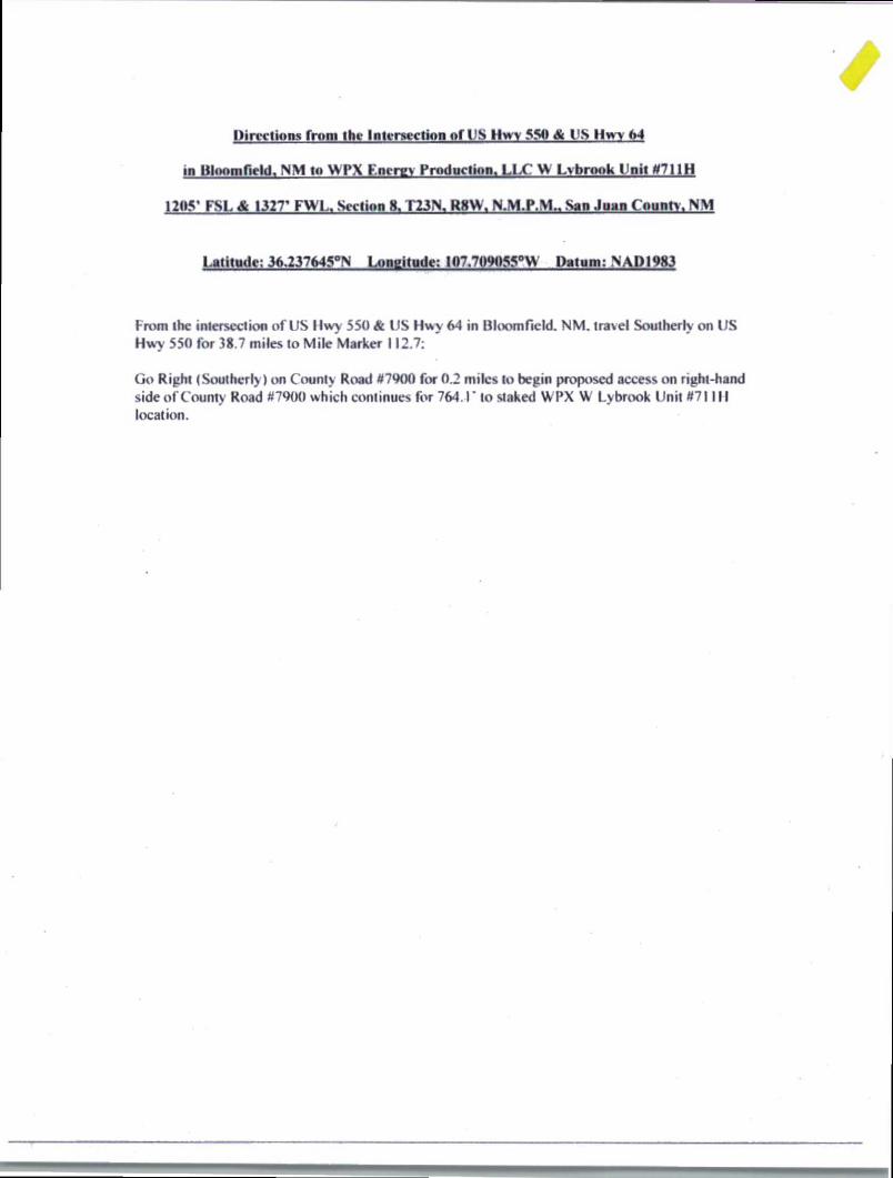
Directions from the Intersection of IIS Hwy 550 & US Hwy 64
in BliK>mr.eldA NM to WPX Energy Production, LLC W Lvbrook Unit *711H
1205- FSL & 1327- FWL, Section 8, T23N, R8W, San Juan Coun^ NM
Latitude: 36,237645°!% Longitude: 10,7.7' iL'IlhMii fi ..PanuR-NADJgSj
From the intersection of US llwy 550 & US Hwy 64 in Bloomfield. NM. travel Southerly on US Hwy 550 for 38.7 miles to Mile Marker 112.7:
Go Right (Southerly) on County Road #7900 for 0.2 miles to begin proposed access on right-hand side of County Road #7900 which continues for 764.1' to staked WPX W Lybrook Unit #71111 location.