state of south carolina - homepage | scdhec
TRANSCRIPT

Technical Report No. 0802-17
STATE OF SOUTH CAROLINA MONITORING STRATEGY FOR CALENDAR YEAR 2018
BU
REA
U O
F W
ATE
R
Sout
h C
arol
ina
Dep
artm
ent o
f Hea
lth a
nd E
nviro
nmen
tal C
ontro
l


DISTRIBUTION LIST Mark Hollis, Bureau Chief, Bureau of Water South Carolina Department of Health and Environmental Control 2600 Bull Street Columbia, SC 29201 803-898-4210 [email protected] Jennifer Hughes, Assistant Bureau Chief, Bureau of Water South Carolina Department of Health and Environmental Control 2600 Bull Street Columbia, SC 29201 803-898-1992 [email protected] Renee Shealy, Chief, Bureau of Environmental Health Services South Carolina Department of Health and Environmental Control EA Laboratories 8231 Parklane Road Columbia, S.C. 29223 803-896-8994 [email protected] Elizabeth Basil, Assistant Bureau Chief, Bureau of Environmental Health Services South Carolina Department of Health and Environmental Control EA Laboratories 8231 Parklane Road Columbia, S.C. 29223 803-896-8408 [email protected] Sandra Flemming, Assistant Bureau Chief, Bureau of Environmental Health Services, QAM South Carolina Department of Health and Environmental Control EA Laboratories 8231 Parklane Road Columbia, S.C. 29223 803-896-0901 [email protected]

Roger Brewer, Acting Director, Analytical and Radiological Environmental Services Division, Bureau of Environmental Health Services South Carolina Department of Health and Environmental Control EA Laboratories 8231 Parklane Road Columbia, S.C. 29223 803-896-0856 [email protected] Bureau of Environmental Health Services, Regional Directors Bureau of Environmental Health Services, Regional Laboratory Managers Bureau of Environmental Health Services, Regional Monitoring Supervisors Bureau of Environmental Health Services, Regional Stream Monitoring Personnel Larry McCord, Supervisor, Analytical & Biological Services, Santee Cooper Public Service Authority Casey Moorer, Analytical & Biological Services, Santee Cooper Public Service Authority SCDHEC Website Elizabeth Smith, Monitoring Coordinator USEPA Region IV 61 Forsyth Street, S.W. Atlanta, GA 30303-8960 404-562-8721 [email protected] Tina Lamar, EPA Project Officer USEPA Region IV 61 Forsyth Street, S.W. Atlanta, GA 30303-8960 404-562-9323 [email protected]

-i-
TABLE OF CONTENTS TABLE OF CONTENTS ................................................................................................................. i LIST OF FIGURES ........................................................................................................................ ii LIST OF TABLES .......................................................................................................................... ii SUMMARY OF CHANGES FOR 2018 ........................................................................................ 1 1.0 PROJECT MANAGEMENT ................................................................................................... 2
1.1 Introduction/Background ............................................................................................. 2 1.2 Monitoring Objectives ................................................................................................. 3 1.3 Project Organization .................................................................................................... 7 1.4 Project/Task Description .............................................................................................. 8
1.4.1 USEPA Elements of a State Water Monitoring and Assessment Program .. 8 1.4.2 Core and Supplemental Water Quality Indicators (Measurements) ............. 9 1.4.3 Data and Field Quality Objectives and Criteria ............................................ 9
2.0 AMBIENT WATER QUALITY MONITORING SAMPLING DESIGN ........................... 13 2.1 Ambient Surface Water Physical & Chemical Discrete Monitoring ......................... 13 2.1.1 Monitoring Objectives ............................................................................................ 13 2.1.2 Monitoring Design .................................................................................................. 13
2.1.2.1 Base Sites ................................................................................................. 13 2.1.2.2 Special Request Sites ............................................................................... 14 2.1.2.3 Statistical Survey Monitoring Sites ......................................................... 16
2.1.3 Schedule for the Ambient Surface Water Quality Monitoring Program for Calendar Year 2018 by Field Laboratory Office .................................................. 21
2.1.4 Core and Supplemental Water Quality Indicators .................................................. 22 2.1.5 Quality Assurance ................................................................................................... 22 2.1.6 Data Management ................................................................................................... 23 2.1.7 Data Analysis/Assessment ...................................................................................... 23 2.1.8 Reporting................................................................................................................. 23 2.2 Ambient Surface Water Physical & Chemical Continuous Monitoring ..................... 24 2.3 Ocean Water Monitoring ........................................................................................... 26 2.4 Biological Monitoring ................................................................................................ 28 2.4.1 Macroinvertebrate Bioassessment .......................................................................... 28 2.4.2 Fish Tissue Monitoring ........................................................................................... 30 2.4.3 Phytoplankton & Chlorophyll Monitoring.............................................................. 32 2.5 Shellfish Growing Area Water Quality Monitoring .................................................. 34 2.6 Groundwater Monitoring ........................................................................................... 39 2.7 Quality Assurance/Quality Control Procedures ......................................................... 39 2.8 Laboratory Support .................................................................................................... 43 2.9 Data Review, Verification, and Validation ................................................................ 46 Appendices ........................................................................................................................ 49
A. Ambient Surface Water Quality Monitoring Site Descriptions Listed By Regional Laboratory Office ................................................... A-1
B. Ambient Surface Water Quality Monitoring Sites Listed by Waterbody ...................................................................... B-1

-ii-
C. Ambient Surface Water Quality Monitoring Sites Listed by Regions Showing Individual Parameter Coverage ............................................... C-1
D. Parameters Sampled at Ambient Surface Water Quality Monitoring Sites................................................. D-1
E. Ocean Water Monitoring Site Descriptions Listed by Regional Office ........................................................................E-1
F. Macroinvertebrate Monitoring Site Descriptions .................................... F-1 G. Fish Tissue Monitoring Site Descriptions............................................... G-1 H. Shellfish Station Descriptions Listed by Area ........................................ H-1 I. Parameters Sampled at Ambient Groundwater Monitoring Sites ............. I-1
Attachments ..................................................................................................... Attachment 1 3.0 SPECIAL MONITORING AND COMPLIANCE MONITORING ..................................... 50
3.1 Intensive Surveys and Special Water Quality Studies ............................................... 50 3.1.1 Documenting Water Quality Improvement Efforts .................................... 52
3.2 Wetlands Monitoring ................................................................................................. 53 3.3 Wastewater Discharge Compliance Monitoring ........................................................ 53 3.4 Complaint Investigations And Fish Kill Program ..................................................... 61 3.5 Public Water Systems Monitoring ............................................................................. 67 Appendices ........................................................................................................................ 72
J. List of Special Section 319 Project and TMDL Sites Sampled by the Aquatic Biology Section .......................................................................... J-1
K. List of Facilities Requiring Federal Compliance Sampling Inspections by EA Regional Office................................................................................. K-1
4.0. PROGRAM EVALUATION AND PLANNING ................................................................. 73
LIST OF FIGURES Figure 1. SCDHEC 2018 Monitoring Sites ................................................................................. 15 Figure 2. SCDHEC 2018 Statistical survey Monitoring Sites ..................................................... 18 Figure 3. Analytical Services Chain-of-Custody and Data Flow ................................................ 48
LIST OF TABLES Table 1. Core and Supplemental Indicators .................................................................................. 11 Table 2. Fixed-Station Shellfish Monitoring Program Physical and Bacteriological Parameter
Coverage and Sampling Frequency........................................................................................ 36 Table 3. Office of Environmental Affairs (EA) Regional Directory ............................................ 64 Table 4. Projected Public Water System Sample Numbers for CY 2018 ..................................... 71

-1-
SUMMARY OF CHANGES FOR 2018 The ambient groundwater monitoring activities remain suspended. Section 2.2 Ambient Surface Water Physical & Chemical Continuous Monitoring was added.

-2-
1.0 PROJECT MANAGEMENT
1.1 Introduction/Background This monitoring strategy establishes the overall goals and objectives for those key elements of the South Carolina Department of Health and Environmental Control (SCDHEC) water quality monitoring program to achieve the goals of the South Carolina Pollution Control Act (PCA), the federal Clean Water Act (CWA), and implement applicable State and Federal regulations. Under the PCA and CWA, SCDHEC has been delegated certain water quality monitoring responsibilities. These include water quality assessment, regulatory monitoring, and program evaluation as needed to fulfill the requirements of the aforementioned Acts. This strategy also serves to document these monitoring activities within the framework presented in the EPA guidance Elements of a State Water Monitoring and Assessment Program (USEPA, 2003). This monitoring strategy document, in conjunction with the referenced field and laboratory Standard Operating Procedures (SOPs), also serves as the Quality Assurance Project Plan for the ambient surface water quality monitoring program. State administrators need to assess the quality of the aquatic environment so that they can make decisions concerning water program priorities and provide reports to the public on the state of the environment, important trends over time, and accomplishments. They also need to evaluate the effectiveness of control measures. Water quality monitoring data provide information necessary to meet these needs. While there are different approaches and philosophies of water quality monitoring, monitoring is not an end in itself but is only a catalyst to spur decisions regarding achievable and desirable resource use alternatives. Monitoring alone does not achieve protection and restoration of water quality. Just because something is monitored does not mean conditions will automatically improve. Monitoring data serves as a tool to assess conditions, to suggest where corrective actions may be necessary, and evaluate the results of those actions. Monitoring data serves as the foundation for informing the Department’s water quality decision-making responsibilities. "Ambient monitoring" refers to monitoring of general surroundings, and includes the set of activities that provide chemical, physical, geological, and biological data about general conditions in the environment. For the purpose of this strategy, water quality monitoring is limited to those activities involved in the State implementation of the PCA and CWA in inland and coastal waters. "Regulatory monitoring" is the collection and analysis of data needed for establishing environmental quality-based permit requirements and for assessing and enforcing compliance with permits. “Regulatory monitoring” also provides data necessary for addressing environmental quality-based assessments of ambient water related to point source and nonpoint source influences. In general, the water quality monitoring activities need to answer key questions about the overall quality of waters in South Carolina, changes in water quality over time, where there are problem areas and areas needing additional protection, the level of protection needed, and the effectiveness of specific clean water projects and programs. However, monitoring is actually a multifaceted discipline with many program areas conducting monitoring activities to fulfill specific objectives: fish tissue monitoring to develop, track, and update fish consumption advisories; ocean monitoring

-3-
to issue timely beach swimming advisories; shellfish sanitation monitoring to determine the harvesting status of the numerous shellfish beds in the state; macroinvertebrate monitoring to determine the health of biological communities of specific waterbodies; ambient surface water monitoring to assess compliance with water quality standards and examine long-term trends at a variety of scales; ambient groundwater monitoring to assess water quality across the major aquifers of the state; National Pollutant Discharge Elimination System (NPDES) discharge monitoring to ensure facilities are in compliance with their permit limits; and special studies for more intensive investigation of specific issues. Therefore it is necessary to use these varied monitoring activities as the vehicle for a cohesive, inter-related approach to water quality management via these diverse types of data. It is through the monitoring programs that sample acquisition, data management and reporting, program needs, committed tasks, and other such Departmental functions all meet. Thus, it is at this natural point of confluence that much opportunity is afforded for integration of sometimes apparently non-related tasks or programs into a step-wise, interrelated approach to the protection of water quality in the State. A great deal of attention to each of those "facets" is required in order for the resulting data to be of the most benefit. As a result, many of the aforementioned programs collect additional samples as part of their activities for the analysis of constituents beyond those required to fulfill their specific objectives. For example, beyond the parameters that can be directly compared to numeric state water quality standards, the Ambient Surface Water Physical & Chemical Monitoring program collects information on additional parameters that are used by the NPDES permit writers and the 303(d), Modeling and TMDL Section to define background conditions and to establish limits for what can safely be discharged by a wastewater treatment facility.
1.2 Monitoring Objectives The information resulting from these monitoring activities are integrated and considered together in various decision-making processes. The incorporation of various data sources allows the Department to address broader objectives. Specific objectives of SCDHEC’s water quality monitoring strategy include: 1.2.1 Determining water quality standards attainment The primary goal is the attainment and maintenance of fishable/swimmable waters wherever possible as mandated by the Clean Water Act (CWA). This includes evaluation of water quality conditions against State Standards, encompassing both numeric and narrative criteria defining designated uses. In evaluating the degree of support of these goals consideration is given to chemical specific data from all components of the Ambient Surface Water Physical & Chemical Monitoring Program, including Chlorophyll Monitoring data, Macroinvertebrate Bioassessment results, the occurrence of fish consumption advisories or shellfish harvesting limitations, and the results of intensive surveys and special water quality studies. The conclusions from such evaluations can range spatially from a much localized stream segment to entire waterbodies, to entire statewide resource condition using the statistical survey monitoring data. The results of such assessments are reported in the State of South Carolina Integrated Report, Parts 1 and 2, which addresses related CWA reporting requirements for §303(d), §305(b) and §314. Please refer to the individual program area descriptions that follow for more details and references or links to published documentation.

-4-
Results from the Ocean Water Monitoring program are used independently in issuing swimming advisories at coastal beaches. 1.2.2 Identifying impaired waters Through the water quality standards attainment evaluations, waters or portions of waterbodies may be identified that are not attaining all State Standards. When this evaluation is conducted specifically for the biennial development of the State of South Carolina Integrated Report, such waters are determined to be “impaired” and are included in the section listing impaired waters which serves to address §303(d) reporting requirements of the CWA. The most current version of the State of South Carolina Integrated Report Part I: Listing of Impaired Waters can be found at http://www.scdhec.gov/HomeAndEnvironment/Water/ImpairedWaters/Overview/. 1.2.3 Identifying causes and sources of water quality impairments The process of determining water quality standards attainment and identifying impaired waters establishes a reason for listing a waterbody as impaired. In many cases it is a physical or chemical parameter that is not in compliance with the State Standards, or the cause of nonsupport, and work begins to identify the source from which it originates. In other cases the reason for listing may be more complex, such as alteration to the aquatic macroinvertebrate community, and the specific cause for the alteration may not be immediately apparent. In such instances a specific cause must be identified before a source can be targeted for control. In instances where a cause of impairment or source for the cause is not readily apparent special studies or intensive surveys may be designed to help determine the causes and sources of nonsupport of designated uses. The data typically collected during such surveys can be physical and chemical water quality parameters, hydraulic stream characteristics, biological community sampling, and effluent and compliance sampling. 1.2.4 Establishing, reviewing, and revising water quality standards Data collected by the monitoring activities are used in the development of designated use classifications and water quality standards, which are in turn used to establish waterbody-specific use classifications. Review of these ambient data help determine if existing water quality in a classified water is adequate to protect existing and designated uses and if appropriate standards have been set. Used in such a manner, ambient data provide valuable feedback to the NPDES permit writing sections as an indication of the need for further discharge restrictions. The ambient data serve to help the refinement of standards and use classifications and, in the absence of numeric criteria, identify and establish appropriate background levels to set standards for additional pollutants. One example was the development of ecoregion specific numeric nutrient and chlorophyll standards for lakes and reservoirs. Ambient data collected statewide as part of the Ambient Surface Water Physical & Chemical Monitoring and Chlorophyll Monitoring programs over a period of many years was used as the basis for identifying ecoregional differences and ranges and were eventually used to set the final numeric standards. A similar process is underway to develop numeric nutrient and chlorophyll standards for estuarine waters. Another example is the recent development of Escherichia coli standards for freshwater to replace the existing fecal coliform bacteria standards. Weekly sampling at 74 monitoring sites in a variety of settings across the state formed the basis for the new E. coli standards.

-5-
1.2.5 Supporting the implementation of water management programs The SCDHEC Bureau of Water focuses its program activities using a Watershed Water Quality Management approach. Watershed water quality management recognizes the interdependence of water quality and all the activities that occur in the associated drainage basin including point source discharges, nonpoint source contributions, and land use characteristics. SCDHEC's Watershed Water Quality Management approach is dependent upon water quality data as the foundation for development of watershed management plans and implementation strategies. These strategies serve to refocus water quality protection efforts including monitoring, assessment, problem identification and prioritization, wasteload allocation monitoring, planning, permitting, and other agency activities. 1.2.6 Supporting the evaluation of program effectiveness By integrating all of the monitoring activities described herein it is possible to identify the sources of pollution and the reasons for nonattainment of designated uses, to address specific issues, determine the efficiency of pollution abatement programs, and allow administrative overview of program effectiveness. 1.2.7 Monitoring for Water Quality-Based Controls The development of discharge controls based on receiving waterbody quality is a very high priority. It involves the collection and analysis of effluent and ambient data to develop water quality-based National Pollutant Discharge Elimination System (NPDES) permit limits. This may involve the calculation of Total Maximum Daily Loads (TMDL) for specific waterbodies and Wasteload Allocations (WLA) for point source discharges. SCDHEC uses long-term ambient monitoring data and special study data, including intensive survey data, in developing WLAs and TMDLs. The kinds of data collected for this type of monitoring may include physical and chemical characterization of effluent and receiving waters, stream hydraulics, macroinvertebrate and fish community assessment of the receiving stream, periphyton/phytoplankton sampling, and toxicity bioassays of effluents and receiving waters. The data are used by the 303(d), Modeling, and TMDL Section in predictive mathematical models to help determine waste treatment levels needed to maintain instream standards. The modeling results are then passed to engineers in the Water Facilities Permitting, and Dams Safety and Stormwater, Permitting, and Monitoring, Protection and Assessment Divisions to be used as the basis for setting final NPDES permit limits. The ambient monitoring data are also used directly by the engineers the Water Facilities Permitting, Dams Safety and Stormwater Permitting, and Monitoring, Protection and Assessment Divisions to establish background conditions for conservative and/or toxic pollutant NPDES permit limits. 1.2.8 Monitoring for NPDES Permit Compliance and Enforcement The NPDES permit is the principal regulatory tool for controlling the quantity of pollutants discharged to the State's waters and for obtaining data on point-source discharges. Data supplied by

-6-
the discharger in the form of routine Discharge Monitoring Reports (DMR) and data collected by SCDHEC personnel from Compliance Sampling Inspections (State CSI and Federal Compliance Sampling Inspection), Federal Compliance Evaluation Inspections (CEI), State Operation and Maintenance Inspections (O&M), Performance Audit Inspections (PAI), Technical Assistance Evaluations (TAE), and Pretreatment Program Audit and Inspections are reviewed by the Water Pollution Compliance and Water Pollution Enforcement Sections to determine the compliance status of a discharger. In all instances of effluent noncompliance, enforcement actions are supported by all of the above data supplied by the Water Pollution Compliance and Water Pollution Enforcement Sections and all ambient monitoring, special studies, and biological monitoring data supplied by the Surface Water Monitoring and Aquatic Biology Sections. The Bureau of Environmental Health Services personnel conduct the majority of the routine inspections and physico-chemical ambient monitoring activities. Data secured and supplied by these monitoring activities are utilized in the majority of SCDHEC's Environmental Affairs enforcement activities. 1.2.9 Making Data Readily Available The last major consideration that has been given to developing a successful monitoring program by South Carolina is the identification of the users of data or the sources of data requests. In South Carolina, this group is quite diverse ranging from individual citizens to interested public groups to various local/state/federal agencies. Data users are:
• Departmental program areas (e.g., domestic wastewater engineers) • Water quality trend/ambient condition analysts • Wasteload allocation analysts • Public/private environmental groups • Public at large • Other local/state/federal agencies (regulatory & non-regulatory) • Departmental administrators via program area outputs
While this large group utilizes the data for different reasons, the Department uses and applies the data to the intermediate objectives and goals as previously discussed. This is done to ascertain whether progress is being made toward successful achievement of these goals and to make correct and appropriate decisions regarding maintenance and enhancement of desirable environmental quality in the State. Implicit in the identification of users of the data, whether in-Department or out-of-Department, is the capacity to communicate the data to interested parties efficiently and accurately. The SC Watershed Atlas (https://gis.dhec.sc.gov/watersheds/) presents summary information from a large variety of Bureau of Water programs on a state map format, with links to many reports and detailed information on the different map features. Technical reports or internal memoranda are produced for every special study and copies are available to any interested organization or persons. A list of technical reports is available upon request. The reports required under CWA §303(d) and §305(b) and most of the major water quality assessment reports are available on the SCDHEC website, http://www.scdhec.gov/HomeAndEnvironment/Water/ImpairedWaters/Overview/. Raw data from

-7-
the Ambient Surface Water Physical & Chemical Monitoring, Ocean Water Monitoring, and Groundwater Monitoring activities are available online in the EPA STORET environmental data system at http://www.epa.gov/storet/. Special studies and biological data are available in several formats through the Surface Water Monitoring and Biological Monitoring Sections. Specific data storage guidelines are addressed in the data management section of each type of monitoring design. Thus, water quality assessment is a broad term describing a multitude of monitoring and sampling activities. Water quality assessment data can be used to fulfill a variety of goals; assessment of current conditions, assessment of long-term trends, determination of priority waterbodies, determination of waterbody designated use attainment or nonsupport, and identification of continuing or emerging problem areas. By integrating all of these monitoring programs it is possible to identify the sources of pollution and the reasons for nonattainment of designated uses, to address specific issues, determine the efficiency of pollution abatement programs, and allow administrative overview of program effectiveness.
1.3 Project Organization To accomplish the objectives of the State of South Carolina Monitoring Strategy several key individuals are identified below with their role and responsibilities. 1.3.1 Program Coordinator/Project Manager (Central Office) The Program Coordinator/Project Manager is responsible for the oversight of the Ambient Water Quality Monitoring Program. This includes insuring consistency between Regional Offices and resolving any discrepancies in the sampling and notification programs. The Program Coordinator is also responsible for the overall data management and reporting to EPA. The Program Coordinator reports directly to management. 1.3.2 Manager, Quality Assurance Manager (Central Office) The Quality Assurance Manager (QAM) is responsible for the oversight of all quality assurance activities associated with the DHEC sampling and analysis SOPs. The QAM will resolve any issues when corrective actions are needed to address data quality issues involving DHEC staff and SOPs. The QAM reports directly to management. 1.3.3 Monitoring Program Manager (Central/Regional Offices) Each Monitoring Program Manager is responsible for local oversight of the ambient water quality monitoring program. Program Managers insure sampling is conducted as outlined in the Monitoring Strategy and report any problems to the Program Coordinator. The Monitoring Program Manager reports directly to management. 1.3.4 Laboratory Manager (Central/Regional Offices) Each Laboratory Manager is responsible for overseeing the operations of the laboratory and assuring

-8-
compliance with laboratory SOPs and quality control procedures. Laboratory Managers review, verify, and release lab data from the laboratory. Laboratory Managers report directly to management. 1.3.5 Monitoring Personnel (Central/Regional Offices) Monitoring personnel are responsible for proper sample collection and transport of samples by adhering to applicable SOPs. Monitoring staff report to the Central/Regional Office Program Manager. 1.3.6 Project Organizational Chart
1.4 Project/Task Description
1.4.1 USEPA Elements of a State Water Monitoring and Assessment Program CWA Section 106(e)(1) requires the Environmental Protection Agency (EPA) to determine that a State is monitoring the quality of navigable waters, compiling, and analyzing data on water quality and including it in the State’s Section §305(b) report prior to the award of Section §106 grant funds. The USEPA Elements of a State Water Monitoring and Assessment Program is meant to serve as the framework for evaluating how state monitoring programs accomplish this task. The individual Elements identified in the EPA document that a state program should address include:
• Monitoring Program Strategy • Monitoring Objectives • Monitoring Design • Core and Supplemental Water Quality Indicators • Quality Assurance • Data Management • Data Analysis/Assessment • Reporting • Programmatic Evaluation • General Support and Infrastructure Planning
Ambient Surface Water Monitoring Program
Monitoring Program ManagersBureau of Water
Program CoordinatorBureau of Water
Regional Stream Monitoring Personnel
Regional Monitoring Manager Regional Laboratory Manager Central Laboratory
Quality Assurance ManagerEnvironmental Services
-9-
It is therefore primarily directed at monitoring activities used to address the determination of designated use support from the viewpoint of §303(d) and §305(b) of the CWA, and specifically to ambient monitoring activities as opposed to compliance related monitoring. As alluded to above and described in more detail in the following sections of this document, the Department conducts a great deal of additional water monitoring, that while not specifically used for those purposes, is nonetheless critical to carrying out the overall mission of protection and restoration of water quality in the State. Some of the Elements can be broadly applied to all of the Department’s ambient monitoring activities, others are more appropriately addressed by the individual program area, and some are applicable at both levels. For example, the Department’s overall objectives are general and applicable to multiple program outcomes, but each program may also have very specific objectives for their monitoring activities. The monitoring design may be different for different programs and some programs may employ more than one monitoring design to accomplish multiple objectives. Therefore each ambient monitoring program area is organized with sections titled by Element and some of these sections may refer to a separate encompassing discussion of specific Elements.
1.4.2 Core and Supplemental Water Quality Indicators (Measurements) Water quality indicators are the means to measure achievement of desired designated uses such as support and maintenance of aquatic life, suitability for recreation, and fish and shellfish consumption. Core indicators are considered most important for directly assessing water quality standards (WQS) attainment as they relate to the designated uses. The set of core indicators is generally used for initial water quality assessments and are applied consistently over broad scales, e.g. statewide. The core set of indicators usually includes physical, chemical, and biological measures of a waterbody (Table 1). Supplemental indicators generally do not have specific water quality standards, but may help suggest sources that might cause or contribute to nonattainment of designated uses (Table 1). They can be pollutants that lack numeric water quality standards but may be indicative of specific activities such as certain manufacturing processes, agricultural practices, current land-use patterns (i.e. type and amount of development), or historic conditions that are no longer present. See Intensive Surveys and Special Water Quality Studies section for further discussion of selection of supplemental indicators. Assessment of designated use support often includes the use of data generated by multiple programs. More comprehensive lists of indicators are addressed under individual program descriptions.
1.4.3 Data and Field Quality Objectives and Criteria Program specific requirements for data quality objectives and assessment methodology are included in the “Data Analysis/Assessment” discussions in Sections 2.1 through 2.5. The formal Data Quality Objectives process includes the following steps:

-10-
1. State the problem 2. Identify the decision 3. Identify inputs to the decision 4. Define the study boundaries 5. Develop a decision rule 6. Specify tolerable limits on decision error 7. Optimize the design This document serves as an umbrella type Quality Assurance Project Plan that describes the entire ambient monitoring program. While steps 1 and 2 are largely mandated by the USEPA, specific SCDHEC objectives are detailed in section 1.2. Samples are collected and field measurements conducted by Bureau of Environmental Health Services personnel from the corresponding SCDHEC Regional Laboratory Office following the most current revision of SCDHEC’s EQC Environmental Investigations Standard Operating Procedures and Quality Assurance Manual. The Bureau of Environmental Health Services, Analytical and Radiological Environmental Services Division laboratories analyze the resulting chemical and microbiological samples. These data provides step 3 – inputs to the decision. Specific performance and measurement criteria are addressed in each field and analytical SOP. Acceptance criteria for reporting results are also stated in each SOP. Results are recorded to two significant figures for most field and laboratory measurements and reported to two significant figures in the Laboratory Information Management System, LIMS. Detection limits for all analytical measurements may be referenced in Section IV-J of the most current revision of SCDHEC’s Procedures and Quality Control Manual for Chemistry Laboratories. Section II-A of the lab manual addresses control of analytical performance. Precision, accuracy, data verification, data quality audits, corrective actions, evaluating statistical control, and anomaly determination are covered. Section II-A of the most current revision of SCDHEC’s Laboratory Procedures Manual for Environmental Microbiology, covers similar details for microbiological analyses. The QA Policy and criteria for assessing data quality is discussed in Section 3 of the most current revision of SCDHEC’s EQC Environmental Investigations Standard Operating Procedures and Quality Assurance Manual and also in the SCDHEC EA Quality Management Plan. Training requirements for field and lab staff and a list of documents and records maintained is discussed in Section 2.7 of this strategy. Table 1 below gives a general overview of the Core and Supplemental Indicators that may be routinely collected and analyzed. Greater detail is included in Appendix D. The study boundary, Step 4, is the entire state of South Carolina. Detailed lists of the monitoring site locations are included in Appendices A, E, F, G, and H. The Assessment Methodology applied as the decision rule, Step 5, is documented in the most current version of the State of South Carolina Integrated Report Part I: Listing of Impaired Waters, updated biennially, available on the SCDHEC website at

-11-
http://www.scdhec.gov/HomeAndEnvironment/Water/ImpairedWaters/Overview/. Steps 6 and 7 document the consequences of decision error and how to optimize the design to avoid making an erroneous decision. Section 2.1.12 details the consequences of that decision error for ambient chemical and microbiological data, Section 2.3.1.6 addresses macroinvertebrate data, and Section 2.3.2.3 addresses fish tissue data. Optimizing the design from step 7 includes corrective actions to avoid decision error.
Table 1. Core and Supplemental Indicators Core and Supplemental Indicators
Aquatic Life Use Support
Recreational Use Support
Fish Consumption
Shellfish Consumption
Core Indicators
Dissolved Oxygen pH Turbidity Ammonia Nitrogen Cadmium Chromium Copper Lead Mercury Nickel Zinc Additional indicators for selected wadeable stream sites: Macroinvertebrate
community condition
Habitat assessment Additional indicators for lakes: Chlorophyll-a Total Nitrogen
(Nitrate/Nitrite Nitrogen + Total Kjeldahl Nitrogen)
Total Phosphorus
E. coli Bacteria Enterococcus
Bacteria
Mercury in fish tissue
Fecal Coliform Bacteria

-12-
Table 1. Core and Supplemental Indicators (Cont.)
Core and Supplemental Indicators Aquatic Life Use
Support Recreational Use Support
Fish Consumption
Shellfish Consumption
Supplemental Indicators
Water Temperature Air Temperature Depth of Sample
Collection Five-Day Biochemical
Oxygen Demand Nitrate/Nitrite Nitrogen Total Kjeldahl Nitrogen Total Phosphorus Alkalinity Iron Manganese Total Suspended Solids Additional indicators at freshwater sites where metals are collected: Hardness Additional indicators for lakes: Transparency (Secchi depth) Additional indicators at saltwater sites: Tide Stage Specific Conductance Salinity Other chemicals of concern in water column or sediment
Other chemicals of concern in water column or sediment
Other chemicals of concern in fish tissue, water column or sediment
Other chemicals of concern in water column or sediment

-13-
2.0 AMBIENT WATER QUALITY MONITORING SAMPLING DESIGN Ambient Water Quality Monitoring activities are carried out as part of several different program areas, each with specific monitoring objectives. In addition to the core data required to accomplish the individual program goals, additional ancillary data are often collected that are necessary to other program areas and broader Environmental Affairs (EA) objectives. Much of the data collected serves multiple purposes, being used by many program areas to address several EA needs. The overall purpose of Ambient Water Quality Monitoring is to provide a system of monitoring activities that produces well defined data reflecting a variety of water quality conditions, physical, chemical, and biological, in the major water resources of South Carolina, including streams, reservoirs, estuaries, and groundwater aquifers. All sampling procedures and analyses are performed in accordance with the Quality Assurance Manager (QAM). All sample collection procedures follow the most current revision of SCDHEC’s Environmental Investigations Standard Operating Procedures and Quality Assurance Manual, Sections 3, 7, 14, and 19. All laboratory analyses are performed according to the most current revisions of SCDHEC’s Procedures and Quality Control Manual for Chemistry Laboratories--Analytical Services and Laboratory Procedures Manual for Environmental Microbiology-- Analytical Services.
2.1 Ambient Surface Water Physical & Chemical Discrete Monitoring
2.1.1 Monitoring Objectives The purpose of the Ambient Surface Water Physical & Chemical Monitoring Network is to provide a system of monitoring sites that are sampled in a way that produces well defined data reflecting physical and chemical conditions of the streams, reservoirs and estuaries in South Carolina.
2.1.2 Monitoring Design There are currently two major components to Surface Water Physical & Chemical Monitoring, including ongoing fixed-location monitoring and statewide statistical survey monitoring; each designed to provide data for water quality assessment of major water resource types at different spatial and temporal scales. The fixed-location component of the monitoring network is comprised of Base Sites that are generally sampled once per month, year round. Statistical Survey Monitoring Sites are typically sampled once per month for one year and moved from year to year. These basic components are discussed in the following sections. 2.1.2.1 Base Sites Base Sites represent the base network of 244 permanent, fixed-location, monitoring sites (Figure 1). Base Sites are sampled monthly, year round, over an extended period of time, in a uniform manner to provide solid baseline data. Base Sites were chosen to target the most downstream

-14-
access (pour point) of each of the National Watershed Boundary Dataset (WBD) 10-digit watershed units (WSU) in the state, as well as the major waterbody types that occur within these WSUs. In some years individual Base Sites may satisfy the requirements of Statistical Survey Monitoring Sites (see Section 2.1.2.3 below) and are sampled monthly as part of that monitoring component. For example, where a WSU ends in a major reservoir, a Base Site is placed in the impounded area to represent reservoir conditions, and another Base Site is generally placed in the main stream feeding that part of the reservoir to represent conditions in the free-flowing portion of the WSU. Similarly, in a primarily riverine WSU ending in estuarine areas at the coast, Base Sites may be placed in both the free-flowing freshwater portion as well as the saltwater area to represent conditions in both habitats. The result is consistent data from all WSUs in the state that can be used in tracking standards compliance and long-term trends. Samples are collected and field measurements conducted by Bureau of Environmental Health Services personnel from the corresponding SCDHEC Field Laboratory Office following the most current revision of SCDHEC’s Environmental Investigations Standard Operating Procedures and Quality Assurance Manual, Sections 3, 7, 14, and 19. All laboratory analyses are performed according to the most current revisions of SCDHEC’s Procedures and Quality Control Manual for Chemistry Laboratories--Analytical Services and Laboratory Procedures Manual for Environmental Microbiology-- Analytical Services. The number of monthly Base Sites per Field Laboratory Office for 2018 is:
Greenville 39 Florence 43 Aiken 30 Columbia 30 Charleston 29 Lancaster 30 Beaufort 32
In addition, 5 Base Sites are collected by the Santee Cooper Public Service Authority in a cooperative effort. Base Sites and location descriptions are listed by Field Laboratory Office in Appendix A, and by waterbody name in Appendix B. Parameter coverage, frequency of analysis, and STORET parameter codes are given in Appendices C and D. 2.1.2.2 Special Request Sites
Special Request Sites are temporary fixed-location sites that target locations of special interest to the Department related to specific data needs. Examples of site selection criteria for establishment of Special Request Sites includes, but is not restricted to:

-15-
!
!
!
!!
!
!
!!
#
!
!
!
!
!
!
!
!
!
!
!
!
!
!
!
!
!
!! !
!
!!
!
!
!
!
!
!
!
!
!
!
!
!
!
!
!
!
!
!!#!
!
#
#
!
!
!
!
#
!
!#
!
!
!
!
!
!
!!
!
!
#
##
#
#
#
#
#
#
!
!
!
!
#
!
!
!
!
!
!
!
!
!!
!!!
!
##
!
##
!
#
!
##
!!
!!
! #!
!
!!
#
!
!
!!
!
!!
!!
!
!
!
!!!
!
!
!
!
!!
!
!!
!
!!!
!
!!
!
#!
!
!
!
!!
!!
!
!
!
!
!
! !
!
!
!
!
!
!
!
!
!
!
!
!
!!
!
!
!
!
!
!
!
!
!
!
!
!
!
!
!
!
!
!
!
!!
!
! !
!
!!
!
!
!
!!
!
!!
!!
!
!
!
!
!
!
!
!
!
!
!
!
!
!!!!!
!
!!
! !
!
!
!
!!
!
!
!
!
!!
!
!
!
!
!
!
Figure 1. SCDHEC 2018Fixed Monitoring Sites
±0 30 60 90 Miles
Fixed Monthly Monitoring Sites! Base Sites# Special Request Sites

-16-
1. To track the progress of specific remediation activities. 2. To gather additional data in specific areas for the development of total Maximum Daily
Loads (TMDLs). 3. To gather data for Wasteload Allocation modeling needs. 4. To obtain data necessary for setting NPDES permit limits. Special Request Sites are also sampled monthly, year round, over a finite time period. Samples are collected and field measurements conducted by Bureau of Environmental Health Services personnel from the corresponding SCDHEC Field Laboratory Office following the most current revision of SCDHEC’s Environmental Investigations Standard Operating Procedures and Quality Assurance Manual, Sections 3, 7, 14, and 19. All laboratory analyses are performed according to the most current revisions of SCDHEC’s Procedures and Quality Control Manual for Chemistry Laboratories--Analytical Services and Laboratory Procedures Manual for Environmental Microbiology-- Analytical Services. For 2018 there are 25 Special Request Sites (Figure 1) distributed amongst the Field Laboratory Offices as follows:
Greenville 1 Florence 0 Aiken 0 Columbia 9 Charleston 0 Lancaster 15 Beaufort 0
Special Request Sites and descriptions are listed by field laboratory in Appendix A, and by water body name in Appendix B. Parameter coverage, sampling frequency, and STORET parameter codes are given in Appendices C and D. 2.1.2.3 Statistical Survey Monitoring Sites Statistical survey monitoring is a design in which the population of interest is sampled in a fashion that allows statements to be made about the whole population based on a subsample, and produces an estimate of the accuracy of the assessment results. The advantage of the statistical survey sampling design is that statistically valid statements about water quality can be made about large areas based on a relatively small subsample. Statistical survey water quality data can be used to make inferences, with known confidence, about the condition of the water resources of the State. A statewide statistical survey, or random sampling, component is part of the Ambient Surface Water Quality Monitoring Network. Separate monitoring schemes have been developed for stream, lake/reservoir, and estuarine resources to represent the entirety of each resource type as described below. Each year a new set of statistical survey sites is selected for each waterbody type. Site selection is done in association with the U.S. Environmental Protection Agency, National Health and Environmental Effects Research Laboratory (NHEERL), Corvallis, Oregon. Although statements about resource conditions can theoretically be made based on data from a single year, the compilation of data from additional years will increase the confidence and accuracy of statements

-17-
about water quality. An additional advantage of the statistical survey approach is that it presents the opportunity for previously unsampled locations to be selected for data collection. Streams Approximately 30 statistical survey sites will be sampled in streams each year (Figure 2). Some of the statistical survey locations may correspond to existing fixed Base Sites. Each statistical survey site will be sampled monthly for one year and will be prioritized for a macroinvertebrate community and habitat analysis. Streams of different sizes may be more or less sensitive to different types of environmental perturbations. Because of this, three stream sizes have been specifically targeted to ensure they are represented in the selected statistical survey sites. 1. First Order streams, or headwater streams, are targeted because these represent streams with
the least dilution capacity and therefore are most immediately impacted by adjacent land use activities and associated runoff. These streams may also serve as spawning areas for fish and refuge areas for young from larger aquatic predators.
2. Second and Third Order streams, which are also streams with relatively small dilution
capacity and represent important habitat for reproduction and survival of aquatic life. They may also reflect the direct impacts of major land use activities.
3. Fourth Order and larger streams, which include the major rivers of the State. In general
these streams have greater dilution capacity and are less affected by small-scale land use perturbations and may be heavily utilized for contact recreation.
These different sizes do not occur in equal proportions in the state, therefore an unequal weighting procedure is used in the site selection process to guarantee inclusion of all three sizes. Taken together and using the proper weighting factors, the random stream sites can be used to make statistically valid statements about all stream resources of the State. Samples are collected and field measurements conducted by Bureau of Environmental Health Services personnel from the corresponding SCDHEC Field Laboratory Office following the most current revision of SCDHEC’s Environmental Investigations Standard Operating Procedures and Quality Assurance Manual, Sections 3, 7, 14, and 19. All laboratory analyses are performed according to the most current revisions of SCDHEC’s Procedures and Quality Control Manual for Chemistry Laboratories--Analytical Services and Laboratory Procedures Manual for Environmental Microbiology-- Analytical Services. The 2018 Statistical survey Stream Sites are distributed by Field Laboratory Offices as follows:
Greenville 8 Florence 9 Aiken 4 Columbia 1 Charleston 2 Lancaster 6 Beaufort 0

-18-
!(
!(
!(
!(
!(#
#
#
#
#
#
#
#
#
#
#
#
#
#
#
!
!
!
!(
!(
!(
!(
!(
!(
!(
!(
!(
!(
!(
!(
!(
!(
!(
!(
!(
!(
!(
!(
!(
!(
!(
!(
!(
!
!
!
!!
!
!
!
!
!
!
!
!
!
!
!
!
!
!
!
!
!
!
!
!
!
!
#
#
#
#
#
#
#
#
#
##
##
#
#
Figure 2. SCDHEC 2018Statistical Survey Sites
±0 30 60 90 Miles
Monthly Statistical Survey Sites! Streams!( Lakes# Estuary

-19-
Statistical survey Stream Sites and location descriptions are listed by Field Laboratory Office in Appendix A, and by waterbody name in Appendix B. Parameter coverage, frequency of analysis, and STORET parameter codes are given in Appendices C and D. Lakes/Reservoirs Approximately 30 statistical survey sites will be sampled in lakes/reservoirs each year (Figure 2). Some of the statistical survey locations may correspond to existing fixed Base Sites. Each statistical survey site will be sampled monthly for one year. Eligible lakes/reservoirs are restricted to “significant lakes”, which refers to those freshwater lakes/reservoirs with at least 40 acres surface area that offer unrestricted public access. The size of significant lakes/reservoirs varies immensely; therefore two size classes of lakes/reservoirs have been specifically targeted to ensure that the smaller lakes/reservoirs are represented in the selected statistical survey sites. 1. Major Lakes/Reservoirs greater than 850 acres surface area. 2. Minor Lakes/Reservoirs greater than 40 acres surface area, but less than or equal to 850
acres. These different sizes do not occur in equal proportions in the state, therefore an unequal weighting procedure is used in the site selection process to guarantee inclusion of both sizes. Taken together and using the proper weighting factors, the statistical survey lake/reservoir sites can be used to make statistically valid statements about all lake/reservoir resources of the State. Samples are collected and field measurements conducted by Bureau of Environmental Health Services personnel from the corresponding SCDHEC Field Laboratory Office following the most current revision of SCDHEC’s Environmental Investigations Standard Operating Procedures and Quality Assurance Manual, Sections 3, 7, 14, and 19. All laboratory analyses are performed according to the most current revisions of SCDHEC’s Procedures and Quality Control Manual for Chemistry Laboratories--Analytical Services and Laboratory Procedures Manual for Environmental Microbiology-- Analytical Services. The 2018 Statistical survey Lake/Reservoir Site network is regionally organized with the following assignments:
Greenville 14 Florence 0 Aiken 1 Columbia 4 Charleston 0 Lancaster 3 Beaufort 0
In addition, 7 Statistical survey Lake/Reservoir Sites will be collected by the Santee Cooper Public Service Authority in a cooperative effort. Statistical survey Lake/Reservoir Sites and location descriptions are listed by Field Laboratory Office in Appendix A, and by waterbody name in Appendix B. Parameter coverage, frequency of analysis, and STORET parameter codes are given in Appendices C and D.

-20-
Estuaries The coastal estuarine statistical survey monitoring scheme has been developed jointly by SCDHEC, Bureau of Water, and the South Carolina Department of Natural Resources (SCDNR), Marine Resources Research Institute (MRRI). This effort has been dubbed the South Carolina Estuarine and Coastal Assessment Program (SCECAP) and sampling of the statistical survey coastal estuarine sites is a cooperative venture between SCDHEC and SCDNR-MRRI. To ensure inclusion of a variety of estuarine ecosystems and habitats, the coastal estuaries have been divided into two discrete categories (strata) based on a common GIS cover developed and utilized by both agencies. 1. Tidal Creeks, identified as less than 100 meters wide on the GIS cover, serve as nursery
areas for important marine species and are most immediately affected by upland land use activities and associated runoff.
2. Open Water areas, identified as greater than 100 meters wide on the GIS cover, represent
larger estuarine rivers and sounds. Within these waterbody types there are typically two distinct types of monitoring sites based on sampling frequency, Core Sites and Supplemental Sites. Core Sites (Figure 2) are sampled monthly for one year by SCDHEC Bureau of Environmental Health Services personnel from the corresponding SCDHEC Field Laboratory Office for water column physical and chemical parameters following the most current revision of SCDHEC’s Environmental Investigations Standard Operating Procedures and Quality Assurance Manual, Sections 3, 7, 14, and 19. All laboratory analyses are performed according to the most current revisions of SCDHEC’s Procedures and Quality Control Manual for Chemistry Laboratories--Analytical Services and Laboratory Procedures Manual for Environmental Microbiology-- Analytical Services. SCDNR-MRRI samples annually for sediment chemistry, sediment physical characteristics, sediment toxicity, benthic infaunal community composition, up to 25-hour hydrolab deployments, and fish trawls following the QAPP developed for the USEPA National Coastal Assessment Program. SCDNR-MRRI also collects additional water samples in SCDHEC supplied containers for analysis by SCDHEC according to the most current revisions of SCDHEC’s Procedures and Quality Control Manual for Chemistry Laboratories--Analytical Services and Laboratory Procedures Manual for Environmental Microbiology-- Analytical Services. When resources are available, additional Supplemental Sites may be selected and sampled. The Supplemental Sites are sampled one time by SCDNR-MRRI for sediment chemistry, sediment physical characteristics, sediment toxicity, benthic infaunal community structure, up to 25-hour hydrolab deployments, and fish trawls. Each year there will be approximately 15 Core Tidal Creek sites, 15 Core Open Water sites, and when resources are available, additional Supplemental Tidal Creek and Open Water sites may be sampled. Some of the statistical survey locations may correspond to existing fixed Base Sites. The total number of Core 2018 Statistical survey Estuary Sites is distributed between three Field Laboratory Offices with the following assignments:

-21-
Charleston 11 Florence 3 Beaufort 16
Core Tide Creek and Core Open Water Sites and location descriptions are listed by Field Laboratory Office in Appendix A, and by waterbody name in Appendix B. Parameter coverage, frequency of analysis, and STORET parameter codes are given in Appendices C and D.
2.1.3 Schedule for the Ambient Surface Water Quality Monitoring Program for Calendar Year 2018 by Field Laboratory Office The following is the schedule for collection of non-monthly parameters for each Regional Laboratory Office. The schedule includes the number of each type of sample to be collected, and it also includes the month(s) for collection. All other parameters, with the exception of chlorophyll a, are collected every month. Please refer to Appendix C and Appendix D for details relevant to specific parameters for each station.
Lab: Greenville Permanent Year-Round Surface Sites Base and Special Request-- 40 Total Statistical Survey Surface Sites -- 22 Total Lab: Aiken Permanent Year-Round Surface Sites
Base and Special Request -- 30 Total Statistical Survey Surface Sites -- 5 Total Lab: Charleston Permanent Year-Round Surface Sites
Base and Special Request -- 31 Total Statistical Survey Surface Sites -- 13 Total Lab: Florence Permanent Year-Round Surface Sites
Base and Special Request -- 43 Total Statistical Survey Surface Sites -- 12 Total

-22-
Lab: Columbia Permanent Year-Round Surface Sites
Base and Special Request -- 39 Total Statistical Survey Surface Sites -- 5 Total Lab: Lancaster Permanent Year-Round Surface Sites
Base and Special Request -- 45 Total Statistical Survey Surface Sites -- 9 Total Lab: Beaufort Permanent Year-Round Surface Sites
Base and Special Request -- 32 Total Statistical Survey Surface Sites -- 16 Total
2.1.4 Core and Supplemental Water Quality Indicators Table 1 lists the primary Core Indicators used in making use support determinations and additional Supplemental Indicators that are also collected. Because of the statewide scale of the routine surface water monitoring program, the choice of supplemental indicators is dictated by laboratory capacity and resources, and the general utility of the resulting data in identifying potential sources contributing to nonattainment of designated uses on a large scale. Assessment of designated use support often includes the use of data generated by other Ambient Water Quality Monitoring programs detailed in the following sections. Appendix D provides a more detailed list of the basic parameters measured customarily as part of routine Surface Water Physical & Chemical Monitoring activities. Detailed information for individual monitoring locations is included in Appendix C.
2.1.5 Quality Assurance All sampling procedures and analyses are performed under the SCDHEC Quality System which is described in the USEPA approved Quality Management Plan For S.C. DHEC, with the supervision of the Quality Assurance Manager (QAM) and all procedures follow the most current revisions of SCDHEC’s Environmental Investigations Standard Operating Procedures and Quality Assurance Manual, Sections 3, 7, 14, and 19, Procedures and Quality Control Manual for Chemistry Laboratories--Analytical Services, and Laboratory Procedures Manual for Environmental Microbiology-- Analytical Services. Please see Section 2.7 of this strategy, Quality Assurance/Quality Control Procedures, for further details.

-23-
2.1.6 Data Management Routine ambient stream samples are collected by Regional Office personnel with some analyses conducted in the Regional Laboratories and others by the Central Laboratory. Data for samples that are analyzed in the Regional Laboratories are reported on the appropriate data sheets and released by the sample custodian for the region. These data sheets are sent to the Analytical and Radiological Environmental Services Division in Columbia where they are sent to the appropriate program areas (see Figure 3). All Ambient Surface Water Physical & Chemical Monitoring data are received by Surface Water Monitoring Section from the Data Management Section, Bureau of Environmental Health Services. The data are reviewed, edited and stored into the IMAP database. The Surface Water Monitoring Section performs a 10 percent review of all data to ensure quality assurance of the data. The data are uploaded to the EPA's STORET water quality database. Data sheets are kept on file in the Surface Water Monitoring Section.
2.1.7 Data Analysis/Assessment The SCDEHC data analysis and assessment methodology used to make attainment decisions about State waters is included as part of the Integrated Report, which is submitted to EPA on even numbered years for review and approval. The most recent version is published in the most current version of the State of South Carolina Integrated Report Part I: Listing of Impaired Waters which can be found on the SCDHEC website at http://www.scdhec.gov/HomeAndEnvironment/Water/ImpairedWaters/Overview/. Specific limits on assessment decision rules are listed below.
2.1.8 Reporting Data generated by the Ambient Surface Water Physical & Chemical Monitoring Program are used routinely in the preparation of the biennial Integrated Report, which addresses Clean Water Act §303(d), §305(b), and §314 reporting requirements. These reports are available on the SCDHEC website http://www.scdhec.gov/HomeAndEnvironment/Water/ImpairedWaters/Overview/.
-24-
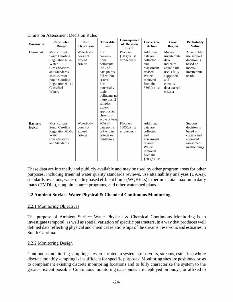
Limits on Assessment Decision Rules
Parameter Parameter Range
Null Hypothesis
Tolerable Limit
Consequence of Decision
Error
Corrective Action
Gray Region
Probability Value
Chemical Most current South Carolina Regulation 61-68 Water Classifications and Standards Most current South Carolina Regulation 61-69 Classified Waters
Waterbody does not exceed criteria
For conven-tional pollutants 90% of data points fall within criteria For potentially toxic pollutants no more than 2 samples exceed appropriate chronic or acute criteria
Place on §303(d) list erroneously
Additional data are collected and assessment revised. Waters removed from the §303(d) list
Macro-invertebrate data indicates aquatic life use is fully supported and chemical data exceed criteria
Aquatic life use support decision is based on macro-invertebrate results
Bacterio- logical
Most current South Carolina Regulation 61-68 Water Classifications and Standards
Waterbody does not exceed criteria
90% of data points fall within criteria or guidelines
Place on §303(d) list erroneously
Additional data are collected and assessment revised. Waters removed from the §303(d) list
Support decision is based on criteria and approved assessment methodology
These data are internally and publicly available and may be used by other program areas for other purposes, including triennial water quality standards reviews, use attainability analyses (UAAs), standards revisions, water quality based effluent limits (WQBELs) in permits, total maximum daily loads (TMDLs), nonpoint source programs, and other watershed plans.
2.2 Ambient Surface Water Physical & Chemical Continuous Monitoring 2.2.1 Monitoring Objectives The purpose of Ambient Surface Water Physical & Chemical Continuous Monitoring is to investigate temporal, as well as spatial variation of specific parameters, in a way that produces well defined data reflecting physical and chemical relationships of the streams, reservoirs and estuaries in South Carolina. 2.2.2 Monitoring Design Continuous monitoring sampling sites are located in systems (reservoirs, streams, estuaries) where discrete monthly sampling is insufficient for specific purposes. Monitoring sites are positioned so as to complement existing discrete monitoring locations and to fully characterize the system to the greatest extent possible. Continuous monitoring datasondes are deployed on buoys, or affixed to

-25-
floating docks if available, at two week intervals. Monitoring at a depth of 0.3 meters is continuous (15 minute intervals) throughout the growing season (May1 –October 31). The deployment period for individual meters, or for the complete study, may be altered depending on physical constraints and the objectives of the study. 2.2.3 Core and Supplemental Water Quality Indicators The datasonde firmware calculates salinity from temperature and conductivity and makes any needed temperature adjustments to DO readings. Notification of updated firmware is pushed to the end-users by the manufacturer and is installed to the datasondes by SC DHEC personnel. Results are reported as follows. The number of significant digits is dictated by the sensor precision of each measurement. Please see the datasonde-specific SOP.
Temperature – °C Conductivity – mS/cm Salinity – PPT (estuarine only) pH – Standard Units LDO – mg/L Chlorophyll a – µg/L Turbidity – NTU
2.2.4 Quality Assurance All continuous monitoring procedures and data analyses are performed in accordance with the Bureau of Water, Standard Operating Procedure for Continuous Monitoring of Ambient Surface Water (Attachment 1). 2.2.5 Data Management Once a sonde is verified after deployment the raw data are downloaded to a DHEC database which is backed up nightly. 2.2.6 Data Analysis/Assessment Calibration, validation, and verification criteria for continuous monitoring data are listed in the table below. Failure to meet these criteria during instrument calibration and validation requires that the calibration be performed again and possibly new standards made. Post-deployment verification occurs prior to cleaning and maintaining the datasonde. If verification fails the first time, the sonde is cleaned and the verification is performed again. Post processing of the data may be performed according to the Standard Operating Procedure for Continuous Monitoring of Ambient Surface Water (Attachment 1), and the data may still be used if it meets the Maximum Allowable Limits for Data Adjustment listed in the Standard Operating Procedure for Continuous Monitoring of Ambient Surface Water (Attachment 1), subject to data quality objectives.

-26-
Parameter USGS Calibration
Verification Criteria (Wagner et al., 2006)
BOW Calibration Verification Criteria
Temperature ± 0.2 ºC Secondary confirmation with NIST thermometer
at least once during field season. ± 0.1 °C
Specific Conductance
± 5 μS/cm or ±3 % of the measured value,
whichever is greater ±10%
Dissolved oxygen ± 0.3 mg/L ± 0.2 mg/L
pH ± 0.2 pH unit ± 0.2 unit
Turbidity ± 0.5 NTU or ± 5%
of the measured value, whichever is greater
± 10%
Chlorophyll a None ± 10%
2.2.7 Reporting Continuous monitoring data are reported within the final report for which the data was used.
2.3 Ocean Water Monitoring 2.3.1 Monitoring Objectives The objective of South Carolina’s ocean water monitoring program is to protect public health through the issuance of swimming advisories based on accurate, representative sampling. 2.3.2 Monitoring Design Sampling sites are located along the beachfront based on public access points. Additional sites are located near problem areas such as swashes and storm drain outfalls. Each site location has been recorded with global positioning systems (GPS) technology and mapped. Samples are collected at knee depth (approximately two feet) to best represent the area where recreation normally occurs. See Appendix E for sample site locations at the time of this publication. As swimming season approaches some modification to sample sites may be made. There are a total of 123 currently active sites in three regions monitored according to the following monitoring design:

-27-
Tier 1 Tier 2
A. When to Conduct Basic Sampling
May 1 - October 1 Once per week Random tidal stages
May 1 - October 1 Twice per month Random tidal stages
B. When to Conduct Additional Sampling
Rainfall events N/A N/A
After a water quality standard is exceeded
If any sample exceeds the action level a repeat sample will be taken within 24 hours of result notification, except where a permanent advisory sign is in place.
After a sewage spill or pollution event
Sampling will be conducted as soon as possible following a sewage spill or other pollution event. At the region manager’s discretion, beaches will be preemptively placed under advisory until satisfactory sample results are received.
Reopening after advisory or closure
Additional samples shall be taken following an advisory until sample results fall below the action level and advisory is lifted.
Further information regarding the monitoring design and sample site selection criteria can be found in South Carolina Beach Monitoring Program Quality Assurance Project Plan, Appendix B. 2.3.3 Core and Supplemental Water Quality Indicators The State records the following parameters for each ocean water sample: project code and county location, sample date, sampling time, station number, sample collector, sample identification numbers, weather conditions, rainfall amount in previous 24 hours, tidal condition, wind direction, enterococci (most probable number based on the Enterolert Quanti-tray sample method), chain of custody, and comments. Of the parameters listed, the only critical measurement is the Enterolert result. Other parameters are collected primarily for informational purposes only. 2.3.4 Quality Assurance All sampling procedures and analyses are performed in accordance with the South Carolina Beach Monitoring Program Quality Assurance Project Plan. 2.3.5 Data Management Copies of the completed Ocean Water Quality Sampling Data forms (DHEC 2508) are entered into IMAP by the Program Coordinator in Central Office. A hard copy of the form is maintained by the Field Laboratory and the original is sent to the Central Office. Data sheets are kept for three years per the retention schedule. At the end of the beach season, all data is uploaded to the EPA. Data are also available to the public by request and on the beach monitoring Web site http://gis.dhec.sc.gov/beachaccess/#. 2.3.6 Data Analysis/Assessment Swimming advisories are issued based on a single sample limit of 500 Enterococci/100 mL or a

-28-
single sample exceeding 104 Enterococci/100 mL followed by a repeat sample exceeding 104 Enterococci/100 mL. When an extreme weather event, such as a hurricane, tropical storm, or torrential rain occurs, a general advisory may be issued without current sampling data. It is known that significant rainfall within a 24-hour period causes elevated bacteria counts that exceed the advisory action levels at some stations. Data assessment procedures can be found in the South Carolina Beach Monitoring Program Quality Assurance Project Plan Appendices D and E. 2.3.7 Reporting In the event of an advisory, signs will be posted at conspicuous areas on the affected beach, if needed. Some sampling sites are permanently advised. Beach advisory signs includes a statement that explains that swimming is not advised due to high bacteria levels in the water, but that wading, fishing, and shell collecting do not pose a risk and list contact information. Local media outlets are contacted by the regional program manager or the municipality as previously negotiated. A copy of the advisory is sent by electronic mail to the program coordinator and each coastal regional EA office (Myrtle Beach, Beaufort, and Charleston). Advisories are also available through the DHEC website. All advisory data are uploaded at least yearly to EPA. Further information regarding reporting is available in the South Carolina Beach Monitoring Program Quality Assurance Project Plan, Section A9 and Appendix C.
2.4 Biological Monitoring The biological monitoring network provides information that will allow for the detection and evaluation of changes in the stability of aquatic communities, including macroinvertebrates and phytoplankton, and the analysis of fish tissue. The various activities falling under the biological monitoring program are detailed below.
2.4.1 Macroinvertebrate Bioassessment Ambient stream macroinvertebrate bioassessments are currently focused on monitoring the condition of stream water quality statewide and include an expanded array of large river sites. Emphasis is placed on building datasets with a long history of frequent sampling to allow for better resolution in the identification of water quality trends. Additionally, biological monitoring continues at statistical survey and special study stations statewide. Review of reports required by NPDES permits is ongoing. 2.4.1.1 Monitoring Objectives The South Carolina Department of Health and Environmental Control began using aquatic macroinvertebrates in environmental studies in 1974 (SCDHEC 1974, 1975). Since then the macroinvertebrate monitoring program has become an important part of the Agency and is utilized for: trend monitoring of streams and rivers, the results of which are included in the §305(b) reports to congress and the Watershed Water Quality Assessment reports produced by the SCDHEC, reporting of streams that do not meet aquatic life uses to be included on the §303(d) list, assessment of the potential impacts of NPDES discharges into waters of the state, evaluation of impacts of catastrophic events such as oil spills, evaluation of the effects of nonpoint source impacts on streams

-29-
and rivers, evaluation of potential outstanding resource waters of the state, providing data for conservation agencies and programs, documenting biodiversity, and demonstrations for volunteer monitoring programs, school groups, 4H groups, and environmental festivals in the state of South Carolina. In addition bioassessments help inform standards as the results are direct measures of aquatic life condition of waters of the Nation. 2.4.1.2 Monitoring Design Sampling sites for macroinvertebrate bioassessments fall into three broad categories: fixed stations, special study stations, and statistical survey stations. Fixed stations were once sampled on a rotating basin schedule with approximately 80 stations completed per year. Thus each site was typically sampled once every 5 years. Currently, 80 of these sites are being sampled every 2-3 years so that any trends might be observed in greater resolution. The remaining fixed stations are sampled as often as resources allow. These fixed stations were established by professional judgment. Criteria for site selection included watershed area, stream size, accessibility, and proximity to surface water quality stations. In general, fixed site macroinvertebrate bioassessments are conducted on mid-order or larger flowing streams. The resulting data represent the present condition of these streams. Special studies are conducted as needed and are generally completed in order to evaluate potential perturbation from point source or non-point source events. Examples include chemical releases, oil spills, forestry activities, or development activities. Generally, these studies involve comparing an upstream control station with a station downstream of the potential impact. These studies can be a one-time event or may continue over months or years. Statistical survey station sampling occurs during the normal fixed station index period. These sites may fall anywhere in the state. Because the selection process is random, these sites change from one year to the next. Collectively, data from the statistical survey sites provide an overview of conditions in the streams and rivers of the state. 2.4.1.3 Core and Supplemental Water Quality Indicators Ecological health of the aquatic macroinvertebrate community is determined using a variety of biometrics outlined in the most current revision of SCDHEC’s Environmental Investigations Standard Operating Procedures and Quality Assurance Manual, Section 8. The EPT (Ephemeroptera, Plecoptera, and Trichoptera) Index and Biotic Index are used to calculate a Bioclassification Score, which will be used to determine the aquatic life use support rating of the stream or river. On rare occasions other metrics may be evaluated such as Taxa Richness and Total Count, and professional judgment used to determine the final aquatic life use rating. For special study stations, it is the change in the bioclassification score from the upstream control site to the downstream test site that will determine the level of impairment an activity may have on a stream. 2.4.1.4 Quality Assurance All sampling procedures and analyses are performed under the SCDHEC Quality System which is described in the USEPA approved Quality Management Plan For S.C. DHEC (SCDHEC, 2008), with the supervision of the Quality Assurance Manager (QAM) and all procedures follow the most

-30-
current revision of SCDHEC’s Environmental Investigations Standard Operating Procedures and Quality Assurance Manual, Sections 8, 14, and 19. Please see Section 2.7 of this strategy, Quality Assurance/Quality Control Procedures, for further details. 2.4.1.5 Data Management Macroinvertebrate and habitat data are entered into an in-house relational database program. This database program generates metric calculations and reports. All data are available to the public through the Freedom of Information Act. Coverage of the macroinvertebrate monitoring stations is available through an in-house Geographic Information System. 2.4.1.6 Data Analysis/Assessment Refer to most current revision of SCDHEC’s Environmental Investigations Standard Operating Procedures and Quality Assurance Manual, Section 8. Specific limits on assessment decision rules are listed below. Limits on Assessment Decision Rules
Parameter Parameter Range
Null Hypothesis
Tolerable Limit
Consequence of Decision
Error
Corrective Action Gray Region Probability
Value
Macro-invertebrate
Most current South Carolina Regulation 61-68 Water Classifications and Standards Most current revision of Environmental Investigations Standard Operating Procedures and Quality Assurance Manual , Section 8.4
Waterbody does not fall below regional guidelines Aquatic Community below point source is similar to community at upstream control
Index values meet or exceed regional guidelines Difference between upstream and downstream index value is no greater than guidelines
Place on §303(d) list erroneously Point source discharger is required to investigate potential cause of condition
Additional data are collected and assessment revised. Waters removed from the §303(d) list Continued monitoring to determine variability
Bio-assessment scores can be affected by non-anthropogenic stressors. Discharge into headwater streams lack upstream control.
Support decision is based on field, habitat, or chemical data
2.4.1.7 Reporting Macroinvertebrate community assessment conclusions are forwarded to the Surface Water Monitoring Section for consideration in the development of Watershed Water Quality Assessments and assessments pursuant to §303(d) and §305(b) of the Clean Water Act.
2.4.2 Fish Tissue Monitoring 2.4.2.1 Monitoring Objectives The collection of fish for the purpose of tissue analysis is necessary to detect the presence and levels of heavy metals, pesticides and toxic organic compounds in edible tissue that may concentrate
-31-
through aquatic food chains and threaten the health of human consumers. Aquatic organisms may accumulate contaminants through gills and epithelial tissue directly from water and sediment (bioconcentration), a combination of bioconcentration and dietary sources (bioaccumulation), or a process by which the tissue concentrations increase as the contaminant passes up the food chain (biomagnification). Data collected is used to issue consumption advisories for the protection of public health when necessary. 2.4.2.2 Monitoring Design and Core and Supplemental Indicators A Statewide Survey for mercury contamination was initiated in 1993. This sampling will be continued in CY 2018. Largemouth bass (Micropterus salmoides) and one other common game fish will be sampled at approximately 60 freshwater sites in CY 2018. Fish tissue sites are established for lakes, rivers, and streams based on river miles or surface acreage. Generally at least ten samples from each site will be analyzed for mercury and one to two samples from each site will be analyzed for other heavy metals, pesticides and PCBs. Monitoring sites locations are listed in Appendix G. Through a cooperative effort, the South Carolina Department of Natural Resources, Marine Resources Research Institute, is furnishing saltwater fish each year from estuaries for tissue analysis. Red drum, spotted sea trout, and southern flounder are the target species. Emphasis will be placed on Upper and Lower Cape Romain, the Ashley River, Charleston Harbor, Winyah Bay, the ACE basin, and the Wando River. SCDNR also provides samples of swordfish, wahoo, dolphin, and tuna for tissue analysis, as available. Through a cooperative effort with other coastal Southeastern states, King mackerel and Spanish mackerel will be collected from selected tournaments and SCDNR routine sampling. The resulting data will be used to supplement the current advisories on mackerel. Tissue from select other saltwater species will be obtained as they become available. American alligator tissue has been obtained in the past through a collaborative effort with the South Carolina Department of Natural Resources. 2.4.2.3 Data Assessment The SCDHEC uses a risk-based approach to evaluate contaminant concentrations in fish tissue and to issue consumption advisories in affected waterbodies. This approach contrasts the average daily exposure dose to the reference dose (RfD). Using these relationships, fish tissue data are interpreted by determining the consumption rates that would not be likely to pose a health threat to adult males and nonpregnant adult females. Because an acceptable RfD for developmental neurotoxicity has not been developed and because scientific studies suggest that exposure before birth may have adverse effects the health of infants, pregnant women, infants, and children are advised to avoid consumption of fish from any waterbody where an advisory has been issued. Specific limits on assessment decision rules are listed below.

-32-
Limits on Assessment Decision Rules
Parameter Parameter Range Null Hypothesis
Tolerable Limit
Consequence of Decision
Error
Corrective Action
Probability Value
Fish Tissue Most current South Carolina Regulation 61-68 Water Classifications and Standards Most current revision of Environmental Investigations Standard Operating Procedures and Quality Assurance Manual , Section 8.5
Fish tissue samples do not exceed risk-based contaminant concentration
Tissue concentration meet risk-based contaminant concentration
Place on §303(d) list and issue fish consumption advisory erroneously
Additional data are collected and assessment revised. Waters removed from the §303(d) list
Support decision is based on accepted risk-based approach
2.4.2.4 Quality Assurance
All sampling procedures and analyses are performed under the SCDHEC Quality System which is described in the USEPA approved Quality Management Plan For S.C. DHEC, with the supervision of the Quality Assurance Manager (QAM) and all procedures follow the most current revision of SCDHEC’s Environmental Investigations Standard Operating Procedures and Quality Assurance Manual, Section 8. All laboratory analyses are performed according to the most current revision of SCDHEC’s Procedures and Quality Control Manual for Chemistry Laboratories--Analytical Services. Please see Section 2.7 of this strategy, Quality Assurance/Quality Control Procedures, for further details. 2.4.2.5 Data Management After samples are collected, data sheets are kept on file in the Aquatic Biology Section until sample analysis is completed. Upon completion of analysis, any physical or chemical data are placed in STORET or a similar data tracking system. Fish tissue results are entered into an Excel database and hard copies are filed and kept on site. The tissue data are currently being entered and stored in a separate database that will be uploaded to STORET or a similar data tracking system.
2.4.3 Phytoplankton & Chlorophyll Monitoring Phytoplankton are the microscopic plants that live free-floating and suspended in bodies of water. The abundance of phytoplankton can strongly influence non-biological aspects of water quality such as pH, dissolved oxygen, color, taste, and odor. Certain species of phytoplankton flourish in highly eutrophic (nutrient enriched) waters while distinct types are very sensitive to organic and/or other chemical wastes. Some species are capable of producing noxious blooms in the form of highly turbid water, floating algal mats, or surface scums. Offensive odors and tastes may develop from these blooms, thereby spoiling a water resource for its various uses. Anoxic conditions that may kill fish and other aquatic life can also result from excessive algal blooms. Toxic conditions resulting in

-33-
human illness and animal deaths can be created by a few phytoplankton species. Chlorophyll a is an indirect measure of phytoplankton biomass that can serve as a warning of the potential to develop nuisance algae bloom conditions. The algal biomass is therefore likely to be indicative of water quality in a selected water body. Consequently, chlorophyll a analyses is a particularly useful biological indicator for assessing nutrient enrichment in water bodies and can aid in management decisions for protecting water resources. Chlorophyll a can be used to assess current water quality in lakes/reservoirs of interest and to provide a baseline of data to observe any potential changes. In addition, the effectiveness of management actions to control nutrient enrichment can be evaluated through a continuing chlorophyll monitoring program. 2.4.3.2 Monitoring Design Sites for chlorophyll monitoring are selected using an integrated approach to best characterize the quality status of the State’s waters. This process includes designating a variety of sites including fixed-station and statistical survey design. Individual sites monitored for chlorophyll a are designed to be representative of segments (e.g. estuary) or areas (embayment of lake) of targeted water bodies. Collectively, monitored sites provide an overview of conditions in specific resource types (e.g. coastal estuaries, lakes/reservoirs, etc.). For CY 2018, chlorophyll a samples will be collected monthly, May through October, at the 30 selected lake statistical survey sites, the 30 selected statistical survey estuary sites, 39 Base Sites and 5 Special Request Sites on lakes. These sites represent all lake locations among the current Base Sites, Special Request Lake Sites, and all Statistical Survey Lake Sites and all Core Statistical Survey Estuarine Sites. It also includes 4 Base Sites and 5 Statistical Survey Lake Sites collected by the Santee Cooper Public Service Authority in a cooperative effort. 2.4.3.3 Core and Supplemental Water Quality Indicators Chlorophyll a is a core indicator for lake/reservoirs habitats that can be used for direct comparison to numeric State standards. In estuaries, where numeric standards are under development, it serves as a supplemental indicator. 2.4.3.4 Quality Assurance All sampling procedures and analyses are performed under the SCDHEC Quality System which is described in the most current USEPA approved Quality Management Plan South Carolina Department of Health and Environmental Control, with the supervision of the Quality Assurance Manager (QAM) and all procedures follow Chlorophyll a Laboratory Methods, SCDHEC Technical Report 0609-15. Please see Section 2.7 of this strategy, Quality Assurance/Quality Control Procedures, for further details. 2.4.3.5 Data Management Chlorophyll data has been entered into “legacy” STORET prior to the advent of the Modernized

-34-
STORET system. Chlorophyll data in STORET are directly accessible by the general public via the internet. In general, chlorophyll a data are entered into Modernized STORET at least annually. Some recent chlorophyll data have not been entered into STORET due to recent STORET software changes. 2.4.3.6 Data Analysis/Assessment Assessment of Chlorophyll a data are included in the SCDEHC data analysis and assessment methodology used to make attainment decisions about State waters included in the Integrated Report, which is submitted to EPA on even numbered years for review and approval. The most recent version is published in the most current version of the State of South Carolina Integrated Report Part I: Listing of Impaired Waters which can be found on the SCDHEC website at http://www.scdhec.gov/HomeAndEnvironment/Water/ImpairedWaters/Overview/. 2.4.3.7 Reporting Chlorophyll a assessment conclusions are forwarded to the Surface Water Monitoring Section for consideration in the preparation of the biennial Integrated Report, which addresses Clean Water Act §303(d), §305(b), and §314 reporting requirements, and the annual Watershed Water Quality Assessments. These reports are available on the SCDHEC website.
2.5 Shellfish Growing Area Water Quality Monitoring 2.5.1 Monitoring Objectives South Carolina’s Shellfish Sanitation Program monitors approximately 580,199 acres of surface water with assigned classifications designated for the harvest of Molluscan shellfish. These coastal waters are divided into 25 shellfish management areas with a total of 462 active monitoring stations. The objectives of the shellfish-monitoring network are to provide data that accurately reflect sanitary and environmental conditions of coastal shellfish and shellfish growing waters in South Carolina in order to:
• Ensure that the health of shellfish consumers is protected; • Protect and maintain existing shellfish growing area water use; and • Identify impaired waters suitable for restoration to appropriate use standards.
2.5.2 Monitoring Design The shellfish-monitoring program provides the database that is used in conducting a comprehensive evaluation of each shellfish growing area. Evaluations of growing areas, which meet NSSP requirements for Triennial Reviews, are conducted annually. Routine bacteriological monitoring and subsequent laboratory analyses of water quality from strategically located sample sites are conducted monthly. Monitoring is based on a systematic random sampling methodology in which coastal shellfish growing area surface waters are sampled in accordance with a pre-established schedule, thereby assuring that a statistically representative cross-section of meteorological, hydrographic, and/or pollution events will be included in the data set. Monitoring sites are established at locations

-35-
representative of variable water quality within non-Prohibited classified shellfish areas. Locations are sited with the intent of determining compliance with existing State shellfish regulation water quality standards. Individual monitoring sites are typically representative of a water reach extending in the directions of tidal flow to the closest adjacent monitoring sites. Resulting laboratory analyses detail physical and bacteriological data that are used to classify shellfish growing waters. All standards, monitoring methodology, and laboratory analyses comply with guidance set forth in the National Shellfish Sanitation Program Model Ordinance. Areas closed to the harvesting of shellfish are posted with signs indicting the potential for serious illness from consuming shellfish harvested within these areas and outlining penalties for harvest violations. The monitoring network also serves to update sanitary-related data from each shellfish area to ensure that conditions that existed during the prior review period still prevail; that the harvest classification is correct; and, ultimately that shellfish are harvested only from growing areas that meet or exceed established standards for shellfish growing waters. Complete descriptions of station locations are included in Appendix H. 2.5.3 Core and Supplemental Water Quality Indicators Fecal coliform, used as a human pathogen indicator organism, is the bacteriological parameter used to decide between the Approved and Restricted classifications (Table 2). Additional monitoring parameters (Salinity, Tide Stage, Wind Direction, etc.) are frequently used in conjunction with the fecal coliform standard and observed meteorological and/or hydrographic conditions in determining the appropriateness of implementing the Conditionally Approved classification. 2.5.4 Quality Assurance Shellfish Sanitation Program monitoring complies with most current revision of SCDHEC’s EQC Environmental Investigations Standard Operating Procedures and Quality Assurance Manual, Section 8.10, and all laboratory analyses are conducted by the Bureau of Environmental Health Services according to the most current revision of SCDHEC’s Laboratory Procedures Manual for Environmental Microbiology-- Analytical Services. 2.5.5 Data Management Shellfish data are stored in STORET. Individual data collected subsequent to the mid-1990s are available through FOI request in an electronic (Excel) format. All monitoring sites are represented in a digital coverage located on the Department’s GIS server. 2.5.6 Data Analysis/Assessment S.C Regulation 61-47, Shellfish, has established a fecal coliform standard (geometric mean not to exceed 14 fc mpn/100ml and the estimated 90th percentile value not to exceed 43 mpn/100ml) for waters classified as Approved. Sites are monitored on a monthly basis, with monitoring scheduled in advance so as to be random with respect to tide and weather conditions. Data collected over a thirty-six consecutive month period is used in determining compliance. A minimum of thirty samples is required to be collected from each monitoring site for

-36-
classification. This standard and methodology fully complies with National Shellfish Sanitation Program Model Ordinance guidance criteria. All shellfish waters receive one of the following harvest classifications.
Table 2. Fixed-Station Shellfish Monitoring Program Physical and Bacteriological Parameter Coverage and Sampling Frequency
_____________________________________________________________________________
Parameter Group Parameter Water Shellstock _____________________________________________________________________________
Physical Tide Stage * NA Water Temperature * NA Air Temperature * NA Wind Direction * NA Salinity * NA
--------------------------------------------------------------------------------------------------------------------- Bacteriological Fecal Coliform * **
Total Plate Count NA ** E. coli ** ** Sample Temperature * ** Sample Type NA ** Species NA **
_____________________________________________________________________________ *Sampled monthly (minimum frequency). **Sampled as appropriate. 2.5.6.1 Approved: Growing areas shall be classified Approved when the sanitary survey concludes that fecal material, pathogenic microorganisms, and poisonous or deleterious substances are not present in concentrations which would render shellfish unsafe for human consumption. Approved area classification shall be determined upon a sanitary survey, which includes water samples collected from stations in the designated area adjacent to actual or potential sources of pollution. For waters sampled under adverse pollution conditions, the median fecal coliform Most Probable Number (MPN) or the geometric mean MPN shall not exceed fourteen per one hundred milliliters, and not more than ten percent of the samples shall exceed a fecal coliform MPN of forty-three per one hundred milliliters (per five tube decimal dilution). For waters sampled under a systematic random sampling plan, the geometric mean fecal coliform Most Probable Number (MPN) shall not exceed fourteen per one hundred milliliters, and the estimated ninetieth percentile shall not exceed an MPN of forty three (per five tube decimal dilution). Computation of the estimated ninetieth percentile shall be obtained using NSSP guidelines. 2.5.6.2 Conditionally Approved: Growing areas may be classified Conditionally Approved when they are subject to temporary conditions of actual or potential pollution. When such events are predictable as in the malfunction of wastewater treatment facilities, non-point source pollution from rainfall runoff, discharge of a major river, potential discharges from dock or

-37-
harbor facilities that may affect water quality, a management plan describing conditions under which harvesting will be allowed shall be adopted by the Department, prior to classifying an area as Conditionally Approved. Where appropriate, the management plan for each Conditionally Approved area shall include performance standards for sources of controllable pollution, e.g., wastewater treatment and collection systems, evaluation of each source of pollution, and means of rapidly closing and subsequent reopening areas to shellfish harvesting. Memorandums of agreements shall be a part of these management plans where appropriate. Shellfish shall not be directly marketed from a Conditionally Approved area until conditions for an Approved classification have been met for a time that should insure the shellfish are safe for consumption. Shellstock from Conditionally Approved areas that have been subjected to temporary conditions of actual or potential pollution may be relayed to Approved areas for purification or depurated through controlled purification operations only by special permit issued by the Department. 2.5.6.3 Restricted: Growing areas shall be classified Restricted when sanitary survey data show a limited degree of pollution or the presence of deleterious or poisonous substances to a degree which may cause the water quality to fluctuate unpredictably or at such a frequency that a Conditionally Approved area classification is not feasible. Shellfish may be harvested from areas classified as Restricted only for the purposes of relaying or depuration and only by special permit issued by the Department and under Department supervision. The suitability of Restricted areas for harvesting of shellstock for Relay or Depuration purposes may be determined through the use of comparison studies of background tissue samples with post-process tissue samples, as well as other process verification techniques deemed appropriate by the Department. For Restricted areas to be utilized as a source of shellstock for depuration, or as source water for depuration, the fecal coliform geometric mean MPN of restricted waters sampled under adverse pollution conditions shall not exceed eighty-eight per one hundred milliliters and not more than ten percent of the samples shall exceed a MPN of two hundred and sixty per one hundred milliliters for a five tube decimal dilution test. For waters sampled under a systematic random sampling plan, the fecal coliform geometric mean MPN shall not exceed eighty-eight per one hundred milliliters and the estimated ninetieth percentile shall not exceed an MPN of two hundred and sixty (five tube decimal dilution). Computation of the estimated ninetieth percentile shall be obtained using the formula outlined in the NSSP manual. 2.5.6.4 Conditionally Restricted: Growing areas may be classified Conditionally Restricted when they are subject to temporary conditions of actual or potential pollution. When such events are predictable, as in the malfunction of wastewater treatment facilities, non-point source pollution from rainfall runoff, discharge of a major river or potential discharges from dock or harbor facilities that may affect water quality, a management plan describing conditions under which harvesting will be allowed shall be prepared by the Department prior to classifying an area as Conditionally Restricted. Where appropriate, the management plan for each Conditionally Restricted area shall include performance standards for sources of controllable pollution, e.g., wastewater treatment and collection systems and an evaluation of each source of pollution, and

-38-
description of the means of rapidly closing and subsequent reopening areas to shellfish harvesting. Memorandums of agreements shall be a part of these management plans where appropriate. Shellfish may be harvested from areas classified as Conditionally Restricted only for the purposes of relaying or depuration and only by permit issued by the Department and under Department supervision. For Conditionally Restricted areas to be utilized as a source of shellstock for depuration, the fecal coliform geometric mean MPN of Conditionally Restricted waters sampled under adverse pollution conditions shall not exceed eighty-eight per one hundred milliliters and not more than ten percent of the samples shall exceed a MPN of two hundred and sixty per one hundred milliliters for a five tube decimal dilution test. For waters sampled under a systematic random sampling plan, the fecal coliform geometric mean MPN shall not exceed eighty-eight per one hundred milliliters and the estimated ninetieth percentile shall not exceed an MPN of two hundred and sixty (five tube decimal dilution). Computation of the estimated ninetieth percentile shall be obtained using ISSP guidelines. 2.5.6.5 Prohibited: Growing areas shall be classified Prohibited if there is no current sanitary survey or if the sanitary survey or monitoring data show unsafe levels of fecal material, pathogenic microorganisms, or poisonous or deleterious substances in the growing area or indicate that such substances could potentially reach quantities which could render shellfish unfit or unsafe for human consumption. Waters classified as Prohibited are administrative closures. Harvesting of shellfish for human consumption from Prohibited areas shall not be allowed by the Department. Shellfish may be depleted for non-food use from Prohibited areas upon approval of the Department and under specified conditions. Growing waters adjacent to sewage treatment plant outfalls and other waste discharges shall be classified Prohibited. A variety of assumptions and criteria will be considered in determining the area that could be potentially impacted. Growing waters within marinas shall be classified as Prohibited. Classification of waters adjacent to marinas will be determined using a dilution analysis that incorporates various assumptions. 2.5.6.6 Waters meeting the standard are typically classified as Approved and waters exceeding the standard are classified as Restricted. Approved waters approaching the standard’s limit (14/43) or Restricted waters slightly exceeding the standard are candidates for management under the Conditionally Approved classification. Use of this classification requires that pollution events be predictable and manageable. Management of Conditionally Approved areas is manpower intensive and, although its use is encouraged; field managers are allowed some discretion in its implementation.

-39-
2.5.7 Reporting The Shellfish Sanitation Program produces annual reports for each of the twenty-five shellfish management areas. These reports are routinely distributed to the United States Food and Drug Administration, the South Carolina Department of Natural Resources, the Department’s Office of Coastal Resource Management, and the Department’s Bureau of Water – Division of Water Quality. All reports are updated annually and are available for viewing on the Department’s Shellfish Sanitation Program webpage.
2.6 Groundwater Monitoring Ambient groundwater monitoring is currently suspended. This section is reserved for future use as needed.
2.7 Quality Assurance/Quality Control Procedures SCDHEC’s Quality System is the means by which the Department implements the quality management process. The Quality System encompasses a variety of technical and administrative elements, which are outlined in the SCDHEC Quality Management Plan. This plan describes how programs within Environmental Affairs (EA) will plan, implement, and assess the quality of environmental work to be performed as part of the various programs’ functions within the Agency. The Director of Environmental Affairs has the overall responsibility for the development, implementation, and continued operation of EA's Quality Assurance (QA) Program. To ensure that EA's QA Program is uniformly applied to the generating and processing of all environmental data, a Quality Assurance Manager (QAM) has been appointed. The QAM is responsible for the Quality Assurance Program. Environmentally-related measurement activities conducted by or for EA shall be done only with the approval of the QAM and/or QAM designee after ensuring that adequate quality assurance guidelines and procedures have been incorporated. This includes study-planning, sample collection, preservation and analysis, data handling, and use of physical, chemical, biological, and other data related to the effects, sources, transport and control of pollution, as well as personnel review and training. 2.7.1 Quality Assurance Project Plans and Standard Operating Procedures Two basic tools for QA management are QA Project Plans (QAPPs) and Standard Operating Procedures (SOPs). Routine studies (program monitoring activities) are implemented under a generic project plan, primarily SOPs. Special studies require a written QAPP specific to that study. Special studies involving an immediate public health threat or a criminal investigation may not have an approved QAPP due to the limited time frame for obtaining samples. These studies will be handled like routine work requiring adherence to applicable SOPs. To accomplish the above, each environmental monitoring organization shall develop and implement SOPs, approved by the QAM and/or designee, for all monitoring activities.
-40-
2.7.2 Sampling Methods EA’s sampling manual is entitled the Environmental Quality Control Environmental Investigations Standard Operating Procedures and Quality Assurance Manual. This document is reviewed periodically and updated as needed. However, Staff can choose to update more frequently if changes in regulation or methodology require it. The manual describes in detail the field sampling procedures by matrix, field instrument calibration and maintenance procedures, sample chain-of-custody documentation, sample preservation, holding times and recommended sample containers specifications, data sheet examples, and data submission requirements. This manual is mainly an internal document. Upon request, specific sections may be released to external parties; however the QAM must approve the request. 2.7.3 Training An intranet training program has been established to ensure staff have access to the most recent revision of the field SOPs and have acknowledged they are familiar with the SOP content for specific assigned duties. Each program area will ensure that all personnel performing tasks and functions related to data quality will have the needed education, training, and experience. Training is tracked through the MySCLearning system. A review of basic training requirements for field staff is found in Section 4 of the most current revision of SCDHEC’s Environmental Quality Control Environmental Investigations Standard Operating Procedures and Quality Assurance Manual. The training of laboratory personnel is discussed in the most current revision of SCDHEC’s Procedures and Quality Control Manual for Chemistry Laboratories, Volume 1, Section III and Laboratory Procedures Manual for Environmental Microbiology -- Analytical Services, Section III. These Sections incorporate forms for acknowledgement that the analyst has read the method, as well as tracking forms for other various types of training. This information is kept on file at the Analytical and Radiological Environmental Services Division or appropriate Regional Laboratory. Each analyst is required to show proficiency in the analysis prior to analyzing samples. Training and documentation of proficiency are kept on file in the appropriate laboratory. 2.7.4 DHEC QA Policy It is the practice of Environmental Affairs (EA) that necessary quality assurance (QA) activities be conducted within the State of South Carolina to demonstrate that all environmental data generated, processed, or used will be scientifically valid, defensible, and of known and acceptable precision and accuracy. It is also critical that all reported data include documented precision and accuracy and be complete, representative, and comparable. The quality of all data generated shall meet or exceed all EA and EPA program requirements. 2.7.5 Documents and Records The following list of documents and records are maintained and stored per Monitoring Strategy requirements.
• Bound Field Logbooks/Workbooks

-41-
In these logbooks are recorded all of the routine daily meter calibration results, remarks and notes relating to all activities, and values for all field measured parameters as well as time, date, station location, and collector identification information associated with all sampling activities. This logbook format provides a legally admissible document for any court supervised compliance/enforcement proceedings. • Chain of Custody Information • Sample Request Sheets/Data • EPA STORET Data • Special Study QAPPs/Data • Analytical Workbooks/Sample Results • Technical Reports • QA Assessment Reports (Lab and Field)
2.7.6 Quality Assurance Assessment Audits are the principal means in this Agency’s QA Program to determine compliance with established QA protocols and guidelines. A complete discussion of these audits can be found in Section 3 of the most current revision of SCDHEC’s Environmental Investigations Standard Operating Procedures and Quality Assurance Manual. The following audits are conducted by the Quality Assurance Manager (QAM) and/or designee:
• Performance Audits • Data Quality Audits • System Audits
In addition, the Office of Environmental Laboratory Certification performs a certification audit on EA internal laboratories (both field and regional laboratories) at least every 3 years under both the CWA and SDWA. 2.7.6.1 Water Quality Monitoring Program Assessment To accomplish the QA objectives cited above, the Surface Water Monitoring and Dam Safety Section and Water Pollution Compliance Section have developed and instituted QAM- approved field study procedures and documentation, data review, and routine EPA operating overview. Some specifics of these Sections' QA/QC activities include:
• Submission of all Quality Assurance Project Plans (QAPPs) to the QAM and/or designee for review and approval prior to implementation. Submission of work plans as requested by the QAM. The project manager can also request reviews of work plans to ensure QA/QC requirements are addressed completely and correctly.
• Regular reviews and updates of SCDHEC's Environmental Investigations Standard
Operating Procedures and Quality Assurance Manual (SOP) and Procedures Manual for Stream and Wastewater Facility Flow Measurement.

-42-
• At least once yearly all water quality monitoring personnel are accompanied on sample
collection activities by the Surface Water Monitoring and Dam Safety Section quality assurance officer for evaluation of adherence to standard operating procedures (SOP) for QA/QC.
• Water Pollution Compliance Section program staff routinely accompany facility compliance
monitoring personnel to ensure adherence to standard operating procedures (SOP) during sample collection activities for QA/QC.
• All SC DHEC EA laboratories in the State are expected to participate in Proficiency Testing
as a requirement for their Certification. • Field staff are also required to participate in either analyzing blind QC samples or PT
samples if they perform field analysis for residual chlorine, conductivity and/or pH.
• Approximately every three years, EPA Region 4 Office conducts an on-site routine audit of the Analytical and Radiological Environmental Services Division (ARESD), the Central Laboratory in Columbia and also reviews the Laboratory SOPs. EPA also conducts an on-site audit of all regional laboratories certified for drinking water parameters each cycle. Approximately every three years the Office of Environmental Laboratory Certification performs an on-site audit that covers both drinking water and wastewater.
• Internal assessments are also performed on ARESD Laboratories. These are conducted by
the QAM or designee or via the peer review process; but these are not certifying audits. EPA Region 4 is the certifying authority over the ARESD Laboratories.
2.7.7 Corrective Actions/Quality Improvement Identifying quality problems and improving performance are key components in our quality improvement efforts. The QAM is responsible for responding to and resolving all quality assurance problems and needs. The QAM will initiate corrective action to adverse conditions that compromise quality in the field or laboratory. Corrective actions may originate from audit findings or problems encountered and reported to the QAM or Program Manager. Staff are expected to initiate corrective actions immediately to resolve QA issues and concerns, to document corrective action and the results of the corrective action. Laboratories that fail Proficiency Studies must submit a letter to the Office of Environmental Laboratory Certification explaining the reason for the failure and the correction action taken. Central/Regional Office Monitoring Program Managers and Laboratory Managers are responsible for making sure corrective actions have been implemented, were effective, and reported to the appropriate Program manager, Project manager, and/or the QAM.

-43-
2.8 Laboratory Support 2.8.1 Laboratory Services The Analytical and Radiological Environmental Services Division (ARESD) in the Bureau of Environmental Health Services (BEHS) provides laboratory services to the Bureaus of Water, Land and Waste Management, and the Milk and Dairy Program. The analytical services offered include bacteriological, chemical, and physical analyses. The types of samples analyzed include water, wastewater, leachate, soil, sediment, chemical waste, fish, shellfish, and milk/dairy products. The BEHS organizational structure encompasses the Central Laboratory (ARESD), seven regional laboratories (each of these regional labs also has a field lab), and five additional field labs. ARESD, also known as the Central Laboratory includes the following laboratories: Microbiology and Milk/Dairy, Inorganic Chemistry, Organic Chemistry, Radiochemistry and the Sample and Data Management Section. These areas are located in the Hayne Building in Columbia. The seven regional laboratories are located in Aiken, Beaufort, North Charleston, Florence, Greenville, Lancaster, and Myrtle Beach. Other field labs which only collect samples and perform field analyses (pH, conductivity, temperature, residual chlorine, and dissolved oxygen) are located in Anderson, Greenwood, Spartanburg, Columbia, and Sumter. The Columbia facility is separate from ARESD, but collects samples for this lab. ARESD, in turn, performs similar functions as the other regional laboratories for the Columbia facility. The field laboratories initiate all stream and wastewater analysis. The Central Laboratory provides support analyses, i.e., metals, nutrient, extraction procedures, and organic analyses. The Beaufort and Myrtle Beach regional laboratories analyze microbiological samples only. Drinking water chemical analysis is essentially a Central Laboratory program with support from the regional labs. All regional laboratories perform microbiological analyses for the Drinking Water Program. 2.8.2 ARESD Quality Assurance Program The Assistant Bureau Chief (ABC) of the BEHS Laboratories, who serves as the Quality Assurance Manager (QAM), along with the Division Director of ARESD coordinate the internal quality assurance program. The laboratory quality assurance program encompasses every aspect of the laboratory analysis from container preparation through the actual data release from ARESD to the Environmental Affairs’ Programs. 2.8.2.1 ARESD has four quality control manuals which detail the day-to-day operation of the quality assurance program: (1) Procedures and Quality Control Manual for Chemistry Laboratories -- ARESD, (2) Laboratory Procedures Manual for Environmental Microbiology -- ARESD, (3) Procedures and Quality Control Manual For the Radiochemistry Laboratory -- ARESD, and (4) Standard Operating Procedures for Milk and Dairy -- ARESD. The elements addressed in the manuals include organization; sample chain of custody; personnel training; quality control of laboratory services, scope and application, equipment and supplies, reagents, standards, methodology, preservation and storage, calibration, performance criteria and quality assurance, and waste management.

-44-
2.8.2.2 The overall laboratory quality assurance program contains many elements, some of which have been previously discussed. The frequency for analysis of replicates and spike recovery samples is noted in the manuals and is in compliance with U.S. EPA guidelines. Acceptance criteria for each QC check is detailed in each procedure of the SOP Manual. The Environmental Microbiology Laboratories perform replicate analyses, positive test controls, media control tests, equipment control tests, etc., as required by EPA Laboratory Certification and Evaluation guidelines. In addition, ARESD and the regional laboratories participate in annual Water Supply and Water Pollution Proficiency Testing Programs. All regional personnel who collect samples that require field testing participate in either the yearly Water Supply or Water Pollution Proficiency Testing Program, whichever is appropriate. Occasionally, field or other non-laboratory staff may assist the Microbiologist in setting up samples or reading them. Anyone participating in this way must demonstrate proficiency in any activity they will perform. Their proficiency is assessed through use of a blind sample obtained from either a QC Sample Vendor or made in-house. This proficiency is documented and kept in the Regional Office. 2.8.2.3 The laboratory analyses for water quality monitoring are conducted according to 40 CFR Parts 141, 136, and 143. The ARESD quality control manuals include a section on methodology designed to reduce variations in applied techniques among the State laboratories where methods permit analyst interpretation, and thus provide a more uniform approach which will increase the reproducibility of results reported from the laboratory system. Analytical SOPs are identified by number and date of revision. Each SOP includes the approved method reference. SOPs are reviewed annually. SOPs include instrument calibration and maintenance procedures as well as corrective actions for any deficiencies or problems encountered. 2.8.3 Sample Containers and Preservation 2.8.3.1 Control of the quality of laboratory analyses begins with the sample collection. The validity of analytical results obtained depends upon a representative sample of the source from which it was collected. The concentration of each constituent in a sample at the time of collection must be maintained until all analyses have been completed. Constituent concentrations may be altered after collection through contamination of the container, reactions between sample components and the container walls, and through naturally occurring reactions within the sample itself. This section contains the methodology employed by the laboratories to control those factors which can affect sample validity. The field sample collection procedures, standard operating procedures, and QC procedures are documented in the most current revision of SCDHEC’s manual entitled Environmental Quality Control Environmental Investigations Standard Operating Procedures and Quality Assurance Manual. 2.8.3.2 The proper containers must be selected for sampling as well as the proper preservation and an adequate volume collected. Sample chain of custody procedures must be adhered to in order to ensure that sample integrity is maintained. An accurate record is needed to trace the possession of each sample from the time of collection to analysis. The reader should refer to the most current revision of SCDHEC’s manual entitled Environmental Quality Control Environmental Investigations

-45-
Standard Operating Procedures and Quality Assurance Manual, Section 19 and Appendix A for details. Glass, polyethylene, and polypropylene bottles are used as sample containers. The sample container is cleaned and labeled for the parameter for which it is used. The containers used for the various parameters have been chosen for their chemical resistance to the chemical parameter of interest and the required preservatives. Random substitution of containers may not be made. Special cleaning procedures are employed for the various containers. Each parameter or parameter group involves different interfering compounds and contaminants which must be removed from the container walls. Containers required for parameters analyzed by the Organic and Inorganic Chemistry Laboratories are maintained by those laboratories. Clean containers for organic and inorganic parameters are shipped to the field laboratories by the Data Management Section in Columbia. Containers required for parameters analyzed by the field laboratories are maintained by those laboratories and cleaned according to special procedures. 2.8.3.3 All ambient water and wastewater samples are preserved at the site immediately after collection or collected in pre-preserved containers. Some drinking water samples are preserved at the site, collected in pre-preserved containers or may be preserved after they have been brought back to the office or the lab in accordance with requirements established by the United States Environmental Protection Agency. The field laboratories are responsible for requesting the preservatives in order to maintain an ample quantity; and the central and regional laboratories provide the supplies upon request. Each dispenser is labeled in bold letters to assist the collector to choose the proper preservative for the container; i.e., METALS, MERCURY, NUTRIENTS, TOC, etc. Because the concentration levels cannot be maintained at the level collected indefinitely, maximum holding times have been set for each parameter. Analyses must be completed during the time limits set for valid results. Required containers, preservatives, and holding times for each parameter and procedures used for preserving samples are listed in the most current revisions of manuals listed in Section 2.8.2.1, and Environmental Quality Control Environmental Investigations Standard Operating Procedures and Quality Assurance Manual (Appendix A). 2.8.4 Laboratory Evaluation Program The SC Environmental Laboratory Certification Program is authorized by Regulation 61-81 entitled “State Environmental Laboratory Certification Regulation” which became effective on January 1, 1981. The Regulation applies to all laboratories which generate data for compliance with state environmental regulations or that is performing any other analyses related to environmental quality evaluations required by the Department or which will be officially submitted to the Department. On-site evaluations of in-state certified laboratories are conducted at least every three years and are scheduled approximately three months prior to the date of expiration documented on the laboratory’s certification certificate. The Certification Program currently offers certification for laboratories performing analyses of drinking water, wastewater and solid and/or hazardous wastes.
-46-
2.9 Data Review, Verification, and Validation The following protocols are followed for review and verification of data use in the Ambient Water Quality Monitoring Program. Data validation and decisions regarding anomalous data are made independently for different activity’s data applications.
• The analyst reviews data and QC for accuracy and completeness. Data are submitted to the Lab Manager or senior level personnel for review and data verification.
• The laboratory manager reviews all sample request sheets originating in the region for
correct information and sends to the Analytical and Radiological Environmental Services Division.
• The analyst, manager, Data Management staff, or designated individual enters data into
LIMS. Senior level personnel or the Data Management staff verify the transcribed data for accuracy. The Lab Director or designee releases the verified data from the laboratory and sends to the appropriate program area.
• When a particular sample fails any portion of the laboratory QC procedures, the data is
flagged in the LIMS according to Section IV-G of the most current revision of SCDHEC’s Procedures and Quality Control Manual for Chemistry Laboratories -- ARESD and Section IV-E of the Laboratory Procedures Manual for Environmental Microbiology -- ARESD. The data is not reportable if the Laboratory Fortified Blank (LFB) is unacceptable. If the surrogate recovery or laboratory matrix spike are out-of-control limits, this may be due to a matrix effect and the data still may be considered valid and reportable (with data flags) after all procedural requirements such as repeating the analysis or sample preparation have been exhausted. The program can request that data be released to them for information purposes only in some instances, e.g. if holding times were exceeded because samples did not arrive in the lab to be analyzed in a timely manner. The data notes would state that samples exceeded holding time, but were analyzed at the program’s request. However, any program request for data for informational purposes only must be made in writing documenting the limited use for non-regulatory purposes. This request should be made to the Laboratory Director of ARESD.
• Upon analysis completion and validation, data are released by the laboratory and sent to the specific program areas responsible for the original samples for final QA review.
• As part of an on-site audit, a peer review process performs an internal assessment which
traces the data from the collection activities, through the analytical methodology, and to the final report.
2.9.1 Reconciliation with Program Specific Data Quality Objectives The Bureau of Water’s Division of Water Quality Management, Assessment and Protection is responsible for final review and reporting of all monitoring results to EPA and other end users.

-47-
For continuous monitoring data, all raw data are maintained separately from any post-processing data correction/adjustment files created. Once data adjustments are applied, then each recorded data point is compared to the original, unadjusted record. It is assigned an accuracy rating according to the table in Section 15.3 of Standard Operating Procedure for Continuous Monitoring of Ambient Surface Water, Attachment 1. If any part of a continuous data segment exceeds the Rejection criteria it is eliminated from further analysis, subject to project data quality objectives, but will be used for informational purposes. Any limitations of data use will be conveyed in reports sent.

-48-
Analytical & Radiological Environmental Services Division (Analytical Services) Sample Chain-of-Custody and Data Flow
Figure 3. Analytical Services Chain-of-Custody and Data Flow
LAND & WASTE MANAGEMENT
PROGRAM
SAMPLE COLLECTION
BUREAU OF WATER
PROGRAM
REGIONAL LABS/OFFICES
CENTRAL LAB
LIMS
RADIOCHEMISTRY LAB
INORGANIC LAB
ORGANIC LAB
MICRO/MILK LAB
DAIRY PROGRAM
MILK DATA

-49-
Appendices
A-1
A. Ambient Surface Water Quality Monitoring Site Descriptions Listed By Regional Laboratory Office

AMBIENT MONITORING SITES FOR APPALACHIA IICOUNTY STREAM
STATION DESCRIPTION LOCATION(S) CLASS(ES)
APPALACHIA II - 2018 RANDOM SITE - ACTIVE
RL-18081 LAKE KEOWEE 0.7 MILES NNE OF SV-338 APPROX 50 YARDS SW OF TIP OF ISLAND PICKENS FWRL-18085 LAKE JOCASSEE 50 YARDS SW OF WESTERN TIP OF COVE AT POINT BETWEEN HORSEPASTURE
RIVER AND TOXAWAY RIVEROCONEE TPGT
RL-18089 LAKE BOWEN NEAR SHORELINE DIRECTLY OPPOSITE NORTH WOODFIN RIDGE DRIVE SPARTANBURG FWRL-18092 LAKE RICHARD B. RUSSELL APPROX 0.35 MILES SSW OF LATIMER RAMP BEHIND ISLAND ABBEVILLE FWRL-18136 BROADWAY LAKE OPPOSITE SMALL COVE NEARSHORE ALONG LAKESIDE DRIVE ANDERSON FWRL-18137 LAKE BLALOCK APPROX .25 MILES SSW PAST BUCK CREEK ROAD APPROX OFF END OF BISHOP
DRIVESPARTANBURG FW
RL-18138 LAKE RABON NORTH RABON ARM NEAR HEADWATERS NEAR EAST BANK LAURENS FWRL-18139 LAKE COOLEY JORDAN CREEK ARM OFF END OF ANDRE DRIVE SPARTANBURG FWRL-18141 LAKE TUGALOO APPROX ON STATE LINE APROX ACROSS FROM BULL SLUICE RD OCONEE TPGTRL-18142 LAKE J. ROBINSON NEAR SHORE OPPOSITE THE END OF HARBOR MASTER LANE GREENVILLE FWRL-18143 LAKE YONAH NEAR WEST BANK APROX 2.3 MILES DOWNSTREAM OF TUGALOO DAM OCONEE FWRL-18144 LAKE CUNNINGHAM APROX DIRECTLY OFF END OF LAKE CUNNINGHAM CIRCLE GREENVILLE FWRL-18151 LAKE KEOWEE APPROX 0.15 MILES SSW OF END OF POINT NORTH DRIVE OCONEE FWRS-18402 OOLENOY RIVER AT OOLENOY CHURCH ROAD S-39-47 SECOND BRIDGE FROM TABLE ROCK ROAD PICKENS FWRS-18406 NORTH PACOLET RIVER AT WILKIE BRIDGE ROAD SPARTANBURG FWRS-18417 WHITEWATER RIVER AT MUSTERGROUND ROAD OCONEE ORWRS-18421 ENOREE RIVER AT S-23-94 HAMMET BRIDGE ROAD/ OLD SPARTANBURG ROAD GREENVILLE FWRS-18426 LITTLE RIVER AT SC 28 ABBEVILLE FWRS-18429 PICKENS CREEK AT HAMLIN ROAD S-4-485 ANDERSON FWS-004 N SALUDA RVR AT BRDG AB JCT WITH SALUDA RVR E OF SC 186 GREENVILLE FWS-022 REEDY FORK OF LK GREENWOOD AT S-30-29 LAURENS FWSV-111 THREE and TWENTY CREEK AT S-04-280 ANDERSON FW
APPALACHIA II - BASE SITE - ACTIVE
B-014 MIDDLE TYGER RVR AT S-42-64 SPARTANBURG FWB-018A NORTH TYGER RVR AT S-42-231; 11 MI S OF SPARTANBURG SPARTANBURG FWB-040 ENOREE RVR AT S-30-112 LAURENS, SPARTANBURG FWB-126 N PACOLET RVR AT S-42-978; 1 MI SE OF FINGERVILLE SPARTANBURG FWB-302 S PACOLET RVR AT S-42-866 1 MI SE CAMPOBELLO SPARTANBURG FWB-332 S TYGER RVR AT S-42-86; 5 MI NE OF WOODRUFF SPARTANBURG FWB-339 LAKE BOWEN 0.3 MI W OF SC 9 SPARTANBURG FWBL-001 LAWSONS FORK CK AT S-42-108 SPARTANBURG FWCL-019 LK JOCASSEE IN FOREBAY EQUIDISTANT FROM DAM AND SHORELINES OCONEE, PICKENS TPGTS-021 REEDY RVR AT S-30-06 E WARE SHOALS LAURENS FWS-024 LAKE GREENWOOD; HEADWATERS; JUST US S-30-33 LAURENS, GREENWOOD FWS-072 REEDY RVR ON HWY 418 AT FORK SHOALS GREENVILLE FWS-096 RABON CK AT S-30-54 8.8 MI NW CROSS HILL LAURENS FWS-119 SALUDA RVR AT S-04-178 3.2 MI SE WILLIAMSTON ANDERSON, GREENVILLE FW
A-2

AMBIENT MONITORING SITES FOR APPALACHIA IICOUNTY STREAM
STATION DESCRIPTION LOCATION(S) CLASS(ES)
APPALACHIA II - BASE SITE - ACTIVE (CONT.)
S-125 SALUDA RVR AT US 25 BYPASS 1.5 MI ESE WARE SHOALS LAURENS, GREENWOOD FWS-131 LK GREENWOOD AT US 221 7.6 MI NNW 96 GREENWOOD, LAURENS FWS-299 SOUTH SALUDA RVR AT SC 186 GREENVILLE, PICKENS FWS-308 LAKE GREENWOOD; REEDY RVR ARM; 150 YDS US RABON CK LAURENS FWS-311 BOYD MILL POND .6 KM W DAM LAURENS FWS-319 REEDY RVR AT RIVERS ST; DOWNTOWN GREENVILLE GREENVILLE FWSV-004 CONEROSS CK AT SC 59 OCONEE FWSV-098 LAKE RUSSELL AT SC 72 3.1 MI SW CALHOUN FALLS ABBEVILLE FWSV-137 TWELVE MILE CK AT S-39-337 PICKENS FWSV-199 CHATTOOGA RVR AT US ROUTE 76 OCONEE ORW, FWSV-200 TUGALOO RVR ARM OF LAKE HARTWELL AT US 123 OCONEE FWSV-203 LITTLE RVR AT S-37-24 7.1 MI NE OF WALHALLA OCONEE FWSV-233 EIGHTEENMILE CK AT 2-04-279 ANDERSON FWSV-236 LAKE HARTWELL AT S-37-184 6.5 MI SSE OF SENECA OCONEE FWSV-268 LAKE HARTWELL - EIGHTEEN MILE CK ARM AT S-04-1098 ANDERSON FWSV-331 LK SECESSION; 1 1/4 MI BELOW SC ROUTE 28 ANDERSON FWSV-335 LK JOCASSEE AT TOXAWAY; HORSE PASTURE; and LAUREL FORK CONFLUENCE OCONEE, PICKENS TPGTSV-336 LK JOCASSEE AT CONFLUENCE OF THOMPSON AND WHITEWATER RVRS OCONEE TPGTSV-338 LK KEOWEE ABOVE SC ROUTE 130 AND DAM OCONEE, PICKENS FWSV-339 LK HARTWELL; SENECA RVR ARM AT USACE BUOY BTWN S-14 AND S-15 ANDERSON FWSV-340 LK HARTWELL; MAIN BODY AT USACE WQ BUOY BTWN MRKRS 11 and 12 ANDERSON FWSV-344 CHAUGA RIVER AT S-37-34 OCONEE FWSV-357 LAKE RUSSELL; ROCKY RVR ARM BETWEEN MARKERS 48 and 49; DS FELKEL ABBEVILLE FWSV-361 LK KEOWEE IN FOREBAY OF LITTLE RIVER DAM OCONEE FWSV-363 LAKE HARTWELL OFF GLENN FORD LANDING US BEAVERDAM CK COVE ANDERSON, HART FW
APPALACHIA II - TEMPORARY REQUESTED SITE - ACTIVE
S-007 SALUDA RVR AT SC 81 SW OF GREENVILLE ANDERSON, GREENVILLE FW
APPALACHIA II - INACTIVE SITE
B-005 SOUTH TYGER RVR AT S-42-63 SPARTANBURG FWB-008 TYGER RVR AT S-42-50 E. WOODRUFF SPARTANBURG FWB-012 MIDDLE TYGER RVR AT S-42-63 SPARTANBURG FWB-019 JIMMIES CK AT S-42-201 2 MI E OF WOODRUFF SPARTANBURG FWB-020 FAIRFOREST CK AT US 221 S OF SPARTANBURG SPARTANBURG FWB-021 FAIRFOREST CK AT SC 56 SPARTANBURG FWB-026 N PACOLET RVR AT S-42-956 6.5 MI E LANDRUM SPARTANBURG FWB-028 PACOLET RVR AT S-42-55 BL JCT OF N and S PACOLET R SPARTANBURG FWB-035 DURBIN CK ON S-23-160 3 MI E OF SIMPSONVILLE GREENVILLE FWB-037 ENOREE RVR AT S-42-118 SW OF WOODRUFF LAURENS, SPARTANBURG FW
A-3

AMBIENT MONITORING SITES FOR APPALACHIA IICOUNTY STREAM
STATION DESCRIPTION LOCATION(S) CLASS(ES)
APPALACHIA II - INACTIVE SITE (CONT.)
B-038 LICK CK AT S-42-118 1 1/4 MI SW WOODRUFF SPARTANBURG FWB-041 ENOREE RVR AT SC 49 SE OF WOODRUFF LAURENS, SPARTANBURG FWB-097 DURBIN CREEK AT SC 418 LAURENS FWB-099A ON # 1 INLET LK LANIER IN GREENVILLE CO GREENVILLE FWB-099B AT DAM LK LANIER IN GREENVILLE CO GREENVILLE FWB-103 SPIVEY CK AT S-42-208 2.5 MI SSE OF LANDRUM SPARTANBURG FWB-113 SPARTANBURG RESERVOIR #1 ON S-42-213 NE OF INMAN SPARTANBURG FWB-148 MIDDLE TYGER RVR AT SC 14 2 MI SSW GOWANSVILLE GREENVILLE FWB-149 S TYGER RVR AT SC 14 2.9 MI NNW OF GREER GREENVILLE FWB-150 WARRIOR CK AT US 221; 8 MI NNE OF LAURENS LAURENS FWB-162 NORTH TYGER RVR AT US 221 7.6 MI NNE OF WOODRUFF SPARTANBURG FWB-163A PACOLET RVR AT BRDG ON S-42-737 2.9 MI NW OF COWPENS SPARTANBURG FWB-164 FAIRFOREST CK AT S-42-651 3.5 MI SSE OF SPARTANBURG SPARTANBURG FWB-186 MOUNTAIN CK AT S-23-335 GREENVILLE FWB-191 POTTER BR ON RD 30 BL OUTFALL FROM HOUSING PROJ COWPENS SPARTANBURG FWB-192 PRINCESS CREEK AT SUBER MILL RD; SECOND RD S OF US 29 OFF S-23-540 GREENVILLE FWB-219 N TYGER RVR AT US 29 7.2 MI W OF SPARTANBURG SPARTANBURG FWB-221 LAWSONS FK CK AT S-42-40 BL INMAN MILL EFF SPARTANBURG FWB-231 BEARDS FORK CK AT US 276 -I-385- 3.7 MI NNE OF CLINTON LAURENS FWB-235 KELSEY CK AT S-42-321 SPARTANBURG FWB-241 GILDER CK AT S-23-142 2.75 MI ENE OF MAULDIN GREENVILLE FWB-246 BEAVERDAM CK AT S-30-97; 7 MI NE OF GRAY COURT LAURENS FWB-259 LITTLE BUCK CK AT UN# CO RD 2.3 MI SW OF CHESNEE SPARTANBURG FWB-263 S TYGER RVR AT SC 290 3.7 MI E OF GREER SPARTANBURG FWB-277 LAWSONS FORK CK AT S-42-218 2.7 MI SSE OF INMAN SPARTANBURG FWB-278 LAWSONS FORK CK AT UN# RD BL MILLIKEN CHEM SPARTANBURG FWB-301 PAGE CK AT S-42-1258 1.7 MI SE LANDRUM SPARTANBURG FWB-315 TRIB TO N TYGER RVR AT UN# RD BL JACKSON #2 EFF SPARTANBURG FWB-317 MUSH CK AT SC 253 BL TIGERVILLE GREENVILLE FWB-321 TRIB TO FAIRFOREST CK 200 FT BL S-42-65 SPARTANBURG FWB-331 PACOLET RVR AT S-42-59; BEACON LIGHT ROAD IN CLIFTON SPARTANBURG FWB-340 LAKE BOWEN NEAR HEADWATERS; 0.4 KM W OF S-42-37 SPARTANBURG FWB-341 LAKE CUNNINGHAM IN FOREBAY NEAR DAM GREENVILLE FWB-347 LAKE BLALOCK IN FOREBAY NEAR DAM SPARTANBURG FWB-348 LAKE COOLEY IN FOREBAY NEAR DAM SPARTANBURG FWB-735 DUNCAN CREEK RESERVOIR 6B IN FOREBAY NEAR DAM LAURENS FWBE-001 ENOREE RVR AT UNNUM RD W US 25 N TRAVELERS REST GREENVILLE FWBE-007 ROCKY CK AT BRDG IN BATESVILLE 1 MI AB JCT WITH ENOREE GREENVILLE FWBE-009 BRUSHY CK AT S-23-164 GREENVILLE FWBE-015 ENOREE RVR AT CO RD 164 GREENVILLE FWBE-017 ENOREE RVR AT SC 296; 7.5 MI NE OF MAULDIN GREENVILLE, SPARTANBURG FWBE-018 ENOREE RVR AT S-30-75 LAURENS, SPARTANBURG FW
A-4

AMBIENT MONITORING SITES FOR APPALACHIA IICOUNTY STREAM
STATION DESCRIPTION LOCATION(S) CLASS(ES)
APPALACHIA II - INACTIVE SITE (CONT.)
BE-020 GILDER CK AT S-23-143 1/4 MI AB JCT WITH ENOREE RVR GREENVILLE FWBE-024 ENOREE RVR AT US 221 LAURENS, SPARTANBURG FWBE-035 BRUSHY CK AT HOWELL RD -S-23-273/335- APPROX 5 MI NE OF GREENVILLE -BIO B-798 GREENVILLE FWBE-039 BEAVERDAM CK AT RD 1967 GREENVILLE FWBE-040 GILDER CK AT SC 14-AB GILDERS CK PT GREENVILLE FWBL-005 LAWSONS FORK CK AT S-42-79 AT VALLEY FALLS SPARTANBURG FWBP-001 PACOLET RVR AB DAM AT PACOLET MILLS SPARTANBURG FWCL-033 LAKE CRAIG 45 M NORTHWEST OF DAM SPARTANBURG FWCL-035 LAKE JOHNSON AT SPILLWAY AT S-42-359 SPARTANBURG FWCL-100 LAKE J. ROBINSON; FOREBAY EQUIDISTANT FROM DAM AND SHORELINES GREENVILLE FWS-005 BR OF GEORGES CK AT S-39-192; 2.6 MI NE EASLEY PICKENS FWS-010 BROAD MOUTH CK AT US 76 ANDERSON FWS-013 REEDY RVR AT S-23-30 3.9 MI SE GREENVILLE GREENVILLE FWS-018 REEDY RVR AT S-23-448 1.75 MI SE CONESTEE GREENVILLE FWS-034 LITTLE RVR AT US 76 BUS IN LAURENS ABOVE STP LAURENS FWS-063 GEORGES CK AT US 123A - EASLEY PICKENS FWS-067 BRUSHY CK ON GREEN ST EXT BL DUNEAN MILL ON SC 20 GREENVILLE FWS-070 REEDY RVR AT U.S. 76 LAURENS FWS-073 REEDY RVR AT UN# RD OFF US 276 .75 MI W TRAVELERS REST GREENVILLE FWS-077 MIDDLE SALUDA RVR AT S-23-41 GREENVILLE TNS-084 BIG BRUSHY CK AT S-04-52 8.3 MI N WILLIAMSTON ANDERSON FWS-086 MATTHEWS CK AT S-23-90 GREENVILLE TNS-087 SOUTH SALUDA RIVER AT S-23-101 GREENVILLE, PICKENS FWS-088 N SALUDA RVR AT S-23-42 5.2 MI NNW TIGERVILLE GREENVILLE FW, ORWS-091 ROCKY CK AT S-23-453 3.5 MI SW OF SIMPSONVILLE GREENVILLE FWS-097 LAKE GREENWOOD - CANE CK ARM AT SC 72 3.1 MI SW CROSS HILL LAURENS FWS-103 OOLENOY RVR AT S-39-47 PICKENS FWS-134 HUFF CK AT S-23-331 GREENVILLE FWS-135 NORTH CK AT JCT WITH US 76 2.8 MI W OF CLINTON LAURENS FWS-161 TRIB TO SALUDA RVR ON DURHAM ST BL CAROLINA PLATING GREENVILLE FWS-171 GROVE CK AT UN# RD BELOW J P STEVENS ESTES PLANT GREENVILLE FWS-178 HUFF CK AT SC 418 1.6 MI NW FORK SHOALS GREENVILLE FWS-250 SALUDA LAKE AT FARRS BRDG ON SC 183 7 MI NE EASLEY GREENVILLE, PICKENS FWS-252 MIDDLE SALUDA RVR AT SC 288 2.3 MI WSW SLATER GREENVILLE FWS-264 LANGSTON CK AT SC 253 GREENVILLE FWS-267 TRIB TO SALUDA RVR 350 FT BL W PELZER STP ON S-23-53 ANDERSON FWS-289 BROAD MOUTH CK AT S-04-267 ANDERSON FWS-291 TABLE ROCK RESERVOIR AT WATER INTAKE GREENVILLE, PICKENS ORW, TPGTS-292 NORTH SALUDA RESERVOIR AT WATER INTAKE GREENVILLE ORW, FWS-296 LAKE RABON 300 FT US OF DAM LAURENS FWS-297 LITTLE RVR AT SC ROUTE 127 LAURENS FWS-300 GEORGES CK AT S-39-28 PICKENS FW
A-5

AMBIENT MONITORING SITES FOR APPALACHIA IICOUNTY STREAM
STATION DESCRIPTION LOCATION(S) CLASS(ES)
APPALACHIA II - INACTIVE SITE (CONT.)
S-301 BIG BRUSHY CK AT S-04-143 ANDERSON FWS-302 BIG CK AT S-04-116 ANDERSON FWS-303 LAKE GREENWOOD 200 FT US OF DAM GREENWOOD, NEWBERRY FWS-304 BROAD MOUTH CK AT S-01-111 ABBEVILLE FWS-307 LAKE GREENWOOD; RABON CK ARM; .8 KM N RD S-30-307 LAURENS FWS-312 LAKE RABON; S RABON CK ARM; AT S-30-312 LAURENS FWS-313 LAKE RABON; N RABON CK ARM; 2.5 MI US DAM LAURENS FWS-314 SALUDA LAKE; .5 MI US OF LANDING GREENVILLE, PICKENS FWS-315 MILL CK AT BENT BRIDGE RD; BL CAROLINA PLATING GREENVILLE FWS-316 MIDDLE SALUDA RVR AT US 276 GREENVILLE FWS-317 OIL CAMP CK AT S-23-097 GREENVILLE TNS-318 SOUTH SALUDA RVR AT SC 8 GREENVILLE, PICKENS FWS-320 SOUTH SALUDA RIVER AT S-39-113 -TABLE ROCK RD GREENVILLE, PICKENS FWS-321 NORTH RABON CK AT S-30-32 LAURENS FWS-322 SOUTH RABON CK ON DIRT RD BETWEEN SC 101 and S-30-76 LAURENS FWS-323 REEDY RVR AT S-23-316 3.5 MI SSW OF MAULDIN GREENVILLE FWS-798 LAKE OOLENOY AT DRAIN NEAR SPILLWAY AT SC 11 PICKENS FWSV-015 TWELVE MI CK AT S-39-51 N OF NORRIS PICKENS FWSV-017 EIGHTEENMILE CK AT UNNUMBERED CO RD 2.25 MI SSW OF EASLEY PICKENS FWSV-031 ROCKY RVR AT S-04-263 2.7 MI SE ANDERSON AT STP ANDERSON FWSV-037 BETSY CK AT S-04-259 BL FIBERGLAS OUTFALL ANDERSON FWSV-041 ROCKY RVR AT S-04-152 BL ROCKY RVR STP ANDERSON FWSV-043 CHEROKEE CK AT S-04-318 4 MI S OF BELTON ANDERSON FWSV-052 SAWNEY CK AT CO RD 1.5 MI SE OF CALHOUN FALLS ABBEVILLE FWSV-053B BLUE HILL CK ON S MAIN ST ABBEVILLE ABBEVILLE FWSV-100 LAKE RUSSELL AT SC 181 6.5 MI SW STARR ANDERSON FWSV-106 MARTIN CK ARM OF LAKE HARTWELL AT S-37-65 N OF CLEMSON OCONEE FWSV-107 LAKE HARTWELL - TWELVE MI CK ARM AT SC 133 PICKENS FWSV-108 CHOESTOEA CREEK AT S-37-49 OCONEE FWSV-135 EIGHTEENMILE CK AT S-39-93 S OF CENTRAL ANDERSON, PICKENS FWSV-136 FIRST CK AFTER LEAVING CENTRAL AT CLVT ON MAW BRDG RD PICKENS FWSV-139 CUPBOARD CK AT S-04-733 AB BREAZEALE ST PLANT and BL BLAIR HILL ANDERSON FWSV-140 CUPBOARD CK AT S-04-209 BL EFF FROM BELTON 2 PLANT ANDERSON FWSV-141 BROADWAY CK AT US 76 BTWN ANDERSON and BELTON ANDERSON FWSV-164 LITTLE RIVER AT S-01-24 ABBEVILLE FWSV-181 6 and 20 CK AT S-04-29 8.2 MI SE OF PENDLETON ANDERSON FWSV-205 SIXMILE CREEK AT S-39-160 PICKENS FWSV-206 NORTH FORK AT US 178 2.9 MI N OF PICKENS PICKENS FWSV-227 CHATTOOGA RVR AT SC 28 3.5 MI NW MT REST OCONEE ORW, FWSV-230 EASTATOE CREEK AT S-39-143 PICKENS TPGTSV-239 GOLDEN CK AT S-39-222 1.2 MI NW OF LIBERTY PICKENS FWSV-241 WOODSIDE BR AT US 123 1.5 MI E OF LIBERTY PICKENS FW
A-6

AMBIENT MONITORING SITES FOR APPALACHIA IICOUNTY STREAM
STATION DESCRIPTION LOCATION(S) CLASS(ES)
APPALACHIA II - INACTIVE SITE (CONT.)
SV-245 EIGHTEENMILE CK AT S-39-27 3.3 MI S OF LIBERTY PICKENS FWSV-249 LAKE HARTWELL; KEOWEE RVR HEADWATERS AT SC 183 3.8 MI WSW SIX MILE OCONEE, PICKENS FWSV-258 BROADWAY LAKE; NEALS CK ARM 50% BETWEEN BANKS AT GOLF COURSE ANDERSON FWSV-282 TWELVE MILE CK AT S-39-273 2.8 MI SSW OF PICKENS PICKENS FWSV-288 LK HARTWELL; SENECA RVR ARM AT USACE BUOY BTWN MRKRS S-28A and S-29 ANDERSON FWSV-301 NORRIS CK AT S-37-435 1 MI S OF WESTMINSTER OCONEE FWSV-308 E FK OF CHATTOOGA RVR AT SC 107 2 MI S OF ST LINE OCONEE ORW, FWSV-311 LK KEOWEE AT SC 188 - CANE CK ARM 3.5 MI NW SENECA OCONEE FWSV-312 LK KEOWEE AT SC 188 - CROOKED CK ARM 4.5 MI N SENECA OCONEE FWSV-316 BIG GENEROSTEE CK AT CO RD 104 ANDERSON FWSV-319 BROADWAY LAKE; BROADWAY CK ARM UPSTREAM OF PUBLIC ACCESS ANDERSON FWSV-321 BROADWAY LAKE FOREBAY; 50% BETWEEN SPILLWAY AND OPPOSITE LAND ANDERSON FWSV-322 CONEROSS CK AT S-37-54 -LAKE HARTWELL OCONEE FWSV-332 LK SECESSION APPROX 400 YDS ABOVE DAM ABBEVILLE FWSV-333 CONEROSS CK AT S-37-13 OCONEE FWSV-334 LK JOCASSEE; MAIN BODY OCONEE, PICKENS TPGTSV-337 LK JOCASSEE OUTSIDE COFFER DAM AT BAD CK PROJECT OCONEE TPGTSV-341 LITTLE EASTATOE CREEK AT S-39-49 PICKENS TPGTSV-342 CANE CREEK AT S-37-133 OCONEE FWSV-343 LITTLE CANE CREEK AT S-37-133 OCONEE FWSV-345 BEAVERDAM CREEK AT S-37-66 OCONEE FWSV-346 ROCKY RIVER AT S-04-244 ANDERSON FWSV-347 WILSON CREEK AT S-04-294 ANDERSON FWSV-348 LITTLE RIVER AT S-01-32 ABBEVILLE FWSV-349 LONG CANE CREEK AT S-01-159 ABBEVILLE FWSV-358 LAKE YONAH; 50% BETWEEN CENTER OF SPILLWAY AND OPPOSITE SHORE OCONEE, STEPHENS FWSV-359 TUGALOO LAKE; FOREBAY EQUIDISTANT FROM SPILLWAY AND SHORELINES OCONEE, HABERSHAM, RABUN TPGTSV-360 LAKE ISSAQUEENA; FOREBAY EQUIDISTANT FROM DAM AND SHORELINES PICKENS FWSV-362 TWELVE MILE CK AT S-39-137 PICKENS FWSV-364 BEAVERDAM CREEK AT SC 243 ANDERSON FW
A-7

AMBIENT MONITORING SITES FOR CATAWBACOUNTY STREAM
STATION DESCRIPTION LOCATION(S) CLASS(ES)
CATAWBA - 2018 RANDOM SITE - ACTIVE
CW-014 CATAWBA RVR AT US 21 YORK FWRL-06435 LAKE WHELCHEL 3 MI NE OF GAFFNEY CHEROKEE FWRL-18087 LAKE ROBINSON COVE NEAR UPSTREAM END OF LAKE NEAR END OF ROAD S-13-7391 CHESTERFIELD FWRL-18146 CEDAR CREEK RESERVOIR DEBUTARY CREEK ARM IN COVE APPROX 90 YARDS N OF DEBUTARY
BOAT RAMPFAIRFIELD FW
RS-18392 JUMPING GULLY AT NEWMAN ROAD S-28-588 KERSHAW FWRS-18396 LITTLE ROCKY CREEK AT OLD CATHOLIC CHURCH ROAD S-12-355 NORTH OF STEELE ROAD CHESTER FWRS-18408 FLAT ROCK CREEK AT BARON DEKALB ROAD S-28-40 KERSHAW FWRS-18416 TINKER CREEK AT WESTBROOK ROAD S-12-70 CHESTER FWRS-18434 TYGER RIVER AT ROSE HILL BOAT RAMP OFF S-44-16 SARDIS ROAD. SAMPLE FROM BANK. UNION FW
CATAWBA - BASE SITE - ACTIVE
B-042 BROAD RVR AT SC 18 4 MI NE GAFFNEY CHEROKEE FWB-044 BROAD RVR AT SC 211 12 MI SE OF GAFFNEY CHEROKEE, YORK FWB-046 BROAD RVR AT SC 72/215/121 3 MI E OF CARLISLE CHESTER, UNION FWB-048 PACOLET RVR AT SC 105 6 MI AB JCT WITH BROAD RVR CHEROKEE, UNION FWB-057 BUFFALO CK AT SC 5 1 MI W OF BLACKSBURG CHEROKEE FWB-062 THICKETTY CK AT SC 211 2 MI AB JCT WITH BROAD RVR CHEROKEE FWB-075 SANDY RVR AT SC 215 2.5 MI AB JCT WITH BROAD RVR CHESTER FWB-136 TURKEY CK AT SC 9; 14 MI NW OF CHESTER CHESTER FWB-159 BULLOCK CK AT SC 97 4.8 MI S OF HICKORY GROVE YORK FWB-333 KINGS CREEK AT S-11-209; 3 MI W OF SMYRNA CHEROKEE, YORK FWBF-008 FAIRFOREST CK AT S-44-16 SW OF UNION UNION FWCW-016 CATAWBA RVR AT SC 9 AT FT LAWN CHESTER, LANCASTER FWCW-017 CANE CK AT S-29-50 LANCASTER FWCW-023 CROWDERS CK AT S-46-564 NE CLOVER YORK FWCW-036 SUGAR CREEK AT S-46-36 LANCASTER, YORK FWCW-041 CATAWBA RVR AT SC 5 AB BOWATER LANCASTER, YORK FWCW-057 FISHING CK RES 75 FT AB DAM NR GREAT FALLS CHESTER, LANCASTER FWCW-083 TWELVEMILE CK AT S-29-55 0.3 MI NW OF VAN WYCK LANCASTER FWCW-197 LAKE WYLIE AB MILL CK ARM AT END OF S-46-557 YORK FWCW-201 LK WYLIE N LAKEWOODS S/D AT EBENEZER ACCESS YORK FWCW-231 LK WATEREE HEADWATERS APPROX 50 YDS DS CONFL CEDAR CK LANCASTER, FAIRFIELD FWCW-233 FISHING CREEK AT S-12-77 CHESTER FWCW-236 ROCKY CK AT S-12-138 CHESTER FWCW-249 ALLISON CK AT S-46-114 YORK FWPD-009 LYNCHES RVR AT US 1 CHESTERFIELD, KERSHAW FWPD-066 LYNCHES RVR AT S-13-42 CHESTERFIELD, KERSHAW FWPD-251 BLACK CK AT US 1 CHESTERFIELD FW-SPPD-327 LK ROBINSON AT S-13-346 5 MI E MCBEE BY BOAT CHESTERFIELD FW-SPPD-338 THOMPSON CK AT S-13-148 S OF CHERAW CHESTERFIELD FW
A-8

AMBIENT MONITORING SITES FOR CATAWBACOUNTY STREAM
STATION DESCRIPTION LOCATION(S) CLASS(ES)
CATAWBA - BASE SITE - ACTIVE (CONT.)
PD-344 LITTLE LYNCHES RIVER AT SC 341; 3.5 MI SE OF BETHUNE KERSHAW FW
CATAWBA - TEMPORARY REQUESTED SITE - ACTIVE
CW-016F FISHING CK RES 2 MI BL CANE CREEK CHESTER, LANCASTER FWCW-029 FISHING CK AT SC 49 NE YORK YORK FWCW-033 CEDAR CK RESERVOIR 100 M N OF DAM LANCASTER, FAIRFIELD FWCW-174 CEDAR CK RESERVOIR AT UNIMP RD AB JCT WITH ROCKY CK CHESTER FWCW-230 LAKE WYLIE AT DAM; UNDER POWERLINES YORK FWRS-14182 ZEKIAL CREEK AT SC 110 CHEROKEE FWRS-14200 GILLS CREEK AT S-29-51; CAMP CREEK RD LANCASTER FWRS-14210 FAIRFOREST CREEK AT S-44-279 GIST BRIDGE RD UNION FWRS-14216 ROCKY CREEK AT SC 901; MOUNTAIN GAP RD CHESTER FWRS-15256 LYNCHES RIVER AT S-13-823 WINTERTIDE DRIVE/S-13-823 Chesterfield, Lancaster FWRS-15284 CONRAD CREEK AT S-46-1273 HAWLEY ROAD YORK FWRS-16312 CATTAIL BRANCH AT S-13-54 EVANS MILL ROAD CHESTERFIELD FWRS-17340 LITTLE ROCKY CREEK AT S-12-52; ROSS DYE ROAD CHESTER FWRS-17352 SIXMILE CREEK AT S-29-65; SHELLY MULLIS ROAD LANCASTER FW
CATAWBA - INACTIVE SITE
B-051 TYGER RVR AT SC 72 5.5 MI SW OF CARLISLE UNION FWB-056 CHEROKEE CK AT US 29 3 MI E OF GAFFNEY CHEROKEE FWB-059 IRENE CK AT S-11-307 2.5 MI W OF GAFFNEY CHEROKEE FWB-064 MENG CK AT SC 49 2.5 MI E OF UNION UNION FWB-067A TOSCHS CK AT S-44-75 2 MI SW OF UNION UNION FWB-067B TOSCHS CK AT ANIMAL SHELTER RD TO SEWAGE TP OFF SC 49 SW OF UNION UNION FWB-074 DRY FORK AT S-12-304 2 MI SW OF CHESTER CHESTER FWB-086 ROSS BR TO TURKEY CK AT SC 49 SW OF YORK YORK FWB-088 CANOE CK AT S-11-245 1/2 MI W OF BLACKSBURG CHEROKEE FWB-095 THICKETTY CREEK AT S-11-164 CHEROKEE FWB-100 PEOPLES CK AT S-11-50 6 MI E OF GAFFNEY CHEROKEE FWB-119 BUFFALO CREEK AT S-11-213; 2.2 MI NNW OF BLACKSBURG CHEROKEE FWB-128 LIMESTONE CK AT S-11-301 CHEROKEE FWB-133 THICKETTY CK AT SC 18 8.3 MI S OF GAFFNEY CHEROKEE FWB-155 BROWNS CK AT S-44-86; 8 MI E OF UNION UNION FWB-199 MITCHELL CK AT CO RD 233 2.3 MI SSW OF JONESVILLE UNION FWB-211 PEOPLES CK AT UNIMPROVED RD 2.3 MI E OF GAFFNEY CHEROKEE FWB-243 TRIB TO MENG CK AT CLVT ON S-44-384 3 MI E OF UNION UNION FWB-286 TINKER CK AT RD TO STP 1.3 MI SSE OF UNION UNION FWB-287 TINKER CK AT UN# CO RD 1.7 MI SSE OF UNION UNION FWB-323 DOOLITTLE CK AT S-11-100 1.25 MI SE OF BLACKSBURG CHEROKEE FW
A-9

AMBIENT MONITORING SITES FOR CATAWBACOUNTY STREAM
STATION DESCRIPTION LOCATION(S) CLASS(ES)
CATAWBA - INACTIVE SITE (CONT.)
B-325 CLARK FORK INTO CRAWFORD LK ON UN# RD NEAR SC 161 and 705-KINGS MT YORK FWB-326 LONG BRANCH ON SC 216 BL KINGS MTN PK REC AREA YORK FWB-330 GUYONMOORE CREEK AT S-46-233 YORK FWB-334 GILKEY CK AT S-11-231; 9 MI SE OF GAFFNEY CHEROKEE FWB-335 GREGORYS CK AT S-44-86; 8 MI E OF UNION UNION FWB-336 TINKER CK AT S-44-278; 9 MI SSE OF UNION UNION FWB-342 LAKE THICKETTY IN FOREBAY NEAR DAM CHEROKEE FWB-343 LAKE CHEROKEE IN FOREBAY NEAR DAM CHEROKEE FWB-344 LAKE JOHN D. LONG IN FOREBAY NEAR DAM UNION FWB-351 BROAD RVR AT SANDY AND BROAD RVR BOAT RAMP CHESTER, UNION FWB-737 LAKE YORK IN KINGS MOUNTAIN STATE PARK YORK FWBF-007 FAIRFOREST CK ON CO RD 12 SW OF JONESVILLE UNION FWCL-021 LAKE OLIPHANT; FOREBAY EQUIDISTANT FROM DAM AND SHORELINES CHESTER FWCL-023 CHESTER STATE PARK LAKE 100 M EAST OF SPILLWAY CHESTER FWCL-086 LAKE WALLACE; FOREBAY EQUIDISTANT FROM DAM AND SHORELINES MARLBORO FWCL-088 JUNIPER LAKE; FOREBAY EQUIDISTANT FROM DAM AND SHORELINES CHESTERFIELD FWCL-094 LK ROBINSON IN FOREBAY EQUIDISTANT FROM DAM AND SHORELINES FROM PRIVATE ACCESS DARLINGTON FW-SPCW-002 ROCKY CK AT S-12-335 3.5 MI E OF CHESTER CHESTER FWCW-005 FISHING CK AT S-46-347 DS YORK WWTP YORK FWCW-006 WILDCAT CK AT S-46-650 YORK FWCW-008 FISHING CK AT SC 223 NE RICHBURG CHESTER FWCW-009 STEELE CK AT S-46-22 N OF FORT MILL YORK FWCW-011 STEELE CK AT S-46-270 YORK FWCW-013 SUGAR CK AT SC 160 E OF FORT MILL LANCASTER, YORK FWCW-024 CROWDERS CREEK AT S-46-1104 YORK FWCW-027 LK WYLIE; CROWDERS CK ARM AT SC 49 AND SC 274 YORK FWCW-047 GILLS CK AT US 521 NNW OF LANCASTER LANCASTER FWCW-064 MCALPINE CK AT S-29-64 LANCASTER FWCW-088 GRASSY RUN BR AT SC 72 1.6 MI NE CHESTER CHESTER FWCW-096 WILDCAT CK AT S-46-998 9 MI ENE OF MCCONNELLS YORK FWCW-105 BROWN CREEK AT S-46-228 -GUINN ST-; 0.3 MI WEST OF OLD NORTH MAIN STREET IN CLOVER; SC YORK FWCW-131 BEAR CK AT S-29-292 1.6 MI W OF LANCASTER LANCASTER FWCW-134 CALABASH BR AT S-46-414 2.5 MI SE OF CLOVER YORK FWCW-145 WAXHAW CK AT S-29-29 LANCASTER FWCW-151 BEAR CK AT S-29-362 3.5 MI SE OF LANCASTER LANCASTER FWCW-152 CROWDERS CK AT US 321 0.5 MI N OF NC ST LINE YORK FWCW-153 BEAVERDAM CK AT S-46-152 8 MI E OF CLOVER YORK FWCW-171 ALLISON CK AT US 321 3.1 MI S OF CLOVER YORK FWCW-175 CEDAR CK RESERVOIR/ROCKY CK AT S-12-141 SE OF GREAT FALLS CHESTER FWCW-176 SIXMILE CREEK AT S-29-54 LANCASTER FWCW-185 CANE CK AT SC 200 5 MI NNE OF LANCASTER LANCASTER FWCW-192 SOUTH FORK CROWDERS CK AT S-46-79 4.5 MI NW OF CLOVER YORK FW
A-10

AMBIENT MONITORING SITES FOR CATAWBACOUNTY STREAM
STATION DESCRIPTION LOCATION(S) CLASS(ES)
CATAWBA - INACTIVE SITE (CONT.)
CW-198 LAKE WYLIE OUTSIDE MOUTH OF CROWDERS CK ARM YORK FWCW-200 LK WYLIE AT SC 274 9 MI NE OF YORK YORK FWCW-203 STEELE CK AT S-46-98 YORK FWCW-212 TOOLS FORK AT S-46-195 7 MI NW OF ROCK HILL YORK FWCW-213 BIG PINE TREE CK AT I-20 KERSHAW FWCW-214 WATEREE RVR AT I-20 KERSHAW FWCW-221 UNNAMED TRIB TO CATAWBA RVR AT HWY 161 0.4 MI W OF I-77 YORK FWCW-224 FISHING CREEK AT S-46-163 YORK FWCW-225 FISHING CREEK AT S-46-503 YORK FWCW-226 MCALPINE CREEK AT US 521; NC LANCASTER FWCW-227 NEELYS CREEK AT 2-46-997 YORK FWCW-232 RUM CK AT S-29-187 LANCASTER FWCW-234 TINKERS CK AT S-12-599 CHESTER FWCW-235 CAMP CK AT SC 97 LANCASTER FWCW-245 LAKE WYLIE; CROWDERS CK ARM AT FIRST POWERLINES US OF MAIN POOL YORK FWCW-246 SUGAR CK US OF CONFLUENCE W/ MCALPINE CK YORK, LANCASTER FWCW-247 SUGAR CK AT MECKLENBURG CO ROAD 51 -IN N.C. MECKLENBURG FWCW-248 LITTLE SUGAR CK AT US 521 -IN N.C. MECKLENBURG FWPD-001 LYNCHES RIVER AT SC 265 CHESTERFIELD, LANCASTER FWPD-004 BLACK CK AT S-13-43 1 MI NE NICEY GROVE CHESTERFIELD FWPD-005 TODD'S BR AT S-29-564 1.5 MI NE OF KERSHAW LANCASTER FWPD-006 LITTLE LYNCHES RVR AT US 601 2 MI NE KERSHAW LANCASTER FWPD-063 CROOKED CREEK AT SC 912 MARLBORO FWPD-067 FORK CK AT SC 151 CHESTERFIELD FWPD-068 FORK CK AT UN# RD 1.5 MI SW JEFFERSON CHESTERFIELD FWPD-080 LYNCHES RVR AT S-28-15 4.5 MI SE BETHUNE KERSHAW, DARLINGTON FWPD-109 LITTLE LYNCHES RIVER AT SC 341; 4 MI SE OF KERSHAW KERSHAW, LANCASTER FWPD-113 LYNCHES RVR AT SC 9 W OF PAGELAND CHESTERFIELD, LANCASTER FWPD-151 CEDAR CREEK AT US 52 CHESTERFIELD, DARLINGTON FWPD-152 THOMPSON CK AT US 1 2.2 MI SW OF CHERAW CHESTERFIELD FWPD-179 N BR WILDCAT CK AT S-29-39 1 MI S OF TRADESVILLE LANCASTER FWPD-180 S BR WILDCAT CK AT S-29-39 2 MI S OF TRADESVILLE LANCASTER FWPD-191 WHITE CREEKS AT US 1 MARLBORO FWPD-215 LITTLE FORK CK AT S-13-265 1.5 MI SW JEFFERSON CHESTERFIELD FWPD-246 THOMPSON CK AT S-13-243 0.8 MI NE OF CHESTERFIELD CHESTERFIELD FWPD-247 THOMPSON CK AT SC 9 1.5 MI ESE OF CHESTERFIELD CHESTERFIELD FWPD-328 HANGING ROCK CK AT S-29-764 1.6 MI S OF KERSHAW LANCASTER FWPD-329 LICK CK AT S-29-13 ABOVE KERSHAW PT LANCASTER FWPD-333 HILLS CREEK AT S-13-105 CHESTERFIELD FWPD-334 HAILE GOLD MINE CREEK AT S-29-188 LANCASTER FWPD-335 HORTON CREEK AT S-29-95 LANCASTER FWPD-339 WESTFIELD CREEK AT US 52 CHESTERFIELD FW
A-11

AMBIENT MONITORING SITES FOR CATAWBACOUNTY STREAM
STATION DESCRIPTION LOCATION(S) CLASS(ES)
CATAWBA - INACTIVE SITE (CONT.)
PD-340 JUNIPER CREEK AT S-13-494 CHESTERFIELD FWPD-342 FLAT CREEK AT S-29-123 LANCASTER FWPD-343 LITTLE LYNCHES RIVER AT S-28-42 KERSHAW FWPD-366 HILLS CREEK AT S-13-545 CHESTERFIELD FW
A-12

AMBIENT MONITORING SITES FOR CENTRAL MIDLANDSCOUNTY STREAM
STATION DESCRIPTION LOCATION(S) CLASS(ES)
CENTRAL MIDLANDS - 2018 RANDOM SITE - ACTIVE
RL-18079 LAKE MURRAY APPROX 270 YARDS SSW OF THE HOUSE AT THE END OF POINT VIEW ROAD LEXINGTON FWRL-18083 LAKE WATEREE APPROX .25 MILES NE OF LAKE WATEREE STATE PARK BOAT RAMP KERSHAW, FAIRFIELD FWRL-18096 LAKE MURRAY IN BEAVER DAM CREEK COVE NEAR END OF PINE POINT DRIVE LEXINGTON FWRL-18099 LAKE MURRAY BUFFALO CREEK ARM DIRECTLY ACROSS FROM S-211 NEAR END OF BETHEL
CHURCH ROAD POINTNEWBERRY FW
RS-18422 CONGAREE RIVER APPROX 0.3 MILES DOWNSTREAM OF DEVRO INC-CORIA DIVISION NPDES. APPROX 2.5 MILES UPSTREAM OF C-074.
RICHLAND, CALHOUN FW
CENTRAL MIDLANDS - BASE SITE - ACTIVE
B-047 BROAD RVR AT SC 34 14 MI NE OF NEWBERRY FAIRFIELD, NEWBERRY FWB-053 ENOREE RVR AT SC 72; 121; and US 176; 1 MI NE WHITMIRE NEWBERRY, UNION FWB-054 ENOREE RVR AT S-36-45 3.5 MI AB JCT WITH BROAD RVR NEWBERRY FWB-072 DUNCAN CK AT US 176 1.5 MI SE OF WHITMIRE NEWBERRY FWB-320 BIG CEDAR CK AT SC 215 RICHLAND FWB-327 MONTICELLO LK-LOWER IMPOUNDMENT BETWEEN LARGE ISLANDS FAIRFIELD FWB-337 BROAD RVR AT US 176 -BROAD RIVER RD- IN COLUMBIA RICHLAND FWB-345 PARR RESERVOIR IN FOREBAY NEAR DAM NEWBERRY, FAIRFIELD FWB-349 TYGER RVR AT S-44-35 3.5 MI S OF CARLISLE UNION, NEWBERRY FWB-350 LITTLE RVR AT SC 215; 1.5 MI NE OF CONFLUENCE WITH BROAD RVR RICHLAND, FAIRFIELD FWB-352 INDIAN CREEK AT MONUMENT ROAD OFF S-36-36 NEWBERRY FWC-007 CONGAREE RVR AT US 601 -SC-001 CALHOUN, RICHLAND FWC-017 GILLS CK AT SC 48 -BLUFF ROAD RICHLAND FWC-070 CONGAREE CK AT S-32-66 LEXINGTON FWC-072 TOMS CK AT SC 48 RICHLAND FWC-074 CONGAREE RVR; WEST BOUNDARY OF CONGAREE SWAMP MONUMENT RICHLAND, CALHOUN FWC-075 CEDAR CK SOUTH OF S-40-734 OLD BLUFF ROAD; AT CANOE LAUNCH RICHLAND FWCL-089 LK WATEREE IN FOREBAY EQUIDISTANT FROM DAM AND SHORELINES KERSHAW FWCW-019 WATEREE RVR AT US 1/601/SC 34 -W DEKALB ST KERSHAW FWCW-206 WATEREE RVR AT US 76 and 378 RICHLAND, SUMTER FWCW-222 WATEREE RIVER 1.6 MI US CONFLUENCE WITH CONGAREE -NEAR SC-002 RICHLAND, SUMTER FWS-047 SALUDA RVR AT SC 121 NEWBERRY, SALUDA FWS-102 BUSH RVR AT S-36-41 8.5 MI S OF NEWBERRY NEWBERRY FWS-211 HOLLANDS LANDING LK MURRAY OFF S-36-26 AT END OF S-36-3 NEWBERRY FWS-213 LAKE MURRAY AT S-36-15 LEXINGTON, NEWBERRY FWS-222 LAKE MURRAY; LITTLE SALUDA ARM AT SC 391 SALUDA FWS-298 SALUDA RVR AT USGS GAGING STATION; 1/2 MI BELOW I-20 LEXINGTON, RICHLAND TPGT-SPS-305 LITTLE RVR AT SC 34 NEWBERRY FWS-309 LAKE MURRAY; BUSH RVR ARM; 4.6 KM US SC 391 NEWBERRY FWS-310 LAKE MURRAY; SALUDA RVR ARM; US BUSH RVR; 3.8 KM US SC 391 NEWBERRY, SALUDA FW
A-13

AMBIENT MONITORING SITES FOR CENTRAL MIDLANDSCOUNTY STREAM
STATION DESCRIPTION LOCATION(S) CLASS(ES)
CENTRAL MIDLANDS - TEMPORARY REQUESTED SITE - ACTIVE
B-080 BROAD RIVER DIVERSION CANAL AT COLA WATER PLANT RICHLAND FWCSB-001L CONGAREE RVR AT BLOSSOM ST -SALUDA RIVER LEXINGTON, RICHLAND FWCSB-001R CONGAREE RVR AT BLOSSOM ST -BROAD RIVER LEXINGTON, RICHLAND FWCW-040 LITTLE WATEREE CK AT S-20-41 5 MI E OF WINNSBORO FAIRFIELD FWCW-072 BIG WATEREE CK AT US 21 FAIRFIELD FWCW-207 LK WATEREE AT END OF S-20-291 FAIRFIELD, KERSHAW FWCW-251 HOGFORK BRANCH AT S-20-20 CAMP WELFARE ROAD FAIRFIELD FWCW-252 BIG WATEREE CREEK AT S-20-20 CAMP WELFARE ROAD FAIRFIELD FWS-287 RAWLS CREEK AT S-32-107 LEXINGTON FWSC-004 UPPER SANTEE RIVER 0.2 KM UPSTRM OF MOUTH OF BROADWATER CR. SUMTER FW
CENTRAL MIDLANDS - INACTIVE SITE
B-077 WINNSBORO BR BELOW PLANT OUTFALL FAIRFIELD FWB-102 JACKSON CK AT S-20-54; 5 MI W OF WINNSBORO FAIRFIELD FWB-110 ELIZABETH LAKE AT SPILLWAY ON US 21 RICHLAND FWB-123 WINNSBORO BR AT US 321-AB WINNSBORO MILLS OUTFALL FAIRFIELD FWB-145 LITTLE RVR AT S-20-60 3.1 MI SE OF JENKINSVILLE FAIRFIELD FWB-236 BROAD RVR AT SO. RR TRESTLE; 0.5 MI DS OF SC 213 FAIRFIELD FWB-280 SMITH BR AT N MAIN ST -US 21- IN COLA RICHLAND FWB-316 CRANE CK AT S-40-43 UNDER I-20 - N COLA RICHLAND FWB-328 MONTICELLO LK-UPPER IMPOUNDMENT AT BUOY IN MIDDLE OF LAKE FAIRFIELD FWB-338 MILL CK AT S-20-48; 10 MI SW OF WINNSBORO FAIRFIELD FWB-346 PARR RESERVOIR 4.8 KM N OF DAM; UPSTREAM MONTICELLO RESERVOIR NEWBERRY, FAIRFIELD FWC-001 GILLS CK AT BRDG ON US 76 -GARNERS FERRY ROAD RICHLAND FWC-005 SIXMILE CK ON US 21 S OF CAYCE LEXINGTON FWC-007E CONGAREE RVR AT MOSS CAMP -OLD USGS GAGE ON RT BANK RICHLAND, CALHOUN FWC-007H CONGAREE RVR 1.5 MI DS BATES MILL CK RICHLAND, CALHOUN FWC-008 CONGAREE CK AT US 21 AT CAYCE WATER INTAKE LEXINGTON FWC-009 SANDY RUN AT US 176 CALHOUN FWC-021 MILL CK AT SC 262 RICHLAND FWC-022 MILL CK AT US 76 AT PINEWOOD LK 8 MI SE OF COLA RICHLAND FWC-025 SIXMILE CK AT SC 602 PLATT SPRINGS RD LEXINGTON FWC-048 WINDSOR LK SPILLWAY ON WINSDOR LK BLVD RICHLAND FWC-058 LK INSPIRATION - ST MATTHEWS -FRONT OF HEALTH DEPT CALHOUN FWC-061 SAVANA BR AT S-32-72 1.7 MI NNW OF S CONGAREE LEXINGTON FWC-063 HALFWAY SWP CK AT S-09-43 3 MI E OF ST MATTHEWS CALHOUN FWC-066 RED BANK CK AT S-32-244 LEXINGTON FWC-067 RED BANK CK AT SANDY SPRINGS RD BTWN S-32-104 and SC 602 LEXINGTON FWC-068 FOREST LAKE AT DAM RICHLAND FWC-069 CEDAR CREEK AT S-40-66 RICHLAND FWC-071 CEDAR CK AT S-40-734 RICHLAND FW
A-14

AMBIENT MONITORING SITES FOR CENTRAL MIDLANDSCOUNTY STREAM
STATION DESCRIPTION LOCATION(S) CLASS(ES)
CENTRAL MIDLANDS - INACTIVE SITE (CONT.)
C-073 REEDER POINT BR AT SC 48 RICHLAND FWCL-078 ADAMS MILLPOND; FOREBAY EQUIDISTANT FROM DAM AND SHORELINES KERSHAW FWCL-083 LK MURRAY IN FOREBAY EQUIDISTANT FROM DAM AND SHORELINES LEXINGTON FWCW-021 BIG PINE TREE CK AT US 521; NW BRIDGE KERSHAW FWCW-079 SAWNEYS CK AT S-28-37 KERSHAW FWCW-080 TWENTYFIVE MILE CK AT S-28-5 3.7 MI W OF CAMDEN KERSHAW FWCW-082 SWIFT CK AT S-28-12 KERSHAW FWCW-154 KELLY CK AT S-28-367 2.9 MI SE OF ELGIN KERSHAW FWCW-155 SPEARS CK AT SC 12 3.6 MI SE OF ELGIN KERSHAW FWCW-166 SPEARS CK AT US 601 KERSHAW FWCW-208 LK WATEREE AT S-20-101 11 MI ENE WINNSBORO FAIRFIELD FWCW-209 LK WATEREE AT SMALL ISLAND 2.3 MI N OF DAM KERSHAW FWCW-223 LITTLE PINE TREE CREEK AT S-28-132 KERSHAW FWCW-228 SAWNEYS CK AT S-20-151 FAIRFIELD FWCW-229 BEAR CK AT S-40-82 RICHLAND FWCW-237 GRANNIES QUARTER CK AT SC 97 KERSHAW FWCW-238 SWIFT CK AT SC 261 KERSHAW FWCW-240 COLONELS CK AT US 601 RICHLAND FWCW-241 HALFWAY SWP CK AT S-09-72 CALHOUN FWCW-242 UNNAMED TRIB TO HALFWAY SWAMP CK AT S-09-158 CALHOUN FWCW-243 BIG BRANCH AT S-14-41 -SC-047 CLARENDON FWCW-244 JACKS CK AT S-14-76 -SC-013 CLARENDON FWCW-250 COLONELS CK AT SC 262 RICHLAND FWE-034 BULL SWP CK AT CLVT ON UNIMP RD 1.1 MI NW OF SWANSEA LEXINGTON FWE-035 BULL SWP CK AT US 321 0.9 MI S OF SWANSEA LEXINGTON FWE-101 LIGHTWOOD KNOT CK OFF S-32-77 AT BATESBURG WATER INTAKE LEXINGTON FWS-038 LITTLE RVR AT SC 560 LAURENS FWS-042 BUSH RIVER AT SC 560 S OF JOANNA NEWBERRY, LAURENS FWS-044 SCOTT CK AT SC 34 SW OF NEWBERRY NEWBERRY FWS-046 BUSH RIVER AT S.C. ROUTE 34 NEWBERRY FWS-099 LITTLE RVR AT S-36-22 8.3 MI NW SILVERSTREET NEWBERRY FWS-149 SALUDA RVR AT MEPCO ELECT. PLANT WATER INTAKE SSE IRMO LEXINGTON TPGT-SPS-150 LORICK BR AT PT UPSTRM OF JCT WITH SALUDA RVR LEXINGTON FWS-152 SALUDA RVR JUST BELOW LK MURRAY DAM LEXINGTON TPGT-SPS-204 LK MURRAY AT DAM AT SPILLWAY -MARKER 1 LEXINGTON FWS-212 MACEDONIA LANDING LK MURRAY AT END OF S-36-26 MACEDONIA NEWBERRY FWS-223 BLACKS BR; LK MURRAY AT SC 391 NEWBERRY, SALUDA FWS-260 KINLEY CK AT S-32-36 -ST. ANDREWS RD- IN IRMO LEXINGTON FWS-273 LK MURRAY AT MARKER 166 LEXINGTON FWS-274 LK MURRAY AT MARKER 143 LEXINGTON, RICHLAND FWS-279 LK MURRAY AT MARKER 63 LEXINGTON, NEWBERRY, SALUDFWS-280 LK MURRAY AT MARKER 102 LEXINGTON, NEWBERRY FW
A-15

AMBIENT MONITORING SITES FOR CENTRAL MIDLANDSCOUNTY STREAM
STATION DESCRIPTION LOCATION(S) CLASS(ES)
CENTRAL MIDLANDS - INACTIVE SITE (CONT.)
S-290 CAMPING CK S-36-202 BLW GA PACIFIC NEWBERRY FWS-294 TWELVEMILE CREEK AT U.S. ROUTE 378 LEXINGTON FWS-306 HOLLOW CK AT S-32-54 LEXINGTON FWSC-001 CONGAREE RVR AT US 601 -SC-001 CALHOUN, RICHLAND FWSC-002 WATEREE RIVER 1.6 MI US CONFLUENCE WITH CONGAREE -NEAR SC-002 RICHLAND, SUMTER FWSC-013 JACKS CK AT S-14-76 -SC-013 CLARENDON FWSC-018 TAWCAW CK AT S-14-127 3.2 MI S OF SUMMERTON -SC-018 CLARENDON FWSC-020 POTATO CK AT S-14-127 3.2 MI S OF SUMMERTON -SC-020 CLARENDON FWSC-047 BIG BRANCH AT S-14-41 -SC-047 CLARENDON FWST-018 TAWCAW CK AT S-14-127 3.2 MI S OF SUMMERTON -SC-018 CLARENDON FWST-035 POTATO CK AT S-14-127 3.2 MI S OF SUMMERTON -SC-020 CLARENDON FW
A-16

AMBIENT MONITORING SITES FOR LOWER SAVANNAHCOUNTY STREAM
STATION DESCRIPTION LOCATION(S) CLASS(ES)
LOWER SAVANNAH - 2018 RANDOM SITE - ACTIVE
E-008 N FORK EDISTO RVR AT S-38-39 WSW OF ROWESVILLE ORANGEBURG FWRL-18100 STROM THURMAN RESERVOIR ON LONG CANE CREEK ARM APPROX 0.5 MILES SW OF SC-28
BRIDGEMCCORMICK FW
RS-18413 PEN BRANCH AT SC 125. ESOP WILL COLLECT THIS LOCATION. BARNWELL FWRS-18418 HURRICANE CREEK AT SC 300 D&D ROAD BARNWELL FWRS-18441 CLOUDS CREEK AT CORLEY BRIDGE ROAD S-41-500. ENTER FROM SPANN ROAD - RINEHART
ROAD SIDE. DON’T ENTER FROM SC 391.SALUDA FW
LOWER SAVANNAH - BASE SITE - ACTIVE
CL-041 CLARKS HILL RESERVOIR IN FOREBAY NEAR DAM MCCORMICK, COLUMBIA, GA FWCL-069 LANGLEY POND IN FOREBAY NEAR DAM AIKEN FWE-008A N FORK EDISTO RVR AT S-38-63 ORANGEBURG FWE-011 S FORK EDISTO RVR AT SC 39 BARNWELL, ORANGEBURG FWE-012 S FORK EDISTO RVR AT S-38-39 BRIDGE ORANGEBURG, BAMBERG FWE-050 COW CASTLE CK AT S-38-170 ORANGEBURG FWE-102 N FORK EDISTO RVR AT S-02-110 AIKEN, LEXINGTON FWE-103 BLACK CK AT S-32-53 -RAMBO BRIDGE LEXINGTON FWE-104 N FORK EDISTO RVR AT S-38-73 ORANGEBURG FWE-111 FOUR HOLE SWAMP AT SC 210 ORANGEBURG FW-SPE-114 S FORK EDISTO RIVER AT S-02-53 AIKEN FWE-115 SANDY RUN AT CEMENT GRIDGE ROAD OFF GROOMS STREET ORANGEBURG FWS-093 NINETY SIX CK AT SC 702 5.2 MI ESE OF 96 GREENWOOD FWS-123 LITTLE SALUDA RVR AT S-41-39 5.2 MI NE SALUDA SALUDA FWS-324 CLOUDS CK AT US 378 SALUDA FWSV-175 LOWER THREE RUNS CK AT SC 125 11 MI NW OF ALLENDALE ALLENDALE FWSV-192 LITTLE RIVER AT S-33-19 MCCORMICK FWSV-250 HORSE CK AT SC 125 1.5 MI SW CLEARWATER AIKEN FWSV-318 LONG CANE CK AT S-33-117 7.0 MI NW MCCORMICK MCCORMICK FWSV-325 UPPER THREE RUNS AT SRP ROAD A AIKEN FWSV-350 HOLLOW CREEK AT S-02-5 AIKEN FWSV-352 TURKEY CREEK AT S-33-227/S-19-68 EDGEFIELD, MCCORMICK FWSV-354 STEVENS CREEK AT S-33-88/S-19-143 EDGEFIELD, MCCORMICK FWSV-365 STEVENS CREEK AT S-33-138 MCCORMICK FWSV-366 SAVANNAH RVR OFF JACKSON LANDING OFF END OF S-02-299 AIKEN, RICHMOND FWSV-367 SAVANNAH RIVER OFF LITTLE HELL LANDING OFF S-03-368 ALLENDALE, BURKE FWSV-368 SAVANNAH RVR OFF COHENS BLUFF LANDING OFF S-03-41 ALLENDALE, SCREVEN FWSV-371 HORN CK AT S-19-143 EDGEFIELD FWSV-372 STEPHENS CREEK RESERVOIR/SAVANNAH RIVER AT SC 28; WALK IN FROM GA SIDE MCCORMICK FW
A-17

AMBIENT MONITORING SITES FOR LOWER SAVANNAHCOUNTY STREAM
STATION DESCRIPTION LOCATION(S) CLASS(ES)
LOWER SAVANNAH - TEMPORARY REQUESTED SITE - ACTIVE
C-015 HALFWAY SWP CK AT SC 33 -SC-007 CALHOUN FW
LOWER SAVANNAH - INACTIVE SITE
CL-039 LITTLE RIVER ARM OF CLARKS HILL RESERVOIR MCCORMICK FWCL-040 CLARKS HILL RESERVOIR HEADWATERS -SAVANNAH RVR MCCORMICK, ELBERT, GA, LINCOFWCL-064 LAKE EDGAR BROWN IN FOREBAY NEAR DAM BARNWELL FWCL-067 VAUCLUSE POND IN FOREBAY NEAR DAM AIKEN FWCSTL-001B TURKEY CK 1 MI BL MILLIKEN BARNWELL OUTFALL AT CLINTON ST. BARNWELL FWCSTL-003 SALKEHATCHIE RVR AT SC 278 2.5 MI S BARNWELL BARNWELL FWCSTL-006 SALKEHATCHIE RVR AT 601 9 MI NE HAMPTON COLLETON, HAMPTON FWCSTL-028 SALKEHATCHIE RVR AT SC 64 2 MI W OF BARNWELL BARNWELL FWCSTL-110 COOSAWHATCHIE RVR AT S-03-47 ALLENDALE FWCSTL-117 LITTLE SALKEHATCHIE RIVER AT SC 64 COLLETON FWCSTL-118 WILLOW SWAMP AT S-15-27 COLLETON FWCSTL-119 BUCKHEAD CREEK AT SC 212 COLLETON FWE-001 FIRST BR AT BRDG ADJACENT TO WTR PLT AT JOHNSTON AT S-19-41 EDGEFIELD FWE-002 S FORK EDISTO RVR AT S-19-57 BL JOHNSTON SWR OUTFALL EDGEFIELD FWE-007 N FORK EDISTO RVR AT US 601 AT ORANGEBURG ORANGEBURG FWE-007A N FORK EDISTO RVR AT POWER LINE CROSSING 2 MI BL E-007 ORANGEBURG FWE-007B N FORK EDISTO RVR 4 MI BL E-007 AT A CABIN ORANGEBURG FWE-007C N FORK EDISTO RVR AT LIVINGSTON LANDING 6 MI BL E-007 ORANGEBURG FWE-013 EDISTO RVR AT US 78 W OF BRANCHVILLE BAMBERG, ORANGEBURG FWE-013A EDISTO RVR AT US 21 BAMBERG, ORANGEBURG FWE-021 S FORK EDISTO RVR AT SC 302 AIKEN FWE-022 GRAMLING CK AT CLVT ON SC 33 2 MI E OF ORANGEBURG ORANGEBURG FW-SPE-030 DEAN SWAMP AT US 176 BERKELEY, ORANGEBURG FWE-036 GOODLAND CK AT SC 4 2.1 MI E OF SPRINGFIELD ORANGEBURG FWE-039 ROBERTS SWAMP AT SC 332 ORANGEBURG FWE-042 BULL SWAMP CK AT S-38-189 ORANGEBURG FWE-051 PROVIDENCE SWP AT E FRONTAGE RD TO I-95 NW OF HOLLY HILL ORANGEBURG FWE-052 HORSE RANGE SWAMP AT US 176 ORANGEBURG FWE-059 FOUR HOLE SWP AT S-38-50 5.2 MI SE OF CAMERON ORANGEBURG, CALHOUN FW-SPE-076 LITTLE BULL CK CK AT SC 33-BL UTICA TOOL CO ORANGEBURG FWE-084 N FORK EDISTO RVR AT S-02-74 AIKEN, LEXINGTON FWE-090 S FORK EDISTO RVR AT US 1 12 MI NE AIKEN AIKEN FWE-091 CHINQUAPIN CREEK AT SC 391 5.5 MI S BATESBURG AIKEN, LEXINGTON FWE-092 N FORK EDISTO RVR AT SC 3 5.5 MI NW NORTH ORANGEBURG FWE-094 SHAW CREEK AT S-02-26 4.2 MI NE AIKEN AIKEN FWE-099 N FORK EDISTO RVR AT S-38-74 NW ORANGEBURG ORANGEBURG FWE-105 CAW CAW SWAMP AT S-38-1032 -1148? ORANGEBURG FW-SPE-106 SHAW CK AT S-02-576 AIKEN FW
A-18

AMBIENT MONITORING SITES FOR LOWER SAVANNAHCOUNTY STREAM
STATION DESCRIPTION LOCATION(S) CLASS(ES)
LOWER SAVANNAH - INACTIVE SITE (CONT.)
E-107 DEAN SWAMP CK AT SC 4 ORANGEBURG FWE-108 CATTLE CK AT S-18-19 DORCHESTER FWE-112 FOUR HOLE SWAMP AT SC 453 DORCHESTER, ORANGEBURG FW-SPE-113 S FORK EDISTO RVR AT S-02-152 AIKEN FWS-050 LITTLE SALUDA RVR AT US 378 E SALUDA SALUDA FWS-092 CORONACA CK AT S-24-100 4 MI NW OF 96 GREENWOOD FWS-113 CLOUDS CK AT S-41-25 SALUDA FWS-186 SALUDA RVR AT SC 34 6.5 MI ESE OF 96 GREENWOOD, NEWBERRY FWS-233 WILSON CK AT S-24-101 GREENWOOD FWS-235 WILSON CK AT S-24-124 GREENWOOD FWS-255 CLOUDS CK AT S-41-26 4 MI NW BATESBURG SALUDA FWS-295 SALUDA RIVER AT S.C. ROUTE 39 SALUDA, NEWBERRY FWSV-068 BEAVERDAM CK AT S-19-35 3.8 MI NW OF EDGEFIELD EDGEFIELD FWSV-069 SAND RVR AT OLD US 1 1.2 MI SE WARRENVILLE AIKEN FWSV-071 HORSE CK AT S-02-104 0.6 MI SW GRANITEVILLE AIKEN FWSV-072 HORSE CK AT S-02-145 AIKEN FWSV-073 LITTLE HORSE CK AT SC 421 BL EFF OF CLEARWTR FIN AIKEN FWSV-096 HORSE CK BELOW LANGLEY POND AT S-02-254 AIKEN FWSV-118 SAVANNAH RVR AT US 301 12.5 MI SW ALLENDALE ALLENDALE FWSV-151 HARD LABOR CREEK AT S-24-164 BRIDGE GREENWOOD FWSV-251 SAVANNAH RVR AT US 1 1.5 MI SW N. AUGUSTA AIKEN FWSV-252 SAVANNAH RVR AT SC 28 1.6 MI NNW OF BEECH ISLAND AIKEN FWSV-291 CLARKS HILL RESERVOIR AT US 378 7 MI SW MCCORMICK MCCORMICK FWSV-294 STEVENS CK RESERVOIR HEADWATERS AT CLARKS HILL DAM BOAT RAMP MCCORMICK FWSV-323 SAVANNAH RVR AT LOCK AND DAM AIKEN FWSV-324 TIMS BR AT SRP ROAD C AIKEN FWSV-326 FOURMILE BRANCH AT SRP ROAD A-7 BARNWELL FWSV-327 STEEL CK AT SRP ROAD A BARNWELL FWSV-328 LOWER THREE RUNS CK AT S-06-20 7.5 MI SW BARNWELL BARNWELL FWSV-329 HORSE CREEK AT ASCAUGA LAKE RD -S-02-33- IN GRANITEVILLE AIKEN FWSV-330 STEVENS CREEK AT S-33-21 MCCORMICK FWSV-351 CUFFYTOWN CREEK AT S-33-138 MCCORMICK FWSV-353 BEAVERDAM CREEK AT FOREST SERVICE ROAD 621 OFF S-19-68 EDGEFIELD FWSV-686 FLAT ROCK POND IN FOREBAY NEAR DAM AIKEN FWSV-722 GRANITEVILLE POND #2 IN FOREBAY NEAR DAM AIKEN FW
A-19
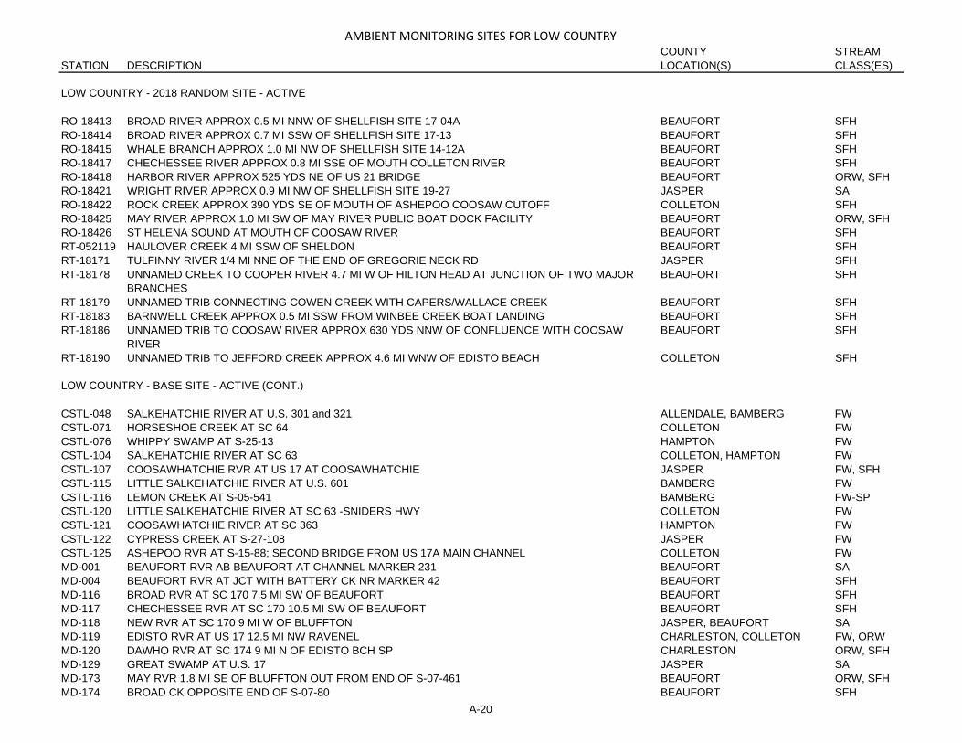
AMBIENT MONITORING SITES FOR LOW COUNTRYCOUNTY STREAM
STATION DESCRIPTION LOCATION(S) CLASS(ES)
LOW COUNTRY - 2018 RANDOM SITE - ACTIVE
RO-18413 BROAD RIVER APPROX 0.5 MI NNW OF SHELLFISH SITE 17-04A BEAUFORT SFHRO-18414 BROAD RIVER APPROX 0.7 MI SSW OF SHELLFISH SITE 17-13 BEAUFORT SFHRO-18415 WHALE BRANCH APPROX 1.0 MI NW OF SHELLFISH SITE 14-12A BEAUFORT SFHRO-18417 CHECHESSEE RIVER APPROX 0.8 MI SSE OF MOUTH COLLETON RIVER BEAUFORT SFHRO-18418 HARBOR RIVER APPROX 525 YDS NE OF US 21 BRIDGE BEAUFORT ORW, SFHRO-18421 WRIGHT RIVER APPROX 0.9 MI NW OF SHELLFISH SITE 19-27 JASPER SARO-18422 ROCK CREEK APPROX 390 YDS SE OF MOUTH OF ASHEPOO COOSAW CUTOFF COLLETON SFHRO-18425 MAY RIVER APPROX 1.0 MI SW OF MAY RIVER PUBLIC BOAT DOCK FACILITY BEAUFORT ORW, SFHRO-18426 ST HELENA SOUND AT MOUTH OF COOSAW RIVER BEAUFORT SFHRT-052119 HAULOVER CREEK 4 MI SSW OF SHELDON BEAUFORT SFHRT-18171 TULFINNY RIVER 1/4 MI NNE OF THE END OF GREGORIE NECK RD JASPER SFHRT-18178 UNNAMED CREEK TO COOPER RIVER 4.7 MI W OF HILTON HEAD AT JUNCTION OF TWO MAJOR
BRANCHESBEAUFORT SFH
RT-18179 UNNAMED TRIB CONNECTING COWEN CREEK WITH CAPERS/WALLACE CREEK BEAUFORT SFHRT-18183 BARNWELL CREEK APPROX 0.5 MI SSW FROM WINBEE CREEK BOAT LANDING BEAUFORT SFHRT-18186 UNNAMED TRIB TO COOSAW RIVER APPROX 630 YDS NNW OF CONFLUENCE WITH COOSAW
RIVERBEAUFORT SFH
RT-18190 UNNAMED TRIB TO JEFFORD CREEK APPROX 4.6 MI WNW OF EDISTO BEACH COLLETON SFH
LOW COUNTRY - BASE SITE - ACTIVE (CONT.)
CSTL-048 SALKEHATCHIE RIVER AT U.S. 301 and 321 ALLENDALE, BAMBERG FWCSTL-071 HORSESHOE CREEK AT SC 64 COLLETON FWCSTL-076 WHIPPY SWAMP AT S-25-13 HAMPTON FWCSTL-104 SALKEHATCHIE RIVER AT SC 63 COLLETON, HAMPTON FWCSTL-107 COOSAWHATCHIE RVR AT US 17 AT COOSAWHATCHIE JASPER FW, SFHCSTL-115 LITTLE SALKEHATCHIE RIVER AT U.S. 601 BAMBERG FWCSTL-116 LEMON CREEK AT S-05-541 BAMBERG FW-SPCSTL-120 LITTLE SALKEHATCHIE RIVER AT SC 63 -SNIDERS HWY COLLETON FWCSTL-121 COOSAWHATCHIE RIVER AT SC 363 HAMPTON FWCSTL-122 CYPRESS CREEK AT S-27-108 JASPER FWCSTL-125 ASHEPOO RVR AT S-15-88; SECOND BRIDGE FROM US 17A MAIN CHANNEL COLLETON FWMD-001 BEAUFORT RVR AB BEAUFORT AT CHANNEL MARKER 231 BEAUFORT SAMD-004 BEAUFORT RVR AT JCT WITH BATTERY CK NR MARKER 42 BEAUFORT SFHMD-116 BROAD RVR AT SC 170 7.5 MI SW OF BEAUFORT BEAUFORT SFHMD-117 CHECHESSEE RVR AT SC 170 10.5 MI SW OF BEAUFORT BEAUFORT SFHMD-118 NEW RVR AT SC 170 9 MI W OF BLUFFTON JASPER, BEAUFORT SAMD-119 EDISTO RVR AT US 17 12.5 MI NW RAVENEL CHARLESTON, COLLETON FW, ORWMD-120 DAWHO RVR AT SC 174 9 MI N OF EDISTO BCH SP CHARLESTON ORW, SFHMD-129 GREAT SWAMP AT U.S. 17 JASPER SAMD-173 MAY RVR 1.8 MI SE OF BLUFFTON OUT FROM END OF S-07-461 BEAUFORT ORW, SFHMD-174 BROAD CK OPPOSITE END OF S-07-80 BEAUFORT SFH
A-20

AMBIENT MONITORING SITES FOR LOW COUNTRYCOUNTY STREAM
STATION DESCRIPTION LOCATION(S) CLASS(ES)
LOW COUNTRY - BASE SITE - ACTIVE
MD-176 COLLETON RVR AT COLLETON NECK-AT JCT WITH CHECHESSEE RV BEAUFORT ORW, SFHMD-252 COMBAHEE RVR OFF FIELDS POINT LANDING OFF END OF S-15-161 COLLETON, BEAUFORT SFHMD-253 ASHEPOO RIVER AT PUBLIC OYSTER GROUND -14-19 COLLETON SFHMD-256 UNNAMED CREEK BETWEEN HARBOR RIVER AND STORY RIVER -16-21 BEAUFORT SFHMD-257 RAMSHORN CREEK AT COOPER RIVER -19-03 BEAUFORT SFH, ORWMD-258 RAMSHORN CREEK AT NEW RIVER -19-07 JASPER, BEAUFORT SFH, SAMD-259 WRIGHT RIVER 1.5 MILES US FROM FIELDS CUT -19-20 JASPER SAMD-260 S EDISTO RVR AT NORTHERN CONFLUENCE WITH ALLIGATOR CREEK -13-20 CHARLESTON, COLLETON ORW, SFHMD-281 PARROT CREEK AND COOSAW RIVER MARKER #1 SHELLFISH 14-10 BEAUFORT SFHMD-282 MORGAN RIVER AT CONFLUENCE WITH WARSAW FLATSSHELLFISH 16A-35 BEAUFORT SFHSV-370 SAVANNAH RVR 0.2 MI UPSTREAM EBENEZER CK JASPER, EFFINGHAM FW
LOW COUNTRY - INACTIVE SITE
CL-062 LAKE WARREN IN FOREBAY NEAR DAM HAMPTON FWCSTL-010 SANDERS BR AT SC 278 HAMPTON FW-SPCSTL-011 SANDERS BR AT S-25-50 HAMPTON FW-SPCSTL-044 IRELAND CK AT S-15-116 5 1/2 MI N OF WALTERBORO COLLETON FWCSTL-068 ASHEPOO RVR AT SC 303 10 MI SSW OF WALTERBORO COLLETON FW, SFHCSTL-069 ASHEPOO RVR AT US 17 3.4 MI ESE OF GREEN POND COLLETON SFHCSTL-075 LAKE WARREN; BLACK CK ARM; AT S-25-41 5 MI SW OF HAMPTON HAMPTON FWCSTL-098 COMBAHEE RVR AT US 17 10 MI ESE YEMASSEE BEAUFORT, COLLETON FW, SFHCSTL-108 SANDERS BRANCH AT SC RD 363 HAMPTON FW-SPCSTL-109 COOSAWHATCHIE RVR AT S-25-27 2.5 MI SW CUMMINGS HAMPTON FWCSTL-111 COMBAHEE RVR BL YEMASSEE SEWAGE OUTFALL COLLETON, BEAUFORT FWMD-002 BEAUFORT RVR AT DRAWBRDG ON US 21 BEAUFORT SAMD-003 BEAUFORT RVR BL BEAUFORT AT CHANNEL MARKER 244 BEAUFORT SAMD-005 BEAUFORT RVR BL OUTFALL OF PARRIS ISL MB AT BUOY 29 BEAUFORT SFHMD-006 PORT ROYAL BTWN BUOY 25 and 24 W OF BAY PT ISLAND BEAUFORT SFHMD-007 POCOTALIGO RVR AT US 17 AT POCOTALIGO BEAUFORT, JASPER SFHMD-012 MOUTH OF BROAD RVR OPPOSITE BALLAST CK BEAUFORT SFHMD-013 MOUTH OF SKULL CK BTWN CHANNEL MARKERS 3 and 4 NEAR REDBO BEAUFORT SFHMD-016 MOUTH OF MAY RVR 1.0 MI W OF CHANNEL MARKER 29 BEAUFORT ORW, SFHMD-128 BEES CK AT SC 462 5.9 MI NE OF RIDGELAND JASPER SBMD-168 COOSAW RVR AT CONFL OF COMBAHEE RVR; NEAR BUOY 186 BEAUFORT SFHMD-172 BROAD RVR AT MOUTH OF ARCHER CK ON SW SIDE OF USMC BEAUFORT SFHMD-175 CALIBOGUE SD AT MOUTH OF COOPER RVR NR RED BUOY 32 BEAUFORT SFHMD-194 WHALE BR AT JCT WITH CAMPBELL'S CK-3/4 MI W OF MD-010 BEAUFORT SFHMD-244 S EDISTO RVR BELOW ST PIERRE CK CHARLESTON, COLLETON SFHMD-245 COLLETON RVR NEAR MOUTH -SHELLFISH STATION 18-5 BEAUFORT ORW, SFHMD-251 ASHEPOO RIVER AT S-15-26 COLLETON SFHMD-254 HUSPAH CREEK AT RAILROAD TRESTLE -14-14 BEAUFORT SFH
A-21
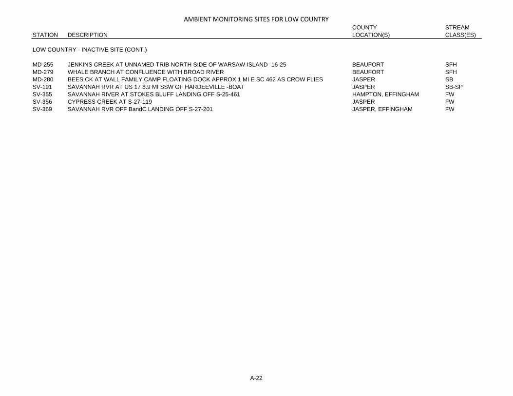
AMBIENT MONITORING SITES FOR LOW COUNTRYCOUNTY STREAM
STATION DESCRIPTION LOCATION(S) CLASS(ES)
LOW COUNTRY - INACTIVE SITE (CONT.)
MD-255 JENKINS CREEK AT UNNAMED TRIB NORTH SIDE OF WARSAW ISLAND -16-25 BEAUFORT SFHMD-279 WHALE BRANCH AT CONFLUENCE WITH BROAD RIVER BEAUFORT SFHMD-280 BEES CK AT WALL FAMILY CAMP FLOATING DOCK APPROX 1 MI E SC 462 AS CROW FLIES JASPER SBSV-191 SAVANNAH RVR AT US 17 8.9 MI SSW OF HARDEEVILLE -BOAT JASPER SB-SPSV-355 SAVANNAH RIVER AT STOKES BLUFF LANDING OFF S-25-461 HAMPTON, EFFINGHAM FWSV-356 CYPRESS CREEK AT S-27-119 JASPER FWSV-369 SAVANNAH RVR OFF BandC LANDING OFF S-27-201 JASPER, EFFINGHAM FW
A-22

AMBIENT MONITORING SITES FOR PEE DEECOUNTY STREAM
STATION DESCRIPTION LOCATION(S) CLASS(ES)
PEE DEE - 2018 RANDOM SITE - ACTIVE
MD-107 KINGSTON LK NR PUMP STA ON LAKESIDE DR CONWAY HORRY FWPD-281 LYNCHES RVR AT S-21-49 5 MI NW JOHNSONVILLE FLORENCE FWPD-364 LYNCHES RIVER AT US 401 DARLINGTON, LEE FWRO-18411 DEBIDUE CREEK APPROX 365 YDS N OF SHELLFISH SITE 05-04 GEORGETOWN ORW, SFHRO-18423 WINYAH BAY APPROX 0.85 MI SOUTH OF MORGAN PARK BEACH GEORGETOWN SBRS-04370 SPARROW SWAMP AT BRIDGE ON UNNUMBERED DIRT RD -FORK RD- OFF OF HWY 301 JUST WEST
OF ELIM 5.6 MI NW OF COWARDFLORENCE FW-SP
RS-18388 BLACK CREEK THROUGH PRIVATE HUNT CLUB ACCESS FLORENCE FWRS-18403 MILL BRANCH AT US 301 CLARENDON FWRS-18419 UNNAMED TRIB TO KINGSTREE SWAMP CANAL AT NEW ZION ROAD S-45-33 WILLIAMSBURG FWRS-18431 LITTLE PEE DEE RIVER AT SANDY BLUFF LANDING OFF DOCK HORRY, MARION ORWRS-18439 UNNAMED TRIB TO KINGSTREE SWAMP CANAL ON BROAD SWAMP RD S-45-249 WILLIAMSBURG FWRT-18169 WOODLAND CREEK APPROX 0.5 MI SSE OF SHELLFISH SITE 04-31 GEORGETOWN SFH
PEE DEE - BASE SITE - ACTIVE
MD-077 SAMPIT RVR AT US 17 GEORGETOWN SBMD-085 INTRACOASTAL WTRWAY AT PT 3 MI N OF BRDG ON US 501 HORRY FWMD-125 INTRACOASTAL WTRWY -LITTLE RVR- ON SC 9 -US 17 HORRY FW, SAMD-127 INTRACOASTAL WTRWAY AT SC 544 7.5 MI SW OF MYRTLE BEACH HORRY FWMD-138 WACCAMAW RVR AT CHANNEL MARKER 57 GEORGETOWN FW-SPMD-142 WACAMMAW RVR DS OF BUTLER ISLAND AT MARKER 86 GEORGETOWN SA-SPMD-145 WACCAMAW RVR 1 MI DS OF BUCKSVILLE LANDING AT BIG BEND IN RVR HORRY FW-SPMD-275 PEE DEE RVR AT WHITE HOUSE PLANTATION GEORGETOWN SB-SPMD-277 PARSONNAGE CREEK AT INLET PORT BASIN -04-17 GEORGETOWN SFHMD-278 WINYAH BAY MAIN CHANNEL; BUOY 19A RANGE E -05-20 GEORGETOWN SBPD-012 PEE DEE RVR AT US 1 NE CHERAW MARLBORO, CHESTERFIELD FWPD-015 GREAT PEE DEE RVR AT US 15 and 401 DARLINGTON, MARLBORO FWPD-028 PEE DEE RVR AT SC 34 11 MI NE DARLINGTON DARLINGTON, MARLBORO FWPD-038 LUMBER RVR AT US 76 AT NICHOLS HORRY, MARION FWPD-043 POCOTALIGO RVR AT S-14-50 9.5 MI NE MANNING CLARENDON FW-SPPD-052 LITTLE PEE DEE AT S-34-60 MARION FWPD-055 LITTLE PEE DEE RVR AT SC 9 DILLON FWPD-076 GREAT PEE DEE RVR AT US 378 FLORENCE, MARION FWPD-078 BLACK CREEK AT SC 327 FLORENCE FWPD-087 LAKE SWAMP AT SC 341 2.6 MI W OF JOHNSONVILLE FLORENCE FW-SPPD-091 POCOTALIGO RVR AT US 15 3.5 MI S SUMTER SUMTER FW-SPPD-093 LYNCHES RIVER AT S-21-55 FLORENCE FWPD-097 CATFISH CANAL AT S-34-34 6 MI SW OF MARION MARION FW-SPPD-176 LAKE SWAMP AT S-26-99 HORRY FW-SPPD-201 ROCKY BLUFF SWAMP AT S-43-41 SUMTER FW-SPPD-203 PUDDING SWP AT SC 527 8.1 MI NW OF KINGSTREE WILLIAMSBURG FW-SP
A-23

AMBIENT MONITORING SITES FOR PEE DEECOUNTY STREAM
STATION DESCRIPTION LOCATION(S) CLASS(ES)
PEE DEE - BASE SITE - ACTIVE (CONT.)
PD-227 BLACK RVR AT S-45-35 8.6 MI NW OF KINGSTREE WILLIAMSBURG FW-SPPD-231 JEFFRIES CK AT UN# RD 3.3 MI ESE OF CLAUSSEN FLORENCE FW-SPPD-325 BLACK RVR AT S-22-489 4 MI NE GEORGETOWN GEORGETOWN SAPD-332 SPARROW SWAMP AT S-21-55 -MEADOW PRONG RD- NR JOHNSONS CROSSROADS FLORENCE FW-SPPD-337 GREAT PEE DEE RVR AT US 301/76 FLORENCE, MARION FWPD-349 BUCK SWAMP AT S-17-42 DILLON, MARION FW-SPPD-350 LITTLE PEE DEE RIVER OFF END OF S-26-135 AT PUNCHBOWL LANDING HORRY, MARION ORW, FWPD-352 CHINNERS SWAMP AT GUNTERS ISLAND RD OFF S-26-99 HORRY FW-SPPD-353 BLACK RIVER AT S-43-57 SUMTER FW-SPPD-359 BLACK RIVER AT S-45-30 WILLIAMSBURG FW-SPPD-361 BLACK MINGO CREEK AT COWHEAD LANDING OFF SC 51 GEORGETOWN FWPD-365 LITTLE PEE DEE RIVER AT S-17-363 DILLON FWPD-370 BRUNSON SWAMP AT S-26-99 HORRY FWPD-371 SHOE HEEL CK AT S-17-70 DILLON FWPD-372 LEITH CK IN NC AT SC/NC 83 ROBESON FWPD-373 WACCAMAW RVR AT OLD SITE RS-02481 AT S-26-31 IN 0304020609 HORRY FW-SPST-005 N SANTEE RVR AT US 17 GEORGETOWN FW, SA
PEE DEE - INACTIVE SITE
CL-077 LAKE ASHWOOD; FOREBAY MOVED TO CATWALK NEAR DAM LEE FWMD-073 SAMPIT RVR OPP AMER CYANAMID CHEM CO GEORGETOWN SBMD-074 SAMPIT RVR AT CHANNEL MARKER #30 GEORGETOWN SBMD-075 SAMPIT RVR BTWN MOUTHS OF PORTS CK and PENNY ROYAL CK GEORGETOWN SBMD-076N TURKEY CK S-22-42 SW OF GEORGETOWN GEORGETOWN FWMD-080 WINYAH BAY AT JCT OF PEE DEE and WACCAMAW AT MARKER 92 GEORGETOWN SBMD-087 INTRACOASTAL WTRWAY JUST N OF BRDG ON US 501 HORRY FWMD-088 INTRACOASTAL WTRWAY 1 MI S OF BRDG ON US 501 HORRY FWMD-089 INTRACOASTAL WTRWY 2 MI S OF BRDG ON US 501 HORRY FWMD-091 INTRACOASTAL WTRWY 4 MI N OF BRDG ON US 501 HORRY FWMD-110 WACCAMAW RVR AT US 501 BY PASS AROUND CONWAY HORRY FW-SPMD-111 WACCAMAW RVR AT COX'S FERRY ON CO RD 110 HORRY FW-SPMD-124 WACCAMAW RVR AT SC 9 7.0 MI W OF CHERRY GROVE HORRY FW-SPMD-136 WACCAMAW RVR 1/4 MI UPSTRM OF JCT WITH INTRACOASTAL WTRWY HORRY FW-SPMD-137 WACCAMAW RVR NR MOUTH OF BULL CK AT CHANNEL MARKER 50 HORRY FW-SPMD-146 WACCAMAW RVR and ICWW 1 MI BL JCT-AT BUCKSPORT LANDING HORRY FW-SPMD-149 WHITES CK 100 YDS UPSTRM OF JCT WITH SAMPIT RVR GEORGETOWN SBMD-158 CRAB TREE SWAMP AT LONG ST BL OUTFALL OF CONWAY #1 POND HORRY FWMD-162 LITTLE RVR AT S END OF ISL DUE E OF TOWN -IN RVR HORRY SAMD-263 SANTEE BAY AT BEACH CREEK -06A-03 GEORGETOWN ORW, SFHMD-276 HOUSE CK AT 53RD AVE OUT FROM BOAT LANDING -01-19 HORRY SFHNO-01099 SAMPIT RIVER OXBOW NEAR GEORGETOWN STEEL -MD-073 GEORGETOWN SB
A-24

AMBIENT MONITORING SITES FOR PEE DEECOUNTY STREAM
STATION DESCRIPTION LOCATION(S) CLASS(ES)
PEE DEE - INACTIVE SITE (CONT.)
PD-014 CROOKED CR AT S-35-43 MARLBORO FWPD-016 PANTHER CK AT S-35-27 MARLBORO FWPD-017A MCLAURINS MILL POND SC 381 MARLBORO FWPD-021 BLACK CK AT S-16-18 1 MI NNE HARTSVILLE DARLINGTON FW-SPPD-023 BLACK CK AT S-16-13 5.5 MI NE HARTSVILLE DARLINGTON FW-SPPD-024A BLACK CK AT US 401 and 52 6 MI NW DARLINGTON DARLINGTON FW-SP, FWPD-025 BLACK CK AT S-16-133 2.25 MI NE OF DARLINGTON DARLINGTON FWPD-027 BLACK CK AT S-16-35 5.5 MI SE DARLINGTON DARLINGTON FWPD-029E LITTLE PEE DEE RVR AT S-17-23 DILLON FWPD-030 MAPLE SWP AT SC 57 DILLON FW-SPPD-030A LITTLE PEE DEE RVR BELOW JCT WITH MAPLE SWP DILLON FWPD-031 BUCK SWP AT S-17-33 DILLON FW-SPPD-035 JEFFERIES CK AT SC 327 AT CLAUSSEN FLORENCE FW-SPPD-037 WHITE OAK CK AT S-34-31 MARION FW-SPPD-039 GREEN SWP AT S-43-33 SUMTER FW-SPPD-040 TURKEY CREEK AT US 521 SUMTER FW-SPPD-041 LYNCHES RVR AT US 52 NEAR EFFINGHAM FLORENCE FWPD-042 LITTLE PEE DEE RVR AT US 501; GALIVANT'S FERRY HORRY, MARION ORW, FWPD-044 BLACK RVR AT US 52 AT KINGSTREE WILLIAMSBURG FW-SPPD-045 BLACK RVR AT SC 377 AT BRYAN'S CROSS ROADS WILLIAMSBURG FW-SPPD-060 PEE DEE RVR AT PETERS FIELD LANDING OFF S-22-36 US IP PUMP STATION GEORGETOWN, MARION FWPD-061 PEE DEE RVR AT US 701 2.75 MI NE YAUHANNAH GEORGETOWN, HORRY FWPD-062 GUM SWAMP AT S-35-27 MARLBORO FWPD-065 GULLEY BR AT S-21-13; TIMROD PARK FLORENCE FWPD-069 LITTLE PEE DEE RVR AT SC 57 11.5 MI NW DILLON DILLON FWPD-071 LYNCHES RVR AT US 15/SC 34 LEE FWPD-072 SPARROW SWP AT S-16-697 2.5 MI E OF LAMAR DARLINGTON FW-SPPD-081 PRESTWOOD LK AT US 15 DARLINGTON FW-SPPD-085 LAKE SWAMP AT US 378 FLORENCE FW-SPPD-086A LAKE SWAMP ON SC 341 FLORENCE FW-SPPD-098 TURKEY CK AT LIBERTY ST IN SUMTER ABOVE SANTEE PRINT WORKS SUMTER FW-SPPD-103 HIGH HILL CK AT US 52 ON CO LINE DARLINGTON, FLORENCE FWPD-106 LYNCHES RVR ON I-20 4 OR 5 MI BELOW BISHOPVILLE SEPTIC LEE FWPD-107 CROOKED CK AT SC 9 IN BENNETTSVILLE MARLBORO FWPD-112 COUSAR BR 1/4 MI BELOW BISHOPVILLE FINISHING CO LEE FWPD-115 POCOTALIGO RVR AT 3RD BRDG N OF MANNING ON US 301 CLARENDON FW-SPPD-116 BLACK RVR AT S-14-40 E OF MANNING CLARENDON FW-SPPD-137 SNAKE BR AT WOODMILL ST-HARTSVILLE DARLINGTON FWPD-141 60" TILE DISCHARGING TO DITCH ACROSS RD AT DARLINGTON STP DARLINGTON FWPD-159 BLACK CK AT S-16-23 4.7 MI NW OF HARTSVILLE DARLINGTON FW-SPPD-167 WILLOW CREEK AT S-21-57 FLORENCE FWPD-168 BIG SWP AT S-21-360 1.1 MI W OF PAMPLICO FLORENCE FW-SP
A-25
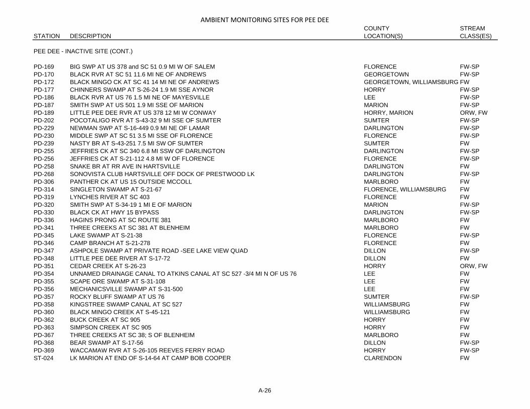
AMBIENT MONITORING SITES FOR PEE DEECOUNTY STREAM
STATION DESCRIPTION LOCATION(S) CLASS(ES)
PEE DEE - INACTIVE SITE (CONT.)
PD-169 BIG SWP AT US 378 and SC 51 0.9 MI W OF SALEM FLORENCE FW-SPPD-170 BLACK RVR AT SC 51 11.6 MI NE OF ANDREWS GEORGETOWN FW-SPPD-172 BLACK MINGO CK AT SC 41 14 MI NE OF ANDREWS GEORGETOWN, WILLIAMSBURG FWPD-177 CHINNERS SWAMP AT S-26-24 1.9 MI SSE AYNOR HORRY FW-SPPD-186 BLACK RVR AT US 76 1.5 MI NE OF MAYESVILLE LEE FW-SPPD-187 SMITH SWP AT US 501 1.9 MI SSE OF MARION MARION FW-SPPD-189 LITTLE PEE DEE RVR AT US 378 12 MI W CONWAY HORRY, MARION ORW, FWPD-202 POCOTALIGO RVR AT S-43-32 9 MI SSE OF SUMTER SUMTER FW-SPPD-229 NEWMAN SWP AT S-16-449 0.9 MI NE OF LAMAR DARLINGTON FW-SPPD-230 MIDDLE SWP AT SC 51 3.5 MI SSE OF FLORENCE FLORENCE FW-SPPD-239 NASTY BR AT S-43-251 7.5 MI SW OF SUMTER SUMTER FWPD-255 JEFFRIES CK AT SC 340 6.8 MI SSW OF DARLINGTON DARLINGTON FW-SPPD-256 JEFFRIES CK AT S-21-112 4.8 MI W OF FLORENCE FLORENCE FW-SPPD-258 SNAKE BR AT RR AVE IN HARTSVILLE DARLINGTON FWPD-268 SONOVISTA CLUB HARTSVILLE OFF DOCK OF PRESTWOOD LK DARLINGTON FW-SPPD-306 PANTHER CK AT US 15 OUTSIDE MCCOLL MARLBORO FWPD-314 SINGLETON SWAMP AT S-21-67 FLORENCE, WILLIAMSBURG FWPD-319 LYNCHES RIVER AT SC 403 FLORENCE FWPD-320 SMITH SWP AT S-34-19 1 MI E OF MARION MARION FW-SPPD-330 BLACK CK AT HWY 15 BYPASS DARLINGTON FW-SPPD-336 HAGINS PRONG AT SC ROUTE 381 MARLBORO FWPD-341 THREE CREEKS AT SC 381 AT BLENHEIM MARLBORO FWPD-345 LAKE SWAMP AT S-21-38 FLORENCE FW-SPPD-346 CAMP BRANCH AT S-21-278 FLORENCE FWPD-347 ASHPOLE SWAMP AT PRIVATE ROAD -SEE LAKE VIEW QUAD DILLON FW-SPPD-348 LITTLE PEE DEE RIVER AT S-17-72 DILLON FWPD-351 CEDAR CREEK AT S-26-23 HORRY ORW, FWPD-354 UNNAMED DRAINAGE CANAL TO ATKINS CANAL AT SC 527 -3/4 MI N OF US 76 LEE FWPD-355 SCAPE ORE SWAMP AT S-31-108 LEE FWPD-356 MECHANICSVILLE SWAMP AT S-31-500 LEE FWPD-357 ROCKY BLUFF SWAMP AT US 76 SUMTER FW-SPPD-358 KINGSTREE SWAMP CANAL AT SC 527 WILLIAMSBURG FWPD-360 BLACK MINGO CREEK AT S-45-121 WILLIAMSBURG FWPD-362 BUCK CREEK AT SC 905 HORRY FWPD-363 SIMPSON CREEK AT SC 905 HORRY FWPD-367 THREE CREEKS AT SC 38; S OF BLENHEIM MARLBORO FWPD-368 BEAR SWAMP AT S-17-56 DILLON FW-SPPD-369 WACCAMAW RVR AT S-26-105 REEVES FERRY ROAD HORRY FW-SPST-024 LK MARION AT END OF S-14-64 AT CAMP BOB COOPER CLARENDON FW
A-26
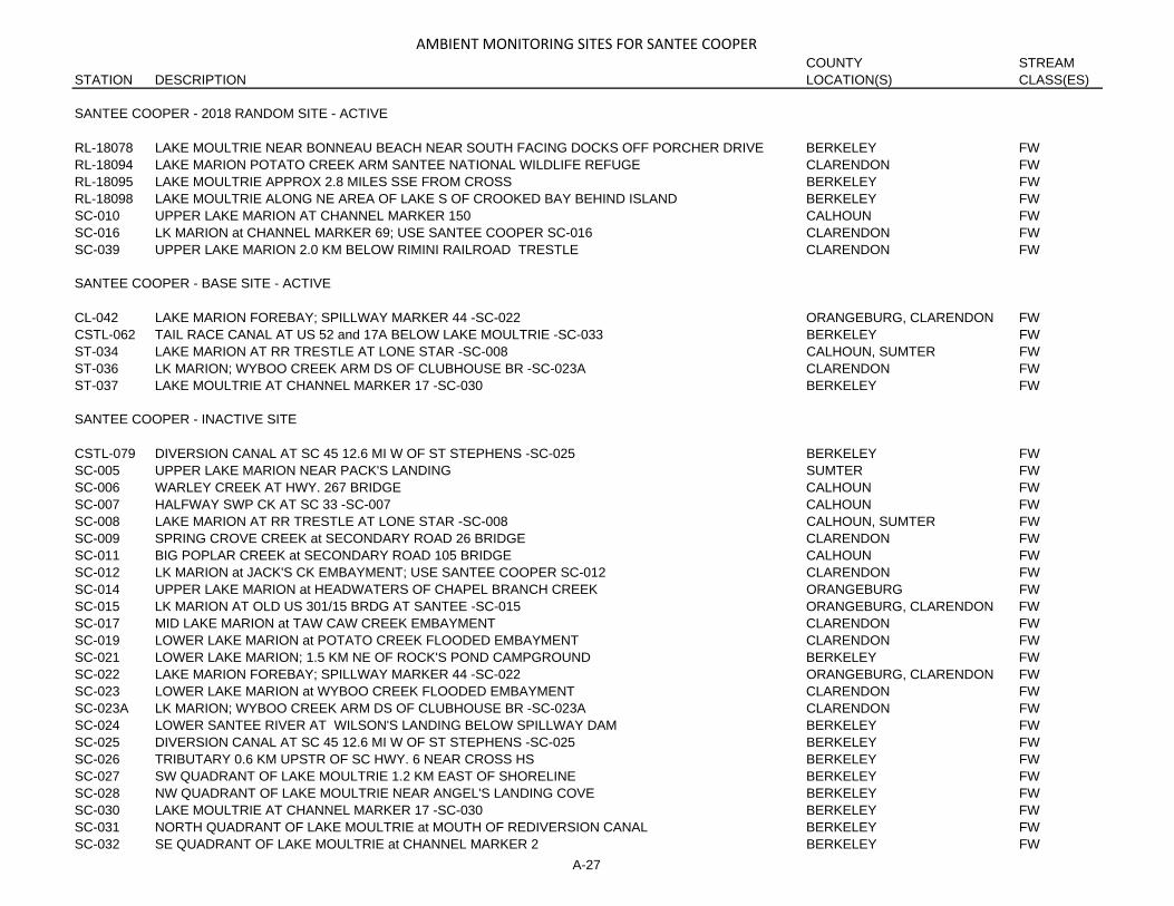
AMBIENT MONITORING SITES FOR SANTEE COOPERCOUNTY STREAM
STATION DESCRIPTION LOCATION(S) CLASS(ES)
SANTEE COOPER - 2018 RANDOM SITE - ACTIVE
RL-18078 LAKE MOULTRIE NEAR BONNEAU BEACH NEAR SOUTH FACING DOCKS OFF PORCHER DRIVE BERKELEY FWRL-18094 LAKE MARION POTATO CREEK ARM SANTEE NATIONAL WILDLIFE REFUGE CLARENDON FWRL-18095 LAKE MOULTRIE APPROX 2.8 MILES SSE FROM CROSS BERKELEY FWRL-18098 LAKE MOULTRIE ALONG NE AREA OF LAKE S OF CROOKED BAY BEHIND ISLAND BERKELEY FWSC-010 UPPER LAKE MARION AT CHANNEL MARKER 150 CALHOUN FWSC-016 LK MARION at CHANNEL MARKER 69; USE SANTEE COOPER SC-016 CLARENDON FWSC-039 UPPER LAKE MARION 2.0 KM BELOW RIMINI RAILROAD TRESTLE CLARENDON FW
SANTEE COOPER - BASE SITE - ACTIVE
CL-042 LAKE MARION FOREBAY; SPILLWAY MARKER 44 -SC-022 ORANGEBURG, CLARENDON FWCSTL-062 TAIL RACE CANAL AT US 52 and 17A BELOW LAKE MOULTRIE -SC-033 BERKELEY FWST-034 LAKE MARION AT RR TRESTLE AT LONE STAR -SC-008 CALHOUN, SUMTER FWST-036 LK MARION; WYBOO CREEK ARM DS OF CLUBHOUSE BR -SC-023A CLARENDON FWST-037 LAKE MOULTRIE AT CHANNEL MARKER 17 -SC-030 BERKELEY FW
SANTEE COOPER - INACTIVE SITE
CSTL-079 DIVERSION CANAL AT SC 45 12.6 MI W OF ST STEPHENS -SC-025 BERKELEY FWSC-005 UPPER LAKE MARION NEAR PACK'S LANDING SUMTER FWSC-006 WARLEY CREEK AT HWY. 267 BRIDGE CALHOUN FWSC-007 HALFWAY SWP CK AT SC 33 -SC-007 CALHOUN FWSC-008 LAKE MARION AT RR TRESTLE AT LONE STAR -SC-008 CALHOUN, SUMTER FWSC-009 SPRING CROVE CREEK at SECONDARY ROAD 26 BRIDGE CLARENDON FWSC-011 BIG POPLAR CREEK at SECONDARY ROAD 105 BRIDGE CALHOUN FWSC-012 LK MARION at JACK'S CK EMBAYMENT; USE SANTEE COOPER SC-012 CLARENDON FWSC-014 UPPER LAKE MARION at HEADWATERS OF CHAPEL BRANCH CREEK ORANGEBURG FWSC-015 LK MARION AT OLD US 301/15 BRDG AT SANTEE -SC-015 ORANGEBURG, CLARENDON FWSC-017 MID LAKE MARION at TAW CAW CREEK EMBAYMENT CLARENDON FWSC-019 LOWER LAKE MARION at POTATO CREEK FLOODED EMBAYMENT CLARENDON FWSC-021 LOWER LAKE MARION; 1.5 KM NE OF ROCK'S POND CAMPGROUND BERKELEY FWSC-022 LAKE MARION FOREBAY; SPILLWAY MARKER 44 -SC-022 ORANGEBURG, CLARENDON FWSC-023 LOWER LAKE MARION at WYBOO CREEK FLOODED EMBAYMENT CLARENDON FWSC-023A LK MARION; WYBOO CREEK ARM DS OF CLUBHOUSE BR -SC-023A CLARENDON FWSC-024 LOWER SANTEE RIVER AT WILSON'S LANDING BELOW SPILLWAY DAM BERKELEY FWSC-025 DIVERSION CANAL AT SC 45 12.6 MI W OF ST STEPHENS -SC-025 BERKELEY FWSC-026 TRIBUTARY 0.6 KM UPSTR OF SC HWY. 6 NEAR CROSS HS BERKELEY FWSC-027 SW QUADRANT OF LAKE MOULTRIE 1.2 KM EAST OF SHORELINE BERKELEY FWSC-028 NW QUADRANT OF LAKE MOULTRIE NEAR ANGEL'S LANDING COVE BERKELEY FWSC-030 LAKE MOULTRIE AT CHANNEL MARKER 17 -SC-030 BERKELEY FWSC-031 NORTH QUADRANT OF LAKE MOULTRIE at MOUTH OF REDIVERSION CANAL BERKELEY FWSC-032 SE QUADRANT OF LAKE MOULTRIE at CHANNEL MARKER 2 BERKELEY FW
A-27

AMBIENT MONITORING SITES FOR SANTEE COOPERCOUNTY STREAM
STATION DESCRIPTION LOCATION(S) CLASS(ES)
SANTEE COOPER - INACTIVE SITE (CONT.)
SC-033 TAIL RACE CANAL AT US 52 and 17A BELOW LAKE MOULTRIE -SC-033 BERKELEY FWSC-034 DUCK POND CREEK at HWY. 6 BERKELEY FWSC-035 LAKE MARION 1.10 M SSE OF SANTEE NAT. WILDLIFE REFUGE AND 1MI S OF EAGLE POINT -SC-035 CLARENDON FWSC-036 MID LAKE MARION at THE MOUTH OF TAW CAW CREEK CLARENDON FWSC-037 REDIVERSION CANAL at HWY. 45 BRIDGE BERKELEY FWSC-038 UPPER LAKE MARION at THE MOUTH OF HALFWAY SWAMP CREEK CALHOUN FWSC-040 MID LAKE MARION at CHANNEL MARKER 79 ORANGEBURG FWSC-041 MID LAKE MARION 3.2 KM NORTH OF CHANNEL MARKER 79 CLARENDON FWSC-042 MID LAKE MARION at NORTH END OF I-95 / U.S. 301 BRIDGES CLARENDON FWSC-043 TRIBUTARY FLOWING TO LAKE MOULTRIE FROM CROSS GENER. STATION BERKELEY FWSC-044 LAKE MARION 0.5 MI NE OF CALHOUN LANDING -USE SC-044 CALHOUN FWSC-045 STREAM FLOWING THRU SANTEE NATIONAL GOLF COURSE POND at HWY 6 ORANGEBURG FWSC-046 SE QUADRANT OF LAKE MOULTRIE AT PINOPOLIS EMBAYMENT BERKELEY FWSC-048 Assigned to Santee-Cooper Project Clarendon FWSC-049 Assigned to Santee-Cooper Project Clarendon FWSC-056 SURFACE DRAINAGE FROM SAFETY KLEEN HAZARDOUS LANDFILL SUMTER FWSC-057 SURFACE DRAINAGE FROM SAFETY KLEEN HAZARDOUS LANDFILL SUMTER FWSC-058 STREAM ORIGINATING UPSTRM OF SAFETY KLEEN HAZARDOUS LANDFILL SUMTER FWSC-059 Assigned to Santee-Cooper Project Clarendon FWST-025 LK MARION AT OLD US 301/15 BRDG AT SANTEE -SC-015 ORANGEBURG, CLARENDON FW
A-28

AMBIENT MONITORING SITES FOR TRIDENTCOUNTY STREAM
STATION DESCRIPTION LOCATION(S) CLASS(ES)
TRIDENT - 2018 RANDOM SITE - ACTIVE
RO-18412 TOWN CREEK CHANNEL APPROX 395 YDS SE OF LIBERTY SQUARE PIER CHARLESTON SBRO-18419 WHITESIDE CREEK APPROX 300 YDS NW OF MOUTH CHARLESTON ORW, SFHRO-18420 LEADENWAH CREEK APPROX 460 YDS SW OF SHELLFISH SITE 12B-12 CHARLESTON ORW, SFHRO-18424 ASHLEY RIVER APPROX 0.86 MI SSE OF COUNTY FARM BOAT RAMP CHARLESTON SA-SPRS-18415 SANTEE RIVER AT MCCONNELS BOAT RAMP ON FOREST ROAD 204 F GEORGETOWN, BERKELEY FWRS-18435 BEAR BRANCH AT S-18-53 FRIENDSHIP ROAD DORCHESTER FWRT-18164 CONCH CREEK APPROX 202 YD E OF SHELLFISH SITE 09A-17A CHARLESTON SFHRT-18175 WAGNER CREEK APPROX 172 YD NE OF CIRCULAR DRIVE OFF DARTS COVE WAY CHARLESTON SFHRT-18176 OYSTER HOUSE CREEK APPROX 256 YD SW OF INTERSECTION AT ARCHFIELD AVE AND CHINA
BACK LNCHARLESTON ORW, SFH
RT-18180 COLE CREEK ALMOST AS FAR UPSTREAM AS POSSIBLE NEAR CONFLUENCE OF THREE CREEKS CHARLESTON SFHRT-18181 PAPAS CREEK APPROX 450 YDS NW OF CONFLUENCE WITH NELLIE CREEK CHARLESTON ORW, SFHRT-18188 UNNAMED TRIB TO LEADENWAH CREEK APPROX 3.0 MI NW OF ROCKVILLE CHARLESTON ORW, SFHRT-18191 CONFLUENCE OF UNNAMED TRIB TO BULLYARD SOUND APPROX 475 YDS W OF SHELLFISH SITE
08-04CHARLESTON ORW, SFH
TRIDENT - BASE SITE - ACTIVE
CSTL-102 ASHLEY RVR AT SC 165 4.8 MI SSW OF SUMMERVILLE DORCHESTER FW, SACSTL-113 WADBOO SWP AT SC 402 BERKELEY FWCSTL-123 EAST BR COOPER RVR AT BONNEAU FERRY PLANTATION BERKELEY FWE-015A FOUR HOLE SWAMP AT S-18-19 DORCHESTER FW-SPE-032 INDIAN FIELD SWAMP AT S-18-19 DORCHESTER FW-SPE-086 EDISTO RVR AT S-18-29 COLLETON, DORCHESTER FWE-109 POLK SWAMP AT S-18-19 DORCHESTER FW-SPMD-043 COOPER RVR AT CHANNEL MARKER 72 NEAR USN AMMO DEPOT BERKELEY SBMD-045 COOPER RVR AB MOUTH OF SHIPYD CK AT CHANNEL BUOY 49 CHARLESTON, BERKELEY SBMD-049 ASHLEY RVR AT MAGNOLIA GARDENS CHARLESTON SAMD-052 ASHLEY RVR AT SALRR BRDG CHARLESTON SAMD-069 INTRACOASTAL WATERWAY AT SC 703 E MT PLEASANT CHARLESTON SB, SFHMD-115 WANDO RVR AT SC 41 BERKELEY SFHMD-130 FOLLY RIVER AT SC 171 CHARLESTON SFHMD-202 STONO RVR AT S-10-20 2 MI UPSTRM OF CLEMSON EXP STA CHARLESTON SFHMD-206 STONO RIVER AT ABBAPOOLA CREEK CHARLESTON SFHMD-209 BOHICKET CK AT FICKLING CK CHARLESTON ORW, SFHMD-248 COOPER RIVER AT MARK CLARK BRIDGE -I-526 CHARLESTON, BERKELEY SBMD-261 YONGES ISLAND CREEK; MARKER #90 -12-03 CHARLESTON ORW, SFHMD-262 N EDISTO RVR AT LEADENWAH CREEK -12-08 CHARLESTON ORW, SFHMD-264 WANDO RIVER AT I-526 MARK CLARK EXPRESSWAY -09B-15 CHARLESTON, BERKELEY SFHMD-266 CASINO CREEK AT CLOSURE LINE -06B-16 CHARLESTON SFH, ORWMD-267 FIVE FATHOM CREEK AT BULL RIVER -07-06A CHARLESTON SFH, SFHMD-269 SEWEE BAY AT MOORES LANDING -08-09 CHARLESTON SFH
A-29

AMBIENT MONITORING SITES FOR TRIDENTCOUNTY STREAM
STATION DESCRIPTION LOCATION(S) CLASS(ES)
TRIDENT - BASE SITE - ACTIVE (CONT.)
MD-271 HAMLIN SOUND -08-02 CHARLESTON SFHMD-273 KIAWAH RIVER ON THE FLATS -11-21 CHARLESTON SFHST-001 SANTEE RVR AT SC 41/US 17A NE OF JAMESTOWN BERKELEY, WILLIAMSBURG FWST-006 S SANTEE RVR AT US 17 CHARLESTON, GEORGETOWN FW, SAST-016 SANTEE RVR AT US 52 6.5 MI NNW OF ST STEPHENS BERKELEY, WILLIAMSBURG FW
TRIDENT - INACTIVE SITE
CSTL-007 COMBAHEE SWP BL YEMASSEE SEWAGE OUTFALL BEAUFORT FWCSTL-013 DORCHESTER CK AT SC 165 DORCHESTER SACSTL-043 SAWMILL BR AT SC 78 E OF SUMMERVILLE DORCHESTER FWCSTL-063 WASSAMASSAW SWP AT US 176 BERKELEY FWCSTL-078 CYPRESS SWP AT US 78 DORCHESTER FWCSTL-085 PIER IN WEST BRANCH COOPER RVR AT END OF RICE MILL RD IN PIMLICO BERKELEY FWCSTL-099 EAGLE CK AT SC 642 5 MI SSE OF SUMMERVILLE DORCHESTER SBCSTL-112 WAMBAW CK AT EXTENSION OF S-10-857 -BRIDGE NEAR BOAT LANDING-; RUTLEDGE ROAD; ON
GRAVEL NATIONAL FOREST ROAD. APPROACH FROM CHARLESTON COUNTY; RUTLEDGE ROAD DIRECTION.
CHARLESTON, BERKELEY FW
CSTL-114 TRIB TO IRON SWAMP AT US 17 CHARLESTON SACSTL-124 BACK RIVER RES IN FOREBAY EQUIDISTANT FROM DAM AND SHORELINES BERKELEY FWE-014 EDISTO RVR AT US 15 S OF ST GEORGE COLLETON, DORCHESTER FWE-015 EDISTO RVR AT SC 61 AT GIVHANS FERRY ST PK COLLETON, DORCHESTER FWE-100 4 HOLE SWP AT US 78 E OF DORCHESTER DORCHESTER FW-SPMD-010 WHALE BR AT US 21 BEAUFORT SFHMD-020 MOUTH OF WAPPOO CK BTWN CHANNEL MARKERS 3 and 4 CHARLESTON SBMD-025 MOUTH OF ELLIOTT CUT AT EDGE WTR DR -S-10-26 OFF HW 17 CHARLESTON SFHMD-026 STONO RVR AT SC 700 CHARLESTON SFHMD-034 RT BK OF ASHLEY RVR BTWN MOUTH OF WAPPOO CK and DILLS CK CHARLESTON SAMD-039 GOOSE CK AT S-08-136 BRIDGE BERKELEY SBMD-044 COOPER RVR BL MOUTH OF GOOSE CK AT CHANNEL BUOY 60 CHARLESTON, BERKELEY SBMD-046 COOPER RVR UNDER GRACE MEMORIAL BRDG CHARLESTON SBMD-047 TOWN CK -W SIDE OF DRUM ISL- UNDER GRACE MEMORIAL BRDG CHARLESTON SBMD-048 S CHANNEL CHAS HBR OFF FT JOHNSON QUAR STA BELL BUOY 28 CHARLESTON SBMD-070 ABANDONED BRDG OVER THE COVE END OF PITT ST MT PLEASANT CHARLESTON SBMD-071 SHEM CK AT COLEMAN BLVD -BUS US 701; 17; SC 703 CHARLESTON SBMD-113 GOOSE CK RES AT CHTN WTR INTAKE BERKELEY FWMD-114 GOOSE CK AT US 52 N CHTN CHARLESTON, BERKELEY FWMD-121 LOG BRIDGE CK AT SC 162 CHARLESTON SFHMD-135 ASHLEY RVR AT SC 7 -N BRDG CHARLESTON SA-SPMD-152 COOPER RVR AT S-08-503 6.2 MI ESE OF GOOSE CK BERKELEY FW, SBMD-165 CHAS HBR AT FT JOHNSON PIER AT MARINE SCI LAB CHARLESTON SBMD-195 CHURCH CR AT SC 700 1 MI SW OF CEDAR SPRINGS CHARLESTON SFH
A-30

AMBIENT MONITORING SITES FOR TRIDENTCOUNTY STREAM
STATION DESCRIPTION LOCATION(S) CLASS(ES)
TRIDENT - INACTIVE SITE (CONT.)
MD-198 WANDO RVR BTWN RATHALL and HOBCAW CKS CHARLESTON, BERKELEY SFHMD-207 KIAWAH RIVER MOUTH AT STONO RIVER CHARLESTON SFHMD-208 STONO RIVER MOUTH AT BUOY 10 OFF SANDY PT CHARLESTON SFHMD-210 BOHICKET CK MOUTH AT N EDISTO RVR CHARLESTON ORW, SFHMD-211 N EDISTO RVR MOUTH BTWN KIAWAH ISLAND and BOTANY BAY ISL CHARLESTON ORW, SFHMD-217 DURHAM CK AT S-08-9 BRIDGE BERKELEY FWMD-240 FOSTER CREEK AT CHARLESTON CPW WATER INTAKE BERKELEY FWMD-241 MECHAW CK AT SC ROUTE 45 CHARLESTON FWMD-242 ASHLEY RVR; BTWN LEEDS AVE BOAT RAMP AND MOUTH OF CHURCH CK CHARLESTON SA-SPMD-243 SHIPYARD CK BETWEEN MARKER #6 AND MCALLOY DOCK CHARLESTON SBMD-246 CHURCH CK MOUTH CHARLESTON SA-SPMD-247 CHARLESTON HARBOR IN VICINITY OF MT PLEASANT WWTP DIFFUSER CHARLESTON SBMD-249 FILBIN CREEK AT VIRGINIA AVE; NORTH CHARLESTON CHARLESTON SBMD-265 ALLIGATOR CREEK AT STATE SHELLFISH GROUND -06B-12 CHARLESTON SFH, ORWMD-268 AWENDAW CREEK AT MARKER #57 -07-03 CHARLESTON SFHMD-270 BULLYARD SOUND - MARKER #104 -08-04 CHARLESTON ORW, SFHMD-272 LOWER HAMLIN CREEK AT SITE OF NEW BRIDGE -09A-29 CHARLESTON SFHMD-274 FOLLY CREEK AT SECESSIONVILLE POLLUTION LINE -10A-15A CHARLESTON SFHNO-01098 ASHLEY RIVER 0.4 MI ESE OF DUCK ISLAND CHARLESTON SANO-02302 WANDO RVR 0.1 MI NW OF SC 41 BRIDGE CHARLESTON, BERKELEY SFHNT-01598 SHEM CREEK 0.8 MI NORTH OF US 703 BRIDGE -COLEMAN BLVD-. CHARLESTON SBNT-01599 BRICKYARD CREEK 2.0 MI NORTH OF CONFL W/ ASHLEY RIVER CHARLESTON SA-SPNT-02301 SHEM CK 0.15 MI S US 703 -COLEMAN BLVD-. CHARLESTON SBSC-037A REDIVERSION CANAL AT US 52 -SC-037A BERKELEY FWST-007 WALKER SW AT US 52 2.5 MI S ST STEPHENS BERKELEY FWST-031 REDIVERSION CANAL AT US 52 -SC-037A BERKELEY FWST-032 GOOSE CREEK RESERVOIR 100 M US OF DAM BERKELEY FWST-033 GOOSE CK RESERVOIR AT 2ND POWERLINES US OF BOAT RAMP BERKELEY FW
A-31

B-1
B. Ambient Surface Water Quality Monitoring Sites Listed by Waterbody

MONITORING SITES BY WATERBODY NAME
WATERBODY DISTRICT STATION STREAM TYPEABENERS CK MACRO CREW B-792 SEE APPENDIX FALLIGATOR CK TRIDENT MD-265 INACTIVE SITEALLISON CK CATAWBA CW-171 INACTIVE SITEALLISON CK CATAWBA CW-249 BASE SITE - ACTIVEASHEPOO RVR LOW COUNTRY CSTL-068 INACTIVE SITEASHEPOO RVR LOW COUNTRY CSTL-069 INACTIVE SITEASHEPOO RVR LOW COUNTRY CSTL-125 BASE SITE - ACTIVEASHEPOO RVR LOW COUNTRY MD-251 INACTIVE SITEASHEPOO RVR LOW COUNTRY MD-253 BASE SITE - ACTIVEASHLEY RIVER TRIDENT RO-18424 2018 RANDOM SITE -ACTIVEASHLEY RVR TRIDENT CSTL-102 BASE SITE - ACTIVEASHLEY RVR TRIDENT MD-034 INACTIVE SITEASHLEY RVR TRIDENT MD-049 BASE SITE - ACTIVEASHLEY RVR TRIDENT MD-052 BASE SITE - ACTIVEASHLEY RVR TRIDENT MD-135 INACTIVE SITEASHLEY RVR TRIDENT MD-242 INACTIVE SITEASHPOLE SWAMP PEE DEE PD-347 INACTIVE SITEAWENDAW CK TRIDENT MD-268 INACTIVE SITEBARNWELL CREEK LOW COUNTRY RT-18183 2018 RANDOM SITE -ACTIVEBEAR BRANCH TRIDENT RS-18435 2018 RANDOM SITE -ACTIVEBEAR CK CATAWBA CW-131 INACTIVE SITEBEAR CK CATAWBA CW-151 INACTIVE SITEBEAR CK CENT MIDLANDS CW-229 INACTIVE SITEBEAR SWAMP PEE DEE PD-368 INACTIVE SITEBEARDS FORK CK APPALACHIA II B-231 INACTIVE SITEBEAUFORT RVR LOW COUNTRY MD-001 BASE SITE - ACTIVEBEAUFORT RVR LOW COUNTRY MD-002 INACTIVE SITEBEAUFORT RVR LOW COUNTRY MD-003 INACTIVE SITEBEAUFORT RVR LOW COUNTRY MD-004 BASE SITE - ACTIVEBEAUFORT RVR LOW COUNTRY MD-005 INACTIVE SITEBEAVER CK MACRO CREW CW-076 SEE APPENDIX FBEAVER DAM CK MACRO CREW CW-691 SEE APPENDIX FBEAVER DAM CK MACRO CREW CW-696 SEE APPENDIX FBEAVER DAM CK MACRO CREW PD-678 SEE APPENDIX FBEAVERDAM CK APPALACHIA II B-246 INACTIVE SITEBEAVERDAM CK MACRO CREW B-784 SEE APPENDIX FBEAVERDAM CK MACRO CREW B-796 SEE APPENDIX FBEAVERDAM CK APPALACHIA II BE-039 INACTIVE SITEBEAVERDAM CK CATAWBA CW-153 INACTIVE SITEBEAVERDAM CK MACRO CREW S-852 SEE APPENDIX FBEAVERDAM CK L. SAVANNAH SV-068 INACTIVE SITEBEAVERDAM CK APPALACHIA II SV-345 INACTIVE SITEBEAVERDAM CK L. SAVANNAH SV-353 INACTIVE SITEBEAVERDAM CK APPALACHIA II SV-364 INACTIVE SITEBEES CK LOW COUNTRY MD-128 INACTIVE SITEBEES CK LOW COUNTRY MD-280 INACTIVE SITEBENNETTS BRANCH MACRO CREW ST-536 SEE APPENDIX FBENS CK MACRO CREW B-782 SEE APPENDIX FBETSY CK APPALACHIA II SV-037 INACTIVE SITEBIG ALLISON CK MACRO CREW CW-694 SEE APPENDIX FBIG BEAVER CK MACRO CREW C-010 SEE APPENDIX FBIG BLACK CK MACRO CREW PD-674 SEE APPENDIX FBIG BRANCH CENT MIDLANDS CW-243 INACTIVE SITEBIG BRANCH CENT MIDLANDS SC-047 INACTIVE SITEBIG BRUSHY CK APPALACHIA II S-084 INACTIVE SITEBIG BRUSHY CK APPALACHIA II S-301 INACTIVE SITEBIG CEDAR CK CENT MIDLANDS B-320 BASE SITE - ACTIVEBIG CK APPALACHIA II S-302 INACTIVE SITEBIG CURLY TAIL CK MACRO CREW SV-732 SEE APPENDIX FBIG GENEROSTEE CK MACRO CREW SV-101 SEE APPENDIX FBIG GENEROSTEE CK APPALACHIA II SV-316 INACTIVE SITEBIG PINE TREE CK CENT MIDLANDS CW-021 INACTIVE SITE
B-2

MONITORING SITES BY WATERBODY NAME
WATERBODY DISTRICT STATION STREAM TYPEBIG PINE TREE CK CATAWBA CW-213 INACTIVE SITEBIG POPLAR CR SANTEE COOPER SC-011 INACTIVE SITEBIG SWAMP PEE DEE PD-168 INACTIVE SITEBIG SWAMP PEE DEE PD-169 INACTIVE SITEBIG WATEREE CK CENT MIDLANDS CW-072 TEMPORARY REQUESTED SITE -ACTIVEBIG WATEREE CREEK CENT MIDLANDS CW-252 TEMPORARY REQUESTED SITE -ACTIVEBIRDS BRANCH MACRO CREW CSTL-579 SEE APPENDIX FBLACK CK MACRO CREW CSTL-583 SEE APPENDIX FBLACK CK L. SAVANNAH E-103 BASE SITE - ACTIVEBLACK CK MACRO CREW E-599 SEE APPENDIX FBLACK CK CATAWBA PD-004 INACTIVE SITEBLACK CK PEE DEE PD-021 INACTIVE SITEBLACK CK PEE DEE PD-023 INACTIVE SITEBLACK CK PEE DEE PD-024A INACTIVE SITEBLACK CK PEE DEE PD-025 INACTIVE SITEBLACK CK PEE DEE PD-027 INACTIVE SITEBLACK CK PEE DEE PD-078 BASE SITE - ACTIVEBLACK CK PEE DEE PD-159 INACTIVE SITEBLACK CK CATAWBA PD-251 BASE SITE - ACTIVEBLACK CK PEE DEE PD-330 INACTIVE SITEBLACK CK MACRO CREW PD-670 SEE APPENDIX FBLACK CREEK PEE DEE RS-18388 2018 RANDOM SITE -ACTIVEBLACK MINGO CK PEE DEE PD-172 INACTIVE SITEBLACK MINGO CK PEE DEE PD-360 INACTIVE SITEBLACK MINGO CK PEE DEE PD-361 BASE SITE - ACTIVEBLACK RVR PEE DEE PD-044 INACTIVE SITEBLACK RVR PEE DEE PD-045 INACTIVE SITEBLACK RVR PEE DEE PD-116 INACTIVE SITEBLACK RVR PEE DEE PD-170 INACTIVE SITEBLACK RVR PEE DEE PD-186 INACTIVE SITEBLACK RVR PEE DEE PD-227 BASE SITE - ACTIVEBLACK RVR PEE DEE PD-325 BASE SITE - ACTIVEBLACK RVR PEE DEE PD-353 BASE SITE - ACTIVEBLACK RVR PEE DEE PD-359 BASE SITE - ACTIVEBLUE HILL CK APPALACHIA II SV-053B INACTIVE SITEBOHICKET CK TRIDENT MD-209 BASE SITE - ACTIVEBOHICKET CK TRIDENT MD-210 INACTIVE SITEBOWEN RVR MACRO CREW B-788 SEE APPENDIX FBRASSTOWN CK MACRO CREW SV-673 SEE APPENDIX FBRIAR CK MACRO CREW SV-745 SEE APPENDIX FBROAD CK LOW COUNTRY MD-174 BASE SITE - ACTIVEBROAD MOUTH CK APPALACHIA II S-010 INACTIVE SITEBROAD MOUTH CK APPALACHIA II S-289 INACTIVE SITEBROAD MOUTH CK APPALACHIA II S-304 INACTIVE SITEBROAD MOUTH CK MACRO CREW S-775 SEE APPENDIX FBROAD RIVER LOW COUNTRY RO-18413 2018 RANDOM SITE -ACTIVEBROAD RIVER LOW COUNTRY RO-18414 2018 RANDOM SITE -ACTIVEBROAD RVR CATAWBA B-042 BASE SITE - ACTIVEBROAD RVR CATAWBA B-044 BASE SITE - ACTIVEBROAD RVR CATAWBA B-046 BASE SITE - ACTIVEBROAD RVR CENT MIDLANDS B-047 BASE SITE - ACTIVEBROAD RVR CENT MIDLANDS B-080 TEMPORARY REQUESTED SITE -ACTIVEBROAD RVR CENT MIDLANDS B-236 INACTIVE SITEBROAD RVR CENT MIDLANDS B-337 BASE SITE - ACTIVEBROAD RVR CATAWBA B-351 INACTIVE SITEBROAD RVR LOW COUNTRY MD-012 INACTIVE SITEBROAD RVR LOW COUNTRY MD-116 BASE SITE - ACTIVEBROAD RVR LOW COUNTRY MD-172 INACTIVE SITEBROADWAY CK APPALACHIA II SV-141 INACTIVE SITEBROADWAY CK MACRO CREW SV-791 SEE APPENDIX FBROADWAY LAKE APPALACHIA II RL-18136 2018 RANDOM SITE -ACTIVEBROWN CK CATAWBA CW-105 INACTIVE SITE
B-3

MONITORING SITES BY WATERBODY NAME
WATERBODY DISTRICT STATION STREAM TYPEBROWNS CK CATAWBA B-155 INACTIVE SITEBRUNSON SWAMP PEE DEE PD-370 BASE SITE - ACTIVEBRUSHY CK APPALACHIA II BE-009 INACTIVE SITEBRUSHY CK APPALACHIA II BE-035 INACTIVE SITEBRUSHY CK APPALACHIA II S-067 INACTIVE SITEBRUSHY CK MACRO CREW S-867 SEE APPENDIX FBUCK CK MACRO CREW B-783 SEE APPENDIX FBUCK CK PEE DEE PD-362 INACTIVE SITEBUCK SWAMP PEE DEE PD-031 INACTIVE SITEBUCK SWAMP PEE DEE PD-349 BASE SITE - ACTIVEBUCKHEAD CK L. SAVANNAH CSTL-119 INACTIVE SITEBUCKHORN CK MACRO CREW B-795 SEE APPENDIX FBUFFALO CK CATAWBA B-057 BASE SITE - ACTIVEBUFFALO CK CATAWBA B-119 INACTIVE SITEBUFFALO CK MACRO CREW B-740 SEE APPENDIX FBULL SWAMP CK CENT MIDLANDS E-034 INACTIVE SITEBULL SWAMP CK CENT MIDLANDS E-035 INACTIVE SITEBULL SWAMP CK L. SAVANNAH E-042 INACTIVE SITEBULLOCK CK CATAWBA B-159 BASE SITE - ACTIVEBULLOCK CK MACRO CREW B-739 SEE APPENDIX FBULLYARD SOUND TRIDENT MD-270 INACTIVE SITEBUSH RVR CENT MIDLANDS S-042 INACTIVE SITEBUSH RVR CENT MIDLANDS S-046 INACTIVE SITEBUSH RVR CENT MIDLANDS S-102 BASE SITE - ACTIVECALABASH BRANCH CATAWBA CW-134 INACTIVE SITECALHOUN CK MACRO CREW SV-171 SEE APPENDIX FCALIBOGUE SOUND LOW COUNTRY MD-175 INACTIVE SITECAMP BRANCH PEE DEE PD-346 INACTIVE SITECAMP CK MACRO CREW CW-084 SEE APPENDIX FCAMP CK CATAWBA CW-235 INACTIVE SITECAMPING CK CENT MIDLANDS S-290 INACTIVE SITECANE CK MACRO CREW B-777 SEE APPENDIX FCANE CK CATAWBA CW-017 BASE SITE - ACTIVECANE CK CATAWBA CW-185 INACTIVE SITECANE CK MACRO CREW CW-210 SEE APPENDIX FCANE CK MACRO CREW S-804 SEE APPENDIX FCANE CK APPALACHIA II SV-342 INACTIVE SITECANNONS CK MACRO CREW B-751 SEE APPENDIX FCANOE CK CATAWBA B-088 INACTIVE SITECASINO CK TRIDENT MD-266 BASE SITE - ACTIVECATAWBA RVR CATAWBA CW-014 2018 RANDOM SITE -ACTIVECATAWBA RVR CATAWBA CW-016 BASE SITE - ACTIVECATAWBA RVR CATAWBA CW-041 BASE SITE - ACTIVECATAWBA RVR TRIB CATAWBA CW-221 INACTIVE SITECATFISH CANAL PEE DEE PD-097 BASE SITE - ACTIVECATTAIL BRANCH CATAWBA RS-16312 TEMPORARY REQUESTED SITE -ACTIVECATTLE CK L. SAVANNAH E-108 INACTIVE SITECAW CAW SWAMP L. SAVANNAH E-105 INACTIVE SITECEDAR CK CENT MIDLANDS C-069 INACTIVE SITECEDAR CK CENT MIDLANDS C-071 INACTIVE SITECEDAR CK CATAWBA PD-151 INACTIVE SITECEDAR CK PEE DEE PD-351 INACTIVE SITECEDAR CK MACRO CREW PD-675 SEE APPENDIX FCEDAR CK MACRO CREW SV-723 SEE APPENDIX FCEDAR CREEK CENT MIDLANDS C-075 BASE SITE - ACTIVECEDAR CREEK CENT OFFICE C-076 INACTIVE SITECEDAR CREEK CENT OFFICE C-077 INACTIVE SITECEDAR CREEK RESERVOIR CATAWBA RL-18146 2018 RANDOM SITE -ACTIVECEDAR SHOALS CK MACRO CREW B-785 SEE APPENDIX FCEDAR SWAMP MACRO CREW E-596 SEE APPENDIX FCHAPEL BRANCH CK SANTEE COOPER SC-045 INACTIVE SITECHARLESTON HARBOR TRIDENT MD-048 INACTIVE SITE
B-4

MONITORING SITES BY WATERBODY NAME
WATERBODY DISTRICT STATION STREAM TYPECHARLESTON HARBOR TRIDENT MD-165 INACTIVE SITECHARLESTON HARBOR TRIDENT MD-247 INACTIVE SITECHATTOOGA RVR APPALACHIA II SV-199 BASE SITE - ACTIVECHATTOOGA RVR APPALACHIA II SV-227 INACTIVE SITECHAUGA RVR APPALACHIA II SV-344 BASE SITE - ACTIVECHAUGA RVR MACRO CREW SV-675 SEE APPENDIX FCHECHESSEE RIVER LOW COUNTRY RO-18417 2018 RANDOM SITE -ACTIVECHECHESSEE RVR LOW COUNTRY MD-117 BASE SITE - ACTIVECHEROKEE CK CATAWBA B-056 INACTIVE SITECHEROKEE CK MACRO CREW B-679 SEE APPENDIX FCHEROKEE CK APPALACHIA II SV-043 INACTIVE SITECHESSEY CK MACRO CREW CSTL-580 SEE APPENDIX FCHEVES CK MACRO CREW SV-725 SEE APPENDIX FCHINNERS SWAMP PEE DEE PD-177 INACTIVE SITECHINNERS SWAMP PEE DEE PD-352 BASE SITE - ACTIVECHINQUAPIN CK L. SAVANNAH E-091 INACTIVE SITECHOESTOEA CK APPALACHIA II SV-108 INACTIVE SITECHURCH CK TRIDENT MD-195 INACTIVE SITECHURCH CK TRIDENT MD-246 INACTIVE SITECLARK CK MACRO CREW B-157 SEE APPENDIX FCLARK FORK TO CRAWFORD LAKE CATAWBA B-325 INACTIVE SITECLOUDS CK L. SAVANNAH S-113 INACTIVE SITECLOUDS CK L. SAVANNAH S-255 INACTIVE SITECLOUDS CK L. SAVANNAH S-324 BASE SITE - ACTIVECLOUDS CREEK L. SAVANNAH RS-18441 2018 RANDOM SITE -ACTIVECOLE CREEK TRIDENT RT-18180 2018 RANDOM SITE -ACTIVECOLLETON RVR LOW COUNTRY MD-176 BASE SITE - ACTIVECOLLETON RVR LOW COUNTRY MD-245 INACTIVE SITECOLONELS CK CENT MIDLANDS CW-240 INACTIVE SITECOLONELS CK CENT MIDLANDS CW-250 INACTIVE SITECOMBAHEE RVR LOW COUNTRY CSTL-098 INACTIVE SITECOMBAHEE RVR LOW COUNTRY CSTL-111 INACTIVE SITECOMBAHEE RVR LOW COUNTRY MD-252 BASE SITE - ACTIVECOMBAHEE SWAMP TRIDENT CSTL-007 INACTIVE SITECONCH CREEK TRIDENT RT-18164 2018 RANDOM SITE -ACTIVECONEROSS CK APPALACHIA II SV-004 BASE SITE - ACTIVECONEROSS CK APPALACHIA II SV-322 INACTIVE SITECONEROSS CK APPALACHIA II SV-333 INACTIVE SITECONGAREE CK CENT MIDLANDS C-008 INACTIVE SITECONGAREE CK CENT MIDLANDS C-070 BASE SITE - ACTIVECONGAREE CK MACRO CREW C-565 SEE APPENDIX FCONGAREE RIVER CENT MIDLANDS RS-18422 2018 RANDOM SITE -ACTIVECONGAREE RVR CENT MIDLANDS C-007 BASE SITE - ACTIVECONGAREE RVR CENT MIDLANDS C-007E INACTIVE SITECONGAREE RVR CENT MIDLANDS C-007H INACTIVE SITECONGAREE RVR CENT MIDLANDS C-074 BASE SITE - ACTIVECONGAREE RVR CENT MIDLANDS CSB-001L TEMPORARY REQUESTED SITE -ACTIVECONGAREE RVR CENT MIDLANDS CSB-001R TEMPORARY REQUESTED SITE -ACTIVECONGAREE RVR CENT MIDLANDS SC-001 INACTIVE SITECONRAD CREEK CATAWBA RS-15284 TEMPORARY REQUESTED SITE -ACTIVECOOPER RVR TRIDENT CSTL-085 INACTIVE SITECOOPER RVR TRIDENT MD-043 BASE SITE - ACTIVECOOPER RVR TRIDENT MD-044 INACTIVE SITECOOPER RVR TRIDENT MD-045 BASE SITE - ACTIVECOOPER RVR TRIDENT MD-046 INACTIVE SITECOOPER RVR TRIDENT MD-152 INACTIVE SITECOOPER RVR TRIDENT MD-248 BASE SITE - ACTIVECOOPER RVR LOW COUNTRY MD-257 BASE SITE - ACTIVECOOSAW RVR LOW COUNTRY MD-168 INACTIVE SITECOOSAW RVR LOW COUNTRY MD-281 BASE SITE - ACTIVECOOSAWHATCHIE RVR LOW COUNTRY CSTL-107 BASE SITE - ACTIVECOOSAWHATCHIE RVR LOW COUNTRY CSTL-109 INACTIVE SITE
B-5

MONITORING SITES BY WATERBODY NAME
WATERBODY DISTRICT STATION STREAM TYPECOOSAWHATCHIE RVR L. SAVANNAH CSTL-110 INACTIVE SITECOOSAWHATCHIE RVR LOW COUNTRY CSTL-121 BASE SITE - ACTIVECOOSAWHATCHIE RVR MACRO CREW CSTL-540 SEE APPENDIX FCORONACA CK L. SAVANNAH S-092 INACTIVE SITECORONACA CK MACRO CREW S-184 SEE APPENDIX FCOUSAR BRANCH PEE DEE PD-112 INACTIVE SITECOW CASTLE CK L. SAVANNAH E-050 BASE SITE - ACTIVECRAB TREE SWAMP PEE DEE MD-158 INACTIVE SITECRANE CK MACRO CREW B-081 SEE APPENDIX FCRANE CK CENT MIDLANDS B-316 INACTIVE SITECRANE CK MACRO CREW SV-684 SEE APPENDIX FCRIMS CK MACRO CREW B-800 SEE APPENDIX FCROOKED CK PEE DEE PD-014 INACTIVE SITECROOKED CK CATAWBA PD-063 INACTIVE SITECROOKED CK PEE DEE PD-107 INACTIVE SITECROWDERS CK CATAWBA CW-023 BASE SITE - ACTIVECROWDERS CK CATAWBA CW-024 INACTIVE SITECROWDERS CK CATAWBA CW-152 INACTIVE SITECUFFYTOWN CK L. SAVANNAH SV-351 INACTIVE SITECUPBOARD CK APPALACHIA II SV-139 INACTIVE SITECUPBOARD CK APPALACHIA II SV-140 INACTIVE SITECYPRESS BRANCH MACRO CREW SV-744 SEE APPENDIX FCYPRESS CK LOW COUNTRY CSTL-122 BASE SITE - ACTIVECYPRESS CK MACRO CREW CSTL-582 SEE APPENDIX FCYPRESS CK LOW COUNTRY SV-356 INACTIVE SITECYPRESS SWAMP TRIDENT CSTL-078 INACTIVE SITEDAWHO RVR LOW COUNTRY MD-120 BASE SITE - ACTIVEDEAN SWAMP L. SAVANNAH E-030 INACTIVE SITEDEAN SWAMP CK L. SAVANNAH E-107 INACTIVE SITEDEBIDUE CREEK PEE DEE RO-18411 2018 RANDOM SITE -ACTIVEDEEP CK MACRO CREW PD-671 SEE APPENDIX FDIVERSION CANAL SANTEE COOPER CSTL-079 INACTIVE SITEDIVERSION CANAL SANTEE COOPER SC-025 INACTIVE SITEDOCTOR BRANCH MACRO CREW ST-537 SEE APPENDIX FDOOLITTLE CK CATAWBA B-323 INACTIVE SITEDORCHESTER CK TRIDENT CSTL-013 INACTIVE SITEDRY FORK CATAWBA B-074 INACTIVE SITEDUCK POND CK SANTEE COOPER SC-034 INACTIVE SITEDUNCAN CK CENT MIDLANDS B-072 BASE SITE - ACTIVEDURBIN CK APPALACHIA II B-035 INACTIVE SITEDURBIN CK APPALACHIA II B-097 INACTIVE SITEDURBIN CK MACRO CREW BE-022 SEE APPENDIX FDURHAM CK TRIDENT MD-217 INACTIVE SITEDUTCHMANS CK MACRO CREW B-733 SEE APPENDIX FDUTCHMANS CK MACRO CREW CW-692 SEE APPENDIX FE BR COOPER RVR TRIDENT CSTL-123 BASE SITE - ACTIVEE FORK CHATTOOGA RVR APPALACHIA II SV-308 INACTIVE SITEE FORK CHATTOOGA RVR MACRO CREW SV-792 SEE APPENDIX FEAGLE CK TRIDENT CSTL-099 INACTIVE SITEEASTATOE CK APPALACHIA II SV-230 INACTIVE SITEEASTATOE CK MACRO CREW SV-741 SEE APPENDIX FEDISTO RVR L. SAVANNAH E-013 INACTIVE SITEEDISTO RVR L. SAVANNAH E-013A INACTIVE SITEEDISTO RVR TRIDENT E-014 INACTIVE SITEEDISTO RVR TRIDENT E-015 INACTIVE SITEEDISTO RVR TRIDENT E-086 BASE SITE - ACTIVEEDISTO RVR LOW COUNTRY MD-119 BASE SITE - ACTIVEEIGHTEENMILE CK APPALACHIA II SV-017 INACTIVE SITEEIGHTEENMILE CK APPALACHIA II SV-135 INACTIVE SITEEIGHTEENMILE CK APPALACHIA II SV-233 BASE SITE - ACTIVEEIGHTEENMILE CK APPALACHIA II SV-245 INACTIVE SITEELLIOTT CUT TRIDENT MD-025 INACTIVE SITE
B-6

MONITORING SITES BY WATERBODY NAME
WATERBODY DISTRICT STATION STREAM TYPEENOREE RIVER APPALACHIA II RS-18421 2018 RANDOM SITE -ACTIVEENOREE RVR APPALACHIA II B-037 INACTIVE SITEENOREE RVR APPALACHIA II B-040 BASE SITE - ACTIVEENOREE RVR APPALACHIA II B-041 INACTIVE SITEENOREE RVR CENT MIDLANDS B-053 BASE SITE - ACTIVEENOREE RVR CENT MIDLANDS B-054 BASE SITE - ACTIVEENOREE RVR MACRO CREW B-797 SEE APPENDIX FENOREE RVR APPALACHIA II BE-001 INACTIVE SITEENOREE RVR APPALACHIA II BE-015 INACTIVE SITEENOREE RVR APPALACHIA II BE-017 INACTIVE SITEENOREE RVR APPALACHIA II BE-018 INACTIVE SITEENOREE RVR MACRO CREW BE-019 SEE APPENDIX FENOREE RVR APPALACHIA II BE-024 INACTIVE SITEFAIRFOREST CK APPALACHIA II B-020 INACTIVE SITEFAIRFOREST CK APPALACHIA II B-021 INACTIVE SITEFAIRFOREST CK APPALACHIA II B-164 INACTIVE SITEFAIRFOREST CK CATAWBA BF-007 INACTIVE SITEFAIRFOREST CK CATAWBA BF-008 BASE SITE - ACTIVEFAIRFOREST CK TRIB APPALACHIA II B-321 INACTIVE SITEFAIRFOREST CREEK CATAWBA RS-14210 TEMPORARY REQUESTED SITE -ACTIVEFERGERSON CK MACRO CREW B-787 SEE APPENDIX FFILBIN CK TRIDENT MD-249 INACTIVE SITEFIRST BRANCH L. SAVANNAH E-001 INACTIVE SITEFISHING CK CATAWBA CW-005 INACTIVE SITEFISHING CK CATAWBA CW-008 INACTIVE SITEFISHING CK CATAWBA CW-029 TEMPORARY REQUESTED SITE -ACTIVEFISHING CK MACRO CREW CW-031 SEE APPENDIX FFISHING CK CATAWBA CW-224 INACTIVE SITEFISHING CK CATAWBA CW-225 INACTIVE SITEFISHING CK CATAWBA CW-233 BASE SITE - ACTIVEFISHING CK MACRO CREW CW-654 SEE APPENDIX FFIVE FATHOM CK TRIDENT MD-267 BASE SITE - ACTIVEFLAT CK MACRO CREW PD-182 SEE APPENDIX FFLAT CK CATAWBA PD-342 INACTIVE SITEFLAT ROCK CK MACRO CREW CW-077 SEE APPENDIX FFLAT ROCK CREEK CATAWBA RS-18408 2018 RANDOM SITE -ACTIVEFLAT SHOALS RVR MACRO CREW SV-743 SEE APPENDIX FFOLLY CK TRIDENT MD-274 INACTIVE SITEFOLLY RVR TRIDENT MD-130 BASE SITE - ACTIVEFORK CK CATAWBA PD-067 INACTIVE SITEFORK CK CATAWBA PD-068 INACTIVE SITEFOSTER CK TRIDENT MD-240 INACTIVE SITEFOUR HOLE SWAMP TRIDENT E-015A BASE SITE - ACTIVEFOUR HOLE SWAMP L. SAVANNAH E-059 INACTIVE SITEFOUR HOLE SWAMP TRIDENT E-100 INACTIVE SITEFOUR HOLE SWAMP L. SAVANNAH E-111 BASE SITE - ACTIVEFOUR HOLE SWAMP L. SAVANNAH E-112 INACTIVE SITEFOURMILE BRANCH L. SAVANNAH SV-326 INACTIVE SITEFOURTEEN MILE CK MACRO CREW S-848 SEE APPENDIX FFULLER SWAMP CK MACRO CREW CSTL-581 SEE APPENDIX FGEORGES CK APPALACHIA II S-063 INACTIVE SITEGEORGES CK APPALACHIA II S-300 INACTIVE SITEGEORGES CK MACRO CREW S-865 SEE APPENDIX FGEORGES CK TRIB APPALACHIA II S-005 INACTIVE SITEGILDER CK APPALACHIA II B-241 INACTIVE SITEGILDER CK APPALACHIA II BE-020 INACTIVE SITEGILDER CK APPALACHIA II BE-040 INACTIVE SITEGILKEY CK CATAWBA B-334 INACTIVE SITEGILL CK MACRO CREW SV-644 SEE APPENDIX FGILLS CK CENT MIDLANDS C-001 INACTIVE SITEGILLS CK CENT MIDLANDS C-017 BASE SITE - ACTIVEGILLS CK CATAWBA CW-047 INACTIVE SITE
B-7

MONITORING SITES BY WATERBODY NAME
WATERBODY DISTRICT STATION STREAM TYPEGILLS CREEK CATAWBA RS-14200 TEMPORARY REQUESTED SITE -ACTIVEGOFORTH CK MACRO CREW B-789 SEE APPENDIX FGOLDEN CK APPALACHIA II SV-239 INACTIVE SITEGOLDEN CK MACRO CREW SV-738 SEE APPENDIX FGOODLAND CK L. SAVANNAH E-036 INACTIVE SITEGOOSE CK TRIDENT MD-039 INACTIVE SITEGOOSE CK TRIDENT MD-114 INACTIVE SITEGRAMLING CK L. SAVANNAH E-022 INACTIVE SITEGRANNIES QUARTER CK MACRO CREW CW-078 SEE APPENDIX FGRANNIES QUARTER CK CENT MIDLANDS CW-237 INACTIVE SITEGRASSY RUN BRANCH CATAWBA CW-088 INACTIVE SITEGREAT SWAMP LOW COUNTRY MD-129 BASE SITE - ACTIVEGREEN SWAMP PEE DEE PD-039 INACTIVE SITEGREGORYS CK CATAWBA B-335 INACTIVE SITEGROVE CK APPALACHIA II S-171 INACTIVE SITEGROVE CK MACRO CREW S-774 SEE APPENDIX FGULLEY BR PEE DEE PD-065 INACTIVE SITEGUM SWAMP PEE DEE PD-062 INACTIVE SITEGUYONMOORE CK CATAWBA B-330 INACTIVE SITEHAGINS PRONG PEE DEE PD-336 INACTIVE SITEHAILE GOLD MINE CK CATAWBA PD-334 INACTIVE SITEHALFWAY SWAMP CK L. SAVANNAH C-015 TEMPORARY REQUESTED SITE -ACTIVEHALFWAY SWAMP CK CENT MIDLANDS C-063 INACTIVE SITEHALFWAY SWAMP CK CENT MIDLANDS CW-241 INACTIVE SITEHALFWAY SWAMP CK SANTEE COOPER SC-007 INACTIVE SITEHALFWAY SWAMP CK MACRO CREW ST-534 SEE APPENDIX FHAMLIN CK TRIDENT MD-272 INACTIVE SITEHAMLIN SOUND TRIDENT MD-271 BASE SITE - ACTIVEHANGING ROCK CK CATAWBA PD-328 INACTIVE SITEHANGING ROCK CK MACRO CREW PD-669 SEE APPENDIX FHARBOR RIVER LOW COUNTRY RO-18418 2018 RANDOM SITE -ACTIVEHARD LABOR CK L. SAVANNAH SV-151 INACTIVE SITEHARD LABOR CK MACRO CREW SV-731 SEE APPENDIX FHAULOVER CK LOW COUNTRY RT-052119 2018 RANDOM SITE -ACTIVEHELLERS CK MACRO CREW B-151 SEE APPENDIX FHEN COOP CK MACRO CREW SV-044 SEE APPENDIX FHIGH HILL CK PEE DEE PD-103 INACTIVE SITEHILLS CK CATAWBA PD-333 INACTIVE SITEHILLS CK CATAWBA PD-366 INACTIVE SITEHILLS CK MACRO CREW PD-672 SEE APPENDIX FHOGFORK BRANCH CENT MIDLANDS CW-251 TEMPORARY REQUESTED SITE -ACTIVEHOGSKIN CK MACRO CREW SV-733 SEE APPENDIX FHOLLOW CK CENT MIDLANDS S-306 INACTIVE SITEHOLLOW CK L. SAVANNAH SV-350 BASE SITE - ACTIVEHORN CK L. SAVANNAH SV-371 BASE SITE - ACTIVEHORN CK MACRO CREW SV-726 SEE APPENDIX FHORSE CK MACRO CREW S-862 SEE APPENDIX FHORSE CK L. SAVANNAH SV-071 INACTIVE SITEHORSE CK L. SAVANNAH SV-072 INACTIVE SITEHORSE CK L. SAVANNAH SV-096 INACTIVE SITEHORSE CK L. SAVANNAH SV-250 BASE SITE - ACTIVEHORSE CK L. SAVANNAH SV-329 INACTIVE SITEHORSE PEN CK MACRO CREW B-793 SEE APPENDIX FHORSE RANGE SWAMP L. SAVANNAH E-052 INACTIVE SITEHORSESHOE CK LOW COUNTRY CSTL-071 BASE SITE - ACTIVEHORTON CK CATAWBA PD-335 INACTIVE SITEHOUSE CK PEE DEE MD-276 INACTIVE SITEHUFF CK APPALACHIA II S-134 INACTIVE SITEHUFF CK APPALACHIA II S-178 INACTIVE SITEHUFF CK MACRO CREW S-863 SEE APPENDIX FHURRICANE CREEK L. SAVANNAH RS-18418 2018 RANDOM SITE -ACTIVEHUSPAH CK LOW COUNTRY MD-254 INACTIVE SITE
B-8

MONITORING SITES BY WATERBODY NAME
WATERBODY DISTRICT STATION STREAM TYPEICWW TRIDENT MD-069 BASE SITE - ACTIVEICWW PEE DEE MD-085 BASE SITE - ACTIVEICWW PEE DEE MD-087 INACTIVE SITEICWW PEE DEE MD-088 INACTIVE SITEICWW PEE DEE MD-089 INACTIVE SITEICWW PEE DEE MD-091 INACTIVE SITEICWW PEE DEE MD-125 BASE SITE - ACTIVEICWW PEE DEE MD-127 BASE SITE - ACTIVEINDIAN CK MACRO CREW B-071 SEE APPENDIX FINDIAN CK CENT MIDLANDS B-352 BASE SITE - ACTIVEINDIAN FIELD SWAMP TRIDENT E-032 BASE SITE - ACTIVEINDIAN FIELDS CK MACRO CREW E-597 SEE APPENDIX FIRELAND CK LOW COUNTRY CSTL-044 INACTIVE SITEIRENE CK CATAWBA B-059 INACTIVE SITEIRON SWAMP TRIB TRIDENT CSTL-114 INACTIVE SITEJACKS CK CENT MIDLANDS CW-244 INACTIVE SITEJACKS CK CENT MIDLANDS SC-013 INACTIVE SITEJACKSON CK CENT MIDLANDS B-102 INACTIVE SITEJACKSON CK MACRO CREW CSTL-051 SEE APPENDIX FJEFFERIES CK PEE DEE PD-035 INACTIVE SITEJEFFERIES CK PEE DEE PD-231 BASE SITE - ACTIVEJEFFERIES CK PEE DEE PD-255 INACTIVE SITEJEFFERIES CK PEE DEE PD-256 INACTIVE SITEJENKINS CK LOW COUNTRY MD-255 INACTIVE SITEJIMMIES CK APPALACHIA II B-019 INACTIVE SITEJIMMIES CK MACRO CREW B-786 SEE APPENDIX FJOHNS CK MACRO CREW SV-734 SEE APPENDIX FJUMPING GULLY CATAWBA RS-18392 2018 RANDOM SITE -ACTIVEJUNIPER CK CATAWBA PD-340 INACTIVE SITEKELLY CK CENT MIDLANDS CW-154 INACTIVE SITEKELSEY CK APPALACHIA II B-235 INACTIVE SITEKIAWAH RVR TRIDENT MD-207 INACTIVE SITEKIAWAH RVR TRIDENT MD-273 BASE SITE - ACTIVEKINGS CK CATAWBA B-333 BASE SITE - ACTIVEKINGS CK MACRO CREW B-799 SEE APPENDIX FKINGSTREE SWAMP CANAL PEE DEE PD-358 INACTIVE SITEKINLEY CK CENT MIDLANDS S-260 INACTIVE SITELAKE ASHWOOD PEE DEE CL-077 INACTIVE SITELAKE BLALOCK APPALACHIA II B-347 INACTIVE SITELAKE BLALOCK APPALACHIA II RL-18137 2018 RANDOM SITE -ACTIVELAKE BOWEN APPALACHIA II B-339 BASE SITE - ACTIVELAKE BOWEN APPALACHIA II B-340 INACTIVE SITELAKE BOWEN APPALACHIA II RL-18089 2018 RANDOM SITE -ACTIVELAKE CHEROKEE CATAWBA B-343 INACTIVE SITELAKE COOLEY APPALACHIA II B-348 INACTIVE SITELAKE COOLEY APPALACHIA II RL-18139 2018 RANDOM SITE -ACTIVELAKE CRAIG APPALACHIA II CL-033 INACTIVE SITELAKE CUNNINGHAM APPALACHIA II B-341 INACTIVE SITELAKE CUNNINGHAM APPALACHIA II RL-18144 2018 RANDOM SITE -ACTIVELAKE EDGAR BROWN L. SAVANNAH CL-064 INACTIVE SITELAKE GREENWOOD APPALACHIA II S-022 2018 RANDOM SITE -ACTIVELAKE GREENWOOD APPALACHIA II S-024 BASE SITE - ACTIVELAKE GREENWOOD APPALACHIA II S-097 INACTIVE SITELAKE GREENWOOD APPALACHIA II S-131 BASE SITE - ACTIVELAKE GREENWOOD APPALACHIA II S-303 INACTIVE SITELAKE GREENWOOD APPALACHIA II S-307 INACTIVE SITELAKE GREENWOOD APPALACHIA II S-308 BASE SITE - ACTIVELAKE HARTWELL APPALACHIA II SV-106 INACTIVE SITELAKE HARTWELL APPALACHIA II SV-107 INACTIVE SITELAKE HARTWELL APPALACHIA II SV-200 BASE SITE - ACTIVELAKE HARTWELL APPALACHIA II SV-236 BASE SITE - ACTIVELAKE HARTWELL APPALACHIA II SV-249 INACTIVE SITE
B-9

MONITORING SITES BY WATERBODY NAME
WATERBODY DISTRICT STATION STREAM TYPELAKE HARTWELL APPALACHIA II SV-268 BASE SITE - ACTIVELAKE HARTWELL APPALACHIA II SV-288 INACTIVE SITELAKE HARTWELL APPALACHIA II SV-339 BASE SITE - ACTIVELAKE HARTWELL APPALACHIA II SV-340 BASE SITE - ACTIVELAKE HARTWELL APPALACHIA II SV-363 BASE SITE - ACTIVELAKE INSPIRATION CENT MIDLANDS C-058 INACTIVE SITELAKE ISSAQUEENA APPALACHIA II SV-360 INACTIVE SITELAKE J. ROBINSON APPALACHIA II CL-100 INACTIVE SITELAKE J. ROBINSON APPALACHIA II RL-18142 2018 RANDOM SITE -ACTIVELAKE JOCASSEE APPALACHIA II CL-019 BASE SITE - ACTIVELAKE JOCASSEE APPALACHIA II RL-18085 2018 RANDOM SITE -ACTIVELAKE JOCASSEE APPALACHIA II SV-334 INACTIVE SITELAKE JOCASSEE APPALACHIA II SV-335 BASE SITE - ACTIVELAKE JOCASSEE APPALACHIA II SV-336 BASE SITE - ACTIVELAKE JOCASSEE APPALACHIA II SV-337 INACTIVE SITELAKE JOHNSON APPALACHIA II CL-035 INACTIVE SITELAKE KEOWEE APPALACHIA II RL-18081 2018 RANDOM SITE -ACTIVELAKE KEOWEE APPALACHIA II RL-18151 2018 RANDOM SITE -ACTIVELAKE KEOWEE APPALACHIA II SV-311 INACTIVE SITELAKE KEOWEE APPALACHIA II SV-312 INACTIVE SITELAKE KEOWEE APPALACHIA II SV-338 BASE SITE - ACTIVELAKE KEOWEE APPALACHIA II SV-361 BASE SITE - ACTIVELAKE LANIER APPALACHIA II B-099A INACTIVE SITELAKE LANIER APPALACHIA II B-099B INACTIVE SITELAKE LONG CATAWBA B-344 INACTIVE SITELAKE MARION SANTEE COOPER CL-042 BASE SITE - ACTIVELAKE MARION SANTEE COOPER RL-18094 2018 RANDOM SITE -ACTIVELAKE MARION SANTEE COOPER SC-005 INACTIVE SITELAKE MARION SANTEE COOPER SC-008 INACTIVE SITELAKE MARION SANTEE COOPER SC-010 2018 RANDOM SITE -ACTIVELAKE MARION SANTEE COOPER SC-012 INACTIVE SITELAKE MARION SANTEE COOPER SC-014 INACTIVE SITELAKE MARION SANTEE COOPER SC-015 INACTIVE SITELAKE MARION SANTEE COOPER SC-016 2018 RANDOM SITE -ACTIVELAKE MARION SANTEE COOPER SC-017 INACTIVE SITELAKE MARION SANTEE COOPER SC-019 INACTIVE SITELAKE MARION SANTEE COOPER SC-021 INACTIVE SITELAKE MARION SANTEE COOPER SC-022 INACTIVE SITELAKE MARION SANTEE COOPER SC-023 INACTIVE SITELAKE MARION SANTEE COOPER SC-023A INACTIVE SITELAKE MARION SANTEE COOPER SC-035 INACTIVE SITELAKE MARION SANTEE COOPER SC-036 INACTIVE SITELAKE MARION SANTEE COOPER SC-038 INACTIVE SITELAKE MARION SANTEE COOPER SC-039 2018 RANDOM SITE -ACTIVELAKE MARION SANTEE COOPER SC-040 INACTIVE SITELAKE MARION SANTEE COOPER SC-041 INACTIVE SITELAKE MARION SANTEE COOPER SC-042 INACTIVE SITELAKE MARION SANTEE COOPER SC-044 INACTIVE SITELAKE MARION SANTEE COOPER SC-048 INACTIVE SITELAKE MARION SANTEE COOPER SC-049 INACTIVE SITELAKE MARION SANTEE COOPER SC-059 INACTIVE SITELAKE MARION PEE DEE ST-024 INACTIVE SITELAKE MARION SANTEE COOPER ST-025 INACTIVE SITELAKE MARION SANTEE COOPER ST-034 BASE SITE - ACTIVELAKE MARION SANTEE COOPER ST-036 BASE SITE - ACTIVELAKE MOULTRIE SANTEE COOPER RL-18078 2018 RANDOM SITE -ACTIVELAKE MOULTRIE SANTEE COOPER RL-18095 2018 RANDOM SITE -ACTIVELAKE MOULTRIE SANTEE COOPER RL-18098 2018 RANDOM SITE -ACTIVELAKE MOULTRIE SANTEE COOPER SC-027 INACTIVE SITELAKE MOULTRIE SANTEE COOPER SC-028 INACTIVE SITELAKE MOULTRIE SANTEE COOPER SC-030 INACTIVE SITELAKE MOULTRIE SANTEE COOPER SC-031 INACTIVE SITE
B-10

MONITORING SITES BY WATERBODY NAME
WATERBODY DISTRICT STATION STREAM TYPELAKE MOULTRIE SANTEE COOPER SC-032 INACTIVE SITELAKE MOULTRIE SANTEE COOPER SC-046 INACTIVE SITELAKE MOULTRIE SANTEE COOPER ST-037 BASE SITE - ACTIVELAKE MURRAY CENT MIDLANDS CL-083 INACTIVE SITELAKE MURRAY CENT MIDLANDS RL-18079 2018 RANDOM SITE -ACTIVELAKE MURRAY CENT MIDLANDS RL-18096 2018 RANDOM SITE -ACTIVELAKE MURRAY CENT MIDLANDS RL-18099 2018 RANDOM SITE -ACTIVELAKE MURRAY CENT MIDLANDS S-204 INACTIVE SITELAKE MURRAY CENT MIDLANDS S-211 BASE SITE - ACTIVELAKE MURRAY CENT MIDLANDS S-212 INACTIVE SITELAKE MURRAY CENT MIDLANDS S-213 BASE SITE - ACTIVELAKE MURRAY CENT MIDLANDS S-222 BASE SITE - ACTIVELAKE MURRAY CENT MIDLANDS S-223 INACTIVE SITELAKE MURRAY CENT MIDLANDS S-273 INACTIVE SITELAKE MURRAY CENT MIDLANDS S-274 INACTIVE SITELAKE MURRAY CENT MIDLANDS S-279 INACTIVE SITELAKE MURRAY CENT MIDLANDS S-280 INACTIVE SITELAKE MURRAY CENT MIDLANDS S-309 BASE SITE - ACTIVELAKE MURRAY CENT MIDLANDS S-310 BASE SITE - ACTIVELAKE OLIPHANT CATAWBA CL-021 INACTIVE SITELAKE OOLENOY APPALACHIA II S-798 INACTIVE SITELAKE RABON APPALACHIA II RL-18138 2018 RANDOM SITE -ACTIVELAKE RABON APPALACHIA II S-296 INACTIVE SITELAKE RABON APPALACHIA II S-312 INACTIVE SITELAKE RABON APPALACHIA II S-313 INACTIVE SITELAKE RICHARD B. RUSSELL APPALACHIA II RL-18092 2018 RANDOM SITE -ACTIVELAKE ROBINSON CATAWBA CL-094 INACTIVE SITELAKE ROBINSON CATAWBA PD-327 BASE SITE - ACTIVELAKE ROBINSON CATAWBA RL-18087 2018 RANDOM SITE -ACTIVELAKE RUSSELL APPALACHIA II SV-098 BASE SITE - ACTIVELAKE RUSSELL APPALACHIA II SV-100 INACTIVE SITELAKE RUSSELL APPALACHIA II SV-357 BASE SITE - ACTIVELAKE SECESSION APPALACHIA II SV-331 BASE SITE - ACTIVELAKE SECESSION APPALACHIA II SV-332 INACTIVE SITELAKE SWAMP PEE DEE PD-085 INACTIVE SITELAKE SWAMP PEE DEE PD-086A INACTIVE SITELAKE SWAMP PEE DEE PD-087 BASE SITE - ACTIVELAKE SWAMP PEE DEE PD-176 BASE SITE - ACTIVELAKE SWAMP PEE DEE PD-345 INACTIVE SITELAKE THICKETTY CATAWBA B-342 INACTIVE SITELAKE TUGALOO APPALACHIA II RL-18141 2018 RANDOM SITE -ACTIVELAKE WALLACE CATAWBA CL-086 INACTIVE SITELAKE WARREN LOW COUNTRY CL-062 INACTIVE SITELAKE WARREN LOW COUNTRY CSTL-075 INACTIVE SITELAKE WATEREE CENT MIDLANDS CL-089 BASE SITE - ACTIVELAKE WATEREE CENT MIDLANDS CW-207 TEMPORARY REQUESTED SITE -ACTIVELAKE WATEREE CENT MIDLANDS CW-208 INACTIVE SITELAKE WATEREE CENT MIDLANDS CW-209 INACTIVE SITELAKE WATEREE CATAWBA CW-231 BASE SITE - ACTIVELAKE WATEREE CENT MIDLANDS RL-18083 2018 RANDOM SITE -ACTIVELAKE WHELCHEL CATAWBA RL-06435 2018 RANDOM SITE -ACTIVELAKE WYLIE CATAWBA CW-027 INACTIVE SITELAKE WYLIE CATAWBA CW-197 BASE SITE - ACTIVELAKE WYLIE CATAWBA CW-198 INACTIVE SITELAKE WYLIE CATAWBA CW-200 INACTIVE SITELAKE WYLIE CATAWBA CW-201 BASE SITE - ACTIVELAKE WYLIE CATAWBA CW-230 TEMPORARY REQUESTED SITE -ACTIVELAKE WYLIE CATAWBA CW-245 INACTIVE SITELAKE YONAH APPALACHIA II RL-18143 2018 RANDOM SITE -ACTIVELAKE YONAH APPALACHIA II SV-358 INACTIVE SITELAKE YORK CATAWBA B-737 INACTIVE SITELAKE, ADAMS MILLPOND CENT MIDLANDS CL-078 INACTIVE SITE
B-11
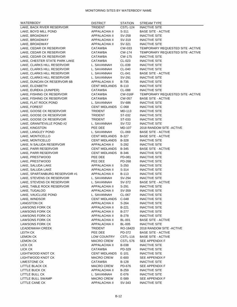
MONITORING SITES BY WATERBODY NAME
WATERBODY DISTRICT STATION STREAM TYPELAKE, BACK RIVER RESERVOIR TRIDENT CSTL-124 INACTIVE SITELAKE, BOYD MILL POND APPALACHIA II S-311 BASE SITE - ACTIVELAKE, BROADWAY APPALACHIA II SV-258 INACTIVE SITELAKE, BROADWAY APPALACHIA II SV-319 INACTIVE SITELAKE, BROADWAY APPALACHIA II SV-321 INACTIVE SITELAKE, CEDAR CK RESERVOIR CATAWBA CW-033 TEMPORARY REQUESTED SITE -ACTIVELAKE, CEDAR CK RESERVOIR CATAWBA CW-174 TEMPORARY REQUESTED SITE -ACTIVELAKE, CEDAR CK RESERVOIR CATAWBA CW-175 INACTIVE SITELAKE, CHESTER STATE PARK LAKE CATAWBA CL-023 INACTIVE SITELAKE, CLARKS HILL RESERVOIR L. SAVANNAH CL-039 INACTIVE SITELAKE, CLARKS HILL RESERVOIR L. SAVANNAH CL-040 INACTIVE SITELAKE, CLARKS HILL RESERVOIR L. SAVANNAH CL-041 BASE SITE - ACTIVELAKE, CLARKS HILL RESERVOIR L. SAVANNAH SV-291 INACTIVE SITELAKE, DUNCAN CK RESERVOIR 6B APPALACHIA II B-735 INACTIVE SITELAKE, ELIZABETH CENT MIDLANDS B-110 INACTIVE SITELAKE, EUREKA (JUNIPER) CATAWBA CL-088 INACTIVE SITELAKE, FISHING CK RESERVOIR CATAWBA CW-016F TEMPORARY REQUESTED SITE -ACTIVELAKE, FISHING CK RESERVOIR CATAWBA CW-057 BASE SITE - ACTIVELAKE, FLAT ROCK POND L. SAVANNAH SV-686 INACTIVE SITELAKE, FOREST CENT MIDLANDS C-068 INACTIVE SITELAKE, GOOSE CK RESERVOIR TRIDENT MD-113 INACTIVE SITELAKE, GOOSE CK RESERVOIR TRIDENT ST-032 INACTIVE SITELAKE, GOOSE CK RESERVOIR TRIDENT ST-033 INACTIVE SITELAKE, GRANITEVILLE POND #2 L. SAVANNAH SV-722 INACTIVE SITELAKE, KINGSTON PEE DEE MD-107 2018 RANDOM SITE -ACTIVELAKE, LANGLEY POND L. SAVANNAH CL-069 BASE SITE - ACTIVELAKE, MONTICELLO CENT MIDLANDS B-327 BASE SITE - ACTIVELAKE, MONTICELLO CENT MIDLANDS B-328 INACTIVE SITELAKE, N SALUDA RESERVOIR APPALACHIA II S-292 INACTIVE SITELAKE, PARR RESERVOIR CENT MIDLANDS B-345 BASE SITE - ACTIVELAKE, PARR RESERVOIR CENT MIDLANDS B-346 INACTIVE SITELAKE, PRESTWOOD PEE DEE PD-081 INACTIVE SITELAKE, PRESTWOOD PEE DEE PD-268 INACTIVE SITELAKE, SALUDA LAKE APPALACHIA II S-250 INACTIVE SITELAKE, SALUDA LAKE APPALACHIA II S-314 INACTIVE SITELAKE, SPARTANBURG RESERVOIR #1 APPALACHIA II B-113 INACTIVE SITELAKE, STEVENS CK RESERVOIR L. SAVANNAH SV-294 INACTIVE SITELAKE, STEVENS CK RESERVOIR L. SAVANNAH SV-372 BASE SITE - ACTIVELAKE, TABLE ROCK RESERVOIR APPALACHIA II S-291 INACTIVE SITELAKE, TUGALOO APPALACHIA II SV-359 INACTIVE SITELAKE, VAUCLUSE POND L. SAVANNAH CL-067 INACTIVE SITELAKE, WINDSOR CENT MIDLANDS C-048 INACTIVE SITELANGSTON CK APPALACHIA II S-264 INACTIVE SITELAWSONS FORK CK APPALACHIA II B-221 INACTIVE SITELAWSONS FORK CK APPALACHIA II B-277 INACTIVE SITELAWSONS FORK CK APPALACHIA II B-278 INACTIVE SITELAWSONS FORK CK APPALACHIA II BL-001 BASE SITE - ACTIVELAWSONS FORK CK APPALACHIA II BL-005 INACTIVE SITELEADENWAH CREEK TRIDENT RO-18420 2018 RANDOM SITE -ACTIVELEITH CK PEE DEE PD-372 BASE SITE - ACTIVELEMON CK LOW COUNTRY CSTL-116 BASE SITE - ACTIVELEMON CK MACRO CREW CSTL-576 SEE APPENDIX FLICK CK APPALACHIA II B-038 INACTIVE SITELICK CK CATAWBA PD-329 INACTIVE SITELIGHTWOOD KNOT CK CENT MIDLANDS E-101 INACTIVE SITELIGHTWOOD KNOT CK MACRO CREW E-600 SEE APPENDIX FLIMESTONE CK CATAWBA B-128 INACTIVE SITELITTLE BLACK CK MACRO CREW PD-676 SEE APPENDIX FLITTLE BUCK CK APPALACHIA II B-259 INACTIVE SITELITTLE BULL CK L. SAVANNAH E-076 INACTIVE SITELITTLE BULL SWAMP MACRO CREW E-589 SEE APPENDIX FLITTLE CANE CK APPALACHIA II SV-343 INACTIVE SITE
B-12

MONITORING SITES BY WATERBODY NAME
WATERBODY DISTRICT STATION STREAM TYPELITTLE EASTATOE CK APPALACHIA II SV-341 INACTIVE SITELITTLE FORK CK CATAWBA PD-215 INACTIVE SITELITTLE FORK CK MACRO CREW PD-647 SEE APPENDIX FLITTLE GENEROSTEE MACRO CREW SV-109 SEE APPENDIX FLITTLE HORSE CK L. SAVANNAH SV-073 INACTIVE SITELITTLE HORSE CK MACRO CREW SV-724 SEE APPENDIX FLITTLE LYNCHES RVR CATAWBA PD-006 INACTIVE SITELITTLE LYNCHES RVR CATAWBA PD-109 INACTIVE SITELITTLE LYNCHES RVR CATAWBA PD-343 INACTIVE SITELITTLE LYNCHES RVR CATAWBA PD-344 BASE SITE - ACTIVELITTLE LYNCHES RVR MACRO CREW PD-632 SEE APPENDIX FLITTLE LYNCHES RVR MACRO CREW PD-640 SEE APPENDIX FLITTLE PEE DEE RIVER PEE DEE RS-18431 2018 RANDOM SITE -ACTIVELITTLE PEE DEE RVR PEE DEE PD-029E INACTIVE SITELITTLE PEE DEE RVR PEE DEE PD-030A INACTIVE SITELITTLE PEE DEE RVR PEE DEE PD-042 INACTIVE SITELITTLE PEE DEE RVR PEE DEE PD-052 BASE SITE - ACTIVELITTLE PEE DEE RVR PEE DEE PD-055 BASE SITE - ACTIVELITTLE PEE DEE RVR PEE DEE PD-069 INACTIVE SITELITTLE PEE DEE RVR PEE DEE PD-189 INACTIVE SITELITTLE PEE DEE RVR PEE DEE PD-348 INACTIVE SITELITTLE PEE DEE RVR PEE DEE PD-350 BASE SITE - ACTIVELITTLE PEE DEE RVR PEE DEE PD-365 BASE SITE - ACTIVELITTLE PINE TREE CK CENT MIDLANDS CW-223 INACTIVE SITELITTLE RIVER APPALACHIA II RS-18426 2018 RANDOM SITE -ACTIVELITTLE ROCKY CK MACRO CREW CW-067 SEE APPENDIX FLITTLE ROCKY CREEK CATAWBA RS-17340 TEMPORARY REQUESTED SITE -ACTIVELITTLE ROCKY CREEK CATAWBA RS-18396 2018 RANDOM SITE -ACTIVELITTLE RVR CENT MIDLANDS B-145 INACTIVE SITELITTLE RVR CENT MIDLANDS B-350 BASE SITE - ACTIVELITTLE RVR PEE DEE MD-162 INACTIVE SITELITTLE RVR APPALACHIA II S-034 INACTIVE SITELITTLE RVR CENT MIDLANDS S-038 INACTIVE SITELITTLE RVR CENT MIDLANDS S-099 INACTIVE SITELITTLE RVR MACRO CREW S-100 SEE APPENDIX FLITTLE RVR APPALACHIA II S-297 INACTIVE SITELITTLE RVR CENT MIDLANDS S-305 BASE SITE - ACTIVELITTLE RVR APPALACHIA II SV-164 INACTIVE SITELITTLE RVR L. SAVANNAH SV-192 BASE SITE - ACTIVELITTLE RVR APPALACHIA II SV-203 BASE SITE - ACTIVELITTLE RVR APPALACHIA II SV-348 INACTIVE SITELITTLE SALKEHATCHIE RVR LOW COUNTRY CSTL-115 BASE SITE - ACTIVELITTLE SALKEHATCHIE RVR L. SAVANNAH CSTL-117 INACTIVE SITELITTLE SALKEHATCHIE RVR LOW COUNTRY CSTL-120 BASE SITE - ACTIVELITTLE SALKEHATCHIE RVR MACRO CREW CSTL-566 SEE APPENDIX FLITTLE SALUDA RVR L. SAVANNAH S-050 INACTIVE SITELITTLE SALUDA RVR L. SAVANNAH S-123 BASE SITE - ACTIVELITTLE SUGAR CK CATAWBA CW-248 INACTIVE SITELITTLE WATEREE CK CENT MIDLANDS CW-040 TEMPORARY REQUESTED SITE -ACTIVELOG BRIDGE CK TRIDENT MD-121 INACTIVE SITELOG CK MACRO CREW SV-728 SEE APPENDIX FLONG BRANCH CATAWBA B-326 INACTIVE SITELONG CANE CK MACRO CREW SV-056 SEE APPENDIX FLONG CANE CK L. SAVANNAH SV-318 BASE SITE - ACTIVELONG CANE CK APPALACHIA II SV-349 INACTIVE SITELORICK BRANCH CENT MIDLANDS S-150 INACTIVE SITELOWER THREE RUNS CK L. SAVANNAH SV-175 BASE SITE - ACTIVELOWER THREE RUNS CK L. SAVANNAH SV-328 INACTIVE SITELUMBER RVR PEE DEE PD-038 BASE SITE - ACTIVELYNCHES RIVER CATAWBA RS-15256 TEMPORARY REQUESTED SITE -ACTIVELYNCHES RVR CATAWBA PD-001 INACTIVE SITELYNCHES RVR CATAWBA PD-009 BASE SITE - ACTIVE
B-13

MONITORING SITES BY WATERBODY NAME
WATERBODY DISTRICT STATION STREAM TYPELYNCHES RVR PEE DEE PD-041 INACTIVE SITELYNCHES RVR CATAWBA PD-066 BASE SITE - ACTIVELYNCHES RVR PEE DEE PD-071 INACTIVE SITELYNCHES RVR CATAWBA PD-080 INACTIVE SITELYNCHES RVR PEE DEE PD-093 BASE SITE - ACTIVELYNCHES RVR PEE DEE PD-106 INACTIVE SITELYNCHES RVR CATAWBA PD-113 INACTIVE SITELYNCHES RVR PEE DEE PD-281 2018 RANDOM SITE -ACTIVELYNCHES RVR PEE DEE PD-319 INACTIVE SITELYNCHES RVR PEE DEE PD-364 2018 RANDOM SITE -ACTIVELYONS CK MACRO CREW ST-533 SEE APPENDIX FMAPLE CK MACRO CREW B-625 SEE APPENDIX FMAPLE SWAMP PEE DEE PD-030 INACTIVE SITEMATTHEWS CK APPALACHIA II S-086 INACTIVE SITEMAY RIVER LOW COUNTRY RO-18425 2018 RANDOM SITE -ACTIVEMAY RVR LOW COUNTRY MD-016 INACTIVE SITEMAY RVR LOW COUNTRY MD-173 BASE SITE - ACTIVEMCALPINE CK CATAWBA CW-064 INACTIVE SITEMCALPINE CK CATAWBA CW-226 INACTIVE SITEMCLAURINS MILL POND PEE DEE PD-017A INACTIVE SITEMCTIER CK MACRO CREW E-578 SEE APPENDIX FMEADOW CK MACRO CREW B-531 SEE APPENDIX FMECHANICSVILLE SWAMP PEE DEE PD-356 INACTIVE SITEMECHAW CK TRIDENT MD-241 INACTIVE SITEMENG CK CATAWBA B-064 INACTIVE SITEMENG CK TRIB CATAWBA B-243 INACTIVE SITEMIDDLE SALUDA RVR MACRO CREW S-076 SEE APPENDIX FMIDDLE SALUDA RVR APPALACHIA II S-077 INACTIVE SITEMIDDLE SALUDA RVR APPALACHIA II S-252 INACTIVE SITEMIDDLE SALUDA RVR APPALACHIA II S-316 INACTIVE SITEMIDDLE SWAMP PEE DEE PD-230 INACTIVE SITEMIDDLE TYGER RVR APPALACHIA II B-012 INACTIVE SITEMIDDLE TYGER RVR APPALACHIA II B-014 BASE SITE - ACTIVEMIDDLE TYGER RVR APPALACHIA II B-148 INACTIVE SITEMIDDLE TYGER RVR MACRO CREW B-794 SEE APPENDIX FMILL BRANCH PEE DEE RS-18403 2018 RANDOM SITE -ACTIVEMILL CK CENT MIDLANDS B-338 INACTIVE SITEMILL CK MACRO CREW B-780 SEE APPENDIX FMILL CK CENT MIDLANDS C-021 INACTIVE SITEMILL CK CENT MIDLANDS C-022 INACTIVE SITEMILL CK APPALACHIA II S-315 INACTIVE SITEMITCHELL CK CATAWBA B-199 INACTIVE SITEMITCHELL CK MACRO CREW B-781 SEE APPENDIX FMOORES CK MACRO CREW S-112 SEE APPENDIX FMORGAN RIVR LOW COUNTRY MD-282 BASE SITE - ACTIVEMOTLOW CK MACRO CREW B-790 SEE APPENDIX FMOUNTAIN CK APPALACHIA II B-186 INACTIVE SITEMOUNTAIN CK MACRO CREW BE-008 SEE APPENDIX FMOUNTAIN CK MACRO CREW S-859 SEE APPENDIX FMOUNTAIN CK MACRO CREW S-864 SEE APPENDIX FMUSH CK APPALACHIA II B-317 INACTIVE SITEMYERS CK MACRO CREW C-578 SEE APPENDIX FN BRANCH WILDCAT CK CATAWBA PD-179 INACTIVE SITEN BRANCH WILDCAT CK MACRO CREW PD-679 SEE APPENDIX FN FORK EDISTO RVR L. SAVANNAH E-007 INACTIVE SITEN FORK EDISTO RVR L. SAVANNAH E-007A INACTIVE SITEN FORK EDISTO RVR L. SAVANNAH E-007B INACTIVE SITEN FORK EDISTO RVR L. SAVANNAH E-007C INACTIVE SITEN FORK EDISTO RVR L. SAVANNAH E-008 2018 RANDOM SITE -ACTIVEN FORK EDISTO RVR L. SAVANNAH E-008A BASE SITE - ACTIVEN FORK EDISTO RVR L. SAVANNAH E-084 INACTIVE SITEN FORK EDISTO RVR L. SAVANNAH E-092 INACTIVE SITE
B-14
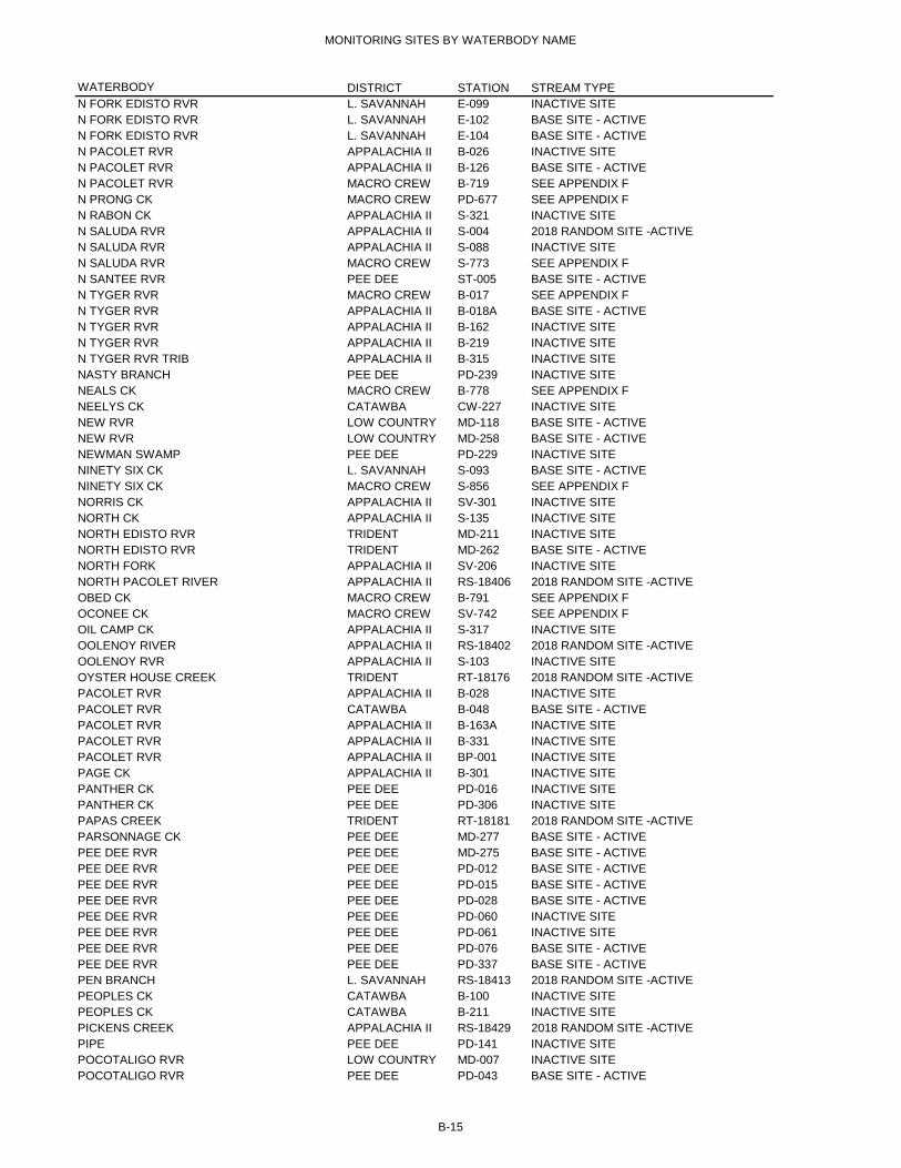
MONITORING SITES BY WATERBODY NAME
WATERBODY DISTRICT STATION STREAM TYPEN FORK EDISTO RVR L. SAVANNAH E-099 INACTIVE SITEN FORK EDISTO RVR L. SAVANNAH E-102 BASE SITE - ACTIVEN FORK EDISTO RVR L. SAVANNAH E-104 BASE SITE - ACTIVEN PACOLET RVR APPALACHIA II B-026 INACTIVE SITEN PACOLET RVR APPALACHIA II B-126 BASE SITE - ACTIVEN PACOLET RVR MACRO CREW B-719 SEE APPENDIX FN PRONG CK MACRO CREW PD-677 SEE APPENDIX FN RABON CK APPALACHIA II S-321 INACTIVE SITEN SALUDA RVR APPALACHIA II S-004 2018 RANDOM SITE -ACTIVEN SALUDA RVR APPALACHIA II S-088 INACTIVE SITEN SALUDA RVR MACRO CREW S-773 SEE APPENDIX FN SANTEE RVR PEE DEE ST-005 BASE SITE - ACTIVEN TYGER RVR MACRO CREW B-017 SEE APPENDIX FN TYGER RVR APPALACHIA II B-018A BASE SITE - ACTIVEN TYGER RVR APPALACHIA II B-162 INACTIVE SITEN TYGER RVR APPALACHIA II B-219 INACTIVE SITEN TYGER RVR TRIB APPALACHIA II B-315 INACTIVE SITENASTY BRANCH PEE DEE PD-239 INACTIVE SITENEALS CK MACRO CREW B-778 SEE APPENDIX FNEELYS CK CATAWBA CW-227 INACTIVE SITENEW RVR LOW COUNTRY MD-118 BASE SITE - ACTIVENEW RVR LOW COUNTRY MD-258 BASE SITE - ACTIVENEWMAN SWAMP PEE DEE PD-229 INACTIVE SITENINETY SIX CK L. SAVANNAH S-093 BASE SITE - ACTIVENINETY SIX CK MACRO CREW S-856 SEE APPENDIX FNORRIS CK APPALACHIA II SV-301 INACTIVE SITENORTH CK APPALACHIA II S-135 INACTIVE SITENORTH EDISTO RVR TRIDENT MD-211 INACTIVE SITENORTH EDISTO RVR TRIDENT MD-262 BASE SITE - ACTIVENORTH FORK APPALACHIA II SV-206 INACTIVE SITENORTH PACOLET RIVER APPALACHIA II RS-18406 2018 RANDOM SITE -ACTIVEOBED CK MACRO CREW B-791 SEE APPENDIX FOCONEE CK MACRO CREW SV-742 SEE APPENDIX FOIL CAMP CK APPALACHIA II S-317 INACTIVE SITEOOLENOY RIVER APPALACHIA II RS-18402 2018 RANDOM SITE -ACTIVEOOLENOY RVR APPALACHIA II S-103 INACTIVE SITEOYSTER HOUSE CREEK TRIDENT RT-18176 2018 RANDOM SITE -ACTIVEPACOLET RVR APPALACHIA II B-028 INACTIVE SITEPACOLET RVR CATAWBA B-048 BASE SITE - ACTIVEPACOLET RVR APPALACHIA II B-163A INACTIVE SITEPACOLET RVR APPALACHIA II B-331 INACTIVE SITEPACOLET RVR APPALACHIA II BP-001 INACTIVE SITEPAGE CK APPALACHIA II B-301 INACTIVE SITEPANTHER CK PEE DEE PD-016 INACTIVE SITEPANTHER CK PEE DEE PD-306 INACTIVE SITEPAPAS CREEK TRIDENT RT-18181 2018 RANDOM SITE -ACTIVEPARSONNAGE CK PEE DEE MD-277 BASE SITE - ACTIVEPEE DEE RVR PEE DEE MD-275 BASE SITE - ACTIVEPEE DEE RVR PEE DEE PD-012 BASE SITE - ACTIVEPEE DEE RVR PEE DEE PD-015 BASE SITE - ACTIVEPEE DEE RVR PEE DEE PD-028 BASE SITE - ACTIVEPEE DEE RVR PEE DEE PD-060 INACTIVE SITEPEE DEE RVR PEE DEE PD-061 INACTIVE SITEPEE DEE RVR PEE DEE PD-076 BASE SITE - ACTIVEPEE DEE RVR PEE DEE PD-337 BASE SITE - ACTIVEPEN BRANCH L. SAVANNAH RS-18413 2018 RANDOM SITE -ACTIVEPEOPLES CK CATAWBA B-100 INACTIVE SITEPEOPLES CK CATAWBA B-211 INACTIVE SITEPICKENS CREEK APPALACHIA II RS-18429 2018 RANDOM SITE -ACTIVEPIPE PEE DEE PD-141 INACTIVE SITEPOCOTALIGO RVR LOW COUNTRY MD-007 INACTIVE SITEPOCOTALIGO RVR PEE DEE PD-043 BASE SITE - ACTIVE
B-15

MONITORING SITES BY WATERBODY NAME
WATERBODY DISTRICT STATION STREAM TYPEPOCOTALIGO RVR PEE DEE PD-091 BASE SITE - ACTIVEPOCOTALIGO RVR PEE DEE PD-115 INACTIVE SITEPOCOTALIGO RVR PEE DEE PD-202 INACTIVE SITEPOLK SWAMP TRIDENT E-109 BASE SITE - ACTIVEPORT ROYAL SOUND LOW COUNTRY MD-006 INACTIVE SITEPOTATO CK CENT MIDLANDS SC-020 INACTIVE SITEPOTATO CK CENT MIDLANDS ST-035 INACTIVE SITEPOTTER BRANCH APPALACHIA II B-191 INACTIVE SITEPRINCESS CK APPALACHIA II B-192 INACTIVE SITEPROVIDENCE SWAMP L. SAVANNAH E-051 INACTIVE SITEPUDDING SWAMP PEE DEE PD-203 BASE SITE - ACTIVERABON CK APPALACHIA II S-096 BASE SITE - ACTIVERAWLS CK CENT MIDLANDS S-287 TEMPORARY REQUESTED SITE -ACTIVERED BANK CK CENT MIDLANDS C-066 INACTIVE SITERED BANK CK CENT MIDLANDS C-067 INACTIVE SITERED BANK CK MACRO CREW C-580 SEE APPENDIX FREDIVERSION CANAL SANTEE COOPER SC-037 INACTIVE SITEREDIVERSION CANAL TRIDENT SC-037A INACTIVE SITEREDIVERSION CANAL TRIDENT ST-031 INACTIVE SITEREEDER POINT BRANCH CENT MIDLANDS C-073 INACTIVE SITEREEDY RVR APPALACHIA II S-013 INACTIVE SITEREEDY RVR APPALACHIA II S-018 INACTIVE SITEREEDY RVR APPALACHIA II S-021 BASE SITE - ACTIVEREEDY RVR APPALACHIA II S-070 INACTIVE SITEREEDY RVR APPALACHIA II S-072 BASE SITE - ACTIVEREEDY RVR APPALACHIA II S-073 INACTIVE SITEREEDY RVR APPALACHIA II S-319 BASE SITE - ACTIVEREEDY RVR APPALACHIA II S-323 INACTIVE SITEREEDY RVR MACRO CREW S-778 SEE APPENDIX FREEDY RVR MACRO CREW S-928 SEE APPENDIX FREMICK SWAMP MACRO CREW CSTL-584 SEE APPENDIX FRICEPATCH CK MACRO CREW CSTL-569 SEE APPENDIX FRICES CK MACRO CREW SV-740 SEE APPENDIX FROBERTS SWAMP L. SAVANNAH E-039 INACTIVE SITEROCK CREEK LOW COUNTRY RO-18422 2018 RANDOM SITE -ACTIVEROCKY BLUFF SWAMP PEE DEE PD-201 BASE SITE - ACTIVEROCKY BLUFF SWAMP PEE DEE PD-357 INACTIVE SITEROCKY BOTTOM CK MACRO CREW SV-676 SEE APPENDIX FROCKY CK APPALACHIA II BE-007 INACTIVE SITEROCKY CK CATAWBA CW-002 INACTIVE SITEROCKY CK CATAWBA CW-236 BASE SITE - ACTIVEROCKY CK APPALACHIA II S-091 INACTIVE SITEROCKY CK MACRO CREW SV-730 SEE APPENDIX FROCKY CREEK CATAWBA RS-14216 TEMPORARY REQUESTED SITE -ACTIVEROCKY RVR APPALACHIA II SV-031 INACTIVE SITEROCKY RVR APPALACHIA II SV-041 INACTIVE SITEROCKY RVR APPALACHIA II SV-346 INACTIVE SITEROCKY RVR MACRO CREW SV-650 SEE APPENDIX FROSEMARY CK MACRO CREW CSTL-588 SEE APPENDIX FROSS BRANCH CATAWBA B-086 INACTIVE SITERUM CK CATAWBA CW-232 INACTIVE SITERUNOFF SANTEE COOPER SC-056 INACTIVE SITERUNOFF SANTEE COOPER SC-057 INACTIVE SITES BRANCH WILDCAT CK CATAWBA PD-180 INACTIVE SITES FORK EDISTO RVR L. SAVANNAH E-002 INACTIVE SITES FORK EDISTO RVR L. SAVANNAH E-011 BASE SITE - ACTIVES FORK EDISTO RVR L. SAVANNAH E-012 BASE SITE - ACTIVES FORK EDISTO RVR L. SAVANNAH E-021 INACTIVE SITES FORK EDISTO RVR L. SAVANNAH E-090 INACTIVE SITES FORK EDISTO RVR L. SAVANNAH E-113 INACTIVE SITES FORK EDISTO RVR L. SAVANNAH E-114 BASE SITE - ACTIVES FORK OF FISHING CK MACRO CREW CW-007 SEE APPENDIX F
B-16

MONITORING SITES BY WATERBODY NAME
WATERBODY DISTRICT STATION STREAM TYPES PACOLET RVR APPALACHIA II B-302 BASE SITE - ACTIVES PACOLET RVR MACRO CREW B-720 SEE APPENDIX FS RABON CK APPALACHIA II S-322 INACTIVE SITES RABON CK MACRO CREW S-860 SEE APPENDIX FS SALUDA RVR APPALACHIA II S-087 INACTIVE SITES SALUDA RVR APPALACHIA II S-299 BASE SITE - ACTIVES SALUDA RVR APPALACHIA II S-318 INACTIVE SITES SALUDA RVR APPALACHIA II S-320 INACTIVE SITES SALUDA RVR MACRO CREW S-771 SEE APPENDIX FS SANTEE RVR TRIDENT ST-006 BASE SITE - ACTIVES TYGER RVR APPALACHIA II B-005 INACTIVE SITES TYGER RVR MACRO CREW B-005A SEE APPENDIX FS TYGER RVR APPALACHIA II B-149 INACTIVE SITES TYGER RVR APPALACHIA II B-263 INACTIVE SITES TYGER RVR APPALACHIA II B-332 BASE SITE - ACTIVES TYGER RVR MACRO CREW B-741 SEE APPENDIX FSALKEHATCHIE RVR L. SAVANNAH CSTL-003 INACTIVE SITESALKEHATCHIE RVR L. SAVANNAH CSTL-006 INACTIVE SITESALKEHATCHIE RVR L. SAVANNAH CSTL-028 INACTIVE SITESALKEHATCHIE RVR LOW COUNTRY CSTL-048 BASE SITE - ACTIVESALKEHATCHIE RVR LOW COUNTRY CSTL-104 BASE SITE - ACTIVESALUDA RVR APPALACHIA II S-007 TEMPORARY REQUESTED SITE -ACTIVESALUDA RVR CENT MIDLANDS S-047 BASE SITE - ACTIVESALUDA RVR APPALACHIA II S-119 BASE SITE - ACTIVESALUDA RVR APPALACHIA II S-125 BASE SITE - ACTIVESALUDA RVR CENT MIDLANDS S-149 INACTIVE SITESALUDA RVR CENT MIDLANDS S-152 INACTIVE SITESALUDA RVR L. SAVANNAH S-186 INACTIVE SITESALUDA RVR L. SAVANNAH S-295 INACTIVE SITESALUDA RVR CENT MIDLANDS S-298 BASE SITE - ACTIVESALUDA RVR TRIB APPALACHIA II S-161 INACTIVE SITESALUDA RVR TRIB APPALACHIA II S-267 INACTIVE SITESAMPIT RVR PEE DEE MD-073 INACTIVE SITESAMPIT RVR PEE DEE MD-074 INACTIVE SITESAMPIT RVR PEE DEE MD-075 INACTIVE SITESAMPIT RVR PEE DEE MD-077 BASE SITE - ACTIVESAND RVR L. SAVANNAH SV-069 INACTIVE SITESANDERS BRANCH LOW COUNTRY CSTL-010 INACTIVE SITESANDERS BRANCH LOW COUNTRY CSTL-011 INACTIVE SITESANDERS BRANCH LOW COUNTRY CSTL-108 INACTIVE SITESANDY RUN CENT MIDLANDS C-009 INACTIVE SITESANDY RUN MACRO CREW CSTL-585 SEE APPENDIX FSANDY RUN L. SAVANNAH E-115 BASE SITE - ACTIVESANDY RVR CATAWBA B-075 BASE SITE - ACTIVESANTEE BAY PEE DEE MD-263 INACTIVE SITESANTEE RIVER TRIDENT RS-18415 2018 RANDOM SITE -ACTIVESANTEE RVR CENT MIDLANDS SC-004 TEMPORARY REQUESTED SITE -ACTIVESANTEE RVR SANTEE COOPER SC-024 INACTIVE SITESANTEE RVR TRIDENT ST-001 BASE SITE - ACTIVESANTEE RVR TRIDENT ST-016 BASE SITE - ACTIVESAVANA BRANCH CENT MIDLANDS C-061 INACTIVE SITESAVANNAH CK MACRO CREW CSTL-053 SEE APPENDIX FSAVANNAH RVR L. SAVANNAH SV-118 INACTIVE SITESAVANNAH RVR LOW COUNTRY SV-191 INACTIVE SITESAVANNAH RVR L. SAVANNAH SV-251 INACTIVE SITESAVANNAH RVR L. SAVANNAH SV-252 INACTIVE SITESAVANNAH RVR L. SAVANNAH SV-323 INACTIVE SITESAVANNAH RVR LOW COUNTRY SV-355 INACTIVE SITESAVANNAH RVR L. SAVANNAH SV-366 BASE SITE - ACTIVESAVANNAH RVR L. SAVANNAH SV-367 BASE SITE - ACTIVESAVANNAH RVR L. SAVANNAH SV-368 BASE SITE - ACTIVESAVANNAH RVR LOW COUNTRY SV-369 INACTIVE SITE
B-17

MONITORING SITES BY WATERBODY NAME
WATERBODY DISTRICT STATION STREAM TYPESAVANNAH RVR LOW COUNTRY SV-370 BASE SITE - ACTIVESAWMILL BRANCH TRIDENT CSTL-043 INACTIVE SITESAWNEY CK APPALACHIA II SV-052 INACTIVE SITESAWNEYS CK CENT MIDLANDS CW-079 INACTIVE SITESAWNEYS CK CENT MIDLANDS CW-228 INACTIVE SITESCAPE ORE SWAMP PEE DEE PD-355 INACTIVE SITESCOTT CK CENT MIDLANDS S-044 INACTIVE SITESECOND CK MACRO CREW C-583 SEE APPENDIX FSEWEE BAY TRIDENT MD-269 BASE SITE - ACTIVESHAW CK L. SAVANNAH E-094 INACTIVE SITESHAW CK L. SAVANNAH E-106 INACTIVE SITESHAWS CK MACRO CREW E-579 SEE APPENDIX FSHEM CK TRIDENT MD-071 INACTIVE SITESHIPYARD CK TRIDENT MD-243 INACTIVE SITESHOALS CK MACRO CREW S-866 SEE APPENDIX FSHOE HEEL CK PEE DEE PD-371 BASE SITE - ACTIVESIMPSON CK PEE DEE PD-363 INACTIVE SITESINGLETON SWAMP PEE DEE PD-314 INACTIVE SITESIX & TWENTY CK MACRO CREW SV-180 SEE APPENDIX FSIX & TWENTY CK APPALACHIA II SV-181 INACTIVE SITESIXMILE CK CENT MIDLANDS C-005 INACTIVE SITESIXMILE CK CENT MIDLANDS C-025 INACTIVE SITESIXMILE CK CATAWBA CW-176 INACTIVE SITESIXMILE CK APPALACHIA II SV-205 INACTIVE SITESIXMILE CREEK CATAWBA RS-17352 TEMPORARY REQUESTED SITE -ACTIVESKIPPER CK MACRO CREW PD-613 SEE APPENDIX FSKULL CK LOW COUNTRY MD-013 INACTIVE SITESMITH BRANCH CENT MIDLANDS B-280 INACTIVE SITESMITH SWAMP PEE DEE PD-187 INACTIVE SITESMITH SWAMP PEE DEE PD-320 INACTIVE SITESNAKE BRANCH PEE DEE PD-137 INACTIVE SITESNAKE BRANCH PEE DEE PD-258 INACTIVE SITESOUTH EDISTO RVR LOW COUNTRY MD-244 INACTIVE SITESOUTH EDISTO RVR LOW COUNTRY MD-260 BASE SITE - ACTIVESOUTH FORK CROWDERS CK CATAWBA CW-192 INACTIVE SITESPARROW SWAMP PEE DEE PD-072 INACTIVE SITESPARROW SWAMP PEE DEE PD-332 BASE SITE - ACTIVESPARROW SWAMP PEE DEE RS-04370 2018 RANDOM SITE -ACTIVESPEARS CK CENT MIDLANDS CW-155 INACTIVE SITESPEARS CK CENT MIDLANDS CW-166 INACTIVE SITESPIVEY CK APPALACHIA II B-103 INACTIVE SITESPIVEY CK MACRO CREW B-104 SEE APPENDIX FSPRING GROVE CK SANTEE COOPER SC-009 INACTIVE SITESPRING GROVE CK MACRO CREW ST-535 SEE APPENDIX FST HELENA SOUND LOW COUNTRY RO-18426 2018 RANDOM SITE -ACTIVESTEEL CK MACRO CREW CW-681 SEE APPENDIX FSTEEL CK L. SAVANNAH SV-327 INACTIVE SITESTEELE CK CATAWBA CW-009 INACTIVE SITESTEELE CK CATAWBA CW-011 INACTIVE SITESTEELE CK CATAWBA CW-203 INACTIVE SITESTEVENS CK MACRO CREW SV-063 SEE APPENDIX FSTEVENS CK L. SAVANNAH SV-330 INACTIVE SITESTEVENS CK L. SAVANNAH SV-354 BASE SITE - ACTIVESTEVENS CK L. SAVANNAH SV-365 BASE SITE - ACTIVESTONEY FORK CK MACRO CREW CW-697 SEE APPENDIX FSTONO RVR TRIDENT MD-026 INACTIVE SITESTONO RVR TRIDENT MD-202 BASE SITE - ACTIVESTONO RVR TRIDENT MD-206 BASE SITE - ACTIVESTONO RVR TRIDENT MD-208 INACTIVE SITESTROM THURMON RESERVOIR L. SAVANNAH RL-18100 2018 RANDOM SITE -ACTIVESUCK CK MACRO CREW B-296 SEE APPENDIX FSUGAR CK MACRO CREW B-779 SEE APPENDIX F
B-18
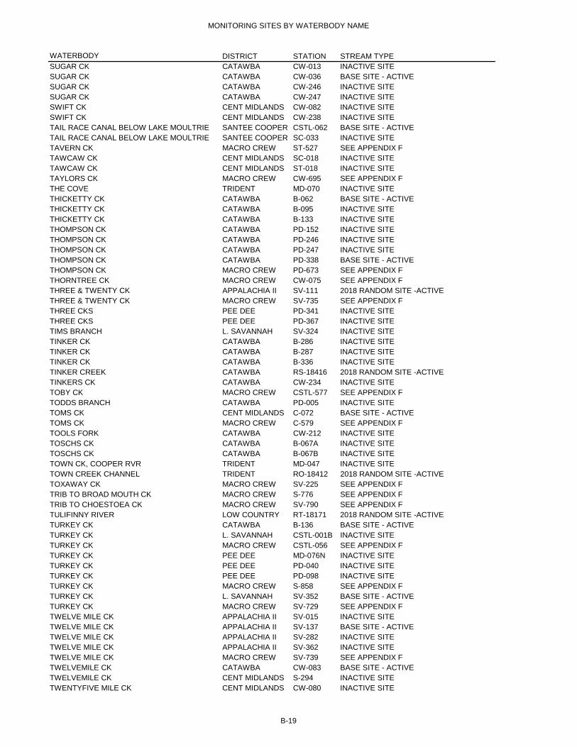
MONITORING SITES BY WATERBODY NAME
WATERBODY DISTRICT STATION STREAM TYPESUGAR CK CATAWBA CW-013 INACTIVE SITESUGAR CK CATAWBA CW-036 BASE SITE - ACTIVESUGAR CK CATAWBA CW-246 INACTIVE SITESUGAR CK CATAWBA CW-247 INACTIVE SITESWIFT CK CENT MIDLANDS CW-082 INACTIVE SITESWIFT CK CENT MIDLANDS CW-238 INACTIVE SITETAIL RACE CANAL BELOW LAKE MOULTRIE SANTEE COOPER CSTL-062 BASE SITE - ACTIVETAIL RACE CANAL BELOW LAKE MOULTRIE SANTEE COOPER SC-033 INACTIVE SITETAVERN CK MACRO CREW ST-527 SEE APPENDIX FTAWCAW CK CENT MIDLANDS SC-018 INACTIVE SITETAWCAW CK CENT MIDLANDS ST-018 INACTIVE SITETAYLORS CK MACRO CREW CW-695 SEE APPENDIX FTHE COVE TRIDENT MD-070 INACTIVE SITETHICKETTY CK CATAWBA B-062 BASE SITE - ACTIVETHICKETTY CK CATAWBA B-095 INACTIVE SITETHICKETTY CK CATAWBA B-133 INACTIVE SITETHOMPSON CK CATAWBA PD-152 INACTIVE SITETHOMPSON CK CATAWBA PD-246 INACTIVE SITETHOMPSON CK CATAWBA PD-247 INACTIVE SITETHOMPSON CK CATAWBA PD-338 BASE SITE - ACTIVETHOMPSON CK MACRO CREW PD-673 SEE APPENDIX FTHORNTREE CK MACRO CREW CW-075 SEE APPENDIX FTHREE & TWENTY CK APPALACHIA II SV-111 2018 RANDOM SITE -ACTIVETHREE & TWENTY CK MACRO CREW SV-735 SEE APPENDIX FTHREE CKS PEE DEE PD-341 INACTIVE SITETHREE CKS PEE DEE PD-367 INACTIVE SITETIMS BRANCH L. SAVANNAH SV-324 INACTIVE SITETINKER CK CATAWBA B-286 INACTIVE SITETINKER CK CATAWBA B-287 INACTIVE SITETINKER CK CATAWBA B-336 INACTIVE SITETINKER CREEK CATAWBA RS-18416 2018 RANDOM SITE -ACTIVETINKERS CK CATAWBA CW-234 INACTIVE SITETOBY CK MACRO CREW CSTL-577 SEE APPENDIX FTODDS BRANCH CATAWBA PD-005 INACTIVE SITETOMS CK CENT MIDLANDS C-072 BASE SITE - ACTIVETOMS CK MACRO CREW C-579 SEE APPENDIX FTOOLS FORK CATAWBA CW-212 INACTIVE SITETOSCHS CK CATAWBA B-067A INACTIVE SITETOSCHS CK CATAWBA B-067B INACTIVE SITETOWN CK, COOPER RVR TRIDENT MD-047 INACTIVE SITETOWN CREEK CHANNEL TRIDENT RO-18412 2018 RANDOM SITE -ACTIVETOXAWAY CK MACRO CREW SV-225 SEE APPENDIX FTRIB TO BROAD MOUTH CK MACRO CREW S-776 SEE APPENDIX FTRIB TO CHOESTOEA CK MACRO CREW SV-790 SEE APPENDIX FTULIFINNY RIVER LOW COUNTRY RT-18171 2018 RANDOM SITE -ACTIVETURKEY CK CATAWBA B-136 BASE SITE - ACTIVETURKEY CK L. SAVANNAH CSTL-001B INACTIVE SITETURKEY CK MACRO CREW CSTL-056 SEE APPENDIX FTURKEY CK PEE DEE MD-076N INACTIVE SITETURKEY CK PEE DEE PD-040 INACTIVE SITETURKEY CK PEE DEE PD-098 INACTIVE SITETURKEY CK MACRO CREW S-858 SEE APPENDIX FTURKEY CK L. SAVANNAH SV-352 BASE SITE - ACTIVETURKEY CK MACRO CREW SV-729 SEE APPENDIX FTWELVE MILE CK APPALACHIA II SV-015 INACTIVE SITETWELVE MILE CK APPALACHIA II SV-137 BASE SITE - ACTIVETWELVE MILE CK APPALACHIA II SV-282 INACTIVE SITETWELVE MILE CK APPALACHIA II SV-362 INACTIVE SITETWELVE MILE CK MACRO CREW SV-739 SEE APPENDIX FTWELVEMILE CK CATAWBA CW-083 BASE SITE - ACTIVETWELVEMILE CK CENT MIDLANDS S-294 INACTIVE SITETWENTYFIVE MILE CK CENT MIDLANDS CW-080 INACTIVE SITE
B-19

MONITORING SITES BY WATERBODY NAME
WATERBODY DISTRICT STATION STREAM TYPETYGER RIVER CATAWBA RS-18434 2018 RANDOM SITE -ACTIVETYGER RVR APPALACHIA II B-008 INACTIVE SITETYGER RVR CATAWBA B-051 INACTIVE SITETYGER RVR CENT MIDLANDS B-349 BASE SITE - ACTIVEUNNAMED APPALACHIA II SV-136 INACTIVE SITEUNNAMED CK LOW COUNTRY MD-256 BASE SITE - ACTIVEUNNAMED DRAINAGE CANAL PEE DEE PD-354 INACTIVE SITEUNNAMED TRIB CENT MIDLANDS CW-242 INACTIVE SITEUNNAMED TRIB SANTEE COOPER SC-026 INACTIVE SITEUNNAMED TRIB SANTEE COOPER SC-043 INACTIVE SITEUNNAMED TRIB SANTEE COOPER SC-058 INACTIVE SITEUNNAMED TRIB TO BULLYARD SOUND TRIDENT RT-18191 2018 RANDOM SITE -ACTIVEUNNAMED TRIB TO COOPER RIVER LOW COUNTRY RT-18178 2018 RANDOM SITE -ACTIVEUNNAMED TRIB TO COOSAW RIVER LOW COUNTRY RT-18186 2018 RANDOM SITE -ACTIVEUNNAMED TRIB TO COWEN/ CAPERS/WALLAC LOW COUNTRY RT-18179 2018 RANDOM SITE -ACTIVEUNNAMED TRIB TO JEFFORD CREEK LOW COUNTRY RT-18190 2018 RANDOM SITE -ACTIVEUNNAMED TRIB TO LEADENWAH CK TRIDENT RT-18188 2018 RANDOM SITE -ACTIVEUNNAMED TRIBUTARY TO KINGSTREE SWAMPPEE DEE RS-18419 2018 RANDOM SITE -ACTIVEUNNAMED TRIBUTARY TO KINGSTREE SWAMPPEE DEE RS-18439 2018 RANDOM SITE -ACTIVEUPPER THREE RUNS L. SAVANNAH SV-325 BASE SITE - ACTIVEUPPER THREE RUNS MACRO CREW SV-680 SEE APPENDIX FVAUGHN CK MACRO CREW B-099-7 SEE APPENDIX FWACCAMAW RVR PEE DEE MD-110 INACTIVE SITEWACCAMAW RVR PEE DEE MD-111 INACTIVE SITEWACCAMAW RVR PEE DEE MD-124 INACTIVE SITEWACCAMAW RVR PEE DEE MD-136 INACTIVE SITEWACCAMAW RVR PEE DEE MD-137 INACTIVE SITEWACCAMAW RVR PEE DEE MD-138 BASE SITE - ACTIVEWACCAMAW RVR PEE DEE MD-142 BASE SITE - ACTIVEWACCAMAW RVR PEE DEE MD-145 BASE SITE - ACTIVEWACCAMAW RVR PEE DEE PD-369 INACTIVE SITEWACCAMAW RVR PEE DEE PD-373 BASE SITE - ACTIVEWACCAMAW RVR, ICWW PEE DEE MD-146 INACTIVE SITEWADBOO SWAMP TRIDENT CSTL-113 BASE SITE - ACTIVEWAGNER CREEK TRIDENT RT-18175 2018 RANDOM SITE -ACTIVEWALKER SWAMP TRIDENT ST-007 INACTIVE SITEWALNUT CK MACRO CREW S-861 SEE APPENDIX FWAMBAW CK TRIDENT CSTL-112 INACTIVE SITEWANDO RVR TRIDENT MD-115 BASE SITE - ACTIVEWANDO RVR TRIDENT MD-198 INACTIVE SITEWANDO RVR TRIDENT MD-264 BASE SITE - ACTIVEWAPPOO CK TRIDENT MD-020 INACTIVE SITEWARLEY CK MACRO CREW C-014 SEE APPENDIX FWARLEY CR SANTEE COOPER SC-006 INACTIVE SITEWARRIOR CK APPALACHIA II B-150 INACTIVE SITEWARRIOR CK MACRO CREW B-742 SEE APPENDIX FWASSAMASSAW SWAMP TRIDENT CSTL-063 INACTIVE SITEWATEREE CK MACRO CREW B-801 SEE APPENDIX FWATEREE RVR CENT MIDLANDS CW-019 BASE SITE - ACTIVEWATEREE RVR CENT MIDLANDS CW-206 BASE SITE - ACTIVEWATEREE RVR CATAWBA CW-214 INACTIVE SITEWATEREE RVR CENT MIDLANDS CW-222 BASE SITE - ACTIVEWATEREE RVR CENT MIDLANDS SC-002 INACTIVE SITEWAXHAW CK CATAWBA CW-145 INACTIVE SITEWESTFIELD CK CATAWBA PD-339 INACTIVE SITEWESTFIELD CK MACRO CREW PD-641 SEE APPENDIX FWHALE BRANCH TRIDENT MD-010 INACTIVE SITEWHALE BRANCH LOW COUNTRY MD-194 INACTIVE SITEWHALE BRANCH LOW COUNTRY MD-279 INACTIVE SITEWHALE BRANCH LOW COUNTRY RO-18415 2018 RANDOM SITE -ACTIVEWHIPPY SWAMP LOW COUNTRY CSTL-076 BASE SITE - ACTIVEWHITE OAK CK MACRO CREW CW-693 SEE APPENDIX F
B-20

MONITORING SITES BY WATERBODY NAME
WATERBODY DISTRICT STATION STREAM TYPEWHITE OAK CK PEE DEE PD-037 INACTIVE SITEWHITES CK PEE DEE MD-149 INACTIVE SITEWHITES CK CATAWBA PD-191 INACTIVE SITEWHITESIDE CREEK TRIDENT RO-18419 2018 RANDOM SITE -ACTIVEWHITEWATER RIVER APPALACHIA II RS-18417 2018 RANDOM SITE -ACTIVEWILDCAT CK CATAWBA CW-006 INACTIVE SITEWILDCAT CK CATAWBA CW-096 INACTIVE SITEWILDCAT CK MACRO CREW SV-683 SEE APPENDIX FWILLOW CK MACRO CREW CSTL-570 SEE APPENDIX FWILLOW CK PEE DEE PD-167 INACTIVE SITEWILLOW SWAMP L. SAVANNAH CSTL-118 INACTIVE SITEWILSON CK L. SAVANNAH S-233 INACTIVE SITEWILSON CK L. SAVANNAH S-235 INACTIVE SITEWILSON CK MACRO CREW SV-185 SEE APPENDIX FWILSON CK APPALACHIA II SV-347 INACTIVE SITEWINDY HILL CK MACRO CREW E-029 SEE APPENDIX FWINNSBORO BRANCH CENT MIDLANDS B-077 INACTIVE SITEWINNSBORO BRANCH CENT MIDLANDS B-123 INACTIVE SITEWINYAH BAY PEE DEE MD-080 INACTIVE SITEWINYAH BAY PEE DEE MD-278 BASE SITE - ACTIVEWINYAH BAY PEE DEE RO-18423 2018 RANDOM SITE -ACTIVEWOODLAND CREEK PEE DEE RT-18169 2018 RANDOM SITE -ACTIVEWOODSIDE BRANCH APPALACHIA II SV-241 INACTIVE SITEWRIGHT RIVER LOW COUNTRY RO-18421 2018 RANDOM SITE -ACTIVEWRIGHT RVR LOW COUNTRY MD-259 BASE SITE - ACTIVEYARROW BRANCH MACRO CREW E-595 SEE APPENDIX FYONGES ISL CK TRIDENT MD-261 BASE SITE - ACTIVEZEKIAL CREEK CATAWBA RS-14182 TEMPORARY REQUESTED SITE -ACTIVE
B-21

C-1
C. Ambient Surface Water Quality Monitoring Sites Listed by Regions Showing Individual Parameter Coverage

C-2
Key to Abbreviations Column Headings STATION NUMBER = Station Identification Number TEMP = Water Temperature DO = Dissolved Oxygen pH = pH PROFILE MAY-OCT = Profile field parameters, months of May through October TIDE STAGE = Tide Stage COND = Specific Conductance (Conductivity) SALT = Salinity TURB = Turbidity ALKL = Alkalinity BOD5 = Five-Day Biochemical Oxygen Demand NH3 NH4 = Ammonia Nitrogen NO2 NO3 = Nitrite & Nitrate Nitrogen TKN = Total Kjeldahl Nitrogen TP = Total Phosphorus as Phosphate E. COLI = Escherichia coli Bacteria ENTERO = Enterococcus Bacteria TSS = Total Suspended Solids HARD = Hardness METALS = Select Heavy Metals (see Appendix D for list) MERC = Mercury CHL-A = Chlorophyll-a, moths of May through October SECH = Transparency (Secchi depth) Sampling Frequency (See Section 2.1 Ambient Surface Water Physical &
Chemical Monitoring for further details) M = Monthly (for Chlorophyll-a and field parameter profiles, months of May
through October only) Q = Quarterly A = Annually

SAMPLE STATIONS FOR CALENDAR YEAR 2018: APPALACHIA II
STATION NUMBER TEMP DO PH PROFILE
TIDE STAGE COND SALINITY TURB ALKL BOD5
NH3NH4
NO2NO3 TKN TP E. COLI ENTRO TSS HARD METALS MERC CHL-A SECH
B‐014 M M M M M M M M M M M Q Q Q QB‐018A M M M M M M M M M M M Q Q Q QB‐040 M M M M M M M M M M M Q Q Q QB‐126 M M M M M M M M M M M Q Q Q QB‐302 M M M M M M M M M M M Q Q Q QB‐332 M M M M M M M M M M M Q Q Q QB‐339 M M M M M M M M M M M Q Q Q M MBL‐001 M M M M M M M M M M M Q Q Q QCL‐019 M M M M M M M M M M M Q Q Q M MRL‐18081 M M M M M M M M M M M Q Q Q M MRL‐18085 M M M M M M M M M M M Q Q Q M MRL‐18089 M M M M M M M M M M M Q Q Q M MRL‐18092 M M M M M M M M M M M Q Q Q M MRL‐18136 M M M M M M M M M M M Q Q Q M MRL‐18137 M M M M M M M M M M M Q Q Q M MRL‐18138 M M M M M M M M M M M Q Q Q M MRL‐18139 M M M M M M M M M M M Q Q Q M MRL‐18141 M M M M M M M M M M M Q Q Q M MRL‐18142 M M M M M M M M M M M Q Q Q M MRL‐18143 M M M M M M M M M M M Q Q Q M MRL‐18144 M M M M M M M M M M M Q Q Q M MRL‐18151 M M M M M M M M M M M Q Q Q M MRS‐18402 M M M M M M M M M M M Q Q Q QRS‐18406 M M M M M M M M M M M Q Q Q QRS‐18417 M M M M M M M M M M M Q Q Q QRS‐18421 M M M M M M M M M M M Q Q Q QRS‐18426 M M M M M M M M M M M Q Q Q QRS‐18429 M M M M M M M M M M M Q Q Q QS‐004 M M M M M M M M M M M Q Q Q QS‐007 M M M M M M M M M M M Q Q Q QS‐021 M M M M M M M M M M M Q Q Q QS‐022 M M M M M M M M M M M Q Q Q M MS‐024 M M M M M M M M M M M M Q Q Q M MS‐072 M M M M M M M M M M M Q Q Q QS‐096 M M M M M M M M M M M Q Q Q QS‐119 M M M M M M M M M M M Q Q Q QS‐125 M M M M M M M M M M M Q Q Q QS‐131 M M M M M M M M M M M Q Q Q M MS‐299 M M M M M M M M M M M Q Q Q QS‐308 M M M M M M M M M M M M Q Q Q M MS‐311 M M M M M M M M M M M M Q Q Q M MS‐319 M M M M M M M M M M M Q Q Q QSV‐004 M M M M M M M M M M M Q Q Q QSV‐098 M M M M M M M M M M M Q Q Q M M
C-3

SAMPLE STATIONS FOR CALENDAR YEAR 2018: APPALACHIA II
STATION NUMBER TEMP DO PH PROFILE
TIDE STAGE COND SALINITY TURB ALKL BOD5
NH3NH4
NO2NO3 TKN TP E. COLI ENTRO TSS HARD METALS MERC CHL-A SECH
SV‐111 M M M M M M M M M M M Q Q Q QSV‐137 M M M M M M M M M M M Q Q Q QSV‐199 M M M M M M M M M M M Q Q Q QSV‐200 M M M M M M M M M M M M Q Q Q M MSV‐203 M M M M M M M M M M M Q Q Q QSV‐233 M M M M M M M M M M M Q Q Q QSV‐236 M M M M M M M M M M M Q Q Q M MSV‐268 M M M M M M M M M M M M Q Q Q M MSV‐331 M M M M M M M M M M M Q Q Q M MSV‐335 M M M M M M M M M M M Q Q Q M MSV‐336 M M M M M M M M M M M Q Q Q M MSV‐338 M M M M M M M M M M M M Q Q Q M MSV‐339 M M M M M M M M M M M M Q Q Q M MSV‐340 M M M M M M M M M M M M Q Q Q M MSV‐344 M M M M M M M M M M M Q Q Q QSV‐357 M M M M M M M M M M M Q Q Q M MSV‐361 M M M M M M M M M M M M Q Q Q M MSV‐363 M M M M M M M M M M M M Q Q Q M M
C-4

SAMPLE STATIONS FOR CALENDAR YEAR 2018: CATAWBA
STATION NUMBER TEMP DO PH PROFILE
TIDE STAGE COND SALINITY TURB ALKL BOD5
NH3NH4
NO2NO3 TKN TP E. COLI ENTRO TSS HARD METALS MERC CHL-A SECH
B‐042 M M M M M M M M M M M Q Q Q QB‐044 M M M M M M M M M M M Q Q Q QB‐046 M M M M M M M M M M M Q Q Q QB‐048 M M M M M M M M M M M Q Q Q QB‐057 M M M M M M M M M M M Q Q Q QB‐062 M M M M M M M M M M M Q Q Q QB‐075 M M M M M M M M M M M Q Q Q QB‐136 M M M M M M M M M M M Q Q Q QB‐159 M M M M M M M M M M M Q Q Q QB‐333 M M M M M M M M M M M Q Q Q QBF‐008 M M M M M M M M M M M Q Q Q QCW‐014 M M M M M M M M M M M Q Q Q QCW‐016 M M M M M M M M M M M Q Q Q QCW‐016F M M M M M M M M M M M M Q Q Q M MCW‐017 M M M M M M M M M M M Q Q Q QCW‐023 M M M M M M M M M M M Q Q Q QCW‐029 M M M M M M M M M M M Q Q Q QCW‐033 M M M M M M M M M M M Q Q Q M MCW‐036 M M M M M M M M M M M Q Q Q QCW‐041 M M M M M M M M M M M Q Q Q QCW‐057 M M M M M M M M M M M M Q Q Q M MCW‐083 M M M M M M M M M M M Q Q Q QCW‐174 M M M M M M M M M M M Q Q Q M MCW‐197 M M M M M M M M M M M M Q Q Q M MCW‐201 M M M M M M M M M M M Q Q Q M MCW‐230 M M M M M M M M M M M M Q Q Q M MCW‐231 M M M M M M M M M M M Q Q Q M MCW‐233 M M M M M M M M M M M Q Q Q QCW‐236 M M M M M M M M M M M Q Q Q QCW‐249 M M M M M M M M M M M Q Q Q QPD‐009 M M M M M M M M M M M Q Q Q QPD‐066 M M M M M M M M M M M Q Q Q QPD‐251 M M M M M M M M M M M Q Q Q QPD‐327 M M M M M M M M M M M Q Q Q M MPD‐338 M M M M M M M M M M M Q Q Q QPD‐344 M M M M M M M M M M M Q Q Q QRL‐06435 M M M M M M M M M M M Q Q Q M MRL‐18087 M M M M M M M M M M M Q Q Q M MRL‐18146 M M M M M M M M M M M Q Q Q M MRS‐14182 M M M M M M M M M M M Q Q Q QRS‐14200 M M M M M M M M M M M Q Q Q QRS‐14210 M M M M M M M M M M M Q Q Q QRS‐14216 M M M M M M M M M M M Q Q Q QRS‐15256 M M M M M M M M M M M Q Q Q Q
C-5
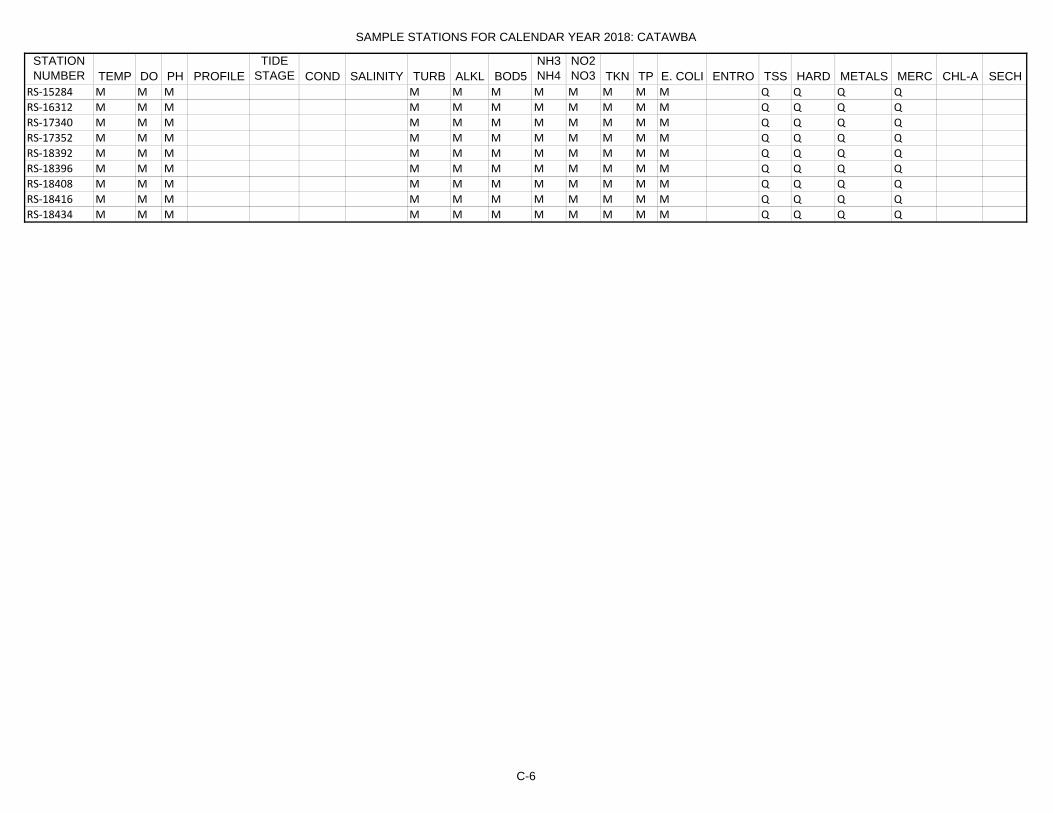
SAMPLE STATIONS FOR CALENDAR YEAR 2018: CATAWBA
STATION NUMBER TEMP DO PH PROFILE
TIDE STAGE COND SALINITY TURB ALKL BOD5
NH3NH4
NO2NO3 TKN TP E. COLI ENTRO TSS HARD METALS MERC CHL-A SECH
RS‐15284 M M M M M M M M M M M Q Q Q QRS‐16312 M M M M M M M M M M M Q Q Q QRS‐17340 M M M M M M M M M M M Q Q Q QRS‐17352 M M M M M M M M M M M Q Q Q QRS‐18392 M M M M M M M M M M M Q Q Q QRS‐18396 M M M M M M M M M M M Q Q Q QRS‐18408 M M M M M M M M M M M Q Q Q QRS‐18416 M M M M M M M M M M M Q Q Q QRS‐18434 M M M M M M M M M M M Q Q Q Q
C-6

SAMPLE STATIONS FOR CALENDAR YEAR 2018: CENTRAL MIDLANDS
STATION NUMBER TEMP DO PH PROFILE
TIDE STAGE COND SALINITY TURB ALKL BOD5
NH3NH4
NO2NO3 TKN TP E. COLI ENTRO TSS HARD METALS MERC CHL-A SECH
B‐047 M M M M M M M M M M M Q Q Q QB‐053 M M M M M M M M M M M Q Q Q QB‐054 M M M M M M M M M M M Q Q Q QB‐072 M M M M M M M M M M M Q Q Q QB‐080 M M M M M M M M M M M Q Q Q QB‐320 M M M M M M M M M M M Q Q Q QB‐327 M M M M M M M M M M M Q Q Q M MB‐337 M M M M M M M M M M M Q Q Q QB‐345 M M M M M M M M M M M M Q Q Q M MB‐349 M M M M M M M M M M M Q Q Q QB‐350 M M M M M M M M M M M Q Q Q QB‐352 M M M M M M M M M M M Q Q Q QC‐007 M M M M M M M M M M M Q Q Q QC‐017 M M M M M M M M M M M Q Q Q QC‐070 M M M M M M M M M M M Q Q Q QC‐072 M M M M M M M M M M M Q Q Q QC‐074 M M M M M M M M M M M Q Q Q QC‐075 M M M M M M M M M M M Q Q Q QCL‐089 M M M M M M M M M M M M Q Q Q M MCSB‐001L M M M M M M M M M M M Q Q Q QCSB‐001R M M M M M M M M M M M Q Q Q QCW‐019 M M M M M M M M M M M Q Q Q QCW‐040 M M M M M M M M M M M Q Q Q QCW‐072 M M M M M M M M M M M Q Q Q QCW‐206 M M M M M M M M M M M Q Q Q QCW‐207 M M M M M M M M M M M Q Q Q M MCW‐222 M M M M M M M M M M M Q Q Q QCW‐251 M M M M M M M M M M M Q Q Q QCW‐252 M M M M M M M M M M M Q Q Q QRL‐18079 M M M M M M M M M M M Q Q Q M MRL‐18083 M M M M M M M M M M M Q Q Q M MRL‐18096 M M M M M M M M M M M Q Q Q M MRL‐18099 M M M M M M M M M M M Q Q Q M MRS‐18422 M M M M M M M M M M M Q Q Q QS‐047 M M M M M M M M M M M Q Q Q QS‐102 M M M M M M M M M M M Q Q Q QS‐211 M M M M M M M M M M M Q Q Q M MS‐213 M M M M M M M M M M M Q Q Q M MS‐222 M M M M M M M M M M M Q Q Q M MS‐287 M M M M M M M M M M M Q Q Q QS‐298 M M M M M M M M M M M Q Q Q QS‐305 M M M M M M M M M M M Q Q Q QS‐309 M M M M M M M M M M M M Q Q Q M MS‐310 M M M M M M M M M M M M Q Q Q M M
C-7

SAMPLE STATIONS FOR CALENDAR YEAR 2018: CENTRAL MIDLANDS
STATION NUMBER TEMP DO PH PROFILE
TIDE STAGE COND SALINITY TURB ALKL BOD5
NH3NH4
NO2NO3 TKN TP E. COLI ENTRO TSS HARD METALS MERC CHL-A SECH
SC‐004 M M M M M M M M M M M Q Q Q Q
C-8

SAMPLE STATIONS FOR CALENDAR YEAR 2018: LOW COUNTRY
STATION NUMBER TEMP DO PH PROFILE
TIDE STAGE COND SALINITY TURB ALKL BOD5
NH3NH4
NO2NO3 TKN TP E. COLI ENTRO TSS HARD METALS MERC CHL-A SECH
CSTL‐048 M M M M M M M M M M M Q Q Q QCSTL‐071 M M M M M M M M M M M Q Q Q QCSTL‐076 M M M M M M M M M M M Q Q Q QCSTL‐104 M M M M M M M M M M M Q Q Q QCSTL‐107 M M M M M M M M M M M M M M M Q Q QCSTL‐115 M M M M M M M M M M M Q Q Q QCSTL‐116 M M M M M M M M M M M Q Q Q QCSTL‐120 M M M M M M M M M M M Q Q Q QCSTL‐121 M M M M M M M M M M M Q Q Q QCSTL‐122 M M M M M M M M M M M Q Q Q QCSTL‐125 M M M M M M M M M M M Q Q Q QMD‐001 M M M M M M M M M M M M M M M Q QMD‐004 M M M M M M M M M M M M M M M Q QMD‐116 M M M M M M M M M M M M M M M Q QMD‐117 M M M M M M M M M M M M M M M Q QMD‐118 M M M M M M M M M M M M M M M Q QMD‐119 M M M M M M M M M M M Q Q Q QMD‐120 M M M M M M M M M M M M M M M Q QMD‐129 M M M M M M M M M M M M M M M Q QMD‐173 M M M M M M M M M M M M M M M Q QMD‐174 M M M M M M M M M M M M M M M Q QMD‐176 M M M M M M M M M M M M M M M Q QMD‐252 M M M M M M M M M M M M M M M Q QMD‐253 M M M M M M M M M M M M M M M Q QMD‐256 M M M M M M M M M M M M M M M Q QMD‐257 M M M M M M M M M M M M M M M Q QMD‐258 M M M M M M M M M M M M M M M Q QMD‐259 M M M M M M M M M M M M M M M Q QMD‐260 M M M M M M M M M M M M M M M Q QMD‐281 M M M M M M M M M M M M M M M Q QMD‐282 M M M M M M M M M M M M M M M Q QRO‐18413 M M M M M M M M M M M M M M M Q Q MRO‐18414 M M M M M M M M M M M M M M M Q Q MRO‐18415 M M M M M M M M M M M M M M M Q Q MRO‐18417 M M M M M M M M M M M M M M M Q Q MRO‐18418 M M M M M M M M M M M M M M M Q Q MRO‐18421 M M M M M M M M M M M M M M M Q Q MRO‐18422 M M M M M M M M M M M M M M M Q Q MRO‐18425 M M M M M M M M M M M M M M M Q Q MRO‐18426 M M M M M M M M M M M M M M M Q Q MRT‐052119 M M M M M M M M M M M M M M M Q Q MRT‐18171 M M M M M M M M M M M M M M M Q Q MRT‐18178 M M M M M M M M M M M M M M M Q Q MRT‐18179 M M M M M M M M M M M M M M M Q Q M
C-9

SAMPLE STATIONS FOR CALENDAR YEAR 2018: LOW COUNTRY
STATION NUMBER TEMP DO PH PROFILE
TIDE STAGE COND SALINITY TURB ALKL BOD5
NH3NH4
NO2NO3 TKN TP E. COLI ENTRO TSS HARD METALS MERC CHL-A SECH
RT‐18183 M M M M M M M M M M M M M M M Q Q MRT‐18186 M M M M M M M M M M M M M M M Q Q MRT‐18190 M M M M M M M M M M M M M M M Q Q MSV‐370 M M M M M M M M M M M Q Q Q Q
C-10

SAMPLE STATIONS FOR CALENDAR YEAR 2018: LOWER SAVANNAH
STATION NUMBER TEMP DO PH PROFILE
TIDE STAGE COND SALINITY TURB ALKL BOD5
NH3NH4
NO2NO3 TKN TP E. COLI ENTRO TSS HARD METALS MERC CHL-A SECH
C‐015 M M M M M M M M M M M Q Q Q QCL‐041 M M M M M M M M M M M M Q Q Q M MCL‐069 M M M M M M M M M M M Q Q Q M ME‐008 M M M M M M M M M M M Q Q Q QE‐008A M M M M M M M M M M M Q Q Q QE‐011 M M M M M M M M M M M Q Q Q QE‐012 M M M M M M M M M M M Q Q Q QE‐050 M M M M M M M M M M M Q Q Q QE‐102 M M M M M M M M M M M Q Q Q QE‐103 M M M M M M M M M M M Q Q Q QE‐104 M M M M M M M M M M M Q Q Q QE‐111 M M M M M M M M M M M Q Q Q QE‐114 M M M M M M M M M M M Q Q Q QE‐115 M M M M M M M M M M M Q Q Q QRL‐18100 M M M M M M M M M M M Q Q Q M MRS‐18413 M M M M M M M M M M M Q Q Q QRS‐18418 M M M M M M M M M M M Q Q Q QRS‐18441 M M M M M M M M M M M Q Q Q QS‐093 M M M M M M M M M M M Q Q Q QS‐123 M M M M M M M M M M M Q Q Q QS‐324 M M M M M M M M M M M Q Q Q QSV‐175 M M M M M M M M M M M Q Q Q QSV‐192 M M M M M M M M M M M Q Q Q QSV‐250 M M M M M M M M M M M Q Q Q QSV‐318 M M M M M M M M M M M Q Q Q QSV‐325 M M M M M M M M M M M Q Q Q QSV‐350 M M M M M M M M M M M Q Q Q QSV‐352 M M M M M M M M M M M Q Q Q QSV‐354 M M M M M M M M M M M Q Q Q QSV‐365 M M M M M M M M M M M Q Q Q QSV‐366 M M M M M M M M M M M Q Q Q QSV‐367 M M M M M M M M M M M Q Q Q QSV‐368 M M M M M M M M M M M Q Q Q QSV‐371 M M M M M M M M M M M Q Q Q QSV‐372 M M M M M M M M M M M Q Q Q M M
C-11

SAMPLE STATIONS FOR CALENDAR YEAR 2018: PEE DEE
STATION NUMBER TEMP DO PH PROFILE
TIDE STAGE COND SALINITY TURB ALKL BOD5
NH3NH4
NO2NO3 TKN TP E. COLI ENTRO TSS HARD METALS MERC CHL-A SECH
MD‐077 M M M M M M M M M M M M M M M Q QMD‐085 M M M M M M M M M M M Q Q Q QMD‐107 M M M M M M M M M M M Q Q Q QMD‐125 M M M M M M M M M M M M M M M Q Q QMD‐127 M M M M M M M M M M M Q Q Q QMD‐138 M M M M M M M M M M M Q Q Q QMD‐142 M M M M M M M M M M M M M M M Q QMD‐145 M M M M M M M M M M M Q Q Q QMD‐275 M M M M M M M M M M M M M M M Q QMD‐277 M M M M M M M M M M M M M M M Q QMD‐278 M M M M M M M M M M M M M M M Q QPD‐012 M M M M M M M M M M M Q Q Q QPD‐015 M M M M M M M M M M M Q Q Q QPD‐028 M M M M M M M M M M M Q Q Q QPD‐038 M M M M M M M M M M M Q Q Q QPD‐043 M M M M M M M M M M M Q Q Q QPD‐052 M M M M M M M M M M M Q Q Q QPD‐055 M M M M M M M M M M M Q Q Q QPD‐076 M M M M M M M M M M M Q Q Q QPD‐078 M M M M M M M M M M M Q Q Q QPD‐087 M M M M M M M M M M M Q Q Q QPD‐091 M M M M M M M M M M M Q Q Q QPD‐093 M M M M M M M M M M M Q Q Q QPD‐097 M M M M M M M M M M M Q Q Q QPD‐176 M M M M M M M M M M M Q Q Q QPD‐201 M M M M M M M M M M M Q Q Q QPD‐203 M M M M M M M M M M M Q Q Q QPD‐227 M M M M M M M M M M M Q Q Q QPD‐231 M M M M M M M M M M M Q Q Q QPD‐281 M M M M M M M M M M M Q Q Q QPD‐325 M M M M M M M M M M M M M M M Q QPD‐332 M M M M M M M M M M M Q Q Q QPD‐337 M M M M M M M M M M M Q Q Q QPD‐349 M M M M M M M M M M M Q Q Q QPD‐350 M M M M M M M M M M M Q Q Q QPD‐352 M M M M M M M M M M M Q Q Q QPD‐353 M M M M M M M M M M M Q Q Q QPD‐359 M M M M M M M M M M M Q Q Q QPD‐361 M M M M M M M M M M M Q Q Q QPD‐364 M M M M M M M M M M M Q Q Q QPD‐365 M M M M M M M M M M M Q Q Q QPD‐370 M M M M M M M M M M M Q Q Q QPD‐371 M M M M M M M M M M M Q Q Q QPD‐372 M M M M M M M M M M M Q Q Q Q
C-12
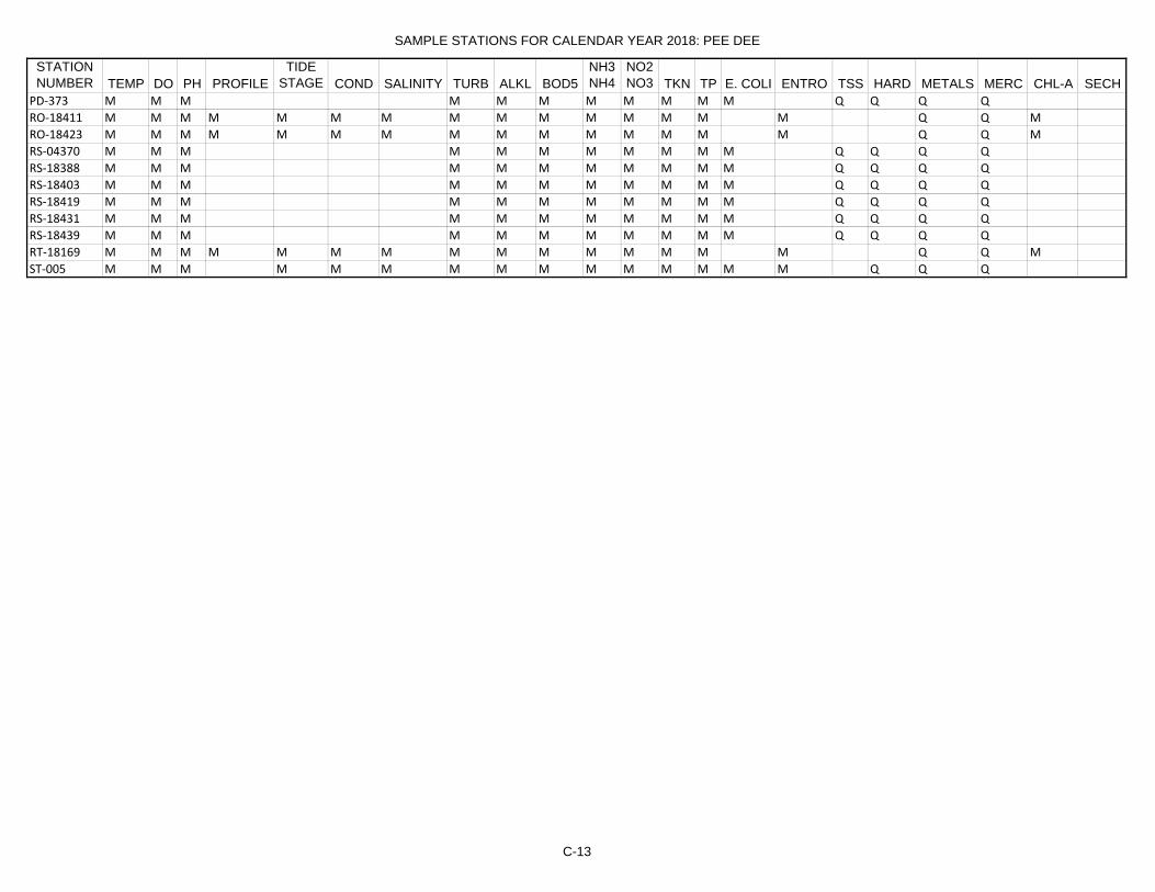
SAMPLE STATIONS FOR CALENDAR YEAR 2018: PEE DEE
STATION NUMBER TEMP DO PH PROFILE
TIDE STAGE COND SALINITY TURB ALKL BOD5
NH3NH4
NO2NO3 TKN TP E. COLI ENTRO TSS HARD METALS MERC CHL-A SECH
PD‐373 M M M M M M M M M M M Q Q Q QRO‐18411 M M M M M M M M M M M M M M M Q Q MRO‐18423 M M M M M M M M M M M M M M M Q Q MRS‐04370 M M M M M M M M M M M Q Q Q QRS‐18388 M M M M M M M M M M M Q Q Q QRS‐18403 M M M M M M M M M M M Q Q Q QRS‐18419 M M M M M M M M M M M Q Q Q QRS‐18431 M M M M M M M M M M M Q Q Q QRS‐18439 M M M M M M M M M M M Q Q Q QRT‐18169 M M M M M M M M M M M M M M M Q Q MST‐005 M M M M M M M M M M M M M M M Q Q Q
C-13

SAMPLE STATIONS FOR CALENDAR YEAR 2018: SANTEE COOPER
STATION NUMBER TEMP DO PH PROFILE
TIDE STAGE COND SALINITY TURB ALKL BOD5
NH3NH4
NO2NO3 TKN TP E. COLI ENTRO TSS HARD METALS MERC CHL-A SECH
CL‐042 M M M M M M M M M M M Q Q Q M MCSTL‐062 M M M M M M M M M M M Q Q Q QRL‐18078 M M M M M M M M M M M Q Q Q M MRL‐18094 M M M M M M M M M M M Q Q Q M MRL‐18095 M M M M M M M M M M M Q Q Q M MRL‐18098 M M M M M M M M M M M Q Q Q M MSC‐010 M M M M M M M M M M M Q Q Q M MSC‐016 M M M M M M M M M M M Q Q Q M MSC‐039 M M M M M M M M M M M Q Q Q M MST‐034 M M M M M M M M M M M Q Q Q M MST‐036 M M M M M M M M M M M Q Q Q M MST‐037 M M M M M M M M M M M Q Q Q M M
C-14

SAMPLE STATIONS FOR CALENDAR YEAR 2018: TRIDENT
STATION NUMBER TEMP DO PH PROFILE
TIDE STAGE COND SALINITY TURB ALKL BOD5
NH3NH4
NO2NO3 TKN TP E. COLI ENTRO TSS HARD METALS MERC CHL-A SECH
CSTL‐102 M M M M M M M M M M M M M M M Q Q QCSTL‐113 M M M M M M M M M M M Q Q Q QCSTL‐123 M M M M M M M M M M M Q Q Q QE‐015A M M M M M M M M M M M Q Q Q QE‐032 M M M M M M M M M M M Q Q Q QE‐086 M M M M M M M M M M M Q Q Q QE‐109 M M M M M M M M M M M Q Q Q QMD‐043 M M M M M M M M M M M M M M M Q QMD‐045 M M M M M M M M M M M M M M M Q QMD‐049 M M M M M M M M M M M M M M M Q QMD‐052 M M M M M M M M M M M M M M M Q QMD‐069 M M M M M M M M M M M M M M M Q QMD‐115 M M M M M M M M M M M M M M M Q QMD‐130 M M M M M M M M M M M M M M M Q QMD‐202 M M M M M M M M M M M M M M M Q QMD‐203MD‐206 M M M M M M M M M M M M M M M Q QMD‐209 M M M M M M M M M M M M M M M Q QMD‐248 M M M M M M M M M M M M M M M Q QMD‐250MD‐261 M M M M M M M M M M M M M M M Q QMD‐262 M M M M M M M M M M M M M M M Q QMD‐264 M M M M M M M M M M M M M M M Q QMD‐266 M M M M M M M M M M M M M M M Q QMD‐267 M M M M M M M M M M M M M M M Q QMD‐269 M M M M M M M M M M M M M M M Q QMD‐271 M M M M M M M M M M M M M M M Q QMD‐273 M M M M M M M M M M M M M M M Q QRO‐18412 M M M M M M M M M M M M M M M Q Q MRO‐18419 M M M M M M M M M M M M M M M Q Q MRO‐18420 M M M M M M M M M M M M M M M Q Q MRO‐18424 M M M M M M M M M M M M M M M Q Q MRS‐18415 M M M M M M M M M M M Q Q Q QRS‐18435 M M M M M M M M M M M Q Q Q QRT‐18164 M M M M M M M M M M M M M M M Q Q MRT‐18175 M M M M M M M M M M M M M M M Q Q MRT‐18176 M M M M M M M M M M M M M M M Q Q MRT‐18180 M M M M M M M M M M M M M M M Q Q MRT‐18181 M M M M M M M M M M M M M M M Q Q MRT‐18188 M M M M M M M M M M M M M M M Q Q MRT‐18191 M M M M M M M M M M M M M M M Q Q MST‐001 M M M M M M M M M M M Q Q Q QST‐006 M M M M M M M M M M M M M M M Q Q QST‐016 M M M M M M M M M M M Q Q Q Q
C-15

D-1
D. Parameters Sampled at Ambient Surface Water Quality Monitoring Sites

D-2
PARAMETERS ANALYZED IN WATER
TEST DESCRIPTION STORET CODE Field Parameters
Monthly - all sites
Dissolved Oxygen mg/L* 00300 pH SU* 00400 Water Temperature oC* 00010 Air Temperature oC 00020
Monthly – all saltwater sites
Specific Conductance umhos/cm* 00402 Salinity ppt* 00480
* Profiled at 1 meter intervals from surface to bottom at selected lake sites and top, bottom, and mid-depth at selected estuarine sites Physical Parameters
Monthly - all sites
Turbidity NTU 00076 Depth of Sample Collection m 82048
Monthly - selected sites
Flow or Stage 00067 or 00061 Total Suspended Solids mg/L 00530 Transparency 00078
Biological Parameters
Monthly - all freshwater sites Escherichia coli Bacteria MPN/100 mL (Quanti-Tray 31633 Method
Monthly – all saltwater sites
Enterococci Bacteria (Q-tray) #/100 mL 50589
Monthly, May through October - selected lake and estuarine sites
Chlorophyll-a ug/l (Corrected) 32209

D-3
PARAMETERS ANALYZED IN WATER (cont.)
TEST DESCRIPTION STORET CODE Chemical Parameters
Monthly - all sites
Five-Day Biochemical Oxygen Demand mg/L 00310 Nitrate/Nitrite Nitrogen mg/L 00630 Total Phosphorus mg/L 00665 Alkalinity mg/L 00410 Ammonia Nitrogen mg/L 00610 Total Kjeldahl Nitrogen mg/L 00625
Quarterly - all sites
Metals Routine for Stream Waters
(1) Cadmium in Water ug/L 01027 (2) Chromium in Water ug/L 01034 (3) Copper in Water ug/L 01042 (4) Iron in Water ug/L 01045 (5) Lead in Water ug/L 01051 (6) Manganese in Water ug/L 01055 (7) Mercury in Water ug/L 71900 (8) Nickel in Water ug/L 01067 (9) Zinc in Water ug/L 01092
Quarterly - all non-marine sites, to coincide with the quarterly metals samples
Hardness, calculated mg/L 00900

E-1
E. Ocean Water Monitoring Site Descriptions Listed by Regional Office

E-2
Bathing Beaches and Public Access Points Rank, Sample Locations, and Positional Data
Tier 1 Beaches City of North Myrtle Beach Station Description Longitude Latitude WAC-001 59th Ave N -78.601819 33.8395118 WAC-002 45th Ave N -78.6233836 33.8336687 WAC-003 30th Ave N -78.6372373 33.8288522 WAC-004 16th Ave N -78.6533888 33.8241275 WAC-005 3rd Ave N -78.6681812 33.8188902 WAC-005A 7th Ave S -78.6681812 33.8139202 WAC-006 9th Ave S -78.6841137 33.8131406 WAC-007 17th Ave S -78.7000859 33.8065623 WAC-008 33rd Ave S -78.7176586 33.7985193 WAC-009 47th Ave S -78.7316984 33.7916396 Town of Atlantic Beach Atlantic Beach is 0.27 miles long, there are no sampling sites on this beach, but it is considered monitored due to sites located directly above and below it. Town of Briarcliffe Acres Station Description Longitude Latitude WAC-009A White Point Swash -78.7399968 33.7867313 WAC-010 Briarcliff cabana -78.741883 33.786364 Arcadia Beach – Horry County Beach Station Description Longitude Latitude WAC-011 2 miles north of Hilton Grand -78.7456588 33.7844389 WAC-012 Lands End Resort -78.7644272 33.7738569 WAC-013 Wyndham Hotel -78.7751472 33.767933 WAC-014 Sands Ocean Club -78.7884552 33.7593629 WAC-015 Singleton Swash -72.794968 33.755458

E-3
City of Myrtle Beach Station Description Longitude Latitude WAC-015A Bear Branch Swash -78.8034271 33.7498004 WAC-016 77th Ave N -78.8128891 33.7432032 WAC-016A Cane Patch Swash -78.8222535 33.7369623 WAC-017 64th Ave N -78.8259239 33.7342228 WAC-017A Deep Head Swash -78.8380851 33.72498 WAC-018 50th Ave N -78.8426859 33.7217018 WAC-019 34th Ave N -78.8571075 33.710391 WAC-020 24th Ave N -78.8662608 33.7028987 WAC-021 8th Ave N -78.8800091 33.6904148 WAC-022A Withers Swash -78.8907427 33.6800915 WAC-023 15th Ave S -78.8997777 33.672911 WAC-024 23rd Ave S -78.9078527 33.6664849 WAC-025A Midway Swash -78.9170543 33.6581395 Springmaid Beach – Horry County Beach Station Description Longitude Latitude WAC-026 Nash Dr -78.9210152 33.6548022 South Carolina State Park and Campgrounds – Horry County Beach Station Description Longitude Latitude WAC-027 Myrtle Beach State Park -78.932237 33.6453918 WAC-028 Beaver Dam Creek -72.944889 33.633105 WAC-029 North end Ocean Lakes Campground -78.9522428 33.6256796 WAC-029A South end Ocean Lakes Campground -72.9584233 33.6190057 Town of Surfside Beach Station Description Longitude Latitude WAC-030 16th Ave N -78.9611507 33.616113 WAC-031 11th Ave N -78.9641393 33.613146 WAC-031A Swash at 5th Ave N -72.9678983 33.6087667 WAC-032 3rd Ave N -78.9691373 33.6077479 WAC-033 3rd Ave S -78.9749541 33.6027406 WAC-034 8th Ave S -78.9771679 33.5993875 WAC-035 13th Ave S -78.9810281 33.5952913 Tier 2 Beaches Garden City Beach – Horry County Beach Station Description Longitude Latitude WAC-036 Hawes Ave -78.9875519 33.5881838 WAC-037 Azalea Ave -78.9987463 33.575971

E-4
Huntington Beach State Park – Georgetown County Beach Station Description Longitude Latitude WAC-039 North Access -79.0485453 33.5144847 WAC-040 Visitors Center -79.065063 33.5015691 Litchfield Beach – Georgetown County Beach Station Description Longitude Latitude WAC-041 Songbird Ln -79.0826594 33.4852593 WAC-042 Litchfield Inn -79.0956795 33.4691087 WAC-043A 1st L Past Gate -79.100628 33.461851 Town of Pawleys Island Station Description Longitude Latitude WAC-044A Pub Access 2nd/Atlantic B -79.1189178 33.4324118 WAC-045A Public Access Springs/Hazard Ave -79.1308041 33.4120827 WAC-046 Pawleys Is. South Parking -79.1381272 33.3996241 Debordieu Beach – Georgetown County Beach Station Description Longitude Latitude WAC-047 Luvan Way -79.1485221 33.3750841 WAC-048 Lafayette/Ocean Green Blv -79.1516853 33.3597849 Isle of Palms Station Description Longitude Latitude TRI-050 Port O' Call -79.720968 32.8140122 TRI-051 Dunes Crest Lane -79.729583 32.804194 TRI-052 53rd Ave -79.745127 32.799372 TRI-053 34th Ave -79.765551 32.793527 TRI-054 21st Ave -79.781677 32.78678 TRI-054B IOP County Park -79.78481667 32.78553333 TRI-054C 10th Ave -79.789765 32.784152 TRI-055 7th Ave -79.794916 32.781163 TRI-056 4th Ave -79.8067147 32.7755509 Sullivans Island Station Description Longitude Latitude TRI-057 Station 30/ Marshall Blvd -79.813956 32.7716983 TRI-058 Station 26/ Bayonne St -79.825617 32.762519 TRI-059 Flag St Coast Guard station -79.8488537 32.7535825

E-5
Folly Beach Station Description Longitude Latitude TRI-060A 1690 E. Ashley Ave -79.894629 32.678377 TRI-061 1561 E Ashley Ave -79.905016 32.670812 TRI-062 11th Ave -79.917766 32.663483 TRI-063A 5th Ave E -79.9311651 32.6578928 TRI-064 Center St -79.938599 32.654503 TRI-065 3rd Ave -79.944598 32.65242 TRI-066 8th Ave -79.955055 32.64722 Kiawah Island Station Description Longitude Latitude TRI-067 Folly Park -79.9719872 32.6386668 TRI-068 Ocean Marsh Rd -80.04221513 32.609361 TRI-069 Surfsong Rd beach access -80.070616 32.60401 TRI-070 Seaforest Dr -80.101296 32.59717 TRI-071 Shipwatch Rd -80.117248 32.591675 TRI-072 Duneside Rd, Villas #1110 & #1118 -80.1450958 32.5781248 Seabrook Island Station Description Longitude Latitude TRI-073 Oyster Catcher Ct -80.150952 32.5745969 TRI-074 St. Christopher Camp -80.1860624 32.5694619 Edisto Island Station Description Longitude Latitude LC-075 Edingsville (Jeremy Cay) -80.27416667 32.51875 LC-076 Jeremy Inlet (North end of state park) -80.288803 32.509114 LC-077 Pavilion Restaurant -80.296189 32.503044 LC-077A Matilda St beach -80.3056 32.49681667 LC-077A2 Mary St -80.30111111 32.49972222 LC-077B Atlantic St -80.30983333 32.4938 LC-078 Cheehaw St -80.314733 32.489908 LC-078B Dorothy St -80.32 32.48611111 LC-079 Edings St -80.325425 32.482564 LC-079A Neptune St -80.33178916 32.47849087 LC-080 Edisto St -80.33763 32.478317 LC-080A Mikell St -80.34125 32.48218333 LC-081 Ebb Tide St -80.343913 32.489112 LC-082 Bay Point at end of Yacht Club Rd -80.346028 32.495352

E-6
Harbor Island Station Description Longitude Latitude LC-084 Between lots 118 and 120 -80.435512 32.412458 LC-085 Between lots 54 and 56 -80.431904 32.409178 LC-085A South Harbor Dr at Pelican Point -80.42593002 32.40315379 Hunting Island Station Description Longitude Latitude LC-086 Between campsites 73 ad 75 -80.430576 32.388379 LC-087 Between campsites 47 and 49 -80.431806 32.384884 LC-088 South Beach restroom -80.440941 32.364887 LC-090 North Beach restrooms -80.436909 32.373069 LC-091 North Beach lighthouse -80.436051 32.375061 Fripp Island Station Description Longitude Latitude LC-092 access 25 on Tarpon Blvd -80.489928 32.31044 LC-093 Fripp Villas -80.480396 32.314431 LC-094 Seahorse Rd -80.471207 32.316385 LC-095 Red Drum Rd North -80.467359 32.31734 LC-096 Beach access #2 on Marlin Dr -80.46245 32.3193 Hilton Head Island Station Description Longitude Latitude LC-098 Port Royal Plantation -80.66859 32.219721 LC-098A Beach access South side of Westin -80.68077 32.20753 LC-099 Starfish Drive off of Folly Field Road -80.688269 32.200691 LC-100 Burks Beach Road -80.696225 32.192884 LC-101 The Moorings off of Mooring Buoy Dr -80.714804 32.167861 LC-102 The Hilton, off of Mooring Buoy Drive -80.720006 32.161801 LC-103 Ocean Woods, N Forest Beach Dr. -80.731057 32.151642 LC-104 Avocet St, next to Sea Crest Motel -80.748045 32.141528 LC-104A Ocean Club, between units 44 and 45 -80.75674 32.1378 LC-106 Alder Ln, next to Grande Ocean -80.762716 32.134925 LC-107 Sea Pines Beach Club -80.78566 32.124179 LC-108 Atlantic Pointe Community -80.800806 32.116488 LC-109 Tower Beach, Sea Pines Plantation -80.822807 32.107528 LC-110 Beachside Tennis Villas -80.828333 32.112209 LC-111 Southern most access Lands End Dr. -80.826054 32.120923
F-1
F. Macroinvertebrate Monitoring Site Descriptions

Macroinvertebrate Community Monitoring Sites and Years Sampled
Station HUC12 Latitude Longitude Location County Years Sampled
B-005A 030501070303 34.92114509 -82.13013970 South Tyger River @ 293 Spartanburg 95,99,17B-008 030501070503 34.75539500 -81.92749800 Tyger River@ Hwy. 50 Spartanburg 16B-014 030501070103 34.87649035 -82.02542142 Middle Tyger Rvr At S-42-64 Spartanburg 95,99,09B-017 030501070202 34.90587301 -82.02830374 North Tyger River @ SC 296 Spartanburg 95,99B-018A 030501070203 34.78860993 -81.95231671 North Tyger River @ S-42-231 Spartanburg 09B-021 030501070402 34.87741502 -81.88290226 Fairforest Ck At SC 56 Spartanburg 95,99,04,09B-047 030501060406 34.39412300 -81.39652400 Broad Rvr At Sc 34 14 Mi NE Of Newberry Fairfield 14B-048 030501051506 34.87366900 -81.53168300 Pacolet Rvr At Sc 105 6 Mi Ab Jct With Broad Rvr Cherokee 16B-051 030501070507 34.53596000 -81.54794000 Tyger R. @ SC Hwy 72 Union 16B-054 030501080502 34.42351981 -81.46700378 Enoree R. @ SR 45 Newberry 89,17B-062 030501051004 34.91463503 -81.49659931 Thicketty Cr. @ SC 211 Cherokee 89,99,09B-071 030501080403 34.41098232 -81.57784966 Indian Crk. @ US 176 Newberry 95,99B-072 030501080303 34.49022356 -81.59212699 Duncan Ck At US 176 1.5 Mi SE Of Whitmire Newberry 95,99,04,09B-075 030501060205 34.59329389 -81.39275525 Sandy Rvr At SC 215 2.5 Mi Ab Jct With Broad Rvr Chester 95,99,04B-081 030501060707 34.08620205 -81.02543847 Crane Creek @ US 321 Richland 95,99,09B-099-7 030501051201 35.18309430 -82.25153104 Vaughn Creek, upstream of B-099A @ Br. Greenville 99,04,09B-102 030501060504 34.37651409 -81.19144735 Jackson Ck At S-20-54, 5 Mi W Of Winnsboro Fairfield 95,99,04,09B-104 030501051301 35.13420895 -82.17820230 Spivey Crk. @ SR 209 Spartanburg 99B-133 030501051004 34.94984397 -81.63104519 Thicketty Cr. @ SC 18 Cherokee 89,95,99,04B-136 030501060105 34.77631626 -81.43240119 Turkey Ck At SC 9, 14 Mi NW Of Chester Chester 95,99,04,09B-143 030501060401 34.45697815 -81.39442123 Beaver Crk. @ SR 95 Fairfield 95,04,17B-145 030501060507 34.25482570 -81.23448788 Little Rvr At S-20-60 3.1 Mi SW Of Jenkinsville Fairfield 95,99,04B-148 030501070101 35.08859181 -82.23796501 Middle Tyger Rvr At SC 14 2 Mi SSW Gowansville Greenville 95,99,09B-151 030501060402 34.33460105 -81.40195837 Hellers Crk. @ SR 97 Newberry 99,04,09B-155 030501060302 34.72478862 -81.48630959 Browns Ck At S-44-86, 8 Mi E Of Union Union 95,99,04,09B-157 030501051101 34.98222838 -81.38013326 Clark Crk. @ SR 63 York 95,99,04,09B-221 030501051401 35.03147111 -82.08845994 Lawsons Fork Creek @ S-42-40 BL Inman Mill EFF. Spartanburg 95,99B-222 030501051603 35.03553200 -81.49348700 Broad River @ Sec Rd 43 "Pick Hill Access" Cherokee 14B-236 030501060703 34.25927800 -81.33288300 Broad River just below Parr Dam Newberry 14B-246 030501080201 34.64623594 -81.99552644 Beaverdam Ck At S-30-97, 7 Mi NE Of Gray Court Laurens 95,99,04,09B-280 030501060708 34.02723011 -81.04197905 Smith Creek @ North Main Street In Columbia Richland 95,99,09B-296 030501050506 35.17951445 -81.77728211 Suck Crk. @ Walter Rd. off S.R. 29 near NC state line-
1st replicate upstream of bridgeCherokee 99,09
B-311 030501060708 34.03904300 -81.07481500 Broad River @ I-20 Richland 14B-316 030501060707 34.05376300 -81.05930300 Crane Creek @ S-40-43 under I-20 (N Cola) Richland 15B-318 030501070503 34.69283400 -81.83190811 Tyger R. @ SC Hwy 56 Spartanburg 89,92B-320 030501060603 34.16219291 -81.11434536 Big Cedar Cr. @ SC 215 Richland 89,92,95,99,04,09,13
Broad Basin
F-2

Macroinvertebrate Community Monitoring Sites and Years Sampled
Station HUC12 Latitude Longitude Location County Years Sampled
Broad Basin (Cont.)B-332 030501070305 34.78301677 -81.97229795 South Tyger River @ SR 86 Spartanburg 99,09B-333 030501050902 35.04310316 -81.47575692 Kings Creek At S-11-209, 3 Mi W Of Smyrna Cherokee 95,99,04,09,13,15B-334 030501051003 34.96484639 -81.55833374 Gilkey Ck At S-11-231, 9 Mi SE Of Gaffney Cherokee 95,99,04,09B-336 030501070505 34.58608249 -81.58127154 Tinker Ck At S-44-278, 9 Mi SSE Of Union Union 95,99,04,09B-337 030501060708 34.02591500 -81.06895800 Broad Rvr At US 176 (Broad River Rd) In Columbia Richland 14B-531 030501051401 35.02926857 -82.02118935 Meadow Crk. @ SR 56 Spartanburg 99,04,09B-625 030501070303 34.93193524 -82.16701841 Maple Crk. @ SR 644 Spartanburg 99,04,09B-679 030501051602 35.08359359 -81.57552817 Cherokee Creek @ SC 329 Cherokee 99,04,09B-718 030501080202 34.61080490 -82.03655010 Warrior Cr @ SR 40 Laurens 89B-719 030501051202 35.18927239 -82.14353280 North Pacolet R. @ SR 128 Spartanburg 89,95,99,04,09B-720 030501051301 35.12773004 -82.18063024 South Pacolet R. @ SR 183 Spartanburg 89,92,93,94,95,99,04,
09B-721 030501060205 34.60890046 -81.37082492 Sandy R. @ SC 121 Chester 89,17B-722 030501060203 34.64912255 -81.37011833 Brushy Fork Cr. @ SR 25 Chester 89,09B-723 030501060205 34.58377572 -81.38416129 John's Cr. @ SC 215 Chester 89B-725 030501070103 34.96299199 -82.17276094 Middle Tyger R. @ SR 789 Spartanburg 89,17B-726 030501070201 34.98056175 -82.12165784 North Tyger R. @ SR 101 Spartanburg 89B-733 030501070502 34.70944856 -81.81392394 Dutchman Cr. @ SR 511 Spartanburg 92,93,94,95,99,04,09B-739 030501051102 34.97170022 -81.36330622 Bullocks Crk. @ SR 40 York 95,99,04,09,10B-740 030501050805 35.15733808 -81.51738638 Buffalo Crk. @ SC Hwy 198 Cherokee 95,99,04,09B-741 030501070301 35.04932570 -82.34497714 South Tyger River @ unnamed Rd. South of SR 569 Greenville 95,99B-742 030501080202 34.60350205 -81.91518933 Warrior Creek @ SC 49 Laurens 95,99,04,09B-751 030501060405 34.27906115 -81.43202695 Cannons Crk. @ US 176 Newberry 95,99,04,15,17B-777 030501070506 34.50640296 -81.44707154 Cane Crk. @ SR 359 Union 99,04B-778 030501060304 34.66493738 -81.45757994 Neals Creek @ SR 86 Union 99,04,09,13,15B-779 030501070404 34.70442213 -81.72222722 Sugar Creek @ SR 52 Union 99B-780 030501051505 34.87673999 -81.64327286 Mill Creek @ SR 73 Union 99,09B-781 030501070405 34.78366371 -81.70859868 Mitchell Creek @ SR 19, Ist replicate of two stations,
downstream of bridgeUnion 99,04,09
B-782 030501070305 34.84347681 -82.07155198 Bens Creek @ SC 417 Spartanburg 99,04B-783 030501051501 35.11140913 -81.89386069 Buck Creek @ Peach Shed Rd Spartanburg 99,04,09B-784 030501070102 34.97470785 -82.19502602 Beaverdam Crk. @ SC 357 Spartanburg 99,04,09B-785 030501080203 34.59647336 -81.85514548 Cedar Shoals Crk. @ unnamed Rd. 0.2 km above
confluence w/ Enoree R., south of SC 56Spartanburg 99,04,09
B-786 030501070501 34.71972391 -81.90860981 Jimmies Crk. @ Stewart Rd, 1 mile upstream of SR 113 Spartanburg 99,04,09
B-787 030501070304 34.76865446 -81.96434377 Fergerson Crk. @ SR 86 Spartanburg 99,04,09
F-3

Macroinvertebrate Community Monitoring Sites and Years Sampled
Station HUC12 Latitude Longitude Location County Years Sampled
Broad Basin (Cont.)B-788 030501051601 35.15839584 -81.58501869 Bowen River @ SR 83 Cherokee 99,04,09B-789 030501051601 35.15992135 -81.62769874 Goforth Crk. (Ross Crk.) @ SR 577 Cherokee 99,04,09B-790 030501051301 35.10628655 -82.14876546 Motlow Crk. @ SR 888 Spartanburg 99,04B-791 030501051203 35.12154806 -81.98983903 Obed Crk. @ SR 42 Spartanburg 99,04,09B-792 030501080104 34.83068493 -82.18976499 Abeners Crk. @ Bennetts Ridge Rd. Spartanburg 99,04B-793 030501080103 34.77264038 -82.20778426 Horse Pen Crk. @ SR 145 Greenville 99,04,09B-794 030501070101 35.10743257 -82.33488477 Middle Tyger R. @ Red Turner Rd., 0.5 miles East of SC
101Greenville 99
B-795 030501080101 34.94930130 -82.33651040 Buckhorn Crk. @ SR 562 Greenville 99,04B-796 030501080101 34.96519119 -82.34917496 Beaverdam Crk. @ SC 253 Greenville 99,09B-797 030501080101 34.98873629 -82.37348546 Enoree R. @ Pine Log Ford Rd., 2nd crossing above SC
253 bridgeGreenville 99
B-798 030501080102 34.87876341 -82.33074267 Brushy Cr. @ SR 273 Greenville 99B-799 030501080501 34.38965152 -81.55725432 Kings Crk. @ US 176, downstream of bridge Newberry 99,04B-800 030501060701 34.24546194 -81.34199781 Crims Crk. @ SC 213 Newberry 99,04,09B-801 030501060702 34.19604442 -81.25869075 Wateree Crk. @ SR 698 Richland 99,04,09,10,14,15,16B-811 030501051604 35.02091800 -81.48647100 Broad River @ 99 Island Cherokee 14B-812 030501060205 34.57225800 -81.42186100 Broad River @ Sandy River Chester 14B-831 030501060404 34.29029650 -81.53564000 Cannon Creek @ Oxner Road Newberry 09,15B-836 030501060703 34.20150400 -81.22600600 Broad River @ Freshly Shoals Rd. Richland 09,16B-837 030501080101 34.92551000 -82.32068800 Mountain Creek @ SR 335 Greenville 09B-841 030501051603 35.07517600 -81.56020200 Broad River above Cherokee Falls Cherokee 14B-842 030501060305 34.66465400 -81.44722900 Broad River below Neal Shoals Dam, Union 14B-843 030501060703 34.25608000 -81.33253000 Broad River below Parr Reservoir Fairfield 14B-844 030501060707 34.10380000 -81.00436000 Crane Creek @ Tubman Ct., Columbia Richland 15BE-007 030501080102 34.84589812 -82.22557875 Rocky Creek @ SR 164 Greenville 99,04,09BE-008 030501080101 34.92369982 -82.30889807 Mountain Crk. @ SR 279 Greenville 99,04BE-009 030501080102 34.85933030 -82.23457133 Brushy Creek @ SR 164 Greenville 99,04,09BE-018 030501080106 34.76939072 -82.12984698 Enoree Rvr At S-30-75 Laurens 95,99,09BE-019 030501080106 34.75349047 -82.10734956 Enoree River @ sc Hwy 418 Laurens 95,99BE-020 030501080103 34.78681648 -82.16073957 Gilder Creek @ SR 143 Greenville 99,04,09BE-022 030501080105 34.69302050 -82.06256037 Durbin Crk. @ SC Hwy 101 Laurens 95,99,04,09BF-008 030501070406 34.64936760 -81.66133123 Fairforest Ck At S-44-16 SW Of Union Union 95,99,04BL-001 030501051402 34.94370037 -81.78854862 Lawson's Fork Cr. @ SR 108 Spartanburg 89,95,99,04,09RS-01028 030501051004 34.92607110 -81.56183821 Thickyty Creek @ SR 104 Cherokee 01RS-01057 030501080303 34.51857288 -81.78270269 Dunkan Creek @ SR 26 Laurens 01RS-03349 030501060103 34.83138667 -81.30117697 Susybole Creek @ SR 59 York 03
F-4

Macroinvertebrate Community Monitoring Sites and Years Sampled
Station HUC12 Latitude Longitude Location County Years Sampled
Broad Basin (Cont.)RS-03352 030501051601 35.15809381 -81.64190393 Ross Creek @ SR 63 Cherokee 03RS-03514 030501051203 35.15075994 -82.08828563 Obed Creek @ unnmbered road of SC 11 Spartanburg 03RS-03517 030501060701 34.22821724 -81.44498910 Unnamed tributary to Crimms Creek @ SR 25 Newberry 03RS-04376 030501051002 35.02816282 -81.78959271 Little Thicketty Creek @ SR 307 Spartanburg 04RS-04527 030501060401 34.52924269 -81.37365360 McClure Creek @ SC 215 Fairfield 04RS-05562 030501060102 34.94631387 -81.31671018 Turkey Creek @ SR 41 York 05RS-05566 030501080201 34.64886670 -82.03166848 Beaver Dam Creek @ SR 399 Laurens 05RS-05578 030501070305 34.86357051 -82.08740043 Brushy Creek @ Brushy Creek Road Spartanburg 05RS-06025 030501070406 34.70136747 -81.65732789 Tosch's Creek @ SR 75 Union 06RS-07048 030501080105 34.70476391 -82.08843537 Durbin Creek @ SR 67 Laurens 07RS-07056 030501051502 35.12346933 -81.95861549 Trib to the Pacolet R @ SR 187 Spartanburg 07RS-07217 030501060302 34.78945280 -81.56935235 Little Brown Creek @ SR 57 Union 07RS-07220 030501080104 34.85541994 -82.20912654 Dillard Creek @ Westmoreland Rd. Spartanburg 07RS-08252 030501051004 34.97299963 -81.70274977 Peoples Crk. @ SC 329 Cherokee 08RS-09291 030501060205 34.65604439 -81.32634560 Sandy R. @ SR 42 Chester 09RS-09307 030501060507 34.19424297 -81.16849793 Little River @ SC 215 (B-350) Fairfield 09
CW-002 030501030502 34.69919423 -81.13526292 Rocky Cr. @ SR 335 Chester 93,98,02,07CW-005 030501030402 34.93204124 -81.16557349 Fishing Cr. @ SR 347 York 93,98,02CW-007 030501030406 34.78554565 -81.06929104 South Fork of Fishing Crk. @ SR 50 Chester 98,02,07CW-014 030501030602 34.98578100 -80.97428100 Catawba Rvr At US 21, Below Lake Wylie Dam York 14CW-016 030501030606 34.70832300 -80.86756100 Catawba Rvr At SC 9 At Ft Lawn Chester 14CW-019 030501040304 34.24568700 -80.65309600 Wateree Rvr At US 1 Kershaw 14CW-024 030501011504 35.13771752 -81.13558979 Crowders Crk. @ SR 1104 York 98,02,07CW-031 030501030402 34.99231804 -81.19341288 Fishing Cr. @ SC 161 York 93,98,02CW-034 030501040106 34.54042300 -80.87480100 Cedar Creek Reservoir Tailrace Lancaster 14CW-039 030501040208 34.33625900 -80.69980200 Wateree River Below Lake Wateree Dam Kershaw 14CW-064 030501030107 35.04121963 -80.89211428 McAlpine Cr. @ SR 64 Lancaster 93,98,02,07CW-067 030501030504 34.61162273 -81.13772487 Little Rocky Cr. @ SR 144 Chester 89,92,93,94,95,98,02,
07CW-069 030501030504 34.58977261 -80.97404577 Little Rocky Cr. @ SR 53 Chester 89CW-075 030501040203 34.30655655 -80.82230920 Thorntree Crk. @ SR 258 Fairfield 98,02,14w,14sCW-076 030501040109 34.46231590 -80.76326357 Beaver Crk. @ SR 13 Kershaw 98,02,07CW-077 030501040201 34.40394053 -80.64637501 Flat Rock Crk. @ SR 40 Kershaw 98,02,07,14w,14sCW-078 030501040202 34.40255961 -80.64210900 Grannies Quarter Cr. @ SR 58 Kershaw 92,93,94,95,98,02,07,
09,13,15,17CW-080 030501040207 34.24392067 -80.67319643 Twenty-Five Mile Cr. @ SR 5 Kershaw 93,98,02,07,13
Catawba Basin
F-5
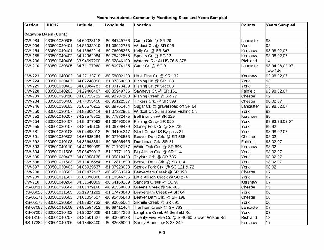
Macroinvertebrate Community Monitoring Sites and Years Sampled
Station HUC12 Latitude Longitude Location County Years Sampled
Catawba Basin (Cont.)CW-084 030501030605 34.60023118 -80.84749766 Camp Crk. @ SR 20 Lancaster 98CW-096 030501030401 34.88933919 -81.06922758 Wildcat Cr. @ SR 998 York 93CW-154 030501040401 34.13662214 -80.76605363 Kelly Cr. @ SR 367 Kershaw 93,98,02,07CW-155 030501040402 34.12962984 -80.75422565 Spears Cr. @ SC 12 Kershaw 93,98,02,07CW-206 030501040406 33.94697200 -80.62846100 Wateree Rvr At US 76 & 378 Richland 14CW-210 030501030305 34.71177960 -80.80974125 Cane Cr. @ SC 9 Lancaster 93,94,98,02,07,
14w,14sCW-223 030501040302 34.27133718 -80.58802133 Little Pine Cr. @ SR 132 Kershaw 93,98,02,07CW-224 030501030407 34.87248050 -81.07350090 Fishing Cr. @ SR 163 York 93CW-225 030501030402 34.89984783 -81.09173429 Fishing Cr. @ SR 503 York 93CW-228 030501040203 34.29406467 -80.85949756 Sawneys Cr. @ SR 151 Fairfield 93,98,02,07CW-233 030501030410 34.63715722 -80.92784100 Fishing Creek @ SR 77 Chester 02CW-234 030501030408 34.74055456 -80.95122557 Tinkers Crk. @ SR 599 Chester 98,02,07CW-246 030501030103 35.03576212 -80.89761484 Sugar Cr. @ gravel road off SR 64 Lancaster 93,98,02,07CW-650 030501030407 34.88303414 -81.07222961 Wildcat Cr. 20 m above Fishing Cr. York 93CW-652 030501040207 34.23575501 -80.77582475 Bell Branch @ SR 129 Kershaw 89CW-654 030501030407 34.84377093 -81.06493009 Fishing Cr. @ SR 655 York 89,93,98,02,07CW-655 030501030407 34.84545105 -81.06799479 Stoney Fork Cr. @ SR 739 York 89,92CW-681 030501030108 35.04493912 -80.94104347 Steel Cr. @ US By-pass 21 York 93,98,02,07CW-691 030501030503 34.65835284 -80.97706553 Beaver Dam Crk. @ SR 555 Chester 98,02CW-692 030501040108 34.35698391 -80.96065465 Dutchman Crk. SR 21 Fairfield 98,02,07CW-693 030501040110 34.41699099 -80.71792177 White Oak Crk. @ SR 696 Kershaw 98,02CW-694 030501011506 35.06479913 -81.13771193 Big Allison Crk. @ SR 114 York 98,02,07CW-695 030501030407 34.85858138 -81.05810428 Taylors Crk. @ SR 735 York 98,02,07CW-696 030501011503 35.11416584 -81.12811899 Beaver Dam Crk. @ SR 114 York 98,02,07CW-697 030501030403 34.85929537 -81.07923028 Stoney Fork Crk. @ SC 121 & 72 York 98,02CW-708 030501030503 34.61472427 -80.95563349 Beaverdam Creek @ SR 198 Chester 07CW-709 030501011507 35.03090306 -81.10346735 Little Allison Creek @ SC 274 York 07CW-710 030501040204 34.31640009 -80.64160289 Sanders Creek @ SC 97 Kershaw 07RS-03511 030501030604 34.81479166 -80.91558000 Greene Creek @ SR 465 Chester 03RS-06020 030501011503 35.12971281 -81.17473840 Beaverdam Creek @ SR 64 York 06RS-06171 030501030503 34.61054507 -80.95435848 Beaver Dam Crk. @ SR 198 Chester 06RS-06176 030501030604 34.88824733 -80.90065004 Sixmile Creek @ SR 691 York 06RS-07059 030501040109 34.52554912 -80.69411404 Tranham Creek @ SR 763 Lancaster 07RS-07208 030501030402 34.95624628 -81.18547258 Langham Creek @ Benfield Rd. York 07RS-13160 030501040207 34.21501627 -80.90069123 Twenty-Five Mile Cr. @ S-40-60 Grover Wilson Rd. Richland 13RS-17384 030501040206 34.18458400 -80.82689000 Sandy Branch @ S-28-349 Kershaw 17
F-6

Macroinvertebrate Community Monitoring Sites and Years Sampled
Station HUC12 Latitude Longitude Location County Years Sampled
E-007 30502030308 33.48280100 -80.87396800 N Fork Edisto Rvr At US 601 At Orangeburg Orangeburg 16E-008 030502030308 33.35526299 -80.88707473 North Fork Edisto R. @ SR 39 Orangeburg 88,97,01,16E-012 030502040312 33.31398921 -80.96477593 South Fork Edisto R. @ SR 39 Orangeburg 88,97,01,17E-013 030502060103 33.24172800 -80.85547500 Edisto Rvr At US 78 W Of Branchville OrangeburgE-015 030502060302 33.02754100 -80.39257100 Edisto Rvr At SC 61 At Givhans Ferry St Pk Dorchester 16E-029 030502040305 33.41939664 -81.22998857 Windy Hill Crk. @ SR 38 Barnwell 97,01E-036 030502040303 33.49257991 -81.24538843 Goodland Creek @ SC 4 Orangeburg 97,01,06E-039 030502040309 33.38565987 -81.03930336 Roberts Branch @ SC 332 Orangeburg 01E-042 030502030208 33.60318167 -81.04178555 Bull Swamp Cr. @ SR 189 Orangeburg 88,92,93,94,95,97,01,
06,17E-055 030502050107 33.44695000 -80.80195000 North Fork Edisto @ SC 394 Orangeburg 16E-076 030502050101 33.52077980 -80.77733358 Little Bull Crk. @ SC 33 Orangeburg 97E-087 030502060303 32.91211600 -80.40621200 Edisto River @ Sullivans Ferry Dorchester 16E-090 030502040103 33.72726802 -81.65545209 South Fork Edisto R. @ US 1 Aiken 88,92,97,01,06E-100 030502050311 33.14137999 -80.34831983 Four Hole Swamp @ US 78 Dorchester 88E-108 030502060105 33.14925775 -80.69232198 Cattle Creek @ SR 19 Dorchester 97,01,06,17E-109 030502060203 33.08921301 -80.52144934 Polk Swamp @ SR 19 Dorchester 97,01,06,17E-576 030502030106 33.72744467 -81.38991525 North Fork Edisto R. @ SR 75 Lexington 88,17E-577 030502030105 33.73241415 -81.30318113 Black Cr. @ SR 245 Lexington 88,17E-578 030502040102 33.75360232 -81.60165876 McTier Cr. @ SR 209 Aiken 88,92,97,01,06,09,13,
15,17E-579 030502040107 33.65896998 -81.71802396 Shaws Cr. @ SR 153 Aiken 88,92,97,01,06E-585 030502040207 33.55514800 -81.48371700 South Edisto River @ Aiken State Park Aiken 16E-589 030502050101 33.49265577 -80.72828923 Grambling Crk. @ SR 154 Orangeburg 97,01,06E-590 030502050101 33.50580667 -80.73362001 Bull Swamp @ SR 65 Orangeburg 97E-591 030502030206 33.76175315 -81.12571793 Bull Swamp @ SC 6 Lexington 97E-592 030502040309 33.43597168 -81.05288049 Roberts Swamp @ SR 690 Orangeburg 97E-593 030502030302 33.51267729 -80.96628821 Great Branch @ SC 4 Orangeburg 97E-595 030502040204 33.47232008 -81.37493634 Yarrow Branch @ SR 161 Barnwell 97,01E-596 030502050201 33.29615556 -80.29222474 Cedar Swamp @ Cement Bridge Rd. off SR 640 Orangeburg 97,01,06E-597 030502060204 33.16784278 -80.50011482 Indian Fields Crk. @ US 78 Dorchester 97,01,06E-602 030502060302 32.95469900 -80.40914100 Edisto River @ Good Hope Landing Colleton 16E-604 030502030105 33.78587307 -81.34209356 Black Creek @ SR 278 Lexington 97,01,06E-605 030502030102 33.84099611 -81.45620718 Lightwood Knot Crk. @ unnamed rd. west of SR 60 Lexington 97,01,06E-606 030502030101 33.80204219 -81.48358135 Chinguapin Crk. @ SR 210 Aiken 97,06RS-01034 030502040104 33.66091469 -81.55691530 Rocky Springs Creek @ Moore Road Aiken 01RS-01036 030502050105 33.44412316 -80.61869154 Goodbys Swamp @ US 176 Orangeburg 01
Edisto Basin
F-7

Macroinvertebrate Community Monitoring Sites and Years Sampled
Station HUC12 Latitude Longitude Location County Years Sampled
Edisto Basin (Cont.)RS-02480 030502040107 33.70401765 -81.75995265 Shaw Creek @ SC 191 Aiken 02RS-03344 030502040106 33.75734406 -81.78518821 Hillyer Branch @ unnumbered Hillyer Bridge Road Edgefield 03RS-03518 030502040102 33.79643919 -81.60560747 Tributary to McTier Creek @ unnumbered Alberta Peach
RoadAiken 03
RS-04537 030502050108 33.41977990 -80.63560763 Unnamed Tributary to Four Hole Swamp @ S-38-92 Orangeburg 04RS-07206 030502060101 33.35725936 -80.84062052 Staley Branch @ SR 117 Orangeburg 07RS-07213 030502050108 33.40352456 -80.67156414 Mill Branch @ SR 36 Orangeburg 07RS-09277 030502050107 33.41946545 -80.73997610 Cow Castle Creek @ SR 198 Orangeburg 09RS-09310 030502030103 33.75174093 -81.42890926 North Fork Edisto R. @ SR 242 Lexington 09RS-17347 030502050301 33.37702334 -80.49155725 Horse Range Swamp @ US 176 Orangeburg 17RS-17366 030502060106 33.17524400 -80.74154700 Box Branch @ S-18-19, Wire Rd. Dorchester 17
CSTL-554 030402060902 33.85072800 -78.89752800 Waccamaw River @ Sec Rd 105 Horry 15CSTL-602 030402070106 33.38757800 -79.31496900 Whites Crk. @ US 17A/521, Georgetown Georgetown 13MD-109 030402060905 33.82933700 -79.04448100 Waccamaw River @ Conway Marina Horry 15MD-124 030402060704 33.91211246 -78.71450105 Waccamaw River @ SC 9 Horry 08,15MD-136 030402060907 33.67260900 -79.06751700 Waccamaw Rvr 1/4 Mi Upstrm Of Jct With Intracoastal
WaterwayHorry 15
MD-140 030402061003 33.50794600 -79.12837600 Waccamaw River @ Sandy Island Georgetown 15MD-144 030402060905 33.75517200 -79.06864900 Waccamaw River @ Toddville Horry 15MD-552 030402060803 33.84908700 -79.06965100 Crabtree Swamp @ US 501 Horry 14PD-001 030402020305 34.63075194 -80.41956974 Lynches R. @ SC 265 Lancaster 94,95,98,03,08,17PD-008 030402020206 34.39420902 -80.38569002 Little Lynches R. @ US 1 Kershaw 88PD-012 030402010504 34.70873300 -79.87514400 Pee Dee Rvr At US 1 NE Cheraw Marlboro 15PD-015 030402010510 34.52531644 -79.83326323 Pee Dee River @ US 401 Darlington 99PD-028 030402010808 34.35690000 -79.69321900 Pee Dee Rvr At SC 34 11 Mi NE Darlington Darlington 15PD-038 030402031404 34.22598737 -79.13489362 Lumber River @ SC 9 Horry 08,15PD-044 030402050710 33.66214000 -79.83695100 Black Rvr At US 52 At Kingstree Williamsburg 15PD-046 030402050906 33.47066200 -79.49821800 Black River @ Pine Tree Landing Georgetown 15PD-048 030402020705 33.83905400 -79.44977800 Lynches River @ Johnsonville Florence 15PD-068 030402020301 34.63148400 -80.40442300 Fork Ck @ county rd 770 1.5 MI SW JEFFERSON Chesterfield 17PD-069 030402040501 34.58303600 -79.42346100 Little Pee Dee Rvr At SC 57 11.5 Mi NW of Dillon Dillon 15PD-071 030402020503 34.24975100 -80.21345000 Lynches Rvr At US 15/SC 34 Lee 15PD-078 030402010710 34.25662320 -79.69946927 Black Crk. @ SC 327 Florence 98,08PD-115 030402050407 33.71286100 -80.20105900 Pocotaligo Rvr At 3rd Bridge N Of Manning On US 301 Clarendon 15PD-157 030402050503 33.85248614 -80.04847416 Pudding Swamp @ US 301 Clarendon 03PD-163 030402040401 34.39588417 -79.43819381 Reedy Cr. @ SR 48 Dillon 88
Pee Dee Basin
F-8

Macroinvertebrate Community Monitoring Sites and Years Sampled
Station HUC12 Latitude Longitude Location County Years Sampled
Pee Dee Basin (Cont.)PD-169 030402020703 33.88766400 -79.52863300 Big Swamp @ US 378/SC 51 Florence 14PD-172 030402050806 33.62169100 -79.43326500 Black Mingo Ck At SC 41 14 Mi NE Of Andrews Georgetown 15PD-177 030402040701 33.97543600 -79.21011200 Chinner's Swamp @ S-26-24 Horry 14PD-180 030402020103 34.74425328 -80.54156473 South Branch of Wildcat Crk. @ SR 39 Lancaster 98,03,08,14w, 14sPD-182 030402020104 34.65173264 -80.51580139 Flat Cr. @ US 601 Lancaster 88,98,03PD-183 030402050105 34.22669689 -80.36358874 Scape Ore Swamp @ SC 34 Lee 88PD-198 030402050303 33.87768156 -80.39198024 Cane Savannah Cr. @ SC 120 Sumter 88PD-202 030402050401 33.80427100 -80.28861100 Pocotaligo Rvr At S-43-32 9 Mi SSE Of Sumter Sumter 15PD-206 030402050706 33.62141763 -79.89791311 Dickie Swamp @ SR 220 Williamsburg 03PD-227 030402050604 33.72126400 -79.95414500 Black Rvr At S-45-35 8.6 Mi NW Of Kingstree Williamsburg 15PD-270 030402040506 34.31808414 -79.29117937 Litttle Pee Dee R. @ SR 22 Dillon 88PD-283 030402040504 34.46988500 -79.36532300 Little Pee Dee River @ Mococasin'S Bluff Dillon 15PD-321 030402070203 33.81619500 -79.36514500 Clarks Creek @ Snow Lake Landing Williamsburg 15PD-333 030402020101 34.76063564 -80.47394838 Hills Crk. @ SR 105 Chesterfield 98,03PD-339 030402010501 34.76728552 -79.95053184 Westfield Cr. @ US 52 Chesterfield 88,03PD-350 030402040810 33.75677100 -79.21877300 Little Pee Dee River Off End Of S-26-135 At Punchbowl
LandingHorry 15,17
PD-351 030402040801 34.17905922 -79.12543186 Cedar Cr. @ SR 23 Horry 94PD-352 030402040701 33.93201800 -79.26717700 Chinner's Swamp @ Gunters Island Rd. Horry 14PD-364 030402020504 34.12860739 -80.13139131 Lynches River @ US 401 Lee 98,08,17PD-542 030402010702 34.42240116 -80.01092016 Boggy Swamp @ SR 50 (=RS-03507) Darlington 08,17PD-608 030402020304 34.57085763 -80.32165221 Big Sandy Cr. @ SR 11 Chesterfield 88PD-610 030402050805 33.66734453 -79.50583674 Black Mingo Cr. @ SR 121 Williamsburg 88PD-611 030402020406 34.21927905 -80.00883919 Lake Swamp @ US 401 Darlington 88PD-612 030402010506 34.79489726 -79.66980025 Crooked Cr. @ 609 Marlboro 88,92,93PD-613 030402010603 34.62278471 -80.19012893 Skipper Cr @ SC 145 Chesterfield 88,92,93,94,95,98,03,
08,10,14w, 14s,16,17PD-617 030402050401 33.79709772 -80.33068598 Briar Branch @ SR 459 Sumter 94PD-618 030402040506 34.33405000 -79.32338000 Little Pee Dee River @ Floydale Bridge Dillon 15PD-619 030402040804 34.05683000 -79.24782300 Little Pee Dee River @ Galavants Ferry Horry 15PD-621 030402070203 33.78544400 -79.32338400 Great Pee Dee River @ Staples Lake Williamsburg 15PD-623 030402010710 34.25082200 -79.68467100 Black Creek @ SC 327 Florence 15PD-627 030402050404 33.71401030 -80.27370260 Big Br. @ SC 261 Clarendon 94,03,17PD-629 030402050709 33.53852052 -79.73998895 Ox Swamp @ US 521 Williamsburg 94,03,08PD-630 030402010904 34.08199756 -79.65793313 Willow Cr. @ SC 327 Florence 94PD-631 030402020703 33.95181723 -79.57710947 Trib to Big Swp. @ SR 164 Florence 94,03,08PD-632 030402020203 34.55120143 -80.54647093 Little Lynches R. @ SC 157 Lancaster 94,98,03,08,13,14
F-9

Macroinvertebrate Community Monitoring Sites and Years Sampled
Station HUC12 Latitude Longitude Location County Years Sampled
Pee Dee Basin (Cont.)PD-636 030402050103 34.18755492 -80.38981104 Beaver Dam Cr. @ SR 313 Lee 94PD-637 030402010802 34.47223028 -79.82760025 Buckholtz Cr. @ dirt Rd. off SR 656 Darlington 94,08PD-638 030402060905 33.79808844 -79.08362737 Bear Swp. @ SR 110 Horry 94PD-639 030402010902 34.24431208 -79.98363957 Jefferies Cr. @ SR 13 Darlington 94,08PD-640 030402020201 34.59516388 -80.59108095 Little Lynches R. @ SR 88 Lancaster 94,98,03,08PD-641 030402010501 34.76811909 -79.95545087 Westfield Crk. @ SR 62 Chesterfield 98,17PD-647 030402020301 34.66839395 -80.41568365 Little Fork Crk. @ Co.Rd. 39 upstream of Brewer Gold
MineChesterfield 98,03,08
PD-656 030402040808 33.95627400 -79.33255000 Little Pee Dee River @ Locust Tree Landing Horry 15PD-661 030402050910 33.45072200 -79.26255100 Black River @ Pringle's Ferry Georgetown 15PD-663 030402070207 33.48322300 -79.17699000 Great Pee Dee River @ Samworth WMA Georgetown 15PD-664 030402031404 34.29294200 -79.07836800 Lumber River @ Causey Landing Dillon 15PD-665 030402040810 33.74461400 -79.22504600 Russ Creek @ Parkers Landing Marion 15PD-669 030402020202 34.51624249 -80.58301932 Hanging Rock Crk. @ SR 770 Lancaster 98,03,08PD-670 030402010603 34.66278128 -80.21160972 Black Crk. @ SR 33 Chesterfield 98PD-671 030402010403 34.76271385 -80.16361792 Deep Crk. @ SR 47 Chesterfield 98,03PD-673 030402010402 34.80307759 -80.21253508 Thompson Crk. @ SC 109 Chesterfield 98,03PD-674 030402010602 34.72622320 -80.35125980 Big Black Crk. @ SR 683 Chesterfield 98,03PD-675 030402010509 34.49781473 -79.99447451 Cedar Crk. @ SR 171 Chesterfield 98,08PD-676 030402010601 34.73106632 -80.28916535 Little Black Crk. @ Zillysteen Rd. (dirt rd.) Chesterfield 98,03PD-677 030402010407 34.68312312 -80.09727476 North Prong Crk. @ SC 102 Chesterfield 98,03PD-678 030402020205 34.41065390 -80.47167919 Beaver Dam Crk. @ SR 59 Kershaw 98,03,08PD-679 030402020103 34.75957184 -80.55424453 North Branch of Wildcat Crk. @ SR 178 Lancaster 98,03,08,14w, 14sPD-693 030402050406 33.64424242 -80.14515122 Deep Creek @ SR 25 Clarendon 03PD-694 030402050904 33.45844718 -79.60350881 Johnson Swamp @ SR 16 Williamsburg 03PD-695 030402050502 33.88857389 -79.95832166 Douglass Swamp @ US 378 Clarendon 03PD-696 030402050701 33.78145030 -79.89033317 Clapps Swamp @ SR 47 Williamsburg 03PD-697 030402050708 33.64201471 -79.77832306 Boggy Swamp @ SC 527 Williamsburg 03PD-698 030402050902 33.55935873 -79.55661886 Burch Creek @ SR 383 Williamsburg 03,13PD-699 030402060802 33.94344300 -78.91629809 Kingston Lake Swamp @ SR 139 Horry 03, 14PD-700 030402060802 33.95150341 -78.93632038 Whiteoak Swamp @ SR 97 Horry 03PD-701 030402040803 34.05711508 -79.23948969 Dawsey Swamp @ SR 99 Horry 03PD-702 030402040806 33.90983346 -79.23912082 Palmetto Swamp @ SR 99 Horry 03PD-703 030402050802 33.72952508 -79.61886925 Paisley Swamp @ SC 261 Williamsburg 03PD-704 030402020204 34.45392975 -80.51033203 Cow Branch @ Spears Road Kershaw 03,08PD-705 030402050802 33.74562400 -79.61380780 Paisley Swamp @ SC 512 Williamsburg 08PD-706 030402060802 33.97597753 -78.89847456 Kingston Lake Swamp @ SR 911 Horry 08
F-10

Macroinvertebrate Community Monitoring Sites and Years Sampled
Station HUC12 Latitude Longitude Location County Years Sampled
Pee Dee Basin (Cont.)PD-707 030402060802 33.98645453 -78.94268297 White Oak Swamp @ Flat Top Rd. Horry 08PD-710 030402010603 34.61324662 -80.17168989 Big Black Crk. @ SR 657, Winery Rd. Chesterfield 08PD-711 030402010408 34.74254324 -80.08944505 Thompson Crk. @ SC 145 Chesterfield 08PD-712 030402010508 34.50672986 -79.97999740 Little Cedar Cr. @ SR 675 Chesterfield 08PD-713 030402010506 34.76914648 -79.67697108 Lightwood Knot Crk. @ SR 166 Marlboro 08PD-714 030402050704 33.66673424 -79.84729716 Black River @ Gilland Memorial Park above Kingstree
Swamp CanalWilliamsburg 08
PD-715 030402070206 33.66415000 -79.13552000 Bull Creek @ Fort Harrelson Horry 15RS-01013 030402010403 34.75206560 -80.19513434 Deep Creek @ SC 9 Chesterfield 01RS-01058 030402020103 34.74423422 -80.54154409 South Fork of Wildcat Creek SR 39 Lancaster 01RS-02311 030402010702 34.45218359 -80.01898607 Boggy Swamp @ SR 50 Darlington 02RS-03345 030402050303 33.83394332 -80.46199474 Brunson Swamp Creek @ SR 251 Sumter 03RS-03507 030402010702 34.42240116 -80.01092016 Boggy Swamp @ SR 50 (=PD-542) Darlington 03RS-04523 030402010606 34.51558777 -80.18311963 Little Aligator Creek @ US 1 Chesterfield 04RS-04533 030402050903 33.52548580 -79.67257303 Spring Gully Swamp @ US 521 Williamsburg 04RS-08233 030402020104 34.63503148 -80.46398682 Flat Cr. @ SR 99 Lancaster 08RS-17360 030402010403 34.76537200 -80.19643600 Gulpins Br. @ S-13-136 Chesterfield 17
CSTL-009 030502080402 32.83535035 -81.13348157 Coosawhatchie R. @ US 601 Hampton 88CSTL-011 030502080401 32.82873265 -81.09195575 Sanders Branch @ S-50 Hampton 96,00,05,10,13CSTL-014 030502070803 32.90821400 -80.66723100 Ireland Ck. @ Hwy 64 Colleton 15CSTL-044 030502070803 32.97809692 -80.62900879 Ireland Creek @ S.R. 116 Colleton 96CSTL-048 030502070603 33.11287300 -81.18540700 Salkehatchie River At U.S. 301 & 321 Allendale 16CSTL-051 030502070201 32.98436615 -81.17900414 Jackson Crk. @ S-18 Allendale 96,00,05,15CSTL-053 030502070602 33.07345072 -81.03368021 Savannah Creek @ S.R.-87 Bamberg 96,00,10CSTL-056 030502070103 33.31165894 -81.35713311 Turkey Creek @ S.R.-169 Barnwell 96,00CSTL-097 030502070104 33.28754655 -81.43174655 Salkehatchie R. @ SR 166 Barnwell 88,92,93,94CSTL-120 030502070508 32.88819900 -80.87479600 Little Salkehatchie River At SC 63 Colleton 16CSTL-540 030502080202 32.94614150 -81.29853996 Coosawatchie River @ S-350 Allendale 96,00,10,15,17CSTL-550 030502070201 33.03674768 -81.33528789 Log Branch @ SR 53 Allendale 88CSTL-551 030502071001 32.78123816 -80.63766984 Ashepoo R. @ SR 41 Colleton 88CSTL-552 030502070508 32.88759967 -80.87074438 Little Salkehatchie R. @ SC 63 Colleton 88CSTL-562 030502070606 32.98355100 -81.05060400 Salkehatchie River @ US 601 Hampton 16CSTL-566 030502070401 33.31098830 -81.19232518 Little Salkehatchie River @ S.C.- 70 Bamberg 96,00,10CSTL-569 030502070604 32.90893055 -80.93754379 Ricepatch Crk. @ SC 63 Colleton 00CSTL-570 030502070505 32.99563284 -80.91618462 Willow Crk. @ SR 42 Colleton 00,13CSTL-576 030502070302 33.23475352 -81.00632193 Lemon Creek @ S-74 Bamberg 96,00
Salkehatchie Basin
F-11

Macroinvertebrate Community Monitoring Sites and Years Sampled
Station HUC12 Latitude Longitude Location County Years Sampled
Salkehatchie Basin (Cont.)CSTL-577 030502070106 33.24896480 -81.31417038 Toby Creek @ S.R.-29 Barnwell 96,00,05,10,17CSTL-578 030502070102 33.30057491 -81.43133240 Buck Creek @ S.R.-167 Barnwell 96CSTL-579 030502070109 33.15948966 -81.18835330 Birds Branch @ S.R. 567 Bamberg 96,00,05,09,10,15CSTL-580 030502070903 32.91400987 -80.52840385 Chessey Creek @ S.R. 45 Colleton 96,00,05CSTL-581 030502070903 32.93211453 -80.56922393 Fuller Swamp Crk. @ US 17A Colleton 96,00,15CSTL-582 030502080302 32.68486819 -81.05247128 Cypress Creek @ SC 3 Jasper 96,00,05CSTL-583 030502070701 32.76957834 -80.83771532 Black creek @ US 21 Colleton 96,00,05,13,16CSTL-584 030502070804 32.77122957 -80.70814939 Remick Swamp Crk. @ SR 41 Colleton 96,00,05,10CSTL-585 030502070508 32.80929917 -80.85666160 Sandy Run Creek @ US 21 Colleton 96,00,05,10,13CSTL-588 030502070101 33.30487771 -81.45554533 Rosemary Crk. @ SR 167 Barnwell 00,10RS-02472 030502070110 33.11764685 -81.22661031 Wells Branch @ SC 300 Allendale 02RS-02488 030502080401 32.86742589 -81.09883057 Sanders Branch @ Paved Road off SC 363 north of
Hampton City LimitsHampton 02
RS-03356 030502070802 32.93723661 -80.68380046 Wolf Creek @ SR 24 Colleton 03RS-03520 030502070804 32.82876571 -80.67212487 Asheppo River @ SR 88 Colleton 03RS-09282 030502080202 32.99590164 -81.32502551 Coosawhatchie River @ SR 22 Allendale 09
C-005 030501100104 33.94365143 -81.07901711 Six Mile Creek @ US 21 Lexington 97C-007 030501100403 33.75294100 -80.64502100 Congaree Rvr At US 601 Calhoun 14C-007K 030501110109 33.73126900 -80.62758800 Santee River @ Trezvant's Landing Sumter 14,17C-009 030501100302 33.80158583 -80.96676660 Sandy Run Crk. @ US Hwy 176 Calhoun 97,01,06C-010 030501100308 33.75933415 -80.91425670 Big Beaver Crk. @ US Hwy 176 Calhoun 97,01,06C-061 030501100104 33.92634531 -81.10961837 Savana Branch @ SR 72 Lexington 97,01C-069 030501100306 33.89722002 -80.81915389 Cedar Creek @ SR 66 Richland 97,01,06C-071 030501100305 33.84095360 -80.86015094 Cedar Creek @ SR 734 Richland 97,01,06C-074 030501100310 33.80907400 -80.86704300 Congaree Rvr, West Boundary Of Congaree Swamp N P Richland 14C-565 030501100102 33.87274595 -81.28113340 Congaree Cr. @ SR 34 Lexington 93,94,95,97,01,06,17C-566 030501100300 34.05905500 -80.89826700 Gills Cr. @ Alpine Rd., Ft. Jackson Richland 93C-577 030501100309 33.72233938 -80.77968968 Bates Mill Crk. @ SR 24 Calhoun 97C-578 030501100306 33.84073702 -80.86004524 Myers Creek @ SR 734 Richland 97,01,06C-579 030501100401 33.82279493 -80.72645671 Toms Creek @ Power Line and RR Track Richland 97,01C-580 030501100101 33.91962473 -81.27102264 Red Bank Creek @ unnumbered Rd. connecting SR 1260
and SR 243Lexington 97,01,06
CSB-001R 030501100301 33.98804600 -81.04601000 Congaree Rvr @ Blossom St, Broad River Side Richland 17C-583 030501100103 33.87149400 -81.14994317 Second Creek @ SR 647 Lexington 97,01,06RS-01012 030501091403 34.08810715 -81.19856042 Rawls Creek @ SR 175 (in Irmo) Lexington 01RS-01044 030501091206 34.20480045 -81.62662256 Bush River @ SC 395 Newberry 01
Saluda Basin
F-12

Macroinvertebrate Community Monitoring Sites and Years Sampled
Station HUC12 Latitude Longitude Location County Years Sampled
Saluda Basin (Cont.)RS-02462 030501090305 34.60378846 -82.42750225 Grove Creek @ SR 52 Greenville 02RS-03346 030501090701 34.21689187 -82.16865192 Rocky Creek @ SC 72 by-pass and SC 254 Greenwood 03RS-04364 030501090802 34.48973824 -82.42540206 Broad Mouth Creek @ SR 265 Anderson 04RS-04521 030501100402 33.75344892 -80.66193203 Buckhead Creek @ SR 151 Calhoun 04RS-04526 030501090907 34.27254326 -81.85581869 Mudlick Creek @ dirt Road off SR 22 Newberry 04RS-04530 030501090203 35.10404748 -82.54825423 Middle Saluda River just downstream of Oil Camp Creek
near Jones GapGreenville 04
RS-05398 030501091003 33.96950558 -81.55886540 West Creek @ SR 105 Greenwood 05RS-06151 030501090302 34.86267438 -82.56535937 Burdine Creek @ SR 192 Pickens 06RS-06167 030501090404 34.75888640 -82.31695609 Unnamed Trib. to Reedy River at Planters Drive Greenville 06RS-07046 030501090702 34.18948118 -82.01695456 Wilson Creek @ SR 397 Greenwood 07RS-07215 030501090301 34.92824726 -82.56494108 Dotties Creek @ Old Dacusville Rd. Pickens 07RS-09097 030501091305 34.20039079 -81.48681562 Camping Creek @ SR 202 (S-290) Newberry 09RS-09114 030501091003 33.99692847 -81.55999656 West Creek @ SR 189 Saluda 09RS-09116 030501090806 34.33183373 -82.02818236 Trib to Cane Creek @ SR 19 Laurens 09RS-09290 030501090904 34.35505026 -81.88631717 Simmons Creek @ SR 38 Laurens 09RS-09312 030501100306 33.92722340 -80.81907373 Cedar Cr. @ SR2561, near Beulah Ch. and McIntyre Gate Richland 09
RS-09323 030501100201 34.06525093 -80.95356667 Lightwood Knot Branch @ Trenholm Road Extension Richland 09RS-17353 030501091204 34.63218300 -81.78574730 Bush River @ SC 560 Laurens 17RS-17381 030501090403 34.65463540 -82.32547070 Huff Cr. @ SR 459 Greenville 17RS-17357 030501090501 34.63610724 -82.22496029 Payne Br. @ S-23-451 Greenville 17S-004 030501090102 34.97890320 -82.52201756 North Saluda River @ SR 89 Greenville 01,16S-007 030501090307 34.79908300 -82.46994200 Saluda Rvr At SC 81 SW Of Greenville Anderson 14S-011 030501090307 34.84665000 -82.45670000 Reedy River @ Roe Ford Road (=S-928) Greenville 05,08S-047 030501091207 34.18392700 -81.72609300 Saluda Rvr At SC 121 Saluda 14,17S-052 030501091402 34.00049739 -81.19521695 Twelve Mile Creek @ SR 106 Lexington 96,97,06S-070 030501090602 34.50653152 -82.22199713 Reedy R. @ US 76 (Colonial Oil Spill RR #5) Laurens 04,08S-072 030501090404 34.65271321 -82.29753152 Reedy River @ Jenkins Bridge Rd. Greenville 08S-076 030501090203 35.12538762 -82.57394793 Middle Saluda R. @ Jones Gap St. PK Greenville 89,92,97,01,06S-086 030501090202 35.06383343 -82.64833395 Matthews Creek @ SR 90 Greenville 97,01,06,09,13S-091 030501090404 34.70239977 -82.29879202 Rocky Creek @ SR 453 Greenville 97,01,04,05,06,08S-096 030501090503 34.38212872 -82.10254545 Rabon Cr. @ Sec. Rd. 54 Laurens 89,92,97,01,06S-100 030501090908 34.23495934 -81.80629100 Little River @ SR 48 Newberry 97,01,06S-103 030501090201 35.00259958 -82.62279219 Oolenoy River @ SR 47 Pickens 97,01,06,17S-111 030501091001 33.94519918 -81.62241680 Cloud Creek @ US 178 Saluda 97S-112 030501091001 33.93989053 -81.61274328 Moores Cr. @ Hwy. 178 Saluda 92,97,01
F-13
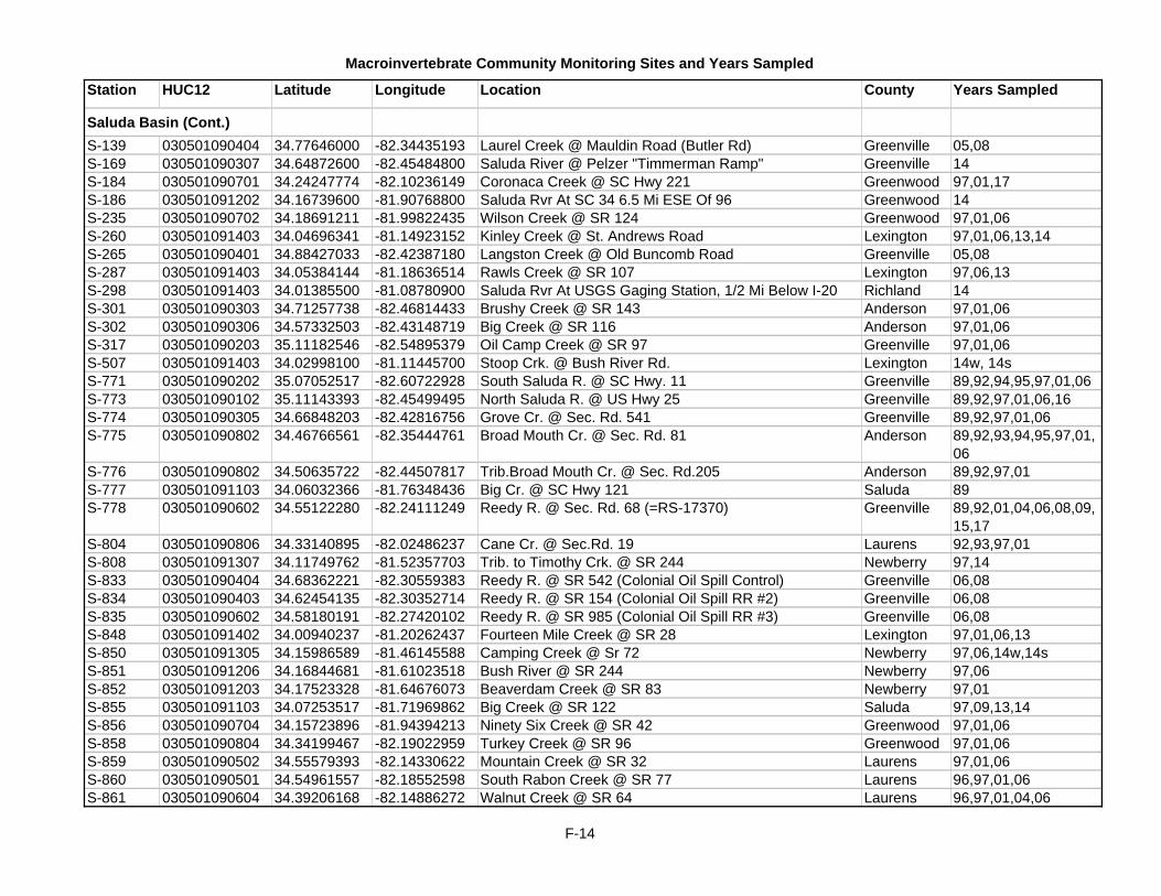
Macroinvertebrate Community Monitoring Sites and Years Sampled
Station HUC12 Latitude Longitude Location County Years Sampled
Saluda Basin (Cont.)S-139 030501090404 34.77646000 -82.34435193 Laurel Creek @ Mauldin Road (Butler Rd) Greenville 05,08S-169 030501090307 34.64872600 -82.45484800 Saluda River @ Pelzer "Timmerman Ramp" Greenville 14S-184 030501090701 34.24247774 -82.10236149 Coronaca Creek @ SC Hwy 221 Greenwood 97,01,17S-186 030501091202 34.16739600 -81.90768800 Saluda Rvr At SC 34 6.5 Mi ESE Of 96 Greenwood 14S-235 030501090702 34.18691211 -81.99822435 Wilson Creek @ SR 124 Greenwood 97,01,06S-260 030501091403 34.04696341 -81.14923152 Kinley Creek @ St. Andrews Road Lexington 97,01,06,13,14S-265 030501090401 34.88427033 -82.42387180 Langston Creek @ Old Buncomb Road Greenville 05,08S-287 030501091403 34.05384144 -81.18636514 Rawls Creek @ SR 107 Lexington 97,06,13S-298 030501091403 34.01385500 -81.08780900 Saluda Rvr At USGS Gaging Station, 1/2 Mi Below I-20 Richland 14S-301 030501090303 34.71257738 -82.46814433 Brushy Creek @ SR 143 Anderson 97,01,06S-302 030501090306 34.57332503 -82.43148719 Big Creek @ SR 116 Anderson 97,01,06S-317 030501090203 35.11182546 -82.54895379 Oil Camp Creek @ SR 97 Greenville 97,01,06S-507 030501091403 34.02998100 -81.11445700 Stoop Crk. @ Bush River Rd. Lexington 14w, 14sS-771 030501090202 35.07052517 -82.60722928 South Saluda R. @ SC Hwy. 11 Greenville 89,92,94,95,97,01,06S-773 030501090102 35.11143393 -82.45499495 North Saluda R. @ US Hwy 25 Greenville 89,92,97,01,06,16S-774 030501090305 34.66848203 -82.42816756 Grove Cr. @ Sec. Rd. 541 Greenville 89,92,97,01,06S-775 030501090802 34.46766561 -82.35444761 Broad Mouth Cr. @ Sec. Rd. 81 Anderson 89,92,93,94,95,97,01,
06S-776 030501090802 34.50635722 -82.44507817 Trib.Broad Mouth Cr. @ Sec. Rd.205 Anderson 89,92,97,01S-777 030501091103 34.06032366 -81.76348436 Big Cr. @ SC Hwy 121 Saluda 89S-778 030501090602 34.55122280 -82.24111249 Reedy R. @ Sec. Rd. 68 (=RS-17370) Greenville 89,92,01,04,06,08,09,
15,17S-804 030501090806 34.33140895 -82.02486237 Cane Cr. @ Sec.Rd. 19 Laurens 92,93,97,01S-808 030501091307 34.11749762 -81.52357703 Trib. to Timothy Crk. @ SR 244 Newberry 97,14S-833 030501090404 34.68362221 -82.30559383 Reedy R. @ SR 542 (Colonial Oil Spill Control) Greenville 06,08S-834 030501090403 34.62454135 -82.30352714 Reedy R. @ SR 154 (Colonial Oil Spill RR #2) Greenville 06,08S-835 030501090602 34.58180191 -82.27420102 Reedy R. @ SR 985 (Colonial Oil Spill RR #3) Greenville 06,08S-848 030501091402 34.00940237 -81.20262437 Fourteen Mile Creek @ SR 28 Lexington 97,01,06,13S-850 030501091305 34.15986589 -81.46145588 Camping Creek @ Sr 72 Newberry 97,06,14w,14sS-851 030501091206 34.16844681 -81.61023518 Bush River @ SR 244 Newberry 97,06S-852 030501091203 34.17523328 -81.64676073 Beaverdam Creek @ SR 83 Newberry 97,01S-855 030501091103 34.07253517 -81.71969862 Big Creek @ SR 122 Saluda 97,09,13,14S-856 030501090704 34.15723896 -81.94394213 Ninety Six Creek @ SR 42 Greenwood 97,01,06S-858 030501090804 34.34199467 -82.19022959 Turkey Creek @ SR 96 Greenwood 97,01,06S-859 030501090502 34.55579393 -82.14330622 Mountain Creek @ SR 32 Laurens 97,01,06S-860 030501090501 34.54961557 -82.18552598 South Rabon Creek @ SR 77 Laurens 96,97,01,06S-861 030501090604 34.39206168 -82.14886272 Walnut Creek @ SR 64 Laurens 96,97,01,04,06
F-14

Macroinvertebrate Community Monitoring Sites and Years Sampled
Station HUC12 Latitude Longitude Location County Years Sampled
Saluda Basin (Cont.)S-862 030501090601 34.52386657 -82.26264536 Horse Creek @ SR 69 Greenville 97,01,04,05,06,08S-863 030501090403 34.65463538 -82.32547071 Huff Creek @ SR 459 Greenville 97,01,04,06S-864 030501090801 34.53033274 -82.35084528 Mountain Creek @ SR 51 Greenville 97,01,06S-865 030501090302 34.86530417 -82.53051667 Georges Creek @ road above SR 36 Pickens 97,01,06S-866 030501090301 34.94758932 -82.53472986 Shoals Creek @ SR 140 Pickens 97,01,06S-867 030501090402 34.79843933 -82.39141663 Brushy Creek @ SR 30 Greenville 97,01,04,05,08,17S-868 030501090401 34.91070487 -82.44790194 Reedy River @ SR 133 Greenville 97,17S-928 030501090401 34.94090063 -82.46532386 Reedy River @ SR 88 (= S-011) Greenville 01,17S-955 030501100301 33.96482100 -81.03626700 Congaree Riv. @ Rosewood Landing Richland 14S-972 030501090404 34.72413563 -82.30866576 Baldwin Creek @ Moore Road Greenville 04,05,08S-979 030501090802 34.48980000 -82.42540000 Broad Mouth Creek @ SR 265 Anderson 05,08S-980 030501090204 34.96833947 -82.55130895 Carpenter Creek @ Pace Bridge Road NE of SC 186/SC
135 intersectionPickens 05,08
S-981 030501090402 34.85511982 -82.38401322 Richland Creek @ E. North Street Greenville 05,08,15S-982 030501090404 34.66917591 -82.29627422 Harrison Creek @ S. Harrison Bridge Road Greenville 05,08S-983 030501090403 34.71340065 -82.35446864 Huff Creek Creek @ Griffin Mill Road Greenville 05,08S-984 030501090403 34.66130683 -82.34655967 Tributary to Baker Creek @ Alverson Road Greenville 05,08S-985 030501090403 34.62627412 -82.30857792 Little Creek @ Berry Road Greenville 05,08S-986 030501090602 34.58541514 -82.24853733 Martin Creek @ Craigs Road Greenville 05,08S-987 030501090602 34.49900164 -82.23257620 Ware Shoals east #1 @ SR 347 Laurens 05,08S-988 030501090604 34.40169519 -82.17201877 Walnut Creek @ SR 36 (Ekom Beach Road) Laurens 05,08S-989 030501090804 34.38308405 -82.29177367 Gibson Creek @ Bolt Road Abbeville 05,08S-990 030501090801 34.53078334 -82.35066529 Trib to Mountain Creek @ Oak Hill Drive west of US 25-
McCollough School Rd. intersecGreenville 05,08
S-991 030501090301 34.94144997 -82.57324875 Shoal Creek @ Deer Creek Road NE of SC 186/SC 135 intersection
Pickens 05,08
S-999 030501090201 35.03393200 -82.70127100 Green Ck behind nature ctr @ Table Rock State Park Pickens 09S-1001 030501090101 35.17427700 -82.40319300 Posey Ck. @ SR 17, Bridge nearest the end of Page
Mountain Rd.Greenville 09,10,14,16
S-1002 030501091403 34.04629100 -81.19082900 Saluda River @ Hope Ferry Landing Lexington 14S-1003 030501090307 34.85119000 -82.48514000 Saluda River @ S-23-63, below dam Greenville 14S-1004 030501090402 34.85907400 -82.38419100 Richland Creek @ Spartanburg St. Greenville Greenville 15S-1005 030501090402 34.84522800 -82.38738300 Richland Creek @ Cleveland Park, Greenville Greenville 15S-1007 030501100301 33.99664000 -81.05106000 Congaree Riv. @ 90m ups. of Gervais St. Brdg on Broad R Richland 17
C-014 030501110101 33.66687751 -80.61269705 Warley Creek @ SC 267 Calhoun 02CSTL-062 030502010701 33.21492400 -79.97514400 Tail Race Canal At US 52 & 17A Below Lake Moultrie Berkeley 16
Santee Basin
F-15

Macroinvertebrate Community Monitoring Sites and Years Sampled
Station HUC12 Latitude Longitude Location County Years Sampled
Santee Basin (Cont.)CSTL-112 030501120302 33.20833200 -79.46903500 Wambaw Ck. @ Extension of S-10-857 (Bridge Boat
Landing)Charleston 15
CSTL-594 030501120206 33.26076700 -79.65812800 Du Tart Crk. @ SC 45 Berkeley 13CSTL-595 030502010201 33.31656400 -79.93796400 Trib to Gravel Hill Swamp @ Mendel Rivers Rd./Magnolia
St.Berkeley 13
CSTL-596 030501120302 33.11954700 -79.53762500 Mechaw Crk. @ Palmers Bridge Rd. Charleston 13CSTL-597 030502010301 33.13551100 -79.80000100 Huger Crk.@ Forest Rd. 159 Berkeley 13,17CSTL-598 030502010301 33.13126700 -79.78389700 Turkey Crk. @ SC 41 Berkeley 13CSTL-599 030502010302 33.17050600 -79.76931100 Nicholson Crk. @ SC 41 Berkeley 13CSTL-600 030502090201 33.04558300 -79.62564700 Steed Crk. @ Eden Bridge Rd. Charleston 13CSTL-601 030502010601 32.99159400 -80.20622200 Sawmill Branch @ S-18-706/Luden Dr., Summerville Dorchester 13CSTL-603 030502090201 33.03503300 -79.67375600 Cooter Creek @ Willow Hall Road Charleston 14CSTL-604 030502010701 33.19729700 -80.01555300 California Branch @ Hwy 6 Berkely 14CSTL-605 030502010304 33.08354000 -79.77761400 Washaw Ck. @ Steed Creek Rd Berkeley 15CSTL-606 030502010203 33.22069000 -79.95069000 Broad Axe Branch @ Old Cherry Hill Rd Berkeley 15RS-04389 030501110101 33.66042304 -80.63097722 Warley Creek @ SR 287 Calhoun 04RS-05399 030501120102 33.54001028 -80.13763254 Bennets Branch @ SR 351 Clarendon 05ST-001 030501120206 33.30460100 -79.67831900 Santee Rvr At SC 41/US 17A NE Of Jamestown Berkeley 16ST-017 030501110106 33.60982074 -80.38962576 Jacks Creek @ SR 26, (=MAC 10) Clarendon 07ST-532 030501120101 33.44938700 -80.16008300 Santee River Below Lake Marion (Wilsons) Clarendon 16ST-527 030501110109 33.75317268 -80.53536484 Tavern Cr. @ SR 808 Sumter 92,93,94,95,02,07,10,
14,16ST-533 030501110103 33.64112116 -80.71844969 Lyons Creek @ SC 6 Calhoun 02,07,17ST-534 030501110104 33.62541297 -80.66004974 Halfway Swamp Creek @ SR 157 Calhoun 02,17ST-535 030501110102 33.66827186 -80.48041251 Spring Grove Creek @SR 26 Clarendon 02ST-536 030501120102 33.53989259 -80.13753118 Bennetts Branch @ SR 351 Clarendon 02,07,17ST-537 030501120102 33.54437744 -80.08606431 Doctor Branch @ SR 48 Clarendon 02,07
RS-01049 030601030510 34.20777469 -82.41475227 Calhoun Creek @ SC 28 Abbeville 01RS-02478 030601030512 34.12554416 -82.51586865 Little River @ SR 308 Abbeville 02RS-03342 030601070106 33.91609896 -82.17797193 Doctors Branch @ SR 21 McCormick 03RS-03506 030601010701 34.75092370 -82.60100602 Charles Creek @ unnumbered Ridge Road off SR-485 Anderson 03RS-03510 030601030711 33.89638589 -82.35364385 Unnamed tributary to Baker Creek @ SR 21 McCormick 03RS-04380 030601020304 34.61960951 -83.18099889 Unnamed Tributary to Chauga River @ SR 142 Oconee 04RS-04544 030601060601 33.51610045 -81.99088995 Tributary to Savanah River @ River Rapids Subdivision Aiken 04RS-05412 030601010503 34.62361838 -82.99464525 Snow Creek @ SR 51 Oconee 05RS-05574 030601030608 34.02182029 -82.31305999 Rocky Branch @ SR 177 Greenwood 05
Savannah Basin
F-16

Macroinvertebrate Community Monitoring Sites and Years Sampled
Station HUC12 Latitude Longitude Location County Years Sampled
Savannah Basin (Cont.)RS-05586 030601030504 34.33863351 -82.50711946 Unnamed Trib. to Johnson Creek @ SR 352 @ 2nd
Bridge from SC 201Abbeville 05
RS-06190 030601030602 34.24309751 -82.35305975 Baileys Creek @ SR 171 Abbeville 06RS-07222 030601030603 34.20889166 -82.26793978 Johns Creek @ SR 61 Abbeville 07RS-08082 030601060205 33.52028056 -81.84793780 Horse Cr. @ SR 254 Aiken 08RS-08089 030601010501 34.73807594 -83.11417687 White Fork @ Stribling Shoals Rd. Oconee 08RS-09107 030601010502 34.69985293 -83.01706825 Richland Creek @ SR 135 Oconee 09RS-09112 030601030504 34.29601213 -82.46510265 Johnson Creek @ SR 184, just west of SC 201 Abbeville 09RS-17349 030601060904 32.87632400 -81.42858800 King Cr. @ SC 3 Allendale 17RS-17377 030601060702 33.06870500 -81.40727800 Trib to Miller Cr. @ SC 125 Allendale 17SV-044 030601030204 34.37891893 -82.56000145 Hen Coop Creek @ SR 244 Anderson 96,00,05SV-054 030601030605 34.13852901 -82.35143691 Double Br. @ SR 33 Abbeville 87,90,96,17SV-056 030601030609 34.08819797 -82.32058206 Long Cane Cr. @ SR 33 Abbeville 87,90,00,17SV-062 030601070108 33.87753743 -82.23236105 Stevens Cr. @ SR 22 McCormick 87,90SV-063 030601070303 33.72945317 -82.18229980 Stevens Cr. @ SC 23 McCormick 87,90,96,00,05,10,13,
17SV-069 030601060203 33.55443360 -81.78865322 Sand Creek @ SC 421 Aiken 96,00,05,10SV-072 030601060205 33.48552047 -81.89616937 Horse Crk. @ SR 145 Aiken 00SV-101 030601030402 34.37347514 -82.77376748 Big Generostee Cr. @ SC 187 Anderson 87,90,96,00SV-108 030601020502 34.60366310 -83.09786164 Choestoea Creek @ SR 49 Oconee 96,00,05SV-109 030601030404 34.27419048 -82.73185773 Little Generositee Creek @ SC 184 Anderson 96,00,05SV-118 030601060905 32.93799100 -81.50212000 Savannah Rvr At US 301 12.5 Mi SW Allendale Allendale 16SV-135 030601010602 34.67291056 -82.78772399 Eighteen Mile Creek @ SR 140 Anderson 96,00SV-141 030601030202 34.47674037 -82.59010404 Broadway Crk. @ U.S. 76 Anderson 96SV-151 030601070101 34.12651997 -82.18671581 Hard Labor Creek @ SR 164 Greenwood 96,00,05SV-164 030601030502 34.34120024 -82.46077918 Little River @ SR 24 Abbeville 96,00,05SV-171 030601030511 34.08342772 -82.47604884 Calhoun Cr. @ SR 40 Abbeville 87,90,93,94,95,96,00,
05SV-175 030601060705 33.07311278 -81.47718956 Lower Three Runs Cr. @ SR 125 Allendale 87,90SV-180 030601010703 34.65616598 -82.64149611 Six & Twenty Cr @ S.R. 174 Anderson 92,93,94,95,00,05,17SV-185 030601030206 34.32931516 -82.64073434 Wilson Creek @ SC 413 Anderson 96,00,05SV-192 030601030513 34.01368217 -82.46532348 Little River @ SR 19 McCormick 00SV-199 030601020209 34.81405995 -83.30594619 Chattooga R. @ US 76 Oconee 87,90SV-201 030601020304 34.68545638 -83.15139469 Chauga R. @ US 76 Oconee 87,90,92SV-205 030601010801 34.77941015 -82.84855492 Six Mile Creek @ SR 160 Pickens 96,00,05SV-206 030601010402 34.92112238 -82.71949934 North Fork of Twelve Mile Creek @ US 178 Pickens 96,00,05,17
F-17

Macroinvertebrate Community Monitoring Sites and Years Sampled
Station HUC12 Latitude Longitude Location County Years Sampled
Savannah Basin (Cont.)SV-225 030601020303 34.65731787 -83.18110147 Toxaway Cr. @ SR 34 Oconee 87,90,96,00,05,09,13,
15,17SV-227 030601020204 34.91920428 -83.16871730 Chattooga R. @ SC 28 Oconee 87,90,96,00,10,14,16SV-230 030601010202 34.95812944 -82.85319035 Eastatoe Cr. @ SR 143 Pickens 87,90,92,93,94,95,00SV-250 030601060205 33.47825685 -81.90754122 Horse Cr. @ SC 125 Aiken 87,90SV-286 030601060505 33.38434366 -81.61579683 Upper Three Runs Cr. @ US 278 Aiken 87SV-294 030601060105 33.65450800 -82.19938200 Stevens Ck Reservoir Headwaters At Clarks Hill Dam Boat McCormick 16SV-308 030601020204 35.00406389 -83.05442144 East Fork of the Chattooga River @ SC 107 Oconee 96,00,05,15SV-318 030601030609 34.00041676 -82.35216303 Long Cane Cr. @ SR 117 McCormick 87,90,96,00,05,10,17SV-323 030601060607 33.37143200 -81.94443500 Savannah Rvr At Lock And Dam Aiken 16SV-328 030601060703 33.17596850 -81.48074482 Lower Three Runs Cr. @ SR 20 Barnwell 00SV-341 030601010202 34.94919541 -82.83309687 Little Eastatoe Creek @ SR 49 Pickens 96,00,05SV-342 030601010305 34.76653493 -83.02571045 Cane Crk. @ SR 133 Oconee 96,00SV-343 030601010305 34.76926882 -83.01150169 Little Cane Creek @ SR 133 Oconee 96,00,05,09,13,17SV-345 030601020505 34.54065349 -82.95809928 Beaver Dam Creek @ SR 66 Oconee 96,00,05SV-348 030601030512 34.16707309 -82.49539717 Little R. @ SR 32 Abbeville 87,90,96,00,17SV-349 030601030606 34.21771602 -82.30373968 Long Cane Creek @ SR 159 Abbeville 96,00,05SV-350 030601060403 33.34300588 -81.82199104 Hollow Creek @ SR 5 Aiken 96,00,10SV-351 030601070106 33.92417138 -82.17959858 Cuffytown Creek @ SR 138 McCormick 96,00,05,17SV-353 030601070207 33.79981006 -82.12331455 Beaverdam Crk. @ SR 621 Edgefield 96,05,09,13,14SV-644 030601030508 34.12544145 -82.54991665 Gill Cr. @ SR 32 Abbeville 87,90,96,00,05SV-650 030601030203 34.36065933 -82.57635176 Rocky R. @ SC 413 Anderson 87,90,96,00SV-673 030601020403 34.72122399 -83.29638147 Brasstown Cr. @ SR 48 Oconee 87,90,96,00SV-674 030601020403 34.68186145 -83.32864654 Brasstown Cr dirt rd 300 m fr Tugalloo R Oconee 87,17SV-675 030601020301 34.83330445 -83.17459890 Chauga R. @ SR 193 Oconee 87,90,96,00SV-676 030601010202 35.04531765 -82.80258772 Rocky Bottom Cr. @ US 178 Pickens 87,90,96,00,05SV-678 030601030512 34.11058799 -82.51115649 Little R. @ SC 72 Abbeville 87,90SV-679 030601060204 33.56796137 -81.87216178 Little Horse Cr. @ SR 33 Aiken 87,90SV-680 030601060502 33.47626621 -81.58844661 Upper Three Runs Cr. @ SR 113 Aiken 87,90,92,93,94,95,96,
00,05,10SV-681 030601060502 33.43109272 -81.60560523 Upper Three Runs Cr. @ SR 114 Aiken 87,90SV-683 030601010801 34.75604223 -82.85782896 Wildcat Cr. @ Clemson U. Rec. off SC 133 Pickens 93,94,95,00,05SV-684 030601010301 34.92350489 -83.07934638 Crane Cr. @ Winding Stairs Rd., Oconee 93,94,95,00,05SV-687 030601090107 32.55629200 -81.28399400 Savannah River @ Stokes Bluff Landing Hampton 16SV-688 030601060105 33.57346800 -82.06122900 Savannah River Above Stevens Creek Edgefield 16SV-690 030601060806 33.05120900 -81.55119200 Savannah River @ Little Hell Landing Allendale 16SV-691 030601060607 33.26811800 -81.83422500 Savannah River @ Jackson Landing Aiken 16
F-18

Macroinvertebrate Community Monitoring Sites and Years Sampled
Station HUC12 Latitude Longitude Location County Years Sampled
Savannah Basin (Cont.)SV-723 030601060501 33.45354884 -81.64283406 Cedar Crk. @ SR 79 Aiken 96,00,05,10SV-724 030601060204 33.56351135 -81.87394817 Little Horse Crk. @ SR 104 Aiken 96,00,05,09,10,13SV-725 030601070306 33.64634220 -81.97530795 Cheves Creek @ SR 34 Edgefield 96,00,05SV-726 030601070305 33.65135186 -82.07409046 Horn Creek @ SR 143 Edgefield 96,00SV-727 030601070206 33.87595386 -82.07522403 Rocky Crk. @ SR 61 Edgefield 96,05,14w, 14sSV-728 030601070205 33.86856833 -82.01561615 Log Creek @ SR 315 Edgefield 96,00,05,14SV-729 030601070203 33.88125195 -81.96841164 Turkey Creek @ SR 100 Edgefield 96,00,05SV-730 030601070107 33.88510342 -82.24473260 Rocky Crk. @ SR 87 McCormick 96,00,05,13,14SV-731 030601070103 33.94406062 -82.22036574 Hard Labor Creek @ SR 23 McCormick 96,00,05,10SV-732 030601030607 34.13079243 -82.30362745 Big Curly Tail Creek @ US Forest Rd 509 Abbeville 96,00,05SV-733 030601030501 34.30965101 -82.43712832 Hogskin Creek @ SC 184 Abbeville 96,00,05SV-734 030601030603 34.20133960 -82.28861070 Johns Creek @ SR 159 Abbeville 96,00,05,17SV-735 030601010702 34.62754357 -82.74641559 Three and Twenty Creek @ SR 29 Anderson 96,00,05SV-738 030601010406 34.78052962 -82.74937340 Golden Creek @ Golden Crk. Rd. Pickens 96,00,05,17SV-739 030601010407 34.80283496 -82.74990751 Twelve Mile Creek @ SR 137 Pickens 96,00SV-740 030601010405 34.81400891 -82.73807596 Rices Creek @ SR 158 Pickens 96,00,05,17SV-741 030601010202 35.04759288 -82.81235281 Eastatoe Creek @ SR 237 Pickens 96,00,05SV-742 030601010303 34.84058078 -82.98948164 Oconee Creek @ SR 129 Oconee 96,00,05SV-743 030601010301 34.86237861 -82.99333555 Flat Shoals River @ SR 129 Oconee 96,00,10,14,16SV-744 030601090301 32.55193254 -81.16721385 Cypress Branch @ US 321 Jasper 96,00,05,10,13,17SV-745 030601060902 32.95846493 -81.46301025 Briar Crk. @ S-102 Allendale 96,00,05,09,13SV-790 030601020502 34.60985103 -83.09467360 Tributary of Choestoea Crk. @ SR 429 Oconee 00,17SV-791 030601030202 34.50249196 -82.58302807 Broadway Crk. @ SR 48 Anderson 00,17SV-792 030601020204 34.98577998 -83.07289724 East Fork Chattooga River 300 meters downstream of
Hatchery OutfallOconee 00
SV-800 030601060601 33.50981700 -81.99515100 Savannah River @ N. Augusta St. Park Aiken 16SV-801 030601060805 33.19831800 -81.75672200 Savannah River @ Steel Creek Barnwell 16SV-803 030601060905 32.99824300 -81.49095400 Savannah River @ Johnson's Landing Allendale 16SV-824 030601020204 34.98560000 -83.06860000 East Fork Of The Chattooga Upstream Of 1st Bridge On
Fish Hatchery Rd.Oconee 15
F-19

G-1
G. Fish Tissue Monitoring Site Descriptions

G-2
BROAD RIVER BASIN CL-100 LAKE ROBINSON GREENVILLE B-114 LAKE BOWEN NEAR SC 9 SPARTANBURG B-222 BROAD RIVER @ SEC RD 43 “PICK HILL ACCESS”CHEROKEE B-345 PARR RESERVOIR NEWBERRY B-327 LAKE MONTICELLO FAIRFIELD B-311 BROAD RIVER @ I-20 RICHLAND
CATAWBA-WATEREE BASIN CW-197 LAKE WYLIE ABOVE MILL CREEK YORK CW-016 CATAWBA RIVER @ SC 9 LANCASTER CW-057 FISHING CREEK RESERVOIR NEAR DAM CHESTER CW-033 CEDAR CREEK RESERVOIR FAIRFIELD CW-034 CEDAR CREEK RESERVOIR TAILRACE LANCASTER CW-207 LAKE WATEREE NEAR SEC RD 291 FAIRFIELD CW-214 WATEREE RIVER @ I-20 KERSHAW CW-206 WATEREE RIVER @ US 378/76 SUMTER
CONGAREE RIVER BASIN C-007 CONGAREE RIVER @ US 601 CALHOUN C-046 SESQUICENTENNIAL STATE PARK RICHLAND
EDISTO RIVER BASIN
E-585 SOUTH EDISTO RIVER @ AIKEN STATE PARK AIKEN E-014 EDISTO RIVER @ US 15 (T COKE WEEKS LDG.) DORCHESTER E-015 EDISTO RIVER @ SC 61 (GIVHANS FERRY LDG.) DORCHESTER MD-119 EDISTO R. BELOW HWY 17 (WEST BANK LDG.) COLLETON CSTL-120 LITTLE SALKEHATCHIE @ SEC RD 63 COLLETON CSTL-561 COMBAHEE RIVER @ SEC RD 756 COLLETON CSTL-048 COMBAHEE R. ABOVE HWY 17 (STEEL BRIDGE) BEAUFORT CSTL-077 COOSAWHATCHIE RIVER @ SEC RD 36 JASPER CSTL-069 ASHEPOO RIVER @ HWY 17 COLLETON CSTL-560 ASHLEY RIVER @ DORCHESTER STATE PARK DORCHESTER
ESTUARY SITES
MD-785 UPPER CAPE ROMAIN CHARLESTON MD-786 LOWER CAPE ROMAIN NEAR MUDDY BAY CHARLESTON MD-787 LOWER CAPE ROMAIN NEAR WHITE BANKS CHARLESTON MD-788 CHARLESTON HARBOR CHARLESTON MD-789 ASHLEY RIVER CHARLESTON

G-3
MD-790 LOWER WANDO RIVER CHARLESTON MD-791 ACE BASIN NEAR EDISTO BEACH COLLETON MD-792 ACE BASIN NEAR COMBAHEE RIVER COLLETON
COOPER RIVER CHARLESTON
PEE DEE RIVER BASIN PD-043 POCOTALIGO RIVER @ SEC RD 50 CLARENDON PD-327 LAKE HB ROBINSON CHESTERFIELD PD-071 LYNCHES RIVER @ HWY 15 LEE PD-624 LYNCHES RIVER @ US 52 FLORENCE CSTL-553 WACCAMAW RIVER @ SC 31 HORRY MD-144 WACCAMAW RIVER @ TODDVILLE HORRY CSTL-557 WACCAMAW RIVER @ BUCKSPORT LANDING HORRY MD-141 WACCAMAW RIVER @ HAGLEY LANDING GEORGETOWN CSTL-558 INTRACOASTAL WATERWAY @ SOCASTEE HORRY PD-012 GREAT PEE DEE RIVER @ SC 9/US 1 CHESTERFIELD PD-028 GREAT PEE DEE RIVER @ SC 34 DARLINGTON PD-623 BLACK CREEK @ SC 327 FLORENCE PD-337 GREAT PEE DEE RIVER @ HWY 301 MARION PD-621 GREAT PEE DEE RIVER @ STAPLES LAKE WILLIAMSBURG CSTL-559 GREAT PEE DEE R. ABOVE HWY 701 BRIDGE HORRY PD-663 GREAT PEE DEE RIVER @ SAMWORTH WMA GEORGETOWN PD-618 LITTLE PEE DEE RIVER @ FLOYDALE BRIDGE DILLON PD-664 LUMBER RIVER @ CAUSEY LANDING HORRY PD-038 LUMBER RIVER @ RICEFIELD COVE HORRY PD-619 LITTLE PEE DEE RIVER @ GALAVANTS FERRY MARION PD-620 LITTLE PEE DEE RIVER @ HWY 378 HORRY PD-350 LITTLE PEE DEE R. @ PUNCHBOWL LANDING HORRY PD-626 BLACK RIVER @ PUMPHOUSE LANDING WILLIAMSBURG PD-659 BLACK RIVER @ OLD PUMP STATION GEORGETOWN PD-661 BLACK RIVER @ PRINGLE’S FERRY GEORGETOWN PD-628 SAMPIT RIVER @ INTERNATIONAL PAPER GEORGETOWN
SALUDA BASIN S-169 SALUDA R. @ PELZER “TIMMERMAN RAMP” ANDERSON S-131 LAKE GREENWOOD @ US 221 GREENWOOD S-105 SALUDA RIVER @ SC 395 NEWBERRY S-223 LAKE MURRAY @ SC 391 SALUDA S-273 LAKE MURRAY @ DAM LEXINGTON
SANTEE BASIN ST-529 LAKE MARION @ LOW FALLS LANDING CALHOUN

G-4
ST-519 LAKE MARION @ RIMINI SUMTER ST-024 LAKE MARION @ WYBOO CREEK CLARENDON ST-528 SANTEE RIVER @ US 52 (HWY 52 LANDING) WILLIAMSBURG ST-001 SANTEE RIVER @ SC 41/US 17A BERKELEY ST-005 NORTH SANTEE RIVER @ POLE YARD GEORGETOWN ST-006 SOUTH SANTEE RIVER ABOVE US 701/17 CHARLESTON CSTL-079 DIVERSION CANAL BERKELEY ST-531 LAKE MOULTRIE @ HATCHERY LANDING BERKELEY CSTL-080 LAKE MOULTRIE @ DAM BERKELEY CSTL-062 COOPER RIVER @ US 17A BERKELEY MD-217 DURHAM CREEK BERKELEY CSTL-564 EAST FORK OF COOPER R. NEAR QUINBY CR. BERKELEY MD-042 COOPER RIVER @ BUSHY PARK BERKELEY ST-032 GOOSE CREEK RESERVOIR BERKELEY
SAVANNAH BASIN SV-599 TUGALOO LAKE OCONEE CL-015 LAKE YONAH OCONEE SV-313 LAKE JOCASSEE @ END OF SEC RD 25 OCONEE SV-311 LAKE KEOWEE @ CANE CREEK ACCESS OCONEE CL-017 LAKE KEOWEE AT NUCLEAR PLANT NEAR DAM OCONEE SV-107 LAKE HARTWELL @ 12 MILE CREEK PICKENS SV-106 LAKE HARTWELL @ MARTIN CREEK PICKENS CL-005 LAKE SECESSION @ DAM ABBEVILLE CL-096 LAKE RUSSELL @ VAN CREEK ABBEVILLE CL-097 LAKE RUSSELL @ DAM ABBEVILLE CL-040 LAKE THURMOND @ BOBBY BROWN STATE PK MCCORMICK SV-688 SAVANNAH RIVER ABOVE STEVENS CREEK EDGEFIELD SV-531 LANGLEY POND AIKEN SV-691 SAVANNAH RIVER @ JACKSON LANDING AIKEN SV-690 SAVANNAH RIVER @ LITTLE HELL LANDING ALLENDALE SV-687 SAVANNAH RIVER @ STOKES BLUFF LANDING HAMPTON MD-118 NEW RIVER @ SC 170 JASPER

H-1
H. Shellfish Station Descriptions Listed by Area

H-2
Shellfish Management Area 01 WATER QUALITY SAMPLING STATIONS DESCRIPTION
Station Shellfish Station Description 01-01 Little River Jetty 01-02 Mouth of Dunn Sound Creek 01-05 Big bend up Dunn Sound Creek 01-06 Bridge to Waites Island 01-07 Hog Inlet 01-17 42nd Avenue - Cherry Grove 01-17A 53rd Avenue Bridge on Canal 01-18 Dunn Sound at Hog Inlet 01-19 53rd Avenue at Main Creek (9 Active)

H-3
Shellfish Management Area 02 WATER QUALITY SAMPLING STATIONS DESCRIPTION
Station Shellfish Station Description 02-01 White Point Swash 02-02 Singleton Swash 02-03 Canepatch Swash (3 Active)

H-4
Shellfish Management Area 03 WATER QUALITY SAMPLING STATIONS DESCRIPTION
Station Shellfish Station Description 03-01 Withers Swash 03-02 Midway Swash - Pebble Beach (2 Active)

H-5
Shellfish Management Area 04 WATER QUALITY SAMPLING STATIONS DESCRIPTION
Station Shellfish Station Description 04-01 Main Creek at Atlantic Avenue Bridge 04-02 Main Creek at Mickey Spillane's Home 04-03A In Main Creek, on the Southeast Side of the Prohibited Area near Captain
Dick’s Marina 04-03B In Main Creek, on the Northwest Side of the Prohibited Area Near Captain
Dick’s Marina 04-04A Garden City Canal due east of Flagg Creek 04-04B Northern boundary of Marlin Quay Marina closure zone in Main Creek 04-04C Western boundary of Marlin Quay Marina closure zone in Main Creek 04-06 Allston Creek at Weston Flat 04-07 Allston Creek Public Oyster Ground - Hughes Landing 04-08 Parsonage Creek at Nance's Dock 04-08A Oyster (Carr) Landing at Huntington Beach Station Park 04-09 Clubhouse Creek at Litchfield Boulevard Bridge 04-10 Shell Avenue and Pawley's Island Creek 04-11 North Causeway Bridge at Pawley's Island Creek 04-12 South Causeway Bridge at Pawley's Island Creek 04-13 Pawley's Inlet 04-14 Dock - End of Sportsman Boulevard 04-15 Midway Inlet 04-16 Parsonage Creek at Chicken Farm Ditch 04-17A Southwest Corner of the Voyager View Marina Prohibited Zone in
Parsonage Creek 04-18 North Boundary of Clambank Flats POG 04-19 Clubhouse Creek - First Bend South of Salt Marsh Cove 04-21 South Pawley's Island Boat Landing 04-23 Main Creek at Oyster Cover 04-24 Oaks Creek at First Curve 04-25 Main Creek at Flagg Creek 04-26 Garden City Canal at the "Old Boat Wreck" 04-27 Main Creek, Opposite Entrance to Mt. Gilead Canal 04-28 Oak's Creek, Approx. 150 Meters from the Huntington Beach State Park
Causeway 04-29 Oyster Cove, South Branch 04-30 Oyster Cove, North Branch 04-31 Woodland Creek, 100 meters east of mainland 04-32 Oak’s Creek at Brigham Hole (33 Active)

H-6
Shellfish Management Area 05 WATER QUALITY SAMPLING STATIONS DESCRIPTION
Station Shellfish Station Description 05-01 Jones Creek at Nancy Creek 05-02 Noble Slough 05-03 North Inlet 05-04 Town Creek at Debidue Creek 05-05 Oyster Bay near Cutoff Creek 05-06 No Man's Friend Creek at Mud Bay 05-07 Jones Creek at Mud Bay 05-08 Town Creek at Sixty Bass Creek 05-09 Town Creek at Southern Reach of Clambank Creek 05-10 Jones Creek at Duck Creek 05-11 Town Creek at Bread and Butter Creek 05-12 Old Man Creek and Sea Creek Bay 05-13 Debidue Creek at Boat Basin 05-14 Mid Channel Island, Bly Creek 05-15 Debidue Creek and Cooks Creek 05-16 Debidue Creek and Bass Hole Bay 05-20 Winyah Bay Main Channel, Buoy 19a, Range E 05-21 Winyah Bay Main Channel, Buoy 17, Range E 05-24 Winyah Bay Main Channel, Coast Guard Dock, Range C 05-25 Winyah Bay, Tip of Western Channel Island (20 Active)

H-7
Shellfish Management Area 06A WATER QUALITY SAMPLING STATIONS DESCRIPTION
Station Shellfish Station Description 06A-01 South Santee River at Alligator Creek 06A-01A South Santee River near the midpoint of Grace Island 06A-02 South Santee Inlet 06A-03 North Santee River at Beach Creek 06A-04 North Santee Inlet 06A-04A North Santee Bay - E of Cane Island 06A-04B North Santee River - SW of Cane Island 06A-04C North Santee River near the northwestern tip of Cane Island 06A-05 North Santee River and Mosquito Creek 06A-11 Atlantic Intracoastal Waterway at Minum Creek (10 Active)

H-8
Shellfish Management Area 06B WATER QUALITY SAMPLING STATIONS DESCRIPTION
Station Shellfish Station Description 06B-06 Alligator Creek and Ocean Inlet 06B-06A North End of Cape Romain Harbor 06B-07 Alligator Creek at Marker #26 06B-08 Casino Creek at Marker #29 06B-09 Dupree Creek - 500 feet N. of new dock (South of Marker #30) 06B-10 AIWW at Marker #32 06B-12 Alligator Creek State Shellfish Ground 06B-15 Casino Creek at Cape Romain Harbor 06B-16 Casino Creek midway between Stations 19 and 24 (at small unnamed
creek on right, southbound) 06B-17 Congaree Creek at Tower Creek 06B-18 Confluence of Dupree Creek and Clubhouse Creek 06B-19 Confluence of Casino Creek and Skrine Creek 06B-19A Casino Creek midway between Stations 06B-19 and 06B-16, at unnamed
creek 06B-20 1,000 yards up Dupree Creek from Clubhouse Creek 06B-21 Confluence of Alligator Creek and Ramhorn Creek 06B-22 Confluence of Ramhorn Creek and Mill Creek 06B-22A Mill Creek at Ramhorn Creek 06B-23 Confluence of Skrine Creek and Congaree Boat Creek 06B-24 Confluence of Casino Creek and Congaree Boat Creek 06B-25 Confluence of Horsehead Creek and Unnamed Creek at lower end of
Horsehead Island 06B-26 Confluence of Skrine Creek and unnamed creek north of Muddy Bay 06B-27 Confluence of the first large creek on the left, with Congaree Boat Creek,
traveling SE of Station #23 (22 Active)

H-9
Shellfish Management Area 07 WATER QUALITY SAMPLING STATIONS DESCRIPTION
Station Shellfish Station Description 07-01A Venning Creek at Bulls Bay 07-02 Graham Creek at Marker #64 07-02A Graham Creek and Bulls Bay 07-03 Awendaw Creek at Marker #57 07-04 Harbor River at Marker #48 07-04A Harbor River at Bulls Bay 07-05 Tibwin Creek at Marker #42 07-06 Five Fathom Creek at Marker #20 07-06A Five Fathom Creek at Bull River 07-08 Clubhouse Creek-1/4 mile north of Five Fathom Creek 07-08A Oyster Bay at Muddy Bay 07-09 Confluence of Doehall Creek with AIWW - north of Marker #46 07-14 Doehall Creek – third bend at the dock 07-15 Sandy Point Creek at fourth bend 07-16 Confluence of Romain River & Santee Path Creek 07-17 Second small creek north of Marker #26 in Five Fathom Creek 07-18 Marker #65 in AIWW 07-19 AIWW at Confluence with Unnamed Creek, 1.5 miles Southwest of
Graham Creek 07-20 Bulls Bay - 1,000ft from Confluence with Graham Creek 07-21 AIWW, midway between Tibwin creek and Matthews Creek 07-22 Tibwin Creek past the first bend, at first small creek on the right. (21 Active)

H-10
Shellfish Management Area 08 WATER QUALITY SAMPLING STATIONS DESCRIPTION
Station Shellfish Station Description 08-01 Morgan Creek at northernmost confluence with AIWW - adjacent to
Marker #115 08-02 Hamlin Sound 08-03 Dewees Inlet at AIWW - North of Marker #110 08-04 Bull Yard Sound - Marker #104 08-06 Mark Bay - Marker #90 08-06A Unnamed Creek East of Marker #90 at Fork 08-09 Moore's Landing Dock - At Marker #74 08-10 Marker #116 north of Isle of Palms STP outfall in AIWW 08-14 Dewees Island - 1/4 mile up Horsebend Creek 08-16 Confluence of Seven Reaches and Gray Bay 08-17 S.W. Copahee Sound at Porcher Bluff Creek 08-18 One-half mile up Cedar Creek from Dewees Inlet 08-19 Confluence of Toomer Creek at Copahee Sound 08-20 Upper reaches Whiteside Creek 08-21 Upper reaches Clawson Creek 08-22 Confluence of Capers Creek and Santee Pass 08-25 Palmetto Point Creek (adjacent to Marker #84) 08-27 Northern Hamlin Sound 08-28 Summerhouse Creek at Bull Island Ferry Dock 08-29 Anderson Creek at the Bull Island Ferry Channel (20 Active)

H-11
Shellfish Management Area 09A WATER QUALITY SAMPLING STATIONS DESCRIPTION
Station Shellfish Station Description 09A-01 Hamlin Creek at its confluence with AIWW 09A-02 Upper end of Hamlin Creek at POG 09A-03 Upper end of Swinton Creek 09A-06 Inlet Creek and Gentide Creek 09A-07 Inlet Creek at its confluence with AIWW 09A-09 Ben Sawyer Bridge 09A-11 End of 10th Street at Hamlin Creek 09A-14 Swinton Creek at its confluence with AIWW 09A-17 Conch Creek State Shellfish Ground - Mt. Pleasant side 09A-17A Conch Creek State Shellfish Ground - Sullivans Island side 09A-18 AIWW adjacent to Wild Dunes Golf Course storm drainage outfall 09A-19 AIWW at 25th Street - Isle of Palms 09A-20 Conch Creek at Lofton Creek 09A-23 Upper reaches of Conch Creek 09A-24 Upper reaches of Inlet Creek 09A-25 Upper reaches of Swinton Creek 09A-26 Hamlin Creek 1/2 way between Stations 1 and 2 09A-28 Swinton Creek west of AIWW at second bend 09A-29 Lower Hamlin Creek at site of new bridge (Isle of Palms Connector) 09A-32 First creek on right downstream from Station 6 09A-35 300 yards upstream from Station 6 09A-36 Conch Creek at its confluence with AIWW 09A-37 Lower Conch Creek at Marina Closure Zone (23 Active)

H-12
Shellfish Management Area 09B WATER QUALITY SAMPLING STATIONS DESCRIPTION
Station Shellfish Station Description 09B-01 Wando River at Nowell Creek 09B-02 Wando River at Horlbeck Creek 09B-04 Wando River at Deep Creek 09B-05 Wando River opposite Big Paradise Island 09B-07 Boone Hall Creek opposite County Recreation Area 09B-08 Wando River at Marker #29 09B-09 Deep Creek - 1 mile from confluence with Wando River 09B-11 Wando River at Guerin Creek 09B-12 Guerin Creek at Old House Creek 09B-15 New bridge- Route I-526 09B-16 Confluence of Martin Creek and Nowell Creek 09B-17 Wando River midway between Stations 3 and 11(at old dry dock) 09B-18 Rat Hall Creek at confluence with Wando River. 09B-19 Foster Creek at Confluence with Wando River 09B-21 Horlbeck Creek at power line crossing 09B-22 Wando River a Marker #27 09B-23 Wando River at Marker #20 09B-24 Wando River at Marker #13 (18 Active)

H-13
Shellfish Management Area 10A WATER QUALITY SAMPLING STATIONS DESCRIPTION
Station Shellfish Station Description 10A-02 Folly Creek Bridge 10A-04 Backman Creek at Folly Creek 10A-05 King Flats and Folly Creek 10A-06 Opposite Little Island in Folly Creek 10A-07 North boundary of Prohibited Area at Folly Marina 10A-08 Folly River Bridge 10A-09 Last dock north in Folly River 10A-10A Robbins Creek at the first bend upstream from Cutoff Reach 10A-11 Rat Island Creek at confluence with first creek on left from Lighthouse
Creek 10A-13 Lighthouse Creek at confluence with Folly Creek 10A-15 Secessionville Creek at private docks 10A-15A Folly Creek at confluence with Secessionville Creek 10A-16 Clark Sound at Ocean View Flats 10A-16B Clark Sound, 550 yards East of the confluence of Fludd's Creek and Clark
Sound 10A-18 Mouth of Schooner Creek 10A-19 Just inside Clark Sound from Schooner Creek 10A-22 Folly River State Shellfish Ground opposite Folly Island 10A-23 Lighthouse Creek State Shellfish Ground at mouth of First Sister Creek 10A-24 Cole Creek State Shellfish Ground 10A-29A Block Island Creek at the Flats 10A-30 Rat Island Creek at the second bend 10A-32 Block Isl. Creek - 100 yds S. of split from spoil area 10A-33 Confluence of Lighthouse Creek and Clark Sound 10A-34 The first dock in Secessionville Creek at its confluence with Clark Sound 10A-34A Lighthouse Creek at Secessionville Creek and Clark Sound 10A-35 Right fork of Schooner Creek, middle of Docks, across from Parrot Point
Development 10A-36 Unnamed creek at Fork near Riverfront Subdivision 10A-37 Folly Creek at Oak Island Creek (28 Active)

H-14
Shellfish Management Area 11 WATER QUALITY SAMPLING STATIONS DESCRIPTION
Station Shellfish Station Description 11-01 Elliott Cut at Stono River 11-02A Stono River - southern boundary of the marina closure zone, south of
Hwy. 700 Bridge 11-03 Docks between Markers 10 & 11 in Stono River 11-05 Mouth of Abbapoola Creek 11-06 Abbapoola Creek at first large bend 11-06A Abbapoola Creek at Confluence with Small Creek on West Bank at
Seventh Bend 11-07 Green Creek at Stono River 11-07A Green Creek, Four Bends Upstream of Station 11-07 11-08 Mouth of Kiawah River 11-11 Stono River (AIWW) at Marker #21A 11-12 Stono River (AIWW) at Marker #27 11-15 Stono River (AIWW) at Marker #63 11-16 Stono River (AIWW) at Marker #51 11-17 Stono River (Log Bridge Creek) at Marker #54 11-18 Confluence of Rantowles Creek and Stono River 11-21 South Kiawah River on the flats 11-22 Kiawah River POG at Mingo Point 11-23 Captain Sams Creek and Kiawah River 11-27 Stono River at mouth of Penny Creek near Marker #25 11-28 Mullet Hall Creek 150 yards from mouth at fork 11-30 Kiawah River at mouth of Bryans Creek 11-31 Bass Creek at confluence with Kiawah River 11-32 Bass Creek at confluence with Cinder Creek 11-33 Sol Legare Boat Landing 11-34 Cinder Creek at Public Dock (3rd bend from confluence with Bass Creek) 11-35 Bass Creek at Public Dock (5th bend from confluence with Cinder Creek (26 Active)

H-15
Shellfish Management Area 12A WATER QUALITY SAMPLING STATIONS DESCRIPTION
Station Shellfish Station Description 12A-09 Adams Creek at Bohicket Creek 12A-11A Adams Creek, North of Adams Creek Marina 12A-13 Bohicket Creek at Fickling Creek 12A-13A Bohicket Creek at Bloody Point 12A-20 Bohicket Creek opposite Hoopstick Island 12A-21 Opposite old dam behind Rast House Restaurant 12A-22 Opposite Boy Scout Camp 12A-29 Raven Point Creek at confluence with Church Creek 12A-31 Southwest Boundary of Prohibited Area At Bohicket Marina 12A-32 Privateer Creek up 1/2 mile at fork 12A-38 Drainage discharge 1/8 mile east of power lines, north bank of Church
Creek 12A-40 Pine Creek at first fork 12A-41 Confluence of Church Creek and New Cut 12A-46 Bohicket Creek midway between Stations 21 and 22 at small, unnamed
tributary on west bank (14 Active)

H-16
Shellfish Management Area 12B WATER QUALITY SAMPLING STATIONS DESCRIPTION
Station Shellfish Station Description 12B-01 Mouth of Church Creek, Marker #77 12B-02 Goshen Point, Marker #69 12B-04 Toogoodoo Creek at confluence with AIWW, Marker #102 12B-05 Dawho Creek, Marker #110 12B-06 Steamboat Creek, Marker #2 12B-07 Westbank Creek at North Edisto River, opposite Leadenwah Creek 12B-09 Dawho River at Marker #119 12B-10 South Boundary of Prohibited Area at Metal Trades Dock 12B-12 Leadenwah Creek 1 mile from confluence of North Edisto River 12B-30 Tom Point Creek at Park Island 12B-34 Toogoodoo Creek SSG at last creek before fork 12B-35 Public Boat Ramp, Lower Toogoodoo Creek 12B-36 Confluence of Tom Point Creek and North Edisto River 12B-37 Confluence of Steamboat Creek and Russell Creek 12B-42 Headwaters of Ocella Creek 12B-43 Russell Creek at estuary entering Sunbelt Clam Farms 12B-43A Russell Creek near Creek Farm Rd. 12B-44 Toogoodoo Creek midway between Stations 4 and 34 12B-45 Toogoodoo Creek at the second bend past the confluence with Lower
Toogoodoo Creek 12B-51 Wadmalaw Sound at day beacon #80 12B-52 Confluence of Whooping Island Creek and Steamboat Creek 12B-53 Dawho River, Marker #126 12B-54 Tom Point Creek, 3 bends upstream of Station 30 12B-55 Leadenwah Creek, at third bend after Station 12B-12 12B-56 Leadenwah Creek, after fourth bend at the fork 12B-57 Oscella Creek at fork 12B-58 Westbank Creek at first bend (27 Active)

H-17
Shellfish Management Area 13 WATER QUALITY SAMPLING STATIONS DESCRIPTION
Station Shellfish Station Description 13-01 Scott Creek at The Mound 13-02 Mouth of Big Bay Creek 13-03 Mouth of St. Pierre Creek 13-04 St. Pierre Creek at Peters Pt. 13-05 Fishing Creek at Sandy Creek Confluence of Shingle Creek and Bailey
Creek 13-08 Edisto River at Ashepoo River Russell Creek at Area 12/13 boundary 13-10 Fishing Creek at Pollution Line 13-13 Mouth of Fish Creek at Otter Island & Atlantic Ocean 13-15 Headwaters of Pine Island Creek at the fork 13-20 Northern confluence of Alligator Creek and S. Edisto River 13-21 Big Bay Creek. Headwaters at first bend to right past the Neck 13-22 Headwaters of Scott Cr. At Jeremy Inlet at the boat landing 13-23 Jeremy Inlet at Atlantic Ocean 13-24 Frampton Inlet at north end of Jeremy Cay 13-26 4,00ft From the Confluence of Fish Creek and Atlantic Ocean at First "T"
in Fish Creek 13-29 Bailey Creek, First Bend Adjacent to Bluff on Bailey Island (Near
Confluence with St. Pierre Creek) 13-30 Bailey Creek at Confluence with unnamed Tributary near southwestern
point of Scanawah Island 13-31 Bailey Creek at confluence with South Edisto River 13-31A Approximately 1000 feet Southwest of Station 13-31 13-32 South Edisto River at western boundary of 1000’ Restricted radius around
Station 02 (confluence of Big bay Creek) (20 Active)

H-18
Shellfish Management Area 14 WATER QUALITY SAMPLING STATIONS DESCRIPTION
Station Shellfish Station Description 14-02 Campbell Creek at Whale Branch 14-04 Bull River Inlet and Coosaw River 14-05 Combahee River Inlet and Coosaw River 14-08 Ashepoo River at St. Helena Sound - Black Can Buoy 14-09 St Helena Sound at Morgan Back Creek 14-10 parrot Creek and Coosaw River, marker #1 14-11 Sam’s Point and Coosaw River 14-12A Confluence of Coosaw River and whale Branch 14-13 Halfmoon Creek at Whale Branch 14-13A First split on Halfmoon Creekon the southern side of Browns Island 14-14 Huspah Creek at Railroad Trestle 14-16A 2000 Feet Southeast of Mouth of Fish Creek 14-18 Huspah Creek at Bull Point - Whale Branch Public Oyster Ground 14-19 Ashepoo River Public Oyster Ground 14-20 Cut Between the S. Edisto River & the Ashepoo River 14-21 Confluence of Mosquito Creek and Ashepoo River 14-22 Whale Branch River 200 meters ENE of SSR.R. Trussell (17 Active)

H-19
Shellfish Management Area 15 WATER QUALITY SAMPLING STATIONS DESCRIPTION
Station Shellfish Station Description 15-01 Brickyard Creek at Range Marker 15-01A McCalleys Creek at Pawkie Island 15-02 Mulligan Creek at Brickyard Creek 15-03 Mouth of Albergotti Creek and Brickyard Creek 15-03A Albergotti Creek 1.0 miles upstream of Station 15-03 15-03B Albergotti Creek 700 feet SE of MCAS Hunt Club Fishing Pier 15-04 Factory Creek – near Marker “G223” 15-05 Beaufort River – Downtown Marina 500 feet Northwest of Marker
“G239” 15-06 Mouth of Battery Creek and Beaufort River near Marker “R42” 15-10 Battery Creek at Five Points Creek 15-15 Ballast Creek at Beaufort River 15-16 Station Creek at Beaufort River 15-17 Cat Island Creek at Cowen Creek 15-18 Second Middle Marsh in Cowen Creek 15-19 Battery Creek 1000 feet below Rabbit Island 15-20 Capers Cr SSG at Penn Community Srvcs Retreat Ctr 15-21 Unnamed Creek at (former) discharge of BC High and Cherry Hill High 15-23 Distant Island State Shellfish Ground 15-24 Battery Creek - SC HWY 280 Bridge 15-25 Battery Creek - Dowlingwood tributary 15-26 Battery Creek - Picket Fence tributary 15-27 Battery Creek - Cherry Hill tributary 15-28 Battery Creek - Storm water outfall under RR track 15-29 Battery Creek - Tributary on R side before Battery Shores 15-30 Battery Creek - Cottage Farms Community Dock 15-33 McCalley Creek - 0.5 miles upstream of 15-01A (26 Active)

H-20
Shellfish Management Area 16A WATER QUALITY SAMPLING STATIONS DESCRIPTION
Station Shellfish Station Description 16A-08 Morgan River at Village Creek 16A-09 Edding Creek at Morgan River 16A-10 Parrot Creek at Morgan River 16A-11 Jenkins Creek at Morgan River 16A-13 Lucy Point Creek at Rocky Springs Creek 16A-13A South Edge of Lucy Point Creek CSZ at Pollution Line 16A-13B North Edge of Lucy Point Creek CSZ at Pollution Line 16A-14 Doe Cr Behind Coastal Seafood - Behind Dataw Island 16A-19 Upper Reaches Rock Springs Creek 16A-23 Edding Cr at Small Tributary Between Stations 9 and 18 16A-24 Jenkins Creek at Right Turn Between Stations 11 and 14 16A-25 Jenkins Creek at Small Unnamed Tributary North Side of Warsaw Island 16A-27 Mouth of Coffin Creek at Morgan River 16A-33 Lucy Point Creek, approximately 3100 ft west of Station 16A-13B 16A-34 Lucy Point Creek, confluence with tributary on northern bank,
approximately 1900 ft south of Station 16A-13 16A-35 Warsaw Flats at confluence with Morgan River 16A-36 Jenkins Creek at southern point of Dataw Island 16A-37 Jenkins Creek at Pollawanna Island boat ramp 16A-38 Village Creek at confluence with unnamed tributary on western bank 16A-39 Sparrow Nest Creek at the Confluence of Morgan River (20 Active)

H-21
Shellfish Management Area 16B WATER QUALITY SAMPLING STATIONS DESCRIPTION
Station Shellfish Station Description 16B-02 Trenchard's Inlet at Mouth of Station Creek 16B-03 Club Bridge Creek at Harbor River Sound 16B-04 Story River at Fripp Island 16B-05 Old House Creek at Fripp Inlet 16B-06 Harbor River at Marker #A-13 16B-06F Unnamed Creek - Fripp Canal at Old House Creek 16B-17 Station Creek SSG - Beaufort County Landing 16B-20 Two Miles N. of Confluence of Story River & Trenchard's Inlet 16B-21 Unnamed Creek Between Harbor River and Story River 16B-22 Skull Creek at Confluence of Creek Leading to Pritchard's Inlet 16B-26 Old House Creek at Confluence of Two Tributaries in Headwaters
Northwest of Fripp Island Marina 16B-29 Midway Stations 3 and 6 at Unnamed Creek Between Story River &
Harbor River 16B-31 Johnson Creek at SC Hwy 21 bridge 16B-33 Skull Creek at confluence with Trenchards Inlet 16B-34 Skull Creek, Midway Between Skull Inlet and Trenchards Inlet at
Confluence with Large Tributary on NW Side of Skull Creek 16B-35 Skull Creek at Confluence with First Major Creek on Right Heading
Inland from Skull Inlet (16 Active)

H-22
Shellfish Management Area 17 WATER QUALITY SAMPLING STATIONS DESCRIPTION
Station Shellfish Station Description 17-01 Broad River at S.A.L. Railroad Bridge 17-02 Boyd Creek at Broad River 17-03 Broad River at Whale Branch 17-04A USMC Laurel Bay WWTP Output 17-07 Mouth of Chechessee Creek at Chechessee River 17-08 Chechessee River Bridge 17-09 Mouth of Euhaw Creek at Hazzard Creek 17-10A Archers Creek 1000 feet west of bridge 17-13 Broad River at Creek below Ballast Creek 17-16 Broad River at Corn Island - Mouth of Creek 17-16A First Split in Habersham Creek above Station #16 17-17 Hazzard Creek at Chechessee River 17-18 Hazzard Creek at Chelsea Plantation Clubhouse 17-21 Confluence of Middle Creek and Whale Branch 17-22 Confluence of East and West Branch of Boyd Creek 17-22A West branch of Boyd Creek ~ 2 miles upstream of Station 17-22 17-22B East branch of Boyd Creek ~ 2 miles upstream of Station 17-22 17-23 Headwaters of Euhaw Creek one mile above Bolin Hall Landing 17-25 Hazzard Creek at Second Right Bend Above Station #17 & 18 17-26 Euhaw Creek ~0.5 miles South of Bolan Hall Landing (20 Active)

H-23
Shellfish Management Area 18 WATER QUALITY SAMPLING STATIONS DESCRIPTION
Station Shellfish Station Description 18-01 Okatie River at Camp St. Mary's Dock 18-02 Okatie River Behind Bailey's Oyster Dock 18-03 Chechessee Creek at Okatie River 18-04 Callawassie Creek at Colleton River, Mouth of Creek 18-05 Callawassie Creek at Colleton Creek at Tree Line 18-06 Sawmill Creek at Colleton Creek 18-07 Okatie River at Indigo Plantation 18-08 Okatie River at Dock Without House 18-09 First Unnamed Tributary in Chechessee Creek from Colleton River 18-10 Second Bridge to Callawassie Island 18-11 First Bridge to Callawassie Island 18-12 Series of Unnamed Tributaries in Chechessee Creek 18-13 First Unnamed Tributary to Chechessee Point in Chechessee Creek 18-14 Tributary from Spring Island Shrimp Pond 18-15 Dock at Waddell Mariculture Center 18-16 Okatie River at confluence of Pinkney Colony tributary 18-17 Okatie River at confluence of Cherry Point tributary (17 Active)

H-24
Shellfish Management Area 19 WATER QUALITY SAMPLING STATIONS DESCRIPTION
Station Shellfish Station Description 19-01 May River South of Palmetto Bluff, Marker #8 19-02 Unnamed Creek at Jack Crow Island in Cooper River 19-02A Cooper River at New River 19-03 Ramshorn Creek at Cooper River 19-04 Cooper River at Marker #41 - Daufuskie Island 19-05 Bloody Point at Mungen Creek 19-06 Wright River, Marker #43 19-07 Ramshorn Creek at New River 19-08 First Creek on Left up New River at Pollution Line 19-09 Bull Creek at Cooper River 19-11 Bull Creek at Savage Creek 19-12 Bull Creek at May River 19-16 May River Behind Bluffton Oyster Co-op 19-17A Cooper River Marina at Edge of CSZ 19-18 May River below Drainage Canals at Marker #11 19-19 May River at First Dock in Headwaters past Bluff 19-19A At unnamed trib near SW corner of Gasciogne Bluff 19-19B At apex of the curve on the May River near Palmetto Bluff 19-19C At first named tributary leading from Gascoigne Bluff 19-20 1.5 Miles up Wright River from Fields Cut 19-21 2.5 Miles up New River from Station 19-02a 19-22 Wright River at Fields Cut 19-24 May River at Southern end of Crane Island 19-25 May River at Green Marker #25 19-26 May River SE of Hayward Cove 19-27 Wright River @ confluence with Atlantic Ocean (26 Active)

H-25
Shellfish Management Area 20 WATER QUALITY SAMPLING STATIONS DESCRIPTION
Station Shellfish Station Description 20-02 Calibogue Sound, Marker #32 20-03 Shark Bank and Broad Creek - CSZ Sea Pines WWTP, Marker #2 20-04A Broad Creek at Palmetto Bay Marina CSZ 20-05 May River at Calibogue Sound 20-06 Jarvis Creek at Calibogue Sound 20-07 Buckingham Landing at Bridge 20-09 Mackey Creek and Chechessee River 20-10 Skull Creek at Small Creek from Mariner's Cove 20-11 Skull Creek, Marker #19 20-12 Skull Creek Behind Hilton Head Seafood Company 20-13 Skull Creek and Port Royal Sound 20-15A Broad Creek at Calibogue Sound - North End of Buck Island 20-16 Creek Behind Lynn Smith's Oyster Plant at Broad Creek 20-17B Broad Creek at Broad Creek Marina CSZ 20-18 Broad Creek at Shelter Cove Marina 20-19A Broad Creek at Harbor Town Marina CSZ 20-20A Moss Creek Marina CSZ 20-22 Old House Creek at Calibogue Sound 20-23 First Major "Y" In Jarvis Creek 20-24 First Major Creek Right After Marker #18 20-25 Broad Creek at Confluence of Channel Leading to Old Oyster Factory 20-26 Northwest of S. Beach Marina closure zone at Latitude 20-28 Broad Creek at Southern Boundary of South Island WWTP Prohibited CZ 20-29 Broad Creek at Northern Boundary of South Island WWTP Prohibited CZ (24 Active)

I-1
I. Parameters Sampled at Ambient Groundwater Monitoring Sites Ambient groundwater monitoring is currently suspended. This section is reserved for future use as needed.

I-2
RESERVED

Attachment 1
Standard Operating Procedure for Continuous Monitoring of Ambient Surface Water


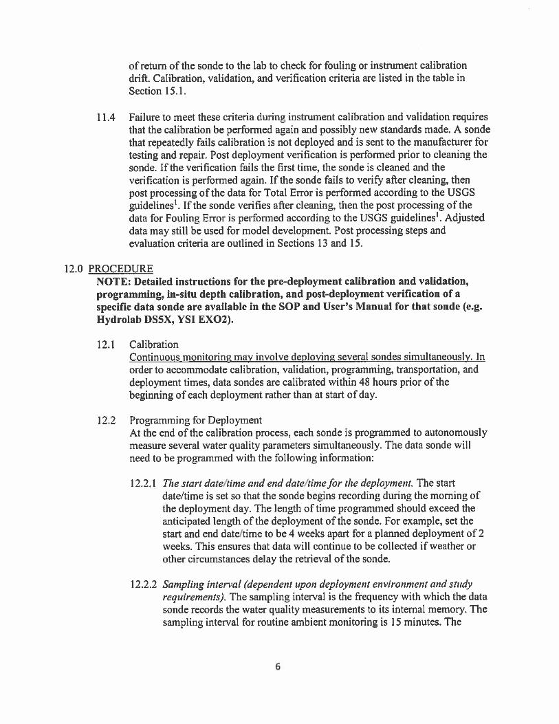


-50-
3.0 SPECIAL MONITORING AND COMPLIANCE MONITORING
3.1 Intensive Surveys and Special Water Quality Studies Special studies provide immediate and in-depth investigations targeting specific environmental problems or involve practical research that leads to a better understanding of the water quality of the State of South Carolina. The data collected are summarized and reported at the conclusion of each study. Special water quality studies are conducted as needed to determine cause and effect relationships in waterbodies where trend monitoring indicates a deterioration in environmental quality. They provide legally defensible data on damage in situations where compliance monitoring indicates violation of permits and/or water quality standards. Special water quality assessments most often target waterbodies listed on the §303(d) list of impaired waters not meeting designated uses or are requested for waterbodies having high or potentially high public water use values. There is usually a specific need or problem identified in the initial study request, such as the pollutant or biological condition resulting in a §303(d) listing. When selecting indicators for a special study, conditions that may cause or contribute to nonattainment of applicable WQS are considered. It is important to consider the potential cumulative impacts to a waterbody resulting from multiple sources of pollutants. For example, are there sources in the watershed that separately or collectively might contribute pollutants in amounts or combinations that could cause an exceedance of a water quality criterion, create toxic conditions, or accumulate in fish tissue? Principal considerations include point sources, nonpoint sources, geology/hydrology, and land-use patterns, both current and historic, and suspected pervasive pollutants that may be transported by atmospheric processes. Point sources in the watershed may contribute pollutants that cause or contribute to nonattainment of WQS. Information about the type of facility and nature of discharges can help identify potential pollutants. Point sources may have existed historically but may no longer be active. Legacy contaminants from these sources may still be present within bed sediments in the waterbody or in soils at the site. A review of current and past permittee’s NPDES permit limits and compliance history information may be included in the study design process. Nonpoint sources generally are related to land-use practices. Land use (e.g., rural, agricultural, urban, industrial) often dictates what indicators may be most suitable for water quality monitoring. To the extent possible, current and historic land-use practices in the watershed are identified. Past land-use practices may be very different from current practices, and residual pollutants may be present in the bed sediments in the water or in soils at the site. Disturbances from land-use practices or changes in land-use may aggravate already marginal natural water quality conditions. Available information about local agriculture, pesticide usage, urban/impervious surfaces, land management practices (e.g., forestry, mining), and best management practices (BMP) that would mitigate pollutant impacts are considered.

-51-
Geologic and hydrologic processes within and upstream from a waterbody generally establish background water quality conditions within the watershed. In some cases, weathering and transport processes for certain geologic areas may result in increased concentrations of metals, particularly arsenic, cadmium, mercury, and selenium. Increased concentrations may be found both in the water column and in underlying sediments. An investigation of specific environmental problems may originate as an official request from other staff from various sections of EA, to support decision making on a variety of issues. Studies may also be initiated in response to requests by private citizens or special interest groups. Once an official request to carry out a specific task has been received, Aquatic Biology Section or Surface Water Monitoring Section staff designs, receives approval from the Quality Assurance Manager (QAM), and implements the study. The results of such studies are reported primarily to the originator of the study request. In conducting practical research, the Aquatic Biology Section or Surface Water Monitoring Section generally relies on its own staff, as well as the scientific staff of other sections of EA. The Aquatic Biology Section or Surface Water Monitoring Section staff designs and implements, or coordinates if other groups are involved, such studies and reports all findings to all interested parties. Study plans for any special studies are submitted to the QAM for approval prior to sampling. All sampling and field analyses are performed according to the most current revisions of SCDHEC’s Environmental Investigations Standard Operating Procedures and Quality Assurance Manual and Procedures Manual for Stream and Wastewater Facility Flow Measurement. All laboratory analyses are performed according to the most current revisions of SCDHEC’s Procedures and Quality Control Manual for Chemistry Laboratories--Analytical Services and Laboratory Procedures Manual for Environmental Microbiology-- Analytical Services. Nonpoint source (NPS) monitoring includes both biological investigations and water quality assessments. Data collected is used for various purposes including: identifying waters not fully meeting designated uses due to NPS pollution, addressing waters currently listed on the §303(d) list, assisting in enforcement investigations, and assessing the effectiveness of best management practices (BMPs) in agricultural, silvicultural and residential areas. Water quality, biological, and habitat assessments are conducted as needed in response to complaints from the public and subsequent requests from central and regional EA personnel. Results help determine the need for enforcement action. Biological investigations typically focus on waterbodies included on the §303(d) list due to a demonstrated impairment to the biological community or excursions relative to metals, pH or dissolved oxygen (DO) levels. Sites are re-assessed for impairment and possible causes may be explored. To maximize effectiveness, these investigations are timed to complement the macroinvertebrate trend-monitoring effort. Sites listed for impairment due to elevated E.coli bacteria levels are also targeted for special sampling. The accompanying effort to identify potential sources typically involves intensive sampling combined with consideration of relevant point sources, nonpoint sources, adjacent land

-52-
use, and shoreline reconnaissance.
3.1.1 Documenting Water Quality Improvement Efforts Section 319 of the Clean Water Act deals with the control and reduction of nonpoint source pollutants, and includes the award of annual grants to states from EPA. These grant funds are primarily used to implement Total Maximum Daily Loads (TMDLs) and watershed-based plans for impaired waters. SCDHEC passes a portion of its annual 319 grant to outside groups through a competitive process to carry out the implementation of these plans. Implementation includes the installation of an array of structural and non-structural Best Management Practices (BMPs) designed to reduce or remove nonpoint source contributions within a watershed. The ultimate goal is to remove the impairment for the specific pollutant for which the plan was developed. Monitoring is a crucial component of determining the initial impairment as well as the documenting potential water quality improvements resulting from such an implementation effort. Because TMDLs and watershed-based plans are developed based on SCDHEC water quality monitoring sites, project success must also be based on data collected from those sites. SCDHEC uses 319 funds to pay for the staff and analysis costs related to this monitoring effort. Often there are sites of interest within the project areas that are not active throughout the duration of the project period as part of the Ambient Surface Water Physical & Chemical Monitoring Network. In these instances, staff in the Aquatic Biology Section are responsible for data collection at these sites. SCDHEC has committed to EPA that all 319-funded implementation projects will be monitored at the associated water quality monitoring site(s) for the life of the project, plus a minimum of one additional year. The data collected are also used to develop project success stories at the request of EPA. For 2018, the sites being collected can be found in Appendix J. At a federal level, EPA and the US Department of Agricultural Natural Resources Conservation Service (NRCS) have partnered together to direct funding in specific watersheds to improve water quality. The funds are a specific set-aside to the NRCS Environmental Quality Improvement Program (EQIP) and are known as the National Water Quality Initiative, or NWQI. Working together, state NPS and state NRCS programs selected specific watersheds where extensive EQIP funds for agricultural BMPs would be directed. Those watersheds are currently Big Swamp, Little Saluda River, Polk Swamp and Chinquapin Creek. SCDHEC and NRCS are in the process of reviewing the current NWQI watersheds and potentially shifting to one or more new watersheds. Once finalized, updates, if any, to NWQI watersheds will be reflected in future submittals. State NPS programs are required to commit to monitor at least one watershed to help determine the effectiveness of this program, similar to monitoring associated with 319 implementation efforts discussed above. SCDHEC has elected to monitor all watersheds; monthly monitoring will occur at each station (listed in Appendix J) for an array of water quality parameters. Study plans for these specific monitoring responsibilities are submitted to the QAM annually for approval prior to sampling. All sampling and field analyses are performed according to the most current revision of SCDHEC’s Environmental Investigations Standard Operating Procedures and Quality Assurance Manual) and Procedures Manual for Stream and Wastewater Facility Flow

-53-
Measurement. All laboratory analyses are performed according to the most current revisions of SCDHEC’s Procedures and Quality Control Manual for Chemistry Laboratories--Analytical Services and Laboratory Procedures Manual for Environmental Microbiology-- Analytical Services.
3.2 Wetlands Monitoring SCDHEC has not traditionally conducted ambient monitoring in wetlands, nor do we maintain a network of wetlands sites that are routinely visited and sampled for traditional water quality parameters such as dissolved oxygen, bacteria, nutrients, metals, and organics. However, we have conducted limited monitoring of wetlands and have required limited compliance monitoring by permittees. 3.2.1 Compliance Monitoring When SCDHEC issues a Water Quality Certification for unavoidable impacts to wetlands, the Certification will often have a requirement for compensatory mitigation provided through a mitigation bank or a permittee responsible mitigation site. Both types of sites generally have monitoring requirements to demonstrate success. Typical monitoring consists of requiring each compensation site to be evaluated on a site-specific basis and, if needed, hydrological and vegetative monitoring is required to show the creation, restoration, or enhancement of an areas hydrology or vegetation. Additionally, certain 401 Water Quality Certifications require wetlands compliance monitoring to ensure that the predicted impacts are within expected ranges. Further, SCDHEC has issued NPDES permits to several wastewater treatment plants where wetlands are the final receiving water. In order to determine if there are detrimental effects of the wastewater on the wetlands, SCDHEC imposes monitoring of the wetland through special conditions of the NPDES permit. Typically, this monitoring consists of ground and surface water quality, vegetation, and hydrological parameters, which are measured bi-annually and reported in an annual report, based on site-specific considerations. 3.2.2 Program Needs If the State were to implement an ambient monitoring program for wetlands, it would be important to have wetlands water quality standards in place. Perhaps a more difficult obstacle is the resources required to maintain an ambient wetland monitoring program. For this to occur SCDHEC would need additional trained staff to conduct wetland monitoring and assess data.
3.3 Wastewater Discharge Compliance Monitoring All wastewater dischargers to the surface waters of the State of South Carolina must obtain a National Pollutant Discharge Elimination System (NPDES) Permit. This applies to all public and privately owned wastewater treatment facilities. The NPDES permit sets limits for physical and chemical characteristics of the facility effluent to protect the water quality of the receiving waterbody. A number of publicly owned treatment works (POTWs) have requirements in their NPDES permits to implement an approved pretreatment program to regulate industrial

-54-
discharges, as well. The purpose of the facility monitoring program is to ensure that permitted effluent limitations are met and properly reported to the State, to ensure proper operation and maintenance of wastewater treatment facilities, and to ensure that the public's concerns and complaints concerning wastewater dischargers are answered effectively. This monitoring function encompasses the review of NPDES permit compliance schedules, review of NPDES self-monitoring data, inspection and evaluation of wastewater treatment facilities, collection and analysis of samples at wastewater treatment facilities, and investigation of complaints concerning wastewater treatment facilities or stream quality throughout the State. The information gathered by the facility monitoring program is used by the State and EPA to determine permit compliance and to support enforcement actions. Inspection results are also useful in grant reviews and permitting functions. Facility monitoring is often included in water quality assessments, as well. Certain inspections are used to improve permittee performance through improved data quality and the provision of technical assistance. Of course, the facility monitoring program also serves to maintain a regulatory presence in the State. The following sections detail the various means at our disposal to accomplish these goals. 3.3.1 Compliance Schedule Tracking Schedules of Compliance for permits and administrative orders are maintained in EFIS as well as a data file designated as the Integrated Compliance Information System or ICIS. ICIS was developed by EPA to track permit compliance and the State has assumed responsibility for maintaining and updating the ICIS database. Compliance staff in the Permit and Data Administration Section conduct a monthly review of permit compliance schedules via reports generated in both EFIS and ICIS. Permit schedule due dates are satisfied in both EFIS and ICIS, and any noncompliance is addressed by both formal and informal enforcement actions. 3.3.2 NPDES Self-Monitoring All NPDES permittees are required to collect and analyze samples of their own effluent at regular intervals for specific permit parameters. Self-monitoring data are transmitted to the Water Pollution Control Division by the permittee in the form of a Discharge Monitoring Report (DMR). The EFIS database is utilized to track NPDES self-monitoring information. For NPDES self-monitoring this system is utilized to assure timely submission of DMRs by dischargers and recording of reported values by effluent parameter for each NPDES permit. DMR files are reviewed on a monthly basis to determine appropriate enforcement action required for failing to submit discharge monitoring reports and/or for significant effluent violations. In addition, permittees are required to report non-compliance covering significant permit violations as they occur. These noncompliance reports, submitted in advance of DMRs, provide DHEC the opportunity to determine if there may be effluent problems requiring immediate investigations. After being logged, reviewed, and entered into EFIS and ICIS by the

-55-
Permit and Data Administration Section DMRs are sent to the NPDES file for the particular facility to provide a readily available source of effluent data. 3.3.3 Federal Compliance Evaluation Inspections - (CEI) The Compliance Evaluation Inspection (CEI) is a non-sampling inspection designed to verify permittee compliance with applicable permit self-monitoring requirements and compliance schedules. This inspection is based on record reviews and visual observations and evaluations of the treatment facilities, effluents, receiving waters, etc. The CEI is used for both chemical and biological self-monitoring programs. The Inspection The inspection is comprised of an evaluation of the physical equipment, laboratory records, discharge monitoring reports, and the operational records of the facility. A narrative report is generated summarizing the findings in each of 9 major areas evaluated during the inspection. The 9 major areas evaluated are as follows: a. Permit Verification - verification of name, address, discharge(s), receiving waters, etc.,
contained in the permit. b. Records and Reports - determination of compliance with record keeping and reporting
requirements stipulated in the permit. c. Facility Site Review - examination of areas on the permittee's premises where pollutants
are generated, pumped, conveyed, treated, stored or disposed. d. Flow Measurement - installation, calibration and accuracy of flow measurement system
are determined. e. Compliance Schedules - where applicable. f. Self-Monitoring Program - sampling frequency, type(s), parameters monitored, parameter
limitations, sampling methodology are examined for compliance with permit. g. Operation and Maintenance - a visual inspection of unit processes is conducted. h. Sludge Disposal - the permittee's sludge management and disposal methods are
evaluated. Laboratory – a verification of lab certification for the parameters that are analyzed is conducted along with a verification and inspection of field meters. Procedure The accepted procedure for conducting the Compliance Evaluation Inspection is as follows:

-56-
a. The inspection is conducted unannounced or with limited notification. If contacted ahead
of time the permittee is instructed to have available all pertinent records for review. b. The evaluator completely fills out the appropriate checklists for each major section
evaluated during the inspection. c. After completion and review of the inspection report, the narrative report is forwarded to
the Water Pollution Compliance Section for review, EFIS and ICIS entry, and distribution.
Follow-up Follow-up evaluations will be made on deficiencies noted in initial Compliance Evaluation Inspections. The follow-up is as follows: a. A letter emphasizing the deficiencies noted will be sent along with the initial report to the
owner. This letter will point out problems found during the inspection and request corrections or plans for corrections. This letter requires a response within fifteen (15) days. Responses are reviewed by Central Office and Regional staff.
b. Based on the review, the Region may be requested to initiate a follow-up field inspection.
The actual follow-up evaluation can be comprised of a routine Facility Evaluation Inspection (FEI) with the emphasis placed on the status of necessary corrective actions to problems noted in the Compliance Evaluation Inspection report.
c. If corrective action on the initially noted deficiencies has not been taken, the Region
should then follow established Enforcement Procedures. 3.3.4 Operation and Maintenance Inspections These evaluations are designed to ensure that wastewater treatment facilities are being properly operated and maintained in accordance with State and Federal regulations. The Operation and Maintenance Inspections (O&M) are periodic performed strategically at wastewater treatment facilities in the State. The O&M involves the actual visit to the treatment plant site, a visual inspection of the facility, and a brief records review. The inspector determines if the facility and the equipment involved are properly operated and maintained. Certain limited physical and chemical tests are run on the effluent to help the evaluator determine the plant's efficiency and effectiveness of operation. The following parameters are collected: Effluent Temperature pH

-57-
Dissolved oxygen Chlorine residual The inspection program is not a totally regulatory program. The inspection results are discussed with the operator, when possible, to let him know what corrective measures, if any, are needed. Procedure The following is the procedure followed for completing a routine facility evaluation: 1. Plan work schedule ahead of visits. 2. Review file (for previous evaluations, inspections, orders, enforcement action, etc.) and
make notes of items that were unsatisfactory on previous visits and carry file or parts needed.
3. Review the permit completely. 4. Inform appropriate person (immediate supervisor) of your planned daily visits. 5. Make every effort possible to contact owner or operator of the facility to be evaluated to
inform him of inspection plans. The owner or operator is expected to accompany the evaluator during the evaluation.
6. If you are unable to contact owner or operator, obtain access and permission to evaluate
facility. 7. Make appropriate observations and field tests to determine which processes are
satisfactory or unsatisfactory. The facility evaluator must make observations and tests as indicated on the evaluation forms. Effluent tests are mandatory.
8. Review the facility’s monitoring and permit compliance records. Make comments as
appropriate. 9. Reports must be completely filled out and signed by person making evaluation. Make
appropriate remarks and recommendations. Deficiencies should be listed in remarks section of inspection form.
10. Record name of person you contacted. Have him sign inspection form when possible. 11. Inform the owner or operator of findings and ask him to make any needed corrections. 12. If samples are collected for laboratory analysis, coordination should be made with
laboratory and results should be included with evaluation report. The inspector's reports are reviewed in the region and central office before the copies are

-58-
distributed. One copy of the inspection is sent to the facility owner, one copy is kept in the regional office, and the original is sent to Central Office to be reviewed, logged and sent to the permittee and Central Files. Inspection results are entered into the EFIS and into ICIS. Suspense files on problem facilities should be maintained in the Regional Office. The facility evaluators should also keep a list of facilities that need to be sampled for possible enforcement action. Those lists should be forwarded to the regional monitoring supervisor periodically to be scheduled for sampling. If the regional staff has exhausted its resources in getting the facility in proper operational condition, then all necessary information concerning the facility can be addressed at a meeting at the Regional level. Necessary enforcement action should follow the established enforcement procedures until compliance is achieved. 3.3.5 Compliance Sampling Inspections Compliance sampling inspections are performed to determine if wastewater treatment facilities are operating as permitted and designed, to collect data for comparison with self-monitoring data, and to support enforcement action. Sampling of facilities are assigned the following priorities: 1. Federal Compliance Sampling Inspections. 2. Enforcement Section or EPA requests. 3. Engineering Division request. 4. Regional personnel request. 5. Routine sampling. Federal Compliance Sampling Inspections The Federal Compliance Sampling Inspection requires that an inspection of the facility be conducted by the EA regional facility evaluator. This inspection is to be made on one of the three (3) days required for effluent sampling. A list of the dischargers receiving Federal Compliance Sampling Inspections for each EA region appears in Appendix K. A detailed inspection of the facility's records, regular operation and maintenance, flow measurement devices, sampling procedures, laboratory, and other permit conditions for compliance verification is conducted by the district facility evaluator. Effluent sampling is included in the Federal Compliance Sampling Inspection. Procedures for sampling the effluent are the same as discussed below for State Minor Compliance Sampling Inspections. After the sampling and inspection has been completed, the laboratory results are mailed to the Analytical Services Division. The narrative reports are entered in EFIS to be processed by the Water Pollution Compliance Section.

-59-
Requested Sampling Inspections Upon receiving a request for compliance sampling, a review of historical data and the NPDES permit regulations for the facility is conducted to determine if previous sampling data will be sufficient. If additional sampling is needed, a request, including all parameters desired is sent to the Regional Office responsible for sampling that facility. This is coordinated by personnel in the Central Office Water Pollution Compliance Section. A written request for the sampling is then made to the Regional monitoring supervisor. Sampling and reporting procedures are the same as for State Minor Compliance Sampling Inspections (see below). State Minor Compliance Sampling Inspections State Minor Compliance Sampling Inspection schedules are established by the Regional monitoring supervisor. An annual schedule that outlines the month and facility that will be sampled is submitted to the Water Pollution Compliance Section. The NPDES permit should be reviewed to determine the composite sampling frequency. For those facilities whose composite sample frequency is once per month or less, a one day composite sample may be collected. Fecal coliform and field parameters should be collected on the day the composite sampler and flow meter are set up, as well as the following day when the composite sample is collected. An updated list of facilities requiring only one day of sampling will be provided to the regional monitoring supervisor annually. If the NPDES permit requires composite sampling for any parameter at a frequency of greater than once per month, then two days of composite sampling must be conducted. The flow recorder and automatic sampler is set up on the initial sampling day. Fecal coliform and field samples should be collected on the day the composite sampler is set up and on each of the two following days on which composite samples are collected. In addition to the effluent total residual chlorine (TRC), the chlorine concentration prior to de-chlorination should be measured if the effluent TRC is measured to be <0.1 mg/l. These results should be reported on DHEC form 2185, on the line following Sulfides. The monitoring personnel should write Cl2 in CC on the line below Sulfides, and 66666 as the STORET code. Samples collected will be taken to the field laboratory for analyses. Samples are collected according to the NPDES permit requirements and the most current revision of SCDHEC's Environmental Investigations Standard Operating Procedures and Quality Assurance Manual. When sampling these facilities with General Permits (SCGs), the specific type of discharge, as identified in the General Permit, must be written in the space labeled TYPE on DHEC form 2185. The correct pipe number, as identified in the General Permit, must also be written in the appropriate space on DHEC form 2185. After completion of the sample analyses the laboratory data sheets are sent to the Analytical Services Division which forwards them to the Water Pollution Compliance Section to be verified, reviewed, and logged in.

-60-
The data are edited and a compliance monitoring report (CMR) is generated. The data are compared with the NPDES permit limits to determine if any permit violations occurred. A formal report is then compiled by Water Pollution Compliance Section personnel and sent to the responsible facility official. Copies are transmitted to the Central Office files, the Region, and EPA (majors). A written response to the agency for any significant permit violation is usually requested. 3.3.6 Compliance Biological Inspections For the purpose of State compliance with the "106 Work Plan" agreement with the EPA, Compliance Biological inspections (CBIs) will be conducted on 10% of major dischargers in conjunction with compliance sampling inspections (CSIs) being conducted by district offices. Discharges to be inspected are selected based on self-monitoring data, requests by department personnel, requests by other parties, and in conjunction with the Federal CSI schedule. Facility records are inspected at the time of Federal and State CSIs. Toxicity test reports and laboratory bench sheets are reviewed to determine if wastewater treatment facilities are in compliance with their NPDES permit WET limits, and to determine the need for permit modifications or enforcement action. CBI’s are conducted on 10% of all major facilities that have WET requirements, annually. 3.3.7. Performance Audit Inspections The Performance Audit Inspection (PAI) is used to evaluate a permittee's self-monitoring program. The purpose of the inspection is not only to determine the quality of self-monitoring but also to assess the reliability of the data reported by the permittee. A field evaluation is conducted which includes an evaluation of flow measurement, sampling, records, and operation and maintenance. Water Pollution Compliance Section personnel perform this part of the PAI. A laboratory evaluation is also conducted which includes a review of analytical methods and procedures, sample handling and preservation, quality assurance, and records. The EA Laboratory Certification Section performs this part of the PAI. 3.3.8 Technical Assistance Evaluations The Technical Assistance Evaluation (TAE) focuses primarily on wastewater treatment facilities that are not in compliance with their permit requirements. The purpose of the evaluation can be to either evaluate causes of noncompliance in support of enforcement actions or to assist those facilities without self-diagnostic capability. The evaluation identifies major plant deficiencies in operation, design, and/or construction. Other aspects of the permit program such as the permittee's self-monitoring program can be included in the technical evaluation if deemed necessary. These evaluations are performed by the Water Pollution Compliance Section and are done on an as needed basis. 3.3.9 Pretreatment Program Audit and/or Inspection The Pretreatment Program Audit and/or Inspection is conducted according to the schedule

-61-
submitted to USEPA which assures that all approved active pretreatment programs receive at least one Audit in each 5 year permit term and at least 2 Inspections during the 5 year permit term. The purpose of the audit and/or inspection is to determine whether the program is being adequately implemented by the POTW. The audit would include a review of the following items: 1. POTW treatment facility background information. 2. POTW pretreatment program background information. 3. Evaluation of POTW pretreatment program changes. 4. Legal authority evaluation. 5. Application of pretreatment standards. 6. Compliance Monitoring and Inspections by POTW personnel in self-monitoring
sampling. 7. Compliance Monitoring and Enforcement - industrial user file review. 8. Enforcement Actions by POTW. 9. Data management and public participation. 10. Program resources review. The Water Pollution Compliance Section conducts Pretreatment Program Audits or Pretreatment Compliance Inspections on the majority of POTWs with a pretreatment program. Pretreatment follow-up inspections are also performed as appropriate. The Pretreatment Program Audits are coordinated with POTW facilities whose permit expires in the forthcoming year. During the audit, the inspector observes the industrial user inspection procedures and tours the industrial facility’s production process to identify sources of wastewater. A report of the findings is forwarded to the POTW for corrective actions where appropriate.
3.4 Complaint Investigations And Fish Kill Program 3.4.1. Complaint Investigations Purpose The primary purpose for the investigation of complaints is to determine whether or not a pollution or public health threat exists, and to require corrective action where problems are found. Since customer service is a primary focus of the Department, complaint response receives a very high priority.

-62-
Strategy Field staff located in the four regions across the state provide the Department with prompt response, follow-up, and documentation of all complaints received either directly from the public or through other sources. Voluntary correction of identified problems is often obtained but enforcement action may be taken when necessary under the Pollution Control Act and/or other applicable regulations and laws. Safety When investigating a complaint, staff safety is top priority. Step one of a complaint investigation should always be for staff to attempt to make contact with the responsible party/property owner prior to visiting the property. A simple phone call can preemptively diffuse a tense or dangerous situation and can alert staff to the need for backup or law enforcement involvement without ever stepping foot on the property. Coworkers with prior knowledge of the area and online resources such as county maps, aerial photography, and the SC Case Record Search (http://www.judicial.state.sc.us/casesearch/) tool can help identify potential dangers before leaving the office. No two investigations are ever the same and no training can fully prepare staff for what they may encounter in the field. The key is for staff to be aware of their surroundings and to have a plan for the unexpected. Field staff typically work alone and have to make personal safety judgment calls. Staff are expected to stop any work task that they believe to be unsafe. If staff are uncomfortable with a situation they encounter in the field and fear for their personal welfare or safety, they should politely excuse themselves, leave the property, and contact their supervisor as soon as it is safe to do so. Complaint Investigation Procedure When possible, complaints should be directed to one of the regional offices that provides coverage over the county in which the complaint is noted (see table 1). Complaints received in the central office will be referred to the applicable regional office for response. Although, complaint investigation and proper documentation to the file are the responsibility of the regional office, central office assistance is available upon request. Discretion and the need to exercise professional judgment are recognized as key components in complaint investigations. The following guidelines are offered to ensure adequate documentation of complaint investigations: 1. All complaints must be entered into the Incidents Module of the EFIS tracking system
upon receipt. This will provide timely documentation of all complaint investigations. Regional staff must contact the complainant by close of business the next business day after the regional office receives a complaint in order to let the complainant know the complaint has been received and will be investigated. The Department has set an initial response time of 48 hours with a five day goal to resolve the complaint.

-63-
2. EFIS should be updated no later than COB the next business day after an action is taken (site visit, phone call, etc.) during a complaint investigation. All actions and all communications associated with a complaint investigation, to include final contact with the complainant, must be documented in EFIS. Reminder: If a complainant wishes to remain “Anonymous,” their contact information should not be captured and they must be informed that they cannot be contacted with investigation results.
3. Follow up communication with the complainant or facility/property owner may be in
person, by phone, e-mail, or in writing but must be documented in EFIS. Some complaints, by their nature, may necessitate a letter to the complainant or facility/property owner covering the results of the Department’s investigations and corrective measures required/taken. (Copies of such letters must be entered into EFIS and stored in the appropriate program files). Poor or incomplete documentation may prevent the Department from taking proper enforcement action.
4. To ensure that copies of letters and other documentation can be properly filed, they
should be sent to the attention of the appropriate Enforcement Division in the Bureau of Water.
5. If staff are verbally denied access to a property or if the property is posted with “No
Trespassing” or “Do Not Enter” signs, a magistrate’s warrant to enter and inspect the property may need to be obtained. When access is denied, the investigating staff person should immediately contact their supervisor when it is safe to do so. A magistrate may need to be contacted in order to obtain access but a magistrate should not be contacted without involving both regional and BEHS management. The program may also need to be involved prior to contacting a magistrate. Once a warrant is issued, Department staff will conduct the investigation and document the results in writing to the magistrate and the program area. As always, EFIS should reflect all actions taken.

-64-
Table 3. Office of Environmental Affairs (EA) Regional Directory
Upstate EA Anderson (Anderson, Oconee Counties)
220 McGee Road Anderson, SC 29621
Phone: (864) 260-5585 Fax: (864) 222-3923
Upstate EA Greenwood (Abbeville, Greenwood, Laurens, McCormick Counties)
1736 South Main Street Greenwood, SC 29646
Phone: (864) 227-5915 Fax: (864) 942-3680
Upstate EA Greenville (Greenville, Pickens Counties)
200 University Ridge Greenville, SC 29601
Phone: (864) 372-3273 Fax: (864) 282-4371
Upstate EA Spartanburg (Cherokee, Spartanburg, Union Counties)
151 East Wood Street Spartanburg, SC 29303
Phone: (864) 596-3327 Fax: (864) 596-3920
Midlands EA Columbia (Fairfield, Lexington, Newberry, Richland Counties)
State Park Health Center 8500 Farrow Road, Bldg. 12 Columbia, SC 29203
Phone: (803) 896-0620 Fax: (803) 896-0617
Midlands EA Lancaster (Chester, Lancaster, York Counties)
2475 DHEC Road Lancaster, SC 29720
Phone: (803) 285-7461 Fax: (803) 285-5594
Midlands EA Aiken (Aiken, Barnwell, Edgefield, Saluda Counties)
206 Beaufort Street, NE Aiken, SC 29801
Phone: (803) 642-1637 Fax: (803) 643-4027
Pee Dee EA Florence (Chesterfield, Darlington, Dillon, Florence, Marion, Marlboro Counties)
145 E. Cheves Street Florence, SC 29506
Phone: (843) 661-4825 Fax: (843) 661-4858
Pee Dee EA Sumter (Clarendon, Kershaw, Lee, Sumter Counties)
105 N. Magnolia Street Sumter, SC 29150
Phone: (803) 778-6548 Fax: (803) 934-2938
Pee Dee EA Myrtle Beach (Georgetown, Horry, Williamsburg Counties)
927 Shine Avenue Myrtle Beach, SC 29577
Phone: (843) 238-4378 Fax: (843) 238-4518
Lowcountry EA Charleston (Berkeley, Charleston, Dorchester Counties)
1362 McMillan Avenue, Suite 300 Charleston, SC 29405
Phone: (843) 953-0150 Fax: (843) 953-0151
Lowcountry EA Beaufort (Beaufort, Colleton, Hampton, Jasper Counties)
104 Parker Drive Beaufort, SC 29906
Phone: (843) 846-1030 Fax: (843) 846-0604
Lowcountry EA Orangeburg (Allendale, Bamberg, Calhoun, Orangeburg, Counties)
1550 Carolina Avenue Orangeburg, SC 29115
Phone: (803) 533-5490 Fax: (803) 268-5784

-65-
3.4.2 Fish Kill Program The Emergency Response Section (ERS) of the Bureau of Environment Health Services (BEHS) of the South Carolina Department of Health and Environmental Control (DHEC) was established to coordinate emergency response activities during oil spills, chemical releases, and fish kills for the Environmental Affairs (EA). The ERS is responsible for the coordination of EA responses regarding emergencies related to water, air, drinking water, solid waste and waste-water. The ERS is also responsible for response and technical assistance regarding other potential threats to environmental health. The data related to fish kill incidents is collected so that BEHS may coordinate an effective response to acute water quality problems. This data is also available to other bureaus within DHEC for the evaluation of trends regarding the mismanagement of pesticide and herbicide applications, point and nonpoint pollution sources, natural phenomena that may result in environmental stress and assessments regarding environmentally sensitive areas. Additionally, this data is available to interested citizens and private parties and other government agencies (i.e.: the South Carolina Department of Natural Resources [DNR] and the National Oceanic and Atmospheric Administration [NOAA]). All reports regarding fish kill incidents are entered into and maintained within the DHEC Environmental Facility Information System (EFIS). A rapid initial response is often essential to an effective investigation regarding a fish mortality incident. Therefore, the 24-hour/toll-free Emergency Response Telephone Number, 888-481-0125, is available for the reception of reports regarding the occurrence of fish kills. Monday through Friday, between the hours of 8:30 a.m. and 5:00 p.m., this number is managed directly by the ERS Central Office Duty Officer (CODO). The CODO coordinates response activities in cooperation with the Regional On-Scene Coordinator (ROSC), of the appropriate EA Regional Office, hereafter referred to as Field Office, where the incident occurred. After business hours and on weekends, the Emergency Response Telephone Number is managed by the operators in the State Warning Point (SWP) which operates at the South Carolina Emergency Management Division (SCEMD). The SWP operators then communicate the information in the initial report to the CODO. The CODO will coordinate a response to the incident. Additionally, fish kill incidents reported directly to the REGION are also communicated to the CODO in order to ensure the effective coordination of all investigative responses. During an investigative response to a fish kill report, a field assessment is conducted to collect relevant information. This information will assist in determining the level of response required. In cases where an investigator is deployed to the incident site, the ROSC is the person who conducts the initial assessment and determines what response actions are necessary. The responsibilities associated with the position of ROSC are assigned to personnel within each of the 13 Field Offices. Each Field Office maintains the equipment necessary to conduct fish kill investigations; including, but not limited to: ice chests, global positioning system cameras, 800 MHz radios, and specimen preservatives and containers for bacteriological, biological and chemical samples. Because a legal liability may be associated with a fish kill incident, each Field Office also possesses the most current version of the DHEC Field Manual for the Investigation of Fish Kills. This document provides procedures for conducting fish kill investigations. The DHEC Field Manual for

-66-
the Investigation of Fish Kills also provides procedures for response actions regarding harmful algal blooms. Additionally, EA personnel frequently participate in educational opportunities related to fish kill incidents in order to increase their knowledge of the conditions and dynamics and to improve the efficacy of DHEC investigative responses. The distribution of responsibilities throughout the Field Offices enables an efficient response by decreasing the distance between the ROSC and the incident location; this reduces response time and increases the possibility of determining the cause of the fish kill. Field Office personnel, ROSCs, are often familiar with the incident locations and local resources available in the area. This familiarity also lends itself to an increased level of awareness and understanding of the variables present in the local ecosystem. Each Field Office collaborates with the local DNR personnel when conducting fish kill investigations. The familiarity between the DHEC EA personnel and local DNR personnel is increased through the frequent coordination and responses at the local level. The DNR Wildlife and Freshwater Fisheries Division participates in the management of fish kill incidents that occur in freshwater conditions. The DNR Marine Resources Division, located in Charleston, participates in the management of fish kill events that occur in saline waters. The DNR Law Enforcement Division also maintains a 24-hour/toll-free telephone number, 800-922-5431, for emergencies requiring immediate law enforcement assistance. For cases in which a fish kill incident is potentially related to a release of fertilizers, herbicides or pesticides, the DHEC personnel coordinate response actions with personnel from the Clemson University Department of Fertilizer and Pesticide Control. If such an official is unavailable, the ERS Fish Kill Coordinator is notified of the event. If necessary, samples may be delivered to the DHEC Analytical Services Division (ASD). The ASD is capable of conducting a laboratory analysis of samples collected during a fish kill investigation; with the exception of biological specimens. The extent of any specific fish kill investigation is dependent upon a number of variables. Those variables include, but are not limited to, the number and types of fish affected, the characteristics of the body of water and the resources available for response actions. Although delayed reporting of a fish kill event can diminish the ability to determine an outcome, an investigation is conducted to identify potential issues related to environmental health regardless of the length of the time that has elapsed since the incident occurred. Fish mortality incidents may result from a variety of natural and unnatural causes. The investigation into a given fish kill should continue until a cause is identified or until the significance of all potential environmental health threats, such as a contamination resulting from a release of chemicals, oil or other pollutants, is eliminated. For cases in which the cause of a fish kill is determined to be related to human activities, a report is submitted to the Division of Water Monitoring, Assessment and Protection of the EA Bureau of Water for potential enforcement actions regarding relevant regulations.

-67-
3.5 Public Water Systems Monitoring The monitoring schedules and requirements are included in the National Primary Drinking Water Regulations of the Safe Drinking Water Act as amended in 1986 for Phases I, II, IIB, and V. Also, included in this Act are the Lead and Copper Rule, Revised Total Coliform Rule, and the Surface Water Treatment Rule. The enclosed numbers are a summary of the required drinking water monitoring for the CY 2018. A description of the sampling compliance cycles and monitoring parameters is included to show where time and effort are focused. The waivers, scheduling, collection, shipment, and analyses are conducted by the South Carolina Department of Health and Environmental Control (Department) Bureau of Water staff, Analytical Services staff, and contracted private laboratories. 3.5.1 Microbiological Required and Repeat Monitoring: Distribution Monitoring The microbiological monitoring program is based on the Revised Total Coliform Rule and Groundwater Rule. The Revised Total Coliform Rule (RTCR) requires all federally defined public water systems to develop a self-monitoring program for their system. The Groundwater Rule requires all federally defined systems that detect total coliform in their distribution system to collect a sample from each source in use at the time of the total coliform positive. To be classified as a federally defined public water system, the system must meet specific criteria. These criteria are as follows: 1. A Community water system services a minimum population of twenty-five (25) year-round
residents, or has at least fifteen (15) service connections in use year-round. OR
2. A Transient Non-Community water system has at least 15 service connections or serves an average of 25 or more people a day, though not the same people each day (i.e. restaurants, rest stops, campgrounds).
OR 3. A Non-Transient Non-Community water system regularly serves at least 25 of the same
people over six months per year (i.e. schools, factories, and offices). A State water system is defined as any water system that serves less than 15 service connections or regularly serves an average of less than 25 individuals daily. Department staff collects quarterly/monthly/annual samples, as required, from the distribution system of this type of water system. Repeat samples are required for each total coliform or E. coli positive routine sample as per the rule. The Department also collects, for mandated compliance monitoring, quarterly/monthly/annual bacteriological samples from the transient non-community water systems. These samples are collected as part of the services included under the Drinking Water Fees. Repeat sample sets are collected for these systems, as required in RTCR. The repeat sets consist of three distribution samples and the source samples for those source(s) in operation at the time of the total coliform or E.

-68-
coli positive routine sample. Migrant camps are monitored during the months they are in operation. Non-Routine: Distribution Monitoring of Public Water Systems Non-routine samples are special samples that may be collected due to complaints on a public water system. Department personnel will collect bacteriological samples from residences where complaints have been filed. Also, if there have been line breakages, line repairs, or extensions, samples may be collected to determine water quality and disinfection residual. Special project samples are included in the non-routine (non-required) program area. Special project samples encompass samples collected in defining an area of contamination, potential contamination, and investigations. These samples may be from public water systems or private wells. 3.5.2 Inorganic Chemicals (IOCs) Required and Repeat Monitoring: Source Monitoring Routine inorganic sample analysis includes the following compounds: arsenic, barium, cadmium, chromium, fluoride, mercury, selenium, antimony, beryllium and thallium. Inorganic monitoring applies to community systems and non-transient non-community systems. There are two schedules for IOCs: one (1) routine sample each calendar year (CY2018) for surface water systems; and one (1) routine sample every three (3) years for groundwater systems (January 2017-December 2019). Any system exceeding a Maximum Contaminant Level (MCL) shall be monitored quarterly beginning in the next quarter after the initial MCL exceedance. The quarterly monitoring may decrease if the system is reliably and consistently below the MCL to one sample at each sampling point during each compliance period for groundwater systems and one sample annually at each sampling point for surface water systems. There are currently five hundred thirty-four (534) systems being monitored for IOCs in CY2017 – CY2019. There are fifty-nine (59) surface water sources/plants and nine hundred sixty-eight (968) groundwater sources/plants being monitored for IOCs in CY2017 – CY2019. Currently there are approximately four hundred nine (409) sources/plants representing two hundred thirty-six (236) systems that will be monitored for IOCs during the CY2018. Required Lead and Copper Monitoring: Source and Distribution Monitoring Community and Non-Community Non-Transient water systems must monitor for lead and copper. Initial sampling is in the distribution system. If the initial two rounds (2 consecutive 6-month sampling periods) of sampling are below the action levels for lead (0.015 ppm) and copper (1.3 ppm), the system may be placed on reduced monitoring. Reduced monitoring is conducted on an annual basis during the months of June, July, August, and September. The system is required to collect half the number of samples of the initial round. Five (5) samples per system is the minimum number of samples that may be collected for initial and reduced monitoring. If three consecutive rounds of reduced monitoring for the system are below the action levels for both lead and copper, the system may be placed on the ultra-reduced monitoring schedule. The systems on ultra-reduced must collect a reduced sampling round once every three years. Should a water system exceed the action

-69-
level for lead, copper, or both, the water system must conduct an Optimal Corrosion Control Treatment (OCCT) study. In addition, system(s) must do water quality parameters and public education (lead only). They may continue sampling on a six-month sampling cycle. OCCT requires source monitoring for all sources within the system. A water system may continue to monitor for lead and copper during the OCCT study. If during the OCCT study period, two consecutive rounds of lead and copper monitoring are below the action levels for both lead and copper, the system may be taken off OCCT and placed on the reduced monitoring schedule. Required Nitrate and Repeat Monitoring: Source Monitoring Currently there are one thousand seventy (1070) water systems that must be monitored for nitrate. There are fifty-nine (59) surface water sources and one-thousand five hundred seventy (1570) groundwater sources/plants that must be monitored. Each public water system must be monitored on an annual basis for nitrate. Repeat monitoring frequency shall be quarterly for at least one year following any one sample in which the concentration is 50 percent or more of the MCL. The schedule may be reduced to annual monitoring after four consecutive quarterly samples are reliably and consistently less than the MCL. Migrant camps should be monitored prior to their opening. Non-Routine/Special Projects (Investigation): Source, Distribution Monitoring These samples are collected due to citizen complaints regarding a public water system or potential health hazard. These samples are not for compliance determination, but to help detect and correct any problem areas noted by the water systems' customers. These samples are part of the Department's public service commitment to investigate any public water complaint, and address them accordingly. Special project samples would be included in this area on investigative sampling. Compliance issues may be raised from the samples and actions taken accordingly to ensure no future problems. 3.5.3 Synthetic Organic Compounds (SOCs) SOCs consist of forty-nine (49) regulated and unregulated compounds. All community and non-transient non-community public water systems require an initial four (4) consecutive quarters of monitoring. If at the end of the four consecutive quarters of monitoring no contaminant had a reading of greater than or equal to the detection limit, then the source is placed on routine monitoring. Once initial monitoring has been completed a system will have its schedule adjusted. If a contaminant result is greater than or equal to the detection limit the system must continue with four additional consecutive quarters of monitoring until the sampling is reliably and consistently below the detection limit. There are three different schedules for SOCs: one (1) routine sample each calendar year (CY2018) for surface water systems; one (1) routine sample every three (3) years for groundwater systems with a population of greater than 3300 (CY2017-CY2019) and one (1) routine sample every nine (9) years for groundwater systems with a population of less than or equal to 3300 (January 2011-December 2019). Currently there are approximately three hundred twenty-one (321) sources/plants representing one hundred seventy-two (172) systems that will be monitored for SOCs

-70-
during the CY2018. 3.5.4 Volatile Organic Compounds (VOCs) VOCs consist of twenty-one (21) regulated contaminants and thirty-eight (38) unregulated contaminants. All community and non-transient non-community public water systems require an initial four (4) consecutive quarters of monitoring. If at the end of the four consecutive quarters of monitoring no contaminant had a reading of greater than 0.0005 mg/L then the source is placed on routine monitoring. Once initial monitoring has been completed a system will have its schedule adjusted. If a detection level is exceeded the system must continue with four additional consecutive quarters of monitoring until the sampling is reliably and consistently below the MCL. There are two schedules for VOCs: one (1) routine sample each calendar year (CY2018) for surface water systems; and one (1) routine sample every six (6) years for groundwater systems (January 2014-December 2019). Currently there are approximately one hundred sixty-eight (168) sources/plants representing one hundred twenty (120) systems that will be monitored for VOCs during the CY2018. Non-Routine: Source or Distribution Monitoring All non-routine VOCs would be collected on a complaint basis or as part of an investigation. These samples may be collected in coordination with landfills, gas stations, and petroleum storage tanks. The Drinking Water Monitoring Section, the EA District offices, and other Bureaus within the Agency may require special projects involving VOC samples to be collected and analyzed. 3.5.5 Total Trihalomethanes (TTHMs): Distribution Monitoring Total Trihalomethanes (TTHMs) are a byproduct of drinking water disinfection. Community water systems and Non-community, non-transient water systems utilizing treated water in whole or in part are required to monitor for TTHMs. Compliance (routine) monitoring is based upon source water type and the population served. In CY2018, approximately three hundred seventy-seven (377) water systems will be monitored for TTHMs. 3.5.6 Haloacetic Acids (HAAs): Distribution Monitoring Haloacetic Acids (HAAs) are a byproduct of drinking water disinfection. Community water systems and Non-community, non-transient water systems utilizing treated water in whole or in part are required to monitor for HAAs. Compliance (routine) monitoring is based upon source water type and the population served. In CY2018, approximately three hundred seventy-seven (377) water systems will be monitored for HAAs. 3.5.7 Radionuclides: Source Monitoring Community water systems are required to monitor for radionuclides, which include gross alpha,

-71-
radium-226, and radium-228. Radium-226 will be analyzed for based on the gross alpha level. Radium-228 will be monitored for all samples collected. Monitoring for radionuclides falls under the new Radionuclide rule which requires monitoring to be collected from the source rather than the distribution system. During CY2018 approximately two hundred twenty-four (224) sources/plants will be monitored.
Table 4. Projected Public Water System Sample Numbers for CY 2018
Microbiological 1. Required Sampling 1971 a. Repeat Sampling 510 2. Non-routine Sampling 2,000
Inorganic Chemicals (IOCs) 1. Required Inorganic Sampling 440 2. Required Lead & Copper Sampling 3,530 a. Source Sampling 50 3. Required Nitrate (routine + repeat monitoring) 1,789 4. Non-Routine Investigative Samples 200 5. Required Nitrite 143 Synthetic Organic Compounds (SOCs) 1. Benzo(a)pyrene 269 2. Semi-Volatile/Pesticides 272 3. Herbicides/Dalapon 275 4. PCB/Toxaphene 273 5. Carbamates 277 6. Glyphosate 269 7. Diquat 270 8. EDB/DBCP 277 Volatile Organic Compounds (VOCs) 1. Required 312 2. Non-Routine Samples 109 Trihalomethanes (TTHMs) Required Monitoring 2600 Haloacetic Acid (HAAs) Required Monitoring 2600 Radionuclides Required Sampling (Alpha, Radium 226/228) 224

-72-
Appendices

J-1
J. List of Special Section 319 Project and TMDL Sites Sampled by the Aquatic Biology Section

Station Station Description County Location (s) 12‐Digit HUC ReasonEQ‐3457 TWELVEMILE CREEK AT BARR RD Lexington 030501091402 319RS‐02457 TWELVEMILE CK AT S‐32‐106 Lexington 030501091402 319S‐294 TWELVEMILE CREEK AT U.S. ROUTE 378 Lexington 030501091402 319MD‐107 KINGSTON LK NR PUMP STA ON LAKESIDE DR CONWAY Horry 030402060803 319MD‐158 AT LONG ST BL OUTFALL OF CONWAY #1 POND Horry 030402060803 319RS‐04375 AT BRIDGE ON US 501 1.5 MI NW OF CONWAY Horry 030402060803 319RS‐06165 STERITT SWAMP AT BRIDGE ON UNNUMBERED DIRT RD Horry 030402060903 319E‐016 POLK SWP AT UNIMP RD S‐18‐180 2 MI S OF ST GEORGE Dorchester 030502060203 NRCS
E‐091 CHINQUAPIN CREEK AT SC 391 5.5 MI S BATESBURGAiken,
Lexington 030502030101 NRCSE‐109 POLK SWAMP AT S‐18‐19 Dorchester 030502060203 NRCSPD‐169 BIG SWP AT US 378 & SC 51 0.9 MI W OF SALEM Charleston 030502090201 319, NRCSS‐171 GROVE CK AT UN# RD BELOW J P STEVENS ESTES PLANT Greenville 030501090305 319S‐267 TRIB TO SALUDA RVR 350 FT BL W PELZER STP ON S‐23‐53 Anderson 030501090307 319S‐302 BIG CK AT S‐04‐116 Anderson 030501090306 319S‐315 MILL CK AT BENT BRIDGE RD, BL CAROLINA PLATING Greenville 030501090307 319S‐070 REEDY RVR AT U.S. 76 Laurens 030501090602 319S‐861 @ SR 64 Laurens 030501090604 319
B‐037 ENOREE RVR AT S‐42‐118 SW OF WOODRUFFLaurens,
Spartanburg 030501080106 319B‐038 LICK CK AT S‐42‐118 1 1/4 MI SW WOODRUFF Spartanburg 030501080106 319
B‐040 ENOREE RVR AT S‐30‐112Laurens,
Spartanburg 030501080106 319BE‐018 ENOREE RVR AT S‐30‐75 Spartanburg 030501080106 319B‐316 CRANE CK AT S‐40‐43 UNDER I‐20 ‐ N COLA Richland 030501060707 319B‐844 CRANE CREEK IMMEDIATELY BELOW N. CRANE CREEK Richland 030501060707 319S‐050 LITTLE SALUDA RVR AT US 378 E SALUDA Saluda 030501091104 319, NRCSS‐123 LITTLE SALUDA RVR AT S‐41‐39 5.2 MI NE SALUDA Saluda 030501091104 319, NRCSS‐178 HUFF CK AT SC 418 1.6 MI NW FORK SHOALS Greenville 030501090403 319CW‐080 TWENTYFIVE MILE CK AT S‐28‐05 3.7 MI W OF CAMDEN Kershaw 030501040207 319CW‐299 BEAR CK AT S‐40‐82 Richland 030501040206 319CW‐652 BELL BRANCH @ CO. RD 129 Kershaw 030501040207 319PD‐065 GULLEY BR AT S‐21‐13, TIMROD PARK Charleston 030502090202 319
J‐2

Station Station Description County Location (s) 12‐Digit HUC ReasonC‐005 SIX MILE CK ON US 21 S OF CAYCE Lexington 030501100104 319C‐008 CONGAREE CK AT US 21 AT CAYCE WATER INTAKE Lexington 030501100104 319RS‐14189 RICHLAND CK AT SPARTANBURG ST OFF STONE ST Greenville 030501090402 319S‐1005 RICHLAND CK AT CLEVELAND PARK DR Greenville 030501090402 319S‐1006 CONGAREE CK AT SOUTH LAKE DRIVE Richland 030501100104 319S‐981 RICHLAND CREEK AT E. NORTH ST CITY OF GREENVILLE Greenville 030501090402 319PD‐352 CHINNERS SWAMP AT GUNTERS ISLAND RD OFF S‐26‐99 Florence 030402020703 319PD‐370 BRUNSON SWAMP AT PEE DEE HWY Horry 030402040701 319PD‐702 @ SR 99 Horry 030402040806 319PD‐363 SIMPSON CREEK AT SC 905 Horry 030402060705 319PD‐362 BUCK CREEK AT SC 905 Horry 030402060703 319C‐001 GILLS CK AT BRDG ON US76‐GARNERS FERRY RD Richland 030501100203 319C‐017 GILLS CK AT SC 48 (BLUFF ROAD) Richland 030501100203 319RS‐02480 SHAW CK AT SC 191 Aiken, Edgefield 030502040107 319E‐579 SHAWS CR. AT SR 153 Aiken, Edgefield 030502040107 319E‐094 SHAW CREEK AT S‐02‐26 4.2 MI NE AIKEN Aiken, Edgefield 030502040107 319
J‐3

K-1
K. List of Facilities Requiring Federal Compliance Sampling Inspections by EA Regional Office

K-2
PLANNED CSI INSPECTIONS FOR REGION 1 - ANDERSON NPDES NAME TYPE
SC0045896 BELTON / DUCWORTH WWTP MUNIC SC0035700 PENDELTON-CLEMSON REGIONAL WWTP MUNIC
PLANNED CSI INSPECTIONS FOR REGION 1- GREENWOOD
NPDES NAME TYPE SC0040002 REWA / DURBIN CREEK WWTP MUNIC SC0020214 WARE SHOALS / DAIRY STREET WWTP MUNIC SC0000353 SAGE AUTO INTERIORS / ABBEVILLE PLT IND
PLANNED CSI INSPECTIONS FOR REGION 2 - SPARTANBURG NPDES NAME TYPE
SC0047732 SSSD / TYGER RIVER REGIONAL WWTP MUNIC SC0031551 GAFFNEY / CLARY WWTP MUNIC SC0021601 CITY OF INMAN WWTP MUNIC
PLANNED CSI INSPECTIONS FOR REGION 3 - LANCASTER
NPDES NAME TYPE SC0038156 YORK / FISHING CREEK WWTP MUNIC SC0020371 FORT MILL WWTP MUNIC
PLANNED CSI INSPECTIONS FOR REGION 3 –COLUMBIA
NPDES NAME TYPE SC0024465 BATESBURG-LEESVILLE WWTP MUNIC SC0020940
COLUMBIA / METRO WWTP MUNIC
PLANNED CSI INSPECTIONS FOR REGION 4 - FLORENCE
NPDES NAME TYPE
SC0046230 GSW&SA / CITY OF MARION WWTP MUNIC
SC0042188 DOMTAR PAPER CO / MARLBORO MILL IND
SC0025178 BENNETSVILLE WWTP MUNIC
PLANNED CSI INSPECTIONS FOR REGION 2 - GREENVILLE NPDES NAME TYPE
SC0033804 REWA PELHAM WWTP MUNIC SC0003191 MILLIKEN / ENTERPRISE PLANT IND

K-3
PLANNED CSI INSPECTIONS FOR REGION 4 – SUMTER
NPDES NAME TYPE
SC0035378 BISHOPVILLE WWTF MUNIC
SC0021032 CAMDEN WWTP MUNIC
PLANNED CSI INSPECTIONS FOR REGION 5 - AIKEN NPDES NAME TYPE
SC0024457 AIKEN PSA / HORSE CREEK WWTP MUNIC
PLANNED CSI INSPECTIONS FOR REGION 6 – MYRTLE BEACH NPDES NAME TYPE
SC0021733 GCW&SD / PAWLEYS AREA WWTP MUNIC SC0040029 CITY OF GEORGETOWN WWTP MUNIC
PLANNED CSI INSPECTIONS FOR REGION 7 - CHARLESTON NPDES NAME TYPE
SC0037541 COMM OF PW / SUMMERVILLE WWTP MUNIC SC0003441 SUN CHEMICAL / BUSHY PARK IND SC0000990 CHARGEURS WOOL (USA) INC IND
PLANNED CSI INSPECTIONS FOR REGION 8 - BEAUFORT
NPDES NAME TYPE
SC0048348 SC0046191
BJW&SA / PORT ROYAL WTR RECL FACILITY HILTON HEAD NO. 1 PSD WWTP
MUNIC MUNIC

-73-
4.0. PROGRAM EVALUATION AND PLANNING The South Carolina ambient monitoring strategy as described in this document represents a comprehensive approach to address the goals and objectives discussed in Section 1. The Strategy is updated each year, and as part of that process each program represented in the Strategy conducts a thorough review of their continuing monitoring activities. This review includes an evaluation of new initiatives and emerging issues and provides the opportunity to incorporate changes to the monitoring activities to insure that those are addressed.