strategic management plan - parks...
TRANSCRIPT

Gunbower Forest Ramsar SiteStrategic Management Plan
Department ofSustainability and Environment
Parks Victoria developed this Strategic Management Plan in conjunction with the Department of Sustainability and Environment and key stakeholders, and coordinated the public comment process on the draft document.
This report was prepared with financial support from the National Wetlands Program, under the Natural Heritage Trust.
© The State of Victoria, Department of Sustainability and Environment, 2003 This publication is copyright. Apart from any fair dealing for the purposes of private study, research, criticism or review as permitted under the Copyright Act 1968, no part may be reproduced, copied, transmitted in any form or by any means (electronic, mechanical or graphic) without the prior written permission of the State of Victoria, Department of Sustainability and Environment. All requests and enquires should be directed to the Copyright Officer, Library Information Services, Department of Sustainability and Environment, 5/250 Victoria Parade, East Melbourne, Victoria 3002. Disclaimers This publication may be of assistance to you and every effort has been made to ensure that the information in the report is accurate. Parks Victoria does not guarantee that the report is without flaw of any kind or is wholly appropriate for your particular purposes and therefore disclaims all liability for any error, loss or other consequence, which may arise from you relying on any information in this publication.
The views and opinions expressed in this document are those of the authors and do not necessarily reflect the views and opinions of the Commonwealth Government of Australia, the Federal Minister for Environment and Heritage, or the Department of the Environment and Heritage.
This report is prepared without prejudice to any negotiated or litigated outcome of any Native Title Determination Applications covering land or waters within the plan’s area. It is acknowledged that any future outcomes of Native Title Determination Applications may necessitate amendment of this report; and the implementation of this plan may require further notifications under the procedures in Division 3 Part 2 of the Native Title Act 1993 (Cwlth).
The plan is also prepared without prejudice to any future negotiated outcomes between the Government/s and Victorian Aboriginal communities. It is acknowledged that such negotiated outcomes may necessitate amendment of this plan. Published in September 2003 by the Department of Sustainability and Environment Level 14, 8 Nicholson Street, East Melbourne, Victoria Copies of this document are available at www.dse.vic.gov.au National Library of Australia Cataloguing-in-Publication entry Victoria. Department of Sustainability and Environment. Gunbower Forest Ramsar Site: Strategic Management Plan Bibliography. ISBN 1 74106 676 X Cover: River Red Gum Forest (Photograph: Parks Victoria collection) Printed on recycled paper.

STRATEGIC MANAGEMENT PLAN FOR THE GUNBOWER FOREST RAMSAR SITE PAGE II
Contents
1 INTRODUCTION 1
1.1 STRATEGIC DIRECTIONS STATEMENT 1 1.2 PURPOSE OF THE STRATEGIC MANAGEMENT PLAN 1 1.3 CONSULTATIVE FRAMEWORK 2
2 RAMSAR SITE DESCRIPTION 3
2.1 LOCATION 3 2.2 WETLAND TYPE 3 2.3 CRITERIA MET FOR RAMSAR LISTING 3 2.4 LAND TENURE AND MANAGEMENT 3 2.5 ADJACENT LAND USE 5 2.6 CATCHMENT SETTING 5 2.7 LOCAL GOVERNMENT 5
3 POLICY FRAMEWORK 7
3.1 STRATEGIES 7 3.2 MUNICIPAL STRATEGIC STATEMENTS, ZONING AND OVERLAYS 7
4 VALUES 9
4.1 WETLAND REPRESENTATIVENESS 9 4.2 FLORA AND FAUNA 9 4.3 WATERBIRDS 9 4.4 NATURAL FUNCTION 10 4.5 CULTURAL HERITAGE 10 4.6 SCENIC 10 4.7 ECONOMIC 10 4.8 EDUCATION AND INTERPRETATION 11 4.9 RECREATION AND TOURISM 11 4.10 SCIENTIFIC 11 4.11 CONDITION 11
5 MANAGEMENT OF RISKS 12
5.1 ALTERED WATER REGIMES 12 5.2 SALINITY 13 5.3 POLLUTION 13 5.4 PEST PLANTS AND ANIMALS 13 5.5 RESOURCE UTILISATION 14 5.6 RECREATION 16 5.7 EROSION 17 5.8 FIRE 17 5.9 LEVEL OF RISK TO RAMSAR VALUES 17
6 SITE MANAGEMENT STRATEGIES 19

STRATEGIC MANAGEMENT PLAN FOR THE GUNBOWER FOREST RAMSAR SITE PAGE III
REFERENCES 23
APPENDIX 1 LIST OF CONTRIBUTORS 25
APPENDIX 2 RESOURCE LIST 26
APPENDIX 3 THREATENED STATUS OF FLORA 28
APPENDIX 4 THREATENED STATUS OF FAUNA 29
APPENDIX 5 JAMBA, CAMBA AND BONN SPECIES 31
APPENDIX 6 GUNBOWER FOREST RAMSAR INFORMATION SHEET 32

STRATEGIC MANAGEMENT PLAN FOR THE GUNBOWER FOREST RAMSAR SITE PAGE 1
1 Introduction
The Strategic Management Plan for the Gunbower Forest Ramsar site is an integral component of a program to develop a comprehensive management framework for Victoria’s Wetlands of International Importance (or ‘Ramsar sites’) listed under the Convention on Wetlands (Ramsar, Iran, 1971). The primary goal of the management framework is to maintain the ecological character of Victoria’s Ramsar sites through conservation and wise use.
1.1 Strategic Directions Statement
The Strategic Directions Statement establishes Management Objectives for Victoria’s Ramsar sites and Statewide Management Strategies to achieve these objectives (NRE 2002a). The Strategic Management Plans for the individual Victorian Ramsar sites apply the Management Objectives and Statewide Management Strategies, promoting a range of specific management actions that will maintain, and in some cases restore, the ecological character of the sites. Individual plans cover 10 of Victoria’s 11 Ramsar sites. Victoria’s eleventh Ramsar site, the Edithvale-Seaford Wetlands, was listed in 2001 and is covered by a separate management plan. A diagram of the framework and related documents is shown below in Figure 1.1.
The Strategic Directions Statement provides the overarching policy framework for managing Ramsar sites in Victoria. It establishes Management Objectives for Ramsar site management across the State, which are then translated to the site-specific level by each of the Strategic Management Plans. The Management Objectives outlined by the Strategic Directions Statement are as follows:
1. Increase the scientific understanding of wetland ecosystems and their management requirements.
2. Maintain or seek to restore appropriate water regimes.
3. Address adverse processes and activities.
4. Manage Ramsar sites within an integrated catchment management framework.
5. Manage resource utilisation on a sustainable basis.
6. Protect, and where appropriate enhance, ecosystem processes, habitats and species.
7. Encourage strong partnerships between management agencies.
8. Promote community awareness and understanding and provide opportunities for involvement in management.
9. Ensure recreational use is consistent with the protection of natural and cultural values.
10. Develop ongoing consistent programs to monitor ecological character.
The Strategic Directions Statement also provides background information on the suite of relevant international conventions, as well as related Commonwealth and State policy and legislation, which directs and supports the management of Ramsar sites. The Strategic Directions Statement and Strategic Management Plans are therefore intended to be read as complementary documents.
1.2 Purpose of the Strategic Management Plan
The primary purpose of the Strategic Management Plan (SMP) for the Gunbower Forest Ramsar site is to facilitate conservation and wise use of the site so as to maintain, and where practical restore, the ecological values for which it is recognised as a Ramsar wetland. This will be achieved by implementing site-specific management strategies under each of the key objectives (derived from the Strategic Directions Statement).
The SMP for the Gunbower Forest Ramsar site provides management agencies and stakeholders with an appropriate management framework and the necessary information to ensure that decisions regarding land use and development, and ongoing management are made with full regard for wetland values in environmental, social and economic terms.
Figure 1.1 Framework for the strategic management of Victoria’s Ramsar sites
STRATEGIC DIRECTIONSSTATEMENT FOR
VICTORIA’S RAMSAR SITES
CORNERINLET
BARMAHFOREST
GIPPSLANDLAKES
GUNBOWERFOREST
HATTAH-KULKYNE
LAKES
PORTPHILLIP BAY
WESTERNDISTRICT
LAKES
LAKEALBACUTYA
KERANGWETLANDS
WESTERNPORT

STRATEGIC MANAGEMENT PLAN FOR THE GUNBOWER FOREST RAMSAR SITE PAGE 2
The SMP has been structured in order to:
�� provide a comprehensive site description; �� examine the legislation, policy and any related
management instruments which direct or otherwise influence management both within and adjacent to the site;
�� clarify the roles and responsibilities of management agencies;
�� identify the values for which the site is recognised as a Ramsar site;
�� assess threats to these values through systematic analysis of both current and potential risks; and
�� give priority to Site Management Strategies that minimise and, where possible, eliminate identified risks to values.
1.3 Consultative framework
The SMP has been developed collaboratively through a multi-disciplinary team comprised of regional and central staff from Parks Victoria and the former Department of Natural Resources and Environment. Throughout the process key local stakeholders have provided input (see Figure 1.2).
The SMP is a public document that has been formalised through a government approval process. As such, the SMP for the Gunbower Forest Ramsar site was subject to a public comment phase commensurate with State Government consultative processes. All comments received during the public consultation phase were considered in finalising the document.
The SMP is intended to operate over a six-year time frame and will be reviewed every three years to coincide with national reporting requirements under the Convention on Wetlands.
Figure 1.2 Process for developing the Gunbower Forest Ramsar site Strategic Management Plan
MULTI-DISCIPLIMARYPROJECT TEAM
LOCAL REFERENCEGROUP
KEY LOCALSTAKEHOLDERS
PUBLIC COMMENT ONDRAFT DOCUMENT
GUNBOWER FORESTSTRATEGIC
MANAGEMENT PLAN

STRATEGIC MANAGEMENT PLAN FOR THE GUNBOWER FOREST RAMSAR SITE PAGE 3
2 Ramsar Site Description
2.1 Location
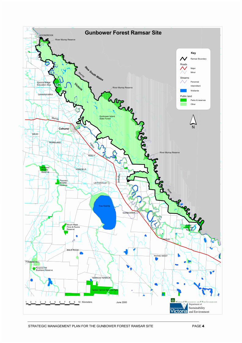
The Gunbower Forest Ramsar site is located on the Murray River floodplain between Torrumbarry and Koondrook approximately 235 km north-west of Melbourne. It is in the Victorian Riverina bioregion (Murray Fans subregion). The Gunbower Forest Ramsar site covers 19,450 ha dominated by River Red Gum open forest and woodland.
2.2 Wetland type
The Gunbower Forest Ramsar site includes areas of three inland wetland types recognised under the classification system used by the Ramsar Convention:
�� seasonal, intermittent or irregular rivers, streams and creeks;
�� seasonal or intermittent freshwater marshes or pools on inorganic soils (including sloughs, potholes, seasonally flooded meadows and sedge marshes); and
�� freshwater, tree dominated wetlands (includes freshwater swamp forest, seasonally flooded forest and wooded swamps on inorganic soils).
In Victoria wetlands are classified into eight categories (Corrick and Norman 1980). The Gunbower Forest Ramsar site includes areas of four wetland types under this system: Deep Freshwater Marsh (95 ha), Freshwater Meadow (9,209 ha), Permanent Open Freshwater (6 ha) and Shallow Freshwater Marsh (545 ha).
2.3 Criteria met for Ramsar listing
To be listed as a Wetland of International Importance, or ‘Ramsar site’, wetlands must meet one or more internationally accepted criteria in relation to their zoology, botany, ecology, hydrology or limnology and importance to waterbirds. The Ramsar Convention updated the criteria in 1999. The new criteria will be applied to Gunbower Forest when the site Ramsar Information Sheet is next updated in 2005. The former criteria met by the Gunbower Forest site when listed in 1982 were:
2(b) is of special value for maintaining the genetic and ecological diversity of the flora and fauna of the region;
3(a) regularly supports >20,000 waterbirds;
3(b) regularly supports substantial numbers of individuals from particular groups of waterbirds; and
3(c) regularly supports 1% of the individuals of a population of one species or subspecies of waterbirds.
Information on how the site meets these criteria is detailed in Chapter 4.
2.4 Land tenure and management
The Gunbower Forest Ramsar site is managed by the Department of Sustainability and Environment, Parks Victoria and Goulburn-Murray Water under the provisions of the Forests Act 1958 and the Crown Land (Reserves) Act 1978 (Table 2.1).
Gunbower State Forest covers an area of 17,108 ha and is reserved under the Forests Act 1958 and is managed by the Department of Sustainability and Environment. The State Forest is required to be managed in accordance with the following Government approved recommendations of the former Land Conservation Council (LCC):
�� extract hardwood timber products; �� conserve native plants and animals, and provide
opportunities for the development of wildlife conservation techniques;
�� provide opportunities for open-space recreation (including hunting) and education;
�� provide for flood mitigation; and �� produce honey, forage, gravel, sand, and other
forest produce such as charcoal (LCC 1985).
Approximately 2,096 ha of the Murray River Reserve falls within the Gunbower Forest Ramsar site. The Murray River Reserve follows the Murray River and its major anabranches. It includes a 60 metre public purposes reserve, which is reserved under the Crown Land (Reserves) Act 1978 and managed by Parks Victoria. The Murray River Reserve is required to be managed in accordance with management objectives derived from recommendations of the former LCC including:
�� provide opportunities for informal recreation (including camping) in a riverine environment for large numbers of people;
�� conserve and protect ecosystems to the extent that is consistent with the above;
�� apiculture be permitted; �� allow flood mitigation and streambank
protection; �� use of existing and licensed pump and pump-
line sites be permitted to continue;
STRATEGIC MANAGEMENT PLAN FOR THE GUNBOWER FOREST RAMSAR SITE PAGE 4
#
#
#
#
#
#
#
#
#
#
#
#
#
#
#
#
#
#
#
#
GUNBOWER
RowlandWildlifeReserve
Kow Swamp
FlanneryWildlifeReserve
Gunbower IslandState Forest
Cohuna
Murray
Valley
Hig
hway
RiverMurray
#
River Murray Reserve
#
River Murray Reserve
Spence BridgeEducation Area
#
River Murray Reserve
Mount HopeFlora & FaunaReserve
Terrick Terrick National Park
PathoWildlife Reserve
Pyramid HillBushland Reserve
PYRAMID HILL
BALD ROCK
TERRICK TERRICK
PATHO WEST
PATHO
LEITCHVILLE
HORFIELD
KEELY
McMILLANS
MEAD
GANNAWARRA
KOONDROOK
June 20001 0 1 2 3 4 5 6 7 8 9 10 Kilometers
NewSouth Wales
N
Victoria
Ramsar Boundary
Roads
Major
Minor
Streams
Perennial
Intermittent
Wetlands
Public land
Parks & reserves
Other
Key
Gunbower Forest Ramsar Site
STRATEGIC MANAGEMENT PLAN FOR THE GUNBOWER FOREST RAMSAR SITE PAGE 5
�� hunting of game birds be permitted during the declared hunting period in areas specified by the land manager where conflict with other recreational users such as camping does not occur; and
�� stock access to water and grazing be permitted at the discretion of the land manager where it is compatible with zone management goals. (LCC 1985).
For a complete list of management recommendations see Final Recommendations for Murray Valley Area (1985) published by the Land Conservation Council.
Managed by Parks Victoria the Spence’s Bridge Education Area covers 230 ha and is reserved under the Forests Act 1958. The Spence’s Bridge Education Area is required to be managed in accordance with the following Government approved recommendations of the former LCC for students of all ages to:
�� study the nature and functioning of reasonably natural ecosystems in a manner such that the integrity of these ecosystems is maintained as far as practicable;
�� compare the ecosystems within education areas with other nearby natural and modified systems;
�� observe and practice the methods of environmental analysis, and the field techniques of natural sciences; and
�� conduct simple long-term experiments aimed at giving an understanding of the changes occurring in an area with time (LCC 1985).
Torrumbarry Weir (Lock Number 26) and a small section of the surrounding land (6 ha) are managed by Goulburn-Murray Water.
The Torrumbarry Weir Camping Park (10 ha) is leased to a private operator by Goulburn-Murray Water, which is the Committee of Management.
Lead management agencies and their key responsibilities are summarised in Table 2.2.
2.5 Adjacent land use
The Gunbower Forest Ramsar site is bound to the north by the Murray River and the adjacent New South Wales State Forests of Perricoota and Koondrook.
Most of the land adjacent to the southern and western boundaries of the forest is privately owned and has been cleared for agriculture, principally for stock grazing and dairying.
A 29 ha freehold enclave (Murray View) is located within the Gunbower Forest Ramsar site. The land is used for growing crops and grazing cattle, and is predominantly cleared.
2.6 Catchment setting
The Gunbower Forest Ramsar site is located on the floodplain of the Murray River in the North Central Catchment Management Area. The North Central Catchment Management Area covers 13% of Victoria, comprising an area of 3 million ha and supports a population of approximately 222,000. The primary industries supported by the catchment include dryland and irrigated agriculture, food processing, forestry and tourism (NCCLPB 1997).
2.7 Local Government
The Gunbower Forest Ramsar site is located in the Shire of Gannawarra and the Shire of Campaspe. Gannawarra Shire encompasses an area of over 3,736 km2 and includes the major town centres of Cohuna and Kerang. Campaspe Shire occupies an area of 4,525 km2 and includes Echuca and Gunbower town centres.
Table 2.1 Land tenure and management
Land Tenure Area (ha) Legal status Management Agency
State Forest 17,108 Forests Act 1958 Department of Sustainability and Environment
Murray River Reserve 2,096 Crown Land (Reserves) Act 1978 Parks Victoria
Spence's Bridge Education Area 230 Forests Act 1958 Parks Victoria
Torrumbarry Weir 6 Crown Land (Reserves) Act 1978 Goulburn-Murray Water
Torrumbarry Weir Camping Park 10 Crown Land (Reserves) Act 1978 (leased out under Section 17D)
Goulburn-Murray Water is the Committee of Management and leases the park to a private operator.

STRATEGIC MANAGEMENT PLAN FOR THE GUNBOWER FOREST RAMSAR SITE PAGE 6
Table 2.2 Lead management agencies and their key responsibilities
Statewide agency Responsibility Local agency Responsibility
Parks Victoria Manage parks and reserves. Parks Victoria - Kerang
Manage the Murray River Reserve and Spence’s Bridge Education Area.
Department of Sustainability and Environment (DSE)
Provide strategic direction for park and reserve management; management of flora and fauna; catchment and water management and implementation of the Ramsar Convention in Victoria.
DSE Bendigo - State Forest and flora and fauna policy
DSE Cohuna - site management
Provide policy advice for the management of Gunbower Forest. Manage the flora and fauna environmental water allocation, hunting, and forestry. Undertake strategic planning and management of the State Forest. Implement the Forest Management Plan: Mid-Murray Forest Management Area.
Department of Primary Industries (DPI)
Provide strategic direction and research for the management of fisheries, agriculture, minerals and petroleum.
DPI Manage commercial and recreational fishing for the Ramsar site in accordance with Fisheries Act 1995.
Victorian Catchment Management Council
Advise State Government on catchment management, and land and water resource issues and priorities. Encourage cooperation between land and water managers. Promote community awareness on catchment management issues.
North Central CMA
Develop and implement the North Central Regional Catchment Strategy. Prepare and implement Action Plans, including 'Flooding Enhancement of The Gunbower Forest Ramsar site'. Manage surrounding catchment and inflowing streams and drainage. License all works on waterways. Delegated function under the Water Act 1989.
Environment Protection Authority
Take responsibility for and coordinate all activities relating to the discharge of wastes into the environment and the generation, storage, treatment, transport and disposal of industrial waste and the emission of noise and for preventing or controlling pollution and noise and protecting and improving the quality of the environment.
EPA Bendigo Licence sewage and other discharges. Monitor water quality.
Committees of Management
Manage reserved Crown Land on behalf of the Minister. Committees are usually the local Shire or publicly elected.
Goulburn-Murray Water
Manage the lease for the Torrumbarry Weir Camping Park.
Regional Water Authority
Provide water and sewerage service to urban communities.
Coliban Water Authority
Provide water and sewerage service to the townships neighbouring The Gunbower Forest Ramsar site. Manage water supply catchments and sewerage treatment plants.
Rural Water Authority
Provide irrigation, drainage, water supply, and management of specific water supply catchments.
Goulburn-Murray Water
Regulation of agriculture extraction. Delegated function under the Water Act 1989. Ensure correct groundwater bore construction. Monitor surface and groundwater salinity.
Local Government/ Shires
Regulate local development through planning schemes, on ground works and management of local roads and urban and some rural drainage.
Gannawarra Shire and Campaspe Shire
Administer planning schemes.
Murray-Darling Basin Commission
Manage the River Murray and advise the Ministerial Council on the use of water, land and other environmental resources of the Murray-Darling Basin under the Murray-Darling Basin Agreement 1992.
Murray-Darling Basin Ministerial Council
Determine major policy issues and measures concerning effective planning and management for the equitable, efficient and sustainable use of the water, land and other environmental resources of the Murray-Darling Basin.
Murray-Darling Basin Commission - River Murray Water
Operate and manage the River Murray system.

STRATEGIC MANAGEMENT PLAN FOR THE GUNBOWER FOREST RAMSAR SITE PAGE 7
3 Policy Framework
The suite of relevant international conventions, and the Commonwealth and Victorian legislation and policy that directs management and use of Ramsar sites, are outlined in the Strategic Directions Statement (NRE 2002a). This Chapter covers the local policy framework comprising plans, strategies and municipal planning provisions as well as statewide strategies approved after publication of the Strategic Directions Statement.
3.1 Strategies
There are a range of existing plans and strategies, which provide for the protection and enhancement of the natural and cultural values of the Gunbower Forest Ramsar site. Victoria has a strong planning framework and as a result these plans and strategies have a high level of integrated planning and address many aspects of wise use. These plans and strategies include:
�� Draft Loddon Catchment Water Quality Strategy (2002);
�� Forest Management Plan for the Mid-Murray Forest Management: Area (2002);
�� Loddon Murray Surface Water Management Strategy (2001);
�� Environmental Water Allocation (27,600 ML) Annual Works Program 2000-2001;
�� The Living Murray: Restoring the Health of the Murray River (MDBMC 2002);
�� Draft North Central Native Vegetation Plan (2000);
�� Entitlements to the Murray – outcomes of work to define how Victoria’s River Murray water is to be shared (NRE 1999);
�� North Central Regional Catchment Strategy (1997);
�� An Interim Water Management Strategy for Gunbower Forest (1993); and
�� Municipal Strategic Statements for the Gannawarra and Campaspe Shires under the Planning and Environment Act 1987.
North Central Catchment Management Authority is undertaking a project Flooding Enhancement of Gunbower Forest, which expands on the work done in the Interim Water Management Strategy for Gunbower Forest (CNR 1993).
Gunbower Island is listed in ‘A Directory of Important Wetlands in Australia’ (EA 2001).
Catchment management authorities in Victoria are currently reviewing their regional catchment
strategies. The revised regional catchment strategies, once accredited by government, will guide future investment in the catchment under some State natural resource management programs, the National Action Plan for Salinity and Water Quality and the Natural Heritage Trust. This strategic management plan will be recognised under the North Central Regional Catchment Strategic framework.
Three recently developed statewide strategies are relevant to the management of Gunbower Forest Ramsar site.
The Victorian River Health Strategy (VRHS) provides a framework that enables Government and community to manage and restore rivers in the State. The VRHS aims to achieve healthy rivers, streams and floodplains, which meet the environmental, economic, recreational and cultural needs of current and future generations (NRE 2002c). The VRHS establishes regional planning processes for CMAs to prepare regional river health strategies, which will coordinate other river-related action plans and direct the development of annual works programs.
The Indigenous Partnership Strategy (NRE 2001) provides the framework for building effective relationships with Indigenous communities, who have a fundamental role in the management of Victoria’s natural resources, as traditional custodians of the land and waters. This strategy sets out key initiatives to assist in the development and delivery of services to Indigenous people, which should be applied during management planning.
Victoria’s Native Vegetation Management – A Framework for Action (NRE 2002f) establishes the strategic direction for the protection, enhancement and revegetation of native vegetation across the State. The framework focuses on managing native vegetation to provide sustainable landscapes and to protect productive capacity and environmental values of land and water resources.
3.2 Municipal Strategic Statements, zoning and overlays
Gannawarra and Campaspe Shires have produced Municipal Strategic Statements that cover the Gunbower Forest Ramsar site. Although these Statements address a number of important land management and environmental issues, they do not emphasise the environmental values of the Gunbower Forest Ramsar site and its catchment or the risks to these values.
STRATEGIC MANAGEMENT PLAN FOR THE GUNBOWER FOREST RAMSAR SITE PAGE 8
Zoning pursuant to the Planning and Environment Act 1987 has been applied to the Gunbower Forest Ramsar site as part of a review of local planning schemes, to control land use and development. The Public Conservation and Resource Zone (PCRZ) has been applied to the Gunbower Forest Ramsar site in the Gannawarra and Campaspe planning schemes. The PCRZ aims to:
�� protect and conserve the natural environment and natural processes for their historic, scientific, landscape, habitat or cultural values;
�� provide facilities which assist in public education and interpretation of the natural environment with minimal degradation of the natural environment or natural processes; and
�� provide for appropriate resource-based uses.
Land adjacent to Gunbower Forest is generally zoned Rural Zone with some zoned Environmental Rural Zone.
Furthermore, as part of the local planning scheme review, a number of overlays have been applied to the site. Overlays operate in addition to zone requirements and generally concern environmental, landscape, heritage, built form and land and site management issues. The overlays applied to the Gunbower Forest Ramsar site in the Gannawarra Planning Scheme are:
�� ESO 1 – Environmental Significance Overlay – Watercourse Environs;
�� LSIO – Land Subject to Inundation; and �� HO22 – Heritage Overlay.
The overlays applied in the Campaspe Planning Scheme are:
�� LSIO – Land Subject to Inundation; �� FO – Floodway Overlay; �� SMO – Salinity Management Overlay; and �� HO – Heritage Overlay.
STRATEGIC MANAGEMENT PLAN FOR THE GUNBOWER FOREST RAMSAR SITE PAGE 9
4 Values
The key environmental values of the Gunbower Forest Ramsar site for which it was listed (representativeness, flora and fauna and waterbirds) are summarised below. Other values described include natural function, cultural heritage, scenic, economic, education and interpretation, recreation and tourism, and scientific.
4.1 Wetland representativeness
In Victoria wetlands are classified into eight categories. The Gunbower Forest Ramsar site includes areas of four wetland types including areas of the State’s most depleted wetland habitats and wetlands least represented in Victoria’s protected area network (Table 4.1). Of note the Gunbower Forest Ramsar site represents approximately 8% of the remaining freshwater meadow in the State.
4.2 Flora and fauna
More than 210 species of indigenous flora and 143 species of indigenous fauna have been recorded at the Gunbower Forest Ramsar site. Of these, three flora and one fauna species are considered to be nationally threatened under the Commonwealth’s Environment Protection and Biodiversity Conservation Act 1999 (Appendices 2 and 3) (DSE 2003b; DSE 2003a).
A total of 18 flora species and 40 fauna species considered to be threatened in Victoria have been recorded at the Gunbower Forest Ramsar site (DSE 2003b; DSE 2003a). Twenty three of the species recorded are also listed under the Flora and Fauna Guarantee Act 1988 (Vic). These include two flora species and 21 fauna species (Appendices 2 and 3) (DSE 2003b; DSE 2003a).
A total of three bird species listed under the Japan Australia Migratory Birds Agreement (JAMBA) and five species listed under the China Australia Migratory Birds Agreement (CAMBA) have been recorded at the Gunbower Forest Ramsar site (Appendix 4). Three of these species are common to both agreements.
The Gunbower Forest Ramsar site also has records of 17 species listed under the Bonn Convention (Appendix 4).
The Forest Red Gum Grassy Woodland ecological community occurring in the Gunbower Forest Ramsar site has been listed under Schedule 2 of the Flora and Fauna Guarantee Act 1988.
Of note the Gunbower Forest Ramsar site is the second largest River Red Gum forest in Victoria and contains some of the tallest Red Gums in the State.
Mapping of Ecological Vegetation Communities within the Gunbower Forest has recently started, with plans to be complete in 2003.
4.3 Waterbirds
The Gunbower Forest Ramsar site provides important feeding, resting and breeding habitat for more than 22 waterbird species.
There is little data available on the number of waterbirds supported by the Gunbower Forest Ramsar site. However, the extent of the forest and nature of the wetland habitat after flooding is such to suggest that the Forest is likely to support large numbers of waterbirds, including Grey Teal, Black Swan, Darter and Egrets.
During flood periods, the Gunbower Forest Ramsar site becomes a large waterbird breeding area. Of note the forest supports the only breeding colony of the Intermediate Egret in Victoria (in 1974 there were an estimated 500 nests, and in 1982 there were over 100 nests) (Horricks et al. 1989). There are also records of significant numbers of Rufous Night Herons, Little Egret, Great Egrets and Darter breeding in the forest.
White Ibis, Sacred Ibis, Grey Teal, Black Swan and other water birds also utilise the Gunbower Forest Ramsar site for breeding (CNR 1993).

STRATEGIC MANAGEMENT PLAN FOR THE GUNBOWER FOREST RAMSAR SITE PAGE 10
Table 4.1 Representativeness of Victorian wetland types in the Gunbower Forest Ramsar site
Wetland type Pre European
area (ha) in Victoria
Area (ha) remaining in
Victoria
Area (ha) in Victoria’s
protected area network1
Ramsar coverage in Victoria (ha)
Gunbower Forest (ha)
Deep Freshwater Marsh 176, 601 54, 860 21, 877 8,943 95
Freshwater meadow 181, 246 118, 899 8,312 27, 568 9,209
Permanent Open Freshwater
70, 658 190, 6942 55, 729 25, 352 6
Shallow Freshwater Marsh
127, 031 54, 603 9,410 8,139 545
1 Includes areas of Ramsar sites. 2 The increase from ‘Pre-European area in Victoria’ to ‘Area remaining in Victoria’ is due to the construction of dams, weirs and other impoundments
4.4 Natural function
The Gunbower Forest Ramsar site provides a suite of important functions including fish and wildlife habitat, organic carbon storage, water supply and purification, groundwater recharge, flood control and maintenance of flow regimes.
4.5 Cultural heritage
The Gunbower Forest Ramsar site contains a cultural landscape that reflects both Aboriginal and European activities.
The Gunbower Forest Ramsar site contains many sites of cultural significance to the Aboriginal people. A survey of approximately 10% of the total Forest area by Aboriginal Affairs Victoria in conjunction with the Echuca Aboriginal Co-operative identified 142 archaeological sites of significance. Sites identified include scarred trees, mounds and shell middens (Rhodes 1996). All Aboriginal sites, places and objects are protected under the Archaeological and Aboriginal Relics Preservation Act 1972 (Vic.) and the Aboriginal and Torres Strait Islander Heritage Protection Act 1984 (Cwth).
The most up to date information from the site register at Aboriginal Affairs Victoria shows a total of 186 sites including 2 shell deposits, 57 mounds, 121 scarred trees, 2 burial/human remains, 1 sub-surface cultural deposit, 1 hearth and 2 other unspecified sites. The area has not been adequately surveyed, so it is likely that more archaeological sites will be discovered.
The locations of many places, such as burial or natural sacred sites, may not yet be listed on the Aboriginal Affairs Victoria site register but are known to members of local Aboriginal communities. Protection of such sites from unintentional damage will benefit from improved awareness and communications between DSE, PV and Aboriginal communities (NRE 2001).
Consultation between land managers and the local indigenous community needs to be enhanced in order to facilitate management of the site. This is being facilitated by the recent Protocols, Principles and Strategies Agreement for Indigenous Involvement in Land and Water Management agreed between the North Central Catchment Management Authority, the North West Nations Clans Aboriginal Corporation and the Yorta Yorta Aboriginal Corporation (VCMC 2003).
A Native Title Determination Application lodged with the Native Title Tribunal covers the Gunbower Forest Ramsar site.
The range of historic places in the Gunbower Forest Ramsar site reflects a number of different phases of European activity in the area. Scattered around the Forest are relics of early settlement, however most of the historical value is in the events that took place and the effect they had rather than what remains.
The Gunbower Island State Forest is being assessed for listing on the Register of the National Estate (Australian Heritage Commission). This is in recognition of its natural values as a waterfowl breeding area.
4.6 Scenic
The Gunbower Forest Ramsar site has high scenic values because of its large size and the diversity of natural and cultural landscape features contained in it. The most significant landscapes are located along the Murray River (CNR 1993).
4.7 Economic
The components, functions and attributes of the Gunbower Forest Ramsar site provide a variety of direct and indirect economic values to the area. The direct economic values provided by the Gunbower Forest Ramsar site include timber production,

DRAFT STRATEGIC MANAGEMENT PLAN FOR THE GUNBOWER FOREST RAMSAR SITE PAGE 11
domestic stock grazing, apiculture and the use of the area for recreation and tourism. In contrast, the natural functions of the Gunbower Forest Ramsar site also have important indirect values, which support or protect economic activities including flood and flow control, nutrient retention, water quality maintenance and flood control.
4.8 Education and interpretation
The Gunbower Forest Ramsar site offers a range of opportunities for education and interpretation. Spence Bridge, an area of 230 ha, has been set aside as an Education Area. The area is used to provide opportunities for students of all ages to study River Red Gum and wetland ecosystems.
In addition an interpretation sign is located at the corner of Rifle Butts and Half Way Stump Tracks produced as part of the Victorian Ramsar wetlands interpretation project, which, aims to promote understanding and gain community support for Ramsar sites and wetlands.
4.9 Recreation and tourism The Gunbower Forest Ramsar site is a popular place to visit in the summer months with visitation dropping significantly during winter. The main activities undertaken by visitors are fishing, camping, pleasure driving, four wheel driving, trail bike riding, cycling, horse riding and bushwalking. Orienteering, picnicking, canoeing, boating, bait collection, duck shooting, hunting of feral animals and nature study are also undertaken.
The most popular areas are adjacent to the Murray River and at Torrumbarry Weir, where a caravan park is located. Camping is permitted in the old Gunbower School, a site that is mostly utilised by school groups. The Cohuna Scout Group also camps within the Forest. Access within the forest is good and includes the River Track, which provides a scenic drive from Koondrook to Torrumbarry Weir (CNR 1993).
4.10 Scientific
The Gunbower Forest Ramsar site has been an important site for research studies in the fields of hydrology and ecology. A recent scientific study investigated the ecology and hydrology of Gunbower Forest, in particular it assessed the responses of
floodplain communities to different flooding parameters. The results of this study have been applied to interim water management strategies to fine tune water management in the Forest and conserve ecological diversity.
4.11 Condition Vegetation River Red Gum, Black Box and Grey Box communities dominate the Gunbower Forest Ramsar site. River Red Gum communities are widely distributed across the north-western part of the site and Black Box communities occur on low rises and sand ridges where flooding occurs infrequently. Grey Box communities occur on sandy ridges, which are rarely flooded and often grow in association with Black Box and occasionally with River Red Gum. In addition some Riverine Grassland and Northern Plain Grassland communities occur within the Forest.
These communities, largely River Red Gum, have been intensively harvested since early settlement resulting in a much younger, and in places denser forest. In addition, changed flooding regimes have reduced the distribution and abundance of flood-dependent species and changed vegetation patterns. Pressure from grazing has reduced the cover and abundance of more palatable species (NRE 1997).
Hydrology Gunbower Island is a depositional basin, which contains a number of still water channels and miscellaneous floodplain depressions. The lowest and therefore major entry point for water into the forest is Spur Creek, which commences to flow at the rate of 13,700 ML/day when the Murray River height is 4 m at Echuca and 3.96 m below Torrumbarry Weir. As the Murray River rises other effluents begin to flow, until the forest is entirely inundated. At a river height of approximately 8 m at Echuca and 6.4 m below Torrumbarry Weir, the flow is 27,800 ML/day. Water depth on the island can vary from a few centimetres on high ground to 6 m in creeks and billabongs in the centre of the forest during flood.

STRATEGIC MANAGEMENT PLAN FOR THE GUNBOWER FOREST RAMSAR SITE PAGE 12
5 Management of Risks
The key risks to the maintenance of environmental values of the Gunbower Forest Ramsar site are discussed below. The risks include altered water regimes, salinity, pollution, pest plants and animals, inappropriate resource utilisation, recreation, erosion and fire, which were in some cases established prior to the listing of the site.
These risks result from activities in the wetland, on adjoining land and in the catchment. Protection of the site therefore requires an integrated approach. A wide variety of measures are being implemented at the Gunbower Forest Ramsar site to deal with risks. They include planning, research, site works, catchment works and education. A brief summary of these measures relevant to each risk is provided.
5.1 Altered water regimes
Since the 1950's the quantity of water diverted from the Murray River for irrigation development has increased substantially, augmented by inter-basin transfers from the Snowy via the Snowy Mountains Scheme. The construction of dams, weirs and other regulators has altered the natural hydrologic regime of the Gunbower Forest Ramsar site (Bren and Gibbs 1988). The storage of winter and spring catchment flows in the Hume and Dartmouth Reservoirs and their subsequent release in summer and autumn to meet downstream irrigation and water supply demands has:
�� reduced the frequency, duration and extent of winter-spring floods;
�� altered the timing of floods; �� reduced variability in flood flows; and �� increased the number of periods of two or more
successive years when the Forest will not be effectively flooded (Atkins et al. 1991).
The alteration to the natural flows of rivers and streams has been listed as a potentially threatening process under the Flora and Fauna Guarantee Act 1988.
These hydrological changes have reduced the distribution and recruitment of flood-dependent flora species, including River Red Gum. Water stress between flood events has also resulted in their death.
The hydrological changes are also likely to have altered faunal habitat and contributed to lower recruitment rates due to the loss of the natural breeding and nesting signals for native, fish, birds, plant and aquatic insects (MDBMC 2002).
The Gum-leaf Skeletoniser is a major defoliant of River Red Gum in the Mid-Murray area and outbreaks are linked to inappropriate water regimes. Infestations occur when the absence of flooding coincides with the larval stage (NRE 2002b). Defoliation rarely if ever results in tree mortality, but growth is temporarily retarded (VMI 1986). The pest has been in the Gunbower Forest since the 1960s however the degree of outbreak differs from year to year. Up to 40,000 ha has been defoliated on at least two occasions in the Murray area (NRE 2002b).
In 1999 the Government approved Murray River bulk entitlements. These include the Flora and Fauna entitlement that can be used for wetlands with access to River Murray water, including Gunbower Forest. In outlining the entitlements, the use of 25 GL one year in three and 40 GL one year in twelve was proposed from flows surplus to irrigation needs for Gunbower Forest.
In Victoria, a steering committee of stakeholders including the Department of Sustainability and Environment, North Central Catchment Management Authority, Goulburn-Murray Water and Parks Victoria has been formed to identify options for improving management of environmental water in the Gunbower Forest. Improvements in the integration of cross-border water management arrangements would facilitate management of Gunbower and the neighbouring Koondrook and Perricoota Forests in NSW as a single ecological unit.
Practical matters on using the surplus water provisions are currently being resolved by a flood enhancement study for Gunbower Forest, which will identify priority sites for watering and structures required for delivery. The aim of the project is to enhance the ecological communities of Gunbower Forest by providing a flooding regime, based on pre- and post-river regulation flooding patterns, focusing on priority areas where enhanced flooding would be environmentally beneficial and physically feasible.
Due to the complexity of water distribution in the forest, studies are required to determine water movement and predict the relationship between volumes and flooding extent to facilitate the management of environmental water allocations. Initially this will be covered by the Gunbower flood enhancement study but ongoing work will be required to further refine the understanding of water movement under various flooding conditions and the responses of plant and animal communities to flooding regimes.
STRATEGIC MANAGEMENT PLAN FOR THE GUNBOWER FOREST RAMSAR SITE PAGE 13
Management processes that consider Gunbower Forest have been established for allocating use of the Flora and Fauna bulk entitlement. A management process for the use of the environmental provision from surplus flows still requires development.
An area of 2,500 ha within Gunbower Forest was flooded in 2000 by complementing high flows in the Murray River with a portion of the Murray Flora and Fauna bulk entitlement.
Existing and future water regulation structures in Gunbower Forest have the potential to prevent the passage of native fish between the floodplain and the Murray River. Fish passage issues will be considered as part of the Flood Enhancement of Gunbower Forest Study.
In the wider context, concerns about the health of the Murray River, security of water supply for existing irrigators and reduced reliability of water supply during long droughts lead the Murray-Darling Basin Ministerial Council to impose a cap on irrigation diversions in 1997. The Living Murray, is a current Murray-Darling Basin Commission initiative about restoring the health of the River Murray and the Murray-Darling Basin.
Localised drainage of water from private land has resulted in areas of tree death in the forest. Community drains and individual farm outfalls need to be managed to ensure that water discharge does not threaten environmental values. The Torrumbarry East of Loddon Draft Environmental Report (1994) highlighted the significant areas of land, which are at risk to degradation and identified areas where environmental enhancement could be achieved. The report made the following recommendations relating to drainage disposal in the Forest.
�� The discharge of any summer irrigation water should not be permitted to Sate Forest when the forest floor is dry; and
�� The number of outfalls should be rationalised and directed along areas of low impact (Beovich and Filippin 1994).
The Loddon Murray Surface Water Management Strategy (2001) establishes principles for future surface water management planning, which considers environmental issues.
5.2 Salinity
Groundwater salinity within Gunbower Forest is generally moderate to high. There is also a persistently high watertable along the southwestern edge of the forest presumably due to irrigation of the nearby farmland. Given the relatively high groundwater salinities in the region, the long term
prognosis for the forest is considered unfavourable. Within another 20 years or so, the forest is expected to be showing severe die back due to the unsustainable concentration of salts where the watertable is within three metres depth. Soil salinity testing in selected high risk areas is needed to help determine how great the risk is and the rate at which it is occurring (SKM 2001).
5.3 Pollution
There are a number of effluent creeks and drains flowing into the Gunbower Forest Ramsar site from surrounding agricultural land. These creeks and drains introduce nutrients, sediments and agricultural chemicals that degrade the aquatic and terrestrial habitats of the Forest.
The risk of pollution is addressed through the implementation of the Draft Loddon Catchment Water Quality Strategy (2002) and the Loddon Murray Surface Water Management Strategy (2001) and the participation of management agencies in statutory planning processes.
5.4 Pest plants and animals
Introduced flora species recorded in the Gunbower Forest Ramsar site include Blackberry, Sweet Briar, Prairie Ground Cherry, Paterson’s Curse, Bathurst Burr, Noogoora Burr, Box Thorn and Horehound.
Boxthorn and Blackberry in particular are reducing waterbird habitat by displacing native vegetation. These species also provide harbour for pest animals including foxes, feral cats, rabbits and introduced birds that prey upon or compete with native fauna for food and habitat.
Noogoora Burr exists on the flood-prone areas along the Murray River and its associated tributaries within the Forest. The extensive root system and growth rate of this species reduces opportunities for native flora regeneration.
Aquatic weeds are an emerging environmental problem along the Murray River, in particular the species Arrowhead. There is concern that if this species becomes established within the Gunbower Forest Ramsar site it will have the capacity to progressively invade billabongs and wetlands, trapping silt in fringing vegetation and thus reducing the size of aquatic habitat.
A number of introduced animals have been recorded within the Gunbower Forest Ramsar site. Species include rabbits, foxes, wild pigs, cats and carp.
Predation of native wildlife by foxes and cats are listed as threatening processes under the Flora and Fauna Guarantee Act 1988. The following categories

STRATEGIC MANAGEMENT PLAN FOR THE GUNBOWER FOREST RAMSAR SITE PAGE 14
of native fauna are considered to be at risk from fox and cat predation in the Gunbower Forest Ramsar site:
�� arboreal mammals including Brushtail and Ringtail possums;
�� bird species that spend much of their time at or near the ground nesting and/or feeding including the Latham’s Snipe, Masked Lapwing and Banded Lapwing; and
�� reptiles such as the Carpet Python.
Foxes also feed on tortoise eggs, and since tortoises are long-lived, the impact of this predation may not be noticed until there is a sudden population decline (DCE 1992).
Grazing by rabbits has contributed to the loss of native perennial flora from the ground layer and reduced River Red Gum and shrub regeneration. Scratching and burrowing by rabbits has also resulted in localised soil erosion.
Populations of feral pigs exist in Gunbower Forest and adjoining areas in NSW. The pig population in Gunbower Forest is considered to be very low, but no accurate figures are available. Pigs cause localised soil disturbance, spread weeds, muddy waterholes and disturb understorey vegetation. In addition, pigs forage for tortoise and waterbird eggs laid on the ground.
The presence of feral honeybees may pose a threat to native flora and fauna arising from their use of nesting hollows and floral resources. This has been listed as a potentially threatening process under the Flora and Fauna Guarantee Act 1988. For information on domestic bee keeping (apiculture) see Section 5.5.
Carp enter the Gunbower Forest Ramsar site when it is inundated with flood waters. The impacts of carp on the aquatic habitat of the Forest have not been documented. However, the feeding habits of carp may make the environment unsuitable for many of the aquatic biota that naturally thrive in the flooded forest by muddying the water.
The impacts associated with pest plants and animals are being addressed through a range of measures including rabbit harbour destruction, fox baiting programs and spraying programs to contain, and as far as possible eradicate, pest plants from the Ramsar site.
5.5 Resource utilisation
Under the Crown Land (Reserves) Act 1978 and the Forests Act 1958 utilisation of the forest for timber, grazing, apiary and other purposes is permitted.
Timber harvesting Victorian River Red Gum forests, including Gunbower Forest, have been harvested since early settlement and were heavily cut between 1860 and 1880 to service river transport along the Murray River and the expansion of the State's railway system (CNR 1993). Timber production has been controlled to ensure future supplies since the 1920s.
Currently, one sawmill takes logs from Gunbower Forest. The Forest Management Plan for the Mid-Murray Forest Management Area (NRE 2002b) provides figures on timber produced from Gunbower and two small forests to the north west of Gunbower. In 2000-2001 the forests produced 972 m3 of sawlogs, 1,169 m3 of sleepers, 1,074 m3 of residual log (low-grade logs that sometimes become available as a by-product of sawlog and sleeper harvesting and regrowth management operations) and 5,730 m3 of firewood (NRE 2002b).
The range of wood products derived from the forest includes heavy construction timbers, railway sleepers, house stumps, furniture timbers, flooring, feature panelling, poles, fence posts, firewood and charcoal. River Red Gum is the only species harvested. Yellow Box, Grey Box and Black Box are not harvested (NRE 2002b).
Sawlogs are supplied in accordance with the sustainable yield rate for the Mid-Murray Forests. The current sustainable yield rate for the whole Mid-Murray Forest Management Area, which includes Gunbower Forest, is set at 5,600 m3 per year. As the result of a review of sawlog licences conducted in 2001, sawlog licences will be reduced to 5,200 m3 per year, in accordance with the principles outlined in Our Forests, Our Future (NRE 2002d).
Previous timber harvesting and silvicultural practices used within the Gunbower Forest Ramsar site have altered the age structure of the forest. Loss of hollow-bearing trees and habitat fragmentation are threatening processes of particular relevance to the forests of the central Murray region. These processes have been listed under the Flora and Fauna Guarantee Act 1988 (Bennett et al. 1994). The Forest Management Plan for the Mid-Murray Forest Management Area (NRE 2002b) outlines enhancement measures for structural diversity by way of protecting hollow-bearing trees, low intensity harvesting using single tree or group selection and the continuation of special protection zones where timber harvesting is not undertaken.
Under the Mid-Murray Forest Management Plan, special protection zones (SPZ) and special management zones (SMZ) have been established in Gunbower State Forest to protect natural and cultural values. SPZs are managed for conservation and

STRATEGIC MANAGEMENT PLAN FOR THE GUNBOWER FOREST RAMSAR SITE PAGE 15
timber harvesting is excluded. Sustainable timber production is permitted in SMZs but under modified conditions directed towards conserving natural or cultural values
An SPZ has been established along Spur and Yarran Creeks, and on several wetlands in Gunbower Forest. Primary effluent or confluent streams have a 10 m SPZ in place at all times. This extends to 20 m when they contain water. An SMZ with a 50 m wide buffer covers other water bodies and natural open wetland areas. A 40 m frontage to Gunbower Creek and a 20 m frontage each side of Yarran Creek has been excluded from harvesting in accordance with LCC recommendations to protect recreation, landscape, wildlife and water values.
The remainder of the State Forest is General Management Zone and is managed for the ecologically sustainable production of timber and other forest products. Timber harvesting is conducted in accordance with the ‘Code of Forest Practices for Timber Production. Revision No. 2’ (NRE 1996).
Fallen timber is a major habitat structural element for plants and animals. A recent study on the depletion of fallen timber (MacNally et al. 2002) found that fallen timber volumes have decreased significantly from natural levels in River Red Gum Forests of the southern Murray-Darling Basin and that this has negative implications for biodiversity. Causes of depletion are attributed to firewood collection, fuel reduction and silvicultural management. The study suggests restoration targets of 40-50 tonnes of woody debris per hectare. The Mid-Murray Forest Management Plan includes guidelines for firewood harvesting and collection to minimise depletion of woody debris.
Grazing Stock grazing is carried out according to grazing licences issued under the Forests Act 1958 and water frontage licences issued under the Land Act 1958.
Thirteen water frontage licences are held for the purposes of grazing and 18 grazing licences are held over areas of the State Forest. Grazing licences are no longer issued on a yearly basis. Agistment is now used as a management tool to dictate the stocking rates (600 maximum) and timing of grazing (M. Thorson pers. comm.). Agistment is a short term grazing licence, which dictates stock numbers for a specific period (e.g. 3 months per year).
Potential impacts associated with stock grazing in the Gunbower Forest Ramsar site include:
�� alteration of the species composition with perennial species being replaced with ephemeral or annual species, changes in
photosynthetic pathway, domination of annual and introduced species and an increased presence of species capable of being dispersed by stock;
�� structural changes in growth form and changes in age class representation; and
�� changes in function of the landscape contributing to leaky soils, water logging, salinity and acidity problems (SFNSW 2000).
Stock grazing is also considered a major threat to the habitat of woodland birds, amphibians and ground invertebrates (SFNSW 2000).
Grazing areas in State Forests usually contain environmentally sensitive sites such as wetlands, riverbanks, sandhills and box woodlands. A strategy for native forests in the Riverina in NSW (SFNSW 2000), which would be applicable to Gunbower Forest, outlined measures to more fully protect these areas, including:
�� fencing of environmentally sensitive sites to exclude stock grazing;
�� where fencing is not practicable, the grazing regime should be set by the most sensitive environmental factors; and
�� the grazing of wetlands should not be undertaken until sediments are dry and water plants have flowered and set seed.
Management strategies such as fencing and applying appropriate grazing regimes are also applicable for cultural site management. Grazing and trampling by livestock can degrade and erode sensitive cultural sites. Some areas such as sandhills, surface scatters and burial mounds are highly culturally sensitive. The Forest Management Plan for the Mid-Murray Forest Management Area establishes guidelines and actions for managing grazing in the State Forest.
Apiculture Apiculture is permitted within the Gunbower Forest Ramsar site. Apiary sites in the Forest are administered under the Forests Act 1958 and provides for Bee Farm and Range sites and temporary bee sites. Twenty-one apiarists have licences for Bee Farm and Range sites in the forest, which are granted for a period of 12 months, and sites have a nominal radius of 1.6 km (range). Eighteen temporary sites are available of which licences are granted for a three or six-month period and have a nominal radius of 0.8 km.
Studies suggest that honeybees may both adversely and positively affect native ecosystems (Paton 1996), although the degree of these effects has not been evaluated. Competition for resources such as nectar and pollen by introduced bees may result in displacement of native fauna, causing a long-term

STRATEGIC MANAGEMENT PLAN FOR THE GUNBOWER FOREST RAMSAR SITE PAGE 16
decline in native pollinator populations. Occupation of hollow-bearing trees by feral honeybees is of concern as the supply of hollow-bearing trees is limited in the Ramsar site.
Effects of honey bees on native flora may include hybridisation of plant species, inefficient pollination and the enhancement of seed production of some native plants whose native pollinators have declined substantially. The extent and impact of increased competition between introduced honeybees and indigenous fauna in the Gunbower Forest Ramsar site is currently unknown and further research is needed.
Large bee populations may interfere with recreational activities (NRE 2002b). As a result, apiculture is not permitted near major recreational sites (distances will vary with local conditions).
Sand extraction Sand extraction was permitted under licence at Broken Axle Track in the Gunbower State Forest, although extraction has not taken place since 1996. Sand extraction activities may disturb Aboriginal Archaeological sites and native flora and fauna, and introduce pest plants and diseases (Rhodes 1996).
5.6 Recreation The Gunbower Forest Ramsar site is a popular destination for people from Melbourne and regional centres such as Shepparton, Bendigo and Echuca. The major attraction is the Murray River and Gunbower Creek, which are the focus for most recreational activities.
Visitor use is concentrated along the Murray River at numerous picnic and camping areas and along access roads. Some recreational activities pose a threat to the environmental and Aboriginal cultural heritage values. Overuse of some areas and the ad-hoc creation of new sites have led to vegetation damage including firewood collection causing loss of habitat for small fauna, soil compaction, erosion of riverbanks and issues associated with rubbish disposal.
Closure of unnecessary and poorly sited tracks in the Gunbower Forest is required in order to ensure long term sustainability of the road network and lessen the impacts of habitat fragmentation. Driving in wet conditions impacts negatively on four-wheel drive tracks and roadside vegetation. Temporary closure of tracks may be necessary during flood events.
Parks Victoria’s (PV) Draft Statewide Road Framework (2002) develops a long term and sustainable approach to the future management of PV managed roads accessed by the public. The existing road and track infrastructure managed by PV
is unsustainable when evaluated against currently available measures (PV 2002).
Hunting (inclusive of duck, fox, rabbit and pigs) is permitted within some areas of the Gunbower State Forest. The impacts of hunting on site values have not been determined, however, hunting can create both physical and noise disturbance to fauna and can result in the accidental shooting of protected species.
Contamination of wetlands from the accumulation of lead shot is listed as a threatening process under the Flora and Fauna Guarantee Act 1988. Lead shot was prohibited for duck hunting in Victoria in 2002 but can still be used for hunting quail, pest animals and for clay target shooting. Waterbirds, which feed in or on the edges of wetlands, are still at risk of lead poisoning due to residual lead in sediments (FFG Action Statement No. 32). The extent of the lead contamination in Gunbower Forest Ramsar site is not known.
Other indirect but localised impacts from hunting include litter (including spent shells) and disturbance to shoreline vegetation from camping, trampling and hide construction.
Recreational fishing is a popular activity at the Gunbower Forest Ramsar site, particularly along the Murray River and Gunbower Creek. This has lead to localised problems associated with litter, fires, discarded fishing line entangling waterbirds, human waste and disturbance to shoreline vegetation. Recreational fishing activity may also disturb waterbirds particularly near feeding, roosting and nesting sites.
Trail bike riding throughout the Forest causes some localised damage to soil and vegetation and is most evident along the river, particularly at heavily used camp sites.
Campers, day visitors and hunters also bring domestic dogs into the Forest that may prey upon or disturb native fauna.
The risks associated with recreation are being addressed through a range of measures. These measures include: a significant enforcement and monitoring presence during duck season; the enforcement of fishing regulations dealing with fish size and catch limits; restricting access during flood events; and the development of visitor interpretation and education programs.

STRATEGIC MANAGEMENT PLAN FOR THE GUNBOWER FOREST RAMSAR SITE PAGE 17
5.7 Erosion
At many locations along the Murray River, erosion of the bank appears to be occurring at an accelerated rate. A 1988 study based on bed and bank surveys carried out in 1876 and 1976 suggests that the river is in general becoming broader and shallower (Loder and Bayley 1988). Whether this process has been caused by changes in the flow regime or the continually higher river levels necessary to satisfy irrigation demands is unknown. Boat wash may also be a contributing factor. Erosion has the potential to impact negatively on Aboriginal cultural values as well as natural values.
NSW is responsible for managing in-stream river issues, and Victoria is restricted to addressing erosion issues from the Victorian border (i.e. top of the southern bank). The New South Wales Department of Infrastructure, Planning and Natural Resources controls speed limits at appropriate places along the river, although there are no limits below Torrumbarry Weir.
5.8 Fire
Fire management on public land in Victoria is governed by the Code of Practice for Fire Management on Public Land (CNR 1995). The Regional Fire Protection Plan for the Bendigo Fire District (NRE 2002e) defines fire protection objectives, strategies and practices to be adopted in the management of wildfires and prescribed burning. Fuel Management Zone 5 applies to the entire Gunbower Forest Ramsar site. Zone 5 areas provide for the exclusion of prescribed burning from areas where there would be potential for economic, ecological or cultural loss.
In most years high fire danger conditions occur throughout summer in the Forest between December and March. There is an average of 20 fires per year less than 1 ha in size, with 99% of fires caused from campfires left burning by campers and 1% occurring from lightning strikes. On 11 January 2002, Gunbower Forest experienced a 300 ha wildfire that apparently was deliberately lit. Fire suppression methods are well established for the area, and most fires are quickly extinguished.
The risk of fire is being addressed through the implementation of the Code of Practice for Fire Management on Public Land (1995) and the Interim
Guidelines and Procedures for Ecological Burning on Public Land in Victoria (FEWG 1999). Combined these documents provide a consistent framework and process for planning and implementing ecological burning programs by DSE and Parks Victoria.
5.9 Level of risk to Ramsar values
The goal of the integrated management framework (incorporating the Strategic Directions Statement and corresponding Strategic Management Plans) is to facilitate the maintenance of ecological character at Victoria’s Ramsar sites by minimising risks to values. This goal will be achieved through the implementation of strategically prioritised management actions. The proposed management actions are prioritised according to their ability to address the identified risks.
A strategic risk assessment process based on the broad concepts and principles of ecological risk assessment has been undertaken for the Strategic Directions Statement and Strategic Management Plans (NRE 2002a – Appendix 7). This process relied on a clear understanding of the range of direct and indirect pressures facing the wetlands, as well as the legislative and policy context.
Such a systematic and strategic analysis of risk provides the necessary information to site managers; and facilitates priority setting, resource allocation and informed decision-making. This form of analysis also provides a better understanding of management issues.
The strategic risk assessment process has established the basis for objectively assigning higher, medium and lower priority levels to risks at Ramsar sites and the management actions designed to address them. The strategic risk assessment approach also facilitates an understanding of the relationship between specific risks and values. The strategic risk assessment framework draws on two major relevant documents: the US Environment Protection Authority’s Guidelines for Ecological Risk Assessment (1997), and the Ramsar Convention’s Wetland Risk Assessment (1999).
The main risks to the environmental values and ecological character of the Gunbower Forest Ramsar site are summarised in Table 5.1. It should be noted that the level of risk has not been assessed against the effort currently being applied to mitigating the risk.

STRATEGIC MANAGEMENT PLAN FOR THE GUNBOWER FOREST RAMSAR SITE PAGE 18
Table 5.1 Level of risk to Ramsar values at the Gunbower Forest Ramsar site
Risks
Alte
red
wat
er re
gim
es
Sal
inity
Pol
lutio
n
Pes
t ani
mal
s
Pes
t pla
nts
Res
ourc
e ut
ilisat
ion
Rec
reat
ion
Fire
Ero
sion
Gunbower Forest Ramsar site ������������ ���� ���� �������� ���� �������� �������� �������� ����
������������ Higher priority risks - risks that currently or may potentially result in the significant loss of the site’s environmental values and ecological character.
�������� Medium priority risks - risks that currently or may potentially result in the moderate loss of the site’s environmental values and ecological character.
���� Lower priority risks - risks that currently or may potentially result in the minor loss of the site’s environmental values and ecological character.
STRATEGIC MANAGEMENT PLAN FOR THE GUNBOWER FOREST RAMSAR SITE PAGE 19
6 Site Management Strategies
A number of Site Management Strategies have been developed in response to the analysis of risks to the values at the Gunbower Forest Ramsar site. The Site Management Strategies are grouped under the relevant Management Objectives established by the Strategic Directions Statement.
The Site Management Strategies for the Gunbower Forest Ramsar site promote a range of specific management actions that will maintain, and in some cases restore the ecological character of the site. The Site Management Strategies are designed to:
a) address risks that are having an adverse impact, or are likely to have an adverse impact on ecological character; and
b) highlight existing strategies and actions that are consistent with wise use principles.
The successful coordination and cooperation of the lead agencies, as well as the continued efforts of the many community and interest groups, is essential for the long-term conservation of the Gunbower Forest Ramsar site. The Strategic Directions Statement, statutory mechanisms, management plans and management strategies will guide the implementation of this Strategic Management Plan.
The Department of Sustainability and Environment will have overall responsibility for:
�� facilitating the implementation of the Strategic Directions Statement and Strategic Management Plans for Ramsar sites by ensuring relevant agencies incorporate relevant strategies into their work programs;
�� coordinating and reporting on the progress and/or issues with implementation of the Strategic Directions Statement and Strategic Management Plans for Ramsar sites;
�� ensuring monitoring programs are established in accordance with the Strategic Directions Statement and Strategic Management Plans for Ramsar sites;
�� ensuring the regular review of Strategic Management Plans for Ramsar sites;
�� preparing the Victorian chapter of Australia’s National Report to triennial Conferences of the Contracting Parties to the Ramsar Convention; and
�� the six yearly update of the Ramsar Information Sheets for each site.
In order to clarify accountabilities, the lead agency responsible for the implementation of each strategy is identified. Lead agencies will monitor implementation of the strategies for which they are responsible. Lead agencies are encouraged to record progress on their responsibilities and extent of implementation and provide information in the form of annual summary reports to the Department of Sustainability and Environment (DSE). This information will be consistent with a format developed by the former NRE and will contribute to Victoria’s chapter in the National Report to the Convention on Wetlands, prepared every three years.
A rating of relative priority accompanies each Site Management Strategy. Definitions of these priorities are as follows:
Higher: Strategies that, when implemented, will significantly contribute to the maintenance of ecological character.
Medium: Strategies that, when implemented in conjunction with Higher priority strategies, will support the maintenance and contribute to the restoration of ecological character.
Lower: Strategies that, when implemented in conjunction with Higher and Medium priority strategies, will result in enhancement of ecological character.
STRATEGIC MANAGEMENT PLAN FOR THE GUNBOWER FOREST RAMSAR SITE PAGE 20
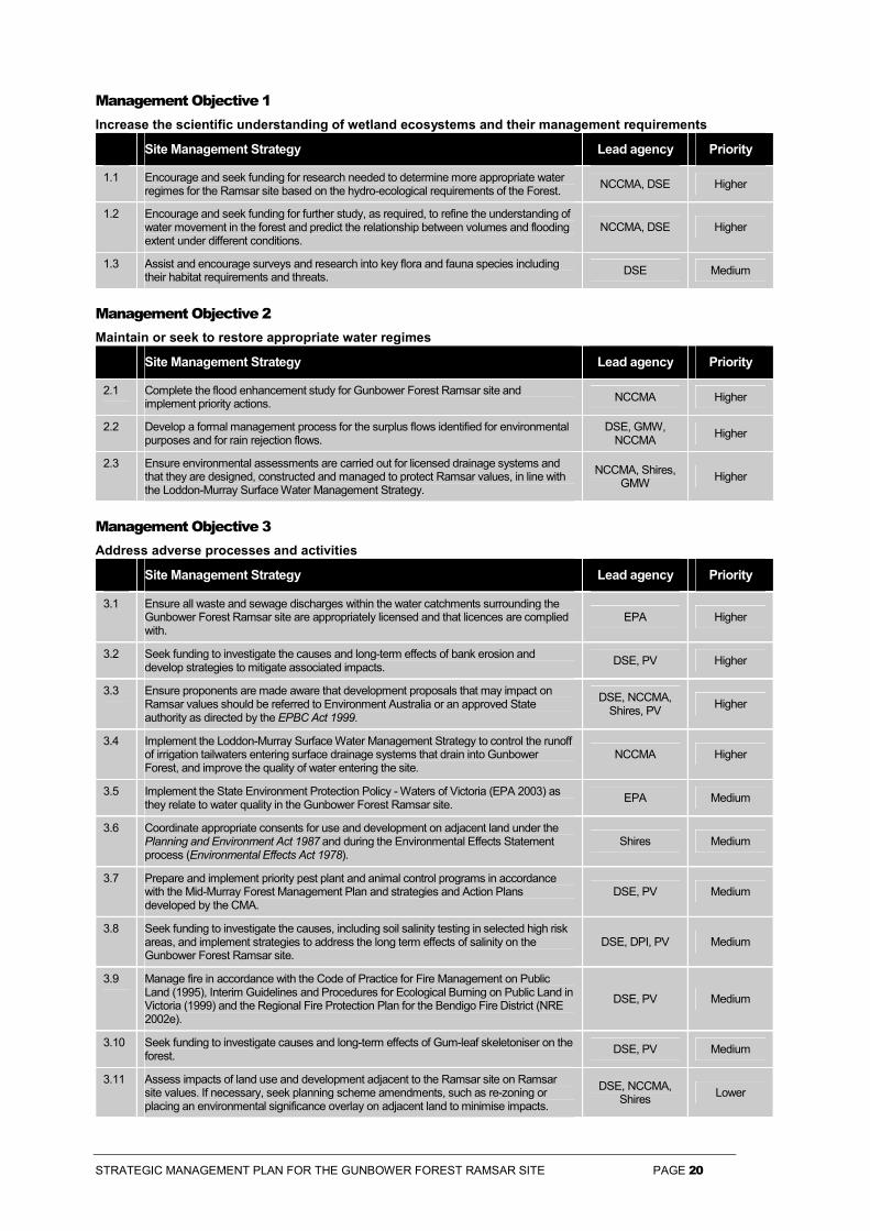
Management Objective 1 Increase the scientific understanding of wetland ecosystems and their management requirements
Site Management Strategy Lead agency Priority
1.1 Encourage and seek funding for research needed to determine more appropriate water regimes for the Ramsar site based on the hydro-ecological requirements of the Forest. NCCMA, DSE Higher
1.2 Encourage and seek funding for further study, as required, to refine the understanding of water movement in the forest and predict the relationship between volumes and flooding extent under different conditions.
NCCMA, DSE Higher
1.3 Assist and encourage surveys and research into key flora and fauna species including their habitat requirements and threats. DSE Medium
Management Objective 2 Maintain or seek to restore appropriate water regimes
Site Management Strategy Lead agency Priority
2.1 Complete the flood enhancement study for Gunbower Forest Ramsar site and implement priority actions. NCCMA Higher
2.2 Develop a formal management process for the surplus flows identified for environmental purposes and for rain rejection flows.
DSE, GMW, NCCMA Higher
2.3 Ensure environmental assessments are carried out for licensed drainage systems and that they are designed, constructed and managed to protect Ramsar values, in line with the Loddon-Murray Surface Water Management Strategy.
NCCMA, Shires, GMW Higher
Management Objective 3 Address adverse processes and activities
Site Management Strategy Lead agency Priority
3.1 Ensure all waste and sewage discharges within the water catchments surrounding the Gunbower Forest Ramsar site are appropriately licensed and that licences are complied with.
EPA Higher
3.2 Seek funding to investigate the causes and long-term effects of bank erosion and develop strategies to mitigate associated impacts. DSE, PV Higher
3.3 Ensure proponents are made aware that development proposals that may impact on Ramsar values should be referred to Environment Australia or an approved State authority as directed by the EPBC Act 1999.
DSE, NCCMA, Shires, PV Higher
3.4 Implement the Loddon-Murray Surface Water Management Strategy to control the runoff of irrigation tailwaters entering surface drainage systems that drain into Gunbower Forest, and improve the quality of water entering the site.
NCCMA Higher
3.5 Implement the State Environment Protection Policy - Waters of Victoria (EPA 2003) as they relate to water quality in the Gunbower Forest Ramsar site. EPA Medium
3.6 Coordinate appropriate consents for use and development on adjacent land under the Planning and Environment Act 1987 and during the Environmental Effects Statement process (Environmental Effects Act 1978).
Shires Medium
3.7 Prepare and implement priority pest plant and animal control programs in accordance with the Mid-Murray Forest Management Plan and strategies and Action Plans developed by the CMA.
DSE, PV Medium
3.8 Seek funding to investigate the causes, including soil salinity testing in selected high risk areas, and implement strategies to address the long term effects of salinity on the Gunbower Forest Ramsar site.
DSE, DPI, PV Medium
3.9 Manage fire in accordance with the Code of Practice for Fire Management on Public Land (1995), Interim Guidelines and Procedures for Ecological Burning on Public Land in Victoria (1999) and the Regional Fire Protection Plan for the Bendigo Fire District (NRE 2002e).
DSE, PV Medium
3.10 Seek funding to investigate causes and long-term effects of Gum-leaf skeletoniser on the forest. DSE, PV Medium
3.11 Assess impacts of land use and development adjacent to the Ramsar site on Ramsar site values. If necessary, seek planning scheme amendments, such as re-zoning or placing an environmental significance overlay on adjacent land to minimise impacts.
DSE, NCCMA, Shires Lower

STRATEGIC MANAGEMENT PLAN FOR THE GUNBOWER FOREST RAMSAR SITE PAGE 21
Management Objective 4 Manage within an integrated catchment management framework
Site Management Strategy Lead agency Priority
4.1 Ensure this strategic management plan is recognised in the North Central Regional Catchment Strategy planning and implementation framework and catchment plans complement this plan to promote the protection of Ramsar site values.
NCCMA Higher
4.2 Coordinate pest plant and animal control efforts with adjacent landholders and management agencies. DSE, DPI, PV Medium
Management Objective 5 Manage resource utilisation on a sustainable basis
Site Management Strategy Lead agency Priority
5.1 Where practicable, construct fences to prevent access by stock to areas of significant cultural and environmental value. Ensure fence design is developed in consultation with the Yorta Yorta Nations and other relevant stakeholders. If fencing is not practicable, manage grazing regimes to minimise impact on the most sensitive environmental and cultural values.
DSE, PV Higher
5.2 Review grazing licences and develop grazing management strategies for licensed areas in consultation with licensees and in accordance with the Mid-Murray Forest Management Plan.
DSE, PV Higher
5.3 Develop a routine assessment process to assess the ecological condition of the grazing areas to improve the ability to manage stock numbers if seasonal conditions or ecological requirements dictate.
DSE, PV Higher
5.4 Ensure timber resource utilisation is conducted in accordance with the Code of Forest Practices for Timber Production, the Forest Management Plan for the Mid-Murray Forest Management Area and ecologically sustainable forest management principles and minimises loss of Ramsar site values.
DSE Higher
5.5 Manage apiculture in accordance with standard licence conditions and according to the Mid-Murray Forest Management Plan. DSE Lower
Management Objective 6 Protect and where appropriate enhance ecosystem processes, habitats and species
Site Management Strategy Lead agency Priority
6.1 Manage the habitat of threatened flora and fauna species in line with the Victorian Riverina Bioregional Network priorities. DSE, PV Higher
6.2 Manage flora and fauna, including threatened, migratory and colonial bird species according to FFG Action Statements and the Mid-Murray Forest Management Plan. DSE, PV Higher
Management Objective 7 Encourage strong partnerships between management agencies
Site Management Strategy Lead agency Priority
7.1 Work with the Murray-Darling Basin Commission, the New South Wales Department of Infrastructure, Planning and Natural Resources and State Forests of New South Wales to develop a formal process for the management of environmental flows in Gunbower and Koondrook Forests.
DSE Higher
7.2 Maintain existing communication and links between all relevant Gunbower Forest management agencies and key organisation such as the North Central Catchment Management Authority and the Shires. Improve communication with New South Wales agencies and the MDBC to improve management of the forest as a whole.
DSE, PV Higher
7.3 Involve local Aboriginal people in all facets of Ramsar site management, consistent with the Strategies Agreement for Indigenous Involvement in Land and Water Management (VCMC 2003) and the Indigenous Partnership Strategy.
DSE, PV Higher
7.4 Consult with local Aboriginal people to ensure that other site management strategies in this plan do not adversely impact on Aboriginal cultural heritage values. DSE, PV Higher
7.5 Continue ongoing engagement with local Indigenous communities in the management of Aboriginal cultural heritage values, in line with the Mid-Murray Forest Management Plan. DSE, PV Higher

STRATEGIC MANAGEMENT PLAN FOR THE GUNBOWER FOREST RAMSAR SITE PAGE 22
Management Objective 8 Promote community awareness and understanding and provide opportunities for involvement in management
Site Management Strategy Lead agency Priority
8.1 Promote greater understanding, awareness and protection of the Gunbower Forest Ramsar site in extension and voluntary programs to landholders and to the community through the provision of educational and promotional material.
DSE, NCCMA Higher
8.2 Identify opportunities and encourage community involvement in ecological monitoring and management activities (e.g. Waterwatch and habitat protection works).
DSE, PV, NCCMA Lower
Management Objective 9 Ensure recreational use is consistent with the protection of natural and cultural values
Site Management Strategy Lead agency Priority
9.1 In consultation with the Yorta Yorta, identify, protect and manage, where appropriate, sites of Aboriginal archaeological and historical interest and significance. Ensure this is done in accordance with Commonwealth and State legislation and in consultation with Aboriginal communities appointed under the Aboriginal and Torres Strait Islander Heritage Protection Act 1984 and Aboriginal Affairs Victoria.
PV, DSE Higher
9.2 Encourage visitors to practise minimal impact techniques and to adhere to recreational codes of conduct. PV, DSE Higher
9.3 Manage camping to ensure that it is environmentally sustainable and minimises degradation to the Murray River environs and also to Aboriginal cultural values as outlined in the Mid-Murray Forest Management Plan.
PV, DSE Higher
9.4 Improve enforcement presence during duck season. DSE, PV Higher
9.5 Manage access by visitors and management according to the Mid-Murray Forest Management Plan and Park Management Plan. DSE, PV Medium
9.6 Maintain and develop appropriate visitor facilities, including interpretation signs, consistent with the protection of natural and cultural values according to the Mid-Murray Forest Management Plan.
PV, DSE Medium
9.7 Manage non-Aboriginal historic sites in accordance with the Mid-Murray Forest Management Plan in consultation with local historical societies where appropriate. DSE, PV Medium
9.8 Monitor the use of the Gunbower Forest Ramsar site by recreational fishers and enforce regulations to control illegal fishing practices. DPI Medium
Management Objective 10 Develop ongoing consistent programs to monitor ecological character
Site Management Strategy Lead agency Priority
10.1 Seek funding to develop an ongoing consistent program to monitor the ecological character of the Gunbower Forest Ramsar site, measured in a statistically sound way with data maintained in appropriate databases. Factors such as water regime, salinity, nutrients, algae, macroinvertebrates, flora and fauna should be measured.
DSE, PV Higher
10.2 Seek funding to monitor the effectiveness of rehabilitation, revegetation and habitat protection works. DSE, PV Higher
10.3 Continue to record fauna species usage of the Gunbower Forest Ramsar site and provide data to update relevant Victorian databases. DSE, PV Lower
10.4 Liaise with local Aboriginal people regarding monitoring of management impacts on cultural heritage values. DSE, PV Medium
Lead agency key:
DSE Department of Sustainability and Environment
DPI Department of Primary Industries
GMW Goulburn-Murray Water
MDBC Murray-Darling Basin Commission
NCCMA North Central Catchment Management Authority
PV Parks Victoria
Shires Shire of Gannawarra and Shire of Campaspe
STRATEGIC MANAGEMENT PLAN FOR THE GUNBOWER FOREST RAMSAR SITE PAGE 23
References
Atkins, B. P., Lloyd, L. N. and Nikolaou, N. (1991) The hydrological characteristics of Gunbower Forest: An Integrated Watering Strategy Report. Department of Natural Resources and Environment, Victoria.
Australian Heritage Commission. Register of the National Estate Database. http://www.ahc.gov.au/register/easydatabase/database.html
Bennett, A. F., Lumsden, L. F. and Nicholls, A. O. (1994). Tree hollows as a resource for wildlife in remnant woodlands: spatial and temporal patterns across the northern plains of Victoria, Australia. Pacific Conservation Biology 1: 222-35.
Beovich, E. and Filippin, L. (1994) Torrumbarry East of Loddon Catchment Management Plan Draft Environmental Report. Department of Conservation and Natural Resources, Victoria.
Bren, L. J. and Gibbs, N. L. (1988) Relationships between flood frequency, vegetation and topography in a river Red Gum forest. Aust. For. Res. 16: 357-370.
Corrick, A. H. and Norman, F. I. (1980) Wetlands of Victoria. In: Wetlands and waterbirds of the Snowy River and Gippsland Lakes catchments. Proceedings of the Royal Society of Victoria 91:1-15.
Department of Conservation and Environment (1992) Barmah State Park and Barmah State Forest Management Plan. Department of Conservation and Environment, Victoria.
Department of Conservation and Natural Resources (1993) Victoria’s High Value Wetlands. Department of Conservation and Natural Resources, Victoria.
Department of Conservation and Natural Resources (1995) Code of Practice for Fire Management on Public Land. Department of Conservation and Natural Resources, Victoria.
Department of Natural Resources and Environment (1996) Code of Forest Practices for Timber Production. Revision No. 2. Department of Natural Resources and Environment, Victoria.
Department of Natural Resources and Environment (1997) Victoria’s Biodiversity: Directions in Management. Department of Natural Resources and Environment, Victoria.
Department of Natural Resources and Environment (1999) Entitlements to the Murray. Outcomes of work to define how Victoria’s River Murray water is to be shared. Department of Natural Resources and Environment, Victoria.
Department of Natural Resources and Environment (2001) Indigenous Partnership Strategy. Department of Natural Resources and Environment, East Melbourne, Victoria.
Department of Natural Resources and Environment (2002a) Management of Victoria’s Ramsar Wetlands: Strategic Directions Statement. Department of Natural Resources and Environment, Victoria.
Department of Natural Resources and Environment (2002b) Forest Management Plan for the Mid-Murray Forest Management Area. Department of Natural Resources and Environment, Victoria.
Department of Natural Resources and Environment (2002c) Healthy Rivers, Healthy Communities and Regional Growth: Victorian River Health Strategy. Department of Natural Resources and Environment, East Melbourne, Victoria.
Department of Natural Resources and Environment (2002d) Our Forests, Our Future - Balancing Communities, Jobs and the Environment. Department of Natural Resources and Environment, East Melbourne, Victoria.
Department of Natural Resources and Environment (2002e) Regional Fire Protection Plan for the Bendigo District. Department of Natural Resources and Environment, Victoria.
Department of Natural Resources and Environment (2002f) Victoria’s Native Vegetation Management – A framework for Action. Department of Natural Resources and Environment, Victoria.
Department of Sustainability and Environment (2003a) Atlas of Victorian Wildlife. Department of Sustainability and Environment, Victoria.
Department of Sustainability and Environment (2003b) Victorian Flora Information System. Department of Natural Resources and Environment, Victoria.
Environment Protection Authority Victoria (2003). Variation to State environment protection policy (Waters of Victoria). Victorian Government Gazette No. S 107, 4 June 2003. Victorian Government Printer.

STRATEGIC MANAGEMENT PLAN FOR THE GUNBOWER FOREST RAMSAR SITE PAGE 24
Fire Ecology Working Group (1999) Interim Guidelines for Ecological Burning on Public Land in Victoria. Department of Natural Resources and Environment, Victoria.
Horricks, G. F. B., Brown, G. W., Earl, C. E., Griffiths, R. C. and Williams, L. M. (1989). Flora and Fauna of Gunbower Island - Northern Victoria, Ecological Survey Report No.28. Department of Conservation and Environment. Lands and Forests Division, Melbourne.
Land Conservation Council (1985) Final Recommendations Murray Valley Area. The Land Conservation Council, Victoria.
Loder and Bayley Pty Ltd (1988) Murray River Streamsides Planning Study. Ministry for Planning and Environment, Melbourne.
MacNally, R, Ballinger, A. and Horrocks, G. (2002) Habitat Change in River Red Gum Floodplains: Depletion of Fallen Timber and Impacts on Biodiversity. Victorian Naturalist, Volume 119 (4), pp. 107-113.
Murray-Darling Basin Ministerial Council (2002) The Living Murray: A Discussion Paper on Restoring the Health of the Murray River. Murray-Darling Ministerial Council, Canberra, ACT.
North Central Catchment and Land Protection Board (1997) North Central Regional Catchment Strategy, North Central Catchment and Land Protection Board, Bendigo, Victoria.
Paton, D. C. (1996) Overview of Feral and Managed Honeybees in Australia: Distribution, Abundance, Extent of Interactions with Native Biota, Evidence of Impacts and Future Research. Australian Nature Conservation Agency, Canberra.
Rhodes, D. (1996) Gunbower Island Archaeological Survey. Aboriginal Affairs Victoria, Victoria.
State Forests of New South Wales (2000) Ecologically Sustainable Forest Management: Grazing Strategy for Riverina Region, Native Forest Management System. State Forests of New South Wales, August 2000.
Victorian Catchment Management Council (2003). Strategies Agreement for Indigenous Involvement in Land and Water Management. Victorian Catchment Management Council. Melbourne.
Von Mueller Institute (1986) Defoliation of River Red Gums by Gum-leaf Skeletoniser. Research and Development Paper No. 1. Von Mueller Institute, Melbourne, Victoria.
STRATEGIC MANAGEMENT PLAN FOR THE GUNBOWER FOREST RAMSAR SITE PAGE 25
Appendix 1 List of Contributors
Multi-disciplinary Project Team Members Kate Maltby Conservation Strategy Officer,
Parks Victoria, National Parks Policy & Strategy Division
Roy Speechley Project Manager, Environment, Parks Victoria, Central Region
Tony Long Chief Ranger Environment, Parks Victoria, Central Region
Neville Byrne Chief Ranger Murray Central District, Parks Victoria,
Mark Tscharke Ranger In Charge, Parks Victoria, Kerang
Bruce Wehner Wetland Planner, Parks Victoria, Central Region
Janet Holmes Senior Policy Officer, DSE
Local Reference Group Murray Rohde Flora & Fauna Officer,
Department of Sustainability and Environment, Swan Hill
Greg Wood Program Leader, Pest Plants & Animals, Department of Primary Industries, Kerang
Murray Thorson Forester in Charge, Department of Sustainability and Environment, Cohuna
Paul Turnbull Forest Management, Department of Sustainability and Environment, Bendigo
Noel Muller Ranger, Parks Victoria, Kerang Andrea Joyce Program Leader, Wetlands and
Environmental Flows, Department of Sustainability and Environment, Bendigo
John Ginnivan Manager, Natural Resources, Goulburn-Murray Water, Kerang
Public Submissions Australasian Wader Study Group
Bird Observers Club of Australia
Bird Observers Club of Australia (Echuca and District Branch)
Birds Australia VicGroup Conservation Committee
Coalition Against Duck Shooting
Cohuna and District Progress Association Inc.
Department of Defence
Department of Sustainability and Environment North West Region
Environment Australia - Wetlands Section
Field & Game Australia Inc.
Koop, P.
Murray-Darling Basin Commission
North Central Catchment Management Authority
Out of the Woods
Parks Victoria
Victorian Farmers Federation

STRATEGIC MANAGEMENT PLAN FOR THE GUNBOWER FOREST RAMSAR SITE PAGE 26
Appendix 2 Resource List
Further reading
Atkins, B. P. and Lloyd, L. N. (1993) An interim water management strategy for Gunbower Forest. Department of Conservation and Natural Resources, Victoria.
Chesterfield, E.A. (1986) Changes in vegetation of the River Red Gum forests at Barmah, Victoria. Australian Forestry 49(1): 4-15.
Chesterfield, E.A., Loyn, R.H. and Macfarlane, M.A. (1984) Flora and Fauna of Barmah State Forest and their Management, Research Branch Report No 240. Forests Commission Victoria, Melbourne.
Dexter, B.D. (1978) Silviculture of the River Red Gum forests of the central Murray floodplain. Proc Roy. Soc. Vic. 90(1): 175-191.
Department of Natural Resources and Environment (1999) Entitlements to the Murray – outcomes of work to define how Victoria’s River Murray water is to be shared. Department of Natural Resources and Environment, Victoria.
Department of Natural Resources and Environment (2000) Environmental Water Allocation (27,600 ML) Annual Works Program 2000/2001 Environmental Water Allocation Committee.
Environment Australia (2001) A Directory of Important Wetlands in Australia, Third Edition. Environment Australia, Canberra.
Frood, D. and Calder, D.M. (1977) Nature Conservation in Victoria: a study report. Victorian National Parks Association, Melbourne.
Land Conservation Council (1983) Study Report, Murray Valley Study Area. Land Conservation Council, Victoria.
Maunsell McIntyre (1999) Barmah-Millewa Forests Water Management Plan Business Plan Part 1. Maunsell McIntyre, ACT.
Murray-Darling Basin Commission (1987) Murray-Darling Basin Environmental Resources Study. State Pollution Control Commission, Sydney.
Murray-Darling Basin Commission (1992) Watering the Barmah-Millewa Red Gum Forest Issues Paper. Murray-Darling Basin Commission, Canberra.
North Central Catchment Management Authority (2000) Draft North Central Native Vegetation Plan. North Central Catchment Management Authority.
North Central Catchment Management Authority (2001) Loddon Murray Surface Water Management Strategy, North Central Catchment Management Authority, Victoria.
North Central Catchment Management Authority (2002) Draft Loddon Catchment Water Quality Strategy. North Central Catchment Management Authority, Victoria.
Contacts for further information and collaboration �� Australasian Wader Study Group �� Coalition Against Duck Shooting �� Cohuna and District Progress Association Inc. �� Bendigo Field Naturalists �� Bird Observers Club of Australia (Echuca
Branch) �� Birds Australia �� Campaspe Shire Council �� Central Highlands Waterwatch c/o Creswick
Landcare Centre �� Echuca Moama Field and Game Association �� Environment Australia
�� Field & Game Australia Inc. �� Gannawarra Shire Council �� Goulburn Broken Catchment Management
Authority �� Goulburn Broken Waterwatch – Goulburn Valley
Water �� Greater Bendigo City Council �� Greening Australia �� Koroop/Gannawarra Landcare Group �� Moira Shire Council �� Murray-Darling Basin Commission �� North Central Catchment Management Authority
�� North Central Waterwatch c/o North Central Catchment Management Authority
�� Out of the Woods �� Shepparton Irrigation Region Waterwatch c/o
Goulburn Murray Landcare Network �� Shire of Campaspe
�� Swan Hill Rural City Council �� Trust for Nature – Goulburn Broken, North
Central �� University of Ballarat �� Victorian Farmers Federation

STRATEGIC MANAGEMENT PLAN FOR THE GUNBOWER FOREST RAMSAR SITE PAGE 27
Related websites
www.ramsar.org
www.parkweb.vic.gov.au
www.dse.vic.gov.au
www.ea.gov.au

STRATEGIC MANAGEMENT PLAN FOR THE GUNBOWER FOREST RAMSAR SITE PAGE 28
Appendix 3 Threatened Status of Flora
Common name Scientific name FFG Listed Status in Victoria
Status Nationally
Buloke Allocasuarina luehmannii L Buloke Mistletoe Amyema linophylla ssp. orientale v Dwarf Swainson-pea Swainsona phacoides e Forde Poa Poa fordeana k Frosted Goosefoot Chenopodium desertorum ssp.
desertorum r
Hooked Needlewood Hakea tephrosperma v Long Eryngium Eryngium paludosum v Matted Water-starwort Callitriche sonderi k Native Peppercress Lepidium pseudohyssopifolium k River Swamp Wallaby-grass
Amphibromus fluitans k V
Smooth Minuria Minuria integerrima r Squat Picris Picris squarrosa r Three-wing Bluebush Maireana triptera r Twiggy Sida Sida intricata v Umbrella Wattle Acacia oswaldii v Western Water-starwort Callitriche cyclocarpa v V Winged Peppercress Lepidium monoplocoides L e E Woolly Buttons Leiocarpa panaetioides r
Source: Victorian Flora Information System DSE (2003b)
FFG Listed
L Listed under the Flora and Fauna Guarantee Act 1988
A An action statement has been prepared for the management of this species.
Status in Victoria
e Endangered in Victoria, ie. rare and at risk of disappearing from the wild state if present land use and other causal factors continue.
v Vulnerable in Victoria, ie. rare, not presently endangered but likely to become so soon due to continued depletion, or which largely occur on sites likely to experience changes in land use which threaten the survival of the species.
r Plants which are rare in Victoria but which are not considered otherwise threatened. This category indicates relatively few known stands.
k species poorly known, suspected of being in one of the above categories.
Status in Australia under the EPBC Act 1999
CE A native species is eligible to be included in the critically endangered category at a particular time if, at that time, it is facing an extremely high risk of extinction in the wild in the immediate future, as determined in accordance with the prescribed criteria.
E A native species is eligible to be included in the endangered category at a particular time if, at that time: (a)it is not critically endangered; and (b)it is facing a very high risk of extinction in the wild in the near future, as determined in accordance with the prescribed criteria.
V A native species is eligible to be included in the vulnerable category at a particular time if, at that time: (a)it is not critically endangered or endangered; and (b)it is facing a high risk of extinction in the wild in the medium-term future, as determined in accordance with the prescribed criteria.

STRATEGIC MANAGEMENT PLAN FOR THE GUNBOWER FOREST RAMSAR SITE PAGE 29
Appendix 4 Threatened Status of Fauna
Common name Scientific name FFG Listed Status in Victoria
Status in Australia
Mammals
Squirrel Glider Petaurus norfolcensis L, A End
Birds
Apostlebird Struthidea cinerea L Azure Kingfisher Alcedo azurea LR Barking Owl Ninox connivens L, A End Black-chinned Honeyeater Melithreptus gularis LR Black-eared Cuckoo Chrysococcyx osculans LR Blue-billed Duck Oxyura australis L, A End Brown Quail Coturnix ypsilophora LR Brown Treecreeper Climacteris picumnus LR Bush Stone-curlew Burhinus grallarius L, A End Diamond Dove Geopelia cuneata LR Diamond Firetail Stagonopleura guttata L Vul Great Egret Ardea alba L Vul Grey-crowned Babbler Pomatostomus temporalis L, A End Ground Cuckoo-shrike Coracina maxima L Vul Hardhead Aythya australis Vul Hooded Robin Melanodryas cucullata L LR Intermediate Egret Ardea intermedia L CEn Latham’s Snipe Gallinago hardwickii LR Little Bittern Ixobrychus minutus L End Little Egret Egretta garzetta L End Musk Duck Biziura lobata Vul Nankeen Night Heron Nycticorax caledonicus LR Pied Cormorant Phalacrocorax varius LR Red-chested Button-quail Turnix pyrrhothorax Vul Royal Spoonbill Platalea regia Vul Whiskered Tern Chlidonias hybridus LR White-bellied Sea-Eagle Haliaeetus leucogaster L, A Vul Reptiles
Broad-shelled Tortoise Chelodina expansa End Carpet Python Morelia spilota metcalfei L End Eastern Bearded Dragon Pogona barbata DD Tessellated Gecko Diplodactylus tessellatus LR Tree Goanna Varanus varius Vul Amphibians
Barking Marsh Frog Limnodynastes fletcheri DD Warty Bell Frog Litoria raniformis L End V Fish
Golden Perch Macquaria ambigua L# Vul Murray Cod Maccullochella peelii peelii L, L# End Silver Perch Bidyanus bidyanus L, L# CEn Unspecked Hardyhead Craterocephalus
stercusmuscarum fulvus L, L#
Invertebrates
Murray Spiny Cray* Euastacus armatus L DD Source: Atlas of Victorian Wildlife DSE (2003a) and * DPI record.

STRATEGIC MANAGEMENT PLAN FOR THE GUNBOWER FOREST RAMSAR SITE PAGE 30
FFG Listed
L Listed under the Flora and Fauna Guarantee Act 1988.
L# Listed under the Flora and Fauna Guarantee Act 1988 as part of the Lowland Riverine Fish Community of the Southern Murray-Darling Basin.
A An action statement has been prepared for the management of this species.
Status in Victoria
CEn Critically Endangered: A taxon that is facing an extremely high risk of extinction in the wild in the immediate future.
End Endangered: A taxon that is not Critically Endangered but is facing a very high risk of extinction in the wild in the immediate future.
Vul Vulnerable: A taxon that is not Critically Endangered or Endangered but is facing a high risk of extinction in the wild in the medium-term future.
LR Lower Risk – near threatened: A taxon that has been evaluated, does not satisfy the criteria for any of the threatened categories, but which is close to qualifying for Vulnerable. In practice, these species are most likely to move into a threatened category should current declines continue or catastrophes befall the species.
DD Data Deficient - A taxon where there is inadequate information to make a direct or indirect assessment of its risk of extinction based on its distribution or population status. Listing of taxa in this category indicates that more information is required and acknowledges the possibility that future investigation will show that a threatened classification is appropriate. Status in Australia under the EPBC Act 1999
Status in Australia under the EPBC Act 1999
CE A native species is eligible to be included in the critically endangered category at a particular time if, at that time, it is facing an extremely high risk of extinction in the wild in the immediate future, as determined in accordance with the prescribed criteria.
E A native species is eligible to be included in the endangered category at a particular time if, at that time: (a)it is not critically endangered; and (b)it is facing a very high risk of extinction in the wild in the near future, as determined in accordance with the prescribed criteria.
V A native species is eligible to be included in the vulnerable category at a particular time if, at that time: (a)it is not critically endangered or endangered; and (b)it is facing a high risk of extinction in the wild in the medium-term future, as determined in accordance with the prescribed criteria.

STRATEGIC MANAGEMENT PLAN FOR THE GUNBOWER FOREST RAMSAR SITE PAGE 31
Appendix 5 JAMBA, CAMBA and Bonn Species
Common name Scientific name JAMBA CAMBA Bonn
Australian Hobby Falco longipennis �
Australian Shelduck Tadorna tadornoides �
Banded Lapwing Vanellus tricolor �
Black Swan Cygnus atratus �
Brown Falcon Falco berigora �
Brown Goshawk Accipiter fasciatus �
Cattle Egret Ardea ibis � �
Collared Sparrowhawk Accipiter cirrhocephalus �
Great Egret Ardea alba � � �
Hardhead Aythya australis �
Latham's Snipe Gallinago hardwickii � �
Little Eagle Hieraaetus morphnoides �
Masked Lapwing Vanellus miles �
Musk Duck Biziura lobata �
Pacific Black Duck Anas superciliosa �
Peregrine Falcon Falco peregrinus �
Swamp Harrier Circus approximans �
Wedge-tailed Eagle Aquila audax �
Whistling Kite Haliastur sphenurus �
White-bellied Sea-Eagle Haliaeetus leucogaster �
White-throated Needletail Hirundapus caudacutus �
Source: Atlas of Victorian Wildlife DSE (2003a)

STRATEGIC MANAGEMENT PLAN FOR THE GUNBOWER FOREST RAMSAR SITE PAGE 32
Appendix 6 Gunbower Forest Ramsar Information Sheet1
1 Ramsar Information Sheets are updated every six years. The last update was in 1999. New or revised information will be incorporated in the next update, due in 2005.
Information Sheet on Ramsar Wetlands
Categories approved by Recommendation 4.7 of the Conference of the Contracting Parties.
1. Date this sheet was completed/updated: May 1999
2. Country: Australia
3. Name of wetland: Gunbower Forest, Victoria
4. Geographical coordinates: Latitude: (approx) 35 o 39' to 36 o 00'S; Longitude: (approx) 144 o 08' to 144 o 30'E
5. Altitude: Approx 80 metres
6. Area: 19,931 hectares
Note: This is a revised area figure based on GIS Mapping (1995) and does not represent any change to the Ramsar Site boundary.
7. Overview: Gunbower Forest is the second largest Red Gum forest in Victoria, and is subject to periodic inundation from the Murray River when it supports large numbers of breeding waterfowl.
8. Wetland type: Inland: N Ts Xf
9. Ramsar criteria: 2b 3a 3b 3c
Please specify the most significant criterion applicable to the site: see point 12
10. Map of site included? Please tick yes �����or no ��������
11. Name and address of the compiler of this form:
Parks Victoria 535 Bourke Street Melbourne VIC 3000 Australia
12. Justification of the criteria selected under point 9, on previous page.
2(b) A wetland is of special value for maintaining the genetic and ecological diversity of a region because of the quality and peculiarities of its flora and fauna.
Gunbower is of special value because it is the second largest River Red Gum forest in Victoria.
3(a) Regularly supports 20,000 waterfowl and
3(b) Regularly supports substantial numbers of waterfowl from particular groups.
There is little data available on waterfowl numbers for Gunbower Forest. However, the extent of the forest and nature of the wetland habitat after flooding, which occurs regularly, is such as to suggest that the forest is likely to support large numbers of waterfowl, particularly ducks, such as Grey Teal, Black Swan, Darter and egrets.
3(c) Regularly supports 1% on the individuals in a population of one species or subspecies.
To date, there is insufficient data to assess these criteria accurately. However, Gunbower Forest supports the only breeding colony of the Intermediate Egret (Egretta intermedia) in Victoria (Horricks et al. 1989). There are also records of significant numbers of Rufous Night Herons, Great Egrets and Darters breeding in the forest.
13. General location: North-central Victoria, Australia, approximately 30 kilometres north-west of Echuca.
14. Physical features: Physiography and Geology
Gunbower Forest is a long shallow depression lying between the banks of the Murray River and Gunbower Creek. Soils in the area are predominantly grey/brown clays.
Flood Regime
Gunbower Island is a depositional basin that contains a number of lentic channels and miscellaneous floodplain depressions. The lowest and therefore major entry point for water into the forest is Spur Creek which runs when the Murray River height at Echuca reaches four metres. All the channels and depressions from Spur Creek are more or less

STRATEGIC MANAGEMENT PLAN FOR THE GUNBOWER FOREST RAMSAR SITE PAGE 33
connected to the Little Gunbower Creek which, at its junction with Gunbower Creek, is the main exit point for floodwaters. As the Murray River rises other effluents begin to flow, until the forest is entirely inundated. This usually occurs when the Echuca river height is approximately eight metres. Water depth on the island can vary from a few centimetres on high ground to six metres in creeks and billabongs in the centre of the forest during flood.
River regulation has caused a change in the natural flood regime. Prior to the completion of the Torrumbarry Lock in 1923 there was little control exerted on water flow except for small scale damming by locals to prevent flooding. Since then Gunbower Creek has been maintained at flood level during the irrigation season (August to May) by three weirs at Gunbower, Cohuna and Koondrook resulting in a protracted flood period for the island. Regulators between Gunbower Creek and the forest prevent water entering the forest during these times.
15. Hydrological values: Information not available at time of publication. 16. Ecological features: The distribution of plant species and communities on Gunbower Island is largely a result of minor differences in elevation which determine the frequency and duration of flooding and grazing practices. River Red Gum (Eucalyptus camaldulensis) forest is widely distributed across the north-western part of Gunbower Forest, in areas that are inundated the most frequently. In general, this part of the island is at a slightly lower elevation. Gunbower Forest is approximately 53 km in length, with a fall in elevation of on average 0.2m per km.
Black Box (E. largiflorens) woodland occurs on low rises and sand ridges where flooding occurs infrequently. In the forest, this community is most abundant at the south-east end of the island, but it also occurs along the length of Gunbower Creek. The other eucalypt present in numbers on the island, Grey Box (E. microcarpa) occurs on sandy ridges which are rarely flooded. This species often grows in association with Black Box and occasionally with River Red Gum. In addition, some small grassy plains and swamp vegetation occur within the forest. During flood periods, the forest becomes a large waterbird breeding area. The only record of Intermediate Egret breeding in Victoria is in the Gunbower Forest (in 1974 there were an estimated 500 nests, and in 1982 there were over 100 nests). Sections of the forest also support breeding colonies of the Rufous Night Heron (Nycticorax caledonicus), the Little Egret (Egretta garzetta), and the Great Egret (Egretta alba).
17. Noteworthy flora: Threatened Species
�� Acacia osswaldii (Umbrella Wattle) - depleted in Victoria
�� Allocasuarina leuhmannii (Buloke) - depleted in Victoria
�� Amphibromus nervosus (River Swamp Wallaby-grass) - vulnerable nationally
�� Amyema linophyllum (Buloke Mistletoe) - vulnerable in Victoria
�� Callitriche cyclopcarpa (Western Water Starwort) - Poorly known in Australia, rare in Victoria
�� Digitaria divaricatissima (Spreading Summer-grass) - vulnerable in Victoria
�� Diplachne fusca (Brown Beetle-grass) - rare in Victoria
�� Eryngium paludosum (Long Eryngium) - vulnerable in Victoria
�� Hakea tephrosperma (Hooked Needlewood) - depleted in Victoria
�� Lepidium monoplocoides (Winged Pepper-cress) - endangered in Australia, endangered in Victoria
�� Minuria integerrima (Smooth Minuria) - rare in Victoria
�� Myoporum deserti (Turkey Bush) - depleted in Victoria
�� Picris squarrosa (Squat Picris) - rare in Victoria �� Santalum acuminatum (Sweet Quandong) -
depleted in Victoria �� Swainsona phacoides (Dwarf Swainson-pea) -
endangered in Victoria
18. Noteworthy fauna: Threatened Species
�� White-bellied Sea-Eagle (Haliaeetus leucogaster) - rare in Victoria
�� Darter (Anhinga melanogaster) - restricted colonial breeding in Victoria
�� Great Egret (Ardea alba) - restricted colonial breeding in Victoria
�� Intermediate Egret (Ardea intermedia) - restricted colonial breeding in Victoria
�� Bush Stone-curlew (Burhinus grallarius) - vulnerable in Victoria
�� Ground Cuckoo-shrike (Coracina maxima) - rare in Victoria
�� Little Egret (Egretta garzetta) - restricted colonial breeding in Victoria

STRATEGIC MANAGEMENT PLAN FOR THE GUNBOWER FOREST RAMSAR SITE PAGE 34
�� Barking Owl (Ninox connivens) - rare in Victoria �� Nankeen Night Heron (Nycticorax caledonicus) -
restricted colonial breeding in Victoria �� Grey-crowned Babbler (Pomatostomus
temporalis) - endangered in Victoria �� Barking Marsh Frog (Limnodynastes fletcheri) -
insufficiently known in Victoria �� Broad-shelled Tortoise (Chelodina expansa) -
insufficiently known in Victoria �� Tree Goanna (Varanus varius) - insufficiently
known in Victoria �� Carpet Python (Morelia spilota variegata) -
vulnerable in Victoria �� Tessellated Gecko (Diplodactylus tessellatus) -
rare in Victoria
19. Social and cultural values: Information not available at time of publication. 20. Land tenure/ownership: Most of Gunbower is managed by Department of Natural Resources and Environment as State Forest. The eastern half (9,712 ha) is also a proclaimed Wildlife Sanctuary and all land between the River and the "River Track" is part of the River Murray Reserve managed by Parks Victoria.
21. Current land use: Timber production, grazing, nature conservation, recreation, apiculture, flood mitigation, sand and gravel supply.
22. Factors (past, present or potential) adversely affecting the site's ecological character, including changes in land use and development projects:
There has been no significant change in ecological character since the Ramsar information sheet was last undated in 1992. In the longer term, the regulation of the Murray River since 1934 has reduced the frequency, intensity and duration of flooding in Gunbower Forest, which has implications for River Red Gum and other species whose survival is flood dependent. Timber harvesting and silvicultural practices have altered the age structure of Red Gum stands and may have reduced the number of nest hollows available to wildlife. Grazing by introduced and domestic animals poses a threat to understorey communities at selected localities within the site.
23. Conservation measures taken: An Interim Water Management Strategy for Gunbower Forest 1992 has reviewed options for hydrological management in the forest. Gunbower State Forest has been proclaimed as a Wildlife Sanctuary, prohibiting the hunting or wilful disturbance of wildlife. The 1994 Torrumbarry East Loddon Environmental Report makes a number of recommendations relevant to the management of the site, in particular that “the discharge of any summer irrigation water not be permitted...when the forest floor is dry”. Action Statements under the Flora and Fauna Guarantee Act 1988 have been produced for the following fauna species that occur in the Ramsar site. The action statements outline conservation measures for these species:
�� White-bellied Sea-eagle (1994) �� Grey-crowned Babbler (1995)
24. Conservation measures proposed but not yet implemented:
In an integrated approach to planning at Ramsar sites, management strategies are being prepared for all Ramsar sites in Victoria, including Gunbower Forest, to provide general strategic direction and site specific strategies. The strategies will be completed by June 1999. The proposed Mid Murray Forest Management Plan will be finalised in 1998 and proposes strategies to maintain sustainable timber harvesting. A water entitlement is currently being finalised for Gunbower. The entitlement will provide increased flexibility in managing the water regime of the forest.
25. Current scientific research and facilities: Vertebrate survey work has been undertaken in Gunbower Forest in association with NRE study of the Northern Plains.
26. Current conservation education: Spence Bridge, an area of 230 ha, has been set aside as an Education Area. The area is to be used to provide opportunities for students of all ages to:
�� Study the nature and functioning of reasonably natural ecosystems in a manner such that the integrity of these ecosystems is maintained as far as practicable;
�� compare the ecosystems within education areas with other nearby natural and modified systems;
�� observe and practise methods of environmental analysis, and the field techniques of the natural sciences; and
�� conduct simple long-term experiments aimed at giving an understanding of the changes occurring in an area with time.
STRATEGIC MANAGEMENT PLAN FOR THE GUNBOWER FOREST RAMSAR SITE PAGE 35
27. Current recreation and tourism: The Forest with its many wetlands, creeks and effluents provides excellent recreation opportunities, and is popular for fishing, camping, and hunting. The convoluted course of the Murray River provides many fishing spots. Wildlife, particularly waterfowl are plentiful. The most popular spots for recreation are along the Murray and at Torrumbarry Weir, where a formal caravan park is located. The Department of Conservation and Environment maintains an extensive system of fireplaces and picnic tables.
Cohuna Scout Group has a camp within the Forest. Access within the forest is good and includes the River Track, which provides a scenic drive from Koondrook to Torrumberry Weir.
28. Jurisdiction: Government of Victoria.
29. Management authority: Managed under the Department of Natural Resources and Environment Parks Program by Parks Victoria -2,184 Ha (11%) Natural Resources and Environment - 17,747 Ha (89%).
30. Bibliographical references: Atkins, B., L. Lloyd and Nikolaou, N. (1991). The Hydrological Characteristics of Gunbower Forest – A background paper for the Integrated Watering Strategy - Draft 7 Feb 1991.
Horricks, G.F.B., Brown, G.W., Earl, C.E., Griffiths, R.C. and Wlliams, L.M. (1989). Flora and Fauna of Gunbower Island - Northern Victoria, Ecological Survey Report No.28. Department of Conservation and Environment. Lands and Forests Division, Melbourne.
Land Conservation Council. (1983). Report on the Murray Valley Area. Government Printer, Melbourne.
31. Personal communications: Bowen, J. Forest Overseer (retired), Cohuna.