stratigraphic study of elk park wetland, gilpin county ... · stratigraphic study of elk park...
TRANSCRIPT
U. S. Department Of The Interior
U.S. Geological Survey
Stratigraphic Study of Elk Park Wetland, Gilpin County, Colorado
Maps, Profiles, and Figures by Eric D. McCaffertyl Text by Douglass E. Owen^
Open-File Report 95-818
This report is preliminary and has not been reviewed for conformity with U.S. Geological Survey editorial standards (or with the North American Stratigraphic Code). Any use of trade, product, or firm names is for descriptive purposes only and does not imply an endorsement by the U.S. Government.
1 USGS Volunteer, Denver, CO, 19942 USGS, Denver, CO
1995
INTRODUCTIONPeatlands or fens are rare physical features in the State of Colorado and represent a unique
depositional environment. They cover approximately 0.3 percent of the land area or about 74,000 hectares (Borland, 1994). Most of these fens occur in the upper montane and subalpine zones, and recent research indicates that conditions required for mountain peat formation to begin may no longer exist (Borland, 1994). Because typical peat accumulation rates in mountain fens are only a fraction of a millimeter per year, the resource is considered non-renewable.
These high altitude wetlands, as edge communities, also support a much greater biodiversity than the surrounding uplands, and their formation, evolution or development, and stability are of interest to both land managers and ecologists. Because relatively few mountain fens have been studied in their third and fourth dimensions (depth and time), the emphasis of this study was stratigraphic. The fen at Elk Park was specifically selected for two reasons: 1) previous reconnaissance work done by the U.S. Geological Survey (Owen and others, 1992) indicated that Elk Park contains one of the largest and best preserved fens in close proximity to the Denver Metropolitan Area, and 2) the USGS Branch of Coal Geology in Denver was looking for a fen with at least 2 m of peat accumulation from which core samples could be taken for stable carbon-isotope analysis and comparison to other depositional environments (the previous reconnaissance had shown Elk Park to contain more than 2 m of peat; therefore, the study was largely funded by them). The cooperation of the Clear Creek Ranger District, U.S. Forest Service, is gratefully acknowledged.
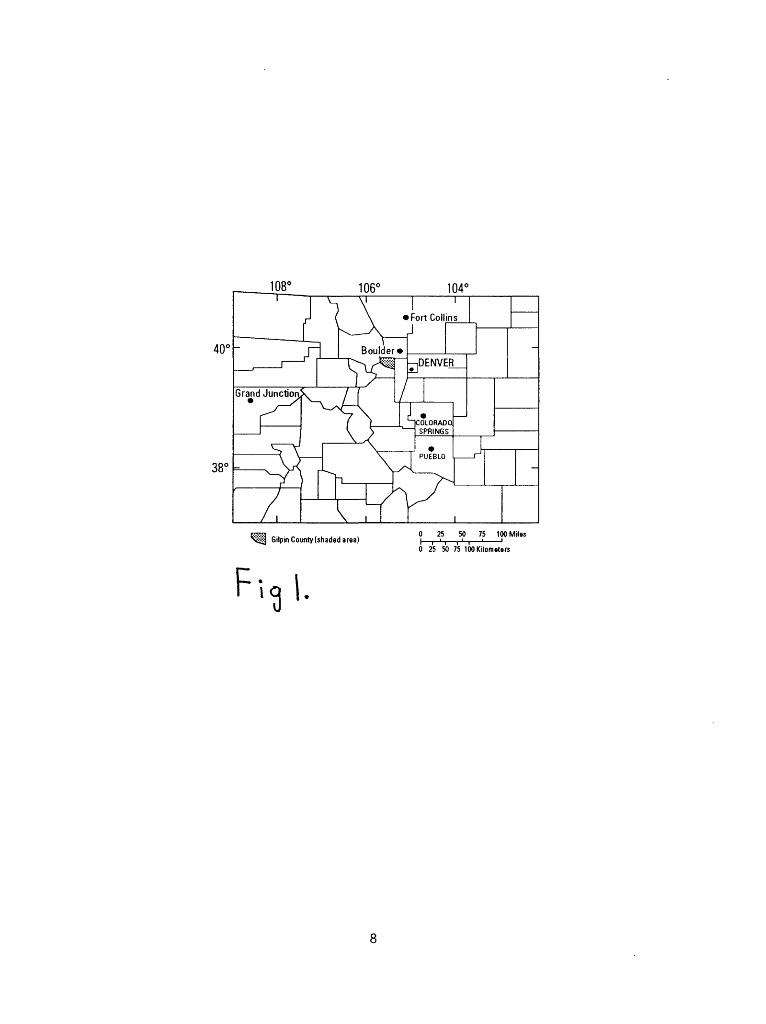
LOCATION AND WETLAND TYPEElk Park wetland in Gilpin County (fig. 1) in north-central Colorado lies in the subalpine
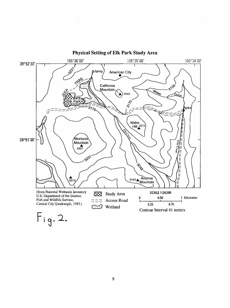
zone and has an average elevation of 3,165 m. It occupies U.S. Forest Service land in the northwest corner of the Central City 7.5' Quadrangle. It is 3.2 km west of Apex, Colorado (see fig. 2) and is 10.5 km northwest of Central City, Colorado.
The study area (fig. 2) covers approximately 78,000 nfl and occupies the western part of the wetlands found in Elk Park. The three wetland areas shown on figure 2 were delineated on The National Wetlands Inventory of the Central City Quadrangle (1983) and are classified there as emergent scrub/shrub wetlands within the palustrine ecological system, which includes all nontidal wetlands dominated by trees, shrubs, persistent emergents, and emergent mosses or lichens. Further, these wetlands were classified as having seasonal water regimes, i.e. surface water is present for extended periods especially early in the growing season, but is absent by the end of the season in most years; when surface water is absent, the water table is often near the land surface (Cowardin and others, 1979). Our observations support the description based on the National Wetlands Inventory.
The study area can be further described as a fen and carr complex. Fens are grass-, sedge- , or reed-dominated peatlands (Crum, 1988). Carrs are wetlands that occur on organic soil composed of minerotrophic peat and have greater than 25 percent shrub cover (Windell and others, 1986). The fen portions of the study area are dominated by sedges and grasses, but also contain a variety of showy wetland plants such as marsh marigolds (Caltha leptosepala\ elephant's head (Pedicularis groenlandica\ shooting stars (Dodecatheon pulchellum), and rose crown (Sedum rhodanthum). The dominant shrubs in the carr portions of the study area are willows (Salix spp.) and bog birch (Betula glandulosa). Both brown and sphagnum mosses are present in the wetland, with the sphagnum more commonly being associated with shrub
hummocks and the brown mosses with "lawn" areas. Some additional description of the plants found in Elk Park wetland can be found in Mohlenbrock, 1993.
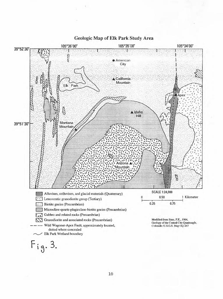
GEOLOGIC AND PHYSICAL SETTINGThe Elk Park study site is nestled within a nivation basin. A C-14 date (9,540 years BP ±
120) from near the base of the wetland suggests that the wetland started to form in this basin about 10,000 years ago. Figure 3 shows the geology of the area around the study site. The bedrock beneath and surrounding the wetland is mapped as being dominantly sillimanitic biotite- quartz gneiss with interlayers of biotite-quartz-plagioclase gneiss and locally garnetiferous biotite- quartz-plagioclase gneiss of Precambrian age (Sims, 1964). A band of granodiorite of Precambrian age (fig. 3) crops out immediately west of the study area (Sims, 1964).
The surface of the wetland is strikingly terraced from west to east with several large fen areas giving way to shrubed escarpments that drop to the next open fen. The wetland also has ridge/swale (string/flark ?) topography in chevron fashion along some of its flanks. We believe that these features are the result of solifluction. Past climatic conditions at the site are unknown, but the wetland, under current climate conditions, is close to having constantly frozen ground or permafrost. While coring in September to retrieve material for C-14 dating and other uses, ice was encountered at a depth of 65 cm, and ice was a common impediment to augering throughout the summer. In June, in areas where ice was encountered, the depth to ice was typically 15 to 20 cm. In these areas the depth to ice gradually increased over the course of the summer until most areas were ice free by late summer. As opposed to fen areas, carr areas were consistently the first to become either completely or sufficiently thawed to permit augering. One possible explanation is that the woody vegetation serves as a heat sink causing earlier melting. Another possible explanation is that there is a significant difference in the sediment moisture content in the carrs, in comparison to the open fens, prior to freezing weather because of the transpiration of the shrubs, mosses, and other plants that grow in the carrs. Less moisture to freeze, would require less heat to thaw. The answer(s) that explains this phenomena may be a combination of the possibilities above or something yet to be determined and is worthy of further investigation.
MINERALIZATIONVarious past mining activities are in evidence near the wetland study site. An adit is
visible about 150m uphill from the study site on the west side, and several dogholes or exploratory pits are uphill from the road along the south side of the study area. Claim posts are still standing in the western and central portions of the wetland. There are a number of abandoned gold/silver mines and one occasionally active mine east of Elk Park. One prominent mine with extensive tailings piles is near where Elk Creek exits the wetland complex.
With known mineralization in the area, the USGS collected reconnaissance auger-samples in 1991 from 8 locations near springs and seeps (potential point sources for metal input) within the current study area to investigate whether any metal enrichment was occurring in the wetland. Mountain wetlands, and fens in particular, are efficient filters for removing uranium and other metals from waters entering them (Owen and others, 1992; Owen and Breit, 1995; Owen and Otton, 1995). A few elements showed some enrichment within the organic-rich wetland sediments. The maximum concentration (dry weight, not ashed) found in any sample for these enriched elements was: chromium, 117 parts per million (ppm); copper, 308 ppm; lead, 125 ppm; manganese, 608 ppm; silver, 9.8 ppm; and zinc, 264 ppm. Uranium, which has been found to be
enriched in many Front Range wetlands (Owen and others, 1992), was not enriched in Elk Park; the highest sample was only 6.6 ppm uranium. Left undisturbed to continue its natural filtration of waters, the wetland is an asset. Should the wetland be disturbed for some reason in the future, a more detailed study of metal concentrations within the wetland should be made and the potential environmental impacts of the release of such metals assessed.
CLIMATEDetailed climatic information for the study site is unavailable. The nearest official weather
reporting station is 14.8 km away to the east-north-east on the flanks of Mt. Thorodin at an elevation of 2,728 m. There, the mean January temperature is -6 °C with an average range of between -10 and 0 °C. Mean July temperature is 14 °C, with an average range between 2 and 20 °C (Doesken, 1994; oral communication). Because Elk Park lies more than 400 m higher than the station on Mt. Thorodin, the mean temperatures at Elk Park are going to be lower than those found on Mt. Thorodin. Annual precipitation is between 118 cm and 142 cm in the vicinity of Elk Park (Gaggiani and others, 1987), with the majority of precipitation as snow. During our sampling efforts we experienced snow as late as July 7, 1994 with notable accumulation at the study area. Winds, which occurred regularly while sampling over the course of the summer, were generally persistent and strong, and wind gusts were often estimated to be in excess of 20 mph. This suggests that evapotranspiration in the wetland is high during the brief growing season found at this altitude.
HYDROLOGYNo streams enter the study area. Other than direct precipitation, the fen and carr complex
of the study area is ground water fed. The periphery of the wetland study area is a continuous zone of seeps and springs where the ground water table intersects the surface. Throughout the summer the elevation of this intersection along the periphery steadily decreased and moved down gradient into the wetland. This caused areas that were originally saturated along the edges to dry out. Also, more than a dozen prominent spring pools are interspersed throughout the study area, and some give rise to leads that flow from a few meters to several 10's of meters before petering out or dissipating. These spring pools suggest that ground water is also following fracture flow paths in the bedrock beneath the wetland and that ground water enters the wetland beneath these pools under sufficient head for the upwelling water to have maintained open pools over time. The surface of the wetland in the study area drops approximately 22 meters from west to east indicating that sheet, surface, and ground water flows within the study are generally going to be easterly. In peatlands, most water leaves by evapotranspiration (Windell and others, 1986, p. 150). Elk Creek, which flows through the riparian wetland complex that forms the upper arm of the portion of the wetland east of the study area (shown on figure 2) serves as the main surface exit or drain for waters moving through the wetlands found in the Elk Park Basin.
METHODSField work was conducted periodically in the study area from late May until early
September of 1994. First, a grid pattern for establishing a fence of auger holes to determine the stratigraphy of the study area was laid out using a hip chain, "Brunton" compass, and wire flags. Flagged stations for auger hole sites were placed at 25 m intervals. The base line of the grid was established along the long axis of the wetland complex and had an azimuth of 95 degrees. The
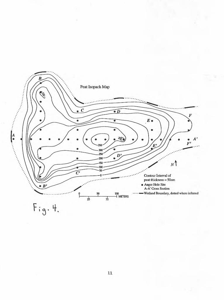
base line was 500 m in length and perpendicular cross lines were added along the base line at 100, 200, 300, 400, and 500 meters (see fig. 4). Upon completion of the grid, a Jacob's Staff, Abney Level (5X magnification with stadia intercept), and a surveyors rod were used to survey in the elevations of the sampling sites. Elevation was surveyed in from a known elevation control point on the rocky knoll 30 m north of the wetland boundary near the 300 m perpendicular cross line. At this time, distances from the last sampling station on each grid line to the wetland boundary were measured. Figure 4 shows the approximate wetland boundary and the location of the auger hole sites that provided the data from which the 6 profiles (A-A through F-F) were drawn.
Each auger hole site was sampled using a hand auger with a diameter of 3.5 cm. A drill- rod coupling at the top of the bit allowed 50 cm long sections of light-weight aluminum drill rod to be added as necessary. A T-handle fabricated from welded pipe sections and fitted with a drill- rod coupling was used to turn the auger. The auger was twisted into the ground in 25-cm drives then pulled straight up and out of the hole. The recovered sample was examined carefully for any slough, which was discarded, then the sample was removed and set aside on a portable table for later description. Successive 25-cm drives were made, the samples saved, and additional sections of drill rod were added as needed until the auger could no longer be twisted into the ground, usually shortly after encountering grus. After each of the 48 auger holes was completed, the samples were examined and the texture, color (Munsell Soil Color), and megascopic composition described. In early September a 5-cm diameter hand-driven core was taken near the 300 m station on the base line to retrieve material for C-14 dating and to provide material for stable carbon-isotope work of others.
RESULTSProfiles or cross sections A-A through F-F1 provide a graphic representation of the
stratigraphy as determined from the 48 auger holes. Because there is a 22 m difference in elevation across the wetland, the tops of the auger holes have been plotted, based on their surface elevation, using the scales found in the upper left- and right-hand corners of the profiles. There is a vertical exaggeration of 35 times between the scale used to plot the auger hole data below the surface of the wetland and the horizontal scale. Figure 4 shows the location of these profiles within the study area. Four basic sediment types were encountered during sampling, peat, peaty muck, muck, and grus. Peat was used to describe sediments that under megascopic examination were estimated to be at least 75 percent organic matter. The most common Munsell color for peat was dark reddish brown (5YR 2.5/2, 5YR 3/2, 5YR 3/3). Peaty muck was used to describe sediments that were estimated to be between 1/2 and 3/4 organic matter, and muck was used for sediments that were estimated to be between 1/4 and 1/2 organic matter. Munsell colors for peaty mucks varied from dark brown (7. SYR 3/2) through very dark brown (10YR 2/2) and very dark grayish-brown (10YR 3/2, 2.5Y 3/2) to black (10YR 2/1). Munsell colors for mucks ranged from dark brown (7.5YR 3/2) and very dark gray (10YR 3/1, 7.5YR 3/0, 5YR 3/1) to black (10YR 2/1, 5YR 2.5/1). Grus, the fragmental products ofin-situ granular disintegration of the bedrock, was typically dark gray (2.5Y 4/0, 5YR 4/1, 7.5YR 4/0, 10YR 4/1) or very dark gray (5Y 3/1, 5YR 3/1, 10YR 3/1). The shapes of individual grus grains were consistently either subangular or subrounded. Mica flakes were frequently present in both the muck and the grus.
Peat is the dominant sediment type within the wetland basin. The peat generally overlies a thinner layer of peaty muck or muck, and sometimes both. Occasionally the peat rested directly upon grus. Peaty mucks generally had fewer discernible roots and plant fragments than peats, and
mucks had less than peaty mucks. Where present, peaty muck overlies either a thin layer of muck or rests directly upon grus. There is neither any geomorphic evidence from the area surrounding the study site, nor any sedimentologic evidence from any of the auger holes to suggest that a stream has ever flowed into the study area during its 10,000 years of existence. None of the 48 auger holes penetrated any lake clays before reaching grus; indicating that a lake has never occupied the wetland basin.
The decomposition of organic matter over time increases the relative percentage of wind blown and slope wash materials present in the organic-rich sediments. In general, because basal or older sediments have had more time to decompose, they are more likely to be classified as peaty mucks or mucks. Besides age, the amount of decomposition may be influenced by the amount of water that has passed through a given section of peat. In general, peats in and near spring pools showed more decomposition than peats distal to spring pools. Also, mucks and peaty mucks were generally thicker along the flanks of the study area where water table fluctuations result in more decomposition from oxidation as the water table drops through the summer and where clastic material can more easily enter the wetland as slope wash. Many of the areas around the edges of wetland did not contain peat, likely due to the poor environment for preservation and increased opportunity for clastic sediment input.
Charcoal was occasionally found in the sediments throughout the wetland study area, documenting that fire has been a part of the natural ecosystem in the surrounding area during the life of the wetland. One hole along profile B-B1, 75 meters from the base line towards B 1, has a zone with a large amount of inorganic matter and with abundant charcoal. This zone likely represents a fire caused by a lightning strike that burned the peat in the immediate area, which concentrated the inorganics, and produced the charcoal. Holes 25 meters to the north and south of this location show no such zone.
Figure 4 is also an isopach map of peat thickness, and depicts peat accumulation in the study area during the last 10,000 years. Peat thickness exceeds 3 meters in the central portion of the study area, and the maximum peat thickness observed in any of the auger holes was 360 cm. The average peat thickness in the study area is 1.7 m and the total calculated in-situ volume of peat is 134,940 nv*. A sample from the core taken near the 300 meter mark on the base line (profile A-A1) yielded a C-14 age of 4,380 ± 60 years BP at a depth of 200 cm. A crude estimate of the accumulation rate of peat in the wetland for the interval between 0 and 200 cm, based on a C-14 age of 4,380 years BP at a depth of 200 cm, is 0.45 mm per year. Twigs and sedge leaves like those found growing at the surface of the wetland today are ubiquitous throughout the entire peat deposit indicating that the wetland has not gone through any serial stages of succession. This wetland ecosystem has been stable for its 10,000 years of existence, despite evidence of fire and the intrusion of man.
CONCLUSIONSThe wetland in the Elk Park study area formed about 10,000 years ago at the beginning of
the Holocene. It has apparently looked much the same as it does today throughout its history and has not gone through serial stages of succession. Charcoal found in some of the samples indicates that fire has been a part of the natural regime in the area through the life of the wetland, and evidence from one auger hole suggests that the wetland itself has not been immune to lightning strikes. The organic rich sediments are performing the function of filtration and removing metals
from ground waters entering the wetland. Apparently solifluction has played an important role in producing some of the surface topography of the wetland.
Should the wetland ever be planned to be disturbed, a more detailed study of the metal distribution in the wetland and the possible impact on Elk Creek should be assessed. Elk Park is a significant wetland resource in close proximity to the Denver Metropolitan Area. Future research could include vegetation mapping and a detailed study of the hydrology. Because the wetland contains a continuous record of the last 10,000 years, palynology and other paleoenvironmental indicator studies could be done to unravel the climatic history of the area.
Bibliography
Borland, Jim, 1994, Colorado Mountain Peatlands: Unique Wetlands of Concern: Colorado Riparian Association The Green Line, v. 5, no. 1, pp. 1 and 3.
Cowardin, L.M., Carter, V., Golet, F.C., and LaRoe, E.T., 1979, Classification of wetlands and deepwater habitats of the United States: US. Fish and Wildlife Service FWS/OBS-79/31, 131 p.
Crum, Howard, 1988, A Focus on Peatlands and Peat Mosses: Ann Arbor, Michigan, The University of Michigan Press, 306 p.
Gaggiani, N.G., Britton, L.J., Minges, D.R., and others, 1987, Hydrology of Area 59, Northern Great Plains and Rocky Mountain Coal Provinces, Colorado and Wyoming: U.S. Geological Survey Water Resources Investigations Open File Report 85-153, 124 p.
Mohlenbrock, R.H., 1993, Elk Park, Colorado: Natural History, Nov. 1993, p. 66-68.
Munsell Color, 1975, Munsell Soil Color Charts: Baltimore, Maryland, Kollmorgen Corporation, 24 p.
National Wetlands Inventory of Central City, Colorado, 1983, U.S. Fish and Wildlife Service Map 1:24,000.
Owen, D.E., and Breit, G.N., 1995, Geochemical Reconnaissance Study of Vassar Meadow (Adams Rib) Wetlands and Vicinity, Eagle County, Colorado: U.S. Geological Survey Circular 1122, 16 p.
Owen, D.E. and Otton, J.K., 1995, Mountain Wetlands: Efficient Uranium Filters Potential Impacts: Ecological Engineering, v. 5, no. 1, p. 77-93.
Owen, D.E., Otton, J.K., Hills, F.A., and Schumann, R.R., 1992, Uranium and other elements in Colorado Rocky Mountain Wetlands: A Reconnaissance Study: USGS Bulletin 1992, 33 p. and 1 plate.
Sims, Paul K., 1964, Geology of the Central City Quadrangle, Colorado: USGS Map GQ-267
Windell, J.T., Willard, B.E., Cooper, D.J., Foster, S.Q., Knud-Hansen, C.F., Rink, L.P., and Kiladis, G.N., 1986, An ecological characterization of Rocky Mountain montane and subalpine wetlands: U.S. Fish and Wildlife Service Biological Report 86(11), 298 p.
|i Gilpin County (shaded area)
Fig!.
0 25 50 75 100 MilesI ! 'i ,' i ' '0 25 50 75 100 Kilometers
39°52'30"
Physical Setting of Elk Park Study Area105°36'00" i05°35'00" 105°34'
39°51'30"
(from National Wetlands Inventory U.S. Department of the Interior, Fish and Wildlife Service, Central City Quadrangle, 1983.)
Study Area
Access Road
Wetland
SCALE 1:24,000
0.50
I i
0.25 0.75 Contour Interval 61 meters
1 KilometerH
Q.
Geologic Map of Elk Park Study Area105°36'00" 105035'00" 105°34'00"
' :..: :' ' ...: American .. .
39°51'30"
HHH Alluvium, colluvium, and glacial materials (Quaternary)
L! ',*\ Leucocratic granodiorite group (Tertiary)
|:.: /:] Biotite gneiss (Precambrian)
tiggggj Microcline-quartz-plagioclase-biotite gneiss (Precambrian)1*^*1 Gabbro and related rocks (Precambrian)
^s^s^^ Granodiorite and associated rocks (Precambrian)
Wild Wagoner-Apex Fault, approximately located,dotted where concealed
^^_^ Elk Park Wetland boundary
SCALE 1:24,000
0.50 1 Kilometer
0.25 0.75
Modified from Sims, PJC., 1964, Geology of the Central City Quadrangle, Colorado: U.S.G.S. Map GQ-267
Fia.3.
10
F.'g.t.
50
25 75
100H METERS
Contour Interval of peat thickness = 50cm
Auger Hole Site A-Af Cross Section
Wetland Boundary, dotted where inferred
11
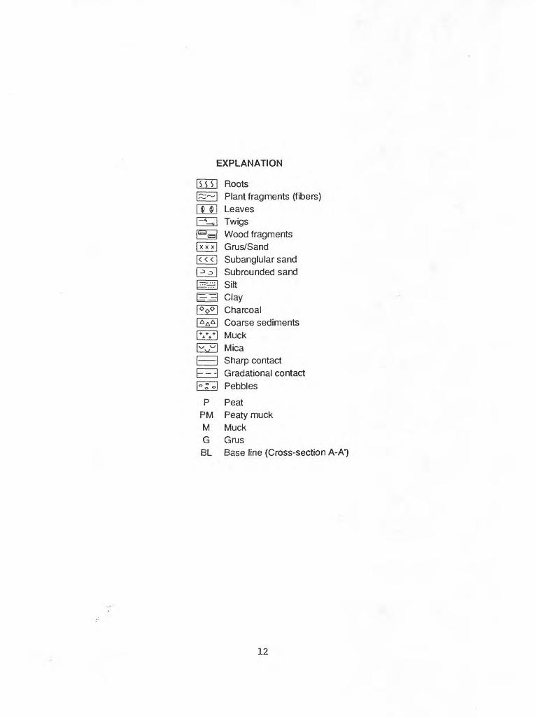
EXPLANATION
rrrri Roots|~~I Plant fragments (fibers)I $ $1 LeavesI~^UI TwigsRsl Wood fragments|xxx| Grus/Sand|«<| Subanglular sand|^^» I Subrounded sand
jOp0 ! CharcoalI AAA ! Coarse sedimentspyvH Muckl www l MicaI I Sharp contacth- -I Gradational contactl°go| Pebbles
P PeatPM Peaty muckM MuckG GrusBL Base line (Cross-section A-A1 )
12