stratigraphy - msnucleus.org repeat themselves through geologic time and are difficult to determine...
TRANSCRIPT

Math/Science Nucleus © 2001 1
STRATIGRAPHYTeacher Guide
including Lesson Plans, Student Readers, and More Information
Lesson 1 - What is stratigraphy?
Lesson 2 - Correlation Activity
Lesson 3 -Geologic Time
Lesson 4 - Earth’s History - Lab
Lesson 5 - Environments through Time
designed to be used as an Electronic Textbook in class or at home
materials can be obtained from the Math/Science Nucleus

Math/Science Nucleus © 2001 2
Objective: Students learn the howstratigraphy developed.
Teacher note
Stratigraphy is usually overlooked in beginning Earth Science classes.However, it is an important tool to the petroleum and mining industries. Stratigraphyis the analysis of different rock formation through time and changing environments.Usually it is associated with sedimentary rocks because they follow predictable rulesas they are deposited. Igneous and metamorphic rocks are more random on howthey are deposited.
Rocks repeat themselves through geologic time and are difficult to determinethe age when they were deposited. A granitic sandstone that was formed millionsof years ago, can resemble a granitic sandstone of today. However, if you look atthe fossils within these sedimentary rocks, they can provide clues on timing ofdeposition. For example, rocks with trilobites in them will not be forming todaybecause there are no trilobites. The evolution of organisms helps us to comparethe different rock strata and determine which one is older or younger. Fossils giveus clues for which strata is younger or older.
It was the layers of rocks that made early geologist think about what couldhave created these layers. After careful analysis, many geologists becameconvinced that it took a lot of time to create these layers. Serious debates over theage of the Earth were started by geologists stating that the Earth was older than onethousand years.
Stratigraphy is built on the concept that the present is the key tounderstanding the past. The same processes that create the rocks today were inoperation in the past. This helps us reconstruct how the strata was deposited in thepast.
The following website has more information on stratigraphy and the scientistsinvolved in changing how we think:
http://turnpike.net/~mscott/index.htm
EARTH SCIENCES - STRATIGRAPHY
Lesson 1 - What is stratigraphy? MATERIALS:
reader
Math/Science Nucleus © 2001 3
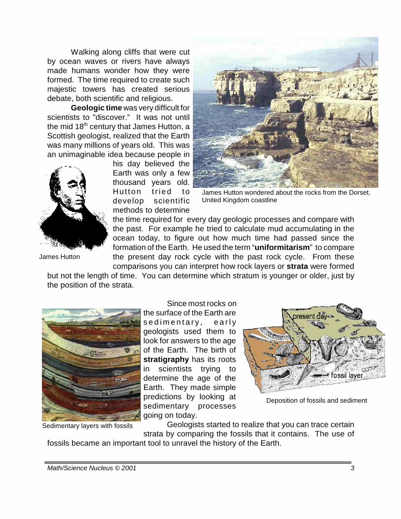
James Hutton wondered about the rocks from the Dorset,United Kingdom coastline
James Hutton
Deposition of fossils and sediment
Sedimentary layers with fossils
Walking along cliffs that were cutby ocean waves or rivers have alwaysmade humans wonder how they wereformed. The time required to create suchmajestic towers has created seriousdebate, both scientific and religious.
Geologic time was very difficult forscientists to "discover.” It was not untilthe mid 18th century that James Hutton, aScottish geologist, realized that the Earthwas many millions of years old. This wasan unimaginable idea because people in
his day believed theEarth was only a fewthousand years old.Hut ton t r i ed todevelop scientif icmethods to determinethe time required for every day geologic processes and compare withthe past. For example he tried to calculate mud accumulating in theocean today, to figure out how much time had passed since theformation of the Earth. He used the term “uniformitarism” to comparethe present day rock cycle with the past rock cycle. From thesecomparisons you can interpret how rock layers or strata were formed
but not the length of time. You can determine which stratum is younger or older, just bythe position of the strata.
Since most rocks onthe surface of the Earth ares e d i m e n t a r y , e a r l ygeologists used them tolook for answers to the ageof the Earth. The birth ofstratigraphy has its rootsin scientists trying todetermine the age of theEarth. They made simplepredictions by looking atsedimentary processesgoing on today.
Geologists started to realize that you can trace certainstrata by comparing the fossils that it contains. The use of
fossils became an important tool to unravel the history of the Earth.

Math/Science Nucleus © 2001 4
Nicholas Steno
Sedimentary layers
William Smith
Nicholas Steno, a Danish physician living in Italy in 1669proposed that the Earth’s strata accumulated with three basic principles.Steno pointed out obvious, but overlooked principles of sedimentaccumulation. They included the Principle of Original Horizontality,Principle of Superposition, and Principle of Original Continuity.
If sediments accumulate in a large basin, the laws of gravity willdeposit the beds, horizontal to the surface of the Earth. Beds can “pinchout” along the sides of the basin as in the figure below.
The Principle of Superposition states that in a sequence ofsedimentary rock layers, the bottom layers are older than the top layers.The bottom layers were deposited first. In the figure below A is theoldest bed and G is the youngest.
The Principal of Original Continuity states that the beds can betraced over a longinterval if thebasins were open.For instance, Bed F can be tracedcontinuously to the smaller basin inthe figure below. The other bedsbelow F can then be correlated toBeds A-E.
The Principle of Faunal Succession was later added byWilliam Smith in the late 1700's who observed and studied fossilsembedded in rock layers. This principle statesthat the oldest fossils in a series of sedimentaryrock layers will be found in the lowest layer(layer A). Progressively younger fossils occurin higher layers (layer B). This is the sameconcept as superposition, but it helpedgeologists realize that you can look at the ageof these layers and assign relative dates. Thisparallels evolution. Younger organisms replaceolder organisms as the older ones becomeextinct.
Since organisms change through time, itallows correlation of beds far apart. If thelayers have similar fossils, one can deduce thatthe layers are the same age.

Math/Science Nucleus © 2001 5
Darwin, Australia
Cores
Ship taking a core
The principles of stratigraphy help to develop asequence of rock layers. In the figure to the left, theoldest rocks are on the bottom (sandstones). Thesandstones represent rocks deposited in a shallowmarine environment. The younger rocks reveal anenvironment change into a tidal area. Through timethe tidal area evolves into a lagoon and then aswamp.
The sequence provides information onchanging environments through time. Then you cand e t e r m i n e t h esequences in otherplaces and thencorrelate one rocktype with another.For instance, alongthe beach in Darwin,Australia you cantrace rock layerseasily. They look likethey match!
Stratigraphy is important to understand events thathappened over time and over a large area, However, tointerpret these events you require slices of rocks throughtime commonly referred to as or cores. Ships can core rocklayers from the oceanbottom. Cores would betaken at intervals that canhelp us correlate andinterpret how the rocks werelaid down.
In the figure of cores, each core represents aslice of the Earth. In “A,” the green shells are the oldestand the blue seastars are the youngest. You can see thatas you go from cores A to D the fauna adds snails to theregion. A stratigrapher would determine what caused thissequence of events. Stratigraphers also look at the rocks,the fossils, and other evidence to make these conclusions.

Math/Science Nucleus © 2001 6
Seismic profile of an idealized area
Interpretation of the ideal seismic profile
Three dimensional seismic model
Interpreting how the Earth’s sedimentary layers have formed, is difficult. Corestaken on land and from the ocean are not only expensive to retrieve, but represent a smallpercentage of the Earth’s surface. Methods using seismic waves developed in the 1960'shelp to observe the crust’s layers in detail. Seismic stratigraphy is when energy wavesare used to bounce off the different layers of the Earth. These layers provide us with datathat a seismic stratigrapher can then interpret. For example, in the seismic profile belowwe show the results of waves bouncing off the different layers and then recorded on thesurface of the Earth. These “wavy” images can then be used to reconstruct the area in
rock units, as shown inthe interpretation of theseismic profile.
These advanceshave allowed geologiststo map more area thanever before. Prior tothese advances, onlyo u t c r o p s a n dgeologists walking andrecording on their mapscould be used.
Seismic profiles can be used tohelp calculate and create three-dimensional models of the Earth’slayers that are hidden from view. Newadvances in other methods such asinfrared prof i les and otherelectromagnetic wave technologies,will allow us one day to see what thecrust looks like.
Stratigraphy has evolved froman observational science into a high tech search fortools to help us explore what our world looks like. All these new techniques that we are developing willhelp us find resources like oil and metals. Thistechnology can also be used to learn about thesurface of other planets.

Math/Science Nucleus © 2001 7
Objective: Students pract icecorrelation of rock units.
Teacher noteRock units without fossils are hard to correlate over large areas that are not
visually continuous. Visual correlation of rock units are difficult because manyoutcrops may be covered. Erosion after the rocks were deposited may also preventcorrelation.
Lithologic units (rocks) without fossils can look the same. Sandstonescreated on the beach could look similar to sands that were deposited offshore instorm conditions or even sand created in deserts.
In this activity we want the students to train their eyes to see these correlationin cores. If you have access to cores, you might want students to see the real thing. You may want to do an internet search to see cores on line.
EARTH SCIENCES - STRATIGRAPHY
Lesson 2 - Correlation Activity
MATERIALS:
readercolored pencilsworksheets
Correlation of cores from theEarth can be easy if you match themup unit by unit. Geologists would mapan area and collect samples to confirmthe units connected. For example, inthe cores to the right, “a” has brownpebbles so you can correlate acrossthe three cores.
In the following exercises youare looking at cores or outcrops andtrying to see similarities. You look atsimilar rock types in one section andthen connect it with the appropriatearea. Coloring the units, one colorhelps to visually see the units easily. In the next exercise, follow the instructions for eachactivity.

Math/Science Nucleus © 2001 8
EARTH SCIENCES - STRATIGRAPHY
CORRELATION ACTIVITY
PROBLEM: How can the principles of stratigraphy be used to do relative age dating?
HYPOTHESIS:
PROCEDURE:Exercise I. This drawing shows a cross-section, or a side view, of the rock layers belowthe Earth’s surface. The trees and water show where the surface is. Each rock layer isidentified by a letter. Some of the rock layers contain fossils. Using the principles ofstratigraphy, answer the following questions about the cross section.
1. Which rock layer is the oldest? Which rock is the youngest? Which principles helpedyou determine your answer?
2. Between what two layers has erosion occurred? How can you tell?
3. Which rock units have been affected by mountain building? How can you tell?
4. Which type of fossil is the oldest? Which stratigraphic principles helped you answerthis question?

Math/Science Nucleus © 2001 9
Exercise II.Correlate the appropriate rock units by drawing a line between the cores. You are givenone clue in defining bed “A.” Color the appropriate units and name them logically. Makea legend so your teacher can easily see the results.
1. Describe what units are missing in section 3.

Math/Science Nucleus © 2001 10
Exercise III. Correlate the appropriate units. Label the cores. Draw a line between unitsthat match and color them appropriately. Create a legend using one of the cores. Can youinterpret under what environmental conditions these units were deposited (i.e., deep orshallow)?
Math/Science Nucleus © 2001 11
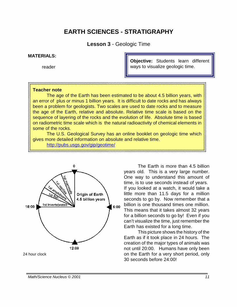
Objective: Students learn differentways to visualize geologic time.
24 hour clock
Teacher noteThe age of the Earth has been estimated to be about 4.5 billion years, with
an error of plus or minus 1 billion years. It is difficult to date rocks and has alwaysbeen a problem for geologists. Two scales are used to date rocks and to measurethe age of the Earth, relative and absolute. Relative time scale is based on thesequence of layering of the rocks and the evolution of life. Absolute time is basedon radiometric time scale which is the natural radioactivity of chemical elements insome of the rocks.
The U.S. Geological Survey has an online booklet on geologic time whichgives more detailed information on absolute and relative time.
http://pubs.usgs.gov/gip/geotime/
EARTH SCIENCES - STRATIGRAPHY
Lesson 3 - Geologic Time MATERIALS:
reader
The Earth is more than 4.5 billionyears old. This is a very large number.One way to understand this amount oftime, is to use seconds instead of years. If you looked at a watch, it would take alittle more than 11.5 days for a millionseconds to go by. Now remember that abillion is one thousand times one million.This means that it takes almost 32 yearsfor a billion seconds to go by! Even if youcan’t visualize the time, just remember theEarth has existed for a long time.
This picture shows the history of theEarth as if it took place in 24 hours. Thecreation of the major types of animals wasnot until 20:00. Humans have only beenon the Earth for a very short period, only30 seconds before 24:00!

Math/Science Nucleus © 2001 12
Geologic time
Fossils from Bitter Springs Formationin Australia, oldest fossils known.
Avalanche
The age of the Earth was determined byusing absolute dating of meteorites and moonrocks, which gives a date of 4.5 billion years old.The oldest known Earth rocks are younger, at justmore than 4 billion years in age. Older Earthrocks have been destroyed by meteorite impacts,weathering, or metamorphism.
The oldest known fossils are almost 3.8billion years old. The oldest fossils, however, arefrom very simple, single-celled forms of life. Theyare far removed from the complex life forms of thepresent. Multi-celled organisms (our likelyancestors) did not appear until approximately 650
million years ago.These creatureslikely gave rise toanimals with hardb o d y p a r t s(skeletons) about560 million yearsago. Evolution oforganisms has taken place in the last quarter of Earth’shistory, which includes the Paleozoic, Mesozoic, andCenozoic.
Geologic time is so different from the time thatinfluences our lives. Geologic time refers to long periodsof time measured in millions to billions or years in the rockrecord. However, geologic time can also record events thatmight be only a few hours or minutes in duration, like acatastrophe. Throughout geologic time, volcanic eruptionshave caused ash to mix with snow causing an avalancheof mud. This wall of mud can cascade over towns and buryall forms of live. This event would be recorded in the rock.The bodies of organisms might not be there whenuncovered by future generations, but the mud thataccumulated will turn into mudstone. You can sometimesaccumulate tens of meters of material in less than a day’swork. Time is odd, and it is the job of a geologist to unearththe truth.

Math/Science Nucleus © 2001 13
Geologic Time Scale
Paleontologists have made a detailed record of the evolution of life through Earth’shistory. This record is the basis for the geologic time scale and is referred to as relativetime. The geologic time scale subdivides the 4.5 billion year history of the Earth intoshorter time periods, based on changes in fossils.
The broadest division of geologic time is the Eon. There are two Eons, thePrePhanerozoic (or Precambrian) and Phanerozoic. The Precambrian stretches from theformation of the Earth 4.5 billion years ago until the start of the Phanerozoic Eon, about560 million years ago. There are many fossils in PrePhanerozoic rocks, but they arealmost all microscopic. Phanerozoic means “visible life.” The rocks of the PhanerozoicEon, which covers about the last 560 million years of Earth history, are characterized byabundant visible fossils.

Math/Science Nucleus © 2001 14
Index fossils
The use of fossils in stratigraphy is referred to as biostratigraphy. It is moreaccurate than absolute dating which has large margins of error. Biostratigraphers are stillrefining how the fossils can be used, but its use in relative dating is powerful.
It has been noted that species have a life span. If the species is short lived andabundant over a large area, it is called an index fossil. So if you find these fossils you cancorrelate time events. Marine organisms are the best because they can be found in largegeographic environments and are deposited in many rock units.
Below are some examples of index fossils. Their time range is graphically displayedin a general manner. Biostratigraphers use much more detailed information.

Math/Science Nucleus © 2001 15
Radioactive decay of Potassium-40
Absolute age dating determines howmany years before the present a rockformed. It gives the age of the rock inyears. Geologists use radioactiveelements to do absolute age dating.Radioactive elements are unstable. Overtime, they decay or change into stableelements or will decay to become eithersome nearby element in the periodic tableor some isotope of the same element. Forexample, radioactive potassium-40 decaysinto calcium-40 (11%) and Argon-40 (89%).We know how long it takes for such atransformation, by calculating the amount ofdaughter material (calcium and argon) thatis produced from potassium. The time ittakes is called its ``half-life'' andrepresents the average time an atom willsurvive in its original state.
Radiometric clocks are "set" wheneach rock is created. So the moment anigneous rock solidifies from magma or asedimentary rock layer is deposited or arock changed by metamorphism, the clock
begins. It is this process that gives us the ability to date rocks that formed at differenttimes in earth history.

Math/Science Nucleus © 2001 16
Objective: Students describe fossilsthat have biostratigraphic significance.
Teacher note
Students have learned to identify fossils in previous units. This lab hasstudents look at similar fossils from specific locations and determine what age theyrepresent. Students should use the charts and information in the reader to helpinterpret what age and environment the fossils represent.
This is a good time to use local fossils to add to this lab. If you are unfamiliarwith fossils in your area, you may want to contact a local college or rock shop tohelp find localities and materials.
The materials should be displayed as a unit. For example, the crinoid,brachiopod, trilobite, and orthocerous are from the Paleozoic of Morocco. Theyshould represent one area and time slice. The ammonites represent the Mesozoicof Morocco. The fossil shark teeth, although from Morocco, represent the Eocenewhich is in the Cenozoic.
The Capitola, California fossils represent just the Miocene, which is part ofthe Cenozoic.
This lab requires that they have completed all other fossil units. You mayalso want to see if students can connect the type of rocks that the fossils are in formore clues. Observation and making the connection that fossils can provide usclues on geologic time are the important skills.
Collecting Fossils in Californiahttp://www.gtlsys.com
EARTH SCIENCES - STRATIGRAPHY
Lesson 4 - Earth History Lab MATERIALS:
reader

Math/Science Nucleus © 2001 17
Red marks Capitola, California
Fossils tell a story about an area. They provide thestories of rocks that would otherwise be in many cases,just rocks. In this lab we will highlight two areas that areon two different continents. There are many other fossillocalities in the world that have similar stories. In yourtravels, you should always ask what does this fossilrepresent and what clue does it provide to understand thegeologic history?
Morocco is on the African continent in thenortheastern portion facing the Mediterranean and Atlantic
Oceans. This area has beenknown for centuries as a fossilhunter’s paradise. The AtlasMountains contain some of themost beautifully preservedfauna in the world. The fossilsre p re s e n t t wo s im i l a renvironments (marine) but withdifferent time spans.
Capitola is a small beachcommunity on the centralCal i fornia coast . Manyswimmers and surfers look at
the cliffs while they are in the water, but most never look at the secrets of the cliffs. Layersof layers of invertebrate fossils embedded in the sandstones and mudstone, tell a story ofdeath on the high seas.

Math/Science Nucleus © 2001 18
Morocco Mesozoic deposits
Fossil shop
Mollusk fossils in mudstone
Marine mammals
Morocco is, geologically, a very complicated area.It records the marine environment of north Africa over500 million years. This area is noted for its shops andexport of fossils to many parts of the world.
In some areas you have typical marine Paleozoicfauna including brachiopod, trilobites, ammonites,crinoids, and sea urchins. The Mesozoic is noted for its
extremely largeammonites thatare found infossil shopsthroughout theworld. TheCenozoic is full of fossil shark teeth, whichreflects a biologically happy area for a long time.Now the area is part of the Sahara Desert, withlittle sign of its glorious past, except in thefossils.
The California coast has been subject to movementbecause of transform motion of two major plates. Mudflatsthat were once home to millions of organisms slowly wereuplifted exposing their remains along the cliffs. Layers offossils represent millions of years of accumulation. You canfind mollusk including bivalves and gastropods, bones from
marine mammals,sand dollars, andeven crab claws.
Many timesthe shells are in distinct layers, with few stillhaving two shells. Paleontologists havededuced that this represents storm layers. Astorm would come in with violent waves and ripup the mollusk community. After the storm theshells would create a “burial” layer. In betweenthe storm layers, you can find bivalves thatwhose shells are still intact, so they lived to aripe old age.

Math/Science Nucleus © 2001 19
Evolution seems to be in one direction. Once a species becomes extinct, thelikelihood of that organism coming back to life is remote. It is this belief that allows us todate rocks. For instance, we will not have dinosaurs again. If you find dinosaur bones inrocks, those rocks are in the Mesozoic. Rocks without dinosaurs are younger (Cenozoic)or older (Paleozoic).
Relative time is very important and based on fossil occurrence. The ordering orthe Principle of Faunal Succession will remain the same. Look at your fossils and try tofamiliarize yourself with the organisms and when they lived in geologic time.

Math/Science Nucleus © 2001 20
EARTH SCIENCES - STRATIGRAPHY
GEOLOGIC TIME LAB
PROBLEM: How can you use fossils to date and determine the paleoenvironment of anarea?
HYPOTHESIS:
MATERIALS: fossils
PROCEDURE:
1. Describe the fossil specimens from Capitola? Draw two different species that you seeon the space provided below. Look at the range chart from the reader and determine theage of this specimen. Explain your answer.
2. Morocco is noted for its hills of fossils. However, many of their fossils come fromdifferent times. Draw all the fossil specimens on a the space provided below. Draw thespecimens in the geologic time grouping they are from.

Math/Science Nucleus © 2001 21
Objective: Students reflect on whyenvironments change through time.
Teacher note
The fossil record charts how organisms in a certain area have changedthrough time. This evolution of organisms provides clues to interpret pastenvironmental conditions.
This reader tries to get students to look at the entire environment that isrepresented by rocks and fossils. In the next units on petroleum and mining, we willinvestigate specific examples of how interpretation of past environments is importantto find and extract resources.
Fossil fish kill
EARTH SCIENCES - STRATIGRAPHY
Lesson 5 - Environments through Time MATERIALS:
reader
We all live in environments that are comfortable. Fish
live in water because their body only works in that habitat. Thechemistry of the water makes a perfect place for fish to thrive.In a healthy environment the fish will live, produce young, anddie. In the present day environments, we can see that if youchange the chemistry or water availability, you can have adrastic effect on organisms. Even in the ocean, a change oftemperature of just 2-5degrees centigrade canwipe out certain species,
but also make conditions better for other species. If you remove one species, it can cause a
chain reaction through the food chain and cause theentire environment to change.
In the fossil record we can witness mass deathand chart when a species becomes extinct. We cansee if the events were at a local level or a largerregional area. These events help us interpret howthe environment evolved through time.

Math/Science Nucleus © 2001 22
Mauritius Island
Dodo bird
A “species” in a biological sense refers to male andfemale organisms that can produce young. If organisms areliving, this is easy to observe. However, if the organismsare extinct we only have their skeletal remains. Inpaleontology we compare similar fossil morphology andrefer to them as a single species. We record when a newskeleton is observed and chart the range of that species.
Sometimes we can see slight changesthat branch off into another species.
In the present we can see theevidence of why organisms becameextinct. The dodo bird is an example of a modern day extinction onMauritius Island in the Indian Ocean. This 50 lb. bird was flightlesswith no enemies on the island. When humans came to the shoresin the early 1500's they ate the bird for meat. Humans also broughtpigs, rats, and monkeys that ate the dodo bird’s eggs. Within 180years after man came to its shores, the dodo was extinct by 1681.So why is one species important in the fossil record. Unfortunatelywhen you take away one species another species will soon follow.
In the case of the fruit-eating dodo, it was recently noted thatcertain trees were no longer producing seedlings. There were 300year old trees with no younger trees. It was concluded that the dodoate the fruit and as the seeds passed through the gut, it prepared theseed for germination. Without the dodo naturally eating the fruit the
tree would become extinct. To save the tree, turkeys are now being used to eat the fruitto produce seedlings.
Change is part of Earth’s history. Stratigraphy records and saves these changesin rocks. Fossils reveal many extinctions through time. Geologists first felt theserepresented catastrophes which wiped our entire groups of organisms. Some felt this wasevidence of biblical floods that caused all these extinctions. However, an extinction ismore severe than just a one time disaster. For example, in the figure you can see that theriver enters into an ocean. Organisms live there. A large monsoon rips up the bottomwhere the organisms live andkills them. The river then addsnew sediment from the landand buries the creatures,preserving them as fossils.With time, the organisms canreestablish their habitat andlive until the next storm event.This is not an extinction.

Math/Science Nucleus © 2001 23
Straits of Gibraltar
A meteorite
A permanent change in the physical conditions of ahabitat, may only cause organisms to move to anotherlocation. However, if an ocean slowly evaporates or is cutoff from another main body of water, and allrepresentatives of a species live in that area, thenextinction can occur.
A disaster could change anenvironment that would cause anextinction. For example if anearthquake caused a narrow area likethe Straits of Gibraltar to close, waterwould be trapped in the MediterraneanSea. Circulation would become limitedand cause layering of zones of stagnant water. The environmentwould change. It might take thousands or millions of years for thewater to evaporate, but species that are endemic to the Mediterraneancould not leave. They would slowly die to extinction.
So an event could trigger an entire habitat to change whichwould cause organisms to die off. Some scientists feel that even largemeteorites could change a long term habitat and cause extinction over
a rapid period of time, other scientists feel that organisms are not all like the dodo bird,and can find other areas to live.
It has been long realized that the fossilrecord showed extinctions that had somethingto do with plate movements. As plates movethe positions of land and ocean, there seems tobe drastic shifts of environments. Marineconditions become land, and this would causeextinctions of any marine organisms.
The timing of plate tectonics andextinctions that are recorded in the fossil recordare similar. When plate movement bringscontinents together, the environment of theorganisms will slowly change, but in the fossilrecord it could look “rapid.”
Plate tectonics can cause mountains toemerge through converging or transformboundaries which become barriers fororganisms. Unlike humans, most organisms donot have the ability to just “move.” An elephantcannot just find a new habitat that will sustain ahealthy population. They just can’t get into acar and drive to a new place.

Math/Science Nucleus © 2001 24
Atmosphere of today
Although the present is the keyto the past, not all the keys fit tounravel our geologic past. Someconditions in the past will never be thesame. For example, the atmosphere isalways changing. When life was firstnoted in the fossil record, theatmosphere was not like it was today.It wasn’t until the beginning of the
Cambrian that methane, hydrogen, and ammonia were not the common gases in ouratmosphere. Organisms, like plants, havechanged the chemical composition of theatmosphere. Humans could not havesurvived in the atmosphere when trilobiteswere king of the oceans. The level of the water has alsoevolved. Only about a billion years after theEarth was formed, was there evidence ofwater. Erosion of the rocks and the additionof gases from the atmosphere, have allchanged the composition of the oceans.
Environments through time havechanged. There are lessons in the present,but all geologists realize the past is a difficultsubject to interpret.

Math/Science Nucleus © 2001 25
Earth Science - Stratigraphy and Correlation - Unit Test
Part I. Definitions: Match the number of the term or concepts in Column 1 with the letterof the correct definition in Column 2.
Column 1 Column 21. Precambrian a. Principle of original horizontality
2. extinction b. study of layers that correlate using fossils
3. absolute date c. oldest fossil
4. index fossils d. dinosaurs and ammonites
5. relative dating e. last occurrence of a species
6. 3.8 billion years f. older than 560 million years
7. biostratigraphy g. species with a short life span and abundant
8. beds that are layered h. origin of Earth
9. Mesozoic i. based on half lives of radioactive decay
10. 4.5 billion years j. using fossils to determine age
Part II. Multiple Choice Choose the best answer to complete each statement.
1. Stratigraphy is not based ona. Principle of Superpositionb. Principle of Faunal Successionc. Principle of Horizontalityd. Principle of Verticality
2. Uniformitarism was first described bya. James Huttonb. William Smithc. Nicholas Stenod. Robert Jones
3. Which principle states that beds can be traced over a long interval a. Principle of Superpositionb. Principle of Original Continuityc. Principle of Faunal Successiond. Principle of Horizontality

Math/Science Nucleus © 2001 26
4. Younger organisms replace older organisms refers to a. Principle of Superpositionb. Principle of Original Continuityc. Principle of Faunal Successiond. Principle of Horizontality
5. Geologists use _______ to help correlate rock units.a. rocksb. coresc. sequencesd. sandstone
6. Seismic profiles help toa. interpret stratigraphy that is not exposedb. find fossilsc. record rocksd. find earthquakes
7. The age of the Earth is determined bya. relative datingb. a clockc. absolute datingd. fossils
8. The oldest known fossils are almost ____ years old.a. 3.8 million yearsb. 4.5 million yearsc. 3.8 billion yearsd. 4.5 billion years
9. Which combination represents the Phanerozoica. Cenozoic, Precambrian, Paleozoicb. Eocene, Cretaceous, Jurassicc. Precambrian, Cenozoic, Eocened. Cenozoic, Mesozoic, Paleozoic
10. Which of the following is responsible for changing environments through time?a. Plate Tectonic movementsb. amount of rainc. amount of sun d. fire

Math/Science Nucleus © 2001 27
ANSWERS:
Part I.1. F2 . E3. I4. G5. J6. C7. B8. A9. D10. H
Part II.1. D. 2. A3. B4. C5. B6. A7. C8. C9. D10. A