submitting an fsp - british columbia · submitting an fsp user guide document change control fsp...
TRANSCRIPT


Submitting an FSP User Guide
Document Change Control
FSP Tracking System—Release 1.5 March, 2011 – Version 1.4
Page 2
Document Change Control
The information contained in this user guide may change based on experience and issues
identified/resolved. Please check the FSP Tracking System website on a regular basis to ensure
you are using the most recent version of this user guide. The website can be found at:
http://www.for.gov.bc.ca/his/fsp/.
The table below outlines the changes that have occurred within each version of the user guide.
This will assist you identify what has changed between the various versions.
Comments, clarifications and questions regarding this user guide should be sent to the Natural
Resource Sector Service Desk at [email protected].
Version Date of Issue Brief Description of Change
1.0 October 12, 2007 Original document.
1.1 January, 2008 Clarify the location of the FSP ESF Submission Guide
available from the links listed on the user guide page of
the FSP website.
1.2 May, 2008 Enhance the user guide for consistency with Release
1.2 of the FSP Tracking System. Changes made
throughout the user guide.
1.3 March, 2009 Edits to reflect the revised functionality for submitting
an FSP through the Electronic Submission Framework
(ESF) as introduced in a maintenance release to version
1.3 of the FSP Tracking System (December, 2008).
1.4 March, 2011 Enhance the user guide for consistency with Release
1.5 of the FSP Tracking System. Changes made
throughout the use guide

Submitting an FSP User Guide
Table of Contents
FSP Tracking System—Release 1.5 March, 2011 – Version 1.4
Page 3
Table of Contents
Document Change Control..............................................................................................................2 Table of Contents............................................................................................................................3
Submitting an FSP Electronically to the Government....................................................................5 1.1 When is information submitted to the government? ..................................................... 5 1.2 How is information submitted to the government? ....................................................... 5 Data requirements for submitting FSPs via the ESF and FSP Tracking System ........................ 5 1.3 User access roles ........................................................................................................... 7
1.4 Submitting FSPs via the Electronic Submission Framework (ESF) ............................. 8 1.4.1 Overview ................................................................................................................. 8
1.4.2 Tools and approaches for creating XML/GML files .............................................. 8
1.4.3 General submission guidelines ............................................................................... 9
1.4.4 Business rules.......................................................................................................... 10 1.4.5 General content requirements ................................................................................. 10 1.4.6 ESF schema layout .................................................................................................. 15
1.4.7 Submission errors (ESF) ......................................................................................... 15 1.5 Submitting FSPs via the FSP Tracking System ............................................................ 16
1.5.1 Overview ................................................................................................................. 16 1.5.2 General submission guidelines ............................................................................... 17 1.5.3 Business rules.......................................................................................................... 18
1.5.4 General content requirements ................................................................................. 18 1.5.5 Submission errors (FSP Tracking System) ............................................................. 23
1.5.6 Fixing incorrect submissions .................................................................................. 23 1.6 Submitting spatial information ..................................................................................... 24
1.6.1 Submitting Forest Development Unit (FDU) boundaries ....................................... 24 1.6.2 FDU boundaries in the FSP legal document ........................................................... 24
1.6.3 FDU boundaries for storage in the LRDW ............................................................. 24 1.6.4 Submitting FRPA Section 196 Areas ..................................................................... 25 1.6.5 Declaring Areas in an approved FSP ...................................................................... 25
1.6.6 Mapping standards for spatial Information ............................................................. 25 1.6.7 Content .................................................................................................................... 25 1.6.8 Map Scale................................................................................................................ 26
1.6.9 Position ................................................................................................................... 26 1.6.10 Accuracy ................................................................................................................. 26 1.6.11 Minimum Resolution .............................................................................................. 26
1.6.12 Acceptable Units ..................................................................................................... 26 1.6.13 Geometry Validation ............................................................................................... 26
1.7 Submitting stocking standards information .................................................................. 27 1.7.1 Stocking standards must be approved by the DDM................................................ 27
1.7.2 Stocking standards for use in the RESULTS application ....................................... 27 1.7.3 Data fix for stocking standards incorrectly entered into RESULTS ....................... 29
1.8 Submitting paper based FSPs........................................................................................ 30
1.9 Submitting Transitional FSPs ....................................................................................... 30
Submitting an FSP User Guide
Table of Contents
FSP Tracking System—Release 1.5 March, 2011 – Version 1.4
Page 4
1.10 Submitting Innovative FSPs ......................................................................................... 30 Appendix A: Definitions and Acronyms .................................................................................... 32 Appendix B: Scanning Tips and Standards (version 1.2) ........................................................... 34

Submitting an FSP User Guide
Overview
FSP Tracking System—Release 1.5 March, 2011 – Version 1.4
Page 5
Submitting an FSP Electronically to the Government
This user guide describes the responsibilities, processes and data standards for submitting FSPs
electronically to the government. Background information on the FSP Tracking System can be
found in Section 1.4 -- FSP Tracking System of the Administrative Guide for FSPs (AGFSP:
Volume 1—Preparation and Approval of an FSP). (See Appendix A for reference link)
1.1 When is information submitted to the government?
FSPs can be electronically submitted when the licensee/BCTS has completed their FSP and is
ready for the MFLNRO review and approval process. The FSP should have been through the
review and comment phase and should be the full, legal copy of the plan that meets all the
requirements of the FRPA including signatures of those required to prepare a plan. The
signatures can either be electronic signatures or scanned versions of the original signature. More
information on signing FSPs, or amendments to approved FSPs, can be found in Section 3.10.15
of Volume I of the AGFSP.
1.2 How is information submitted to the government?
FSPs can be submitted to the government via the Electronic Submissions Framework (ESF)
system or FSP Tracking System. Section 1.4 of this user guide provides the details for submitting
FSPs via the ESF and Section 1.5 of this guide provides details for submitting FSPs via the FSP
Tracking System. The following table lists the data requirements for each of the options for
submitting FSPs.
Data requirements for submitting FSPs via the ESF and FSP Tracking System
ESF FSP Tracking System
Data Element Mandatory? Method Mandatory? Method MFLNRO District Yes XML Yes Entered on FSP
Info screen
Agreement Holder Yes XML Yes Entered on FSP
Info screen
FSP Name Yes XML Yes Entered on FSP
Info screen
FSP Effective Date n/a n/a Yes Determined on
Workflow tab
when DDM
approves plan.

Submitting an FSP User Guide
Overview
FSP Tracking System—Release 1.5 March, 2011 – Version 1.4
Page 6
ESF FSP Tracking System
Data Element Mandatory? Method Mandatory? Method FSP Term (years &
months) or FSP
Expiry Date
Yes—either
FSP Term or
FSP Expiry
Date
XML Yes—either
FSP Term or
FSP Expiry
Date
Defaults to 5
years. Can change
on FSP Info
screen. FSP
Expiry Date, if not
entered, is
calculated when
plan approved.
Contact Name Yes XML Yes Entered on FSP
Info screen
Telephone Number Yes XML Yes Entered on FSP
Info screen
Email address Yes XML Yes Entered on FSP
Info screen
Transitional FSP No—required
if transitional
FSP
XML No—required
if transitional
FSP
Set on FSP Info
screen
Stocking Standards
(for use in
RESULTS)
No—required
prior to FSP
approval*
XML No—required
for FSP
approval*
Enter on Stocking
Standards screen
FDU Boundaries
(electronic spatial
files for LRDW)
No—required
prior to FSP
approval*
GML No—required
for FSP
approval*
Discuss with
District Manager
FRPA Section 196
areas (electronic
spatial files for
LRDW)
No—required
if transitional
FSP
GML No—required
if transitional
FSP
Discuss with
District Manager
Declared areas in an
approved FSP
(electronic spatial
files for LRDW)
No GML No Discuss with
District Manager
Legal FSP Document
including signatures,
results, strategies,
measures, stocking
standards and FDU
boundaries
Yes Attachment Yes Attach on
Attachments tab
screen
Supporting
documentation
No** Attachment No** Attach on
Attachments tab
screen

Submitting an FSP User Guide
Overview
FSP Tracking System—Release 1.5 March, 2011 – Version 1.4
Page 7
* stocking standards and FDU boundaries not included in the initial submission must be
submitted before the FSP can be marked as approved in the FSP Tracking System. Stocking
standards can be submitted at a later date as a second, ―update‖ submission through ESF or by
returning to the FSP Tracking System and entering the information on the Stocking Standards
tab. FDU boundaries can be submitted at a later date as a second ―update‖ submission through
ESF or by providing a zipped folder of the spatial files in the Attachments tab of the FSP
Tracking System. The option of providing FDU boundaries as a zipped folder of spatial files
should be discussed with the District Manager to confirm the availability of resources to
download, unzip and load the spatial files into the Land and Resource Data Warehouse (LRDW).
If resources are not available, the FSP Tracking System Systems Administrator should be
contacted through the local district application contact.
** Supporting documentation submitted to the FSP Tracking System to aid the FSP review and
adjudication process will have security restrictions on who can view the information. Only
government users and users within the same licensee can see these documents in the FSP
Tracking System. Other licensees/BCTS will not be able to view these documents (but can view
the FSP legal document itself once it is marked as ―approved‖).
Multi-District FSP submissions
Multi-district FSPs will be submitted once, by the licensee/BCTS, to the FSP Tracking System
which will automatically notify each District covered in the FSP via the InBox. The districts
covered by the FSP will determine who and how to review the FSP.
1.3 User access roles
Licensees, BCTS and district personnel who wish to submit FSPs electronically to the
government will need to have an access role of ―FSP Submitter‖. An access role of ―FSP
Submitter‖ will enable licensees/BCTS to:
enter FSPs, amendments and extension requests into the FSP Tracking System—including
stocking standards;
submit FSPs, amendments and extension requests through either the FSP Tracking System or
the ESF;
submit FSPs extension requests through the FSP Tracking System;
view FSPs, amendments and extension requests submitted by their organization—regardless
of status (e.g., draft, approved, in effect, rejected, Opportunity To Be Heard Sent, submitted);
delete FSPs and amendments that are in ―draft‖ status. FSPs that are rejected by a DDM
cannot be deleted from the FSP Tracking System.
Access roles can be requested from the FSP website at http://www.for.gov.bc.ca/his/fsp/.
Note: You can check your FSPTS Access roles by going to the ADAM website:
https://apps14.for.gov.bc.ca/adam/welcome.do

Submitting an FSP User Guide
Submitting FSPs via the ESF
FSP Tracking System—Release 1.5 March, 2011 – Version 1.4
Page 8
1.4 Submitting FSPs via the Electronic Submission Framework
(ESF)
1.4.1 Overview
Submitting FSPs via the ESF is the long term direction of the MFLNRO for receiving electronic
submissions of FSPs and/or amendments to approved FSPs. Eventually, all FSPs, and
amendments to those FSPs, will be submitted through the ESF. However, there are currently
limited tools available to create the XML/GML files necessary to submit via the ESF. As an
alternate method, licensees/BCTS can submit their FSPs via the FSP Tracking System and avoid
having to create XML/GML files. This process is described in the next section of this User
Guide.
The ESF submission process involves five steps as illustrated in the diagram and described
below.
Information on the XML/GML schema and the requirements of the ESF can be found in the
document titled ―FSP ESF Submission Guide‖ available from the links listed on the user guide
page of the FSP website at http://www.for.gov.bc.ca/his/fsp/userGuides/.
1.4.2 Tools and approaches for creating XML/GML files
Tools and approaches for creating a partial or complete XML/GML file for submitting an FSP
through the Electronic Submission Framework (ESF) are listed below. The submission format is
not specific to any particular software application. NOTE: the MFLNRO does not advocate using
any particular system, listed or otherwise. The tools include the following:
Computer Aided Mapping/Design Applications (CAM/CAD)—these applications support
cartographic design and development, but do not provide direct linkages between spatial
elements and their attributes (e.g., AutoCAD, Microstation);
Create
XML/GML File
Upload
XML/GML Submission
in ESF
Attach
Documents in ESF
Review
FSP in FSP Tracking System
Submit FSP in
FSP Tracking System

Submitting an FSP User Guide
Submitting FSPs via the ESF
FSP Tracking System—Release 1.5 March, 2011 – Version 1.4
Page 9
Geographic Information Systems (GIS)—these systems focus on managing and analyzing
spatial information and provide a mechanism to relate spatial and attribute information (e.g.,
Arc);
Non-Spatial Forest Management Systems—these systems manage attributes relating to
inventories, surveys, etc. but do not directly manage or integrate spatial information into the
product;
Integrated Forest Management Systems—these systems manage both the attribute and spatial
information related to forest applications (e.g., GENUS);
Data Conversion System—these tools are often referred to as data transformation tools and
convert data from one format and structure to another (e.g., FME);
e-Submission Document Management Tools—these are tools developed to support direct
editing of e-submission documents. These tools focus directly on editing the content of an e-
submission document (e.g., eziLink); and
Development Libraries and Utilities—these custom applications are developed to support the
creation and editing of XML/GML directly.
Electronic submissions to the ESF are made by uploading a submission document to the ESF
website. The XML/GML file is submitted first and contains the FSP header information,
stocking standards, FDU boundaries and any FRPA Section 196 areas. When the XML/GML file
is successfully processed, a unique identifier for the FSP is automatically assigned. At this point,
the user can attach and upload documents such as the FSP legal document and any supporting
information. ESF submissions must be completed in one session.
1.4.3 General submission guidelines
Submissions must be made by a user with an access role of ―FSP Submitter‖. The submission
involves:
Creating an XML/GML file containing mandatory information describing the FSP (header
information) such as the name of the FSP, MFLNRO district office(s) covered by the plan
area, licensee(s) involved, term of the plan, etc. Stocking standards may be included in the
submission, and if so, are part of the XML file. Spatial information describing the licensees’
Forest Development Unit (FDU) boundaries and/or FRPA Section 196 areas can be provided
as an XML/GML file. This spatial information is optional for the submission but the FDU
boundaries must be provided before the FSP can be marked as approved in the application.
The spatial information can be submitted later as a second ―update‖ submission through ESF
or by providing a zipped folder of the spatial files to the MFLNRO via the Attachments tab
on the FSP Tracking System;
Uploading the XML/GML file via the ESF website at http://www.for.gov.bc.ca/his/esf/;
Attaching documents once the XML/GML file is successfully processed. The FSP legal
document containing the signature(s) of those required to prepare the plan must be provided.
Licensees/BCTS users can attach multiple documents as supporting material for any of the
attachment types (except the FSP legal document). From a file size perspective, it is
recommended users attach multiple, small documents rather than combining and attaching
one large document;

Submitting an FSP User Guide
Submitting FSPs via the ESF
FSP Tracking System—Release 1.5 March, 2011 – Version 1.4
Page 10
reviewing the draft FSP in the FSP Tracking System to confirm, revise and/or enhance the
FSP as necessary. Once the FSP is uploaded from the ESF and accepted in the FSP Tracking
System, users can log on to the FSP Tracking System and find the draft FSP to review; and
submitting the FSP to the government through the FSP Tracking System.
Only one FSP can be submitted at a time to the ESF website (e.g., batch submissions are not
possible).
If the submission is unsuccessful, the submitter will receive a report outlining the issue.
A successful submission will be turned over to the MFLNRO for the review and approval
process. It is recommended that the licensee/BCTS notify the lead MFLNRO district that an FSP
has been submitted. The FSP Tracking System will automatically place the FSP in the InBox of
the MFLNRO user(s) with user roles of ―reviewer‖ and ―decision maker‖. A courtesy call or
email to remind the MFLNRO personnel that the FSP has been submitted electronically will
avoid any delays in finding the FSP in their InBox. Districts can also setup an email notification
list in the FSP Tracking System that will automatically generate an email and send to everyone
on the notification list when any FSP, or amendment or extension request, is submitted (Admin
Tab).
It is important to realize that the FSP is not approved when the FSP is successfully submitted.
The plan will need to go through the MFLNRO review and approval process before it is
approved. The FSP submitter will be automatically sent an email by the system when the plan is
approved or rejected.
1.4.4 Business rules
The following business rules apply to submissions through the Electronic Submission
Framework (ESF):
• Licensees/BCTS must attach a legal FSP document, with signatures enclosed, to the FSP
submission as a .doc, .docx, or .pdf document;
• Other documents may be attached. These documents must have an extension of .doc, .docx,
.xls, .xlsx, .pdf, .jpg, .txt, .rtf or .zip;
• Spatial information of FDU boundaries and/or FRPA Section 196 areas can be submitted for
storage in the LRDW. The ESF submission requires the boundaries in an XML/GML format.
If this information changes, the entire FDU map/linework must be re-submitted—not just the
changes as files are replaced in the LRDW, not updated; and
• FSPs that have been rejected by a DDM cannot be deleted from the FSP Tracking System by
the ―FSP Submitter‖. An FSP can only be deleted by the ―FSP Submitter‖ if the FSP is in
―draft‖ status.
1.4.5 General content requirements
Requirements of FSP information submitted through the ESF include the information listed
below. More information on the XML/GML schema and the requirements of the ESF can be

Submitting an FSP User Guide
Submitting FSPs via the ESF
FSP Tracking System—Release 1.5 March, 2011 – Version 1.4
Page 11
found in the document titled ―FSP ESF Submission Guide‖ available from the links listed on the
user guide page of the FSP website at http://www.for.gov.bc.ca/his/fsp/userGuides/.
General Content Requirements Create
XML/GML File
Create the XML/GML file containing the following information:
FSP (Header) Information (Mandatory)
Includes information on the MFLNRO district(s) under the plan area,
licensee(s) involved in the plan, plan name, term or expiry date and
contact information for the licensee. This information is provided as part
of the XML file. Licensees/BCTS should consider setting up and entering
an email distribution list for the email address instead of a single email
address. This will enable the system to send notice(s) to several recipients
and minimize issues with invalid email accounts and mailbox full errors.
The FSP header information will also contain an indicator to identify
transitional FSPs. Transitional FSPs can be submitted to the FSP
Tracking System and are automatically approved when submitted. More
information can be found in the section below labeled ―Submitting a
Transitional FSP‖(Section 1.9).
Stocking Standards (Conditional)
Individual FSP stocking standards should be submitted to the FSP
Tracking System as part of the XML/GML file. This will make them
available in RESULTS once the FSP is marked as approved. They do not
have to be provided with the initial submission but must be provided
before the FSP can be marked as approved (e.g., the stocking standards
can be submitted as an ―update‖ submission at a later date). More
information is available in the section labeled ―Submitting stocking
standards information‖(Section 1.7).
Spatial Information (Conditional)
FDU Boundaries
Forest Development Unit (FDU) boundaries can be submitted
electronically with the FSP or at a later time. However, FSPs cannot be
marked as approved until the FDU boundaries are loaded into the LRDW.
An FSP will be assigned a status of "rejected" if FDU boundaries are
submitted without a corresponding FSP legal document. To avoid this
scenario, the FSP legal document must either be attached to the
submission or already stored with the FSP in the FSP Tracking System.
This information is provided as part of the XML/GML file.
Licensees must list the forest licence(s) that apply within the boundaries

Submitting an FSP User Guide
Submitting FSPs via the ESF
FSP Tracking System—Release 1.5 March, 2011 – Version 1.4
Page 12
General Content Requirements of each FDU. Each forest licence(s) listed must be owned by the client
number of the submitter. Submissions by BCTS are exempt from this
requirement as no specific licences are involved.
FRPA Section 196 areas
Areas identified as FRPA Section 196(1) or 196(2) blocks and/or roads in
an approved Forest Development Plan can be submitted with the FSP.
These areas should be submitted separately—differentiating between
Section 196(1) areas and Section 196(2) areas.
Declared areas (in an approved FSP)
Information on declaring an area(s) under section 14(4) of the FPPR can
be found in the Amending an Approved FSP User Guide.
Mapping Standards
Mapping standards for spatial information is described below in Section
1.6.4 ―Mapping Standards for Spatial Information‖.
Upload
Submission in
ESF
(XML/GML
File)
Choose Submission Type (Mandatory) Select ―Forest Stewardship Plan submission‖ from the drop down list.
Enter User Reference (Optional)
Provide a name or label to assist in the identification of the submission in
ESF. Suggestions include listing the licensee and name of the plan being
submitted.
Browse to Submission file (XML/GML) (Mandatory)
Browse to the XML/GML file and attach to the submission.
When done, press the ―Upload Submission‖ button.
Finalize
Submission in
ESF
E-mail Address (Mandatory with default)
Confirm the email address for which ESF will send an email message
containing the status of the ESF submission. A default email address is
obtained from the XML/GML file and the email address associated with the
user-id (e.g., BCeID).
When done, press the ―Finalize Submission‖ button.
Upload
Attachments in
ESF
Monitor the status of your submission by visiting the ESF ―Search Page‖
through the link in the middle of the screen of the ESF ―Electronic
Submission – Complete Submission‖ webpage. The status indicator can be
found in the middle of the ―Electronic Submission – Submission Details‖
webpage under the line item ―Status‖. Periodically press the ―F5‖ key to

Submitting an FSP User Guide
Submitting FSPs via the ESF
FSP Tracking System—Release 1.5 March, 2011 – Version 1.4
Page 13
General Content Requirements refresh the screen which updates the status field.
Once the submission status is ―In Progress‖, you will receive the FSP ID
from the FSP Tracking System via the ESF. The FSP ID is the unique
identifier for the FSP. NOTE: the FSP ID will be used for future reference
(e.g., to help you find your FSP in the FSP Tracking System). You will also
get a note indicating how many attachments the system is expecting you to
submit (e.g., ―There are still XX outstanding attachments‖). At this point you
may attach your documents including the following listed below.
Press the ―Upload Attachment‖ button to attach your FSP documents. When
asked, identify the type of document being attached from the drop-down list
and browse to the corresponding file. Add comments to describe the
document (e.g., {name of licensee} FSP). Continue the process until all
documents are attached.
FSP Legal Document (Mandatory)
A copy of the legal FSP document must be attached. This must be a .doc,
.docx or .pdf document. To minimize the size of the PDF file, it is
recommended you create the PDF document directly from MS Word
using Adobe Acrobat’s PDFWriter. If this is not possible, scan the
documents directly into PDF format using Adobe Acrobat. Use a
resolution of 200dpi with an image or picture type of ―black and white‖.
Avoid gray scale and color unless scanning a photograph. Also avoid
using the scanner’s Optical Character Reader (OCR) settings as they can
alter the scanned document. Additional scanning tips and techniques can
be found in Appendix B: Scanning tips and Standards.
The FSP attached is the version that will be reviewed and
approved/rejected by the Delegated Decision Maker (DDM). The FSP
must contain either an electronic signature or scanned copy of the paper
based signature of those required to sign the plan.
Section 3.10.15 of Volume I of the AGFSP (―Who is responsible for
signing-off on the FSP?‖) contains additional information on the
requirements for signing FSPs.
Amendment Description (Not required)
This field is used when submitting amendments to approved FSPs.
Stocking Standards report (Optional)
If an FSP is prepared with the proposed stocking standards as a separate
document, the licensee/BCTS can attach the stocking standards
component here. If the license/BCTS has the stocking standards within

Submitting an FSP User Guide
Submitting FSPs via the ESF
FSP Tracking System—Release 1.5 March, 2011 – Version 1.4
Page 14
General Content Requirements their FSP legal document, then this field should be left blank. NOTE:
users will also need to provide their stocking standards as part of the
XML/GML file to ensure they are loaded into the FSP Tracking System,
approved with the FSP and passed to the RESULTS application for use in
assignment to openings, etc.
More information on entering stocking standards is listed below in the
section labeled ―Submitting stocking standards information‖ (Section
1.7).
Map of FDUs (Optional)
Not required for submitting FSPs via the ESF. Licensees/BCTS may
attach an image of their FDUs here. This is not the same as submitting
boundaries of their FDUs for storage in the LRDW—this must be
included in the XML/GML file.
Map of FRPA Section 196-1 (Optional)
Not required for submitting FSPs via the ESF. Licensees/BCTS may
attach an image of their FRPA Section 196(1) areas here (i.e., cutblock
and/or roads in an approved forest development plan with the required
assessments complete). This is not the same as submitting boundaries of
their FRPA Section 196(1) areas for storage in the LRDW—this must be
included in the XML/GML file.
Map of FRPA Section 196-2 (Optional)
Not required for submitting FSPs via the ESF. Licensees/BCTS may
attach an image of their FRPA Section 196(2) areas here (i.e., cutblock
and/or roads in an approved forest development plan where the required
assessments are not complete). This is not the same as submitting
boundaries of their FRPA Section 196(2) areas for storage in the
LRDW—this must be included in the XML/GML file.
Map of FPPR Section 14-4 (Optional)
Not required for submitting FSPs via the ESF. Licensees/BCTS may
attach an image of their declared areas under FPPR section 14(4) here (as
part of an amendment to an approved FSP). This is not the same as
submitting boundaries of their declared areas for storage in the LRDW—
this must be included in the XML/GML file.
Supporting Document (Optional)
Additional information the licensee/BCTS wishes to submit to aid the
MFLNRO in their review and adjudication process (e.g., supporting
documentation) can be attached. This information can be in a variety of
formats including .doc, .docx, .xls, .xlsx, .pdf, .rtf, .jpg.

Submitting an FSP User Guide
Submitting FSPs via the ESF
FSP Tracking System—Release 1.5 March, 2011 – Version 1.4
Page 15
General Content Requirements Review FSP in
FSP Tracking
System
Once the FSP is submitted in the ESF and accepted in the FSP Tracking
System, the draft FSP can be reviewed in the FSP Tracking System before
final submission to the government:
Logon to the FSP Tracking System;
Find the draft FSP in the FSP Tracking System using the FSP ID
provided when uploading the FSP in the ESF. Use the ―search‖ menu to
find the FSP if the FSP ID is not available;
Review the draft FSP in the FSP Tracking System. Confirm the
information on the FSP Information tab is correct, files are attached in the
correct sections in the Attachment tab and stocking standards are correct
and complete on the Stocking Standards tab. Confirm the FDU
boundaries shown in MapView (FDU/Map tab) are correct; and
Revise and/or enhance the information as necessary (e.g., MFLNRO
district default stocking standards can be added in the FSP Tracking
System).
Submit FSP in
FSP Tracking
System
Users can submit their FSP via the ―submit‖ button on the FSP Information
tab.
NOTE: once the FSP is submitted, users can no longer make any changes to
it. Users should be sure they are ready to submit the FSP before they press
the ―submit‖ button. For example, retain the FSP in ―draft‖ status until all
FSP stocking standards have been entered.
1.4.6 ESF schema layout
Information on the XML/GML schema and the requirements of the ESF can be found in the
document titled ―FSP ESF Submission Guide‖ available from the links listed on the user guide
page of the FSP website at http://www.for.gov.bc.ca/his/fsp/userGuides/. Samples of the FSP
Schema can also be found on the ESF website at http://www.for.gov.bc.ca/his/esf/.
1.4.7 Submission errors (ESF)
When a submission through the ESF is rejected, an error message is included with the rejection
notification. By clicking on the hyperlinked error message identification number, or by
navigating to the technical documentation page
(http://www.for.gov.bc.ca/his/fsp/webhelp/index.htm) users will find a description of the error,
and often times, a recommended solution (Click on FSP, Online Tech Specs, PDFs). These lists
of error messages cannot cover every possible error, but they do cover the most common errors.

Submitting an FSP User Guide
Submitting FSPs via the FSP Tracking System
FSP Tracking System—Release 1.5 March, 2011 – Version 1.4
Page 16
1.5 Submitting FSPs via the FSP Tracking System
1.5.1 Overview
The FSP Tracking System can be used when submitting the initial FSP, amending an approved
FSP and/or extending/replacing the FSP at the end of its term. The ESF can also be used when
submitting an FSP and/or amending an approved FSP. However, the FSP Tracking System
provides an alternate way to submit FSPs until licensees/BCTS have the software tools to create
the necessary XML/GML files to submit via the ESF. It also enables smaller licensees who do
not have the resources to prepare XML/GML files to submit their amendments electronically.
Spatial information of FDU boundaries and FRPA Section 196 areas cannot be submitted in an
XML/GML format for loading into the LRDW via the FSP Tracking System. However, FDU
boundaries must be loaded into the LRDW before the FSP can be ―approved‖ in the FSP
Tracking System. One way to load the spatial information into the LRDW is to attach a folder in
the FSP Tracking System containing zipped spatial files of the spatial information and requesting
the MFLNRO manually download, unzip and load the line work into the LRDW.
The process for submitting FSPs through the FSP Tracking System is illustrated in the diagram
and described below.
Users enter core (header) information on their FSP into the FSP Tracking System. The first time
the plan is saved in the application, a unique identifier for the FSP will be assigned. At this point,
the user can attach the necessary documents including the FSP legal document and enter their
stocking standards. On-line validation will identify major errors in the submission and request
the user to correct before submitting the plan. When the FSP is successfully submitted, it will be
turned over to the MFLNRO for the review and approval process.
Enter FSP (Header)
Information
Attach FSP Documents and Spatial Information
Enter Stocking Standards
Submit FSP

Submitting an FSP User Guide
Submitting FSPs via the FSP Tracking System
FSP Tracking System—Release 1.5 March, 2011 – Version 1.4
Page 17
1.5.2 General submission guidelines
Submissions must be made by a user with an access role of ―FSP Submitter‖. Electronic
submissions via the FSP Tracking System are made by:
Entering header (administrative) information about the FSP including the MFLNRO district
office(s), licensee(s), name and term of the plan as well as contact information for the
submitter (mandatory);
Attaching the FSP legal document complete with signature(s) of those required to prepare the
plan (mandatory);
Attaching zipped folders of the necessary shape files for FDU boundaries (optional). The
FDU boundaries must be loaded into the LRDW before the FSP can be marked as approved
in the FSP Tracking System. If the licensee/BCTS cannot create an XML/GML file of their
FDU boundaries for submission through the ESF, they can follow this approach and attach
the zipped files and request the MFLNRO to download, unzip and load this information into
the LRDW. This approach should be discussed with the MFLNRO District Manager to
ensure the resources are available to load the files into the LRDW;
Attaching zipped folders of the shape files for any FRPA Section 196 areas being submitted
with the FSP (optional). The process for attaching these shape files is the same as described
above for attaching a zipped folder of the FDU boundaries;
Attaching other supporting materials the licensee chooses to submit with their FSP
(optional). Licensees/BCTS can attach multiple documents for any of the attachment types
(except the FSP legal document). From a file size perspective, it is recommended users attach
multiple, small documents rather than combining and attaching one large document; and
Entering stocking standards (optional but encouraged). Stocking standards must be submitted
or entered into the FSP Tracking System so that they can be stored in the central database
and made available for use in RESULTS. Stocking standards that are not included with the
original submission, can be submitted to the FSP Tracking System by submitting a second,
―update‖ submission through ESF or entering the information on the Stocking Standards tab
of the FSP Tracking System. For more information, see the section below labelled
―Submitting stocking standards information‖ (Section 1.7).
Once the FSP is submitted to the government via the system, the licensee/BCTS cannot make
any further changes to their plan. If further changes are required, licensees/BCTS should contact
the District Manager for the lead district under the plan area and ask for the DDM to go into the
application and set the ―request clarification‖ flag on the Workflow tab. This will send the plan
back to the licensee/BCTS with a status of ―draft‖ and allow them to make any necessary
changes. For more information, see the ―request clarification‖ in the General Adjudication
Guidelines Section in the ―Reviewing and Adjudicating FSPs User Guide‖.
In the FSP Tracking System, users can save the FSP information as entered and return at a later
date/time to continue and/or complete the submission. There is no audit trail maintained of
changes made to the FSP while it is in ―draft‖ status. The application only maintains the most
recent version of the plan. This functionality is not applicable to ESF submissions where all
submissions must be completed in one session.
Submitting an FSP User Guide
Submitting FSPs via the FSP Tracking System
FSP Tracking System—Release 1.5 March, 2011 – Version 1.4
Page 18
Once the FSP is submitted, the licensee/BCTS should notify the lead MFLNRO district to inform
them of the submission. The FSP Tracking System will automatically place the FSP in the InBox
of the MFLNRO user(s) with user roles of ―FSP reviewer‖ and ―FSP decision maker‖. However,
a courtesy call or email to remind the MFLNRO personnel that the FSP has been submitted
electronically will avoid any delays in finding the FSP in their InBox. Districts can also setup an
email notification list in the FSP Tracking System that automatically generates an email and
sends to everyone on the notification list when any FSP, amendment or extension, is submitted.
1.5.3 Business rules
The following business rules apply to submissions through the FSP Tracking System:
• FSPs can only be submitted and updated by a licensee/BCTS while the FSP is in ―DRAFT‖
status. Once an FSP is approved, an amendment must be submitted to make any changes;
• Updates or changes to the FSP while in ―draft‖ status are not tracked/audited. Updated
information will overwrite older information;
• A licensee must attach a legal FSP document, with signatures enclosed—as either a .doc,
.docx, or .pdf document;
• Other documents may be attached. These documents must have an extension of .doc, .docx,
.xls, .xlsx, .pdf, .jpg, .txt, .rtf or .zip;
• The FSP Tracking System cannot accept XML/GML files of spatial information such as
FDU boundaries and FRPA Section 196 areas. Licensees can, if agreed with the District
Manager, attach a zipped folder containing the necessary shape files and a .pdf image of the
boundaries for quality assurance purposes. When the MFLNRO has the resources available,
they will load the information into the LRDW; and
• FSPs that have been rejected by a DDM cannot be deleted from the FSP Tracking System by
the ―FSP Submitter‖. An FSP can be deleted by the ―FSP Submitter‖ if the FSP is in ―draft‖
status.
• FSPs cannot be approved without spatial information or stocking standards.
1.5.4 General content requirements
Requirements for FSP information submitted through the FSP Tracking System include the
following:
General Content Requirements Enter FSP
(Header)
Information
(FSP
Information Tab)
District (Mandatory)
Specify the district(s) covered in the FSP plan area. If the plan is a multi-
district submission, identify all the districts in the list.
Copies of the plan do not need to be submitted to each district in a multi-
district FSP—the system automatically places the plan in the ―InBox‖ of
all applicable districts.

Submitting an FSP User Guide
Submitting FSPs via the FSP Tracking System
FSP Tracking System—Release 1.5 March, 2011 – Version 1.4
Page 19
General Content Requirements Agreement Holder (Client Number/Acronym) (Mandatory)
Specify the client number/acronym for the agreement holder that is
submitting the plan. The client cannot be a ―deactivated‖ client. A search
window is included to assist users look up the desired client
number/acronym.
If the plan is a multiple licensee plan, use the ―Add More‖ button to enter
the full list of licensees.
FSP Name (Mandatory) Enter the name of the FSP. If possible, use a name that is meaningful and
will be easy to identify through the search tools—(e.g., include company
/ division name / landscape unit in title).
FSP Term or Expiry Date (Mandatory with default)
Provide the length (term) of the plan in years and months or the FSP
Expiry Date. The default is a FSP Term of 5 years. Only one of the two
fields should be entered—either FSP Term or FSP Expiry Date. If not
provided, the FSP Expiry Date will be calculated when the plan is
marked as approved based on the FSP Effective Date and the FSP Term.
Contact Information (Mandatory)
Provide contact information for the FSP submitter. The contact should be
someone who can field questions about the FSP from MFLNRO
reviewers, decision makers and/or other personnel (e.g., contact for C&E
personnel who are planning inspections on areas under an approved FSP).
Provide the contact name, phone number and email address. The FSP
Tracking System will automatically send emails to the email address
provided when the plan status changes (e.g., ―approved‖, ―rejected‖).
Licensees/BCTS should consider setting up and entering an email
distribution list for the email address instead of a single email address.
This will enable the system to send notice(s) to several recipients and
minimize issues with invalid email accounts and mailbox full errors.
Press ―save‖ before moving to another tab. The application will
automatically generate the FSP ID the first time you save the document. This
number is the unique identifier for the FSP in the system. Note this FSP ID
for future reference (e.g., finding the FSP in the FSP Tracking System).
Attach FSP
Documents
(Attachments
FSP Legal Document (Mandatory)
A copy of the legal FSP document must be attached. The plan must be
either a .doc, .docx, or .pdf document. To minimize the size of the PDF
file, it is recommended you create the PDF document directly from MS

Submitting an FSP User Guide
Submitting FSPs via the FSP Tracking System
FSP Tracking System—Release 1.5 March, 2011 – Version 1.4
Page 20
General Content Requirements Tab) Word using Adobe Acrobat’s PDFWriter. If this is not possible, scan the
documents directly into PDF format using Adobe Acrobat. Use a
resolution of 200dpi with an image or picture type of ―black and white‖.
Avoid gray scale and color unless scanning a photograph. Also avoid
using the scanner’s Optical Character Reader (OCR) settings as they can
alter the scanned document. Additional scanning tips and techniques can
be found in Appendix B: Scanning Tips and Standards.
The document attached should be the version that is to be reviewed and
approved/rejected by the Delegated Decision Maker (DDM). The FSP
must contain either the electronic signature(s) or a scanned copy of the
paper based signature(s) of those required to sign the plan along with the
stocking standards and FDU boundaries.
Section 3.10.15 of Volume I of the AGFSP (―Who is responsible for
signing-off on the FSP?‖) contains additional information on the
requirements for signing FSPs.
Amendment Description (Not required)
This field is not used for the original FSP submission.
Stocking Standards Report (Optional)
If an FSP is prepared with the proposed stocking standards as a separate
document, the licensee/BCTS can attach the stocking standards
component here. If the licensee/BCTS has the stocking standards within
their FSP legal document, then this field should be left blank. NOTE:
users will also need to enter their stocking standards into the stocking
standards tab to ensure they are approved and passed to the RESULTS
application for use in assignment to openings, etc.
More information on entering stocking standards is listed below in
Section 1.7 ―Submitting stocking standards information‖.
FDU Map (map and zipped shape files)--conditional
Licensees/BCTS that are unable to create an XML/GML file of their
FDU boundaries can attach a zipped folder containing the spatial files of
the FDU boundaries. Enter a description of the attachment in the blank
field and browse to the zipped folder to attach. Press the ―save‖ button
when the file is located.
The spatial information does not need to be attached to the FSP when it is
submitted. However, the spatial information on FDU boundaries must be
provided and loaded into the LRDW before the DDM can mark the FSP
as approved in the FSP Tracking System.

Submitting an FSP User Guide
Submitting FSPs via the FSP Tracking System
FSP Tracking System—Release 1.5 March, 2011 – Version 1.4
Page 21
General Content Requirements Licensees must list the forest licence(s) that apply within the FDU
boundaries. This information will be specified in the FSP document. Each
forest licence(s) listed must be owned by the client number of the
submitter. Submissions by BCTS are exempt from this requirement as no
specific licences are involved.
More information on this approach is contained in Section 1.6.2 labeled
―Submitting Forest Development Unit (FDU) Boundaries‖.
Identified Areas - FRPA Section 196(1) (image and zipped shape files) --
Mandatory if identifying a FRPA Section 196(1) area
Licensees/BCTS may attach a zipped folder containing the spatial files of
their FRPA Section 196(1) area(s) here (i.e., cutblock and/or roads in an
approved forest development plan with the required assessments
complete).
Enter a description of the attachment in the blank field and browse to the
zipped folder location to attach. Press the ―save‖ button when the file is
located.
More information on submitting FRPA Section 196 areas is contained in
Section 1.6.4 labeled ―Submitting FRPA Section 196 areas‖.
Identified Areas - FRPA Section 196(2)--Mandatory if identifying a
FRPA Section 196(2) area
Licensees/BCTS may attach a zipped folder containing the spatial files of
their FRPA Section 196(2) area(s) here (i.e., cutblock and/or roads in an
approved forest development plan where the required assessments are not
yet complete).
Enter a description of the attachment in the blank field and browse to the
zipped folder location to attach. Press the ―save‖ button when the file is
located.
More information on submitting FRPA Section 196 areas is contained in
Section 1.6.4 labeled ―Submitting FRPA Section 196 areas‖.
Declared Areas - FPPR Section 14(4) (image and zipped shape files) --
Mandatory if declaring an area in an amendment to an approved FSP
Licensees/BCTS may attach a zipped folder containing the spatial files of
their declared areas here.
Enter a description of the attachment in the blank field and browse to the
zipped folder location to attach. Press the ―save‖ button when the file is

Submitting an FSP User Guide
Submitting FSPs via the FSP Tracking System
FSP Tracking System—Release 1.5 March, 2011 – Version 1.4
Page 22
General Content Requirements located.
More information on submitting declaring areas is contained in the
―Amending an Approved FSP User Guide‖.
Supporting Documents (access restricted) -- Optional yet encouraged
Licensees/BCTS can attach additional information they wish to submit to
aid the MFLNRO in their review and adjudication process (e.g.,
supporting documentation).
Enter a description of the attachment in the blank field (e.g., Supporting
documentation for {insert name of FSP}) and browse to the file location
to attach. Press the ―save‖ button when the file is located.
Supporting documentation can be in the following formats: .doc, .docx,
.xls, .xlsx, .pdf, .jpg, .txt, .rtf or .zip files.
Access to information contained within this section is restricted to the
agreement holder and MFLNRO users. This enables licensees/BCTS to
submit supporting information that may be sensitive or confidential in
nature.
Enter Stocking
Standards
(Stocking
Standards Tab)
Stocking Standards (Conditional)
Stocking standards for FSPs must be entered into the FSP Tracking
System (or submitted as part of the XML/GML file through ESF). Once
the FSP is marked as approved, all stocking standards within the FSP will
also have a status of approved and be available for use in the RESULTS
application.
Stocking standards do not have to be entered when the FSP is submitted.
However, the stocking standards must be provided before the DDM can
mark the FSP as approved in the FSP Tracking System. If you plan to
enter the stocking standards via the stocking standards tab, retain the FSP
in "draft" status until they have been entered. You cannot add stocking
standards once the FSP has been submitted.
More information on entering stocking standards is listed in Section 1.7
labeled ―Submitting stocking standards information‖.
Submit FSP
(FSP
Information Tab)
Users can submit their plan via the ―submit‖ button on the FSP Information
tab.
NOTE: once the FSP is submitted, users can no longer make any changes to
it. Users should be sure they are ready to submit the FSP before they press
the ―submit‖ button. For example, retain the FSP in ―Draft‖ status until all
FSP stocking standards have been entered.

Submitting an FSP User Guide
Submitting FSPs via the FSP Tracking System
FSP Tracking System—Release 1.5 March, 2011 – Version 1.4
Page 23
1.5.5 Submission errors (FSP Tracking System)
The FSP Tracking System validates the FSP as the information is entered and saved. Any error
messages will be immediately displayed on the screen. The error message, along with this user
guide and the on-line help available on each screen in the FSP Tracking System should provide
enough information to resolve the error.
1.5.6 Fixing incorrect submissions
In general, amendments should be submitted to amend the FSP legal document. Amendments
should not be submitted to fix data entry errors. Any errors in entering or submitting information
to the FSP Tracking System should be addressed by a data fix. Contact
[email protected] to request a data fix.
If you find you submitted your FSP with incorrect information (e.g., stocking standards
incomplete or incorrect), you can correct this information through the following process. Contact
the local DDM and ask them to change the status of the FSP in the FSP Tracking System to
―Request clarification‖ on the Workflow tab. This turns the status of the FSP back to ―draft‖ and
allows you to correct the data. Logon to the FSP Tracking System at
http://apps19.for.gov.bc.ca/fsp/ with your BCeID user-id and password. Correct the necessary
information on the corresponding page/tab. When done, press the ―submit‖ button on the FSP
Information tab to send the FSP back to the MFLNRO. NOTE: this process is not applicable to
FDU boundaries which can only be submitted through re-creating the XML/GML file and
submitting through ESF. In this case, you must request a data fix to delete the first FSP
submitted and submit a new FSP.

Submitting an FSP User Guide
Submitting Spatial Information
FSP Tracking System—Release 1.5 March, 2011 – Version 1.4
Page 24
1.6 Submitting spatial information
1.6.1 Submitting Forest Development Unit (FDU) boundaries
FDU boundaries must be provided in two locations within the FSP Tracking System:
within the FSP legal document; and
as electronic spatial information for storage in the LRDW.
1.6.2 FDU boundaries in the FSP legal document
The boundaries of all forest development units proposed in the FSP must be submitted as part of
the FSP legal document that is approved by the DDM.
The FSP legal document is submitted in a similar manner whether you are submitting via the
ESF or the FSP Tracking System. In ESF, it is submitted as an attachment after the XML/GML
file is processed. In the FSP Tracking System, it is submitted on the Attachments tab. In either
case the document must be in a .doc, .docx or .pdf format.
1.6.3 FDU boundaries for storage in the LRDW
Electronic files of spatial information describing the FDU boundaries must be submitted through
the ESF or provided to the FSP Tracking System. This information is not required when the FSP
is submitted but must be loaded into the LRDW before the plan can be marked as approved in
the FSP Tracking System.
If a licensee/BCTS can generate an XML/GML file of their FDU boundaries, they can submit
their spatial information through the ESF. The FSP Tracking System will automatically load this
information into the LRDW. This is the preferred, long term direction for submitting spatial
information on FDU boundaries.
Licensees /BCTS that are unable to create an XML/GML file of their FDU boundaries can
provide their information for loading into the LRDW via the FSP Tracking System.
Licensees/BCTS can attach a zipped folder containing the spatial files of their FDU boundaries
under the FDU Map section of the Attachments tab. A .pdf image of the FDU boundaries should
also be attached for quality assurance purposes. The MFLNRO will then load these files into the
LRDW when the resources are available. This process provides the district with a ―local
solution‖ since the district is then managing the information and is very familiar with the FDU
areas. However, this is subject to the availability of resources to load and link the spatial
information. The licensee/BCTS should discuss this approach with the District Manger before
making the submission to confirm the availability of resources for completing this task. If the
District Manager does not have the resources available, then the FSP Tracking System Systems
Administrator should be contacted via the local district FSP Tracking System representative.
Submitting an FSP User Guide
Submitting Spatial Information
FSP Tracking System—Release 1.5 March, 2011 – Version 1.4
Page 25
Mapping standards for the FDU boundaries are described below in the section labeled ―Mapping
Standards for Spatial Information‖.
1.6.4 Submitting FRPA Section 196 Areas
Licensees/BCTS can submit spatial information for any FRPA Section 196 areas identified in
their FSP as part of their XML/GML file submitted through ESF or by attaching the zipped
folder of the shape files on the Attachments tab of the FSP Tracking System (―Identified Areas –
FRPA Section 196(1)‖ and/or ―Identified Areas – FRPA Section 196(2)‖). Spatial information
should be submitted separately for FRPA Section 196(1) and FRPA Section 196(2) areas.
1.6.5 Declaring Areas in an approved FSP
Declared areas are typically submitted as an amendment to an approved FSP. More information
on declaring areas can be found in the ―Amending an Approved FSP User Guide‖.
1.6.6 Mapping standards for spatial Information
The following standards apply to the submission of electronic spatial information describing the
boundaries of forest development units in a Forest Stewardship Plan (FSP). These same
standards also apply to spatial submissions for declared areas and FRPA section 196(1) and
196(2) areas. Spatial information must meet predetermined data standards to ensure the quality
and integrity of the data within the FSP Tracking System and the LRDW. The spatial
information must conform to the same spatial data topology rules that apply to other MFLNRO
systems such as FTA and RESULTS.
1.6.7 Content
The spatial information must define the outer boundaries of the FDU(s), declared area(s) or
FRPA Section 196 area(s) as proposed in the FSP. These areas can be submitted as a single
polygon or multiple polygons comprising the one FDU, declared area or FRPA Section 196 area.
The information is stored in separate layers in the LRDW. Therefore, the information must be
submitted as separate files (e.g., separate datasets for FDU information, declared areas, FRPA
Section 196(1), FRPA Section 196(2)). It is also preferred that information comprising multiple
areas be submitted through ESF as a multi-polygon. For example, if an FDU comprises three
areas—two areas and a connecting road—then the three areas should be merged into one multi-
part polygon.
Roads must be submitted as polygons. There is no standard for the width of a road buffer—this is
up to the licensee/BCTS to determine.

Submitting an FSP User Guide
Submitting Spatial Information
FSP Tracking System—Release 1.5 March, 2011 – Version 1.4
Page 26
1.6.8 Map Scale
The base map is 1:20,000. All spatial boundaries must originate from a 1:20,000 (or greater) map
scale. This scale corresponds with the scale of the Terrain Resource Information Management
(TRIM) map base. A map scale greater than 1:20,000 (e.g., 1:10,000 or 1:5,000) will not increase
the positional accuracy of the submission with respect to the TRIM map.
1.6.9 Position
Maps are checked for positional accuracy with 1:20,000 TRIM maps.
1.6.10 Accuracy
At the 1:20,000 scale, spatial boundaries must be within one millimetre of their true North
American Datum of 1983 (NAD83) map location (within 20m of their true location). One tie
point must be established within 10m of its true NAD83 position for all traversed boundaries.
1.6.11 Minimum Resolution
Minimum resolution refers to the degree to which closely related features can be distinguished.
Linear features (e.g., roads) should not be less than 10m apart (some GIS systems have difficulty
processing smaller resolutions).
1.6.12 Acceptable Units
The hectare (ha) is the acceptable unit.
1.6.13 Geometry Validation
Suggested validation parameters for polygons submitted include the following listed below.
These parameters are based on the validation tools in the eziLink application (under Tools).
Suggested validation includes all the Geometry Metrics Validation options except ―polygon
orientation‖. Polygons should be closed with a minimum angle of 1.0 and a minimum polygon
area of 0.001. Check the minimum segment length is 0.001. Avoid the validation options under
―Geometry Types Validation‖.

Submitting an FSP User Guide
Submitting Paper Based FSPs
FSP Tracking System—Release 1.5 March, 2011 – Version 1.4
Page 27
1.7 Submitting stocking standards information
Stocking standards must be:
1. submitted with the FSP legal document for review and approval by the DDM; and
2. entered or submitted in a format that can be used in the RESULTS application (e.g., assign to
openings).
1.7.1 Stocking standards must be approved by the DDM
Stocking standards must be submitted as part of the FSP legal document that is approved by the
DDM. These stocking standards can be located in the FSP Tracking System:
1. within the legal FSP document found on the attachments tab; or
2. as a separate Stocking Standards report (and referenced in the FSP) and found on the
attachments tab; AND
3. submitted or entered into the Stocking Standards tab of the FSP Tracking System.
The first two options are submitted in a similar manner whether you are submitting via the ESF
or FSP Tracking System. In ESF, they are submitted as an attachment after the XML/GML file is
processed. In the FSP Tracking System, they are submitted on the Attachment tab. The
documents are typically in .doc, .docx or .pdf format. The Stocking Standards report can also be
in an .xls or .xlsx format. The third option can be accomplished by submitting the stocking
standards as part of the XML/GML submission through ESF or entering the stocking standards
into the Stocking Standards tab in the FSP Tracking System. This option is described in further
detail in the next section.
1.7.2 Stocking standards for use in the RESULTS application
Each FSP stocking standard must be submitted or entered into the FSP Tracking System in a
format that can be stored in the database and made available to the RESULTS application. In
other words, if you submitted your stocking standards as part of the FSP legal document or as a
Stocking Standards report, they will not be in a format that can stored in the database and
available to RESULTS. They will need to be submitted as part of their XML/GML file or
entered into the Stocking Standards tab of the FSP Tracking System (as an identical copy of the
standards proposed in the FSP and approved by the DDM). Once the FSP Tracking System
receives the stocking standard, it will assign a unique identification number to each stocking
standard (SS ID).
Stocking standards can be entered or added/copied from another licensee/BCTS plan and/or from
MFLNRO default stocking standards (e.g., district, region, branch default stocking standards).
The functionality to add/copy stocking standards from another FSP or default stocking standard
is only available in the FSP Tracking System to licensees/BCTS (e.g., not available in ESF nor to
MFLNRO users). This functionality is available via the ―Search Standards‖ button on the
Stocking Standards tab:

Submitting an FSP User Guide
Submitting Paper Based FSPs
FSP Tracking System—Release 1.5 March, 2011 – Version 1.4
Page 28
1. Copy from another licensee/BCTS—use the search criteria to locate the stocking
standard(s) you wish to copy from another FSP into your FSP. Ensure the field for
―Default Standards‖ is set to ―No‖. Use the other criteria fields to narrow your search
(e.g., enter the ―Client‖ name if known). Once found and copied into your FSP, the
stocking standard(s) are assigned a new SS ID and belong to your FSP (no longer
associated with the original FSP). Once copied, the stocking standard can be changed as
much as necessary before being submitted for MFLNRO review and adjudication.
2. Add default stocking standards—use the search criteria to locate the default stocking
standard(s). Ensure the field for ―Default Standards‖ is set to ―Yes‖ and the ―Client‖ field
is blank. Once the desired default stocking standards are located, they can be added to the
FSP through the ―Add‖ button—in which case they retain the SS ID and the status of
approved (default stocking standards cannot be edited and retain a status of ―approved‖).
3. Copy default stocking standards—if the licensee/BCTS wants to modify a default
stocking standard and include it in their FSP, they should copy, instead of add, a default
stocking standard. Follow the steps listed above for adding a default stocking standard
until the desired standard is located. Press the ―Copy‖ button to bring the stocking
standard into your FSP and allow changes to be made before being submitted for
MFLNRO review and adjudication. The copied stocking standard will no longer be a
default stocking standard—it will be assigned a new SS ID and have a status of ―draft‖.
The status of stocking standards in the FSP Tracking System will match the status of the
corresponding FSP. For example, if the FSP is approved, all stocking standards in the FSP will
also be set to ―approved‖ status. If the FSP is set back to ―draft‖ status, all stocking standards in
the FSP will also be set back to ―draft‖ status. The system will also assign an effective date for
the approved stocking standard based on the effective date of the FSP. The DDM sets the
effective date of the FSP as either the date the FSP is approved or a different date if requested by
the licensee/BCTS.
Licensees/BCTS can add, change and delete stocking standards as long as they have a status of
―draft‖. Stocking standards cannot be changed or deleted once they are approved as they may
have already been used on an Opening in RESULTS. The recommended option to address a
requirement to change a stocking standard is to submit an amendment containing new stocking
standard(s) and have the old standard expired. You can use the ―copy‖ functionality in the FSP
Tracking System to create a new stocking standard that is a copy of the existing standard and
then edit as necessary before submitting for DDM review and adjudication. Licensees/BCTS
should contact the MFLNRO to have ―old‖ stocking standards expired. Only MFLNRO
personnel can expire approved stocking standards—at the request of the licensee/BCTS. This
does not apply to default stocking standards as these standards are automatically approved and
do not expire.
Stocking standards for FSPs will no longer be entered into RESULTS although site specific
changes to FSP stocking standards that are within approved variations will be done in RESULTS
once the stocking standard is assigned to a standard unit. Approved variations are built in to the
additional standard or may be within the FSP legal document itself or part of a comprehensive
stocking standard addendum. Stocking standards for Forest Development Plans (FDP) approved

Submitting an FSP User Guide
Submitting Paper Based FSPs
FSP Tracking System—Release 1.5 March, 2011 – Version 1.4
Page 29
under the Code, as well as Woodlot Plan (WLP) stocking standards under FRPA, will continue to
be submitted to RESULTS through the current ―Standards Proposal‖ tool. FDP standards in
RESULTS cannot be assigned to FSP openings.
If, during the transition to the FSP Tracking System, you entered approved FSP stocking
standards or proposed new ones into the RESULTS application, you will need to request a data
fix to link them to the FSP in order ensure they are available in both the FSP Tracking System
and the RESULTS application. Several scenarios, along with workarounds, for stocking
standards that may need a data fix are described in the document labelled ―Stocking Standards
Scenarios‖. This document can be found on the FSP Tracking System website at:
http://www.for.gov.bc.ca/his/fsp/business.htm. (Please note that the ―Stocking Standards
Scenarios‖ document has been flagged for updating as of March 2011 - check with Forest
Tenures Branch to see if a newer version is available.) The section below labelled ―Data fix for
stocking standards incorrectly entered into RESULTS‖ contains more information on one option
for correcting stocking standards.
More information on entering stocking standards is available on the RESULTS website at:
http://www.for.gov.bc.ca/his/results/business.htm#FSP_Procedures including a document
entitled "Procedures for using FSP-approved standards in RESULTS".
1.7.3 Data fix for stocking standards incorrectly entered into RESULTS
Licensees/BCTS who incorrectly entered their FRPA stocking standards into the RESULTS
application instead of the FSP Tracking System can correct the situation through a data fix.
The process involves the following steps:
1. Request the FSP Administrator to unapprove the FSP or amendment. This will set the
FSP or amendment status back to ―submitted‖.
2. Ask the FSP Decision Maker to go into the workflow screen of the FSP Tracking System
and ―Request Clarification‖. This will set the FSP or amendment status back to ―draft‖.
3. Ask the FSP Submitter to go in to the Stocking Standards tab and use the Search
Standards screen to find the stocking standard incorrectly entered into RESULTS (i.e.,
use the SS ID in the search field). Copy the stocking standard into the FSP or
amendment. The stocking standard will be copied across with a new SS ID and a status of
―draft‖.
4. If this is an amendment for just the changed stocking standard, ask the FSP Submitter to
go to the FSP Information screen, and click on the amendment hyperlink. Select ―Yes‖
for the Stocking Standards changes button, and ensure that the Requires Amendment
button is set to ―No‖ and press ―Save‖.
5. Ask the FSP Submitter to return to the FSP Information screen and click on the Submit
button to resubmit the FSP or amendment.
6. Ask the RESULTS decision maker to go into their RESULTS InBox and reject the
submitted stocking standard. This should set the status to ―draft‖ and the stocking
standard can be deleted. Contact the licensee/BCTS to let them know the new SS ID for
the ―new‖ stocking standard that is now part of the FSP in the FSP Tracking System.

Submitting an FSP User Guide
Submitting Paper Based FSPs
FSP Tracking System—Release 1.5 March, 2011 – Version 1.4
Page 30
1.8 Submitting paper based FSPs
The goal is to have all FSPs submitted electronically and available through the FSP Tracking
System. Depending on local situations, licensees/BCTS should contact their local District
Manager regarding the potential to submit a paper based FSP. If a paper based submission is
accepted, the district manager will need to identify and allocate the resources to load the FSP
into the FSP Tracking System on behalf of the Licensee/BCTS. Paper based submissions should
be accompanied by a digital copy of any spatial information (e.g., FDU boundaries, declared
areas, FRPA Section 196 areas) so that this information can also be loaded into the LRDW and
linked to the FSP.
If the MFLNRO receives and loads a paper based submission into the FSP Tracking System, it is
recommended that all future amendments to that FSP be submitted electronically by the
licensee/BCTS.
1.9 Submitting Transitional FSPs
Transitional FSPs can be submitted to the FSP Tracking System. They must be indicated as such
by selecting the ―Transitional FSP‖ flag on the FSP Information tab. A Transitional FSP must
contain an FSP legal document and the spatial information for the FRPA Section 196 blocks and
roads that comprise the Transitional FSP. The spatial information can be submitted as part of the
XML/GML file submitted through ESF or attached in the corresponding section of the
Attachments tab of the FSP Tracking System. Separate spatial information must be submitted for
FRPA Section 196(1) and FRPA Section 196(2) areas.
Once submitted to the FSP Tracking System, the Transitional FSP will be automatically marked
as approved. Transitional FSPs can be amended via the ESF or the FSP Tracking System.
Amendments to Transitional FSPs are handled in the same manner as amendments to full FSPs.
More information on amendments to approved FSPs can be found in the Amending an Approved
FSP User Guide.
More information on transitional FSPs can be found in FRPA bulletins number 2, 7 and 13 on
the Provincial FRPA Implementation Team (PFIT) website at:
http://www.for.gov.bc.ca/hth/timten/FRPA_implementation/Bulletins.htm.
1.10 Submitting Innovative FSPs
Licensees/BCTS who submit FSPs, or amendments, with innovative concepts should work with
the local MFLNRO district to determine how to submit the innovative plan and ensure the
MFLNRO personnel can adequately review and adjudicate the plan, or amendment. For
example, some licensees have submitted innovative stocking standards that contain most of the
information and commitments in the supporting rationale. To understand the stocking standard,

Submitting an FSP User Guide
Submitting Paper Based FSPs
FSP Tracking System—Release 1.5 March, 2011 – Version 1.4
Page 31
the user must refer to both the information on the Stocking Standards tab and a document in the
Supporting Document section of the Attachments tab.

Submitting an FSP User Guide
Appendix A
FSP Tracking System—Release 1.5 March, 2011 – Version 1.4
Page 32
Appendix A: Definitions and Acronyms
In this User Guide:
―AGFSP‖ means the Administrative Guide to FSPs maintained by the Forest Tenures Branch of
the MFLNRO. The AGFSP (Volumes I and II) contains information and advice for
preparing, reviewing, adjudicating and administering FSPs. The AGFSP can be obtained
from the following website: http://www.for.gov.bc.ca/hth/timten/agfsp/;
―BCeID‖ means the British Columbia Electronic Identification, an electronic login identification
that allows private sector clients to access the BC government applications;
―BCTS‖ means British Columbia Timber Sales. More information on BCTS can be obtained
from their website at: http://www.for.gov.bc.ca/bcts/;
―C&E‖ means Compliance and Enforcement Branch of the MFLNRO;
―DDM‖ means the Delegated Decision Maker who has been granted authority by the Minister of
Forests, Lands and Natural Resource Operations to adjudicate FSPs;
―DM‖ means District Manager or someone designated by the District Manager;
―ESF‖ means the Electronic Submission Framework, a combination of technology, tools, and a
website that allows clients of the Ministry of Forests, Lands and Natural Resource
Operations to submit data electronically;
―e-Submission‖ means electronic submission;
―FDP‖ means Forest Development Plan under the Forest Practices Code of British Columbia
Act;
―FDU‖ means Forest Development Unit, an area identified in a forest stewardship plan
(a) where forest development may occur during the term of the plan, and
(b) within which, during the term of the plan, timber to be harvested or roads to be
constructed are entirely located;
―FPPR‖ means Forest Planning and Practices Regulation’ under the FRPA;
―FRPA‖ means Forest and Range Practices Act;
―FSP‖ means Forest Stewardship Plan under the FRPA;

Submitting an FSP User Guide
Appendix A
FSP Tracking System—Release 1.5 March, 2011 – Version 1.4
Page 33
―FSP ID‖ means the unique identifier for each FSP in the FSP Tracking System. The FSP ID is
automatically assigned by the FSP Tracking System when the FSP is first saved into the
application;
―GML‖ means geography mark-up language;
―IDIR‖ means Information Directory‖, an electronic login identification that allows BC
government employees, and their contractors, to access the BC government applications;
―Licensee‖ means agreement holder under the Forest Act of BC;
―LRDW‖ means the Land and Resource Data Warehouse;
―Ministry‖ means the Ministry of Forests, Lands and Natural Resource Operations;
―MFLNRO‖ means the Ministry of Forests, Lands and Natural Resource Operations;
―OTBH‖ means an Opportunity To Be Heard, which in the context of submitting an FSP,
typically involves the DDM offering the licensee/BCTS an opportunity to explain aspects
of their plan before the determination is made;
―QA‖ means quality assurance, a process to check the results of the submission were as intended;
―RESULTS‖ means the Reporting Silviculture Updates and Land Status Tracking System online
application and database, used by the MFLNRO to track silviculture information by
managing the submission of openings, disturbances, silviculture activities, and obligation
declarations as required by Forest and Range legislation;
―TRIM‖ means the BC government Terrain Resource Information Management program; and
―XML‖ means extensible mark-up language.

Submitting an FSP User Guide
Appendix B
FSP Tracking System—Release 1.5 March, 2011 – Version 1.4
Page 34
Appendix B: Scanning Tips and Standards (version 1.2)
Contents:
Introduction
A simple introduction to scanning directly to a PDF
Objectives
What is Resolution?
Scanning in Black & White is the Default
Scanning Colour Documents
Scanning Photos
Introduction
This guide provides a number of simple tips and standards for scanning paper documents.
The scanner you use may be one of several types. Its recommended that you use multi-
function devices (MFDs) such as those from Ricoh Canada (the latest standard) or, if your
office is so equipped, existing workgroup devices such as the HP Digital Sender, HP multi-
function printer/scanner, or Canon multi-function printer/scanner.
MFDs are faster and easier to use than typical PC attached flatbed scanners and are all
capable of making a standard black & white PDF directly. As of April 2007, the government
standard for new multi-function devices (MFDs) are those from Ricoh Canada.
A simple introduction to Scanning directly to a PDF
The multi-function devices (MFDs) mentioned above are all capable of scanning from paper
direct to a PDF. A PDF file is one of our standard formats for record keeping and sharing.
These devices are built to be used directly by staff much like a photocopier or fax machine,
with default settings to make them easy to use. They are capable of scanning both sides of
the paper (duplex). An electronic copy is emailed to you as a PDF file. This email you can
forward as needed or can be filed directly into TRIM, our electronic record keeping system.
While each of the scanners noted have slightly different buttons, the basic steps are as
follows:
1. The scanners should already be setup with default settings of black and white, 300
dpi resolution, letter size, and PDF format. Please confirm that yours is setup as
such.
2. Place your paper in the hopper.
3. Select single or double sided.
4. Select or enter your email address (always email to yourself then forward later).
5. Press the scan/copy button.
6. Repeat as necessary.
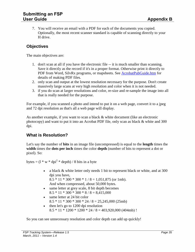
Submitting an FSP User Guide
Appendix B
FSP Tracking System—Release 1.5 March, 2011 – Version 1.4
Page 35
7. You will receive an email with a PDF for each of the documents you copied.
Optionally, the most recent scanner standard is capable of scanning directly to your
H drive.
Objectives
The main objectives are:
1. don't scan at all if you have the electronic file -- it is much smaller than scanning.
Save it directly as the record if it's in a proper format. Otherwise print it directly to
PDF from Word, SilvRx programs, or mapsheets. See AcrobatPubGuide.htm for
details of making PDF files.
2. only scan and output at the lowest resolution necessary for the purpose. Don't create
massively large scans at very high resolution and color when it is not needed.
3. if you do scan at larger resolutions and color, re-size and re-sample the image into all
that is really needed for the purpose.
For example, if you scanned a photo and intend to put it on a web page, convert it to a jpeg
and 72 dpi resolution as that's all a web page will display.
As another example, if you want to scan a black & white document (like an electronic
photocopy) and want to put it into an Acrobat PDF file, only scan as black & white and 300
dpi.
What is Resolution?
Let's say the number of bits in an image file (uncompressed) is equal to the length times the
width times the dots per inch times the color depth (number of bits to represent a dot or
pixel). So:
bytes = (l * w * dpi2 * depth) / 8 bits in a byte
a black & white letter only needs 1 bit to represent black or white, and at 300
dpi you have,
8.5 * 11 * 300 * 300 * 1 / 8 = 1,051,875 (or 1mb).
And when compressed, about 50,000 bytes.
same letter at grey scale, 8 bit depth becomes
8.5 * 11 * 300 * 300 * 8 / 8 = 8,415,000
same letter at 24 bit color
8.5 * 11 * 300 * 300 * 24 / 8 = 25,245,000 (25mb)
then let's go to 1200 dpi resolution
8.5 * 11 * 1200 * 1200 * 24 / 8 = 403,920,000 (404mb) !
So you can see unnecessary resolution and color depth can add up quickly!

Submitting an FSP User Guide
Appendix B
FSP Tracking System—Release 1.5 March, 2011 – Version 1.4
Page 36
Scanning in Black & White is the Default
Everything should be black & white unless there is some real reasons to have it otherwise.
The reason is simply to contain the size of the image.
A typical scan of a black & white letter sized page (8.5 x 11) is about 50k a page. This is
about the same as a fax. Some other tips:
resolution of 240 to 300 dpi -- that's all you need.
pure black & white
save as a TIF file. It will compress, non-lossy to about 50k/page.
alternatively, save it as a PDF. This will also average about 50k/page.
You can view TIF files directly as all ministry PCs have a tool called Microsoft
Office Document Imaging. It can open multi-page TIFs for viewing and has other
features such as OCR. You can also import TIFs into products like Acrobat to make
PDFs of them.
Scanning Colour Documents
as above but a modest 256 (8 bit) color depth
save as pdf, png, or jpeg
Scanning Photos
as above but a deeper 24 bit color depth
save as pdf or jpeg
From: Ministry of Forests, Lands and Natural Resource Operations, IT Assets Group