supervising scientist · supervising scientist annual technical report 2015-16 executive summary...
TRANSCRIPT

SUPERVISING SCIENTIST
Annual Technical Report
2015–16

© Commonwealth of Australia, 2017
The Supervising Scientist’s Annual Technical Report 2015–16 is licensed by the Commonwealth of Australia for use under a Creative Commons Attribution 3.0 Australia licence with the exception of the Coat of Arms of the Commonwealth of Australia, the logo of the agency responsible for publishing the report, content supplied by third parties, and any images depicting people. For licence conditions see: http://creativecommons.org/licenses/by/3.0/au/
This report should be attributed as Supervising Scientist 2017. Annual Technical Report 2015–16, Commonwealth of Australia 2017.
Disclaimer
The views and opinions expressed in this publication are those of the authors and do not necessarily reflect those of the Australian Government or the Minister for the Environment.
While reasonable efforts have been made to ensure that the contents of this publication are factually correct, the Commonwealth does not accept responsibility for the accuracy or completeness of the contents, and shall not be liable for any loss or damage that may be occasioned directly or indirectly through the use of, or reliance on, the contents of this publication.
ISSN: 2207-7758 (Print)
ISSN: 2207-7766 (Online)
Supervising Scientist Branch is part of the Science Division of the Australian Government Department of
the Environment and Energy.
ABN: 34 190 894 983
Contact
Supervising Scientist Branch
Department of the Environment and Energy
Postal: GPO Box 461, Darwin NT 0801 Australia
Street: Pederson Road/Fenton Court, Eaton NT 0820 Australia
Telephone +61 8 8920 1100
Facsimile +61 8 8920 1199
environment.gov.au/science/supervising-scientist

Our mission
To protect and restore the environment of the Alligator Rivers Region from the effects of uranium mining
Supervising Scientist Branch acknowledges the traditional custodians of the lands on which we live and work, and their continuing connection to land, sea and community.
We pay our respects to the cultures of the Mirarr, Larrakia and Ngunnawal people, and to their elders both past and present.

Photos (from top left): UAV image of Wirnmuyurr billabong and adjacent savanna; using the Water and Sediment Quality Team’s high resolution stereo microscope to photograph northern trout gudgeon fry; egg mass of freshwater snail Amerianna cumingi; Hydra viridissima; helicopter used to access remote and inaccessible water sampling points; bushfood collected as part of Gundjeihmi bushfood project; 2016 popnetting crew; collecting mussels as part of the ecotoxicology program; Supervising Scientist staff running the organisation’s information stall at the 2015 Mahibilil Festival in Jabiru; water flea Moinodaphnia macleayi; Supervising Scientist Branch’s octocopter in flight.
Supervising Scientist Annual Technical Report 2015-16
v
CONTENTS
EXECUTIVE SUMMARY VI
1 INTRODUCTION 1
1.1 Role and function of the Supervising Scientist 1
1.2 Uranium in the Alligator Rivers Region 1
2 PUBLIC ASSURANCE AND ADVICE 3
2.1 Alligator Rivers Region Advisory Committee 3
2.2 Alligator Rivers Region Technical Committee 3
2.3 Communication with other stakeholders 3
3 SUPERVISION 5
3.1 Ranger 5
3.2 Jabiluka 12
3.3 Nabarlek 13
3.4 Other activities in the Alligator Rivers Region 14
4 MONITORING 16
4.1 Environmental monitoring 16
4.2 Radiological monitoring 24
5 RESEARCH 30
5.1 Introduction 30
5.2 Planning and the Key Knowledge Needs 30
5.3 Status of research program 30
APPENDIX 1 SUPERVISING SCIENTIST PUBLICATIONS FOR THE PERIOD
JULY 2015 TO JUNE 2016 36
APPENDIX 2 SUMMARY OF SSB WORK PLANNING AND PRIORITISATION
PROCESS FOR 2016–17 38
APPENDIX 3 SUMMARIES OF RESEARCH PROJECTS PROPOSED, ACTIVE
OR COMPLETED IN 2015–16 AND 2016–17 41
APPENDIX 4 PROJECT SCHEDULING RELATIVE TO TIMELINES FOR THE
DEVELOPMENT OF CLOSURE CRITERIA 135
GLOSSARY OF TERMS, ABBREVIATIONS AND ACRONYMS 139

Supervising Scientist Annual Technical Report 2015-16
EXECUTIVE SUMMARY
Over the 2015–16 reporting period the Supervising Scientist Branch completed all planned monitoring
and supervision activities, and finalised a number of key research projects. The multiple lines of evidence
gathered through these combined programs continue to show that the people and the environment of the
Alligator Rivers Region remain protected from the effects of uranium mining, including from the Ranger
uranium mine.
The Supervising Scientist Branch released a revision of the Ranger Water Quality Objectives in early
2016. The revised objectives were the accumulation of 10 years of research and monitoring data, forming
a truly world leading water quality compliance framework. For the first time water quality objectives were
set for Gulungul Creek and continuous monitoring and automatic sampling were included as a statutory
requirement. The Northern Territory Department of Primary Industries and Resources formally issued
the revised Ranger Water Quality Objectives on 7 March 2016 thereby giving them statutory force.
All statutory water quality objectives were met in both Magela and Gulungul Creeks throughout the
2015–16 wet season. The mine had negligible influence on water quality in Magela Creek. Gulungul Creek
water quality continued to show the effects of shallow groundwater seepage expressing into Gulungul
Creek Tributary 2, originating from the western edge of the Ranger Tailings Storage Facility. Effects on
water quality were reduced in comparison to the 2014–15 wet season due to low wet season rainfall and
extensive seepage interception works.
The Supervising Scientist Branch continues to take a risk and evidence-based approach to environmental
monitoring. During 2015–16 the Supervising Scientist Branch reduced the inspection schedule for
Jabiluka, and ceased surface water monitoring at Jabiluka and atmospheric radiological monitoring
surrounding Ranger. These changes are supported by a large amount of data showing the associated
environmental and human health risks to be very low. Monitoring in the Gulungul Creek catchment was
significantly increased in response to observed changes in water quality, including the installation of an
additional upstream monitoring station and the deployment of a number of temporary sensors
throughout the catchment. The Supervising Scientist will continue to monitor any changes in mining
operations through-out the Region and adjust monitoring programs accordingly.
The Supervising Scientist Branch continued an active and applied research program through 2015–16,
focussed almost solely on the rehabilitation of Ranger. Of the 34 research projects underway, 11 were
completed during 2015–16. The program has been expanded to 41 projects for the 2016–17 year,
including significant external collaboration. The Supervising Scientist Branch’s research outputs included
28 peer reviewed publications and representation at a range of domestic and international fora. The
feedback from these engagements has been overwhelmingly positive and shows that the Supervising
Scientist continues to produce world leading science.
Oversight and endorsement of the Supervising Scientist Branch’s research program was provided by the
Alligator Rivers Region Technical Committee which met three times during 2015–16.
Importantly, both a comprehensive ecological risk assessment on the rehabilitation of Ranger and a
revision of the Alligator Rivers Region Technical Committee Key Knowledge Needs were completed
during the reporting period. The risk assessment formed the basis for the revised Key Knowledge Needs,
which in turn drive the Supervising Scientist Branch research program. In combination with a
strengthened planning and prioritisation process, these key projects ensure that the research program
remains clearly linked to the rehabilitation of Ranger, and focussed closely on the highest priority needs.
During 2014–15 the Supervising Scientist Branch was focussed on the assessment of expansion plans,
including an extension of operations on the Ranger Project Area beyond 2021. The announcement by
Energy Resources of Australia Ltd on 11 June 2015 that the Ranger 3 Deeps underground mine would
not proceed significantly shifted the focus of the Supervising Scientist Branch to the imminent cessation
of operations and the rehabilitation of Ranger.

Supervising Scientist Annual Technical Report 2015-16
The Supervising Scientist Branch continues to provide advice to Energy Resources of Australia Ltd
through the Closure Criteria Working Group process. Whilst the development of closure criteria by
Energy Resources of Australia Ltd is delayed, rapid progress is now being made and many criteria appear
likely to be agreed during the 2016–17 year.
The Supervising Scientist Branch continued to oversee uranium mining operations in the Region through
2015–16, including conducting a range of site inspections, audits and incident investigations. Notable
developments at Ranger included: the commissioning of a dredge in the Tailings Storage Facility; the
installation of a significant seepage and surface water interception system to the west of the Tailings
Storage Facility; and the October 2015 fire which escaped the Ranger Project Area and burnt through
adjacent areas of Kakadu National Park.
Following from the re-alignment of the work program during 2015–16, and the transition of the
Supervising Scientist Division to a Branch within the Science Division, significant structural changes were
completed. The structure of the Branch was revised to align with the statutory functions of the
Supervising Scientist and key business outputs. This included the introduction of a Public Assurance and
Advice team, the amalgamation of the Supervision and Monitoring functions into a single team and a
consolidation of research teams to better facilitate multi-disciplinary projects. Additional to the structural
changes, the Branch planning, prioritisation and reporting processes have been significantly revised and
strengthened. These changes will position the Supervising Scientist Branch well to continue to support
the statutory role of the Supervising Scientist into the future.

Supervising Scientist Annual Technical Report 2015-16
viii
Figure 1 Alligator Rivers Region.

Supervising Scientist Annual Technical Report 2015-16
ix
Figure 2 Ranger mine site.

Supervising Scientist Annual Technical Report 2015-16
x
Figure 3 Location of waterbodies and atmospheric monitoring sites used until December 2015 in SSB’s
research and monitoring programs.

Supervising Scientist Annual Technical Report 2015-16
1
1 INTRODUCTION
1.1 Role and function of the Supervising Scientist
The position of the Supervising Scientist was established under the Commonwealth Environment Protection
(Alligator Rivers Region) Act 1978 in response to a recommendation of the final Fox Commission report in
May 1977. The role of the Supervising Scientist is held by the First Assistant Secretary of the Science
Division in the Department of the Environment and Energy. The Supervising Scientist Branch (SSB) is
situated within the Science Division.
The Supervising Scientist has four key functions with respect to mining activities in the Alligator Rivers
Region (ARR):
Supervision
– Supervise uranium mining operations, including oversight of the regulatory process, to ensure
regulation is adequate, effective and consistent with Commonwealth requirements.
– Assess rehabilitation planning and subsequent activities to ensure statutory requirements are
achieved.
Research
– Provide a rigorous scientific basis for the development of environmental standards, and practices
and procedures including monitoring programs that support the supervision program throughout
mine operations and rehabilitation.
Monitoring
– Conduct a comprehensive and independent program of monitoring to detect effects of uranium
mining on people and the environment.
– Provide data to inform the Research and Supervision programs.
Public Assurance and Advice
– Ensure that the Minister and key stakeholders are informed of environmental risks related to
mine operations and rehabilitation, and understand how relevant environmental standards ensure
protection.
– Advise key stakeholders and the general public of the environmental monitoring program
outcomes to provide assurance that people and the environment remain protected.
– Communicate the science underpinning rehabilitation to key stakeholders and the general public
to provide assurance that the people and the environment of the ARR remain protected.
1.2 Uranium in the Alligator Rivers Region
The ARR is located 220 km east of Darwin and encompasses an area of approximately 28,000 km2
(Figure 1). The Region includes the catchments of the West Alligator, South Alligator and East Alligator
Rivers, and extends into western Arnhem Land. The World Heritage listed Kakadu National Park lies
entirely within the ARR.
The Ranger and Jabiluka uranium deposits within the ARR are surrounded by, but separate from, Kakadu
National Park. The Koongarra project area was incorporated into the Kakadu World Heritage area in
2011. Commonwealth legislation incorporating the Koongarra project area into Kakadu National Park
came into effect in March 2013. Nabarlek is situated to the east of Kakadu National Park within Arnhem
Land.
Ranger is currently the only operational uranium mine in the ARR. Mining at Ranger ceased in 2012,
however processing of stockpiled ore is continuing. Mining ceased at Jabiluka in 1999 and the site

Supervising Scientist Annual Technical Report 2015-16
2
remains under long-term care and maintenance. Operations at Nabarlek ceased in 1988 and the site has
been substantially decommissioned and is subject to ongoing rehabilitation. There are also a number of
former uranium mine sites in the South Alligator River Valley that operated during the 1950s and 1960s.
The Australian Government funded the rehabilitation of these sites, which was completed in 2009.
This report provides an update on the current status of each of these sites and the activities undertaken
by SSB throughout the 2015–16 reporting period.

Supervising Scientist Annual Technical Report 2015-16
3
2 PUBLIC ASSURANCE AND ADVICE
The outcomes of the supervision, research and monitoring activities undertaken by Supervising Scientist
Branch (SSB) are communicated to various stakeholders by way of a range of consultative activities.
These activities provide SSB with the opportunity to identify, understand and address the broad range of
stakeholder concerns that accompany the sensitive issue of uranium mining.
2.1 Alligator Rivers Region Advisory Committee
The Alligator Rivers Region Advisory Committee (ARRAC) provides a valuable forum for community
liaison and exchange of views and information regarding protection of the Alligator Rivers Region (ARR)
from the effects of uranium mining.
ARRAC comprises an independent Chairperson and representatives from various stakeholder
organisations. ARRAC meeting minutes are available from the ARRAC website at:
environment.gov.au/science/supervising-scientist/communication/committees/arrac
At the 46th meeting of ARRAC in Jabiru in September 2016, the committee discussed a range of matters
related to SSB’s role in relation to Ranger mine, including the process and progress of minesite
rehabilitation, changes to SS’s atmospheric monitoring program, and the functionality of an interception
trench installed at the mine site.
2.2 Alligator Rivers Region Technical Committee
The Alligator Rivers Region Technical Committee (ARRTC) plays an important role in ensuring the
adequacy and appropriateness of the scientific research conducted by SSB. ARRTC also reviews the
quality and adequacy of the science used for the regulatory assessment and approval of uranium mining
related applications and proposals in the ARR.
ARRTC comprises a Chairperson and a number of independent scientific members.
In September 2015, ARRTC convened in Canberra for a one-day special meeting to review a synthesis
report detailing the outcomes of an ecological risk assessment undertaken by SSB. The risk assessment
was used to identify key risks to the environment associated with mine closure and the meeting focussed
on identifying future Key Knowledge Needs based on these risks. The process was revisited during the
35th ARRTC meeting, which was held in Darwin on 23–26 November 2015.
The proposed 2016–17 research program for SSB was presented to members at the 36th ARRTC meeting,
which was held in Darwin on 10–11 August 2016. The meeting focussed on the progression of
rehabilitation at Ranger mine, including the successful revision of the ARRTC Key Knowledge Needs and
the clarity this provided with regards to the links between the research of SSB and Ranger mine
rehabilitation.
ARRTC meeting minutes are available on the ARRTC website at:
environment.gov.au/science/supervising-scientist/communication/committees/arrtc
2.3 Communication with other stakeholders
During 2015–16 SSB communication activities have been focussed on advising stakeholders and the general public about the rehabilitation progress at Ranger mine and the contributions made by SSB. The organisation’s scientific publications are made available publicly on the Department’s website. A list of publications in the reporting period, is at Appendix 1. Scientific communication activities included the presentation of a number of key research outcomes to the wider national and international scientific community (Table 1).

Supervising Scientist Annual Technical Report 2015-16
4
TABLE 1 PRESENTATIONS AT KEY INTERNATIONAL CONFERENCES DURING 2015–16
Conference Place/date (no. Papers)
Uranium Mining Remediation Exchange Group Schlema, Germany 31 August 2015
(1 Presentation)
UAS4RS Conference Brisbane, 17–18 February 2016
(2 presentations, 1 poster)
Aquatic Toxicology Symposium Bar Harbour, Maine, USA, 7–9 June 2016
(1 presentation)
International Conference on Environmental Quality
Standards for the Protection of the Aquatic Environment
Hong Kong, 18–20 June 2016
(1 presentation)
A number of community outreach activities have occurred during the reporting period, including the
2015 Mahbilil festival in Jabiru, at which SSB had an information stall displaying scientific posters and
offering hands-on science activities. Presence at local events is an important opportunity to share
information and have a two way conversation with local people. SSB’s Mahbilil festival stall always
attracts plenty of people to learn about the work of SSB in protecting the ARR.
SSB recently produced an online movie on mine closure and rehabilitation. The information is presented
in the Kunwinjku language with English subtitles. Kunwinjku is the main dialect spoken in Aboriginal
communities in the ARR. This is the third in a series of movies in the Kunwinjku language and all have
received a very positive reception. All the movies can be accessed through the Department of the
Environment and Energy’s website.
Through local employment arrangements, SSB staff regularly work alongside Indigenous landowners,
enabling sharing of knowledge and gaining of insight into cultural values. In May 2016, staff from SSB
undertook the biannual aquatic sampling (‘pop netting’) program in billabongs around the mine (see
section 4.1.3). The activity involved the deployment of a large temporary labour force which included
team members from Gundjeihmi Aboriginal Corporation, Departmental staff from Canberra, students
from Charles Darwin University and a volunteer from Jabiru (Figure 4).
Figure 4 Science Division and Gundjeihmi Aboriginal Corporation staff undertaking 2016 popnetting program

Supervising Scientist Annual Technical Report 2015-16
5
3 SUPERVISION
SSB provides regulatory oversight of mining and exploration activities in the ARR. The primary
mechanism for SSB’s participation in the regulatory processes of the Northern Territory Government is
through assessment of applications made by Energy Resources of Australia Ltd (ERA) under the
Authorisations for Ranger and Jabiluka, which are issued under the Northern Territory Mining Management
Act 2008.
In addition to undertaking assessments, SSB also carries out routine periodic site inspections (RPIs) and
audits, and integrates these processes with the results obtained from a comprehensive suite of
environmental monitoring programs. Minesite Technical Committees (MTCs) have been established for
Ranger, Jabiluka and Nabarlek to enable key stakeholders to discuss issues in relation to the assessment of
applications, the findings of the site inspections and the outcomes of the monitoring programs.
3.1 Ranger
ERA operates the Ranger uranium mine, which is located 8 km east of the township of Jabiru. The mine
lies within the 78 km2 Ranger Project Area and is adjacent to Magela Creek, a tributary of the East
Alligator River. Ranger is an open cut mine and commercial production of uranium concentrate (U3O8)
has been under way since 1981. Orebody No 1 was exhausted in late 1994 and excavation of Orebody
No 3 began in 1997. Mining in Pit 3 at Ranger ceased in 2012 and the pit has been backfilled and
engineered provide a long-term repository for tailings and other wastes. In accordance with the Ranger
Authority processing of stockpiled ore can continue until January 2021.
The majority of data presented in this section is reported to SSB by ERA throughout the year.
3.1.1 Operations
3.1.1.1 Water management
All water on site is managed in accordance with the Water Management Plan, which is updated annually
and subject to assessment by the MTC before approval. The plan describes the systems for routine and
contingency management of the three water classes on site which are classified based on quality, as shown
in Table 2.
TABLE 2 WATER CLASSES AT RANGER MINE
Water class Indicative EC range (µS/cm)
Release water 193–476
Pond water 1220–2380
Process water 18,800–34,900
As shown in Figure 5, the rainfall in the 2015–16 wet season was a well below average, with a total of
921 mm recorded at Jabiru Airport compared to the average annual rainfall of 1550 mm (since 1971).
Process water
Process water has been in direct contact with uranium ore during processing and it must be retained on
site due to its very poor quality. Process water is currently stored in the above ground Tailings Storage
Facility (TSF), Pit 3 and parts of the Pit 1 catchment area. As part of the strategy to manage and reduce
the process water inventory on site, ERA constructed a brine concentrator in 2013 to treat process water
for off-site release. Details of water treatment using the brine concentrator are shown in Table 3.

Supervising Scientist Annual Technical Report 2015-16
6
Figure 5 Annual rainfall Jabiru Airport 1995–96 to 2015–16
TABLE 3 ANNUAL PROCESS WATER TREATMENT VOLUMES
Date Annual operating period (days) Distillate produced (ML)
2013–14 181 470
2014–15 328 1031
2015–16* 138 523
* Data from September 2015 to February 2016.
Brine concentraor distillate is of a very high quality and it is discharged at various locations around the
site, ultimately reporting to Magela Creek during the wet season or being irrigated on Land Application
Areas (LAAs) during the dry season. The brine concentrator has a nominal capacity to treat 1830 ML of
process water per year and forms an integral part of ERA’s rehabilitation strategy.
Pond water
The pond water has been in contact with stockpiled mineralised material and operational areas of the site
other than those contained within the process water system. Pond water is stored in Retention Pond 2
(RP2), Retention Pond 3 (RP3), Retention Pond 6 (RP6) and parts of the Pit 1 catchment area. ERA has
previously committed that pond water will not be released without prior treatment. Pond water is
currently treated via three microfiltration/reverse osmosis water treatment plants (WTP), with WTP1 and
WTP2 each having a 7 ML/day capacity and WTP3 an 11 ML/day capacity. Table 4 shows the annual
volume of water treated and permeate produced.
TABLE 4 ANNUAL POND WATER TREATMENT VOLUMES
Date Volume treated (ML) Permeate produced (ML)
2011–12 7097 4873
2012–13 842 589
2013–14 4782 3311
2014–15 3028 2025
2015–16 N/A* 620
* Awaiting data from ERA.
Treated permeate is discharged at various locations around the site, ultimately reporting to Magela Creek
during the wet season or being irrigated on LAAs during the dry season.

Supervising Scientist Annual Technical Report 2015-16
7
Release water
Rainfall runoff from certain locations of the Ranger site discharges passively during the wet season. Major release pathways include the Coonjimba Creek system and the Corridor Creek system (Figure 2). Relatively small volumes of water were released passively during the 2015–16 wet season due to the very low rainfall. Table 5 shows the total volume of water released from the site since 2013.
TABLE 5 ANNUAL WATER RELEASE VOLUMES
Location Volume (ML)
2013–14 1674
2014–15 772
2015–16 117
3.1.1.2 Tailings and waste management
Table 6 summarises the management of tailings over time. The Tailings and Brine Management (TBM)
project is now focussed on the final deposition of tailings into the mined out pits. Tailings deposition in
Pit 1 has been completed and the pit is now capped and awaiting final backfill. Tailings deposition in Pit 3
commenced in 2015 and it is now receiving tailings from both the processing mill and from the TSF.
TABLE 6 TAILINGS HISTORY
Activity Year
Construction of the TSF approved 1979
Tailings deposition in TSF 1980–96
Tailings deposition in Pit 1 1996–08
Tailings deposition in TSF 2008–15
Tailings deposition from processing to Pit 3 commences 2015
Tailings transfer from TSF to Pit 3 commences 2016
The primary mechanisms for disposal of controlled wastes include disposal in the mine pits, incineration
via turbo burning and offsite recycling. Non-hazardous wastes are disposed of either through disposal to
landfill or offsite recycling. In 2016 an application to instate a new temporary controlled waste disposal
site adjacent to Pit 3 was approved. This new site replaces the waste disposal site in the North West
section of Pit 1.
3.1.2 Rehabilition
On 11 June 2015 ERA announced that Ranger 3 Deeps underground mine would not proceed. ERA
stated this decision was based upon uncertainty in the short term direction of the uranium market, and
the economics of the project requiring operations to extend beyond the current Ranger Authority which
expires in 2021.
Following the announcement by ERA on 11 June 2015 Rio Tinto, the majority shareholder in ERA,
released a media statement stating they did not support the future development of Ranger 3 Deeps due to
the project’s economic challenges.
These announcements required a significant re-focus for SSB, from the assessment of the expansion
proposal to rehabilitation and eventual site closure.
Consistent with Northern Territory regulatory arrangements, ERA, as the operator of the Ranger mine, is
responsible for proposing closure criteria for consideration by the Northern Territory regulator and
relevant stakeholders, including the Supervising Scientist. Once finalised, these closure criteria will require
approval by both the Northern Territory Minister for Resources and the Commonwealth Minister for
Resources and Northern Australia.

Supervising Scientist Annual Technical Report 2015-16
8
In order to progress the development of relevant closure criteria and provide a forum for reaching
consensus between stakeholders on closure objectives, the Ranger MTC established a Closure Criteria
Working Group (CCWG) in 2008. The CCWG comprises representatives from the Supervising Scientist,
the NT Department of Primary Industry and Resources (DPIR), the Northern Land Council and the
Gundjeihmi Aboriginal Corporation (representing Traditional Owner interests) and is chaired by ERA.
The CCWG has established six Technical Working Groups (TWG) covering the Landform, Radiation,
Water and Sediment, Flora and Fauna, Soils, and Cultural themes. Figure 6 provides an overview of how
these working groups and the MTC will be utilised to develop closure criteria for ministerial approval.
Figure 6 The closure criteria development process for Ranger mine.
The CCWG and the TWGs met frequently throughout 2015–16 and there has been significant progress
in the development of closure criteria. In August 2016, SSB commenced the development of
rehabilitation standards for Ranger, which draw upon years of research undertaken by the Branch to
quantify the rehabilitation objectives set out in the Ranger Environmental Requirements.
The Environmental Requirements for the Ranger uranium mine set out the Commonwealth’s
environmental protection conditions for the Authority issued under Section 41 of the Atomic Energy Act
1953. Section 11.2 of the Environmental Requirements requires that by the end of operations all tailings
must be placed in the mined out pits. Major rehabilitation works in relation to this requirement are
summarised in Table 7 and described in the sections below.
TABLE 7 REHABILITATION WORKS
Activity Year
Pit 1
Preload capping with waste rock 2014
Laterite cover - conversion to pond water catchment 2016
Pit 3
Waste rock backfill to -100 mRL 2014
Under bed drainage and brine injection infrastructure 2014
Deposition of mill tailings 2015
Deposition of TSF tailings 2016
TSF
Tailings dredging 2016

Supervising Scientist Annual Technical Report 2015-16
9
3.1.2.1 Pit 1
Mining in Pit 1 ceased in 1995 and tailings transfer to the pit commenced in 1996 and was completed in
2008. During 2014, a 2.5 m thick layer of waste rock was placed over the tailings within Pit 1 to activate
7,499 wicks and accelerate the dewatering of the tailings. The placement of a laterite cap on top of the
waste rock was completed in 2016. This enabled conversion of the Pit 1 footprint from the process water
catchment to the pond water catchment. Incident rainfall and runoff from surrounding areas that report
to the laterite capped section of Pit 1 is managed as pond water, provided the electrical conductivity (EC)
remains below a management threshold of 4,000 µS/cm. ERA will continue to manage water in the Pit 1
catchment area until the final placement of wasterock and subsequent revegetation of this area.
On 17 March 2016 ERA submitted an application for a final tailings level in Pit 1. This application was
supported by tailings consolidation and solute egress modelling reports. This application and supporting
information is currently under review by SSB.
3.1.2.2 Pit 3
A number of projects are underway to transfer tailings into Pit 3, including diversion of mill tailings from
the TSF to Pit 3 and transfer of TSF tailings to Pit 3. To increase potential for process water treatment in
the future, it is intended that brines produced from the Brine Concentration will be stored in the waste
rock under-fill in Pit 3.
Mining in Pit 3 was completed in November 2012 and preparation of Pit 3 to receive tailings was
completed on 23 December 2014. This included backfilling the pit with 31.2 million tonnes of waste rock,
establishing a network of brine injection bores in the waste rock backfill and constructing a water relief
drainage system on top of the waste rock backfill, which will enable removal and treatment of waste water
produced during and after tailings consolidation. Brine injection trials are currently underway.
3.1.2.3 Tailings Storage Facility
As indicated above, the tailings currently stored in the above ground TSF will be transferred to the mined
out Pit 3 using a custom-built dredge. Assembly of all dredge components, including a support vessel and
pontoon was completed in early 2015 and the dredge was successfully launched on the TSF in August
2015. As of 30 June 2016, 1,050,238 m3 of tailings has been transferred from the TSF to Pit 3.
During 2015–16 a significant amount of work was undertaken to characterise and delineate groundwater
contamination around the TSF, including the installation of a number of additional monitoring bores. In
November 2014, ERA installed a 300 m long seepage interception trench adjacent to the north-western
wall of the TSF. The trench was excavated to competent rock and is of varying depth, down to
approximately 4 m. Water collected in the trench is recovered via two wells and pumped to the adjacent
Tailings West Wall Sump (TWWS) and from there transferred to the pond water system. Further
groundwater investigations are planned, including the development of 3D groundwater models for the
region to the south-east of the TSF.
3.1.3 Assessment Activities
3.1.3.1 Assessments and approvals
SSB assessed and provided feedback to the regulatory authorities on the numerous periodic reports
produced by ERA according to the requirements in the Authorisation. A number of technical scientific
reports were also reviewed.
The Ranger MTC met six times during 2015–16. Significant agenda items discussed at the meetings
included updates from ERA on site activities including, management and monitoring strategies for high
EC events in Gulungul Creek, TSF tailings dredging, process safety developments, Pit 3 tailings
deposition and Pit 1 preload.
3.1.3.2 Audits and inspecitons
The 2015 environmental audit of Ranger mine was conducted from 15 to 19 June 2015 with criteria
focusing on the evaluation of critical controls associated with the TSF, bulk diesel, and ammonia storage
facilities. The audit identified two Category 2 Non-Conformances and three Conditional findings. As of
July 2016, these identified deficiencies had been satisfactorily addressed.

Supervising Scientist Annual Technical Report 2015-16
10
The 2016 environmental audit was conducted from 14 to 17 June 2016. Seventy-five commitments were
drawn from environmental commitments and actions contained within the approved Ranger Mining
Management Plan and supporting Environmental Management Plans. The audit identified two Category
2 Non-Conformances and fourteen Conditional findings. SSB and other stakeholders will continue to
follow up on all identified issues and ensure the close-out of corrective actions.
Routine Periodic Inspections (RPIs) were carried out for each month of the 2015–16 reporting year with
the exception of June 2016 when the annual environmental audit was conducted. Table 8 shows the focus
areas for the RPIs.
TABLE 8 RANGER ROUTINE PERIODIC INSPECTIONS DURING 2015–16
Month Primary focus
July 2015 Dredge assembly, ADU slurry incident at calciner, brine concentrator, Pit 3 tailings deposition, southern
boundary track
August Annual TSF statutory inspection
September Pond water pipe leak NW of RP6, Pit 1 hazardous waste alternative disposal site, CV21 process water
spill (21/08/2015), Diesel spill at TWWS (4/9/2015)
October Presentations by ERA, stakeholder discussion and site inspection related to the Fire Incident of 01
October 2015
November Pit 3 tailings deposition, pond water discharge line at SED2B, GCT2 cut-off trench installation, TSF and
dredge
December Pit 1, GCT2 cut-off trench installation
January 2016 TSF dredge, GCT2 cut-off trench, Pit 1 earthworks including Pit 1 tip head, Pit 3 status update
February Proposed hazardous waste disposal site, Pit 3 tailings disposal update, Pit 1 post earthworks
inspection, GC2 weir
March GCT2, processing CCD knife gates, RPA external gate damage
April TSF 6 monthly inspection
May Pit 3 wall slip, TLF burn, power station diesel spill, exposed tailings in TSF, WTP brines squeezing
trials.
Following discussion at the Ranger MTC on 27 May 2016, all stakeholders agreed that the RPI process
should be reviewed to ensure that it remains effective and appropriate. This review was undertaken in July
2016 by SSB in consultation with DPIR and the outcomes are currently being implemented. Ongoing
improvement of the RPI process will continue throughout 2016-17.
3.1.3.3 Environmental incidents
A number of environmental incidents were reported to stakeholders throughout 2015-16. These incidents
are summarised in the section below. All incidents were investigated by SSB through the RPI process and
were deemed to be resolved satisfactorily.
During 2015–16, 16 environmental incidents were reported. Of note, reporting of minor process water
spills has increased and reporting of hydrocarbon spills has decreased. The reduction in the number of
hydrocarbon spills reported was in part attributed to the realignment of incident reporting requirements
with DPIR guidelines. Table 9 summarises the 2015–16 breakdown of environmental incident types and
locations with Figure 7a) showing the distribution by location and Figure 7b) showing the distribution by
incident type.

Supervising Scientist Annual Technical Report 2015-16
11
TABLE 9 2015–16 ENVIRONMENTAL INCIDENTS AT RANGER MINE
Uranium
product spill
(ADU)
Hydrocarbon spill Process water Fire Other Total
Off RPA - - 1 1 - 2
Operational Mine site 1 - - - - 1
Processing - - 9 - 1 10
RPA - 2 - 1 - 3
Total 1 2 10 2 1 16
Figure 7 2015 – 2016 Incidents at Ranger mine a) by location and b) by type
An annual comparison of incidents reported each year for the last 5 years is shown in Figure 8,
demonstrating a consistent downward trend in the number of environmental incidents reported each year
since 2009.
Figure 8 Ranger incidents by year
3.1.3.4 Notable incidents
The following notable incidents or associated investigations occurred or were concluded during the
reporting period.
Off RPA
Ops
Processing
RPA ADU
Diesel/Oil spill
Fire
Other
Process water
a) b)

Supervising Scientist Annual Technical Report 2015-16
12
Uncontrolled fire in Kakadu National Park
On 1 October 2015 a fire associated with weed management burning adjacent to RP1 within the Ranger
Project Area escaped into Kakadu National Park. The multi-front fire burnt into culturally and
environmentally sensitive areas within Kakadu’s floodplain and stone country. Following aerial water
bombing and ground based back burning all the fires were extinguished by 8 October 2015. SSB
estimated the extent of the fire affected area from a Landsat 8 image was 147 km2.
The Department’s Compliance and Enforcement Branch determined that the action of starting the fire
that burnt into Kakadu National Park between 1 and 9 October 2015 was unlikely to have resulted in a
significant impact on matters of national environmental significance. As such, the Department does not
intend to pursue this matter further.
A separate investigation, conducted jointly with SSB and DPIR, identified deficiencies in ERA’s fire
management system. The 2016 Ranger Annual Environmental Audit included a formal assessment of the
current Ranger fire management practices and an assessment of the implementation status of corrective
actions identified by ERA as part of their internal investigation into this incident.
Product Packing Stack emissions
In November 2014 the Supervising Scientist was notified that uranium emissions from the product
packing stack at Ranger mine during July 2014 had exceeded the authorised value of 1.5 kg/day of
uranium, as detailed in Schedule 4.2.5 of the Ranger Authorisation. Preliminary investigation findings
suggested technical issues with the product packing scrubber system were responsible for the exceedance.
In September 2015 ERA presented updated findings in relation to this incident, indicating that there was
a data entry error for the reporting period, which incorrectly inflated the stack emission value. Their
investigation concluded the limit was not exceeded. SSB and DPIR are satisfied with this conclusion.
Leach Tank incident
In December 2013 Leach Tank No. 1 at the Ranger uranium mine collapsed, spilling approximately 1,400
m3 of slurry containing ground uranium ore, water and sulphuric acid into the processing area. SSB
determined that there were no adverse impacts to human health or the surrounding environment arising
from this incident. The findings of the Supervising Scientist’s investigation have been published in
SSR207.
In February 2016, DPIR finalised their investigation and concluded they would not be proceeding to
prosecution. DPIR has retained Noetic Solutions Ltd to monitor the implementation of
recommendations related to process safety via a series of quarterly inspections
3.2 Jabiluka
The ERA owned Jabiluka Mineral Lease abuts the northern boundary of the Ranger Project Area. The
Jabiluka mine site is situated 20 km north of the Ranger mine site. It is in the catchment of the East
Alligator River, adjacent to Ngarradj (Swift Creek), which drains north to the Magela floodplain.
Development work at Jabiluka took place in the late 1990s but ceased in September 1999, at which time
the site was placed in an environmental management and standby phase that lasted until 2003. During
2003, an agreement was reached between the parties that resulted in Jabiluka being placed in long-term
care and maintenance.
3.2.1 Rehabilitation
The Jabiluka site remains in a long-term care and maintenance mode. In October 2013 work on the
removal of the Interim Water Management Pond (IWMP) was completed and the area recontoured and
prepared for revegetation.
3.2.1.1 Revegetation
Revegetation of the remaining disturbed parts of the Jabiluka Lease utilises local native plant species in
similar density and abundance to that existing in undisturbed, adjacent areas. In late 2013 3,600 tube stock
were planted at the site, with approximately 4,000 additional plantings conducted during November and

Supervising Scientist Annual Technical Report 2015-16
13
December 2014. ERA advised that the six-month revegetation survival was 48% for the planting
conducted in late 2013.
ERA has an active program of weed management within the Jabiluika lease, which includes application of
broad-scale herbicide glyphosate as the primary control mechanism.
Fire will be excluded from revegetated areas for approximately three years to allow framework species to develop sufficiently to withstand a cool burn. The revegetation at the former Djarr Djarr camp site has historically been detrimentally affected by wild fires, which come from the bush areas surrounding Djarr Djarr including the adjacent Kakadu National Park. ERA undertakes annual burning of the area around Djarr Djarr to reduce the chance of wildfires affecting the revegetation.
3.2.1.2 Water management
Water management at Jabiluka was transitioned from an active to a passive system in 2013 with the
removal of the IWMP infrastructure, and is currently managed and monitored in accordance with the
Authorisation. ERA has installed a number of sediment traps to reduce the transport of fine material in
surface run off and resulting turbidity in the creek. ERA monitors continuous water quality upstream and
downstream of Jabiluka, and in both the northern and central tributaries of Ngarradj Creek. Given the
low environmental risk posed by the Jabiluka site SSB did not undertake water quality monitoring at
Jabiluka during the 2015–16 wet season.
3.2.2 Assessment activities
SSB assessed and provided feedback to DPIR on the numerous periodic reports produced by ERA
according to the requirements in the Authorisation. The Jabiluka MTC met on six occasions throughout
2015–16. Discussions focussed on the ongoing progress of revegetation.
Two RPIs have been undertaken at Jabiluka with the second being the 2016 pre-wet season inspection,
which is scheduled for November 2016.
The 2015 annual Jabiluka environmental audit was conducted from 18 to 19 June 2015, with
commitments taken from the 2013–14 Wet Season Report and the Interpretative Report. No non-
compliances were identified, however the audit team made a number of observations to assist in ongoing
development of these annual plans for Jabiluka.
Following a review of the audit program by SSB in consultation with DPIR and noting that Jabiluka has
now entered a long-term revegetation phase of rehabilitation, the annual audit of Jabiluka has been
suspended indefinitely. Pre and post-wet season RPIs will continue to be undertaken to assess any
emerging issues with the site revegetation progression.
A single incident was recorded at the Jabiluka site, involving an uncontrolled fire originating off lease and
impacting on the Djarr Djarr rehabilitation area.
3.3 Nabarlek
The former Nabarlek mine is located approximately 280 km east of Darwin. Queensland Mines Ltd
undertook mining at Nabarlek during the dry season of 1979 and milling of the ore continued until 1988. Some 10,857 tonne of uranium concentrate (U3O8) was produced. Decommissioning of the mine was
completed in 1995 and the performance of the rehabilitation and revegetation program continues to be
monitored by SSB. In early 2008, Uranium Equities Limited (UEL) bought Queensland Mines Pty Ltd
thereby acquiring the Nabarlek lease. Since then UEL has undertaken further exploration on the lease as
well as a range of weed control, revegetation and other rehabilitation works.
3.3.1 Rehabilitation
UEL has undertaken significant works to clean up several areas of the site including the old Nabarlek
Village and re-contouring the waste rock dump runoff pond. Further revegetation works are planned by
UEL, including additional planting and ongoing fire and weed management activities.
Supervising Scientist Annual Technical Report 2015-16
14
3.3.1.1 Water management and monitoring
Statutory monitoring of the site is conducted by DPIR and the operator, UEL. DPIR carries out surface
and groundwater monitoring on and off site, including surface water monitoring downstream of the mine
in Kadjirrikamarnda and Cooper Creeks, and reports the results of this monitoring in the six-monthly
Northern Territory Supervising Authorities Environmental Surveillance Monitoring in the ARR reports.
3.3.1.2 The Radiologically Anomalous Area
The 0.4 ha Radiologically Anomalous Area (RAA) is located immediately south-west of the former pit
area. The RAA exhibits elevated levels of radioactivity and has been identified to contribute about one-
quarter of the total radon flux from the rehabilitated mine site and three-quarters of the radionuclide flux
from the site via the erosion pathway (more detail is provided in Supervising Scientist Annual Report
2004–05).
In August 2015, UEL undertook a shallow program of drilling involving 25 x 5 m drill holes within the
RAA to better understand the area’s radioactivity profile. Analysis of 1 m composites from this program
suggests the majority of the elevated radioactivity is located in a discrete near surface section of the RAA.
This information will assist in refining the work program required to rehabilitate this area.
3.3.2 Assessment activities
A Mining Management Plan for the 2016 dry season exploration works was submitted to DPIR in June
2016. SSB provided comments on this proposed program on 26 July 2016. The 2015 Nabarlek MTC was
held on 10 December 2015 with the 2016 MTC yet to be scheduled.
The 2015 audit of Nabarlek was undertaken on 3 November 2015 with the audit criteria being assessment
of compliance to the approved 2015 Nabarlek MMP. Four conditional findings were determined, relating
to hazardous substance storage and fire management.
3.4 Other activities in the Alligator Rivers Region
3.4.1 Rehabilitaiton projects
3.4.1.1 South Alligator Valley uranium mines
During the 1950s and 1960s a number of small uranium mines and milling facilities operated in the South
Alligator River Valley, in the southern part of Kakadu National Park. The majority of these sites are now
the responsibility of the Australian Government Director of National Parks and in May 2006, the
Australian Government provided funding over four years for their rehabilitation. A containment facility
was constructed in 2009 at the old El Sherana airstrip for the final disposal of historic uranium mining
waste recovered from numerous sites throughout the South Alligator River Valley. Further background
on the remediation of historic uranium mining sites in the South Alligator Valley has been provided in the
2008–09 Supervising Scientist Annual Report.
SSB staff carried out the annual inspection of the containment facility on 26 June 2015. Bushfires had
been through the area in September 2014 impacting on vegetation regrowth however monitoring
equipment was not damaged by these fires. An audit of the facility was conducted by ARPANSA on 10
September 2015.
3.4.1.2 Koongarra
The Koongarra deposit is about 25 km southwest of Ranger, in the South Alligator River catchment. The
Koongarra lease was owned by Koongarra Pty Ltd, a subsidiary of AREVA Australia Pty Ltd. In 2011,
the Koongarra Project Area was added to the Kakadu World Heritage Area by the World Heritage
Committee with the support of the Australian Government. The lease area was incorporated into Kakadu
National Park in 2013.
SSB will assist Parks with technical advice on the removal of remnant infrastructure and any remediation
of the site which may be required.

Supervising Scientist Annual Technical Report 2015-16
15
3.4.2 Exploration Projects
3.4.2.1 Cameco Arnhem Project and Wellington Range – King River Joint Venture Projects
The 2015 audit of Cameco Arnhem Project and Wellington Range – King River Joint Venture Projects
was undertaken from 1 to 2 October 2015. The audit identified two conditional findings. The audit also
provided a number of observations based upon the audit criteria. All non-conforming issues raised in the
2014 audit have been closed out.
3.4.2.2 Alligator Energy Arnhem Project
The 2015 audit of Alligator Energy Arnhem Project was undertaken from 30 September to 1 October
2015. The audit identified two conditional findings. The audit also provided a number of observations
based upon the audit criteria. All non-conforming issues raised in the 2014 audits have been closed out.
3.4.2.3 UEL West Arnhem Joint Venture
The 2015 audit of UEL West Arnhem Joint Venture was undertaken in conjunction with the Nabarlek
audit on 3 November 2015. The focus of the audit was compliance with the approved Mining
Management Plan. Four conditional findings were determined, relating to hazardous substance storage
and fire management.
3.4.2.4 UXA Resources Nabarlek Group Project
As no exploration activity was being undertaken an audit of UXA Nabarlek Group Project was not
undertaken in 2015.
Supervising Scientist Annual Technical Report 2015-16
16
4 MONITORING
4.1 Environmental monitoring
In order to ensure protection of the environment and the people of the ARR, ERA is required to achieve
specific water quality objectives for both Magela and Gulungul creeks (Figure 2). These objectives are
largely based on site-specific biological effects data and as such, their achievement gives confidence that
the environment has been protected. The water quality objectives for Magela Creek were reviewed and
updated by SSB in 2016, and issued by DPIR on 7 March 2016. Key amendments include:
Objectives for Gulungul Creek;
Mandated continuous monitoring and event-based sampling;
A chronic exposure Limit for Mg;
A pulse exposure framework for deriving event-specific Mg guideline values;
A revised Limit for uranium – reduced from 6 to 2.8 µg/L;
A revised Limit for 226Ra – reduced from 10 mBq/L to 3 mBq/L;
Revised turbidity trigger values based on continuous monitoring; and
Removal of statutory requirement to measure pH for regulatory purposes.
Supervising Scientist Internal Report 638 details the review process, providing scientific justification for
each of the amendments as well as guidance on their implementation. This report can be found on the
Supervising Scientist Branch website.
In addition to ERA’s statutory monitoring program, SSB conducts an independent surface water quality
monitoring program that uses a multiple lines of evidence approach for undertaking environmental
impact assessment. This includes measurement and assessment of key chemical, physical and biological
indicators. All monitoring undertaken by SSB during 2015–16 indicated that there was no environmental
impact from operations at Ranger mine, and that the Ranger Water Quality Objectives were met in both
Magela and Gulungul Creeks.
SSB uses two broad approaches to assessment of the effects of mine water inputs to receiving waters
during the wet season: (1) early detection throughout the wet season, and (2) assessment of long-term
ecosystem-level responses at the end of the wet season.
Early detection methods include continuous monitoring of chemical and physical indicators as well as in
situ toxicity monitoring using freshwater snail reproduction.
For long-term ecosystem-level responses, benthic macroinvertebrate and fish community data from late
wet season sampling in Magela and Gulungul Creek sites are compared with historical data and data from
control sites in streams unaffected by contemporary mining. The dates for flow commencement and
cessation since the 2009–10 wet season are listed in Table 10.
The monitoring results provided below show that the people and the environment of the ARR continue
to remain protected from the effects of uranium mining.
4.1.1 Early detection monitoring in Magela Creek
Magela Creek runs to the north west of the Ranger mine site and receives water from RP1, the former
Djalkmara Billabong and Georgetown Creek (Figure 2). The electrical conductivity data measured in
Magela Creek upstream and downstream of these mine inputs are shown in Figure 9.
There were no significant electrical conductivity events (i.e. no exceedances above the compliance value)
in Magela Creek during the 2015–16 wet season. A number of samples were collected as part of the
routine quality control program and the concentrations of all key analytes were well within those
measured historically. All water quality objectives were met, including that set for 226Ra which was revised
from 10 mBq/L to 3 mBq/L. Figure 10 shows the 226Ra measurements for the 2015–16 wet season along
with historical results.

Supervising Scientist Annual Technical Report 2015-16
17
TABLE 10 SEASONAL FLOW SUMMARY
Wet season Magela Creek Gulungul Creek
Flow
commencement
Flow cessation Flow
Duration
(days)
Flow
commencement
Flow
cessation
Flow
Duration
(days)
2009–10 2 Dec 2009 27 Jul 2010 237 30 Dec 2009 24 Jun 2010 176
2010–11 24 Nov 2010 15 Aug 2011 264 14 Dec 2010 7 Jul 2011 205
2011–12 23 Nov 2011 7 Aug 2012 258 2 Nov 2011 21 Jun 2012 232
2012–13 7 Jan 2013 1 Jul 2013 175 23 Dec 2012 18 Jun 2013 177
2013–14 28 Nov 2013 21 Jul 2014 235 4 Dec 2013 23 Jun 2014 201
2014–15 27 Dec 2014 15 June 2015 170 2 Jan 2015 1 May 2015 119
2015–16 25 Dec 2015 6 Jun 2016 163 31 Jan 2016 23 May 2016 99
Figure 9 Magela Creek electrical conductivity (EC) data measured during the 2015–16 wet season.
Figure 10 Magela Creek 226
Ra data.

Supervising Scientist Annual Technical Report 2015-16
18
Seven in situ toxicity monitoring tests were conducted in Magela Creek, spanning the period 04 January
2016 to 21 March 2016 (Figure 11). Very high concordance in mean upstream and downstream snail egg
production and difference values for the tests was observed (mean egg number upstream, 200.3;
downstream, 201.6; difference value, -1.3), reflecting similar high concordance in water quality observed
between the two sites. Results showed no significant difference between the 2015–16 wet season results
and those from all previous wet seasons conducted in Magela Creek.
Figure 11 Time series of in situ snail egg production data from toxicity monitoring tests conducted in Magela Creek since 2006.
4.1.2 Early detection monitoring in Gulungul Creek
Gulungul Creek runs along the western boundary of the Ranger project area (Figure 2). ERA does not
release any mine water into the Gulungul Creek catchment other than surface runoff. A number of water
collection and diversion systems are installed on the mine site in an attempt to limit the volume of poor
quality mine derived water that enters Gulungul Creek.
The electrical conductivity data measured in Gulungul Creek upstream and downstream of the mine are
shown in Figure 12. There were five notable EC events in Gulungul Creek during the 2015–16 wet
season, which are summarised in Table 11.
Figure 12 Gulungul Creek electrical conductivity (EC) data measured during the 2015–16 wet season.

Supervising Scientist Annual Technical Report 2015-16
19
TABLE 11 2015–16 GULUNGUL CREEK EC EVENTS
Date Duration1
(hour)
Maximum EC
(µS/cm)
Maximum concentrations
(Limit/Guideline values)
Mg
(3)
mg/L
U
(2.8)
µg/L
Mn
(75)
µg/L
SO4
(N/A)
mg/L
226Ra
(N/A)
mBq/L
28 Feb 2016 6 60.7 3.7 0.21 29.9 13.1 14.6
5 March 2016 6 76.4 4.5 0.13 5.9 16.7
19–20 March 2016 6.5 68.6 4.8 0.19 31.8 15.8
21–23 March 2016 67.5 95.8 6.9 0.16 23.1 26.8 13.8
18 April2 20162 2 50.7 - - - - -
1 Above 42 µS/cm at downstream site
2 Data supplemented from ERA site GCLB
Whilst a number of these events exceeded 42 µS/cm, they did not exceed 72 hours in duration and
therefore did not constitute a breach of the water quality objectives.
Since the 2013–14 wet season there has been an increase in the frequency of high EC events in Gulungul
Creek. Previous investigations carried out by SSB indicated that the elevated EC in Gulungul Creek was
caused by input of high EC water originating from the north-western perimeter of the TSF.
Investigations to date, conducted by ERA, have indicated that the contamination is generally confined to
the shallow aquifer system which expresses along the reach of Gulungul Creek Tributary 2 (GCT2),
which is shown in Figure 2.
To reduce solute delivery to Gulungul Creek, ERA installed a surface/shallow ground water interception
system, comprising an interception trench adjacent to the west wall of the TSF and seven dewatering
bores installed down gradient along the GCT2 alignment. Approximately 72 ML of water was extracted
from the interception system during the 2015–16 wet season. Electrical conductivity of the water varied
between approximately 3,000 µS/cm and 7,000 µS/cm.
226Ra readings were below the geometric mean limit at Gulungul Creek for the 2015–16 wet season.
Figure 13 displays the historical 226Ra readings. Note that the revised limit of 3 mBq/L was in effect for
the 2015–16 wet season.
Figure 13 Gulungul Creek 226
Ra historical data.

Supervising Scientist Annual Technical Report 2015-16
20
Four toxicity monitoring tests were conducted in Gulungul Creek, spanning the period 4 February 2016
to 28 March 2016 (Figure 14). Results showed no significant difference between the 2015–16 wet season
results and those from all previous wet seasons conducted in Gulungul Creek. This includes the
reproductive responses of snails exposed to elevated EC downstream of GCT2, at the Gulungul lease
boundary site (referred to as midstream in Figure 14). Egg production was generally higher at the
downstream site compared to the upstream site, which has been observed in previous years.
Figure 14 Time series of in situ snail egg production data from toxicity monitoring tests conducted in
Gulungul Creek since 2009.
4.1.3 Ecosystem monitoring
4.1.3.1 Macroinvertebrate communities
During the recessional flow period of the 2015–16 wet season macroinvertebrate communities were
sampled from upstream and downstream sites on Gulungul and Magela creeks (‘exposed’ sites) and from
Burdulba and Nourlangie creeks (control sites).
Compilation of the full macroinvertebrate dataset from 1988 to 2016 has been completed, with results
shown in Figure 15. This figure plots the paired-site dissimilarity values using family-level (log-
transformed) data, for the two ‘exposed’ streams and the two ‘control’ streams. For the past two seasons,
a third Gulungul Creek site has also been sampled (GCT2GCC). This site was also paired with the current
year’s Gulungul Creek upstream site to derive an additional dissimilarity value (Figure 15). Disturbed sites
may be associated with significantly higher dissimilarity values compared to undisturbed sites.
Dissimilarity values for 2016 data were comparable to those from previous years, indicating no significant
alteration of macroinvertebrate communities at the downstream exposed sites.
The ANOVA completed on the original sites (i.e. without GCT2GCC) showed no significant change
from the before (pre 2015–16) to after (2015–16) periods in the magnitude of upstream-downstream
dissimilarity across both ‘exposed’ streams, and this was consistent between both streams (BA and
BA*Stream interaction not significant respectively). This result is unsurprising given that the dissimilarity
values for both creeks for 2016 plot at similar values to those recorded in most previous years (Figure 15).
Graphical ordination methods can also be used to infer potential impact if points associated with exposed
sites sit well outside of points representing reference sites. Data points associated with the 2016 Gulungul
and Magela Creek downstream sites are generally interspersed amongst the points representing the
control sites (Figure 16), indicating that these ‘exposed’ sites have macroinvertebrate communities that are
similar to the communities occurring at the control sites. This was confirmed by PERMANOVA
(PERmutational Multivariate Analysis of Variance) testing on the individual sites (cf paired site

Supervising Scientist Annual Technical Report 2015-16
21
dissimilarity for the above ANOVA) of the exposed streams (Magela and Gulungul sites, excluding
GCT2GCC). This showed no significant difference between the downstream data from 2016 with
downstream data from previous years, and no significant difference between the upstream data from 2016
with upstream data from previous years.
GCT2GCC site replicates, exposed to higher EC waters than Gulungul and Magela Creek downstream
replicates for both 2015 and 2016, are also generally interspersed within control sites. However, the
dissimilarity for GCT2GCC vs upstream Gulungul Creek is greater than that for the paired upstream and
downstream sites (Figure 15). This distinction deserves further investigation. Despite exposure in
Gulungul Creek to mine wastewaters at solute concentration in excess of those experienced in previous
seasons, no apparent impairment to macroinvertebrate community was observed at the downstream site
over the last two wet seasons. This result was consistent with the results of toxicity monitoring studies
reported in section 4.1.2.
These collective results provide good evidence that changes to water quality downstream of Ranger as a
consequence of mining during the period 1994 to 2016 have not adversely affected macroinvertebrate
communities.

Supervising Scientist Annual Technical Report 2015-16
22
Figure 15 Paired upstream-downstream dissimilarity values (using the Bray-Curtis measure) calculated for community structure
of macroinvertebrate families in several streams in the vicinity of the Ranger mine for the period 1988 to 2016. The black
symbol on the Gulungul Creek dissimilarity graph represents the Upstream-GCT2GCC stream pairwise comparison. The
dashed vertical lines delineate periods for which a different sampling and/or sample processing method was used. Dashed
horizontal lines indicate mean dissimilarity across years. Dissimilarity values represent means (± standard error) of the 5
possible (randomly-selected) pairwise comparisons of upstream-downstream replicate samples within each stream.
0
50
100
Year
19
87
19
88
19
89
19
90
19
91
19
92
19
93
19
94
19
95
19
96
19
97
19
98
19
99
20
00
20
01
20
02
20
03
20
04
20
05
20
06
20
07
20
08
20
09
20
10
20
11
20
12
20
13
20
14
20
15
20
16
20
17
Dis
sim
ilari
ty v
alu
e (
%)
0
50
100
0
50
100
0
50
100
Burdulba Creek
Nourlangie Creek
Magela Creek
Gulungul Creek

Supervising Scientist Annual Technical Report 2015-16
23
Figure 16 Ordination plot (axis 1 and 2) of macroinvertebrate community structure data from sites sampled in several streams
in the vicinity of Ranger mine for the period 1988 to 2016. Data from Magela and Gulungul Creeks for 2016 are indicated by the
enlarged symbols.
4.1.3.2 Fish communities
Fish communities in deep channel billabongs are assessed every year, and in shallow lowland billabongs
are assessed every two years.
Monitoring of fish communities is conducted in six shallow lowland billabongs, comprising three ‘control’
versus ‘exposed’ billabong pairs. Multivariate dissimilarity indices are used to compare fish communities
in shallow billabongs downstream of Ranger mine on Magela Creek (Georgetown, Coonjimba and
Gulungul billabongs) with communities in control billabongs (Sandy Shallow and Buba billabongs on
Nourlangie Creek and Wirnmuyurr Billabong – a Magela floodplain tributary) (see Figure 4). For all
billabongs, and billabong pairs, there was no significant change in fish communities in 2016 compared to
all previous years.
Paired-site dissimilarity values are displayed in Figure 17 and they show that fish communities in each of
the billabongs comprising a site-pair are quite different from one another (between 40 and 60%). The
particularly high dissimilarity value observed for the Gulungul versus Wirnmuyurr site-pair for 2016 is
likely to be caused by significant plant growth in one of the five plots in Gulungul Billabong. Plant
growth is known to physically prevent fish residency.
The results of fish community monitoring to date indicate that changes to water quality downstream of
Ranger mine has not adversely affected fish communities in shallow lowland billabongs.
3D stress = 0.19
Control sites
Magela downstream
Gulungul downstream
Magela control 2016Gulungul control 2016
Magela downstream 2016Gulungul downstream 2016
GCT2GCC
GCT2GCC 2016

Supervising Scientist Annual Technical Report 2015-16
24
Figure 17 Paired control-exposed site dissimilarity values (using the Bray-Curtis measure) calculated for community structure
of fish in ‘exposed’ Magela and ‘control’ Nourlangie and Magela Billabongs in the vicinity of Ranger mine over time. Values are
means ( standard error) of the 5 possible (randomly-selected) pairwise comparisons of average trap enclosure data between
the pairwise billabong comparisons, Coonjimba-Buba, Gulungul-Wirnmuyurr and Georgetown-Sandy shallow billabongs.
4.2 Radiological monitoring
4.2.1 Background
The radiation dose limits for workers and members of the public from other-than-natural sources
recommended by the International Commission on Radiological Protection (ICRP) and adopted in
Australia by the Australian Radiation Protection and Nuclear Safety Agency (ARPANSA) are:
Limit to a member of the public (1 mSv)
Non-designated workers (5 mSv)
Limit to workers (100 mSv over 5 years with a maximum of 50 mSv in any one year).
Designated workers are those who may be expected to receive a significant occupational radiation dose,
nominally above 5 mSv per year. These workers are monitored more intensely than the non-designated
workers. It is ERA’s responsibility to ensure that the level of exposure to ionising radiation received by
workers and the general public are as low as reasonably achievable.
Dose constraints for the Ranger operation are revised annually and detailed in the Annual Radiation and
Atmospheric Monitoring Report. The current dose constraints for Ranger mine are listed in Table 12.
Supervising Scientist Annual Technical Report 2015-16
25
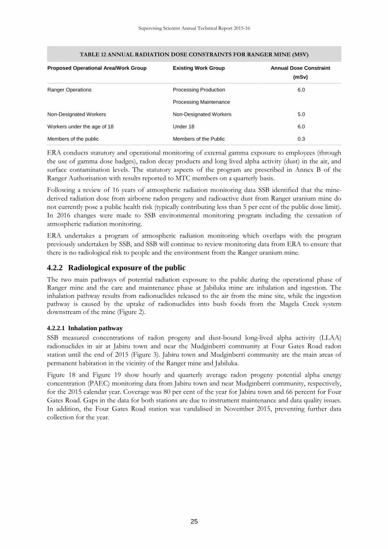
TABLE 12 ANNUAL RADIATION DOSE CONSTRAINTS FOR RANGER MINE (MSV)
Proposed Operational Area/Work Group Existing Work Group Annual Dose Constraint
(mSv)
Ranger Operations Processing Production 6.0
Processing Maintenance
Non-Designated Workers Non-Designated Workers 5.0
Workers under the age of 18 Under 18 6.0
Members of the public Members of the Public 0.3
ERA conducts statutory and operational monitoring of external gamma exposure to employees (through
the use of gamma dose badges), radon decay products and long lived alpha activity (dust) in the air, and
surface contamination levels. The statutory aspects of the program are prescribed in Annex B of the
Ranger Authorisation with results reported to MTC members on a quarterly basis.
Following a review of 16 years of atmospheric radiation monitoring data SSB identified that the mine-
derived radiation dose from airborne radon progeny and radioactive dust from Ranger uranium mine do
not currently pose a public health risk (typically contributing less than 5 per cent of the public dose limit).
In 2016 changes were made to SSB environmental monitoring program including the cessation of
atmospheric radiation monitoring.
ERA undertakes a program of atmospheric radiation monitoring which overlaps with the program
previously undertaken by SSB, and SSB will continue to review monitoring data from ERA to ensure that
there is no radiological risk to people and the environment from the Ranger uranium mine.
4.2.2 Radiological exposure of the public
The two main pathways of potential radiation exposure to the public during the operational phase of Ranger mine and the care and maintenance phase at Jabiluka mine are inhalation and ingestion. The inhalation pathway results from radionuclides released to the air from the mine site, while the ingestion pathway is caused by the uptake of radionuclides into bush foods from the Magela Creek system downstream of the mine (Figure 2).
4.2.2.1 Inhalation pathway
SSB measured concentrations of radon progeny and dust-bound long-lived alpha activity (LLAA)
radionuclides in air at Jabiru town and near the Mudginberri community at Four Gates Road radon
station until the end of 2015 (Figure 3). Jabiru town and Mudginberri community are the main areas of
permanent habitation in the vicinity of the Ranger mine and Jabiluka.
Figure 18 and Figure 19 show hourly and quarterly average radon progeny potential alpha energy
concentration (PAEC) monitoring data from Jabiru town and near Mudginberri community, respectively,
for the 2015 calendar year. Coverage was 80 per cent of the year for Jabiru town and 66 percent for Four
Gates Road. Gaps in the data for both stations are due to instrument maintenance and data quality issues.
In addition, the Four Gates Road station was vandalised in November 2015, preventing further data
collection for the year.

Supervising Scientist Annual Technical Report 2015-16
26
Figure 18 Hourly (black diamonds) and quarterly average (grey columns) radon progeny PAEC in air at Jabiru town in 2015.
Figure 19 Hourly (black diamonds) and quarterly average (grey columns) radon progeny PAEC in air at Four Gates Road
radon station near Mudginberri community in 2015.
The quarterly average PAEC results show the typical wet-dry seasonal trend, with higher concentrations
occurring in the second and third quarter of the year (dry season) and lower concentrations occurring in
the first and fourth quarter of the year (wet season).
Table 13 provides a summary of annual average radon progeny PAEC in air and estimated doses to the
public. The total annual effective dose from radon progeny in air, which is largely due to the contribution
from natural background, has been estimated to be 0.339 mSv at Jabiru town and 0.428 mSv at
Mudginberri.
TABLE 13 RADON PROGENY PAEC IN AIR AND ESTIMATED DOSES TO THE PUBLIC AT JABIRU TOWN
AND MUDGINBERRI DURING 2015
Jabiru town Mudginberri
Annual average PAEC [µJ m-3] 0.035 0.044
Total annual dose [mSv] 0.339 0.428
Mine-derived dose* [mSv] 0.038 0.001
* The radon progeny PAEC difference used in SSB mine-derived dose calculation was 0.018 µJ/m3 for Jabiru town and 0.006 µJ m-3 for
Mudginberri.
This total annual dose has been estimated from the product of the annual average radon progeny PAEC
in air, the radon progeny dose conversion factor of 0.0011 mSv per µJ∙h m-3 recommended by the ICRP
and the assumed full year occupancy of 8,760 hours.
01/01/2015 01/04/2015 01/07/2015 01/10/2015 01/01/20160.0
0.1
0.2
0.3
0.4
0.5
PA
EC
(µ
J m
-3)
Date
01/01/2015 01/04/2015 01/07/2015 01/10/2015 01/01/20160.0
0.1
0.2
0.3
0.4
0.5
PA
EC
(µ
J m
-3)
Date

Supervising Scientist Annual Technical Report 2015-16
27
The mine-derived annual dose from radon progeny in air has been estimated to be 0.038 mSv at Jabiru
town and 0.001 mSv at Mudginberri, much less than the public dose limit of 1 mSv in a year. This dose is
dependent on wind direction and has been estimated from the difference in average radon progeny
PAEC in air when the wind was from the direction of the mine and when the wind was from directions
other than the mine. Hourly wind direction data for 2015 were obtained from the Bureau of Meteorology
weather station at Jabiru Airport. Analysis of these data suggests that the wind was from the direction of
the mine for 1,970 hours during the year at Jabiru town (90–110 degree sector) and 198 hours during the
year at Mudginberri (140–160 degree sector).
Figure 20 and Figure 21 show measured and quarterly average concentrations of dust-bound LLAA
radionuclides in air at Jabiru town and near Mudginberri community, respectively, for 2015. Gaps in the
data are due to instrument maintenance and data quality issues, as well as vandalism of the Four Gates
Road radon station in November 2015.
Figure 20 Measured (black diamonds) and quarterly average (grey columns) concentrations of dust-bound LLAA radionuclides
in air at Jabiru town in 2015.
Figure 21 Measured (black diamonds) and quarterly average (grey columns) concentrations of dust-bound LLAA radionuclides
in air at Four Gates Road radon station near the Mudginberri community in 2015.
Table 14 provides a summary of annual average LLAA radionuclide concentration and estimated total
and mine-related doses to the public. The total annual effective dose from dust-bound LLAA
radionuclides, which includes contribution from natural background, has been estimated to be 0.008 mSv
at Jabiru town and 0.008 mSv at Mudginberri. This total annual dose has been estimated by calculating
the time weighted annual average LLAA concentration from the individual samples and then multiplying
01/01/2015 01/04/2015 01/07/2015 01/10/2015 01/01/20160
0.0004
0.0008
0.0012
LL
AA
(B
q m
-3)
Date
01/01/2015 01/04/2015 01/07/2015 01/10/2015 01/01/20160
0.0004
0.0008
0.0012
LL
AA
(B
q m
-3)
Date

Supervising Scientist Annual Technical Report 2015-16
28
with a dose conversion factor of 0.0061 mSv Bqα-1, breathing rate of 0.75 m3 h-1 and assumed full year
occupancy of 8,760 hours.
TABLE 14 LLAA RADIONUCLIDE CONCENTRATIONS IN AIR AND ESTIMATED
DOSES TO THE PUBLIC AT JABIRU TOWN AND MUDGINBERRI IN 2013
Jabiru town Mudginberri
Annual average PAEC [µJ m-3] 2.1×10⁻⁴ 1.9×10⁻⁴
Total annual dose [mSv] 0.008 0.008
Mine-related dose* [mSv] 9×10⁻⁴ 2×10⁻⁵
* Calculated from the assumption that the ratio of mine-related to total annual dose from dust is the same as that for radon progeny.
The mine-related dose from dust-bound LLAA radionuclides has been estimated by assuming that the
ratio of mine-related to total annual dose from dust is the same as that for radon progeny. This
assumption is likely to result in an overestimate of the mine-related dose via the dust inhalation pathway.
This is because dust in air should settle out much quicker as a function of distance from the mine
compared with gaseous radon, meaning that the mine-related to total dose ratio for dust should be less
than that for radon progeny.
4.2.2.2 Ingestion pathway
The uptake of 226Ra by freshwater mussels has been previously identified as the most important food
source contributing to radiation dose from traditional diet. Mussels are collected annually from
Mudginberri Billabong (potentially impacted site) and triennially from Sandy Billabong (un-impacted site)
for measurement of 226Ra (Fig 3).
In 2015, mussels were collected in both Mudginberri Billabong and Sandy Billabong. Figure 22 shows 226Ra activity concentrations in mussels collected from Mudginberri and Sandy Billabongs in 2015 and
compares them with average activity concentrations measured previously. 226Ra activity concentrations in
aged mussels from Sandy Billabong were lower than from Mudginberri Billabong in 2015, as with
previous years, and activity concentrations measured in 2015 were no different compared with average
values from previous collections.
Figure 22 226Ra activity concentrations measured in mussel flesh (wet mass) from Mudginberri Billabong (circles) and Sandy
Billabong (triangles). The average of previous end of dry season collections (2000–2013) is shown as solid symbols, open
symbols show the results from the 2015 collections.
0
100
200
300
400
500
0 1 2 3 4 5 6 7 8 9 10 11 12 13 14 15
22
6R
a (B
q k
g-1
we
t m
ass)
Mussel age (y)

Supervising Scientist Annual Technical Report 2015-16
29
Based on the activity concentrations of 226Ra in mussel flesh and the age distribution of mussels collected,
the average annual committed effective dose can be calculated for a 10-year-old child who eats 2 kg (wet
mass) of mussel flesh from Mudginberri Billabong. The average of all collections from 2000 to 2013 is
0.11 mSv. In 2015, the committed effective dose was also 0.11 mSv.
This dose is almost exclusively from natural background contributions and would be received irrespective
of the operation of the Ranger uranium mine. This assertion can be made since: (1) the difference
between 226Ra activity concentrations measured in Magela Creek upstream and downstream of the Ranger
mine is very small; and (2) the findings from previously reported research show that mussel radionuclide
activity loads in Mudginberri Billabong are due to natural catchment rather than mining influences.

Supervising Scientist Annual Technical Report 2015-16
30
5 RESEARCH
5.1 Introduction
The Environmental Research Institute of the Supervising Scientist (ERISS) provides specialist
technical advice to the Supervising Scientist on the protection of the environment and people of
the Alligator Rivers Region (ARR) from the effects of uranium mining. Its major function is to
conduct research into developing environmental standards and leading practice methodologies
for monitoring and assessing the environmental impact of uranium (U) mining in the ARR. The
research spans the operational, decommissioning and post-rehabilitation phases of mining. This
chapter summarises the status of the research program of ERISS for the period 2015–16 and the
first half of 2016–17. It captures projects proposed, active and completed across this period.
5.2 Planning and the Key Knowledge Needs
SSB undertakes a comprehensive planning and prioritisation process to ensure that its work is
appropriately targeted to the highest priority issues (Appendix 2). The process considers the
following aspects:
1. Relevance to ensuring environmental protection from both operations and rehabilitation;
2. Timeframe for when the knowledge is needed; and
3. Project duration.
For the ERISS research program, this process is underpinned by the Key Knowledge Needs
(KKNs), which are developed through consultation between ARRTC, the Supervising Scientist,
ERA and other stakeholders. The KKNs articulate the relevant knowledge and tools required, to
ensure:
the environment and people of the Alligator Rivers Region (ARR) are protected from the
impacts of uranium mining; and
upon reaching end-of-life, uranium mines in the ARR are rehabilitated to the standard
required by the Australian Government and community.
The KKNs were revised in 2015–16, following completion of an ecological risk assessment for
the decommissioning and post-decommissioning phases at Ranger (see below for further details
of the risk assessment). Final amendments to the revised KKNs were being made at the time of
completion of the present report. The highest priority areas within the KKNs relate to (i) the
continued need to ensure environmental protection during mine operations at Ranger, and (ii)
the development of robust closure criteria by ERA, to assess the success of rehabilitation at
Ranger. The current research planning process also adheres to two general guiding principles: (i)
the size of the overall work program should be commensurate with the available staff and
financial resources; and (ii) wherever possible, existing projects should be completed before new
projects commence.
SSB has strengthened research prioritisation and planning processes to ensure that available
resources are applied to their greatest effect, and that the highest priority work is undertaken.
Moreover, not all of the KKN research areas are able to be covered by ERISS, since not all of
the required disciplines are available within the Institute. To address these particular gaps,
collaborative projects are conducted between ERISS and researchers from other organisations,
and consultants are commissioned by ERISS and others to undertake specific pieces of work.
5.3 Status of research program
The ERISS has been focusing almost solely on Ranger rehabilitation-related research for well
over 5 years, in accordance with the KKNs. The revision of the KKNs in 2015–16 resulted in a
re-alignment of the research program towards four key Ranger closure themes, namely, Water

Supervising Scientist Annual Technical Report 2015-16
31
and sediment, Landform, Radiation and Flora and fauna, and a focus on the various closure
criteria that will need to be developed for each of these. Associated with this, in September 2016,
the ERISS research program was re-structured from five teams to three teams, Water and
Sediment Quality, Radiation and Revegetation and Landform. Importantly, however, there was
no reduction in the breadth of disciplines covered by ERISS. Although the responsibility for
developing closure criteria for Ranger rests with ERA, much of the science to inform the criteria
has been, and is being, undertaken by ERISS. As a result, in August 2016, SSB commenced the
development of rehabilitation standards for Ranger, which will provide quantitative measures
against which the regulatory authorities can judge the achievement of the rehabilitation objectives
provided in the Ranger Environmental Requirements. These standards, being developed in
accordance with s5c of the Environment Protection Alligator Rivers Region Act 1978, will provide the
basis for the advice of the Supervising Scientist to the Minister for Resources and Northern
Australia as required under clause 9 of the Environmental Requirements. This significant work
effort has involved many ERISS staff.
Research projects proposed, active or completed during 2015–16 and for 2016–17 are listed in
Table 16, and described in Appendix 3, where they are listed in order of the mine phase.
Rehabilitation-related projects are listed according to the closure themes (i.e. Water and sediment,
Radiation, Landform, Flora and fauna) and, within these, according to the three key categories,
Developing closure criteria, Demonstrating achievement of closure criteria and Monitoring of closure criteria. In
numerous cases, projects will be applicable to more than one mine phase or closure criteria
category, although they will only appear once, typically wherever they are needed most urgently.
Of the 41 projects on this list, 11 were completed during the reporting period (see Table 15). The
remainder are either currently active or expected to commence before the end of 2016–17. The
ERISS research program for 2015–16 comprised 34 research projects and was endorsed by
ARRTC at its 34th meeting in May 2015. The ERISS research program for 2016–17 comprised 33
research projects, and was endorsed by ARRTC at its 36th meeting in August 2016. All of the 41
projects are relevant to Ranger uranium mine, with some, most notably method development
projects, also being relevant to other sites. A breakdown of the research program in relation to
the relevance of the 41 projects to the key aspects of Ranger’s current operations and
rehabilitation is provided in Figure 23. Although not evident from this figure, it is worth re-
emphasising that the outcomes of numerous projects are relevant to both current operations and
rehabilitation. For example, research on ammonia toxicity to aquatic biota will inform both
operational water quality limits as well as closure criteria.
Figure 23 Breakdown of the ERISS research program during 2015–16 and 2016–17 according to the phase of
operations and closure themes at Ranger uranium mine.
0
2
4
6
8
10
12
14
16
Operational Overarching Developing closure criteria
Demonstrating achievement of
closure criteria
Monitoring of closure criteria
Nu
mb
er
of p
roje
cts
Rehabilitation
Total
Completed
Active
Proposed

Supervising Scientist Annual Technical Report 2015-16
32
TABLE 15 SUPERVISING SCIENTIST BRANCH RESEARCH PROJECTS COMPLETED,
ACTIVE OR PROPOSED DURING 2015–16 AND FOR 2016–17.
Project Status
Operational phase
Refining the toxicity test protocol for Chlorella sp Completed
Refining the toxicity test protocol for the duckweed Lemna aequinoctialis Completed
Development of a model for radium-226 uptake in Velesunio angasi (freshwater mussel) Completed
Developing a short-term chronic toxicity test for the fish, Mogurnda mogurnda Active
Desktop assessment of historical WET data to evaluate multiple single toxicant water quality Limits Active
Evaluating the appropriateness of the water quality limit for Mg Active
Toxicity of ammonia to freshwater mussels Active
Developing videography-based methods for monitoring fish Active
Genomics-based identification of macroinvertebrates to species level Active
Rehabilitation
Overarching
Critical Groundwater Research Needs for Ranger Mine and the Alligator Rivers Region Completed
Cumulative risk assessment for Ranger rehabilitation and closure - includes literature review of quantitative risk assessment methods Proposed
Water and sediment
Toxicity of ammonia to freshwater biota and derivation of a site-specific water quality guideline value Completed
Aquatic ecosystem knowledge assessment and evaluation Completed
Monitoring billabong turbidity using a Remotely Piloted Aircraft System (RPAS) Completed
Billabong macroinvertebrates responses to mine-derived solutes Active
The toxicity of U to sediment biota of Gulungul Billabong Active
Effects of pH on ammonia toxicity to local species Active
Literature and data review of seasonal utility of Magela channel for connectivity processes Active
Developing a rehabilitation standard for sulfate (acid sulfate soils) Active

Supervising Scientist Annual Technical Report 2015-16
33
Project Status
A review of the risks associated with nutrient inputs from the rehabilitated mine site Proposed
Re-analysis of magnesium toxicity mesocosm study data Proposed
Scope and undertake a pilot study to inform design of detailed study for chemical and biological characterisation of Magela sand channel Proposed
Landform
Analysis of historical unpublished erosion studies in the ARR Active
Calibrating suspended sediment outputs of the CAESAR-Lisflood LEM for application to a rehabilitated ranger mine - Gulungul Creek scale Active
Model geomorphic stability of pre-mine landform for up to 10,000 years Active
Trial Landform Research Active
Development of enhanced vegetation component for the CAESAR model Active
Impact of rip lines on runoff and erosion Active
Model the geomorphic stability of the landform for up to 10,000 years Active
Determine natural bedload movements (non-mine impacted) in Magela and Gulungul Creeks. Active
Establishing updated/new site specific relationships between suspended sediment and turbidity to enable use of turbidity as a surrogate for suspended sediment Proposed
Radiation
Radionuclide uptake in traditional Aboriginal foods Completed
Radon exhalation fluxes expected from final landforms at the rehabilitated Ranger mine Completed
Atmospheric dispersion of radon and radon daughters from the rehabilitated landform Active
Dose rates to non-human biota Active
Environmental fate and transport of Ac-227 and Pa-231 Active
Flora and fauna
Evaluation of aquatic vegetation data Completed
Preliminary mapping of groundwater dependent ecosystems (GDEs) on the Ranger Lease. Completed
Quantifying trajectories for savanna habitat at Ranger to inform revegetation closure criteria Active
Vegetation analogue review Active
Development of a low cost method for continuous monitoring of water stress in eucalypt vegetation on a rehabilitated mine site. Active

Supervising Scientist Annual Technical Report 2015-16
34
As with previous years, and in order to focus on higher priorities, a number of projects remained
suspended due to competing priorities. At the time of publication of this report, 12 projects were
suspended (Table 16), including nine projects suspended during the reporting period. As always, assessing
priorities and ways of achieving efficiencies are ongoing activities. As part of this, emphasis continues to
be placed on working with external consultants and collaborators to achieve research outcomes. Eight
(24%) of the 33 research projects in 2016–17 are being or will be done as external contracts, while
another eight (24%) involve significant external collaboration with other research organisations. We
continue to look for such collaborative opportunities where they align with our strategic research
priorities and timelines.
TABLE 16 LIST OF SUSPENDED RESEARCH PROJECTS AS OF NOVEMBER 2016.
Project No. Project title
RES-2010-007 Assessing the geomorphic stability of the Ranger trial landform
RES-2014-006 East Alligator Slackwater deposits.
RES-2009-003 Turbidity closure criteria for off-site billabongs and streams
RES-2012-014 Optimisation of cladoceran diet for toxicity testing
RES-2008-006 The direct effects of suspended sediment on tropical freshwater biota
To be advised Potential biological impacts due to acidification of Coonjimba Billabong: Responses of macroinvertebrate
communities to acid event in January 2016
RES-2005-003
Use of analogue plant communities as a guide to revegetation and associated monitoring of the post-
mine landform at Ranger
RES-2008-002
Development and implementation of a remote sensing framework for environmental monitoring within the
Alligator Rivers Region (focus on the Magela Floodplain)
RES-2009-009 Geological province of fine suspended sediment within the Magela Creek catchment
RES-2013-009 Radionuclide fluxes from the trial landform
RES-2013-012
Demonstrating the utility of unmanned aerial vehicles (UAVs) for monitoring rehabilitation and
revegetation of the Ranger mine site
RES-2014-009 Spectral investigation of Ranger salts
RES-2015-015 Characterising and mapping salt effloresences using remotely sensed data
With timelines imminent for the development of various closure criteria, it is critical to track overall
progress of relevant research projects in the context of these timelines. Appendix 4 presents graphs
showing the timelines for all the projects currently identified for the Water and sediment, Landform, Radiation
and Flora and fauna closure criteria themes in the context of key closure criteria milestone dates.
The project summaries (Appendix 3) have not been formally linked to the relevant KKNs at this stage,
because the KKNs were still being finalised following feedback from ARRTC37 in August. Once
finalised, the relevant linkages between KKNs and their associated projects will be made.
Key projects to be undertaken during the reporting period include (but are not limited to):
Toxicity of ammonia to freshwater species – Toxicity data for six local species have been used to derive a
matrix of water quality guideline values for ammonia based on pH and temperature ranges of local
creeks. This work has now been extended in a new project to test the validity of existing quantitative
relationships between ammonia toxicity and pH for local species and conditions;
Development of an enhanced vegetation component for the CAESAR landform evolution model – Remote sensing
data for local vegetation establishment and dynamics are being used to calibrate vegetation
parameters used in the CAESAR-Lisflood landform evolution model, which will be used to assess the
evolution and long-term stability of the final rehabilitated landform at Ranger;
Quantifying trajectories for savanna habitat at Ranger to inform revegetation closure criteria – An historical aerial
photographic record extending back to 1950 is being analysed to characterise temporal variability and

Supervising Scientist Annual Technical Report 2015-16
35
associated patterns in undisturbed woodlands. The results will inform closure criteria for
rehabilitation at Ranger, including understanding potential vegetation trajectories following
disturbances;
Radionuclide uptake in traditional Aboriginal foods – Measurements of radionuclide activity concentrations
in bush foods over the past 30 years have been brought together in a database that can be used to
calculate bush food concentration ratios and facilitate more rigorous radiological dose assessments
for the ingestion pathway;
Radon exhalation fluxes expected from final landforms at the rehabilitated Ranger mine – Intra- and inter-
seasonal radon-222 exhalation flux densities from different depths of waste rock were measured in
large experimental columns as well as on a trial rehabilitated landform. The data are being used to
inform radiological dose assessments for the post-rehabilitated landform; and
Developing water quality closure criteria for solutes in billabongs – Field data have been used to identify
magnesium / electrical conductivity thresholds at or below which aquatic communities are not
impacted. The results support existing laboratory and mesocosm toxicity data for magnesium, with
thresholds typically occurring at concentrations of 3 mg/L. The data from the different lines of
evidence are currently being brought together in a formal weight of evidence assessment to finalise a
water quality guideline for magnesium.
Screening level ecological risk assessment for the decommissioning and post-decommissioning phases at Ranger uranium
mine – The risks of the Ranger rehabilitation to (i) the protection of the off-site ecosystems and (ii)
the success of the rehabilitation itself, were assessed based on a multiple stakeholder evaluation
approach. Causal conceptual models were constructed and, based on these, approximately 150
stressor-pathway combinations were assessed. The results from the stakeholder workshops were
analysed using Bayesian networks to determine critical, high, moderate and low risk stressor-pathway
combinations. The critical and high risks were subsequently subjected to further assessment to
identify knowledge needs, from which the revised KKNs (see above) were developed. The study was
completed with final publication of the results expected in early 2017.
Research for other sites within the Supervising Scientist’s remit has been scaled back to focus on the
research needs for the rehabilitation of Ranger. The project developing UAS-based monitoring methods
for the Ranger rehabilitation is using the Jabiluka rehabilitated area and, to a lesser extent, the El Sherana
radiological containment site in the South Alligator River Valley, as study sites. At present, no research is
being undertaken at Nabarlek. This is recognised as a critical gap, and a Nabarlek knowledge needs
workshop has been proposed for February 2017.
The key non-uranium mining related external activity for the reporting period was the involvement of
several ERISS staff in the current revision of the Australian and New Zealand Guidelines for Fresh and
Marine Water Quality.
Researchers at ERISS continue to publish their work externally. In 2015–16, approximately 25 peer-
reviewed journal publications and three peer-reviewed Supervising Scientist Reports were produced from
the research program (see Appendix 1). The 2016–17 publications will be reported in the 2016-17 Annual
Technical Report.

Supervising Scientist Annual Technical Report 2015-16
36
APPENDIX 1 SUPERVISING SCIENTIST PUBLICATIONS FOR
THE PERIOD JULY 2015 TO JUNE 2016
Bollhöfer A & Doering C 2016. Long-term temporal variability of the radon-222 exhalation flux from a
landform covered by low uranium grade waste rock. Journal of Environmental Radioactivity (published
online DOI: 10.1016/j.jenvrad.2015.06.005).
Boyden J, Saynor M & Erskine M 2016. Ranger Trial Landform: Hydrology – Rainfall & runoff data for
Erosion Plot 1: 2009–2015. Internal Report 646, August, Supervising Scientist, Darwin.
Dafforn KA, Johnston EL, Ferguson A, Humphrey C, Monk W, Nichols SJ, Simpson SL, Tulbure MG &
Baird DJ 2015. Big data opportunities and challenges for assessing multiple stressors across scales in
aquatic ecosystems. Marine and Freshwater Research 67, 393–413.
Doering C & Bollhöfer A 2016. A soil radiological quality guideline value for wildlife-based protection in
uranium mine rehabilitation. Journal of Environmental Radioactivity 151, 522–529
Doering C & Bollhöfer A 2016. A database of radionuclide activity and metal concentrations for the
Alligator Rivers Region uranium province, Journal of Environmental Radioactivity 162–163, 154–159.
Erskine W 2016. River Reaches, Historical Channel Changes and Recommended Methods to Improve
Macquarie Perch Habitat on Hughes Creek, Victoria, June 2015. Supervising Scientist Report 208,
Supervising Scientist, Darwin.
Erskine WD & MJ Saynor 2016. Changes in Distribution and loading of Large Wood in Sand-Bed
Channels Flanked by A Monsoonal Vine Forest in Kakadu National Park, Australia, Following
Cyclone Monica in 2006 11th International Symposium on Ecohydraulics, Melbourne, Australia, The
University of Melbourne.
Hancock GR, Coulthard TJ & Lowry JBC 2016. Predicting uncertainty in sediment transport and
landscape evolution – the influence of initial surface conditions. Computers and Geosciences 90, 117–130.
Hancock GR, Coulthard TJ & Lowry JBC 2015. Predicting uncertainty in sediment transport and
landscape evolution – the influence of initial surface conditions. Computers and Geosciences. Published
online 16 September 2015 doi:10.1016/j.cageo.2015.08.014
Hancock GR & Lowry JBC 2015. Hillslope erosion measurement – a simple approach to a complex
process. Hydrological Processes. Published online DOI: 10.1002/hyp.10608
Hancock GR, Lowry JBC & Coulthard TJ 2016. Long-term landscape trajectory – can we make
predictions about landscape form and function for post-mining landforms. Geomorphology 266, 121–
132.
Hancock GR, Lowry JBC, Dever C & Braggins M 2015. Do introduced fauna influence soil erosion? A
field and modelling assessment. Science of the Total Environment. Published online Mar 7;518–519C:189–
200. doi: 10.1016/j.scitotenv.2015.02.086.
Hancock GR, Lowry JBC & Saynor MJ 2016. Early landscape evolution – a field and modelling
assessment for a post-mining landform. Catena, 147, 699–708.
Harford AJ, Mooney TJ, Trenfield MA & van Dam RA 2015. Manganese (Mn) toxicity to tropical
freshwater species in low hardness water. Environmental Toxicology and Chemistry (published online DOI:
10.1002/etc.3135).
Lowry J, Erskine W, Pickup G, Coulthard T & Hancock G 2015. Future Directions for Application of
Landform Modelling by the Supervising Scientist: Response to the Review of the CAESAR-Lisflood
Sediment Model by the ERISS Hydrologic and Geomorphic Processes program. Supervising Scientist
Report 210, Supervising Scientist, Darwin.
Medley P & Bollhöfer A 2016. Influence of group II metals on Radium-226 concentration ratios in the
native Green Plum (Buchanania obovata) from the Alligator Rivers Region, Northern Territory,
Australia. Journal of Environmental Radioactivity. 151, 522–529

Supervising Scientist Annual Technical Report 2015-16
37
Pease C, Trenfield M, Cheng K, Harford A, Hogan A, Costello C, Mooney T, & van Dam R, 2016.
Refinement of the reference toxicity test protocol for the tropical duckweed Lemna aequinoctialis.
Internal Report 644, June, Supervising Scientist, Darwin.
Prouse AE, Hogan AC, Harford AJ, van Dam RA & Nugegoda D 2015. Hydra viridissima (Green hydra)
rapidly recover from multiple magnesium pulse exposures, Environmental Toxicology and Chemistry
(published online DOI: 10.1002/etc.2966).
Saynor MJ & WD Erskine 2016. Morphodynamic changes caused by Cyclone Monica April 2006 on
Ngarradj Creek, Northern Territory. 11th International Symposium on Ecohydraulics, Melbourne, Australia,
The University of Melbourne.
Saynor MJ & Erskine WD 2016. Sand Slugs formed by large-scale channel erosion during extreme floods
on the East Alligator River, Northern Australia. Geografiska Annaler Vol 98(2), 169–181.
Saynor MJ, Erskine WD & Sinclair 2016 Soils and surficial materials of the Ranger Leach Tank Incident
Site. Internal Report 634, March 2016 Supervising Scientist, Darwin.
Saynor MJ, Boyden JM & Erskine WD 2016 Ranger Trial Landform: Hydrology –Rainfall & runoff data
for Erosion Plot 2: 2009 – 2014. Internal Report 632, April Supervising Scientist, Darwin.
Suradi M, Fourie AB & Saynor MJ 2015. An experimental and numerical study of a landslide triggered by
an extreme rainfall event in northern Australia. Landslides: 1–14. DOI 10.1007/s10346-015-0606-1
Trenfield M, van Dam J, Harford A, Parry D, Streten C, Gibb K & van Dam R 2015. A chronic toxicity
test for the tropical marine snail Nassarius dorsatus to assess the toxicity of copper, aluminium,
gallium and molybdenum. Environmental Toxicology and Chemistry (published online DOI:
10.1002/etc.3331)
Turner K, Tayler K & Tyrrell J 2016. Revised Ranger Mine Water Quality Objectives for Magela Creek
and Gulungul Creek. Internal Report 638, April, Supervising Scientist.
Whiteside TG & Bartolo RE 2015. Mapping aquatic vegetation in a tropical wetland using high spatial
resolution multispectral satellite imagery. Remote Sensing 7 (9), 11664–11694.
Whiteside, T G & Bartolo, R E 2015. Use of WorldView-2 time series to establish a wetland monitoring
program for potential offsite impacts of mine site rehabilitation. International Journal of Applied Earth
Observation and Geoinformation 42(2015) 24–37.
Winton VHL, Bowie AR, Edwards R, Keywood M, Townsend AT, van der Merwe P, Bollhöfer.
Fractional iron solubility of atmospheric iron inputs to the Southern Ocean. Marine Chemistry, 177,
20–32.
Unpublished papers and reports
Mooney TJ, Harford AJ, Trenfield MA, Pease CJ, Hogan AC, van Dam RA 2016. Increasing uranium
exposure durations to the aquatic snail, Amerianna cumingi, does not result in lower toxicity
estimates. Environmental Toxicology and Chemistry, in press.
Pease C, Trenfield M, Cheng K, Harford A, Hogan A, Costello C, Mooney T & van Dam R 2016.
Refinement of the reference toxicity test protocol for the tropical duckweed Lemna aequinoctialis.
Internal Report 644, June, Supervising Scientist, Darwin.
Pease C, Mooney T, Trenfield M, Costello C & Harford A, 2016. Updated procedure for the 72 hour
algal growth inhibition toxicity test using Chlorella sp. Internal Report 645, June, Supervising Scientist,
Darwin.

Supervising Scientist Annual Technical Report 2015-16
38
APPENDIX 2 SUMMARY OF SSB WORK PLANNING AND
PRIORITISATION PROCESS FOR 2016–17
The 2016-17 planning process is described below and depicted in Figure 1.
Three workshops were held:
1. SSB project identification workshop (February 2016) – SSB staff identified projects that would be needed to
address each of the new KKNs. A coarse prioritisation process was undertaken, using the scheme
that was applied at ARRTC35 for the KKN identification workshops. It was recognised that not all
project requirements could be identified at the time, while KKNs that were viewed to be primarily
the responsibility ERA were typically skipped. Thus, the list is not exhaustive. Discussions still need
to be held with ERA to populate the remaining KKNs with projects. In a few instances, follow-up
mini-workshops/meetings were held to further discuss and agree project requirements.
2. SSB closure criteria workshop (April 2016) – Given impending deadlines for numerous closure criteria, a
separate workshop was held with the primary aim of refining the SSB’s view on closure criteria and
associated information. This included views on proposed criteria, their scientific basis, gaps in
knowledge, ability to undertake additional work within existing timeframes, etc. Additional projects
that were identified were added to the overall projects list.
3. SSB project prioritisation and 2016-17 work planning workshop (May 2016) – Given the large number of
projects identified through the first two workshops, there was a need to undertake a more detailed
assessment of priorities. From this, and considering timelines and resourcing, a proposed work
program for 2016-17 was then determined. A finer resolution prioritisation process was developed as
an extension to the process used at the first workshop and for the ARRTC35 KKN workshops
(Attachment A). The process also captured elements of the project prioritisation that was
undertaken when planning the 2015-16 work program (see ARRTC34 report), and included
consideration of the following:
– Relevance to ensuring environmental protection from both operations and rehabilitation;
– Timeframe for when the knowledge is needed; and
– Project duration.
The process enabled the identification of the most important projects that could still be completed within
the required timeframes, with these projects forming the basis of the 2016-17 workplan. Other projects,
with less imminent timeframes, have been sequenced to commence after 2016-17. The process also
helped identify projects that could be outsourced, either through collaboration or consultancy.
Supervising Scientist Annual Technical Report 2015-16
39
Figure 1 Summary of SSB work planning process for 2016-17, flowing from the Ranger rehabilitation risk assessment and
subsequent Key Knowledge Need review.
Rehab/closure ecological risk assessment2014-2015
SSB project identification workshop(for each KKN)
25 Feb 2016
SSB project prioritisation and work planning workshop
25 May 2016
SSB closure criteria workshop
11-12 April 2016
KKN identification process
Cross-mapping with Closure Criteria WG process &
2008-2010 KKNs (including non-Ranger KKNs)
Relevant context
Dec 15 – Jan 16

Supervising Scientist Annual Technical Report 2015-16
40
Attachment A Project prioritisation process
There are three factors to consider for project prioritisation: 1. project relevance; 2. when the results are
needed (i.e. timeframe); and 3. the time it will take to complete the project (i.e. project duration). These
elements have been combined into a three step process, as follows:
1. Project importance matrix - combines project relevance and timeframe (see below). The higher the
relevance and the shorter the timeframe, the higher the importance and priority. Timeframe is to be
determined mostly by the revised closure criteria schedule (which will be provided);
2. Time buffer estimate - subtracts the time required to complete the project from the timeframe (see
below). A small time buffer means there is only a small time window to start a project in order to achieve
the results in time for when they're required; and
3. Assessment of project priority - the combination of project importance and the time buffer determines its
relative priority, and should assist with project scheduling / work planning for each Research Program
(see example below).

Supervising Scientist Annual Technical Report 2015-16
41
APPENDIX 3 SUMMARIES OF RESEARCH PROJECTS
PROPOSED, ACTIVE OR COMPLETED IN 2015–16 AND
2016–17
Ranger–Operational phase (and decommissioning)
Research (9 projects)
Monitoring (1 project)
Rehabilitation
Overarching (2 projects)
Water and sediment (11 projects)
Landform (9 projects)
Radiation (5 projects)
Flora and fauna (5 projects)
Other sites
Research (0 projects)
Monitoring (0 projects)

Supervising Scientist Annual Technical Report 2015-16
42
Ranger - Operational phase (and decommissioning)
Research projects (9 projects)
Project details
Project title Refining the toxicity test protocol for the duckweed Lemna aequinoctialis
SSB function Research Site All
Project category Operational phase Project status Completed
What business need
does this project inform?
This project will improve the confidence in the toxicity estimates produced for the
duckweed species Lemna aequinoctialis
Closure criteria theme
(if applicable)
N/A Project
Priority
Relevance 1 Timeframe 1
Importance 1 Time buffer A
Project number
(if already commenced)
RES-2012-014 Project commencement date 1/7/2011
Estimated completion date 1/3/2013
Project duration
(months)
68 Date required
In-house or outsourced Collaboration Actual completion date 20/9/2016
Lead team Ecotox Reason for project delay (where
applicable)
Additional test
features that
required
optimisation
Supporting team(s) N/A
Project manager Pease, Ceiwen Project total estimated internal resources
(person weeks)
8
Project sponsor Van Dam, Rick Project total estimated collaborator
resources (person weeks)
N/A
Aims
To refine the toxicity test protocol for the duckweed species Lemna aequinoctialis to incorporate an
additional, more accurate endpoint (surface area) and to optimise the nutrient concentrations used in the
test.
Background
There was a need to develop a more suitable test medium for L. aequinoctialis which would promote
healthy growth of the plants but also have a more environmentally relevant nutrient concentration. The
nutrient concentrations used previously were excessive and potentially interfering with the assessment of
metal toxicity.
There was also a need to use a more accurate and sensitive endpoint than the current endpoint based on
frond number.
Progress against plan
Completion of new method occurred in early 2016.
An Internal Report was published in June/July 2016.

Supervising Scientist Annual Technical Report 2015-16
43
Key findings
The most suitable test medium for L. aequinoctialis reference toxicity testing was synthetic soft water with the addition of 1 mg L-1 of NO3- and 0.1 mg L-1 PO4-.
A successful method was developed using surface area as an endpoint which will now be used as a
secondary endpoint (in addition to frond number) for all toxicity tests with L. aequinoctialis.
Workplan for 2016–17
This project is completed
Planned project outputs and associated outcomes
Results were communicated in the form of an Internal Report (644).
Planned communication activities
Published as an Internal Report.
Project publications to date (if applicable)
Pease C, Trenfield M, Cheng K, Harford A, Hogan A, Costello C, Mooney T & van Dam R 2016. Refinement of the reference toxicity test protocol for the tropical duckweed Lemna aequinoctialis. Internal Report 644, June, Supervising Scientist, Darwin.

Supervising Scientist Annual Technical Report 2015-16
44
Project details
Project title Refining the toxicity test protocol for Chlorella sp
SSB function Research Site All
Project category Operational phase Project status Completed
What business need
does this project inform?
The refinement of this method will result in a more sensitive algal toxicity test
Closure criteria theme
(if applicable)
N/A Project
Priority
Relevance 1 Timeframe 1
Importance 1 Time buffer A
Project number
(if already commenced)
COR-2003-001 Project commencement date 6/10/2014
Estimated completion date 10/7/2016
Project duration
(months)
28 Date required
In-house or outsourced Internal Actual completion date 10/10/2016
Lead team Ecotox Reason for project delay (where
applicable)
N/A
Supporting team(s) N/A
Project manager Pease, Ceiwen Project total estimated internal resources
(person weeks)
5
Project sponsor Harford, Andrew Project total estimated collaborator
resources (person weeks)
N/A
Aims
To refine (minimise) the nutrient concentrations used in the reference toxicity test for Chlorella sp.
To reduce the starting density of algae used in the tests in order to increase sensitivity of the algae to
contaminants.
Background
Previous studies have shown that where nutrient concentrations in algal tests can be minimised this will
increase the sensitivity of the algae to test contaminants. It was recognised that the nutrient
concentrations that have been used in the Chlorella sp growth test are not as low as they could be.
A comparison of our algal test protocol with other recent freshwater tests also shows that we were not
using as low a starting cell density as we could be.
Progress against plan
Toxicity tests have been completed trialling different nutrient concentrations and different starting
cell densities.
An Internal Report has been completed to communicate the results of these changes to the algal test
protocol.
Key findings
The test protocol has now been adapted to use a quarter of the nutrients that we were previously using in
the method and to also use a starting cell density that is an order of magnitude lower. We have already
observed that our effect concentrations in our routine uranium tests are lower than they were previously
suggesting that we have been successful in increasing the sensitivity of this test species.

Supervising Scientist Annual Technical Report 2015-16
45
Workplan for 2016–17
Planned project outputs and associated outcomes
Internal Report 645 describing new method
Planned communication activities
Published as an Internal report. The results may also be communicated at a conference in 2017.
Project publications to date (if applicable)
Pease C, Mooney T, Trenfield M, Costello C & Harford A 2016. Updated procedure for the 72 hour algal
growth inhibition toxicity test using Chlorella sp. Internal Report 645, September, Supervising Scientist,
Darwin.

Supervising Scientist Annual Technical Report 2015-16
46
Project details
Project title Desktop assessment of historical WET data to evaluate multiple single toxicant water
quality Limits (including the Mg Limit)
SSB function Research Site Ranger
Project category Operational phase Project status Active
What business need
does this project inform?
Informs the water quality limits, especially Mg at different Mg:Ca ratios
Closure criteria theme
(if applicable)
N/A Project
Priority
Relevance 1 Timeframe 2
Importance 1 Time buffer A
Project number
(if already commenced)
RES-2015-018 Project commencement date 1/3/2016
Estimated completion date 1/12/2016
Project duration
(months)
6 Date required
In-house or outsourced Internal Actual completion date N/A
Lead team Ecotox Reason for project delay (where
applicable)
N/A
Supporting team(s) N/A
Project manager Trenfield, Melanie Project total estimated internal resources
(person weeks)
5
Project sponsor Harford, Andrew Project total estimated collaborator
resources (person weeks)
N/A
Aims
To collate historical chemistry data from on-site and off-site water bodies and groundwater to
determine patterns in Mg:Ca ratios (and, if possible, other patterns in major ions) in the waters from
the Magela Creek catchment.
To collate historical pre-release biological toxicity testing data for Ranger mine waters to determine
any patterns in U and Mg toxicity to local freshwater species at particular Mg:Ca ratios.
Background
To date, the Ecotoxicology program has produced site-specific Water Quality Guideline Values
(WQGVs) for the key contaminants of potential concern (COPC) from the Ranger mine, i.e. uranium
(U), magnesium (Mg) and manganese (Mn). A WQGV for ammonia is in the process of being derived.
These COPC have been assessed individually. However, modelling from Pit 1 and 3 shows that
contaminated groundwater will reach surrounding creeks and billabongs as a mixture of these
contaminants. Hence, a key question remains to be answered. Are the single contaminant WQGVs
protective of the environment for mixtures of the COPC?
Guidance from ANZECC and ARMCANZ (2000) recommends that, where 5 or less significant
contaminants are present then an additive calculation (i.e. sum of toxic units approach) can be used to
predict toxicity, so long as the toxicity is not known to be more than additive or non-additive. In cases
where there is uncertainty, Direct Toxicity Assessments are recommended. However, over many decades
numerous studies have aimed to predict if contaminant mixtures result in less-than-additive, additive or
more than additive effects. Reviews of these studies have concluded that there is no clear pattern that
would allow quantitative, or even qualitative, prediction of the effect of contaminant mixtures (Meyer et al

Supervising Scientist Annual Technical Report 2015-16
47
2015). Consequently, this project is needed to provide assurance that the WQGVs will protect the
environment.
Progress against plan
Historical chemistry data from 2010-2016 have been collected from ERA, the Supervision and
Monitoring group and from the Aquatic Ecosystem Protection Program.
Historical toxicity data from 23 whole effluent toxicity tests conducted from 1983 to present have
been collated and initial analyses undertaken. These tests represent 13 different sets of DTA’s using
13 different batches of water
Toxicity and chemistry data were presented at ARRTC.
Toxicity of the DTA mixtures was assessed against known toxicity of single toxicants, U and Mg and
Mn, to determine, in the case of each water type, which metal could be attributed to causing toxicity.
Key findings
Summary of chemistry data determined that an average Mg:Ca ratio on site is ~ 5:1, although for
process water this is 13-23:1. For Magela and Gulungul Creeks the ratio is 2-3:1
Only minimal sections of the toxicity data could be reanalysed and used but indicated that in all cases
the toxicity observed in the DTAs (RP2, Pit 3 and Djalkmara Billabong) was due to U and not Mg or
Mn.
Workplan for 2016–17
Desktop analyses are complete and results will be written up.
Planned project outputs and associated outcomes
The data and analyses will be included in the Internal report on the toxicity of seepage water from the
GCT2 tributary.
Planned communication activities
A summary of this data was included in a presentation to ARRTC. It may also be presented at a
conference in 2017.
Project publications to date (if applicable)
No publications to date.

Supervising Scientist Annual Technical Report 2015-16
48
Project details
Project title Development of a model for radium-226 uptake in Velesunio angasi (freshwater mussel)
SSB function Research Site Ranger
Project category Operational phase Project status Completed
What business need
does this project inform?
(i) Community assurance that mussels downstream of Ranger are not accumulating
radiocunclides to unsafe levels; (ii) Reduced WHS risks to staff; (iii) Staff time-saving by
no longer needing to collect and analyse mussels; (iv) reduces environmental impact by no
longer collecting and killing mussels each year.
Closure criteria theme
(if applicable)
N/A Project
Priority
Relevance 2 Timeframe 1/ongoing
Importance 2 Time buffer A
Project number
(if already commenced)
RES-2015-013 Project commencement date 1/6/2015
Estimated completion date 1/4/2016
Project duration
(months)
6 Date required 1/10/2016
In-house or outsourced Internal Actual completion date 1/10/2016
Lead team EnRad Reason for project delay (where
applicable)
Staff departures and
competing priorities Supporting team(s) N/A
Project manager Doering, Che Project total estimated internal
resources (person weeks)
4
Project sponsor Van Dam, Rick Project total estimated collaborator
resources (person weeks)
N/A
Aims
To develop a model to predict the radium-226 concentration in freshwater mussels from the radium-
226 and calcium concentrations in water
To reduce workplace health and safety risks and environmental impacts on aquatic ecosystems by
eliminating the need to collect freshwater mussels.
Background
Freshwater mussels have an excellent capacity for bioaccumulating radium-226. This is a consequence of
the low calcium concentration waters of Magela Creek and radium having a similar chemistry to calcium.
Freshwater mussels uptake radium-226 as an analogue of calcium, thinking it is an essential nutrient for
their growth. It has been hypothesised that the ratio between radium-226 and calcium in water influences
the radium-226 uptake in mussels and that this uptake can be predicted if the radium-226 and calcium
concentrations in water are known.
Progress against plan
Early delays were overcome, and the model was finalised and manuscript subsequently written and
submitted for publication.
Key findings
A 226Ra bioaccumulation-water hardness model was developed that can potentially streamline
bioaccumulation monitoring downstream of Ranger uranium mine.

Supervising Scientist Annual Technical Report 2015-16
49
Workplan for 2016–17
Model finalised and work written up as scientific paper for journal.
Planned project outputs and associated outcomes
The primary output for the project is:
A model to predict radium-226 concentrations in freshwater mussels from radium-226 and calcium
concentrations in water.
The outcomes that this project will achieve are ongoing public reassurance that freshwater mussels remain
‘safe’ to eat and at the same time reduce workplace health and safety risks to staff and our own impacts
on aquatic ecosystems within Kakadu National Park.
Planned communication activities
The primary communication activities for the project are:
Reporting and presentations to key stakeholders as necessary.
Reporting in Supervising Scientist Annual Technical Report and publication in scientific journal.
Project publications to date (if applicable)
Doering C & Bollhöfer A. Submitted for publication. Water hardness determines 226Ra uptake in the tropical freshwater mussel (Velesunio angasi). Journal of Environmental Radioactivity.

Supervising Scientist Annual Technical Report 2015-16
50
Project details
Project title Developing videography-based methods for monitoring fish
SSB function Research Site Ranger
Project category Operational phase Project status Active
What business need
does this project inform?
Development of a replacement monitoring method for SSB's fish channel billabong study,
based on improved WH&S
Closure criteria theme
(if applicable)
N/A Project
Priority
Relevance 1 Timeframe 1/ongoing
Importance 1 Time buffer A
Project number
(if already commenced)
RES-2013-016 Project commencement date 1/3/2015
Estimated completion date 1/3/2018
Project duration
(months)
36 Date required 1/3/2018
In-house or outsourced Collaboration Actual completion date N/A
Lead team AEP Reason for project delay (where
applicable)
N/A
Supporting team(s) CDU
Project manager Ellis, MarkB. Project total estimated internal resources
(person weeks)
4
Project sponsor Humphrey, Chris Project total estimated collaborator
resources (person weeks)
N/A
Aims
This project aims to:
Identify and develop a quantitative, accountable and easily repeatable fish monitoring method using
remote cameras which could replace the current visual census method used in channel billabongs
(MON-1989-001) which has significant (crocodile) safety concerns.
Develop and apply the methods to explore comparative visual vs video use in various wetland
habitats of Kakadu National Park.
Background
To meet requirements of KKN 1.3.1, an annual visual fish monitoring technique has been conducted in
two channel billabongs by SSB since 1989 (MON-1989-001). This method employed a small custom-
made boat with a clear Perspex dome, in which an observer lies to identify and count fish. While this
method has produced a valuable long-term dataset of fish community structure along the littoral margins
of the channel billabongs, the risk of crocodile attack associated with this technique has increased in
recent years. Since a larger (unwieldy) replacement boat is not a suitable option for the habitats sampled,
underwater videography has been identified as a potential alternative technology.
Initial research and development was conducted in channel and shallow lowland billabongs of the ARR in
2015 to assess different cameras and relative locations of the cameras (near-surface, benthic, littoral and
central channel). These findings have guided decisions for work being conducted in 2016.
Progress against plan
Draft report of initial study with recommendations provided to SSB by CDU (May 2016)

Supervising Scientist Annual Technical Report 2015-16
51
Fieldwork planned for May 2016 was cancelled due to equipment failure and other monitoring
priorities.
Fish videography fieldwork to replace the previous visual census method was undertaken on the 4-8
July 2016. The design imitated that of the previous method, utilising five existing 50 meter transects
at both Mudginberri (exposed) and Sandy (control) Billabongs, deploying 10 GoPro cameras at five
meter intervals for each transect. The cameras were randomly orientated for surface or benthic
deployment (five of each) and set to record for 1 hour and 30 minutes each. A subsample of six
randomly picked videos for each transect (three benthic, three surface) is currently being analysed by
Charles Darwin University with further training on counting methodology to be provided to eriss
staff.
Key findings
The key aims of the 2015 pilot study were to conduct comparative assessments of:
several brands of underwater camera,
moving versus stationary deployment,
benthic versus surface orientation, and
suitability of baited vs. unbaited cameras.
This was assessed for both fish community survey billabong types, deep channel and shallow lowland.
Results of the pilot study provided in the draft report recommended the GoPro Hero4 camera.
The draft report also recommended the most suitable method for both billabong types was of stationary,
unbaited cameras, in either surface or benthic orientation.
A further eight specific recommendations for ERISS for direction of future research was provided in the
draft report.
These findings along with further discussions with CDU helped inform ERISS on a suitable methodology
for replicating the fish communities in channel billabongs monitoring project MON-1989-001 for the
2015-2016 wetseason.
Workplan for 2016–17
Undertake fieldwork utilising new techniques in July 2016.
CDU to undertake computer analysis of the fish videography imagery acquired in the July 2016 field
work (July-December 2016).
Provision of final analysed imagery data from CDU (December 2016).
CDU to provide SSB with a report outlining the previous 12 months data, including summary results
and information on fish videography relevant to SSB’s channel billabong fish surveys (June 2017).
Planned project outputs and associated outcomes
The primary output for this project is a report outlining the previous 12 months work, including summary
results and information on fish videography relevant to SSB’s channel billabong fish surveys (June 2017).
The project outcome is the establishment of a complementary and replacement monitoring method to
that of previous observations to enable continued public assurance of environmental protection.
Planned communication activities
The primary communication activities for the project are:
Annual update of monitoring results on the Supervising Scientist website.

Supervising Scientist Annual Technical Report 2015-16
52
Annual reporting of results in the Supervising Scientist Annual Technical Report.
Reports to ARRTC and ARRAC meetings.
Project publications to date (if applicable)
King, A.J., George, A., Buckle, D. and Novak, P. (2016). Developing remote underwater video camera
techniques for monitoring fish communities in wetlands of the wet/dry tropics. Unpublished technical
report. Charles Darwin University and the Department of the Environment’s Environmental Research
Institute of the Supervising Scientist (ERISS)

Supervising Scientist Annual Technical Report 2015-16
53
Project details
Project title Toxicity of ammonia to freshwater mussels
SSB function Research Site Ranger
Project category Operational phase Project status Active
What business need
does this project inform?
Informs the ammonia surface water quality Limit for operations as well as the
rehabilitation standard.
Closure criteria theme
(if applicable)
N/A Project
Priority
Relevance 1 Timeframe 2
Importance 1 Time buffer A
Project number
(if already commenced)
RES-2015-025 Project commencement date 1/9/2015
Estimated completion date 1/7/2017
Project duration
(months)
12 Date required 1/7/2016
In-house or outsourced Internal Actual completion date N/A
Lead team Ecotox Reason for project delay (where
applicable)
N/A
Supporting team(s) AEP, RMIT
University
Project manager Trenfield, Melanie Project total estimated internal resources
(person weeks)
26
Project sponsor Harford, Andrew Project total estimated collaborator
resources (person weeks)
1
Aims
The aims of this project are to:
Complete the collation of available information on freshwater mussel culturing and toxicity
testing.
Collect Velesunio angasi mussels and develop a culturing method for this species (larvae and
juvenile stages).
Develop standardised acute and chronic test methods for this species.
Conduct ammonia toxicity testing using this species and publish results.
Background
An assessment of ammonia toxicity has recently been completed to develop a site-specific Water Quality
Guideline value (GV) for the Ranger Uranium Mine. An interim ammonia GV was developed using
toxicity estimates from international species with adjustments made for site-specific pH and temperature
conditions. In a preliminary review of all the Genus Mean Chronic Values collected by the USEPA
(USEPA 2013), Lampsilis and Vilosa (both genera of freshwater mussel) were the most sensitive to the
effects of ammonia. Unionid mussel feeding includes filtration of surface and pore water, suspended
sediment, and sediment-associated fine particles, which may increase their exposure to ammonia in their
surrounding media (Augspurger et al. 2003). Freshwater mussels are present downstream of the Ranger
uranium mine and are important bushtucker of the Mudginberri community. Thus, it was identified that
ammonia toxicity should be assessed using this taxa. Toxicity estimates from this species will be
incorporated into a site-specific Species Sensitivity Distribution and will allow for the derivation of a GV
that ensures the protection of freshwater mussels as well as other species.

Supervising Scientist Annual Technical Report 2015-16
54
This project is being carried out by PhD student, Linda Kleinhenz (RMIT University), using external
funding. The toxicity test protocol will also be used for an assessment of the effects of uranium (U) and
magnesium (Mg) on this taxon. If time allows, it may also include the affect of key toxicity modifying
factors, e.g. the amelioration of Mg toxicity by calcium (Ca).
Progress against plan
A preliminary literature review has been completed.
Velesunio angasi have been collected and cultured in the aquaria facility in Darwin.
A genetic study on diversity of V. angasi has been conducted.
An acute test method has been developed, and a chronic test method is in development.
Toxicity testing has been carried out on V. angasi larvae with ammonia using the acute test method.
Journal paper describing the acute toxicity test method is nearly complete.
Key findings
The genetic study has revealed species differences between mussels collected from 10 different sites.
Acute toxicity estimates indicate that tropical Velesunio sp. were highly sensitive to ammonia.
The 24-h exposures to ammonium sulfate at pH 6.1 and 27.5°Cgenerated an LC50 of 9.2 mg
TAN/L, and an LC10 of 3.4 mg TAN/L.
When normalised to pH 7 and 20°C, the LC50 is estimated as 11.7 mg/L, which is the second lowest
toxicity estimate for all mussel species, and the lowest amongst all tropical freshwater species from
other taxa.
Transformation of mussel glochidia into juveniles was successful using M. mogurnda as a host fish.
Juvenile mussel growth is improved with the addition of sediment and algae.
Workplan for 2016–17
2016: Collection of wild Velesunio angasi and culturing mussels in the aquaria facility in Darwin
involving development of culturing methods, followed by development of acute and chronic testing
methods.
2017: Continued toxicity testing and publication writing
Planned project outputs and associated outcomes
The primary outputs for the project are:
An acute and chronic toxicity test using larvae and juveniles of the freshwater mussel Velesunio angasi
specifically for testing the toxicity of ammonia.
Use these tests to also assess the toxicity of other mine-related contaminants such as U, Mn and Mg.
This will be documented in the form of an internal report as well as at least one peer reviewed journal
article.
The outcome of this project is increased confidence in site-specific GVs, which are used to inform
operational water quality limits and closure criteria for rehabilitation.
Planned communication activities
The primary communication activities for the project are:
Four journal papers covering different aspects of the project
An oral presentation at a conference each year over the course of the project
Reports/presentations as necessary to ARRTC and other key stakeholders and research updates to
the university involved (RMIT).
Project publications to date (if applicable)
No publications to date.

Supervising Scientist Annual Technical Report 2015-16
55
Project details
Project title Evaluating the appropriateness of the water quality limit for Mg
SSB function Research Site Ranger
Project category Operational phase Project status Active
What business need
does this project inform?
Informs operational water quality limits and closure criteria, especially Mg at different
Mg:Ca ratios
Closure criteria theme
(if applicable)
Water and Sediment Project
Priority
Relevance 1 Timeframe 2
Importance 1 Time buffer A
Project number
(if already commenced)
RES-2015-018 Project commencement date 1/8/2016
Estimated completion date 1/12/2017
Project duration
(months)
12 Date required
In-house or outsourced Internal Actual completion date N/A
Lead team Ecotox Reason for project delay (where
applicable)
N/A
Supporting team(s) N/A
Project manager Trenfield, Melanie Project total estimated internal resources
(person weeks)
11
Project sponsor Harford, Andrew Project total estimated collaborator
resources (person weeks)
N/A
Aims
The aims of this project are to:
Prepare a rehabilitation standard paper discussing the validity of the current site-specific Mg water
quality limit.
If necessary, conduct laboratory toxicity testing to further characterise the toxicity of Mg at a range of
Mg:Ca ratios or at a range of different mixture scenarios.
Background
The current water quality limit for magnesium (3 mg/L) has been derived for soft, fresh waters with
Mg:Ca ratios less than 9:1 (van Dam et al 2010). This limit (which was derived based on assessments
using six local species), was the recommended concentration of Mg that should not be exceeded in order
to protect 99% of the aquatic species in this ecosystem (the Magela Creek catchment). However, during
the wet season of 2014–15, a Direct Toxicity Assessment of water from Gulungul Creek Tributary 2
(GCT2), which was high in EC (~2435 µs/cm) and magnesium (350 mg/L), with a Mg:Ca ratio of 5:1 (Ca
= 69 mg/L), indicated minimal to no toxicity to the three freshwater tropical species tested. The order of
sensitivity for these species was H. viridissima > A. cumingi > L. aequinoctialis, with no toxic response to
100% GCT2 water detected for L. aequinoctialis. The sensitivity of H. viridissima to GCT2 water (at a 5:1
Mg:Ca ratio) was greater than expected based on its response to Mg observed by van Dam et al (2010) at
a 9:1 Mg:Ca ratio.
The minimal toxicity observed observed for A. cumingi and L. aequinoctialis may have been due to the
elevated level of calcium, also present in the water from GCT2, which has been shown to ameliorate
magnesium sulfate toxicity (van Dam et al 2010). However based on the responses shown by van Dam et

Supervising Scientist Annual Technical Report 2015-16
56
al (2010), even at that level of Ca, the toxic responses were less than anticipated, suggesting other
potential causes of amelioration of Mg toxicity.
It should be noted, however, that only three species were successfully tested, and for one sample only.
Ideally, all six species of the ecotoxicology suite at eriss, would have been tested several times.
Investigating the relationship between Mg and Ca in different waters, both across the site and off-site, will
help inform decisions about whether additional Mg toxicity studies, more tailored to site conditions, will
need to be undertaken in order to improve the existing Mg limit. This work will also directly inform the
development of the Mg closure criterion for rehabilitation.
Progress against plan
The rehabilitation standard paper is completed and currently under review.
Key findings
The rehabilitation standard for Mg remains at 3 mg/L where the Mg:Ca ratio is <9:1;
The evidence indicates that the standard shjould not be relaxed at lower Mg:Ca ratios; and
There remains the potential for higher Mg toxicity where the Mg:Ca ratio is >9:1.
Workplan for 2016–17
The outcome of the assessment will determine whether additional toxicity testing needs to be done in
relation to Mg.
Planned project outputs and associated outcomes
The primary outputs for the project are:
A 'rehabilitation standard' paper discussing the validity of the current site-specific Mg water quality
limit
A journal paper presenting a formal weight of evidence approach to deermining the rehabilitation
standard for Mg.
The outcome that this project will achieve isgreater confidence in the site-specific water quality
operational limit and closure criterion for Mg in surface waters.
Planned communication activities
The primary communication activities for the above-mentioned publications and reports/presentations to
key stakeholders as required.
Project publications to date (if applicable)
No publications to date as this is a new project.
Supervising Scientist Annual Technical Report 2015-16
57
Project details
Project title Genomics-based identification of macroinvertebrates to species level
SSB function Research Site Ranger
Project category Operational phase Project status Active
What business need
does this project inform?
Optimising SSB’s stream monitoring program
Closure criteria theme
(if applicable)
N/A Project
Priority
Relevance 2 Timeframe 3
Importance 3 Time buffer D
Project number
(if already commenced)
RES-2015-019 Project commencement date 1/4/2015
Estimated completion date 1/4/2018
Project duration
(months)
60 Date required 1/8/2018
In-house or outsourced External Actual completion date N/A
Lead team AEP Reason for project delay (where
applicable)
N/A
Supporting team(s) CDU/NTG
Project manager Buccella, Constanza Project total estimated internal resources
(person weeks)
2
Project sponsor Humphrey, Chris Project total estimated collaborator
resources (person weeks)
N/A
Aims
To build a baseline DNA barcode library for freshwater macroinvertebrate species from ARR and
streams, commencing with caddisflies (Trichoptera) and mayflies (Ephemeroptera).
Background
Macroinvertebrate communities are the most commonly employed biological monitoring group for
freshwater ecosystems, including monitoring and assessment of potential mining impacts in the ARR. An
ongoing impediment to their use is the labour-intensive processing of samples and accurate identification
of the constituent fauna. Emerging genetic techniques in monitoring (eDNA, ecogenomics) offer vastly
improved and cost effective approaches to deriving accurate, species-level information for
macroinvertebrate samples, and there are moves worldwide to undertake the necessary R&D to build
regional baseline DNA barcode libraries. This library provides the basis for determining the composition
of fauna in collected samples, using suitable new generation genomic technologies. Preliminary
discussions have been undertaken amongst SSB, NT Government, CDU and Griffith University
researchers to pilot a proof of concept using two aquatic insect orders, caddisflies (Trichoptera) and
mayflies (Ephemeroptera). Material for this study is being drawn from NT Top End streams, including
the ARR.
At this stage, SSB’s contribution to the study is provision of material for genetic analysis.
Progress against plan
SSB, Charles Darwin University and NT Government researchers have arranged meetings to coordinate
and integrate information needs. The first meeting is proposed for late October 2016.

Supervising Scientist Annual Technical Report 2015-16
58
Key findings
There are no key findings to date.
Workplan for 2016–17
Scope amongst potential collaborators the development of a regional, baseline DNA barcode library
for freshwater NT invertebrates.
Provide material for genetic analysis.
Planned project outputs and associated outcomes
The primary outputs for the project are:
Initial proof of concept, development of a regional, baseline DNA barcode library for caddisflies
(Trichoptera) and mayflies (Ephemeroptera).
The outcomes that this project will achieve are cost effective approaches to sample processing and
identification of freshwater macroinvertebrate species used as indicators of water quality in the Alligator
Rivers Region.
Planned communication activities
The primary communication activities for the project are:
Reports to ARRTC and ARRAC
SSB/Science Division website updates
Project publications to date (if applicable)
Northern Territory Government is the lead for this project. They have not produced any publications to date.

Supervising Scientist Annual Technical Report 2015-16
59
Project details
Project title Developing a short-term chronic toxicity test for the fish, Mogurnda mogurnda
SSB function Research Site Other
Project category Operational phase Project status Active
What business need
does this project inform?
Improves the suitability of fish toxicity estimates used in all Water Quality Guideline
Values
Closure criteria theme
(if applicable)
N/A Project
Priority
Relevance 2 Timeframe 1/ongoing
Importance 2 Time buffer A
Project number
(if already commenced)
RES-2015-028 Project commencement date 1/6/2015
Estimated completion date 1/12/2016
Project duration
(months)
6 Date required
In-house or outsourced Internal Actual completion date N/A
Lead team Ecotox Reason for project delay (where
applicable)
N/A
Supporting team(s) N/A
Project manager Pease, Ceiwen Project total estimated internal resources
(person weeks)
5
Project sponsor Harford, Andrew Project total estimated collaborator
resources (person weeks)
N/A
Aims
Develop a chronic toxicity test for Mogurnda mogurnda with the incorporation of sub-lethal endpoints.
Use the new methodology to inform guideline values for contaminants of potential concern in
Magela Creek and Gulungul Creek in Kakadu National Park.
Background
In the ERISS ecotoxicology laboratory, a suite of local species has been routinely used to derive Water
Quality Guideline Values (WQGV) for two creeks adjacent to Ranger Uranium Mine, Magela Creek and
Gulungul Creek, in Kakadu National Park. The current routine toxicity test for the Northern Trout
Gudgeon, Mogurnda mogurnda, is an acute 96-h exposure (using a survival endpoint). This test is typically a
less sensitive indicator of toxicity than the chronic tests used for the other species in the suite. The acute
data generated from this test are not ideal for WQ GV derivation as it does not represent the long term
effects of the contaminant within the environment. Thus, there was a need to update the current method
to a cost-effective, chronic test based on sub-lethal endpoints.
A 28 day chronic toxicity test for M. mogurnda was previously developed using length and weight as sub-
lethal endpoints (Cheng et al., 2010). This test detected responses to uranium (U) at lower concentrations
than the acute test and found that dry weight was the most sensitive sub-lethal endpoint. The present
project aims to develop a chronic toxicity test, specifically to determine the feasibility of a 7 d larval
growth toxicity test, as this is the minimum test length required for a test to be considered chronic in
Australia and New Zealand (Batley et al., 2014, Warne et al., 2015).

Supervising Scientist Annual Technical Report 2015-16
60
Progress against plan
Method is almost complete with some refinements to the feeding method required to boost growth
rates.
Two toxicity tests have been performed with ammonia as the toxicant.
Three toxicity tests have been performed with uranium as the toxicant.
Journal manuscript in early stages.
Key findings
A chronic sub lethal toxicity test method has been successfully developed for Mogurnda mogurnda.
Workplan for 2016–17
Complete methodology for the chronic toxicity test including refinements to feeding method.
Perform a series of 14 d tests to establish whether sensitivity increases with test duration or whether
7 d is sufficient to gain a sufficiently sensitive toxicity estimate.
Incorporate new method into reference toxicity testing schedule.
Planned project outputs and associated outcomes
The primary outputs for the project are:
An Internal Report stating the new methodology
A journal article published in a peer reviewed journal paper .
Annual reporting to Alligator Rivers Region Technical Committee (ARRTC)
The outcomes that this project will achieve are:
This project will improve the relevance of the toxicity testing suite employed at ERISS, and will
ultimately improve confidence in site-specific water quality limits and closure criteria for several
contaminants of potential concern for Ranger mine.
Planned communication activities
The primary communication activities for the project are:
Presentation at the annual SETAC Australasia conference
A peer reviewed journal article
Reports/presentations to key stakeholders as appropriate.
Project publications to date (if applicable)
No publications to date.

Supervising Scientist Annual Technical Report 2015-16
61
Monitoring (1 project)
Project details
Project title Upper Gulungul catchment assessment
SSB function Monitoring Site Ranger
Project category Monitoring of closure criteria Project status Active
What business need
does this project inform?
Assess the increase in electrical conductivity from upstream Gulungul Creek. This will
affect closure criteria of the mine site if a source is not delineated.
Closure criteria theme
(if applicable)
Water and Sediment Project
Priority
Relevance 1 Timeframe 1
Importance 1 Time buffer A
Project number
(if already commenced)
TBA Project commencement date 1/9/2016
Estimated completion date 1/4/2017
Project duration
(months)
18 Date required 1/4/2017
In-house or outsourced Internal Actual completion date N/A
Lead team S&M Reason for project delay (where
applicable)
N/A
Supporting team(s) N/A
Project manager Felmingham, Ty Project total estimated internal resources
(person weeks)
6
Project sponsor Turner, Kate Project total estimated collaborator
resources (person weeks)
N/A
Aims
Identify the source/s that are contributing the elevated electrical conductivity (EC) values at Gulungul
Creek upstream site (GCUS).
Background
This project seeks to indentify through surface water monitoring, the source/s that are contributing to the
elevated electrical conductivity (EC) values at the Gulungul Creek upstream site (GCUS). It is critical to
identify if these high EC occurrences are natural or mine related. Mine related sources need to be
addressed in order to prevent any potential environmental degradation.
Progress against plan
Project was started in 2015, with a literature review conducted and divers installed along tributaries of
Gulugul Creek prior to the 2015-16 wet season.
Project resumed in September 2016 with analysis of the diver data and a plan is currently being
formulated to install the divers for the 2016-17 wet season and subeqeuntually report on the findings.
Key findings
Findings will be reported once the diver data for the 2016/2017 wet season have been analysed. Pending
the findings of the report, the project may be completed.
Workplan for 2016–17
The work plan for the 2016-17 period is as follows:

Supervising Scientist Annual Technical Report 2015-16
62
Install divers prior to the the commencement of the 2016-17 wet season at select locations along the
tributaries of Gulungul Creek.
During periods of flow of Gulungul Creek, undertake field water quality readings of the tributaries.
Download the divers at the end of the wet season.
Analyse and report on the findings.
Planned project outputs and associated outcomes
The planned output would be to identify the source of the increased electrical conductivity readings at
GCUS.
Planned communication activities
These results will be communicated internally and with ARRTC.
Project publications to date (if applicable)
Not applicable.

Supervising Scientist Annual Technical Report 2015-16
63
REHABILITATION - CLOSURE CRITERIA (CC)
CC theme: Overarching (2 projects)
Project details
Project title Critical Groundwater Research Needs for Ranger Mine and the Alligator Rivers Region
SSB function Research Site Ranger
Project category Rehabilitation - overarching Project status Completed
What business need
does this project inform?
Understanding of groundwater systems at Ranger and their role as pathways and potential
receptors of contaminants.
Closure criteria theme
(if applicable)
Water and Sediment Project
Priority
Relevance 1 Timeframe 2
Importance 2 Time buffer B
Project number
(if already commenced)
RES-2015-012 Project commencement date 1/2/2015
Estimated completion date 1/5/2015
Project duration
(months)
9 months Date required 30/12/2015
In-house or outsourced Internal Actual completion date 30/12/2015
Lead team HGCP Reason for project delay (where
applicable)
Competing
demands Supporting team(s) N/A
Project manager Lytton, Lucy Project total estimated internal resources
(person weeks)
0
Project sponsor Van Dam, Rick Project total estimated collaborator
resources (person weeks)
N/A
Aims
To identify critical groundwater research needs related to the operational and rehabilitation activities at
Ranger uranium mine.
Background
The shape and nature of the landform at Ranger is gradually being altered as part of operations as well as
the rehabilitation of the mine site. This includes the infilling of voids and the re-shaping of the landform.
These important changes foreshadow the potential for significant changes in groundwater hydraulic
behaviour. Clear conceptual site models, combined with robust data (historic, current and future) of
groundwater levels, groundwater quality, landform topography and landform composition, will be
essential to ensuring adequate protection of the environment from the off-site migration of contaminants
via the groundwater pathway.
This project attempted to identify what is known in relation to groundwater systems at Ranger and
identify key knowledge gaps that need to be addressed.
Progress against plan
A progress report was presented to ARRTC at its 35th meeting.
The report was finalised and has been published as IR641
Supervising Scientist Annual Technical Report 2015-16
64
Key findings
Much research and monitoring has been undertaken at Ranger, but much of the information has not
been fully integrated and consolidated into a site-wide understanding.
Conceptualisation of groundwater at Ranger appears incomplete and not linked to the groundwater
monitoring strategy.
Limited observation of available groundwater data, and its presentation in reports or meeting
documents, indicate that the management, presentation and accessibility of the full record of
groundwater data remains suboptimal.
Much of the effort is in collating and interpreting existing material prior to launching new research.
Seven research recommendations were made to address the above-noted deficiencies.
Workplan for 2016–17
Not applicable.
Planned project outputs and associated outcomes
Outputs:
An internal report documenting the process, findings and recommendations.
Outcomes:
Greater understanding of the body of groundwater monitoring and research that has been
undertaken; and
a clear view of what is required to result in a clear and comprehensive understanding of the
groundwater systems and their role in transporting contaminants.
Planned communication activities
Presentation to ARRTC
Production of an Internal Report.
Project publications to date (if applicable)
Lytton L & Marshall S 2016. Critical groundwater research needs for Ranger mine and the Alligator Rivers Region. Internal Report 641. Darwin, NT, 75 pp.

Supervising Scientist Annual Technical Report 2015-16
65
Project details
Project title Cumulative risk assessment for Ranger rehabilitation and closure
SSB function Research Site Ranger
Project category Rehabilitation - overarching Project status Proposed
What business need
does this project inform?
Underpins research priorities and research program.
Closure criteria theme
(if applicable)
Overarching Project
Priority
Relevance 1 Timeframe 2
Importance 2 Time buffer B
Project number
(if already commenced)
Project commencement date 1/2/2017
Estimated completion date 31/12/2017
Project duration
(months)
24 Date required 31/12/2017
In-house or outsourced Collaboration Actual completion date N/A
Lead team RLE Reason for project delay (where
applicable)
N/A
Supporting team(s) CSIRO
Project manager Bartolo, Renee Project total estimated internal resources
(person weeks)
4
Project sponsor Van Dam, Rick Project total estimated collaborator
resources (person weeks)
TBC
Aims
The aims of this project for 2016-17 are to:
Identify and catalogue datasets across ERISS that will be used in the cumulative risk assessment.
Undertake a cumulative risk assessment for the rehabilitation and closure phases at Ranger.
Background
The screening level ecological risk assessment for Ranger rehabilitation and closure focussed on the risks
of multiple individual stressors in isolation of other stressors, to the environment and, in the case of
chemical and radiological contaminants, humans also. However, stressors typically co-occur in the
environment and have the potential to interact with each other. Consequently, the risk assessment needs
to be extended to characterise the cumulative risks of multiple stressors including their interactions.
The US EPA has published a framework for cumulative risk assessment which is the first step in a long-
term effort to develop cumulative risk assessment guidelines. Cumulative risk assessment is defined as “an
analysis, characterisation, and possible quantification of the combined risks to health or the environment
from multiple agents or stressors”. Cumulative risk is specifically defined by the US EPA as “the
combined risks from aggregate exposures to multiple agents or stressors”. Key aspects framing the use of
cumulative risk assessment include:
Cumulative risk assessment does not have to be quantitative (as long as it meets other
requirements).
The combination of risks from multiple agents or stressors must be combined, but it does not
necessarily mean the risks are additive. Some analysis should be undertaken to determine how
risks interact.

Supervising Scientist Annual Technical Report 2015-16
66
Given the large amount of environmental data ERISS has collected over the decades, a quantitative
cumulative risk assessment can be undertaken.
Progress against plan
Not applicable – this is a new project.
Key findings
Not applicable – this is a new project.
Workplan for 2016–17
Dataset identification and cataloguing across ERISS programs for use in quantitative analysis
(May 2017)
Undertake quantitative cumulative risk assessment (December 2017)
Planned project outputs and associated outcomes
There are multiple outcomes from this project. The two immediate outcomes are:
1. Identifying interactions between risks and how this can affect risks as a whole. Interactions
between risks have the potential to change the profile of risks, for example, moving a low or
moderate risk to a high risk; and, as a result of such findings,
2. Identification of knowledge gaps and prioritisation of research.
Other longer term outcomes from the project are include the ability to use the cumulative risk assessment
to undertake scenario testing and adaptive management.
The primary outputs for the project are:
Report detailing the cumulative risk assessment.
Catalogue of ERISS data used in the cumulative risk assessment.
Planned communication activities
The primary communication activities for the project are:
Presentation to ARRTC on the results of cumulative risk assessment.
Plain language summary of the results of the cumulative risk assessment.
Project publications to date (if applicable)
Not applicable–this is a new project.

Supervising Scientist Annual Technical Report 2015-16
67
CC theme: Water and sediment (11 projects)
Developing closure criteria
Project details
Project title Toxicity of ammonia to freshwater biota and derivation of a site-specific water quality
guideline value
SSB function Research Site Ranger
Project category Developing closure criteria Project status Completed
What business need
does this project inform?
Derivation of a site-specific water quality guibeline value for ammonia.
Closure criteria theme
(if applicable)
Water and Sediment Project
Priority
Relevance 1 Timeframe 1
Importance 1 Time buffer A
Project number
(if already commenced)
RES-2012-014 Project commencement date 1/12/2012
Estimated completion date 1/1/2015
Project duration
(months)
24 Date required
In-house or outsourced Internal Actual completion date N/A
Lead team Ecotox Reason for project delay (where
applicable)
technical issues
with data
analysis Supporting team(s) N/A
Project manager Mooney, Tom Project total estimated internal resources
(person weeks)
3
Project sponsor Harford, Andrew Project total estimated collaborator
resources (person weeks)
N/A
Aims
Assess the toxicity of ammonia to six local species.
Derive a site-specific water quality guideline value for ammonia to be applied to Magela and Gulungal
Creeks.
Background
Ammonia is present at high concentrations in Ranger process water (~1000 mg/L Total Ammonia
Nitrogen,TAN). To date it has presented negligible environmental risk as process water is not discharged
to the off-site environment. However, these risks may increase in the future, through potential seepage of
ammonia from in-pit tailings post-closure.
Consequently, there is a need to understand ammonia toxicity under physico-chemical conditions relevant
to the off-site surface water environment (i.e. Magela and Gulungal Creeks) to a range of local freshwater
species, and to use this information to derive site-specific trigger values/closure criteria.
Progress against plan
The toxicity of ammonia to six local species has been assessed at approximately pH 6 and 29°C.
Toxicity estimates from these species have been used in the derivation of a site-specific water quality
guideline value for Magela and Gulungal Creeks.

Supervising Scientist Annual Technical Report 2015-16
68
Key findings
Toxicity of ammonia varied greatly among the six species tested with EC50 values ranging
between 8 to 227 mg/L total ammonia nitrogen.
These values were used to derive a matrix of water quality guideline values, adjusted to a range of
pH and temperatures, which reflect local conditions.
Workplan for 2016–17
Complete manuscript and communicate results to the MTC and Closure Criteria working group.
Planned project outputs and associated outcomes
Assess the toxicity of ammonia to six local species.
Derivation of a site-specific water quality guideline value for Magela and Gulungal Creeks.
Planned communication activities
Key findings for this project will be published in a scientific journal and communicated to key
stakeholders through the mine site technical committee, ARRTC and ARRAC.
Project publications to date (if applicable)
Mooney TJ, Pease C, Hogan A, van Dam R, Kleinhenz L and Harford AJ ‘Ammonia Toxicity to Aquatic
Tropical Biota in Low pH Waters’, Environmental Science and Technology, In review

Supervising Scientist Annual Technical Report 2015-16
69
Project details
Project title Scope and undertake a pilot study to inform design of detailed study for chemical and
biological characterisation of Magela sand channel
SSB function Research Site Ranger
Project category Developing closure criteria Project status Proposed
What business need
does this project inform?
Assessing impacts of surface water runoff and groundwater egress from current
operations and the final landform on Magela Creek sand channels
Closure criteria theme
(if applicable)
Water and Sediment Project
Priority
Relevance 1 Timeframe 1
Importance 1 Time buffer A
Project number
(if already commenced)
TBA Project commencement date 1/7/2016
Estimated completion date 1/7/2018
Project duration
(months)
24 Date required 1/7/2018
In-house or outsourced Internal Actual completion date N/A
Lead team AEP Reason for project delay (where
applicable)
N/A
Supporting team(s) Macqarie University
(to be confirmed)
Project manager Chandler, Lisa Project total estimated internal resources
(person weeks)
30
Project sponsor Tomlinson, Moya Project total estimated collaborator
resources (person weeks)
N/A
Aims
Characterise the dry season subsurface faunal communities in Magela Creek sandbed.
Characterise the dry season surface and subsurface water quality in Magela Creek.
Background
The site-specific limit for magnesium (Mg) in Magela Creek is 3 mg/L. Preliminary sampling in December
2015 identified elevated Mg in Magela Creek 5 km downstream of Ranger (MCDW). There have been
several previous occurrences of Mg contamination, either unusually high concentrations or outside the
period of main creek flows. Efflorescence of magnesium sulfate (MgSO4) in the Magela Creek area was
first noticed at the base of the Magela Creek Land Application Area and on the creek banks in the 1993
dry season. Conductivity in small residual pools in the creek bed in the affected area was much higher
than in other pools (1450 µS/cm cf. 22 – 115 µS/cm), and pH was much lower (3.26 cf. 6.04 – 7.05).
There has also been efflorescence of MgSO4 in the Djalkmara Land Application Area in 2007 and 2009,
resulting in an estimated Mg concentration of 5.4 mg/L entering Magela Creek and 6 mg/L entering
Coonjimba Billabong due to transport during first flush. In 2014, several EC events and elevated levels of
Mg and SO4 were observed in Magela Creek, primarily associated with flushing of solutes from Gulungul
Creek Tributary 2. In addition, modelling of post-closure solute migration from Pit 3 predicts that a
plume of Mg will intersect the Magela Creek sandbed within 10 years if no mitigation is in place.
A workshop in March 2016 scoped specific research needs regarding potential impacts of elevated Mg on
the subsurface ecology in Magela Creek. The presence, composition of, and risks to, subsurface faunal
communities in Magela Creek are unknown.

Supervising Scientist Annual Technical Report 2015-16
70
Detailed spatial characterisation is required to determine the extent of this contamination, and to
determine whether it is seasonal only, or indicative of long-term residency along the creek channel and
through the sand depth profile. Characterisation of the subsurface fauna in the sands is also required for
impact and risk assessment. Information arising from a study of current contamination should inform
assessment of risks associated with predicted groundwater expression of contaminants in Magela Creek
from Pit 3 closure modelling.
Progress against plan
Preliminary faunal and water quality samples taken in December 2015
Groundwater ecology workshop held in March 2016
Surface water quality samples collected, and field parameters measured, in June 2016
Twelve piezometers installed longitudinally in the Magela Creek sandbed in July 2016. Samples taken
for fauna and full suite water chemistry analysis.
Data loggers installed in all piezometers.
Fauna and water chemistry samples collected from piezometers in August 2016.
Protocol for collection and processing of samples for genomic analysis tested in August 2016.
Sampling in September 2016 not possible due to flow in Magela Creek.
Key findings
Elevated EC (220 microsiemens/cm) and Mg (14 mg/L), and low pH (3.1–3.4), recorded in Magela
Ck sandbed adjacent to the Magela Land Application Area and Coonjimba Billabong in July 2016.
Elevated EC (370 microsiemens/cm) recorded at sites adjacent to Coonjimba Billabong again in
August 2016.
Water chemistry and continuous EC data collected to date is currently being examined further
Workplan for 2016–17
Monthly from July 2016:
Sample sub-surface fauna longitudinally along Magela Creek at sites sampled in December 2015
(MCUS, and MCDW) and a new site at Coonjimba confluence.
Collect subsurface water samples, and surface water field parameters and samples where possible for
analysis of total ionic composition plus alkalinity at the three main sites
At intermediate sites, sample shallow subsurface fauna and field water quality parameters.
Planned project outputs and associated outcomes
The primary output for the project is:
Report on findings of pilot project (2015 and 2016 sampling) including a spatial and temporal
description of the presence and composition of subsurface faunal communities in the Magela Creek
sandbed, and of surface and subsurface water quality including Mg contamination.
The results will improve understanding of the location and movement of current contamination in
Magela Creek sandbed. It will also provide an understanding of the potential impacts of elevated Mg on
the subsurface ecology in Magela Creek, and inform more detailed sampling for 2017–18 and out-years,
that could also include Nourlangie and Gulungul creeks, possible sampling of monitoring bores for
groundwater fauna, and characterisation of subsurface bacterial activity.

Supervising Scientist Annual Technical Report 2015-16
71
Planned communication activities
The primary communication activities for the project are:
Presentations as required to key stakeholders and at conferences
Publication in an Internal report and, if possible, a perr-reviewed publication.
Project publications to date (if applicable)
Not applicable–new project.

Supervising Scientist Annual Technical Report 2015-16
72
Project details
Project title Billabong macroinvertebrates responses to mine-derived solutes
SSB function Research Site Ranger
Project category Developing closure criteria Project status Active
What business need
does this project inform?
A line of evidence informing closure criteria for MgSO4
Closure criteria theme
(if applicable)
Water and Sediment Project
Priority
Relevance 1 Timeframe 1/ongoing
Importance 1 Time buffer A
Project number
(if already commenced)
RES-2005-002 Project commencement date 1/5/2006
Estimated completion date 1/9/2016
Project duration
(months)
2 Date required 1/6/2016
In-house or outsourced Internal Actual completion date N/A
Lead team AEP Reason for project delay (where
applicable)
Competing
demands Supporting team(s) N/A
Project manager Chandler, Lisa Project total estimated internal resources
(person weeks)
3
Project sponsor Humphrey, Chris Project total estimated collaborator
resources (person weeks)
N/A
Aims
To quantify macroinvertebrate community structure across a gradient of mine-related water quality
disturbance in ARR lentic waterbodies
Determine a threshold response to Mg that would be protective of assemblages and thereby serve as
a line of evidence contributing to closure criteria for this contaminant
Background
Biological effects data provide the basis for deriving water quality guideline and closure criteria values for
protection of aquatic ecosystems from Ranger mine wastewaters. Criteria based upon field effects data
offer a complementary approach to those derived from laboratory toxicity testing, and when confounding
by stressors or environmental variation unrelated to the contaminant of concern is minimised, can
incorporate environmental realism not possible from laboratory-based criteria. The present study has
been underway since 2006 and aims to inform closure criteria for magnesium based upon field-effects
data, specifically, macroinvertebrate community data from lentic onsite, mine water-exposed and offsite
reference waterbodies. Initially, the work focused on Georgetown Billabong, a Ranger onsite waterbody
that had until recent years (~2009) received only mildly contaminated mine wastewaters. Closure criteria
were to be based upon that water quality supporting ‘no effects’. Since 2013, the study has expanded to
include the full mine water-contaminated gradient available in Djalkmara (1995 and 1996), Coonjimba,
Georgetown and Retention Pond 1, for the period 1979 to 2013. Analysis of the full dataset, including
data gathered concurrently from reference waterbodies, has been completed. Adverse biological effects
are evident at Mg concentrations at or less than 5 mg/L, supporting the conservative laboratory value (of
2.5 mg/L mg).

Supervising Scientist Annual Technical Report 2015-16
73
Progress against plan
Analysis of the full macroinvertebrate dataset from lentic waterbodies (exposed and reference)
completed in June 2016, with a derived Mg value protective of ecosystems.
The report is currently being internally reviewed prior to peer review, and will be considered as part
of a wider weight of evidence evaluation of other lines of evidence relevant to Mg effects associated
with Ranger.
Key findings
Responses of macroinvertebrate communities in shallow waterbodies across a spatial and temporal gradient of exposure to Ranger mine wastewaters dominated by MgSO4 were used to infer effects and
derive protective concentrations. Using the 34-year record (seven annual sampling occasions between
1979 and 2013) and 14 waterbodies, minewater-exposed and reference, 1% effectconcentrations (EC1)
for community structure and taxa number response measures were 5.6 and 3.9 mg/L magnesium
respectively. For the exposed waterbody demonstrating highest biological sensitivity, the
magnesium:calcium ratio was ~3.5:1, indicating lack of calcium amelioration.
Workplan for 2016–17
August 2016: The results have been written up for peer review in a Supervising Scientist Report
September 2016: Results to be considered as part of a wider weight of evidence evaluation of other
lines of evidence relevant to Mg, which will report final closure criteria for this contaminant of
potential concern.
Planned project outputs and associated outcomes
The primary outputs for the project are:
Supervising Scientist Report: Use of field-effects information to inform surface water closure criteria
for magnesium sulfate in Magela Creek.
Presentation to SETAC Asia-Pacific Conference in Singapore, September 2016.
Weight of evidence evaluation of lines of evidence relevant to Mg effects on Ranger receiving waters
The outcomes that this project will achieve are lines of evidence contributing to development of closure
criteria for Mg in Ranger receiving waters.
Planned communication activities
The primary communication activities for the project are:
Presentation to SETAC Asia-Pacific Conference in Singapore, September 2016
ARRAC and ARRTC meetings for 2016-17
Website updates
Project publications to date (if applicable)
Supervising Scientist Report in draft: Use of field-effects information to inform surface water closure criteria for magnesium sulfate in Magela Creek.

Supervising Scientist Annual Technical Report 2015-16
74
Project details
Project title The toxicity of U to sediment biota of Gulungul Billabong
SSB function Research Site Ranger
Project category Developing closure criteria Project status Active
What business need
does this project inform?
Provides closure criteria for uranium in sediments
Closure criteria theme
(if applicable)
Water and Sediment Project
Priority
Relevance 1 Timeframe 3
Importance 3 Time buffer D
Project number
(if already commenced)
RES-2009-002 Project commencement date 1/7/2008
Estimated completion date 1/12/2016
Project duration
(months)
6 Date required 1/1/2020
In-house or outsourced Internal Actual completion date N/A
Lead team Ecotox Reason for project delay (where
applicable)
N/A
Supporting team(s) CSIRO
Project manager Harford, Andrew Project total estimated internal resources
(person weeks)
5
Project sponsor Van Dam, Rick Project total estimated collaborator
resources (person weeks)
N/A
Aims
The aim of this project is to derive a sediment quality guideline value for uranium (U)
Background
A project that aims to derive a sediment Guideline Value (GV) for uranium (U) has been on-going since
2009. Following an initial site characterisation during the 2008–09 wet season, two pilot studies were
conducted during the 2009-10 and 2010-11 wet seasons. The methods and results of the pilot studies
have been previously reported in Annual Research Summaries (van Dam et al 2010, Harford et al 2011,
Harford et al 2012). Briefly, sediments spiked with U were deployed in an un-impacted billabong
(Gulungul) for the duration of the wet season. They were retrieved and sub-sampled for the analysis of
bacteria (prokaryotes), micro- and macro-invertebrates (eukaryotes) using a combination of ecogenomic
and traditional taxonomic methods.
The analyses showed that benthic macro-invertebrate taxa typically colonising fine silt-clay sediments of
backflow billabongs are only likely to be directly impacted by high U contamination. However, all
multivariate analyses indicated a compositional change of micro-invertebrate eukaryotes across the U
concentration range, as well as effects at lower concentrations. Numerous statistical analyses found
statically significant results and thresholds of change between 40–420 mg kg-1 U. Future work will
include further analysis of the datasets and publication of the results in peer-reviewed journals. The
results will be used in discussions with stakeholders in order to derive a sediment quality Guideline Value
(GV) for U for current operations and closure of the mine.
Progress against plan
All field experiments have been completed
Write-up of results has been delayed due to competing priorities.

Supervising Scientist Annual Technical Report 2015-16
75
Key findings
A sediment quality guideline for U of 94 mg/kg (AEM) or 115 mg/kg (TRM) was derived and
communicated to the Water and Sediment Closure Criteria Work Group. However, this still needs to be
finalised using a formal weight of evidence approach across the results of the multiple statistical analyses
that were undertaken.
Workplan for 2016–17
March 2017–three papers completed and submitted for peer-review.
Planned project outputs and associated outcomes
The primary outputs for the project are:
Four journal papers in peer-reviewed journals
The outcome that this project will achieve is an understanding of the effects of sediment-bound U on
benthic communities and an associated increased ability to ensure the environment of the ARR is
protected from U mining activities.
Planned communication activities
The primary communication activities for the project are:
Four papers published in peer-reviewed journals.
Reports/presentations to key stakeholders as appropriate.
Project publications to date (if applicable)
Harford, AJ, van Dam, RA, Humphrey, CL, Jones, DR, Simpson, SL, Stauber, JL, Gibb, KS & Streten-
Joyce C (2011) The toxicity of uranium to sediment biota of Magela Creek backflow billabong
environments. In eriss research summary 2009–2010. Jones DR & Webb A (eds) Supervising Scientist
Report 202, Supervising Scientist, Darwin NT.
Harford, AJ, van Dam, RA, Humphrey, CL, Jones, DR, Simpson, SL, Chariton, AA, Gibb, & Stauber, JL
(2012) The toxicity of uranium to sediment biota of Magela Creek backflow billabong environments. In
eriss research summary 2010–2011Jones DR & Webb A (eds). Supervising Scientist Report 203,
Supervising Scientist, Darwin NT.
Harford, AJ, Simpson, SL, Chariton, AA, van Dam, RA & Humphrey CL (2013). The toxicity of uranium
(U) to sediment biota of Magela Creek backflow billabong environments. In eriss research summary
2012–2013. Supervising Scientist Report 205, Supervising Scientist, Darwin NT, 2–7.

Supervising Scientist Annual Technical Report 2015-16
76
Project details
Project title Re-analysis of magnesium toxicity mesocosm study data
SSB function Research Site Ranger
Project category Developing closure criteria Project status Proposed
What business need
does this project inform?
Informs the Mg GV for operations and closure - an additional line of evidence
Closure criteria theme
(if applicable)
Water and Sediment Project
Priority
Relevance 1 Timeframe 1
Importance 1 Time buffer A
Project number
(if already commenced)
Project commencement date 1/5/2016
Estimated completion date 1/4/2016
Project duration
(months)
2 Date required 1/8/2016
In-house or outsourced Internal Actual completion date N/A
Lead team AEP Reason for project delay (where
applicable)
N/A
Supporting team(s) Ecotox
Project manager Project total estimated internal resources
(person weeks)
6
Project sponsor Humphrey, Chris Project total estimated collaborator
resources (person weeks)
N/A
Aims
Assess the effects of Mg on assemblage structure of biota in Magela Creek
Determine assemblage-based Mg toxicity estimate(s) for biota in Magela Creek
Background
Magnesium is a contaminant of concern for the operation and closure of Ranger Mine. A laboratory
based, site-specific guideline value (GV) has been derived. However, to ensure the adequacy of the GV, a
weight-of-evidence approach is required which encompasses field assessments of the toxicity of Mg to
biota in Magela Creek. Previously, McCullough (2002) reported the results of a mesocosm experiment
conducted during the 2002 dry season in the Magela Creek channel upstream of Ranger. Mesocosms were
spiked with a range of Mg sulfate concentrations (0-68 mg L-1) and left for 2 months. Periodically, the
mesocosms were sampled for a range of community biota, including: macroinvertebrates,
microinvertebrates, diatoms and algal communities. Changes to these assemblages were assessed across
Mg concentrations.
Given advances in statistical analysis methods and software since 2006, the results require re-analysis,
together with publication in a peer reviewed scientific journal.
Progress against plan
This project work was submitted in 2006 as part of Clint McCullough’s PhD thesis “A multi-scale
assessment of the ecological risk of Mg sulphate to aquatic biota of Magela Creek, Northern territory,
Australia”.
Recently, a re-analysis of the results of the PhD has commenced. Data for zooplankton and
phytoplankton have been re-analysed.

Supervising Scientist Annual Technical Report 2015-16
77
Key findings
Results of this work, including recent re-analyses, demonstrated sensitivity after four-week exposure of
phytoplankton (algal biomass viz chlorophyll a) and zooplankton, with inferred trophic interaction (i.e.
grazing impact of zooplankton on algae). The 1% effect concentrations (EC1) for algal biomass and
community structure response measures for zooplankton were 1.5 and 2.3 mg/L magnesium respectively.
Workplan for 2016–17
Re-analyse data from the early 2000s Mg mesocosm study.
Write journal manuscript
Planned project outputs and associated outcomes
The primary outputs for the project are community based toxicity estimate(s) for Mg.
The outputs will be used as additional lines of evidence to the weight of evidence assessment to
determine the closure criterion for Mg.
Planned communication activities
The primary communication activities for the project are:
Journal manuscript
Presentations a relevant fora (e.g. ARRTC)
Project publications to date (if applicable)
McCullough (2002), A multi-scale assessment of the ecological risk of magnesium sulphate to aquatic biota of Magela Creek, Northern territory, Australia. Charles Darwin University, PhD Thesis

Supervising Scientist Annual Technical Report 2015-16
78
Project details
Project title A review of the risks associated with nutrient inputs from the rehabilitated mine site
SSB function Research Site Ranger
Project category Developing closure criteria Project status Proposed
What business need
does this project inform?
It will assess the potential impact of nutrients inputs to the creeks and billabongs and
determine a suitable closure criteria
Closure criteria theme
(if applicable)
Water and Sediment Project
Priority
Relevance 1 Timeframe 1/ongoing
Importance 1 Time buffer A
Project number
(if already commenced)
TBA Project commencement date 1/7/2016
Estimated completion date 1/6/2017
Project duration
(months)
Date required 1/12/2016
In-house or outsourced External Actual completion date N/A
Lead team Ecotox Reason for project delay (where
applicable)
N/A
Supporting team(s) TBC
Project manager TBC Project total estimated internal resources
(person weeks)
2
Project sponsor TBC Project total estimated collaborator
resources (person weeks)
TBC
Aims
The aim of this project is to determine if nutrient inputs from the rehabilitated site will lead to impacts
(e.g. toxicity and/or stimulation of aquatic plant growth) of the billabongs and creeks.
Background
The interim site-specific water quality limit for ammonia is based on its potential toxicity. During the
post-decommissioning phase, nutrients will primarily be transported to Magela and Gulungul creeks via
the groundwater pathway. The nutrients of primary concern following rehabilitation of Ranger are
ammonia, from buried tailings, and nitrate, from explosive residues in the waste rock covering the
landform. Other than the toxicity of ammonia, aspects relating to the risks of these compounds to the
local aquatic ecosystems are not well understood. This includes the transport and fate of ammonia and
nitrate, and potential ecological effects of the nutrients associated with stimulation of plant growth.
Progress against plan
Not applicable – this is a new project.
Key findings
Not applicable as this is a new project.
Workplan for 2016–17
Commission a review of the geochemistry (transport and fate) of ammonia and nitrate related to the
rehabilitated Ranger site, including an assessment of the rigour of the outputs of ERA’s groundwater
and surface water hydrodynamic modelling data

Supervising Scientist Annual Technical Report 2015-16
79
Undertake an assessment (internal or external – to be confirmed) of the ecological risks of nutrient
inputs to the local creek and billabong systems, in the context of natural seasonal water quality
variability.
Planned project outputs and associated outcomes
The primary outputs for the project are:
A consultancy report and/or position paper on the geochemistry review.
A report (internal or consultancy) on the ecological risks
The outcome that this project will achieve is an understanding of the ecological risk of nutrient inputs to
the local billabongs and creeks. This will inform the need for any additional or refined closure criteria.
Planned communication activities
The primary communication activities for the project are:
Reports and presentations to relevant stakeholders (e.g. Water & Sediment Closure Criteria Technical
Working Group)
Potentially, a peer-reviewed journal publication.
Project publications to date (if applicable)
Not applicable – this is a new project.

Supervising Scientist Annual Technical Report 2015-16
80
Project details
Project title Developing a rehabilitation standard for sulfate (acid sulfate soils)
SSB function Research Site Ranger
Project category Developing closure criteria Project status Active
What business need
does this project inform?
This project will lead to the development of a rehabilitation standard for acid sulfate soils
that can inform Ranger of the desired sulfate concentrations that should be met at closure.
Closure criteria theme
(if applicable)
Water and Sediment Project
Priority
Relevance 1 Timeframe 1
Importance 1 Time buffer A
Project number
(if already commenced)
TBA Project commencement date 1/9/2016
Estimated completion date 30/12/2016
Project duration
(months)
2 Date required 30/12/2016
In-house or outsourced Internal Actual completion date N/A
Lead team Ecotox Reason for project delay (where
applicable)
N/A
Supporting team(s) AEP
Project manager Trenfield, Melanie Project total estimated internal resources
(person weeks)
2
Project sponsor Harford, Andrew Project total estimated collaborator
resources (person weeks)
N/A
Aims
To assess available information on acid sulfate soils (ASS) and safe sulfate concentrations in water
and sediment.
To develop a rehabilitation standard for sulfate as a guide to prevent the formation of ASS in off-site
local water bodies.
Background
Sulfate itself is not considered to be very toxic to aquatic organisms but, at high enough
concentrations and under the right conditions, it can lead to the formation of acid sulfate soils.
There are no existing water quality guidelines for sulfate but there has been some investigation into
the effects of sulfate in on-site and off-site local waters and the formation of ASS.
Coonjimba Billabong has shown evidence of extreme acid events since the wet season of 2013,
accompanised by sulfate water concentrations of 57 mg/L, and with potential to impact on aquatic
biota.
Progress against plan
A draft rehabilitation standard has been commenced, but requires input from an external ASS expert.
Key findings
This project has only just commenced, and there are no key findings as such.

Supervising Scientist Annual Technical Report 2015-16
81
Workplan for 2016–17
Draft sulfate/ASS rehabiltiation standard
Seek expert advice in order to be able to finalise the standard.
Planned project outputs and associated outcomes
The key output will be a rehabilitation standard for sulfate (acid sulfate soils). This standard will ensure
that sulfate concentrations and, where possible, certain environmental conditions remain such that the
risk of formation of ASS is low.
Planned communication activities
Communication of rehabilitation standard to the Water and Sediment Closure Criteria Technical
Working Group
If pssoble, a peer-reviewed publication..
Project publications to date (if applicable)
None.

Supervising Scientist Annual Technical Report 2015-16
82
CC theme: Water and sediment
Demonstrating achievement of closure criteria
Project details
Project title Aquatic ecosystem knowledge assessment and evaluation
SSB function Research Site All
Project category Demonstrating achievement of closure
criteria
Project status Completed
What business need
does this project inform?
The project considered knowledge gaps informing the development of closure criteria for
aquatic ecosystems.
Closure criteria theme
(if applicable)
Water and Sediment Project
Priority
Relevance 1 Timeframe 1
Importance 1 Time buffer A
Project number
(if already commenced)
RES-2013-010 Project commencement date 31/1/2014
Estimated completion date 31/1/2015
Project duration
(months)
Date required
In-house or outsourced Collaboration Actual completion date 31/1/2015
Lead team AEP Reason for project delay (where
applicable)
N/A
Supporting team(s) Clarke, Kyla (ERA)
Project manager George, Amy Project total estimated internal resources
(person weeks)
0
Project sponsor Humphrey, Chris Project total estimated collaborator
resources (person weeks)
N/A
Aims
Evaluate existing available literature on aquatic ecosystems of the Alligator Rivers Region
From this, identify key areas requiring research effort to meet the rehabilitation requirements for
Ranger minesite.
Background
Biological and ecological research has been conducted on and around the Ranger minesite since the early
1980s. Both SSD and ERA have active research programs which continue to address these areas of
interest. A significant portion of this work is widely available through external peer reviewed journals and
much of the information has been captured in internal documents.
While these literature sources are readily available, the overall volume of information often complicates
the dissemination of the key learnings from the studies. Key learnings are often retained as ‘corporate
knowledge’ which can be lost through attrition. Aquatic ecosystems benefit from a long-standing
retention of corporate knowledge, but there is still a need to collate the existing information on this topic.
A literature review ensures that any research program developed for aquatic ecosystem establishment will
address actual knowledge gaps, rather than attempting to direct work into areas which may have already
been addressed, albeit not in the recent past

Supervising Scientist Annual Technical Report 2015-16
83
Progress against plan
Recent risk assessments and revision of the KKNs have superseded this overarching study, with more
targeted aquatic research identified for Ranger closure. As a consequence the project ceased in early 2015.
Key findings
Not applicable
Workplan for 2016–17
Nil
Planned project outputs and associated outcomes
Outcome
Identify and develop key knowledge gaps for aquatic ecosystem establishment (viz revised KKNs).
Outputs of the project
Aquatic ecosystem knowledge database (an updatable type of annotated bibliography on aquatic
ecosystems) (database held by ERA)
Identified knowledge gaps that fed into recent risk assessments and KKN revisions. Identified
knowledge gaps that fed into recent risk assessments and KKN revisions.
Note that this project was ceased prior to significant progress, due to it being superseded by other
knowledge generating activities.
Planned communication activities
Not applicable
Project publications to date (if applicable)
Not applicable
Planned communication activities
Project publications to date (if applicable)

Supervising Scientist Annual Technical Report 2015-16
84
Project details
Project title Literature and data review of seasonal utility of Magela channel for connectivity processes
SSB function Research Site Ranger
Project category Demonstrating achievement of closure
criteria
Project status Active
What business need
does this project inform?
Assessing impacts of surface water runoff and groundwater egress from the final
landform on Magela Creek sand channels
Closure criteria theme
(if applicable)
Water and Sediment Project
Priority
Relevance 2 Timeframe 2
Importance 2 Time buffer B
Project number
(if already commenced)
Project commencement date 1/4/2016
Estimated completion date 1/9/2016
Project duration
(months)
6 Date required 1/12/2016
In-house or outsourced Internal Actual completion date N/A
Lead team AEP Reason for project delay (where
applicable)
Redirection of
project staff to
other priorities Supporting team(s) N/A
Project manager Tomlinson, Moya Project total estimated internal resources
(person weeks)
8
Project sponsor Humphrey, Chris Project total estimated collaborator
resources (person weeks)
N/A
Aims
The overall aim of the literature and data review is to use the concept of ecological connectivity as a
framework for understanding the implications of predicted egress of a solute plume from Pit 3 into
Magela Creek. The literature review will:
Summarise use of the Magela Creek by dispersing and migrating fauna, focusing on fish migration
and invertebrate drift.
Describe the existing and potential sources, pathways and concentrations of Mg contamination in
Magela Creek.
Summarise where possible data on tolerance of resident creek fauna to Mg.
Identify implications for ecological connectivity in Magela Creek of current and potential Mg
contamination.
Background
The main contaminant of potential concern in Magela Creek, arising from mining at Ranger, is
magnesium (Mg), derived primarily from weathering of Mg-dominant, chlorite schists in the mine waste
rock. Solute modelling predicts egress of a plume of Mg contamination from (at least) Pit 3 into Magela
Creek sand channel following filling of the pit with tailings and waste rock. Natural EC levels in Magela
Creek are very low. Magela Creek is a conduit for fish movement between the floodplain and the
upstream dry season refugia. With the start of flow, fish from permanent waterbodies move into
seasonally- inundated floodplains, lowland sandy channels and backflow billabongs to breed and feed. In
the second half of the wet season including recessional flow, individuals representing a large number of

Supervising Scientist Annual Technical Report 2015-16
85
fish species from a number of lowland habitats (floodplains, billabongs and creek channels) move
upstream along the length of the creek to dry season refuges. The effect on fish movement of elevated
Mg concentrations in Magela Creek is unknown. Macroinvertebrate communities of the Magela sand
channels are diverse, observe successional changes over the wet season and may colonise the creek at
first-flow through downstream drift. Potential disruption to dispersion and recruitment processes of these
assemblages arising from solute egress also needs to be assessed. This literature review will review the
available data on fish migration, invertebrate recruitment processes and the scientific literature to identify
the implications of potential disruption to ecological connectivity caused by Mg contamination.
Progress against plan
Literature review commenced in May. Graduate project (carried out May - August) involved collation
of stream discharge, rainfall and fish migration data and generating plots of numbers migrating versus
stream flow for ten species for nine years.
Graduate (Nick Metherall) presented his findings at a seminar on 25 August attended by SSB staff
and CDU researchers.
The findings will be incorporated into the literature review. Analysis of fish migration and stream
flow data is continuing.
Completion of literature review is delayed by one month.
Key findings
Fish movement counts often peak after a peak in discharge, but this response is variable. Peak fish
movement does not always follow the highest peak of stream discharge.
Some fish (Ambassis spp. and rainbow fish) may be identified as 'early starters" which respond to
peaks in stream discharge early in the wet season. Movement of others (the terapontids) is more
often associated with recessional flow. This is likely to be associated with the breeding and dry season
refuge sites for these two groups, being the floodplain and upstream billabongs respectively.
Workplan for 2016–17
Complete literature review by end October.
Planned project outputs and associated outcomes
The primary outputs for the project are:
Presentations as required
Internal report
The project will identify knowledge gaps and research questions to test hypothesised effects of Mg
contamination on connectivity values in Magela Creek.
Planned communication activities
The primary communication activities for the project are:
Presentations as required
Internal report
Project publications to date (if applicable)
Not applicable–this is a new project.

Supervising Scientist Annual Technical Report 2015-16
86
Project details
Project title Effects of pH on ammonia toxicity to local species
SSB function Research Site Ranger
Project category Demonstrating achievement of closure
criteria
Project status Active
What business need
does this project inform?
Tests the suitability of alogrithms used to derive ammonia GVs for high pH conditions.
Closure criteria theme
(if applicable)
Water and Sediment Project
Priority
Relevance 1 Timeframe 1
Importance 1 Time buffer A
Project number
(if already commenced)
TBA Project commencement date 1/12/2012
Estimated completion date 1/12/2016
Project duration
(months)
6 Date required 31/12/2016
In-house or outsourced Internal Actual completion date N/A
Lead team Ecotox Reason for project delay (where
applicable)
N/A
Supporting team(s) N/A
Project manager Project total estimated internal resources
(person weeks)
25
Project sponsor Harford, Andrew Project total estimated collaborator
resources (person weeks)
N/A
Aims
Assess the toxicity of ammonia to Hydra viridissima over the pH range 6.5 to 8.5.
To validate algorithm-derived ammonia site-specific water quality guidelines for water bodies with a
pH greater than 6.
Background
A project was undertaken to assess the toxicity of ammonia to six local species of the Alligator Rivers
Region, at environmentally relevant conditions (approximately pH 6 and 29°C). Toxicity estimates were
used to derive site-specific water quality guideline values (GVs) for ammonia to be applied to Magela and
Gulungul Creeks. In the environment, the toxicity of ammonia increases to biota as both pH and
temperature increase, due to the greater availability of NH3.
During the dry season, natural diurnal pH fluctuations in billabongs have the potential to increase
ammonia toxicity from the disassociation of NH4+ to NH3 with increasing pH. Therefore, it is
important to ensure the guideline values that were derived for Magela Creek are also protective for
environments of a different pH. Specifically, this project will contribute by validating whether the matrix
of ammonia water quality GVs (dependent on pH and temperature) derived for Magela Creek are
appropriate for application to billabongs and other freshwater bodies.
Progress against plan
The toxicity of ammonia has been assessed at approximately pH 6 and 29°C for six local species
(previous project).
Water quality guidelines have been derived for Magela and Gulungul creeks.

Supervising Scientist Annual Technical Report 2015-16
87
Ammonia toxicity has been tested at pH 6.5, 7, 7.5, 8 & 8.5 for Hydra viridissima
Key findings
Analyses are not yet complete but preliminary results show a trend of increasing toxicity with increasing
pH.
Workplan for 2016–17
Dec 2016: complete toxicity testing.
Mar 2017: publication of journal manuscript.
Planned project outputs and associated outcomes
The primary outputs for the project are:
Ammonia toxicity estimates for Hydra viridissima in waters ranging in pH 6.5-8.5.
Journal publication
The outcomes that this project will achieve are:
Validation of algorithm derived GVs for water bodies of differing pHs within the Alligator Rivers
Region
Planned communication activities
The primary communication activities for the project are:
Peer reviewed journal manuscript
Presentation at key fora
Project publications to date (if applicable)
No publications to date.

Supervising Scientist Annual Technical Report 2015-16
88
CC theme: Water and sediment
Monitoring of closure criteria
Project details
Project title Monitoring billabong turbidity using a Remotely Piloted Aircraft System (RPAS)
SSB function Research Site Ranger
Project category Monitoring of closure criteria Project status Completed
What business need
does this project inform?
Monitoring closure criteria
Closure criteria theme
(if applicable)
Water and Sediment Project
Priority
Relevance 3 Timeframe 3
Importance 4 Time buffer D
Project number
(if already commenced)
RES-2014-007 Project commencement date 22/9/2014
Estimated completion date 4/7/2016
Project duration
(months)
Date required 13/10/2016
In-house or outsourced Collaboration Actual completion date 13/10/2016
Lead team RLE Reason for project delay (where
applicable)
Thesis
submission
delayed Supporting team(s) Charles Darwin
University
Project manager Bartolo, Renee Project total estimated internal resources
(person weeks)
8
Project sponsor Van Dam, Rick Project total estimated collaborator
resources (person weeks)
N/A
Aims
The main objective of the project was to develop a methodology based on RPAS technology to monitor
turbidity in billabongs.
The specific aim was to develop a quantitative method to map turbidity in floodplain billabongs using
data derived from a Remotely Piloted Aircraft System (RPAS).
Background
The Supervising Scientist conducts an independent surface water quality monitoring program that
includes measurement of chemical and physical variables and biological monitoring in Magela and
Gulungul Creeks as well as other reference creeks and waterbodies in the region. This is a point sampling
program and as such does not capture spatial variability in water quality variables such as turbidity.
This project is focused on developing a methodology for measuring turbidity in billabongs using eriss’s
RPAS. This application has the potential to value add to the soil erosion monitoring program during
decommissioning and rehabilitation, by providing distribution maps of suspended sediment in the
surrounding creek systems and provide extra information for interpreting biological monitoring results.
Furthermore, maps showing the spatially continuous distribution of suspended sediments can be useful
aids in designing or improving point sampling monitoring programs through highlighting the best

Supervising Scientist Annual Technical Report 2015-16
89
locations for sampling. This may become more relevant during the decommissioning and rehabilitation
phase of the mine with potential fluctuations in suspended sediments within Magela Creek.
Progress against plan
The project has been completed with the Honours thesis submission. Once the thesis has been reviewed
a journal publication will be prepared.
Key findings
Water quality calibration algorithms under turbid inland water conditions were investigated for
Coonjimba Billabong. A reflectance-based approach was developed to map billabong turbidity. Five
bands of ultra high resolution spectral digital data were collected from a Micasense sensor on board a
3DR-X8 octocopter and the observations of turbidity values were obtained near-simultaneously using
turbidity sensors on an Autonomous Surface Vehicle (ASV). The relationships between reflectance and
water turbidity were assessed using single-band reflectance, band ratios, and water-related indices. Results
show the Normalised Difference Water Index (NDWI) is a good indicator for water turbidity. Its linear
model had a coefficient of determination of 0.7231. This study developed a new method to process multi-
spectral RPAS imagery for turbidity monitoring in inland water bodies.
Workplan for 2016–17
Completed.
Planned project outputs and associated outcomes
The outcome of this project was a cost-effective method for monitoring turbidity in waterbodies (creeks
and billabongs) in the off-site environment during the operational and rehabilitation phases of Ranger
mine. This method will also have the ability to measure spatial variability in turbidity.
Specific outputs are:
Honours thesis on developing and testing a quantitative method for mapping billabong turbidity
using a RPAS.
Journal publication – Using a RPAS to map and monitor turbidity in tropical billabongs
(technical paper).
Planned communication activities
Coffee Break Seminar presentation at SSB - 25 August 2016
Honours seminar at Charles Darwin University - 27 September 2016
Project publications to date (if applicable)
Chen, H. 2016. Monitoring tropical billabong water turbidity using Remotely Piloted Aircraft System (RPAS) derived imagery, Honours thesis, Charles Darwin University.

Supervising Scientist Annual Technical Report 2015-16
90
CC theme: Landform (9 projects)
Developing closure criteria
Project details
Project title Analysis of historical unpublished erosion studies in the ARR
SSB function Research Site Ranger
Project category Developing closure criteria Project status Active
What business need
does this project inform?
Analysis of historical unpublished erosion data to inform/validate the CAESAR-Lisflood
landform evolution model.
Closure criteria theme
(if applicable)
Landform Project
Priority
Relevance 1 Timeframe 1
Importance 1 Time buffer A
Project number
(if already commenced)
RES-2015-022 Project commencement date 1/7/2016
Estimated completion date 1/12/2016
Project duration
(months)
2 Date required 1/12/2016
In-house or outsourced External Actual completion date N/A
Lead team HGCP Reason for project delay (where
applicable)
N/A
Supporting team(s) Professor Ken Evans,
CDU
Project manager Saynor, Mike Project total estimated internal resources
(person weeks)
2
Project sponsor Van Dam, Rick Project total estimated collaborator
resources (person weeks)
N/A
Aims
Analyse the erosion data collected by Steve Riley in the early 1990’s that was not published.
Background
In the late 1980s and early 1990s, a series of experiments was undertaken by Steve Riley (former eriss
employee) to investigate erosion from and around the Ranger mine site. These experiments included
monitoring of natural events, concentrated flume experiments and rainfall simulation. These experiments
were undertaken at the Ranger site (Waste Rock dumps –cap and batter slopes) and at natural sites
adjacent to the mine site and at Tin Camp Creek in Arnhem Land. The majority of this work has not
been published. This project involves sifting through the data to see what might be useful particularly
with regard to landform evolution modelling. It is planned to outsource the work as a small non-
consultancy to Professor Ken Evans (Charles Darwin University).
Progress against plan
The data sheets have been looked through and electronic data sets have been located.
Key findings
Not applicable as the project is yet to sufficiently progress.

Supervising Scientist Annual Technical Report 2015-16
91
Workplan for 2016–17
Finalise screening of unpublished data, and scope and set up a small non-consultancy with Ken
Evans at CDU.
Comment on report.
Planned project outputs and associated outcomes
The primary outputs for the project are:
Analysis of results from previously unpublished experiments for purposes of informing/validating
CAESAR-Lisflood model.
One report, which will developed into a journal publication.
The outcomes that this project will achieve is further validation and confidence that the CAESAR-
Lisflood model is accurately predicting observed erosion rates.
Planned communication activities
The primary communication activities for the project are:
Discussion at the Landform Closure Criteria Technical Working Group.
Journal publication.
Reporting and presentations to key stakeholders as necessary.
Project publications to date (if applicable)
Not applicable as project is not yet completed.
Supervising Scientist Annual Technical Report 2015-16
92
Project details
Project title Calibrating suspended sediment outputs of the the CAESAR-Lisflood LEM for
application to a rehabilitated ranger mine - Gulungul Creek scale
SSB function Research Site Ranger
Project category Developing closure criteria Project status Active
What business need
does this project inform?
Ensure confidence in landform model predictions of suspended sediment output reflect
actual measured / monitored output.
Closure criteria theme
(if applicable)
Landform Project
Priority
Relevance 1 Timeframe 1/ongoing
Importance 1 Time buffer A
Project number
(if already commenced)
Res-2016-002 Project commencement date 1/7/2016
Estimated completion date 1/12/2016
Project duration
(months)
6 Date required 1/12/2016
In-house or outsourced Collaboration Actual completion date N/A
Lead team HGCP Reason for project delay (where
applicable)
N/A
Supporting team(s) Professor Ken Evans,
CDU
Project manager Lowry, John Project total estimated internal resources
(person weeks)
5
Project sponsor Van Dam, Rick Project total estimated collaborator
resources (person weeks)
N/A
Aims
Calibrate and validate CAESAR-Lisflood outputs of suspended sediment loads at the catchment scale.
Background
This project will contribute to the work of the Supervising Scientist by assessing what effect the transport
of suspended sediment will have on the on-site and off-site habitats of the rehabilitated landform.
Specifically, the project will assist with the calibration of the CAESAR-Lisflood model to enable it to
reliably predict the quantity of suspended sediment material that may be produced by the rehabilitated
landform under a range of scenarios, by comparing simulated outputs with field measured values. This
project is being undertaken as a Masters-by-coursework student at Charles Darwin University, supervised
by Professor Ken Evans.
Progress against plan
Not applicable–this is a new project.
Key findings
Not applicable as this is a new project.
Workplan for 2016–17
March–June 2016: Data collation and integration.
April–August 2016: Analysis and calibration of field data

Supervising Scientist Annual Technical Report 2015-16
93
May–August 2016: Comparison of field data with model outputs
May–September 2016: Calibration and validation of suspended sediment outputs from CAESAR-Lisflood
project.
November 2016: Masters thesis complete.
December 2016: Internal report on calibration methodology and results.
Planned project outputs and associated outcomes
The primary outputs for the project are:
Revised/enhanced parameters sets for measuring modelled suspended sediment loads from the
CAESAR-Lisflood model.
Internal Report describing suspended sediment methodology and results.
A completed Masters thesis.
The outcomes that this project will achieve are an enhance capacity of the CAESAR-Lisflood model to
simulate the amount of suspended sediment that may be produced at a catchment scale on a rehabilitated
landform. The project will provide a better idea of how the undisturbed environment around the Ranger
mine will evolve over an extended period of time into the future. For example, the project will identify
whether features in the landscape will have infilled through the transport of sediment.
Planned communication activities
The primary communication activities for the project are:
Internal Report–December 2016.
Input into landform technical working group discussions.
Project publications to date (if applicable)
Not applicable–this is a new project.

Supervising Scientist Annual Technical Report 2015-16
94
Project details
Project title Model geomorphic stability of pre-mine landform for up to 10,000 years
SSB function Research Site Ranger
Project category Developing closure criteria Project status Active
What business need
does this project inform?
Calibration of landform evolution model for different surfaces, i.e. pre- and post-mine
Closure criteria theme
(if applicable)
Landform Project
Priority
Relevance 3 Timeframe 1/ongoing
Importance 3 Time buffer A
Project number
(if already commenced)
RES-2015-017 Project commencement date 1/7/2016
Estimated completion date 1/12/2016
Project duration
(months)
6 Date required 1/12/2017
In-house or outsourced Collaboration Actual completion date N/A
Lead team HGCP Reason for project delay (where
applicable)
N/A
Supporting team(s) Professor Ken Evans
and Dr Monishka
Narayan, CDU
Project manager Lowry, John Project total estimated internal resources
(person weeks)
2
Project sponsor Van Dam, Rick Project total estimated collaborator
resources (person weeks)
N/A
Aims
To assess the geomorphic stability of a pre-mine landform for a simulated period of 10,000 years.
To better understand the range of parameters and variables that should be employed in the CESAR-
Lisflood model for landform modelling purposes.
Background
The project aims to model the geomorphic and erosional stability of a pre-mine landform of the Ranger
environment for a period of 10,000 years. The simulations will be used to visually assess how the
landscape may evolve without the presence of the mine. As much as practically possible, the same
parameters and inputs will be used in the simulations of the pre-mine landform as will be used in the
simulations of the rehabilitated landform. For example, it is expected that the rainfall dataset developed
for 10,000 years will be used as input for simulations in this project to enable the same climate and rainfall
scenarios to be modelled. As with the assessment of the rehabilitated landform, both the CAESAR-
Lisflood and SIBERIA landform evolution models will be used.
This project was originally conceived as a potential collaborative honours project that could be
undertaken by a student at Charles Darwin University. However, a post-doctoral research fellow has since
expressed interest in undertaking this work as part of their research program.
It is anticipated that the project will be a desktop modelling project. The Supervising Scientist
involvement will be limited to providing advice and support in applying the landform evolution models
and collaborating on updating parameter input values.

Supervising Scientist Annual Technical Report 2015-16
95
Progress against plan
Comparative catchment areas delineated from pre-mine surface.
Model parameters revised and enhanced for modelling undisturbed model conditions.
Initial multi-millennial simulations run using the same rainfall scenario datasets as simulations on the
post-mining surface.
Key findings
Landform modelling simulations of a pre-mining landscape using same the rainfall scenarios as
simulations of a post-mining landscape indicate denudation rates are within the background
environmental range (0.01-0.4 mm/yr) from the commencement of simulation. This contrasts with
the post-mining landscape where it is predicted to take thousands of years for the denudation rate to
reach the background level.
This indicates that the model is correctly calibrated and is able to model both natural and disturbed /
rehabilitated surfaces.
Workplan for 2016–17
Incorporate effects of billabongs and backwater billabongs into model simulations, to determine
natural rate of infilling (October 2016).
Apply enhanced CAESAR model features–weathering, vegetation–to additional simulations, to better
understand how pre-mine landscape may evolve (January 2017).
Planned project outputs and associated outcomes
The primary outputs for the project are conference or journal paper on comparing evolution of pre-and
post-mining landforms.
The outcomes that this project will achieve are a better understanding of the performance of the
CAESAR-Lisflood evolution model in a natural, undisturbed environment; and how an undisturbed
landscape may evolve in the long term.
Planned communication activities
The primary communication activities for the project are:
Conference presentation or journal submission.
Contribution to Landform Technical Working Group.
Project publications to date (if applicable)
Not applicable–this is a new project.

Supervising Scientist Annual Technical Report 2015-16
96
Project details
Project title Trial Landform Research
SSB function Research Site Ranger
Project category Developing closure criteria Project status Active
What business need
does this project inform?
Gather real data on suspended sediment and bedload transport of a rehabilitated site in
order to validate predictions from the landform evolution model, CAESAR-Lisflood,
which will be used to determine the long-term stability of the Ranger rehabilitated mine
site.
Closure criteria theme
(if applicable)
Landform Project
Priority
Relevance 1 Timeframe 1
Importance 1 Time buffer A
Project number
(if already commenced)
RES-2009-011 Project commencement date 1/7/2016
Estimated completion date 1/12/2016
Project duration
(months)
6 Date required 1/12/2016
In-house or outsourced Internal Actual completion date N/A
Lead team HGCP Reason for project delay (where
applicable)
N/A
Supporting team(s) N/A
Project manager Saynor, Mike Project total estimated internal resources
(person weeks)
30
Project sponsor Van Dam, Rick Project total estimated collaborator
resources (person weeks)
N/A
Aims
To measure, through time, erosion rates in terms of bedload, suspended load and solute load from a
constructed trial landform at the Ranger mine to assess effects of different surface treatments and
vegetation establishment strategies.
To provide data which may be used to assist validate the predictions of long term landform
evolution modelling of proposed landform designs.
To determine loads of key contaminants present in the dissolved and suspended-sediment fractions
available for export from the trial landform via the surface water pathway.
Background
Construction of the trial landform was completed in early March 2009, and construction and
instrumentation of erosion plots and planting of tube stock and direct seeding was completed by
November 2009. The results from this project will provide quantitative data on runoff water quality
bedload, suspended load and solute load yields. Data have been collected from the trial landform since
the 2009-2010 wet season, as described below.
Progress against plan
Rainfall, runoff and bedload data have been collected for seven wet seasons 2009–2010 to 2015–16.
Rainfall and runoff data has been cleaned, QA/QC and archived in Hydstra for all for plots for the
wet season 2009–2010 to 2015–2016.

Supervising Scientist Annual Technical Report 2015-16
97
Bedload yields have been completed for all 4 plots for seven wet seasons (2009–2010 to 2015–2016).
Continuous monitoring of EC, turbidity and stage has been done at each of the four plots over the
five wet seasons (2009/2010 to 2013/2014), and these data will be used to derive total loads of
suspended sediment and solutes.
Chemical analysis was completed for selected runoff samples collected by turbidity and/or EC
activated auto samplers during the first five wet seasons (2009/2010 to 2013/2014).
Particle size distribution was completed for samples of bedload, and selected sediment samples were
analysed for metal content and radionuclide activity.
Particle size distribution has also been completed for the surface samples collected in 2009, 2012 and
in 2014 and the earlier data have been reported in an internal report.
The project was scaled back during the 2014/2015 wet season with only rainfall runoff and bedload
collected during the 2014–2015 and 2015–2016 wet seasons. ERA burnt two plots on the laterite
waste rock mix in May 2016.
Key findings
Hydrology, (rainfall and runoff) and bedload collected for seven wet seasons from 4 erosion plots
Bedload erosion from the erosion plots is reducing exponentially from all plots
Bedload erosion has always been higher from erosion plot 2 which is observed to have the least
established vegetation
Preliminary work on the suspended sediment suggests that makes up between 5 and 25% of the
total sediment load
Workplan for 2016–17
Finalise the suspended sediment turbidity relationship from the trial landform so that total loads
leaving the erosion plots can be calculated.
Finalise a Supervising Scientist report about the trial landform project.
Test and validate CAESAR using erosion results from the trial landform.
Prepare a journal paper on the hydrology of the erosion plots on the trial landform.
Monitor some of the erosion plots on the trial landform during the 2016–2017 wet season.
Planned project outputs and associated outcomes
The primary outputs for the project is to determine rainfall, runoff, solute, suspended sediment and
bedload yields from the trial landform.
Development of suspended-sediment turbidity relationships for the trial landform so that suspended-
sediment losses can be indirectly monitored by continuous turbidity measurements; and use of these
relationships to derive event-based and annual loads of suspended sediment.
Development of relationships between solute concentrations and electrical conductivity to derive
solute loads from the continuous measurements of EC and discharge.
Determining the concentrations of metals and radionuclides in the suspended sediment fraction.
Sediment loads – (bedload and suspended sediment including turbidity relationship)–December 2016.
Landform evolution modelling, calibration of model parameters and validation of model predictions.
The outcomes that this project will be to determine rainfall, runoff, sediment and solute loads from the
trial landform to assist with the validation of the CAESAR LEM. This will be used to assist with the
development of the rehabilitated landform.

Supervising Scientist Annual Technical Report 2015-16
98
Planned communication activities
The primary communication activities for the project are:
Conference presentations.
Presentations and discussions with the Landform Closure Criteria echnical Working Group.
Internal reports and annual research summaries.
Journal publications.
Project publications to date (if applicable)
Hancock GR, Lowry JBC & Saynor MJ 2016. Early landscape evolution–a field and modelling assessment
for a post-mining landform. Catena, 147, pp. 699-708.
Saynor MJ & Erskine WD 2016. Bed load losses from experimental plots on a rehabilitated uranium mine
in northern Australia. In Proceedings of the Life-of-Mine 2016 Conference, 28-30 September, Brisbane Australia,
The Australasian Institute of Mining and Metallurgy, pp. 168-171.
Saynor M, Boyden J & Erskine W 2016. Ranger Trial Landform: Hydrology – Rainfall & runoff data for
Erosion Plot 2: 2009 - 2014. Internal Report 632 Supervising Scientist, Darwin. Unpublished paper.
Boyden J, Saynor M & Erskine W 2016. Ranger Trial Landform: Hydrology – Rainfall & runoff data for
Erosion Plot 1: 2009 - 2015. Internal Report 646 Supervising Scientist, Darwin. Unpublished paper.
Lowry, J, Saynor, M, Erskine, W, Coulthard, T and Hancock, G, 2014. A multi-year assessment of
landform evolution model predictions for a trial rehabilitated landform, in Proceedings: Life-of-Mine 2014,
The Australasian Institute of Mining and Metallurgy, Melbourne.
Saynor MJ, Lowry J, Erskine WD, Coulthard T, Hancock G, Jones D & Lu P 2012. Assessing erosion
and run-off performance of a trial rehabilitated mining landform. In Proceedings: Life-of-Mine 2012.
Maximising Rehabilitation Outcomes, 10–12 July 2012, Brisbane, Qld, The Australasian Institute of
Mining and Metallurgy, Carlton Victoria, 123–134.
Saynor MJ & Houghton R 2011. Ranger trial landform: Particle size of surface material samples in 2009
with additional observations in 2010. Internal Report 596, August, Supervising Scientist, Darwin.

Supervising Scientist Annual Technical Report 2015-16
99
Project details
Project title Establishing updated/new site specific relationships between suspended sediment and
turbidity to enable use of turbidity as a surrogate for suspended sediment
SSB function Research Site Ranger
Project category Developing closure criteria Project status Proposed
What business need
does this project inform?
Determine site specific turbidity suspended sediment relationships for Gulungul and
Magela Creeks - timeframe needs revisiting
Closure criteria theme
(if applicable)
Landform Project
Priority
Relevance 1 Timeframe 3
Importance 3 Time buffer A
Project number
(if already commenced)
Project commencement date 1/7/2016
Estimated completion date 1/12/2019
Project duration
(months)
6 Date required 1/12/2018
In-house or outsourced External Actual completion date N/A
Lead team HGCP Reason for project delay (where
applicable)
N/A
Supporting team(s) CDU
Project manager Saynor, Mike Project total estimated internal resources
(person weeks)
2
Project sponsor Van Dam, Rick Project total estimated collaborator
resources (person weeks)
N/A
Aims
Determine site specific relationships for suspended sediment and turbidity.
Use these relationships to synthesise/develop a continuous suspended sediment trace from in-situ
turbidity traces.
Determine environmental impact using BACIP and regressions relationships.
Background
Fine suspended sediment (FSS) concentration in streams has been measured indirectly using
turbidimeters in numerous studies (listed in Moliere & Evans (2010) in the Alligator Rivers Region. As
part of several studies in the ARR, in situ turbidimeters were installed at gauging stations within the
Magela Creek catchment to measure turbidity values on an almost continuous basis.
The measurement of suspended sediment is a time and resource dependant activity. Water samples
collected at gauging stations by an automatic pump sampler during larger rainfall-runoff events have the
FSS concentration determined by sieving, filtering and oven drying techniques. These FSS data along with
concurrent in situ turbidity can be used to derive statistically significant relationships between FSS
concentration and turbidity for gauging stations. These relationships allow the continuous turbidity data
to be used to derive surrogate continuous FSS (Moliere et al 2005). In Moliere and Evans (2010),
suspended sediment and turbidity relationships were developed up until 2008 for stations on Magela and
Gulungul Creeks.
This project will check FSS versus turbidity relationships for Gulungul Creek and Magela Creek (MCDS
& MCUS) using samples collected since 2008, and update as necessary.

Supervising Scientist Annual Technical Report 2015-16
100
Progress against plan
Initial work has been undertaken by Professor Ken Evans from CDU. Interim report focussing on
Gulungul Creek has been provided.
Key findings
Not applicable – project is not yet sufficient progressed.
Workplan for 2016–17
Assess FSS samples collected since 2008 to see if the relationships determined are still applicable for
Magela and Gulungul Creeks.
Assess event FSS loads using the established BACIP approach and regression relationships to see if
they are still current and update as necessary.
Planned project outputs and associated outcomes
The primary outputs for the project are:
Suspended sediment turbidity relationships using turbidity as a surrogate for suspended sediment.
These relationships will be used to assess suspended sediment in the creek from the rehabilitated
landform.
The site-specific suspended sediment turbidity relationships will enable continuous suspended sediment
loads to be determined. This will be used in either a BACIP approach or regression equations to asses
mine related impacts downstream of the rehabilitated landform.
Planned communication activities
The primary communication activities for the project are:
Communication to the Landform Closure Criteria Technical Working Group.
Publication in peer reviewed journal.
Project publications to date (if applicable)
Moliere DR, Evans KG, Saynor MJ & Smith BL 2005. Hydrology and suspended sediment of the
Ngarradj catchment, Northern Territory: 2003–2004 wet season monitoring. Internal Report 497,
February, Supervising Scientist, Darwin. Unpublished paper.
Moliere DR, Saynor MJ, Evans KG & Smith BL 2007. Hydrology and suspended sediment transport in
the Gulungul Creek catchment, Northern Territory: 2005–2006 wet season monitoring. Internal Report
518, January, Supervising Scientist, Darwin. Unpublished paper.
Moliere DR, Evans KG & Saynor MJ 2007. Hydrology and suspended sediment transport in the
Gulungul Creek catchment, Northern Territory: 2006–2007 wet season monitoring. Internal Report 531,
June, Supervising Scientist, Darwin. Unpublished paper.
Moliere DR & Evans KG 2010. Development of trigger levels to assess catchment disturbance on stream
suspended sediment loads in the Magela Creek, Northern Territory, Australia. Geographical Research 48,
370–385.

Supervising Scientist Annual Technical Report 2015-16
101
CC theme: Landform
Demonstrating achievement of closure criteria
Project details
Project title Model the geomorphic stability of the landform for up to 10,000 years
SSB function Research Site Ranger
Project category Demonstrating achievement of closure
criteria
Project status Active
What business need
does this project inform?
Ensuring the rehabilitated landform is designed to minimise erosion and sediment
transport off the site, trhough rigorous modelling of long-term stability under different
rainfal/climate scenarios.
Closure criteria theme
(if applicable)
Landform Project
Priority
Relevance 1 Timeframe 1/ongoing
Importance 1 Time buffer A
Project number
(if already commenced)
RES-2012-005 Project commencement date 1/7/2016
Estimated completion date 1/12/2018
Project duration
(months)
30 Date required 1/12/2016
In-house or outsourced Collaboration Actual completion date N/A
Lead team HGCP Reason for project delay (where
applicable)
N/A
Supporting team(s) Professor Tom
Coulthard, University
of Hull, Associate
Professor Greg
Hancock, University
of Newcastle
Project manager Lowry, John Project total estimated internal resources
(person weeks)
35
Project sponsor Van Dam, Rick Project total estimated collaborator
resources (person weeks)
N/A
Aims
To assess the geomorphic stability of the proposed rehabilitated final landform for a simulated period of
10,000 years.
Background
The project aims to assess the geomorphic and erosional stability of the rehabilitated Ranger landform
for a period of 10,000 years. A key requirement is the ability to incorporate and model the range of
climate / rainfall extremes that may be expected to occur over 10,000 years. Related to the different
climate / rainfall regimes, is identifying and determining size and distribution of gullies on the landform;
the composition (bedload, suspended sediment), volume and distribution of sediment transport; and the
effects of mass movement and weathering. Modelling will be principally undertaken using the CAESAR-
lisflood LEM, supported and supplemented by the SIBERIA LEM, which will be run separately to
validate and assess CAESAR-Lisflood results.

Supervising Scientist Annual Technical Report 2015-16
102
Progress against plan
Weathering module developed and implemented.
Long-term rainfall datasets developed and progressively being incorporated into simulations.
Enhanced vegetation modelling component developed–about to commence validation/testing.
Peer-reviewed paper on long-term modelling published in Journal of Geomorphology May 2016.
Key findings
CAESAR-Lisflood simulations indicate that it will take several thousand years for the denudation rate
of the rehabilitated landform to reach the background denudation rate of 0.01-0.04 mm/yr
Landform modelling shows that modification of the conceptual landform design has reduced erosion
in the areas around Pit 1 and Pit 3.
Simulations utilising different synthetic rainfall datasets indicates that sediment output may vary,
based on rainfall scenarios, but the location of key erosion points / gullies are constant.
The maximum gully depth predicted after 10,000 years on the landform is up to 14 metres deep, in
the catchment of Coonjimba Creek.
Workplan for 2016–17
Test and validate weathering effects into model simulations (November 2016).
Test / validate and implement rainfall datasets into long term simulations (December 2016).
Implement enhanced vegetation component into simulations (January 2017).
Model updated / revised landform supplied by ERA (June 2017).
Planned project outputs and associated outcomes
The main outputs for this project will be:
A long-term (10,000 year) assessment of the geomorphic stability of the conceptual rehabilitated
landform of the Ranger mine. A variety of scenarios will be simulated, incorporating a range of
weathering, surface cover types, vegetation scenarios, and climate/ rainfall regimes, using the
CAESAR-Lisflood and SIBERIA landform evolution models.
Peer-reviewed papers describing the processes involved in the long-term modelling process, including
the use of the CAESAR-Lisflood and SIBERIA LEMs to complement and validate model outputs.
Two conference presentations (Life of Mine and Climate Adaptation conferences).
Two journal publications (Journal Hydrology; additional publication to be decided).
The outcome of this project will be an optimum landform design with respect to erosional stability and
geomorphic impact on the surrounding catchment, incorporating the potential impact of extreme climate
events.
Planned communication activities
The primary communication activities for the project are:
Conference presentations – Life of Mine conference–two papers; Climate Adaptation conference–
one paper.
Technical Working Group presentations.
Journal publications–two journal papers in preparation.

Supervising Scientist Annual Technical Report 2015-16
103
Project publications to date (if applicable)
Hancock GR, Lowry J & Coulthard, T 2014a. Catchment reconstruction – erosional stability at millennial
time scales using landscape evolution models, Geomorphology, Vol. 231, pp. 15–27.
Hancock GR, Willgoose GR, & Lowry, J 2014b. Transient landscapes: gully development and evolution
using a landscape evolution model, Stochastic Environmental Research and Risk Assessment, Vol. 28(1), pp.
83-98 DOI 10.1007/s00477-013-0741-y.
Hancock GR, Coulthard TJ & Lowry JBC 2015. Predicting uncertainty in sediment transport and
landscape evolution the influence of initial surface conditions. Computers and Geosciences Vol. 90(Part B)
pp117-130 DOI: 20.1010/j.cageo.2015.08.014
Hancock GR, Lowry JBC & Coulthard TJ 2016a. Long-term landscape trajectory–can we make
predictions about landscape form and function for post-mining landforms? Geomorphology, Vol. 266,
pp121-132. DOI: 10.1016/j.geomorph.2016.05.014
Hancock GR, Coulthard TJ & Lowry JBC 2016b. Use of landform evolution models to assess uncertainty
in long-term evolution of post-mining landscapes. In Proceedings of the Life-of-Mine 2016 Conference, 28-30
September, Brisbane Australia, The Australiasian Instititute of Mining and Metallurgy, pp. 67-70
Lowry, JBC, Coulthard, TJ & Hancock GR. 2013. Assessing the long-term geomorphic stability of a
rehabilitated landform using the CAESAR-Lisflood landscape evolution model, in Proceedings of the 8th
International Conference on Mine Closure, M Tibbett, AB Fourie and C Digby (eds), 18–20 September 2013,
Cornwall, United Kingdom, Australian Centre for Geomechanics, Perth, pp. 611–624.
Lowry, JBC, Hancock GR & Coulthard TJ 2015a. Assessing the evolution of a post-mining landscape
using landform evolution models at millennial time scales. In Proceedings of the 10th International Conference on
Mine Closure, AB Fourie, M Tibbett, L Sawatsky and D vanZyl (eds) , 1-3 June 2015, Vancouver Canada,
Infomine Inc. pp. 207-220
Lowry J, Erskine W, Pickup G, Coulthard T & Hancock G 2015b. Future Directions for Application of
Landform Modelling by the Supervising Scientist: Response to the Review of the application of the
CAESAR-Lisflood model by the eriss Hydrologic, Geomorphic and Chemical Processes program.
Supervising Scientist Report 210, Supervising Scientist, Darwin NT.
Lowry JBC, Verdon-Kidd D, Hancock GR, Saynor MJ & Coulthard TJ 2016. Application of synthetic
rainfall data to long term modelling of a rehabilitated landform. In Proceedings of the Life-of-Mine 2016
Conference, 28-30 September, Brisbane Australia, The Australiasian Instititute of Mining and Metallurgy,
pp. 75-79

Supervising Scientist Annual Technical Report 2015-16
104
Project details
Project title Development of enhanced vegetation component for the CAESAR model
SSB function Research Site Ranger
Project category Demonstrating achievement of closure
criteria
Project status Active
What business need
does this project inform?
Enhance the capacity to incorporate vegetation growth patterns into long term land form
evolution modelling, thereby increasing confidence in the accuracy and reliability of long-
term model predictions.
Closure criteria theme
(if applicable)
Landform Project
Priority
Relevance 1 Timeframe 1/ongoing
Importance 1 Time buffer A
Project number
(if already commenced)
RES-2015-027 Project commencement date 1/7/2016
Estimated completion date 30/6/2017
Project duration
(months)
6 Date required 1/12/2017
In-house or outsourced Collaboration Actual completion date N/A
Lead team HGCP Reason for project delay (where
applicable)
N/A
Supporting team(s) Professor Tom
Coulthard, University
of Hull; Associate
Professor Greg
Hancock, University
of Newcastle
Project manager Lowry, John Project total estimated internal resources
(person weeks)
3
Project sponsor Van Dam, Rick Project total estimated collaborator
resources (person weeks)
N/A
Aims
Finalise collation and analysis of remotely sensed data delineating temporal vegetation growth
patterns for input into the CAESAR-Lisflood vegetation growth model.
Calibrate vegetation parameters of the CAESAR-Lisflood LEM for the Ranger mine site and so
inform closure design for the final rehabilitated landform.
Prepare material for presentation at Life of Mine conference and in publication of special edition.
Background
Landform Evolution Models (LEMs) are important in the assessment of the closure design for the
Ranger mine site as they provide a rational spatial framework to assess the long-term stability of post-
mining landscapes. However, factors controlling landscape evolution must be accurately portrayed in
LEMs. This requires that input parameters for a LEM be scaled and calibrated to represent the landscape
and environment of interest.
This project applies remote sensing to calibrate vegetation parameters used in the CAESAR-Lisflood
LEM for application to the Ranger uranium mine located in the Alligator Rivers Region (ARR).
Vegetation exerts strong controls on the hydrologic and geomorphic processes that drive landscape
evolution. Hence, vegetation and the scales over which typical patterns in vegetation are represented, are
Supervising Scientist Annual Technical Report 2015-16
105
important considerations in LEM calibration. Remote sensing enables patterns in vegetation to be
measured at extents and spatial and temporal scales relevant to landscape evolution.
Progress against plan
Multi-scale remotely sensed data and field observations collated for integration and input into
enhanced vegetation cover growth model developed for CAESAR-Lisflood.
Initial phase of vegetation growth model development complete.
Methodology for calibration and validation of vegetation developed.
Key findings
Not applicable as project is not yet sufficiently progressed.
Workplan for 2016–17
Finalise collation of remotely sensed data for validating landform model predictions of vegetation
cover. (September 2016)
Prepare material for presentation at Life of Mine conference (September 2016)
Test and validate model predictions of vegetation growth (November 2016).
Journal paper on development of enhanced vegetation component to CAESAR model (June 2017)
Planned project outputs and associated outcomes
The primary outputs for the project are:
Conference presentation at Life of Mine 2016.
(Planned) peer-reviewed journal paper on development of vegetation component of CAEASAR
model
The outcome that this project will achieve is an enhanced vegetation growth model integrated into the
CAESAR-Lisflood model.
Planned communication activities
The primary communication activities for the project are:
Attendance at Life of Mine conference in Brisbane, September 2016.
Submit peer-reviewed journal paper to appropriate publication (to be decided).
Reporting and presentations to key stakeholders as necessary.
Project publications to date (if applicable)
Boyden J, Lowry JBC, Coulthard TJ, Whiteside T, Hancock GR & Grant S 2016. Accounting for
vegetation dynamics in landform evolution modelling. In Proceedings of the Life-of-Mine 2016 Conference, 28-30
September, Brisbane Australia, The Australasian Institute of Mining and Metallurgy, pp. 63-66

Supervising Scientist Annual Technical Report 2015-16
106
Project details
Project title Impact of rip lines on runoff and erosion
SSB function Research Site Ranger
Project category Demonstrating achievement of closure
criteria
Project status Active
What business need
does this project inform?
Assess impact of rip lines on a landform surface, through modelling amounts of erosion
resulting from comparable ripped / non-ripped surfaces.
Closure criteria theme
(if applicable)
Landform Project
Priority
Relevance 2 Timeframe 2
Importance 2 Time buffer A
Project number
(if already commenced)
RES-2015-016 Project commencement date 1/7/2016
Estimated completion date 1/12/2016
Project duration
(months)
6 Date required 1/12/2016
In-house or outsourced Internal Actual completion date N/A
Lead team HGCP Reason for project delay (where
applicable)
N/A
Supporting team(s) N/A
Project manager Saynor, Mike Project total estimated internal resources
(person weeks)
6
Project sponsor Van Dam, Rick Project total estimated collaborator
resources (person weeks)
N/A
Aims
To determine what impact rip lines have on erosion and runoff from the final landform at Ranger for
time periods up to 50 years.
Background
This project contributes to the understanding and quantification of the impact that rip lines have on
runoff and erosion using the landform evolution model, CAESAR. There are differing ideas on the
impacts rip lines have on erosion and runoff off rehabilitated landforms while there is concern regarding
the costs associated with the construction of rip lines. This project will of assist with the development and
assessment of the final rehabilitated landform at the Ranger mine. It will inform closure on whether rip
lines are required on the final landform to reduce both runoff and erosion.
Progress against plan
Slopes or 0, 2, 4, 8 and 12% with rip lines and without rip lines have been modelled using CAESAR for
time periods up to six years. Output are being analysed.
Key findings
Initial modelling indicates that riplines reduce runoff when compared to non ripped plots.
Workplan for 2016–17
Analyse the results for the modelling that has been undertaken, potentially model for periods up to
50 years.
Write up results by December 2016.

Supervising Scientist Annual Technical Report 2015-16
107
Planned project outputs and associated outcomes
The main outputs for the project will be:
Information on the impact of rip lines on runoff and erosion.
Internal Report November 2016.
One peer reviewed journal paper.
The outcome of this project will be information on the impacts that rip lines have on erosion from the
final landform at Ranger.
Planned communication activities
The primary communication activities for the project are:
Communication to the landform technical working group.
Peer reviewed journal publication.
Project publications to date (if applicable)
No publications to date

Supervising Scientist Annual Technical Report 2015-16
108
CC theme: Landform
Monitoring of closure criteria
Project details
Project title Determine natural bedload movements (non mine impacted) in Magela and Gulungul
Creeks.
SSB function Research Site Ranger
Project category Monitoring of closure criteria Project status Active
What business need
does this project inform?
Determine natural bedload and channel morphology of Gulungul and Magela Creeks.
Closure criteria theme
(if applicable)
Landform Project
Priority
Relevance 3 Timeframe 2
Importance 3 Time buffer C
Project number
(if already commenced)
RES-2005-005 Project commencement date 1/7/2016
Estimated completion date 1/7/2022
Project duration
(months)
60 Date required 1/12/2019
In-house or outsourced External Actual completion date N/A
Lead team HGCP Reason for project delay (where
applicable)
N/A
Supporting team(s) N/A
Project manager Saynor, Mike Project total estimated internal resources
(person weeks)
1
Project sponsor Van Dam, Rick Project total estimated collaborator
resources (person weeks)
N/A
Aims
To determine natural bedload movements in Magela and Gulungul Creeks.
To determine the geomorphic, channel and floodplain characteristics in Gulungul Creek to provide a
reference condition for assessing mine site impact and rehabilitation success.
Background
This project will characterise bedload movement in Magela and Gulungul Creeks. The data will be used to
determine baseline sediment loads (this includes bedload) for the derivation of a complete sediment
budget. The sediment budget will be used as baseline for monitoring the performance of the rehabilitated
landform.
The bedload movement in Gulungul Creek is a component of a much larger project investigating the
geomorphology, channel and floodplain characteristics in Gulungul Creek. These are being determined to
establish baseline catchment conditions against which post rehabilitation conditions can be assessed.
Limited bedload data has been collected for both Gulungul and Magela Creeks.
Stream channel stability along Gulungul Creek will be determined by annual dry season measurements of
cross sectional change, scour and fill, and bed particle size at numerous locations along the main channel.
Data from Gulungul Creek has been collected almost annually during each dry season since 2004. These

Supervising Scientist Annual Technical Report 2015-16
109
data will be used to develop knowledge of the geomorphic behaviour of the creek under current
conditions.
Progress against plan
Data for the stream channel stability has been collected since 2004. Whilst the data collection has taken
place there has been limited analysis of this data.
Key findings
Initial observations of the annual surveyed cross sections indicate that the banks are relatively stable and
there hasn't been any lateral migration of the channel. Changes occur mainly with bed levels as sand
moves down the creek channel.
Workplan for 2016–17
Proposed to set a consultancy with Professor Wayne Erskine to analyse and write up aspects of the
channel morphology of Gulungul Creek.
It is not proposed to undertake any bedload sampling during 2016-17.
The primary outputs for the project are to establish:
Baseline geomorphic conditions of Gulungul Creek.
Natural bedload movements in the creeks around the Ranger mine.
The outcome that this project will achieve is an understating of the baseline channel morphology of
Gulungul Creeks incorporating natural bedload movements for both Gulungul and Magela Creek.
Planned project outputs and associated outcomes
The primary outputs for the project are:
SSR/Journal paper on geomorphic characteristics of Gulungul Creek.
Although not part of 2016–17 year a planned output is to understand the natural rates of bedload
movement in the creeks surrounding Ranger Mine.
The outcome that this project will achieve is a better understanding of the geomorphic characteristics of
Gulungul Creek, including natural bedload rates.
Planned communication activities
The primary communication activities for the project are:
Conference presentations.
Communication to the landform technical working group.
Publication in peer reviewed journal.
Project publications to date (if applicable)
Erskine, WD, Saynor, MJ, Turner, KA, Whiteside, T, Boyden, J, & Evans, KG (2015). Do suspended
sediment and bedload move progressively from the summit to the sea along Magela Creek, northern
Australia. Proceedings of the International Association of Hydrological Sciences 367 (2015): 283.
Saynor M, Houghton R, Erskine W, Smith B & Crisp E 2010. Cross section, scour chain and particle size
data for Gulungul and Ngarradj Creeks: 2006 to 2009. Internal Report 574, April, Supervising Scientist,
Darwin.
Saynor MJ & Smith BL 2006. Cross section, scour chain and particle size data for Gulungul and Ngarradj
Creeks 2005. Internal Report 514, February, Supervising Scientist, Darwin. Unpublished paper.
Saynor MJ, Smith BL, Fox G & Evans KG 2005. Cross section, scour chain and particle size in Gulungul
Creek for 2002 to 2004. Internal Report 500, February, Supervising Scientist, Darwin. Unpublished paper.

Supervising Scientist Annual Technical Report 2015-16
110
CC theme: Radiation (5 projects)
Developing closure criteria
Nil.
CC theme: Radiation
Demonstrating achievement of closure criteria
Project details
Project title Radionuclide uptake in traditional Aboriginal foods
SSB function Research Site Ranger
Project category Demonstrating achievement of closure
criteria
Project status Completed
What business need
does this project inform?
Provides concentration ratios for the uptake of radionuclides in bush foods. Needed as
part of the assessment of ingestion doses (and, ultimately, overall doses) to traditional
owners and whether or not radiological closure criteria can be met.
Closure criteria theme
(if applicable)
Radiation Project
Priority
Relevance 2 Timeframe 1
Importance 2 Time buffer A
Project number
(if already commenced)
RES-1996-002 Project commencement date 1/1/1996
Estimated completion date 1/12/2016
Project duration
(months)
6 Date required 1/6/2016
In-house or outsourced Internal Actual completion date N/A
Lead team EnRad Reason for project delay (where
applicable)
N/A
Supporting team(s) JFS
Project manager Doering, Che Project total estimated internal resources
(person weeks)
10
Project sponsor Van Dam, Rick Project total estimated collaborator
resources (person weeks)
N/A
Aims
To measure radionuclides in Aboriginal bush foods and determine their concentration ratios
To estimate doses to Aboriginal people from radionuclides in bush foods
To develop tools to calculate concentration ratios and ingestion doses
Background
Bush foods form the traditional diet of Aboriginal people. Areas downstream and surrounding Ranger
mine serve as bush food reservoirs for Aboriginal people. Concerns have been raised about potential
radionuclide contamination of bush foods in these reservoirs due to the operation and pending
rehabilitation of the mine. Supervising Scientist has been collecting bush foods and measuring
radionuclides in them for more than 30 years, resulting in a substantial database of bush food

Supervising Scientist Annual Technical Report 2015-16
111
radionuclide activity concentrations. This database can be used to calculate bush food concentration
ratios and facilitate ingestion dose assessments.
Progress against plan
Bush foods collected and measured for their radionuclide content for more than 30 years.
Database of bush food radionuclide concentrations developed and published.
Tool for calculating concentration ratios from the database developed and published.
Bush food dose calculator developed and manuscript submitted to international journal.
Key findings
Dose scaling factors between radionuclide levels in terrestrial and aquatic ecosystems and dose from
bush foods have been calculated.
The scaling factors allow radiation doses from bush foods to be estimated once post-rehabilitation
radiological conditions are known.
Workplan for 2016–17
July 2016: Finalise/revise manuscript on concentration ratio tool for journal publication.
August 2016: Finalise/revise manuscript on bush food dose calculator for journal publication.
June 2017: Finish all outstanding measurements (limiting factor is detector availability and long
counting times)
Planned project outputs and associated outcomes
The primary outputs for the project are:
Data on radionuclide activity concentrations and concentration ratios in bush foods
Database for storing data in a standardised format
Tool for calculating concentration ratios from the database Calculator for estimating ingestion doses
from bush foods
The outcomes that this project will achieve are:
Community assurance that bush foods remain ‘safe’ to eat during operational phase of the mine
Demonstrating (in part) the achievement of radiological closure criteria for the mine
Planned communication activities
The primary communication activities for the project are:
Liaison with Aboriginal people on traditional diet and involving them in bush food collections
Supervising Scientist Annual Technical Report and publication in scientific journals.
Project publications to date (if applicable)
Past five years:
Doering, C., Bollhöfer, A., Medley, P., 2016. Estimating doses from Aboriginal bush foods post-
remediation of a uranium mine. Journal of Environmental Radioactivity (submitted for review).
Doering, C., Bollhöfer, A., 2016. A tool for calculating concentration ratios from large environmental
datasets. Journal of Environmental Radioactivity 165, 32–34.

Supervising Scientist Annual Technical Report 2015-16
112
Doering, C., Bollhöfer, A., 2016. A database of radionuclide activity and metal concentrations for the
Alligator Rivers Region uranium province. Journal of Environmental Radioactivity 162–163, 154–159.
Medley, P., Bollhöfer, A., Parry, D., Martin, P., 2013. Radium concentration factors in passionfruit
(Passiflora foetida) from the Alligator Rivers Region, Northern Territory, Australia. Journal of Environmental
Radioactivity 126, 137–146.
Medley, P., Bollhöfer, A., 2016. Influence of group II metals on Radium-226 concentration ratios in the
native green plum (Buchanania obovata) from the Alligator Rivers Region, Northern Territory, Australia.
Journal of Environmental Radioactivity 151, 551–557.

Supervising Scientist Annual Technical Report 2015-16
113
Project details
Project title Radon exhalation fluxes expected from final landforms at the rehabilitated Ranger mine
SSB function Research Site Ranger
Project category Demonstrating achievement of closure
criteria
Project status Completed
What business need
does this project inform?
Knowledge of the radon-222 source term for the rehabilitated landform, which is needed
to assess the radon-222 inhalation pathway.
Closure criteria theme
(if applicable)
Radiation Project
Priority
Relevance 1 Timeframe 1
Importance 1 Time buffer A
Project number
(if already commenced)
N/A Project commencement date 1/1/2012
Estimated completion date 1/9/2015
Project duration
(months)
72 Date required
In-house or outsourced Internal Actual completion date 1/9/2015
Lead team EnRad Reason for project delay (where
applicable)
N/A
Supporting team(s) JFS
Project manager Bollhoefer, Andreas Project total estimated internal resources
(person weeks)
Project sponsor Van Dam, Rick Project total estimated collaborator
resources (person weeks)
N/A
Aims
To measure radon-222 exhalation flux densities from waste rock, including seasonal and longer-term
variability.
To determine a value for the radon-222 exhalation flux density normalised to radium-226 activity
concentration in waste rock.
Background
Radon-222 is a radioactive gas produced through the decay of radium-226 in the uranium decay series. It
exhales from rocks and soils into the atmosphere where it is transported and dispersed by wind. The
decay of radon-222 produces a series of short-lived radioactive progeny that can deliver a dose upon
inhalation.
The proposed rehabilitation strategy for Ranger uranium mine is to build a final landform overlaid with
several metres of waste rock. Radioactivity levels in waste rock are elevated compared to the surrounding
environment. The final landform will thus be a source of above-background radiation exposure to
traditional owners and the regional community. All pathways contributing to above-background radiation
exposure must be assessed to provide assurance that doses do not exceed dose limits.
This project will provide site-specific information that enables characterisation of the radon-222 source
term for the rehabilitated landform in dose assessment models.
Progress against plan
More than 1000 radon exhalation flux density measurements made over 5-years, covering both wet
and dry seasons.

Supervising Scientist Annual Technical Report 2015-16
114
Measurements made of the radium-226 activity concentration in waste rock.
Data analysed to determine the radon-222 exhalation flux density normalised to radium-226 activity
concentration in waste rock.
Key findings
Radon-222 exhalation flux density is higher in the dry season than in the wet.
Dry season radon-222 exhalation flux density increased over the 5-year study period due to
weathering of the waste rock into finer particles.
The dry season radon-222 exhalation flux density normalised to radium-226 activity concentration in
waste rock was 0.47 mBq m-2 s-1 per Bq kg-1.
Workplan for 2016–17
Not applicable, project complete.
Planned project outputs and associated outcomes
Value for radon-222 exhalation flux density normalised to radium-226 activity concentration in waste
rock that can be used to characterise the radon-222 source term for the rehabilitated landform in dose
assessment models.
Planned communication activities
Presentation at SPERA2014 and publication in Journal of Environmental Radioactivity.
Project publications to date (if applicable)
Bollhofer A & Doering C 2016. Long-term temporal variability of the radon-222 exhalation flux from a landform covered by low uranium grade waste rock. Journal of Environmental Radioactivity 151, 593-600.

Supervising Scientist Annual Technical Report 2015-16
115
Project details
Project title Environmental fate and transport of Ac-227 and Pa-231
SSB function Research Site Ranger
Project category Demonstrating achievement of closure
criteria
Project status Active
What business need
does this project inform?
Addresses whether or not actinium series radionuclides are of radiological significance to
people and non-human biota, and will enable their incorporation into dose estimates to
compare against closure criteria.
Closure criteria theme
(if applicable)
Radiation Project
Priority
Relevance 2 Timeframe 3
Importance 2 Time buffer A
Project number
(if already commenced)
RES-2015-004 Project commencement date 1/2/2015
Estimated completion date 1/2/2021
Project duration
(months)
60 Date required 1/12/2019
In-house or outsourced Internal Actual completion date N/A
Lead team EnRad Reason for project delay (where
applicable)
N/A
Supporting team(s) ANU
Project manager Medley, Peter Project total estimated internal resources
(person weeks)
20
Project sponsor Doering, Che Project total estimated collaborator
resources (person weeks)
24
Aims
To develop methods to prepare and measure environmental samples for actinium-227 and
protactinium-231.
To measure actinium-227 and protactinium-231 in environmental samples and determine
concentration ratios.
To estimate radiation dose contributions to people and non-human biota from actinium-227 and
protactinium-231.
Background
Although a significant body of research has been undertaken on the behaviour of radionuclides of the
uranium series in the environment, there is very little information for actinium series radionuclides, in
particular actinium-227, partly because techniques for measurement of two key isotopes in the actinium
series – protactinium-231 and actinium-227 – are limited and prone to technical difficulties (particularly in
the chemical separation steps). It is also argued that the activity concentration of uranium-235, at the head
of the actinium series, is ~20 times below that of uranium-238 for natural uranium and is therefore less
significant. However, actinium-227 dose conversion coefficients are typically higher than those for the
uranium-238 series radionuclides, with ingestion doses similar to those of polonium-210, 1.6 times higher
than lead-210 and 4 times higher than radium-226. Inhalation dose coefficients for both actinium-227 and
protactinium-231 are higher than for polonium-210, lead-210 and radium-226 even after taking into
account the relative abundances of the parents of the different decay chains. Uranium mining and milling
may significantly increase the mobility of radionuclides in both the uranium and actinium series compared

Supervising Scientist Annual Technical Report 2015-16
116
to the natural state creating the potential for these isotopes to be released into the environment and
potentially leading to increased exposure to ionising radiation for humans and non-human biota.
Environmental assessment of the Ranger Uranium Mine, both before and after mine closure, requires
that all potential pathways of exposure to ionising radiation be considered. This project involves research
into techniques for measurement of environmental concentrations of protactinium-231 and actinium-227,
and the potential mobility of these isotopes in aquatic and terrestrial environments in the vicinity of
RUM.
Progress against plan
Method developed for preparation of a protactinium-233 tracer for determining the recovery
efficiency of protactinium-231 in environmental samples undergoing radiochemistry processing.
Calibration of actinium-227 tracer solution completed and the solution used to validate an extraction
chromotography method for actinium-227 separation.
Preliminary testing of a liquid scintillation counting method for actinium-227 measurement
undertaken.
Key findings
No key findings yet as project is still in its initial stages.
Workplan for 2016–17
Calibration of the Accelerator Mass Spectrometer for measurement of protactinium-231 and the
Liquid Scintillation Counter for measurement of actinium-227
Assessment of potential chemical analogues of Ac and Pa for estimating concentration ratios in
traditional bush foods and non-human biota
Development of a sample preparation protocol for samples requiring measurement of actinium-227
and protactinium-231
Measurement of actinium-227 via LSC on a limited suite of environmental samples
Planned project outputs and associated outcomes
The primary outputs for the project are:
Development of methods for:
– preparation of a protactinium-233 tracer for radiochemical measurement of protactinium-231
– separation of protactinium-231 from environmental samples and measurement via Accelerator
Mass Spectrometry (AMS)separation of actinium-227 in environmental samples and measurement via
Liquid Scintillation Counting (LSC)
Measurement of protactinium-231 via AMS and actinium-227 via LSC on a selected suite of
environmental samples
The outcomes that this project will achieve are:
An understanding of the contribution of actinium-series radionuclides to the RUM whole-of-site
dose model
Planned communication activities
The primary communication activities for the project are:
Reporting and presentations to key stakeholders as necessary.

Supervising Scientist Annual Technical Report 2015-16
117
Reporting in Supervising Scientist Annual Technical Report
Publication in a scientific journal on: methods for the preparation of a protactinium-233 tracer, for
separation of protactinium-231 from environmental samples and measurement of protactinium-231
via AMS; methods for the separation of actinium-227 from environmental samples and measurement
via Liquid Scintillation Counting (LSC); results from LSC measurements of actinium-227 in a selected
suite of environmental samples and implications for the RUM whole-of-site dose model; and results
from AMS measurements of protactinium-231 in a selected suite of environmental samples.
Project publications to date (if applicable)
None.

Supervising Scientist Annual Technical Report 2015-16
118
Project details
Project title Atmospheric dispersion of radon and radon daughters from the rehabilitated landform
SSB function Research Site Ranger
Project category Demonstrating achievement of closure
criteria
Project status Active
What business need
does this project inform?
Models the activity concentration of radon in air as a function of distance and direction
from the rehabilitated landform. Needed as part of the assessment of inhalation doses
(and, ultimately, overall doses) to traditional owners and whether or not radiological
closure criteria can be met.
Closure criteria theme
(if applicable)
Radiation Project
Priority
Relevance 2 Timeframe 1
Importance 2 Time buffer A
Project number
(if already commenced)
RES-2014-004 Project commencement date 1/2/2016
Estimated completion date 1/12/2016
Project duration
(months)
6 Date required 1/6/2016
In-house or outsourced External Actual completion date N/A
Lead team EnRad Reason for project delay (where
applicable)
N/A
Supporting team(s) ANSTO
Project manager Doering, Che Project total estimated internal resources
(person weeks)
6
Project sponsor Van Dam, Rick Project total estimated collaborator
resources (person weeks)
4
Aims
To model the atmospheric dispersion of radon and radon progeny from the Ranger rehabilitated
landform
To estimate doses to Aboriginal people from radon and radon progeny coming from the rehabilitated
landform
To demonstrate (in part) the achievement of radiological closure criteria for the mine
Background
Radon-222 is an inert radioactive gas formed from the decay of radium-226 in the uranium decay series.
When radium-226 in soil or rock decays, the resulting radon-222 atom can emanate into the pore space,
be transported to the ground surface and exhale to the atmosphere. It is then dispersed in the atmosphere
by wind and thermal currents. When radon-222 decays it produces a series of short-lived progeny
radionuclides. Unlike radon, these progeny radionuclides are metals (not gases) and can attach to aerosols.
The main contribution to dose from the radon exposure pathway comes from the inhalation of progeny
radionuclides because of their retention in the lung tissue and subsequent alpha decay. Radon-222 itself
does not contribute much to inhalation dose, as it is immediately exhaled from the lung, with little decay
occurring inside the lung due to its long half-life of ~3.8 days.
The current rehabilitation strategy for Ranger mine involves the creation of a final landform overlaid with
several metres of waste rock. Waste rock (or grade 1 material) contains approximate equilibrium activity
concentrations of uranium decay series radionuclides of up to 2100 Bq/kg. This is distinctively elevated
Supervising Scientist Annual Technical Report 2015-16
119
compared to the surrounding natural environment (~30–100 Bq/kg) and the average pre-mining baseline
of the Ranger site (~260 Bq/kg). Thus, the rehabilitated landform looms as a source of above baseline
radon progeny exposure to Aboriginal people using the landform and surrounding environment of
Kakadu National Park.
Progress against plan
Atmospheric dispersion modelling of radon from the rehabilitated landform undertaken by the
Australian Nuclear Science and Technology Organisation (ANSTO) using the RESRAD OFFSITE
computer code developed by the United States Department of Energy.
The dispersion modelling has provided flux-dose scaling factors for radon coming from the
rehabilitated landform at on- and off-site locations out to 10 km.
Key findings
No key findings yet. Once the results of this project have been combined with those from the radon
exhalation project, key results will indicate potential radiological significance (i.e. doses) to the public.
Workplan for 2016–17
July–August: Flux-dose scaling factors to be adjusted for site-specific radon exhalation fluxes
previously measured for waste rock (dry and wet season)
September–October: Investigate the possibility of developing a radon dose calculator or dose-
distance maps
November–December: Final results to be written up as journal paper
Planned project outputs and associated outcomes
The primary output for the project is:
Scaling factors between radium-226 activity concentration in surface waste rock on the rehabilitated
landform and dose to Aboriginal people at various locations on- and off-site of the landform.
The outcome that this project will achieve is:
Demonstrating (in part) the achievement of radiological closure criteria for the mine
Planned communication activities
The primary communication activities for the project are:
Publication of results in Supervising Scientist Annual Technical Report and scientific journal.
Reporting and presentations to key stakeholders as necessary.
Project publications to date (if applicable)
ANSTO, 2016. Radon and dust inhalation dose rate scaling factors from RESRAD modelling of the future rehabilitated Ranger uranium mine site. Consultancy report ANSTO-C-1479, ANSTO, commercial in confidence.

Supervising Scientist Annual Technical Report 2015-16
120
Project details
Project title Dose rates to non-human biota
SSB function Research Site Ranger
Project category Demonstrating achievement of closure
criteria
Project status Active
What business need
does this project inform?
Provides an estimate of dose rates to non-human biota. Needed to compare to closure
criteria and assess overall radiological protection of aquatic and terrestrial ecosystems.
Closure criteria theme
(if applicable)
Radiation Project
Priority
Relevance 2 Timeframe 1
Importance 2 Time buffer A
Project number
(if already commenced)
RES-2012-002 Project commencement date 1/5/2016
Estimated completion date 1/12/2016
Project duration
(months)
6 Date required 1/6/2016
In-house or outsourced External Actual completion date N/A
Lead team EnRad Reason for project delay (where
applicable)
N/A
Supporting team(s) ARPANSA
Project manager Doering, Che Project total estimated internal resources
(person weeks)
6
Project sponsor Van Dam, Rick Project total estimated collaborator
resources (person weeks)
N/A
Aims
To estimate radiation doses to aquatic non-human biota post-rehabilitation of Ranger mine
To demonstrate the achievement of radiological closure criteria for aquatic non-human biota
Background
The International Commission on Radiological Protection has recognised the need to consider radiation
exposures to non-human biota in addition to those to people. The reason being is to demonstrate directly
and provide greater confidence that the environment is protected from deleterious radiological impacts.
The Ranger rehabilitated landform may be a source of elevated radionuclide activity concentrations to the
creeks and waterbodies surrounding the site due to rainfall runoff and the expression of groundwater
impingent on buried tailings and waste. These elevated water concentrations will give rise to elevated dose
rates to aquatic non-human biota. These dose rates need to be assessed and compared to agreed
benchmark values in order to determine whether the aquatic environment is likely to suffer significant
radiological harm.
Progress against plan
Memoranduum of understanding established with the Australian Radiation Protection and Nuclear
Safety Agency (ARPANSA) to undertake the work.
Tissue to whole organism conversion factors calculated to convert concentration ratio data into the
required format for wildlife dose assessment.
Whole organism concentration ratios calculated from site-specific data.

Supervising Scientist Annual Technical Report 2015-16
121
Sediment-water distribution coefficients calculated from site-specific data.
Scaling factors calculated between radionuclide activity concentrations in water and dose rates to
aquatic organisms.
Draft report received from ARPANSA
Key findings
No key findings yet as draft report is still under review.
Workplan for 2016–17
July 2016: Determination of tissue to whole organism conversion factors for radionuclides
August 2016: Determination of whole organism concentration ratios for selected wildlife groups
(internal exposure pathway)
September 2016: Determination of in situ sediment-water distribution coefficients for radionuclides
(external exposure pathway)
October 2016: Determination of concentration-dose scaling factors between radionuclide activity
concentrations in water and dose rates to aquatic organisms
November 2016: Written report from ARPANSA of methods and results
December 216–January 2017: Write up of paper for scientific journal
Planned project outputs and associated outcomes
The primary output for the project is:
Concentration-dose scaling factors that allow dose rates to aquatic non-human biota to be calculated
directly from water radionuclide activity concentrations
The outcome that this project will achieve is:
Demonstration of the achievement of radiological closure criteria for aquatic non-human biota
Planned communication activities
The primary communication activities for the project are:Reporting and presentations to key stakeholders
as necessary.
Reporting in Supervising Scientist Annual Technical
Report and scientific journal
Project publications to date (if applicable)
Doering, C., Bollhöfer, A., 2016. A soil radiological quality guideline value for wildlife-based protection in uranium mine rehabilitation, Journal of Environmental Radioactivity 151, 522–529.

Supervising Scientist Annual Technical Report 2015-16
122
CC theme: Radiation
Monitoring of closure criteria
Nil.
CC theme: Flora and fauna (5 projects)
Developing closure criteria
Project details
Project title Evaluation of aquatic vegetation data
SSB function Research Site All
Project category Developing closure criteria Project status Completed
What business need
does this project inform?
Assessing impacts of surface water runoff from current operations and the final landform
on aquatic vegetation
Closure criteria theme
(if applicable)
Flora and Fauna Project
Priority
Relevance 1 Timeframe 1
Importance 1 Time buffer A
Project number
(if already commenced)
RES-2014-010 Project commencement date 1/12/2014
Estimated completion date 29/5/2015
Project duration
(months)
Date required
In-house or outsourced Internal Actual completion date N/A
Lead team AEP Reason for project delay (where
applicable)
N/A
Supporting team(s) Chandler, Lisa
Project manager George, Amy Project total estimated internal resources
(person weeks)
0
Project sponsor Humphrey, Chris Project total estimated collaborator
resources (person weeks)
N/A
Aims
Address the gap in understanding about the spatial and temporal variations in aquatic plant
communities in natural and mine-disturbed waterbodies adjacent to Ranger
Use this knowledge to inform establishment methods and targets for rehabilitation of aquatic systems
both on- (within the RPA) and offsite.
Background
A review of aquatic ecosystem literature for the ARR highlighted a knowledge gap related to aquatic
vegetation. While aquatic vegetation data are collected as the ‘habitat’ component of current monitoring
projects on macro invertebrate and fish communities, these data have not been analysed and evaluated for
their own value, both in terms of responses of aquatic vegetation to natural and mine-related stressors,
and in the context of ecosystem establishment and rehabilitation targets. Such an evaluation was

Supervising Scientist Annual Technical Report 2015-16
123
proposed during the ARRTC meeting in November 2014. It was agreed that evaluation of current data
would be beneficial for determining variation in aquatic vegetation.
This project contributes to knowledge needs associated with the effects of mine waste waters upon
aquatic vegetation both during current operations and at closure.
The project also benefits the core work of the Supervising Scientist by comprehensively evaluating
vegetation habitat data from each (macro invertebrate and fish) monitoring project. This will add value to
the data already being collected.
Progress against plan
Key findings
Results were reported in the Supervising Scientist's Annual Report for 2014-15 (Section 4.3) with
additional analyses reported in Humphrey and Chandler (in review). (Latter is an SSR titled: Use of field-
effects information to inform surface water closure criteria for magnesium sulfate in Magela Creek.)
No strong relationships were observed between aquatic vegetation and water quality in ARR waterbodies,
including natural billabongs on the Ranger minesite.
The key researcher undertaking these studies left SSB in late 2015 and so no further work has been
undertaken. Remaining work has not been regarded as high priority at this stage.
Workplan for 2016–17
Planned project outputs and associated outcomes
Outcomes
Characterisation of aquatic vegetation community composition
Characterisation of spatial (different types of billabongs) and temporal compositional variation in
aquatic vegetation communities (potential shifts between seasons and years)
Outputs
Database–Comprehensive compilation of aquatic vegetation data from multiple monitoring projects
Report–Conveyance of key findings from the desktop analyses related to rehabilitation and
management of observable aquatic vegetation on- and off-site of Ranger.
Planned communication activities
Project publications to date (if applicable)
Supervising Scientist 2015. Annual Report 2014–15, Commonwealth of Australia. Section 4.3, Analysis of aquatic vegetation community data from shallow waterbodies of the Alligator Rivers Region. Pp. 80–86.

Supervising Scientist Annual Technical Report 2015-16
124
Project details
Project title Quantifying trajectories for savanna habitat at Ranger to inform revegetation closure
criteria
SSB function Research Site Ranger
Project category Developing closure criteria Project status Active
What business need
does this project inform?
Develop and monitor closure criteria
Closure criteria theme
(if applicable)
Flora and Fauna Project
Priority
Relevance 1 Timeframe 2
Importance 2 Time buffer D
Project number
(if already commenced)
RES-2013-002 Project commencement date 1/9/2015
Estimated completion date 1/11/2016
Project duration
(months)
5 Date required 1/11/2018
In-house or outsourced Collaboration Actual completion date N/A
Lead team R&L Reason for project delay (where
applicable)
Other priorities
have impacted
on the delivery
time of this
project
Supporting team(s) University of
Tasmania
Project manager Bartolo, Renee Project total estimated internal resources
(person weeks)
25
Project sponsor Van Dam, Rick Project total estimated collaborator
resources (person weeks)
N/A
Aims
Develop a timeline of landscape disturbances and change for Kakadu National Park, and in particular
the Ranger mine site area (1950-2015).
Characterise vegetation change for a ‘stable’ temporal envelope (1996-2015) using the aerial
photography record.
Characterise vegetation recovery using the aerial photography record, (a) immediately post BTEC
from 1996, and (b) post Cyclone Monica (from 2006)
Characterise vegetation trajectory under a disturbance regime (1950 – 1981) using the aerial
photography record.
Background
It is important that closure criteria and our understanding of analogue sites for the Ranger mine site, are
developed in the context of temporal change in the landscape and disturbance of the site. The
Environmental Requirements refer specifically to revegetation under the primary environmental
objectives for rehabilitation: “revegetation of the disturbed sites of the Ranger Project Area using local
native plant species similar in density and abundance to those existing in adjacent areas of Kakadu
National Park, to form an ecosystem the long term viability of which would not require a maintenance
regime significantly different from that appropriate to adjacent areas of the park”.

Supervising Scientist Annual Technical Report 2015-16
125
There are both spatial and temporal components in this objective that need to be addressed and a
landscape ecology approach is an appropriate framework to do this by. The aerial photography record
provides a suitable dataset to analyse vegetation change and trajectories for the surrounding environment
at Ranger mine site over a number of temporal phases spanning 1950–2016.
The previous vegetation analogue research provides some of the information required for informing
terrestrial vegetation criteria (such as species lists), but it is not the whole picture. A major limitation of all
ground-based surveys is that only small samples in the landscape are taken. A landscape approach, such as
deriving measures from remote sensing, provides a total dataset to compare an area of interest with the
surrounding landscape. More importantly, natural variability, change and disturbance have not been taken
into account in previous research.
The outputs from this project will provide an envelope of variability, or trajectory, in setting closure
criteria based on analogue sites, and provide a continuous representation of the landscape rather than
discrete sampling points, both spatially and temporally.
Progress against plan
Obtained digital aerial photographs and pre-processed registered mosaics for further analysis: 1950,
1964, 1976, 1978, 1981, 1984, 1987, 1991, and 2004.
Processed WorldView-3 data for 2016 to include in the analysis.
Landscape change timeline completed.
Developed and applied rule sets for extraction of vegetation parameters.
Rule set validation completed.
Compiled descriptive statistics on tree cover, change in tree cover and fate attributes derived from
landscape metrics.
Key findings
Workplan for 2016–17
Source and process 2010 and 2016 satellite imagery (July 2016)
Validate rule sets for extraction of vegetation cover for analysis for all years (August 2016).
Generate shape files using landscape metrics for change analysis (October 2016).
Analysis of changes in landscape metrics and production of statistical results for reporting
(December 2016).
Statistical inference with parameters such as fire, rainfall and buffalo–to be undertaken in
collaboration with the University of Tasmania (April 2017).
Reporting and journal paper production (May 2017).
Planned project outputs and associated outcomes
The primary outputs for the project are:
Historical digital air photo mosaics of the Ranger area that can be used for spatial analysis (1950,
1964, 1776, 1978, 1984, 1987, and 2004 including satellite imagery for 2010 and 2016).
Quantitative methods for assessing vegetation change from aerial photography records.
A spatial definition of adjacency in the context of the Environmental Requirements.
Report to the Closure Criteria Working Group with key recommendations for setting vegetation
closure criteria.

Supervising Scientist Annual Technical Report 2015-16
126
Timeline infographic completed in collaboration with PAA. Made available for presentations and
closure criteria technical working groups.
Internal report: Documentation of data, methods, rule sets, tool boxes and validation processes.
Journal paper: Woody cover mapping method compared with traditional ecological methods.
Journal article: landscape metrics tool box and application to savanna temporal.
Journal paper: Time series of decadal change in savanna.
The outcomes that this project will achieve are:
Characteristics of savanna habitat over a ‘stable’ temporal scale that can be used to specify a
trajectory for closure criteria.
Timeline of landscape changes and disturbances for the region will provide a useful guide for the
flora and fauna closure criteria sub-group. It provides a history and context when setting and
reviewing criteria.
By looking at recovery period, we may be able to provide a timeline for when monitoring for closure
criteria is no longer required (i.e. can the site be closed out based on revegetation?).
If density is a suitable closure criteria and monitoring measure we can provide a numerical range for
criteria to be set on. If density is found not to be a suitable closure criteria and monitoring measure,
the project will be able to suggest an alternative.
The information produced by this project can be used to inform the revegetation strategy.
Planned communication activities
The primary communication activities for the project are:
Timeline of landscape change.
Report to the Closure Criteria Working Group with key recommendations for setting vegetation
closure criteria.
Plain language summary of the key findings and advice on when (timeframe) the revegetation may be
on an agreed trajectory to meeting the ERs.
Conference presentation
Journal papers
Project publications to date (if applicable)
No publications to date. Refer to planned project outputs for scheduled publications.
Supervising Scientist Annual Technical Report 2015-16
127
Project details
Project title Vegetation analogue review
SSB function Research Site Ranger
Project category Developing closure criteria Project status Active
What business need
does this project inform?
Develop and monitor closure criteria
Closure criteria theme
(if applicable)
Flora and Fauna Project
Priority
Relevance 1 Timeframe 2
Importance 2 Time buffer C
Project number
(if already commenced)
RES-2014-002 Project commencement date 1/2/2017
Estimated completion date 1/6/2017
Project duration
(months)
6 Date required 1/10/2018
In-house or outsourced Internal Actual completion date N/A
Lead team RLE Reason for project delay (where
applicable)
N/A
Supporting team(s) AEP
Project manager Bartolo, Renee Project total estimated internal resources
(person weeks)
25
Project sponsor Van Dam, Rick Project total estimated collaborator
resources (person weeks)
N/A
Aims
Review existing vegetation analogue research undertaken in relation to Ranger mine site and
catalogue the data.
Assess the existing vegetation analogue sites in the context of remote sensing imagery that provides a
continuous dataset, and whether the full range of habitats have been characterised.
Scale the existing species information to a comparable size for the rehabilitated area to provide
appropriate closure criteria for species density.
Undertake a preliminary assessment of understorey characteristics for analogue sites using existing
ultra high resolution remotely sensed data (UAV derived).
Produce a synthesis of the information from aims 1 and 2 to inform vegetation closure criteria.
Background
It is important that closure criteria for the Ranger mine site are developed based on an understanding of
analogue sites in the surrounding area. Research on vegetation analogues has been undertaken in the past
by SSB and ERA using traditional ecological methods predominantly at the plot scale (i.e. ground-based
surveys). The output of this research has been identification of plant community types that has resulted in
an agreed species list for rehabilitation. Other site assessments containing vegetation data (e.g. historical
Northern Territory Government surveys) have not been included in the analogue research and analyses to
date. More importantly, the research that has been undertaken has only focussed on shrubs (>1.5 m in
height) and trees, as this is the immediate priority in early establishment of revegetation. Discussions held
by the Flora and Fauna Technical Working Group (TWG) have highlighted the gap in knowledge on
understorey, particularly in the existing analogue research.

Supervising Scientist Annual Technical Report 2015-16
128
A limitation of ground-based survey approaches is that only small samples of the landscape are measured,
and the results may not be representative of the communities and habitats when viewed at a landscape
scale. A landscape approach, such as deriving measures from remote sensing, provides continuous data
to: derive measures for closure criteria; and to compare the rehabilitated mine site with the surrounding
landscape. Using remote sensing data, spatial statistics and landscape metrics, the existing analogue sites
and data can be compared in a landscape context and ensure the range of communities and habitats have
been defined.
This project addresses development and agreement of closure criteria for revegetation and informs
ongoing work on the establishment and sustainability of ecosystems on the mine landform post-
decommissioning. There is also a link to the savanna trajectory project.
Progress against plan
Not applicable – this is a new project.
Key findings
Workplan for 2016–17
Review existing vegetation analogue research and catalogue the data (February 2017)
Compare existing analogue data to data derived from remotely sensed imagery and map those
communities at landscape scale using Random Forest Classifier (RFC) approach (March 2017)
Use species information from existing analogue research and scale to develop closure criteria for the
rehabilitated area (May 2017)
Preliminary assessment of understorey characteristics using existing UAV data over an analogue site
(May 2017)
Synthesis of information from above activities and communication activities (June 2017)
Planned project outputs and associated outcomes
The primary outputs for the project are:
Accessible catalogue of existing analogue data.
Landscape scale map of vegetation communities derived from the existing analogue data (if possible
using RFC approach).
Synthesis report and journal publication on information derived from the aims of this project.
Communication outputs as outlined in the planned communication activities section below.
The outcomes that this project will achieve are:
Integration of existing analogue data with larger scale dataset to ensure robustness of the data
underpinning closure criteria.
Communication products for analogue-trajectory approach to closure criteria and expectations of
landscape using analogue sites that stakeholders are familiar with.
Refined closure criteria for relative abundance at the scale of the rehabilitation area.
Scoping and plan to undertake a study on understorey to derive information for closure criteria
specific to understorey.

Supervising Scientist Annual Technical Report 2015-16
129
Planned communication activities
The primary communication activities for the project are:
Synthesis report on the vegetation analogue research review and analysis of existing data using
remotely sensed imagery.
Presentation to the Flora and Fauna Technical Working Group.
Plain language summary of the research and the implications for vegetation closure criteria and
monitoring.
Stakeholder communication product on expected outcomes for revegetation (infographic).
Project publications to date (if applicable)
Not applicable – this is a new project.

Supervising Scientist Annual Technical Report 2015-16
130
CC theme: Flora and fauna
Demonstrating achievement of closure criteria
Nil.
CC theme: Flora and fauna
Monitoring of closure criteria
Project details
Project title Preliminary mapping of groundwater dependent ecosystems (GDEs) on the Ranger Lease.
SSB function Research Site Ranger
Project category Monitoring of closure criteria Project status Completed
What business need
does this project inform?
Identifies areas to monitor for potential environmental impacts.
Closure criteria theme
(if applicable)
Flora and Fauna Project
Priority
Relevance 3 Timeframe 3
Importance 3 Time buffer C
Project number
(if already commenced)
RES-2015-010 Project commencement date 2/2/2015
Estimated completion date 30/4/2015
Project duration
(months)
3 Date required 30/4/2015
In-house or outsourced Collaboration Actual completion date 30/4/2015
Lead team RLE Reason for project delay (where
applicable)
N/A
Supporting team(s) Charles Darwin
University Student
Placement Project
Project manager Bartolo, Renee Project total estimated internal resources
(person weeks)
2
Project sponsor Van Dam, Rick Project total estimated collaborator
resources (person weeks)
N/A
Aims
The aim of this project was to produce a preliminary map of the distribution of groundwater dependent
ecosystems (GDEs) on the Ranger Project Area (RPA).
Background
This project was a student professional placement project undertaken by a student from Charles Darwin
University.
The seepage to groundwater to surface water pathway was identified as stressor pathway when developing
conceptual models of stressor pathways and assessing relative importance of pathways during the
operational phase of ranger Mine. With Ranger Mine entering the decommissioning phase, this pathway is
of increasing importance. This pathway involves the potential transport of stressors via seepage from the
mine site to groundwater and then to the water column within Magela and Gulungul creeks or their

Supervising Scientist Annual Technical Report 2015-16
131
tributaries. In this context GDEs are a potential reviving habitat for stressors transported by this pathway
(i.e. inorganic toxicants, radionuclides and organic toxicants).
GDEs may be a useful habitat to monitor for any potential impacts from groundwater transported
stressors. To investigate this further, we need an understanding of the location and type of GDEs present
on the Ranger Lease.
Preliminary mapping undertaken with existing data (e.g. the GDE Atlas) will provide a high level
screening of GDEs and subsequent satellite imagery analysis will highlight areas for further investigation.
Progress against plan
Completed project.
Key findings
There are limited existing spatial data directly related to GDEs for the RPA. Neither aquifer data nor
detailed spatial data is readily accessible. Therefore the accuracy of the output mapping product is limited.
The purpose of this project was to provide a preliminary base map for potential GDE’s in the local
region using available datasets and existing mapping methodologies. Potential data gaps for GDEs
highlighted by this project could be further investigated through the use of Remotely Piloted Aircraft
Systems (RPAS).
Terrestrial GDEs were distinguished visually from remote sensing images according to their vegetation
vigour (greenness) in the late dry season. The accuracy of this process could be significantly improved by
using NDVI or other spectral analysis using high resolution remotely sensed data. The identification of
potential terrestrial GDEs highlights areas for further investigation.
Workplan for 2016–17
Completed project
Planned project outputs and associated outcomes
The outcome was to provide SSB with a better understanding of the location of GDEs at Ranger and the
type of GDEs found in the local region. This in turn will inform the ecological risk assessment of the
rehabilitation and closure phases of the mine as well as current assessments of issues on site (such as the
salts in the region west of the TSF).
This project may highlight potential data gaps for GDEs that could be addressed through the use of the
UAV.
Specific outputs were:
Internal report providing a summary of the datasets used to produce a GDE GIS coverage and the
approach/methods undertaken for mapping GDEs.
GIS coverage–GIS file showing GDEs for the Ranger Lease based on the Queensland GDE Mapping
and Classification method.
Planned communication activities
Publication of the internal report.
Project publications to date (if applicable)
Li, X & Bartolo, R 2016. Preliminary mapping of Groundwater Dependent Ecosystems (GDEs) on the Ranger Lease. Internal Report 635, October, Supervising Scientist, Darwin.
Supervising Scientist Annual Technical Report 2015-16
132
Project details
Project title Development of a low cost method for continuous monitoring of water stress in eucalypt
vegetation on a rehabilitated mine site.
SSB function Research Site Ranger
Project category Monitoring of closure criteria Project status Active
What business need
does this project inform?
Develop and monitor closure criteria
Closure criteria theme
(if applicable)
Flora and Fauna Project
Priority
Relevance 3 Timeframe 3
Importance 3 Time buffer C
Project number
(if already commenced)
RES-2013-017 Project commencement date 1/7/2013
Estimated completion date 28/2/2017
Project duration
(months)
10 Date required
In-house or outsourced Collaboration Actual completion date N/A
Lead team RLE Reason for project delay (where
applicable)
N/A
Supporting team(s) Charles Darwin
University
Project manager Esparon, Andrew Project total estimated internal resources
(person weeks)
4
Project sponsor Bartolo, Renee Project total estimated collaborator
resources (person weeks)
2
Aims
The project aims are:
Determine spectral changes in both E. miniata and E. tetradonta due to water stress using a
spectrometer.
Develop a low cost Light Emitting Diode (LED) continuous monitoring of vegetation regrowth on
the Ranger TLF.
Determine the relationship between stomatal conductance and leaf temperature. Specifically, how to
remotely monitor E. miniata and E. tetradonta stomatal conductance via plant/leaf temperature.
Deploy a number of LED devices with a built-in infrared temperature sensor to continuously
monitor both E. miniata and E. tetrodonta on the trial landform.
Background
Ranger mine site is entering the rehabilitation and closure phase where monitoring and assessment of
early revegetation efforts needs to be undertaken in a cost and time effective manner. A traditional
remote sensing method for monitoring plant vigour and health involves using a field spectrometer to
calculate Spectral Vegetation Indices (SVIs) such as the commonly used Normalised Difference
Vegetation Index (NDVI). These measurements can be taken in the field with a spectrometer, but the
advantage of a simple spectroradiometer in the form of an LED is that the device is low cost, stable, and
enables continuous measurement of the NDVI and other SVIs.

Supervising Scientist Annual Technical Report 2015-16
133
These measurements can be used to determine the health of the vegetation and the fraction of vegetation
green cover. More importantly, the continuous measurements will enable investigation of diurnal and
annual variations in vegetation structure and metabolism allowing early detection of water stress on the
final rehabilitated mine site.
Progress against plan
Potted trials of E. tetradonta and E. miniata conducted to determine spectral characteristics of water
stress.
Five LEDs constructed and deployed to the TLF for the 2014 and 2015 dry seasons for water stress
testing and stomatal conductance measurements.
Data collected and analysed.
Key findings
Preliminary results show that the LED sensors are able to record fluctuations in plant health that can be
related to water stress. The inclusion of a built-in infrared tempertaure sensor was used to monitor leaf
tempertaure which controls stomatal conductance which can be indicative of water stress also.
The temperature sensor is a more timely and sensitive measure for water stress when compared with the
spectral measurement.
The method developed can potentially be adapted to detect early signs of water stress using a remotely
piloted aircraft (RPA) with a hyperspectral and thermal sensors, across a revegetated site.
Workplan for 2016–17
Internal Report to be completed in Q1 2017
Planned project outputs and associated outcomes
The knowledge gained from this project will contribute to assessing the success of mine site rehabilitation
by detecting changes in ecosystem condition as they relate to mine closure criteria and will contribute to
the research and development of a remotely sensed monitoring program for mine site rehabilitation.
The outputs include:
LED sensors designed and built.
Internal Report documenting the method development and data collection and analysis.
Planned communication activities
Publication of an internal report.
Project publications to date (if applicable)
No publications to date.

Supervising Scientist Annual Technical Report 2015-16
134
Other sites
Research Nil.
Monitoring Nil.

Supervising Scientist Annual Technical Report 2015-16
135
APPENDIX 4 PROJECT SCHEDULING RELATIVE TO TIMELINES FOR THE DEVELOPMENT OF CLOSURE CRITERIA
Notes: There may be some minor discrepancies between the information here and the final project summaries in Appendix 3, due to minor revisions/updates to the latter upon preparing the report.
Figure A4.1 Water and sediment closure criteria

Supervising Scientist Annual Technical Report 2015-16
136
Figure A4.2 Landform closure criteria

Supervising Scientist Annual Technical Report 2015-16
137
Figure A4.3 Radiation closure criteria

Supervising Scientist Annual Technical Report 2015-16
138
Figure A4.4 Flora and fauna closure criteria

139
GLOSSARY OF TERMS, ABBREVIATIONS AND ACRONYMS
ANOVA ANalysis of VAriance testing
application A document stating how the mining operator proposes to change the conditions set out in the
mining Authorisation. These changes need to be approved by all MTC stakeholders.
AREVA AREVA, France – (formerly - Afmeco Mining and Exploration Pty Ltd)
ARPANSA Australian Radiation Protection and Nuclear Safety Agency
ARR Alligator Rivers Region
ARRAC Alligator Rivers Region Advisory Committee
ARRTC Alligator Rivers Region Technical Committee
authorisation For mining activities authorisation is required under the Northern Territory Mining Management
Act 2008 (MMA) for activities that will result in substantial disturbance of the ground. It details the
authorised operations of a mine, based on the submitted mining management plan and any other
conditions that the Northern Territory Minister considers appropriate.
BACIP Before-After Control-Impact Paired design
Bq (becquerel) SI unit for the activity of a radioactive substance in decays per second [s-1].
CC (Closure Criteria) Performance measures used to assess the success of minesite rehabilitation.
concentration factor The metal or radionuclide activity concentration measured in biota divided by the respective
concentration measured in the underlying soil (for terrestrial biota) or water (for aquatic biota).
CCWG Closure Criteria Working Group
CDU Charles Darwin University
DME Northern Territory Department of Mines and Energy (formerly Northern Territory Department of
Resources)
dose coefficient The committed tissue equivalent dose or committed effective dose Sievert [Sv] per unit intake
Becquerel [Bq] of a radionuclide. See definition of Sievert and Becquerel.
dose constraint The International Commission on Radiation Protection (ICRP) defines dose constraint as ‘a
prospective restriction on anticipated dose, primarily intended to be used to discard undesirable
options in an optimisation calculation’ for assessing site remediation options.
early detection Measurable early warning biological, physical or chemical response in relation to a particular
stress, prior to significant adverse effects occurring on the system of interest.
EC (electrical conductivity) A measure of the total concentration of salts dissolved in water.
ERA Energy Resources of Australia Ltd
ERISS Environmental Research Institute of the Supervising Scientist
ERs Environmental Requirements
GCT2 Gulungul Creek Tributary 2
GCUS Gulungul Creek Upstream (upstream monitoring site)
GDEs groundwater dependent ecosystems
half-life Time required to reduce by one-half the concentration (or activity in the case of a radionuclide) of a
material in a medium (e.g. soil or water) or organism (e.g. fish tissue) by transport, degradation or
transformation.
ICRP International Commission on Radiological Protection
ionising radiation Sub-atomic particles (α, β) or electromagnetic (γ, x-rays) radiation that have enough energy to
knock out an electron from the electron shell of molecules or atoms, thereby ionising them.
in situ a Latin phrase that translates to ‘on site’
IT Information Technology

140
IWMP Interim Water Management Pond
JFS Jabiru Field Station
KKN Key Knowledge Needs
KNP Kakadu National Park
LAA Land Application Area
laterite In the Ranger mine context, laterite is a local term used to describe well weathered rock and soil
profile material that consists primarily of a mixture of sand and silt/clay size particles. It may or
may not exhibit characteristics of a fully-developed laterite profile.
LC50 The concentration of a compound that causes the death of 50% of a group of organisms relative
to that of a control group of organisms (i.e. a group of organisms not exposed to the compound).
LLAA Long-lived alpha activity
mRL Reduced Level metres
MTC Minesite Technical Committee
NT Northern Territory
ore A type of rock that bears minerals, or metals, which can be extracted.
OSS Office of the Supervising Scientist
PAEC Potential alpha energy concentration
PERMANOVA PERmutational Multivariate Analysis Of Variance testing
permeate The higher purity stream produced by passage of water through a reverse osmosis (RO)
treatment process.
pH a measure of the acidity or basicity of an aqueous solution
polished Water that has been passed through a wetland filter.
polonium (Po) A radioactive chemical element that is found in trace amounts in uranium ores.
pond water Water derived from seepage and surface water runoff from mineralised rock stockpiles as well as
runoff from the processing areas that are not part of the process water circuit.
process water Water that has passed through the uranium extraction circuit, and all water that has come into
contact with the circuit. It has a relatively high dissolved salt load constituting the most impacted
water class on site.
RAA Radiologically Anomalous Area. Area that displays significantly above background levels of
radioactivity.
radionuclide An atom with an unstable nucleus that loses its excess energy via radioactive decay. There are
natural and artificial radionuclides. Natural radionuclides are those in the uranium (238U), actinium
(235U) and thorium (232Th) decay series for example, which are characteristic of the naturally
occurring radioactive material in uranium orebodies.
radium (Ra) A radioactive chemical element that is found in trace amounts in uranium ores.
RPA Ranger Project Area
RPAS Remotely Piloted Aircraft System
RPI Routine Periodic Inspection
RP1 Retention Pond 1
RP2 Retention Pond 2
RP3 Retention Pond 3
RP6 Retention Pond 6
RUM Ranger Uranium Mine. The name of the mine in Kakadu run by Energy Resources of Australia
Ltd.
SETAC Society of Environmental Toxicology and Chemistry

141
sievert (Sv) Unit for equivalent dose and effective dose 1 Sievert = 1 Joule·kg-1.
In contrast to the Gray, the Sievert takes into account both the type of radiation and the radiological
sensitivities of the organs irradiated, by introducing dimensionless radiation and tissue weighting
factors, respectively.
SSB Supervising Scientist Branch. A Branch of the Science Division, Department of the Environment,
which incorporates the Environmental Research Institute of the Supervising Scientist
(ERISS)and Office of the Supervising Scientist (OSS).
tailings A slurry of ground rock and process effluents left over once the target product, in this case
uranium, has been extracted from mineralised ore.
TAN Total Ammonia Nitrogen
TBM Tailings and Brine Management
toxicity monitoring The means by which the toxicity of a chemical or other test material is determined in the field
over time. The monitoring comprises field toxicity tests which are used to measure the degree of
response produced by exposure to a specific level of stimulus (or concentration of chemical).
trigger values Concentrations (or loads) of the key performance indicators measured for an ecosystem, below
which there exists a low risk that adverse biological (ecological) effects will occur. They indicate
a risk of impact if exceeded and should ‘trigger’ some action, either further ecosystem specific
investigations or implementation of management/remedial actions.
TSF Tailings Storage Facility
UAS Unmanned Aerial System
UEL Uranium Equities Ltd
U (uranium) The product mined from the Ranger mine.
WTP Water Treatment Plants
WHS Work Health and Safety
WQGV Water Quality Guideline Value