supplemental environmental assessment civil works, minor
TRANSCRIPT

Supplemental Environmental AssessmentCivil Works, Minor Section 408 NEPA ComplianceU.S. Army Corps of Engineers Fort Worth District
Carleton Development’s Storm Drain and Access Roads
April, 2014


TC-1
TABLE OF CONTENTS
1.0 INTRODUCTION .................................................................................................................... 11.1 PURPOSE AND NEED ................................................................................................... 21.2 SCOPE ............................................................................................................................. 2
2.0 DESCRIPTION OF ALTERNATIVES ................................................................................... 22.1 ALTERNATIVE 1- NO ACTION .................................................................................... 22.2 ALTERNATIVE 2- TWO OUTFALL STRUCTURES ..................................................... 32.3 ALTERNATIVE 3- PROPOSED ACTION ...................................................................... 3
3.0 AFFECTED ENVIRONMENT ................................................................................................ 43.1 SETTING ......................................................................................................................... 43.2 SOCIOECONOMIC RESOURCES .................................................................................. 43.3 HAZARDOUS MATERIALS .......................................................................................... 43.4 NOISE AND AESTHETICS ............................................................................................ 43.5 AQUATIC RESOURCES ................................................................................................ 4
3.5.1 SURFACE WATER .......................................................................................... 43.5.2 GROUNDWATER ............................................................................................ 53.5.3 WETLANDS AND WATERS OF THE U.S. ..................................................... 5
3.6 BIOLOGICAL RESOURCES .......................................................................................... 53.6.1 VEGETATION .................................................................................................. 53.6.2 FISH AND WILDLIFE SPECIES ...................................................................... 53.6.3 THREATENED AND ENDANGERED SPECIES ............................................. 6
3.7 AIR QUALITY ................................................................................................................ 63.8 CLIMATE ........................................................................................................................ 63.9 CULTURAL RESOURCES ............................................................................................. 63.10 RECREATION ................................................................................................................ 7
4.0 ENVIRONMENTAL CONSEQUENCES ................................................................................ 74.1 SOCIOECONOMIC RESOURCES .................................................................................. 7
4.1.1 NO ACTION ..................................................................................................... 74.1.2 PROPOSED ACTION ....................................................................................... 7
4.2 HAZARDOUS MATERIALS .......................................................................................... 74.2.1 NO ACTION ..................................................................................................... 74.2.2 PROPOSED ACTION ....................................................................................... 7
4.3 NOISE AND AESTHETICS ............................................................................................ 84.3.1 NO ACTION ..................................................................................................... 84.3.2 PROPOSED ACTION ....................................................................................... 8
4.4 AQUATIC RESOURCES ................................................................................................ 8
TC-2
4.4.1 SURFACE WATER .......................................................................................... 84.4.1.1 NO ACTION ....................................................................................... 84.4.1.2 PROPOSED ACTION ......................................................................... 8
4.4.2 GROUNDWATER ............................................................................................ 84.4.2.1 NO ACTION ....................................................................................... 84.4.2.2 PROPOSED ACTION ......................................................................... 9
4.4.3 WETLANDS AND WATERS OF THE U.S. ..................................................... 94.4.3.1 NO ACTION ....................................................................................... 94.4.3.2 PROPOSED ACTION ......................................................................... 9
4.5 BIOLOGICAL RESOURCES .......................................................................................... 94.5.1 VEGETATION .................................................................................................. 9
4.5.1.1 NO ACTION ....................................................................................... 94.5.1.2 PROPOSED ACTION ......................................................................... 9
4.5.2 FISH AND WILDLIFE SPECIES .................................................................... 104.5.2.1 NO ACTION ..................................................................................... 104.5.2.2 PROPOSED ACTION ....................................................................... 10
4.5.3 THREATENED AND ENDANGERED SPECIES ........................................... 104.5.3.1 NO ACTION ..................................................................................... 104.5.3.2 PROPOSED ACTION ....................................................................... 10
4.6 AIR QUALITY .............................................................................................................. 104.6.1 NO ACTION ................................................................................................... 104.6.2 PROPOSED ACTION ..................................................................................... 10
4.7 CULTURAL RESOURCES ........................................................................................... 114.7.1 NO ACTION ................................................................................................... 114.7.2 PROPOSED ACTION ..................................................................................... 11
4.8 RECREATION .............................................................................................................. 114.8.1 NO ACTION ................................................................................................... 114.8.2 PROPOSED ACTION ..................................................................................... 11
5.0 MAINTENANCE .................................................................................................................... 115.1 PRIMARY AND SECONDARY MAINTENANCE ACCESS ROUTE .......................... 115.2 LONG TERM MAINTENANCE ................................................................................... 12
6.0 MITIGATION ........................................................................................................................ 126.1 CLEAN WATER ACT SECTION 404 ........................................................................... 126.2 VEGETATION .............................................................................................................. 12
7.0 CUMULATIVE IMPACTS .................................................................................................... 127.1 BIOLOGICAL RESOURCES ........................................................................................ 13

TC-3
7.2 AIR QUALITY .............................................................................................................. 137.3 CULTURAL RESOURCES ........................................................................................... 13
8.0 PUBLIC INVOLVEMENT .................................................................................................... 138.1 AGENCY COORDINATION ........................................................................................ 138.2 PUBLIC INFORMATION AND REVIEW .................................................................... 13
9.0 REFERENCES ....................................................................................................................... 1410.0 CREDENTIALS ..................................................................................................................... 14
APPENDIXAppendix A – ExhibitsAppendix B – Agency Coordination LettersAppendix C – Public Involvement

Supplemental Environmental Assessment April 2014Carleton Development’s Storm Drain and Access Roads Page 1
1.0 INTRODUCTION
Carleton-Trinity Bluffs, Ltd. is submitting the proposed project, Carleton Development’s StormDrain and Temporary Access Road, as a future minor 408 request for National EnvironmentalPolicy Act (NEPA) compliance under the Programmatic Environmental Assessment (PEA).
This document is a Supplemental Environmental Assessment (SEA) to the PEA entitled CivilWorks Minor Section 408 NEPA Compliance, United States Army Corps of Engineers (USACE),Fort Worth District, dated April 11, 2011. The PEA received a Finding of No Significant Impact(FONSI) on April 15, 2011. The PEA is posted on the Fort Worth District’s websitewww.usace.army.mil.
The purpose of the PEA was to evaluate known minor Section 408 requests and future minorSection 408 requests on properties of USACE Public Works projects located within the USACEFort Worth District Civil Works boundaries. Due to the high demand and increasing interest ofnon-federal entities proposing alterations within USACE Public Works boundaries, USACEfound it necessary to prepare the PEA to address NEPA compliance for minor Section 408requests on completed USACE Public Works projects to further the Federal review and approvalprocess.
This document provides information on a project that will require alterations to Tarrant CountyWater Control and Improvement District #1’s flowage and sewage easements. These easementsare USACE Public Works projects, and a floodplain maintenance easement along the West ForkTrinity River, which was not included in the PEA. In accordance with 33 USC Section 408, anyalteration of a USACE Public Works project will require USACE review and approval to ensurethat the alteration does not adversely impact the USACE Public Works. Furthermore, 33 CFRSection 230, Procedures for Implementing NEPA (Engineering Regulation 200-2-2), stipulatesthat a NEPA document must be prepared to address the impacts to the environment as a result ofthe Federal action. All requests for alterations to a USACE Public Works project are submittedby the non-Federal sponsor.
The PEA identified five criteria that, if met, would prevent the need for additional NEPAdocumentation on future minor Section 408 requests:
1. Primary vegetative impact must consist of grasslands with no riparian bottomland forestimpacted,
2. No impacts to federal mitigation areas and/or lands specified as ecosystem restoration.3. Impacts to waters of the U.S. would have to meet the requirements of a Nationwide or
Regional General Permit,4. No significant impacts to threatened or endangered species will be allowed to ensure
Endangered Species Act (ESA),5. No significant impacts to cultural resources will be allowed.
The Proposed Action that this SEA addresses meets all but one of these criteria. The project willimpact forest vegetation. The PEA states that if the proposed minor Section 408 request does not

Supplemental Environmental Assessment April 2014Carleton Development’s Storm Drain and Access Roads Page 2
meet the five categories, then a supplemental EA or EIS would be required. The preparation ofthis SEA is required to construct the proposed project.
1.1 PURPOSE AND NEED
Carleton-Trinity Bluffs, Ltd. proposes to build a 2.05-acre multi-family residentialdevelopment to meet the residential needs of this rapidly growing area. A proposedoutfall structure is necessary to provide safe drainage from the proposed Trinity Bluffs’multi-family development project. The outfall structure is necessary to allow for thestorm water drainage system of this project to drain as designed. The most directdrainage route is west of the development, to the east bank of the West Fork TrinityRiver. The proposed project triggers the SEA because the construction of the proposedstorm water drain piping and associated access road will permanently clear vegetationwithin the right of way. A temporary access road is proposed, providing temporaryaccess to the proposed multi-family development east of the Tarrant County WaterControl and Improvement District # 1’s easements.
The Proposed Action will include the construction of one storm drain, associated piping,permanent access road to stormceptor, and a temporary access road located on the eastbank of the West Fork Trinity River, just west of Samuels Ave in Fort Worth, Texas(Appendix A, Sheet 1 of 8). The project (Proposed Action) must provide for safedrainage of storm water discharge. The outfall structure was part of the drainage plan forthe Trinity Bluffs’ multi-family development throughout the planning and design process.The Proposed Action’s objectives are to provide safe storm water drainage, minimizepotential environmental damage, and minimize maintenance of the proposed structures.
1.2 SCOPE
The scope of the SEA is to evaluate the Section 408 request to install an outfall structure,piping, and temporary access road on the east bank of the West Fork Trinity River whichwill cross the Tarrant County Water Control and Improvement District #1’s sewage andflowage easements which runs along the east bank of the river. Carleton-Trinity Bluffs,Ltd. did not conduct scoping or public involvement activities for the SEA. This SEArelied on PEAs scoping and public involvement activities. This document will beavailable for public review as a part of the process. Public involvement is discussedfurther is Section 8 of this report.
2.0 DESCRIPTION OF ALTERNATIVES
The No Action and the Proposed Action are the only two reasonable alternatives for this project.
2.1 ALTERNATIVE 1- NO ACTION
The No Action alternative would not meet the needs of the Trinity Bluff’s multi-familyresidential development. The multi-family development would not drain excess stormwater. This situation is not desirable and is potentially unsafe for residents and adjacentresidential areas to the project area. Due to the drastic proposed elevation changes

Supplemental Environmental Assessment April 2014Carleton Development’s Storm Drain and Access Roads Page 3
between the development and the West Fork Trinity River, the No Action alternativewould create an overland flow, likely hazardous conditions. Additionally, excess stormwater may promote a health hazard (e.g., mosquitoes).
The No Action alternative would not allow for the installation of the outfall structure,piping and access roads on the east bank of the West Fork Trinity River. If the outfallstructure is not constructed the storm water drainage system for the multi-familydevelopment would not function as designed. The proposed development and adjacentresidential areas could flood and flood waters could flow overland until they reached theWest Fork Trinity River.
2.2 ALTERNATIVE 2- TWO OUTFALL STRUCTURES
Preliminary discussions considered installing two outfall structures discharging into theWest Fork Trinity River. One outfall structure was proposed on the northern portion ofthe project and the second on the southern portion. This alternative is not the leastenvironmentally damaging alternative and would result in more maintenance then theProposed Action. This alternative was rejected because it does not meet the project’sobjectives.
2.3 ALTERNATIVE 3- PROPOSED ACTION
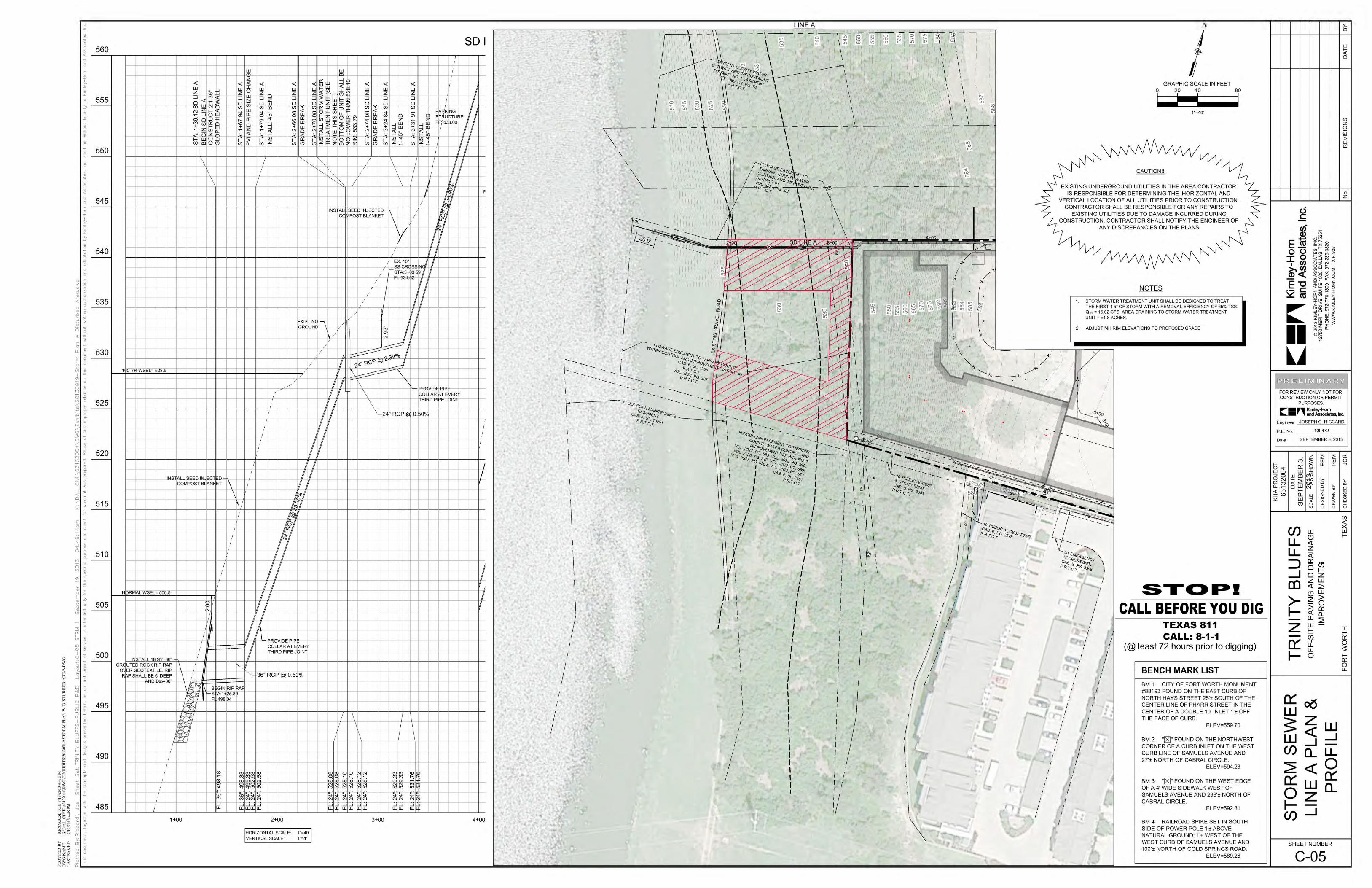
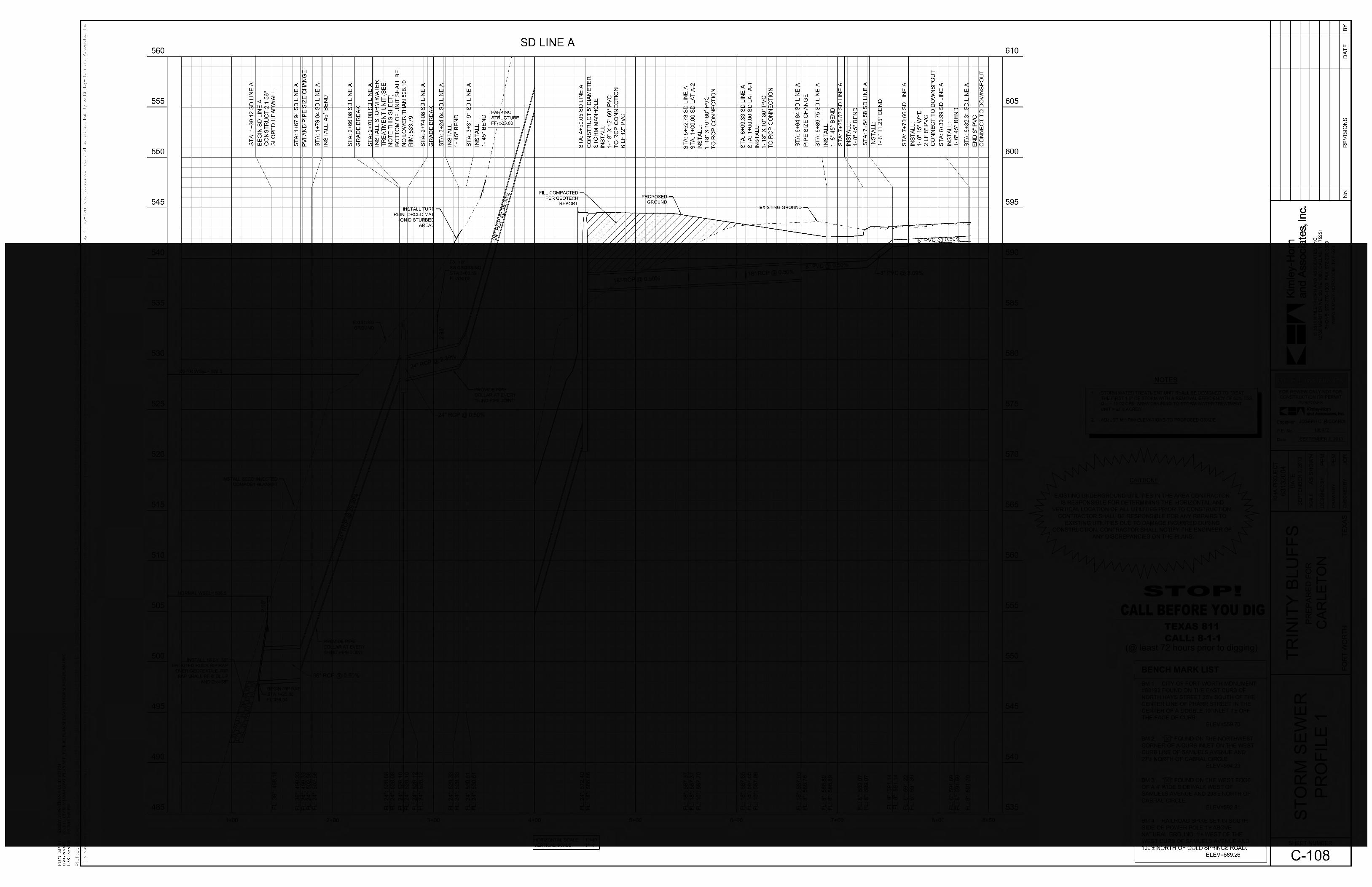
The Proposed Action would include the installation of an outfall structure and piping tothe West Fork Trinity River and the construction of a permanent access road andtemporary access road (Sheet 2 of 8 in Appendix A). This outfall structure will providedrainage for the Trinity Buff’s multi-family development project. The piping connectingthe outfall structure to the proposed development and access road would cross TarrantCounty Water Control and Improvement District #1’s Sewage and Flowage easementsalong the West Fork Trinity River.
The outfall structure will consist of a 24-inch diameter reinforced concrete pipe (RCP)(Appendix A, Sheet 6 through 8 of 8). The outfall structure will be placed below thenormal water elevation.
The outfall structure will be constructed within the floodplain maintenance easementalong the West Fork Trinity River. The piping and access roads will be constructed inthe Tarrant County Water Control and Improvement District #1’s Sewage and Flowageeasements. The permanent access road will be constructed to provide an access route tothe stormceptor. The Proposed Action, one outfall structure and associated piping andaccess roads, minimizes the impact to the existing vegetation on the bluff. Trinity RiverAssociation (TRA) requires the outfall structure to be located a minimum of 3-feet belowthe normal water surface elevation, which is why minimal disturbance to the river bank isproposed.

Supplemental Environmental Assessment April 2014Carleton Development’s Storm Drain and Access Roads Page 4
3.0 AFFECTED ENVIRONMENT
The existing conditions and affected environment of the proposed study area were assessed todetermine the potential environmental consequences.
3.1 SETTING
The proposed project is surrounded by land that is planned as mixed-use development.The project area is currently zoned as Planned Development. The project is within theTarrant County Water Control and Improvement District #1’s Sewage and Flowageeasements. The storm water pipe and outfall structure will be located within theFloodplain Maintenance easement. The project area is comprised of 50 percent deciduousforest, 40 percent grassland and 10 percent riparian vegetation community.
3.2 SOCIOECONOMIC RESOURCES
According to the U.S. Census data for 2010, the project area is located in Census Tract1232, Block Group 1, Block 1143. The median household income within this CensusTract 1232 is $38,631. There are a total of 478 people that live in Block 1143 with 24.9percent of the population consisting of minorities (2.5 percent Black/African American,19.9 percent Hispanic, 1.5 percent Asian, 0.2 percent American Indian/ Alaska Native,and 0.2 percent other).
3.3 HAZARDOUS MATERIALS
No hazardous, toxic, or radioactive waste (HTRW) is anticipated within the project area.Field observations were made during the preparation of this document and no evidence ofpast contamination was observed.
3.4 NOISE AND AESTHETICS
The construction of the outfall structure, piping and access roads will likely take one tothree weeks. Noise and aesthetic concerns associated would be a factor during the timeof construction. Heavy machinery would be used to clear vegetation and dig the trench toinstall the piping for the outfall structure.
3.5 AQUATIC RESOURCES
3.5.1 SURFACE WATER
Surface water associated with the project area is the West Fork Trinity River. Theoutfall structure will be located below the 100-year floodplain (Appendix A,Sheet 3 of 8).

Supplemental Environmental Assessment April 2014Carleton Development’s Storm Drain and Access Roads Page 5
3.5.2 GROUNDWATER
The project area is located within the Trinity (subcrop) Aquifer (Hayes, 2009) andlocated in the Trinity River Basin and the Lower West Fork Trinity Sub-Basin(Hayes, 2004).
3.5.3 WETLANDS AND WATERS OF THE U.S.
Wetlands were not observed within the project area. The West Fork Trinity Riveris located within the project area and would be classified as a water of the U.S.The West Fork Trinity River is considered a perennial stream. The banks of theWest Fork Trinity, within the project area, are dominated by western ragweed(Ambrosia psilostachya), Bermudagrass (Cynodon dactylon) and prostrateknotweed (Polygonum aviculare).
3.6 BIOLOGICAL RESOURCES
3.6.1 VEGETATION
The vegetation within the project area consists of grassland, riparian anddeciduous forest communities. The proposed storm water outfall structure islocated within the grassland and riparian vegetation community. The existinggrassland vegetation is maintained on a regular basis and is dominated byBermudagrass, western soapberry saplings (Sapindus saponaria var.drummondii), Johnsongrass (Sorghum halepense) and switch grass (Panicumvirgatum). The riparian vegetation associated with storm water outfall structureconsisted of western ragweed, prostrate knotweed, trumpet creeper (Campsisradicans), button bush (Cephalanthus occidentalis) and red mulberry (Morusrubra).
The access roads and piping associated with the storm water outfall structure islocated within the deciduous forest vegetation community. The deciduous foresthas an understory dominated by Canadian wildrye (Elyleymus hirtiflorus),Chinese privet (Ligustrum sinensis), western soapberry and greenbrier (Smilaxrotundifolia). The understory consisted of 40 percent vegetation cover, 55percent natural forest litter, and five percent residential trash. The overstory isdominated by hackberry (Celtis laevigata), chinaberry (Melia azedarach) andcedar elm (Ulmus crassifolia). The average diameter at breast height (DBH) ofthe overstory trees was four-inches.
3.6.2 FISH AND WILDLIFE SPECIES
Fish and wildlife species found within the project area would be similar to thatdescribed in the PEA.

Supplemental Environmental Assessment April 2014Carleton Development’s Storm Drain and Access Roads Page 6
3.6.3 THREATENED AND ENDANGERED SPECIES
The U.S. Fish and Wildlife Service (USFWS) list two species within TarrantCounty as endangered. These species are the interior least tern (Sternaantillarum) and whooping crane (Grus americana) (USFWS, 2013).
Interior least terns nest in colonies along sand and gravel bars located near bodiesof water. Their diet includes small fish and aquatic crustaceans. When thesebirds are breeding they will forage within a few hundred feet of the nesting colony(TPWD, 2013). Whooping cranes are a potential migrant throughout most ofTexas.
There are no designated critical habitats present for the federally listed specieswithin the project area. These federally listed bird species were not observedwithin the project area. This proposed project is not expected to have any effecton these listed species.
3.7 AIR QUALITY
The proposed project is located within the nine-county Dallas/Fort Worth nonattainmentarea. The General Conformity Determination described in PEA would apply to theproposed project. The only difference from the PEA is the 2008 eight-hour ozonestandard designation. A ten-county Dallas/Fort Worth area was designatednonattainment and classified moderate under the 2008 eight-hour ozone NationalAmbient Air Quality Standards (NAAQS), effective July 20, 2013 (77 FR 30088). TheDallas Fort Worth area includes the nine counties that were designated under the 1997eight-hour ozone standards in addition to Wise County. The attainment deadline for theDallas Fort Worth moderate attainment area was December 31, 2008.
3.8 CLIMATE
The climate for the state of Texas for this proposed project is similar to what is describedin the PEA.
3.9 CULTURAL RESOURCES
The proposed project’s area of potential effect (APE) is limited to the footprint of theproject, seen on Sheet 3 of 8 in Appendix A. The APE is defined by the extent ofconstruction. Kimley-Horn staff verified the presence of the Trinity River Bluff, aTraditional Cultural Property (TCP), in the APE. The Trinity River Bluff is assessed as aTCP, which is defined as “a historic property whose significance derives from the rolethe property plays in a community’s historically rooted beliefs, customs, and practices”(Prior, 2009). The bluff begins at the beginning of the project’s footprint and terminatesat the water front. The project does not propose to adversely affect the bluff. Proposedimpacts are limited to dirt moving activities, construction of a temporary access road andremoval of vegetation. No historic resources are known to be present in the proposedoutfall structure’s locations. Consultation with Texas Historical Commission indicated

Supplemental Environmental Assessment April 2014Carleton Development’s Storm Drain and Access Roads Page 7
that the no additional archeological survey is required. If previously unrecordedarcheological resources are encountered during construction, work should stop in the areaand Texas Historical Commission and the U.S. Army Corps of Engineers Fort WorthDistrict should be notified.
3.10 RECREATION
No designated recreation areas are located within the project area. The project will notresult in impacts to recreation.
4.0 ENVIRONMENTAL CONSEQUENCES
This section describes the environmental consequences associated with each alternativethat is considered under this SEA.
4.1 SOCIOECONOMIC RESOURCES
4.1.1 NO ACTION
Implementing the No Action alternative would result in no impacts to minoritiesor low-income populations.
4.1.2 PROPOSED ACTION
The Proposed Action would not result in any adverse impacts on the surroundingcommunity. The census tract that the Proposed Action falls within is above the2013 Department of Health and Human Services (HHS) poverty guidelines of$23,550. The proposed project would not restrict access to any surroundingexisting public or community service facilities. While minority and low incomepopulation could be affected by the Proposed Action, there would not be anyadverse effects to these populations.
4.2 HAZARDOUS MATERIALS
4.2.1 NO ACTION
Implementing the No Action alternative would result in no impacts to hazardousmaterials.
4.2.2 PROPOSED ACTION
The Proposed Action would not result in any impacts related to hazardousmaterials. If, during the construction of the outfall structure, piping and theaccess road, any hazardous materials are discovered, construction willimmediately cease and hazardous materials will be classified, removed, andproperly disposed of before constriction continues in that area.

Supplemental Environmental Assessment April 2014Carleton Development’s Storm Drain and Access Roads Page 8
4.3 NOISE AND AESTHETICS
4.3.1 NO ACTION
Implementing the No Action alternative would result in no impacts from noise orthe visual aspect of the area.
4.3.2 PROPOSED ACTION
The Proposed Action will result in temporary impacts to the noise and visualaspect of the area. The impacts would only be temporary and occur during thetime of construction. Construction will occur over a one- to three-week period.Construction would only occur during daylight hours when loud noises are moretolerable.
Heavy machinery and storage of materials will be necessary during construction.This would temporarily affect the aesthetics within the project area. Onceconstruction is complete the area will be returned to pre-construction contours.The permanent access road will result in permanent clearing of vegetation withinthe right of way. The temporary access road will be revegetated with herbaceousspecies.
4.4 AQUATIC RESOURCES
4.4.1 SURFACE WATER
4.4.1.1 NO ACTION
Implementing the No Action alternative would result in no impacts tosurface water.
4.4.1.2 PROPOSED ACTION
The Proposed Action would result in direct impacts to the West ForkTrinity River as a result of the outfall structure. The outfall structure willbe located below the normal water elevation of the West Fork TrinityRiver. Impacts from the outfall structure will be limited to minimumnecessary for construction and would fall within the impact threshold foruse of a Regional General Permit 12.
4.4.2 GROUNDWATER
4.4.2.1 NO ACTION
Implementing the No Action alternative would result in no impacts togroundwater.
Supplemental Environmental Assessment April 2014Carleton Development’s Storm Drain and Access Roads Page 9
4.4.2.2 PROPOSED ACTION
The Proposed Action would result in minimal to non-existent impacts togroundwater resources. The outfall structure and storm water line wouldbe installed through an open-cut method close to the existing groundsurface. No horizontal drilling or other techniques that have beenassociated with groundwater impacts would occur.
4.4.3 WETLANDS AND WATERS OF THE U.S.
4.4.3.1 NO ACTION
Implementing the No Action alternative would result in no impacts towetlands and waters of the U.S.
4.4.3.2 PROPOSED ACTION
The Proposed Action would result in temporary impacts to 0.003-acres ofwaters of the U.S. The discharges at this location would not impactwetlands or other special aquatic sites. The impacts from the outfallstructure would be authorized under Regional General Permit 12 forModification and Alteration of Corps of Engineers Projects. TheProposed Action would not impact Section 10 waters.
4.5 BIOLOGICAL RESOURCES
4.5.1 VEGETATION
4.5.1.1 NO ACTION
Implementing the No Action alternative would result in no impacts tovegetation.
4.5.1.2 PROPOSED ACTION
The Proposed Action would result in impacts to the grassland, riparian,and deciduous forest vegetation communities. Impacts to grassland wouldbe temporary. The existing grassland vegetation is dominated bybermudagrass, which is maintained on a regular basis. Impacts to thedeciduous forest vegetation community will be temporary. The deciduousforest vegetation would be revegetated following construction. Pre-construction contours will be restored following construction.
Approximately 36 trees (six-inches and larger diameter at breast height)would be removed to construct the piping associated with the outfallstructure and the access roads.

Supplemental Environmental Assessment April 2014Carleton Development’s Storm Drain and Access Roads Page 10
4.5.2 FISH AND WILDLIFE SPECIES
4.5.2.1 NO ACTION
Implementing the No Action alternative would result in no impacts to fishand wildlife species.
4.5.2.2 PROPOSED ACTION
The Proposed Action will result in minimal impacts to fish and wildlifespecies. The impacts to fish and wildlife species would be similar to theimpacts described in the PEA. The PEA states that projects “locatedwithin urban environments with typical fish and wildlife species adaptedto urban activities and surroundings. Since the fish and wildlife specieshave adapted to the present conditions and the proposed alterations wouldnot significantly alter that condition, and impacts to wildlife and theirhabitats would be temporary in nature and limited to the constructionphase.”
4.5.3 THREATENED AND ENDANGERED SPECIES
4.5.3.1 NO ACTION
Implementing the No Action alternative would result in no impacts tothreatened and endangered species.
4.5.3.2 PROPOSED ACTION
Due to the urban location of the project area, on-going disturbance,fragmented and altered habitat, and small footprint of the project, nosignificant adverse impacts to threatened or endangered species areexpected to occur as a result of the Proposed Action.
4.6 AIR QUALITY
4.6.1 NO ACTION
Implementing the No Action alternative would result in no impacts to air qualitybecause no construction would occur.
4.6.2 PROPOSED ACTION
Impact to regional air quality resulting from relatively minor constructionactivities associated with the Proposed Action, such as dust and exhaust fromconstruction equipment, would be considered temporary, minimal, and considered

Supplemental Environmental Assessment April 2014Carleton Development’s Storm Drain and Access Roads Page 11
deminimus. The associated minimal impacts would not require a GeneralConformity Analysis.
4.7 CULTURAL RESOURCES
4.7.1 NO ACTION
Under the No Action alternative, any cultural resource within the project areawould remain undisturbed. No impacts to cultural resources would occur due tothe implementation of the No Action alternative.
4.7.2 PROPOSED ACTION
No known archeological sites are extant within the project area. A single historicproperty exists within the project area; the Bluff, a Traditional Cultural Property(TCP) that is eligible for the National Register of Historic Places (NRHP). Theproposed action does not diminish the relevant or significant impact to the historicproperty. If human remains or archeological materials are encountered during theconstruction, work shall immediately stop in the area and the U.S. Army Corp ofEngineers Fort Worth District will be notified along with appropriate authorities.Work shall not continue until the U.S. Army Corps of Engineers has therequirements of all applicable federal historic preservation laws.
4.8 RECREATION
4.8.1 NO ACTION
The No Action alternative would result in no impacts to recreational designatedareas.
4.8.2 PROPOSED ACTION
The Proposed Action alternative would result in no impacts to recreationaldesignated areas because they are not located within the project area.
5.0 MAINTENANCE
5.1 PRIMARY AND SECONDARY MAINTENANCE ACCESS ROUTE
The existing maintenance gravel road located east of the West Fork Trinity River will bethe primary access route to the stormceptor. A secondary access route to the stormceptorwill be constructed between Samuels Ave. and the existing gravel road, see Sheet 2 of 8in Appendix A. This secondary access route will be a permanent access road located onthe north side of the development (Sheet 2 of 8 in Appendix A).
Supplemental Environmental Assessment April 2014Carleton Development’s Storm Drain and Access Roads Page 12
5.2 LONG TERM MAINTENANCE
The developer, Carleton-Trinity Bluff, Ltd., will be responsible for long termmaintenance of the stormceptor, secondary access road and drainage structure.
6.0 MITIGATION
6.1 CLEAN WATER ACT SECTION 404
Adverse impacts to waters of the U.S. would be avoided and minimized to the extentpracticable. The need for compensatory mitigation for adverse impacts to waters of theU.S. is not necessary since the proposed impacts are minimal both individually andcumulatively from a Section 404 standpoint.
6.2 VEGETATION
Clearing of vegetation would be limited to the “Limits of Disturbance,” seen on Sheet 5of 8 in Appendix A. The “Limits of Disturbance” is necessary for construction. Thepermanent access road located within the “Limits of Disturbance” will not berevegetated. The remaining disturbed areas within the flowage easement will receive a2” thick seed injection compost blanket. This will help restore the disturbed area to pre-construction conditions. The USACE does not require woodland mitigation for Section408 actions, unless impacts occur with Section 404 jurisdictional areas. This action doesnot require a pre-construction notification or compensatory mitigation under Section 404.
7.0 CUMULATIVE IMPACTS
Past, Present, Reasonably Foreseeable Projects
Past projects would include the floodplain maintenance easement, Tarrant County WaterControl and Improvement District #1’s flowage easement, floodplain easement andsewage easement and residential and commercial development adjacent to and near theproject area.
Present projects would include operation and maintenance of the West Fork Trinity Riverby USACE, Tarrant County Water Control Improvement District #1, and the City of FortWorth.
Future projects would include residential development east of the project (i.e. TrinityBluff’s multi-family development). The outfall structure will service the Trinity Bluff’smultifamily development.
No direct or indirect impacts from this project are expected to groundwater or threatenedand endangered species. No cumulative impacts from implementing the Proposed Actionare anticipated.
Supplemental Environmental Assessment April 2014Carleton Development’s Storm Drain and Access Roads Page 13
7.1 BIOLOGICAL RESOURCES
The impacts to the grassland, riparian and deciduous forest vegetation community havebeen minimized to the extent possible. Cumulative impacts to the vegetation wouldresult from development of open space to urban development. Portions of the deciduousforest outside of the levee easement will likely be converted to residential uses.
7.2 AIR QUALITY
The limited scope of the Proposed Action would not be enough to trigger significantcumulative impacts to the air quality.
7.3 CULTURAL RESOURCES
No adverse direct impacts to cultural resources are anticipated from the Proposed Action.Cumulative impacts could occur as a result of development of adjacent property.
8.0 PUBLIC INVOLVEMENT
8.1 AGENCY COORDINATION
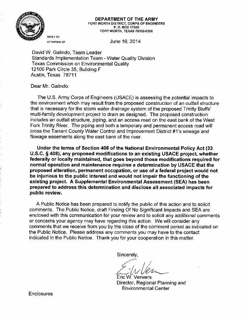
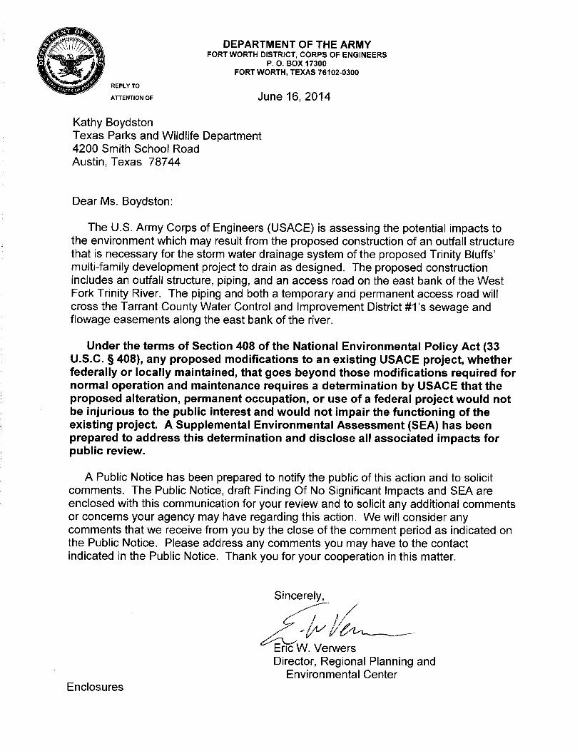
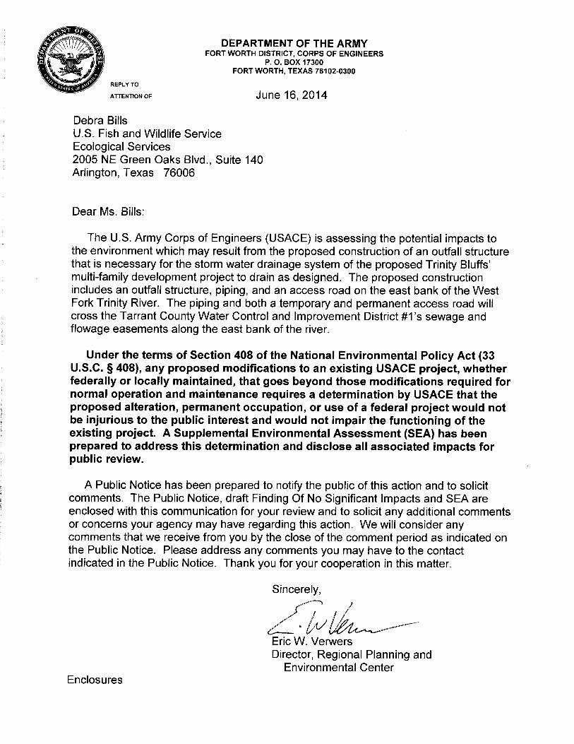
This section discusses consultations and coordination that will occur during thepreparation of this document. This includes contacts made during the development of theproposed action, other alternatives considered, and preparation of this SEA. Copies ofagency coordination letters are presented in Appendix B. Formal and informationcoordination would be conducted with the following agencies:
· State Historic Preservation Office (SHPO),· Texas Historic Commission (THC),· U.S. Fish and Wildlife Service (USFWS),· Environmental Protection Agency (EPA), Region 6 office· Texas Parks and Wildlife Department (TPWD), and· Texas Commission on Environmental Quality (TCEQ).
8.2 PUBLIC INFORMATION AND REVIEW
In accordance with NEPA, a 30-day review period of the SEA was provided via a Noticeof Availability, posting of the document on the Fort Worth District websitewww.swf.usace.army.mil, and a local mailing (Appendix C).

Supplemental Environmental Assessment April 2014Carleton Development’s Storm Drain and Access Roads Page 14
9.0 REFERENCES
Hayes, Mark. Texas Water Development Board. January 2004. Texas Major River Basins andSub-Basins over DEM Map. Retrieved September 18, 2013 fromhttp://www.twdb.state.tx.us/mapping/maps.asp.
Hayes, Mark. Texas Water Development Board. December 2004. Major Aquifers of Texas.Retrieved September 18, 2013 from http://www.twdb.state.tx.us/mapping/maps.asp.
Prior, Marsha, Duane E. Peter, and Joseph Murphey, eds. Below the Bluff: Urban Developmentat the Confluence of the West Fork and Clear Fork of the Trinity River, 1846-1965- ExpandedEdition, Historic Context, Inventory, and Assessment of the Central City Segment of the TrinityRiver Vision Master Plan, Fort Worth, Texas. Rep. U.S. Army Corps of Engineers, Fort WorthDistrict, 2009. Web. Feb. 2014.
Texas Commission on Environmental Quality. Texas State Implementation Plan. RetrievedSeptember 18. 2013 from http://www.tceq.texas.gov/airquality/sip/texas-sip.
Texas Commission on Environmental Quality. Dallas-Fort Worth and the State ImplementationPlan. September 18, 2013 from http://www.tceq.texas.gov/airquality/sip/dfw/sip-dfw.
Texas Parks and Wildlife Department. Rare, Threatened, and Endangered Species by County.Retrieved September 18, 2013 fromhttp://www.tpwd.state.tx.us/landwater/land/maps/gis/ris/endangered_species/.
United States Army Corps of Engineers. 2011. Final Programmatic EnvironmentalAssessment, Civil Works, Minor Section 408 NEPA Compliance, United States Army Corps ofEngineers Fort Worth District, Texas. April 11, 2011.
United States Census Bureau. 2010. Census. Retrieved September 24, 2013 fromhttp://www.census.gov/prod/cen2010/doc/sf1.pdf.
United State Fish and Wildlife Service. Ecological Service, Southwest Region, EndangeredSpecies Program, T&E Species Lists. Retrieved September 18, 2013 fromhttp://www.fws.gov/southwest/es/ES_ListSpecies.cfm
10.0 CREDENTIALS
Larry ClendenenCertified Forester/ Professional Wetland Scientist19-years of experience
Sarah RichterEcologist1-year of experience

Supplemental Environmental Assessment April 2014Carleton Development’s Storm Drain and Access Roads
Appendix A
Exhibits
OF 8 SHEETS
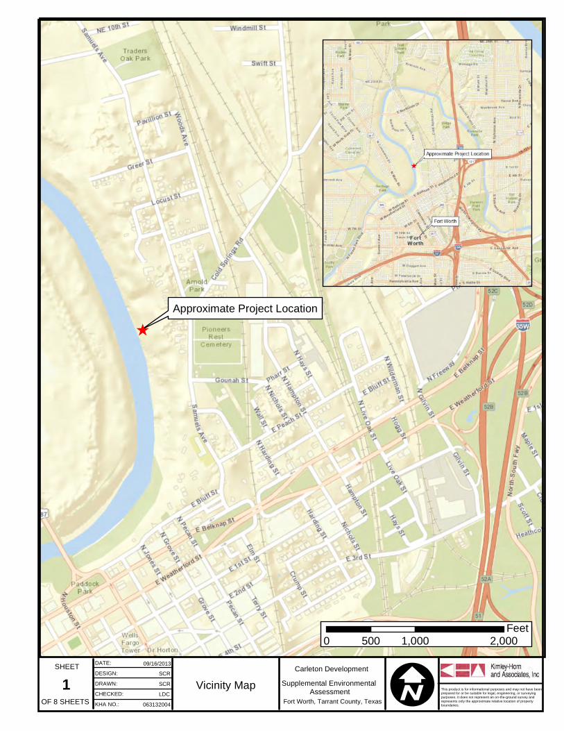
Approximate Project LocationÊ
1 I09/16/2013
SCRSCRLDC
063132004
Vicinity MapFort Worth, Tarrant County, Texas
SHEET DATE:DESIGN:DRAWN:CHECKED:KHA NO.:
This product is for informational purposes and may not have beenprepared for or be suitable for legal, engineering, or surveyingpurposes. It does not represent an on-the-ground survey andrepresents only the approximate relative location of propertyboundaries.
0 1,000 2,000500Feet
Supplemental Environmental Assessment
Carleton Development

OF 8 SHEETS
Source: Esri, DigitalGlobe, GeoEye, i-cubed, USDA, USGS, AEX,Getmapping, Aerogrid, IGN, IGP, swisstopo, and the GIS User Community
2 I12/18/2013
SCRSCRLDC
063132004
Aerial MapFort Worth, Tarrant County, Texas
SHEET DATE:DESIGN:DRAWN:CHECKED:KHA NO.:
This product is for informational purposes and may not have beenprepared for or be suitable for legal, engineering, or surveyingpurposes. It does not represent an on-the-ground survey andrepresents only the approximate relative location of propertyboundaries.
0 100 20050Feet
LegendBuilding FootprintPermanent Access RoadStorm Water PipeTarrant County's Flowage EasementTarrant County's Sewage EasementLimits of Disturbance/ Temporary Access RoadStorm Water Outfall
Supplemental Environmental AssessmentAerial Source: TNRIS 2012
Carleton Development

OF 8 SHEETS3 I
12/18/2013SCRSCRLDC
063132004
FEMA ExhibitFort Worth, Tarrant County, Texas
SHEET DATE:DESIGN:DRAWN:CHECKED:KHA NO.:
This product is for informational purposes and may not have beenprepared for or be suitable for legal, engineering, or surveyingpurposes. It does not represent an on-the-ground survey andrepresents only the approximate relative location of propertyboundaries.
0 100 20050Feet
Supplemental Environmental Assessment
LegendPermanent Access RoadStorm Water PipeStorm Water OutfallTarrant County's Flowage EasementTarrant County's Sewage EasementLimits of Disturbance/ Temporary Access RoadZone X- Areas of 0.2% annual chance flood; areas of 1% annual chance flood with average depths of less than 1 foot or with drainage areas less than 1 square mile; and protected by levees from 1% annual chance floodZone AE- Base Flood Elevation determined
Aerial Source: TNRIS 2012
Carleton Development


Supplemental Environmental Assessment April 2014Carleton Development’s Storm Drain and Access Roads
Appendix B
Agency Coordination Letters


Supplemental Environmental Assessment April 2014Carleton Development’s Storm Drain and Access Roads
Appendix C
Public Involvement