systematic fishway survey and for passage of adult …€¦ · vertical walls and move in very...
TRANSCRIPT

USFWS ‐ Systematic Fishway Survey and Evaluation
Systematic Fishway Survey and Evaluation for Upstream Passage of Adult Pacific Lamprey at the FCRPS Projects
in the Mainstem Columbia and Snake Rivers
David A. Wills
Donald R. Anglin U.S. Fish and Wildlife Service
Columbia River Fisheries Program Office 1211 S.E. Cardinal Court, Suite 100
Vancouver, WA 98683 October 29, 2012

USFWS ‐ Systematic Fishway Survey and Evaluation
Cover photo:Lower Granite Dam adult fish ladder.
Image by USFWS.

USFWS ‐ Systematic Fishway Survey and Evaluation
1
Systematic Fishway Survey and Evaluation for Upstream Passage of Adult Pacific Lamprey at the
FCRPS Projects in the Mainstem Columbia and Snake Rivers
I. Introduction Although Pacific Lamprey (Entosphenus tridentatus) were historically widespread and relatively abundant, recent observations of the reduction of abundance and distribution have raised concerns regarding the status and trend of the species. These observed declines may be a result of reduced quantity and quality of spawning and rearing habitats, impacts associated with hydropower and irrigation diversion passage and entrainment, and mortality from predation (Luzier et al. 2011). Although accurate abundance data for Pacific Lamprey are difficult to obtain, observational trends suggest that the current populations are declining from historical numbers, particularly in the Columbia River Basin. Historically, lamprey passing Bonneville Dam numbered in the hundreds of thousands. The highest recorded count at Bonneville was 379,509 in 1969 (USACE 2012a). In recent years, counts at Bonneville indicate a dramatic decline in the number of adult lamprey returning to the Columbia River. Continuing threats such as barriers to mainstem and tributary passage, streamflow management, stream and floodplain degradation, and reduced water quality are impacting all freshwater life stages. In response to the growing concern for the status of Pacific lamprey, the U.S. Army Corps of Engineers (USACE) finalized their Pacific Lamprey Passage Improvements Implementation Plan 2008 – 2018 (USACE 2009). Funding commitments came from formal agreements with treaty tribes in 2008, called the Tribal Accords. In addition, because of the cultural, subsistence, and ecological values associated with Pacific lamprey, and the decline in abundance, the Native American Columbia River treaty tribes (Nez Perce, Umatilla, Yakama, and Warm Springs) developed their own restoration plan (CRITFC 2011). The first objective listed in their plan is to improve lamprey mainstem passage, survival, and habitat. The U.S. Fish and Wildlife Service (USFWS, or Service) also recognized the need for a comprehensive plan to conserve and restore Pacific lamprey. To that end, the Service worked with various Federal, State, and local governmental agencies, Native American tribes, scientific institutions, consultants, non‐profit groups, utility companies, private landowners and others from California to Alaska to develop a comprehensive conservation initiative for Pacific lamprey (Luzier et al. 2011). The Service also conducted a risk analysis for lamprey and found that “The NatureServe rank indicates that Pacific Lamprey geographic population groupings are at ‘high risk’ throughout much of the Columbia River basin, particularly in the Snake River, the Mid‐Columbia region and the Upper Columbia” (Luzier et al. 2011). The Service determined that a systematic fishway evaluation survey for adult Pacific lamprey passage at each of the eight mainstem dams in the lower Columbia and Snake rivers was needed. The systematic survey need had been raised by the Service within the USACE’s Anadromous Fish Evaluation Program (AFEP) process since 2010. The goal of this work would be to complete a systematic adult fishway evaluation survey at each Federal Columbia River Power System (FCRPS) project and integrate it with biological information on lamprey passage capabilities. The purpose is to provide a consistent, systematic evaluation at each project to inform priorities or the sequence of actions to be taken to

USFWS ‐ Systematic Fishway Survey and Evaluation
2
improve adult passage through the projects and to improve the attraction of adult lamprey to the fishway entrances, while not degrading adult salmon passage. Since the USACE prioritization process from their 10‐year plan indicated that Bonneville Dam was the highest priority location to improve lamprey passage, the Service chose to start onsite inspections and evaluations of fishways at Bonneville Dam with a reconnaissance level inspection. The goal of this report is to present the Service’s concept of what the systematic fishway survey and evaluation process should entail and to provide the results of a reconnaissance level inspection conducted at Bonneville Dam in 2011 and recommended needed actions. Topics covered in this report include:
• a brief introduction to Pacific lamprey and the Columbia River Basin area of concern • background information on Bonneville Dam and what is readily known about;
o the physical structure and operations of the fish passageways (includes entrances) o historic lamprey passage at Bonneville Dam o previous lamprey and passage research
• a review of the USACE Pacific Lamprey Passage Improvements Implementation Plan 2008‐2018 (USACE 2009) as it pertains to Bonneville Dam
• the results of the USFWS reconnaissance level survey and assessment at Bonneville Dam • components of a systematic fishway survey and evaluation • overview of USACE’s newly implemented systematic fishway survey • summary of USFWS recommendations and priority needs at Bonneville Dam
II. Pacific Lamprey Life Cycle The following summary of Pacific lamprey life cycle information comes from Streif (2008). Pacific lampreys spawn in similar habitats to salmon; in gravel bottomed streams, at the upstream end of riffle habitat, typically above suitable ammocoete habitat. Spawning occurs between March and July depending upon location within their range. Hatched ammocoetes (larvae) drift downstream to areas of low velocity and fine substrates where they burrow, grow, and live as filter feeders for 3 to 7 years and feed primarily on diatoms and algae. Several generations and age classes of ammocoetes may occur in high densities. Metamorphosis to macropthalmia (juvenile phase) occurs gradually over several months as developmental changes occur, including the appearance of eyes and teeth. When metamorphosis is complete, the macropthalmia leave the substrate and enter the water column. They migrate downstream to the ocean between late fall and spring where they fully mature into adults. After spending 1 to 3 years in the marine environment as parasitic feeders on fish, Pacific lampreys cease feeding and migrate to freshwater between February and June. They are thought to overwinter and remain in freshwater habitat for approximately one year before spawning where they may shrink in size up to 20 percent. Most upstream migration takes place at night. Adult size at the time of migration ranges from about 15 to 25 inches. Physical Abilities and Characteristics The swimming capabilities and characteristics of Pacific lamprey are very different from salmonids. Salmon are strong swimmers usually found in the upper water column. They are most active diurnally when passing the dams. Pacific lamprey, however, are relatively weak swimmers, primarily found low in the water column. A significant proportion of juvenile salmonids migrating downstream can be safely guided away from the turbines by the fish bypass screens at the turbine entrances of the mainstem

USFWS ‐ Systematic Fishway Survey and Evaluation
3
dams. However, juvenile and larval lamprey that are bypassed are more likely to be impinged on the screens and suffer injuries or death than juvenile salmonids. Mueller et al. (2006) reported on juvenile Pacific lamprey burst speeds measured in laboratory flume studies. The results indicated that the juvenile lamprey average burst speed was 2.3 feet per second (fps), or 5.2 body lengths per second, much slower than typical juvenile salmonids which are capable bursts of nine to 12 times their body length per second. The Juvenile lamprey sustained swim speeds averaged only 0.5 fps over a five minute period. Fish ladder conditions are designed for adult anadromous salmonids and are generally not suitable for adult Pacific lamprey. Adult salmon migrating upstream are attracted to and enter relatively high flows and are unaffected by 90° corners typically found at the fishway entrances and on weirs and orifices. Adult salmonid burst speeds can range from 8 to 26 fps, with sustained speeds close to five fps, while adult sea lamprey (Petromyzon marinimus)have been calculated to burst 6‐7 fps (Bell 1991). Once inside fishways, adult salmon are guided and excluded from areas of potential danger by diffuser grates and picketed leads. The adult lamprey can pass through typical diffuser gratings and picketed leads and often are lost in areas migrating fish were not intended to enter. Adult lamprey can, though, climb vertical walls and move in very shallow water (NFSC 2007), a trait not shared by adult salmon.
III. Columbia River Basin Pacific lampreys were historically widespread from Baja California, Mexico north to the Gulf of Alaska and Aleutian Islands (Close et al. 2002; USFWS 2004), and along the Pacific Rim to Japan (Luzier et al. 2011). Along the west coast of North America, Pacific lamprey distribution extended far inland up major river systems, including the Columbia and Snake Rivers (Wydoski and Whitney 2003). Due to mainstem and tributary passage barriers, water management, and habitat and water quality degradation, the distribution and abundance of Pacific lamprey in Washington, Oregon, Idaho, and California has declined (Luzier et al. 2011; Wydoski and Whitney 2003). In the Columbia River Basin, the four lower Columbia River mainstem hydropower dams and the four lower Snake River mainstem hydropower dams are the nexus of fish passage issues for anadromous Pacific lampreys (Figure 1).
Figure 1. Lower Columbia River and Lower Snake River federal hydropower projects.

USFWS ‐ S
The four linclude BoThe Snakeconfluenc41), Little These eigColumbiaowners anRiver basi MainstemfluctuatioColumbiaoccurred
Figure 2from 1970
Systematic Fis
ower Columbonneville [rivee River entersce of the CleaGoose (RM 7ht hydropowRiver Power nd operators ins.
m dam daytimons in estimatRiver (Figurethroughout t
2. Window co0 through 199
shway Survey
bia River hydrer mile (RM) s the Columbrwater River 70), and Loweer projects anSystem (FCRof all 31 of th
me passage coted numbers oe 2). Fluctuathe lower Colu
ounts of adul95. (USACE 20
y and Evaluat
ropower dam146], The Daia at RM 324.(Snake RM 13er Granite (RMnd 23 additioPS). The USAhe federally o
ounts for lampof adult lampions in numbumbia/Snake
t Pacific lamp012a)
ion
4
ms downstreamlles (RM 192).2. The lower39) include IcM 108). All arnal upstreamACE and the Bowned hydrop
prey began inpreymigratingers of Pacific River Basins
prey at Bonne
m from the c), John Day (Rr Snake hydroce Harbor (RMre owned andm hydropowerBureau of Recpower dams i
n 1938, and thg upstream palamprey inclwithin recen
eville Dam, 19
onfluence of RM 216), and opower damsM 10), Lower d operated byr projects maclamation (USin the Columb
here have sinast Bonnevilleuding overallt history (Tab
939‐2011. No
the Snake RivMcNary (RMs below the Monumentay the USACE. ake up the FedSBR) are the bia and Snake
ce been drame Dam on thel declines havble 1).
o counts mad
ver 292).
l (RM deral
e
matic e ve
de
USFWS ‐ Systematic Fishway Survey and Evaluation
5
IV. Bonneville Dam Background As the lowermost project on the Columbia River, and the first dam in the FCRPS, Bonneville Dam is the first hydropower project that adult lamprey encounter on their upstream migration. Bonneville Dam was authorized for power and navigation purposes in 1935. Other uses include fisheries, recreation and water quality. The first powerhouse (Powerhouse 1 or PH1, located on the Oregon shore) was completed in 1938 with 10 turbine units. The second powerhouse (Powerhouse 2 or PH2, located on the Washington shore) was authorized in 1974 and completed in 1982. The project is located at RM 146.1 near Bonneville, Oregon. It is a run‐of‐river project and has minimal capacity for active storage. Total hydraulic capacity is 288,000 cubic feet per second (cfs). Powerhouse 1 capacity is 136,000 cfs and Powerhouse 2 is 152,000 cfs. The maximum historical peak unregulated flow was calculated to be 1,240,000 cfs in 1894 where the dam now stands. The nameplate generation capacity is 1050 megawatts (MW) with Powerhouse 1 at 518 MW and Powerhouse 2 at 532 MW. Although the maximum forebay elevation is 82.5 feet above mean sea level (msl), the typical operational forebay ranges from 70‐77 feet msl. Depending upon the time of year and river conditions, the tailwater elevation may range from seven feet msl to over 32 feet msl. This results in a vertical distance of 45‐70 feet that adult lamprey have to negotiate. For the time period of primary lamprey passage from June 1 through August 31, a high water year (e.g. 2011) would result in a 50 foot vertical distance, an average water year (e.g. 2006 or 2008) would result in a 56‐58 foot vertical distance, and a low water year (2001) would result in about a 65 foot vertical distance. Fish ladders at the mainstem dams have been designed to attract and pass adult salmonids. The ladder entrances are typically maintained at 1‐2 feet of head (USACE 2012b) which produces attraction velocities of 8‐10 fps (Clay 1995). The main ladder sections are typically pools with weirs having overflows, and submerged orifices. Target velocities for the orifices and overflows are 8 fps for salmon passage. The typical ladder slope is 1:16. The window count slot station section is narrowed by picketed leads to a width of about 3 feet. A mechanical crowder can narrow the gap to less than two feet. The sections above the count windows are typically vertical slot weirs for flow control in that section due to fluctuation of the forebay elevation.
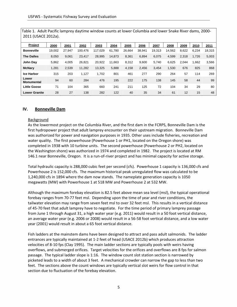
Table 1. Adult Pacific lamprey daytime window counts at lower Columbia and lower Snake River dams, 2000‐2011 (USACE 2012a).
Project 2000 2001 2002 2003 2004 2005 2006 2007 2008 2009 2010 2011 Bonneville 19,002 27,947 100,476 117,029 61,780 26,664 38,941 19,313 14,562 8,622 6,234 18,315
The Dalles 8,050 9,061 23,417 28,995 14,873 8,361 6,894 6,075 4,599 2,318 1,726 5,003
John Day 5,862 4,005 26,821 20,922 11,663 8,312 9,600 5,740 6,625 2,044 1,662 3,566
McNary 1,281 2,539 11,282 13,325 5,888 4,158 2,456 3,454 1,530 676 825 868
Ice Harbor 315 203 1,127 1,702 801 461 277 290 264 57 114 269 Lower Monumental 94 60 284 476 195 222 175 138 145 58 44 99
Little Goose 71 104 365 660 241 211 125 72 104 34 29 80
Lower Granite 28 27 138 282 122 40 35 34 61 12 15 48

USFWS ‐ Systematic Fishway Survey and Evaluation
6
Fish ladder flow conditions are driven by salmon passage criteria with depth over ladder weirs at 1.0 ± 0.1 feet during the fish passage season from March 1 through November 30 (USACE 2012b). A one foot head drop between pools in a fishway has been used as a standard for Pacific salmon for 50 years (Clay 1995). Because of the design of the ladder weirs, a consistent hydraulic head is maintained over the tops and through the bottom orifices of the weirs which produces a velocity of 8 fps (Clay 1995). During periods of high American shad passage (> 5,000 shad per day/ per count station), the weir head criteria is raised to 1.3 ± 0.1 feet (USACE 2012b). The additional depth makes more space available for the surface oriented shad to pass, thus reducing congestion at the orifices below, minimizing delays for salmonid passage. The Bonneville Dam has eight entrances to three adult ladders and two powerhouse collection channels (Figure 3). An upstream migrant transportation channel (UMT) connects the Cascades Island ladder to the Washington Shore ladder. More detailed information can be found in Appendix A. Each powerhouse collection channel has entrances at the north and south ends (Figure 3). Water flow direction is from the north end to the south. A water velocity of 1.5‐4.0 fps is maintained in both collection channels. Fish entering at the south end of Powerhouse 1 migrate north through the collection channel to the Bradford Island “A” Branch ladder (details in Appendix A, Figure A‐2).
Figure 3. Overview of Bonneville Dam and upstream fishways. Image adapted from USACE 2012b.

USFWS ‐ Systematic Fishway Survey and Evaluation
7
Fish entering at the north end of the powerhouse enter directly into the “A” Branch of the Bradford Island Ladder. The fish ascend and exit the ladder upstream of the powerhouse on the south side of Bradford Island. Fish entering the Powerhouse 2 collection channel from the south end migrate north through the channel and enter into the lower junction pool at the base of the Washington Shore ladder (details Appendix A, Figure A‐4), along with the entrances from the north end of powerhouse and the north downstream entrance (ND‐E). There are also ladder entrances at the north and south ends of the spillway. The south entrance leads to the Bradford Island “B” Branch, which merges with the “A” Branch below the count window. The north end enters the Cascades Island Ladder. The Cascades Island Ladder merges into the UMT on the south side of Powerhouse 2. The UMT proceeds north along the upstream side of the powerhouse and merges into the Washington Shore Ladder below the count window (details in Appendix A, Figure A‐3). The fishways have a diffuser system that supplies auxiliary water to the structure in order to maintain hydraulic criteria throughout the entire structure for salmon passage. All diffuser gratings at Bonneville Dam have a 2.5 cm (1.0 inch) gap designed to keep adult salmon out of the auxiliary water supply (AWS) system. To document the physical environment adult lamprey encounter in attempting to pass over Bonneville Dam, a matrix has been made (Table 2) to list the physical and hydraulic information for all of the fishway structures. The information was gathered from readily available documentation and passage studies and reports. Much of the physical and hydraulic information to fully describe the structures is missing from the table and needs to be obtained.

USFWS ‐ Systematic Fishway Survey and Evaluation
8
Table 2. Known and unknown (?) physical and hydraulic information for Bonneville Dam fishway structures (n/a ‐ not applicable). ________________________________________________________
a includes entrance sections and junction pools, if present. b i.e. section length, width, depth; weir dimensions and placement; orifice and slot placement and dimensions. c OF = overflow weir; VS = vertical slot weir; O = orifice. Lamprey Passage Total, direct window counts of lamprey passage for all ladders at Bonneville Dam for 1997 through 2011 (Table 3) ranged from about 117,000 in 2003 to 14,562 in 2008. Until 2009, daytime window counts were the only method of enumerating adult lamprey at Bonneville Dam. Because of the increasing information documenting higher levels of nighttime passage (Moser et al. 2002a), night video counts were begun in 2009 at the Washington Shore and Bradford Island ladder window count stations. Lamprey auxiliary passage systems, or lamprey passage structure (LPS) have been installed at the Washington Shore, Cascades Island, and Bradford Island ladders and counts began for those structures in 2009.
Sectiona DimensionsbType of
WeirscNo. of Weirs in Section
Elev (ft msl)
Velocities: overflows, slots and orifices
Velocities: section or between weirs
Powerhouse 1 Collection Channelentrance ? n/a n/a tailwater n/a 8‐9 ft/schannel ? n/a n/a tailwater n/a 1.5‐4 ft/s
Bradford Island "A" Branch ladderentrance ? n/a n/a tailwater n/a 8‐9 ft/smain ? OF+O 46 8‐53 8‐9 ft/s ?
Bradford Island "B" Branch ladderentrance ? n/a n/a tailwater n/a 8‐9 ft/smain ? OF+O 46 8‐53 8‐9 ft/s ?
Bradford Island Common Branchjunction pool ? n/a n/a 53 n/a ?main ? OF+O 14 54‐67 8‐9 ft/s ?count window ? n/a n/a 67 ? ?serpentine ? VS 17 68‐forebay 8‐9 ft/s ?
Cascades Island Ladderentrance ? n/a n/a tailwater n/a 8‐9 ft/smain ? OF+O 59 8‐66 8‐9 ft/s ?serpentine ? VS 18 67‐forebay 8‐9 ft/s ?
Upstream Migrant ChannelUMT ? n/a n/a 66‐67 n/a ?
Powerhouse 2 Collection Channelentrance ? n/a n/a tailwater 8‐9 ft/s ?channel ? n/a n/a tailwater n/a 1.5‐4 ft/s
Washington Shore Ladderentrance ? n/a n/a tailwater n/a 8‐9 ft/slower junction pool ? n/a n/a tailwater n/a ?lower ladder ? OF+O 11 8‐18 8‐9 ft/s ?turning pool 1 ? n/a n/a 18 n/a ?middle ladder ? OF+O 15 19‐33 8‐9 ft/s ?turning pool 2 ? n/a n/a 33 n/a ?upper ladder ? OF+O 34 34‐67 8‐9 ft/s ?upper junction pool ? n/a n/a 67 n/a ?count window ? n/a n/a 67 ? ?serpentine ? VS 17 68‐forebay 8‐9 ft/s ?exit ? n/a n/a forebay n/a ?
2‐
1‐2‐
1‐
1‐2‐
1‐
8‐9‐
10‐11‐
Fishway
1‐2‐3‐4‐5‐6‐
1‐2‐
3‐
2‐3‐
7‐
1‐
4‐
1‐2‐

USFWS ‐ Systematic Fishway Survey and Evaluation
9
Table 3. Counts of adult Pacific lamprey at Bonneville Dam, 1997‐2011 (USACE 2012a)*. ______________
Year Window1 Video2 LPS3 Total 1997 22,830 n/a n/a 22,830 1998 37,515 n/a n/a 37,515 1999 37,308 n/a n/a 37,308 2000 19,002 n/a n/a 19,002 2001 27,947 n/a n/a 27,947 2002 100,476 n/a n/a 100,476 2003 117,029 n/a n/a 117,029 2004 61,780 n/a n/a 61,780 2005 26,664 n/a n/a 26,664 2006 38,941 n/a n/a 38,941 2007 19,313 n/a n/a 19,313 2008 14,562 n/a n/a 14,562 2009 8,624 6,262 4,542 19,428 2010 6,234 13,435 4,889 24,568 2011 18,315 18,857 14,029 51,201
* 2009‐2011 data from USACE 2010 and 2012b 1 Typically April 1 through October 31, 5 AM to 9 PM (DST). 2 June 15 to September 30, 9 PM to 5 AM (DST).
3 June – August, 24 hours per day. Cumulative run passage timing from 1999 through 2011 (Table 4) indicates that the mean peak passage date is July 11, with the first and last adult lamprey being recorded, on average, on April 23 and October 26, respectively. Table 4. Adult Pacific lamprey migration timing at Bonneville Dam (DART 2012).
No. of MidYear First 1% 5% 10% 50% 90% 95% Last 80% Days1999 4/23 5/21 5/25 5/27 7/17 9/3 9/13 10/31 1002000 4/17 5/13 5/24 5/29 6/28 8/20 9/6 11/9 842001 4/30 5/21 5/27 6/4 7/5 8/13 8/27 10/30 712002 5/4 5/31 6/7 6/18 7/13 8/28 9/5 10/31 722003 4/28 5/29 6/6 6/8 7/5 8/10 8/25 11/2 642004 5/4 5/25 6/4 6/10 7/2 8/11 8/22 10/31 632005 5/9 5/26 6/3 6/9 7/2 8/3 8/14 10/30 562006 4/8 5/29 6/10 6/16 7/17 9/3 9/9 12/3 802007 5/11 5/31 6/5 6/14 7/14 8/6 8/22 9/16 542008 5/11 5/23 6/6 6/20 7/15 8/23 9/1 11/13 652009 5/13 5/23 5/27 6/1 7/8 8/7 8/19 9/26 682010 5/15 6/6 6/12 6/17 7/20 8/25 9/7 10/18 702011 1/18 5/24 6/23 7/3 7/27 8/27 9/7 10/11 56
‐‐‐‐‐‐‐ ‐‐‐‐‐‐‐ ‐‐‐‐‐‐‐ ‐‐‐‐‐‐‐ ‐‐‐‐‐‐‐ ‐‐‐‐‐‐‐ ‐‐‐‐‐‐‐ ‐‐‐‐‐‐‐ ‐‐‐‐‐‐‐
Min 1/18 5/13 5/24 5/27 6/28 8/3 8/14 9/16 69
Max 5/15 6/6 6/23 7/3 7/27 9/3 9/13 12/3 63
Mean 4/23 5/25 6/4 6/11 7/11 8/18 8/30 10/26 69
Passage Dates for Cumulative Run

USFWS ‐ Systematic Fishway Survey and Evaluation
10
Previous Lamprey Passage Research Adult and sub‐adult lamprey passage research at Bonneville Dam and at other mainstem dams in the Columbia and Snake Rivers has been ongoing for many years. A brief synopsis of studies from 1994 through 2011 is listed in Appendix B. Following is a summary of important findings relative to Pacific lamprey passage at Bonneville Dam. Radio tagging studies with adult lamprey were conducted at Bonneville Dam from 1997 through 2000 (Moser et al. 2002b) found that “After entering the fishways, lampreys had the greatest difficulty (1) negotiating collection channels and transition areas that lacked attachment sites and (2) passing through the Bonneville Dam counting stations. Unexpectedly high passage success was documented in the ladders, where maximum current velocities could exceed 2.4 m/s “(7.9 fps) (Moser et al. 2002b). The median travel time needed for radio‐tagged adult lampreys to pass over Bonneville Dam ranged from 4.4 to 5.7 days. Only 38–47% of the tagged fish were successful in passing over the dam. It was found that lamprey were delayed and fell back most frequently in the serpentine weir sections upstream from the Washington shore count station. Overall, Lamprey were seen to be most active at the fishway entrances at Bonneville dam during the night, and individual fish often made multiple entrances (Moser et al. 2002a). Based on the radio‐tagging studies from 1997 through 2002 Moser et al. (2005) calculated passage efficiencies for the different sections of the fishways. (Table 5). Adult lamprey had the most difficulty with the fishway entrances (particularly at spillway entrances), collection channels, transition areas (lower junction pools), and the top end of the ladders (count window areas and serpentine sections). The ladder areas (pools and weirs not influenced by tailwater), however, seemed to pose much less difficulty with passage efficiencies above 90%. Presumably, movement was primarily through the bottom orifices of the weirs. Overall project passage efficiency for the radio‐tagged lamprey from release below the dam to the top of the dam was 48% in 2002, 46% in 2001 and 47% in 2000. More recent radio‐tag and PIT tag studies from 2007 through 2011 (Keefer et al. 2009a, 2009b, 2010, 2011 and 2012) calculated project passage efficiencies for both radio‐tagged and half‐duplex PIT tagged lamprey (Table 6). Passage for radio‐tagged lamprey ranged from 21% to 41%, while the passage efficiency for the PIT tagged fish ranged from 47% to 56%. The lower levels of escapement for the radio‐tagged fish was speculated to be a result of radio‐tagging and associated handling negatively affecting adult performance.

USFWS ‐ Systematic Fishway Survey and Evaluation
11
Table 5. The passage efficiency (number of fish that passed through the area / the number that approached that area × 100) of radio‐tagged lamprey that passed through each area within each fishway at Bonneville Dam from 1997‐2002. Adapted from Moser et al. 2005.
Passage Efficiency Fishway Area Avg. % Min % Max % PH1 Entrance 73% 60% 80% Collection 82% 76% 88% Transition 94% 89% 98% Ladder 90% 75% 98%
Count Station 78% 63% 89%
PH2 Entrance 78% 69% 85% Collection 69% 60% 79% Transition 68% 54% 83% Ladder 95% 88% 100%
Count Station 83% 80% 88%
Spillway Entrance 57% 44% 65% Collection 75% 54% 96% Transition 63% 50% 74% Ladder 89% 79% 95%
Count Station 72% 54% 82%
Table. 6. Percent conversion of radio‐tagged (RT) and half‐duplex PIT tagged adult Pacific lamprey from below Bonneville Dam to the top of the dam. From Keefer et al. 2009a, 2009b, 2010, 2011 and 2012.__________________
The same studies determined the final detection locations of PIT tagged fish that did not pass the dam. Of the PIT tagged lamprey released from 2008 through 2011, the percent of lamprey last detected inside any Bonneville ladder, but not at the exit antenna, ranged from about 8% to 14% (Table 7). The percentage just for the Cascades ladder accounted for about 50% of these fish. This seems to indicate that lamprey are exiting the ladders through unintended routes, likely to dead ends and cul‐de‐sacs where they probably perish.
Percent Cnversion Year RT (n) PIT (n) RT PIT 2007 398 757 21% 52% 2008 595 608 26% 52% 2009 596 368 31% 47% 2010 312 13 41% 54% 2011 ‐‐‐ 800 ‐‐‐ 56%

USFWS ‐ Systematic Fishway Survey and Evaluation
12
Table. 7. Percent of half‐duplex PIT tagged adult Pacific lamprey released below Bonneville Dam and last detected inside a fish ladder.
% Last Detected
n PIT Tags In All In Cascades
Year Released ladders ladder 2008 608 10.9% 4.6% 2009 368 13.4% 6.3% 2010 13 7.7% 7.7% 2011 800 13.5% 7.0%
The AWS system at Bonneville dam has grating with 1 inch gaps. Adult lamprey can and will pass through this gap and become lost and trapped in segments of the AWS system, especially when the ladders are dewatered. Moser et al. (2007) tested adult lamprey passage through grates with gaps of 1.3, 1.6, 1.9, 2.2 and 2.5 centimeters (cm) and horizontal grates with gaps of 1.9 and 2.5 cm. They concluded that gaps or bar spacing of 1.9 cm (0.75 in) excluded most adult Pacific lamprey. The USACE (2009) has identified a 0.75 inch gap as the new criteria when old grates need to be replaced or problem areas are identified. “Using this information, the U.S. Army Corps of Engineers conducted a field test of the 1.9‐cm grating at John Day Dam. No lamprey passed through the 1.9‐cm grating they installed, further confirming our findings.” In 2008 the USACE (USACE 2009) determined that, when possible, 0.75 inch gap is the new criteria when old grates need to be replaced or problem areas are identified. Mesa et al. (2003) performed laboratory experiments on adult Pacific lamprey and derived the first quantitative measures of their swimming performance. They used tagged and untagged lamprey to determine their critical swim speed. Critical swimming speed (Ucrit) is a standard measurement to assess swimming capabilities of fishes. Ucrit data are commonly used to establish water velocity criteria for lack of a better alternative (Peake 2004). Lamprey Ucrit was measured by starting with a low water velocity and then increasing water velocity every 30 minutes until the lamprey fatigued. Fatigue occurred when the lamprey became impinged on the downstream screen despite three successive attempts to dislodge from it. Ucrit was 86.2 cm/s (2.8 fps) for untagged lamprey and 81.5 cm/s (2.7 fps) for radio tagged lamprey. Three swimming capability categories of concern for fish and the development of passage fish facility structures were defined by Bell (1991); cruising (a speed that can be maintained for long periods of time (hours), sustained (a speed that can be maintained for minutes), and darting (a single effort, not sustainable). The definition of sustained speed seems to most closely align with the Ucrit measure from Mesa (2003). Although data for Pacific lamprey were not cited, Bell (1991) did reference sustained and darting (burst) speeds of adult Sea Lamprey (Petromyzon marinus) at about 3 fps and 7 fps, respectively. Video monitoring of new lamprey orifices cut into the bottom of the tilting‐weir supports at the exit section of the McNary Dam Oregon shore fish ladder (USACE 2011) has provided visual documentation of adult lamprey successfully attaining a burst speed of at least 8 fps as the adult lamprey passed through the six inch distance of the orifice to reach a safe hold on the upstream side. In an effort to determine if reduced fishway entrance velocities improved adult lamprey entrance efficiency, Johnson et al. (2012) used radio‐tagged adult lamprey at Bonneville Dam to test the “control” standard velocity (for salmon entrance criteria) of >1.98 m/s (6.5 fps), versus a “reduced” velocity of about 1.2 m/s (3.94 fps), and a near zero or “standby” velocity used when cleaning the ladder water

USFWS ‐ Systematic Fishway Survey and Evaluation
13
intake trash racks. Lamprey entrance efficiencies were significantly higher with the reduced velocity (26–29%) than with the control velocity (13–20%) or with the near zero standby velocity (5–9%). “However, overall passage efficiency at the dam was relatively unchanged, suggesting that additional passage bottlenecks for Pacific lampreys exist upstream from fishway entrances” (Johnson et al. 2012). As a component of current standard operation, during nighttime spill hours from June 1 through August 31, the Washington Shore fish ladder is operated to provide 0.5 feet of entrance head at all Powerhouse 2 entrances, rather than the daytime minimum entrance head of 1 foot required for salmon passage. Less head on the weirs means less water is entering the ladder. A head of 0.5 feet results in an entrance velocity of about 4 fps (Johnson et al. 2012). Keefer et al. (2010) looked at some of the challenges adult Pacific lamprey have with passing certain structures found in fishways. Adult lamprey, though maybe attracted to high flows, cannot make headway easily against the high flows. In difficult passage situations and with fast water velocities, lamprey use their oral suctorial disc to attach to substrate, rest if needed, then burst forward, reattach to the substrate, rest, and repeat. Using an experimental fishway constructed at the Bonneville Dam adult fish facility and work done in the Bonneville ladders, they documented that steps and other 90° corners on bulkhead slots or orifice openings were problematic for lampreys. The fish were unable to release their hold, lunge forward and reestablish their grip before being swept downstream. In areas where bottom grates (diffuser) are installed, lampreys were not able to attach themselves and maintain their position in areas of high water velocity. Finally, wide slots in various entrances and along fishways (for bulkheads or stoplogs) created turbulent flow and probably impacted adults trying to swim past.
V. USACE Pacific Lamprey Passage Improvements Implementation Plan 2008‐2018 The USACE finalized their Pacific Lamprey Passage Improvements Implementation Plan 2008 – 2018 (USACE 2009) with the goal “to improve both juvenile and adult lamprey passage and survival through the FCRPS as a part of a regional effort to immediately arrest the decline of Pacific lamprey populations within the Columbia Basin and to quickly and substantially contribute towards rebuilding these populations to sustainable, harvestable levels throughout their historic range.” Among the commitments made in this plan for adult lamprey were:
• Address adult lamprey passage in the mainstem hydropower projects • Conduct site inspections of each dewatered fish ladder. • Evaluate, fully develop and implement as warranted lamprey auxiliary passage systems (LPS).
The USACE prioritized their efforts to improve lamprey passage based on two criteria:
(1) where passage efficiency is the poorest (2) where the affected numbers of Pacific lamprey are the highest.
Bonneville Dam was the first FCRPS project to be addressed based on this prioritization. The USACE identified three tasks for Bonneville Dam adult lamprey passage improvements, along with their target completion dates:
• Cascades Island entrance modification that includes entrance weir, velocity refuge ("rock") floor, PIT reader, and LPS (prototype installed 2009).

USFWS ‐ S
• M• W
C
Annual prtracked thimplemen The Cascain 2009, 2reduce floBollards wholds, andfishway wmodificatlamprey p(2011) repmovemenentrance entrance impedimeproportioWashingt
Figure 4. box. c. Ca Modificatbecause oentrance,entrance.second w2011‐201contract w
a
Systematic Fis
March 2009‐20Washington Shomplete 2011
rogress updathe implementntation of any
ades Island la2010 and 201ows near the were placed od lead lamprewas significantion (2008 = 3performance ported that, nt into the fisand transitioramp of the Lent. Annuallyn of lamprey on Shore ladd
a. Cascades Iascades Island
tions for the Wof the extensi and the evol The Washinas completed2. However, will be release
shway Survey
010 ‐ evaluathore Ladder E1‐2012.
tes for 2009 ttation of thesy new ideas d
dder entranc1. The modifbottom of thon the floor juey to the entrtly higher in t33.3%; 2007 =metrics betw"Overall, the hway, but than pool, probaLPS, necessitay, about 10‐15use the Bradder (USACE 2
sland ladder d LPS climbin
Washington Sve rebuild of lving preferengton ladder ed and a contrathere were ned for constru
b
y and Evaluat
ion/modificatEntrance Mod
through 2011se tasks for Beveloped for
e modificatiofications inclue entrance wust inside of trance of the Lthe post‐mod= 0.50; P<0.00ween years anresults suggeat poor passaably upstreamated by physi5% of adult ladford Island la009).
entrance witg up and ove
Shore north dthe concretence to attractentrance desiact was releano acceptableuction in the
ion
14
tion of Cascadification ‐des
(USACE 2010Bonneville Dar Bonneville D
on (Figure 4a)uded a new kewhile maintainhe entrance tLPS. Lampreyification year01)(Clabough d locations best the modifage conditionm of the bollacal limitationampreys use tadder, but the
h bollard mor the dam to
ownstream ee structure net and route thgn (Figure 5) sed for conste bids receivewinter work
c
des Island ensign developm
0, USACE 201m, and the deDam for resea
) proceeded oeyhole shapening high flowto further redy entrance effrs (2009 = 59.et al. 2011).
benefits were fications provs for adult lamrd field (Figurs of the laddethe Cascadese majority of
difications. ba trap box. I
entrance (ND‐eeded to replhe lamprey inwith attractitruction durind and the conperiod of 201
ntrance. ment beginni
11, and USACEevelopment aarch or constr
on schedule aed entrance wws above for sduce flows foficiency at the.5%; 2010 = 6 Overall, comquestionable
vided an imprmprey persistre 4a and 4b)er, may also bs Island laddethe adult lam
b. LPS entrancmages by US
‐E) took a difficate the Cascnto an LPS outon flows of ang the winter ntract was wi13‐2014.
ng in 2009.
E 2012c) haveand ruction.
and was evaluweir designed salmon attracr lamprey, pre Cascades Is61.1%) than bmpared to othe. Clabough eovement to t between th),." The steebe an r. A larger mpreys use th
ce flume and FWS.
ferent approacades Island tside of the labout four feework period ithdrawn. A n
e
uated to ction. rovide land before her et al.
e p
e
rest
ach
adder et per of new

USFWS ‐ Systematic Fishway Survey and Evaluation
15
Figure 5. Conceptual design of Washington shore ladder adult lamprey entrance. From USACE 2012c.
New Tasks Identified Following the Release of the USACE 10‐Year Plan Planning new project construction and research is a dynamic that is continually changing and evolving based on current research and monitoring results. These results are discussed and the next steps developed in the closed USACE/Tribal Accord process, and the USACE’s regional AFEP process open to all managers. New actions are added to the living “to do list”. As discussed previously, of the three initial actions listed for Bonneville Dam in the original 10 year plan, only the Washington Shore ladder lamprey entrance modification remains. However, thirteen other fishway improvements for lamprey passage and survival at Bonneville Dam were under consideration and discussed at Regional forums in 2011 (Table 8). Of these, seven actions were identified for the Bonneville Washington Shore ladder, including modification to the serpentine weir section. Two actions were identified for the Cascades Island ladder, including the extension of the LPS to exit into the forebay above the ladder exit. The four remaining actions were for the Bradford Island ladder, including ramps over 90° steps and installation of plates on sections of diffuser gratings. The USACE’s 2011 progress report (USACE 2012c) for their 10 year plan summarized completed and planned actions into two tables. Their first summary (Table 9) listed planned and completed minor fishway modifications. This table carries forward all of the actions discussed in Table 8 except action number 6, Washington Shore weir orifice structure. This should be included in potential future actions. The second summary (Table 10) listed completed and planned major fishway implementation and operational actions at Bonneville Dam to improve lamprey passage. This table, however, omitted two actions from Table 8 (action numbers 5 and 7; Washington Shore serpentine section modifications and Cascades Island LPS exit extension, respectively). The modification to the Washington Shore serpentine section is very important, in our view, but was omitted from the 2011 summary. This action should be returned to the list of important major actions needed for consideration. The Cascades Island LPS extension had been expected to be completed during the winter work period of 2011‐2012 at the time the annual summary was written. It should have been listed in the summary table. Complications arose and the project is now scheduled for the winter work period of 2012‐2013.

USFWS ‐ Systematic Fishway Survey and Evaluation
16
Table 8. Adult Pacific lamprey passage improvements discussed for Bonneville Dam at regional forums in 2011.
ITEM STRUCTURE ACTION DESCRIPTIONEST. TARGET START DATE
TARGET COMPLETION
DATE
COMPLETION DATE O&M or CRFM
DESIGN NEEDED (YES OR NO)
HYDRAULIC ANALYSIS NEED (YES OR NO)
PROJECT INSTALL OR CONTRACT Notes
1 WA Shore LadderMove North Downstream Entrance LPS to South Downstream Entrance
Move WA Shore Fish Ladder North Downstream Entrance (NDE) LPS (scheduled to be removed in Winter 2012‐13) to South Downstream Entrance (SDE). Purpose: Passage efficiency is poor from SDE and SUE to transition pool at WA Shore fishway. Moving the LPS structure to this location may divert some adult lamprey.
Nov‐12 Mar‐13 CRFM No No Contract Include in BON WA Shore lamprey flume system construction contract or include in separate contract.
2 WA Shore Ladder Instal l entrance weir guide fil ler plates
Design, construct, and install fil ler plates for bulkhead and weir guides at all (4) WA Shore fishway entrances.
CRFM Yes No TBD
Already exists at BON Cascades Island fishway entrance bulkhead slots. Purpose is to provide smooth surface for lamprey entering fishways. Simpler for bulkhead slots. Also consider installation of brushes or seals on weirs to prevent impingement/crushing.
3 WA Shore LadderInstall 3/4‐in. picket leads at
"triangle" AWS area of junction pool
Design, construct, and install four (4) new picket leads at "triangle" AWS area adjacent to junction pool to exclude all fish, including lamprey, sturgeon, shad, and adult salmonids. Should include 3/4‐in. lamprey exclusion criteria and plating along bottom edges to further discourage lamprey use and to faci litate upstream migration behavior.
Nov‐12 Mar‐13 CRFM Yes Yes TBD
4 WA Shore LadderInstall lamprey diffuser
plating in transition pool and lower ladder
Remove existing lamprey diffuser plating with center (orifice to orifice) orientation and replace with lamprey diffuser plating upstream and downstream of all transition pool and lower ladder (weirs 34, 35, 36, 37) submerged orifices. If diffuser velocities allow, also instal l narrow (6 to 10‐in) plating along margins of diffuser pools.
Nov‐12 Mar‐13 CRFM Yes Yes TBD Diffusers 34 through 37 may be inactive. Need to confirm.
5 WA Shore LadderSerpentine weir
modifications or bypass Modify serpentine weirs (cut orifices) in key locations to improve lamprey passage conditions. Dec‐14 Feb‐15 CRFM Yes Yes Contract
Requires alternatives study and significant design work (in FY13 or FY14?) due to hydraulic and structural concerns. Alternative concept would be to instal l LPS directly in fishway in lower part of serpentine section. WA Shore fishway scheduled to be dewatered in Winter 2012‐13 and Winter 2014‐15.
6 WA Shore Ladder Weir orifice modifications Install bollard‐l ike structures on upstream and downstream faces of submerged orifices to slow velocities and faci litate lamprey attachment.
CRFM Yes Yes Contract Suggestion from H. Schaller (USFWS). Requires further discussion.
7 WA Shore Ladder Seasonal closure of B2 FOGsIF beneficial to lamprey and no impact on salmon, close all floating orifice gates (FOGs) along PH2 collection channel to potentially reduce fallout of lamprey in collection channel and to faci litate upstream migration.
Jun‐12 Jun‐12 O&M No TBD ProjectRequires additional discussion and FPOM coordination. RT results are mixed regarding the potential benefit of this proposed operation.
8Cascades Island
LadderExtend Cascades Island LPS to
forebay Extend entrance LPS exit to forebay, upstream of fishway exit. Dec‐11 Feb‐12 CRFM Yes NoResearch Contract
(NOAA)
As of end of FY11, we will have 3 complete seasons of evaluations of this experimental LPS system. While performance has not been as positive as we hoped, this LPS needs to be extended to eliminate costly trap‐and‐haul operation. Most fabrication and instal lation does not have to occur during IWW period due to location.
9 Cascades Island Ladder
Instal l new LPS upstream of UMT junction
Install new LPS just upstream of UMT junction or at count station area. CRFM Yes No Research Contract (NOAA)
Not l ikely sufficiently beneficial to justify cost of instal lation and O&M.
10 Bradford Island Ladder
Instal l entrance weir guide fil ler plates
Design, construct, and install fil ler plates for bulkhead and weir guides at all Bradford Island fishway entrances.
CRFM Yes No TBD
Already exists at BON Cascades Island fishway entrance bulkhead slots. Purpose is to provide smooth surface for lamprey entering fishways. Simpler for bulkhead slots. Also consider installation of brushes or seals on weirs to prevent impingement/crushing.
11Bradford Island
LadderInstal l prototype "bridge boxes" in diffuser pools
Design and instal l plates or "bridge boxes" at Bradford Island A and B‐branch diffuser pools to improve passage through transition pools and to provide refuges from sturgeon predation. Dec‐13 Feb‐14 CRFM Yes Yes TBD
Need hydraulic analysis, but hydro effects should be minimal (since pools are recessed). Need NOAA to design these "bridges". Prioritize based on RT data.
12Bradford Island
Ladder Ramp at base of picket leadsInstall ramp at the l ip/sil l of the downstream end of the 3 southern‐most count station picket leads to improve access to the AWS channel LPS and to divert more lamprey away from serpentine weir section.
Dec‐11 Feb‐12 CRFM Yes YesResearch Contract
(NOAA) Pending results of 2011 evaluation at WA Shore.
13Bradford Island
LadderExclusion from crowder area
at count station
Replace existing (1‐in criteria) count station picket lead section that is associated with count station crowder with 3/4‐in. picket lead section to improve counting and encourage use of AWS channel LPS.
Dec‐11 Feb‐12 CRFM Yes YesResearch Contract
(NOAA)
Pending results of 2011 evaluation at WA Shore. Requires structural and hydraulic review. Requires replacement of upstream picket lead section with 5/8‐in bar spacing picket leads to prevent debris problems.

USFWS ‐ Systematic Fishway Survey and Evaluation
17
Table 9. USACE summarized list of planned and completed minor fishway modifications at Bonneville Dam to improve lamprey passage. Taken from USACE (2012c).
ITEM Description Date Completed
1WA Shore Ladder – Install ramp at the lip/sill of the downstream end of the 3 southern‐most count station picket leads to improve access to AWS channel LPS. Jan‐11
2WA Shore Ladder ‐Install 3/4 picket leads immediately upstream and downstream of crowder area to improve counting and encourage use of AWS channel LPS. " Jan‐11
3WA Shore Ladder ‐Install LPS entrances closer to picket leads at count station area to improve LPS use in AWS section.
4Install LPS at Cascades Island count station or AWS channel.
5WA Shore Ladder ‐Triangle at NUE/NDE junction pool. Fix and/or resolve picket lead deployment at North Junction Pool to exclude sturgeon.
6WA Shore Ladder ‐Construct and install filler plates for bulkhead and weir guides at fishway entrances (all PH2 fishway entrances).
7Bradford Island Ladder ‐Construct and install filler plates for bulkhead and weir guides at fishway entrances (all PH1 and spillway entrances).
8Move WA Shore Ladder NDE entrance LPS (to be removed in winter 2012‐2013) to SDE
9Raise Bradford Island count station picket leads to 1 to improve LPS use in AWS section. " Jan‐11
10
Bradford Island Ladder ‐Install 3/4 picket leads upstream and downstream of count station in crowder area to improve counting and encourage use of AWS channel LPS. "
11Bradford Island Ladder ‐Modify (ramp) at the lip/sill of the downstream end of the 3 western‐most count station picket leads to improve access to AWS channel LPS.
12Design and install plates or bridge boxes at Bradford Island (A and B) diffuser pools to improve passage through transition pools.
13Move existing diffuser plates from center (orifice to orifice) orientation to side‐wall orientation and add new plates as necessary in these diffuser sections.
14Raise WA Shore count station picket leads by 1 to improve LPS use in AWS section. " May‐10
15WA Shore Ladder ‐Install diffuser plates at diffusers between weirs 34, 35, 36, 37. Note: These may be inactive diffusers.

USFWS ‐ Systematic Fishway Survey and Evaluation
18
Table 10. USACE list of completed and planned major fishway implementation and operational actions at Bonneville Dam to improve lamprey passage. Taken from USACE (2012c)._______________________________________________________
ITEM Description
Date Completed or
Adopted
1 Installation of prototype WA Shore Lamprey Flume System at North Downstream Entrance (NDE) Spring 2013
2 Installation of first prototype Bradford Island ladder Exit area LPS Spring 2003
3 Installation of final design Bradford Island ladder Exit area LPS Spring 2006
4 Installation of WA shore ladder Exit area LPS Spring 2007
5 Standardized night time flow reduction operations at WA shore ladder Spring 2009
6 Modify Cascade Island ladder entrance (variable width slot, floor bollards, and prototype LPS) Spring 2009
7 Modify WA shore north downstream ladder entrance area with alternative lamprey entrances and channel leading to an LPS Spring 2013*
*Currently re‐scheduled for Spring 2014 due to contracting problems.
VI. USFWS Assessment Of Adult Fishways at Bonneville Dam
The USACE conducts annual visual inspections of any dewatered fishways during the winter maintenance period, typically December through March. The inspections are conducted by USACE biologists and engineers. Interested co‐managers may be allowed to accompany them. The Service, along with other co‐managers, inspected the Bonneville Cascades Island and Washington Shore fishways with USACE biologists and engineers on February 9, 2011 just prior to the ladders being watered up for the 2011 fish passage season. The Bradford Island ladder was not inspected as it remained watered up to provide an open passage route for adult salmon and steelhead. Documentation with specific ladder metrics (length, width, slope, velocities, etc.) for Bonneville Dam fishways were not provided by the USACE pre‐ or post‐inspection. Field notes and photos were taken to record areas needing repair and to identify any new lamprey passage concerns for later regional discussion. This inspection was viewed as a reconnaissance level inspection to become familiar with the structures, identify areas of concern, and note areas with information gaps. This inspection and other information would then feed into the development of the systematic fishway survey and evaluation. The inspection results follow, with specific observations (OB), concerns (C), or data needs (DN) listed. These needs were linked to physical and biological capabilities/limitations and needs of lamprey identified from the previous research discussed above, and can be categorized asbeing related to; swimming strength/speed (SS), body shape/size (BS), holding/resting structure (HR), and stress (ST).

USFWS ‐ S
1) Down
Figu
DN‐ DeteDN‐ MapDN‐ DeteC‐ Evaluasubstrate 2) Casca
The ethe m
C‐ Data gDN‐ WateDN‐ ShapDN‐ IdenDN‐ AreaDN‐ Loca
The Lof com
Systematic Fis
nstream Appr
ure 6. Approa
ermine how ap the bathymeermine associate for potent to lamprey s
ades Island Lantrance area
main ladder segaps in potenter velocities ipe, dimensiontify all squarea specific watetions, extent
PS was inspecmpleting an e
shway Survey
roach Area of
aches to Bonn
dult lampreyetry and subsated velocitytial impacts toswimming ab
adder was not com
ections. tial problem an the entrancns of structuree corners, steer velocities tof diffusers.
cted and discexit extension
y and Evaluat
f Bonneville D
neville Dam s
approach thetrate of the a distribution,o adult lamprility and pote
mpletely dewa
areas. ce pool need e. (SS, HR) ps, dead endthroughout th (BS, HR, SS)
cussed. The Ln directly to th
ion
19
Dam Ladder E
pillway and p
e ladder entrapproaches exmagnitude, a
rey by compaential holding
atered when i
to be confirm
s, openings. (he junction po
LPS terminatehe forebay w
Entrances (Fi
powerhouse f
rances. (SS, Hxternal to theand directionring velocity g structure. (S
inspected and
med. (SS)
(SS, HR, BS) ool. (SS)
es in a trap boas reiterated
igure 6).
fish ladders.
HR) e ladder entran. (SS) profiles and dSS, HR, BS)
d access was
ox (Figure 7). .
Image by USA
ance. (HR, BS
distribution o
not possible
The importa
ACE.
S)
of
into
nce

USFWS ‐ S
C‐ ComplCurrently the foreba
3) UpstrladdeUSAC
C‐ DatDN‐ WDN‐
Systematic Fis
ete the LPS eall trapped laay will elimin
ream Migrantr (Figure 8) wE staff at the
ta gaps in potWater velocitIdentify all sq
shway Survey
Figure 7
exit to a forebamprey must ate the hand
t Channel: Thwas not inspecproject.
Figure 8Island ladde
tential probleties in the chaquare corners
y and Evaluat
7. Cascades Is
bay area with be handled aling stress for
he UMT conncted. Howev
. Upstream mer to the Was
em areas. annel need tos, steps, dead
ion
20
sland LPS trap
minimal poteand transportr the lamprey
necting Cascader, there are
migrant channshington Shor
o be providedd ends, openin
p box. Image
ential for fall ted to a releay . (ST)
des Island ladno weirs in t
nel (UMT) frore ladder. Im
d or determinngs. (SS, HR, B
e by USFWS.
back via the ase site uprive
dder to the Whe channel, a
om Cascades mage by USFW
ed. (SS) BS)
spillway. er. A direct e
Washington Shaccording to
WS.
exit to
hore

USFWS ‐ Systematic Fishway Survey and Evaluation
21
4) Powerhouse 2 Collection Channel: Approximately 50% of the lamprey entering the north entrances on the Washington Shore fishway make it through the junction pool and reach the detectors at the overflow weirs in the lower section of the ladder, whereas only 5% of lamprey entering the South shore entrances of the Washington Shore fishway make it through the powerhouse collection channel and past the junction pool to the detectors at the overflow weirs. After accessing the collection channel through the south entrance, lamprey may be falling out of the collection channel through the floating orifice gates (FOGs), back into the tailrace. However, closing the FOGs conflicts with maintaining open orifice gates for salmon. Open FOGs are deemed important for salmon management as the openings provide an avenue for adult salmon to escape predation by pinnipeds. Access to the collection channel at Bonneville Powerhouse 1 or 2 was not possible, but the structure is similar to the collection channel seen at Lower Granite Dam (Figure 9).
Figure 9. Lower Granite Dam powerhouse collection channel. Viewed from the north end with fish eye view of travel direction. Image by D. Benner.
C‐ Extremely poor conversion of lamprey to the junction pool through the collection channel. DN‐ Determine how effective the closure of the Powerhouse 2 floating orifice gates would be in improving lamprey passage from the collection channel’s south entrance to the Washington Shore junction pool at the north end of the powerhouse collection channel. There may be an opportunity to coordinate FOG closures with the decrease in pinniped numbers in June. (SSS) DN‐ Shape, dimensions of structure. (SS, HR) DN‐ Identify all square corners, steps, dead ends, openings. (SS, HR, BS) DN‐ Locations, extent of diffusers. (BS, HR, SS)
5) Washington Shore Lower Junction Pool: This junction pool (Figure 10a, 10b) is the convergence
area of the three entrances to the ladder (north upstream entrance, north downstream entrance, and the Powerhouse 2 collection channel) just prior to the first weir wall of the ladder. The floor is entirely diffuser plating which allows auxiliary water to be added to maintain flow and depth criteria in the entrance section for adult salmonid passage.
• This is the area (Figure 10a) where several thousand sturgeon were found when dewatering the ladder in 2011.

USFWS ‐ S
•
Figure 10ladder for2011. Ima C‐ Poor laDN‐ DocuIs it low oweirs? Is sturgeon,DN‐ ShapDN‐ IdenDN‐ LocaDN‐ Wate 6) Wash
the enareas
a
Systematic Fis
A solid plahave beenwall (Figur
. a. Sturgeonr maintenancages by USAC
amprey conveument the car confusing vit harassmen or both? (SSpe, dimensiontify all squaretions, extent er velocity dis
hington Shorend of the uppfor lamprey
shway Survey
te lamprey “w better placere 10b, bottom
removal at te inspectionsCE and USFWS
ersion througuse(s) of the elocities in thnt by sturgeonS, HR, ST) ns of structuree corners, steand grate sizstribution, ma
e Upper Junctper ladder sec(Figure 11).
y and Evaluat
walkway” thrd through them left) from w
he Washingtos, January 201S
gh the junctiopassage probhe junction pon causing lam
e. (SS, HR) ps, dead endze of diffusersagnitude, and
tion Pool: A ction of the WResting/refug
ion
22
ough the nore southern suwhere lampre
on Shore ladd11. b. Washin
on pool. blem at the Boool preventin
mprey to fall b
s, openings. s. (BS, HR, SSd direction. (
long junctionWashington Shge structures
b
rth submergeubmerged oriey could hold
der junction pngton Shore l
onneville Wang more lampback into the t
(SS, HR, BS)S) SS, HR)
n pool beginshore ladder. s may reduce
b
ed orifices (Figifices closer t and move.
pool during dadder junctio
ashington Shoprey from findtailrace, or di
where the UMThere are nofallback.
“w
gure 10b) mao the solid so
ewatering of on pool, Febr
ore junction pding the laddeirect predatio
MT merges wo holding/rest
walkway”
y outh
f the uary
pool. er on by
with ting

USFWS ‐ Systematic Fishway Survey and Evaluation
23
Figure 11. Washington Shore ladder at the picketed weir location below the count station. The view is downstream. In the foreground is the new ramp to lead lamprey over a 90° step and under the picket leads. Image by USFWS. DN‐ Shape, dimensions of structure. (SS, HR) DN‐ Identify all square corners, steps, dead ends, openings. (SS, HR, BS) DN‐ Water velocity distribution, magnitude, and direction. (SS, HR) C‐ Develop and install structure for lamprey attachment and resting in high velocity areas. (HR, SS,) C‐ Design and deploy refugia boxes in the junction pool for lamprey during the daylight hours. (ST)
7) Washington Shore Count Widow: The width of the passage slots at the count windows of the ladders are adjusted by mechanical crowders (Figure 12). The FPP (USACE 2012c) governs the slot width depending upon water conditions and season of the year. The width ranges from 18 inches during turbid conditions to maintain fish counts, to full open due to unscheduled events. The full open distance is not specified.
Figure 12. Washington Shore ladder count window slot. Image by USFWS.
DN‐ Determine the slot dimensions, crowder range, and water velocities through the slot, from the minimum width to maximum width. (SS) 8) Washington Shore Ladder Auxiliary Water Supply (AWS) Channel: The AWS lies behind the
picketed leads to the south of the count window and serpentine section at the Washington Shore ladder (Figure 13 and Figure 14). It provides adult lamprey an alternate passage route with lower water velocities to the LPS without the numerous sharp corners present in the serpentine weir section above the count window.

USFWS ‐ Systematic Fishway Survey and Evaluation
24
Q
DN‐ Shape, dimensions of structure. (SS, HR) DN‐ Water velocity distribution, magnitude, and direction. (SS, HR) C‐ Develop and install structure for lamprey attachment and resting in high velocity areas. (HR, SS) C‐ Design and deploy refugia boxes in the AWS for lamprey during the daylight hours. (ST) 9) Washington Shore Lower Serpentine Section: Just above the count window, but before the
beginning of vertical slotted weir serpentine section (Figure 15) is a serpentine section with vertical curved metal baffles and a transverse concrete baffle that directs flow and helps control velocities. The concrete baffle is about two feet high with all square corners located on the floor in the center of the section.
Figure 13. Auxiliary water supply channel behind the picketed leads to count window at the Washington Shore ladder. Channel leads to LPS, allowing lamprey to bypass the serpentine weirs to the left. Image by USFWS.
Figure 14. LPS in auxiliary water supply channel behind the picketed leads to the count window of the Washington Shore ladder. Image by USFWS.
AWS channel
Serpentine weirs
Count window
LPS

USFWS ‐ S
Figure 15slotted weImage by DN‐ ShapDN‐ WateC‐ Round 4 fps. (SS 10) Wash
metalthrouwith vedges
Figure 16above the
Systematic Fis
. Washingtoneir section onUSFWS.
pe, dimensioner velocity disthe corners a, HR, BS)
hington Shorel baffles discugh distances velocities toos. Sharp 90° c
. Figures a ane count statio
a
shway Survey
n Shore ladden the upper ri
ns of structurestribution, maand cut orifice
e Upper Serpeussed above, than the usu high (8‐9 fpscorners are p
nd b show theon. Images by
y and Evaluat
r just above tght, through
e. (SS, HR) agnitude, andes through th
entine Sectioare multiple val weir orifices) for suitableresent where
e Washingtony USFWS.
ion
25
the count stattwo baffled t
d direction . (he two‐foot st
on: Upstreamvertical slot wes (5”‐6”). Di lamprey pase lamprey mu
n Shore ladde
b
tion. Flow coturns, and the
(SS, HR) tub wall locat
m of the countweirs with nastances may ssage (Figure ust negotiate
er serpentine
omes from then left past th
ted here if ve
t window andrrow openingbe too long (16). There ar180° turns.
section with
e serpentine he count wind
locities are a
d the vertical gs and longer up to two feere no rounde
vertical slot w
dow.
bove
et) d
weirs

USFWS ‐ Systematic Fishway Survey and Evaluation
26
DN‐ Shape, dimensions of structure. (SS, HR) DN‐ Water velocity distribution, magnitude, and direction. (SS, HR) C‐ Round all corners in the vertical slots. (HR, SS) C‐ Install alternative lamprey passage orifices in lower velocity zones at the bottom of the weirs. (SS, HR, BS) 11) Ladder Exit The exit was not inspected. DN‐ Shape, dimensions of structure. (SS, HR) DN‐ Water velocity distribution, magnitude, and direction. (SS, HR) C‐ Structure and holding surfaces for lamprey. HR, SS) DN‐ Trash rack dimensions. (HR, BS)
VII. Recommended Components of a Systematic Fishway Survey and Evaluation Based on the reconnaissance level survey the Service did at Bonneville Dam and the information that was and was not collected during the survey, or made available afterwards, the recommended components and information that should be collected for each fishway at each hydro project to complete a systematic review of passage structures is listed below. Specific types of needed data associated with each component are recommended. The development and application of a systematic fishway survey and evaluation of physical conditions in the upstream passage facilities at the eight Columbia and Snake River FCRPS hydro projects will provide the information to determine the suitability of those conditions for upstream passage of adult lamprey. Suitability will be a function of the physical and biological capabilities of adult lamprey. Since upstream passage facilities were initially designed for anadromous salmonids, hydro‐system operators and fishery managers need detailed information on how those conditions may affect adult lamprey passage success. With consistent application of a systematic survey of mainstem passage facilities, managers will have the information needed to identify specific areas within passage facilities that are problematic for adult lampreys, develop solutions for any problem areas, and prioritize implementation of corrective actions. The objective of the surveys should be to identify the structures that comprise upstream passage systems at each of the mainstem hydro projects, collect the data to describe the physical and hydraulic conditions associated with the components of the structures, identify knowledge or information gaps, integrate the physical data with biological capabilities of adult lamprey, and develop recommended studies or corrective actions where required. A data management system should be developed to facilitate data analysis and modeling, and to provide results of the surveys, analysis, and modeling in a consistent and organized manner to the Regional Managers.
Approach to Fish Ladder Entranceways • Bathymetric river profile (X,Y,Z) leading to fish ladder entrance • Substrate characteristics and distribution of the substrate • Water velocity distribution, magnitude, and direction

USFWS ‐ Systematic Fishway Survey and Evaluation
27
Fish Ladder Entranceways • Ladder entrance water velocity distribution, magnitude, and direction; shape, dimensions,
characteristics, and bottom structure and water velocities through any bottom velocity reducing structures
• Identify all 90° corners or steps • Locations, extent, and grate size of auxiliary water supply (AWS) diffusers
Powerhouse Collection Channels • Shape, dimensions • Water velocity distribution, magnitude, and direction • Identify all 90° corners, steps, dead ends • Locations, extent, and grate size of AWS diffusers
Junction (Transition) Pools • Shape, dimensions • Water velocity distribution, magnitude, and direction • Identify all 90° corners, steps, dead ends • Locations, extent, and grate size of AWS diffusers
Fish Ladder Components • Overflow weir, vertical slot weir, orifices
− Type, locations, dimensions − Identify all 90° corners, steps − Water velocity characteristics
• Pools between weirs, turning pools − Width, length, depth − Head differential − EDF (energy dissipation factor) − Water velocity distribution, magnitude, and direction
• Distances between adequate lamprey attachment surfaces and holds • Identify potential sites for structure placement for holds to improve Lamprey Passage • Identify all 90° corners, steps, dead ends • Locations, extent and grate size of AWS diffusers
Adult Lamprey Passage Systems (LPS) • Approach to LPS entranceway
− Bathymetric river profile (X,Y,Z) leading to LPS entrance − Substrate characteristics
• Water velocity distribution, magnitude, and directionLPS entrance velocity • Dimensions • Slope, distance • LPS exit location
Count Window Channel • Slot dimensions, crowder range • Water velocity distribution, magnitude, and direction

USFWS ‐ Systematic Fishway Survey and Evaluation
28
• Structure and holding surfaces for lamprey • Identify all 90° corners, steps • Locations, extent, and grate size of AWS diffusers
Fish Ladder Exits • Exit pool dimensions • Water velocity distribution, magnitude, and direction • Structure and holding surfaces for lamprey • Trash rack dimensions
After gathering the specific fishway data at each project, the next step would be to integrate fishway‐specific physical and hydraulic data with biological characteristics for adult lamprey, evaluate and determine if there are potential problem areas within each fishway system. Key critical tasks should include the following:
Approaches to Fishway Entrances ‐ Integrate distribution of velocity and substrate characteristics for approaches to LPS entrances with swimming capabilities and potential holds for adult lamprey. Possibly develop a map of the probability for adult lamprey passage routes for the approaches to LPSs.
Fishway Entranceways ‐ Integrate distribution of velocity and substrate characteristics for fish ladder entrances with swimming capabilities and identification of placement of structures for potential holds for adult lamprey.
Lamprey Passage Systems ‐ Integrate distribution of velocity and substrate characteristics for approaches to LPS entrances with swimming capabilities and potential holds for adult lamprey. Possibly develop a map of the probability for adult lamprey passage routes for the approaches to LPSs.
This process will be critical to understanding the external and internal ladder environment and evaluating potential ladder passage impacts to lamprey. Regional lamprey passage discussions should move forward from this knowledge base to prioritize needed studies and physical or operational improvements for lamprey passage system wide, as well as at each individual project.
VIII. USACE Regional AFEP Systematic Fishway Survey
The USACE has now funded such an effort beginning this process with Bonneville Dam in 2012 as the Systematic Adult Lamprey Passage Documentation. The management purpose of this work is to facilitate regional discussion of lamprey passage improvement planning and prioritization, and to develop a more accurate, consistent, and useful method for:
1. Synthesizing and reporting adult Pacific lamprey passage study results to the region; 2. Documenting existing structural fishway conditions at each project; 3. Documenting known and suspected lamprey passage problem areas and fishway features, and
their severity, for each fishway (operational and structural); 4. Tracking implementation of the USACE Pacific Lamprey Passage Improvements Implementation
Plan: 2008‐2018 and additions.

USFWS ‐ Systematic Fishway Survey and Evaluation
29
Objectives include: 1. Complete a data inventory and synthesis to facilitate deliberation on adult lamprey passage
planning and prioritization. a. Synthesis of adult lamprey passage evaluations (1997‐2011). b. Map basic hydraulics of each of the major fishway sections (e.g. overflow weirs, orifices,
etc.), including velocity estimates and relative turbulence. 2. Develop a reference tool for USACE staff and regional fish managers to identify lamprey passage
problem areas, diagnose potential causes, identify potential solutions, and systematically track passage improvement implementation and evaluations.
a. Incorporate results into a 3D, open‐source model of the Bonneville Washington Shore Fish Ladder.
b. Conduct a regional workshop to review model assumptions, functions, and methodology. Incorporate results into model.
3. Integrate results of Year 1 objectives into an addendum to the USACE Pacific Lamprey Passage Improvements Implementation Plan: 2008‐2018.
The objectives above should be largely completed by January 2013. The information collected by this project should fill in the critical information gaps highlighted in Table 2. The work is proposed to continue in 2013 as the Synthetic Evaluation of Adult Pacific Lamprey Passage, with the objectives to:
1. Generate 3D models of other dams and fishways, incorporating findings from Year 1. Work with USACE staff and regional fish managers to update list of potential structural and operational modifications that could address each identified problem area.
2. Under guidance from USACE staff and regional fish managers, update 3D model to include capability for tracking potential and implemented passage improvement actions, including ranking considerations from Objective 2.
IX. Recommended List of USFWS Prioritized Needs and Actions for Bonneville Dam Lamprey Passage Integrating the results of the Service reconnaissance assessment at Bonneville Dam, the known and unknown elements of the Bonneville Dam fishway structures listed in Table 2 above, the USACE’s list for planned minor and major fishway modifications (Table 7 and Table 8 respectively), and research needs developed through AFEP, the following list of top priority actions needed for Bonneville Dam are recommended by the Service.
1) Modify Washington shore north downstream ladder entrance area with alternative lamprey entrances and channel leading to an LPS, and the lamprey flume system at the North Downstream Entrance. (currently scheduled for completion in Spring 2014)
2) Complete the Cascades Island LPS exit to the forebay area with minimal potential for fall back via the spillway.
3) Document the cause (physical conditions, predation, etc.) of the passage problem at the Bonneville Washington Shore junction pool.
4) Determine how effective the closure of the Powerhouse 2 floating orifice gates would be in improving lamprey passage from the collection channel’s south entrance.
5) Explore the feasibility of adding an LPS to bypass the PH2 collection channel.

USFWS ‐ Systematic Fishway Survey and Evaluation
30
6) Install alternative lamprey passage orifices in lower velocity zones at the bottom of the serpentine weirs in the Washington shore ladder.
7) Explore the feasibility of adding an LPS at the beginning of the serpentine section in the Washington shore ladder.
8) Determine how adult lampreys approach the ladder entrances. 9) Map and identify the bathymetry and substrate of the approaches external to the ladder
entrances. Determine associated velocity distributions, magnitudes, and directions. 10) Integrate distribution of velocity and substrate characteristics for approaches to fish ladder
entrances with swimming capabilities and potential holds for adult lamprey. Possibly develop a map of the probability for adult lamprey passage routes for the approaches to fish ladders. Determine if adding structure (and where) could improve approaches to ladder entrances.
11) Design and deploy resting boxes in the AWS channel and upper junction pool in the Washington shore ladder for lamprey refuge during the daylight hours.
12) Move existing diffuser plates from center (orifice to orifice) orientation to side‐wall orientation and add new plates as necessary in these diffuser sections.
13) Install a ramp at the lip/sill of the downstream end of the 3 western‐most count station picket leads to improve access to the AWS channel LPS.
As they become available, merge new data for the specific unknown physical and hydraulic elements of the Bonneville Dam fishway structures listed in Table 2 above, the USACE’s current list for planned minor and major fishway modifications, and the data needs and concerns from the Service’s annual fishway inspections with current knowledge of lamprey. Review and update the Service list of recommended prioritized actions needed for Bonneville Dam.
X. Recommendations for Continued USFWS Evaluation of Lamprey Passage
The Service should remain attentive and closely involved with the systematic survey project funded by the USACE through the AFEP process. As the AFEP survey results become available, the Service should annually develop scientifically‐based recommendations on the structure and operations of the inspected ladders and fishways to improve adult Pacific lamprey survival. The Service should then make two lists of prioritized recommendations for improvements in structures and operations. The first list for each individual dam, the second list as prioritized recommendations on a system wide scale to be delivered to the USACE, tribes, and state fisheries co‐managers for discussion and consensus building on the approach to, and prioritization of future needs for adult lamprey passage. 1) USFWS Fishway Inspections
a) Service biologists should actively participate in the annual USACE ladder inspections at the eight USACE projects in the lower Columbia and Snake Rivers to track improvements, identify new concerns, and merge with available data from the AFEP systematic survey. Annually develop a Service prioritized list of fishway improvements for adult lamprey passage to share and discuss with our co‐managers.
2) Regional AFEP Systematic Fishway Survey
a) Service biologists should track the completion of the regional AFEP systematic survey for all fishways at Bonneville Dam and all fishways for the remaining seven dams.

USFWS ‐ Systematic Fishway Survey and Evaluation
31
b) Based on the results from a), Service biologists should develop a list of prioritized actions
needed for Bonneville Dam lamprey passage.
c) The USACE should continue the Regional AFEP Systematic Fishway Survey with the seven remaining mainstem USACE projects. Complete these surveys as soon as possible, ideally well before the end of the USACE’s ten year plan in 2018.
3) AFEP Processes a) Service biologists should prepare for and attend the USACE’s Adult Lamprey Passage Synthesis
and Documentation regional workshop on recent results for the USACE’s systematic fishway survey for Bonneville Dam. Included will be planning for the next steps in out years. Integrate this report into the passage synthesis workshop discussions and next steps. The workshop is scheduled for October 2012.
b) Service biologists should maintain close attention to the annual timelines and schedules of, and actively participate in, the USACE’s Anadromous Fish Evaluation Program (AFEP) process, which develops and funds the research on lamprey passage.
c) Service biologists should remain actively engaged in the USACE’s Fish Facility Design and Review Work Group (FFDRWG) which discuss, reviews and recommends new design ideas for passage structures at the dams.
d) Service biologists should remain actively engaged in the USACE’s monthly Fish Passage Operations and Maintenance (FPOM) group, which discuss and reviews real time operational effects of existing passage structures at the dams and makes recommendations to the FFDRWG on corrective needs and new structural concerns regarding the fishways, as they arise.
XI. References Bell, M. C. 1991. Fisheries handbook of engineering requirements and biological criteria. U. S. Army
Corps of Engineers, North Pacific Division. 350 pp. Clay, C. H. 1995. Design of fishways and other fish facilities, 2nd edition. Lewis Publishers, Boca Raton,
Florida. 248 pp. Clabough, T.S., E.L. Johnson, M.L. Keefer and C.C. Caudill, and M.L. Moser. 2011. Evaluation of Adult
Pacific Lamprey Passage at The Cascades Island Fishway After Entrance Modifications, 2010. Idaho Cooperative Fish and Wildlife Research Unit, Technical Report 2011‐3. Report for Project ADS‐P‐00‐8 for U.S. Army Corps of Engineers, Portland District. 24pp.
Close, D. A., M. S. Fitzpatrick, and H. W. Li. 2002. The ecological and cultural importance of a species and
risk of extinction, Pacific lamprey. Fisheries 27(7):19‐25. CRITFC (Columbia River Inter‐Tribal Fish Commission). 2011. Tribal Pacific Lamprey Restoration Plan for
the Columbia River Basin. 194 pp.

USFWS ‐ Systematic Fishway Survey and Evaluation
32
DART (Columbia River Data Access in Real Time). 2012. 10 Year Historical Run Timing Adult Passage Counts ‐ Lamprey at Bonneville Dam. Columbia Basin Research, School of Aquatic & Fishery Sciences, University of Washington. http://www.cbr.washington.edu/dart/adult_hrt.html
Johnson, E. L., C. C. Caudill, M. L. Keefer, T. S. Clabough, C. A. Peery, M. A. Jepson and M. L. Moser. 2012.
Movement of Radio‐Tagged Adult Pacific Lampreys during a Large‐Scale Fishway Velocity Experiment. Transactions of the American Fisheries Society 141:571–579.
Keefer, M. L., C. T. Boggs, C. A. Peery, and M. L. Moser. 2009. Adult Pacific Lamprey Migration in the
Lower Columbia River: 2007 Radiotelemetry and Half‐Duplex Pit Tag Studies. Idaho Cooperative Fish and Wildlife Research Unit, Technical Report 2009‐1. Report for Study Code ADS‐P‐00‐8 for U.S. Army Corps of Engineers, Portland District, Portland OR. 39pp.
Keefer, M. L., C. A. Peery, C. C. Caudill, E. L. Johnson, C. T. Boggs, B. Ho, and M. L. Moser. 2009. Adult
Pacific Lamprey Migration in the Lower Columbia River: 2008 Radiotelemetry and Half‐Duplex Pit Tag Studies. Idaho Cooperative Fish and Wildlife Research Unit, Technical Report 2009‐8. Report for Study Code ADS‐P‐00‐8 for U.S. Army Corps of Engineers, Portland District, Portland OR. 45pp.
Keefer, M. L., C. C. Caudill, E. L. Johnson, C. T. Boggs, B. Ho, T. S. Clabough, M. A. Jepson and M. L. Moser.
2010. Adult Pacific Lamprey Migration in the Lower Columbia River: 2009 Radiotelemetry and Half‐Duplex Pit Tag Studies. Idaho Cooperative Fish and Wildlife Research Unit, Technical Report 2010‐3. Report for Study Code ADS‐P‐00‐8 for U.S. Army Corps of Engineers, Portland District, Portland OR. 45pp.
Keefer, M. L., C. C. Caudill, E. L. Johnson, T. S. Clabough, M. A. Jepson and M. L. Moser. 2011. Adult
Pacific Lamprey Migration in the Lower Columbia River: 2010 Radiotelemetry and Half‐Duplex Pit Tag Studies. Idaho Cooperative Fish and Wildlife Research Unit, Technical Report 2011‐4. Report for Study Code ADS‐P‐00‐8 for U.S. Army Corps of Engineers, Portland District, Portland OR. 43pp.
Keefer, M. L., C. C. Caudill, E. L. Johnson, T. S. Clabough, M. A. Jepson, C. T. Boggs and M. L. Moser. 2012.
Adult Pacific Lamprey Migration In The Lower Columbia River: 2011 Half‐Duplex Pit Tag Studies. Idaho Cooperative Fish and Wildlife Research Unit, Technical Report 2012‐3. Report for Study Code ADS‐P‐00‐8 for U.S. Army Corps of Engineers, Portland District, Portland OR. 38pp.
Keefer, M. L., W. R. Daigle, C. A. Peery, H. T. Pennington, S. R. Lee and M. L. Moser. 2010. Testing Adult
Pacific Lamprey Performance at Structural Challenges in Fishways, North American Journal of Fisheries Management, 30:2, 376‐385.
Luzier, C. W., H. A. Schaller, J. K. Brostrom, C. Cook‐Tabor, D.H. Goodman, R. D. Nelle, K. Ostrand and B.
Streif. 2011. Pacific Lamprey (Entosphenus tridentatus) Assessment and Template for Conservation Measures. U.S. Fish and Wildlife Service, Portland, Oregon. 282 pp.
Mesa, M. G., J. M. Bayer and J. G. Seelye. 2003. Swimming Performance and Physiological Responses to
Exhaustive Exercise in Radio‐Tagged and Untagged Pacific Lampreys, Transactions of the American Fisheries Society, 132:3, 483‐492.

USFWS ‐ Systematic Fishway Survey and Evaluation
33
Mueller, R. P., R. A. Moursund and M. D. Bleich. 2006. Tagging Juvenile Pacific Lamprey with Passive Integrated Transponders: Methodology, Short‐Term Mortality, and Influence on Swimming Performance. North American Journal of Fisheries Management, 26:361–366.
Moser M. L., L. C. Stuehrenberg, W. Cavender, S. G. McCarthy and T. C. Bjornn. 2002a. Radiotelemetry
Investigations of Adult Pacific Lamprey Migration Behavior: Evaluation of Modifications to Improve Passage at Bonneville Dam, 2000. Report of the National Marine Fisheries Service to the U.S. Army Corps of Engineers, Portland District, Portland, OR. 84pp.
Moser M. L., P. A. Ocker, L. C. Stuehrenberg, and T. C. Bjornn. 2002b. Passage Efficiency of Adult Pacific
Lampreys at Hydropower Dams on the Lower Columbia River, USA. Transactions of the American Fisheries Society 131:956–965.
Moser, M. L., D. A. Ogden and C. A. Peery. 2005. Migration behavior of adult Pacific lamprey in the lower
Columbia River and evaluation of Bonneville Dam modifications to improve passage, 2002. Final Report to the U.S. Army Corps of Engineers, Portland District, Portland, OR.
Moser, M. L., H. T. Pennington and J. M. Roos. 2007. Grating size needed to protect adult Pacific lamprey
in the Columbia River Basin. Final Report to U.S. Army Corps of Engineers, Portland District, Portland OR. 19 pp.
NFSC (Northwest Fisheries Science Center. 2007. Spotlight on Innovative Lamprey Research. NOAA
Fisheries Service. http://www.nwfsc.noaa.gov/resources/featurefind/article.cfm?articleID=449 . Peake, S. 2004. An Evaluation of the Use of Critical Swimming Speed for Determination of Culvert Water
Velocity Criteria for Smallmouth Bass. Transactions of the American Fisheries Society 133:1472–1479.
Streif, B. 2008. FACT SHEET ‐ PACIFIC LAMPREY. USFWS, Portland , Oregon.
http://www.fws.gov/oregonfwo/Species/Data/PacificLamprey/Documents/012808PL‐FactSheet.pdf .
USACE (U.S. Army Corps of Engineers). 2009. Pacific Lamprey Passage Improvements Implementation
Plan – 2008‐2018. U.S. Army Corps of Engineers, Northwestern Division, Portland District. July 2009 Final Report. 88 pp.
USACE (U.S. Army Corps of Engineers). 2010. Pacific Lamprey Passage Improvements Implementation
Plan ‐ 2009 Progress Report. U.S. Army Corps of Engineers, Northwestern Division, Portland District. February 19, 2010. 11 pp.
USACE (U.S. Army Corps of Engineers). 2011. Pacific Lamprey Passage Improvements Implementation
Plan ‐ 2010 Final Progress Report. U.S. Army Corps of Engineers, Northwestern Division, Portland District. February 23, 2011. 23 pp.
USACE (U.S. Army Corps of Engineers). 2012a. Year To Date Report (1938 to the present). U.S. Army
Corps of Engineers, Northwestern Division, Portland District. http://www.nwp.usace.army.mil/Missions/Environment/Fishdata.aspx

USFWS ‐ Systematic Fishway Survey and Evaluation
34
USACE (U.S. Army Corps of Engineers). 2012b. 2012 Fish Passage Plan – Corps of Engineers Projects. U.S. Army Corps of Engineers, Northwestern Division, Portland Oregon. March 2012. 443 pp.
USACE (U.S. Army Corps of Engineers). 2012c. Pacific Lamprey Passage Improvements Implementation
Plan ‐ 2011 Progress Report. U.S. Army Corps of Engineers, Northwestern Division, Portland District. March 15, 2012. 27 pp.
USFWS (U. S. Fish and Wildlife Service). 2004. 90‐Day finding on a petition to list three species of
lamprey as threatened or endangered. Federal Register: December 27, 2004 (Volume 69, Number 2) Proposed Rules Page 77158‐77167.
Wydoski, R. S., and R. R. Whitney. 2003. Inland fishes of Washington. American Fisheries Society,
Bethesda, Maryland in association with University of Washington Press, Seattle and London, University of Washington Press, Singapore.

USFWS ‐ Systematic Fishway Survey and Evaluation
35
APPENDIX A. Diagrams of Bonneville Dam and the fishways, courtesy of USACE. Table A‐1. Adult fishways and entrances at Bonneville Dam. Figure A‐1. Bonneville Dam Figure A‐2. Bonneville Dam First Powerhouse and Bradford Island Fish Ladder Figure A‐3. Bonneville Dam Spillway and Cascades Island Figure A‐4. Bonneville Dam Second Powerhouse

USFWS ‐ Systematic Fishway Survey and Evaluation
36
Table A1. Adult fishways and entrances at Bonneville Dam. Bonneville Dam (BON) Entrance Name (USACE code) Notes Powerhouse 1 Collection
Channel
South Adult Collection System Entrances (WG‐1 & SG‐2)
at south end of PH1, into PH1 Collection Channel, north across PH1 to Bradford A Branch and Exit
Bradford Island "A" Branch ladder
"A" Branch ladder Entrances(WG‐65 & SG‐64)
at north end of PH1, to Bradford Island Ladder Exit
Bradford Island "B" Branch ladder
"B" Branch ladder Entrances(SO‐S6‐4S & SO‐S6‐SN)
at south end of spillway, to Bradford Island Ladder Exit
Cascades Island Ladder
Cascades Island Ladder Entrances(SG‐3S & SG‐3N)
at north end of spillway, to UMT, across P2 to Washington Shore Ladder Exit
Powerhouse 2 Collection Channel
South Entrances(SD‐E & SU‐E)
at south end of PH2, into PH2 Collection Channel, north across PH2 to Washington Shore and Exit
Washington Shore Ladder
North Entrances(ND‐E & NU‐E)
at north end of PH2, to Washington Shore Ladder Exit

USFWS ‐ Systematic Fishway Survey and Evaluation
37
Figure A‐1. Bonneville Dam (courtesy of USACE).

USFWS ‐ Systematic Fishway Survey and Evaluation
38
Figure A‐2. Bonneville Dam First Powerhouse and Bradford Island Fish Ladder (courtesy of USACE).

USFWS ‐ Systematic Fishway Survey and Evaluation
39
Figure A‐3. Bonneville Dam Spillway and Cascades Island (courtesy of USACE).

USFWS ‐ Systematic Fishway Survey and Evaluation
40
Figure A‐4. Bonneville Dam Second Powerhouse (courtesy of USACE).

USFWS ‐ Systematic Fishway Survey and Evaluation
41
APPENDIX B. Previous lamprey passage research at, or applicable for, Bonneville Dam. Taken from USACE 2009, 2010, 2011, and 2012c. 1994
• Pacific Lamprey Passage Studies Program was initiated in June of 1994 with requests issued by the USACE for preliminary proposals
• USACE Fishery Field Unit reviewed the literature and historic passage records to characterized run timing, diel passage, and passage numbers, and compiled areas of potential problems for adult and juvenile passage based on observations and discussions with researchers.
• Underwater camera observations of fish through orifices in BON2 ladder section found some lamprey spent substantial time in or near orifices.
1996 • Radio tagging
(a) 85 radiotagged lamprey released below BON to evaluate passage upstream. (b) 94% returned to dam. (c) Top of ladder detection problems limited meaningful passage estimates.
1997
• Radio tagging a) 147 radiotagged lamprey released below BON. b) 88% returned to BON dam. c) 38% BON passage efficiency. 1 fallback fish.
1998
• Radio tagging a) 205 radiotagged lamprey released below BON to evaluate passage upstream. b) 89% returned to BON dam. c) 40% BON passage efficiency. 1 fallback fish.
1999
• Radio tagging a) 197 radiotagged lamprey released below BON to evaluate passage upstream. b) 92% returned to BON dam. c) 45% BON passage efficiency. 4 fallback fish.
• Swimming performance ‐ applicable at all projects a) Lab tests found adult lamprey critical swim speed of 0.86 m/sec, burst speed to 2.1m/sec,
and that they recovered quickly from a single stressor exposure (USGS‐Cook Lab). • Passage improvement design and implementation – adult experimental fishway – applicable at
all projects a) Baseline passage rates under normal fishway ladder conditions were established. b) Adding velocity refuges reduced passage times, did not affect success.
2000 • Radio tagging
a) 299 radiotagged lamprey released below BON.

USFWS ‐ Systematic Fishway Survey and Evaluation
42
b) 87% returned to BON dam. c) 47% BON passage efficiency. 3.3% (4) fallback.
• Count window lighting a) Did not affect adult passage.
• Juvenile lamprey swim behavior a) Impingement problems (15‐75%) at 1/8 inch extended length bar screens that increased
with flow rates and time, but little problem with 1/8 traveling screen mesh or 3/32 bar screen.
b) Exposure to simulated shear and pressure changes indicate turbine passage may be fairly benign as no injuries to juveniles were found.
c) Light from the sides or above eliciting a diving response in lab studies of juveniles. • Juvenile tagging
a) OSU studies on juvenile tagging protocols found existing active tags are too large. b) External tags are poorly tolerated by the animal. c) Short term PIT tag studies on larger sized juveniles (>150 mm) may work. d) Fungus growth on handled juveniles are a problem.
• Passage improvement design and implementation – adult experimental fishway a) Daytime passage was less successful than nighttime passage; artificial nighttime light could
reduce passage success. b) Adding a 20.3 cm step at the base of an orifice reduced passage rates from 69 to 49%.
Diffuser gratings slowed passage but this difference disappeared when a plate was attached. c) Simulated count windows found no effects on passage with or without simulated count
window lights or picketed lead weirs. 2001
• Radio tagging a) Drought year ‐ very low flow and reduced spill. b) 298 radiotagged lamprey released below BON. c) 93% returned to BON dam. d) 46% BON passage efficiency. 12% fallback.
• Rounding of entrance bulkheads a) Evaluations at Cascade Island b) Researchers concluded that improved entrance efficiency based on a 11% increases over
previous 2 years (51.5 vs. 62.5%). • Reduced flow at spillway entrances
a) Evaluations found no passage improvements but controlling entrance test velocities was problematic.
• Passage efficiency a) High efficiency exists through ladder sections. b) Entrances, collection, transition areas and serpentine weirs are problematic.
2002
• Radio tagging a) 201 radiotagged lamprey released below BON. b) 96% returned to BON dam. c) 48% BON passage efficiency. 1 fallback fish.
• Underwater and acoustic camera investigations (FFU)

USFWS ‐ Systematic Fishway Survey and Evaluation
43
a) Limited evaluation of floor plates on diffusers between weirs in BON 2 transition pools found no evidence of preferential use of orifices with plates and limited use of the plates, suggesting adult lamprey may move laterally to the walls.
• Diffuser plating (a) 41 cm wide plates over diffuser gratings in BON2 ladder transition section resulted in an
increase in passage efficiency through that section (weir 1‐10) compared to 2000 (72 vs.82%) but efficiency dropped to 74% in 2002.
• Serpentine weirs and the area immediately downstream of weir 1 in BON2 transition section of the ladder were found to be major passage problems.
• Yearly chemical/hormonal cycle of adult Pacific lamprey (USGS‐Cook) (a) Evaluations found no differences between fish that did or did not pass; that there were few
indications of any migratory related changes. • Vertical distribution
(a) Of the 711 juvenile lamprey collected in the gatewell and fyke nets at BON2, 75% were caught in net levels 3 and 4 (from elevation ‐0.3 m to ‐5.1 m msl). This was comparable to results seen previously at BON Dam First and Second Powerhouse. In all cases, most juvenile lamprey were well below an area where they were susceptible to interception by the STS. Although it is possible that juveniles were not observed in fyke nets higher in the water column because they may have been impinged or guided by the STS nets in front of the vertically distributed fyke net banks.
• 2002 Passage Improvement Design and Implementation (a) Lamprey Passage Systems (LPS)
(i) First prototype sections of an LPS designed and installed in the Bradford Island Exit AWS channel show some promise to pass fish.
(b) Adult experimental fishway (i) Tests on a simulated entrance weir found increases in passage rates from 4% with 45.7
cm of head to 78% with 15.2 cm of head. (ii) Rounding the bulkhead shape increased passage rates from 34 to 41%. (iii) Offering a side channel with reduced velocities increased passage from 3 to 44%.
2003
• Passage improvement design and implementation (a) Lamprey Passage Systems (LPS) ‐ Bradford Island AWS Channel
(i) Three prototype collection structures were built and evaluated in both an upstream and downstream configuration to evaluate effectiveness at collecting adults. 5458 adults were collected and 1089 were marked and rereleased in the channel to estimate treatment efficiency. Downstream‐oriented ramps performed the best, recapturing 18%.
(b) Bradford Island Ladder Exit Area Vertical slot Adult PIT installation (i) Installation designs incorporated lamprey features; chamfering of right angle corners,
reduction of gap tolerances for antennae inserts, and less roughness for concrete. (c) Diffuser Grating
(i) Preliminary tests of grating gap size found adults pass readily through 1 inch gap but do not in ¾ inch gap openings.
(d) Dewatering procedures (i) Methods altered to reduce impacts to lamprey; diversion pipes from upper diffuser
chambers to tailwater (JDA), use of orifice blockers to sustain pools above weirs at key

USFWS ‐ Systematic Fishway Survey and Evaluation
44
points to keep fish is water for salvage, more equipment and personnel, start salvage early in the week.
2004 • Passage improvement design and implementation
(a) Lamprey Passage Systems (LPS) ‐ Bradford Island AWS Channel (i) System was extended to include PIT readers, resting boxes a volitional egress section to
forebay. (ii) 7,500 adults (21% of Bradford Island passage) passed via LPS from mid‐June to mid‐
September. (iii) 25% of tagged fish released in AWS passed via LPS; median time of 1 hour from first rest
box to exit. (b) Adult experimental fishway
(i) LPS collection test ramp evaluations found 1. Passage efficiency (88%+) did not differ among flows but mean passage times were
considerably faster with reduced flows. 2. Passage efficiency (90+%) did not differ among flows but mean passage times were
slowest (0.84 hr) for 35 degrees ramp that 45 and 60 degree slope ramps (0.31hr and 0.40 hrs, respectively).
3. Adding adults above the ramp as a potential olfactory attractant did not improve passage.
(c) Washington Shore Ladder Exit Area Vertical Slot Adult PIT installation (i) Installation designs incorporated lamprey features; chamfering of right angle corners,
reduction of gap tolerances for antennae inserts, and less roughness for concrete.
2005 • Half Duplex PIT Tag Study
(a) Half duplex PIT tag readers were installed at Bradford Island auxiliary water channel, at the entrance to BON Washington Shore ladder, and at MCN and IHR ladder entrances and exits. Initial efforts involved testing detection rates and refining systems.
(b) Lamprey that successfully migrated to upstream sites were significantly larger than unsuccessful fish (mean weights of 570 vs. 508grams). Condition factor declined as fish migrated from BON to MCN and ICE.
• Passage improvement Design and Implementation (a) Lamprey Passage Systems (LPS) ‐ Bradford Island AWS Channel
(i) No changes in passage metrics were found between 2 flow levels tested in the LPS. (ii) 8,889 (29% of Bradford Island passage) lamprey passed using the LPS. (iii) 42% of tagged fish released in AWS passed via LPS; median passage time through
complete LPS was 1.5hrs. (b) Lamprey Passage Systems (LPS) – Washington Shore Ladder Entrance
(i) Prototype LPS installed downstream in late August of entrance in tailrace to evaluate attraction near but outside of ladder.
(c) Adult experimental fishway (i) LPS collection test flume evaluations found
1. When presented with 3 alternative choices (left wall, mid channel, and right wall) with varying flow rates, lamprey preferred routes adjacent to walls;
2. Increasing flows differentially to mid channel could increase its use but with increased passage times.

USFWS ‐ Systematic Fishway Survey and Evaluation
45
(d) Diffuser Grating (i) In NMFS vertical gap size volitional passage testing, 100% of adult Pacific lamprey (mean
length 67.5cm) passed 2.5cm gaps, 47% through 2.2cm gap, and none passed through 1.9cm gaps.
2006 • Half Duplex PIT Tag Study
(a) PIT Conversions (i) Half duplex PIT systems added to tops of ladders at BON2, TDA, and JDA. (ii) Median travel times from dam top of ladder to dam top of ladder were;
1. 5.1 days BON – TDA. 2. 4.1 days TDA – JDA. 3. 12.8 days JDA – MCN.
(iii) Lamprey that successfully migrated to upstream sites were significantly larger than unsuccessful fish (mean weights of 541 vs. 504grams).
(iv) Eleven fish tagged in 2005 overwintered and were detected at dams in 2006; 5 at BON. • Passage improvement design and implementation
(a) Lamprey Passage Systems (LPS) ‐ Bradford Island AWS Channel (i) A two ramp design collection system was installed for the AWS channel LPS. (ii) 14,975 (34% of Bradford Island passage) lamprey passed using the LPS.
(b) Adult experimental fishway (i) LPS collection test ramp evaluations found;
1. Passage behavior, efficiency, and times were not altered or different by the addition of either or 2 rest box design.
2. Using water jets, air bubbles, and waterfall action to attract fish to base of ramp did significantly improve passage.
(c) Diffuser Grating (i) In NMFS dewatering simulations, 86% of adult Pacific lamprey (mean length 67.5cm)
passed through a grating with 2.5 cm bar spacing but none passed through a 1.9cm bar spacing.
(ii) A ¾ inch (1.9cm) gap diffuser grating was installed at pool 16 just above the JDA north ladder count station. No adult lamprey were found beneath it during winter dewatering even though it has a history of stranding.
2007 • Radio tagging
(a) Summary of 1997‐2002 and 2007 radio tagged fish data for BON, TDA, and JDA (i) Fish tagged in 2007 were considerably smaller.
• Passage improvement design and implementation (a) Nighttime Entrance Velocity Reduction Test
(i) Passage efficiency increased at both the north and south entrances with velocities reduced to approximately 4 ft/s with 0.5 ft of head differential; however increases in the total number of fish entering only occurred at the north entrances which had higher velocities under normal conditions. The south entrances showed a net reduction in the number of fish entering as a result of a reduction in attraction to the entrance, likely related to the reduced flows. At the north entrance, where normal flow velocities are considerably higher than the south entrances, both entrance efficiency and numbers entering increased.

USFWS ‐ Systematic Fishway Survey and Evaluation
46
(b) PIT Data (i) Reach Conversions and Detection rates
1. Median travel times from dam top of ladder to dam top of ladder were; a. 4.0 days BON – TDA. b. 4.3 days TDA – JDA. c. 8.8 days JDA – MCN.
2. Radiotagged based conversions were much lower than PIT based conversions pointing to possible radiotag effects or failures.
3. Lamprey that successfully migrated to upstream sites were significantly larger than unsuccessful fish.
(c) Preliminary Ladder Window Counts at BON and TDA dams (i) Tabulated by video at night and by counters during the day
(d) Pheromone Tests (i) NMFS built a Y‐maze and did initial testing of the effects of current velocity, ambient
larval pheromone, and ammocoete washings on lamprey movements. (e) Lamprey Passage Systems (LPS) ‐ Bradford Island AWS Channel
(i) 7,387 (38% of Bradford Island passage) lamprey passed using the LPS. (f) Lamprey Passage Systems (LPS) – Washington Shore AWS Channel
(i) A dual ramped LPS similar to the final Bradford Island design was installed by late June. 2,517 lamprey passed via this route.
(g) Diffuser Grating (i) In‐ladder inspections found most ladder floor diffuser gratings are not supported
adequately to hold required load and will need modification. (ii) Intake trash racks leading to diffuser pools will also need to be replaced with ¾ inch
gaps if diffusers are changed to prevent debris build up below diffusers. (iii) BON, TDA, and JDA develop list of diffuser gratings with history of lamprey strandings
and mortalities.
2008 • Lamprey Passage Studies Research, Design Development, and Implementation:
(a) Evaluating effects of ladder modifications and improvements on lamprey passage at BON. (b) Obtain/improve baseline passage metric information at upstream dams (JDA, MCN, and
Snake River dams if adequate sample sizes) (c) Determine problem areas, prioritization, and evaluate effects of future improvements. (d) Second year of evaluation of new BON WA ladder AWS channel Lamprey passage system. (e) Evaluate effects of radiotags on adult lamprey passage behavior. (f) Lab flume tests of bottom velocity reducing structures as a part of new entrance designs. (g) Second year of study of methodology to improve lamprey counts at dams, including night
video counts at window and tabulation of LPS passage. (h) First year of lab evaluations of the effects of juvenile lamprey pheromones on adult
migration. (i) Finalizing designs for new lamprey safe diffuser gratings, intake screens, and prioritization.
Grating replacements planned to begin winter maintenance period 09‐10. (j) Finalizing designs of new entrance shape, bottom structure, and connections to LPS systems
to improve entrance efficiencies for lamprey. (k) BON Cascade Island prototype lamprey fixed weir entrance planned installation this winter
with evaluations of effectiveness next summer.

USFWS ‐ Systematic Fishway Survey and Evaluation
47
(l) Finalizing O&M manual for Bradford Island AWS lamprey passage system including as‐built drawings as part of handoff of system to BON project.
(m) Continue development of juvenile lamprey separator in JBS. (n) Tagging Studies
(i) Lamprey Passage Systems (LPS) ‐ Preliminary results. 1. 6,441 (42% of Bradford Island passage) lamprey passed using the LPS. 2. 1,985 lamprey passed via the WA shore ladder LPS. 3. 12% of all tagged fish passed BON using an LPS.
(ii) PIT Data (iii) Twice as many PIT tagged fish made it from release to the top of BON dam compared to
radiotagged fish (26 vs. 52%), 12% more from top of BON to top of TDA, and 23% more from top of TDA to top of JDA, indicating radiotagging negatively effects adult performance . This tagging effect and smaller median sized fish being captured at BON makes it more difficult to assess relative passage improvements related to modifications. As was found over the last several years, larger fish were more likely to pass farther upstream.
(iv) Nighttime Entrance Velocity Reduction Evaluation (0 ft head) 1. PH2 fishway velocities at Bonneville Dam were manipulated by placing fish units on
standby to float debris off of the trash racks. Shutting off fish units occurred only at night (typically between 2200 and 0430) to minimize potential effects on adult salmonid passage. This created 0 ft of head difference and minimum velocities at the entrances. Passage during the 0 head difference condition was compared to nights with normal head. Preliminary results indicate that passage efficiency may be negatively affected by this operation.
(o) Diffuser Grating (i) New designed ¾ inch diffuser gap grating developed that does not alter flows or ladder
hydraulics. (ii) Concerns about large quantities of galvanized steel grating being replace at one time
leads to adding powdercoating to new grating design criteria. (p) Cascade Island entrance modifications
(i) Developed designs for a prototype lamprey‐friendly modified entrance; fixed weir, floor velocity reducing structures, and a tailwater to forebay LPS to be installed and tested in 2009
(q) Bradford Island LPS (i) As‐built drawing of Bradford Island LPS completed and available.
2009
• Lamprey Passage Studies Research, Design Development, and Implementation: a) Evaluated effects of ladder modifications and improvements on lamprey passage at
Bonneville and upstream dams. b) First year of evaluations of prototype Bonneville Dam Cascades Island entrance weir,
bottom structure, and LPS system. Preliminary results promising for improving lamprey entrance efficiency but concerns for salmon entrance delay effects need to be examined.
c) Second year of night time flow reduction testing at BON Washington Shore ladder. d) Third year of evaluation of new BON WA ladder AWS channel Lamprey passage system. e) Initiated nighttime lamprey video window counts at BON, MCN, and Lower Granite Dam
(LGR) as a new part of long term O&M funded fish counting contracts.

USFWS ‐ Systematic Fishway Survey and Evaluation
48
f) (System) Initiated a 2‐year study of materials, sizes, and shape criteria for a functional juvenile lamprey active tag.
g) (System) Developed specs and contracting for acoustic mobile tracking system to begin determining fate of adults in reservoirs. (i) Initiated design development of new entrance for Bonneville Dam Second Powerhouse
north downstream entrance including hydraulic and physical modeling. (ii) Continued development of juvenile lamprey separator in juvenile bypass systems.
2010 • Lamprey Passage Studies Research, Design Development, and Implementation:
a) Evaluated effects of ladder modifications and improvements on lamprey passage at Bonneville and upstream dams. Preliminary results indicated an increase in dam passage efficiency at BON and higher dam to dam conversion rates.
b) Underwater video evaluations at Cascade Island LPS used to investigate where there may be passage problems within the prototype system.
c) Second year of evaluations of prototype Bonneville Dam Cascades Island entrance weir, bottom structure, and LPS system. Preliminary results show improved lamprey entrance efficiency but continue to show high levels of ladder drop out. Efforts to address this, such as installing resting boxes, will begin in 2011. Results in 2010 showed limited effects on salmon passage. Hydraulic anomalies from unusually high diffuser flows in the entrance area and a slipped orifice cover may have accounted for first year delays for salmon.
d) Continue nighttime lamprey video window counts at BON, MCN, and Lower Granite (LWG).
e) Finalized a 2‐year study of materials, sizes, and shape criteria for a functional juvenile lamprey active tag.
f) Continued development of standard protocols for handling and tagging juvenile lamprey for future passage investigations.
g) Undertook first year of acoustic mobile tracking to determine fate of adults in BON reservoirs.
h) Finalized design documentation for prototype lamprey entrance and passage system for Bonneville Dam (BON) Washington Shore ‐ North Downstream Entrance (NDE).
i) Lifted picketed leads 1.5” at BON Washington Shore AWS channel to allow improved access to LPS. Preliminary results show 3‐fold increase in use of the LPS and fewer lamprey falling back through count station.
j) Implemented small scale fixes I. WA Shore Ladder – Install ramp at the lip/sill of the downstream end of the 3
southern‐most count station picket leads to improve access to AWS channel LPS. JAN 2011
II. WA Shore Ladder ‐ Install 3/4" picket leads immediately upstream and downstream of crowder area to improve counting and encourage use of AWS channel LPS. JAN 2011
III. Raise Bradford Island count station picket leads to 1" to improve LPS use in AWS section. JAN 2011
IV. Raise WA Shore count station picket leads by 1" to improve LPS use in AWS section. MAY 2010
k) Enumerated juvenile lamprey captured in turbine cooling water screens and investigated potential modifications to reduce entrainment.

USFWS ‐ Systematic Fishway Survey and Evaluation
49
l) Implemented night time flow reductions at BON Washington Shore Fish Ladder. Turbines supplying water to the AWS system were turned down to reduce fishway entrance head to 0.5‐ft of head, per USACE‐funded reduced nighttime flow evaluations by the University of Idaho.
2011 • Lamprey Passage Studies Research, Design Development, and Implementation:
a) Evaluated effects of ladder modifications and improvements on lamprey passage at BON and upstream dams.
b) Completed second year of a multi‐year evaluation of adult lamprey fate and migration behavior in the BON pool and tailrace.
c) Continued nighttime lamprey video window counts at BON, MCN, and Lower Granite (LGR). d) Completed design for prototype lamprey entrance and passage system for Bonneville Dam
(BON) Washington Shore ‐ North Downstream Entrance (NDE). Initiated re‐design of water supply system for this passage system.
e) Continued to implement night time flow reductions at BON Washington Shore Fish Ladder and the MCN South Fish Ladder entrances.