table 1 selected site chronology -...
TRANSCRIPT

Table 1
Selected Site Chronology
Date Event Description
1950-1969 5280 N Highway Dr & 5348 N Highway Dr (AMRI Oil) operated as a waste oil storage and refining facility.
1955Roger Road Wastewater Treatment Plant begins discharging into the Santa Cruz River. Uses effluent holding ponds just south of the El
Camino del Cerro (CDC) Landfill.1950s–1971 3100 W Curtis Rd (E.C. Winter Oil) property was used as an oil recycling facility.1955-1970 Roger Road Wastewater Treatment Plant uses wastewater to irrigate farmland.
1950s-2013Properties along the I-10 Frontage Rd (4780 - 5374 N Casa Grande Highway) are established as various auto repair shops, retail shops, truck
stops and miscellaneous light industrial use.1960 Lee's Auto (adjacent east of the ECDC landfill) operates as a auto repair and salvage yard.
1963-2013 5266 N Highway Drive (formerly D&D Enterprises) property used as an auto repair facility.1973–1977 Pima County operated the ECDC Landfill.
1982 Pima County initiated the Landfill Environmental Studies Program (LESP) for Ina Road Regional Sanitary Landfill and ECDC Landfill.
1983-1998 5348 N Highway Dr (Western Stucco/Western Trailer Park) operated as a manufacturing plant and a residential area.November-1983 The LESP identified groundwater contamination in the ECDC Landfill.December-1984 Preliminary Assessment for Tanner Well.
1985-2008 5281 N Highway Dr (Arizona Wrecksperts) operated as an auto dismantling and storage facility.October-1986 Phase II - LESP preliminary evaluation of remedial measures at ECDC Landfill.January-1988 Drilling and construction of monitor wells P-1 through P-3 at ECDC Landfill.
1989 Lee's Auto (adjacent east of the CDC landfill) is closed based on aerial photograph review.1989 Pima County capped the former CDC landfill.
1989
Pima County purchased eight wells along the Casa Grande Highway from private well owners. (National Truck Stop, Jenks Café, Quality Truck
Parts, Arizona Truck Service, Cowtown Boots, Kaylor Trailer, Sunset Plaza, Cardinal Castings) after providing connecctions to the public water utility service
(Tucson Water).January-1990 Shallow soil-gas investigation, LESP - Phase III.January-1991 Soil-gas survey of 3200 W El Camino Del Cerro; (Drakes Property).January-1992 Site inspection for Tanner Well area.
July-1992 Preliminary assessment for Tanner Well.July-1992 ADEQ began formal oversight and active participation in project planning and management of the ECDC RI
August-1992 Preliminary assessment for Drake property; (immediately North of Lee's Auto).August-1992 Shallow soil-gas investigation, Drake Property; (immediately North of Lee's Auto).
1993 Roger Road Wastewater Treatment Plant effluent holding ponds are no longer in use based on review of aerial photographs.1993 VOCs were found in Z-006 and well was taken out of service.
March-1993 Private wells purchased by the county were video logged excluding the Cowtown Boots well.
March 1993 -
November 1993
Preliminary Assessments and Site Inspections for I-10 Corridor and North Highway properties (Arizona Truck Services, Southwest Glassware, Jay's Tack Shack,
Cowtown Boots, Arizona Fleet Specialists, Cardinal Castings, Northwest Auto and Bob's Custom Roofing, Industrial Radiator Service, Tire Industries, All Auto
Diagnostics, Gilbert Pump of Tucson and D&D Enterprises).
March-1994 Preliminary assessment La Cholla Chevron Food Mart.March-1994 VOCs were found in S-Shannon Well.
September-1994 VOCs were found in the Acacia Garden Mobile Home Park water supply.November-1994 CDC-W20, CDC-W21, and CDC-W22 wells were installed.
December-1994 Preliminary Assessment for Arizona Wrecksperts begun.
1995 Acacia well was connected to Tucson Water.June-1995 Blood lead levels tested for family living at 5280 N Highway Drive (Wrecksperts).July-1995 Vapor Trace Shallow Soil-gas Investigation, LESP III Site.July-1995 CDC-W23 through CDC-W27 wells were installed.
October-1995 Site inspection for Arizona Wrecksperts.October-1995 CDC-W28 well was installed.
April-1996 Soil-gas Survey at the AZ Wrecksperts Site.July-1996 LESP – Phase III, El Camino Del Cerro Study Area, Existing Data Report.
September-1996 Pima County installed a landfill gas collection system. Removed landfill gasses and routed to a flare.August-1996 S-Shannon Well service area water supply study.
1997 Treatment system was added to S-Shannon Well.May-1997 Site Remediation Report, Arizona Wrecksperts Site, 5280 W. Highway Drive.June-1997 Installation and initial soil vapor sampling event for soil vapor monitoring in ECDC Site.July-1997 LESP - Phase III, El Camino Del Cerro Study Area, Remedial Investigation Report.July-1997 Pre-Initial site assessments for Quality Truck Parts and Bingham Equipment.July-1997 Acacia Gardens Mobile Home Park installed wellhead treatment system for Acacia Well.
September-1997 Expanded Site Inspection Report for Arizona Wrecksperts.December-1997 LESP - Phase III, El Camino Del Cerro Study Area, Landfill Operable Unit Feasibility Study Report.
May-1998 Initial site assessment for National Truck Stop.July-1998 Preliminary assessment and site inspection for E.C. Winter Oil .July-1998 Initial Site Assessment for Cummings Plumbings.
August-1998 LESP – Phase III, El Camino Del Cerro Study Area, Groundwater Operable Unit Feasibility Study Report (GOU FS).August-1998 El Camino Del Cerro (ECDC) site placed on WQARF RegistryAugust 1998 -
December 1998
Initial site assessment for the I-10 Corridor properties (Jenk's Café, Antique Trading post, Arizona Truck Service, Accurate Auto Body and
Industrial Radiator).1999 Pima County conducted a biofilter system pilot test for treatment o the landfill gasses as a more effective alternative to the flare.
January 1999 -
March 1999Initial site assessment for the I-10 Corridor properties (Carson Trailers, Southwest Glassware, Sunset Plaza, I-10 Surplus and Cowtown Boots).
April-1999 Shannon Road-Rillito Creek (SRRC) placed on WQARF RegistryApril 1999 -
December 1999
Phase II environmental site assessments for I-10 Corridor properties (Mantis Development, Cummings Plumbings, Arizona Truck Services,
Accurate Auto Body, I-10 Surplus and National Truck Stop).January-2000 Initial site assessment for Tire Industries.March 2000 -
March 2001
Phase II environmental site assessments for I-10 Corridor properties (Sunset Plaza, DelRon Mechanical, Mantis Development, Industrial
Radiator and Tire Industries).November-2000 SRRC WQARF Registry Site Phase I Remedial Investigation.December-2000 Acacia Gardens Mobile Home Park discontinues use of wellhead treatment for the Acacia Well
2001 Single well tests and a cross-hole test was performed using Acacia Garden, Z-006, Palm Vista, S-Shannon and CDC-W25.June-2001 Community Involvement Plan, Shannon Road-Rillito Creek WQARF Site.June-2001 Engineering Evaluation/Cost Analysis, Early Response Action, E. C. Winter Site.
September-2001 Well abandon completion for Acacia Gardens well. [ERA]November-2001 Soil-gas survey, Western Stucco / Western Trailer Park Property, 5348 North Highway Drive. [ERA]
January-2002 Passive soil-gas monitoring results Acacia Gardens, LLC and SAISC, Inc. properties.January-2002 Quality Assurance Project Plan for ECDC.
February-2002 Characterization of Shallow Deposits Beneath Rillito Creek, Pima County, Arizona.
February-2002 Removal Action Report for Early Response Action at E. C. Winter Site.June-2002 Geophysical and passive soil-gas surveys Interstate 10 Frontage Road Corridor, El Camino del Cerro to Sunset Road.July-2002 Final Report Historical Research, El Camino del Cerro WQARF Site.
August-2002 Draft Vadose Zone Remedial Action Plan, Former E.C. Winter Facility in support of Early Response Actions.October-2002 Rillito Creek - South Bank Passive Soil-gas Survey Summary Report.
May-2003 Draft Work Plan for Shallow Soil Removal Western Trailer Park. [ERA]July-2003 South Shannon Treatment System Modification Feasibility Study.
2004 ECDC and SRRC WQARF sites were administratively combined into one site – the SR/ECDC WQARF site.2004 Pima County shut down the landfill gas collection system. Based on available information.
February-2004 Final monitor well installation report for well sites W-30 through W-35 and W-37, ECDC and SRRC WQARF Sites.February-2004 Aquifer testing South Shannon Well 55-62675, SR/ECDC WQARF Site.
July-2004 Vapor Monitoring Report 1st and 2nd Quarter, 2003 1st Quarter 2004, ECDC WQARF Site.July-2005 Monitor well installation for W-38 Well Site, SR/ECDC WQARF Site.
Final remedial Investigation
Shannon Road/El Camino del Cerro WQARF Site
Tucson, AZ Page 1 of 2

Table 1
Selected Site Chronology
Date Event Description
February-2006 30% Design Submittal Soil Vapor Extraction Unit, Former E.C. Winter Site, SR/ECDC WQARF Site.June-2006 Soil-gas survey, Wrecksperts 5280 North Highway Drive. [ERA]July-2006 Monitor well installation report for W-39 and W-40 Well Sites.
October-2006 Soil vapor monitor well installation, Wrecksperts. [ERA]March-2007 Shallow soil removal action, former AMRI Oil Facility. [ERA]June-2007 Monitor well installation report for SRC-W41, SRC-W42, SRC-W43, SRC-W44, & SRC-W45.
August-2007 Pit Characterization, former AMRI Oil Facility. [ERA]April-2008 Human health risk assessment, former AMRI Oil Facility.May-2008 Monitor well installation for SRC-W46M, SRC-W47S, SRC-W48M, SRC-W49M AND SRC-W50S, SR/ECDC WQARF Site.May-2008 Summary Report Soil Vapor Extraction System, Former E. C. Winter Site.June-2009 Pima County Solid Waste Division began operation of a Shallow Tray Air Stripper treatment system at the former ECDC Landfill.[ERA]
November-2009 Soil vapor extraction unit removed from E.C. Winter site.2009-2011 Groundwater treatment pilot study at the ECDC Landfill.
September-2011 Pima County Solid Waste Division ceases operation of the Shallow Tray Air Stripper treatment system at the former ECDC Landfill.2012 Pima County installs a new extraction well (PEX2) to resume operation of the pilot study groundwater treatment system.
October-2012 Former Curtis Road Landfill investigation.
March-2013 Monitor well installation of SRC-W51S and SRC-W52M.
June-2014 Pilot study groundwater treatment system is restarted at the ECDC Landfill.
November-2014 Four new monitor wells installed at the ECDC Landfill.
ADEQ = Arizona Department of Environmental Quality
WQARF = Water Quality Assurance Revolving Fund
ERA = Early Response Action
VOC = Volatile Organic Compound
Final remedial Investigation
Shannon Road/El Camino del Cerro WQARF Site
Tucson, AZ Page 2 of 2

Table 2
Well Construction
Well ID Property LocationADWR Registry
NumberWell Owner
Well Construction
Date
Well Depth
(ft-bgs)Cadastral Location Latitude Longitude
Well Top
Elevation
(ft-amsl)
Well Bottom
Elevation
(ft-amsl)
Screened
Interval
(ft-bgs)
Casing
Diameter
(inches)
Well Use Aquifer Zone
CDC-W5 CDC Landfill 55-513866 PCWWM Apr-86 150 D(13-13)17DCB 32° 17' 48.639" -111° 2' 10.441" 2235.94 2085.94 110-150 6 Mon S
CDC-W9 CDC Landfill 55-508585 PCWWM Sep-84 195 D(13-13)17ACC 32° 17' 56.025" -111° 2' 22.753" 2228.13 2033.1324-31 99-106 183-1906 Mon S
CDC-W10 CDC Landfill 55-521332 PCWWM Jul-88 157 D(13-13)17CDA 32° 17' 49.888" -111° 2' 19.289" 2237.23 2080.23 93.5-157 12 Mon S
CDC-W11 ROW/El Camino del Cerro Rd 55-521331 PCWWM Aug-88 168 D(13-13)20ABB 32° 17' 38.691" -111° 2' 7.222" 2239.82 2071.82 105-168 12 Mon S
CDC-W12 5175 N. Casa Grande Hwy 55-521329 PCWWM Aug-88 160 D(13-13)17CAB 32° 17' 59.488" -111° 2' 25.103" 2237.97 2077.97 92-155 12 Mon S
CDC-W13 5175 N. Casa Grande Hwy 55-521330 PCWWM Aug-88 167 D(13-13)17CAA 32° 18' 5.274" -111° 2' 20.434" 2238.94 2071.94 104-167 12 Mon S
CDC-W14 Parcel 101-20-029C 55-526200 PCWWM Nov-89 180 D(13-13)17DBC 32° 17' 58.717" -111° 2' 8.252" 2242.05 2062.05 107-170 16 Mon S
CDC-W15D CDC Landfill 55-521749 PCWWM Aug-88 338 D(13-13)17DCB 32° 17' 50.087" -111° 2' 10.909" 2233.27 1895.27 288-338 10 Mon D
CDC-W16 3243 W. Diamond St 55-526198 PCWWM Nov-89 180 D(13-13)17DCA 32° 17' 52.085" -111° 2' 5.124" 2242.55 2062.55 107-170 16 Mon S
CDC-W17 3180 W. Diamond St 55-542137 PCWWM Feb-94 170 D(13-13)17DCD 32° 17' 55.041" -111° 2' 9.022" 2242.29 2072.29 85-165 4 Mon S
CDC-W18 ROW/Parcel 101-20-036C 55-542139 PCWWM Feb-94 170 D(13-13)17DCB 32° 17' 41.944" -111° 2' 3.975" 2239.29 2069.29 85-165 4 Mon S
CDC-W19 CDC Landfill 55-542138 PCWWM Feb-94 170 D(13-13)17DBC 32° 17' 51.944" -111° 2' 13.246" 2232.02 2062.02 85-165 4 Mon S
CDC-W20 ROW/N. Highway Dr 55-546427 PCSWM Nov-94 170 D(13-13)17ACD 32° 18' 6.581" -111° 2' 4.184" 2238.95 2068.95 105-165 4 Mon S
CDC-W21 ROW/N. Highway Dr 55-546425 PCSWM Nov-94 170 D(13-13)17ABC 32° 18' 19.159" -111° 2' 13.983" 2234.75 2064.75 105-165 4 Mon S
CDC-W22 3059 W. Sahara St 55-546426 PCSWM Nov-94 167 D(13-13)17ADB 32° 18' 14.888" -111° 1' 54.893" 2238.99 2071.99 101.5-161.5 4 A S
CDC-W23 ROW\Curtis Rd 55-550445 PCSWM Jul-95 170 D(13-13)17DAB 32° 18' 5.041" -111° 1' 52.814" 2244.03 2074.03 97-157 4 Mon S
CDC-W24 5348 N. Highway Dr 55-550444 PCSWM Jul-95 170 D(13-13)17ACA 32° 18' 18.385" -111° 2' 3.824" 2238.51 2068.51 97-157 4 Mon S
CDC-W25 ROW/5505 N. Shannon Rd 55-550429 PCSWM Jul-95 170 D(13-13)17AAC 32° 18' 22.193" -111° 1' 50.366" 2243.78 2073.78 105-165 4 Mon S
CDC-W26 ROW/N. Shannon Rd 55-550446 PCSWM Jul-95 170 D(13-13)17ADA 32° 18' 13.793" -111° 1' 44.465" 2245.81 2075.81 101-161 4 Mon S
CDC-W27 ROW/W. Jusnic Cir 55-550462 PCSWM Jul-95 170 D(13-13)17ABA 32° 18' 28.124" -111° 2' 3.629" 2239.78 2069.78 105-165 4 Mon S
CDC-W28D ROW/N. Highway Dr 55-550447 PCSWM Oct-95 335 D(13-13)17ACD 32° 18' 6.181" -111° 2' 3.869" 2237.12 1902.12 280-330 4 Mon D
CDC-W29S 3100 W. Curtis Rd 55-591764 ADEQ Apr-02 150 D(13-13)17ACD 32° 18' 8.924" -111° 2' 0.324" 2238.04 2088.04 147-150 1 Mon S
CDC-W29M 3101 W. Curtis Rd 55-591764 ADEQ Apr-02 348 D(13-13)17ACD 32° 18' 8.924" -111° 2' 0.324" 2237.79 1889.79 345-348 1 Mon D
CDC-W29D 3102 W. Curtis Rd 55-591764 ADEQ Apr-02 386 D(13-13)17ACD 32° 18' 8.924" -111° 2' 0.324" 2237.72 1851.72 381-384 1 Mon D
SRC-W30S ROW/Parcel 101-17-001G 55-596344 ADEQ Mar-03 170 D(13-13)17AAA 32° 18' 30.458" -111° 1' 52.003" 2233.35 2063.35 120-170 4 Mon S
SRC-W30M ROW/Parcel 101-17-001G 55-596346 ADEQ Mar-03 260 D(13-13)17AAA 32° 18' 30.458" -111° 1' 52.003" 2233.51 1973.51 205-235 4 Mon M
SRC-W30D ROW/Parcel 101-17-001G 55-596344 ADEQ Mar-03 400 D(13-13)17AAA 32° 18' 30.458" -111° 1' 52.003" 2233.13 1833.13 370-400 4 Mon D
SRC-W31S ROW/N. Shannon Rd 55-596342 ADEQ Jun-03 170 D(13-13)08DAD 32° 18' 53.434" -111° 1' 43.866" 2235.37 2065.37 130-180 4 Mon S
SRC-W31M ROW/N. Shannon Rd 55-596343 ADEQ Jun-03 235 D(13-13)08DAD 32° 18' 53.434" -111° 1' 43.866" 2235.45 2000.45 205-235 4 Mon M
SRC-W31D ROW/N. Shannon Rd 55-598442 ADEQ Jun-03 400 D(13-13)08DAD 32° 18' 53.434" -111° 1' 43.866" 2235.32 1835.32 370-400 4 Mon D
CDC-W32S 5348 N. Highway Dr 55-597302 ADEQ Mar-03 170 D(13-13)17ACA 32° 18' 15.097" -111° 2' 6.290" 2234.70 2064.70 120-170 4 Mon S
CDC-W32M 5348 N. Highway Dr 55-597302 ADEQ Mar-03 235 D(13-13)17ACA 32° 18' 15.097" -111° 2' 6.290" 2234.67 1999.67 205-235 3 Mon M
CDC-W33S 5450 N. Camino De La Tierra 55-597306 ADEQ Jun-03 170.5 D(13-13)17ABD 32° 18' 21.961" -111° 1' 59.883" 2238.08 2067.58 120.5-170.5 3 Mon S
CDC-W33M 5450 N. Camino De La Tierra 55-597306 ADEQ Jun-03 235 D(13-13)17ABD 32° 18' 21.961" -111° 1' 59.883" 2238.07 2003.07 205-235 3 Mon M
CDC-W34S 5201 N. Casa Grande Hwy 55-597307 ADEQ Jun-03 175 D(13-13)17ACD 32° 18' 5.261" -111° 2' 5.491" 2238.65 2063.65 125-175 3 Mon S
CDC-W34M 5201 N. Casa Grande Hwy 55-597308 ADEQ Jun-03 240 D(13-13)17ACD 32° 18' 5.261" -111° 2' 5.491" 2238.86 1998.86 200-230 4 Mon M
CDC-W34D 5201 N. Casa Grande Hwy 55-597307 ADEQ Jun-03 400 D(13-13)17ACD 32° 18' 5.261" -111° 2' 5.491" 2238.54 1838.54 370-400 3 Mon D
SRC-W35S ROW/Parcel 101-07-132G 55-597309 ADEQ Jun-03 175 D(13-13)08DAD 32° 18' 45.143" -111° 1' 54.615" 2227.56 2052.56 125-175 3 Mon S
SRC-W35M ROW/Parcel 101-07-132G 55-597309 ADEQ Jun-03 235 D(13-13)08DAD 32° 18' 45.143" -111° 1' 54.615" 2227.54 1992.54 205-235 4 Mon M
SRC-W37M ROW/Parcel 101-07-135D 55-900084 ADEQ Jun-04 282 D(13-13)17DDD 32° 18' 38.387" -111° 1' 48.214" 2233.35 1951.35 252-282 4 Mon M
SRC-W38S 5348 N. Highway Dr 55-901884 ADEQ Mar-05 180 D(13-13)17ACA 32° 18' 18.379" -111° 2' 3.641" 2236.80 2056.80 130-180 3 Mon S
SRC-W38M 5348 N. Highway Dr 55-901884 ADEQ Mar-05 300 D(13-13)17ACA 32° 18' 18.379" -111° 2' 3.641" 2236.86 1936.86 205-235 3 Mon M
SRC-W39S ROW/W. River Rd 55-904656 ADEQ Apr-06 180 D(13-13)09CCC 32° 18' 35.144" -111° 1' 39.998" 2236.75 2056.75 130-180 3 Mon S
SRC-W39M ROW/W. River Rd 55-904656 ADEQ Apr-06 285.5 D(13-13)09CCC 32° 18' 35.144" -111° 1' 39.998" 2236.89 1951.39 254-284 3 Mon M
Final Remedial Investigation
Shannon Road/El Camino Del Cerro WQARF Site
Tucson, AZ Page 1 of 3

Table 2
Well Construction
Well ID Property LocationADWR Registry
NumberWell Owner
Well Construction
Date
Well Depth
(ft-bgs)Cadastral Location Latitude Longitude
Well Top
Elevation
(ft-amsl)
Well Bottom
Elevation
(ft-amsl)
Screened
Interval
(ft-bgs)
Casing
Diameter
(inches)
Well Use Aquifer Zone
SRC-W39D ROW/W. River Rd 55-904656 ADEQ Apr-06 400 D(13-13)09CCC 32° 18' 35.144" -111° 1' 39.998" 2236.92 1836.92 370-400 3 Mon D
SRC-W40S ROW/W. Sahara St 55-904657 ADEQ May-06 180 D(13-13)17ADB 32° 18' 16.343" -111° 1' 57.824" 2239.08 2059.08 130-180 3 Mon S
SRC-W40M ROW/W. Sahara St 55-904657 ADEQ May-06 235 D(13-13)17ADB 32° 18' 16.343" -111° 1' 57.824" 2239.30 2004.30 205-235 3 Mon M
SRC-W40D ROW/W. Sahara St 55-904657 ADEQ May-06 400 D(13-13)17ADB 32° 18' 16.343" -111° 1' 57.824" 2239.18 1839.18 365-395 3 Mon D
SRC-W41S 3100 W. Curtis Rd 55-907268 ADEQ Nov-06 200 D(13-13)17ACD 32° 18' 9.100" -111° 2' 0.858" 2237.99 2037.99 121.5-196.5 4 Mon S
SRC-W42S ROW/N. Highway Dr 55-907267 ADEQ Apr-07 200 D(13-13)17ACD 32° 18' 10.104" -111° 2' 7.116" 2236.52 2036.52 119-195 4 Mon S
SRC-W43S ROW/N. Highway Dr 55-907265 ADEQ Mar-07 205 D(13-13)17ACD 32° 18' 12.187" -111° 2' 8.842" 2235.70 2030.70 127-201.5 4 Mon S
SRC-W44S 5348 N. Highway Dr 55-907263 ADEQ Nov-06 202 D(13-13)17ACB 32° 18' 15.077" -111° 2' 9.831" 2235.57 2033.57 121.5-196.5 4 Mon S
SRC-W45S 5348 N. Highway Dr 55-907269 ADEQ Nov-06 200 D(13-13)17ACA 32° 18' 15.118" -111° 2' 3.852" 2235.92 2035.92 120-195 4 Mon S
SRC-W46M ROW/W. Jusnic Cir 55-908349 ADEQ Feb-08 225 D(13-13)17AAC 32° 18' 26.358" -111° 2' 6.804" 2236.99 2011.99 205-225 4 Mon M
SRC-W47S ROW/W. Jusnic Cir 55-908350 ADEQ Feb-08 205 D(13-13)17AAC 32° 18' 26.712" -111° 2' 6.818" 2237.33 2032.33 130-205 4 Mon S
SRC-W48M ROW/Parcel 101-07-1150 55-908351 ADEQ Jan-08 225 D(13-13)08DCD 32° 18' 31.914" -111° 2' 0.030" 2242.69 2017.69 205-225 4 Mon M
SRC-W49M ROW/N. Sunbrook Rd 55-908352 ADEQ Feb-08 225 D(13-13)9CDC 32° 18' 38.112" -111° 1' 21.908" 2239.35 2014.35 205-225 4 Mon M
SRC-W50S 5190 N. Casa Grande Hwy 55-908353 ADEQ Feb-08 205 D(13-13)17DBB 32° 18' 6.174" -111° 2' 3.869" 2240.93 2035.93 135-205 4 Mon S
SRC-W51S 5707 N. Camino De La Tierra 55-915341 ADEQ Apr-13 190 D(13-13)08CDD 32° 18' 38.180" -111° 2' 18.362" -- -- 140-190 4 Mon S
SRC-W52M ROW/Parcel 101-11-6730 55-915342 ADEQ Mar-13 230 D(13-13)09CBD 32° 18' 46.438" -111° 1' 35.013" -- -- 179-229 4 Mon M
4-Hire (HBI) 5135 N. Casa Grande Hwy 55-638815 ADOT Apr-82 244 D(13-13)17DBD 32° 17' 59.683" -111° 2' 10.526" 2242.61 1998.61 115-210 8 P/Mon S
Acacia Gardens 5505 N. Shannon Rd 55-801579 Acacia Gardens LLC Dec-75 400 D(13-13)17ADA 32° 18' 24.379" -111° 1' 44.713" 2249.62 1849.62 114-370 12 A Z
AZ Truck 5201 N. Casa Grande Hwy 55-700446 Gilbert Kaylor -- -- D(13-13)17DBA 32° 18' 1.728" -111° 2' 3.449" 2241.58 -- -- -- P/Mon --
Cardinal Castings 5300 N Casa Grande Hwy 55-501063 ADOT Nov-81 249 D(13-13)17ACB 32° 18' 11.775" -111° 2' 13.972" 2237.99 1988.99 99-239 9 A Z
CDC-PEX1 3180 W. Diamond St 55-906715 PDEQ Apr-07 250 D(13-13)17DBC 32° 17' 56.821" -111° 2' 8.853" 2238.92 1988.92 150-250 8 Mon M
CDC-PW1 ROW/Parcel 101-17-021B 55-906717 PDEQ Mar-07 175 D(13-13)17ACB 32° 18' 5.529" -111° 2' 14.408" 2243.46 2068.46 145-175 4 Mon S
CDC-PW2 3180 W. Diamond St 55-906714 PDEQ Mar-07 174 D(13-13)17DBB 32° 17' 55.384" -111° 2' 5.663" 2242.62 2068.62 144-174 4 Mon S
CDC-PW3 CDC Landfill 55-906716 PDEQ Mar-07 169 D(13-13)17DBD 32° 17' 51.624" -111° 2' 9.998" 2244.99 2075.99 139-169 4 Mon S
Cowtown 5190 N. Casa Grande Hwy 55-803972C. Barlow, R. Miller &
Cowtown BootsSep-86 -- D(13-13)17ACC 32° 18' 4.326" -111° 2' 7.338" -- -- -- -- A --
DeConcini 6020 N. Shannon Rd 55-626739 MDWID Feb-75 470 D(13-13)09BCC 32° 19' 0.238" -111° 1' 41.542" 2243.46 1773.46 70-460 12 Pd Z
Estes 2509 W. Dolbrook Wy 55-801842 MDWID Jul-48 600 D(13-13)09CAD 32° 18' 44.584" -111° 1' 14.999" 2249.38 1649.38 72-415 12 Pd Z
Jenks Café 5000 N. Casa Grande Hwy 55-627346 ADOT Jun-82 160 D(13-13)17DAC 32° 17' 54.754" -111° 1' 58.167" 2244.54 2084.54 93-160 8 A S
Kaylor Trailer 5201 N. Casa Grande Hwy 55-633887 Gilbert Kaylor May-82 165 D(13-13)17ACC 32° 18' 6.872" -111° 2' 9.347" 2239.00 2074.00 68-128 8 A S
Latamore-N 3530 W. River Rd 55-626738 MDWID May-51 280 D(13-13)08BDC 32° 18' 59.041" -111° 2' 23.042" 2222.00 1942.00 70-280 18 Pd Z
Latamore-S 3531 W. River Rd 55-626762 MDWID Feb-73 507 D(13-13)08BDC 32° 18' 58.440" -111° 2' 22.832" 2230.62 1723.62 88-488 16 Pd Z
Moore Parcel 101-11-2120 55-620988 MDWID Nov-51 507 D(13-13)09CDC 32° 18' 34.528" -111° 1' 14.713" 2251.01 1744.01 100-507 4 Pd Z
National Truck 4966 N. Casa Grande Hwy 55-800564 ADOT 1977 197 D(13-13)17DDB 32° 17' 49.435" -111° 1' 52.927" 2246.06 2049.06 113-190 8 A S
Palm Vista 5445 N. Shannon Rd 55-601903W.S. Hotchkiss, John &
Josie GutierrezMar-76 401 D(13-13)17AAA 32° 18' 18.721" -111° 1' 45.388" 2242 1841.00 134-396 12 P/Dom Z
PCP 3190 W El Camino Del Cerro 55-805739 Martin Lopez Apr-90 -- D(13-13)17DDC 32° 17' 45.567" -111° 1' 59.921" 2245.86 -- -- -- Mon --
Quality Truck 5128 N. Casa Grande Hwy 55-700447 Dennis Artery -- 146 D(13-13)17DBA 32° 17' 59.736" -111° 2' 3.833" 2241.74 2095.74 91-146 8 A S
Smith 3221 W. Sunset Rd 55-633618 Max L. Smith 1959 160 D(13-13)17ABB 32° 18' 30.074" -111° 2' 7.267" 2232 2072.00 20-160 6 P S
S-Shannon 5781 N. Shannon Rd 55-626757 MDWID Jun-78 505 D(13-13)08DDA 32° 18' 44.302" -111° 1' 45.112" 2236.43 1731.43 90-501 16 Pd Z
Sunset Plaza Parcel 101-07-015B 55-508611 ADOT July-84 250 D(13-13)17ACC 32° 18' 9.321" -111° 2' 11.990" 2238.22 1988.22 108-228 8 P/Dom S
Tanner (TPAC) 5175 N Casa Grande Hwy 55-594505
TPAC - (KIEWIT,
California Portland
Cement Company)
Nov-02 350 D(13-13)17CAA 32° 17' 55.583" -111° 2' 15.774" 2240.41 1890.41 250-350 8 P/Ind D
Wildwood N. Shannon Rd 55-626758 MDWID Apr-78 459 D(13-13)08ADA 32° 19' 10.039" -111° 1' 44.896" 2239.00 1780.00250-465
480-50016 Pd D
Final Remedial Investigation
Shannon Road/El Camino Del Cerro WQARF Site
Tucson, AZ Page 2 of 3

Table 2
Well Construction
Well ID Property LocationADWR Registry
NumberWell Owner
Well Construction
Date
Well Depth
(ft-bgs)Cadastral Location Latitude Longitude
Well Top
Elevation
(ft-amsl)
Well Bottom
Elevation
(ft-amsl)
Screened
Interval
(ft-bgs)
Casing
Diameter
(inches)
Well Use Aquifer Zone
Z-004 5460 N. Highway Dr 55-619841 COT Sept-57 230 D(13-13)17ABC 32° 18' 23.708" -111° 2' 12.761" 2247.51 2017.51 90-225 10 Pd Z
Z-006 5515 N. Shannon Rd 55-619843 COT Feb-52 506 D(13-13)17AAA 32° 18' 26.212" -111° 1' 44.743" 2232.91 1726.91 108-506 14 Pd Z
Notes:Irr= Irrigation A= Well abandoned S= Screened across shallow aquifer zone (~50-199 ft-bgs) ft-amsl= Feet above mean sea level PDEQ= Pima County Department of Environmental QualityP= Private well Dom= Domestic water D= Screened across deep aquifer zone (~300-500 ft-bgs) ft-bgs= Feet below ground surface ADEQ= Arizona Department of Environmental QualityInd= Industrial Pd= Production well M= Screened across medium aquifer zone (~200-30 ft-bgs) ADOT= Arizona Department of Transportation MDWID= Metropolitan Domestic Water Improvement District-- = Unknown Mon= Monitoring well Z= Screened across multiple aquifer zones (~50-500 ft-bgs) COT= City of Tucson ROW= Pima County Right of Way
Permit Date PCSWM= Pima County Solid Waste Management PCWWM= Pima County Wastewater Management
References for this table were used in this order: URS Well Construction Reports, ADWR Well Registry Website, GWSI Website, URS and Brown & Caldwell Groundwater Reports.
Final Remedial Investigation
Shannon Road/El Camino Del Cerro WQARF Site
Tucson, AZ Page 3 of 3

Table 3Rillito Creek and Santa Cruz River Discharge
Final Remedial InvestigationShannon Road/El Camino Del Cerro WQARF SiteTucson, AZ Page 1 of 1
Rillito Santa Cruz Rillito Santa Cruz Rillito Santa Cruz Rillito Santa Cruz Rillito Santa Cruz Rillito Santa Cruz Rillito Santa Cruz Rillito Santa Cruz Rillito Santa Cruz Rillito Santa Cruz Rillito Santa Cruz Rillito Santa Cruz1995 -- -- -- -- -- -- -- -- -- -- -- -- -- -- -- -- -- -- 0 -- 0 -- 0 --1996 0 -- 0 -- 0 -- 0 -- 0 -- 0 -- 0 -- 3.90 -- 53.7 -- 0 2.23 0 0 0 01997 0 0 0 0 0 11.5 0 32.9 0 0 0 0 0 0 0 3.71 0 0 0 0.645 0 0 0 12.21998 0 0 148.3 19.5 10.0 1.97 31.3 0.473 0 0 0 0 9.68 55.7 3.84 13.4 2.07 7.47 0 0 0.042 0.147 0 0.0691999 0 0 0 0.435 0.003 0.156 0.023 3.63 0 0 0 0 139.8 84.2 20.0 43.6 4.17 12.5 0 0 0 0 0 02000 0 0 0 0.786 0 0.448 0 0 0 0 12.4 18.8 0.01 17.7 12.1 31.2 0.501 2.43 298.7 356 64.9 85 0 02001 0 9.23 0 0 0.011 2.73 0.405 1.5 0 0 0 0.159 0 3.77 0.968 3.64 0 0.001 0 0.026 0 0 0.613 0.192002 0.226 0 0 0 0 0 0 0 0 0 0 0 1.61 6.04 41.9 5.76 12.8 43.9 0 0.2 0 0.013 0 0.0152003 0 0 0.507 1.24 0 0.118 0 0.009 0 1.2 0 0 12.1 14.5 47.2 49.7 5.17 6.2 3.48 0.542 6.74 4.2 0 02004 1.10 0.546 1.66 0.052 22.2 0.761 3.97 3.62 0 0 0 0 2.53 18.6 9.72 1.1 13.4 18.3 0.031 1.26 0 0.157 8.24 0.3262005 39.0 3.36 127.2 10.2 0 0.042 0 0.177 0.071 0.048 0 0.005 0.002 11.8 16.9 253.5 0.004 0 0.739 0.423 0 0 0 02006 0 0 0 0.484 0.432 0.065 0 0.01 0 0 0 0.335 509.8 163.2 96.8 80.7 30.8 27.1 0 0.311 0 0.043 0 0.0672007 0 0.3 0 0 0 0.531 0 0.001 0 0 0 0 93.2 166.3 48.9 69.7 0.19 5.57 0 0.355 1.63 1.8 81.2 3.032008 127.1 0.135 2.27 2.49 0 0 0 0 0 0 0 2.57 45.4 73.1 35.0 38 2.30 16.7 0 0.001 0 0.037 0 0.1592009 0 0.067 0.014 0.293 0 0.001 0 0.007 0.001 0.8 0 0 1.57 31.8 0.677 0.012 0.50 10 0 0 0 0 0 0.382010 17.9 62.3 15.0 11.6 85.5 0.147 0 0 0 0 0 0 28.4 165.2 2.02 8.32 0.551 4.41 0.516 2.67 0 0 0.126 0.0422011 0 0 0.003 0 0 0 0.007 0 0 0 0 1.93 19.8 19.4 3.17 17.4 42.3 103.7 0 -- 0.131 -- 2.02 --2012 0.019 -- 0.001 -- 0.014 -- 0 -- 0 -- 0 -- 9.93 -- 7.27 -- 1.02 -- -- -- -- -- -- --
Mean of Monthly
Discharge11.0 5.10 17.0 3.10 7.00 1.20 2.10 2.80 0 0.14 0.73 1.60 51.0 55.0 21.0 41.0 10.0 17.0 18.0 24.0 4.30 6.10 5.40 1.10
Notes:
-- = Data not availableUnits are cubic feet per second.Calculation period restricted by USGS staff due to special conditions at/near site.No Incomplete data have been used for statistical calculation.Stations: USGS 09486055 RILLITO CREEK AT LA CHOLLA BLVD NEAR TUCSON, AZ. USGS 09482500 SANTA CRUZ RIVER AT TUCSON, AZ.
DecemberNovemberOctoberSeptemberAugustJanuary JulyJuneMayAprilFebruary March

Table 4
Arizona Wrecksperts (Former AMRI Oil, et al.) Early Response Action Summary
Final Remedial Investigation Shannon Road/El Camino Del Cerro WQARF Site Tucson, AZ Page 1 of 2
Date Agency Action/Results Report Acronyms
ARIZONA WRECKSPERTS
June, 1995 PCHD Collected blood samples from on-site children.
Blood lead levels ranged from 6.3-17.4 µg/dl, from oldest to youngest, the youngest having the highest blood
lead level.
After a follow up test in July, 1995 the blood lead level of the youngest increased to 20 µg/dl and the family
moved off the property.
Pima County Health, 1996 Blood Lead
Levels/Motes Family, Intergovernmental
Memorandum.
PCHD = Pima County Health Department
µg/dl = Micrograms per deciliter
1996 ADEQ/EPA Objective was to further characterize the extent and severity of hazardous substances, lead and PCBs due to the
apparent problems presented in the 1995 PA/SI of Arizona Wrecksperts and the blood lead level tests on the
Motes Family.
Declared the site eligible for emergency WQARF Funding and a site remediation was conducted for ADEQ by
Growth Environmental Services, Inc. in February through April 1996
Presents summaries of the 1995 PA/SI, the blood level testing for the Motes family and the site remediation.
ADEQ, 1997 Expanded Site Inspection Report,
Arizona Wrecksperts
EPA = Environmental Protection Agency PCB = Polychlorinated biphenyl WQARF = Water Quality Assurance Revolving Fund PA = Preliminary Assessment SI = Site Inspection
February,
1996
ADEQ Designed specifically to address lead, PCB, and petroleum-impacted soils, as characterized by pre-existing data
provided by ADEQ.
Previous information, soil sampling and on site XRF analysis was to used determine the excavation of impacted
soils above the R-SRLs of 400 mg/kg, 0.11 mg/kg and 7,000 mg/kg for lead, PCB and TPH, respectively.
Excavated ∼6,100 tons of soil and backfilled with ∼7,300 tons of well graded clean fill material.
Excavated waste streams were disposed of in four separate waste categories. Non-hazardous lead-impacted soils
(∼3,400 tons) with TPH levels below 50,000 mg/kg. Non-hazardous waste oil-impacted soils (∼2,100 tons) with
TPH levels above 50,000 mg/kg but no detectable PCBs. Waste oil-impacted soils (∼300 tons) with
concentrations of PCBs of ~0.5 mg/kg. Hazardous lead-impacted soils (∼300 tons) with concentrations of lead
above 400 mg/kg.
Confirmation sampling indicated areas underneath clean backfill exceeded the R-SRL of lead (∼0.6 acres) and of
PCB. Areas outside of the excavation (∼0.25 acres) exceeded the R-SRL of lead in surface soils.
Growth Resources, Inc., 1997 Site
Remediation Report, Arizona Wrecksperts
PCB = Polychlorinated biphenyl
XRF = X-ray fluorescence spectrometer
R-SRL = Residential soil remediation level
mg/kg = milligram per kilogram
TPH = Total petroleum hydrocarbons
∼ = Approximately
April, 1996 PCSWM Collected 23 soil gas samples
PCE was detected in one of the samples, SG-10 at 4.2 µg/L. Hydro Geo Chem, Inc., 1996 Soil Gas Survey at
the AZ Wrecksperts Site Pima County, Arizona.
PCSWM = Pima County Solid Waste Management PCE = Tetrachloroethene µg/L = micrograms per liter
May, 1996 ADEQ Abandonment of 125 foot below ground surface private well on property. Growth Resources, 1997 Site Remediation
Report, Arizona Wrecksperts
June, 2006 ADEQ/URS Sample collection from 55 passive soil gas collectors installed to 3 feet bgs on an approximate 51 foot grid.
PCE was detected in 28 of the 55 samples at concentrations ranging from 0.02 to 16.29 µg.
TCE was detected in six of the 55 samples at concentrations ranging from 0.02 to 11.2 µg.
PAHs were detected in 12 of the 55 samples at concentrations ranging from 0.02 to 6.47 µg.
URS, 2006 Soil Gas Survey Report,
Wrecksperts, 5280 North Highway Drive
bgs = Below ground surface µg = Micrograms PCE = Tetrachloroethene TCE = Trichloroethene PAH = Poly-cyclic aromatic hydrocarbons

Table 4
Arizona Wrecksperts (Former AMRI Oil, et al.) Early Response Action Summary
Final Remedial Investigation Shannon Road/El Camino Del Cerro WQARF Site Tucson, AZ Page 2 of 2
Date Agency Action/Results Report Acronyms
ARIZONA WRECKSPERTS
October, 2006
ADEQ/URS Installation of three soil vapor monitor well nests, consisting of four screen intervals: 30, 50, 70, and 90 feet bgs.
During installation of the soil vapor monitor wells soil samples were collected from each screened interval (12
soil samples) and one sample was collected from visually stained soils at 4 feet bgs. All soil samples were
analyzed for VOCs.
PCE (0.320 mg/kg) and 1,3,4-trimethylbenzene (0.240 mg/kg) were detected in the stained soil sample. 1,3,4-
trimethylbenzene was detected in four soil samples. No other VOCs were detected at concentrations above the
method detection limit.
URS, 2007 Completion Report for Shallow Soil
Removal Action, Former AMRI Oil Facility
bgs = Below ground surface
VOC = Volatile organic compound
PCE = Tetrachloroethene
mg/kg = milligram per kilogram
TCE = Trichloroethene
March, 2007 ADEQ/URS Excavated and removed 1,378 tons of lead impacted soil (0-48 inch bgs) from the northeast quarter and an area
in the north central portion of the Arizona Wrecksperts property (areas of concern).
Soil screening of the walls and floor of the excavation was conducted using a portable XRF.
The portable XRF was used after excavation to determine that the areas above R-SRLs (400 mg/kg) had been
removed. Confirmation soil samples of the excavated areas were below the R-SRL.
URS, 2007 Completion Report for Shallow Soil
Removal Action, Former AMRI Oil Facility
bgs = Below ground surface
XRF = X-ray fluorescence spectrometer
R-SRL = Residential soil remediation level
August, 2007 ADEQ/URS Drilled 10 soil borings to depths ranging from 11 to 30 feet bgs within the footprint of several former oil pits
located in the north-central and north-western portion of the property.
Collected 40 soil samples for PAH, VOC, and metals analysis
Six PAH compounds were detected; however, no concentrations exceeded the SRLs.
PCE was detected in 3 soil samples at concentrations ranging from 0.058 to 3.5 mg/kg.
TCE was detected in 5 soil samples at concentrations ranging from 0.052 to 0.37 mg/kg.
Fourteen other VOCs were detected; however, no concentrations exceeded the SRLs.
Arsenic was detected at concentrations exceeding the SRLs in 2 samples.
URS, 2007 Pit Characterization Report, Former
AMRI Facility
bgs = Below ground surface
PAH = Poly-cyclic aromatic hydrocarbons
VOC = Volatile organic compound
SRL = Soil remediation level
PCE = Tetrachloroethene
mg/kg = milligram per kilogram
TCE = Trichloroethene
WESTERN STUCCO/WESTERN TRAILER PARK
November,
2001
ADEQ/URS Passive gas survey was conducted by sampling 124 modules distributed across the properties.
PCE was detected in 32 of the samples ranging from <0.03 to 2.08 µg.
Two areas of concentrated PCE detections were in the vicinity of the main building (highest concentrations) and along the eastern half of the Western Stucco parcel.
BTEX had widespread detections (56 of 124 samples, ranging from <0.02 to 1.19 µg).
PAHs were detected in three distinct area (17 of 124 samples, ranging from <0.02 to 0.20 µg).
URS, 2002 Soil Gas Survey Report, Western
Stucco/Western Trailer Park
PCE = Tetrachloroethene µg = Micrograms BTEX = Benzene, toluene, ethylbenzene, and total xylenes PAH = Poly-cyclic aromatic hydrocarbons
April, 2002 ADEQ/URS Installation of two soil borings to approximately 130 feet bgs, north of the former waste oil trench.
Soil and soil-gas samples were collected at depths of 30, 60, 90, 120, and 128 feet bgs.
No volatile organic compounds were detected above the method detection limit in soil samples. TCE was the only Site COC detected in groundwater, at a concentration of 2.0 µg/L in boring B-7.
PCE was the only Site COC detected in soil-gas samples. All detections were <15 ppbv.
URS, 2002 Draft Boring Installation Report for
the Western Stucco/Western Trailer Park
Facility
bgs = Below ground surface COC = Contaminant of concern PCE = Tetrachloroethene TCE = Trichloroethene µg = Micrograms
May, 2003 ADEQ/URS A total of 182 primary soil samples were collected from 28 sample locations.
Eight soil samples were collected between 0 and 4 feet bgs. Soil samples from the upper two feet were submitted for lead analysis.
Four sample locations exceeded the R-SRL and were located in the southeastern portion of the parcel between 1 and 2 feet bgs.
URS, 2003 Draft Delineation of Contaminated
Soil , Western Trailer Park
bgs = Below ground surface
R-SRL = Residential soil remediation level

Table 5URS Quarterly Groundwater Sampling Schedule
Final Remedial Investigation Shannon Road/El Camino Del Cerro WQARF SiteTucson, AZ Page 1 of 1
Quarter 2001 2002 2003 2004 2005 2006 2007 2008 2009 2010 2011 2012 20131 Feb Feb -- Feb Feb Jan Jan Jan -- -- -- -- --2 May May June May May April April April -- June April April April3 Aug Sept -- -- Sept/Oct Oct July/Aug Oct -- -- -- -- --4 Nov Dec Dec Dec -- -- -- -- -- -- -- -- --
Notes: -- = No sampling was conducted that quarter.
Year

Table 6
PCE Analytical Results Summary from 2001-2013(in micrograms per liter [µ/L])
Well ID AWQS Feb-01 May-01 Aug-01 Nov-01 Feb-02 May-02 Sep-02 Dec-02 Jun-03 Dec-03 Feb-04 May-04 Dec-04 Feb-05 May-05 Oct-05 Jan-06 Apr-06 Oct-06 Feb-07 Apr-07 Aug-07 Feb-08 Apr-08 Nov-08 Jun-10 Apr-11 May-12 May-13
Shallow Aquifer Screened Wells
CDC-W5a 5 9.1 10 10 ~ 8.9 ~ 9.8 14 19 ~ 14 13 ~ 4.2 2.9 3.2 ~ 1.9 2.1 1.5 1.3 1.3 1.4 1.2 ~ ~ ~ ~ ~
CDC-W10a 5 ~ ~ ~ ~ ~ ~ ~ ~ <0.50 ~ <0.50 <1.0 ~ <1.0 <1.0 <1.0 ~ <1.0 ~ ~ <1.0 ~ ~ ~ ~ ~ ~ ~ ~
CDC-W11a 5 <0.50 <0.50 <0.50 ~ ~ ~ <0.50 <0.50 <0.50 ~ <0.50 ~ ~ <1.0 <1.0 <1.0 ~ <1.0 ~ ~ <0.50 ~ ~ ~ ~ <0.50 <4.0 <0.50 ~
CDC-W12a 5 ~ ~ <0.50 ~ ~ ~ <0.50 ~ <0.50 ~ <0.50 ~ ~ <1.0 <1.0 <1.0 ~ <1.0 ~ ~ <0.50 ~ ~ ~ ~ <0.50 ~ ~ ~
CDC-W13a 5 ~ ~ <0.50 ~ ~ ~ <0.50 ~ <0.50 ~ ~ ~ ~ <1.0 <1.0 <1.0 ~ <1.0 ~ ~ <0.50 ~ ~ ~ ~ <0.50 <2.0 ~ ~
CDC-W14a 5 14 16 19 ~ ~ ~ 29 32 30 31 27.4 ~ ~ 46 52 70 ~ 77 ~ 110 110 97 120 110 ~ 67 17.4 11.8 ~
CDC-W16a 5 17 18 17 ~ ~ ~ 25 28 23 23 14 ~ ~ 12 7.1 5.7 ~ 3.8 ~ 2.8 2.3 6.2 1.9 1.4 ~ 4.5 2.33 1.87 ~
CDC-W17a 5 110 120 120 ~ ~ ~ 53 45 46 ~ 23.5 ~ ~ ~ ~ ~ ~ ~ ~ ~ ~ ~ ~ ~ ~ ~ ~ ~ ~
CDC-W18a 5 <0.50 <0.50 <0.50 ~ ~ ~ <0.50 <0.50 <0.50 ~ <0.50 ~ ~ <1.0 <1.0 <1.0 ~ <1.0 ~ <0.50 <0.50 <0.50 <0.50 <0.50 ~ <0.50 <2.0 <0.50
CDC-W19a 5 <0.50 <0.50 <0.50 ~ ~ ~ <0.50 <0.50 <0.50 <0.50 <0.50 <1.0 ~ ~ ~ ~ ~ ~ ~ ~ ~ ~ ~ ~ ~ ~ ~ ~ ~
CDC-W20 5 39 41 43 34 35 53 38 28 30 ~ ~ 36 ~ ~ ~ ~ ~ ~ ~ ~ ~ 20 21 16 2.7 2.4 1.3 1.9 ~
CDC-W21 5 <0.1 <0.1 <1.0 <1.0 <1.0 <1.0 <1.0 <1.0 <1.0 <1.0 ~ <1.0 ~ ~ ~ ~ ~ ~ ~ ~ ~ <1.0 <1.0 <1.0 <1.0 <0.50 <0.50 <1.0 <1.0
CDC-W22 5 <0.1 <0.1 <1.0 <1.0 <1.0 <1.0 <1.0 <1.0 <1.0 ~ ~ <1.0 ~ ~ ~ ~ ~ ~ ~ ~ ~ ~ ~ ~ ~ ~ ~ ~ ~
CDC-W23 5 <0.1 <0.1 <1.0 <1.0 <1.0 <1.0 <1.0 <1.0 <1.0 ~ ~ <1.0 ~ ~ ~ ~ <1.0 <1.0 <1.0 <1.0 ~ <1.0 <1.0 <1.0 <1.0 ~ ~ ~ ~
CDC-W24 5 180 170 140 150 160 91 120 170 110 80 80 60 ~ ~ ~ ~ ~ ~ ~ <1.0 ~ 150 200 170 180 ~ ~ ~ ~
CDC-W25 5 <0.1 <0.1 <1.0 <1.0 <1.0 <1.0 <1.0 <1.0 <1.0 ~ ~ ~ ~ ~ ~ ~ ~ ~ ~ <1.0 ~ <1.0 <1.0 <1.0 <1.0 <0.50 <0.50 ~ ~
CDC-W26 5 <0.1 <0.1 1.2 <1.0 <1.0 <1.0 <1.0 <1.0 <1.0 ~ ~ ~ ~ ~ ~ ~ ~ ~ ~ <1.0 ~ <1.0 <1.0 <1.0 <1.0 <0.50 <0.50 ~ ~
CDC-W27 5 <0.1 <0.1 <1.0 <1.0 <1.0 <1.0 <1.0 <1.0 <1.0 ~ ~ <1.0 ~ ~ ~ ~ ~ ~ ~ ~ ~ ~ ~ ~ ~ ~ ~ ~ ~
CDC-W29S 5 1.5 1.5 <1.0 2.5 ~ ~ 13 ~ ~ ~ ~ ~ ~ ~ ~ ~ ~ ~ ~ ~ ~ ~ ~ ~
SRC-W30S 5 ~ <1.0 <1.0 <1.0 ~ <1.0 ~ ~ <1.0 ~ <1.0 <1.0 ~ <1.0 <1.0 <1.0 <1.0 <0.50 <0.50 ~ ~
SRC-W31S 5 <1.0 <1.0 <1.0 <1.0 <1.0 <1.0 <1.0 ~ ~ <1.0 <1.0 <1.0 ~ <1.0 <1.0 <1.0 <1.0 <0.50 <0.50 <0.50 <1.0
CDC-W32S 5 27 83 69 66 ~ ~ 85 100 51 64 ~ 61 ~ 87 73 87 80 90 91 79 ~
CDC-W33S 5 <1.0 <1.0 <1.0 <1.0 ~ ~ <1.0 <1.0 <1.0 <1.0 ~ <1.0 ~ <1.0 <1.0 <1.0 1.5 1.1 0.88 1.0 1.2
CDC-W34S 5 18 16 9.5 13 ~ ~ 52 50 48 54 38 43 ~ 45 38 33 36 33 28 17.8 16.3
SRC-W35S 5 <1.0 <1.0 <1.0 <1.0 <1.0 <1.0 <1.0 <1.0 <1.0 <1.0 <1.0 <1.0 ~ <1.0 <1.0 <1.0 <1.0 <0.50 ~ <0.50 <1.0
SRC-W38S 5 110 350 220 280 110 290 ~ 190 180 210 190 200 150 172 122
SRC-W39S 5 <1.0 <1.0 ~ <1.0 <1.0 <1.0 <1.0 <0.50 <0.50 <0.50 <1.0
SRC-W40S 5 26 31 ~ 16 28 25 27 18 14 14.0 11.4
SRC-W41S 5 41 38 49 26 26 23 26 21 ~ ~
SRC-W42S 5 6.2 18 10 9.5 14 31 33 33.8 ~
SRC-W43S 5 6.5 12 6.0 6.6 11.0 14.0 13.0 25.7 12.2
SRC-W44S 5 5 4.9 <1.0 3.6 3.4 5.1 6.0 7.1 9.7 12.1
SRC-W45S 5 150 99 93 62 72 72 120 80 71.4 63.4
SRC-W47S 5 14 15 13 9.1 8 7.3 8.5
SRC-W50S 5 9.2 <1.0 1.6 33 37 29 13.5
SRC-W51S 5 <1.0
CDC-PW1a 5 <0.50 <0.50 <0.50 <0.50 ~ <0.50 <2.0 <0.50 ~
CDC-PW2a 5 2 10 52 11 12 ~ 10 3.95 2.32 ~
CDC-PW3a 5 7.2 43 20 36 33 ~ 31 13.4 ~ ~
4-Hire (HBI)a 5 ~ ~ ~ ~ ~ ~ ~ ~ ~ ~ ~ ~ ~ ~ ~ ~ ~ ~ ~ 11 9 ~ ~ 15 ~ 9.5 7.91 4.52 ~
Quality Truck 5 65 62 ~ 44 54 44 38 41 ~ ~ ~ ~ ~ ~ ~ ~ ~ ~ ~ ~ ~ ~ ~ ~ ~ ~ ~ ~ ~
Sunset Plaza 5 ~ ~ ~ ~ ~ ~ <1.0 <1.0 <1.0 ~ ~ ~ ~ ~ ~ ~ ~ ~ ~ 2.7 ~ 3.3 2.4 3.2 2.8 4.5 1.6 2.8 <1.0
Final Remedial Investigation
Shannon Road/El Camino Del Cerro WQARF Site
Tucson, AZ Page 1 of 2

Table 6
PCE Analytical Results Summary from 2001-2013(in micrograms per liter [µ/L])
Well ID AWQS Feb-01 May-01 Aug-01 Nov-01 Feb-02 May-02 Sep-02 Dec-02 Jun-03 Dec-03 Feb-04 May-04 Dec-04 Feb-05 May-05 Oct-05 Jan-06 Apr-06 Oct-06 Feb-07 Apr-07 Aug-07 Feb-08 Apr-08 Nov-08 Jun-10 Apr-11 May-12 May-13
Medium Aquifer Screened Wells
SRC-W30M 5 120 96 91 110 ~ 99 66 76 85 71 51 52 ~ 44 42 26 27 22 29 28.2 22.5
SRC-W31M 5 <1.0 <1.0 <1.0 <1.0 <1.0 ~ <1.0 <1.0 3.3 12 18 ~ 22 11 7.3 2.4 <0.50 <0.50 <0.50 <1.0
CDC-W32M 5 <1.0 <1.0 <1.0 <1.0 ~ ~ <1.0 <1.0 <1.0 <1.0 ~ <1.0 ~ <1.0 <1.0 <1.0 <1.0 <0.50 <0.50 <0.50 <1.0
CDC-W33M 5 60 100 74 74 ~ ~ 77 78 70 68 ~ 50 ~ 55 36 24 30 29 15 9.64 8.4
CDC-W34M 5 <1.0 <1.0 <1.0 <1.0 ~ ~ ~ ~ <1.0 ~ <1.0 <1.0 ~ <1.0 <1.0 <1.0 <1.0 <0.50 <0.50 <0.50 <1.0
SRC-W35M 5 <1.0 <1.0 <1.0 <1.0 <1.0 <1.0 <1.0 <1.0 <1.0 <1.0 <1.0 <1.0 ~ <1.0 <1.0 <1.0 <1.0 <0.50 <0.50 <0.50 <1.0
SRC-W37M 5 92 81 85 66 72 76 86 71 80 ~ 75 93 97 93 75 75 50.8 35.6
SRC-W38M 5 9 13 19 23 21 17 ~ 22 14 14 9.6 23 16 14.9 ~
SRC-W39M 5 74 87 ~ 77 65 60 61 51 66 55.4 40.1
SRC-W40M 5 25 20 ~ 14 7.4 5.5 5.7 2.8 1.3 1.32 <1.0
SRC-W46M 5 6.1 7.2 2.6 2.7 3.3 3.5 4.3
SRC-W48M 5 120 41 43 38 110 120 96.3
SRC-W49M 5 <1.0 <1.0 <1.0 <0.50 <0.50 <1.0 <1.0
SRC-W52M 5 <1.0
CDC-PEX1a 5 ~ ~ ~ ~ ~ 14 6.63 ~ ~
Deep Aquifer Screened Wells
CDC-W15Da 5 <0.50 ~ <0.50 ~ ~ ~ ~ <0.50 <0.50 ~ <0.50 ~ ~ <1.0 <1.0 <1.0 ~ <1.0 ~ <0.50 <0.50 ~ ~ 0.5 ~ <0.50 <2.0 <0.50 ~
CDC-W28D 5 <0.1 1.2 1.4 1.3 1.5 1.6 1.5 1.7 1.3 1.1 1.6 1.6 ~ ~ 1.1 1.2 1.2 1.3 ~ ~ ~ <1.0 <1.0 <1.0 <1.0 0.50 0.68 ~ <1.0
CDC-W29M 5 <1.0 <1.0 <1.0 <1.0 ~ ~ <1.0 ~ ~ ~ ~ <1.0 ~ ~ <1.0 ~ <1.0 <1.0 <1.0 <1.0 <0.50 <0.50 ~ ~
CDC-W29D 5 <1.0 <1.0 <1.0 <1.0 ~ ~ <1.0 ~ ~ ~ ~ <1.0 ~ ~ <1.0 ~ <1.0 <1.0 <1.0 <1.0 <0.50 <0.50 ~ ~
SRC-W30D 5 <1.0 <1.0 <1.0 <1.0 ~ ~ ~ ~ <1.0 ~ <1.0 <1.0 ~ <1.0 1.0 <1.0 1.0 <0.50 <0.50 <0.50 <1.0
SRC-W31D 5 <1.0 <1.0 <1.0 <1.0 <1.0 <1.0 <1.0 <1.0 <1.0 <1.0 <1.0 <1.0 ~ <1.0 <1.0 <1.0 <1.0 <0.50 <0.50 <0.50 <1.0
CDC-W34D 5 <1.0 <1.0 <1.0 <1.0 ~ ~ ~ ~ <1.0 ~ <1.0 <1.0 ~ <1.0 <1.0 <1.0 <1.0 <0.50 <0.50 <0.50 <1.0
SRC-W39D 5 <1.0 <1.0 ~ <1.0 <1.0 <1.0 <1.0 <0.50 <0.50 <0.50 <1.0
SRC-W40D 5 <1.0 <1.0 ~ <1.0 <1.0 <1.0 <1.0 <0.50 <0.50 0.55 <1.0
Tanner (TPAC)a 5 ~ ~ ~ ~ ~ ~ ~ ~ <0.50 <0.50 <0.50 <1.0 ~ <1.0 <1.0 <1.0 ~ <1.0 ~ 0.63 0.97 0.99 0.74 0.84 ~ <0.50 <2.0 <0.50 ~
Wildwood 5 ~ ~ <1.0 <1.0 <1.0 <1.0 <1.0 <1.0 <1.0 ~ ~ <1.0 ~ ~ <1.0 <1.0 <1.0 <1.0 ~ <1.0 ~ <1.0 <1.0 ~ <0.50 <0.50 <0.50 <1.0 <1.0
Multiple or Unknown Aquifer Screened Wells
DeConcini 5 <0.1 <0.1 <1.0 <1.0 <1.0 <1.0 <1.0 <1.0 <1.0 <1.0 ~ <1.0 <1.0 <1.0 <1.0 <1.0 <1.0 <1.0 <1.0 <1.0 ~ <1.0 <1.0 <1.0 <1.0 <0.50 <0.50 ~ <1.0
Estes 5 ~ ~ ~ <1.0 ~ <1.0 <1.0 <1.0 <1.0 ~ ~ <1.0 ~ ~ ~ ~ <1.0 ~ ~ <1.0 ~ <1.0 ~ ~ <5.0 <0.50 <0.50 ~ ~
Latamore-N 5 ~ ~ ~ ~ ~ ~ ~ ~ ~ ~ ~ ~ ~ ~ ~ ~ <1.0 <1.0 ~ ~ ~ ~ <1.0 ~ <0.50 <0.50 <0.50 <1.0 <1.0
Latamore-S 5 ~ ~ <1.0 ~ ~ ~ ~ ~ ~ ~ ~ ~ ~ ~ ~ ~ <1.0 <1.0 ~ <1.0 ~ ~ <1.0 ~ ~ <0.50 <0.50 <1.0 <1.0
Moore 5 ~ ~ <1.0 ~ <1.0 <1.0 <1.0 <1.0 <1.0 <1.0 ~ <1.0 ~ ~ <1.0 <1.0 ~ ~ ~ <1.0 ~ ~ ~ ~ <0.50 <0.50 <0.50 <1.0 <1.0
Palm Vista 5 ~ <0.1 <1.0 <1.0 <1.0 <1.0 ~ ~ <1.0 ~ ~ <1.0 ~ ~ ~ ~ ~ ~ ~ ~ ~ ~ ~ ~ ~ ~ ~ ~ ~
PCPa 5 ~ ~ ~ ~ ~ ~ ~ ~ ~ ~ ~ ~ ~ ~ ~ ~ ~ ~ ~ <0.50 <0.50 <0.50 <0.50 <0.50 ~ <0.50 <0.50 <0.50 ~
S-Shannon 5 ~ 9.4 8.6 ~ 11 12 10 12 15 25 13 ~ ~ ~ ~ ~ 20 21 17 21 ~ 16 12 11 10 9.9 12 9.6 13.1
Z-006 5 ~ ~ ~ ~ ~ ~ 1.5 1.3 3.9 ~ ~ 11 ~ ~ ~ ~ 9.8 ~ ~ 3.8 ~ 6.6 <1.0 1.8 2.2 <0.50 1.4 1.2 1.2
Notes:
Well not installed~ = No Sample/No DataPCE - tetrachloroethenea Wells sampled by Brown and Caldwell. Dates of samples are within the quarter of the indicated month and year from 2001 to 2008 and then sampled yearly from 2010 to 2013.
Above Detection LimitAbove AWQS
Final Remedial Investigation
Shannon Road/El Camino Del Cerro WQARF Site
Tucson, AZ Page 2 of 2

Table 7
TCE Analytical Results Summary from 2001-2013(in micrograms per liter [µ/L])
Well ID AWQS Feb-01 May-01 Aug-01 Nov-01 Feb-02 May-02 Sep-02 Dec-02 Jun-03 Dec-03 Feb-04 May-04 Dec-04 Feb-05 May-05 Oct-05 Jan-06 Apr-06 Oct-06 Feb-07 Apr-07 Aug-07 Feb-08 Apr-08 Nov-08 Jun-10 Apr-11 May-12 May-13
Shallow Aquifer Screened Wells
CDC-W5a 5 21 20 20 ~ 16 ~ 19 25 31 ~ 22 22 ~ 10 7.9 9 ~ 5.5 5.5 4.4 3.6 2.9 3.2 2.6 ~ ~ ~ ~ ~
CDC-W10a 5 ~ ~ ~ ~ ~ ~ ~ ~ <0.50 ~ <0.50 <1.0 ~ <1.0 <1.0 <1.0 ~ <1.0 ~ ~ <1.0 ~ ~ ~ ~ ~ ~ ~ ~
CDC-W11a 5 <0.50 <0.50 <0.50 ~ ~ ~ <0.50 <0.50 <0.50 ~ <0.50 ~ ~ <1.0 <1.0 <1.0 ~ <1.0 ~ ~ <0.50 ~ ~ ~ ~ <0.50 <4.0 <0.50 ~
CDC-W12a 5 ~ ~ <0.50 ~ ~ ~ <0.50 ~ <0.50 ~ <0.50 ~ ~ <1.0 <1.0 <1.0 ~ <1.0 ~ ~ <0.50 ~ ~ ~ ~ <0.50 ~ ~ ~
CDC-W13a 5 ~ ~ <0.50 ~ ~ ~ <0.50 ~ <0.50 ~ ~ ~ ~ <1.0 <1.0 <1.0 ~ <1.0 ~ ~ <0.50 ~ ~ ~ ~ <0.50 <2.0 ~ ~
CDC-W14a 5 6.6 7 7.7 ~ ~ ~ 9.5 9.9 8 7.1 8.2 ~ ~ 13 15 21 ~ 22 ~ 32 32 28 33 32 ~ 17 7.37 5.85 ~
CDC-W16a 5 20 20 22 ~ ~ ~ 43 66 57 68 33 ~ ~ 22 13 11 ~ 8.4 ~ 5.3 5 11 3.9 3.1 ~ 6.4 2.9 2.91 ~
CDC-W17a 5 32 33 31 ~ ~ ~ 14 14 15 ~ 66.1 ~ ~ ~ ~ ~ ~ ~ ~ ~ ~ ~ ~ ~ ~ ~ ~ ~ ~
CDC-W18a 5 <0.50 <0.50 <0.50 ~ ~ ~ <0.50 <0.50 <0.50 ~ <0.50 ~ ~ <1.0 <1.0 <1.0 ~ <1.0 ~ <0.50 <0.50 <0.50 <0.50 <0.50 ~ <0.50 <2.0 <0.50 ~
CDC-W19a 5 <0.50 <0.50 <0.50 ~ ~ ~ <0.50 <0.50 <0.50 <0.50 <0.50 <1.0 ~ ~ ~ ~ ~ ~ ~ ~ ~ ~ ~ ~ ~ ~ ~ ~ ~
CDC-W20 5 20 23 23 22 20 35 24 18 25 ~ ~ 21 ~ ~ ~ ~ ~ ~ ~ ~ ~ 66 46 59 47 14 4.5 3.3 ~
CDC-W21 5 <0.1 <0.1 <1.0 <1.0 <1.0 <1.0 <1.0 <1.0 <1.0 <1.0 ~ <1.0 ~ ~ ~ ~ ~ ~ ~ ~ ~ <1.0 <1.0 <1.0 <1.0 <0.50 <0.5 <1.0 <1.0
CDC-W22 5 9.8 10 10 11 12 13 11 12 13 ~ ~ 14 ~ ~ ~ ~ ~ ~ ~ ~ ~ ~ ~ ~ ~ ~ ~ ~ ~
CDC-W23 5 <0.1 <0.1 <1.0 <1.0 <1.0 <1.0 <1.0 <1.0 <1.0 ~ ~ <1.0 ~ ~ ~ ~ <1.0 <1.0 <1.0 <1.0 ~ <1.0 <1.0 <1.0 <1.0 ~ ~ ~ ~
CDC-W24 5 55 49 40 49 49 27 36 51 31 21 24 18 ~ ~ ~ ~ ~ ~ ~ ~ ~ 63 86 84 91 ~ ~ ~ ~
CDC-W25 5 <0.1 <0.1 <1.0 <1.0 <1.0 <1.0 <1.0 <1.0 <1.0 ~ ~ ~ ~ ~ ~ ~ ~ ~ ~ <1.0 ~ <1.0 <1.0 <1.0 <1.0 <0.50 <0.5 ~ ~
CDC-W26 5 <0.1 <0.1 <1.0 <1.0 <1.0 <1.0 <1.0 <1.0 <1.0 ~ ~ ~ ~ ~ ~ ~ ~ ~ ~ <1.0 ~ <1.0 <1.0 <1.0 <1.0 <0.50 <0.5 ~ ~
CDC-W27 5 <0.1 <0.1 <1.0 <1.0 <1.0 <1.0 <1.0 <1.0 <1.0 ~ ~ <1.0 ~ ~ ~ ~ ~ ~ ~ ~ ~ ~ ~ ~ ~ ~ ~ ~ ~
CDC-W29S 5 5 <1.0 <1.0 2.8 ~ ~ 11 ~ ~ ~ ~ ~ ~ ~ ~ ~ ~ ~ ~ ~ ~ ~ ~ ~
SRC-W30S 5 ~ <1.0 <1.0 <1.0 ~ <1.0 ` ~ <1.0 ~ <1.0 <1.0 ~ <1.0 <1.0 <1.0 <1.0 <0.50 <0.5 ~ ~
SRC-W31S 5 <1.0 <1.0 <1.0 <1.0 <1.0 <1.0 <1.0 ~ <1.0 <1.0 <1.0 ~ <1.0 <1.0 <1.0 <1.0 <0.50 <0.5 <0.5 <1.0
CDC-W32S 5 9.9 27 27 23 ~ ~ <1.0 35 21 23 ~ 23 ~ 35 29 36 35 34 34 30 ~
CDC-W33S 5 <1.0 <1.0 <1.0 <1.0 ~ ~ <1.0 <1.0 <1.0 <1.0 ~ <1.0 ~ <1.0 <1.0 <1.0 <1.0 <0.5 0.76 1 1.6
CDC-W34S 5 8.3 7.4 4.8 5.3 ~ ~ 26 33 31 29 21 20 ~ 18 15 12 11 14 16 10.7 8.7
SRC-W35S 5 <1.0 <1.0 <1.0 <1.0 <1.0 <1.0 <1.0 <1.0 <1.0 <1.0 <1.0 <1.0 ~ <1.0 <1.0 <1.0 <1.0 <0.50 ~ <0.50 <1.0
SRC-W38S 5 44 78 81 79 77 85 ~ 97 100 76 85 73 66 61.5 63.2
SRC-W39S 5 <1.0 <1.0 ~ <1.0 <1.0 <1.0 <1.0 <0.50 <0.50 <0.50 <1.0
SRC-W40S 5 20 20 ~ 17 21 17 18 13 11 10.2 10
SRC-W41S 5 36 34 40 24 23 18 21 16 ~ ~
SRC-W42S 5 3.2 7.7 4.8 4.4 6.5 11 13 14.6 ~
SRC-W43S 5 3 5.1 3.2 3.2 5.2 5 5.7 9.94 4.7
SRC-W44S 5 2.5 2.5 2.7 2.1 1.7 2.4 3 3.4 <0.5 5.1
SRC-W45S 5 53 49 48 36 41 41 48 42 35.6 35.8
SRC-W47S 5 5 5.8 4.7 2.8 2.8 2.5 3.1
SRC-W50S 5 3.5 <1.0 <1.0 10 11 9.7 4.6
SRC-W51S 5 <1.0
CDC-PW1a 5 <0.50 <0.50 <0.50 <0.50 ~ <0.50 <2.0 <0.50 ~
CDC-PW2a 5 8.2 32 40 35 37 ~ 19 4.39 3.9 ~
CDC-PW3a 5 4.8 30 46 23 22 ~ 24 12.3 ~ ~
4-Hire (HBI)a 5 ~ ~ ~ ~ ~ ~ ~ ~ ~ ~ ~ ~ ~ ~ ~ ~ ~ ~ ~ 5.2 5.7 ~ ~ 5.9 ~ 4.5 3.39 1.9 ~
Quality Truck 5 72 67 ~ 59 62 60 61 61 ~ ~ ~ ~ ~ ~ ~ ~ ~ ~ ~ ~ ~ ~ ~ ~ ~ ~ ~ ~ ~
Sunset Plaza 5 ~ ~ ~ ~ ~ ~ <1.0 <1.0 <1.0 ~ ~ ~ ~ ~ ~ ~ ~ ~ ~ 1.7 ~ 2.3 2.1 2.5 1.8 2.5 1.6 2.6 1.2
Final Remedial Investigation
Shannon Road/El Camino Del Cerro WQARF Site
Tucson, AZ Page 1 of 2

Table 7
TCE Analytical Results Summary from 2001-2013(in micrograms per liter [µ/L])
Well ID AWQS Feb-01 May-01 Aug-01 Nov-01 Feb-02 May-02 Sep-02 Dec-02 Jun-03 Dec-03 Feb-04 May-04 Dec-04 Feb-05 May-05 Oct-05 Jan-06 Apr-06 Oct-06 Feb-07 Apr-07 Aug-07 Feb-08 Apr-08 Nov-08 Jun-10 Apr-11 May-12 May-13
Medium Aquifer Screen Wells
SRC-W30M 5 42 35 40 40 ~ 36 23 28 30 27 19 20 ~ 20 20 11 12 9.2 13 13.2 11.3
SRC-W31M 5 <1.0 <1.0 <1.0 <1.0 <1.0 ~ <1.0 <1.0 1.5 5.8 7.8 ~ 8.7 4.7 2.8 <1.0 <0.5 <0.5 <0.5 <1.0
CDC-W32M 5 <1.0 <1.0 <1.0 <1.0 ~ ~ <1.0 <1.0 <1.0 <1.0 ~ <1.0 ~ <1.0 <1.0 <1.0 <1.0 <0.5 <0.5 <0.5 <1.0
CDC-W33M 5 21 35 29 27 ~ ~ 31 36 35 34 ~ 29 ~ 29 24 16 18 16 8.4 <0.5 5.3
CDC-W34M 5 <1.0 <1.0 <1.0 <1.0 ~ ~ ~ ~ <1.0 ~ <1.0 <1.0 ~ <1.0 <1.0 <1.0 <1.0 <0.5 <0.5 <0.50 <1.0
SRC-W35M 5 <1.0 <1.0 <1.0 <1.0 <1.0 <1.0 <1.0 <1.0 <1.0 <1.0 <1.0 <1.0 ~ <1.0 <1.0 <1.0 <1.0 <0.5 <0.5 <0.5 <1.0
SRC-W37M 5 29 28 30 23 23 30 29 26 28 ~ 30 37 36 33 29 24 <0.5 13.8
SRC-W38M 5 3.9 5.2 9 12 12 9.8 ~ 12 7.8 8.3 5.4 12 8.9 6.85 ~
SRC-W39M 5 35 39 ~ 38 32 28 27 21 25 <0.5 16.5
SRC-W40M 5 19 14 ~ 10 6.1 4.3 4.2 2.1 1.2 0.86 <1.0
SRC-W46M 5 2.5 3.9 2.4 1.1 1.4 1.5 2.1
SRC-W48M 5 41 19 25 12 36 41 38.1
SRC-W49M 5 <1.0 <1.0 <1.0 <0.5 <0.5 <1.0 <1.0
SRC-W52M 5 <1.0
CDC-PEX1a 5 ~ ~ ~ ~ ~ 9.5 5.86 ~ ~
Deep Aquifer Screened Wells
CDC-W15Da 5 0.5 ~ <0.50 ~ ~ ~ ~ <0.50 <0.50 ~ 0.6 ~ ~ 2.8 1.4 1.3 ~ <1.0 ~ 0.53 <0.50 ~ ~ 0.5 ~ <0.50 <2.0 <0.50 ~
CDC-W28D 5 4.6 4.9 4.9 4.5 5 4.8 4.7 5 3.9 2.8 4.5 4.1 ~ ~ 3.7 4.3 4 3.6 ~ ~ ~ 2.9 2.1 2.4 1.7 1.6 1.6 ~ <1.0
CDC-W29M 5 <1.0 1.3 <1.0 1.6 ~ ~ 1.6 ~ ~ ~ ~ 1.4 ~ ~ 1.1 ~ 1 <1.0 <1.0 <1.0 0.62 <0.5 ~ ~
CDC-W29D 5 1.4 1.4 <1.0 <1.0 ~ ~ <1.0 ~ ~ ~ ~ 1.2 ~ ~ <1.0 ~ <1.0 <1.0 <1.0 <1.0 0.52 <0.5 ~ ~
SRC-W30D 5 <1.0 <1.0 <1.0 <1.0 ~ ~ ~ ~ <1.0 ~ <1.0 <1.0 ~ <1.0 <1.0 <1.0 <1.0 <0.50 <0.50 <0.50 <1.0
SRC-W31D 5 <1.0 <1.0 <1.0 <1.0 <1.0 <1.0 <1.0 <1.0 <1.0 <1.0 <1.0 <1.0 ~ <1.0 <1.0 <1.0 <1.0 <0.50 <0.5 <0.5 <1.0
CDC-W34D 5 <1.0 <1.0 <1.0 <1.0 ~ ~ ~ ~ <1.0 ~ <1.0 <1.0 ~ <1.0 <1.0 <1.0 <1.0 <0.50 <0.50 <0.50 <1.0
SRC-W39D 5 <1.0 <1.0 ~ <1.0 <1.0 <1.0 <1.0 <0.5 <0.5 <0.5 <1.0
SRC-W40D 5 <1.0 <1.0 ~ <1.0 1.1 <1.0 1.2 0.83 0.8 1.11 1.3
Tanner (TPAC)a 5 ~ ~ ~ ~ ~ ~ ~ ~ <0.50 <0.50 <0.50 <1.0 ~ <1.0 <1.0 <1.0 ~ <1.0 ~ 0.69 1.5 1.4 0.96 1.1 ~ <0.50 <2.0 <0.50 ~
Wildwood 5 ~ ~ <1.0 <1.0 <1.0 <1.0 <1.0 <1.0 <1.0 ~ ~ <1.0 ~ ~ <1.0 <1.0 <1.0 <1.0 ~ <1.0 ~ <1.0 <1.0 ~ <0.50 <0.50 <0.5 <1.0 <1.0
Multiple or Unknown Aquifer Screened Wells
DeConcini 5 <0.1 <0.1 <1.0 <1.0 <1.0 <1.0 <1.0 <1.0 <1.0 <1.0 ~ <1.0 <1.0 <1.0 <1.0 <1.0 <1.0 <1.0 <1.0 <1.0 ~ <1.0 <1.0 <0.50 <0.50 <0.50 <0.5 ~ <1.0
Estes 5 ~ ~ ~ <1.0 ~ <1.0 <1.0 <1.0 <1.0 ~ ~ <1.0 ~ ~ ~ ~ <1.0 ~ ~ <1.0 ~ <1.0 ~ ~ <0.50 <0.50 <0.5 ~ ~
Latamore-N 5 ~ ~ ~ ~ ~ ~ ~ ~ ~ ~ ~ ~ ~ ~ ~ ~ <1.0 <1.0 ~ ~ ~ ~ <1.0 ~ <0.50 <0.50 <0.5 <1.0 <1.0
Latamore-S 5 ~ ~ <1.0 ~ ~ ~ ~ ~ ~ ~ ~ ~ ~ ~ ~ ~ <1.0 ~ ~ ~ ~ ~ <1.0 ~ ~ <0.50 <0.50 <1.0 <1.0
Moore 5 ~ ~ <1.0 ~ <1.0 <1.0 <1.0 <1.0 <1.0 <1.0 ~ <1.0 ~ ~ <1.0 <1.0 <1.0 ~ ~ <1.0 ~ ~ ~ ~ <0.50 <0.50 <0.5 <1.0 <1.0
Palm Vista 5 <0.1 <0.1 <1.0 <1.0 <1.0 <1.0 <1.0 <1.0 <1.0 1.3 1 <1.0 <1.0 <1.0 <1.0 <1.0 <1.0 <1.0 ~ <1.0 ~ ~ ~ ~ ~ ~ ~ ~ ~
PCPa 5 ~ ~ ~ ~ ~ ~ ~ ~ ~ ~ ~ ~ ~ ~ ~ ~ ~ ~ ~ <0.50 <0.50 <0.50 <0.50 <0.50 ~ <0.50 <0.50 <0.50 ~
S-Shannon 5 ~ 2.2 2.6 ~ 3.2 3.8 3.4 3.1 5 7.6 4.7 ~ ~ ~ ~ ~ 7 6.5 6.8 6.5 ~ 5.3 4.8 3.7 4.1 3.4 4.2 3.6 5.5
Z-006 5 ~ ~ ~ ~ ~ ~ <1.0 <1.0 2 ~ ~ 5.9 ~ ~ ~ ~ 5.6 ~ ~ 1.9 ~ 3.4 <1.0 <1.0 1.2 <0.50 1 <1.0 1.4
Notes:
Well not installed~ = No sample/No DataTCE - trichloroethenea Wells sampled by Brown and Caldwell. Dates of samples are within the quarter of the indicated month and year from 2001 to 2008 and then sampled yearly from 2010 to 2013.
Above AWQSAbove Detection Limit
Final Remedial Investigation
Shannon Road/El Camino Del Cerro WQARF Site
Tucson, AZ Page 2 of 2

Table 8
cis-1,2-DCE Analytical Results Summary from 2001-2013(in micrograms per liter [µ/L])
Well ID AWQS Feb-01 May-01 Aug-01 Nov-01 Feb-02 May-02 Sep-02 Dec-02 Jun-03 Dec-03 Feb-04 May-04 Dec-04 Feb-05 May-05Sept-Oct
2005Jan-06 Apr-06 Oct-06
Jan-Feb
2007Apr-07
July-Aug
2007
Jan-Feb
2008Apr-08
Oct-Nov
2008Jun-10
Mar-Apr
2011
April-May
2012
April-May
2013
Shallow Aquifer Screened Wells
CDC-W5a 70 89 89 120 ~ 100 ~ 180 220 230 ~ 310 230 ~ 61 41 44 ~ 25 32 21 18 25 24 18 ~ ~ ~ ~ ~
CDC-W10a 70 ~ ~ ~ ~ ~ ~ ~ ~ <0.50 ~ <0.50 <1.0 ~ <1.0 <1.0 <1.0 ~ <1.0 ~ ~ <1.0 ~ ~ ~ ~ ~ ~ ~ ~
CDC-W11a 70 <0.50 <0.50 <0.50 ~ ~ ~ <0.50 <0.50 <0.50 ~ <0.50 ~ ~ <1.0 <1.0 <1.0 ~ <1.0 ~ ~ <0.50 ~ ~ ~ ~ <0.50 <4.0 <0.50 ~
CDC-W12a 70 ~ ~ <0.50 ~ ~ ~ <0.50 ~ <0.50 ~ <0.50 ~ ~ <1.0 <1.0 <1.0 ~ <1.0 ~ ~ <0.50 ~ ~ ~ ~ <0.50 ~ ~ ~
CDC-W13a 70 ~ ~ <0.50 ~ ~ ~ <0.50 ~ <0.50 ~ ~ ~ ~ <1.0 <1.0 <1.0 ~ <1.0 ~ ~ <0.50 ~ ~ ~ ~ <0.50 <2.0 ~ ~
CDC-W14a 70 7.4 8.7 8.1 ~ ~ ~ 10 10 9.5 7.1 7 ~ ~ 11 12 17 ~ 16 ~ 19 18 18 17 17 ~ 17 7.11 6.79 ~
CDC-W16a 70 25 23 27 ~ ~ ~ 44 36 20 23 17 ~ ~ 12 10 11 ~ 11 ~ 5.7 5 21 5.1 2.4 ~ 14 5.62 4.42 ~
CDC-W17a 70 25 21 20 ~ ~ ~ 13 13 13 ~ 14.3 ~ ~ ~ ~ ~ ~ ~ ~ ~ ~ ~ ~ ~ ~ ~ ~ ~ ~
CDC-W18a 70 0.7 <0.50 <0.50 ~ ~ ~ <0.50 <0.50 <0.50 ~ <0.50 ~ ~ <1.0 <1.0 <1.0 ~ <1.0 ~ <0.50 <0.50 <0.50 <0.50 <0.50 ~ <0.50 <2.0 <0.50 ~
CDC-W19a 70 0.5 0.7 0.7 ~ ~ ~ 1.9 1.3 1.3 1.1 0.9 1.8 ~ ~ ~ ~ ~ ~ ~ ~ ~ ~ ~ ~ ~ ~ ~ ~ ~
CDC-W20 70 25 28 28 27 24 36 28 27 33 ~ ~ 38 ~ ~ ~ ~ ~ ~ ~ ~ ~ 86 91 81 65 36 28 21 ~
CDC-W21 70 <0.1 <0.1 <1.0 <1.0 <1.0 <1.0 <1.0 <1.0 <1.0 <1.0 ~ <1.0 ~ ~ ~ ~ ~ ~ ~ ~ ~ <1.0 <1.0 <1.0 <1.0 <0.5 <0.5 <1.0 <1.0
CDC-W22 70 <0.1 <0.1 <1.0 <1.0 <1.0 <1.0 <1.0 <1.0 <1.0 ~ ~ <1.0 ~ ~ ~ ~ ~ ~ ~ ~ ~ ~ ~ ~ ~ ~ ~ ~ ~
CDC-W23 70 <0.1 <0.1 <1.0 <1.0 <1.0 <1.0 <1.0 <1.0 <1.0 ~ ~ <1.0 ~ ~ ~ ~ <1.0 <1.0 48 <1.0 ~ <1.0 <1.0 <1.0 <1.0 ~ ~ ~ ~
CDC-W24 70 42 38 28 36 37 18 27 38 22 13 17 15 ~ ~ ~ ~ ~ ~ ~ ~ ~ 50 88 76 89 ~ ~ ~ ~
CDC-W25 70 <0.1 <0.1 <1.0 <1.0 <1.0 <1.0 <1.0 <1.0 <1.0 ~ ~ ~ ~ ~ ~ ~ ~ ~ ~ <1.0 ~ <1.0 <1.0 <1.0 <1.0 <0.50 <0.5 ~ ~
CDC-W26 70 <0.1 <0.1 <1.0 <1.0 <1.0 <1.0 <1.0 <1.0 <1.0 ~ ~ ~ ~ ~ ~ ~ ~ ~ ~ <1.0 ~ <1.0 <1.0 <1.0 <1.0 <0.50 <0.5 ~ ~
CDC-W27 70 <0.1 <0.1 <1.0 <1.0 <1.0 <1.0 <1.0 <1.0 <1.0 ~ ~ <1.0 ~ ~ ~ ~ ~ ~ ~ ~ ~ ~ ~ ~ ~ ~ ~ ~ ~
CDC-W29S 70 <1.0 1.7 <1.0 6.1 ~ ~ 18 ~ ~ ~ ~ ~ ~ ~ ~ ~ ~ ~ ~ ~ ~ ~ ~ ~
SRC-W30S 70 ~ <1.0 <1.0 <1.0 ~ <1.0 ~ ~ <1.0 ~ <1.0 <1.0 ~ <1.0 <1.0 <1.0 <1.0 <0.50 <0.5 ~ ~
SRC-W31S 70 <1.0 <1.0 <1.0 <1.0 <1.0 <1.0 <1.0 ~ ~ <1.0 <1.0 <1.0 ~ <1.0 <1.0 <1.0 <1.0 <0.50 <0.5 <0.5 ~
CDC-W32S 70 6.2 17 20 18 ~ ~ 24 25 20 18 ~ 18 ~ 28 24 29 32 30 28 26 ~
CDC-W33S 70 <1.0 <1.0 <1.0 <1.0 ~ ~ <1.0 <1.0 <1.0 <1.0 ~ <1.0 ~ <1.0 <1.0 <1.0 <1.0 <0.50 <0.5 <1.0 <1.0
CDC-W34S 70 21 24 16 16 ~ ~ 36 58 52 48 36 31 ~ 29 19 18 13 19 28 17.4 13.7
SRC-W35S 70 <1.0 <1.0 <1.0 <1.0 <1.0 <1.0 <1.0 <1.0 <1.0 <1.0 <1.0 <1.0 ~ <1.0 <1.0 <1.0 <1.0 <1.0 <0.50 <0.50 <1.0
SRC-W38S 70 50 74 86 79 82 99 ~ 100 100 130 120 79 97 70.0 73.6
SRC-W39S 70 <1.0 <1.0 ~ <1.0 <1.0 <1.0 <1.0 <0.5 <0.5 <0.5 <1.0
SRC-W40S 70 17 17 ~ 7.8 21 16 18 13 13 9.3 8.8
SRC-W41S 70 63 57 68 47 39 34 35 22 ~ ~
SRC-W42S 70 4.2 11 6.9 5.7 9.2 13 16 19.9 ~
SRC-W43S 70 3.7 6.4 3.4 3.5 6.2 4.4 6.3 9.43 4.2
SRC-W44S 70 2.4 2.2 3.2 2 1.6 1.9 2.3 2.7 2.69 3.8
SRC-W45S 70 76 67 68 58 63 62 56 67 42.6 46.3
SRC-W47S 70 3.8 5.1 2.7 1.6 1.6 1.6 1.8
SRC-W50S 70 3.3 <1.0 <1.0 8.3 10 11 4.2
SRC-W51S 70 <1.0
CDC-PW1a 70 <0.50 <0.50 <0.50 <0.50 ~ <0.50 <2.0 <0.50 ~
CDC-PW2a 70 1.5 9.8 49 10 9.4 ~ 16 3.95 3.44 ~
CDC-PW3a 70 6.9 36 24 34 35 ~ 66 57.6 ~ ~
4-Hire (HBI)a 70 ~ ~ ~ ~ ~ ~ ~ ~ ~ ~ ~ ~ ~ ~ ~ ~ ~ ~ ~ 4.7 4.2 ~ ~ 5 ~ 4.6 3.27 2.55 ~
Quality Truck 70 140 130 ~ 140 130 140 140 140 ~ ~ ~ ~ ~ ~ ~ ~ ~ ~ ~ ~ ~ ~ ~ ~ ~ ~ ~ ~ ~
Sunset Plaza 70 ~ ~ ~ ~ ~ ~ <1.0 <1.0 <1.0 ~ ~ ~ ~ ~ ~ ~ ~ ~ ~ <1.0 ~ <1.0 <1.0 1.1 1.1 1.4 1 1.7 1
Final Remedial Investigation
Shannon Road/El Camino Del Cerro WQARF Site
Tucson, AZ Page 1 of 2

Table 8
cis-1,2-DCE Analytical Results Summary from 2001-2013(in micrograms per liter [µ/L])
Well ID AWQS Feb-01 May-01 Aug-01 Nov-01 Feb-02 May-02 Sep-02 Dec-02 Jun-03 Dec-03 Feb-04 May-04 Dec-04 Feb-05 May-05Sept-Oct
2005Jan-06 Apr-06 Oct-06
Jan-Feb
2007Apr-07
July-Aug
2007
Jan-Feb
2008Apr-08
Oct-Nov
2008Jun-10
Mar-Apr
2011
April-May
2012
April-May
2013
Medium Aquifer Screened Wells
SRC-W30M 70 47 32 44 42 ~ 37 21 26 28 27 18 20 ~ 24 19 11 12 11 16 16.7 15.1
SRC-W31M 70 <1.0 <1.0 <1.0 <1.0 <1.0 ~ <1.0 <1.0 <1.0 3.3 4.8 ~ 5.4 3.2 1.8 <1.0 <0.50 <0.5 <0.50 ~
CDC-W32M 70 <1.0 <1.0 <1.0 <1.0 ~ ~ <1.0 <1.0 <1.0 <1.0 ~ <1.0 ~ <1.0 <1.0 <1.0 <1.0 <0.50 <0.50 <0.50 <1.0
CDC-W33M 70 26 39 34 34 ~ ~ 41 48 53 49 ~ 47 ~ 46 37 26 29 25 17 7.86 8.1
CDC-W34M 70 <1.0 <1.0 <1.0 <1.0 ~ ~ ~ ~ <1.0 ~ <1.0 <1.0 ~ <1.0 <1.0 <1.0 <1.0 <0.50 <0.5 <0.50 <1.0
SRC-W35M 70 <1.0 <1.0 <1.0 <1.0 <1.0 <1.0 <1.0 <1.0 <1.0 <1.0 <1.0 <1.0 ~ <1.0 <1.0 <1.0 <1.0 <0.50 <0.50 <0.50 <1.0
SRC-W37M 70 26 27 29 21 26 32 27 22 27 ~ 30 33 34 32 34 29 19.7 15.7
SRC-W38M 70 5.1 5.5 13 17 19 15 ~ 17 11 12 8 15 17 9.88 ~
SRC-W39M 70 32 33 ~ 36 32 26 26 20 25 18.4 14
SRC-W40M 70 30 24 ~ 18 11 7.5 7.4 4.2 2.3 1.46 1.2
SRC-W46M 70 2.6 4.7 2.2 0.76 0.97 1.3 1.7
SRC-W48M 70 36 14 25 8.8 33 39 36.5
SRC-W49M 70 <1.0 <1.0 <1.0 <0.5 <0.5 <1.0 <1.0
SRC-W52M 70 <1.0
CDC-PEX1a 70 ~ ~ ~ ~ ~ 6.5 4.26 ~ ~
Deep Aquifer Screened Wells
CDC-W15Da 70 1.2 ~ <0.50 ~ ~ ~ ~ 0.63 0.65 ~ 1.5 ~ ~ 8.8 4.8 4.3 ~ 2.3 ~ 1.8 1.2 ~ ~ 0.71 ~ <0.50 <2.0 0.6 ~
CDC-W28D 70 <0.1 <0.1 <1.0 <1.0 <1.0 <1.0 <1.0 1.2 <1.0 <1.0 <1.0 <1.0 ~ ~ <1.0 1.3 <1.0 <1.0 ~ ~ ~ <1.0 <1.0 <1.0 <1.0 <0.50 0.51 ~ <1.0
CDC-W29M 70 <1.0 <1.0 <1.0 <1.0 ~ ~ <1.0 ~ ~ ~ ~ <1.0 ~ ~ <1.0 ~ <1.0 <1.0 <1.0 <1.0 <0.50 <0.50 ~ ~
CDC-W29D 70 <1.0 <1.0 <1.0 <1.0 ~ ~ <1.0 ~ ~ ~ ~ <1.0 ~ ~ <1.0 ~ <1.0 <1.0 <1.0 <1.0 <0.50 <0.50 ~ ~
SRC-W30D 70 <1.0 <1.0 <1.0 <1.0 ~ ~ ~ ~ <1.0 ~ <1.0 <1.0 ~ <1.0 <1.0 <1.0 <1.0 <0.50 <0.50 <0.50 <1.0
SRC-W31D 70 <1.0 <1.0 <1.0 <1.0 <1.0 <1.0 <1.0 <1.0 <1.0 <1.0 <1.0 <1.0 ~ <1.0 <1.0 <1.0 <1.0 <0.50 <0.50 <0.50 <1.0
CDC-W34D 70 <1.0 <1.0 <1.0 <1.0 ~ ~ ~ ~ <1.0 ~ <1.0 <1.0 ~ <1.0 <1.0 <1.0 <1.0 <0.50 <0.50 <0.50 <1.0
SRC-W39D 70 <1.0 <1.0 ~ <1.0 <1.0 <1.0 <1.0 <0.50 <0.50 <0.50 <1.0
SRC-W40D 70 <1.0 <1.0 ~ <1.0 <1.0 <1.0 <1.0 <0.50 <0.50 <0.50 <1.0
Tanner (TPAC)a 70 ~ ~ ~ ~ ~ ~ ~ ~ <0.50 <0.50 <0.50 <1.0 ~ <1.0 <1.0 <1.0 ~ <1.0 ~ 0.84 0.89 1.1 0.8 0.66 ~ <0.50 <2.0 <0.50 ~
Wildwood 70 ~ ~ <1.0 <1.0 <1.0 <1.0 <1.0 <1.0 <1.0 ~ ~ <1.0 ~ ~ <1.0 <1.0 <1.0 <1.0 ~ <1.0 ~ <1.0 <1.0 ~ <0.50 <0.50 <0.50 <1.0 <1.0
Multiple or Unknown Aquifer Screened Wells
DeConcini 70 <0.1 <0.1 <1.0 <1.0 <1.0 <1.0 <1.0 <1.0 <1.0 <1.0 ~ <1.0 <1.0 <1.0 <1.0 <1.0 <1.0 <1.0 <1.0 <1.0 ~ <1.0 <1.0 <0.50 <0.50 <0.50 <0.50 ~ <1.0
Estes 70 ~ ~ ~ <1.0 ~ <1.0 <1.0 <1.0 <1.0 ~ ~ <1.0 ~ ~ ~ ~ <1.0 ~ ~ <1.0 ~ <1.0 ~ ~ <0.50 <0.50 <0.50 ~ ~
Latamore-N 70 ~ ~ ~ ~ ~ ~ ~ ~ ~ ~ ~ ~ ~ ~ ~ ~ <1.0 <1.0 ~ ~ ~ ~ <1.0 ~ <0.50 <0.50 <0.50 <1.0 <1.0
Latamore-S 70 ~ ~ <1.0 ~ ~ ~ ~ ~ ~ ~ ~ ~ ~ ~ ~ ~ <1.0 ~ ~ ~ ~ ~ <1.0 ~ ~ <0.50 <0.50 <1.0 <1.0
Moore 70 ~ ~ <1.0 ~ <1.0 <1.0 <1.0 <1.0 <1.0 <1.0 ~ <1.0 ~ ~ <1.0 <1.0 <1.0 ~ ~ <1.0 ~ ~ ~ ~ <0.50 <0.50 <0.50 <1.0 <1.0
Palm Vista 70 <0.1 <0.1 <1.0 <1.0 <1.0 <1.0 <1.0 <1.0 1.2 2 <1.0 1.2 <1.0 <1.0 <1.0 <1.0 <1.0 <1.0 ~ <1.0 ~ ~ ~ ~ ~ ~ ~ ~ ~
PCPa 70 ~ ~ ~ ~ ~ ~ ~ ~ ~ ~ ~ ~ ~ ~ ~ ~ ~ ~ ~ <0.50 <0.50 <0.50 <0.50 <0.50 ~ <0.50 <0.50 <0.50 ~
S-Shannon 70 ~ <0.1 1.6 ~ 2.2 2.1 2.4 1.4 3.8 4.9 1.9 ~ ~ ~ ~ ~ 4.9 4.6 4.9 4.7 ~ 4.2 4.2 3.2 3 3.0 4.0 3.5 5.6
Z-006 70 ~ ~ ~ ~ ~ ~ <1.0 <1.0 2.6 ~ ~ 8.1 ~ ~ ~ ~ 7.3 ~ ~ 2 ~ 4.4 <1.0 1.1 1.6 <0.50 1 1.3 1.9
Notes:
Well not installed~ = No Sample/No DataDCE - dichloroethenea Wells sampled by Brown and Caldwell. Dates of samples are within the quarter of the indicated month and year from 2001 to 2008 and then sampled yearly from 2010 to 2013.
Above AWQSAbove Detection Limit
Final Remedial Investigation
Shannon Road/El Camino Del Cerro WQARF Site
Tucson, AZ Page 2 of 2

Table 9
1,1-DCE Analytical Results Summary from 2001-2013(in micrograms per liter [µ/L])
Well ID AWQS Feb-01 May-01 Aug-01 Nov-01 Feb-02 May-02 Sep-02 Dec-02 Jun-03 Dec-03 Feb-04 May-04 Dec-04 Feb-05 May-05Sept - Oct
2005Jan-06 Apr-06 Oct-06
Jan-Feb
2007Apr-07
July-Aug
2007
Jan-Feb
2008Apr-08
Oct-Nov
2008Jun-10
Mar-Apr
2011
April-May
2012
April-May
2013
Shallow Aquifer Screened Wells
CDC-W20 7 <0.1 <0.1 <1.0 <1.0 6.3 1.2 <1.0 <1.0 <1.0 ~ ~ <1.0 ~ ~ ~ ~ ~ ~ ~ ~ ~ 3.4 4.5 3.9 3 1.1 0.72 <2.0 ~
CDC-W21 7 <0.1 <0.1 <1.0 <1.0 <1.0 <1.0 <1.0 <1.0 <1.0 <1.0 ~ <1.0 ~ ~ ~ ~ ~ ~ ~ ~ ~ <1.0 <1.0 <1.0 <1.0 <0.5 <0.5 <2.0 <1.0
CDC-W22 7 <0.1 <0.1 <1.0 <1.0 <1.0 <1.0 <1.0 <1.0 <1.0 ~ ~ <1.0 ~ ~ ~ ~ ~ ~ ~ ~ ~ ~ ~ ~ ~ ~ ~ ~ ~
CDC-W23 7 <0.1 <0.1 <1.0 <1.0 <1.0 <1.0 <1.0 <1.0 <1.0 ~ ~ <1.0 ~ ~ ~ ~ <1.0 <1.0 <1.0 <1.0 ~ <1.0 <1.0 <1.0 <1.0 ~ ~ ~ ~
CDC-W24 7 11 9.7 7.4 9.2 9 5.1 5.8 8.5 5.5 3.7 3.5 2.3 ~ ~ ~ ~ ~ ~ ~ ~ ~ 8 9.2 8.7 6.7 ~ ~ ~ ~
CDC-W25 7 <0.1 <0.1 <1.0 <1.0 <1.0 <1.0 <1.0 <1.0 <1.0 ~ ~ ~ ~ ~ ~ ~ ~ ~ ~ <1.0 ~ <1.0 <1.0 <1.0 <1.0 <0.50 <0.5 ~ ~
CDC-W26 7 <0.1 <0.1 <1.0 <1.0 <1.0 <1.0 <1.0 <1.0 <1.0 ~ ~ ~ ~ ~ ~ ~ ~ ~ ~ <1.0 ~ <1.0 <1.0 <1.0 <1.0 <0.50 <0.5 ~ ~
CDC-W27 7 <0.1 <0.1 <1.0 <1.0 <1.0 <1.0 <1.0 <1.0 <1.0 ~ ~ <1.0 ~ ~ ~ ~ ~ ~ ~ ~ ~ ~ ~ ~ ~ ~ ~ ~ ~
CDC-W29S 7 <1.0 <1.0 <1.0 1.2 ~ ~ <1.0 ~ ~ ~ ~ ~ ~ ~ ~ ~ ~ ~ ~ ~ ~ ~ ~ ~
SRC-W30S 7 ~ <1.0 <1.0 <1.0 ~ <1.0 3.7 ~ <1.0 ~ <1.0 <1.0 ~ <1.0 <1.0 <2.0 <1.0 <0.50 <0.5 ~ ~
SRC-W31S 7 <1.0 <1.0 <1.0 <1.0 <1.0 <1.0 <1.0 ~ ~ <1.0 <1.0 <1.0 ~ <1.0 <1.0 <1.0 <1.0 <0.50 <0.5 <0.5 <1.0
CDC-W32S 7 1 2.4 1 1.4 ~ ~ 2.4 2.5 <1.0 1.6 ~ 1 ~ 2.3 1.4 1.8 2.2 1.9 1.8 <2.0 ~
CDC-W33S 7 <1.0 <1.0 <1.0 <1.0 ~ ~ <1.0 <1.0 <1.0 <1.0 ~ <1.0 ~ <1.0 <1.0 <1.0 <2.0 <0.50 <0.5 <1.0 <1.0
CDC-W34S 7 2.7 <1.0 <1.0 <1.0 ~ ~ 2.7 4.3 4.2 4.1 5 4 ~ 5 5.2 3.8 3.5 3.4 2.5 1.44 1.3
SRC-W35S 7 <1.0 <1.0 <1.0 <1.0 <1.0 <1.0 <1.0 <1.0 <1.0 <1.0 <1.0 <1.0 ~ <1.0 <1.0 <2.0 <1.0 <0.50 ~ <0.50 <1.0
SRC-W38S 7 4.4 7.8 7.8 7.5 7.5 7.7 ~ 9.3 7.9 6.3 6.6 5.6 5.7 5.47 5.3
SRC-W39S 7 <1.0 <1.0 ~ <1.0 <1.0 <1.0 <1.0 <0.5 <0.5 <0.5 <1.0
SRC-W40S 7 2.3 1.2 ~ <1.0 1.7 1.2 1.6 0.87 0.84 0.72 <1.0
SRC-W41S 7 4.4 3.9 4.4 3.4 2.4 2.4 1.7 0.94 ~ ~
SRC-W42S 7 ~ <1.0 <1.0 <1.0 <1.0 <1.0 1.6 1.8 2.72 ~
SRC-W43S 7 ~ <1.0 <1.0 <1.0 <1.0 <1.0 <0.5 <0.5 1.12 <1.0
SRC-W44S 7 <1.0 <1.0 <1.0 <1.0 <2.0 <1.0 <0.5 <0.5 <0.5 <1.0
SRC-W45S 7 4.3 4.4 4.3 3.3 3.8 4 3.5 3.4 2.8 2.8
SRC-W47S 7 <1.0 <2.0 <1.0 <0.5 <0.5 <2.0 <1.0
SRC-W50S 7 <1.0 <2.0 <1.0 1.5 2.2 2.1 1.3
SRC-W51S 7 <1.0
Quality Truck 7 9.3 9.8 ~ 7.3 7.6 7.4 4.7 4.8 ~ ~ ~ ~ ~ ~ ~ ~ ~ ~ ~ ~ ~ ~ ~ ~ ~ ~ ~ ~ ~
Sunset Plaza 7 ~ ~ ~ ~ ~ ~ <1.0 <1.0 <1.0 ~ ~ ~ ~ ~ ~ ~ ~ ~ ~ <1.0 ~ <1.0 <1.0 <1.0 <1.0 <0.50 <0.5 <2.0 <1.0
Medium Aquifer Screened Wells
SRC-W30M 7 6.2 4.6 4.8 5.4 ~ 4.6 3.3 3.8 4.1 3.9 2.7 2.7 ~ 2.9 2.3 1.2 1.5 1.0 1.3 1.58 1.3
SRC-W31M 7 <1.0 <1.0 <1.0 <1.0 <1.0 ~ <1.0 <1.0 <1.0 <1.0 1.1 ~ 1.2 <1.0 <1.0 <1.0 <0.5 <0.5 <0.5 <1.0
CDC-W32M 7 <1.0 <1.0 <1.0 <1.0 ~ ~ <1.0 <1.0 <1.0 <1.0 ~ <1.0 ~ <1.0 <1.0 <2.0 <1.0 <0.5 <0.5 <0.5 <1.0
CDC-W33M 7 3.2 4.8 3 3.5 ~ ~ 4 4.5 4.4 4.1 ~ 3.6 ~ 3.5 2.6 1.6 2.2 1.6 0.63 0.60 <1.0
CDC-W34M 7 <1.0 <1.0 <1.0 <1.0 ~ ~ ~ ~ <1.0 ~ <1.0 <1.0 ~ <1.0 <1.0 <1.0 <1.0 <0.5 <0.5 <0.50 <1.0
SRC-W35M 7 <1.0 <1.0 <1.0 <1.0 <1.0 <1.0 <1.0 <1.0 <1.0 <1.0 <1.0 <1.0 ~ <1.0 <1.0 <2.0 <1.0 <0.5 <0.5 <0.5 <1.0
SRC-W37M 7 3.7 3.6 4 3.3 4.2 4.1 4 3.5 4.4 ~ 4.7 5.0 5.3 4.5 4.1 3 2.2 1.5
SRC-W38M 7 <1.0 <1.0 <1.0 1.2 2.2 1.2 ~ 1.4 <1.0 <1.0 <1.0 1.1 0.91 0.83 ~
SRC-W39M 7 5.4 5 ~ 5.2 4.4 3.4 3.3 2.6 2.9 2.3 1.8
SRC-W40M 7 1.8 1.5 ~ 1.1 <1.0 <1.0 <1.0 <0.50 <0.5 <0.50 <1.0
SRC-W46M 7 <5.0 <2.0 <1.0 <0.50 <0.50 <2.0 <1.0
SRC-W48M 7 6.7 3.4 5 2.1 6.5 4.7 4.2
SRC-W49M 7 <1.0 <2.0 <1.0 <0.5 <0.5 <2.0 <1.0
SRC-W52M 7 <1.0
Final Remedial Investigation
Shannon Road/El Camino Del Cerro WQARF Site
Tucson, AZ Page 1 of 2

Table 9
1,1-DCE Analytical Results Summary from 2001-2013(in micrograms per liter [µ/L])
Well ID AWQS Feb-01 May-01 Aug-01 Nov-01 Feb-02 May-02 Sep-02 Dec-02 Jun-03 Dec-03 Feb-04 May-04 Dec-04 Feb-05 May-05Sept - Oct
2005Jan-06 Apr-06 Oct-06
Jan-Feb
2007Apr-07
July-Aug
2007
Jan-Feb
2008Apr-08
Oct-Nov
2008Jun-10
Mar-Apr
2011
April-May
2012
April-May
2013
Deep Aquifer Screened Wells
CDC-W28D 7 <0.1 <0.1 <1.0 <1.0 <1.0 <1.0 <1.0 <1.0 <1.0 <1.0 <1.0 <1.0 ~ ~ <1.0 <1.0 <1.0 <1.0 ~ ~ ~ <1.0 <1.0 <1.0 <1.0 <0.50 <0.5 ~ <1.0
CDC-W29M 7 <1.0 <1.0 <1.0 <1.0 ~ ~ <1.0 ~ ~ ~ ~ <1.0 ~ ~ <1.0 ~ <1.0 <1.0 <1.0 <1.0 <0.50 <0.5 ~ ~
CDC-W29D 7 <1.0 <1.0 <1.0 <1.0 ~ ~ <1.0 ~ ~ ~ ~ <1.0 ~ ~ <1.0 ~ <1.0 <1.0 <1.0 <1.0 <0.50 <0.50 ~ ~
SRC-W30D 7 <1.0 <1.0 <1.0 <1.0 ~ ~ ~ ~ <1.0 ~ <1.0 <1.0 ~ <1.0 <1.0 <2.0 <1.0 <0.50 <0.50 <0.50 <1.0
SRC-W31D 7 <1.0 <1.0 <1.0 <1.0 <1.0 <1.0 <1.0 <1.0 <1.0 <1.0 <1.0 <1.0 ~ <1.0 <1.0 <1.0 <1.0 <0.50 <0.5 <0.5 <1.0
CDC-W34D 7 <1.0 <1.0 <1.0 <1.0 ~ ~ ~ ~ ~ ~ <1.0 <1.0 ~ <1.0 <1.0 <1.0 <1.0 <0.50 <0.50 <0.50 <1.0
SRC-W39D 7 <1.0 <1.0 ~ <1.0 <1.0 <1.0 <1.0 <0.50 <0.5 <0.5 <1.0
SRC-W40D 7 <1.0 <1.0 ~ <1.0 <1.0 <1.0 <1.0 <0.50 <0.5 <0.50 <1.0
Wildwood 7 ~ ~ <1.0 <1.0 <1.0 <1.0 <1.0 <1.0 <1.0 ~ ~ <1.0 ~ ~ <1.0 <1.0 <1.0 <1.0 ~ <1.0 ~ <1.0 <1.0 ~ <0.50 <0.50 <0.5 <2.0 <1.0
Multiple Aquifer Screened Wells
DeConcini 7 <0.1 <0.1 <1.0 <1.0 <1.0 <1.0 <1.0 <1.0 <1.0 <1.0 ~ <1.0 <1.0 <1.0 <1.0 <1.0 <1.0 <1.0 <1.0 <1.0 ~ <1.0 <1.0 <0.50 <0.50 <0.50 <0.5 ~ <1.0
Estes 7 ~ ~ ~ <1.0 ~ <1.0 <1.0 <1.0 <1.0 ~ ~ <1.0 ~ ~ ~ ~ <1.0 ~ ~ <1.0 ~ <1.0 ~ ~ <0.50 <0.50 <0.5 ~ ~
Latamore-N 7 ~ ~ ~ ~ ~ ~ ~ ~ ~ ~ ~ ~ ~ ~ ~ ~ <1.0 <1.0 ~ ~ ~ ~ <1.0 ~ ~ <0.50 <0.50 <2.0 <1.0
Latamore-S 7 ~ ~ <1.0 ~ ~ ~ ~ ~ ~ ~ ~ ~ ~ ~ ~ ~ <1.0 ~ ~ ~ ~ ~ <1.0 ~ ~ <0.50 <0.50 <2.0 <1.0
Moore 7 ~ ~ <1.0 ~ <1.0 <1.0 <1.0 <1.0 <1.0 <1.0 ~ <1.0 ~ ~ <1.0 <1.0 <1.0 ~ ~ <1.0 ~ ~ ~ ~ <0.50 <0.50 <0.5 <2.0 <1.0
Palm Vista 7 <0.1 <0.1 <1.0 <1.0 <1.0 <1.0 <1.0 <1.0 <1.0 <1.0 <1.0 <1.0 <1.0 <1.0 <1.0 <1.0 <1.0 <1.0 ~ <1.0 ~ ~ ~ ~ ~ ~ ~ ~ ~
S-Shannon 7 ~ <0.1 <1.0 ~ <1.0 <1.0 <1.0 <1.0 <1.0 <1.0 <1.0 ~ ~ ~ ~ ~ <1.0 <1.0 1.3 <1.0 ~ <1.0 <1.0 <0.50 0.56 0.57 <0.5 <2.0 <1.0
Z-006 7 ~ ~ ~ ~ ~ ~ <1.0 <1.0 ~ ~ ~ <1.0 ~ ~ ~ ~ <1.0 ~ ~ ~ ~ <1.0 <1.0 <1.0 <1.0 <0.50 <0.5 <2.0 <1.0
Notes:
Well not installed~ = No Sample/No DataDCE - dichloroethene
Historic data for wells sampled by Brown and Caldwell was not availible for this analyte, refer to individual quarterly reports.
Above AWQSAbove Detection Limit
Final Remedial Investigation
Shannon Road/El Camino Del Cerro WQARF Site
Tucson, AZ Page 2 of 2

Table 10
Vinyl Chloride Analytical Results Summary from 2001-2013(in micrograms per liter [µ/L])
Well ID AWQS Feb-01 May-01 Aug-01 Nov-01 Feb-02 May-02 Sep-02 Dec-02 Jun-03 Dec-03 Feb-04 May-04 Dec-04 Feb-05 May-05Sept-Oct
2005Jan-06 Apr-06 Oct-06
Jan-Feb
2007Apr-07
July-Aug
2007
Jan-Feb
2008Apr-08
Oct-Nov
2008Jun-10
Mar-Apr
2011
April-May
2012
April-May
2013
Shallow Aquifer Screened Wells
CDC-W5a 2 23 25 33 ~ 28 ~ 45 64 64 ~ 41 34 ~ 18 15 15 ~ 9 8.4 7.2 5 3.3 2.6 2.3 ~ ~ ~ ~
CDC-W10a 2 ~ ~ ~ ~ ~ ~ ~ ~ <0.50 ~ <0.50 <1.0 ~ <1.0 <1.0 <1.0 ~ <1.0 ~ ~ <1.0 ~ ~ ~ ~ ~ ~ ~ ~
CDC-W11a 2 <0.50 <0.50 <0.50 ~ ~ ~ <0.50 <0.50 <0.50 ~ <0.50 ~ ~ <1.0 <1.0 <1.0 ~ <1.0 ~ ~ <0.50 ~ ~ ~ ~ <0.50 <4.0 <0.50 ~
CDC-W12a 2 ~ ~ <0.50 ~ ~ ~ <0.50 ~ <0.50 ~ <0.50 ~ ~ <1.0 <1.0 <1.0 ~ <1.0 ~ ~ <0.50 ~ ~ ~ ~ <0.50 ~ ~ ~
CDC-W13a 2 ~ ~ <0.50 ~ ~ ~ <0.50 ~ <0.50 ~ ~ ~ ~ <1.0 <1.0 <1.0 ~ <1.0 ~ ~ <0.50 ~ ~ ~ ~ <0.50 <0.50 ~ ~
CDC-W14a 2 0.6 0.7 0.9 ~ ~ ~ 1.3 1.7 1.3 1 1.1 ~ ~ 2.2 3.2 5.4 ~ 6.6 ~ 8.9 9.4 9 7.3 6.1 ~ 4 <0.08 <0.50 ~
CDC-W16a 2 5.9 6.1 7.6 ~ ~ ~ 12 12 12 10 5.2 ~ ~ 2.7 2.6 3.3 ~ 3.4 ~ 2.6 2.2 4.4 0.89 0.72 ~ <0.50 <0.50 0.51 ~
CDC-W17a 2 11 11 11 ~ ~ ~ 7.4 9 5.3 ~ 8.4 ~ ~ ~ ~ ~ ~ ~ ~ ~ ~ ~ ~ ~ ~ ~ ~ ~ ~
CDC-W18a 2 1.7 1.5 1 ~ ~ ~ 0.6 0.72 0.53 ~ <0.50 ~ ~ <1.0 1.1 1.2 ~ 1.4 ~ 1.1 0.93 0.64 <0.50 <0.50 ~ <0.50 <2.0 <0.50
CDC-W19a 2 <0.50 <0.50 <0.50 ~ ~ ~ 1 1 0.94 0.68 <0.50 <1.0 ~ ~ ~ ~ ~ ~ ~ ~ ~ ~ ~ ~ ~ ~ ~ ~ ~
CDC-W20 2 3.4 2.2 1.7 <1.0 2.6 1.9 2.1 2.4 <1.0 ~ ~ 3.6 ~ ~ ~ ~ ~ ~ ~ ~ <1.0 2.4 1.7 <1.0 <0.50 <0.50 <1.0 ~
CDC-W21 2 <0.1 <0.1 <1.0 <1.0 <1.0 <1.0 <1.0 <1.0 <1.0 <1.0 ~ <1.0 ~ ~ ~ ~ ~ ~ ~ ~ ~ <1.0 <1.0 <1.0 <1.0 <0.50 <0.50 <1.0 <1.0
CDC-W22 2 <0.1 <0.1 <1.0 <1.0 <1.0 <1.0 <1.0 <1.0 <1.0 ~ ~ <1.0 ~ ~ ~ ~ ~ ~ ~ ~ ~ ~ ~ ~ ~ ~ ~ ~ ~
CDC-W23 2 <0.1 <0.1 <1.0 <1.0 <1.0 <1.0 <1.0 <1.0 <1.0 ~ ~ <1.0 ~ ~ ~ ~ <1.0 <1.0 <1.0 <1.0 ~ <1.0 <1.0 <1.0 <1.0 ~ ~ ~ ~
CDC-W24 2 9.4 6.5 4.7 8.6 12 3.1 5.8 10 2.8 <1.0 <1.0 1.6 ~ ~ ~ ~ ~ ~ ~ ~ ~ <1.0 11 7.6 8.2 ~ ~ ~ ~
CDC-W25 2 <0.1 <0.1 <1.0 <1.0 <1.0 <1.0 <1.0 <1.0 <1.0 ~ ~ ~ ~ ~ ~ ~ ~ ~ ~ <1.0 ~ <1.0 <1.0 <1.0 <1.0 <0.50 <0.50 ~ ~
CDC-W26 2 <0.1 <0.1 <1.0 <1.0 <1.0 <1.0 <1.0 <1.0 <1.0 ~ ~ ~ ~ ~ ~ ~ ~ ~ ~ <1.0 ~ <1.0 <1.0 <1.0 <1.0 <0.50 <0.50 ~ ~
CDC-W27 2 <0.1 <0.1 <1.0 <1.0 <1.0 <1.0 <1.0 <1.0 <1.0 ~ ~ <1.0 ~ ~ ~ ~ ~ ~ ~ ~ ~ ~ ~ ~ ~ ~ ~ ~ ~
CDC-W29S 2 <1.0 <1.0 <1.0 <1.0 ~ ~ <1.0 ~ ~ ~ ~ ~ ~ ~ ~ ~ ~ ~ ~ ~ ~ ~ ~ ~
SRC-W30S 2 ~ <1.0 <1.0 <1.0 ~ <1.0 ~ ~ <1.0 ~ <1.0 <1.0 ~ 3.7 <1.0 <1.0 <1.0 <0.50 <0.50 ~ ~
SRC-W31S 2 <1.0 <1.0 <1.0 <1.0 <1.0 <1.0 <1.0 ~ ~ <1.0 <1.0 <1.0 ~ <1.0 <1.0 <1.0 <1.0 <0.50 <0.50 <0.50 <1.0
CDC-W32S 2 <1.0 <1.0 <1.0 <1.0 ~ ~ 1.4 1.2 <1.0 <1.0 ~ <1.0 ~ <1.0 <1.0 <1.0 <1.0 <0.50 <0.50 <1.0 ~
CDC-W33S 2 <1.0 <1.0 <1.0 <1.0 ~ ~ <1.0 <1.0 <1.0 <1.0 ~ <1.0 ~ <1.0 <1.0 <1.0 <1.0 <0.50 <0.50 <1.0 <1.0
CDC-W34S 2 2.1 1.3 1.6 1.3 ~ ~ 10 14 8.9 6.8 5 4 ~ 2.1 3.3 2.1 1.2 1.0 <0.50 <0.50 <1.0
SRC-W35S 2 <1.0 <1.0 <1.0 <1.0 <1.0 <1.0 <1.0 <1.0 <1.0 <1.0 <1.0 <1.0 ~ <1.0 <1.0 <1.0 <1.0 <0.50 ~ <0.50 <1.0
SRC-W38S 2 6.4 16 16 15 16 21 ~ 15 19 15 18 5.1 2.8 1.99 1.4
SRC-W39S 2 <1.0 <1.0 ~ <1.0 <1.0 <1.0 <1.0 <0.50 <0.50 <0.50 <1.0
SRC-W40S 2 <1.0 <1.0 ~ <1.0 <1.0 <1.0 <1.0 <0.50 <0.50 <0.50 <1.0
SRC-W41S 2 5.6 5.6 7.1 2.7 2.8 1.3 1.2 0.74 ~ ~
SRC-W42S 2 <1.0 1.1 <1.0 <1.0 <1.0 0.97 0.54 0.52 ~
SRC-W43S 2 <1.0 <1.0 <1.0 <1.0 <1.0 <0.50 <0.50 <0.50 <1.0
SRC-W44S 2 <1.0 <1.0 <1.0 <1.0 <1.0 <1.0 <0.50 <0.50 <0.5 <1.0
SRC-W45S 2 14 12 8.6 9.2 8.7 9.1 1.7 2.1 1.64 1.5
SRC-W47S 2 <1.0 <1.0 <1.0 <0..5 <0.5 <1.0 <1.0
SRC-W50S 2 <1.0 <1.0 <1.0 1.2 0.65 <1.0 <1.0
SRC-W51S 2 <1.0
CDC-PW1a 2 <0.50 <0.50 <0.50 <0.50 ~ <0.50 <2.0 <0.50 ~
CDC-PW2a 2 <0.50 1.6 2.2 2 1.7 ~ 0.52 <0.50 <0.50 ~
CDC-PW3a 2 <0.50 9.5 2.9 1.3 1.3 ~ 0.86 1.71 ~ ~
4-Hire (HBI)a 2 ~ ~ ~ ~ ~ ~ ~ ~ ~ ~ ~ ~ ~ ~ ~ ~ ~ ~ ~ <1.0 0.89 ~ ~ 0.8 ~ 0.77 0.58 <0.50 ~
Quality Truck 2 42 26 ~ 30 44 32 24 28 ~ ~ ~ ~ ~ ~ ~ ~ ~ ~ ~ ~ ~ ~ ~ ~ ~ ~ ~ ~ ~
Sunset Plaza 2 ~ ~ ~ ~ ~ ~ <1.0 <1.0 <1.0 ~ ~ ~ ~ ~ ~ ~ ~ ~ ~ <1.0 ~ <1.0 <1.0 <1.0 <1.0 <0.50 <0.5 <1.0 <1.0
Final Remedial Investigation
Shannon Road/El Camino Del Cerro WQARF Site
Tucson, AZ Page 1 of 2

Table 10
Vinyl Chloride Analytical Results Summary from 2001-2013(in micrograms per liter [µ/L])
Well ID AWQS Feb-01 May-01 Aug-01 Nov-01 Feb-02 May-02 Sep-02 Dec-02 Jun-03 Dec-03 Feb-04 May-04 Dec-04 Feb-05 May-05Sept-Oct
2005Jan-06 Apr-06 Oct-06
Jan-Feb
2007Apr-07
July-Aug
2007
Jan-Feb
2008Apr-08
Oct-Nov
2008Jun-10
Mar-Apr
2011
April-May
2012
April-May
2013
Medium Aquifer Screened Wells
SRC-W30M 2 12 3.5 7.1 5.5 ~ 3.3 4.6 <1.0 5.7 <1.0 <1.0 <1.0 ~ <1.0 <1.0 <1.0 <1.0 <0.50 <0.50 <0.50 <1.0
SRC-W31M 2 <1.0 <1.0 <1.0 <1.0 <1.0 ~ <1.0 <1.0 <1.0 <1.0 <1.0 ~ <1.0 <1.0 <1.0 <1.0 <0.50 <0.50 <0.50 <1.0
CDC-W32M 2 <1.0 <1.0 <1.0 <1.0 ~ ~ <1.0 <1.0 <1.0 <1.0 ~ <1.0 ~ <1.0 <1.0 <1.0 <1.0 <0.50 <0.50 <0.50 <1.0
CDC-W33M 2 9.1 13 13 11 ~ ~ 7 6.9 7.2 7 ~ 3.4 ~ 2.7 1.8 1.0 1.2 0.57 <0.50 <0.50 <1.0
CDC-W34M 2 <1.0 <1.0 <1.0 <1.0 ~ ~ ~ ~ <1.0 ~ <1.0 <1.0 ~ <1.0 <1.0 <1.0 <1.0 <0.50 <0.50 <0.50 <1.0
SRC-W35M 2 <1.0 <1.0 <1.0 <1.0 <1.0 <1.0 <1.0 <1.0 <1.0 <1.0 <1.0 <1.0 ~ <1.0 <1.0 <1.0 <1.0 <0.50 <0.50 <0.50 <1.0
SRC-W37M 2 6 6.2 6.6 4.6 5.6 1.2 5.7 3.9 5.7 ~ 5.2 6.2 6.8 5.5 0.67 0.65 <0.5 <1.0
SRC-W38M 2 1 <1.0 2 2.7 2.7 1.8 ~ 2.1 1.3 <1.0 <1.0 0.66 <0.50 <0.50 ~
SRC-W39M 2 <1.0 <1.0 ~ <1.0 <1.0 <1.0 <1.0 <0.50 <0.50 <0.50 <1.0
SRC-W40M 2 1.8 <1.0 ~ 1 <1.0 <1.0 <1.0 <0.50 <0.50 <0.50 <1.0
SRC-W46M 2 <5.0 <1.0 <1.0 <0.50 <0.50 <1.0 <1.0
SRC-W48M 2 1.6 <1.0 <1.0 <0.50 0.65 3.4 2.9
SRC-W49M 2 <1.0 <1.0 <1.0 <0.50 <0.50 <1.0 <1.0
SRC-W52M 2 <1.0
CDC-PEX1a 2 ~ ~ ~ ~ ~ 1.1 <0.50 ~ ~
Deep Aquifer Screened Wells
CDC-W15Da 2 0.7 ~ <0.50 ~ ~ ~ ~ <0.50 <0.50 ~ <0.50 ~ ~ 3 1.4 1.2 ~ <1.0 ~ <0.50 <0.50 ~ ~ 0.5 ~ <0.50 <0.50 <0.50 ~
CDC-W28D 2 <0.1 <0.1 <1.0 <1.0 <1.0 <1.0 <1.0 <1.0 <1.0 <1.0 <1.0 <1.0 ~ ~ <1.0 <1.0 <1.0 <1.0 ~ ~ ~ <1.0 <1.0 <1.0 <1.0 <0.50 <0.50 ~ <1.0
CDC-W29M 2 <1.0 <1.0 <1.0 <1.0 ~ ~ <1.0 ~ ~ ~ ~ <1.0 ~ ~ <1.0 ~ <1.0 <1.0 <1.0 <1.0 <0.50 <0.50 ~ ~
CDC-W29D 2 <1.0 <1.0 <1.0 <1.0 ~ ~ <1.0 ~ ~ ~ ~ <1.0 ~ ~ <1.0 ~ <1.0 <1.0 <1.0 <1.0 <0.50 <0.50 ~ ~
SRC-W30D 2 <1.0 <1.0 <1.0 <1.0 ~ ~ ~ ~ <1.0 ~ <1.0 <1.0 ~ <1.0 <1.0 <1.0 <1.0 <0.50 <0.50 <0.50 <1.0
SRC-W31D 2 <1.0 <1.0 <1.0 <1.0 <1.0 <1.0 <1.0 <1.0 <1.0 <1.0 <1.0 <1.0 ~ <1.0 <1.0 <1.0 <1.0 <0.50 <0.50 <0.50 <1.0
CDC-W34D 2 <1.0 <1.0 <1.0 <1.0 ~ ~ ~ ~ <1.0 ~ <1.0 <1.0 ~ <1.0 <1.0 <1.0 <1.0 <0.50 <0.50 <0.50 <1.0
SRC-W39D 2 <1.0 <1.0 ~ <1.0 <1.0 <1.0 <1.0 <0.50 <0.50 <0.50 <1.0
SRC-W40D 2 <1.0 <1.0 ~ <1.0 <1.0 <1.0 <1.0 <0.50 <0.50 <0.50 <1.0
Tanner (TPAC)a 2 ~ ~ ~ ~ ~ ~ ~ ~ <0.50 <0.50 <0.50 <1.0 ~ <1.0 <1.0 <1.0 ~ <1.0 ~ <0.50 <0.50 <0.50 <0.50 0.5 ~ <0.50 <0.50 <0.50 ~
Wildwood 2 ~ ~ <1.0 <1.0 <1.0 <1.0 <1.0 <1.0 <1.0 ~ ~ <1.0 ~ ~ <1.0 <1.0 <1.0 <1.0 ~ <1.0 ~ <1.0 <1.0 ~ <0.50 <0.50 <0.50 <1.0 <1.0
Multiple Aquifer or Unknown Screened Wells
DeConcini 2 <0.1 <0.1 <1.0 <1.0 <1.0 <1.0 <1.0 <1.0 <1.0 <1.0 ~ <1.0 <1.0 <1.0 <1.0 <1.0 <1.0 <1.0 <1.0 <1.0 ~ <1.0 <1.0 <0.50 <0.50 <0.50 <0.50 ~ <1.0
Estes 2 ~ ~ ~ <1.0 ~ <1.0 <1.0 <1.0 <1.0 ~ ~ <1.0 ~ ~ ~ ~ <1.0 ~ ~ <1.0 ~ <1.0 ~ ~ <0.50 <0.50 <0.50 ~ ~
Latamore-N 2 ~ ~ ~ ~ ~ ~ ~ ~ ~ ~ ~ ~ ~ ~ ~ ~ <1.0 ~ ~ ~ ~ ~ <1.0 ~ <0.50 <0.50 <0.50 <1.0 <1.0
Latamore-S 2 ~ ~ <1.0 ~ ~ ~ ~ ~ ~ ~ ~ ~ ~ ~ ~ ~ <1.0 <1.0 ~ ~ ~ ~ <1.0 ~ ~ <0.50 <0.50 <1.0 <1.0
Moore 2 ~ ~ <1.0 ~ <1.0 <1.0 <1.0 <1.0 <1.0 <1.0 ~ <1.0 ~ ~ <1.0 <1.0 <1.0 ~ ~ <1.0 ~ ~ ~ ~ <0.50 <0.50 <0.50 <1.0 <1.0
Palm Vista 2 <0.1 <0.1 <1.0 <1.0 <1.0 <1.0 <1.0 <1.0 <1.0 <1.0 <1.0 <1.0 <1.0 <1.0 <1.0 <1.0 <1.0 ~ ~ <1.0 ~ ~ ~ ~ ~ ~ ~ ~ ~
PCPa 2 ~ ~ ~ ~ ~ ~ ~ ~ ~ ~ ~ ~ ~ ~ ~ ~ ~ ~ ~ <0.50 <0.50 <0.50 <0.50 <0.50 ~ <0.50 <0.50 <0.50 ~
S-Shannon 2 ~ <0.1 <1.0 ~ <1.0 <1.0 <1.0 <1.0 <1.0 <1.0 <1.0 ~ ~ ~ ~ ~ <1.0 <1.0 <1.0 <1.0 ~ <1.0 <1.0 <0.50 <0.50 <0.50 <0.50 <1.0 <1.0
Z-006 2 ~ ~ ~ ~ ~ ~ <1.0 <1.0 <1.0 ~ ~ <1.0 ~ ~ ~ ~ <1.0 ~ ~ <1.0 ~ <1.0 <1.0 <1.0 <1.0 <0.50 <0.50 ~ <1.0
Notes:
Well not installed
~ = No Sample/No Data
VC - Vinyl Chloridea
Wells sampled by Brown and Caldwell. Dates of samples are within the quarter of the indicated month and year from 2001 to 2008 and then sampled yearly from 2010 to 2013.
Above AWQS
Above Detection Limit
Final Remedial Investigation
Shannon Road/El Camino Del Cerro WQARF Site
Tucson, AZ Page 2 of 2
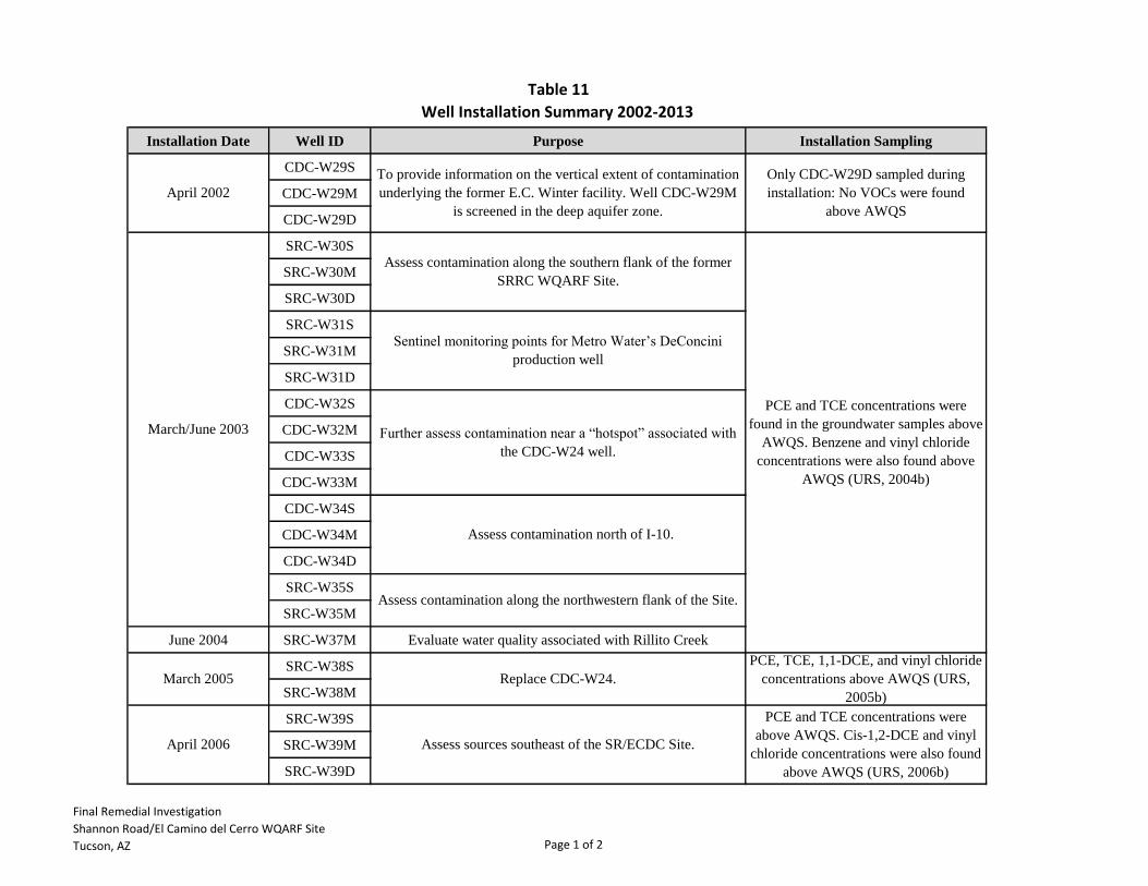
Table 11
Installation Date Well ID Purpose Installation Sampling
CDC-W29S
CDC-W29M
CDC-W29D
SRC-W30S
SRC-W30M
SRC-W30D
SRC-W31S
SRC-W31M
SRC-W31D
CDC-W32S
CDC-W32M
CDC-W33S
CDC-W33M
CDC-W34S
CDC-W34M
CDC-W34D
SRC-W35S
SRC-W35M
June 2004 SRC-W37M Evaluate water quality associated with Rillito Creek
SRC-W38S
SRC-W38M
SRC-W39S
SRC-W39M
SRC-W39D
Only CDC-W29D sampled during
installation: No VOCs were found
above AWQS
To provide information on the vertical extent of contamination
underlying the former E.C. Winter facility. Well CDC-W29M
is screened in the deep aquifer zone.
PCE and TCE concentrations were
found in the groundwater samples above
AWQS. Benzene and vinyl chloride
concentrations were also found above
AWQS (URS, 2004b)
Assess contamination along the southern flank of the former
SRRC WQARF Site.
Assess contamination north of I-10.
Sentinel monitoring points for Metro Water’s DeConcini
production well
Further assess contamination near a “hotspot” associated with
the CDC-W24 well.
Assess contamination along the northwestern flank of the Site.
Replace CDC-W24.March 2005
March/June 2003
April 2002
Well Installation Summary 2002-2013
April 2006
PCE and TCE concentrations were
above AWQS. Cis-1,2-DCE and vinyl
chloride concentrations were also found
above AWQS (URS, 2006b)
Assess sources southeast of the SR/ECDC Site.
PCE, TCE, 1,1-DCE, and vinyl chloride
concentrations above AWQS (URS,
2005b)
Final Remedial Investigation
Shannon Road/El Camino del Cerro WQARF Site
Tucson, AZ Page 1 of 2

Table 11
Installation Date Well ID Purpose Installation Sampling
Well Installation Summary 2002-2013
SRC-W40S
SRC-W40M
SRC-W40D
SRC-W41SDowngradient monitoring point from former E.C. Winter
Facility
SRC-W42S
SRC-W43S
SRC-W44S
SRC-W45S
SRC-W46M Delineate west side of the SR/ECDC plume (middle zone)
SRC-W47S Delineate west side of the SR/ECDC plume (shallow zone)
SRC-W48M Replace CDC-W27 (dry).
SRC-W49M Delineate the northeast side of the plume.
SRC-W50SMonitor contaminant concentrations migrating from the former
Pima County landfill.
SRC-W51S
SRC-W52M
Notes:
VOC = Volatile Organic Compound
AWQS = Aquifer Water Quality Standard
PCE = Tetrachloroethene
TCE = Trichloroethene
1,1-DCE = 1,1-Dichloroethene
Cis-1,2-DCE = Cis-1,2-Dichloroethene
1,1-DCA = 1,1-Dichloroethane
Upgradient monitor points from Wrecksperts and additional
downgradient monitor points from ECDC Landfill.
Provide greather horizontal delineation of the plume.
May 2006
PCE and TCE concentrations were
above AWQS. Cis-1,2-DCE and vinyl
chloride concentrations were also found
above AWQS (URS, 2006b)
March/April 2013
PCE, TCE, 1,1-DCA and vinyl chloride
concentrations above AWQS (URS,
2008b)
PCE, TCE, 1,1-DCA and vinyl chloride
concentrations above AWQS (URS,
2007d)
No VOCs above AWQS
Provide groundwater monitoring points immediately
downgradient of the former Wrecksperts property.
Replace CDC-W22 and assess for sources downgradient of E.C
Winter.
November 2006 -
April 2007
January/February 2008
Final Remedial Investigation
Shannon Road/El Camino del Cerro WQARF Site
Tucson, AZ Page 2 of 2