table of contents city ordinance no. 2012 -101: … 1: part 1 - profile of makati city i table of...
TRANSCRIPT

Volume 1: Part 1 - Profile of Makati City
i
TABLE OF CONTENTS City Ordinance No. 2012-101: An Ordinance Adopting the New Makati Comprehensive Land Use Plan (2013-2023)
List of Figures .................................................................................................... iii List of Tables ....................................................................................................... v
VOLUME 1 PART 1: PROFILE OF MAKATI CITY I. PROFILE OF MAKATI CITY
1.1 HISTORY ............................................................................................................. 2 1.2 HUMAN RESOURCE .............................................................................................. 3
1.2.1 Population Levels and Growth Rates: Metropolitan Context ........................ 3 1.2.2 Population Levels and Growth Trends: Makati City and its
Barangays .................................................................................................... 4 1.2.3 Daytime Population ...................................................................................... 5 1.2.4 Population Distribution and Density ............................................................ 6 1.2.5 Labor Force ................................................................................................ 9
1.3 PHYSICAL FEATURES ......................................................................................... 10
1.3.1 Geographic Location .................................................................................. 10 1.3.2 Territorial Jurisdiction and Barangay Subdivision ....................................... 10
1.4 PHYSICAL AND INFRASTRUCTURE AND OTHER RESOURCES .................................. 14
1.4.1 Transportation Network.............................................................................. 14 1.4.2 Social Services Facilities, Utilities and Amenities ...................................... 22 Health ........................................................................................................ 22 Education, Culture and the Arts ................................................................. 29 Social Welfare ............................................................................................ 40 1.4.3 Protective Services………………………………… ..... ……………………… 54 Police…………………………………………………………………… ............ 58 Jail Management……………………………………………………… ............ 59 Fire Incidence and Prevention ................................................................... 59 Public Safety and Traffic Enforcement ....................................................... 62 Anti-Drug Abuse Operations ...................................................................... 65 Makati Rescue Services ............................................................................ 66 1.4.4 Utilities: Power, Water, Communication Network, Waste
Management ............................................................................................. 65 1.5 THE ECONOMIC STRUCTURE .............................................................................. 76
1.5.1 Number and Type of Business Establishments ......................................... 77 1.5.2 Growth Rate per Type of Establishment……………………………… ......... 77 1.5.3 Share per Type of Establishment……………………………………… ....... . 78 1.5.4 Number of Assessed Business Establishments……………….…… ........... 80 1.5.5 Business Density Ratio .............................................................................. 81
Volume 1: Part 1 - Profile of Makati City
ii
1.5.6 Office and Commercial Centers ................................................................. 82 1.5.7 Employment ……………………………………………………………... ......... 82 1.5.8 Tourism ...................................................................................................... 85
1.6 ENVIRONMENTAL MANAGEMENT ......................................................................... 85 1.6.1. Geology ..................................................................................................... 86 1.6.2. Geologic Hazard ........................................................................................ 88 1.6.3. Solid Waste Management .......................................................................... 97 1.6.4 Water Quality Management ....................................................................... 98 1.6.5. Air Quality Management ............................................................................ 99 1.6.6. Urban Greening ....................................................................................... 101
1.7 PUBLIC FINANCE ............................................................................................. 101
1.7.1. Trends in Income .................................................................................... 102 1.7.2. Trends in the Assessed Value of Real Properties .................................... 106 1.7.3. Trends in Expenditure .............................................................................. 107 1.7.4. Trends in Budget Utilization ..................................................................... 110
1.8 LOCAL INSTITUTIONAL DEVELOPMENT ............................................................... 113
1.8.1. The City Bureaucracy ............................................................................... 113
1.9 EXISTING LAND USE AND LAND USE TRENDS .................................................... 119 1.9.1. Existing Land Use .................................................................................... 119 1.9.2. Land Use Trends ..................................................................................... 120 1.9.3. Land Use Distribution .............................................................................. 121
2.0 COMPARATIVE/COMPETITIVE ADVANTAGES ....................................................... 134 2.1 WEAKNESSES: PRIORITY ISSUES AND CONCERNS .............................................. 135
2.1.1 Land Use Issues and Concerns: .............................................................. 135 2.1.2 Functional Role of the City ....................................................................... 139

Volume 1: Part 1 - Profile of Makati City
iii
List of Figures Figure 1. Population Density Map, 2010 ................................................................... 7
Figure 2. Barangay Cluster Map ............................................................................. 13
Figure 3. Transportation Network Map ................................................................... 15
Figure 4. Metro Manila Rail Network Map .............................................................. 19
Figure 5. Pasig River Ferry Stations ....................................................................... 20
Figure 6. Airport Access Map ................................................................................. 20
Figure 7. Traffic Demand Management (TDM) – One-way Street Network ............ 21
Figure 8. Average Share to Total Number of Establishments by Type,
2006-2011 .............................................................................................. 79
Figure 9. Number of Assessed, New and Renewed Business Establishments ....... 81
Figure 10. Growth Rates, Number of Assessed, Renewal and New Business
Establishments ........................................................................................ 81
Figure 11. Major Tectonic Elements that May Affect Makati City ............................ 87
Figure 12. Regional Geologic Map, Cross Section and Stratigraphy of the
Study Area ............................................................................................. 88
Figure 13. Possible Ground Acceleration in the Project Site Generated by
the Valley Fault Sytem ............................................................................ 89
Figure 14. Trace of the Valley Fault within Makati City ............................................. 90
Figure 15. Liquefaction Hazards Map of Metro Manila ............................................. 91
Figure 16. Landslide and Flood Susceptibility Map .................................................. 92
Figure 17. Map Showing the Distribution of Volcanoes in the Philippines ................ 93
Figure 18. Flood Hazard Map of Metro Manila ......................................................... 94
Figure 19. Makati Watershed ................................................................................... 95
Figure 20. Results of the Flo-2D Simulation for Makati City ..................................... 96
Figure 21. Number of Apprehended Smoke Belchers and Annual TSP Level ........ 100
Figure 22. Total Revenue ....................................................................................... 102
Figure 23. Growth Rates, Total Revenues ............................................................. 103
Figure 24. Revenues by Source ............................................................................. 105
Figure 25. Average Share to Total Revenues by Source ....................................... 105
Figure 26. Total Expenditures................................................................................ 107
Figure 27. Growth Rates, Total Expenditures ........................................................ 108
Volume 1: Part 1 - Profile of Makati City
iv
Figure 28. Expenditures by Service ....................................................................... 109
Figure 29. Average Share to Total Expenditures by Sector ................................... 109
Figure 30. Makati City Government Organizational Chart ..................................... 115
Figure 31. Number of Employees by Status of Employment .................................. 116
Figure 32. Personnel Complement ......................................................................... 118
Figure 33. Number of Employees by Educational Attainment ................................ 119
Figure 34. 1998 Land Use Map .............................................................................. 123
Figure 35. Existing Land Use Map, 2011 ................................................................ 124

Volume 1: Part 1 - Profile of Makati City
v
List of Tables
Table 1. Total Population and Annual Population Growth Rates: NCR and
Cities/Municipalities .................................................................................. 3
Table 2. Total Population and Percentage Share of City/Municipality to NCR ......... 4
Table 3. Intercensal Annual Population Growth Rate ............................................... 5
Table 4. Estimates of Daytime – Population Ratio .................................................... 5
Table 5. Population Distribution and Gross Population Density by
Barangay, 2010 .......................................................................................... 8
Table 6. Working Age Population and Gainful Workers 15 Years Old
and Over by Sex ......................................................................................... 9
Table 7. Gainful Workers 15 Years Old and Over by Sex and Place of Work ........ 10
Table 8. Land Area, by Barangay ........................................................................... 10
Table 9. Barangay Clustering, 2009 ....................................................................... 12
Table 10. Vital Health Statistics ................................................................................ 23
Table 11. Malnutrition Prevalence Rate (Pre-schooler)……………………….. ......... 24
Table 12. Number of Makati Health Plus Beneficiaries…………………………. ........ 25
Table 13. Number of Makati Health Plus/Cards Issued/Claimed per Barangay…….25
Table 14. Makati Public Health Personnel……………………………………….. ....... 27
Table 15. Health and Medical Facilities, 2011 ......................................................... 27
Table 16. Inventory of Public and Private Medical Facilities, 2011 ........................... 28
Table 17. Literacy Rates, City of Makati and NCR………………………………......... 30
Table 18. Household Population 5 Years Old and Over by Highest
Year/Grade/ Completed and Sex……………………………………… ........ 31
Table 19. Public School Enrolment………………………………………………… ....... 32
Table 20. Private School Enrolment………………………………………………. ....... 32
Table 21. Enrolment Statistics, University of Makati ………………….…………........ 32
Table 22. SPED Enrolment Statistics……………………..………………………......... 33
Table 23. Open High School Enrolment Statistics……………………………….. ....... 34
Table 24. Public School Performance Indicators ………………………………. .... … 35
Table 25. Pre-School Indicators ............................................................................... 36
Table 26. Elementary and Secondary Schools Indicators ………………………. ...... 36
Table 27. Classroom-Student Ratio in the Public Secondary Schools ..................... 37

Volume 1: Part 1 - Profile of Makati City
vi
Table 28. Presence and Status of Educational Facilities, Elementary and
Secondary Levels: City of Makati, As of SY 2009-2010 ............................ 38
Table 29. Number of Philhealth Cardholders…………………………………….. ....... 41
Table 30. Number of Day Care Centers and Number of Day Care Service
Beneficiairies…………………………………………………………… .......... 42
Table 31. Location of Day Care Centers……………………………………….… ........ 42
Table 32. Number of Senior Citizens Availing of Benefit Cards……………….. ........ 44
Table 33. Number of BLU CardHolders……………………..……. ............................. 44
Table 34. Informal Settlement Management Program Indicators………………. ....... 47
Table 35. Number and Physical Condition of Social Welfare Facilities by
Type of Facility and Barangay .................................................................. 48
Table 36. Type of Fuel Used for Lighting of Households: NCR and
City of Makati, 2000 .................................................................................. 50
Table 37. Manner of Garbage Disposal of Households: NCR and
City of Makati, 2000 ................................................................................ ..51
Table 38. Main Source of Water Supply for Drinking and/or Cooking
of Households: NCR and City of Makati, 2000 ......................................... 51
Table 39. Occupancy Rate: Makati Homes II .......................................................... 52
Table 40. Resettlement Areas: Makati City, 2010 ..................................................... 53
Table 41. Crime Incidence and Solution Efficiency ………………………….…. ........ 56
Table 42. Crime Prevention Statistics……………………………….…………….. ...... 58
Table 43. Inventory of Police Services Facilities and Equipment.............................. 58
Table 44. Inventory of Jail Facilities and Equipment ................................................. 59
Table 45. Fire Incidence by Barangay ...................................................................... 60
Table 46. Inventory of Fire Protection Facilities and Equipment ............................... 62
Table 47. Type and Number of Traffic Violations Committed ................................... 63
Table 48. Makati Anti Drug Abuse Council (MADAC) Barangay Operations
Statistics ................................................................................................... 65
Table 49. Makati Rescue Services Rendered .......................................................... 66
Table 50. Status of Road Concreting ........................................................................ 67
Table 51. Inventory of Local Bridges ........................................................................ 68
Table 52. Inventory of Bridges, National/DPWH ...................................................... 69
Table 53. List of Flyovers ......................................................................................... 70

Volume 1: Part 1 - Profile of Makati City
vii
Table 54. Inventory of Waiting Sheds ....................................................................... 71
Table 55. Inventory of Overpass and Underpass ..................................................... 73
Table 56. Percentage of Households with Access to Safe Drinking Water .............. 75
Table 57. Number of Establishments by Type .......................................................... 77
Table 58. Growth Rate per Type of Establishment ................................................. 78
Table 59. Share to Total Number of Establishments by Type ................................ 78
Table 60. Average Distribution of Business Establishment by Type of
Activity, 2010 ............................................................................................ 79
Table 61. Number of Business Establishments Assessed (New and Renewed) ...... 80
Table 62. Growth Rates in Number of Business Establishments Assessed ............. 80
Table 63. Business Density Ratio ............................................................................. 82
Table 64. Employment Assistance Programs ........................................................... 83
Table 65. Workers Entrepreneurship (WORKSTREP) Livelihood Program .............. 83
Table 66. Number of Unemployed Persons .............................................................. 84
Table 67. Job Placement Program Employment Assistance Refereed vs.
Hired ......................................................................................................... 84
Table 68. Comparative Volume of Garbage Collection ............................................. 97
Table 69. Number of Apprehended Violators of Solid Waste Management
Code ......................................................................................................... 97
Table 70. Biological Oxygen Demand, Guadalupe Monitoring Station ..................... 98
Table 71. Annual TSP Reading ................................................................................ 99
Table 72. Apprehension of Smoke Belchers ............................................................ 99
Table 73. Summary of Collected Data on PM 10, by Station and Period
Covered .................................................................................................. 100
Table 74. Inventory of Parks ................................................................................... 101
Table 75. Total Income (in Php Millions) ................................................................ 102
Table 76. Revenue by Source (in Php Millions) ...................................................... 104
Table 77. Assessed Value of Real Property Units (RPUs) (in Php Billion) ............. 106
Table 78. Growth Rates in Assessed Value of Real Property Unit (RPU) .............. 106
Table 79. Total Expenditures .................................................................................. 107
Table 80. Expenditures by Sector (in Php Million) .................................................. 108
Volume 1: Part 1 - Profile of Makati City
viii
Table 81. Approved Budget vs. Actual Onligations/Expenditures
(in Php Millions) ...................................................................................... 110
Table 82. Approved Budget vs. Actual Obligations/Expenditures (by sector) ........ 110
Table 83. Budgetary Allocation by Sector .............................................................. 111
Table 84. Budgetary Allocation by Expense Class ................................................. 112
Table 85. Budget Utilization Rate by Expense Class .............................................. 112
Table 86. Budget Utilization Rate by Sector ........................................................... 113
Table 87. Regular Personnel Complement and Employment Status. ..................... 117
Table 88. Land Use Distribution 1998 and 2012 (Square Kilometer). ..................... 120
Table 89. Land Use, by Barangay, 2012 (Square Kilometer) ................................ 126
Table 90. Land Use Shares, per Barangay, 2012 (Land Use %) ............................ 128
Table 91. Land Use Concentration, per Barangay, 2012 (Land Use %) ................. 130
Table 92. Land Use Specialization, per Barangay, 2012 (Land Use %) ................. 132
Volume 1: Part I - Profile of Makati City
1
PROFILE OF MAKATI CITY
VOLUME 1 PART 1

Volume 1: Part I - Profile of Makati City
2
1. PROFILE OF MAKATI CITY
1.1 HISTORY
Pre-Hispanic to Spanish Colonial Period The present Makati City has its roots as a pre-Hispanic settlement in the swamplands near Pasig River led by Lakan Tagkan and his wife Bouan. Don Manuel Lopez de Legaspi, founder of Manila and the first Governor General of the Philippines discovered the area and were told that the river‟s tide is ebbing by the residents - “Makati na, Kumati na.” Legaspi thought this was the response to his query as to what the place is called. The settlement was renamed San Pedro de Makati after its patron saint. A visita1 of Santa Ana de Sapa, Makati was under the jurisdiction of the Franciscan friars from 1600-1700. Two (2) of the earliest Catholic churches - Nuestra Señora de Gracia in Guadalupe and the Church of Saints Peter and Paul- are located in Makati. In 1890, San Pedro de Makati was decreed a public town of Manila. 2 American Commonwealth Period After the Americans took over the control of the island of Luzon from the Spaniards at the turn of the 20th century, San Pedro de Makati was incorporated into the province of Rizal under Commonwealth Act No. 137 in June 11, 1901. In the same year, the Americans established Fort William McKinley as a military reservation. In 1902, the Americans described the town as “a pueblo on the south shore of Pasig River,” known for a “resort for convalescents,” with a population of 3,921. A year later, a town administrator was installed to supervise community affairs. San Pedro de Makati remained a third-class agricultural town wherein the primary means of livelihood came from the cultivation of rice and horse fodder. In 1914, Philippine Legislature Act No. 2390 shortened the name of the town to its present name of Makati. During the birth of commercial aviation before the Second World War, Nielson Airport opened in what is now the Ayala Triangle, the first airport in the country. Post-Second World War to the Present A master-planned mixed-use community was established in the 1950s in Makati. Makati in the 1970s was a financial and commercial center and part of the National Capital Region (Metro Manila). Makati became a City with the enactment of Republic Act No. 7854 and a plebiscite approval in 1995 during the term of former Mayor Jejomar C. Binay and now the Vice President of the country. Makati has been described as a City of three areas: the Central
1 A visita is a settlement on the circuit of a non-resident priest. Source:
http://www.somosprimos.com/spanishterms/spanishterms.htm accessed on 26 August 2012. 2 Excerpts from the History page of the Makati City Government Website. Accessed from
http://www.makati.gov.ph/portal/main/index.jsp?main=13&content=151#top on 26 August 2012.

Volume 1: Part I - Profile of Makati City
3
Business District, the Old Town or Poblacion area, and the Fort Bonifacio area.
1.2 HUMAN RESOURCE
1.2.1 Population Levels and Growth Rates: Metropolitan Context
With a total population of 529,039, Makati ranked ninth in terms of population size among the 16 cities and one (1) municipality of Metro Manila based on the 2010 Census of Population and Housing. With the unprecedented rapid growth of the cities of Taguig and Pasig and steady growth of Parañaque and Caloocan during the 20-year period, the City fell from its fourth rank position in population size in 1990 to its current rank position. (Table 1) Makati posted a sluggish annual growth of 0.39% from 1990 to 2000, but has recovered eventually with an annual growth of 1.16% during the following ten-year period (2000-2010).
Table 1. Total Population and Annual Population Growth Rates: NCR and Cities/Municipalities
Region/City/ Municipality
Total Population Annual Population Growth
Rate (%)
1-May 2010 1-May 2000
1-May 1990
2000- 2010
1990- 2000
1990- 2010
Philippines 92,337,852a 76,506,928
b 60,703,810
c 1.90 2.34 2.12
National Capital Region
11,855,975 9,932,560 7,948,392 1.78 2.25 2.02
Quezon City 2,761,720 2,173,831 1,669,776 2.42 2.67 2.55
City of Manila 1,652,171 1,581,082 1,601,234 0.44 -0.13 0.16
Caloocan City 1,489,040 1,177,604 763,415 2.37 4.43 3.39
City of Pasig 669,773 505,058 397,679 2.86 2.42 2.64
Taguig City 644,473 467,375 266,637 3.26 5.77 4.51
City of Parañaque 588,126 449,811 308,236 2.72 3.85 3.28
City of Valenzuela 575,356 485,433 340,227 1.71 3.62 2.66
City of Las Piñas 552,573 472,780 297,102 1.57 4.75 3.15
City of Makati * 529,039 471,379 453,170 1.16 0.39 0.78
City of Muntinlupa 459,941 379,310 278,411 1.95 3.14 2.54
City of Marikina 424,150 391,170 310,227 0.81 2.34 1.58
Pasay City 392,869 354,908 368,366 1.02 -0.37 0.32
City of Malabon 353,337 338,855 280,027 0.42 1.92 1.17
City of Mandaluyong 328,699 278,474 248,143 1.67 1.16 1.41
City of Navotas 249,131 230,403 187,479 0.78 2.08 1.43
City of San Juan 121,430 117,680 126,854 0.31 -0.75 -0.22
Municipality of Pateros 64,147 57,407 51,409 1.12 1.11 1.11 Source: National Statistics Office, 1990 Census of Population and Housing, 2000 Census of Population and Housing
and 2010 Census of Population and Housing (www.census.gov.ph) * Makati‟s Population includes persons residing in the disputed areas with Taguig (PP Northside and PP
Southside): 51,320 in 2010, 26,512 in 2000. a. Includes 2,739 Filipinos in Philippine embassies, consulates, and missions abroad. b. Includes 2,851 Filipinos in Philippine embassies, consulates, and missions abroad. c. Includes 2,876 homeless population and 2,336 Filipinos in Philippine embassies, consulates, and missions
abroad.

Volume 1: Part I - Profile of Makati City
4
Like the City of Manila and the other seven (7) cities and one (1) municipality, Makati exhibited a decreasing percentage share to the NCR population, from 5.7% in 1990 down to 4.7% in 2000 and 4.5% in 2010. Caloocan City, Quezon City and Taguig City, meanwhile, exhibited the most significant increase in their percentage share to the total population of the metropolis with 3.0, 2.3 and 2.0 percentage points within the same 20-year period, respectively (Table 2).
Table 2. Total Population and Percentage Share of City/Municipality to NCR
Region/City/ Municipality Total Population Percent Share (%)
1990 2000 2010 1990 2000 2010
National Capital Region 7,948,392 9,932,560 11,855,975 100.0 100.0 100.0
Quezon City 1,669,776 2,173,831 2,761,720 21.0 21.9 23.3
City of Manila 1,601,234 1,581,082 1,652,171 20.1 15.9 13.9
Caloocan City 763,415 1,177,604 1,489,040 9.6 11.9 12.6
City of Pasig 397,679 505,058 669,773 5.0 5.1 5.6
Taguig City 266,637 467,375 644,473 3.4 4.7 5.4
City of Parañaque 308,236 449,811 588,126 3.9 4.5 5.0
City of Valenzuela 340,227 485,433 575,356 4.3 4.9 4.9
City of Las Piñas 297,102 472,780 552,573 3.7 4.8 4.7
City of Makati * 453,170 471,379 529,039 5.7 4.7 4.5
City of Muntinlupa 278,411 379,310 459,941 3.5 3.8 3.9
City of Marikina 310,227 391,170 424,150 3.9 3.9 3.6
Pasay City 368,366 354,908 392,869 4.6 3.6 3.3
City of Malabon 280,027 338,855 353,337 3.5 3.4 3.0
City of Mandaluyong 248,143 278,474 328,699 3.1 2.8 2.8
City of Navotas 187,479 230,403 249,131 2.4 2.3 2.1
City of San Juan 126,854 117,680 121,430 1.6 1.2 1.0
Municipality of Pateros 51,409 57,407 64,147 0.6 0.6 0.5 Source: NSO, 1995 Census of Population, 2000 Census of Population and Housing and 2007 Census of Population
(www.census.gov.ph) * Makati‟s Population includes persons residing in the disputed areas with Taguig (PP Northside and PP
Southside): 51,320 in 2010 and 26,512 in 2000.
1.2.2 Population Levels and Growth Trends: Makati City and its Barangays
The first census of population conducted in 1903 recorded a total of only 2,700 inhabitants in Makati. The town‟s population grew fast and steadily at 10.82% annually until the end of year 1918. Population growth rates exhibited a fluctuating but positive trend from then on until 1995. The unprecedented increase in the population experienced during the period 1960-1970 was attributed to massive in-migration of people to Makati as it became the center of business and commercial activities in the country. During the period 1995-2000, however, historical data shows a significant reduction in the City‟s population, and thus a tremendous drop in the growth pattern registering a negative annual growth of 0.57% during the 5-year period. The growth rate picked up during the following 7-year period at 2.12% per annum, but dived again at -1.34% per annum between 2007 and 2010. As of 2010, Makati‟s population
Volume 1: Part I - Profile of Makati City
5
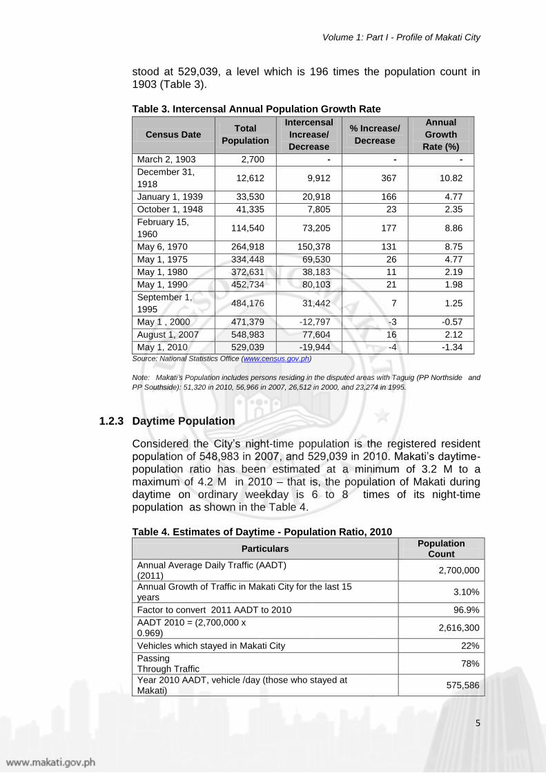
stood at 529,039, a level which is 196 times the population count in 1903 (Table 3).
Table 3. Intercensal Annual Population Growth Rate
Census Date Total
Population
Intercensal
Increase/
Decrease
% Increase/
Decrease
Annual
Growth
Rate (%)
March 2, 1903 2,700 - - -
December 31,
1918 12,612 9,912 367 10.82
January 1, 1939 33,530 20,918 166 4.77
October 1, 1948 41,335 7,805 23 2.35
February 15,
1960 114,540 73,205 177 8.86
May 6, 1970 264,918 150,378 131 8.75
May 1, 1975 334,448 69,530 26 4.77
May 1, 1980 372,631 38,183 11 2.19
May 1, 1990 452,734 80,103 21 1.98
September 1,
1995 484,176 31,442 7 1.25
May 1 , 2000 471,379 -12,797 -3 -0.57
August 1, 2007 548,983 77,604 16 2.12
May 1, 2010 529,039 -19,944 -4 -1.34
Source: National Statistics Office (www.census.gov.ph)
Note: Makati’s Population includes persons residing in the disputed areas with Taguig (PP Northside and
PP Southside): 51,320 in 2010, 56,966 in 2007, 26,512 in 2000, and 23,274 in 1995.
1.2.3 Daytime Population
Considered the City‟s night-time population is the registered resident population of 548,983 in 2007, and 529,039 in 2010. Makati‟s daytime- population ratio has been estimated at a minimum of 3.2 M to a maximum of 4.2 M in 2010 – that is, the population of Makati during daytime on ordinary weekday is 6 to 8 times of its night-time population as shown in the Table 4.
Table 4. Estimates of Daytime - Population Ratio, 2010
Particulars Population
Count
Annual Average Daily Traffic (AADT) (2011)
2,700,000
Annual Growth of Traffic in Makati City for the last 15 years
3.10%
Factor to convert 2011 AADT to 2010 96.9%
AADT 2010 = (2,700,000 x 0.969)
2,616,300
Vehicles which stayed in Makati City 22%
Passing Through Traffic
78%
Year 2010 AADT, vehicle /day (those who stayed at Makati)
575,586

Volume 1: Part I - Profile of Makati City
6
Table 4. Estimates of Daytime - Population Ratio, 2010 (cont…)
Particulars Population Count
Year 2010 AADT, vehicle/day (those who passed thru Makati)
Vehicle composition:
(55% cars; 25% jeepneys; 6%buses; 14% truck or goods‟ vehicles)
2,040,714
Estimated number of daytime populations based on average occupancy rate
3,054,635
Net Population via Rail who will not transfer to jeepneys or buses
21,139
Net Population via Rail who will not take any form of motorized transport
82,324
Total Minimum Daytime Population 3,158,098
Passing Thru Passengers (10% of passing thru passengers)
1,083,007
Total Maximum Daytime Population 4,241,105
Source: Makati City Transportation Study, 2012
1.2.4 Population Distribution and Density
The population and land distribution presented in Figure 1 and Table 5 illustrates the wide disparities in population concentration across the barangays. Aggregately, 42.2% of the City‟s population in 2010 were residing in District I, which accounted for the 61.8% of the City‟s total land area. Meanwhile, the remaining 38.2% of the City‟s total land area (District II) was being occupied by the other 57.8% of its total population. Overall, the average population density of the City was estimated at 19 persons per 1,000 square meters as of 2010. The City, which has most densely populated barangays, or those with more than 70 residents per 1,000 square meters, were Pembo, Rizal, Pitogo and South Cembo, all of them comprising the District II area. The top three most densely populated barangays in the District I area, on the other hand, were Singkamas (57 persons/1,000 sq. m.), Kasilawan (56 persons/1,000 sq. m.) and Tejeros (49 persons/1,000 sq. m.).

Volume 1: Part I - Profile of Makati City
7
Fig
ure
1:
Po
pu
lati
on
De
ns
ity M
ap
, 2
01
0

Volume 1: Part I - Profile of Makati City
8
Table 5. Population Distribution and Gross Population Density by Barangay, 2010
Barangay Population % Share Land Area in
Square Meters % Share
Population Density per 1,000 Square
Meters
District I
Bangkal 23,378 4.40% 875,900 3.20% 27
Bel-Air 18,280 3.50% 1,712,100 6.30% 11
Carmona 3,096 0.60% 352,900 1.30% 9
Dasmariñas 5,654 1.10% 1,903,300 7.00% 3
Forbes Park 2,533 0.50% 2,500,000 9.10% 1
Kasilawan 5,291 1.00% 94,600 0.30% 56
La Paz 7,931 1.50% 247,800 0.90% 32
Magallanes 5,576 1.10% 1,199,500 4.40% 5
Olympia 21,270 4.00% 456,500 1.70% 47
Palanan 17,283 3.30% 649,900 2.40% 27
Pio del Pilar 27,035 5.10% 880,900 3.20% 31
Poblacion 17,120 3.20% 1,034,200 3.80% 17
San Antonio 11,443 2.20% 895,800 3.30% 13
San Isidro 7,589 1.40% 482,900 1.80% 16
San Lorenzo 10,006 1.90% 1,734,100 6.30% 6
Singkamas 7,426 1.40% 129,300 0.50% 57
Sta. Cruz 7,440 1.40% 473,000 1.70% 16
Tejeros 13,868 2.60% 283,200 1.00% 49
Urdaneta 3,717 0.70% 739,900 2.70% 5
Valenzuela 7,261 1.40% 251,400 0.90% 29
Sub Total 223,197 42.20% 16,897,200 61.80% 13
District 2
Cembo 27,998 5.30% 426,700 1.60% 66
Comembo 14,433 2.70% 309,000 1.10% 47
East Rembo 26,433 5.00% 481,100 1.80% 55
Guadalupe Nuevo 18,271 3.50% 570,400 2.10% 32
Guadalupe Viejo 16,411 3.10% 540,400 2.00% 30
Pembo 44,803 8.50% 639,800 2.30% 70
Rizal 41,959 7.90% 594,700 2.20% 71
Pinagkaisahan 5,804 1.10% 160,300 0.60% 36
Pitogo 15,332 2.90% 195,500 0.70% 78
Post Proper Northside*
6,010 1.10% 2,376,000 8.70% 3
Post Proper Southside*
45,310 8.60% 3,412,000 12.50% 13
* Disputed Barangays

Volume 1: Part I - Profile of Makati City
9
Table 5. Population Distribution and Gross Population Density by Barangay, 2010
(cont…)
Barangay Population % Share Land Area in
Square Meters % Share
Population Density per 1,000 Square
Meters
South Cembo 14,672 2.80% 200,000 0.70% 73
West Rembo 28,406 5.40% 552,500 2.00% 51
Sub Total 305,842 57.80% 10,458,500 38.20% 29
Grand Total 529,039 100.00% 27,355,700** 100.00% 19
Source: NSO, 2010 Census of Population and Housing (www.census.gov.ph); Makati Urban Development Department for Land Area
* Disputed Barangays with Taguig. ** Including the Military Reservation (4,402,700 square meters)
1.2.5 Labor Force
On the whole, 60% of Makati‟s working age population (15-64 years old) in 2007 was engaged in gainful occupation. A person is considered a gainful worker or usually working most of the time if he/she worked for at least ten hours a week for six (6) months or longer during the last twelve months preceding the interview (NSO, NSCB definition). He/she may be working for pay; for profit in his/her own farm, business, private practice of a profession or trade; or without pay on his/her own family farm or business . A bigger proportion of the male population in the working age bracket was engaged in gainful occupation compared to their female counterpart in 2007 – that is, 70% versus 51% (Table 6).
Table 6. Working-Age Population and Gainful Workers 15 Years Old and
Over, by Sex Both Sexes Male Female
Population 15-64 Years Old 378,720 173,132 205,588
Gainful Workers 15 Years Old and Over 227,068 121,777 105,291
Percent of Gainful Workers to Working-Age Population
60.0% 70.3% 51.2%
Source: NSO, 2007 Census of Population (Special tabulation requested from NSO)
Majority, or 69% of Makati‟s 2007 total population engaged in gainful occupation are working within the City in 2007. Almost a quarter of the City‟s working population was working in other cities/municipalities of NCR and nearby provinces of Southern Tagalog and Central Luzon regions. More males (33%) than females (24%) were likely to work outside their city of residence as shown by the data (Table 7).

Volume 1: Part I - Profile of Makati City
10
Table 7. Gainful Workers 15 Years Old and Over by Sex and Place of Work
Place of Work Both Sexes Male Female
Number % Number % Number %
Gainful Workers 15 Years Old and Over
227,068 100.0 121,777 100.0 105,291 100.0
Same City 155,993 68.7 79,208 65.0 76,785 72.9
Other City/Municipality within NCR
17,913 7.9 11,024 9.1 6,889 6.5
Other City/Municipality outside NCR
34,826 15.3 20,800 17.1 14,026 13.3
Foreign Country 12,337 5.4 8,101 6.7 4,236 4.0
Unknown 5,999 2.6 2,644 2.2 3,355 3.2 Source: NSO, 2007 Census of Population (Special tabulation requested from NSO)
1.3 PHYSICAL FEATURES
1.3.1 Geographic Location
Makati is located at the center of the National Capital Region (NCR) and is bounded by Pasig River on the north, the municipality of Pateros on the east, the City of Taguig on the southeast, the City of Pasay on the south and southwest and the City of Manila on the northwest.
1.3.2 Territorial Jurisdiction and Barangay Subdivision
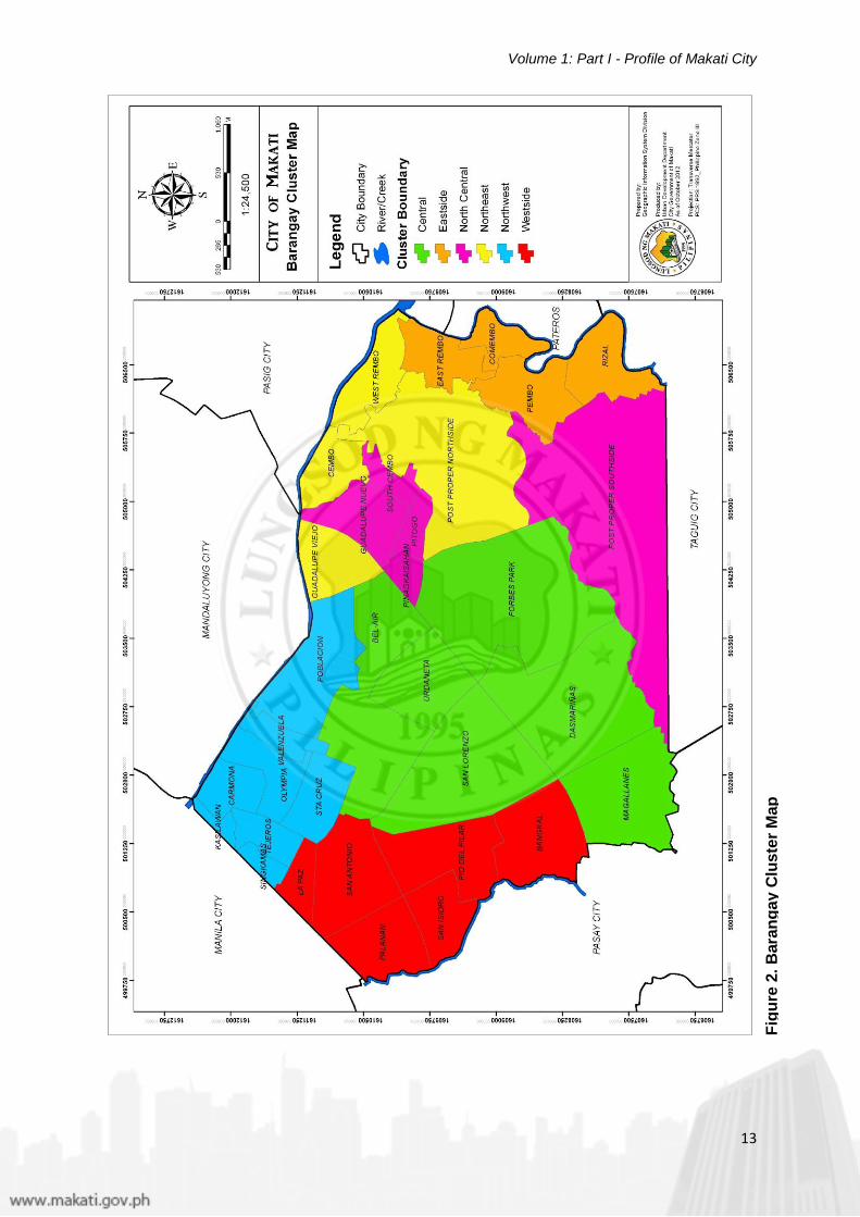
The total land area of Makati is 27,355,700 square meters which accounts for 4.3% of Metro Manila‟s total land area. The City is composed of 33 barangays, which are distributed between two (2) legislative districts. Figure 2 shows the barangay cluster map of the City.
Table 8. Land Area by Barangay
Barangay Land Area in Square
Meters % Share
District I
Bangkal 875,900 3.2%
Bel-Air 1,712,100 6.3%
Carmona 352,900 1.3%
Dasmariñas 1,903,300 7.0%
Forbes Park 2,500,000 9.1%
Kasilawan 94,600 0.3%
La Paz 247,800 0.9%
Magallanes 1,199,500 4.4%
Olympia 456,500 1.7%
Palanan 649,900 2.4%
Pio del Pilar 880,900 3.2%
Poblacion 1,034,200 3.8%
San Antonio 895,800 3.3%

Volume 1: Part I - Profile of Makati City
11
Table 8. Land Area by Barangay (cont…)
Barangay Land Area in Square
Meters % Share
San Isidro 482,900 1.8%
San Lorenzo 1,734,100 6.3%
Singkamas 129,300 0.5%
Sta. Cruz 473,000 1.7%
Tejeros 283,200 1.0%
Urdaneta 739,900 2.7%
Valenzuela 251,400 0.9%
Sub Total 16,897,200 61.8%
District II
Cembo 426,700 1.6%
Comembo 309,000 1.1%
East Rembo 481,100 1.8%
Guadalupe Nuevo 570,400 2.1%
Guadalupe Viejo 540,400 2.0%
Pembo 639,800 2.3%
Rizal 594,700 2.2%
Pinagkaisahan 160,300 0.6%
Pitogo 195,500 0.7%
Post Proper Northside 2,376,000 8.7%
Post Propose Southside 3,412,000 12.5%
South Cembo 200,000 0.7%
West Rembo 552,500 2.0%
Sub Total 10,458,500 38.2%
Grand Total 27,355,700 100%
Source: Urban Development Department, City Government of Makati, 2012
The City is widely known for its commercial areas that support its recognized role as the Philippine‟s financial and business center. It should be noted, however, that land devoted to commercial use comprises only about 14.82% of the City‟s total land area. At the core of the City is the Central Business District, which hosts the headquarters of the biggest banks and corporations in the Philippines. Makati adapted the six (6)-cluster grouping of its barangays. The grouping of barangays that have common geo-physical and socio-economic characteristics has resulted to high impact programs/projects addressing common problems/concerns using pooled resources. This grouping is used in the conduct of the City‟s annual Program Review and Planning Workshop (PRPW).

Volume 1: Part I - Profile of Makati City
12
Table 9. Barangay Clustering, 2009
Cluster I
(Central)
Cluster II
(Westside)
Cluster III
(Northwest)
Cluster IV
(North Central)
Cluster V
(Eastside)
Cluster VI
(Northwest)
Bel-Air Bangkal Poblacion Guadalupe Nuevo Comembo Cembo
Dasmariñas La Paz Valenzuela South Cembo East Rembo Guadalupe
Viejo
Forbes Park Palanan Sta. Cruz P.P. Southside Pembo P.P. Northside
Magallanes Pio Del Pilar Olympia Pitogo Rizal West Rembo
San Lorenzo San Antonio Tejeros Pinagkaisahan
Urdaneta San Isidro Kasilawan
Singkamas Carmona Sources: Urban Development Department, City Government of Makati and Liga ng mga Barangay, 2012
Volume 1: Part I - Profile of Makati City
13
Fig
ure
2.
Bara
ng
ay C
lus
ter
Ma
p

Volume 1: Part I - Profile of Makati City
14
1.4 PHYSICAL AND INFRASTRUCTURE RESOURCES
1.4.1 Transportation Network
Makati is a major traffic generator for the greater Metropolitan Manila Area because it is the primary Central Business District of the country. The City attracts a large amount of vehicle traffic due to its relatively large resident population and its predominantly service-oriented economy. Thus, the City regulates the in-bound and out-bound traffic during the morning and afternoon peak hours respectively. Mobility and accessibility, is one (1) of Makati‟s most important requirements. However, continuing population growth, economic development, and corresponding increases in vehicular trips that are internally generated or passing through the City have constrained regional accessibility and local circulation. It is, therefore, a great concern that any further development in the City must be sustainable in terms of its traffic-carrying capacity, or programs are identified to mitigate potential severe congestion.
Road Network System The City‟s road network is part of a system of circumferential and radial roads of Metro Manila (Figure 3). Traffic congestion within Makati is compounded by the fact that major expressways exist in north and south of Metro Manila but they are not interconnected. As a result, north and south through traffic is fed to major roads that are at the same time the major gateways to Makati. These gateways are Roxas Boulevard, Osmeña Highway, EDSA, and C5. Among these roads, EDSA is the busiest with 170,000 vehicles per day along the stretch from Guadalupe Bridge to Sen. Gil Puyat Avenue. Next is C5 with 136,000 vehicles per day within the vicinity of Kalayaan Avenue and Fort Bonifacio. Osmeña Highway has 115,000 vehicles per day within the Don Bosco area, while Roxas Boulevard has 75,000 vehicles per day within the segment south of Sen. Gil Puyat Avenue. Several projects were in place to improve gateways capacity to Makati City. These include the EDSA interchanges (Sen. Gil Puyat-EDSA northbound interchange, Ayala Avenue-EDSA northbound interchange, and, EDSA-Ayala-Pasay Road Interchange) and the Metro Manila Skyway (Don Bosco slip ramps, Pasay Road-Amorsolo ramps, and Sen. Gil Puyat Ave Ramps).
Feeder roads to the City are J.P. Rizal Avenue, Kalayaan Avenue, Sen. Gil Puyat Avenue, Ayala Avenue, and Chino Roces Avenue. The roads combined with 435 kilometers of Makati roads (distributed among its 1,151 streets) provide travel space for both Makati and external traffic.

Volume 1: Part I - Profile of Makati City
15
Fig
ure
3.
Tra
nsp
ort
ati
on
Netw
ork
Ma
p

Volume 1: Part I - Profile of Makati City
16
Traffic Volume and Demand Based on 2011 estimates, Makati generates 594,872 vehicle trips daily equivalent to about 13% of the 4.5 million Metro Manila vehicle trips. The major destinations of Makati City internal traffic reckoned from Barangay Poblacion are the Makati CBD and clusters of Barangays in Northwest and Northeast. Eleven percent of internal traffic crosses Epifanio Delos Santos Avenue (EDSA) making this a major traffic issue considering that EDSA is a 10-lane highway with commuter rail line at the center. For regional distribution of external traffic, 62% is northbound (including City of Manila), 25% is southbound (including Pasay City), and 13% is eastbound (Taguig, Pateros, Marikina, and eastern province of Rizal)
In terms of vehicle composition, of the total traffic generated by the City, 55% is car; 25% jeepneys; 6% buses; and, 14% trucks or goods vehicles. Jeepneys and buses are transit vehicles and they have fixed routes. Car travel is being managed through Number Coding scheme. This works in a manner where vehicles with plate numbers end in one (1) or two (2) are barred from city streets from seven (7) in the morning to seven (7) in the evening on Mondays, Three (3) and four (4) on Tuesdays, and so on. Truck traffic is also managed by way of truck ban. On major roads, truck ban extends from seven (7) to ten (10) in the morning and four (4) to seven (7) in the evening. Transit Network
The transit systems in the City are road-based (jeepneys and buses) and rail-based (rail). For road-based transit, jeepneys are taken mainly for local circulation while buses, with the exception of Fort Bus, are regional in scope and service. Rail-based transit lines that serve Makati are all part of the regional system. This includes the LRT 1, MRT 3, and the PNR. (Figure 4) Rail Transit The Philippine National Railways (PNR), is a railway company owned by the Philippine Government that operates a commuter line service in Metro Manila and another line to the Bicol Region. PNR restored its daily Manila-Naga intercity commuter service to the Bicol Region, called the Bicol Express, in 2011. The PNR stations that service the City are located along Osmeña Highway with stations at Sen. Gil Puyat Avenue, Pasay Road, EDSA, and Nichols. In 2010, PNR carries 8,000 passengers daily through its commuter line service.

Volume 1: Part I - Profile of Makati City
17
Light Rail Transit Line 1 (LRT1) originally operates from Taft Avenue to Monumento with 18 stations. In October 2010, its north extension project began commercial operations up to Roosevelt with two (2) additional stations. Soon, LRT 1 will connect with the EDSA MRT 3 at North Avenue. In 2011, LRT 1 has an average total daily passenger boarding of 435,121 with an average fare of 14 pesos. The Sen. Gil Puyat Station of LRT 1 directly serves Makati commuters. In 2011, this station served about 6,000 commuters for one (1) peak hour. Mass Rail Transit 3 (MRT 3) is also known as EDSA MRT because it runs almost the entire stretch of EDSA. This is thus far the most important rail system that serves Makati since four of its stations are located inside the City. With estimated peak-hour passenger volume in 2011, these stations include Guadalupe (5,463 passengers); Sen. Gil Puyat (3,499 passengers); Ayala (6,247 passengers) and, Magallanes (5,130 passengers). For its entire alignment, MRT 3 has 13 stations and the average daily passenger boarding is about 427,000 in 2011. Majority of MRT 3 commuters are mostly employees. Light Rail Transit 2 (or LRT 2) has no direct impact on Makati Commuters except that it links with MRT 3 at Cubao Station and LR1 at Bambang Station (Recto). LRT 2 runs east-west direction, with eleven stations. LRT 2 is under capacity with only 177,000 average daily passengers boarding. According to surveys, LRT 2 commuters are majority students. Water Transport The water-based transportation that used to serve commuters through Pasig River is the Pasig River Ferry Service. The Pasig River Ferry Service has fourteen stations with two (2) stations located in Makati – the Valenzuela Station in Barangay Valenzuela and the Guadalupe Station in Barangay Guadalupe Nuevo. When it was still operational under SCC Nautical Transport Services Inc. (NTSI), its route was from Barangay Pinagbuhatan in Pasig City to Intramuros in Manila and vice versa. The boats have maximum capacity of 150 passengers, but the actual demand is much lower with only less than 2,000 passengers per day. During its run from 2007 to 2011, the boats ran at an average of 19 kilometers per hour (10 knots). (Figure 5). Other than the Pasig River Ferry System, informal boat system exists called “Tawiran” using a traditional boat to cross the Pasig River going to and from the adjacent City of Mandaluyong.

Volume 1: Part I - Profile of Makati City
18
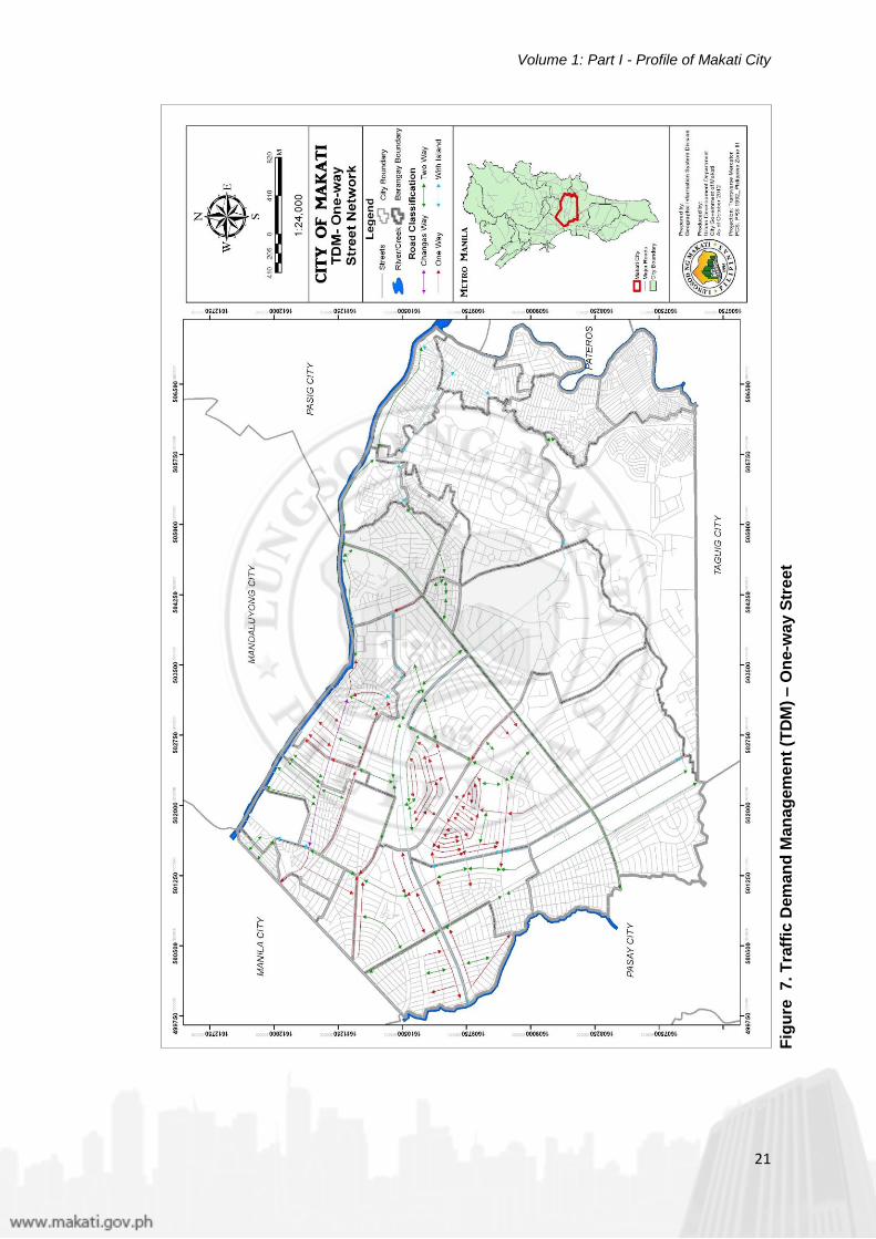
Air Transport Makati is very accessible to the commercial airports of Metro Manila. The usual route of EDSA-Tramo to the airport terminal is only about six (6) kilometers. Accessibility of Makati City to the airport was further enhanced with the opening of the NAIA Expressway Phase 1 (Figure 6). This is basically a set of ramps from of Skyway to Sales Avenue fronting NAIA Terminal 3. Helicopter service from most of the city‟s hotels is also available as chartered service while top companies have their private helicopters for limited services. Traffic Demand Management (TDM) Traffic demand management measures in Makati are aimed at providing rational traffic operations by increasing mobility. The TDMs are in the form of one-way street system and signalization. To encourage walking, the Central Business District of Makati also embarked on the construction of a pedestrian walkways network consisting of elevated, at-grade pedestrian-protected walkways (Figure 7).

Volume 1: Part I - Profile of Makati City
19
Figure 4. Metro Manila Rail Network Map

Volume 1: Part I - Profile of Makati City
20
Figure 5. Pasig River Ferry Stations
Figure 6. Airport Access Map
Volume 1: Part I - Profile of Makati City
21
Fig
ure
7
. T
raff
ic D
em
an
d M
an
ag
em
en
t (T
DM
) – O
ne-w
ay S
tre
et
Ne
two
rk

Volume 1: Part I - Profile of Makati City
22
1.4.2 Social Services Facilities, Utilities and Amenities
Health The good health status of the Makati can be attributed to its comprehensive health packages from womb to tomb which belongs to the City‟s top priorities every year. For 2011, Makati allocated Php1.491B or 18.1% of the total expenditures. The effort of the City in making Makati a healthy city to live and work has gained recognition not only in the country but also abroad. Indeed, the Makati Health Program (MHP), one of breakthroughs on the City‟s health development which was emulated by other local government units, has received its first international recognition from Dubai International Award for Best Practices to Improve the Living Environment. The remarkable improvement of the City health statistics, as shown by the different health indicators, is due to its regular preventive and curative program done by different departments/offices. Each office works hand in hand to achieve the City Health sectoral mission that is to “maintain the Makati citizenry in an optimum state of wellness thru a health care system that is client-sensitive and financially sustainable that leverages and networks with private sector and other public agencies.” Dedicated to optimizing the health and well-being of its residents, the City continuously maintains a comprehensive health care program through its wide network of health facilities and personnel, as well as a health financing scheme that provides solutions to the perennial health issues related to access, quality, and cost of healthcare. A wide array of health programs and services are being provided by the City‟s four (4) departments: Makati Health Department, Ospital ng Makati, Makati Veterinary Services Office, and Makati Health Program Office. Vital Health Indicators Makati‟s Crude Birth Rate (CBR) has been on a decreasing trend over the last six (6) years. Gradual decrease in CBR has been noted from 2006 to 2007 and from 2008 to 2011. But between 2007 and 2008, decline was quite sharp at 31.2 to 22.33 per 1000 population. This declining trend can probably be due to increased contraceptive prevalence rate, from 27.0% in 2007 to 32.5% in 2009. Crude Death Rate displayed a fluctuating trend over the last five years. From 2006 and 2007, a slight increase was noted from 6.5 to 6.8 per 1000 population. However, it went down to 5.0 per 1000 population in 2008, but slightly went up to 5.3 and 5.5 per 1000 population in 2009 and 2010, respectively. In 2011, as compared with the figure in 2010, the rate decreased by only 0.14 point.

Volume 1: Part I - Profile of Makati City
23
Maternal Mortality Rate was on a downward trend from 0.32 in 2007 to 0.27 per 1000 live births in 2009. The decline was due to the early detection of complication of pregnancy, accessible back up hospital, and prompt and efficient system for risk cases. However, an increase was noted in 2011 at 1.1 per 1000 live births. A generally increasing trend was observed in the City‟s Infant Mortality Rate from 2006-2011. Data from 2006 to 2008 showed an increasing trend from 7.7 to 10.8 per 1000 live births. It slightly declined to 10.6 per 1000 live births in 2009 but moved up to 11.3 per 1000 live births in 2010 and to 11.7 in 2011. The increasing trend in Infant Mortality Rate in 2008 was due mainly to the upsurge of sepsis cases in Ospital ng Makati. Corrective measures, however, have been undertaken including intensification of breastfeeding advocacy and implementation of infection prevention and control measures. Nevertheless, Infant and Under-five Mortality Rates of Makati are lower compared to the 2006 national averages of 24 and 32 per 1000 live births. The Maternal Mortality Rate of Makati at 0.39 per 1000 live births was likewise lower than the 2006 national rate of 138 per 100,000 live births (or 1.38 per 1000 live births). Even then, such rate in maternal deaths should be addressed and further reduced given the existing modern facilities and services of the City. Malnutrition Prevalence Rate showed a decreasing trend over the 5-year period, thus, an indication of success in providing the residents the right approach and strategies in combating malnutrition among pre-schoolers.
Table 10. Vital Health Statistics Indicators 2006 2007 2008 2009 2010 2011
Crude Birth Rate (per 1000 population)
29.24 31.2 22.33 21.30 19.63 18.0
Crude Death Rate (per 1000 population)
6.53 6.8 5.04 5.31 5.47 5.33
Child Mortality Rate (per 1000 live births)
9.72 10.44 13.60 12.83 14.36 15.2
Infant Mortality Rate (per 1000 live births)
7.74 8.22 10.85 10.63 11.31 11.7
Maternal Mortality Rate (per 1000 live births)
0.26 0.32 0.25 0.27 0.39 1.1
Malnutrition Prevalence Rate (%)
1.2 1.19 0.97 0.79 0.80 0.68
Source: Makati Health Department
Nutrition Table 11 shows the malnutrition prevalence rate of the City among children ages 0-6 years old. Data shows that a very satisfactory nutritional status among pre-schoolers in Makati. The figures in the table below reveal that pre-school aged children whose weight is within the normal range comprised 93.2% to 97.2% during the 6-year period. No wonder Makati is one of the cities with the lowest malnutrition

Volume 1: Part I - Profile of Makati City
24
prevalence and has been consistently cited as one of the healthiest cities in the country. Furthermore, the percentage of overweight and underweight children was very low compared to the national figure, and such rate seemed to continuously decrease. Data further reveals that there were more overweight than underweight children. Efforts to reduce the number of overweight children should be done through monitoring, counseling, information and education campaign on the identified overweight children. Activities conducted to improve the nutritional status of children included monthly monitoring of identified underweight and overweight pre-schoolers, micronutrient supplementation, food assistance, cooking demonstration, promotion and utilization of iodized salt and fortified foods, home and community food production, income generating projects and nutrition education. These interventions helped reduce the City‟s malnutrition prevalence. This current trend in nutritional status showed that the efforts of the City on the implementation of nutrition programs in coordination with all its barangays and the entire social development sector have remarkable effects in reducing malnutrition prevalence among pre-schoolers.
Table 11. Malnutrition Prevalence Rate (Pre-schooler)
Nutritional
Status
2006 2007 2008 2009 2010 2011
No. % No. % No. % No. % No. % No. %
Below
Normal-Very
Low
54 0.1 55 0.1 57 0.1 41 0.1 89 0.2 78 0.1
Below
Normal-Low
682 1.1 621 1.1 486 0.9 435 0.7 388 0.7 362 0.6
Normal 58,333 95.0 54,381 95.6 52,405 93.3 57,847 95.7 57,997 97.1 62,520 97.2
Above
Normal/
Over-weight
2,343 3.8 1,820 3.2 3,234 5.76 2,114 3.5 1,238 2.1 1,357 2.1
Total 61,412 56,877 56,182 60,437 59,712 64,317
Source: Makati Health Department
Makati Health Plus (MHP) Program
The City has several programs and projects intended for the residents. The focus is not only towards development of the City but also the improvement of the welfare of residents and people who primarily render services for the development of Makati. One of the programs of the City is the Makati Health Plus Program whereby residents are given color-coded cards that give them discounts on hospital bills and consultation fees. Availing of this program reduces the patients‟ burden of paying their hospital bills. The Makati Health Program Office is the overall in-charge of the program operations.

Volume 1: Part I - Profile of Makati City
25
As of 2011, the City has a total of 211,118 program beneficiaries. Of this total, more members are registered as MHP 1 or with yellow card, which entitles beneficiaries to 100% discount for bills amounting P5,000 or less, or pay only P200 for bills above to P5,000. The City Government Employees are automatically entitled to yellow cards. Low-income households and individuals including senior citizens belong to MHP 1 or yellow card bearers. The MHP guidelines, however, on patient entitlements on MHP need to be reviewed and revised accordingly.
Table 12. Number of Makati Health Plus Beneficiaries
Category MHP I-
Yellow
MHP II-
Blue
MHP III-
Green
MHP IV-
Red Total
District I 55,235 21,459 13,497 3,885 94,076
District II 66,406 21,495 17,349 2,255 107,505
MCG-Non
Makati
Residents
9,537 - - - 9,537
Total 131,178 42,954 30,846 6,140 211,118
Source: Makati Health Program Office, 2011
The cumulative sum of the MHPlus cardholders showed that barangays Olympia, Pio del Pilar, and Bangkal are the top 3 barangays in District I with the highest number of MHPlus card beneficiaries. In District II, on the other hand, barangays Rizal, Pembo, and West Rembo registered the highest number of beneficiaries.
Table 13: Number of Makati Health Plus/Cards Issued/Claimed Per Barangay
Barangay MHP I MHP II MHP III MHP IV TOTAL
District I
Bangkal 6,984 1,352 1,298 115 9,749
Bel-Air 662 166 324 4 1,156
Carmona 1,310 296 192 83 1,881
Dasmariñas 421 201 276 6 904
Forbes Park 527 105 242 1 875
Kasilawan 2,475 440 467 112 3,494
La Paz 2,166 519 531 79 3,295
Magallanes 549 111 240 2 902
Olympia 6,603 4,082 1,696 810 13,191
Palanan 3,534 2,127 1,037 480 7,178
Pio del Pilar 6,434 3,331 1,527 648 11,940
Poblacion 3,763 2,874 1,393 588 8,618
San Antonio 2,467 1,528 720 413 5,128
San Isidro 1,822 1,080 565 214 3,681
San Lorenzo 765 250 272 88 1,375
Singkamas 2,467 454 367 47 3,335
Sta. Cruz 3,253 608 645 35 4,541

Volume 1: Part I - Profile of Makati City
26
Table 13: Number of Makati Health Plus/Cards Issued/Claimed Per Barangay
(cont…)
Barangay MHP I MHP II MHP III MHP IV TOTAL
Tejeros 6,008 1,389 1,024 98 8,519
Urdaneta 395 124 204 6 729
Valenzuela 2,630 422 477 56 3,585
Sub-Total 55,235 21,459 13,497 3,885 94,076
District II
Cembo 6,538 2,492 1,822 257 11,109
Comembo 4,151 1,136 958 396 6,641
East Rembo 5,630 2,041 1,454 163 9,288
Guadalupe
Nuevo
6,879 1,536 1,519 120 10,054
Guadalupe
Viejo
4,158 834 941 63 5,996
Pembo 8,103 3,394 2,589 315 14,401
Pinagkaisahan 1,379 1,029 372 160 2,940
Pitogo 4,039 861 699 86 5,685
Post Proper
Northside
694 78 91 3 866
Post Proper
Southside
2,997 1,160 1,090 67 5,314
Rizal 10,653 3,762 3,201 365 17,981
South Cembo 3,487 1,038 887 105 5,517
West Rembo 7,698 2,134 1,726 155 11,713
Sub-Total 66,406 21,495 17,349 2,255 107,505
City
Government
Employees
9,537 - - - 9,537
Grand total 131,178 42,954 30,846 6,140 211,118
Source: Makati Health Program, 2011
Veterinary Services Rabies prevention and control, stray animal operations and the quality control of meat, poultry and fish products are some of the major activities handled by the Veterinary Services Office. Makati has a dog impounding facility for strays and its Responsible Pet Ownership program may have contributed to the decrease in number of impounded stray dogs. Meanwhile, of the total 19,252 dog population in 2011, only about half were registered and immunized. Coverage of dog immunization reached 94% of total registered dogs. As a result, no death due to rabies exposure was reported within the period from 2007 to 2011, except for 2 cases in 2009.
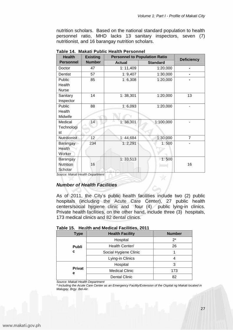
Public Health Personnel Table 14 shows the health manpower of the Makati Health Department (MHD). In 2011, MHD had a total of 567 health personnel, composed of physicians, dentists, nurses, midwives, sanitary inspectors, medical technologist, nutritionist, barangay health workers and barangay
Volume 1: Part I - Profile of Makati City
27
nutrition scholars. Based on the national standard population to health personnel ratio, MHD lacks 13 sanitary inspectors, seven (7) nutritionist, and 16 barangay nutrition scholars.
Table 14. Makati Public Health Personnel
Health
Personnel
Existing
Number
Personnel to Population Ratio Deficiency
Actual Standard
Doctor 47 1: 11,409 1:20,000 -
Dentist 57 1: 9,407 1:30,000 -
Public
Health
Nurse
85 1: 6,308 1:20,000 -
Sanitary
Inspector
14 1: 38,301 1:20,000 13
Public
Health
Midwife
88 1: 6,093 1:20,000 -
Medical
Technologi
st
14 1: 38,301 1:100,000 -
Nutritionist 12 1: 44,684 1:30,000 7
Barangay
Health
Worker
234 1: 2,291 1: 500 -
Barangay
Nutrition
Scholar
16
1: 33,513 1: 500
16
Source: Makati Health Department
Number of Health Facilities As of 2011, the City‟s public health facilities include two (2) public hospitals (including the Acute Care Center), 27 public health centers/social hygiene clinic and four (4) public lying-in clinics. Private health facilities, on the other hand, include three (3) hospitals, 173 medical clinics and 82 dental clinics.
Table 15. Health and Medical Facilities, 2011
Type Health Facility Number
Public
Hospital 2*
Health Center/ 26
Social Hygiene Clinic 1
Lying-in Clinics 4
Private
Hospital 3
Medical Clinic 173
Dental Clinic 82
Source: Makati Health Department * Including the Acute Care Center as an Emergency Facility/Extension of the Ospital ng Makati located in Malugay, Brgy. Bel-Air.
Volume 1: Part I - Profile of Makati City
28
Table 16 shows the type, bed capacity and location of the existing medical facilities in the City, as well as their current conditions. Overall, the public facilities have a total of 232 beds, while the privately owned facilities have 711 beds.
Table 16. Inventory of Public and Private Medical Facilities, 2011
Facility Type # of
Beds Location of Facility
(Barangay)
Public
Hospital & Lying-In Centers
1. Ospital ng Makati - OSMAK Acute Care Center
Tertiary Emergency Hospital
206 22
Sampaguita St., Pembo Malugay St, Bel-Air
2. Bangkal Lying-In Clinic 1 P.Binay St., Bangkal
3. Comembo Lying-In Clinic
1 Anahaw St., Comembo
4. East Rembo Lying-In Clinic
1 23
rd Avenue, East
Rembo
5. Guadalupe Nuevo Lying In Clinic
1 La Consolacion St, Guadalupe Nuevo
Total 232
Public
Health Centers
6. Carmona Health Center
1. A.P. Reyes Avenue 2. H. Santos St., Carmona
7. Kasilawan Health Center E. Pascua St, Kasilawan
8. Singkamas Health Center F. Nazario St., Singkamas
9. Sta. Cruz Health Center Yague St., Sta. Cruz
10. La Paz Health Center Archimedes St, La Paz
11. Tejeros Health Center H. Santos St, Tejeros
12. San Antonio Health Center
Mayapis St., Brgy. San Antonio
13. Olympia Health Center Fortuna St, Barangay Olympia
14. Pio del Pilar Health Center
Apolinario Cor Arguelles, Pio del Pilar
15.Poblacion Health Center A. Bonifacio St., Poblacion
16.Valenzuela Health Center Hormiga St., Valenzuela
17.San Isidro Health Center Marconi St, San Isidro
18. Bangkal Health Center P. Binay, Bangkal
19. Palanan Health Center Casino St., Palanan

Volume 1: Part I - Profile of Makati City
29
Table 16. Inventory of Public and Private Medical Facilities, 2011 (cont…)
Facility Type # of
Beds Location of
Facility (Barangay)
20.Guadalupe Viejo Health Center
Gumamela St., Guadalupe Viejo
21.Guadalupe Nuevo Health Center
La Consolacion St, Guadalupe Nuevo
22.Pinagkaisahan Health Center
Danlig cor Tolentino St., Pinagkaisahan
23.Pitogo Health Center Cebu St cor Luzon, Pitogo
24.Cembo Health Center Banaba St., Cembo
25.West Rembo Health Center
J.P Rizal Extension
26.East Rembo Health Center
23
rd Avenue, East
Rembo
27.Pembo Health Center Santan St., Pembo
28.Comembo Health Center Anahaw St., Comembo
29.Rizal Health Center Amarillo St, Rizal
30.South Cembo Health Center
Gen. del Pilar St, South Cembo
31.Social Hygiene Clinic New Makati City Hall, Poblacion
Private
1. Makati Medical Center Tertiary 616 San Lorenzo
2. Ma. Lourdes Hospital Secondary 20 Pasong Tamo
3. St. Claire Hospital Secondary 75 Palanan
4. Medical Clinic
5. Dental Clinics
Total 711 Source: Department of Engineering and Public Works (DEPW), Makati Health Department
Education, Culture and the Arts
Education is a basic constitutional right as stipulated in Article 1, Section 17 and Article 14, Sections 1-4 of the 1987 Constitution. Furthermore, Section 1 of the Republic Act 9155 states the policy of the State “to protect and promote the right of all citizens to quality basic education accessible to all“ and that “such education includes alternative learning system for out-of-school youth and adult learners”. Given its thrust of empowering its constituents and improving their capacity to engage in economic activities, the Makati City Government continuously provides and improves public education from pre-school to college. Provision of quality education extends to the out-of-school youths, undergraduate and unemployed adults, and the physically and mentally handicapped residents of the City. On arts and culture, the City has a variety of cultural resources for its residents and visitors to explore, thus the continued preservation
Volume 1: Part I - Profile of Makati City
30
efforts to ensure that the historic structures remain intact and other intangible cultural assets preserved and enhanced.
Education As a tool for congruent economic and social development of the City, the level and quality of education accessed by its residents should be attuned with the demands of both the local and foreign business communities. Furthermore, future impacts on the public school system must be monitored as school-age population grows in order to determine the capacity of existing educational facilities and manpower to accommodate such growth. Literacy Rate Literacy rate is the percentage of the population who are able to read and write. Makati has a high literacy rate of 98.93% as of 2000, slightly higher than the NCR literacy rate. Female literacy rate is slightly higher than male literacy rate.
Table 17. Literacy Rates, City of Makati and NCR
Literacy Rate (%)
National Capital Region 98.10
Makati City 98.93
Male 98.84
Female 99.01 Source: 2000 Census of Population and Housing
Educational Attainment of Population
Based on the 2007 Census, the highest educational attainment completed by majority of the population in Makati was high school. This was comprised of 162,899 individuals, or 33% of the total household population 5 years old and over. Out of this number, 72% finished high school while 28% were undergraduates. More females (56%) than males (44%) were high school graduates. Those who did not have any grade completed comprised only 3% of the population, while 18% had elementary education. More males than the females were without any formal education. Of those who have had elementary education, 51% were able to complete 1st to 4th grade only, 14% until 5th to 6th grade, and 36% were able to graduate. College undergraduates comprised 15% of the total population, while 21% were academic degree holders. Less than 1% of the population were Post-Baccalaureate degree holders. More females than males were able to achieve post-secondary education, complete college undergraduate courses and get academic degrees. However, for some reasons, more males were able to get post-baccalaureate degrees.

Volume 1: Part I - Profile of Makati City
31
Table 18. Household Population 5 Years Old and Over by Highest Year Grade/Completed and Sex
Highest Grade/Year Completed
Both Sexes Male Female
Total 496,169 229,972 266,197
No Grade Completed 15,129 7,854 7,275
Pre-school 9,675 4,998 4,677
Elementary 86,588 40,214 46,374
1st - 4th Grade 44,000 21,853 22,147
5th - 6th Grade 11,794 5,749 6,045
Graduate 30,794 12,612 18,182
High School 162,899 72,825 90,074
Undergraduate 46,191 21,286 24,905
Graduate 116,708 51,539 65,169
Post-Secondary 26,292 13,058 13,234
Undergraduate 4,608 2,608 2,000
Graduate 21,684 10,450 11,234
College Undergraduate 74,557 36,610 37,947
Academic Degree Holder 102,375 45,830 56,545
Post Baccalaureate 3,617 1,877 1,740
Not Stated 15,037 6,706 8,331
Source: NSO, 2007 Census of Population
Education Sector’s Performance Enrolment Statistics 1. Formal Education Enrolment in Public Schools The number of enrollees in the City‟s public schools for school years 2006 to 2012 showed an increasing trend although increases were negligible, except in SYs 2007-2008 and 2008-2009 when significant increases were observed. Annual pre-school enrolment has been confined to a level around 5,900 students from SY 2006-2007 to SY 2011-2012. Comparing the elementary and secondary levels, annual enrolment in the former level showed a downward trend from SY 2009-2010 to SY 2011-2012 but with only a minimal reduction of less than 1% each year. On the other hand, enrolment in the secondary level continuously increased during the same period. One reason for this downward trend in elementary enrolment could be the diminishing numbers of Grade I entrants during the recent years.

Volume 1: Part I - Profile of Makati City
32
Table 19. Public School Enrolment
Level
Number of Enrollees
2006-2007
2007-2008
2008-2009
2009-2010
2010-2011
2011-2012
Pre-school 5,953 5,860 5,863 5,922 5,684 6,153
Elementary 48,619 50,793
51,947 51,828 51,565 51,270
Secondary 27,909 28,756
31,292 31,994 32,669 33,362
TOTAL 82,481 85,409 89,102 89,744 89,918 90,785
Source: DepEd Makati
Enrolment in Private Schools The total number of enrollees in the City‟s private schools for school years 2006 to 2012, as shown in the table below, exhibited a fluctuating trend. The same trend was also observed in the enrolment levels in pre-school and elementary levels. At the secondary level, however, enrolment was on a rising trend from SYs 2007-2012.
Table 20. Private School Enrolment
LEVEL
Number of Enrollees
2006-2007
2007-2008
2008-2009
2009-2010
2010-2011
2011-2012
Pre-School 4,424 3,755
5,173 5,495 4,399 5,166
Elementary 10,896 11,152
12,255 12,244 12,061 12,864
Secondary 5,595 6,104
6,463 6,639 6,766 7,011
TOTAL 20,915 21,011
23,891 24,378 23,226 25,041
Source: DepEd Makati
Enrolment in the University of Makati The number of enrollees at the University of Makati from school years 2006 to 2012 displayed an increasing trend, although the increase was more pronounced during the more recent school year when enrollment rose by 10.1% during SY 2010-2011 over the previous year‟s figure.
Table 21. Enrolment Statistics, University of Makati
Period Number of Enrollees % Annual Increase
SY 2006-2007 10,902 -
SY 2007-2008 11,387 4.5%
SY 2008-2009 11,692 2.7%
SY 2009-2010 12,008 2.7%
SY 2010-2011 13,215 10.1%
SY 2011-2012 14,537 10.0%
Source: University of Makati

Volume 1: Part I - Profile of Makati City
33
SPED Enrolment Makati has four (4) schools that have special education facilities, and these are Pio del Pilar Elementary School, N. Yabut Elementary School, Gen. Pio del Pilar National High School and Fort Bonifacio High School. The total number of SPED enrollees of these school showed an increasing trend, except during SY 2008-2009 when the enrolment dropped to 88 from the 116 enrollees of the previous year. Enrolment, however, picked up in the succeeding two (2) school years. There was a 112% increase in enrolment during SY 2009-2010, and a 73% increase during SY 2010-2011. Fast learner students enrolled in Pio del Pilar Elementary School and N. Yabut Elementary School were included for SY 2011-2012. Accordingly, the increase is attributed to transfer of students from private SPED institutions. Meanwhile, it can also be observed that SPED enrolment in the high schools was relatively lesser than in the elementary schools.
Table 22. SPED Enrolment Statistics
SPED CENTER
SCHOOL YEAR
2006-2007 2007-2008 2008-2009 2009-2010 2010-2011 2011-2012
Pio del Pilar Elem School
53 63 55 111 155 208*
N.Yabut Elem School
23 32 22 44 133 156*
Gen. Pio del Pilar NHS
7 21 11 22 15 23
Fort Bonifacio High School
- - - 10 20 27
TOTAL 83 116 88 187 323 414 Source: DepEd Makati * Fast Learner Included
Open High School Enrolment The number of enrollees in Open High School System was at its peak in SY 2011-2012 due to pilot schools with blended open high school such as San Antonio National High School, Bangkal High School and Fort Bonifacio-Tibagan High School Annex. In Makati High School, enrolment sustained an increasing trend, while enrolment figures in Benigno Aquino High School and Fort Bonifacio High School were both on a fluctuating trend during the period 2006-2012. These two high schools have shown decreases in enrolment in the recent school year (SY 2010-2011).

Volume 1: Part I - Profile of Makati City
34
Table 23. Open High School Enrolment Statistics
SCHOOL SCHOOL YEAR
2006-2007 2007-2008 2008-2009 2009-2010 2010-2011 2011-2012
Makati High School
102 157 202 363 385 406
Benigno Aquino High School
102 150 126 171 163 156
Fort Bonifacio High School
59 114 246 298 284 308
*San Antonio NHS
63
*Bangkal HS 16
*FBHS-Tibagan HS Annex
66
TOTAL 263 421 574 832 832 1,015
Source: DepEd Makati *Pilot Schools with Blended Open High School
2. Non-Formal Education (NFE) Programs Non-Formal Education Beneficiaries The non-formal education programs offered in Makati City are the following: Vocational Training, Food, Special Programs and Literacy Programs. The number of beneficiaries of these programs from school years 2005 to 2011 was on a fluctuating trend. Number of completers likewise followed a fluctuating trend. Data also indicated that many beneficiaries of all the programs were not able to complete the program they have enrolled in. There were more beneficiaries of the Special Programs compared to the other programs. Food-related programs have the least number of beneficiaries. Completion rate in the NFE programs was highest during SY 2007-2008 with 80.2%, and lowest during SY 2006-2007 with only 43.6%. Among the NFE courses/programs, Food related courses posted the highest completion rate in the recent school year with 87%. Public School Performance Indicators Participation rates at both levels, elementary and high school, displayed a fluctuating pattern during the school terms from 2005 to 2011. The cohort survival rates declined from 70.4% in SY 2007-2008 to 66.6% in SY 2010-2011 at the elementary level, and from 70.9% to 63.6% at the secondary level during the same periods. Generally, the trends in the drop-out rates and cohort survival rates at both levels indicate that many students failed to finish elementary and secondary education.

Volume 1: Part I - Profile of Makati City
35
Absenteeism, poor health and employment were the common causes of dropping out from school. All these factors were related to poor economic conditions. Failures in grades, however, could be attributed to absenteeism, tardiness and slow or poor mental ability. Data shows a continuous reduction in the completion rates in the elementary level during the school terms SY 2008-2009 to SY 2009-2010). At the secondary level, completion rates displayed a fluctuating trend, with a significant reduction of 9% during the SY 2006-2007 from the previous school year‟s rate. Low repetition rates at the elementary level were constantly displayed during the entire 2005-2011 period, although the rate experienced a falling trend from SY 2006-2007 to SY 2010-2011. At the secondary level, repetition rates were notably higher but going on a downward trend in the past years until it manifested an increase to 3.7% in SY 2008-2009 from 2.7% during the previous school year.
Table 24. Public School Performance Indicators
Particulars
School Year
2005-2006 2006-2007 2007-2008 2008-2009 2009-2010 2010-2011
Elem HS Elem HS Elem HS Elem HS Elem HS Elem HS
Participation Rate (%) 88.1 76.4 71.3 59.5 72.4 58.6 74.9 64.1 72.6 66.9 76.3 74.9
Repetition Rate (%) 1.9 5.0 1.6 3.3 1.5 2.7 1.3 3.7 1.3 3.7 1.2 3.6
Cohort Survival Rate (%) 84.1 76.1 60.6 66.2 70.4 70.9 69.7 74.8 59.5 69.7 66.6 67.7
Completion Rate (%) 81.6 71.2 60.0 61.8 70.2 67.8 69.2 72.0 59.1 67.0 66.1 63.6
Drop-Out Rate (%) 0.5 4.5 0.5 4.4 0.5 3.8 0.4 4.0 0.6 5.1 0.7 5.8
Source: DepEd Makati
Educational Facilities and Personnel 1. Pre-School Level Table 25 clearly indicates a big class size for the pre-schoolers. A ratio of 1:40 to 1:47 is a big class to be handled by a teacher. Moreover, data also shows that one (1) classroom holds about 2.5 classes, which indicates a shortage of classrooms. Teacher-Pupil Ratio appears to be small, which may be due to the implementation of the shifting schedules. The City can very well provide teachers for pre-school children but the problem of lack of classrooms to house additional pre-schoolers is a big obstacle. Most of the pre-school classes are housed in the elementary school buildings which have enough classrooms just for the elementary grade schoolers. To address this concern, a two (2)-hour class schedule was tried on a pilot basis starting SY 2008-2009. While the scheme indeed increased the number of classes that were accommodated, it adversely affected the efficiency of the teachers

Volume 1: Part 1 - Profile of Makati City
36
involved in the pilot study. For them, holding three classes in a row is taxing. This brings the issue of providing quality education.
Table 25. Pre-School Indicators
Indicators School Year
2006-2007 2007-2008 2008-2009 2009-2010 2010-2011 2011-2012
Number Enrolled 5,953 5,860 5,863 5,922 5,684 6,153
Number of
Classes
155 154 160 162 162 205
Number of
Teachers
92 91 94 99 99 122
Teacher-Pupil
Ratio
1:32 1:32 1:31 1:30 1:29 1:25
Number of
Classrooms
63 66 66 66 66 77
Classroom-Pupil
Ratio
1:47 `1:45 1:44 1:45 1:43 1:40
Source: DepEd Makati
2. Elementary and Secondary Levels
Text book-student ratio and computer-student ratio have both improved significantly when a ratio of 1.1 has been achieved lately. Teacher-student ratio is within the standard ratio of 1:35 for elementary and 1:45 for secondary.
Table 26. Elementary and Secondary Schools Indicators
Indicators
School Year
2006-2007 2007-2008 2008-2009 2009-2010 2010-2011 2011-2012
Elem HS Elem HS Elem HS Elem HS Elem HS Elem HS
Textbook-
Student
Ratio
1:1 1:2 1:1 1:1 1:1 1:1 1:1 1:1 1:1 1:1 1:1 1:1
Computer-
Student
Ratio
1:31 1:42 1:2 1:3 1:2 1:3 1:2 1:3 1:1 1:1 1:1 1:1
Classroom
-Student
Ratio
1:56 1:62 1.58 1.65 1:59 1:66 1:58 1:67 1:56 1:68 1:56 1:69
Teacher-
Student
Ratio
1:33 1:38 1:34 1:35 1:34 1:35 1:34 1:37 1:34 1:37 1:34 1:38
Source: DepEd Makati Standard Teacher-Student Ratio (1:35 Elem; 1:45 Secondary) Standard Classroom-Student Ratio (1:35 Elem; 1:45 Secondary)

Volume 1: Part 1 - Profile of Makati City
37
Big class size and congested class schedules can be some of the primary factors of poor performance among students. Except for Makati Science High School, San Antonio and Makati High Schools, all high schools in Makati have class size of 50 and above, and all adopting two (2) shifts as shown in Table 27. The City‟s public secondary level students and many elementary graders are packed in small rooms and need to finish their classes in six (6) hours to give way to the next batches of classes. Because of the lack of space for more classrooms in the City, there is a need to continue in an intensified manner the remedial programs for slow learners particularly the slow readers and the numerically illiterate students. It also has to be expanded to cover more students needing remediation. These problems are exacerbated by problems of alarmingly fast turn-over of teachers -- either they are retiring at 60 or younger, resigning, or transferring to schools or work (i.e., schools abroad, call centers). The City is losing top-calibre teachers because of this problem. In addition, due to the salary standardization law, there is a growing demoralization among teachers who have more teaching loads but are getting the same pay as those who have lesser loads. A performance-based incentive program may be needed to motivate them to perform better. In anticipation to the implementation of the K12 program of the national DepEd., freshman subject teachers will have no teaching load for the first two (2) years of implementation of the program. This may pose a serious problem and therefore immediate attention by DepEd.-Makati is needed.
Table 27. Classroom-Student Ratio in the Public Secondary Schools
Schools Classroom-Student Ratio
Makati High School 1:43
Bangkal High School 1:66
Benigno Aquino High School 1:60
Fort Bonifacio High School 1:54
Gen. Pio del Pilar High School 1:59
Makati Science High School 1:34
Pitogo High School 1:53
San Antonio National High School 1:46
San Isidro National High School 1:62
Average 1:54
Source: DepEd Makati
Standard Classroom-Student Ratio (1:45 Secondary)

Volume 1: Part 1 - Profile of Makati City
38
3. Tertiary Level
A 1:40 teacher-student ratio was achieved in both the 1st and 2nd semesters in SY 2004-2005 and SY 2005-2006. However, in succeeding years, as student population rose above the 10,000 mark, the number of teachers did not increase proportionately. During the 2nd semester, with student population dropping by approximately 10% and teacher population maintained, a 1:40 ratio was achieved in the last six (6) years. With student population expected to rise by at least 5% every year, there is a need for a more responsive augmentation of teacher complement to achieve the targeted ratio. This becomes even more imperative particularly in UMak as it continues to lose good faculty members. The lack of budget for specialized training for academic personnel in the tertiary level is discouraging faculty members from staying in the university. The university‟s facilities also need to be expanded, and its equipment and manpower upgraded to attract more students enrolling in the university. Likewise, the university‟s dormitory has to be made available not only to scholar athletes, but should also cater to other students needing accommodation.
Condition of Educational Facilities Based on the data presented on Table 28, it appears that educational facilities in most public elementary and high school in Makati were in good condition as of SY 2009-2010. At the secondary level, only Fort Bonifacio High School had no complete educational facilities such as Science Laboratory, HE rooms and IA workshop areas. All the other schools did have these educational facilities in good conditions as of SY 2009-2010.
Table 28. Presence and Status of Educational Facilities, Elementary and
Secondary Levels, As of SY 2009-2010
School
Condition of Facilities
Science
Lab
HE
rooms
IA Work-
shops
Computer
rooms Library Clinic Canteen
Comfort
rooms
Elementary
Cembo ES Good Good Good Good Good Good Good Good
Bangkal ES Good Good Good Good Good Good Good Good
Bangkal ESI Good Good Good Good Good Good Good
Bangkal ESII Good Good Good Good Good
Bangkal ESIII Good Good Good Good Good
Comembo ES Good Good Good Good Good Good Good
East Rembo ES Good Good Good Good Good Good Good
F. Benitez ES Good Good Good Good Good Good Good Good
F. Benitez ES III Good Good Good Good Good Good Good Good
Fort Bonifacio ES Good Good Good Good Good Good Good Good
Guad Viejo ES Good Good Good Good Good Good
Volume 1: Part 1 - Profile of Makati City
39
Table 28. Presence and Status of Educational Facilities, Elementary and Secondary Levels, As of SY 2009-2010 (cont…)
Source: DepEd-Makati
Culture and the Art Through the signing of RA No. 7854 by President Fidel V. Ramos in January 2, 1995, Makati was converted into a highly urbanized City. To cope with the demands of the new organizational structure of the City Government, City Ordinance No. 96-052 was passed upgrading Makati Tourism and Cultural Affairs Division into the Museum and Cultural Affairs Office (MCAO) with 2 divisions: Museum Division and the Cultural Affairs Division. Its objectives are: (i) promotion and enhancement of culture and the arts, (ii) preservation of the City‟s historical and cultural heritage, (iii) mounting of events in partnership with the private sector, NGOs, and other LGUs, and (iv) enhancement of people‟s pride of the country by their involvement in the activities.
School
Condition of Facilities
Science
Lab
HE
rooms
IA Work-
shops
Computer
rooms Library Clinic Canteen
Comfort
rooms
Gen.Pio del Pilar ES Good Good Good Good Good Good Good Good
Gen.Pio del Pilar ES I Good Good Good Good Good Good Good Good
F. Benitez ES II Good Good Good Good Good Good Good
La Paz ES Good Good Good Good Good Good Good Good
Makati ES Good Good Good Good Good Good Good Good
M. Estrella ES Good Good Good Good Good Good Good Good
N. Yabut ES Good Good Good Good Good Good Good Good
N. Garcia, SR ES Good Good Good Good Good Good Good Good
Palanan ES Good Good Good Good Good Good Good Good
Pembo ES Good Good Good Good Good Good Good Good
Pitogo ES Good Good Good Good Good Good Good Good
Rizal ES Good Good Good Good Good Good Good Good
San Antonio V. ES Good Good Good Good Good Good Good
San Jose ES Good Good Good Good Good Good Good Good
South Cembo ES Good Good Good Good Good Good Good Good
Tibagan ES Good Good Good Good Good Good
West Rembo ES Good Good Good Good Good Good Good
Secondary
Makati HS Good Good Good Good Good Good Good Good
Bangkal HS Good Good Good Good Good Good Good Good
B. Aquino HS Good Good Good Good Good Good Good Good
Fort Bonifacio HS Good Good Good Good Good Good Good Good
Fort Bonifacio HS-Tibagan Annex
Good Good Good Good Good Good
Gen.Pio del Pilar NHS
Good Good Good Good Good Good Good Good
Makati Science HS Good Good Good Good Good Good Good Good
Pitogo HS Good Good Good Good Good Good Good Good
San Antonio NHS Good Good Good Good Good Good Good Good
San Isidro NHS Good Good Good Good Good Good Good Good

Volume 1: Part 1 - Profile of Makati City
40
Cultural and Arts Facilities The Museo ng Makati, aside from serving as repository of artifacts, treasures and relics of the City‟s magnificent memoir, serves as a venue for mounting art works/exhibits, storytelling and art workshops. It will soon be undergoing renovation as part of improving and preserving the City‟s heritage structures. The Museum is situated in the heart of the planned heritage restoration area of the City. The masterplan for heritage restoration considered the redevelopment of Plaza Cristo Rey, Poblacion Park, J.P. Rizal and Museo Plaza, as well as the pedestrianization of D.M. Rivera Street. Private structures considered as heritage have been already mapped and will be part of the overall conservation strategy of the City. Apart from the tangible cultural preservation, songs, traditions, cuisines and other intangible cultural assets will also be preserved as laid out in the Makati Poblacion Heritage Conservation Project. The current activities of the City Library aim to address the widening of client base, with the inclusion of high school and elementary students as well as persons with disability. Through the Outreach Program, the people in the community are made aware of the library‟s existence and importance through, i.e. public library day celebration, national book month, national children‟s book day, library anniversary. Public participation is encouraged through contests, programs, seminars and the organization of groups to help the public libraries, e.g., Makati Librarians‟ Association, and Friends of Makati Public Libraries, Inc. Focus is also given to the Children‟s Corner, where Day Care Services are provided to employees‟ children. Services include scheduled story-telling, video film showing and library of children‟s books for pre-school and primary grades students. Social Welfare Social welfare services generally include programs and projects on child and youth welfare, family and community welfare, women‟s welfare, welfare of the elderly and disabled persons, street children, juvenile delinquents and victims of drug abuse, as well as livelihood, subsidized housing and other pro-poor projects. The City implements a Comprehensive Social Welfare Program that aims to uplift the quality of life and well-being of its citizens. Social Welfare Programs and Services
The Makati Social Welfare Department (MSWD) is the social welfare and development agency of the City Government of Makati mandated to “care, protect, and rehabilitate the segment of its society which has the
Volume 1: Part 1 - Profile of Makati City
41
least in life in terms of physical, mental, and social well-being.”3 To be able to achieve its goals and mandates, MSWD adopts a Sectoral Clientele System wherein there is one (1) section of the department that looks after the needs and concerns of a specific sector of society (i.e., children, women, persons with disability, elderly, etc.).
PhilHealth ng Masa Program Another social security program of the City for families is the PhilHealth ng Masa Program, which is designed to provide medical health insurance to indigent Makati residents. Since its inception, the number of PhilHealth cardholders has been increasing. From 69,803 PhilHealth cardholders in 2006, the number has been increasing by about 9% annually. The increase in the number of PhilHealth ng Masa cardholders is attributed to the City Government‟s “No PhilHealth Card, No Yellow Card, No Subsidized Health Service” policy and the intensive campaign to avail of PhilHealth services. In 2011, the PhilHealth ng Masa Program had a total of 100,263 beneficiaries, which notably were not all indigents. To ensure a Universal Health Insurance Coverage, the City allowed the self-employed residents who do not have a stable and permanent income to be enrolled in the program.
Table 29. Number of PhilHealth Cardholders
Year Number of PhilHealth Cardholders
2006 69,803
2007 78,800
2008 81,462
2009 86,277
2010 91,776
2011 100,263
Source: MSWD
Day Care Services The City is already 100% compliant to DSWD Order No. 82 series of 2003 mandating one (1) day care center per barangay. Meanwhile, the number of day care enrollees has been increasing every year. In 2011, Day Care Services benefited a total of 3,580 children aged 3-5 years old. In spite of this increasing trend, Makati‟s target to hit 100% completion rate has not yet been achieved because of incidents of drop outs usually of those recipients aged 2½ to 3 years old. The day care service provides avenues for children to show their talents and gain self-confidence through Paligsining and Children Month Celebration for Day Care Beneficiaries. Aside from this, every year, day
3 MSWD Manual of Operations

Volume 1: Part 1 - Profile of Makati City
42
care recipients are given a chance to go on a one (1)-day field trip. Capability building activities are also provided to day care workers to update and upgrade their skills and knowledge in handling sessions on child and classroom management.
Table 30. Number of Day Care Centers and Number of Day Care Services
Beneficiaries
Year Number of Day Care Centers Number of Beneficiaries
2006 28 2,732
2007 29 3,070
2008 32 3,212
2009 32 3,602
2010 34 3,719
2011 36 3,580
Source: MSWD
Table 31. Location of Day Care Centers
Barangay Name of Day Care Center Address
District I
Poblacion South Poblacion DCC 2nd Flr. Likod Simbahan, Burgos
St.
North Poblacion DCC 3rd
Flr. Makati Sporting,
Bonifacio St.
Valenzuela Valenzuela DCC Barangay Hall, Pililia St.
Olympia Olympia DCC Barangay Hall, Honrades St.
Sta. Cruz Sta. Cruz DCC V. Cruz cor. South Avenue
Tejeros Tejeros DCC Barangay Hall, H. Santos St.
Tejeros SDC SDC, Malolos cor. Barasoain
Kasilawan Kasilawan DCC C. Francisco St.
Singkamas Singkamas DCC F. Benitez Elem. School, F.
Nazario St.
La Paz La Paz DCC Barangay Hall, Caong St.
Pio Del Pilar Pilar Del DCC J. Victor
Palanan Palanan I DCC Barangay Hall, Casino St.
Palanan II DCC Barangay Hall, Casino St.
San Isidro San Isidro DCC Barangay Hall, Marconi St.
Bangkal Bangkal DCC P. Binay St.
Carmona Carmona DCC Barangay Hall, A.P. Reyes St.
District II
Pembo Pembo DCC

Volume 1: Part 1 - Profile of Makati City
43
Table 31. Location of Day Care Centers (cont…)
Barangay Name of Day Care Center Address
Rizal
Rizal I DCC Barangay Hall, J.P. Rizal St.
Rizal II DCC M.H. Del Pilar St.
Rizal 10 Tagak St.
Rizal Pabahay Bldg. A, Makati Homes,
Milkweed St.
Comembo Comembo DCC Barangay Hall, Anahaw St.
East Rembo East Rembo DCC 6th Ave.
Bahay Bulilit C5 Road
West Rembo West Rembo DCC Blk. 7 Sitio 2
West Rembo NHEEP
Cembo Cembo DCC Multi-Purpose Hall
South Cembo South Cembo DCC Barangay Hall, M.H. Del Pilar St.
Pitogo Pitogo DCC Barangay Hall, Cebu St.
Guadalupe
Nuevo
Guadalupe Nuevo 1 DCC Barangay Hall, Orense St.
Guadalupe Nuevo 2 DCC Barangay Hall, Orense St.
Pinagkaisahan Pinagkaisahan DCC Barangay Hall, Danlig St.
Guadalupe
Viejo
Guadalupe Viejo I DCC Barangay Hall, Camia St.
Guadalupe Viejo IIDCC Barangay Hall, Camia St.
PPSouth Side South Side DCC Palar St.
Source: MSWD; As of December 2011
Senior Citizen’s Benefit Cards Senior citizens in Makati receive various benefit cards which they can use to avail of additional benefits: the OSCA National Card Program (White Card), Makati Health Card Program (Yellow Card) and the famous BLU Card. The White Card entitles the senior citizen to 20% discount in the purchase of medicines and some basic commodities. They also enjoy limitless free movies in all Makati cinemas. On the other hand, through the Yellow Card, they have benefits of free hospitalization at the City Government-owned Ospital ng Makati. For the past five years, the number of senior citizens availing benefit cards has been increasing. However, the number of elderly who availed National ID Card, Makati Health Plus Card as well as Medicine Booklet slightly decreased in 2011.

Volume 1: Part 1 - Profile of Makati City
44
Table 32. Number of Senior Citizens Availing of Benefit Cards
Program/Project/Activities 2006 2007 2008 2009 2010 2011
National ID Card 3,832 4,637 4, 695 6, 169 6, 290 6,046
Makati Health Plus Card 4,547 4,377 4, 171 4, 336 3, 059 2,128
Medicine Booklets 8,856 9,292 9, 469 11,
568 12,
957 12,878
Basic Commodities Booklet 8,836 7,740 7, 701 9, 866 -
Agricultural Commodities Booklet
- 3,437 6, 604 8, 753 -
Basic Necessities and Prime Commodities Booklet (combined benefit booklet for the elderly previously known as Basic Commodities Booklet and Agricultural Commodities Booklet)
- - - - 11,
636 11,818
Cinema Booklets 211,731 236,678 27,
330 30,
612 32,
529 38,686
Source: MSWD
When created in 2002, the BLU Card Program did not appear attractive to older persons as it only aimed to provide 3,000 pesos burial assistance to families of deceased cardholder. However, the expansion of the BLU Card benefits include the annual 2,000 pesos Cash Gift which is intended to help them defray some of their day-to-day expenses, especially on food and medicine. The number of senior citizens availing of BLU Cards has been increasing each year, from 36,602 in 2006 to 41,275 in the following year. In 2008, a total of 4,727 new BLU Cards had been issued and 5,715 in 2009. In 2010, an additional of 5,880 new BLU Cards had been issued to persons who turned 60 years old that year so that the number of BLU Cards issued from the time of its inception until the end of 2010 would be 57,446 to 51,435 actual BLU cardholders as of the end of 2011.
Table 33. Number of BLU Cardholders
Year Number of BLU Cardholders
2006 36,602
2007 41,275
2008 45,804
2009 57,538
2010 46,778
2011 51,435
Source: MSWD
Aside from the Burial Assistance and Cash Gift, the BLU Card grants senior citizens the privilege to use their vehicle anytime of the week in Makati even if it is “coded.” This is to ensure that senior citizens have easy access to medical services during the day when their vehicle is not allowed to travel. Furthermore, BLU Cardholders are given
Volume 1: Part 1 - Profile of Makati City
45
Birthday/Golden Wedding Anniversary Cake on their birthday/50th wedding anniversary.
In partnership with SM Foundation, Inc., the SM Felicidad Sy Center for the Elderly was established. It provides a recreation area for senior citizens, temporary shelter for the lost or abandoned and wellness services. In 2010, the Center hosted a number of functions or activities of the City‟s senior citizens and provided temporary home care to four lost and abandoned elderly. Poor Families and Informal Settlers Poverty incidence in the City has been constantly low compared to that of the entire country and in the whole of the National Capital Region (NCR). Based on the 2003 City and Municipal Level Poverty Estimates issued by the National Statistical Coordination Board (NSCB), the City of Makati marked a 1.86% poverty incidence.4 This means that only about 9,618 individuals in the City belonged to the poor category. By merely looking at the figures presented, one could tell that there were only a handful of individuals in Makati considered living under the poverty line. Another poverty measure is poverty gap which measures the total income shortfall (expressed in proportion to the poverty line) of individuals with income below the poverty line divided by the total number of individuals. This provides information as to how much, on the average, is needed by each individual for them to become non-poor. The poverty gap in Makati means that on the average, the per capita income of families living in the City is only 0.13% short of the poverty threshold. By means of the poverty measure which is the severity of poverty, it was determined that Makati has a severity of poverty value of 0.09%. Severity of poverty estimates the inequality among poor. This measure is sensitive to the distribution of living standards among the poor. A high value indicates that the distribution is worse or that poverty is severe. Obviously, the poverty situation among the Makati poor is not severe. Based on this report, poverty in Makati has been characterized as being not prevalent, not severe, and it is relatively easy for the poor in Makati to escape poverty. Despite the “better” situation of poverty in Makati as compared to other cities and municipalities in the country, the City does not treat this issue with mediocrity. In fact, the Makati, through the MSWD, will undertake an ambitious attempt to reduce to zero the number of poor people/families by 2019.
4 Report on Poverty in Makati issued by NSCB.

Volume 1: Part 1 - Profile of Makati City
46
These families will be identified in a poverty mapping to be conducted by MSWD. Considering the aforementioned characteristic of poverty in Makati and its commitment and capacity to end poverty, the zero poverty target by 2019 is not an impossible dream.
The City has been implementing anti-poverty programs. Children avail of free and state-of-the-art elementary and secondary education, while tertiary education at the local government-run University of Makati is highly subsidized. Through the Makati Training Placement and Livelihood Consortia (MTPLC), residents get access to skills training, job placement and livelihood assistance for free. MSWD is a member of the MTPLC and is responsible for the provision of various skills training. Informal Settlements Reduction and Management One of the priority objectives of the City is to achieve zero informal settlers. It was for this reason that the City had purchased two (2) properties; one in San Jose Del Monte City, Bulacan (3.2 hectares) and another in Calauan, Laguna (40 hectares) and developed these into subdivisions where the informal settlers would be relocated. The relocation site in Bulacan is called “Dreamland Ville” while the one in Laguna is called “Makati Home Ville.” Makati has Gawad Kalinga (GK) as its partner in this Relocation Program. The City purchased and developed the relocation site, GK, on the other hand, is responsible for the construction of houses and Community Development. The City also helps raise funds for the construction of the GK houses. In 2011, the City has a total of 7,675 informal settlers which is 9.5% more than the 2010 figure of 7,009 informal settlers. This increase can be attributed to at least two (2) factors: i) the establishment of new households by members of informal settler families, and ii) the influx of new informal settlers. As regards provision of assistance to displaced informal settlers, MSWD assisted a total of 1,401 families who were affected by demolition activities in 2008. Of this number, 571 families availed of the Relocation Program: 94 in NHA-Calauan and 413 in Dreamland Ville. In 2009, MSWD assisted an additional 1,846 families whose houses were demolished. Some 816 of them were relocated to Makati Home Ville. No demolition activity had been undertaken in 2010 while 316 families were affected by demolition in 2011. In total, the City had relocated 1,390 informal settler families by the end of 2011.
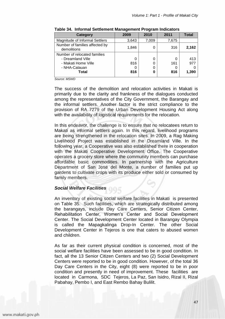
Volume 1: Part 1 - Profile of Makati City
47
Table 34. Informal Settlement Management Program Indicators
Category 2009 2010 2011 Total
Magnitude of Informal Settlers 3,643 7,009 7,675
Number of families affected by demolitions
1,846 0 316 2,162
Number of relocated families - Dreamland Ville - Makati Home Ville - NHA-Calauan
Total
0
816 0
816
0 0 0 0
0
161 0
816
413 977
0 1,390
Source: MSWD
The success of the demolition and relocation activities in Makati is primarily due to the clarity and frankness of the dialogues conducted among the representatives of the City Government, the Barangay and the informal settlers. Another factor is the strict compliance to the provision of RA 7279 of the Urban Development Housing Act along with the availability of logistical requirements for the relocation. In this endeavor, the challenge is to ensure that no relocatees return to Makati as informal settlers again. In this regard, livelihood programs are being strengthened in the relocation sites. In 2009, a Rag Making Livelihood Project was established in the Dreamland Ville. In the following year, a Cooperative was also established there in cooperation with the Makati Cooperative Development Office. The Cooperative operates a grocery store where the community members can purchase affordable basic commodities. In partnership with the Agriculture Department of San Jose del Monte, a number of families put up gardens to cultivate crops with its produce either sold or consumed by family members. Social Welfare Facilities An inventory of existing social welfare facilities in Makati is presented on Table 35. Such facilities, which are strategically distributed among the barangays, include Day Care Centers, Senior Citizen Center, Rehabilitation Center, Women‟s Center and Social Development Center. The Social Development Center located in Barangay Olympia is called the Mapagkalinga Drop-In Center. The other Social Development Center in Tejeros is one that caters to abused women and children. As far as their current physical condition is concerned, most of the social welfare facilities have been assessed to be in good condition. In fact, all the 13 Senior Citizen Centers and two (2) Social Development Centers were reported to be in good condition. However, of the total 36 Day Care Centers in the City, eight (8) were reported to be in poor condition and presently in need of improvement. These facilities are located in Carmona, SDC Tejeros, La Paz, San Isidro, Rizal II, Rizal Pabahay, Pembo I, and East Rembo Bahay Bulilit.

Volume 1: Part 1 - Profile of Makati City
48
Among the current major issues and challenges in the social welfare services sub-sector that has land use implications are:
Densely populated areas show high incidence crimes against persons;
Poor condition of some existing facilities;
Rising number of informal settler families which could be attributed to the establishment of new households by members of informal settler families, and influx of new informal settlers;
Table 35. Number and Physical Condition of Social Welfare Facilities by Type of Facility and Barangay
Barangay/
Location
Social Welfare Facilities
Day Care Center Senior Citizen
Center*
Violence Against
Women (VAW) Desk
G P C G P C G P C
1. Poblacion South
North
√
√
√ √
2. Valenzuela √ √ √
3. Olympia √ √
4. Sta. Cruz √ √
5. Carmona √ √ √
6. Tejeros
SDC Tejeros
√
√
√*
√
7. Kasilawan √ √ √
8. Singkamas √ √
9. La Paz √ √
10. San Antonio √ √ √
11. Pio del Pilar √ √ √
12. Palanan I
Palanan II
√
√
√ √
13. San Isidro √ √
14. Bangkal √ √
15. Southside √ √
16. Rizal 10 (Tagak)
Rizal I (Brgy. Hall)
Rizal II (MH del
Pilar)
Rizal Pabahay
√
√
√
√
√
17. Pembo I √ √ √
18. Comembo I √ √
19. East Rembo
Bahay Bulilit
√
√
√
20. West Rembo
NHEEP West Rembo
√
√
√ √
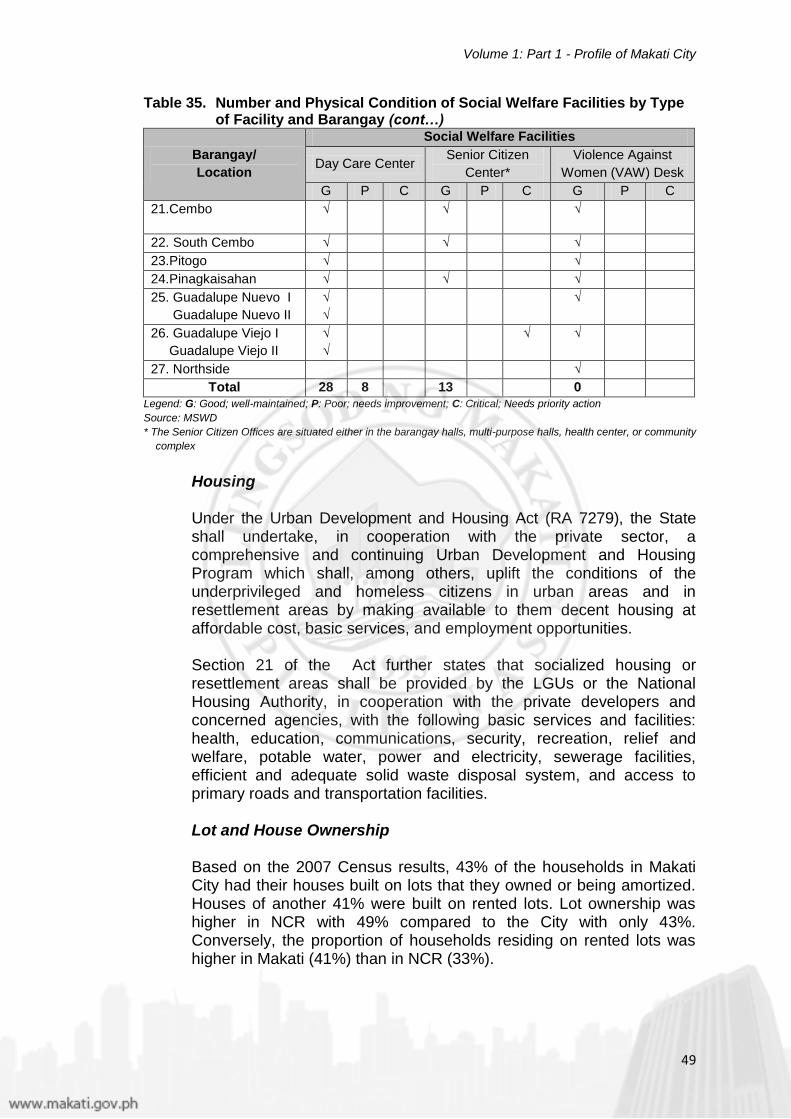
Volume 1: Part 1 - Profile of Makati City
49
Table 35. Number and Physical Condition of Social Welfare Facilities by Type of Facility and Barangay (cont…)
Barangay/
Location
Social Welfare Facilities
Day Care Center Senior Citizen
Center*
Violence Against
Women (VAW) Desk
G P C G P C G P C
21.Cembo √ √ √
22. South Cembo √ √ √
23.Pitogo √ √
24.Pinagkaisahan √ √ √
25. Guadalupe Nuevo I
Guadalupe Nuevo II
√
√
√
26. Guadalupe Viejo I
Guadalupe Viejo II
√
√
√ √
27. Northside √
Total 28 8 13 0
Legend: G: Good; well-maintained; P: Poor; needs improvement; C: Critical; Needs priority action
Source: MSWD
* The Senior Citizen Offices are situated either in the barangay halls, multi-purpose halls, health center, or community
complex
Housing Under the Urban Development and Housing Act (RA 7279), the State shall undertake, in cooperation with the private sector, a comprehensive and continuing Urban Development and Housing Program which shall, among others, uplift the conditions of the underprivileged and homeless citizens in urban areas and in resettlement areas by making available to them decent housing at affordable cost, basic services, and employment opportunities. Section 21 of the Act further states that socialized housing or resettlement areas shall be provided by the LGUs or the National Housing Authority, in cooperation with the private developers and concerned agencies, with the following basic services and facilities: health, education, communications, security, recreation, relief and welfare, potable water, power and electricity, sewerage facilities, efficient and adequate solid waste disposal system, and access to primary roads and transportation facilities. Lot and House Ownership Based on the 2007 Census results, 43% of the households in Makati City had their houses built on lots that they owned or being amortized. Houses of another 41% were built on rented lots. Lot ownership was higher in NCR with 49% compared to the City with only 43%. Conversely, the proportion of households residing on rented lots was higher in Makati (41%) than in NCR (33%).

Volume 1: Part 1 - Profile of Makati City
50
Housing Characteristics On the whole, Makati recorded a ratio of 105 households per 100 occupied housing units. This implies a backlog of 5 housing units per 100 households in the City if the housing program goal is „one house for each household‟. Among the 115,594 occupied housing units in the City in 2007, the most common construction materials used for outer walls were concrete/brick/stone (58%), half concrete/brick/stone and half wood (27%), and wood (11%). As to the construction materials of the roof, 81% of the 115,594 occupied housing units in the City had roofs made of galvanized iron/aluminum in 2007. A few of the housing units had roofs made up of a combination of galvanized iron and concrete (8%) and concrete/clay tile (6%). Household Utilities Based on Census 2000 results, large majority of households (94%) in Makati used electricity as the main source of lighting.
Table 36. Type of Fuel Used for Lighting of Households: NCR and City
of Makati, 2000 Source: NSO, 2000 Census of Population and Housing
Based on 2000 data, garbage of 93% of Makati households is being picked-up by garbage trucks compared to only 90% for NCR.
Type of Fuel Used for Lighting
National Capital Region City of Makati
Number % Number %
Electricity 1,976,739 92.7 97,325 93.6
Kerosene 32,304 1.5 1,190 1.1
LPG 37,051 1.7 1,914 1.8
Oil 920 0.0 44 0.0
Others 85,975 4.0 3,508 3.4
Total Households
2,132,989 100 103,981 100

Volume 1: Part 1 - Profile of Makati City
51
Table 37. Manner of Garbage Disposal of Households: NCR and City
of Makati, 2000
Manner of Garbage Disposal
National Capital Region City of Makati
Number % Number %
Picked up by garbage truck
1,910,139 89.6 96,620 92.9
Dumping in individual pit
65,181 3.1 2,520 2.4
Burning 122,380 5.7 3,533 3.4
Composting 8,646 0.4 500 0.5
Burying 11,677 0.5 354 0.3
Feeding to animals 7,839 0.4 297 0.3
Others 7,127 0.3 157 0.2
Total Households 2,132,989 100 103,981 100 Source: NSO, 2000 Census of Population and Housing
The main sources of water supply for drinking and/or cooking of households in the City were own faucet from community water system (63%), shared faucet from community water system (26%) and shared tubed/piped deep well (4%).
Table 38. Main Source of Water Supply for Drinking and/or Cooking of
Households: NCR and City of Makati, 2000
Main Source of Water Supply
National Capital Region City of Makati
Number % Number %
Own Use, Faucet, Community Water System
1,083,072 50.8 65,148 62.7
Shared, Faucet, Community Water System
518,091 24.3 26,742 25.7
Own Use, Tubed/ Piped Deep Well
84,776 4.0 1,562 1.5
Shared, Tubed/Piped Deep Well
206,709 9.7 4,267 4.1
Tubed/Piped Shallow Well 13,057 0.6 135 0.1
Dug Well 13,049 0.6 79 0.1
Spring, Lake, River, Rain, etc.
3,629 0.2 55 0.1
Peddler 135,205 6.3 2,802 2.7
Bottled Water 27,603 1.3 1,999 1.9
Others 47,798 2.2 1,192 1.1
Total Households 2,132,989 100 103,981 100 Source: NSO, 2000 Census of Population and Housing
Makati Housing Program Through the Makati Housing Program, the City Government continuously provides decent and affordable housing to its residents. The Makati Homes I in Barangay Tejeros, which benefited 316 families from 1990 to 2008, is currently undergoing renovation. The Makati Homes II, on the other hand, which is composed of three 5-storey buildings located at Milkweed St. in Barangay Rizal, was completed in 1998 and is being occupied by 469 families of Makati residents and City Government employees.
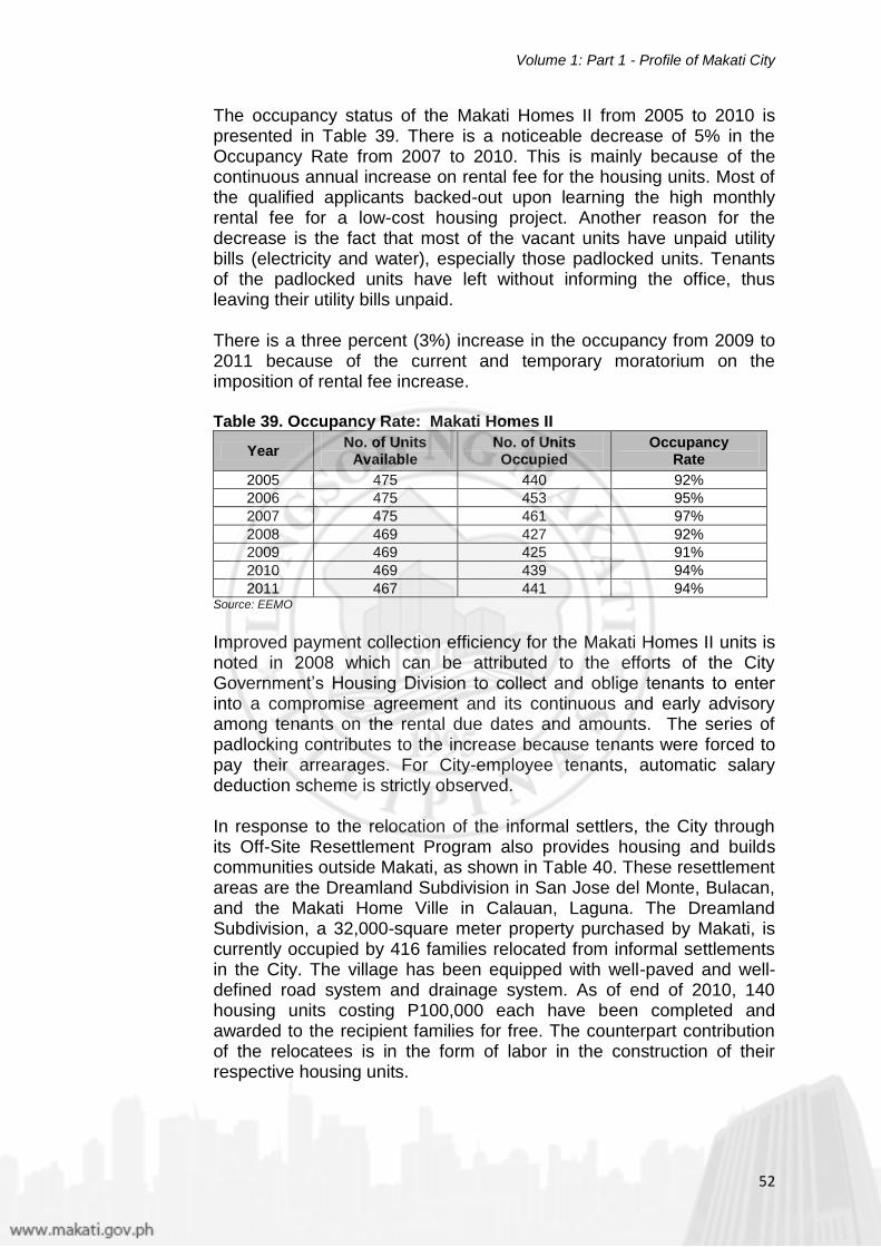
Volume 1: Part 1 - Profile of Makati City
52
The occupancy status of the Makati Homes II from 2005 to 2010 is presented in Table 39. There is a noticeable decrease of 5% in the Occupancy Rate from 2007 to 2010. This is mainly because of the continuous annual increase on rental fee for the housing units. Most of the qualified applicants backed-out upon learning the high monthly rental fee for a low-cost housing project. Another reason for the decrease is the fact that most of the vacant units have unpaid utility bills (electricity and water), especially those padlocked units. Tenants of the padlocked units have left without informing the office, thus leaving their utility bills unpaid. There is a three percent (3%) increase in the occupancy from 2009 to 2011 because of the current and temporary moratorium on the imposition of rental fee increase.
Table 39. Occupancy Rate: Makati Homes II
Year No. of Units
Available No. of Units Occupied
Occupancy Rate
2005 475 440 92%
2006 475 453 95%
2007 475 461 97%
2008 469 427 92%
2009 469 425 91%
2010 469 439 94%
2011 467 441 94% Source: EEMO
Improved payment collection efficiency for the Makati Homes II units is noted in 2008 which can be attributed to the efforts of the City Government‟s Housing Division to collect and oblige tenants to enter into a compromise agreement and its continuous and early advisory among tenants on the rental due dates and amounts. The series of padlocking contributes to the increase because tenants were forced to pay their arrearages. For City-employee tenants, automatic salary deduction scheme is strictly observed. In response to the relocation of the informal settlers, the City through its Off-Site Resettlement Program also provides housing and builds communities outside Makati, as shown in Table 40. These resettlement areas are the Dreamland Subdivision in San Jose del Monte, Bulacan, and the Makati Home Ville in Calauan, Laguna. The Dreamland Subdivision, a 32,000-square meter property purchased by Makati, is currently occupied by 416 families relocated from informal settlements in the City. The village has been equipped with well-paved and well-defined road system and drainage system. As of end of 2010, 140 housing units costing P100,000 each have been completed and awarded to the recipient families for free. The counterpart contribution of the relocatees is in the form of labor in the construction of their respective housing units.

Volume 1: Part 1 - Profile of Makati City
53
The Makati Home Ville is a 40-hectare lot purchased by the City in 2007 and being developed into a village for the relocated informal settlers. As of 2010, a total of 954 families have been relocated to the site.
Aside from the provision of basic utilities (water, electricity and water-sealed toilet) and facilities (school, chapel, community center, covered court), various livelihood and social development projects are being implemented in both resettlement areas with the support of the business sector and non-government organizations.
Table 40. Resettlement Areas, 2010
Name of Resettlement
Area/ Address
No. of Families
Number of Housing
Units
Type of land
ownership
Presence of Utilities/Amenities Admin./ Manage-
ment Water Power
Livelihood Center
Community Center
Others
1 .Makati Dreamland Ville, Brgy Kaypian, San Jose del Monte, Bulacan
416
177 (GK= 168,
non-GK =9)
City Gov‟t-Makati
√ √ √ √ √*
Social Services
Dep‟t- Makati
City Gov‟t
2. Makati Homeland, Brgy. Dayap, Calauan, Laguna
954 0 City Gov‟t-
Makati √ √ √
√**
Social Services
Dep‟t- Makati
City Gov‟t
Source: UDD/NHA/MSWD/Civic Organizations * Other amenities present-MSWD satellite office, Water sealed toilet, Cooperative store, Sibol Preparatory School ** Other amenities include MSWD satellite office, school building (elem. and high school), chapel, covered court
Sports and Recreation Another important aspect of social development, aside from the general population‟s access to quality health care, education and decent housing, is the presence of and access to recreational opportunities in the locality. The availability of parks and other amenities for recreational and sports activities plays an important role in the perceived quality of life of one area over another.
Sports and Recreational Facilities Makati boasts of its multitude and variety of sports and recreational facilities, both publicly and privately owned. The most popular recreational facility in the City is the karaoke bar, which numbered 143 in all as of 2010. Movie houses, covered and open courts, gymnasiums, and parks and playground also abound in the City. Parks and other recreational facilities are strategically distributed around the City, which provide easy access to residents and visitors from all walks of life. The City has numerous sports and recreational facilities intended to develop the youth‟s potential on sports. These venues for sports activities are organized by the various offices of the City, youth groups,

Volume 1: Part 1 - Profile of Makati City
54
and the private sector found in the different barangays. The City through the Youth and Sports Development Department (YSDD) and SK Federation in coordination with other departments and offices should use these facilities in developing future athletes who will represent the City in any sporting events, and will be known locally and internationally. The YSDD and the SK Federation, in close coordination with the MSWD, work hand in hand in undertaking various programs and projects that will help the youth become independent, empowered and useful citizens of tomorrow. These programs include youth training and leadership programs (i.e., Youth Leadership and Volunteerism, Peer Counseling, Lakbay Aral, ISKOLAR BOS) and socio-cultural activities such as Inter-Barangay Sports Tournament, Inter-High School and Inter-Elementary Sports Tournament, Himigsikan and Dance Billboard, Himig Pasko, Mr. and Ms. Teen Makati, etc.. Other programs also focus on services and special education programs such as Iwas Droga, Balik Eskwela, Barangay Computer Enhancement, Brain Olympics and JESB Community Outreach Program. Despite the numerous sports and recreational facilities in the City intended to develop the youth‟s potential on sports, one opportunity to strengthen sports development in the City is the creation of Makati Sports Development Committee. The Youth and Sports Development Department, however, is looking into this. The initial step deemed to be practical is to fast track the formulation of the Makati City Sports Development Plan, which up to the present has not progressed.
1.4.3 Protective Services Security to life and property is a fundamental right of every Filipino citizen and it is, therefore, the duty of the State to protect it. This is explicitly stated in the Article II Section 5 of the Philippine Constitution, to wit: “The maintenance of peace and order, the protection of life, liberty, and property, and promotion of the general welfare are essential for the enjoyment by all the people of the blessings of democracy”. The City, through its network of efficient and effective police, emergency and rescue, and firefighting force and facilities continuously strives to create a safe and secure living and working environment. The following departments, offices and council are in-charge of law enforcement and various protective services in Makati: Makati Police Department enforces law in order to prevent/control crimes, maintain peace and order, and ensure internal security with the active support of the community;

Volume 1: Part 1 - Profile of Makati City
55
Makati Fire Department is responsible for the prevention and suppression of all destructive fires, investigation of their causes, enforcement of the Fire Code and provision for medical and rescue services; Makati City Jail administers the operations of the City Jail and the provision of services to inmates; Makati Rescue is a multi-functional emergency response office with the responsibility of providing a broad range of emergency services to the community; Makati Traffic Enforcement Unit enforces traffic laws and regulations, and apprehends traffic violators; Public Safety Department, also known as MAPSA, was organized primarily to assist the local police force in providing public safety within the City. Specifically, it is tasked to provide traffic assistance, secure the City Government‟s premises and properties, and maintain peace and order at the barangay level; and Makati Disaster Risk Reduction and Management Council is responsible in the formulation and implementation of programs/activities as part of the preparedness, mitigation, response and rehabilitation in case of occurrence of disasters in the City. Index and Non-Index Crimes: Incidence and Solution Efficiency From 2006 to 2011, the number of index crimes exhibited an erratic trend. The number increased two (2)-fold in 2011 as it rose to 1,112. Within the span of 6-years, theft and robbery remained to have the highest incidence. However, robbery cases climbed to 468 in 2011, or 200 % increase from 156 in 2010. Incidence of physical injury rose to 150 in 2011 from only 66 in 2010. Other crime incidences reported were murder, homicide and rape. The annual target of 5% reduction in crime incidence was obviously not met during the 6-year period. Likewise, incidence of non-index crimes exhibited an increasing trend from 2006-2008. In 2009, the number dropped to 164 from 242 in 2008, but it rose again in 2010 to 238 and climbed to 358 in 2011. Crime incidence related to drugs had the highest number among non-index crimes, although it started to decrease during the last two years. Incidence of violence against women and children significantly decreased by more than 50% while estafa showed tremendous increase in 2011. Carnapping incidence increased significantly from eight in 2007 to 29 in 2008, but it diminished in 2009 to 2010 and further rose to 142 in 2011. Violence against women and children, malicious mischief, use/possession of illegal drugs, acts of
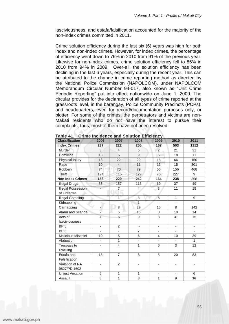
Volume 1: Part 1 - Profile of Makati City
56
lasciviousness, and estafa/falsification accounted for the majority of the non-index crimes committed in 2011. Crime solution efficiency during the last six (6) years was high for both index and non-index crimes. However, for index crimes, the percentage of efficiency went down to 76% in 2010 from 91% of the previous year. Likewise for non-index crimes, crime solution efficiency fell to 86% in 2010 from 94% in 2009. Over-all, the solution efficiency has been declining in the last 6 years, especially during the recent year. This can be attributed to the change in crime reporting method as directed by the National Police Commission (NAPOLCOM), under NAPOLCOM Memorandum Circular Number 94-017, also known as “Unit Crime Periodic Reporting” put into effect nationwide on June 1, 2009. The circular provides for the declaration of all types of crime reported at the grassroots level, in the barangay, Police Community Precincts (PCPs), and headquarters, even for record/documentation purposes only, or blotter. For some of the crimes, the perpetrators and victims are non-Makati residents who do not have the interest to pursue their complaints, thus, most of them have not been resolved. Table 41. Crime Incidence and Solution Efficiency
Classification 2006 2007 2008 2009 2010 2011
Index Crimes 237 222 255 167 503 1112
Murder 3 4 5 2 21 31
Homicide 13 6 9 5 18 11
Physical Injury 13 22 22 15 66 150
Rape 10 4 11 13 15 301
Robbery 74 70 79 56 156 468
Theft 124 116 129 76 227 9
Non Index Crimes 188 220 242 164 238 358
Illegal Drugs 85 157 118 69 37 49
Illegal Possession
of Firearms
- 7 4 3 11 15
Illegal Gambling - 1 3 5 1 9
Kidnapping - - 1 - - -
Carnapping - 8 29 15 8 142
Alarm and Scandal - 5 15 8 10 14
Acts of
lasciviousness
4 6 9 3 31 15
BP 5 - 2 - - - -
BP 6 - - 7 - - -
Malicious Mischief 10 5 6 4 10 39
Abduction - 1 - - - 1
Trespass to
Dwelling
- 4 1 6 3 12
Estafa and
Falsification
15 7 8 5 20 83
Violation of RA
9827/PD 1602
- 2 - - - -
Unjust Vexation 5 1 1 - - 6
Assault 8 1 8 1 9 16

Volume 1: Part 1 - Profile of Makati City
57
Table 41. Crime Incidence and Solution Efficiency (cont…) Classification 2006 2007 2008 2009 2010 2011
RA 9262 violation
(anti violence
against women &
children)
17
2 1 16 39 17
RA 7610 violation
(anti child abuse)
41
1 - - - 10
RA 8484 violation
(defrauding of
creditors)
-
2 - - - -
Threat - - 2 - - 32
Resistance and
Disobedience
-
-
5
1
4
4
Vagrancy/
Mendicants
- - 1 1 0 5
Abduction - - 1 - 1
Other Crimes 3 8 22 27 55 31
Total No. of Index
Crimes Solved 239 ` 152 382
No data
submitted
Solution Efficiency
% of Index
Crimes
93.73% 91.02% 75.94
% -
Total no. of Non-
Index Crimes
Solved
219 154 204 No data
submitted
Solution Efficiency
% of Non-Index
Crimes
90.50% 93.90% 85.71
% -
All Crimes
Total Crime Volume 425 442 497 331 741 1470
Total no. of Crimes
Solved 413 415 458 306 586 452
Solution Efficiency
(%) of All Crimes 97.18% 93.90% 92.15% 92.45%
79.08
% 30.75%
Source: Makati Police Department
Public Safety Department personnel also assist in maintaining peace and order in the City. The table below shows the crime prevention statistics classified by whom/what the crimes were committed against. In the maintenance of peace and order in the barangay, the number of crimes reported showed a decreasing trend in the past three years, with exception of the number of crimes committed against persons which displayed a slight decrease of 0.5% in 2011 from the previous year‟s number. Over-all, the total number of cases reported in 2011 climbed to 5,043 or an increase of 21.5% from 2010.

Volume 1: Part 1 - Profile of Makati City
58
Table 42. Crime Prevention Statistics
Crime
Against:
Number of Cases Reported
2006 2007 2008 2009 2010 2011
Person 2,077 2,560 2,036 1,205 1,297 1,290
Property 1,223 1,428 1,179 1,185 959 995
Chastity 105 95 129 59 46 41
Others 3,090 4,045 3,555 2,937 1,850 2,717
TOTAL 6,495 8,128 6,699 5,386 4,152 5,043
Source: Public Safety Department (MAPSA)
Police Police Facilities and Equipment Makati has a total of nine (9) police precincts scattered in different locations within the City, a police headquarters (main) and a traffic management group, with a total of 489 personnel, 57 vehicles and 33 motorcycles, which were all assessed to be currently in good condition. With a total population of 529,039 in 2010, the Makati Police needs additional police personnel to meet the standard police-population ratio of 1:500. The deficiency in police force is heightened during the daytime when the City‟s population is estimated to increase six (6) to eight (8) times because of the presence of non-resident workers and students as well as tourists and shoppers.
Table 43. Inventory of Police Services Facilities and Equipment
Type of Faciliti
es Location
No. of Personnel
Number of Facilities/ Equipment
Current Condition
Vehicle Others
Headquarters
Yakal St., cor. Ayala Avenue Extension
231 25 27
Motor Cycles
Good
Sub-station
PCP1
Taliba St., Cor JP Rizal Ave.,South Ave., Olympia
25 4 Good
PCP2
La Consolacion St., Guadalupe Nuevo
28 4 Good
PCP3
Santos cor. Evangelista Sts., Bangkal
20 3 Good
PCP4 Batangas cor. Arnaiz Sts., Brgy. San Isidro
23 3 Good
PCP5 Casino St. cor Osmeña Hi-way, Palanan
21 3 Good

Volume 1: Part 1 - Profile of Makati City
59
Table 43. Inventory of Police Services Facilities and Equipment (cont…)
Type of Faciliti
es Location
No. of Personnel
Number of Facilities/ Equipment
Current Condition
Vehicle Others
PCP6 3/F Ayala Car Park, Ayala Center, Bel-Air
36 6 Good
PCP7 Block 0, J.P. Rizal Extn., West Rembo
25 2 Good
PCP8 Anahaw St., Brgy. Comembo
27 2 Good
PCP9 San Mateo cor. P. Gomez, Brgy. Poblacion
22 4 1 Good
Traffic F. Zobel St., Brgy. Poblacion
22 1 5 Good
TOTAL 502 57 33
Motor- cyles
Source: Makati Police Department, 2011
Jail Management The City has one (1) City Jail with a cell area of 1,236 square meters. Inmate population continued to fall from 592 in 2008 to 507 in 2010. With the average jail population of 510 inmates, each inmate occupies roughly 2.42 square meters. This falls below the United Nation Standard of three (3) square meters per inmate, and has a 25.3% congestion rate. On the other hand, the Bureau of Jail Management and Penology (BJMP) sets the National standard of two (2) square meters per inmate as ideal capacity, and one (1) square meter per inmate as maximum capacity. Based on this national standard, the City Jail is above standard with a variance rate of 20.94%, meaning, the jail size is adequate. The present jail facility is composed of 10 cells.
Table 44. Inventory of Jail Facilities and Equipment
Location Area
(sq. m.) No. of
Personnel
Number of Facilities/Equipment
Current Condition
Vehicle Others
City Jail
#2 Lawton Avenue, Brgy. Post Proper Northside, Makati City
Land Area = 6,076 sq.m. Cell area =1,236 sq.m.
132
Two (2) Prisoners
Van
1 Good and 1 Poor
Source: Makati City Jail, 2011
Fire Incidence and Prevention During the last three (3) years, the most number of fire incidence occurred in Barangays Palanan, Poblacion, San Lorenzo, Bel-Air, Bangkal, San Antonio and Guadalupe Nuevo. Areas with the least incidence of fire were in Barangays Pitogo, Post Proper Northside, and

Volume 1: Part 1 - Profile of Makati City
60
Post Proper Southside. This could be attributed to the increase in fire safety awareness and consciousness among the residents and local leaders of these three barangays. Fire occurrences showed a fluctuating trend during the last three years. From 231 in 2008, the number decreased by 9% in 2009, but it rose again sharply in 2010 by 45%. Lectures and seminars on fire safety and prevention have been increased, and being handled by fire safety educators of the Fire Station, and coordinated by the Public Information Service of the City. Increased education activities are also being conducted during the Fire Prevention Month (March). Among the activities conducted are fire drills, distribution of fliers on fire safety, and the Oplan Paala-ala, wherein sub-station personnel do house-to-house visitation and inspection around their areas of responsibility.
Table 45. Fire Incidence by Barangay
Barangay Frequency of Occurrence
2008 2009 2010
District I 147 149 213
Bangkal 18 16 21
Bel-Air 13 4 20
Carmona 2 - 4
Dasmariñas 1 2 4
Forbes 2 - 1
Kasilawan - 1 3
La Paz 7 2 3
Magallanes 1 3 15
Olympia 7 10 16
Palanan 14 9 27
Pio del Pilar 8 9 13
Poblacion 16 26 13
San Antonio 12 11 14
San Isidro 2 7 5
San Lorenzo 22 25 20
Sta. Cruz 6 3 4
Singkamas 1 1 3
Tejeros 10 10 13
Urdaneta 1 6 3
Valenzuela 4 4 11
District II 84 62 93
Cembo 5 2 7
Comembo 12 2 12
East Rembo 4 4 6
Guadalupe Nuevo
32 15 22
Guadalupe Viejo
6 3 6
Pembo 7 8 11
Rizal 4 6 5
Pinagkaisahan - 5 2

Volume 1: Part 1 - Profile of Makati City
61
Table 45. Fire Incidence by Barangay (cont…)
Barangay Frequency of Occurrence
2008 2009 2010
Pitogo 1 1 1
Post Proper Northside
- - 1
Post Proper Southside
- 1 -
South Cembo 5 5 9
West Rembo 8 10 11
TOTAL 231 211 306 Source: Makati Fire Department
Fire Protection Services, Facilities and Equipment Fire protection facilities and equipment include a fire station (main) and 10 sub-stations with 119 fire protection personnel, 11 fire trucks and one (1) ambulance. Each fire station is equipped with a fire truck, but eight (8) of these fire trucks are no longer in good condition. The operational capability of the Makati Fire Station to suppress all kinds of fires is therefore being constrained due to lack of equipment in good working condition. Moreover, the station needs additional skilled drivers and mechanics. Such personnel and facility deficiencies compels the Makati Fire Station to tap the Barangay First Responders to augment the existing firefighting personnel. Fire brigades are also available, with some of them housed in the BFP fire stations. Barangays Guadalupe, Poblacion, Forbes Park and Singkamas have their own responding teams, ready for deployment not only in their area of responsibility but also within the City if need arises. The response team of the City‟s Fire Station is technologically supported and guided by a world-class Command, Control and Communication System (C3). The team provides responses to emergencies in coordination with other responding groups such as the Makati Rescue, Traffic Unit of the PNP, and the Public Safety Department. Makati has been cited ten times since 1992 as the Local Government Unit in the National Capital Region (NCR) with the Best Fire Station.
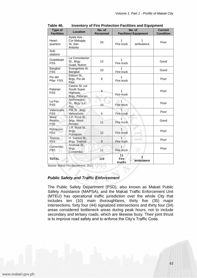
Volume 1: Part 1 - Profile of Makati City
62
Table 46. Inventory of Fire Protection Facilities and Equipment
Type of Facilities
Location No. of
Personnel No. of
Facilities/ Equipment Current
Condition
Head-quarters
Ayala Ave , Cor Malugay St, San Antonio
24 1
Fire truck 1
ambulance Poor
Sub-stations
Guadalupe FSS
La Consolacion St., Brgy. Guad. Nuevo
12 1
Fire truck Good
Bangkal FSS
Evangelista St. Bangkal
10 1
Fire truck Good
Pio del Pilar FSS
Edison St., Brgy. Pio de Pilar
6 1
Fire truck Poor
Palanan FSS
Casino St. cor South Super Highway, Brgy. Palanan
8
1 Fire truck
Poor
La Paz FSS
Archimedes St., Brgy. La Paz
10
1 Fire truck
Poor
Valenzuela FSS
Pilli St., Brgy. Valenzuela
6
1 Fire truck
Poor
West Rembo FSS
J.P. Rizal St., Brgy. West Rembo
11
1 Fire truck
Good
Poblacion FSS
J.P. Rizal St., Brgy. Poblacion
12
1 Fire truck
Poor
Tejeros FSS
H. Santos St., Brgy. Tejeros
9
1 Fire truck
Poor
Comembo FSS
Anahaw St., Brgy. Comembo
11
1 Fire truck
Poor
TOTAL 119 11
Fire trucks
1 ambulance
Source: Makati Fire Department, 2011
Public Safety and Traffic Enforcement The Public Safety Department (PSD), also known as Makati Public Safety Assistance (MAPSA), and the Makati Traffic Enforcement Unit (MTEU) has operational traffic jurisdiction over the whole City that includes ten (10) main thoroughfares, thirty five (35) major intersections, forty four (44) signalized intersections and thirty four (34) areas considered bottleneck areas during peak hours, not to include secondary and tertiary roads, which are likewise busy. Their joint thrust is to improve road safety and to enforce the City‟s Traffic Code.

Volume 1: Part 1 - Profile of Makati City
63
Traffic Violations Table 47 shows a decreasing trend in all types of traffic violations committed from 2007 to 2011. Overall, the number of traffic violations posted a 33% increase in 2011 from the previous year‟s 36,544 violations. Non-use of seatbelt consistently recorded the most number of traffic violations during the 5-year period, with 27% share of total violations in 2011. This was followed by disobedience to traffic control and signals at 10%, and violation of vehicle volume reduction scheme (VVRS) at 10%. Violations on jaywalking sharply increased from 1078 in 2010 to 3,874 in 2011, and violations on urinating/defecating/spitting ordinance leaped from 448 to 775 during the same period. The overall decrease in the violations can be attributed to the strict implementation of the City‟s traffic regulations. Programs were also implemented to lessen accidents in the City such as distribution of leaflets to motorists and pedestrians on how to avoid traffic accidents, and conduct of Road and Safety Seminars, which educate attendees on traffic laws, rules, and regulations, ordinances, and other safety tips on preventing accidents.
Table 47. Type and Number of Traffic Violations Committed
Type Number of Traffic Violations
2007 2008 2009 2010 2011
Non-Use of Seatbelt 15,160 18,407 16,290 10,463 13,471
Disobedience to traffic control signs and signals
13,184 10,878 10,027 5,208 5,255
Violations of VVRS 7,156 6,720 5,764 3,753 4,840
Driving in Sandos/ Slippers of PUV drivers
5062 6,139 5,436 3,485 4,493
Obstructing Roads by Motor Vehicles/Stalled Vehicles
5,282 4,221 3,629 2,351 3,004
No safety helmet for motor cyclist
5,318
3,992
3,547
2,281
2,940
Disregarding lane markings
2,550 1,951 1,620 1,019 1,323
Violation of Limited Truck Ban
1,544 1,699 1,601 1,057 1,365
Violation on lights, warning signs, and equipment
2,018 1,260 1,162 766 996
Violation on Mufflers and Noise Controlling Device
1,437 1,175 1,042 672 876
Unauthorized use of Commemorative Plate/Expired
938 793 412 265 358
Commemorative Plate/Failure to Display Regular Plates
Violation of Loading/ Unloading Zone
1,717 635 516 334 429

Volume 1: Part 1 - Profile of Makati City
64
Table 47. Type and Number of Traffic Violations Committed (cont…)
Type Number of Traffic Violations
2007 2008 2009 2010 2011
Violation of No Entry Sign
338 517 398 248 325
Reckless Driving 1,072 511 528 355 462
Arrogant 330 497 468 313 409
Colorum Operation of Passenger Vehicle
433 493 344 219 288
Illegal Counter-flow 543 460 331 189 251
Road Unworthiness of Motor Vehicles (side mirror, wiper)
313 455 446 303 395
Unregistered Motor Vehicles
774 446 463 303 395
Using cellphone while driving
404 408 196 138 197
No ID displayed 382 364 426 265 358
Parking and Waiting in Prohibited Areas
1,460 275 231 150 202
Driving Tricycle on National Road
223 249 271 194 395
Improper Display of Plates
143 226 122 81 112
Driving without license 274 208 234 146 168
Unclean, unsanitary vehicle, lack of signs, dirty plates
217 178 125 81 113
Failure to show/carry registration
276 110 121 81 114
Illegal Signboard 103 119 114 70 96
Urinating, defecation, Spitting
28 79 20 448 775
Failure to show/carry/ surrender drivers‟ license
33 68 94 70 99
Out of service area (tricycle, pedicabs)
28 55 38 23 58
Jaywalking 64 40 55 1,098 3,874
Out of route/line (PUB,PUJ)
33 34 16 12 46
Trucking Mud into load 8 28 16 12 26
Overcharging of Fares/Contracting Service
11 24 14 12 46
No fare matrix / IDs displayed
94 23 61 35 72
Discrimination of Passengers/ Trip Cutting
22 22 16 12 40
Smoking Ban 51 15 4 - -

Volume 1: Part 1 - Profile of Makati City
65
Table 47. Type and Number of Traffic Violations Committed (cont…) Type Number of Traffic Violations
No franchise/ CPC/PA carried
13 11 30 23 50
Projecting Load on passenger vehicle
4 - - - -
Breach of Franchise Condition
2 - - - -
Parking in front of Commercial Establishment
2
-
-
-
-
Smoke Belching 2 10 20 9 26
Failure to install Seatbelts
1 - - - -
Colorum operation of cargo vehicles
1 - - - -
Violation of No Overtaking Bridge Sign
1 - - - -
TOTAL 70,039 63,795 56,248 36,544 48,742
Source: Public Safety Department
Anti-Drug Abuse Operations The Makati Anti-Drug Abuse Council (MADAC) was conferred a plaque of recognition by the Philippine Drug Enforcement Agency (PDEA) for its exceptional contributions in preventive and control strategies in combating the drug problem in the City. From 2006 to 2008, anti-drugs operations conducted increased from 468 to 618. However, in 2009, the number of operation dropped down to 471. As the number of operations diminished, so were the number of individuals apprehended which totaled to only 86 persons in 2009 from 139 in 2008. The number of individual cases filed started to decline in 2008 from the previous year‟s 351 cases to 217, and further to 139 in 2009.
Table 48. Makati Anti-Drug Abuse Council (MADAC) Barangay
Operations Statistics
Particulars 2006 2007 2008 2009
Number of Operations 468 507 618 471
Number of Individuals Apprehended
115 197 139 86
Number of Individual Cases Filed
170 351 217 139
TOTAL 753 1055 974 696
Source: MADAC
In partnership with the Philippine Drug Enforcement Agency (PDEA) and the Association of Metro Manila Anti-Drug Abuse Council (AMMADAC), the Makati Anti-Drug Abuse Council (MADAC) spearheaded several campaigns/activities against illegal drugs in the City.

Volume 1: Part 1 - Profile of Makati City
66
Makati Rescue Services
Makati Rescue Services provided include Emergency Medical Services (EMS), response to fire incidents and vehicular accidents, K-9 services, paneling, patrol/posting services, and response to bomb threat incidents. Response to emergency medical concerns has the most number of services rendered throughout the five-year period. The number of services rendered to such concern has been increasing every year. From 2006, the number increased in 2010 by more than five times. This increase could be attributed to the escalating requests from different departments, barangays and other constituents of the City on the transportation of non-emergency patients to and from the hospital.
Table 49. Makati Rescue Services Rendered
Type of Services Number of Services Rendered
2006 2007 2008 2009 2010
Emergency Medical Services
277 475 498 876 1,687
Response to Fire Incidents
63 67 61 63 65
Response to Vehicular Incidents
91 113 223 282 280
K-9 Services (Technical Support to Makati Police/SWAT-EOD) - Paneling Services - Patrol/posting
Services - Bomb Threat
Incident Response
123 - -
22 98 17
83 24 16
86 - 7
83 - 8
Source: Makati Rescue
EMS is being provided in coordination with Ospital ng Makati and Acute Care Center. It is considered vital in responding, evaluating and intervening in potentially catastrophic events. EMS co-manages initial scenes in many medium-to-large scale incidents involving large number of casualties. Response to vehicular accidents is the second most rendered rescue services during the five-year period, with slight increases noted every year. Their numbers were only about one-fourth to one-sixth of the number rendered to emergency medical services. Paneling services and response to fire incidents rendered were lesser in number, while patrolling/posting and response to bomb threat incidents were the least rescue services rendered.

Volume 1: Part 1 - Profile of Makati City
67
The Makati Rescue Team managed to maintain its average response time of 5-7 minutes from Rescue Base to any point of Makati, which means that the team was able to respond to any emergency situation at the shortest possible time. Makati‟s Rescue Team can be considered the most equipped with the acquisition of modern tools and devices.
In terms of logistics, Makati Rescue has one (1) Rescue Truck, which is fully equipped with air, sea and land technical rescue equipment, one (1) fire truck, two (2) advance cardiac life support ambulance, two (2) utility pick-ups, one (1) K9 van. The annual increase in the number of medical and technical equipment boosted the response ability of Makati Rescue.
1.4.4 Utilities: Power, Water, Communication Network, Waste Management
Road Improvement All roads in Makati have been concreted since 2004 and meet established standards on structural design. Current road-related improvements include landscaping and provision of street lighting for the safety of motorists and pedestrians. Other improvements being considered are related to improving levels of service through the expansion of road right-of-way (RROW) by expropriating land and through other means such as the allocation of additional lanes during the development of Planned Unit Developments (PUDs) in exchange for the relaxing or waiving of certain development restrictions.
Table 50. Status of Road Concreting
District No. of
Streets Total Length
(in km.)
Completed
No. of Streets
Length (in km.)
I 436 246.10 436 246.10
II 524 204.45 524 204.45
Villages 191 183.98 191 183.98
Total 1151 634.53 1151 634.53
Source: DEPW, 2010
The City has in the past programmed the following to improve its traffic condition:
Expropriation of private lots to be converted into access road.
Road Restoration and Maintenance Program (concreting, concrete blocking and road restoration) to make sure that all roads are in good condition.
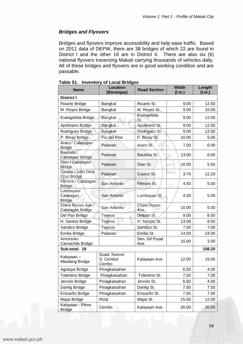
Volume 1: Part 1 - Profile of Makati City
68
Bridges and Flyovers Bridges and flyovers improve accessibility and help ease traffic. Based on 2011 data of DEPW, there are 38 bridges of which 22 are found in District I and the other 16 are in District II. There are also six (6) national flyovers traversing Makati carrying thousands of vehicles daily. All of these bridges and flyovers are in good working condition and are passable.
Table 51. Inventory of Local Bridges
Name Location
(Barangay) Road Section
Width (l.m.)
Length (l.m.)
District I
Ricarte Bridge Bangkal Ricarte St. 9.00 12.50
M. Reyes Bridge Bangkal M. Reyes St., 9.00 10.00
Evangelista Bridge Bangkal Evangelista St.
9.00 12.00
Apolinario Bridge Bangkal Apolinario St. 9.00 12.50
Rodriguez Bridge Bangkal Rodriguez St. 9.00 12.50
P. Binay Bridge Pio del Pilar P. Binay St. 10.00 5.00
Araro / Calatagan Bridge
Palanan Araro St. 7.00 6.00
Bautista / Calatagan Bridge
Palanan Bautista St. 13.00 6.00
Dian / Calatagan Bridge
Palanan Dian St. 10.00 5.50
Casino / Julio Dela Cruz Bridge
Palanan Casino St. 3.70 12.20
Filmore / Calatagan Bridge
San Antonio Filmore St. 4.50 5.00
Lumbayao/ Calatagan Bridge
San Antonio Lumbayao St. 4.50 5.00
Chino Roces Ave / Calatagan Bridge
San Antonio Chino Roces Ave.
10.00 5.00
Del Pan Bridge Tejeros Delpan St. 9.00 6.50
H. Santos Bridge Tejeros H. Santos St. 13.00 8.50
Sandico Bridge Tejeros Sandico St. 7.50 7.00
Emilia Bridge Palanan Emilia St. 14.00 24.00
Amorsolo-Camachile Bridge
Sen. Gil Puyat Ave.
15.00 3.00
Sub-total: 19 158.20
Kalayaan – Masilang Bridge
Guad. Nuevo/ S. Cembo/ Cembo
Kalayaan Ave. 12.00 15.00
Agutaya Bridge Pinagkaisahan 6.50 4.00
Tolentino Bridge Pinagkaisahan Tolentino St. 7.50 7.00
Jervois Bridge Pinagkaisahan Jervois St. 6.50 4.00
Danlig Bridge Pinagkaisahan Danlig St. 7.50 7.50
Ensueño Bridge Pinagkaisahan Ensueño St. 7.50 7.50
Maya Bridge Rizal Maya St. 15.00 12.00
Kalayaan - Pinos Bridge
Cembo Kalayaan Ave. 30.00 20.00

Volume 1: Part 1 - Profile of Makati City
69
Table 51. Inventory of Local Bridges (cont…)
Name Location
(Barangay) Road
Section Width (l.m.)
Length (l.m.)
Pateros-Pembo Bridge
Pembo - 8.90 30.0
Sub-total: 9 77.00
Total : 28 265.20 Source: DEPW, 2011
Table 52. Inventory of Bridges, National/DPWH
Name Location
(Barangay) Road
Section Width (l.m.)
Length (l.m.)
District I
Makati / Mandaluyong Bridge (Pantaleon Br.)
Poblacion Makati Avenue
7.4 100.00
Cementina Dolores Bridge
Pio del Pilar Pasay Road Makati
15.00 26.00
Tripa de Gallina Bridge
Palanan Sen. Gil Puyat Ave.
14.5 14.00
Sub-total: 3 140.00
District II
San Jose Bridge Guad. Nuevo J.P. Rizal Extension
12.00 15.00
Balisahan Bridge Guad. Viejo J.P. Rizal Extension,
20.00 15.00
Pateros Bridge Pateros / Comembo Bdry.
J.P. Rizal Ext.
12.00 30.00
Buting Bridge Makati / Pasig Bdry.
Kalayaan Ave.
15.00 25.00
Taguig / Makati Bridge
Taguig / Makati Bdry.
Chino Roces Avenue Extension
20.00 30.00
C-5 Bridge West Rembo C-5 20.00 100.00
EDSA - Guadalupe Bridge
Makati - Mandaluyong Boundary
EDSA 60.00 100.00
Sub-total: 7 315.00
Total : 10 455.00 Source: DEPW, 2011

Volume 1: Part 1 - Profile of Makati City
70
Table 53. List of Flyovers
Name Location Length (l.m.) Width (l.m.)
Magallanes Flyover (DPWH)
Magallanes - South Super Highway
8 15 - 20
Buendia - South Super Highway
Buendia - South Super Highway
300 20 - 25
EDSA - Buendia - Global Flyover
EDSA – Buendia 1,000 15 - 20
EDSA - Ayala Flyover EDSA – Ayala 300 15 - 20
EDSA - Estrella Flyover
EDSA - Estrella St. Guad. Viejo
200 12 - 15
C-5 / Kalayaan Avenue (Elevated U-Turn)
C-5 / Kalayaan East Rembo
200 12 - 15
Source: DEPW, 2011
Ancillary Road Facilities In addition to road networks are ancillary facilities throughout the City. Sidewalk The City has a total sidewalk length of 304.406 km. Out of the total length of sidewalk, 301.399 km. or 99.01% is walkable based on 2010 data. In order to attain 100% walkable sidewalks, the City continuously implements the rehabilitation and sidewalk beautification program which includes: landscaping and sidewalk improvement; demolition of structures encroaching the sidewalk; repair and maintenance of damaged sidewalks, curbs and gutter, and manhole covers; installation of railings, bollards for Persons With Disabilities (PWDs); recovery of government lots; removal of idle/dilapidated lamp posts and pedestals; and, strict implementation of ordinances on the proper use of sidewalks. Streetlights For the safety of the motorists, residents and transients during night time, the City through the DEPW implemented street lighting programs. Since the beginning of the program in 2003, 252.54 km. of streets have been lighted, including major thoroughfares and secondary roads. This is equivalent to 67.60 % of total 373.59 km. target. There are on-going projects for 48.49 km. of street lighting corresponding to13.0% of the total. The remaining 72.56 km. is already in the pipeline. The City has also adopted street lighting projects which also concerns the protection of the environment. One of these is through the use of an Energy Efficient Lighting System (EELS) in all of the existing streetlights which not only provides better lighting, but also saves on the amount of energy being utilized.
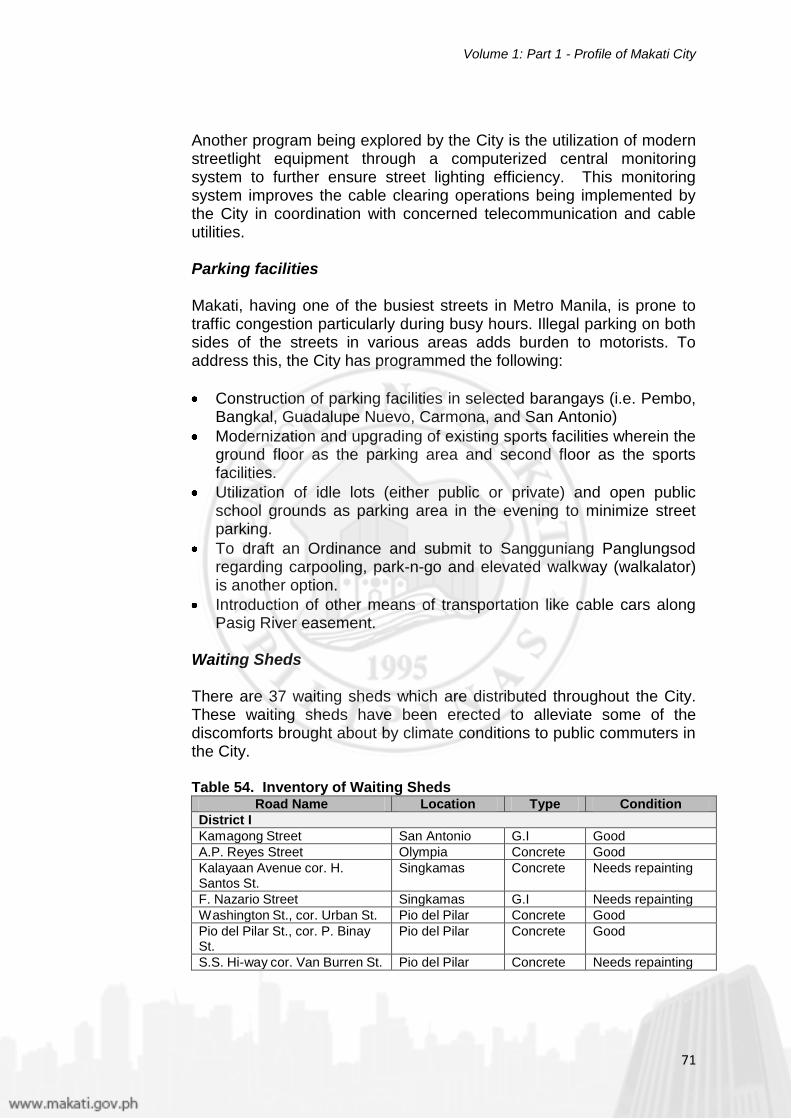
Volume 1: Part 1 - Profile of Makati City
71
Another program being explored by the City is the utilization of modern streetlight equipment through a computerized central monitoring system to further ensure street lighting efficiency. This monitoring system improves the cable clearing operations being implemented by the City in coordination with concerned telecommunication and cable utilities. Parking facilities Makati, having one of the busiest streets in Metro Manila, is prone to traffic congestion particularly during busy hours. Illegal parking on both sides of the streets in various areas adds burden to motorists. To address this, the City has programmed the following:
Construction of parking facilities in selected barangays (i.e. Pembo, Bangkal, Guadalupe Nuevo, Carmona, and San Antonio)
Modernization and upgrading of existing sports facilities wherein the ground floor as the parking area and second floor as the sports facilities.
Utilization of idle lots (either public or private) and open public school grounds as parking area in the evening to minimize street parking.
To draft an Ordinance and submit to Sangguniang Panglungsod regarding carpooling, park-n-go and elevated walkway (walkalator) is another option.
Introduction of other means of transportation like cable cars along Pasig River easement.
Waiting Sheds There are 37 waiting sheds which are distributed throughout the City. These waiting sheds have been erected to alleviate some of the discomforts brought about by climate conditions to public commuters in the City.
Table 54. Inventory of Waiting Sheds
Road Name Location Type Condition
District I
Kamagong Street San Antonio G.I Good
A.P. Reyes Street Olympia Concrete Good
Kalayaan Avenue cor. H. Santos St.
Singkamas Concrete Needs repainting
F. Nazario Street Singkamas G.I Needs repainting
Washington St., cor. Urban St. Pio del Pilar Concrete Good
Pio del Pilar St., cor. P. Binay St.
Pio del Pilar Concrete Good
S.S. Hi-way cor. Van Burren St. Pio del Pilar Concrete Needs repainting

Volume 1: Part 1 - Profile of Makati City
72
Table 54. Inventory of Waiting Sheds (cont…) Road Name Location Type Condition
Kalayaan Avenue cor. Pasong Tamo St.
Sta. Cruz Concrete Good
Kalayaan Avenue cor. Zapote St.
Sta. Cruz Concrete Good
Kalayaan Avenue cor. Makiling St.
Sta. Cruz Mixed Needs repair and repainting
Kalayaan Avenue cor. J.B. Roxas St.
Sta. Cruz Mixed Needs repainting
Vito Cruz Extension cor. South Avenue
Sta. Cruz G.I Needs repainting
Zapote St., cor. Yague St., Sta. Cruz G.I Needs repainting
Metropolitan Ave., cor. Kakarong St.
Sta. Cruz Concrete Needs repainting
Vito Cruz Extension La Paz Concrete Needs repainting
Flordeliz Street La Paz Concrete Needs repainting
Dian St., cor. Faraday St. San Isidro Concrete Needs repainting & repair
Dian St., cor. Ford St. San Isidro Concrete Needs repainting & repair
Batangas St., cor. Faraday St. San Isidro G.I Needs repainting
Filmore St., cor. Dayap St. Palanan Concrete Needs repair and repainting
Dian St., cor. Dayap St. Palanan Concrete Needs repair and repainting
Bautista St., cor. Enrique St. Palanan Concrete Needs repair and repainting
Bautista St., cor. Calatagan St. Palanan Concrete Needs repair and repainting
Dian St., near cor. Arellano St. Palanan G.I Needs repainting
Bautista St., cor. Dayap St. Palanan Concrete Needs repair and repainting
A.P. Reyes Avenue (center island)
Tejeros G.I Needs repainting
S.S. Hi-way cor. Dallas St. Bangkal G.I Needs repainting
N. Garcia St., cor. Metropolitan St.
Bel-Air Concrete Needs repainting
Buendia Avenue between Makati Avenue and N. Garcia Street
Bel-Air Concrete Good
Pasong Tamo Street cor. Arnaiz Avenue
San Lorenzo Concrete Good
Tindalo Street cor. Gil Puyat Avenue
San Lorenzo Concrete Needs repair and repainting
Sub-total 31
District II
J.P. Rizal Street near cloverleaf Guadalupe Viejo Concrete Good
J.P. Rizal Street near corner Camia Street
Guadalupe Viejo Concrete Good
J.P. Rizal Street near Estrella Street
Guadalupe Viejo Concrete Good
J.P. Rizal Extension Cembo Concrete Good
Malvar Street cor. J.P. Rizal Street
South Cembo Concrete Good
Col. Santos Street South Cembo G.I Good
Sub-total 6
TOTAL 37 Source: DEPW, 2011

Volume 1: Part 1 - Profile of Makati City
73
Overpass/ Underpass The City also has ancillary road facilities catering to pedestrian traffic. These facilities are located along major circulation networks such as EDSA, Sen. Gil Puyat Avenue and Ayala Avenue, among others.
Table 55. Inventory of Overpass and Underpass
Barangay Location Length Width Type of
Structure Remarks
DISTRICT I
Overpass
Bangkal EDSA near corner Evangelista St.
54.70 m 4.00 m concrete good condition
Bangkal South Super Hi-Way (Foot Bridge)
45.80 m 2.40 m Steel New
Bangkal Under Magallanes Interchange
71.80 m 7.00 m concrete On-going rehabilitation
Urdaneta EDSA cor. Sen. Gil Puyat Avenue
34.00 m 2.00 m steel with escalator machine
good condition
San Lorenzo
Ayala Avenue cor. EDSA
68.20 m 4.50 m steel with escalator machine
good condition
Underpass
San Lorenzo/ Bel-Air
Ayala Avenue cor. Salcedo St.
37.10 m 6.00 m
concrete with escalator machine
good condition
San Lorenzo/ Bel-Air
Ayala Ave. cor. Paseo de Roxas St.
57.50 m 7.85 m
concrete with escalator machine
good condition
San Lorenzo/ Bel-Air
Ayala Avenue cor. Herrera St.
37.10 m 3.70 m
concrete with escalator machine
good condition
San Lorenzo/ Bel-Air
Ayala Avenue cor. Makati Avenue
75.00 m 6.50 m
concrete with escalator machine
good condition
DISTRICT II
Overpass
West Rembo
J.P. Rizal Extension in front of University of Makati
17.48 m 2.10 m concrete with girder
good condition
West Rembo
J.P. Rizal Extension in front of Fort Bonifacio Elem. School
17.48 m 2.10 m concrete with girder
good condition
West Rembo
Kalayaan Avenue near corner Papaya St. Sitio 8
30.00 m 3.10 m concrete with girder
good condition
West Rembo
along C-5 Road between 27th St., West Rembo and 2nd Avenue, East Rembo
58.40 m 2.90 m steel frame and concrete
good condition

Volume 1: Part 1 - Profile of Makati City
74
Table 55. Inventory of Overpass and Underpass (cont…)
Barangay Location Length Width Type of
Structure Remarks
Guad. Nuevo Kalayaan Avenue near corner Bo. Visayas
30.00 m
3.10 m
concrete with girder
good condition
Guad. Nuevo
EDSA near Burgos St. crossing near San Bernardino St., G. Viejo
54.70 m
3.20 m
concrete good condition
Pinagkaisahan EDSA near Estrella St. crossing near Agutaya St.
54.70 m
5.10 m
concrete good condition
Cembo Kalayaan Avenue near corner Acacia St.
30.00 m
3.10 m
concrete with girder
good condition
East Rembo C-5 Road near corner Kalayaan Avenue
58.40 m
3.20 m
steel frame and concrete
good condition
East Rembo C-5 Road near corner 22nd Avenue
35.85 m
2.90 m
steel frame and concrete
good condition
Rizal C-5 Road near corner Blue Boz St.
58.40 m
3.20 m
steel frame and concrete
good condition near corner Blue Boz St.
Source: DEPW, 2011
Road Markings Like other countries, proper use of lane markings contributes to the smooth flow of vehicular traffic and promotes discipline to the public with regards to proper use and courtesy. Thermoplastic lane markings are conducted every year to help the Protective Services Sector lessen traffic congestion. Water Supply Manila Water Company and Maynilad provide water service in Makati City through several primary distribution mains. Raw water, however, comes from the Angat-Ipo-La Mesa water system, an external source that begins in Norzagaray, Bulacan and supplies the whole of Metro Manila. Water supplied by the Manila Water company is treated at the Balara Treatment Plant while Maynilad treats its water at the La Mesa Dam. In 2011, 97.50% of households in Makati were considered to have access to safe drinking water. Data from the Makati Health Department from 2009-2011, however, indicate a decrease in the total number of households served from 2010 to 2011.
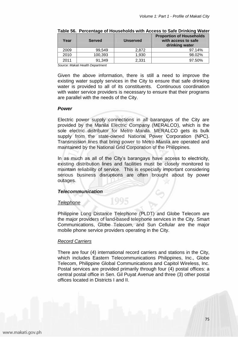
Volume 1: Part 1 - Profile of Makati City
75
Table 56. Percentage of Households with Access to Safe Drinking Water
Year Served Unserved Proportion of Households
with access to safe drinking water
2009 99,549 2,872 97.14%
2010 100,393 1,930 98.02%
2011 91,349 2,331 97.50%
Source: Makati Health Department
Given the above information, there is still a need to improve the existing water supply services in the City to ensure that safe drinking water is provided to all of its constituents. Continuous coordination with water service providers is necessary to ensure that their programs are parallel with the needs of the City. Power
Electric power supply connections in all barangays of the City are provided by the Manila Electric Company (MERALCO), which is the sole electric distributor for Metro Manila. MERALCO gets its bulk supply from the state-owned National Power Corporation (NPC). Transmission lines that bring power to Metro Manila are operated and maintained by the National Grid Corporation of the Philippines. In as much as all of the City‟s barangays have access to electricity, existing distribution lines and facilities must be closely monitored to maintain reliability of service. This is especially important considering serious business disruptions are often brought about by power outages. Telecommunication Telephone Philippine Long Distance Telephone (PLDT) and Globe Telecom are the major providers of land-based telephone services in the City. Smart Communications, Globe Telecom, and Sun Cellular are the major mobile phone service providers operating in the City. Record Carriers There are four (4) international record carriers and stations in the City, which includes Eastern Telecommunications Philippines, Inc., Globe Telecom, Philippine Global Communications and Capitol Wireless, Inc. Postal services are provided primarily through four (4) postal offices: a central postal office in Sen. Gil Puyat Avenue and three (3) other postal offices located in Districts I and II.
Volume 1: Part 1 - Profile of Makati City
76
Radio, Television and Publication There are five (5) FM radio stations, three (3) AM radio stations; two (2) cable operators and two (2) satellite television providers in Metro Manila servicing the City. There are also two (2) television stations and six (6) publishing houses based in the City. Existing telecommunication facilities meet the standards set by the HLURB and show that the City‟s communication level is adequate. These, however, must be continuously improved in order to be at par with the fast modernization of telecommunication facilities and innovations that are available globally. Drainage and Sewerage Makati is prone to flooding because of its topographic and hydrological conditions characterized by low-level areas and the low gradient of the Pasig River combined with the prevalence of heavy rainfalls associated with tropical cyclones. The City has three (3) types of drainage channels: open canals, reinforced concrete covered pipes, and improved box culverts. Domestic and industrial wastes are discharged into storm drains and into the nine rivers and creeks that extend from Del Pan Street to San Jose, Guadalupe. During the period 2009 to 2011, improvements were made to the City‟s drainage system. Open canals were converted to improved box culverts and reinforced circular concrete pipes (RCCP). By 2011, 419.238 kms. or 66.07% of City streets have improved box culvert systems, 208.54 kms. or 32.87% are lined with RCCP drainage while only 6.75 kms. or 1.06% remain as open canals.
1.5 THE ECONOMIC STRUCTURE
Makati is the country‟s premier business district. It has the largest concentration of commercial activities in the Philippines, and is the country‟s primary link to international finance and the global economy. With 2.75 million square meters of prime office space as of the end of 2010, the City‟s business district is 5.56 times larger than the second largest (Bonifacio Global City) in the country, and accounts for 60% of Metro Manila‟s prime office space inventory of 4.5 million square meters.
Unlike most cities and municipalities in the Philippines, whose primary concerns revolve mostly around local development issues, the major economic challenges facing the City are how: (a) to enhance its role as the premier central business district, not only of the country but of the entire Southeast Asian region, amidst competition from other business districts, and (b) to ensure that its residents share in the benefits as well as the

Volume 1: Part 1 - Profile of Makati City
77
responsibilities of this role. In order to address these challenges, there is a need to anticipate and provide for future growth requirements, and to continuously upgrade local service capacities and improve the overall physical environment.
1.5.1 Number and Type of Business Establishments
Number of Establishments The number of establishments showed an increasing trend from 2007 to 2010; from 55,129 to 60,304. The highest number recorded was in 2006 with 61,974 business establishments. The lowest number of business establishments was in 2007 when there was a significant decrease of General Merchandise, Services & Real Estate.
For 2011, services comprised a majority of establishments, followed by General Merchandise, and Real Estate. Manufacturing represents the lowest number of business establishments. This may be attributed to the shifting of manufacturing companies to other peripheral areas.
Table 57. Number of Establishments by Type
Number of Establishments 2006 2007 2008 2009 2010 2011
General Merchandise 20,402 16,481 16,650 16,611 17,644 17,546
Services 19,825 18,842 19,117 19,353 20,655 19,629
Real Estate 10,043 9,616 9,726 9,797 10,150 9,703
Convenience Stores, Restaurants & Amusement Places
4,518 4,163 4,194 4,389 4,745 4,473
Import/Export 1,971 1,453 1,471 1,702 2,115 2,747
Manufacturing 1,390 1,131 1,144 1,197 1,261 1,123
Banks & Finance-Related Business 3,825 3,443 3,477 3,529 3,734 3,594
Special Business Permits - - - - - 105
Total 61,974 55,129 55,779 56,578 60,304 58,920 Source: Business Permits Office
1.5.2 Growth Rate per Type of Establishment
Establishments engaged in Import/Export recorded the highest average growth rate of 8.96% from 2007-2011. Convenience Stores, Restaurants & Amusements Places exhibited the lowest growth rate of negative 0.2%.

Volume 1: Part 1 - Profile of Makati City
78
Table 58. Growth Rate by Type of Establishment Number of
Establishments 2007 2008 2009 2010 2011 Ave.
General Merchandise
(19.22) 1.03 (0.23) 6.22 (0.56) (2.55)
Services (4.96) 1.46 1.23 6.73 (4.97) (0.10)
Real Estate (4.25) 1.14 0.73 3.60 (4.40) (0.64)
Convenient Stores, Restaurants & Amusement Places
(7.86) 0.74 4.65 8.11 (5.73) (0.02)
Import/Export (26.28) 1.24 15.70 24.27 29.88 8.96
Manufacturing (18.63) 1.15 4.63 5.35 (10.94) (3.69)
Banks & Finance-Related Business
(9.99) 0.99 1.50 5.81 (3.75) (1.09)
Total (11.04) 1.18 1.43 6.59 (2.30) (0.83)
Source: Business Permits Office 1.5.3 Share per Type of Establishments
Services remains the largest number of share in all business establishments which accounted for an average of 33.70 % of the total number of establishments followed by General Merchandise at 30.18%, Real Estate (16.95%), Convenience Store, Restaurants & Amusement Places (7.60%), Banks and Finance-Related Business (6.20%), Export/Import (3.27%) and Manufacturing (2.08%).
Table 59. Share to Total Number of Establishments, by Type
Number of Establishments
2006 2007 2008 2009 2010 2011 Ave.
General Merchandise
32.92 29.90 29.85 29.36 29.26 29.78 30.18
Services 31.99 34.18 34.27 34.21 34.25 33.31 33.70
Real Estate 16.21 17.44 17.44 17.32 16.83 16.47 16.95
Convenient Stores, Restaurants & Amusement Places
7.29 7.55 7.52 7.76 7.87 7.59 7.60
Import/Export 3.18 2.64 2.64 3.01 3.51 4.66 3.27
Manufacturing 2.24 2.05 2.05 2.12 2.09 1.91 2.08
Banks & Finance-Related Business
6.17 6.25 6.23 6.24 6.19 6.10 6.20
Special Business Permits
- - - - - 0.18 -
Total 100 100 100 100 100 100 100
Source: Business Permits Office

Volume 1: Part 1 - Profile of Makati City
79
Figure 8. Average Share to Total Number of Establishments, by Type, 2006 - 2011
Table 60. Average Distribution of Business Establishment by Type of Activity, 2010
Establishment Type Ave % Dist.
Establishment Type Ave % Dist.
Wholesale/Retail 100.0% Services 100.0%
Retailer (Essential) 2.5% Advertising/Sign//Billboards 0.0%
Retailer (Non-Essential) 50.3% Hotel 0.3%
Retailer –Sari-Sari Store 25.4% Services – Gen. Contractor 1.8%
Gen. Merchandise – Essential 1.4% Services – Other Contractor 97.8%
Gen. Merchandise – Non-Essential
30.5% Services – Fixed 0.0%
Real Estate 100.0% Convenient Stores, Rest. & Amusement Places
100.0% Office Space 30.9%
Shopping Center – Market 0.5% Amusement Place – For Adults 7%
Real Estate Dealer 10.5% Amusement Place – For Gen. Patronage
2.8%
Real Estate – Lessor Commercial 38.6% Food Establishment by Area 75.2%
Real Estate – Residential 19.5% Carinderia 15%
Banks & Finance–Related Business
100.0%
Export/Import 100.0%
Banks 12.6% Importer – Essential 2.4%
Dealer in Securities 3.6% Importer – Non-Essential 68.5%
Foreign Exchange 11.8% Exporter 29.2%
Cooperative 6.1% Manufacturing 100.0%
Fixed Tax 0.0% Manufacturer – Essential 10.5%
Financial Lending Institutions 53% Manufacturer – Non-Essential 89.5%

Volume 1: Part 1 - Profile of Makati City
80
Table 60. Average Distribution of Business Establishment by Type of Activity, 2010 (cont…)
Establishment Type Ave % Dist.
Establishment Type Ave % Dist.
Money Shop 0.5%
Pre-Need Company 1.7%
Insurance 4.3%
Pawnshop 6.5%
Source: Business Permits Office
1.5.4 Number of Assessed Business Establishments During the period 2006-2011, the total number of establishments assessed (renewal and new establishments) by the Business Permits Office increased by 2.26% from 29,207in 2006 to 32,632 in 2011.
Renewals have been fairly static at the 27,000 level each year in 2009 and 2010. In the short-run, this could be symptomatic of the need for regular revaluation of taxable properties and more vigorous tax mapping.
Table 61. Number of Business Establishments Assessed (New and
Renewed)
Source: Business Permits Office
Table 62. Growth Rates in Number of Business Establishments Assessed
Activity 2007 2008 2009 2010 2011 Ave.
Renewal of Business Establishments 4.30% 1.20% 1.6% 2.5% 1.3% 2.2%
New Business Establishments 11.4% -15.3% 12.1% -5.3% 13.7% 3.3%
Total 5.2% -1.1% 2.9% 1.5% 2.8% 2.26% Source: Business Permits Office
No. of Business Establishments
2006 2007 2008 2009 2010 2011
Renewal of Business Establishments
25,333 26,419 26,739 27,170 27,860 28,221
New Business Establishments
3,874 4,314 3,656 4,097 3,879 4,411
Total 29,207 30,733 30,395 31,267 31,739 32,632

Volume 1: Part 1 - Profile of Makati City
81
0
5,000
10,000
15,000
20,000
25,000
30,000
2006 2007 2008 2009 2010 2011
Renewal of Business Establishments
New Business Establishments
25,33326,419 26,739 27,170 27,860
28,221
3,874 4,314 3,656 4,097 3,879 4,411
Figure 9. Number of Assessed, New and Renewed Business Establishments
-20
-15
-10
-5
0
5
10
15
20
2007 2008 2009 2010 2011
Renewal of Business Establishments
New Business Establishments
11.4%
-15.3%
12.1%
-5.3%
13.7%
4.30%
1.20%1.6%
2.5%
1.3%
Figure 10. Growth Rates, Number of Assessed, Renewal and New Business Establishments
1.5.5. Business Density Ratio
The business density ratio per 1,000 population is another indicator of economic activity. Table 63 shows that the business density ratio in Makati averages 114 business establishments per 1,000 persons from 2006-2011. The highest record of ratio was in 2006 of which it constitutes the lowest number of population of 481,424 in 2006. Banks & Finance-Related Business constitutes the least number of figures and remained constant together with Manufacturing from 2007-2011.

Volume 1: Part 1 - Profile of Makati City
82
Table 63. Business Density Ratio
Sources: CLUP 2000, Business Permits Office (BPO)
1.5.6 Office and Commercial Centers
Aside from wholesale and retail trade and services, real estate establishments including office and commercial space play an important role in the City‟s economy. Many commercial and office establishments are located in the Ayala-owned Central Business District (CBD) which houses the headquarters of almost 40% of all companies listed in the top 1,000 corporations. In addition to the CBD, the Rockwell Center in Barangay Poblacion likewise plays host to commercial and business activities in the City. Commercial centers and wet markets also provide a steady supply of commercial spaces in the City. Major commercial centers include Ayala Center (Glorietta I- V and Greenbelt I –V), South Gate Mall, Guadalupe Commercial Center, A Venue, Unimec, and Power Plant. Wet markets include Bangkal Market, Palanan Market, Pio del Pilar Market, Poblacion Market (City Government-owned), Sacramento Market, and Tejeros Market in District I; and Comembo Market, Comembo Commercial Complex, Guadalupe Commercial Complex, and Kalayaan Talipapa in District II.
1.5.7 Employment
Makati gives priority to providing employment opportunities to its residents. It currently has several employment assistance programs such as job placement/referral; job fairs; government internship program, employment of students, senior citizens, persons with disability, and differently-abled persons; emergency employment; and
Item
Business Density Ratio
(No. of Establishments per 1,000 Pop'n)
2006 2007 2008 2009 2010 2011
Total Number of Establishments
131 108 109 111 114 111
General Merchandise 43 32 33 33 33 33
Services 42 37 37 38 39 37
Real Estate 21 19 19 19 19 18
Convenient Stores, Restaurants & 8
Amusement Places 10 8 8 9 9
Export/Import 4 3 3 3 3 5
Manufacturing 8 7 7 7 7 7
Banks & Finance-Related Business
3 2 2 2 2 2

Volume 1: Part 1 - Profile of Makati City
83
career development programs. In 2011, 7,053 out of 22,033 registered applicants (32.0%) were hired under the City‟s employment programs.
Table 64. Employment Assistance Programs
Program
2009 2010 2011
Registered Hired Hiring Rate
Registered Hired Hiring Rate
Registered Hired Hiring Rate
Job Placement 1,838 189 10.3% 3,683 511 13.9% 4,008 864 21.6%
Jobs Fair (Mini/Mega) 3,673 530 14.4% 4,528 907 20.0% 10,538 1,284 12.2%
Pwede Pa Kami Program 10 2 20% 12 4 33.3% - - -
Brgy. PESO Satellite 919 268 29.2% 151 45 29.8% 800 288 36..0%
TULAY 20 2 10% 22 3 13.6% 16 16 100.0%
TUPAD - - - 132 132 100.0% - - -
GIP 6,219 3,541 56.9% 6,000 3,500 58.3% 5,361 3,359 62.6%
SPES 2,734 200 7.3% 1,000 300 30% 1,310 1,242 94.8%
Total 15,413 4,732 30.7% 15,396 5,270 34.2% 22,033 7,053 32.0%
Source: Makati Public Employment Service Office (PESO), 2009-2011 Note: TULAY - Tulong Alalay sa Taong May Kapansanan TUPAD -Tulong Panghanapbuhay Para sa Disadvantaged Workers GIP - Government Internship Program SPES - Special Program for the Employment of Students
The City‟s PESO coordinates with companies for the latter‟s manpower requirements and refers qualified applicants. The status of applicants‟ employment is then monitored largely through coordination with concerned barangays. Registered applicants who were not employed are referred either to other companies or to the Makati Training Placement and Livelihood Consortia (MTPLC) for further training.
Others who are in dire need of employment or any other assistance are considered for TUPAD (an emergency employment program), DOLE Integrated Livelihood Program (DILP), Government Internship Program (GIP), and Special Program for the Employment of Students (SPES), among others. Under SPES, the City shoulders about 60% of the salaries while the DOLE bears the balance. Persons with disabilities (PWDs) or differently-abled persons (DAPs) are hired under TULAY while under senior citizens are hired for temporary employment under the Pwede Pa Kami Program. A program of the Department of Labor and Employment (DOLE) called Workers‟ Entrepreneurship (WORKSTREP) Livelihood Program has benefited selected Makati residents by providing them with seed capital for business enterprises.
Table 65. Workers’ Entrepreneurship (WORKSTREP) Livelihood Program
Item 2009 2010
No. of Beneficiaries 39 25
Approved Capital (Php)
947,000 204,714
Source: PESO

Volume 1: Part 1 - Profile of Makati City
84
Startup capital and self-employment starter kits are provided to beneficiaries under the Displaced Overseas Filipino Workers Livelihood Assistance Program and the Youth Entrepreneurship Support (YES) Program of the DOLE. The City also implements Labor Enhancement for Graduating Students (LEGS) which trains graduating college on their basic rights and obligations as part of the country‟s labor force.
Despite the City‟s efforts at providing employment, it still has 15,650 unemployed persons seeking employment as of 2011 (Table 66).
Table 66. Number of Unemployed Persons
Barangay No. of
Unemployed
Barangay No. of
Unemployed
Bangkal 467 Pitogo 579
Carmona 487 Poblacion 358
Cembo 1,627 Post Proper Northside 110
Comembo 402 Post Proper Southside 267
East Rembo 647 Rizal 897
Guadalupe Nuevo 454 San Antonio 209
Guadalupe Viejo 1,117 San Isidro 1,022
Kasilawan 161 Singkamas 364
La Paz 769 South Cembo 488
Olympia 568 Sta. Cruz 407
Palanan 194 Tejeros 648
Pembo 1,039 Valenzuela 126
Pinagkaisahan 373 West Rembo 948
Pio del Pilar 922 Total 15,650 Sources: Skills Registration System, Makati Public Employment Service Office (PESO), 2011
The target of 50.5% percent hiring rate was apparently achieved during 2006 and 2008. Hiring rate dramatically decrease starting in 2009 to 2011. The drop off in numbers may be attributed to the job mismatch of the applicants to the job requirements. The number of applicants referred in 2011 was the largest number among the number of applicants for the six (6)-year period. However, out of the total number of job applicants referred in 2011, less than half of the job applicants were successfully hired.
Table 67. Job Placement Program Employment Assistance Referred vs. Hired
Source: Makati PESO Note: SPES and GIP not included
Year 2006 2007 2008 2009 2010 2011
Referred 6,877 5,021 3,950 1,838 3,683 22,033
Hired 3,472 2,457 2,015 189 511 7,053
Hiring Rate
50.50% 48.90% 51.00% 10.30% 13.90% 32%

Volume 1: Part 1 - Profile of Makati City
85
1.5.8 Tourism
The City boasts numerous hotels, historical and cultural sites, shopping centers, art galleries, restaurants and bars serving local and international gourmet, and sports/recreational facilities. Its accessibility to the Ninoy Aquino International Airport is another advantage. The City has 58 hotels, six (6) of which are 5-star hotels (Hotel Intercontinental. Mandarin Oriental, Dusit Hotel Nikko, Makati Shangri-la Hotel, Peninsula Hotel, and New World Hotel). There are also high-class tourist inns and apartelles in the City such as St. Illian‟s Inn Makati, El Cielito Tourist Inn, Sq. Resources, Ascott, Amorsolo Mansion Apartment and Suites, and Fraser Place Service Residences. There are also premier malls located in the City such as Glorietta Malls, SM, Rustan‟s, among others. The City is also home to 50 foreign embassies, 43 consulates, and 17 international organizations. Museums include the Ayala Museum and Museo ng Makati (Makati Museum). Historical and cultural sites include Libingan ng Bayani, American Cemetery, and the Guadalupe Ruins. Heritage structures (historical houses and church) are also located in Poblacion. Makati has its own annual festivals, which regularly draw tourists such as Araw ng Makati, Balik Culi-Culi, Caracol, Filipino Heritage Festival and Flores de Mayo.
1.6 ENVIRONMENTAL MANAGEMENT
The public is reminded of the necessity of adjusting human activity to the processes of nature each time an extreme natural event such as a flash flood, typhoon or earthquake occurs. These occurrences pose a threat to life and property and the risk is significant in the City -- one of the most important business centers in the country. Environmental degradation also raises the hazards associated with living in the City. Man-made pollution continues to be a major cause of respiratory diseases while also contributing to the rise in global temperatures that are associated with the extreme weather events experienced in different parts of the world. Earthquakes are part of a natural process and the damage it causes to urbanized areas affects decisions made on where and how to build. Whether these are houses, roads, skyscrapers, malls or any other structure needed for habitation or commerce, the structural system must fit the type of underlying material on which it rests. Man-made pollution in its various forms, on the
Volume 1: Part 1 - Profile of Makati City
86
other hand, are brought about by activities of the resident population, its larger transient (daytime) population and the resulting vehicular traffic generated by the convergence of residents, workers and pass-by commuters. Due to the interconnectedness of Makati and adjacent cities, addressing and mitigating risk from natural geologic and climatic events and human activity requires a metropolitan or even national approach. Problems regarding air quality, water pollution, and waste management, for instance, need integration and coordination with efforts at a regional scale. Local efforts, are likewise essential and will go a long way towards reducing environmental degradation and the impacts of natural disasters. The natural physical characteristics of the City and the changes it undergoes over time exert pressure on the City to be prepared for extreme scenarios. Natural movements of the earth‟s crust and extreme weather occurrences present hazards that can lead to damage to property, injury and even loss of lives. The threat posed by these processes if ignored increases the potential damage that may result in the aftermath of such events. A deeper understanding of the physical characteristics and natural processes and identification of the critical areas that are most likely to be affected are essential steps towards a plan of action for mitigating the associated risks of natural events and human activity. 1.6.1 Geology
Tectonic Setting The identification and understanding of geologic structures is essential in planning and development as man-made structures may significantly affect the stability of underlying rock units. The type of underlying rock will determine the need for and/or appropriate design of building foundations to prevent or mitigate the effects ground movement or differential settlement. Based on the regional geology, several tectonic features and structures (Figure 11), might affect Makati City, namely:
(1) The West Valley Fault (WVF) of the Valley Fault System (VFS), formerly known as the Marikina Valley Fault System (MVFS). The VFS is essentially a gravity fault system consisting of two (2) parallel northeast trending faults, the West Valley Fault (WVF) and the East Valley Fault (EVF). (2) The Philippine Fault (PF) which is an active left lateral strike slip fault and traverses the archipelago from northern Luzon to southern Mindanao with a general trend of northwest-southeast (MGB, 2003). (3) The Casiguran Fault, which was identified by Daligdig and Besana (1993) as one of the potential earthquake generators that may affect the metropolis and nearby provinces.
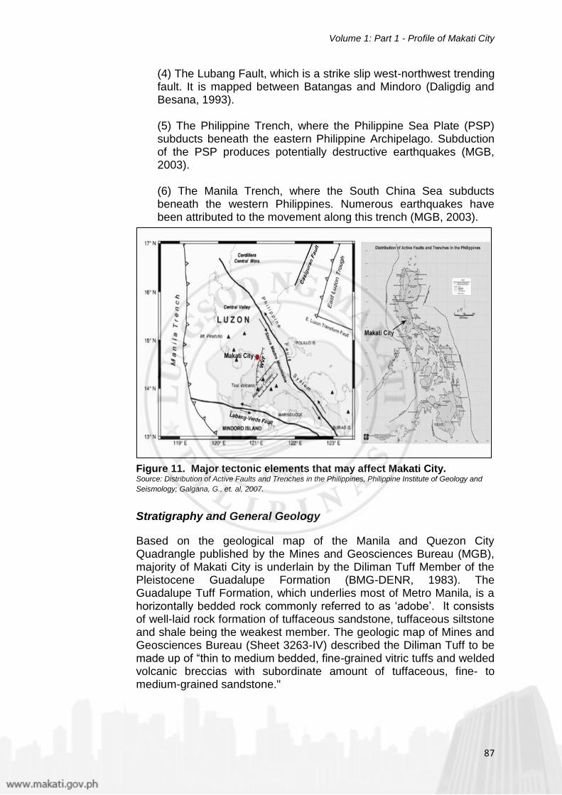
Volume 1: Part 1 - Profile of Makati City
87
(4) The Lubang Fault, which is a strike slip west-northwest trending fault. It is mapped between Batangas and Mindoro (Daligdig and Besana, 1993). (5) The Philippine Trench, where the Philippine Sea Plate (PSP) subducts beneath the eastern Philippine Archipelago. Subduction of the PSP produces potentially destructive earthquakes (MGB, 2003). (6) The Manila Trench, where the South China Sea subducts beneath the western Philippines. Numerous earthquakes have been attributed to the movement along this trench (MGB, 2003).
Figure 11. Major tectonic elements that may affect Makati City. Source: Distribution of Active Faults and Trenches in the Philippines, Philippine Institute of Geology and
Seismology; Galgana, G., et. al, 2007.
Stratigraphy and General Geology
Based on the geological map of the Manila and Quezon City Quadrangle published by the Mines and Geosciences Bureau (MGB), majority of Makati City is underlain by the Diliman Tuff Member of the Pleistocene Guadalupe Formation (BMG-DENR, 1983). The Guadalupe Tuff Formation, which underlies most of Metro Manila, is a horizontally bedded rock commonly referred to as „adobe‟. It consists of well-laid rock formation of tuffaceous sandstone, tuffaceous siltstone and shale being the weakest member. The geologic map of Mines and Geosciences Bureau (Sheet 3263-IV) described the Diliman Tuff to be made up of “thin to medium bedded, fine-grained vitric tuffs and welded volcanic breccias with subordinate amount of tuffaceous, fine- to medium-grained sandstone."

Volume 1: Part 1 - Profile of Makati City
88
Structural Geology
The nearest known active fault within the City is the West Valley Fault (Figure 12). This north to northwest trending fault extends from the town of Rodriguez, Rizal, up north, transects parts of eastern Marikina, and can be traced as far south as Tagaytay Ridge. Rimando, et al. (1996) documented the presence of ground ruptures with vertical and/or horizontal displacements situated in the Muntinlupa-San Pedro-Biñan area. He concluded that the systematic distribution and consistency of these ruptures with the master faults of the WVF were caused by the creeping movements along the WVF. Graduate students from the National Institute of Geological Sciences (NIGS) were able to delineate north-northeast trending fractures when they mapped the Ortigas-Pasig area (Anacio, 2000). These vertical displacements were attributed to the WVF.
Figure 12. Regional Geologic Map, Cross-section and Stratigraphy of the Study Area
Source: Geologic Map of Manila and Quezon City Quadrangle. Sheet 3263-IV. BMG-DENR, 1983.
1.6.2 Geologic Hazard
This assessment aimed to evaluate the geological environment of the area and to determine if there are possible geological hazards that could affect the different parts of the City.

Volume 1: Part 1 - Profile of Makati City
89
Tectonic Earthquakes Makati lies within a tectonically active region in the Philippines known as the Philippine Mobile Belt, and has experienced numerous destructive earthquakes in its recorded history. There are six (6) known tectonic earthquake generators affecting the area, namely (MGB, 2003 and Daligdig and Besana, 1993): (1) the Valley Fault System, (2) the Philippine Fault Zone, (3) the Lubang Fault, (4) the Casiguran Fault, (5) the Philippine Trench, and the (6) Manila Trench. The nearest active fault within the City is the West Valley Fault.
Ground Acceleration and Resonance
Makati‟s response to movements along the WVF is calculated based on the seismic activity attributed to the nearest earthquake generator as identified by PHIVOLCS and the type of material underneath the project site. Daligdig and Besana (1993) produced a deterministic PGA (Possible Ground Acceleration) distribution map of Metro Manila from a magnitude 7.5 earthquake generated from the Valley Fault System. It is estimated that alluvial deposits will have a ground acceleration of 0.60 to 0.80 g while rocks in the Guadalupe formation will have 0.20 to 0.60 g from a 7.5 magnitude earthquake generated by the Valley Fault system in Pasig City. PGA values for the City ranges from 0.20-0.60 in areas underlain by the Guadalupe Tuff in the central portion and 0.60-0.80 in areas underlain by Quaternary Alluvium adjacent to the floodplains of Pateros River and flat areas to the west near Manila Bay.
Figure 13. Possible ground acceleration in the project site generated by the Valley Fault System (VFS).
Source: Daligdig and Besana, 1993.

Volume 1: Part 1 - Profile of Makati City
90
Ground Rupture
Surface rupture or the breaking and movement of the ground along the active fault trace could result to horizontal or vertical shifting of the ground or a combination of both. The official trace of the Marikina Valley Fault System can be seen on the eastern portion of Makati City. This fault system cuts across Barangays East Rembo, West Rembo, Comembo, Pembo and Rizal in District II.
Figure 14. Trace of the Valley Fault within Makati City. Source: Philippine Institute of Volcanology and Seismology; Google Earth
Liquefaction and Differential Settlement Strong ground shaking caused by a high magnitude earthquake increases pore water pressures on the saturated subsurface causing the loose sand to expand. A subsurface made up of loose sand with the static water level near the ground level, is a typical subsurface susceptible to liquefaction. The result is to turn sand into a liquefied condition with an upward flow towards the surface which would consequently lead to differential settlement. Based on the PHIVOLCS Liquefaction Hazard Map, the potential for liquefaction in Makati ranges from low to none in areas underlain by the Guadalupe Tuff and moderate in areas underlain by Quaternary Alluvium. Areas of moderate hazard are mostly in District I, particularly, the west and northwestern region of Makati. These affect Barangays Kasilawan, Carmona, Singkamas, Tejeros, La Paz, San Antonio, Palanan and San Isidro and portions of Valenzuela, Olympia and Poblacion near the

Volume 1: Part 1 - Profile of Makati City
91
Pasig River. In District II, areas along the banks of Pateros River area also categorized as having moderate liquefaction hazard. The rest of Makati has low or no hazard due to liquefaction.
Figure 15. Liquefaction Hazards Map of Metro Manila
Source: Philippine Institute of Volcanology and Seismology
Mass Movement Makati is classified as having low susceptibility to landslide (Figure 16) according to a study done by Mines and Geosciences Bureau of DENR. However, mass movement may occur in areas with very steep and unprotected slopes produced by excavations and road cuts.
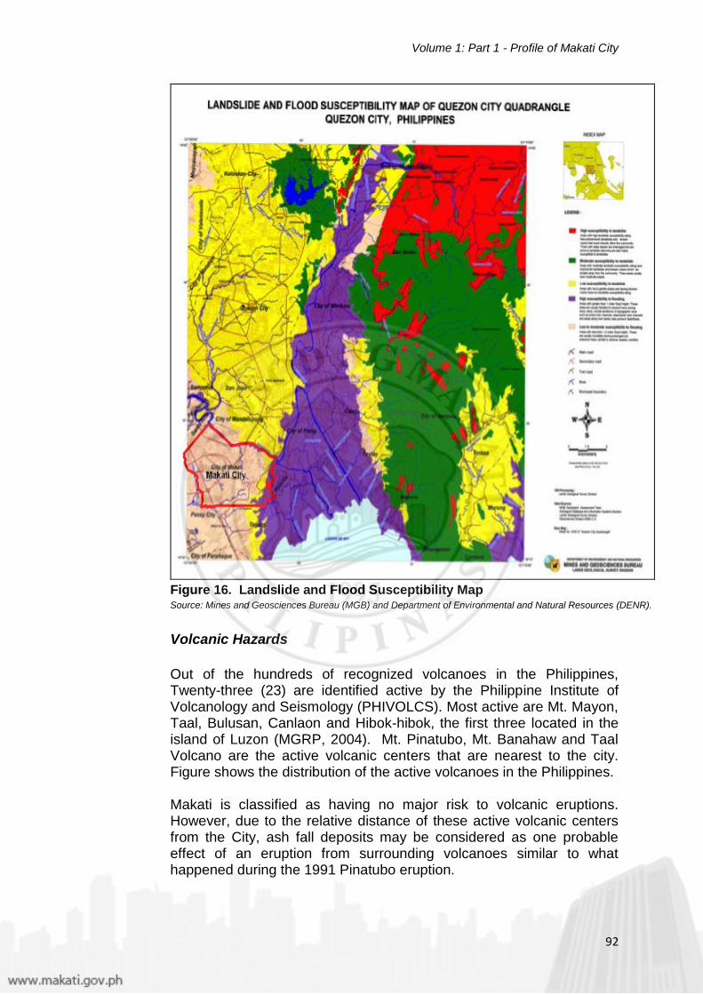
Volume 1: Part 1 - Profile of Makati City
92
Figure 16. Landslide and Flood Susceptibility Map Source: Mines and Geosciences Bureau (MGB) and Department of Environmental and Natural Resources (DENR).
Volcanic Hazards
Out of the hundreds of recognized volcanoes in the Philippines, Twenty-three (23) are identified active by the Philippine Institute of Volcanology and Seismology (PHIVOLCS). Most active are Mt. Mayon, Taal, Bulusan, Canlaon and Hibok-hibok, the first three located in the island of Luzon (MGRP, 2004). Mt. Pinatubo, Mt. Banahaw and Taal Volcano are the active volcanic centers that are nearest to the city. Figure shows the distribution of the active volcanoes in the Philippines. Makati is classified as having no major risk to volcanic eruptions. However, due to the relative distance of these active volcanic centers from the City, ash fall deposits may be considered as one probable effect of an eruption from surrounding volcanoes similar to what happened during the 1991 Pinatubo eruption.

Volume 1: Part 1 - Profile of Makati City
93
Figure 17. Map Showing the Distribution of Volcanoes in the Philippines Source: Philippine Institute of Volcanology and Seismology (PHIVOLCS)
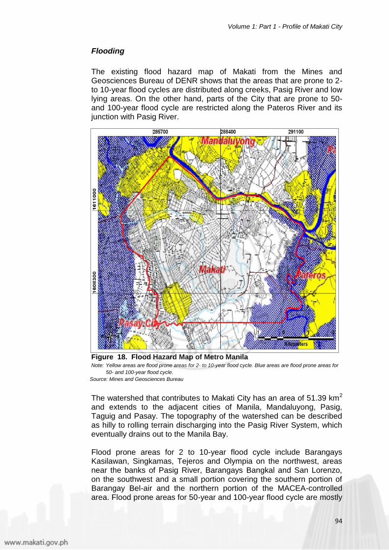
Volume 1: Part 1 - Profile of Makati City
94
Flooding
The existing flood hazard map of Makati from the Mines and Geosciences Bureau of DENR shows that the areas that are prone to 2- to 10-year flood cycles are distributed along creeks, Pasig River and low lying areas. On the other hand, parts of the City that are prone to 50- and 100-year flood cycle are restricted along the Pateros River and its junction with Pasig River.
Figure 18. Flood Hazard Map of Metro Manila Note: Yellow areas are flood prone areas for 2- to 10-year flood cycle. Blue areas are flood prone areas for
50- and 100-year flood cycle.
Source: Mines and Geosciences Bureau
The watershed that contributes to Makati City has an area of 51.39 km2 and extends to the adjacent cities of Manila, Mandaluyong, Pasig, Taguig and Pasay. The topography of the watershed can be described as hilly to rolling terrain discharging into the Pasig River System, which eventually drains out to the Manila Bay. Flood prone areas for 2 to 10-year flood cycle include Barangays Kasilawan, Singkamas, Tejeros and Olympia on the northwest, areas near the banks of Pasig River, Barangays Bangkal and San Lorenzo, on the southwest and a small portion covering the southern portion of Barangay Bel-air and the northern portion of the MACEA-controlled area. Flood prone areas for 50-year and 100-year flood cycle are mostly

Volume 1: Part 1 - Profile of Makati City
95
in the eastern portion of the City along Pateros River. Affected Barangays include West Rembo, East Rembo, Comembo , Pembo and Rizal.
Figure 19. Makati Watershed

Volume 1: Part 1 - Profile of Makati City
96
Simulations of Typhoon Ondoy was conducted using Flo-2D software. Flo-2D is a dynamic flood routing model that simulates channel flow, unconfined overland flow and street flow. The numerical simulation can track floods over complex topography and roughness while reporting on volume conservation; the key to accurate flood distribution. The model uses the full dynamic wave momentum equation and a central finite difference routing scheme with eight potential flow directions to predict the progression of a flood hydrograph over a system of square grid elements. The output maps include flood depth, flood velocity, and flood hazard.
Figure 20. Results of the Flo-2D simulation for Makati City
Flood occurrence is generally restricted to creeks and rivers except in western part of the City wherein sheet floods cover a large area due to the very low and flat topography. Flood depths in the western part ranges from 1-3 meters along the creeks and 0.15-1 meter for residential adjacent to these creeks. On the eastern part of the city, flood depths ranges from 1-3 meters along the Pateros River and 0.15-1 meter for a narrow area adjacent to the river. The deepest floodwaters are found along the Pasig River reaching above 6 meters. In the immediate vicinity of the Pasig River, flood depths ranges from 0.15-2 meters.

Volume 1: Part 1 - Profile of Makati City
97
1.6.3 Solid Waste Management
Based on garbage collection data from the Solid Waste Management Division (SWMD) of the Department of Environmental Services (DES) for the period 2006 – 2011, the volume of actual garbage collected has generally been declining at an average rate of 2.03%. It was only in 2008 that there was a positive (0.5%) increase in garbage collected and disposed.
The diversion rate of solid waste, on the other hand, has been increasing annually. Between 2006 and 2007, the diversion rate increased by 4.0%, the highest for the period. Makati has been able to comply with the mandatory diversion rate of 25% set in R.A. 9003 for the whole 6-year period. In 2011, the City achieved a waste diversion rate of 44%, the highest ever, since monitoring started in 2003. Table 68. Comparative Volume of Garbage Collection
Year
2006 2007 2008 2009 2010 2011
Actual Garbage
Collected and
Disposed (in cu. m.)
886,933 857,230 861,707 857,662 838,165 799,747
Volume of Garbage
Reduced (in cu. m.) 367,417 422,268 443,381 473,528 519,649 628,373
Target Rate (%) 24 30 33 34 36 36
Diversion Rate 29 33 34 36 38 44
Source: Department of Environmental Services
Over 41,225 apprehensions have been made between 2006 and 2011 in relation to City Ordinance 2003-095 or the Makati Solid Waste Management Code. The number of violators, however, has generally decreased despite fluctuations as a result of increases in 2008 (22.82%) and in 2010 (28.39%). It was, however, only in 2008 that there was a corresponding increase from the previous year in garbage collected and disposed. The following year, 2009, there was a 48% decrease in apprehensions, despite having recorded the lowest number of cases for the 6-year period at 5,686. This however, did not affect the positive trend in volume reduction from 2009 onwards (Table 69). Table 69. Number of Apprehended Violators of Solid Waste
Management Code
Year
2006 2007 2008 2009 2010 2011
No. of
Apprehended
Violators
10,416 8.912 10,946 5,686 7,300 6,868
% change -14.76% -14.44% 22.82% -48.05% 28.39% -5.92%
Source: Department of Environmental Services
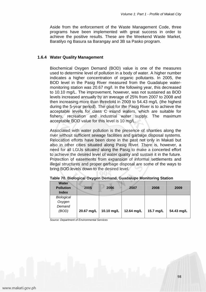
Volume 1: Part 1 - Profile of Makati City
98
Aside from the enforcement of the Waste Management Code, three programs have been implemented with great success in order to achieve the positive results. These are the Weekend Waste Market, Baratilyo ng Basura sa Barangay and 3B sa Pasko program.
1.6.4 Water Quality Management
Biochemical Oxygen Demand (BOD) value is one of the measures used to determine level of pollution in a body of water. A higher number indicates a higher concentration of organic pollutants. In 2005, the BOD level in the Pasig River measured from the Guadalupe water-monitoring station was 20.67 mg/l. In the following year, this decreased to 10.10 mg/L. The improvement, however, was not sustained as BOD levels increased annually by an average of 25% from 2007 to 2008 and then increasing more than threefold in 2009 to 54.43 mg/L (the highest during the 5-year period). The goal for the Pasig River is to achieve the acceptable levels for class C inland waters, which are suitable for fishery, recreation and industrial water supply. The maximum acceptable BOD value for this level is 10 mg/L. Associated with water pollution is the presence of shanties along the river without sufficient sewage facilities and garbage disposal systems. Relocation efforts have been done in the past not only in Makati but also in other cities situated along Pasig River. There is, however, a need for all LGUs situated along the Pasig to make a concerted effort to achieve the desired level of water quality and sustain it in the future. Protection of easements from expansion of informal settlements and illegal structures and proper garbage disposal are some of the ways to bring BOD levels down to the desired level. Table 70. Biological Oxygen Demand, Guadalupe Monitoring Station
Water
Pollution
Index
2005 2006 2007 2008 2009
Biological
Oxygen
Demand
(BOD) 20.67 mg/L 10.10 mg/L 12.64 mg/L 15.7 mg/L 54.43 mg/L
Source: Department of Environmental Services

Volume 1: Part 1 - Profile of Makati City
99
1.6.5 Air Quality Management
Based on the analysis of data from the Makati Pollution Control Office and DENR-EMB, the following can be said of the level of air pollution in Makati. TSP readings are monitored from the air quality monitoring station located along Ayala Avenue Extension corner Yakal Street in Brgy. San Antonio. Air quality recorded from 2006 to 2011 show that the highest TSP reading was registered in 2008 and 2010 at 158 ug/Ncm and the lowest was recorded in 2009 at 106 ug/Ncm. Significant drops were registered in 2006 (15.47%) and 2009 (32.91%). Despite this general improvement, the recorded figures exceed the long term standard for TSP of 90 ug/Ncm.
Table 71. Annual TSP Reading
2006 2007 2008 2009 2010 2011
TSP
Reading 153 141 158 106 158 132
%
change -15.47% -7.84% 12.06% -32.91% 49.06% 16.4%
Source: DENR-EMB, 2010
The number of apprehended smoke belchers is fluctuating from 2006 to 2011. Apprehensions decreased by as much as 14% from the base data of 8,785 apprehensions in 2005. The highest decrease was recorded in 2011 at 21%
Table 72. Apprehension of Smoke Belchers
2006 2007 2008 2009 2010 2011
Number of
apprehensions 7,520 6,461 6,662 6,704 6,595 5,214
% change -14.40% -
14.08% 3.11% 0.63% -1.63% -21%
Source: Makati Pollution Control Office, 2010
As the number of apprehensions went down from 2006 to 2007, TSP readings also went down suggesting a correlation between intensity of enforcement and TSP levels. The data shows that efforts against smoke-belching have attained some degree of success but still not enough to bring levels of TSP below the long-term-standard of 90ug/Ncm.

Volume 1: Part 1 - Profile of Makati City
100
Figure 21. Number of Apprehended Smoke Belchers and Annual TSP Levels
Based on a comparison of readings for periods May 2008 – November 2009 and May 2009 – October 2010, the monitoring station along Lawton Avenue in Barangay Cembo registered the highest PM10 readings. However, while 4 out of 5 stations recorded an increase in PM10 readings, only the Lawton Station recorded a decrease between the 2 periods (Table 73). Particulate matter in the City are mostly the result of the burning of fossil fuels and a factor of the volume of traffic the City generates as a financial center. To a certain degree commercial processes associated with its role as financial hub is also a contributing factor.
Table 73. Summary of Collected Data on PM10, by Station and
Period Covered
PM10 Readings
Station May2008 – November
2009
May 2009 – October
2010
% change
Pasong Tamo,
Sta. Cruz 62 65 4.84%
A.P. Reyes,
Carmona 64 94 46.88%
Kalayaan,
Pitogo 115 123 6.96%
Lawton Ave.,
Cembo 178 142 -20.22%
Comembo, JP
Rizal 116 130 12.07%
Source: DENR-EMB, 2010

Volume 1: Part 1 - Profile of Makati City
101
1.6.6 Urban Greening
One of the measures being undertaken by the City to arrest the rapid degradation of environmental quality brought about by industrialization and urbanization is through its urban greening program. This involves an integrated citywide green system to help reduce noise and air pollution, as well as provide for recreation and aesthetic enhancement to help improve the quality of life of the City‟s constituents. At present, there are 12 parks being monitored by the Parks and Green Division of the Department of Environmental Services with a total land area of approximately 8 hectares. The division also maintains four (4) plant nurseries for its tree planting activities. Since the tree planting activities started in 2002, 90,146 trees have been inventoried by the division giving a tree to person ratio of 1:7. This is still well below the standard tree to person ratio of 1:4 which at present is not met by the City due to the lack of space for greening. Table 74. Inventory of Parks
Park Land Area (sq.m)
Magallanes Interchange Park 25, 349
Buendia Plaza 3,316
Makati Park and Garden 35, 433
Poblacion Park 2,876
Kenken Lacia Binay Park 4,033
Guadalupe Viejo Park 1,484
Freedom Park 953
Pinagkaisahan Underpass Park 265
EDSA Buendia Park 1,022
Guadalupe Nuevo Linear Park 2,415
Valenzuela Linear Park 1,611
Makati DES Linear Park 3,672
Total 82,429
Source: Department of Environmental Services, 2010
1.7 PUBLIC FINANCE
Makati is among the top three income grossing LGUs of the country, ranking first during the last six (6) years (2005-2010). Its main challenge is to sustain its revenue growth rate through improved tax base identification and assessment efforts and effecting more development investments – both hard infrastructure and accompanying soft capital investments – to keep up with population growth, inflation, and most importantly with the competitive pressures exerted by emerging business districts in Metro Manila and other key regional growth centers in the country.
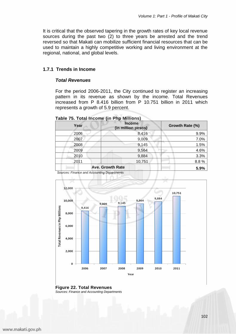
Volume 1: Part 1 - Profile of Makati City
102
It is critical that the observed tapering in the growth rates of key local revenue sources during the past two (2) to three years be arrested and the trend reversed so that Makati can mobilize sufficient financial resources that can be used to maintain a highly competitive working and living environment at the regional, national, and global levels. 1.7.1 Trends in Income
Total Revenues For the period 2006-2011, the City continued to register an increasing pattern in its revenue as shown by the income. Total Revenues increased from P 8.416 billion from P 10.751 billion in 2011 which represents a growth of 5.9 percent.
Table 75. Total Income (in Php Millions)
Year Income
(in million pesos) Growth Rate (%)
2006 8,416 9.9%
2007 9,009 7.0%
2008 9,145 1.5%
2009 9,564 4.6%
2010 9,884 3.3%
2011 10,751 8.8 %
Ave. Growth Rate 5.9% Sources: Finance and Accounting Departments
Figure 22. Total Revenues Sources: Finance and Accounting Departments

Volume 1: Part 1 - Profile of Makati City
103
Figure 23. Growth Rates, Total Revenues Sources: Finance and Accounting Departments
Revenues by Source During the six (6) year period (2006-2011), City License/Business Taxes and Real Property Tax topped the main sources of revenue which represents 43.9 percent and 39.1 percent, respectively. Operating and Miscellaneous Revenues (8.7 percent), Internal Revenue Allotment (6.5 percent), and Other Sources (1.8 percent) composed the sources of City‟s revenue include interest income, dividend income, borrowings, and gains on disposed assets. City License/Business Tax sustained its growth for the entire period as shown in the Table 76. The adherence to the strict implementation of the Makati Revised Revenue Code and monitoring of all business establishments are the contributory factors in the increased collection of business taxes. It was in 2009 that RPT declined its revenue due to the effects of the global financial crisis resulting to difficulty of taxpayers to pay taxes due on their properties. Other reasons were the non-payment of some big accounts and returned notices of delinquency that were not received by recipients for some reasons. Operating and Miscellaneous Revenues (composed of Economic Enterprises, Property Transfer, Other Taxes, Miscellaneous Fees and Charges) declined from 2008 to 2010. It is significant to note that the City places much emphasis on social services compared to economic enterprises. One of the contributory factors for the decline was when the amended RA 7160 section 140 took effect in September 2009 which reduces the collection of amusement tax from 30 percent to 10 percent, respectively. On the contrary, significant increase was recorded in 2011 which represents a 6.7 percent.
Volume 1: Part 1 - Profile of Makati City
104
Compared, however, to other LGUs, it is also worth noting that the City is not dependent on the Internal Revenue Allotment (IRA) from the national government because it has the capability to generate revenues for its internal source. Based on the 2011 data of the Commission on Audit‟s (COA) top three cities in the Philippines (Makati City, Manila and Quezon City), Manila and Quezon City have both substantial IRA share from the national government. In contrast to Manila (P 1.9 billion or 25.1 percent) and Quezon City (P 2.93 billion or 25.3 percent), Makati‟s IRA constitutes only 7.4 percent of its total income in the amount of P793.25 million only.
Table 76. Revenues by Source (in Php Millions)
Source 2006 2007 2008 2009 2010 2011 Average
Share to Total (2002-2011)
City License 3,229 3,519 4,032 4,421 4,532 5,187 43.9
Real Property Tax (RPT) * 3,683 3,813 3,539 3,657 3,720 3,832 39.1
Operating & Miscellaneous Fees ** 836 990 784 741 758 809 8.7
Internal Revenue Allotment 436 558 540 628 731 793 6.5
Other Sources*** 232 129 250 117 143 130 1.8
TOTAL 8,146 9,009 9,145 9,564 9,884 10,751 100.0 Sources: Finance and Accounting Departments *Includes Basic, Barangay and SEF **Includes income/collection from Economic Enterprises, Property Transfer, Other Taxes, Miscellaneous Fees and Charges ***Includes Dividend Income, Interest Income and Income from Gains on Sale of Disposed Assets

Volume 1: Part 1 - Profile of Makati City
105
Figure 24. Revenues by Source Sources: Finance and Accounting Departments
Figure 25. Average Share to Total Revenues, By Source Sources: Finance and Accounting Departments.

Volume 1: Part 1 - Profile of Makati City
106
1.7.2 Trends in the Assessed Value of Real Properties
During the five-year period (2007-2011), the total assessed value of Real Property Units (RPUs) has been increasing yearly by an average of 4.0 percent from Php 151.51 billion in 2007 to 176.97 in 2011. Commercial and Residential had the largest share to total assessed value. In terms of growth rate, Residential/Commercial registered the highest average growth rate for the period 2007 to 2011 at 7.6 percent followed by Residential (5.5 percent) and Commercial (4.6 percent).
Table 77. Assessed Value of Real Property Units (RPUs), (in Php Billion)
RPU Type 2007 2008 2009 2010 2011
Commercial 91.57 97.4 103.11 103.22 106.46
Industrial 4.88 3.01 4.25 4.12 4.05
Residential 43.96 45.68 47.6 48.89 54.36
Residential/Commercial 2.95 4.25 3.09 3.5 3.51
Special 1.66 1.66 1.66 1.71 1.64
Exempted 6.49 6.88 6.99 7.02 6.95
Total 151.51 158.87 166.7 168.45 176.97
Source: Assessment Department
Table 78. Growth Rates in Assessed Value of Real Property Units (RPU)
RPU Type 2008 2009 2010 2011 Ave.
Commercial 6.40% 5.90% 0.10% 3.10% 3.90%
Industrial -38.30% 41.20% 0.10% -1.70% 0.30%
Residential 3.90% 4.20% 2.70% 11.20% 5.50%
Residential/Commercial 44.10% -27.30% 13.30% 0.30% 7.60%
Special 0.00% 0.00% 3.00% -4.10% -0.30%
Exempted 6.00% 1.60% 0.40% -1.00% 1.80%
Total 4.90% 4.90% 1.00% 5.10% 4.00% Source: Assessment Department
The total assessed value of real properties from 2007-2011 grew at an average annual growth rate of 4.0 percent. The continuing increase in the assessed value of real properties may be attributed to continuous tax mapping and field operation efforts of the Assessment Department. In 2011, the total assessed value of Real Properties amounted to Php 176.97 million.

Volume 1: Part 1 - Profile of Makati City
107
1.7.3 Trends in Expenditures
Total Expenditures Despite the huge investments in the delivery of public services, the City assures of that no budget deficits had incurred. For the year 2006 to 2011, Makati City significantly registered an upward trend in its spending. From P 7.708 billion in 2006, it rose to P 8.256 billion in 2011. Expenditure patterns showed that the City invested more on General Public Services, Infrastructure, Education, and Health.
Table 79. Total Expenditures
Year Expenditure Growth Rate (in million pesos)
2006 7,708 18.10%
2007 9,391 21.83%
2008 6,641 -29.30%
2009 7,092 6.80%
2010 8,177 15.30%
2011 8,256 0.97%
Ave Growth Rate 5.6% Source: Accounting and Budget Departments
Figure 26. Total Expenditures Source: Accounting and Budget Departments

Volume 1: Part 1 - Profile of Makati City
108
Figure 27. Growth Rates, Total Expenditures Source: Accounting and Budget Departments
Expenditures by Service In terms of expenditure by service, General Public Service accounted for the largest expenditure which represents 21.3 percent for the period 2006- 2011. This is followed by Infrastructure (19.4%), Education (18.2%), Health (14.1%), and Other Purposes (11.4%). Relatively smaller shares were recorded for Environment (6.8%), Protective Services (4.0%), Social Welfare (2.5%), and Economic Services (2.2%).
Table 80. Expenditures by Sector (In Php Million)
Service 2006 2007 2008 2009 2010 2011 Ave.
Growth Rate%
General Public Service
1,299 1,710 1,726 1,870 1,597 1,887 21.3
Education 1,449 1,445 1,364 1,581 1,312 1,473 18.2
Health 788 840 1,067 1,190 1,308 1,491 14.1
Social Welfare
124 160 191 234 216 235 2.5
Environment 485 518 526 551 541 585 6.8
Infrastructure 1,659 2,304 910 826 1,817 1,632 19.4
Protective Services
381 322 309 277 316 308 4.0
Economic Services
188 187 183 144 160 180 2.2
Other Purposes
1,335 1,905 365 419 910 465 11.4
TOTAL 7,708 9,390 6,641 7,092 8,177 8,256 100.0
Source: Accounting and Budget Departments, 2011, as stated in Finance Management Report, page 6. *Includes expenditure of Offices of the Mayor and Vice-Mayor, City Council, Departments/Offices under the Administrative Services Sector, and Assistance to National Government offices based in Makati, e.g., Police, Fire, Jail, Courts, etc. **Includes loan amortization, interest payments and prior year obligations.
Volume 1: Part 1 - Profile of Makati City
109
Figure 28. Expenditures by Service Source: Accounting and Budget Departments.
Figure 29. Average Share to Total Expenditures by Sector Source: Accounting and Budget Departments

Volume 1: Part 1 - Profile of Makati City
110
1.7.4 Trends in Budget Utilization Budget and Obligations Actual obligations accounted for 86 to 50 percent of the approved budget for the period 2007 to 2011.
Table 81. Approved Budget vs. Actual Obligations/Expenditures (in Million Pesos)
Item 2007 2008 2009 2010 2011
Approved Budget 7,794.00 8,058.00 8,550.00 8,430.00 16,643.50
Actual Obligations/ Expenditures
6,694.00 6,910.34 6,717.89 6,571.95 8,256.40
Actual Obligations/ Expenditures as % of Approved Budget
85.90% 85.80% 78.60% 78.00% 49.61%
Source: Finance Department
Table 82. Approved Budget vs. Actual Obligations/Expenditures (in Million Pesos)
Source: Finance Department and Annual Outcome Evaluation Report 2011 – Finance Management
Sector Approved Budget (Estimated Expenditure)
Actual Obligations /Expenditure
2008 2009 2010 2011 2008 2009 2010 2011
Administrative Services 2,827.13 2,941.64 2,770.27 3,811.69 2,482.91 2,311.31 2,047.90 2,221.44
Economic Development 32.65 36.03 36.86 37.1 21.93 23.86 22.973 25.6
Finance Management 176.96 181.47 192.66 204.51 110.17 112.16 125.163 142.89
Social Development:
Health Sub-sector 1,050.35 1,177.91 1,638.22 2,341.34 938.13 1,026.80 1,222.61 1,454.54
Education Sub-sector 291.83 307.84 350.57 402.04 220.37 219.98 319.25 304.81
Social Welfare Sub-sector
131.75 144.28 130.4 167.19 88.71 93.22 98.52 117.99
Special Education Fund
1,350.00 1,400.00 1,280.00 1,450.00 1,237.62 1,259.52 1,019.04 1,161.23
Infrastructure Development 723.17 287.85 300.32 6,141.65 653.39 195.02 202.08 1,306.65
Protective Services 315.88 299.76 326.85 356.26 211.46 273.47 284.54 298.36
Environmental Management 573.73 609.67 614.3 635.22 526.34 552.42 541.37 584.25
Statutory & Contractual Obligations
584.56 1,163.55 789.55 1,096.50 419.32 650.13 688.5 638.64
Total 8,058.00 8,550.00 8,430.00 16,643.50 6,910.34 6,717.89 6,571.95 8,256.40

Volume 1: Part 1 - Profile of Makati City
111
Budgetary Allocation by Sector Over the past six (6) years, the largest share for budget allocation has been given to Administrative Services Sector (31.2 percent) by Education, Culture and the Arts Sub-sector (18.6 percent), Statutory and Contractual Obligations (13.5 percent), and the Health Subsector (12.5 percent).
Table 83. Budgetary Allocation by Sector
Sector 2006 2007 2008 2009 2010 2011 Ave.
Administrative Services
26.60% 32.20% 36.70% 35.50% 33.50% 22.90% 31.2%
Economic Development
0.30% 0.40% 0.40% 0.40% 0.40% 0.22% 0.4%
Environmental Management
7.40% 7.20% 7.10% 7.10% 7.30% 3.82% 6.7%
Finance Management
2.40% 2.70% 2.20% 2.10% 2.30% 1.23% 2.2%
Infrastructure Development
2.40% 2.60% 9.00% 3.40% 3.60% 36.90% 9.7%
Protective Services
4.10% 3.70% 2.80% 2.80% 3.20% 2.14% 3.1%
Social Development
Education, Culture and the Arts Sub-sector
20.50% 20.30% 20.40% 20.00% 19.30% 11.13% 18.6%
Health Sub-sector
9.40% 10.90% 12.50% 13.80% 19.40% 14.07% 13.3%
Social Welfare Sub-sector
1.10% 1.20% 1.60% 1.70% 1.60% 1.00% 1.4%
Statutory and Contractual Obligations
25.80% 18.90% 7.30% 13.20% 9.40% 6.59% 13.5%
Total 100.00% 100.00% 100.00% 100.00% 100.00% 100.00% 100.0%
Source: Finance Department
Budgetary Allocation by Expense Class In terms of budget by expense for General Fund and Special Education Fund (SEF), Maintenance and Other Operating Expenses (MOOE) registered the largest budgetary allocation. For the General Fund, Personal Services and MOOE registered an increasing pattern. For MOOE, the trend is due to significant allocations for the Special Activities Fund (SAF) of the Office of the Mayor, medical, dental and laboratory supplies of Ospital ng Makati, and other professional services requirements.

Volume 1: Part 1 - Profile of Makati City
112
Also, MOOE of the SEF exhibited a generally increasing trend of allocations.
Table 84. Budgetary Allotment by Expense Class
Source: Budget Department
Budget Utilization Rate By Expense Class It is noteworthy that Capital Outlay achieved 100 percent utilization rate in 2009 and 2010 under the General Fund, and in 2006, 2008 and 2009 under the Special Education Fund (SEF). However, the least expense in 2011 went to Capital Outlay (20.78 percent) under General Fund. Meanwhile PYO registered the least expenses with 8.37 percent under SEF. Table 85. Budget Utilization Rate by Expense Class
Particulars 2006 2007 2008 2009 2010 2011 Ave.
General Fund (FG)
Personal Services 77.50% 76.80% 77.40% 69.80% 72.60% 75.42% 74.92%
MOOE 86.10% 86.50% 83.60% 75.30% 76.40% 73.17% 80.20%
Capital Outlay 97.20% 98.30% 96.60%
100.00% 100.00% 20.78% 85.50%
Financial Expenses 62.80% 62.80%
SEF
Personal Services 83.10% 88.60% 87.20% 90.60% 85.90% 85.65% 86.80%
MOOE 88.40% 88.10% 90.00% 86.50% 86.90% 90.35% 88.40%
Capital Outlay 100.00% 68.90% 100.00%
100.00% 65.60% 37.30% 78.60%
PYO 8.37% 8.37% Source: Budget Department
Particulars 2006 2007 2008 2009 2010 2011
General Fund (GF)
Personal Services 27.40% 28.00% 28.40% 28.80% 33.50% 18.58%
MOOE 36.00% 38.90% 43.80% 45.70% 51.40% 30.08%
Capital Outlay 10.8 14.20% 20.50% 12.30% 5.70% 51.34%
Statutory 25.80% 18.90% 7.30% 13.20% 9.40%
Financial Expenses - - 0.10% 0.10% - 0.00%
Special Education Fund (SEF)
Personal Services 13.30% 13.90% 19.20% 13.30% 17.50% 15.91%
MOOE 63.00% 61.10% 65.30% 65.10% 74.40% 66.55%
Capital Outlay 23.70% 25.10% 20.60% 21.60% 8.10% 17.54%

Volume 1: Part 1 - Profile of Makati City
113
Budget Utilization Rate by Sector
High utilization rates were observed in the Environmental Management (87.6 percent), Health Subsector (85.2 percent), Infrastructure (82.2 percent), and Protective Services (80.1 percent).
Table 86. Budget Utilization Rate by Sector
Sector / Service
2006 2007 2008 2009 2010 2011 Ave.
Administrative Services 86.70% 83.20% 87.40% 78.60% 73.90% 58.28% 78.01%
Economic Development 66.90% 68.00% 67.20% 66.20% 62.30% 67.57% 66.40%
Environmental Management 93.00% 92.20% 91.70% 90.60% 88.10% 69.61% 87.50%
Finance Management 78.40% 73.60% 62.30% 61.80% 65.00% 62.11% 67.20%
Infrastructure Development 96.10% 92.30% 90.40% 67.80% 67.30% 79.16% 82.20%
Protective Services 81.30% 84.30% 66.90% 90.90% 87.10% 70.06% 80.10%
Education, Culture & the Arts Sub-sector 88.90% 82.10% 88.80% 86.60% 82.10% 21.27% 75.00%
Health Sub-sector 89.70% 86.80% 89.30% 87.20% 74.60% 83.71% 85.20%
Social Welfare Sub-sector 74.00% 75.10% 67.30% 64.60% 75.60% 91.97% 74.80%
Statutory and Contractual 81.80% 90.80% 73.80% 55.90% 87.20% 58.21% 74.60% Source: Budget Department
1.8 LOCAL INSTITUTIONAL DEVELOPMENT
Good and responsive governance primarily rests on the three (3) pillars: a) efficiency, b) effectiveness, and c) economy. This study on the institutional sector highlights the local bureaucracy‟s capacity to absorb the ever-escalating demand and expectations to provide quality services to its clientele, which is the general public. 1.8.1 The City Bureaucracy
Makati has a large and complex bureaucracy as shown in Figure 30. It is comprised of various offices and departments that perform administrative, economic, environmental, finance management, infrastructure, protective and social functions. In addition, there are four (4) national government agencies operating in the City.

Volume 1: Part 1 - Profile of Makati City
114
The City employs a large number of personnel (8,490 as of year 2011) in either regular, casual, contractual or job order basis. Regular and casual employees numbered the most in any given year for the period 2006-2011. There were also those who receive their salary from the Special Education Fund. Of the 4,027 regular personnel, about 94.7% or 3,815 of these hold permanent positions, 48 are temporarily hired, 20 are elected officials, and 144 hold tenure co-terminus with the Local Chief Executive. The Department of Environmental Services (DES) has the biggest personnel complement with 654 employees, followed by the Public Safety Department with 402 personnel, and the Ospital ng Makati with 336 people. This reflects the important service delivery functions of these departments, as well as the development priorities of Makati City. With a population numbering at 529,039 as of the latest census (2010), the civil servant to population ratio of Makati City stands at 1:66, interpreted as one (1) civil servant for every 66 residents. This is the same with that of Singapore‟s 1:66 ratio – computed as 5,076,700 population over 76,000 civil servants.5 Be that as it may though, there is still a need to reinforce Makati‟s bureaucracy, especially taking into account its growing population and anticipated developments. In light of recent developments, i.e., the passage of Republic Act 10121 or what is known as the Philippine Disaster Risk Reduction and Management Act of 2010, there is a need to establish a new office under the Office of the Mayor, the City Disaster Risk Reduction and Management Office, and provide for its corresponding staff. At present, only a little more than half of the total plantilla positions available are filled-up. In fact, there are still 3,186 vacant positions as of the end of the year 2011. Of these, 630 vacancies are indicated under the Public Safety Department, 504 under the University of Makati and 465 under the DES. These numbers can be attributed to reasons such as plantilla positions were still based on the year 1986 and these positions were not filled up and resorted to hiring on casual employees basis due to civil service eligibility concerns. To answer these concerns, the Human Resource and Development Office is in the process of reviewing and re-organizing the plantilla positions that best fit the current need of the City.
5 Source: Public Service Division, Singapore
Volume 1: Part 1 - Profile of Makati City
115
Office of the Vice Mayor
SangguniangPanlungsod
Office of the Sangguniang
Panlungsod Secretary
Makati Action Center
Liga ng mga Barangay
University of Makati
Ospital ng Makati
Department of Interior and Local Government
Dep-Ed Makati
Makati Fire Department
Makati Police Department
Makati City Jail
Human Resource Development Office
Civil Registration Office
Internal Management Control Office
Internal Relations Department
Economic Enterprise Management Office
Makati Cooperative Development Office
Makati Public Employment Services
Office
Urban Development Department
Information and Community Relations Department
Law Department
General Services Department
Veterinary Services
Office
Museum and Cultural Affairs
Office
Makati Health
Department
Makati Social Welfare
Department
Youth and Sports Development Department
Education Department
SK Federation
Office
Office of the Senior Citizens Affair
Makati Tourism Office
Finance Department
Accounting Department
Assessment Department
Budget Department
Business Permits Office
Office of the Building Official
Department of Engineering and Public Works
Department of Environmental Services
Public Safety
Department
Makati Command, Control and Communication Center
Makati Rescue
Office of the Mayor
Office of the City Administrator
ADMINISTRATIVE SERVICES
ECONOMIC DEVELOPMENT
ENVIRONMENTAL MANAGEMENT
FINANCE MANAGEMENT
INFRASTRUCTURE DEVELOPMENT
SOCIAL DEVELOPMENT
PROTECTIVE SERVICES
Figure3.1.1.1. Makati City Government Organizational Chart
Makati Health
Program
Figure 30. Makati City Government Organizational Chart Source: DP 101- Development Planning in Makati: Innovation in Action

Volume 1: Part 1 - Profile of Makati City
116
Figure 31. Number of Employees by Status of Appointment Source: Human Resource Development Office (HRDO)

Volume 1: Part 1 - Profile of Makati City
117
Table 87. Regular Personnel Complement and Employment Status
Off
ice
s
To
tal
Pla
nti
lla
Po
sit
ion
s
Ele
cte
d
Te
mp
ora
ry
Pe
rma
ne
nt
Co
-te
rmin
us
Va
ca
nt
To
tal
Fille
d-
Up
Po
sit
ion
s
Accounting Department 65 - - 42 - 23 42
Budget Department 32 - - 23 - 9 23
University of Makati (UMak) 834 - - 330 - 504 330
Business Permit Office (BPO) 115 - - 74 - 41 74
City Administrator's Office (CAO) 12 - - 5 - 7 5
Office of the City Mayor 35 1 - 18 8 8 27
Economic Enterprises
Management Office (EEMO)
53 - - 31 - 22 31
Education Department 414 - - 257 - 157 257
Human Resource Development
Office (HRDO)
55 - - 32 - 23 32
Information and Community
Relations Department (ICRD)
40 - - 14 - 26 14
Internal Management Control
Office (IMCO)
32 - - 13 - 19 13
International Relations
Department (IRD)
52 - - 3 - 49 3
Liga ng mga Barangay 15 - - 9 - 6 9
Makati Cooperative Development
Office (MCDO)
28 - - 18 - 10 18
Museum and Cultural Affairs
Office (MCAO)
38 - - 7 - 31 7
Ospital ng Makati (OsMak) 479 - 44 292 - 143 336
Makati Social Welfare
Department (MSWD)
105 - - 90 - 15 90
Office of the Sangguniang
Panlungsod (SP)
108 18 - - 90 - 108
Office of the Sangguniang
Panlungsod Secretary
21 - - 2 - 19 2
Urban Development Department
(UDD)
76 - - 39 - 37 39
Veterinary Services Office (VSO) 36 - - 7 - 29 7
Assessment Department 92 - - 61 - 31 61
Finance Department 144 - - 94 - 50 94
Law Department 121 - - 40 - 81 40
Youth and Sports Development
Department (YSDD)
222 - - 114 - 108 114
Office of the City Building Official
(OBO)
89 - - 69 - 20 69
City Civil Registration Office
(CCRO)
55 - - 36 - 19 36
Office of the City Vice Mayor 65 1 - 17 46 1 64
Department of Engineering and
Public Works (DEPW)
331 - - 259 - 72 259
Public Safety Department (PSD) 1032 - - 402 - 630 402
Makati Health Department
(MHD)
444 - - 336 - 108 336
Department of Environmental
Services (DES)
1119 - 4 650 - 465 654
Makati Action Center (MAC) 407 - - 167 - 240 167
General Services Department 447 - - 264 - 183 264
TOTAL 7,213 20 48 3,815 144 3,186 4,027
Source: Human Resource Development Office (HRDO)

Volume 1: Part 1 - Profile of Makati City
118
Figure 32. Personnel Complement Source: Human Resource Development Office (HRDO)
In terms of educational attainment, most of the employees of the City Government are college graduates. While there are also some who were not able to finish secondary education, there were also a few who hold doctorate degrees (Figure 25). As per the latest (2011) Situational Analysis of the Administrative Services Sector of Makati City, all personnel are qualified in terms of education, training hours and eligibility standards of the Civil Service Commission. The City Government has always been vigilant in its verification of personnel supplied information to ensure that only qualified personnel will be placed in appropriate positions.

Volume 1: Part 1 - Profile of Makati City
119
Figure 33. Number of Employees by Educational Attainment Source: Human Resource Development Office (HRDO)
1.9 EXISTING LAND USE AND LAND USE TRENDS 1.9.1 Existing Land Use
Makati has been widely accepted as Metro Manila‟s Financial Center. Although it is known for hosting many financial institutions, corporate headquarters, and shopping complexes, the City‟s major land use based on land area and excluding roads is still residential. The two (2) other major land uses are special mixed - use and commercial.

Volume 1: Part 1 - Profile of Makati City
120
Table 88. Land Use Distribution 1998 and 2012 (Square Kilometer)
Land Use 1998 2012 1998-2011
Area % Area % Area %
Residential 10.31 37.69 9.57 34.97 -0.74 -7.20
Commercial 4.16 15.22 4.06 14.83 -0.10 -2.48
Industrial 0.39 1.41 0.02 0.08 -0.37 -94.59
Institutional 3.9 14.24 0.85 3.10 -3.05 -78.28
Recreational 1.58 5.77 1.00 3.65 -0.58 -36.84
Parks and Open Space
0.34 1.25 0.31 1.12 -0.03 -9.71
Cemetery 0 0 0.87 3.17 0.87 100.00
Utility 0 0 0.12 0.45 0.12 100.00
Special Mixed-Use
0 0 4.00 14.60 4.00 100.00
Government Center Zone
0 0 0.07 0.26 0.07 100.00
Riverside Development Zone
0 0 0.06 0.20 0.06 100.00
Roads 6.68 24.41 6.45 23.57 -0.23 -3.44
TOTAL 27.36 100 27.36 100
Based on the Land Use Plan 2001-2011 adopted in 2001, residential areas accounted for the largest land use in Makati City, accounting for slightly more than one-third (34.97%) of the total land area. Special Mixed-Use and Commercial Uses rank next at 14.60% and 14.83% respectively. The rest of Makati‟s land area is shared by institutional, recreational, parks and open spaces, cemetery, government center, and Riverside Development. Roads comprised 23.57% of the total land area.
1.9.2 Land Use Trends
Land use trends observed in the City for the past ten (10) years include the following:
Increase in commercial areas. Much of the new developments in the last ten years have occurred in areas that were converted into commercial/mixed-use in the 2001 Zoning Ordinance. High-density developments have accelerated in such commercial/ mixed-use areas as Bonifacio Global City, the new development areas in Barangay Post Proper South Side, and the strip along Chino Roces Avenue. The lands in the former military camp Fort Bonifacio that were converted from military use to commercial/ mixed-use in the 2001 Land Use Plan account for most of the new high density developments. However, the traditional commercial areas in the Poblacion (Makati Avenue area), the CBD and commercial areas around it have also experienced intensified building densities following the FAR provisions of the 2001 Zoning Ordinance. Moreover, areas recognized as having high real estate potential

Volume 1: Part 1 - Profile of Makati City
121
(e.g. South Bonifacio, North Bonifacio, and Santa Ana Race Track) have been identified for redevelopment.
Increase in High-Density Residential Buildings. The presence of enormous economic opportunities in the City has created a demand for more residential units. Land allocated for residential use, however, has remained constant because of the limited land left for conversion. Most of the new residential units introduced in the last ten years have been provided by high-rise residential buildings that have maximized allowed Floor Area Ratios (FAR) of properties. Most of these high-rise residential buildings cater to the middle-to-high income brackets and are situated in or adjacent commercial/mixed-use zones.
Decreasing manufacturing activities. Policies in the 2001 Comprehensive Land Use Plan called for the easing out of industries by prohibiting expansion/improvement of remaining factories until they ultimately convert to commercial, or mixed-use. In the last ten years, many of the facilities (e.g., lots along Chino Roces Avenue) that were related to manufacturing have already started conversion to higher density mixed-use developments to capitalize on their sizeable parcels and strategic location.
Limited open spaces and multi-purpose barangay halls. There are limited opportunities for parks and open spaces for residential communities outside of the gated residential enclaves. The most significant open space for the general public is the linear park along Pasig River made possible by the enforcement of river easements. Many of the barangays that have limited or no areas for open spaces and recreation have resorted to multi-purpose barangay halls that include covered basketball courts at the top floor. Aside from serving as neighborhood breathing spaces, open spaces serve as staging areas/evacuation spaces during disasters (e.g., earthquakes, fires).
Increasing mix of land uses. One of the principles of Smart Growth city planning is the mix of land uses to create more compact communities that avoid long distance travel between homes and places of work. The 2001 Zoning Ordinance created many such commercial/mixed-use developments that promoted urban but more sustainable lifestyles. Aside from the large planned unit developments (e.g. Bonifacio Global City, McKinley Hill, Rockwell), the 2001 Zoning Ordinance identified other mixed-use zones which allow blocks and individual lot owners to mix residential with commercial.
Increasing building densities. The rationalized prescription on building densities of the 2001 Zoning Ordinance showed the building potential of the lots in the City. The increasing demand for specific land uses and floor spaces served as the impetus for redevelopment of under-utilized parcels to maximize building

Volume 1: Part 1 - Profile of Makati City
122
potential. This resulted in unprecedented building heights not only in the Central Business District, the Bonifacio Global City, along main thoroughfares (e.g. Makati Avenue, Chino Roces Avenue), but also in barangays that were traditionally residential prior to the 2001 Comprehensive Land Use Plan.
The existing and emerging land uses are actually the continuation of a steadily increasing demand for service-oriented land uses that was being experienced in the period even before the formulation of the 2001-2011 Comprehensive Land Use Plan. Land values and densities have further appreciated as the demand for space increased in a city with a finite supply of undeveloped land. The CBD remains the primary influence in the use and value of land in the City. Connecting seamlessly to other centers of commercial activity such as towards the riverfront (e.g., Makati City Hall, Rockwell) and the Bonifacio Global City has not been completely achieved as connecting roads could not be widened. The Bonifacio Global City and areas around it have the biggest inventory of vacant parcels that will likely experience intense development in the next ten years.

Volume 1: Part 1 - Profile of Makati City
123
Fig
ure
34. M
akati
Cit
y 1
998
La
nd
Use
Ma
p

Volume 1: Part 1 - Profile of Makati City
124
F
igu
re 3
5. E
xis
tin
g L
an
d U
se M
ap
, 2
01
2

Volume 1: Part 1 - Profile of Makati City
125
1.9.3 Land Use Distribution
The distribution of land uses throughout the City‟s barangays is shown in Tables 88 to 91. Table 88 shows the land use by barangay while Table 89 shows the corresponding shares of each land use category in every barangay. On the other hand, Tables 90 and 91 show the land use concentration and specialization (%), respectively.
Residential land accounted for more one third or 35% of the total land area in the City followed by commercial land at 15%.
On land use concentration (for residential) as shown in Table 90, Dasmariñas and Forbes Park accounted for 14.45% and 15.07%, respectively.
Post Proper Northside and Post Proper Southside, accounted for the bulk of the total special mixed-use in the City. (Table 90)
Barangays San Lorenzo, Bel-Air and Bangkal are dominated by commercial land while nearly three fourth or 72.22% of Barangay Carmona, wherein the Philippine Racing Club is located, is currently designated as recreational land. (Table 88)
San Lorenzo has most of the remaining total open space of Makati accounting for 22.56% followed by Bel-Air at 18.74%. (Table 90)
Forbes Park, which has the Manila Golf Club and the Manila Polo Club, and Post Proper North and South, which also has a golf course, accounted for the majority of the City‟s recreational area.

Volume 1: Part 1 - Profile of Makati City
126
Table 89. Land Use, by Barangay, 2012 (in Square Kilometers)
Barangay Residential Commercial Industrial Institutional Recreational Open space
RDZ Cemetery Utility Road Special Mixed -
Use
Government Center Zone
Bangkal 0.23 0.33 0.00 0.02 0.00 0.02 0.00 0.00 0.01 0.26 0.00 0.00
Bel Air 0.49 0.62 0.00 0.03 0.02 0.06 0.00 0.00 0.00 0.49 0.00 0.00
Carmona 0.03 0.00 0.02 0.01 0.26 0.00 0.00 0.00 0.00 0.04 0.00 0.00
Dasmariñas 1.38 0.01 0.00 0.10 0.00 0.00 0.00 0.00 0.00 0.40 0.00 0.00
Forbes Park 1.44 0.01 0.00 0.04 0.68 0.00 0.00 0.00 0.00 0.33 0.00 0.00
Kasilawan 0.06 0.01 0.00 0.00 0.00 0.00 0.00 0.00 0.00 0.02 0.00 0.00
La Paz 0.14 0.02 0.00 0.02 0.00 0.00 0.00 0.00 0.00 0.07 0.00 0.00
Magallanes 0.40 0.38 0.00 0.03 0.01 0.04 0.00 0.00 0.05 0.29 0.00 0.00
Olympia 0.27 0.04 0.00 0.01 0.00 0.00 0.00 0.00 0.00 0.14 0.00 0.00
Palanan 0.23 0.20 0.00 0.01 0.00 0.00 0.00 0.00 0.00 0.21 0.00 0.00
Pio Del Pilar 0.23 0.28 0.00 0.06 0.00 0.04 0.00 0.00 0.01 0.25 0.00 0.00
Poblacion 0.27 0.35 0.00 0.02 0.00 0.02 0.01 0.00 0.01 0.28 0.00 0.07
San Antonio 0.27 0.36 0.00 0.03 0.00 0.00 0.00 0.00 0.01 0.22 0.00 0.00
San Isidro 0.17 0.16 0.00 0.00 0.00 0.00 0.00 0.00 0.00 0.15 0.00 0.00
San Lorenzo 0.40 0.72 0.00 0.08 0.00 0.07 0.00 0.00 0.00 0.47 0.00 0.00
Singkamas 0.08 0.02 0.00 0.00 0.00 0.00 0.00 0.00 0.00 0.03 0.00 0.00
Sta. Cruz 0.10 0.04 0.00 0.01 0.00 0.01 0.00 0.25 0.00 0.07 0.00 0.00
Tejeros 0.16 0.03 0.00 0.01 0.00 0.01 0.00 0.00 0.00 0.08 0.00 0.00
Urdaneta 0.44 0.06 0.00 0.03 0.00 0.00 0.00 0.00 0.00 0.20 0.00 0.00
Valenzuela 0.13 0.03 0.00 0.00 0.00 0.00 0.00 0.02 0.00 0.08 0.00 0.00
Subtotal 6.93 3.67 0.02 0.51 0.98 0.27 0.01 0.27 0.10 4.07 0.00 0.07

Volume 1: Part 1 - Profile of Makati City
127
Table 89. Land Use, by Barangay, 2012 (in Square Kilometers) (cont.)
Barangay Residential Commercial Industrial Institutional Recreational Open space
RDZ Cemetery Utility Road Special Mixed-
Use
Government Center Zone
Cembo 0.27 0.01 0.00 0.01 0.00 0.00 0.02 0.00 0.00 0.12 0.00 0.00
Comembo 0.19 0.04 0.00 0.02 0.00 0.00 0.00 0.00 0.00 0.07 0.00 0.00
East Rembo 0.30 0.02 0.00 0.01 0.00 0.00 0.00 0.00 0.00 0.15 0.00 0.00
Guadalupe Nuevo 0.24 0.12 0.00 0.03 0.00 0.02 0.00 0.00 0.00 0.16 0.00 0.00
Guadalupe Viejo 0.14 0.07 0.00 0.14 0.01 0.02 0.00 0.00 0.00 0.15 0.00 0.00
Pembo 0.47 0.03 0.00 0.02 0.00 0.00 0.00 0.00 0.00 0.13 0.00 0.00
Pinagkaisahan 0.07 0.02 0.00 0.00 0.00 0.00 0.00 0.00 0.00 0.07 0.00 0.00
Pitogo 0.10 0.05 0.00 0.01 0.00 0.00 0.00 0.00 0.00 0.04 0.00 0.00
Post Proper Northside 0.02 0.00 0.00 0.01 0.00 0.00 0.00 0.00 0.00 0.61 1.75 0.00
Post Proper Southside 0.00 0.00 0.00 0.00 0.00 0.00 0.00 0.00 0.00 0.55 2.85 0.00
Rizal 0.44 0.00 0.00 0.01 0.00 0.00 0.00 0.00 0.00 0.14 0.00 0.00
South Cembo 0.15 0.00 0.00 0.00 0.00 0.00 0.00 0.00 0.00 0.05 0.00 0.00
West Rembo 0.27 0.02 0.00 0.07 0.00 0.00 0.03 0.00 0.02 0.15 0.00 0.00
Subtotal 2.63 0.39 0.00 0.34 0.02 0.04 0.05 0.00 0.02 2.38 4.60 0.00
Makati City 9.57 4.06 0.02 0.85 1.00 0.31 0.06 0.27 0.12 6.45 4.60 0.07
Percentage Share 0.35 0.15 0.00 0.03 0.04 0.01 0.00 0.01 0.00 0.24 0.17 0.00
Volume 1: Part 1 - Profile of Makati City
128
Table 90. Land Use Shares, per Barangay, 2012 (Land Use %)
Barangay Residential Commercial Industrial Institutional Recreational Open space
RDZ Cemetery Utility Road Special Mixed-
Use
Government Center Zone
Bangkal 0.83 1.21 0.00 0.09 0.00 0.09 0.00 0.00 0.04 0.95 0.00 0.00
Bel Air 1.81 2.28 0.00 0.12 0.06 0.21 0.00 0.00 0.00 1.78 0.00 0.00
Carmona 0.13 0.00 0.06 0.02 0.93 0.00 0.00 0.00 0.00 0.15 0.00 0.00
Dasmariñas 5.05 0.03 0.00 0.38 0.01 0.01 0.00 0.00 0.00 1.47 0.00 0.00
Forbes Park 5.27 0.05 0.00 0.14 2.48 0.00 0.00 0.00 0.00 1.20 0.00 0.00
Kasilawan 0.23 0.04 0.00 0.00 0.00 0.00 0.00 0.00 0.00 0.07 0.00 0.00
La Paz 0.53 0.07 0.00 0.07 0.00 0.00 0.00 0.00 0.00 0.24 0.00 0.00
Magallanes 1.47 1.38 0.00 0.11 0.03 0.14 0.00 0.00 0.19 1.07 0.00 0.00
Olympia 0.98 0.13 0.00 0.02 0.00 0.00 0.00 0.00 0.00 0.53 0.00 0.00
Palanan 0.83 0.74 0.00 0.03 0.00 0.00 0.00 0.00 0.00 0.77 0.00 0.00
Pio Del Pilar 0.84 1.03 0.00 0.23 0.00 0.14 0.00 0.00 0.05 0.91 0.00 0.00
Poblacion 1.00 1.26 0.00 0.08 0.01 0.06 0.03 0.00 0.04 1.02 0.00 0.27
San Antonio 1.00 1.31 0.01 0.11 0.00 0.02 0.00 0.00 0.04 0.79 0.00 0.00
San Isidro 0.60 0.60 0.00 0.01 0.00 0.00 0.00 0.00 0.00 0.55 0.00 0.00
San Lorenzo 1.46 2.63 0.00 0.27 0.01 0.25 0.00 0.00 0.00 1.72 0.00 0.00
Singkamas 0.29 0.07 0.00 0.01 0.01 0.00 0.00 0.00 0.00 0.10 0.00 0.00
Sta. Cruz 0.36 0.15 0.00 0.02 0.00 0.02 0.00 0.91 0.00 0.26 0.00 0.00
Tejeros 0.58 0.10 0.00 0.02 0.00 0.05 0.00 0.00 0.00 0.29 0.00 0.00
Urdaneta 1.62 0.23 0.00 0.11 0.00 0.00 0.00 0.00 0.01 0.74 0.00 0.00
Valenzuela 0.47 0.10 0.00 0.01 0.00 0.00 0.00 0.06 0.00 0.28 0.00 0.00
Subtotal 25.34 13.41 0.08 1.87 3.57 0.99 0.03 0.97 0.37 14.86 0.00 0.27

Volume 1: Part 1 - Profile of Makati City
129
Table 90. Land Use Shares, per Barangay, 2012 (Land Use %) (cont.)
Barangay Residential Commercial Industrial Institutional Recreational Open space
RDZ Cemetery Utility Road Special Mixed -
Use
Government Center Zone
Cembo 0.98 0.02 0.00 0.04 0.00 0.00 0.06 0.00 0.00 0.45 0.00 0.00
Comembo 0.68 0.13 0.00 0.07 0.00 0.00 0.00 0.00 0.00 0.24 0.00 0.00
East Rembo 1.09 0.09 0.00 0.04 0.00 0.00 0.00 0.00 0.00 0.54 0.00 0.00
Guadalupe Nuevo 0.87 0.45 0.00 0.09 0.01 0.07 0.00 0.00 0.02 0.58 0.00 0.00
Guadalupe Viejo 0.51 0.27 0.00 0.52 0.05 0.06 0.01 0.00 0.00 0.55 0.00 0.00
Pembo 1.72 0.10 0.00 0.06 0.00 0.00 0.00 0.00 0.00 0.46 0.00 0.00
Pinagkaisahan 0.25 0.08 0.00 0.00 0.00 0.00 0.00 0.00 0.00 0.25 0.00 0.00
Pitogo 0.35 0.18 0.00 0.04 0.00 0.00 0.00 0.00 0.00 0.14 0.00 0.00
Post Proper Northside 0.07 0.00 0.00 0.05 0.00 0.00 0.00 0.00 0.00 2.22 6.38 0.00
Post Proper Southside 0.00 0.00 0.00 0.00 0.00 0.00 0.00 0.00 0.00 2.03 10.42 0.00
Rizal 1.60 0.00 0.00 0.05 0.00 0.00 0.00 0.00 0.00 0.52 0.00 0.00
South Cembo 0.54 0.00 0.00 0.01 0.00 0.00 0.00 0.00 0.00 0.18 0.00 0.00
West Rembo 0.97 0.09 0.00 0.25 0.01 0.00 0.10 0.00 0.06 0.54 0.00 0.00
Subtotal 9.63 1.42 0.00 1.23 0.08 0.13 0.18 0.00 0.07 8.70 16.80 0.00
Total Percentage Share 34.97 14.83 0.08 3.10 3.65 1.12 0.20 0.97 0.44 23.56 16.80 0.27

Volume 1: Part 1 - Profile of Makati City
130
Table 91. Land Use Concentration, per Barangay, 2012 (Land Use %)
Barangay Residential Commercial Industrial Institutional Recreational Open space
RDZ Cemetery Utility Road Special Mixed -
Use
Government Center Zone
Bangkal 2.36 8.16 0.00 2.95 0.05 7.70 0.00 0.00 9.07 4.01 0.00 0.00
Bel Air 5.17 15.38 0.00 3.88 1.61 18.74 0.00 0.00 0.00 7.55 0.00 0.00
Carmona 0.36 0.00 79.90 0.72 25.61 0.00 0.00 0.00 0.00 0.64 0.00 0.00
Cembo 2.80 0.14 0.00 1.40 0.00 0.00 31.00 0.00 0.00 1.91 0.00 0.00
Comembo 1.94 0.88 0.00 2.31 0.12 0.00 0.00 0.00 0.00 1.03 0.00 0.00
Dasmariñas 14.45 0.23 0.00 12.12 0.21 1.17 0.00 0.00 0.00 6.25 0.00 0.00
East Rembo 3.11 0.61 0.00 1.28 0.08 0.00 0.00 0.00 0.00 2.28 0.00 0.00
Forbes Park 15.07 0.34 0.00 4.54 67.90 0.00 0.00 0.00 0.00 5.09 0.00 0.00
Guadalupe Nuevo 2.48 3.04 0.00 3.02 0.14 6.41 1.08 0.00 3.50 2.46 0.00 0.00
Guadalupe Viejo 1.46 1.84 0.00 16.73 1.50 5.10 3.77 0.00 0.00 2.34 0.00 0.00
Kasilawan 0.66 0.29 0.00 0.11 0.00 0.00 0.00 0.00 0.00 0.29 0.00 0.00
La Paz 1.50 0.49 0.00 2.14 0.08 0.00 0.00 0.00 0.00 1.02 0.00 0.00
Magallanes 4.20 9.31 0.00 3.59 0.88 12.06 0.00 0.00 42.35 4.53 0.00 0.00
Olympia 2.82 0.90 0.00 0.71 0.09 0.00 0.00 0.00 0.00 2.23 0.00 0.00
Palanan 2.37 5.00 0.00 1.05 0.07 0.00 0.00 0.00 0.00 3.26 0.00 0.00
Pembo 4.91 0.67 0.00 1.87 0.06 0.00 0.00 0.00 0.00 1.95 0.00 0.00
Pinagkaisahan 0.72 0.57 0.00 0.11 0.00 0.00 0.00 0.00 0.00 1.04 0.00 0.00
Pio Del Pilar 2.41 6.96 0.00 7.56 0.12 12.82 0.00 0.00 11.63 3.86 0.00 0.00
Pitogo 1.01 1.21 0.00 1.26 0.00 0.00 0.00 0.00 0.00 0.60 0.00 0.00
Poblacion 2.87 8.52 6.27 2.64 0.36 5.54 13.48 0.00 8.32 4.31 0.00 100.00
Post Proper Northside 0.19 0.00 0.00 1.56 0.00 0.00 0.00 0.00 0.00 9.41 37.97 0.00
Post Proper Southside 0.00 0.00 0.00 0.00 0.00 0.00 0.00 0.00 0.00 8.60 62.02 0.00
Rizal 4.57 0.00 0.00 1.58 0.05 0.00 0.00 0.00 0.00 2.23 0.00 0.00
San Antonio 2.85 8.84 13.97 3.56 0.05 1.61 0.00 0.00 9.21 3.33 0.00 0.00

Volume 1: Part 1 - Profile of Makati City
131
Table 91. Land Use Concentration, per Barangay, 2012 (Land Use %) (cont..)
Barangay Residential Commercial Industrial Institutional Recreational Open space
RDZ Cemetery Utility Road Special Mixed -
Use
Government Center Zone
San Isidro 1.73 4.04 0.00 0.42 0.00 0.00 0.00 0.00 0.00 2.33 0.00 0.00
San Lorenzo 4.17 17.72 0.00 8.87 0.25 22.56 0.00 0.00 0.00 7.28 0.00 0.00
Singkamas 0.82 0.45 0.00 0.25 0.40 0.00 0.00 0.00 0.00 0.41 0.00 0.00
South Cembo 1.53 0.00 0.00 0.32 0.12 0.00 0.00 0.00 0.00 0.76 0.00 0.00
Sta. Cruz 1.04 0.99 0.00 0.68 0.00 2.11 0.00 93.98 0.00 1.11 0.00 0.00
Tejeros 1.66 0.65 0.00 0.68 0.00 4.21 0.00 0.00 0.00 1.23 0.00 0.00
Urdaneta 4.63 1.53 0.00 3.65 0.00 0.00 0.00 0.00 2.39 3.12 0.00 0.00
Valenzuela 1.35 0.65 0.00 0.31 0.09 0.00 0.00 6.01 0.00 1.17 0.00 0.00
West Rembo 2.78 0.59 0.00 8.18 0.16 0.00 50.47 0.00 13.24 2.28 0.00 0.00

Volume 1: Part 1 - Profile of Makati City
132
Table 92. Land Use Specialization, per Barangay, 2012 (Land Use %)
Barangay Residential Commercial Industrial Institutional Recreational Open space
RDZ Cemetery Utility Road Special Mixed -
Use
Government Center Zone
Bangkal 25.78 37.81 0.00 2.85 0.06 2.70 0.00 0.00 1.26 29.54 0.00 0.00
Bel Air 28.87 36.45 0.00 1.92 0.94 3.36 0.00 0.00 0.00 28.45 0.00 0.00
Carmona 9.68 0.00 4.76 1.71 72.22 0.00 0.00 0.00 0.00 11.63 0.00 0.00
Dasmariñas 72.64 0.48 0.00 5.39 0.11 0.19 0.00 0.00 0.00 21.19 0.00 0.00
Forbes Park 57.66 0.55 0.00 1.54 27.11 0.00 0.00 0.00 0.00 13.14 0.00 0.00
Kasilawan 66.68 12.64 0.00 0.95 0.00 0.00 0.00 0.00 0.00 19.72 0.00 0.00
La Paz 57.98 7.97 0.00 7.31 0.31 0.00 0.00 0.00 0.00 26.43 0.00 0.00
Magallanes 33.49 31.49 0.00 2.53 0.73 3.09 0.00 0.00 4.31 24.37 0.00 0.00
Olympia 59.04 7.97 0.00 1.31 0.20 0.00 0.00 0.00 0.00 31.48 0.00 0.00
Palanan 34.90 31.24 0.00 1.37 0.11 0.00 0.00 0.00 0.00 32.38 0.00 0.00
Pio Del Pilar 26.19 32.04 0.00 7.27 0.13 4.47 0.00 0.00 1.61 28.29 0.00 0.00
Poblacion 26.58 33.41 0.13 2.17 0.35 1.65 0.73 0.00 0.98 26.91 0.00 7.11
San Antonio 30.40 40.04 0.33 3.36 0.06 0.55 0.00 0.00 1.25 24.00 0.00 0.00
San Isidro 34.23 33.92 0.00 0.73 0.00 0.00 0.00 0.00 0.00 31.12 0.00 0.00
San Lorenzo 22.99 41.46 0.00 4.33 0.14 3.99 0.00 0.00 0.00 27.08 0.00 0.00
Singkamas 60.51 14.06 0.00 1.66 3.07 0.00 0.00 0.00 0.00 20.69 0.00 0.00
Sta. Cruz 20.96 8.47 0.00 1.21 0.00 1.37 0.00 52.86 0.00 15.13 0.00 0.00
Tejeros 56.02 9.31 0.00 2.05 0.00 4.57 0.00 0.00 0.00 28.05 0.00 0.00
Urdaneta 59.82 8.37 0.00 4.18 0.00 0.00 0.00 0.00 0.39 27.23 0.00 0.00
Valenzuela 51.56 10.55 0.00 1.06 0.35 0.00 0.00 6.37 0.00 30.12 0.00 0.00
Subtotal 835.98 398.24 5.22 54.92 105.89 25.93 0.73 59.23 9.81 496.97 0.0000 7.11
Volume 1: Part 1 - Profile of Makati City
133
Table 92. Land Use Specialization, per Barangay, 2012 (Land Use %) (cont..)
Barangay Residential Commercial Industrial Institutional Recreational Open space
RDZ Cemetery Utility Road Special Mixed -
Use
Government Center Zone
Cembo 62.87 1.35 0.00 2.77 0.00 0.00 4.07 0.00 0.00 28.94 0.00 0.00
Comembo 60.20 11.50 0.00 6.33 0.39 0.00 0.00 0.00 0.00 21.59 0.00 0.00
East Rembo 61.92 5.13 0.00 2.26 0.16 0.00 0.00 0.00 0.00 30.53 0.00 0.00
Guadalupe Nuevo 41.55 21.64 0.00 4.48 0.25 3.45 0.11 0.00 0.75 27.77 0.00 0.00
Guadalupe Viejo 25.93 13.84 0.00 26.22 2.77 2.90 0.39 0.00 0.00 27.96 0.00 0.00
Pembo 73.50 4.27 0.00 2.48 0.09 0.00 0.00 0.00 0.00 19.66 0.00 0.00
Pinagkaisahan 43.09 14.51 0.00 0.57 0.00 0.00 0.00 0.00 0.00 41.83 0.00 0.00
Pitogo 49.66 25.20 0.00 5.46 0.00 0.00 0.00 0.00 0.00 19.68 0.00 0.00
Post Proper Northside 0.78 0.00 0.00 0.55 0.00 0.00 0.00 0.00 0.00 25.46 73.20 0.00
Post Proper Southside 0.00 0.00 0.00 0.00 0.00 0.00 0.00 0.00 0.00 16.29 83.71 0.00
Rizal 73.52 0.00 0.00 2.25 0.09 0.00 0.00 0.00 0.00 24.14 0.00 0.00
South Cembo 73.40 0.00 0.00 1.35 0.59 0.00 0.00 0.00 0.00 24.66 0.00 0.00
West Rembo 48.22 4.31 0.00 12.55 0.28 0.00 5.12 0.00 2.92 26.61 0.00 0.00
Subtotal 614.63 101.73 0.0000 67.27 4.62 6.34 9.67 0.0000 3.67 335.12 156.91 0.0000
Total 1450.61 499.97 5.22 122.19 110.51 32.27 10.41 59.22 13.49 832.09 156.91 7.11

Volume 1: Part 1 - Profile of Makati City
134
2.0 COMPARATIVE/COMPETITIVE ADVANTAGES The following are the land use potentials/advantages of City that account for the competitive advantages of Makati.
Compact urban structure
With an expanding service-oriented economy restrained by a relatively limited land area, Makati had to develop in a compact manner that also allowed for more efficient service delivery and use of infrastructure. The manageable size also enhances the feasibility of transit facilities, which require substantial ridership along their service corridors, and encourages a healthy pedestrian-oriented environment. Other utility systems and urban services are provided more efficiently because of the highly concentrated nature of development.
Metro Manila‟s Premier CBD As Metro Manila‟s financial and business center, the Makati CBD
continues to attract more high-value developments. Retaining the foremost status of the CBD is among the most important development objectives of the City if it is to continue attracting first-rate investments and cutting-edge infrastructure, its large revenue base and, therefore, its financial resources to serve the rest of Makati. In fact, the City can set its sights higher and now aspire to become a major business center in Asia.
Existing infrastructure The presence of several metropolitan-scale transport infrastructures
(PNR line, MRT, SLEX, EDSA, Circumferential Road 5) makes Makati one of the most accessible cities in Metro Manila. The high capacity transit systems support Makati‟s aspiration to become a more energy-efficient and sustainable City. In addition, there are new infrastructure projects that are expected to further increase the City‟s access to other transport infrastructure such as airports and seaports.
Convivial waterfront development The existing linear park along Pasig River that was initiated and
maintained by the City Government is still somewhat detached from the rest of the City because of the lack of complementary land uses and strong pedestrian-oriented inland linkages. Many segments along Pasig River have yet to be acquired to create a continuous river park from Barangay Kasilawan in the west to Barangay East Rembo in the east.
Volume 1: Part 1 - Profile of Makati City
135
Introducing new civic buildings and spaces (e.g., performance spaces, cultural center, museum) close to the linear park will provide points of interest that are accessible by walking along the waterfront. Cleaning and dredging of other streams and tributaries, reactivation of the river ferry, and the promotion of the heritage value of the Poblacion will further contribute to the revitalization of the Pasig River waterfront. Because the river spans across both districts of the City, the riverfront development could also help in the physical and functional integration of the two (2) districts of Makati.
Premium residential base The high quality, low-density residential villages surrounding the CBD
are the most well-known residential addresses in the Philippines. Aside from the prestige they add to the City, they serve as pockets of low-density developments that control the sprawl of high-density developments. The largest open spaces and natural recreational areas of the City are located in these exclusive gated communities.
Potential heritage/cultural district Makati‟s prominence as the country‟s financial district has created a
modern and cosmopolitan image that is the envy of other cities. However, Makati also has a rich heritage that is overshadowed and even overlooked but has the potential to be developed into cultural and tourist destinations. The Poblacion is the heart of Makati‟s historical and cultural heritage but is in need of further development and support.
2.1 WEAKNESSES: PRIORITY ISSUES AND CONCERNS
2.1.1 Land Use Issues and Concerns:
Land use issues considered in the New Makati Comprehensive Land Use Plan (2013-2023) are the following: A. Need to:
Manage growth of the CBD
The growth of the CBD has to be planned and managed so that future growth is accommodated without sacrificing the current advantages enjoyed by the City in terms of its high quality residential and commercial spaces. Areas where the CBD can expand have to be defined to avoid or minimize haphazard developments that conflict with adjacent uses or cannot be supported by existing and future infrastructure and other services. Building densities have to be carefully calculated so

Volume 1: Part 1 - Profile of Makati City
136
that prospective new developments do not hinder movement or strain utilities to the detriment of the whole.
Increase integration within the City The inter-city circumferential road EDSA (Circumferential Road 4) is considered Metro Manila‟s most important avenue and is one of the main access roads leading to the City. The 10-lane circumferential road EDSA, however, traverses the City virtually separating Districts I and II. Better functional and visual integration between the two (2) districts are needed to allow more efficient utilization and sharing of the City‟s services and resources as well as to foster a common local identity. Stronger linkages between the Makati City Hall complex (Barangay Poblacion) and the two (2) districts will contribute to operational efficiency and a sense of unity.
For infrastructure upgrade As the City now aspires to become a major center of business in
Asia, the need for state of the art infrastructure becomes even more paramount. In order to maintain and to attract the best of the country‟s as well as the region‟s service activities, transportation/transit, communication, water supply, sewerage, drainage and other utility systems and facilities require further improvement and expansion.
For a broader land use mix Even though Makati has the highest value land uses in the
country, there is still a need to broaden the land use mix in the City to serve a wider constituency. These include: (a) medium to high-density housing that caters to the middle- and lower-middle-income segment of the market; (b) historical and cultural uses (museums, art galleries, performing arts centers, etc.) that will further enrich Makati‟s culture; and (c) recreational uses to provide residents and visitors a wider range of activities.
Integrate/mainstream disaster risk reduction and climate change adaptation measures (DRR-CCA)
(For further readings please refer to another document)6
o Hazard Risks and Climate Change 7 Hazard risks and climate change threaten safety and health
of the City residents and the attractiveness of Makati as the
6 Mainstreaming Disaster Risk Reduction-Climate Change Adaptation (DRR-CCA) on the New
Comprehensive Land Use Plan (2013 - 2023) 7Makati Multi-Hazard Risk Assessment Study

Volume 1: Part 1 - Profile of Makati City
137
preferred residential and business location in the country. Disaster risks have to be carefully assessed so that measures may be introduced to avert potential danger to life and damage to property. Provision of more community open spaces as staging areas during disasters and the control of development in identified risk areas are some of the needed land use interventions.
Highly-congested, sub-standard housing near the West
Valley Fault Zone need some re-blocking to clear the 5-meter easements on both sides of the fault line. Re-blocking will allow for more efficient development of medium rise housing facilities and the conversion of fault zone easements into linear parks. The West Valley Fault Zone traverses the congested barangays in the Eastside Cluster (i.e., Barangays Pembo, Comembo, Rizal, East Rembo) including West Rembo and Post Proper Southside.. Barangay Rizal has been identified as the most vulnerable barangay, the presence of the West Valley Fault Zone and its impact such ground rapture, ground shaking, liquefaction and land-slide. Rizal and other adjacent barangays are also susceptible to flooding. High population density and low economic condition worsen the problem.
Sea Level Rise due to climate change based from Metro Manila scenario, the worst possible for Makati is 7meters and through this data, we determined the areas that need interventions to cope with this disaster.
Improve regional access
The City is accessible thru different channels of transportation such as railways (LRT, MRT, PNR); ferry, land transport (jeepneys, buses, tricycle, taxis) and is only half an hour from the airport. The challenge, however, is how to improve regional accessibility of the City to sustain its stand as the financial center of the Country and to make Makati a livable and walkable City, with quality network of greens, pedestrian oriented facilities and open spaces.
Increase affordable housing stocks
There are more than 7,000 informal settler families in Makati. Majority of them are occupying government lots. Some however, are occupying private lots while others are in danger areas.
With the City‟s target of Zero IS, there is a need to increase
affordable housing stocks. Currently, the City have two (2) relocation sites , one in San Jose del Monte Bulacan, and the
Volume 1: Part 1 - Profile of Makati City
138
other one in Calauan, Laguna. There are 416 relocatees in Bulacan and 954 in Calauan.
With insufficient/lack of land/lot in the City, the big challenge is
how to address housing needs of its residents.
B. Address the lack/inadequacy of:
Usable green/open spaces. There is a glaring disparity in the distribution of open spaces in Makati. Most of the gated communities have access to open spaces but it is sorely lacking in the other barangays. Such open spaces are needed to improve the urban landscape, to promote a healthy environment, to enhance pedestrian movements and, to encourage social interaction. Open spaces have the additional function of serving as evacuation areas or staging areas for emergency response during disasters. The lack of open spaces is most noticeable in the barangays of the Eastside Cluster where the population densities are higher. One of the best opportunities for creating new recreational/open spaces is by clearing identified geo-hazard areas such as fault lines/zones, flood-prone areas, and areas susceptible to landslides. Such projects reduce disaster vulnerability and at the same time provide community spaces for recreation and social interaction. Redevelopment of sites for medium to high-density housing can also be used as a strategy to create more open spaces by reducing building footprints while providing the same or more floor area for housing. A possible site for housing redevelopment is the medium–rise BLISS Housing in Barangay Cembo that is in need of rehabilitation.
C. Integrate:
Heritage conservation and preservation
As the historical center of Makati, Barangay Poblacion has the best potential for preservation/development of heritage areas (buildings, streets, or blocks), and possibly even the construction of a cultural center (e.g., center for performing arts, museum, etc.). Other barangays have similarly unique histories (e.g., barangays that began as “Enlisted Men‟s Barrios”, Barangay Guadalupe Viejo, Barangay Carmona) and could develop events and activities related to their heritage.

Volume 1: Part 1 - Profile of Makati City
139
2.1.2 Functional Role of the City
Makati has been the financial capital of the Philippines since the 1970s and is considered as the country‟s premier business district. The Philippine Stock Exchange has one of its two (2) trading floors at the Ayala Tower One in the Makati Central Business District. Fifty three percent of all the biggest banks in the Philippines have their head offices in Makati City. Furthermore, another forty percent of the Top 1000 corporations in the country have their main headquarters in the city. Among the Business Districts in the whole Philippines, Makati has the largest concentration of commercial activities. The Makati Central Business District alone is 5.56 times larger than the second largest (Bonifacio Global City) in the country, and accounts for 60% of Metro Manila‟s prime office space inventory of 4.5 million square meters (See Section 1.5 The Economic Structure). The City provides employment and economic opportunities for more non-Makati City residents than Makati residents. This is the very reason why its daytime population is six (6) to eight times its nighttime or resident population. Because of its accessibility to the Ninoy Aquino International Airport (NAIA) and its attractive business environment, several hotels have chosen to locate in the City. There are 58 hotels in Makati City, six (6) of which are 5-star hotels (i.e. Hotel Intercontinental. Mandarin Oriental, Dusit Hotel Nikko, Makati Shangri-la Hotel, Peninsula Hotel, and New World Hotel). There are also high-class tourist inns, apartelles and serviced apartments. Available transport infrastructures also make Makati very accessible to other business centers in Metro Manila. The presence of the hotels and business opportunities are responsible for Makati‟s involvement in the tourism industry including the lucrative MICE market or tourism that revolves around Meetings, Incentives, Conventions, and Exhibitions. Although the City‟s hotels have become venues for such MICE functions, the bigger facilities are situated in neighboring cities in Metro Manila. The presence of transport infrastructure and outstanding hotels and facilities in the City, however, allow it to keep its role as dominant player in the hospitality, shopping, and service industry. The City‟s cosmopolitan identity and world-class stature make it the favored location of foreign embassies, consulates and international organizations. Makati hosts a total of 50 foreign embassies, 43 consulates and 17 international organizations. With all its assets that allow it to lead the business world and its connectivity with the rest of the country as well as the world, Makati is truly the country‟s premier business center and the primary link to international finance and the global economy.