table of contents - north carolina hill wreck wilde-ramsing/angley/lawrence/scofield table of...
TRANSCRIPT

Rose Hill Wreck Wilde-Ramsing/Angley/Lawrence/Scofield �
TABLE OF CONTENTSACKNOWLEDGEMENTS 5
TABLE OF FIGURES __________________________________________________ 4
Dedicated to the Memory of ______________________________________________ 7
INTRODUCTION______________________________________________________ 8 ENVIRONMENTAL SETTING _________________________________________ 10
HISTORICAL BACKGROUND_________________________________________ 12 UNDERWATER ARCHAEOLOGICAL BACKGROUND___________________ 26
DESCRIPTION OF WORK ____________________________________________ 30 Survey_____________________________________________________________ 31 Wreck Examination _________________________________________________ 33
VESSEL CONSTRUCTION ____________________________________________ 35 Keel_______________________________________________________________ 35 Stem/Apron ________________________________________________________ 37 Deadwood and Sternpost _____________________________________________ 37 Rising Wood________________________________________________________ 37 Floors _____________________________________________________________ 38 Futtocks ___________________________________________________________ 39 Keelson ____________________________________________________________ 39 Ceiling_____________________________________________________________ 40 Planking ___________________________________________________________ 40 Fasteners __________________________________________________________ 42 Bilge Pump_________________________________________________________ 42 Rudder ____________________________________________________________ 43 Iron Cookstove _____________________________________________________ 45 Discussion of Construction Features ____________________________________ 47
ARTIFACT ANALYSIS________________________________________________ 50 Metal______________________________________________________________ 52
Drift Bolts________________________________________________________ 52

Rose Hill Wreck Wilde-Ramsing/Angley/Lawrence/Scofield �
Nails ____________________________________________________________ 52 Specialized Fastenings______________________________________________ 53 Iron Pig__________________________________________________________ 53 Copper Knob _____________________________________________________ 55
Glass ______________________________________________________________ 55 Ceramics___________________________________________________________ 56 Ballast Stones_______________________________________________________ 58
HISTORIC SHIP LOSSES _____________________________________________ 59 SUMMARY AND CONCLUSIONS ______________________________________ 64
RECOMMENDATIONS _______________________________________________ 66 REFERENCES CITED ________________________________________________ 69
INDEX ______________________________________________________________ 75

Rose Hill Wreck Wilde-Ramsing/Angley/Lawrence/Scofield �
TABLE OF FIGURESFigure 1: Project location _______________________________________________9Figure 2: Topographic map 11 Figure 3: Collet map of 1770 19 Figure 4: Rose Hill area from Eric Norden map of 1926 24 Figure 5: Rose Hill wreck site plan 31 Figure 6: Hull layout 36 Figure 7: Center line structure 38 Figure 8: Limber board 40 Figure 9: Hull planking 41 Figure 10: Bilge pump location 43 Figure 11: Rudder reconstruction 44 Figure 12: Iron stove construction 46 Figure 13: Iron fastenings 53 Figure 14: Iron bolts 54 Figure 15: Iron pig, 31NER45 54 Figure 16: Copper knob, 31 NER13 55 Figure 17: Wine bottles 56 Figure 18: Ceramic pieces 58 Figure 19: Wilmington area map with historic location 62

Rose Hill Wreck Wilde-Ramsing/Angley/Lawrence/Scofield �
ACKNOWLEDGEMENTS The Rose Hill expedition was organized and directed by Richard W. Lawrence, head,
Underwater Archaeology Unit (UAU); Mark Wilde-Ramsing, UAU [Note: UAU became the Underwater Archaeology Branch (UAB) in 2001] staff archaeologist; and Geoffrey Scofield, curator of maritime technology at the North Carolina Maritime Museum, Beaufort. Leslie Bright, UAU preservationist; Wilson Angley, research historian, North Carolina Division of Archives and History; Julep Gillman-Bryan, UAU archaeological technician; and Gehrig Spencer, manager, Fort Fisher State Historic Site, provided valuable assistance.
While the primary goal was to learn about the Rose Hill Wreck, the project also served as a field classroom for training participants in basic underwater archaeological techniques. This resulted in a core of trained persons who are available to assist the UAU during future underwater archaeological endeavors in the state. The UAU staff extends its appreciation to the following participants, Steve Claggett, chief archaeologist, and Mark Mathis, archaeologist, Office of State Archaeology, Raleigh; Mark Samples, student at the University of North Carolina at Wilmington; Allen Gunter, intern at Cape Fear Community College (CFCC); Jerry Dunn, Peter Gillman-Bryan, Edward Congleton, and Kenneth Bland, UAU volunteers; and John Sarsfield, maritime Museum volunteer.
Data analysis and report writing were a cooperative effort undertaken by various staff members according to their fields of expertise. Mark Wilde-Ramsing acted as the report assembler to ensure that sections within the report were consistent and compatible.
Archival research, which is reported in the Historical Background and Historic Ship Losses sections, was placed in the able hands of Wilson Angley. Richard Lawrence and Mark Wilde-Ramsing combined their underwater archaeological knowledge to produce the Description of Work section. Using his formal training as a master shipwright and extensive knowledge of historic shipbuilding practices, Geoffrey Scofield analyzed the structural data from the Rose Hill wreck (Vessel Construction and Conclusions section). The Introduction, Underwater Archaeological Background, and Artifact Analysis sections were written by mark Wilde-Ramsing. Preparation and editing of this report for

Rose Hill Wreck Wilde-Ramsing/Angley/Lawrence/Scofield �
publication are due, in large part to the persistent efforts of Barbara L. Brooks, UAU office administrator.
The management and personnel at the General Electric plant at Castle Hayne were very helpful in providing vehicular access to the site. It is hoped that they will take special pride in the knowledge that the remains of Rose Hill plantation, its river landing, and a colonial shipwreck are all present on or near General Electric property and that they will seek ways to preserve that heritage for generations to come.

Rose Hill Wreck Wilde-Ramsing/Angley/Lawrence/Scofield �
Geoffrey Scofield (lt), Mark Wilde-Ramsing (ctr), Richard W. Lawrence (rt) examining the Rose Hill pump
Dedicated to the Memory of Geoffrey John Scofield
October 18, 1943 - May 18, 1992 Geoffrey was born in London, England, and apprenticed to the trade of
boatbuilding, gaining a wide range of experience in England's excellent system of education and training. In 1977 he became involved with the North Carolina Maritime Museum (NCMM) in Beaufort and later founded and operated the NCMM's popular and successful boatbuilding school. There he gained national prominence as a skilled craftsman and boatbuilder.
More recently Geoffrey was deeply involved in boat archaeology and research on colonial vessels. His depth of experience in a wide range of boatbuilding methods made his contributions to research uniquely valuable. During the last five years Geoffrey frequently accompanied the Underwater Archaeology Unit staff on investigations of shipwrecks. His knowledge of ship's construction and his desire to "get to the bottom" of a shipwreck greatly furthered our understanding of those wrecks, while his great sense of humor always made the fieldwork more enjoyable.
By dedicating the Rose Hill report to Geoffrey's memory, we wish to acknowledge his significant contributions to our program. His passing leaves a void that will not be filled.

Rose Hill Wreck Wilde-Ramsing/Angley/Lawrence/Scofield �
INTRODUCTION The Rose Hill landing was once the site of a colonial plantation on the Northeast
Cape Fear River, six miles above Wilmington (Figure 1). The discovery of eighteenth-century wine bottles in association with a large wooden wreck at the landing was reported to the UAU facility at Fort Fisher in 1987 by local divers Ben Walker and Robert Brook. Their find was later confirmed during several brief visits to the site by UAU staff members. A major underwater investigation was organized and conducted May 9-13, 1988, at the Rose Hill site. The goals of the investigation were to gather sufficient information to determine the vessel's origin, age, and function. They were accomplished by:
1. Controlled survey of the river bottom outside the confines of the hull 2. Mapping of the wreck structure 3. Collection of artifactual evidence 4. Detailed examination and recovery of the rudder and other key structural
features The 62 foot by 12 foot shipwreck was found exposed on the east channel shoulder of
the river bottom with a thin layer of fine sandy sediment covering it. Detailed site mapping was difficult because of the murky water and swift tidal currents of the river. Working at a depth averaging 18 ft below the surface, divers installed a longitudinal base line above the keel of the vessel.
Within the hull in several key areas it was necessary to clear ballast rock, tree limbs, and sediment from key structural features. This was accomplished both by hand and by using a fire pump-dredge system to vacuum sediments prior to measuring. Using a screening box attached to the dredge exhaust, small artifacts were captured for inspection.
Divers also visually inspected the river bottom surrounding the vessel's hull, searching for associated structural components. This controlled-line survey located the rudder and several dislodged frames in two concentrations in the channel adjacent to the wreck.
Based on field research, projected measurements of the Rose Hill vessel revealed an overall length of 67 feet, a 22-foot beam, and a displacement of approximately 103 tons. It appears to have been a single-masted sailing vessel built in one of the northeastern American colonies early in the eighteenth century and outfitted to operate in southern

Rose Hill Wreck Wilde-Ramsing/Angley/Lawrence/Scofield
waters. Charring found on recovered artifacts such as the bilge pump tube and a detached plank, as well as divers' examinations of the submerged hull, revealed that the vessel had been extensively burned. That, in all likelihood, was the cause of its sinking. No evidence of cargo was found.
Figure 1: Project Location
Small artifacts, including Indian ceramic shards, colonial wine bottles, nineteenth-century crockery fragments, and World War II U.S. Army Medical Department plates,

Rose Hill Wreck Wilde-Ramsing/Angley/Lawrence/Scofield �
revealed man's long and continuous use of this area of the river. Nevertheless, objects deposited at the landing were thoroughly mixed, making it extremely difficult to tie datable artifacts exclusively to the wreck.
Upon completion of the five-day field session, laboratory analysis and conservation began and continued for nearly a year. Specialized analysis was sought for the wood, ballast rock, and sheathing samples, while inquiries were made concerning possible identification of the cookstove. Documentary research focused on the construction of eighteenth-century vessels and on riverine activities taking place near Rose Hill, particularly during the Revolutionary War.
Few entries for vessels lost in the Northeast Cape Fear River exist in the UAU shipwreck files, and none could be found to identify the Rose Hill vessel positively. Reference has been found to an American schooner and sloop burned in the river during the British occupation of Wilmington in 1781 (British Records 1781: XV: XVI: XX). While the latter is an inviting candidate, efforts to place its location at Rose Hill have failed; the vessel's demise appears to have taken place well upstream. It is just as likely to have been a vessel accidentally burned at its mooring at Rose Hill.
The Rose Hill wreck has been dated to the eighteenth century primarily because of details of its construction. Its physical remains represent vestiges of the colonial period in North Carolina, which are extremely rare. Information the wreck site holds can significantly supplement written records relating to shipbuilding and commerce of that period. The information derived from the May 1988 expedition has provided a thorough understanding of the Rose Hill wreck's archaeological significance, present condition, and surrounding environment, which will guide future management decisions at the site.
ENVIRONMENTAL SETTING
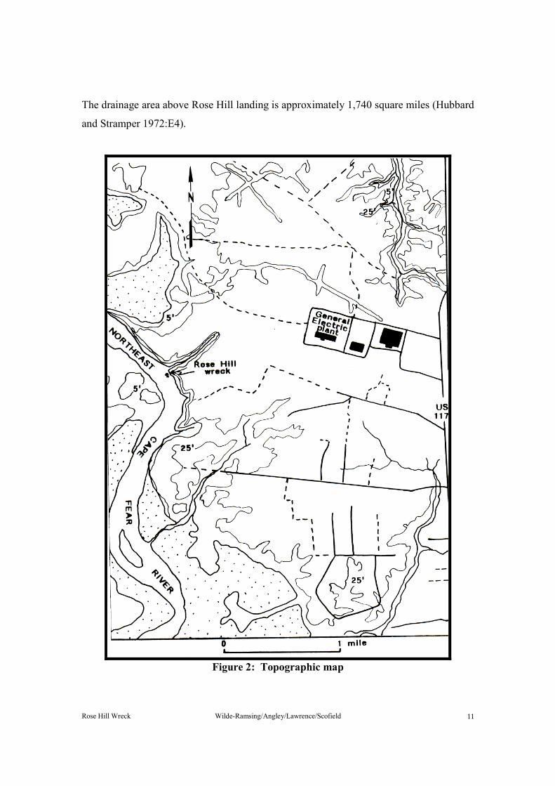
The Rose Hill wreck is located on the bottom of the Northeast Cape Fear River, 6.4 miles from the river's mouth, in approximately 18 feet of water (Figure 2). The entire river basin is situated within the coastal plain. Stream gradients average less than .5 feet per mile (Giese, et al., 1985:31). The river rises in Wayne County, North Carolina, and flows south through Duplin, Pender, and New Hanover counties and at Wilmington flows into the Cape Fear River, which in turn empties into the ocean thirty miles further south.
Rose Hill Wreck Wilde-Ramsing/Angley/Lawrence/Scofield
The drainage area above Rose Hill landing is approximately 1,740 square miles (Hubbard and Stramper 1972:E4).
Figure 2: Topographic map

Rose Hill Wreck Wilde-Ramsing/Angley/Lawrence/Scofield �
Much of the river's main stream and its tributaries are typical black water, with sand-detritus bottoms and low turbidity. In the lower reaches, however, where the wreck is located, tides are the dominant flow component (Giese, et al., 1985:31-32). At Rose Hill the Northeast Cape Fear River estuary is well mixed, with no vertical stratification of fresh and salt waters, which is typical for estuaries where the volume of water is several times greater from tidal flow than fresh water inflow (Hubbard and Stramper 1972:E4). Except during freshets, the river's average freshwater inflow at the wreck site is about 2,100 cubic feet per second, or 5 to 8 percent of the average velocities attributed to the tides. Each tidal cycle at Rose Hill produces current reversals that have a strong flow, averaging 1 to 1.5 feet per second and seldom exceeding 2 feet per second (Giese, et. al., 1985:32). Tidal range at the site is 3.4 feet, and the characteristic diurnal cycle of tides is approximately twenty-four hours and fifty minutes (Hubbard and Stramper 1972:E4).
HISTORICAL BACKGROUND
From the early stages of European exploration and settlement of North Carolina, the lands along the Northeast Cape Fear River and its tributaries were recognized as a prime area for agricultural development and the production of lumber and naval stores. In August 1662 the New Englander William Hilton set sail from Massachusetts Bay aboard the ship Adventure, bound for the Cape Fear region. After failing several times to reach his appointed destination, he entered the mouth of the Cape Fear on the morning of October 4, 1662. For more than three weeks Hilton and his associates explored the stream. Taking the Adventure as far as present-day Wilmington, he then proceeded by small boat up the Northeast branch, which he took to be a continuation of the main river. Hilton is thought to have reached a point approximately sixty miles upstream from the ocean bar. According to historian E. Lawrence Lee's reading of Hilton’s own account:
He and his associates were pleased with the fertile and abundant land, with its flourishing vegetation and plentiful game, and with the climate that was "ye most temperate of ye temperate zone." They were also impressed with the meadows and upland fields along the river.
During that initial voyage, Hilton and his men encountered only about 100 Indians along the Northeast Cape Fear.
Rose Hill Wreck Wilde-Ramsing/Angley/Lawrence/Scofield �
When he prepared a map of his expedition, Hilton named a number of landmarks and tributary streams along the Cape Fear and Northeast Cape Fear rivers. He identified the Brunswick River as "Hilton River" and Smith's Creek, just above Wilmington, as "Goldsmith River," after Samuel Goldsmith, a member of Hilton's crew. For some unaccountable reason, the map also showed the symbolic outline of a parapeted fortification downstream from "Goldsmith River" identified as "Janury" or "James Fort." No mention of such a fort appears in Hilton's written account. It is probable that the symbol was meant to indicate nothing more than a suggested location for a fort to be constructed in the future.
In October 1663 Hilton returned aboard the Adventure to conduct a more extensive exploration of the Cape Fear region. Again he and his men ascended the Northeast Cape Fear in a small boat; and on this second expedition they named other landmarks and areas far upstream, including "Turkie-Quarters," "Rocky-Point," and "Stag Park"--the vast area later claimed by Governor George Burrington. Once more the expeditionary party was favorably impressed with the region: "As good tracts of land, dry, well wooded, pleasant and delightful as we have seen any where in the world."
Encouraged by Hilton's reports of the lower Cape Fear area, a group of hopeful colonists set sail in several ships from Massachusetts Bay colony in the winter of 1663-1664. For reasons not entirely clear, this early attempt to settle the area failed after a very short time.
From 1664 to 1667 several abortive and ill-fated endeavors to establish and maintain a colony of Barbadians along the lower Cape Fear occurred in the vicinity of the Charles Town settlement, which was situated on the west bank of the river just above Town Creek. Colonists were plagued by a combination of inadequate external support, internal dissention, and increasingly hostile relations with local Indians. Following the failure of the Charles Town settlement, the lower Cape Fear remained the domain of its Indian inhabitants for more than half a century.
Permanent white settlement along the lower Cape Fear finally began in the mid-1720s with the coming of Maurice Moore and others and the laying out of Brunswick Town. Between 1726 and 1731 a closely associated group of about three-dozen men acquired some 115,000 acres of Cape Fear land. The men took up lands not only along the lower

Rose Hill Wreck Wilde-Ramsing/Angley/Lawrence/Scofield �
reaches of the stream but also along both the Northwest and Northeast branches. The resulting concentration of large landholdings among a relatively few wealthy and influential men went far toward establishing the plantation pattern, which remained dominant in the area until the Civil War. During the half-century preceding the American Revolution, these early landowners laid off vast plantations on the Northeast Cape Fear. The plantation extended far upstream from the fledgling settlement of Wilmington (formerly New Town or Newton). The landowners were some of the most prominent and influential men in colonial North Carolina.
Rose Hill plantation was located on the Northeast Cape Fear River approximately six miles north of Wilmington. At its fullest extent, it encompassed a vast area along the east side of the river as far upstream as Prince George Creek near Castle Hayne. By the end of the eighteenth century, the lands associated with Rose Hill included the former plantation known as Red Banks. Indeed, the original Rose Hill and Red Banks plantation houses appear to have been situated in close proximity to each other and near the site of the Rose Hill wreck. Although the documentary sources shed no light on the question, it is quite possible that the two plantations shared a common landing at or near the shipwreck site.
The lands along the eastern side of the Northeast Cape Fear River in the general vicinity of the Rose Hill wreck were originally included in grants to William Gray in 1736 (New Hanover County Deeds, Book F: 168-170; Hofmann 1979:110-111, 132). An early settler in the area, Gray had figured prominently in establishing the town of Wilmington. It was Gray who had laid out the town in 1733 when its projected name was New Liverpool. Clearly, he was closely associated with James Wimble and other founding fathers of Wilmington, all of whom had extensive merchant and maritime interests (Lee 1965:120-121). Gray served as deputy surveyor of New Hanover County under Matthew Rowan in the late 1730s, and in 1737 he was one of those charged with surveying the controversial boundary line between the two Carolinas (Colonial Court Records, William Gray estates papers; Saunders 1886-1890:IV 28, 283). Certainly, Gray had an extensive familiarity with the lower Cape Fear area. In addition to his holdings along the Northeast Cape Fear, he also acquired lands in present-day Bladen County and along the lower reaches of the Cape Fear below Brunswick Town (Saunders 1886-1890,

Rose Hill Wreck Wilde-Ramsing/Angley/Lawrence/Scofield �
IV:57, 59, 217; Hofman 1979a:9, 113-114; Hofman 1979b, I:105, 113; New Hanover County Deeds, Book A B:264).
With landholdings below Brunswick Town and along both branches of the Cape Fear, there can be no doubt that Gray was exporting large quantities of naval stores, lumber, and various agricultural products. There is no evidence that Gray established a residence on the future Rose Hill plantation, but he may well have used the landing there in conjunction with his export activities. It is of interest to note that the James Wimble map of 1738 indicates the presence of a Carter residence only a short distance downstream from the future Rose Hill. This same Carter apparently was William Gray's business partner and, in fact, Gray was co-owner of the tract upon which Carter lived. The upper corner of the Gray and Carter tract was a point on the riverbank that marked corners of the Red Banks tract and the future Rose Hill plantation as well. Indeed, it is almost precisely at the point formed by the juncture of the three tracts on the riverbank where the Rose Hill wreck is situated (New Hanover County Deeds, Book F:168-170; Kellam Collection).
By 1742 William Gray had died. Gray's brother and administrator, John Gray, conveyed William Gray's contiguous tracts along the Northeast Cape Fear River to Captain William Lithgow, a Cape Fear merchant and mariner (New Hanover County Deeds, Book F:168-170). Lithgow was a resident of Wilmington, but his landholdings in the lower Cape Fear region were fairly extensive. In addition to the lands he purchased from John Gray, Lithgow acquired at least four other tracts in New Hanover County totaling approximately 2,500 acres (Saunders 1886-1890, IV:684, 714; New Hanover County Deeds, Book C:157). It was in connection with his lands on the Northeast Cape Fear that Lithgow ran afoul of "King" Roger Moore, builder of Orton. Moreover, there is a distinct possibility that the controversy with Moore involved the Red Banks and Rose Hill areas and perhaps the Rose Hill landing itself.
It appears that just before Lithgow's purchase of the Gray lands, Moore had used them extensively for the production of timber and naval stores. Discovering Moore's activities, Lithgow attempted to prevent him from shipping the products downstream for export. These events were later summarized in a deposition concerning certain miscarriages of justice under Governor Gabriel Johnston:

Rose Hill Wreck Wilde-Ramsing/Angley/Lawrence/Scofield �
[the deponent] acquainted us that one Mr. Lithgow a gentleman of credit in that Country [North Carolina] had purchased a Plantation from one Mr. Grey orey on which plantation Mr. Roger Moore one of the Council was at the time of such sale cutting down timber & burning lightwood to make tar[.] Mr. Lithgow would not suffer Mr. Moore after he had made the purchase to carry off the tar upon which Mr. Moore did it by force and threatened to sue Mr. Lithgow for Barratry. (Saunders 1886-1890, IV:934-935).
Eventually, Moore had Lithgow seized and thrown in jail as Lithgow was preparing to leave for Boston (Saunders 1886-1890, IV:934-935, 1080, 1094, 1111-1112, 1122).
Following the death of William Lithgow, the contiguous tracts originally granted to William Gray passed into the hands of Lithgow's daughter and son-in-law, who in 1767 conveyed them to the prosperous merchant and planter Richard Quince. A native of Ramsgate, England, Quince had become involved in the Cape Fear trade during the 1730s and by the early 1740s had established his residence and base of operations at Brunswick Town. During the ensuing years he served as town commissioner, churchwarden of St. Philips, chairman of the county court, and vice-admiralty judge. In the years just preceding his purchase of the Northeast Cape Fear lands, he had also figured prominently in the resistance to the Stamp Act and related activities. By the late 1760s he had also acquired extensive landholdings throughout the lower Cape Fear, including Orton plantation, and was the owner of several merchant vessels as well. From Brunswick Town those vessels traded with numerous ports along the Atlantic seaboard, in Great Britain, and especially in the West Indies (Angley 1986:1, 4-6, 8-11).
It is quite possible that Richard Quince derived significant quantities of export commodities from his lands along the Northeast Cape Fear, but his ownership lasted for only two years. In August 1769 he sold the five contiguous tracts, comprising some 2,805 acres, to Lewis Henry DeRosset. The stipulated sum of # 150 sterling suggests that the land had not been improved to any considerable degree (New Hanover County Deeds, Book F:168-170).
Of the five tracts, the one farthest upstream, consisting of 640 acres, was described in the deed at the time of DeRosset's purchase as being "known by the name of ye Red Banks joining ye upper line of a tract of Gray & Carters beginning at a pine on the river bank." The adjoining tract, just below the first, also comprised 640 acres and shared the

Rose Hill Wreck Wilde-Ramsing/Angley/Lawrence/Scofield �
same pine tree on the riverbank as a point of reference. This tract, though as yet unnamed, would come to be known as Rose Hill by the mid-1780s. Extending downstream from the Red Banks and future Rose Hill properties were three other tracts comprising 640, 185, and 700 acres respectively (New Hanover County Deeds, Book F:168-170; Kellam Collection).
The new owner of the Northeast Cape Fear lands, Lewis Henry DeRosset, was a man of even greater wealth and prominence than Richard Quince. He had come to the lower Cape Fear in the mid-1730s and, like Quince, had established himself as a prosperous merchant and planter. He had served New Hanover County as sheriff and justice of the peace and had represented Wilmington in the colonial assembly. Most importantly, he had served as a member of the royal council since 1754 and would continue to do so until the outbreak of the American Revolution. It is significant to note that strong family and social ties linked DeRosset to Quince prior to their transaction of 1769. DeRosset and Quince's son John had both married daughters of the late Robert Walker (Powell 1986, II:56-57; Meares 1906:34-35, 40-41; Davis and Walker Family Papers, Southern Historical Collection, Chapel Hill; Kellam 1959:16).
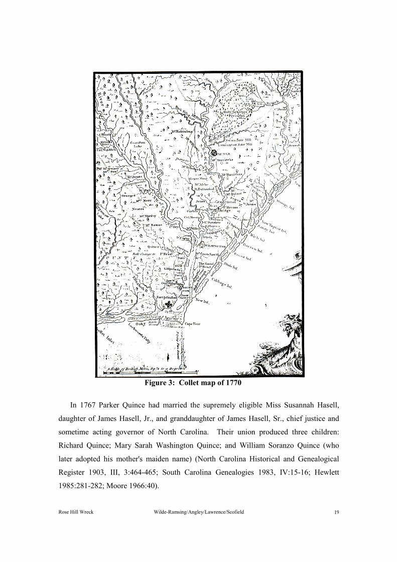
It was almost certainly Lewis Henry DeRosset who built the first substantial dwelling house on either the Red Banks or Rose Hill tract. Moreover, there are strong indications that he did so almost immediately after his purchase from Quince. John Collet's map of North Carolina, published in 1770, clearly shows DeRosset's residence near the point of juncture between the Red Banks and Rose Hill tracts and in close proximity to the Rose Hill wreck (Figure 3). The Mouzon map of 1775 also indicates the presence of DeRosset's plantation home (Collet 1770; Mouzon 1775).
During the course of the American Revolution, DeRosset was forced at length to declare his allegiance to either the patriot cause or to his sovereign. He chose the latter, thereby placing all of his property in danger of confiscation. Prior to his banishment from North Carolina, DeRosset therefore sold as much of his property as he possibly could, though he was unable to receive full value under the prevailing circumstances. Among the properties sold was his Red Banks home and plantation, together with the four adjacent tracts on the Northeast Cape Fear. These he sold to Richard Quince's son,

Rose Hill Wreck Wilde-Ramsing/Angley/Lawrence/Scofield �
Parker Quince, on March 9, 1779. The stipulated consideration was # 11,500 (New Hanover County Deeds, Book G:296-300).
Some idea of the improvements on the Red Banks land is conveyed in the papers DeRosset later submitted to the British government in requesting compensation. The papers indicated that he had:
3000 acres--2 or 300 acres [of which] were cultivated & a good House built upon it which cost him # 1,500 St[erling]. He had lost 31 Slaves worth # 50 each making # 1,500 [and had] left a Wife in that country & left her # 2,000 Sterling consisting of Stock, Negroes, Cattle, Money, etc. (Loyalists' Claims, DeRosset folder). Before departing the Cape Fear in the spring of 1779, DeRosset purchased and fitted
out a brig of about 100 tons, which he filled with a cargo of tobacco, indigo, and other valuable commodities, some of which may have come from his Red Banks plantation. The combined value of the vessel and cargo was put at # 8,000 sterling. DeRosset had planned to sell the vessel and cargo upon reaching England. In any event however, they were taken at sea by a patriot privateer and confiscated in New England. When DeRosset finally reached England in 1783, he was fifty-nine years old and nearly penniless. He died in London in 1786, his wife having passed away in the lower Cape Fear region during the previous year (Powell 1986, II:56-57; Meares 1906:37-42; Loyalists' Claims, DeRosset folder).
Parker Quince, the man to whom DeRosset had sold his plantation in 1779, was the best known of Richard Quince's children. A prosperous planter and merchant in his own right, he had achieved considerable prominence in public life as a justice of the peace, militia officer, member of the Brunswick Safety Committee, and representative for Brunswick Town in the provincial congresses of 1775 and 1776. In partnership with his father, Parker Quince had long engaged in extensive and far-flung maritime enterprises. When in 1774 the Port of Boston had been closed in response to the Boston Tea Party, he had joined with other prominent citizens of the lower Cape Fear region in dispatching a relief vessel to the embargoed city. Quince himself furnished the vessel that carried the provisions northward "freight free." Moreover, he and his crew carried out the relief mission "without receiving one farthing wages." (Angley 1986:3, 14).
Rose Hill Wreck Wilde-Ramsing/Angley/Lawrence/Scofield
Figure 3: Collet map of 1770
In 1767 Parker Quince had married the supremely eligible Miss Susannah Hasell, daughter of James Hasell, Jr., and granddaughter of James Hasell, Sr., chief justice and sometime acting governor of North Carolina. Their union produced three children: Richard Quince; Mary Sarah Washington Quince; and William Soranzo Quince (who later adopted his mother's maiden name) (North Carolina Historical and Genealogical Register 1903, III, 3:464-465; South Carolina Genealogies 1983, IV:15-16; Hewlett 1985:281-282; Moore 1966:40).

Rose Hill Wreck Wilde-Ramsing/Angley/Lawrence/Scofield ��
During the period immediately following the Revolution, Parker Quince and his family normally resided in Wilmington at a house known as The Lodge; but Quince also owned several plantations in the lower Cape Fear region in addition to the lands purchased from Lewis Henry DeRosset. Moreover, he made his will in February 1785, while temporarily "residing in Ironmonger Lane, City of London." There he passed away during the same month, having requested that his funeral arrangements be made by his uncle, John Quince of Ramsgate (North Carolina Historical and Genealogical Register 1903, III, 3:464-465). To his wife Susannah he left his "House and lot called the Lodge" in Wilmington. To his daughter Mary and son William he left town property and a plantation near Shallotte respectively. To his friend Thomas Callender he left a plantation known as Snow Hill. It was in the bequest to his son Richard that Parker Quince disposed of his lands on the Northeast Cape Fear; and it was in that bequest that Rose Hill plantation was referred to by name in a legal document, perhaps for the first time: "To son Richard Quince my Plantation called Rose Hill and tracts of Land called Oke [sic] Island and Plantation called Mount Pleasant." Also bequeathed to his son Richard was a considerable number of slaves (North Carolina Historical and Genealogical Register 1903, III, 3:464-465).
The Richard Quince who inherited Rose Hill was only sixteen years of age at the time of his father's death (South Carolina Genealogies 1983, IV:15). It would be several years before he could take full possession in his own right. Moreover, it is clear that the settlement of Parker Quince's estate as a whole proved extremely complex and protracted. In large measure the difficulty in settling the estate stemmed from unresolved problems in the settlement of his fathers estate. Parker Quince and his brother Richard had faced an insurmountable task as executors of their father's estate during the tumult of the Revolutionary period and its aftermath. Both men had taken possession of large parts of the estate and had made independent sales of personal property. Both men had also become heavily indebted to the estate. In the end, lingering and perplexing questions regarding the estate of Richard Quince produced some five cases in the Wilmington District Superior Court and resulted in proceedings before the North Carolina Supreme Court in 1806 (Angley 1986:20-21).
Rose Hill Wreck Wilde-Ramsing/Angley/Lawrence/Scofield �
Further evidence that Rose Hill was involved in the complex Quince's estate is found among the records kept by one of the executors, Captain Thomas Callender. Entries for 1787 and 1789 indicate that at least some minor activity was going on at Rose Hill. Perhaps of more interest is an entry for 1796, which recorded the "Sales of Sundries at Rose Hill." The lands involved in Parker Quince's estate, however, were far from being restricted to Rose Hill. Also mentioned in the records were tracts near Hillsborough, in Wilmington, and at Lockwoods Folly, Town Creek, Mount Pleasant, and Holly Shelter (New Hanover County Estates Papers, Parker Quince folder; Clark 1895-1906, XXV:28-29).
It was presumably in connection with the settlement of his father's and grandfather's estates that Richard Quince found it necessary to purchase Rose Hill and large adjoining tracts from kinsman George Moore of Orange County in 1805, even though he had inherited Rose Hill through the provisions of his father's will some twenty years earlier. Indeed, he also purchased as part of that same transaction two large tracts on the Northeast Cape Fear that he himself had patented in 1796. In all, Quince purchased from Moore some 4,335 acres comprising seven contiguous tracts. Three of the seven were properties acquired by William Gray in 1736, and five of the seven were identical to those conveyed by Richard Quince's grandfather to Henry Lewis DeRosset in 1769. The stated consideration for the seven tracts in 1805 was 3,000 Spanish milled dollars (New Hanover County Deeds, Book M:449-452; Kellam Collection).
It appears to have been in the late eighteenth or early nineteenth century that Rose Hill became the principal plantation residence of Richard Quince and his family. Quince's wife was the former Elizabeth Moore. Their marriage produced at least five sons: Parker, William, Richard, Roger, and John (South Carolina Genealogies 1983, IV:15-16); Moore 1966:41; New Hanover County Wills, Will of Richard Quince). Richard Quince lived only a few years after establishing his residence at Rose Hill. He died in 1809 at about forty years of age. It is quite possible that he was interred at Rose Hill, but if so his tombstone no longer survives (New Hanover County Wills, Will of Richard Quince; Kellam Collection).
Richard Quince's will provided that his plantation be left to his wife Elizabeth, with their sons Parker, William, and Richard to receive portions of the property upon attaining

Rose Hill Wreck Wilde-Ramsing/Angley/Lawrence/Scofield ��
their majorities (New Hanover County Wills, Will of Richard Quince). Though Elizabeth Quince was still living in 1817, it was necessary during that year for Thomas F. Davis to be appointed the sons' guardian to defend the family against a lawsuit, which possibly involved the Rose Hill property in some way (Moore 1966:43).
For several years following the death of Parker Quince in 1785, Susannah Quince, William Soranzo (Quince) Hasell, and Mary Sarah Washington Quince had lived in Charleston. They returned to the lower Cape Fear in the early 1800s, establishing their residence in Wilmington. William Soranzo (Quince) Hasell died in 1815 and was buried at Rose Hill, the plantation seat of his brother. He left no heirs. Susannah Quince, widow of Parker Quince, died in 1812 at the age of sixty. Mary Sarah Washington Quince had long since married one Abraham Motte. Their union had produced at least four children (Moore 1966:40-41; Kellam Collection; New Hanover County Wills, Will of Susannah Quince).
Richard Quince's widow, the former Elizabeth Moore, survived her husband by more than a quarter century, apparently continuing to live at Rose Hill. There she died in 1835 at the age of sixty-two. Almost certainly she was interred there in the family burial ground, though her final resting place has not been located (Kellam Collection).
The surviving gravestones in the small Rose Hill cemetery all date from the antebellum period, reinforcing the documentary evidence that Rose Hill was a Quince family residence and plantation for only about half a century. Other identifiable burials, besides those mentioned above, were those of Nathaniel Hill Quince (1842), Jane Quince (1849), and Elizabeth Moore Davis (1853). Both Elizabeth Moore Davis and Nathaniel Hill Quince were children of Parker Quince and grandchildren of the Richard Quince who had died in 1809. Jane Quince was their mother and the first wife of Parker Quince. She died at the relatively early age of forty-seven. The marriage between Parker Quince and Jane (Hill) Quince had produced some eight children, all born between 1820 and 1839 (Kellam Collection; Hewlett 1985:281).
It appears to have been in the 1840s that Rose Hill ceased to be a permanent residence and working plantation under the Quinces' management. In 1842 Parker Quince sold his one-third interest in the property to his brothers Richard and William for a stated consideration of $1,500. During the same year the brothers in turn conveyed the property

Rose Hill Wreck Wilde-Ramsing/Angley/Lawrence/Scofield ��
to James F. McRee, with the 2,287 acres being described as the "tract or tracts known as Rose Hill Plantation." (Kellam Collection; McKoy 1973:40).
When Dr. John Hampden Hill compiled his detailed accounts of lower Cape Fear plantations in the mid-1840s, Rose Hill was described as a relatively unimportant thing of the past, together with the Davis family's neighboring Rock Hill plantation: "The next two places below on the river were Rose Hill, the residence of the Quince family, and Rock Hill of the Davises, two rather inconsiderable and inferior rice plantations." (Fisher 1929:35-36).
Parker Quince died in 1867, a quarter century after conveying his interests in Rose Hill to his brothers, who apparently had predeceased him. Quince's death occurred at his home on Masonboro Sound, a residence that had been in the Hasell and Quince families for more than a century (Moore 1966:39). It is significant to note, however, that Parker Quince's body was taken to Rose Hill for burial. On the morning of November 12 the Wilmington Morning Star carried the following notice of Quince’s passing:
Death of Parker Quince, Esq. - Mr. Parker Quince, who has been lying very ill
for some time past, died at his residence on Masonboro Sound, yesterday morning at nine o'clock. The funeral will take place from St. James' Church this morning, from whence the remains will be conveyed to Rose Hill, on the Cape Fear, where is the family burial ground of the deceased.
Mr. Quince was one of our oldest citizens, being seventy-eight years old at the time of his death, and was the oldest representative of one of the most ancient and honored Cape Fear families, one of the few remaining links that bound us to the glorious history of this section during the troubles of 1776, in which his fathers took an active part. He has outlived a large and interesting family, who have nearly all found early graves, and he leaves no son behind him to perpetuate his name (Kellam Collection).
Maps dating from the latter half of the nineteenth century indicate that there may no
longer have been a residence on the Rose Hill property in immediate proximity to the shipwreck site, though there were residences both upstream and downstream from the site. A military map of 1864 shows the Davis family residence slightly downstream and the home of one W. McPherson just upstream. This map also indicates quite clearly that the riverbank near the shipwreck site was high and steep (James 1864). An 1869 map of New Hanover County (Figure 4) indicates that two farm roads led down to the Northeast Cape Fear from the "Duplin Road" and that the two roads terminated at the river just

Rose Hill Wreck Wilde-Ramsing/Angley/Lawrence/Scofield ��
above and just below the shipwreck site. The map shows the Davis residence at the end of the lower road (James and Brown 1869). An 1886 map of New Hanover County records no residences along the river but does show the two farm roads leading down to the stream above and below the shipwreck site (Moss Engraving Company 1886).
Figure 4: Rose Hill area from Eric Norden map of 1926

Rose Hill Wreck Wilde-Ramsing/Angley/Lawrence/Scofield ��
In 1899 Rose Hill plantation was advertised for sale in parcels of fifty acres or more. The notice that appeared in the Wilmington Messenger of November 9 of that year spoke glowingly of mill sites, standing timber, pasturage, productive soils, abundance of game, and of convenient access to rail and steamboat transportation. Significantly, however, it made no mention of a dwelling house on the property.
For Sale - This plantation lies on the east side of the North East Cape Fear river six miles from the city of Wilmington, N.C., one-half mile from the Atlantic Coast Line Rail Road.
The highlands are well adapted to fruits and truck growing of all kinds-especially strawberries and lettuce, timber and oaks, pine and hickory.
Lands level, with grey loan and clay foundation. The river sides are high bluffs overlooking the most beautiful stream in the south-plied by small river steamers making the city easily accessible to all on the plantation. . . .
Two magnificent sites for mills, with an inexhaustible supply of water. The lowlands are adapted to rice, hay, and corn. Swamplands are Juniper, Poplar, Ash and Cypress in abundance.
There is no game preserve in the country which has more attractions for the sportsman. Deer, wild hogs, turkeys, and quail, are here in great numbers. The streams abound with duck and fish.
The place is extremely healthy. The pasturage is splendid, remaining green the entire year; cane in winter and tempting grasses in spring and summer. No place on earth would be better suited for stock raising. Suitable for hogs, cows and sheep.
Contains fine deposits of phosphate and agricultural marl. Known as the Rose Hill Plantation and will sell in lots from Fifty Acres up, at
low prices (Kellam Collection, Abstract from Wilmington Messenger of 9 November 1899).
By 1926 the Gore Estate Corporation had acquired the Rose Hill plantation property.
It was during that year that a detailed map of the property was executed by Wilmington surveyor Eric Norden. Despite the advertisement for partition and sale a quarter century earlier, the Rose Hill plantation then encompassed a vast expanse of land along the Northeast Cape Fear River, extending from a point just below the shipwreck site upstream to the mouth of Prince George Creek. From that point the boundary ran up and along the course of Prince George Creek, then southward along Sanders Mill Creek to the "Road to Goldsboro," then westward and southwestward back to the riverbank. Seven structures were located at that time in the general vicinity of the shipwreck site. One structure was especially close to the site, being located at the end of a farm road and near the lower end of the high bluffs along the riverbank. A cluster of other structures was
Rose Hill Wreck Wilde-Ramsing/Angley/Lawrence/Scofield ��
located just upstream from the shipwreck site, perhaps 100 yards distant (Norden 1926, Figure 4).
Debouching into the river approximately one-half mile further up was a stream significantly labeled "Brickyard Cr[eek]," perhaps indicating the area's involvement in the construction of the Red Banks and Rose Hill plantation houses. Significant, too, is the designation on this map of "Long or Quince's Reach," the map gives the broad stretch of the river at and above Brickyard Creek. The "Quince's" reference clearly reflects the long association of the Quince family with that area along the river. Even more ancient, however, is the alternative name of this particular portion of the river, for explorer William Hilton had referred to it as a "long reach" during his upriver expedition in 1663 (Norden 1926; Thomas 1959:25).
An aerial photograph taken in 1938 shows that a narrow farm road led down to a house site or clearing in the immediate vicinity of the shipwreck site. It is unclear from the photograph whether the house shown on the 1926 map was still standing. Clearly discernible, however, is the large farmhouse just upstream, which had appeared on the map of 1926. On both sides of that farmhouse, and running well back from the river, were extensive cultivated fields. A row of trees, broken only by the clearing near the shipwreck site, ran along the river both above and below the farmhouse (New Hanover County aerial photograph 1938).
The land formerly comprising nuclear portions of Rose Hill and possibly Red Banks plantations is now owned by the General Electric Company, which operates a large manufacturing facility nearby. For many years the land has had no connection with maritime activity. It is quite possible, however, that the Rose Hill landing saw at least intermittent use from the 1730s through the early years of the twentieth century as a focal point of local trade. That use was probably most concentrated during the late eighteenth and early nineteenth centuries, when Rose Hill served as the plantation residence of the Quince family.
UNDERWATER ARCHAEOLOGICAL BACKGROUND
The portion of the Northeast Cape Fear River from Wilmington to Castle Hayne along the northwestern border of New Hanover County has a rich history, with

Rose Hill Wreck Wilde-Ramsing/Angley/Lawrence/Scofield ��
magnificent plantations, farmsteads, and associated boat landings dotting its shoreline. There were also river crossings, the one near Castle Hayne being particularly important since that crossing was the site of a colonial drawbridge, Revolutionary and Civil War fortifications, and nearly 200 years of continuous ferry operations.
State archaeologists have devoted considerable attention to the Northeast Cape Fear River, since the UAU facility at Fort Fisher is located a short distance away. The river’s dark but clear water, low turbidity, and sandy bottoms offer an excellent environment for diving. Artifacts that lie on the bottom are normally exposed and can be seen with underwater flashlights.
More than a decade ago the sport diving community began to realize the advantages of exploring the Northeast Cape Fear River, particularly in terms of bottle and relic collecting. During the late 1970s and early 1980s the UAU learned that sport divers had located colonial landing sites and were finding an array of interesting artifacts. Among the most spectacular finds were two Revolutionary War cannon reportedly resting on the river bottom at the river crossing near Castle Hayne. The report of those cannon prompted three magnetometer surveys by the UAU in 1980/1981, all of which failed to locate the reported cannon (Duff and Lange 1980; Lange and Duff 1980; Lawrence 1981). About that time two ferry barges were discovered in the same area of the river near Castle Hayne. East Carolina University's Program in Maritime History and Underwater Research spent several field sessions extensively documenting the ferries. While divers surveyed the immediate vicinity for additional vessel remains, they observed Confederate obstructions and portions of the early drawbridge, known as Herons or Big Bridge (Watts and Reedy 1982; Watts 1985; Watts and Hall 1986).
No significant finds were discovered during an archaeological survey conducted in the Northeast Cape Fear River at Castle Hayne prior to the construction of the Interstate I-40 (Koski-Karell 1982). Another survey took place near the Hilton Railroad Bridge four miles downstream from Rose Hill. There a magnetometer survey and site assessment were conducted by an archaeological contractor hired by American Coal Company prior to proposed deepening and widening of the river channel. That work lead to the discovery and subsequent recording of the sunken remains of the Spray, a steamer used on the river during the mid-nineteenth century (Saltus and Angley 1982). During the

Rose Hill Wreck Wilde-Ramsing/Angley/Lawrence/Scofield ��
three-week investigation of the shipwreck, members of the UAU were exposed to river conditions similar to those at Rose Hill.
The first archaeological investigation to be conducted in the river at Rose Hill was a joint exercise in which UAU staff members trained CFCC students enrolled in the Marine Technology Program on the use of a proton precession magnetometer. Using a 50-foot survey vessel and beginning just above the Hilton railroad bridge, UAU staff members surveyed the channel of the Northeast Cape Fear River up to Long Creek and continued up that creek an additional two miles. The magnetometer survey failed to detect magnetic anomalies at Rose Hill, since the survey vessel was well out in the channel. Therefore, while divers were sent to assess several targets-one of which was identified as the remains of a barge located three and one-half miles upstream-none were sent down to examine the Rose Hill river bottom (Lawrence and Wilde-Ramsing 1985).
On September 9, 1987, UAU staff members investigated a section of the Northeast Cape Fear River at the request of Mr. Stanley Rehder of Wilmington. Mr. Rehder, who was considering developing a piece of riverfront property that bordered the land owned by General Electric, was interested in hearing the UAU's potential recommendations. His tentative plans were to break the land into large residential lots and build a small private marina near the General Electric dock. The investigations included a magnetometer survey and diver inspection in the vicinity of the proposed marina (Wilde-Ramsing 1987).
Magnetometer survey efforts were focused on the west side of the river, where sport divers had reported the wreck, while bottom searching began on the east side downstream from the General Electric dock. The magnetometer search failed to locate magnetic disturbances that might represent a wreck, but divers almost immediately located the remains of a large wooden vessel on the east side of the river channel. They found a heavy concentration of materials such as ballast stone, brick, and ceramic fragments deposited on the bottom all around the wreck, thus supporting the contention that the site was a historic river landing.
On October 20, 1987, UAU staff returned to the site accompanied by Peter Gillman-Bryan and Geoffrey Scofield to examine the wreck further. Divers stretched a measuring tape between the sternpost knee and the keel at the bow for the purpose of recording
Rose Hill Wreck Wilde-Ramsing/Angley/Lawrence/Scofield �
features and beam measurements. They made a preliminary sketch of structural timbers and recorded the vessel's framing pattern. Three disarticulated timbers, consisting of two floor frames and an outer hull plank, were recovered for laboratory analysis at the conclusion of the dive (Wilde-Ramsing 1987).
Later, sport divers advised UAU staff members that they had felt the vessel's mast in the channel off the bow. On November 17, 1987, the UAU returned to the site in an attempt to locate the reported mast. In the dive company was David Moore, who had been studying Florida wrecks of the sixteenth, seventeenth, and eighteenth centuries (Wilde-Ramsing 1987).
During the November reconnaissance, divers recovered additional samples, including wood sheathing and hair from the vessels outer hull and a disarticulated iron gudgeon strap from the stern area. A random search of the channel adjacent to the port bow encountered considerable amounts of scattered debris made up in large part of a few wooden timbers from the wreck and many logs and branches. Divers were unable to locate the reported mast, but they did find a wooden rudder off the bow. They conducted a very brief examination of that find before leaving the site.
The preliminary investigations at Rose Hill presented investigators with many questions concerning the wreck. The remains were considered significant because of their suspected age. Furthermore, although heavily eroded by river currents, the lower hull retained its structural integrity and was in an excellent state of preservation.
Therefore, the Rose Hill wreck was chosen as the focus for a concentrated field and laboratory study, as well as documentary research. The underwater archaeological expedition was conducted May 9-13, 1988, at the Rose Hill wreck site. The results of that investigation, as reported here, served as the basis for developing a management plan at the site and in turn support its nomination for listing in the National Register of Historic Places. The field project also provided an opportunity for UAU staff members to train volunteers in underwater archaeological techniques.
Access to the site was gained both from the land side through the General Electric property and by boat from Wilmington. While the sandy beach fronting the site provided a land-based staging area, two open boats-one 14 feet in length and the other 20 feet long-held dredge equipment and provided a dive platform over the wreck site.

Rose Hill Wreck Wilde-Ramsing/Angley/Lawrence/Scofield ��
During the course of the project eleven divers and three topside technicians participated. A total of sixty-seven hours of bottom time was registered. Shoreside technicians spent their time tying the project reference line into the General Electric property markers, recording and tagging artifacts as they were brought to the surface, and operating the dredge equipment.
DESCRIPTION OF WORK
The investigation of the Rose Hill wreck was divided into two phases: mapping the shipwreck remains and a systematic search of the surrounding river bottom for associated structural timbers. In order to position work during both phases, a reference line was established parallel to shore near the high-tide mark. The line's origin (00') was placed near the southeast end of the General Electric pier, and its terminus was 180 feet downstream. Both ends and a point along the reference line at 80 feet were marked with iron pipes driven into the ground. The reference line was positioned in order that the wreck, which lay parallel to the bank and 50 feet out in the river, was centered along the longitudinal axis. The line also ran at a 90-degree angle to the General Electric pier to facilitate placing search lanes on the river bottom. Once established, the reference line was then tied into a concrete marker, which served as the southwest corner boundary marker for the General Electric property (Figure 5).
From the reference line a grid was extended into the river to divide the bottom into 10-foot-by-10-foot units. Alphabetical letters designated the distance along the reference line beginning at the origin, while numbers were assigned to units from the shore out. The grid followed the contour of the bottom, which varied from the shoreline to 20 feet below the water. Therefore, units on the slope were actually slightly smaller and closer to the reference than shown in the site plan.
Two lines 120 feet long were stretched perpendicular to the reference line and staked in the river bottom. One at the reference line origin (00') ran along the General Electric pier pilings, and the second, at 70 feet, ran just upstream of the wreck's bow remains. The wreck, being roughly parallel to the reference line, ran along the grid lane at 60 feet, from grid "7h" to "6n." Therefore, once positioned through triangulation from reference
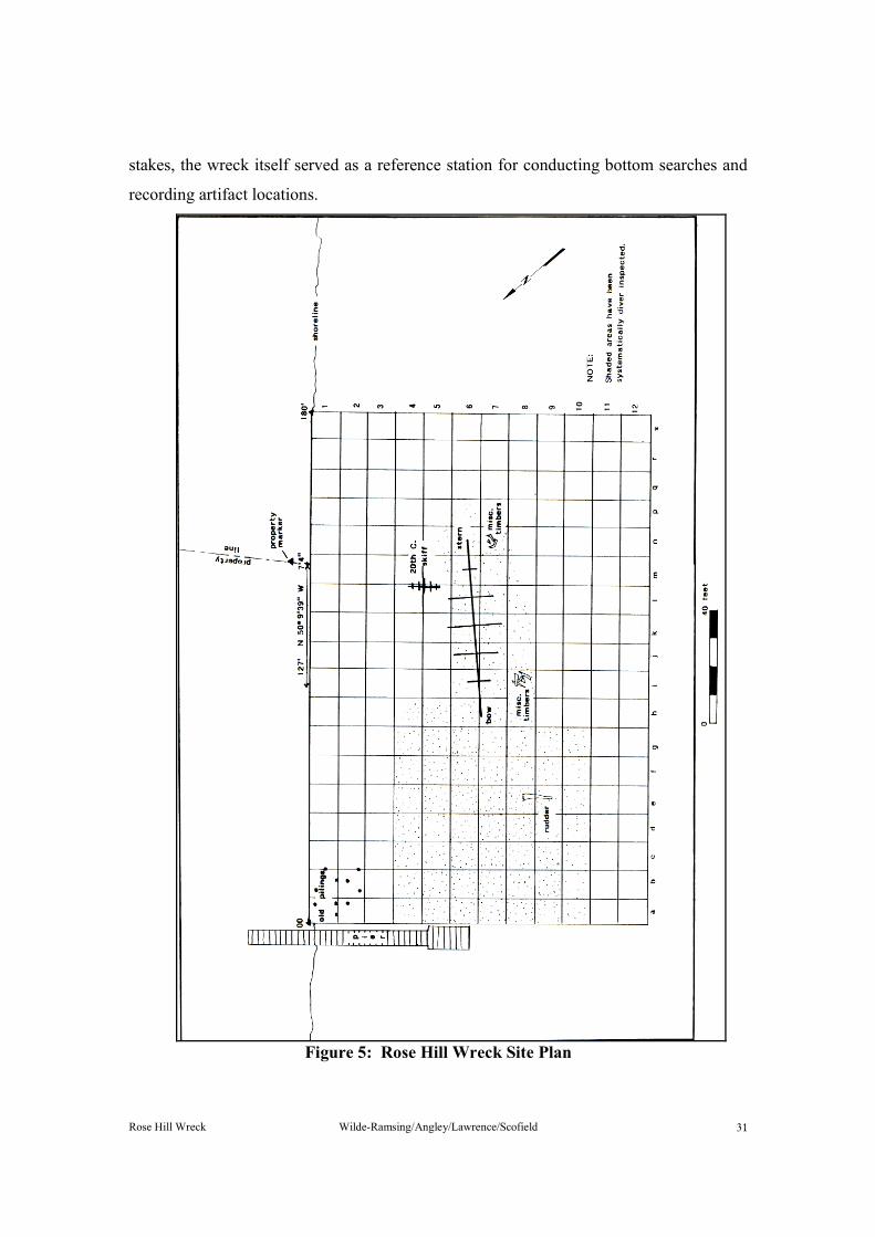
Rose Hill Wreck Wilde-Ramsing/Angley/Lawrence/Scofield �
stakes, the wreck itself served as a reference station for conducting bottom searches and recording artifact locations.
Figure 5: Rose Hill Wreck Site Plan

Rose Hill Wreck Wilde-Ramsing/Angley/Lawrence/Scofield ��
SurveyThe systematic search of the surrounding river bottom for structural pieces of the
wreck was prompted by the discovery of the rudder and reports from sport divers that the ship's mast could be found on the channel bottom some 50 feet forward of the bow. The search to relocate these pieces and additional remains was hampered by poor visibility (maximum 2 feet), currents, and numerous sunken trees and organic debris.
Lane lines were used to cover systematically the bottom between the bow of the wreck and the General Electric pier. With the two lines established at 00 feet and 70 feet, a knotted lane line was attached between them at 10-foot intervals. The diver, holding the lane line with one hand, searched a 5-foot swath along the bottom parallel to the base line. When an artifact was located, the diver recorded its lane and distance from the reference line origin by feeling coded knots on the lane line. In this way the river bottom was searched between the pier and the wreck from 30 to 100 feet out into the river. During the search the rudder was relocated at grid "9e" and a variety of diagnostic ceramic and glass artifacts were recovered.
Circle searches were employed on the river channel bottom adjacent to the port side of the wreck. By attaching a line to pins driven every 10 feet along the keelson, arcs were swung every 5 feet out to 20 feet. In doing so, an area of river bottom roughly 12 to 15 feet outside the wreck's port side was examined. During this investigation a concentration of ship timbers was located near the bow grid "8i" and another near the stern at grid "7n." In both areas, a few small artifacts were noted. A final circle search was conducted off the sternpost out to a maximum distance of 20 feet, during which no additional structural pieces or small artifacts were found.
On the slope of the river bottom along the starboard side no systematic survey was conducted; however, the area was heavily trafficked by divers descending and ascending from the wreck. Random searches were also conducted there primarily in search of diagnostic artifacts, since cultural debris was thickest in that area. A number of glass and ceramic artifacts were recovered, and the remains of a wooden skiff, 0039NER, assigned to the twentieth century, were observed. No structural remains from the Rose Hill wreck were noted in this area.

Rose Hill Wreck Wilde-Ramsing/Angley/Lawrence/Scofield ��
The extensive efforts expended in searching the river bottom around the wreck produced rather scanty results. In addition to the rudder, two concentrations of loose structural timbers were found outside the wreck on the port side. Their description is incorporated in the "Description of Findings" section of this report.
Small artifacts recovered during the survey represented a wide range in age and appeared randomly distributed so as not to allow a positive association with the wreck itself. A discussion of the nonstructural finds of the survey can be found in the "Description of Artifacts" section of this report. Wreck Examination
Since the surviving structure consisted primarily of the bottom of a flat-floored vessel, a two-dimensional plan view of the wreck site was the initial objective. The first step in mapping the site was to establish a longitudinal base line down the middle of the vessel to act as a reference control. Two steel fence posts, each 6 feet long, were driven into the river bottom to secure the ends of the base line. One post was placed immediately forward of the stem and the other just aft of the sternpost. Both fence posts were lashed to the wreck to hold them firmly in place. A 3/16-inch stainless steel cable, marked with yellow tape in 1-foot segments and plastic tags every 5 feet, made up the base line and was stretched from bow to stern. After checking to make certain it ran directly above the keelson, the base line was securely tied to the stern fence post by means of a cable clamp. The final step in establishing the base line was to stretch a 100-foot fiberglass tape along the stainless steel cable. Galvanized gutter spikes were driven into the wreck every 5 feet, and the cable and tape were wired to the spikes with thin copper wire. The result was a very strong and firmly established line, which allowed measurements to be read to the nearest eighth of an inch.
To facilitate positioning boats over the wreck site, mooring buoys were attached to the bow and stern of the wreck. In addition, a heavy line was run from the bow of the wreck along the bottom to shore and tied to a large cypress tree. Since most of the diving was conducted from shore, this down line provided quick and safe access to the site.
Measurements of the structure were recorded with some difficulty. Measuring tapes had to be analyzed with the aid of a flashlight, with the figures then recorded on a dive
Rose Hill Wreck Wilde-Ramsing/Angley/Lawrence/Scofield ��
card. The information on the dive card was taken to the surface and plotted on an overall site plan.
With the base line established, recording of the floor timbers began. Starting at the forward end, the distance from the bow to the forward edge of each floor was recorded, as was the distance from the base line to the starboard and port ends of the floor. A total of twenty-eight floors were measured in this manner.
The presence of futtocks between the floors was noted during this process, as were other general features. These included the presence of outer hull planking, ceiling, and keelson features. Once the basic site plan had been prepared, detailed measurements were taken in specific areas to record scantlings and details of construction. In order to reveal these details, limited excavation was necessary to remove sediments within the hull. It was hoped that this excavation, particularly in the lower part of the bilge, would uncover diagnostic artifacts that could be associated with the ship.
Excavations were conducted in three areas. The first was 40 feet aft of the bow on both sides of the keelson and out to the frame ends on the port side. The second was 19 feet from the bow. At this location the keelson, ceiling, and the garboard strake on the port side were missing, and it was possible to excavate through the hull to the bottom of the keel. The final area of excavation was on the outside of the hull at the sternpost. Dredging there was hampered by trees and branches buried in the sediment; however, the lower portion of the rudder was found to be attached to the sternpost, where details could be recorded.
Observations and measurements were made in the bow area, with special efforts to record the stem/keel scarf. There no excavation was necessary, since bottom currents had kept sediments from accumulating. Additional time was spent measuring various timbers (i.e., the molded and sided dimensions of random floor timbers, planking, and ceiling dimensions) and recovering wood samples from the different structural components.
On June 17, 1988, the site was revisited by UAU staff members in order to measure the vessel's deadrise. To accomplish this task, a device was constructed using a 10-foot-long two-by-four board. On either end of the board a piece of angle iron was attached, forming two legs that supported the board, on edge, 18 inches off the ground. A vertical

Rose Hill Wreck Wilde-Ramsing/Angley/Lawrence/Scofield ��
hole was drilled through the top of the board, midway from both ends, through which was placed a 3/16-inch stainless steel rod. The rod was held in place by a setscrew.
When set up on a level surface the length of the rod from its tip to the bottom of the board was 18 inches, the same length as the angle iron legs. On site, the device was set up athwartships with the rod positioned over the base line and the legs resting on the floor timbers to either side. With any amount of deadrise at all, the distance from the tip of the rod where it touched the floor to the bottom of the board was greater than the length of the legs. By subtracting 18 inches from the rod measurement, it was possible to calculate the amount of rise over a 5-foot distance and, from these figures, the angle of deadrise. In portions of the wreck where the keelson was still present, it was necessary to add the molded dimension of the keelson to the rod measurement to get the total height above the floor. The device worked well on site and was relatively easy to use, since the weight of the angle-iron legs served to anchor the board in its proper orientation.
VESSEL CONSTRUCTION
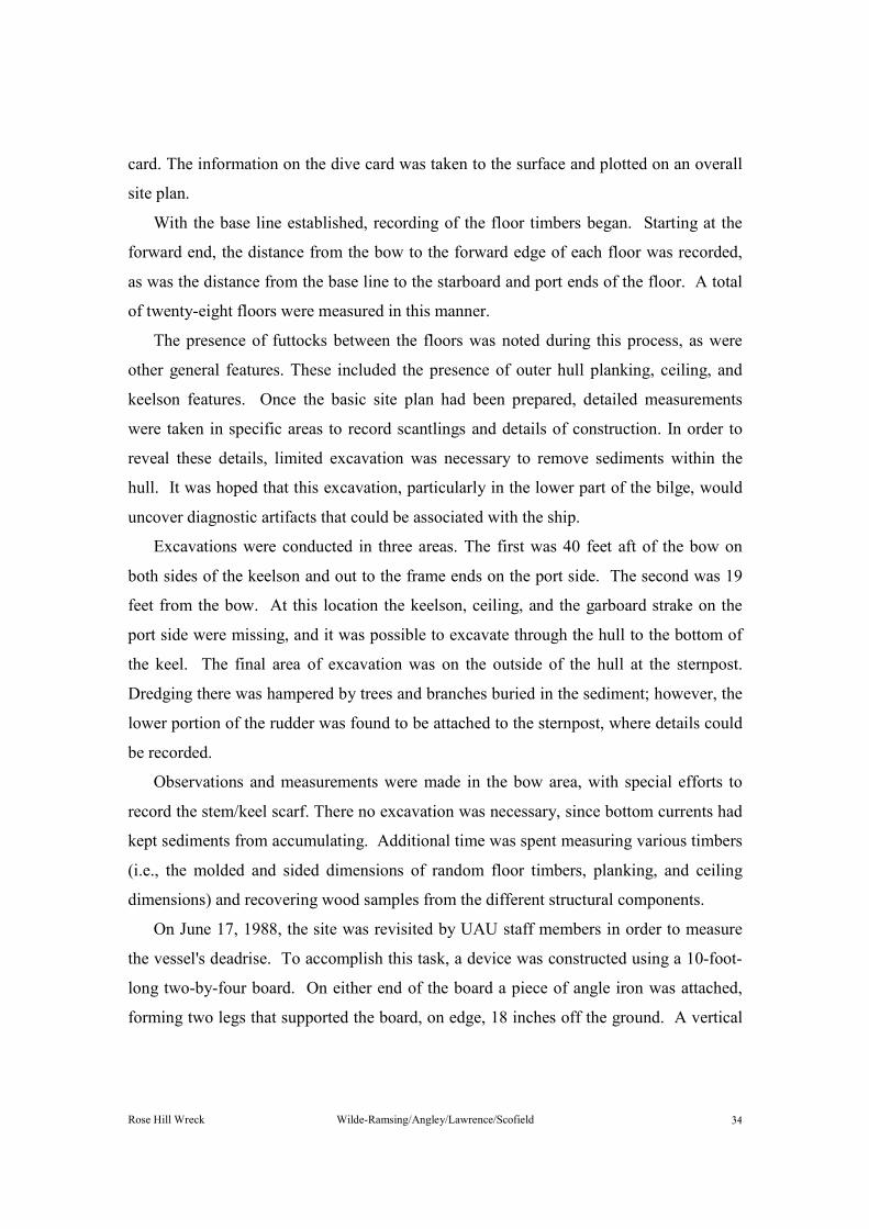
The hull layout of the Rose Hill wreck shown in Figure 6 depicts its structural
remains in a level attitude and not as the remains actually lie on the bottom, heeled to port side at an angle of approximately 40 degrees. The sternpost also has been drawn vertical, but in situ it was 55 degrees from the vertical. The outer hull and its configuration of the planking and keel were not accessible (except where noted) and are an interpretation based upon published data regarding hull shapes of the eighteenth century, the period to which this vessel has been attributed. The numbering system used throughout for the location of the floors, or their placement points, is based on the site plan. The floors have been numbered from 1 through 27, with No. 1 beginning at the bow.
Intact hull remains were found to have an overall length of 61 feet, 9 inches, including the remaining stem and stern rakes. The maximum width was 16 feet at Floor No. 17. Each structural feature will be discussed below. Keel
The true length of keel was 54 feet, 6 inches, measured on a straight rabbet from the afterside of the sternpost to the afterend of the nibbed scarf. The dimensions of the keel
Rose Hill Wreck Wilde-Ramsing/Angley/Lawrence/Scofield ��
were 15 inches moulded, which probably includes the false keel depth, and 8 inches sided. Siding at the fore and aft end of the keel are tapered to match the siding of the stem- and sternposts.
Figure 6: Hull Layout
Rose Hill Wreck Wilde-Ramsing/Angley/Lawrence/Scofield ��
It has not been determined whether the keel was made from single or multiple timbers. A sample of the keel taken near the bow revealed that that portion was constructed from hard maple (Acer sp.) (Newsom 1988).
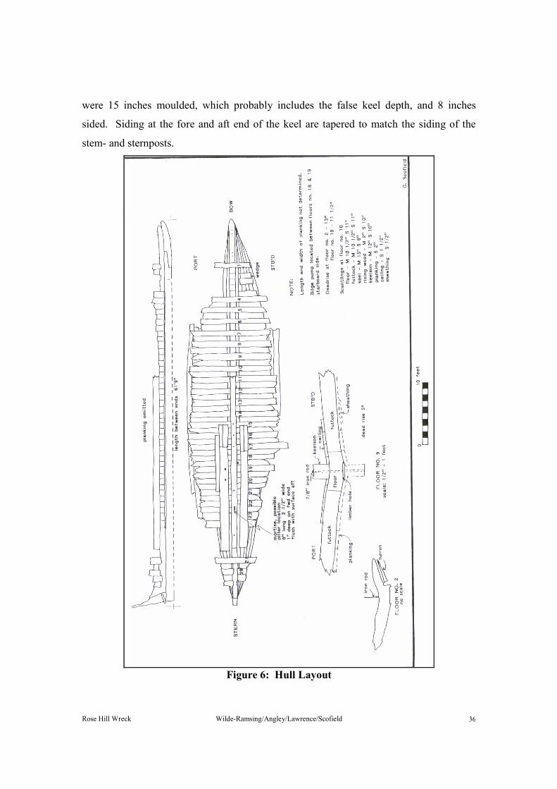
The forward end of the keel is joined to the stem by means of a nibbed scarf, made in the horizontal plane. The length of the scarf was 2 feet 9 inches, and nibs were 5 inches, giving a slope of 1.82:12 inches. There were three iron fasteners, each 3/4-inch in diameter, piercing the joint. Stem/Apron
The extant length of the apron, which bears directly on top of the keel and fore gripe, was 11 feet. The apron was 8 inches moulded by 12 inches sided at a place 5 feet 2 inches from the forward end of the remaining structure. The port and starboard faces of the apron were beveled to form the apex and bearding line, with the rabbet having been cut into the stem forefoot. There were three notches across the top of the apron, each 1-inch deep by 11 inches wide, for the purpose of fitting floor timbers. Deadwood and Sternpost
The lower portion of the aft deadwood was buried in sediments to an approximate depth of 2 feet 9 inches, with partial planking still attached. Dredging was greatly hampered because of the high concentration of trees and branches outside the stern and was only partially successful in exposing features for examination.
The remains of the sternpost measured 4 feet 9 inches high from the bottom of the keel. Siding and moulding were not determined because of the high degree of deterioration. The sternpost was constructed from a red oak species (Quercus sp.) (Newsom 1988). Attached to the lower half of the sternpost was the remains of an iron brace with pintle, to which the lower part of the rudder was still attached.
On the interior, the siding measurement at the top of the deadwood was found to be 10 inches. There were six housings on the existing deadwood, three per side, each approximately 2 inches deep, cut into the side near the top of the deadwood to receive the heels of the lower futtocks (Figure 6). Rising Wood
Set between the aft end of the apron and the forward end of the deadwood, directly on top of the keel, was the rising wood or hog, moulded 2 inches and sided 10 inches. This

Rose Hill Wreck Wilde-Ramsing/Angley/Lawrence/Scofield ��
member forms the apex and bearding line for the landing of the garboard strake and is the member to which the garboard is fastened. The rabbet line was located about 2 inches down from the top edge of the keel. The rising wood or hog appeared not to have been recessed for the setting-down of the floor as would be common in naval vessels of the eighteenth century (Figure 6 and 7).
Figure 7: Centerline structure Floors
Twenty-three floor members were found in situ. Floor No. 2 was temporarily removed from the site for recording and analysis, and a disarticulated floor member lying approximately 20 feet off the portside bow was believed to be Floor No. 3. This was also recovered for recording and analysis.
A random sampling of the floor measurements revealed the moulding to be 10 1/2 inches and the siding to be 11 inches. Floors were spaced on 22-inch centers and were notched over the rising wood at their midpoint, making them flush with the bearding line on their underside. The notches were extended beyond the width of the rising wood by 2 1/2 inches on each side to provide limbers for the free passage of water through the vessel. None of the floors, at their outer surviving extremities, appeared to be entering the

Rose Hill Wreck Wilde-Ramsing/Angley/Lawrence/Scofield �
turn of the bilge. A random sampling of the floors for wood identification indicated the use of both beech (Fagus sp.) and white oak (Quercus sp.) (Newsom 1988).
Upon removal of Floor No. 2, a wood wedge-shaped filler piece, known as a furren, was found still attached to the planking on the starboard side. This suggests that the stock for that member was undersize and brought up to thickness by the means of the furren. Futtocks
The futtocks were fitted snugly between the floors, with the toes ending approximately 11 inches from the base line. The moulded and sided dimensions of the futtocks, 10 1/2 inches by 11 inches, matched the floors. Since the first futtocks completely filled the area between floors and that area's width was the same as the floor's sided dimension, the Rose Hill vessel was determined to have room equal to space.
The outer ends of the futtocks were eroded and terminated in a line corresponding to ends of the floors. As far as could be determined, the floors and futtocks were not fastened to each other.
The deadrise of the vessel was measured at Floor No. 9, the theoretical dead flat, or master frame (Scofield 1990). It was found to be 5 degrees. Deadrise at two other locations was 13 degrees at Floor No. 2 and 11 1/2 degrees at Floor No. 18. Keelson
The existing length of keelson, from its fractured forward end at Floor No. 11 to its finished aft end at 1 foot 3 inches forward of Floor No. 27, was 28 feet 9 inches. It was 12 inches moulded by 10 inches sided and was made from white oak (Quercus sp.) (Newsom 1988).
The centerline structure was fastened together with 3/4-inch-diameter iron rods or drift pins inserted into an augured hole running through the keelson and floors into the keel. The upper end of the pin was clenched, to retain its position. Washers were not found between the keelson and clenching, which were often applied to increase the size of the clenching and thus spread the load. It could not be determined if the hole for the pin pierced the underside of the keel and was clenched, which was a common practice of eighteenth-century builders. Seven pins were randomly located throughout the length of
Rose Hill Wreck Wilde-Ramsing/Angley/Lawrence/Scofield ��
the remaining keelson, and for accurate measurements of their placement Figure 6 should be viewed. Ceiling
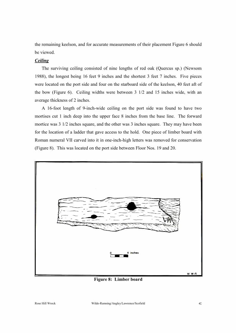
The surviving ceiling consisted of nine lengths of red oak (Quercus sp.) (Newsom 1988), the longest being 16 feet 9 inches and the shortest 3 feet 7 inches. Five pieces were located on the port side and four on the starboard side of the keelson, 40 feet aft of the bow (Figure 6). Ceiling widths were between 3 1/2 and 15 inches wide, with an average thickness of 2 inches.
A 16-foot length of 9-inch-wide ceiling on the port side was found to have two mortises cut 1 inch deep into the upper face 8 inches from the base line. The forward mortice was 3 1/2 inches square, and the other was 3 inches square. They may have been for the location of a ladder that gave access to the hold. One piece of limber board with Roman numeral VII carved into it in one-inch-high letters was removed for conservation (Figure 8). This was located on the port side between Floor Nos. 19 and 20.
Figure 8: Limber board

Rose Hill Wreck Wilde-Ramsing/Angley/Lawrence/Scofield �
PlankingVery few details of the planking and sheathing were obtained, since access to the
underside of the vessel was prevented by sedimentation and ballast stone. One of the few accessible locations where planking widths could be measured was on the port side at Floor No. 7. Width of the garboard strake was 10 inches; first board, 12 inches; second board, 17 inches; first, second, and third strakes, 14 1/2 inches each; and the fourth strake was 7 inches.
A single length of planking, which had become detached from the craft, was recovered and removed for analysis and recording (Figure 9). It had an overall length of 12 feet 7 inches, a width of 12 1/2 inches, and a thickness of 2 3/8 inches. The inside face of this plank showed signs of extensive charring. The depth and the uneven pattern of charring on the interior surface point to accidental burning as the cause rather than exposure to fire during "stoving", a method used to facilitate plank bending at the time of vessel construction. The several planking samples tested were of the white oak group (Quercus sp.) (Newsom, 1988).
Figure 9: Hull planking
Rose Hill Wreck Wilde-Ramsing/Angley/Lawrence/Scofield ��
Attached to the outside of the third strake at Floor No. 13 on the port side was a small piece of wood sheathing measuring 10 inches in width by 1/2-inch in thickness. The sheathing was attached with 1/8-inch square stock iron nails, 1 1/2 inches in length, which were placed in a random pattern. Once removed, the sheathing was found to have been laid in pine tar and hair. A sample of the hair was analyzed as that of a horse or mule (Equus. sp.) (Worsham 1989). The sheathing was identified as hard pine (Pinus sp.) (Newsom 1988). Fasteners
Trunnels were the primary means used to hold the planking in position. In addition to trunnels, 1/4-inch square stock iron nails were placed at about 5-foot intervals. These nails may have held the plank in position before the trunnels were installed at the time of vessel construction.
The trunnels were polygonic, 1 1/4-inches across the flats, and were wedged at their outer ends with pegs measuring up to 1 3/4 inches long by 3/8 to 1/2-inch square. Both the trunnels and pegs were made from white oak (Quercus sp.) (Newsom 1988). The twenty trunnels or placement holes found in the 12 1/2-foot plank were placed toward the outer edge, with two driven into each floor and each futtock. Fore and aft centers between each varied between 11 and 13 inches. Bilge Pump
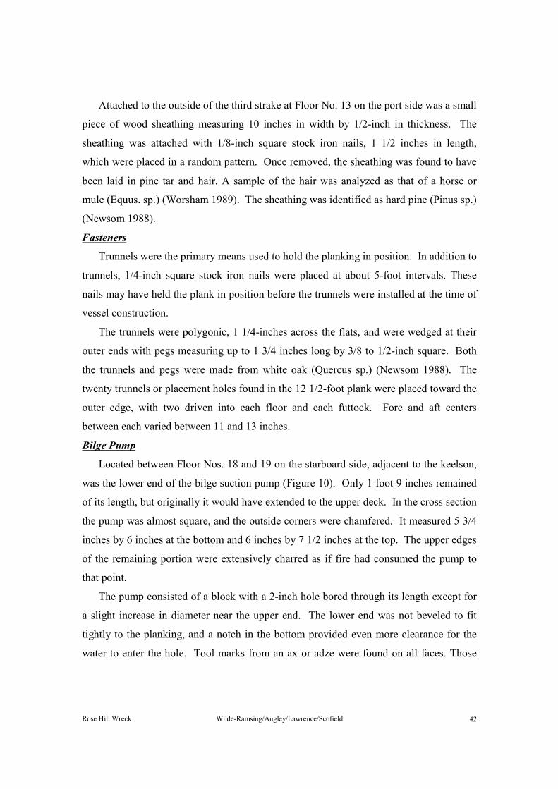
Located between Floor Nos. 18 and 19 on the starboard side, adjacent to the keelson, was the lower end of the bilge suction pump (Figure 10). Only 1 foot 9 inches remained of its length, but originally it would have extended to the upper deck. In the cross section the pump was almost square, and the outside corners were chamfered. It measured 5 3/4 inches by 6 inches at the bottom and 6 inches by 7 1/2 inches at the top. The upper edges of the remaining portion were extensively charred as if fire had consumed the pump to that point.
The pump consisted of a block with a 2-inch hole bored through its length except for a slight increase in diameter near the upper end. The lower end was not beveled to fit tightly to the planking, and a notch in the bottom provided even more clearance for the water to enter the hole. Tool marks from an ax or adze were found on all faces. Those
Rose Hill Wreck Wilde-Ramsing/Angley/Lawrence/Scofield ��
marks were most frequent in the mid-body of the remaining tube, which had been undercut to form a waist to fit between futtock and keelson.
Figure 10: Bilge pump location Rudder
The rudder was lifted from its resting place some 32 feet off the port bow and transported to the shoreline for recording and later redeposited on the site. There can be no certainty why the rudder had been dislodged from the sternpost. It apparently occurred during a violent episode, since the lower portion of the rudder was still attached

Rose Hill Wreck Wilde-Ramsing/Angley/Lawrence/Scofield ��
to the sternpost but remained in a twisted and distorted condition. While at first this was thought to have happened at the time of sinking, it is now speculated that the rudder was wrenched from the vessel during salvage attempts or channel-clearing efforts and dropped on the river bottom nearby.
Figure 11: Rudder reconstruction

Rose Hill Wreck Wilde-Ramsing/Angley/Lawrence/Scofield ��
The rudder was constructed from three separate pieces of wood, with the top of the forward one comprising the stock. Overall length was 12 feet 4 inches, with a maximum width of 2 feet 7 inches. Holding the three pieces of wood together were four iron rods, 7/8-inch in diameter, clenched at each end. Still attached to the rudder were two pintles made from forged iron and fastened by iron nails with 3/4-inch square stock.
Figure 11 shows the rudder as it was found and its projected original shape and length. There were three sets of braces and pintles; the lower ones were found attached to the lower portion of the rudder and sternpost. The reconstructed length shows the straps equally spaced, giving the vessel a possible draft at the aft end of approximately 8 feet. Iron Cookstove
One of the most interesting and intriguing artifacts recovered from the Rose Hill wreck was what is believed to be the cook or galley stove. Four disarticulated cast iron plates, each 1/2-inch thick, were found adjacent to the keelson on the starboard side 36 feet from the bow (Figure 12). Two of the plates were parallel sided, more or less square at one end and peaked at the other. Each piece measured approximately 32 inches long by 20 inches wide. The end opposite the pointed one was broken and ragged, making it impossible to determine the original overall length. Apart from the deteriorated ends, the two pieces were identical in shape and size.
The two remaining pieces differed from the first two, as well as each other. One was almost square, 27 inches by 25 inches, and the other was 29 inches by 25 inches. One edge of the latter plate is modified by a half-round lobe.
At least three of the flat plates had originally been attached to each other at the corners by means of square rivets through one-inch-square wrought iron bar vertical stiffeners. Holes for the rivets had been cast into the plates upon manufacture (Goodwin 1987:161).
The most reasonable assembly of the four existing pieces indicates that the front of the stove is missing. That piece most likely contained doors to permit access to the inside of the stove and firebox. The four pieces have been put together in varying configurations, but the one shown in Figure 11 is the most logical.

Rose Hill Wreck Wilde-Ramsing/Angley/Lawrence/Scofield ��
Figure 12: Iron stove reconstruction The bottom of the stove, or fire hearth, may have contained fire bricks to dissipate
the heat. Three holes in each side piece were in logical positions to have held the grate bars running from side to side, on which the kettle stood. Hinge pins affixed to each side

Rose Hill Wreck Wilde-Ramsing/Angley/Lawrence/Scofield ��
of the vertical stiffeners may have been door hinges or could have supported cranes for swinging the kettle in and out of the stove.
Although no evidence of a flue was found, there were attachment holes in the side plates at the top, located where a flue would logically be attached. Lifting rings on the outside faces two of the end plates were typical for cookstoves.
The shape or size of the stove has yet to conform to any located on other wreck sites or in historical manuscripts to date. Yet, it follows the general configuration of cookstoves found on vessels from the eighteenth century (Lavery 1988:199). Almost all of the iron stoves of the eighteenth century had iron rings for securing purposes. Iron stoves were first proposed for shipboard use in 1728 and had become fairly standard by 1757 (Lavery 1988:197).
The Rose Hill wreck's iron stove was located amidships either on the main or lower deck. In small vessels, stoves were often placed in the mid-body because of the extremely limited space in the forecastle, which was the common location of the galley (Goodwin 1987:169). Discussion of Construction Features
The construction methods used on the Rose Hill wreck suggests a date from the 1660s to 1750s and more specifically the second quarter of the eighteenth century. The first evidence was found in the framing pattern. Sir Anthony Deane, in Deane's Doctrine on Naval Architecture, 1670 stated that, like the Rose Hill wreck, vessels built at that time had room equal to space. This practice became outdated in England by the first quarter of the eighteenth century. Although space between frames increased during the eighteenth century to allow a better airflow to the lower bilge area and therefore reduced the risk of rot, the practice of ending the futtocks short of the keelson, as found on the Rose Hill wreck, continued (Deane 1670).
The keelson and rabbet line were also a factor in considering the date of the wreck. The keelson stops short of the deadwood, a practice that had been outmoded by the 1750s. After that decade it was common to continue the keelson through to the sternpost (Goodwin 1987:28). Furthermore, the rabbet line was cut on the top outside face of the keel, a tradition that was more common prior to 1780 and usually confined to naval
Rose Hill Wreck Wilde-Ramsing/Angley/Lawrence/Scofield ��
vessels. With merchant vessels, it was more common to locate the rabbet at 50 percent of the keel depth (Goodwin 1987:7).
The continuation of outmoded practices must have been common throughout all historic periods. This could explain both the location of the rabbet line and the length of the keelson. The rabbet may also be evidence of a builder who had received formal training and may have been trained in a naval dockyard.
Certain construction techniques on the Rose Hill vessel closely follow those employed on merchant vessels built in England in the early part of the eighteenth century. The first futtocks do not cross the keel, as noted earlier, but were kept short of the keelson by approximately 11 inches from the keelson centerline. This extra space in the bilge allowed the water to accumulate below the hold ceiling, thus acting as a sump and helping to reduce the amount of free water in the cargo hold (Steele 1805:378).
Draft of the vessel, as determined from the evidence of the rudder, is at least 8 feet, eliminating such vessel types as the shoal draft barge or the lighter. The wreck shows very little deadrise-only 5 degrees-at the dead flat, suggesting that this was a burdensome vessel. The length of the floor timbers, lying across the centerline of the vessel, should be equal to two thirds of the vessel's designed beam, which was a design practice used in naval and merchant vessels in the late seventeenth century (Deane 1670). This wreck has a little more than two thirds of its floor length left, which conforms with the design criteria of the period. Because the outer ends of the remaining floors and futtocks do not show an upward sweep, denoting the turn of the bilge, again it can be assumed that this was a bulky vessel.
When built, merchant vessels took full advantage of the tonnage regulations in use at the time. Architect/builders formulated certain ratios that were used in the construction of particular types of vessels. These "formulas" governed all the sizes of the components that went into a vessel, as well as length-to-beam ratios and mast proportions. As in most cases in which a trade was passed from father to son by direct example rather than textbook, more than a little confusion results from attempting to make interpretations of vessels that originated in remote areas far from established shipbuilding centers.
Contemporary works on naval architecture (Deane 1670; Steel 1805) are useful guides to the ratios used but deal mainly with naval warships. Therefore, actual data

Rose Hill Wreck Wilde-Ramsing/Angley/Lawrence/Scofield �
from known merchant ships of the eighteenth century have been compiled in an effort to formulate more meaningful ratios (Scofield 1990). If it is assumed that the Rose Hill wreck was a merchantman of the eighteenth century, then the analysis and projections below can be made. Using the measured keel length as a guide, the wreck was originally 67 feet between the fore and aft perpendiculars, including stem and stern rakes, and would have had a beam of 22 feet. Depth in hold would have been about 8 feet 6 inches. Rake of the stem would have been close to 10 feet 6 inches and the stern rake about 2 feet 6 inches. The dead flat, or master frame, would have been positioned at Floor No. 9. Tonnage, using the English rule enacted in 1720, calculates to 103 tons (Lyman 1945:33).
Evidence of mast steps or their locations was not found on the wreck. Therefore, an indication of the rig type must be interpreted. A vessel having a capacity of more than 100 tons is a strong indication that it had at least two masts. The most common types of two-masted merchant vessels during this period were the brig and the schooner. The forward mast step location in a brig would be just ahead of Floor No. 1. The mainmast would be stepped at Floor No. 15. In the case of a schooner, the mainmast would be stepped at about the same location as the brig, while the foremast would be stepped a little farther forward.
Unfortunately, all structural evidence to substantiate a forward mast step on the wreck has disappeared. At Floor No. 15, on the other hand, where the centerline structure is well preserved, there is no evidence of a mast step saddle or mortice in the keelson. This raises the possibility that the Rose Hill wreck was originally single masted.
Cutters and sloops are known to have been built to this tonnage but typically would exhibit considerably more deadrise than this vessel (MacGregor 1985:7). In the event that the wreck had been single masted, the step should have been located at, or near, Floor No. 8. Unfortunately again, this portion of the centerline structure was missing.
The possibility that the wreck never had a mast and thus was used as a lighter seems unlikely. As mentioned before, its assumed depth makes it almost unusable on all but the deepest of rivers. Furthermore, the wreck's sheer bulk and the construction methods employed indicate that it was built for more then just river transport. The cookstove was also more substantial than it would have needed to be if it was used only on a river.

Rose Hill Wreck Wilde-Ramsing/Angley/Lawrence/Scofield ��
Cooking could be achieved on the riverbank with little risk from fire to the vessel or its cargo.
According to colonial records, most of the vessels of this size, trading in North Carolina in the early part of the eighteenth century, were constructed in the northern colonies. The wood species identified from the wreck may also lead to that conclusion. Red oak (Quercus sp.), hard maple (Acer sp.), and beech (Fagus sp.) have not been identified as southern shipbuilding species but are found in American-built vessels. In general, European shipbuilders did not employ those species, apart from beech, which was used at times for keel members (Baker 1962:33). Once again, however, caution should be exercised, for it was a well-known fact that merchant vessels came at the end of the line in the availability of good lumber. The best materials were used for naval vessels, while atypical and inferior types may have been used on some merchant vessels.
ARTIFACT ANALYSIS
The river bottom at Rose Hill presented a far-from undisturbed collection of artifacts
associated with the wreck. Quite the contrary, it was strewn with a large amount of cultural debris dominated by brick and ballast stones. Datable artifacts span the last three centuries and even before, since pottery sherds made during prehistoric times were observed. There was no detectable patterning of diagnostic bottle and ceramic fragments that might lead researchers to tie a time period or activities specifically to the wreck.
Several factors seem to have contributed to the disturbed nature of the Rose Hill archaeological record. Little sedimentation occurs at the site. Therefore, since its sinking, the vessel and its contents have not been sealed off from an intrusion of more recent cultural materials. Furthermore, strong tidal currents have worked to reduce the structure of the vessel and rendered it nearly flat with the bottom, thus allowing resorting of small artifacts.
The fact that Rose Hill is an ideal location for a ship's landing has certainly influenced the archaeological record. Deep water comes very close to shore, where the shoulder of a small drainage allows easy terrestrial access to nearby uplands-a rather unique occurrence along the banks of the lower Northeast Cape Fear River. Historical

Rose Hill Wreck Wilde-Ramsing/Angley/Lawrence/Scofield �
records indicate that this site was selected as a landing very early in the area's settlement. The amount and variety of artifacts observed and the presence of the Rose Hill wreck, as well as that of two small twentieth-century vessels, readily support the contention that the landing was used continuously. Consequently, a great deal of cultural debris other than that associated with the Rose Hill wreck has been dropped into the river, either purposefully, such as the dumping of ballast, or by accident.
In the late 1970s recreational SCUBA divers discovered the site. Driven mostly by the chance of finding intact vintage bottles, sport divers have typically examined the river bottom with flashlights and possibly have probed or hand-dug holes to explore the 6-inch to 12-inch-thick sandy sediments at the landing. In addition to the removal of certain classes of artifacts, such as intact bottles, the retrieval, examination, and discarding of less desirable objects may have resulted in their being misplaced. With Rose Hill's reputation for yielding "onion" bottles, it undoubtedly has been visited over the past ten years by scores of sport divers, who have significantly altered the archaeological record.
The difficulty of associating miscellaneous artifacts with the wreck at Rose Hill was realized during previous site inspections, at which time a mixture of old and recent artifacts was found in the wreck, as well as outside. For this reason the primary emphasis of field research at the site was locating and documenting the wreck structure rather than controlled artifact collecting. During diver surveys of the river bottom outside the wreck, while searching for disarticulated pieces, and while measuring the wreck itself, cultural materials were generally ignored unless they were whole specimens, diagnostic fragments with some age, or sample collections. Therefore, metal drink cans, bricks, and ballast were ignored, while dark glass bottle necks, salt-glazed stoneware sherds, and intact World War II plates were recovered and processed. Only within the excavation units was total artifact recovery employed, but, unfortunately, with the exception of metal objects (i.e., drift pins, spikes, nails) and ballast rock (which was sampled), other classes of artifacts simply were not present.
Therefore, while all artifacts recovered during the project are reported here, it is important to remember that many of them, particularly ceramic and glass, were not contemporary with the wreck. Most of the metal and wood artifacts should be afforded a greater degree of association based on their similarity to the wreck's articulated structure.

Rose Hill Wreck Wilde-Ramsing/Angley/Lawrence/Scofield ��
Many of these artifacts also show evidence of being heated or burned, in identical fashion to the wreck itself. Metal
Drift BoltsA total of twelve wrought iron drift bolts was collected from within the wreck, and
others were observed as fasteners for the keelson, floors, and keel. One end of each drift bolt was "mushroomed" from hammering, while most appear to have been broken on the other end. The exception is a 26-inch-long example with a slightly tapered point. This may represent the original length of most bolts, since it is the appropriate length for fastening the centerline structure (keelson, floors, and keel). The dislodging of portions of the keelson may have produced the relatively large number of loose and broken drift bolts.
Number Length Stock Location NER 5 12 inches ¾ inch General NER 44 13 inches, 12 inches, 12
inches, and 10 ½ inches ¾ inch 6n
NER 48 10 ½ inches ¾ inch 6n NER 49 13 ½ inches ¾ inch 6 m NER 50 12 inches ¾ inch 8i NER 50 14 inches ¾ inch 8i NER 51 26 inches ¾ inch General NER 51 10 inches ¾ inch General
NailsTen wrought iron nails from the wreck varied in length from 3 to 7 inches. Each was
made of square wrought iron stock with hand-hammered rose heads and points tapering on opposite sides. A single small nail, 31NER41, was found in association with the vessel's sheathing. Made from 1/8-inch wrought iron square stock, it exhibited a rose head and a length in excess of 1 1/2 inches (Figure 13).
Number Length Stock Location NER 37 8 inches ½ inch 61 NER 38 (2) 3 inches 3/8 inch 61 NER 38 (2) 5 inches 3/8 inch 61 NER 38 >4 inches ½ inch 61 NER 39 7 inches ½ inch by 3/8 inch 61 NER 41 1 ½ inch nail 1/8 inch General NER 42 7 inches 1/2 inch 61 NER 47 6 inches ¼ inch 6n NER 47 2 inches partial ¼ inch 6n NER47 2 inches ¼ inch 6n
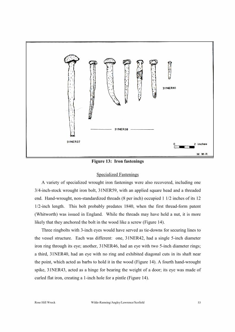
Rose Hill Wreck Wilde-Ramsing/Angley/Lawrence/Scofield ��
Figure 13: Iron fastenings
Specialized FasteningsA variety of specialized wrought iron fastenings were also recovered, including one
3/4-inch-stock wrought iron bolt, 31NER59, with an applied square head and a threaded end. Hand-wrought, non-standardized threads (8 per inch) occupied 1 1/2 inches of its 12 1/2-inch length. This bolt probably predates 1840, when the first thread-form patent (Whitworth) was issued in England. While the threads may have held a nut, it is more likely that they anchored the bolt in the wood like a screw (Figure 14).
Three ringbolts with 3-inch eyes would have served as tie-downs for securing lines to the vessel structure. Each was different: one, 31NER42, had a single 5-inch diameter iron ring through its eye; another, 31NER46, had an eye with two 5-inch diameter rings; a third, 31NER40, had an eye with no ring and exhibited diagonal cuts in its shaft near the point, which acted as barbs to hold it in the wood (Figure 14). A fourth hand-wrought spike, 31NER43, acted as a hinge for bearing the weight of a door; its eye was made of curled flat iron, creating a 1-inch hole for a pintle (Figure 14).

Rose Hill Wreck Wilde-Ramsing/Angley/Lawrence/Scofield ��
Figure 14: Iron bolts
Iron PigA single cast iron bar, 31NER45, weighing 26-3/4 pounds was recovered in the
vicinity of the stove. It measured 12 inches long (both ends were broken), 5 inches wide at its base, and 4 1/2 inches at the highest point. The many air holes indicate that the casting technique was poor, and its shape suggests that a shallow ditch served as the casting mold (Figure 15).
Figure 15: Iron pig, 31NER45

Rose Hill Wreck Wilde-Ramsing/Angley/Lawrence/Scofield ��
Copper KnobA 1 1/2-inch diameter hollow copper knob, 31NER13, to a door or a drawer was
recovered outside the wreck during a general reconnaissance dive. It had square 1/2-inch holes for a stem on opposing flattened sides (Figure 16).
Figure 16: Copper knob, 31NER13 Glass
Glass artifacts consisted of bottles and bottle fragments and one electrical insulator. There was a great range in dates assigned to these artifacts, while their distribution within and outside the wreck appeared random.
Dark green hand-blown glass bottles dominated the collection. Their shape and features represented one period centering on the 1730s and another on the 1780s (Hume 1969:60-71). The remaining bottles and insulator exemplify the continued use of the landing site from that time until the present (Figure 17).
Number Description Period LocationNER 25 dark glass bottle 1732 8i NER 24 dark glass bottle 1735 4h NER 17 dark glass bottle (2
frag) 1735 7k
NER 52 dark glass bottle 1735 General NER 15 dark glass bottle 1761 6a NER 6 dark glass bottle 1780 6m NER 14 dark glass bottle 1788 6h NER 11 dark glass bottle(3
necks) 1788 General
NER 26 clear glass bottle 1840 5g

Rose Hill Wreck Wilde-Ramsing/Angley/Lawrence/Scofield ��
Number Description Period LocationNER 26 clear glass bottle 1840 General NER 36 clear glass bottle 1850 6h NER 16 dark glass bottle 1850 5g NER 23 amber glass bottle 1870 8h NER 27 brown glass bottle 1890 6n NER 18 aqua glass bottle 1900 8f NER 19 insulator > 1930 7d NER 34 aqua glass bottle > 1930 7d
Figure 17: Wine bottles
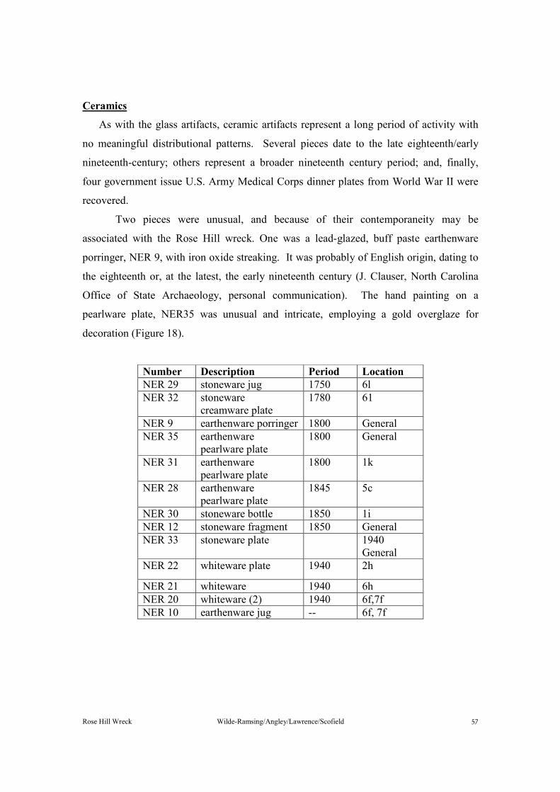
Rose Hill Wreck Wilde-Ramsing/Angley/Lawrence/Scofield ��
CeramicsAs with the glass artifacts, ceramic artifacts represent a long period of activity with
no meaningful distributional patterns. Several pieces date to the late eighteenth/early nineteenth-century; others represent a broader nineteenth century period; and, finally, four government issue U.S. Army Medical Corps dinner plates from World War II were recovered.
Two pieces were unusual, and because of their contemporaneity may be associated with the Rose Hill wreck. One was a lead-glazed, buff paste earthenware porringer, NER 9, with iron oxide streaking. It was probably of English origin, dating to the eighteenth or, at the latest, the early nineteenth century (J. Clauser, North Carolina Office of State Archaeology, personal communication). The hand painting on a pearlware plate, NER35 was unusual and intricate, employing a gold overglaze for decoration (Figure 18).
Number Description Period Location NER 29 stoneware jug 1750 6l NER 32 stoneware
creamware plate 1780 61
NER 9 earthenware porringer 1800 General NER 35 earthenware
pearlware plate 1800 General
NER 31 earthenware
pearlware plate 1800 1k
NER 28 earthenware pearlware plate
1845 5c
NER 30 stoneware bottle 1850 1i NER 12 stoneware fragment 1850 General NER 33 stoneware plate 1940
General NER 22 whiteware plate 1940 2h NER 21 whiteware 1940 6h NER 20 whiteware (2) 1940 6f,7f NER 10 earthenware jug -- 6f, 7f

Rose Hill Wreck Wilde-Ramsing/Angley/Lawrence/Scofield ��
Figure 18: Ceramic pieces
Rose Hill Wreck Wilde-Ramsing/Angley/Lawrence/Scofield �
Ballast StonesThe following is an analysis provided by East Carolina University geologist Jim
Watson of ballast stones sampled from the Rose Hill wreck: 1. Specimen No. 31NER53-1: Plagioclase (feldspar) and hornblende. 2. Specimen No. 31NER53-2: Pegmatite with large crystals of orthoclase, quartz,
and muscovite 3. Specimen No. 31NER53-3: Unknown, a completely weathered small cobble
of volcanic origin. Barnacle attached. 4. Specimen No. 31NER53-4: Silty sandstone. Barnacles attached.
"All specimens are smooth-surfaced, roughly rounded cobbles from riverine sources. Specimen 53-4 is the only sedimentary rock of the four examined. Sandstone is scarce in the piedmont and could possibly have come from the Appalachian west of the Blue Ridge Mountains. Feldspars and pegmatite can be found in the North Carolina piedmont but are scarce in the coastal plain. Specimens of this nature would likely have been shipped into the coastal regions from the piedmont, or possibly from geographic areas north of Virginia."
HISTORIC SHIP LOSSES
The shipwreck research files of the UAU contain nearly 3,000 entries for vessel
losses in North Carolina. During the past twenty-five years this body of data has been collected from newspaper accounts, Lifesaving Service and Coast Guard records, Army Corps of Engineers reports, the List of Merchant Vessels, official records of military activities, personal papers, and a variety of other sources.
Shipwreck losses for the Northeast Cape Fear River are surprisingly few, as indicated below:
Name Type Date Lost Cause LocationUnknown Sloop 1781 Burned Unknown Unknown Schooner 1781 Burned Unknown Spray Steamer < 1892 Unknown Above Hilton Bridge Pioneer Steamer 1920 Hit Obstruction Bannerman’s Bridge Unknown Wreck < 1931 Unknown Mouth of Smiths CreekUnknown Scow < 1931 Unknown Mouth of Smiths Creek

Rose Hill Wreck Wilde-Ramsing/Angley/Lawrence/Scofield ��
Only the two vessels lost during the Revolutionary War remotely satisfy the general characteristics reflected in the archaeological record. Efforts by researchers to link the Rose Hill wreck with one of those two vessels have failed and it appears that it is most likely not one of them.
The author of the following two documents was Captain Andrew Barkley (or Barclay) of the HMS Blond (or Blonde) (British Records, 1781). It was Barkley who led the naval contingent up the Cape Fear against Wilmington in conjunction with the forces of Major James Craig. The first document, transcribed below, bears the heading "Vessels taken [i.e., seized] up Cape Fear River by a Detachment of the Army & Gallies ye 1 Feb y 1781". On its reverse side the document is labeled simply "Vessels Captured in Cape Fear River." The text of this vessel list is as follows:
1. Rose a new Brigg of 120 Tons two three pounders pearced [pierced] for Twelve Guns-Loaded with rice Tobacco & bale goods
2. Schooner Betsy 70 Tons Six 9 pound Carronades loaded with rice flour rum & some ammunition
3. Schooner Flying Fish loaded with rice flour, Turpentine & Rum 4. Schooner Ceres 25 Tons loaded with Rice flour & Ammunition 5. Schooner Wild Cat 20 Tons. Empty 6. Schooner & Sloop with stores Ammunition & Provisions Burnt The second document, a letter to Lieutenant Colonel Balfour, was written aboard the
HMS Blond at Wilmington on February 12, 1781. It contains yet another account of the capture and destruction of the patriot vessels and of the movement of British and patriot forces prior to that event:
On the Morning of the 28th [January] the Troops landed at Ellis's plantation nine miles below the Town without the least opposition. The Rebels who were in arms, amounting to about two hundred Men marched out early in the Morning. We found two Batteries erected towards the River one of ten 12 & 9 pounders the other of seven 12 pounders. They were most of them spiked up.
Our being so long detained below [Wilmington] gave the Rebels time to remove their Effects Stores Provisions and Ammunition up the N.E. River in small craft; receiving information where those Vessels lay, Major Craig marched out with a Detachment of the Troops. I at the same time sent a Galley with two Gunboats under the Direction of Lieutenant Winter up the River and they were so fortunate as to get possession of them next Morning, except a Schooner & Sloop loaded with Provisions and Ammunition, that were a ground [aground], & obliged to burn them. I inclose you a list of the other Vessels Captured" [the list reproduced above].

Rose Hill Wreck Wilde-Ramsing/Angley/Lawrence/Scofield �
While this assessment leaves the site of the vessels' destruction undefined, additional research has turned up some clues. It appears from the following deposition, recorded for a John Williams of New Hanover County, November 29, 1789, that the wreck location was nearly ten miles upstream of the Long Bridge (also known as Heron's Bridge), which in turn was twelve river miles above Rose Hill (North Carolina Genealogical Society Journal 1977, III, 3:178).
…that about the 31st of January. . .[1781]. . .[he] was ordered by Coln Young of Wilmington County [sic]. . .to assist with several Others in taking the publick provisions from the ware House at the Long Bridg & that before they had finished Loading the publick vessel provided for that purpose they had further Orders to push of[f] immediately as high Up the River as possable pursuant to sd orders. . .they set out & had not gone over ten miles Before they were Overtaken By the Britis[h] & was obliged to make their Escape In A Bote to Shore. . .He saw the British Board the Vessel & before they Got out of the Swamp, Saw the Smoak arise which they supposed to be the Vessell on fire. . .the Deponent further saith that their was trunks & Desk & other property belonging to private persons In sd Vessell. One additional document concerning the lower Cape Fear campaign of early 1781 by
the British is from the logbook of one of the participating vessels, probably one of the galleys. Entries in the log show that this vessel passed upstream from Wilmington on January 30, 1781, and came to rest "at single anchor off Quince's plantation [Rose Hill landing] in 3 fathoms water." It remained at this location on the following day and on February 1 moved upriver to a place referred to as "Cowpen," located approximately six miles above Rose Hill landing (Figure 19). That afternoon the British transport agent "returned with a Prize Brig captured a few miles above." On the following day this vessel fell slightly downstream to an anchorage a "little below the Cowpen," having been involved in an exchange of fire with patriot troops on shore (British Records 1781).
This casts an additional, if unwelcome, cloud of doubt over the possibility that the Rose Hill wreck could have been one of the ships burned by the British, since this British vessel was at Rose Hill (Quince's plantation) very soon after the schooner and sloop reportedly were burned. There is no indication in the log of a known shipwreck nearby.

Rose Hill Wreck Wilde-Ramsing/Angley/Lawrence/Scofield ��
Figure 19: Wilmington area map with historic locations

Rose Hill Wreck Wilde-Ramsing/Angley/Lawrence/Scofield ��
A search of the shipwreck files for wrecks that occurred in the general vicinity of Wilmington during the eighteenth and nineteenth centuries produced another possible candidate. A colonial newspaper reported the following:
VESSEL: Pelican DATE LOST: July 16, 1768
MANNER OF LOSS: Burned LOCATION: At Cape Fear, North Carolina TYPE OF VESSEL: Sloop PORT OF REGISTER: New Port, Rhode Island BOUND FOR: Cape Fear, North Carolina CARGO: Tar CAPTAIN: Robert Benny CREW LOST: None DETAILS: The Pelican apparently was at anchor, being loaded in preparation
to sail. By some accident the vessel took fire and in a very short time was entirely consumed. Captain Benny and the entire crew were aboard at the time and "had scarcely time to get the boat out and save their lives." As Captain Benny was getting over the side, "the boat not being near enough from him to step immediately into" his hands were burned causing him to fall into the water, where he sunk twice before being taken up (Virginia Gazette, July 28, 1768). This report is general enough that Rose Hill could be the location of this wreck;
however, the vessel Pelican, under Captain Benning, which cleared Port Brunswick on April 1, 1768, was listed as 30 tons burthen, far smaller than the 100-plus tons projected for the Rose Hill wreck (Brunswick Port Records 1718).
Perhaps the reason why the Rose Hill wreck has not been conclusively identified is because the vessel came to grief before any Wilmington newspapers were published-or, at the least, during a period from which few documents survive. Considering the property disputes in the 1740s between William Lithgow and "King" Roger Moore, in which the former accused the latter of illegally shipping timber and naval stores from the Rose Hill and Red Banks properties, one wonders what offense was committed against Moore to result in Lithgow's arrest and jail term. Sinking a ship, perhaps? Archival inquiries reveal the paucity of records surviving from that time. No Wilmington newspapers existed prior to 1764, when the North Carolina Gazette began publication. That journal continued until 1767 and was succeeded by the Cape Fear Mercury (1769-1775). Both were weekly papers. Yet, only four Gazettes and twenty-one Mercurys are
Rose Hill Wreck Wilde-Ramsing/Angley/Lawrence/Scofield ��
known to exist. Similar disappointment comes from New Hanover County Court Minutes, since those records from June 1742 through November 1758 have been lost or destroyed (Walker 1958:31).
Conducting research on the latter part of the eighteenth century, particularly examining Revolutionary War activities during which a vessel might be sunk, produces similar difficulties. From 1775 to 1788 no newspapers were published at all in Wilmington. Furthermore, very few government records appear to have survived from that episode, and many of those may be tucked away in British archives. While there is a remote chance that the Rose Hill wreck was the Pelican or one of the two American vessels destroyed by the British in 1781, it is more likely to be an as yet undetermined vessel. A historical account clearly identifying the wreck, if it exists, may be extremely difficult to find.
SUMMARY AND CONCLUSIONS
The Rose Hill wreck represents an early to mid-eighteenth-century seagoing sailing vessel that lies on the east shoulder of the Northeast Cape Fear River channel in fifteen feet of water. Its hull remains consist of the lower portion of the bilge exposed on the hard, sandy bottom. The wreck measures 62 feet long by 16 feet wide, and projects a maximum of 4 feet 9 inches above the bottom at the sternpost.
The structural remains provide by far the most reliable information for interpreting the Rose Hill wreck. Artifacts at the wreck site were neither sealed in a context clearly associated with the wreck nor did their spatial distributions provide meaningful insight. It should be noted that in the case of glass artifacts the 1730s and 1780s were the two decades most heavily represented, while slightly higher concentrations of ceramic artifacts of the late eighteenth century were in evidence. This may reflect the period of active service for the Rose Hill vessel.
Historical documentation linked directly with the Rose Hill wreck has not surfaced despite rather exhaustive efforts. The fact that the wreck was the correct vintage and showed signs of burning made it an excellent candidate for speculation as one of two vessels lost during the Revolutionary War. Archival research suggested, however, that

Rose Hill Wreck Wilde-Ramsing/Angley/Lawrence/Scofield ��
the reported sinking took place well upstream. Other historically documented vessel losses, for one reason or another, did not match well with the archaeological record of the Rose Hill wreck.
At present the most useful data for understanding the Rose Hill wreck comes from its structural remains. Attempting to draw rational conclusions of origin and date on the basis of the vessel's structure presents major problems, however. Virtually no data are available on eighteenth- and nineteenth-century construction practices for North American-built vessels. Known shipbuilding methods from other countries are the only standards available for reference. In using them, great care should be exercised, as there is the risk that unique local methods of construction may well be overlooked or misinterpreted if, in appearance, the wreck does not emulate its European counterparts. Until there is an accumulation of data from North American wreck sites to comprise a primary research data base, reliance upon foreign shipbuilding practices will continue.
Using existing knowledge, archaeologists working on the Rose Hill project were able to make a number of projections. The vessel appears to have been built between 1660 and 1750, and most likely between 1725 and 1750, based on construction methods found in the wreck's framing pattern, keelson, and rabbet line. The framing pattern also supports the contention that the Rose Hill wreck was built as a merchantman, since its design allowed water to collect below the ceiling and away from cargo stored in the hold. This is further substantiated by the vessel's hull shape, which is both deep drafted and wide and flat, representing a burdensome vessel.
Given that it is a merchant vessel dating to the early eighteenth century, vital statistics can be projected for the Rose Hill wreck. The vessel's length would have been 67 feet between fore and aft perpendiculars, including stem (10 feet 6 inches) and stern (2 feet 6 inches) rakes. Other calculated measurements were a beam of 22 feet, depth of hold of 8 feet 6 inches, and a capacity of 103 tons.
Ascertaining the wreck's rig type presented a greater challenge, since essential evidence was missing. Vessels of that period and size would generally have been schooners or brigs; however, the keelson showed no evidence of a step for the mainmast. Further confusing the issue was the missing forward portion of keelson, which would have held evidence of a forward mast step. That missing section is also where the mast
Rose Hill Wreck Wilde-Ramsing/Angley/Lawrence/Scofield ��
would have been stepped had the wreck been single masted. While a single mast appears most probable, sloops were generally smaller and exhibited greater deadrise. The wreck may have been unmasted, but its deep draft and the presence of a substantial cookstove suggest overseas or coastal service rather than use merely as a lighter in the Cape Fear River.
The presence and use of most North American wood types found on the Rose Hill wreck suggest that the vessel was built in the American colonies. The overall characteristics exhibited from the construction features point to a builder who had formal naval training in the European tradition. During the first half of the eighteenth century, New England would have been the most likely launch site for the Rose Hill wreck.
RECOMMENDATIONS
At this writing the Rose Hill wreck is the earliest recorded shipwreck in North Carolina. It provides a rare glimpse of colonial maritime activities in the southeastern United States and most likely a view of shipbuilding activities in the American colonies.
Although it has not been positively identified or tied directly to either a historical event or significant persons, the wreck's structural features provide a source of information on shipbuilding unavailable in historical documents or in data generated by archaeological investigations. Artifacts associated with the wreck, although few in number, offer important data concerning shipboard life during the eighteenth century. The wreck's cast iron galley stove is particularly important, since its association with a vessel possibly built between 1700 and 1730 would predate historical references for the introduction of iron stoves on ships. It is not out of the question, though, that the stove could have been added to the vessel at a later date.
The archaeological investigations detailed in this report provided a better understanding of the Rose Hill wreck and, in turn, generated the following management recommendations. Foremost, the wreck site should be nominated for listing in the National Register of Historic Places. Form preparation should be relatively simple, given the thorough documentation presented in this report and the significance of the site.

Rose Hill Wreck Wilde-Ramsing/Angley/Lawrence/Scofield ��
Once designated, the Rose Hill wreck will receive a high degree of attention should construction projects threaten to disturb or destroy it in the future..
Exposed on the river bottom subjects the Rose Hill wreck to natural phenomena such as river currents and suspended debris, which may have a slow but destructive effect on its stability. Perhaps more detrimental to its preservation are visits from sport divers, who can be very destructive in their efforts to find artifacts without regard to the archaeological value of a site.
The actual threats to long-term preservation of the Rose Hill wreck from any source are not known. The wreck has survived in its present condition for two centuries; exposure to natural forces, construction projects, or sport-diving activities may have a minimal effect in the long term. On the other hand, any destructive force or combination of such forces could readily destroy the wreck site. Therefore, it is recommended that periodic site inspections be conducted to monitor the condition of the site. Annual visits, but preferably semiannual visits, are recommended, perhaps in conjunction with training exercises.
If in the future the Rose Hill wreck is being destroyed or threatened with destruction, a mitigation plan must be devised to record important archaeological data and to recover significant structural elements for long-term preservation. Elements of such a plan should include:
1. A thorough and expanded search of the wreck site vicinity to locate and record all disarticulated structural pieces and associated artifacts.
2. Inspection and documentation of the keel and other hull planking and overall hull shape.
3. Excavation of sediments lying underneath the wreck to recover cultural materials.
Furthermore, in order to accomplish tasks 2 and 3 effectively, both in terms of
standards of documentation and costs, the possibility of raising the hull from the bottom should be strongly considered. Besides allowing easy access to both the lower hull and the underlying sediments for examination, the hull itself would be in a position to be moved to a conservation facility or a holding area (e.g., an out-of-the-way part of the river) for long-term wet storage.

Rose Hill Wreck Wilde-Ramsing/Angley/Lawrence/Scofield ��
As new documentary sources are explored, the Rose Hill wreck should be kept in mind. Somewhere, perhaps in an obscure newspaper edition, a family letter, or a British commander's logbook, there exists a clue that can help identify the wreck. If those clues are recognized and the vessel can be given a written history, its significance will be increased. Researchers will then be able to affix a time and place for the construction methods and artifacts (e.g., iron galley stove) found at Rose Hill in their effort to reach a broader understanding of maritime trends.
Rose Hill Wreck Wilde-Ramsing/Angley/Lawrence/Scofield �
REFERENCES CITED Angley, Wilson 1986 Richard Quince: merchant, planter and patriot of Brunswick Town. Ms. on file, North Carolina Division of Archives and History, Raleigh. Baker, William 1962 Colonial Vessels. Barre Publishing Company, Massachusetts. British Records 1781 Andrew Barclay in the State Records of North Carolina, XV:XVI:IX. North Carolina State Archives, Raleigh. Brunswick Port Records 1768 Treasurer's and Comptroller's Papers. North Carolina State Archives, Raleigh. Clark, Walter (editor) 1895-1906 State Records of North Carolina. 16 Volumes, State of North Carolina, Winston and Goldsboro. Collet, John 1770 A complete map of North Carolina from an actual survey. From North
Carolina in Maps, W.P. Cummings, 1966, North Carolina State Archives, Raleigh. Colonial Court Records William Gray Estate Papers. North Carolina State Archives, Raleigh. Davis and Walker Family Papers Genealogical notes in the Davis and Walker family papers. University of North Carolina, Chapel Hill. Deane, Sir Anthony 1670 Deane's Doctrine of Naval Architecture. Edited and reprinted by Brian Lavery, 1981, Conway Maritime Press, Greenwich, London. Duff, James A. and Diana M. Lange 1980 A magnetometer survey of the Northeast Cape Fear River at Blossom's Ferry crossing, Castle Hayne, North Carolina. Ms. on file, North Carolina Underwater Archaeology Unit, Kure Beach.

Rose Hill Wreck Wilde-Ramsing/Angley/Lawrence/Scofield ��
Fisher, R.H. 1929 Biographical Sketches of Wilmington Citizens. Wilmington Stamp and Printing Company, Wilmington. Giese, G.L., H.B. Wilder, and G.G. Parker, Jr. 1955 Hydrology of major estuaries and sounds of North Carolina: U.S. Geological Survey water-supply paper 2221. U.S. Government Printing Office, Washington, D. C. Goodwin, Peter 1987 English Man of War 1650-1880. Conway Maritime Press, London, England. Hewlett, Crockette W. 1985 Between the Creeks Revised: Masonboro Sound, 1735-1985. New Hanover Printing and Publishing Company, Wilmington, North Carolina. Hofmann, Margaret M. 1979a Province of North Carolina, 1663-1729: Abstracts of Land Patents.
Roanoke News Company, Weldon, North Carolina.
1979b Colony of North Carolina: Abstracts of Land Patents, 2 volumes. Roanoke News Company, Weldon, North Carolina. Hubbard, E.F. and William G. Stramper 1972 Movement and Dispersion of soluble pollutants in the Northeast Cape Fear Estuary, North Carolina: U.S. Geological Survey water-supply paper 1873-E. U.S. Government Printing Office, Washington, D.C. Hume, Ivor Noel 1969 A Guide to Artifacts of Colonial America. Alfred A. Knopf, Inc, New York. James, Captain William H. 1864 Defenses of Wilmington...map of county between the Northeast Cape Fear River and Topsail Sound. North Carolina State Archives, Raleigh. James and Brown, Civil Engineers 1869 Map of New Hanover County, North Carolina, North Carolina State Archives, Raleigh. Kellam, Ida (compiler) 1959 Marriage and Death Notices in Newspapers Published in Wilmington,
North Carolina 1791-1842...published by author, Wilmington.
Rose Hill Wreck Wilde-Ramsing/Angley/Lawrence/Scofield �
Collection notes of newspaper accounts, land records, plats and cemetery records. Ms. on file, Research Branch, North Carolina Division of Archives and History, Raleigh. Koski-Karell, Daniel 1982 Cultural resource investigation of the project area of a proposed highway bridge over the Northeast Cape Fear River, Pender and New Hanover Counties, North Carolina. Ms. on file, Karell Archaeological Services, Washington, D.C.
Lange, Diana M. and James A. Duff 1980 A magnetometer survey of the Northeast Cape Fear River near Castle Hayne, North Carolina. Ms. on file, North Carolina Underwater Archaeology Unit, Kure Beach.
Lawrence, Richard W. 1981 Field notes on a search for cannon reported at Blossom's Ferry, Castle Hayne, North Carolina. Ms. on file, North Carolina Underwater Archaeology Unit, Kure Beach. Lawrence, Richard W. and Mark Wilde-Ramsing 1985 Magnetometer survey of portions of the Northeast Cape Fear River and Long Creek between Wilmington and Castle Hayne, North Carolina. Ms. on file, North Carolina Underwater Archaeology Unit, Kure Beach. Lavery, Brian 1988 Arming and Fitting of English Ships of War 1600-1815. Conway Maritime Press, London, England. Lee, Lawrence 1965 The Lower Cape Fear in Colonial Days. The University of North Carolina Press, Chapel Hill. Loyalists' Claims Henry Lewis DeRosset folder in the English Records, North Carolina State Archives, Raleigh. Lyman, John 1945 Registered Tonnage and Its Measurements. American Neptune V(3): 223-234. MacGregor, David R. 1985 Merchant Sailing Vessels 1775-1815, Naval Institute Press, Annapolis, Maryland.
Rose Hill Wreck Wilde-Ramsing/Angley/Lawrence/Scofield ��
McKoy, Elizabeth F. (compiler and editor) 1973 Early New Hanover County Records. Published by the compiler and editor, Wilmington. Meares, Catherine DeRosset (compiler) 1906 Annals of the DeRosset Family. R.L. Bryan Company, Columbia, South Carolina. Moore, Elizabeth 1966 Rice, Hasell, Hawks and Carruthers Families of North Carolina.
Genealogical Recorders, Bladensburg, Maryland. Moss Engraving Company 1886 Map of New Hanover County, North Carolina. North Carolina State Archives, Raleigh. Mouzon, Henry 1775 An accurate map of North and South Carolina with their Indian frontiers. From North Carolina in Maps, W.P. Cummings, 1966, North Carolina State Archives, Raleigh.
New Hanover County Deeds, Estate Papers, Wills North Carolina State Archives, Raleigh. New Hanover County Aerial Photographs 1938 North Carolina State Archives, Raleigh. Newsom, Lee A. 1988 Wood identification of Rose Hill shipwreck timber samples. Ms. on file, The Florida State Museum, University of Florida, Gainesville. Norden, Eric 1926 Rose Hill plantation, property of the Gore Estate Corporation, Cape Fear Township. North Carolina State Archives, Raleigh. North Carolina Genealogical Society Journal 1977 Volume III, No. 3:178. North Carolina State Archives, Raleigh. North Carolina Historical and Genealogical Register 1903 Edited by J.R.B. Hathaway. Volume III, No. 3 (July). North Carolina State Archives, Raleigh.
Powell, William S. (editor)

Rose Hill Wreck Wilde-Ramsing/Angley/Lawrence/Scofield ��
1979 and 1986 Dictionary of North Carolina Biography. Volumes I and II. The University of North Carolina Press, Chapel Hill. Saltus, Allen R., Jr. and Wilson Angley 1982 Cultural resources survey of a portion of the Northeast Cape Fear River and report on the test excavation to evaluate the steamship Spray. Ms. on file, North Carolina Underwater Archaeology Unit, Kure Beach. Saunders, William L. (editor) 1886-1890 Colonial Records of North Carolina. 10 volumes. State of North Carolina, Raleigh. Scofield, Geoffrey 1990 Program to calculate historic vessel sizes. Ms. on file, North Carolina Maritime Museum, Beaufort. South Carolina Genealogies 1983 Articles from The South Carolina Historical (and Genealogical) Magazine.
Volume IV, The Reprint Company, Spartanburg, South Carolina. Steel, David 1805 Elements and Practice of Naval Architecture, 1805. Reprint 1977, Sim Comfort Association, London. Thomas, Cornelius, M. D. 1959 James Forte: A 17th Century Settlement...and the Hilton Pamphlet, 1664.
Charles Towne Preservation Trust, Wilmington, North Carolina. Walker, Alexander McDonald 1958 New Hanover County Court Minutes 1738-1769. Published by the author, Bethesda, Maryland. Watts, Gordon P., Jr. 1985 Investigating historic Blossom's Ferry, North Carolina. Archaeology,
Vol. 38, No. 5:26-33. Watts, Gordon P., Jr. and Wesley K. Hall 1986 An investigation of Blossom's Ferry on the Northeast Cape Fear River. Ms. on file, East Carolina University, Greenville, North Carolina. Watts, Gordon P., Jr. and James R. Reedy, Jr. 1982 An archaeological reconnaissance of vessel remains lying in the vicinity of an historic ferry crossing on the Northeast Cape Fear River (New Hanover County). Ms. on file, East Carolina University, Greenville, North Carolina.
Rose Hill Wreck Wilde-Ramsing/Angley/Lawrence/Scofield ��
Wilde-Ramsing, Mark 1987 Investigation of the remains of a sunken vessel at the historic river landing of Rose Hill plantation, Northeast Cape Fear River above Wilmington, North Carolina. Ms. on file, North Carolina Underwater Archaeology Unit, Kure Beach. Worsham, William Scott 1989 Lab report on the analysis of hair from the Rose Hill wreck. Ms. on file, State Bureau of Investigation, Raleigh, North Carolina

Rose Hill Wreck Wilde-Ramsing/Angley/Lawrence/Scofield ��
INDEX
AAerial Photograph (1938), 26 American Coal Company, 27 Angley, Wilson, 5, 73 Archives & History, NC Division, 5, 69 Artifact Analysis, 5 Artifact Tagging, 30 Artifacts, Ceramic, 32 Artifacts, Glass, 32
BBalfour, ___, Lt. Col. (1781), 60 Ballast Stones, 50, 59 Barbadians, 13 Barclay, Andrew, Capt. *1781), 60 Barkley, Andrew, Capt. (1781), 60 Beaufort, NC, 5, 7, 73 Benning, Robert, Capt., 63 Benny, Robert, Capt., 63 Bilge-Pump, 9 Bland, Kenneth, 5 Boston, MA, 16, 18 Bottles, Glass, 27, 50, 51, 55, 56, 57 Bow Remains, 30 Brickyard Creek, 26 Brig Rose (1781), 4, 5, 6, 7, 8, 10, 12, 14, 15, 17, 20,
21, 22, 23, 24, 25, 26, 27, 28, 29, 30, 31, 32, 35, 39, 45, 47, 48, 49, 50, 51, 57, 59, 60, 61, 63, 64, 65, 66, 67, 68, 72, 74
Bright Leslie, 5 British Occupation, Wilmington (1781), 10 Brook, Robert, 8 Brooks, Barbara L. (UAU), 6 Brunswick River, 13 Burrington, George, Governor, 13
CCallender, Thomas, Capt. (1785), 20, 21 Cape Fear River, 8, 10, 12, 14, 15, 25, 26, 27, 28, 50,
59, 60, 64, 66, 69, 71, 73, 74 Carolinas Boundary Dispute (1737), 14 Carter, _____, 15 Castle Hayne, 6, 14, 26, 27, 69, 71 Ceiling, 2, 40 Center Line Structure, 4, 40 Ceramic Artifacts, 32, 57, 64 Charles Town Settlement 1664-1667, 13, 73 Charleston, SC, 22 Civil War Fortifications, 27 Claggett, Steve, 5 Colonial Drawbridge, 27 Colonization, Cape Fear Area, 13 Confederate Obstructions, 27 Confiscation, Property, 17 Congleton, Edward, 5 Conservation, 10, 40, 67
Construction Features, 66 Copper Knob, 55 Cowpen, Cape Fear River, 61 Craig, James, Major, 60 Creamware Plate, 57 Crockery Fragments, 19th century, 10
DDating of Wreck, 47 Davis, Elizabeth Moore (1853), 22 Davis, Thomas F. (1817), 22 Deadwood and Sternpost, 2, 37 DeRosset, Lewis Henry, 16, 17, 18, 20, 21, 71, 72 Description of Work, 5 Drift Bolts, Iron, 52 Dunn, Jerry, 5
EEarthenware Porringer or Jug, 57
FFasteners, Iron, 2, 42 Ferries, NE Cape Fear River, 27, 73 Fort Fisher State Historic Site, 5 Fort Fisher Underwater Archaeology Unit, 5, 6, 8, 10,
27, 28, 29, 34, 59 Framing Pattern, 29, 47, 65 Futtocks, 2, 39
GGeneral Electric Company Plant, 6, 26, 28, 29, 30, 32 Gillman-Bryan, Julep, 5 Gillman-Bryan, Peter, 5, 28 Glass Artifacts, 32 Gore Estate Corporation, 25, 72 Gray & Carter, 15, 16 Gray, John (1742), 15 Gray, William (1736), 14, 15, 16, 21, 69 Gunter, Allen (CFCC), 5
HHasell Susannah (Quince), 19, 22 Hasell, James, Jr., 19 Heron’s Bridge (Big Bridge), 27 Hill, John Hampden, Dr., 23 Hilton Railroad Bridge, 28 Hilton, William (1662-1663), 12, 13, 26, 27, 28, 59,
73 Historic Ship Losses, 5 Historical Background, 5 Hull Remains, 35, 64

Rose Hill Wreck Wilde-Ramsing/Angley/Lawrence/Scofield ��
IIndian Ceramic Sherds, 50, 51 Indians, Cape Fear, 12 Interstate I-40, 27 Iron Cookstove, 2, 45 Iron Pig or Bar, 45, 54
JJohnston, Gabriel, Governor, 15
KKeelson, 32, 33, 34, 35, 39, 40, 42, 43, 45, 47, 48, 49,
52, 65 Knob, Copper, 55
LLawrence, Richard W., 5, 7 Lithgow, William, Capt., 15, 16, 63 Long Creek, 28, 71
MMap - Eric Norden (1926), 4, 24 Map - Hilston’s, 13 Map - James Wimble (1738), 15 Map - John Collet (1770), 4, 17, 19 Map - Military (1864), 23 Map - Mouzon (1775), 17 Map - New Hanover County (1869), 4, 23, 24 Map - New Hanover County (1886), 24 Map - Project Location, 9 Map - Topographic, 4, 12 Mathis, Mark, 5 McPherson, W., 23 McRee, James F. (1842), 23 Moore Elizabeth (Quince), 21, 22 Moore, David, 29 Moore, George (1805), 21 Moore, Roger, 15, 16, 63 Motte, Abraham, 22
NNails, Iron, 3, 52 Naval Stores Industry, 12, 15, 63 New Liverpool Settlement, 14 New Town, or Newton Settlement, 14 Newspapers, Early, 63, 64 Norden, Eric, 4, 24, 25 North Carolina Supreme Court, 20
OOrton Plantation, 15, 16
PPearlware Plate, 57 Planking, 4, 34, 35, 37, 39, 41, 42, 67 Plantations, Cape Fear, 16, 20, 23, 25 Prince George Creek, 14, 25
QQuince Susannah Hasell, 19, 22 Quince, Eliabeth Moore, 22 Quince, Jane (1849), 22 Quince, John, 20 Quince, Mary Sarah Washington, 19, 22 Quince, Nathaniel Hill (1842), 22 Quince, Parker (1779), 18, 19, 20, 21, 22, 23 Quince, Richard, 16, 17, 18, 19, 20, 21, 22, 69 Quince, William Soranzo (Hasell), 19
RRed Banks Plantation, 14, 15, 16, 17, 18, 26, 63 Rehder, Stanley, 28 Revolutionary War, 10, 27, 60, 64, 65 Rising Wood or Hog, 2, 37 Rose Hill Plantation, 23, 25 Rowan, Matthew, 14 Rudder, 8, 29, 32, 33, 34, 37, 43, 45, 48
SSanders Mill Creek, 25 Sarsfield, John, 5 Schooner Betsy (1781), 60 Schooner Ceres (1781), 60 Schooner Flying Fish (1781), 60 Schooner Wild Cat (1781), 60 Scofield, Geoffrey J., 7Sheathing, 10, 29, 41, 42, 52 Ship Adventure, 12, 13 Site Survey, 2, 32, 70 Slaves, 18 Sloop Pelican, 63, 64 Spencer, Gehrig, 5 St. Philips Epsicopal Church, 16 Steamer Pioneer, 59 Steamer Spray, 27, 59, 73 Stem/Apron, 2, 37 Sternpost, 37
TTrunnels & Pegs, 42
UUnderwater Archaeology, 5, 7, 69, 71, 73, 74

Rose Hill Wreck Wilde-Ramsing/Angley/Lawrence/Scofield ��
VVessel Construction, 5 Volunteers, UAU, 5, 29
WWalker, Ben, 8 Walker, Robert, 17
Watson, Jim, 59 Wilde-Ramsing, Mark, 5, 7, 71 Williams, John (1789), 61 Wilmington, NC, 4, 5, 8, 10, 11, 12, 13, 14, 15, 17, 20,
21, 22, 23, 25, 26, 28, 29, 60, 61, 62, 63, 64, 70, 71, 72, 73, 74
Wine Bottles, Colonial, 8, 10 Winter, ____, Lt. (1781), 60 Wreck Examination, 2, 33
�