table of contents - santa clara valley water district · 5 flood risk management the land adjacent...
TRANSCRIPT


Table of Contents Introduction ..................................................................................................................................................................... 1
Management Recommendations from the Science Advisors ............................................................................... 8
Next Steps ..................................................................................................................................................................... 13
Acknowledgments ....................................................................................................................................................... 14
Literature Cited ............................................................................................................................................................. 15
Appendix A: Workshop Attendees ............................................................................................................................ 17
Appendix B: Workshop Presentation Slides ............................................................................................................ 18


1
Introduction Upper Penitencia Creek has a history of flooding, particularly in its downstream reaches near the confluence with Coyote Creek. Because of this, the Santa Clara Valley Water District (District) recently initiated the Upper Penitencia Creek Project, with main goals including the prevention of flooding damage along the creek and shutdowns to utility and transportation infrastructure. The District is seeking a management approach for the creek that meets these goals in a manner that is resilient to changing land use and climatic conditions, while providing additional benefits beyond flood risk management, including maximizing water supply, supporting ecological processes and functions, and creating recreational opportunities. The District is also seeking to develop this new management approach in coordination with local partners who own and operate land adjacent to the creek (e.g., City of San Jose, County of Santa Clara, and local school districts), thereby explicitly incorporating the partners’ management goals into the approach and expanding the areas adjacent to the creek that could be managed to provide multiple benefits.
Though bound by a highly urbanized landscape in its lower reaches, Upper Penitencia Creek remains an important resource that provides ecological services that are relatively unique in Santa Clara Valley. For example, the creek provides vital habitat for threatened steelhead trout (Oncorhynchus mykiss) and other native fish species. In addition, public open spaces and forested natural areas along the creek corridor provide important habitat for native plants, amphibians, fishes, birds, and other wildlife, providing a major portion of what could eventually be a regionally important corridor of habitat connectivity from the Diablo Range in the eastern portion of Santa Clara Valley to the Bay.
Upper Penitencia Creek from the confluence with Coyote Creek upstream to Alum Rock Park.

2
As a first step in developing a new management approach for Upper Penitencia Creek that benefits both people and wildlife, the District, in partnership with the San Francisco Estuary Institute-Aquatic Science Center (SFEI-ASC), convened a workshop on March 13, 2017 aimed at creating a high level, science-based “landscape concept” for the area. The workshop included presentations by District engineers and planners and SFEI-ASC scientists on the historical and contemporary characteristics of Upper Penitencia Creek and its surrounding landscape, including terrestrial and aquatic ecology, dry season and flood hydrology/hydraulics, groundwater dynamics, and geomorphology. Information about current recreational and educational opportunities was also included. The presentations were followed by a moderated discussion that focused on the short- and long-term management measures put forth by an expert panel of science advisors, or Science Hub. The Hub members were Andy Collison (fluvial geomorphologist, ESA), Lorraine Flint (hydrogeologist, USGS), Robert Leidy (fisheries biologist, US EPA), Bruce Orr (riparian ecologist, Stillwater Sciences), and Steve Rottenborn (wildlife biologist, HT Harvey). The moderator for the discussion was Caitlin Sweeney (San Francisco Estuary Partnership). The audience, which included representatives from local partner organizations as well as state and federal regulatory agencies responsible for permitting projects, were active participants in the discussion and asked critical questions that helped clarify the measures being proposed. Taken together, the measures discussed at the workshop form the landscape concept. This memorandum documents the key information from the Upper Penitencia Creek landscape concept workshop. Here, we provide a summary of the information presented at the workshop and an initial version of the landscape concept. A next step could include a more detailed description of the landscape characteristics and change over time, along with more information on the management measures and a refined landscape concept. This additional information will be useful to District staff as they work with local partners and regulatory agencies to develop a multi-benefit management approach for the creek and surrounding landscape over the short- and long-term.
Creek field visit with the Science Hub members and District staff (November 29, 2016).
Photo: Amy Richey
3
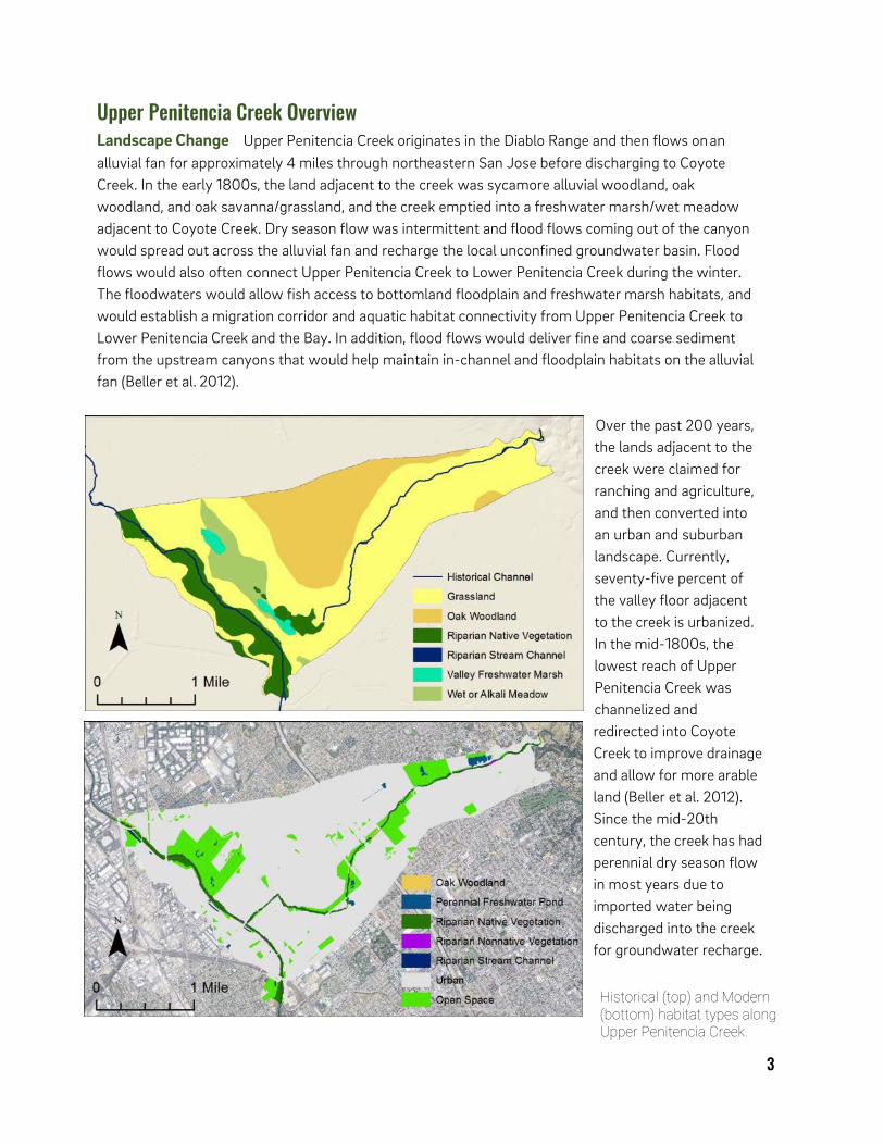
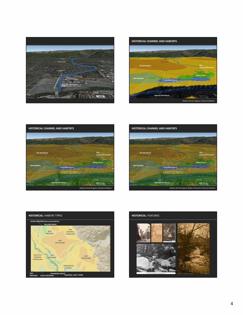
Upper Penitencia Creek Overview Landscape Change Upper Penitencia Creek originates in the Diablo Range and then flows on an alluvial fan for approximately 4 miles through northeastern San Jose before discharging to Coyote Creek. In the early 1800s, the land adjacent to the creek was sycamore alluvial woodland, oak woodland, and oak savanna/grassland, and the creek emptied into a freshwater marsh/wet meadow adjacent to Coyote Creek. Dry season flow was intermittent and flood flows coming out of the canyon would spread out across the alluvial fan and recharge the local unconfined groundwater basin. Flood flows would also often connect Upper Penitencia Creek to Lower Penitencia Creek during the winter. The floodwaters would allow fish access to bottomland floodplain and freshwater marsh habitats, and would establish a migration corridor and aquatic habitat connectivity from Upper Penitencia Creek to Lower Penitencia Creek and the Bay. In addition, flood flows would deliver fine and coarse sediment from the upstream canyons that would help maintain in-channel and floodplain habitats on the alluvial fan (Beller et al. 2012).
Over the past 200 years, the lands adjacent to the creek were claimed for ranching and agriculture, and then converted into an urban and suburban landscape. Currently, seventy-five percent of the valley floor adjacent to the creek is urbanized. In the mid-1800s, the lowest reach of Upper Penitencia Creek was channelized and redirected into Coyote Creek to improve drainage and allow for more arable land (Beller et al. 2012). Since the mid-20th century, the creek has had perennial dry season flow in most years due to imported water being discharged into the creek for groundwater recharge.
Historical (top) and Modern (bottom) habitat types along Upper Penitencia Creek.

4
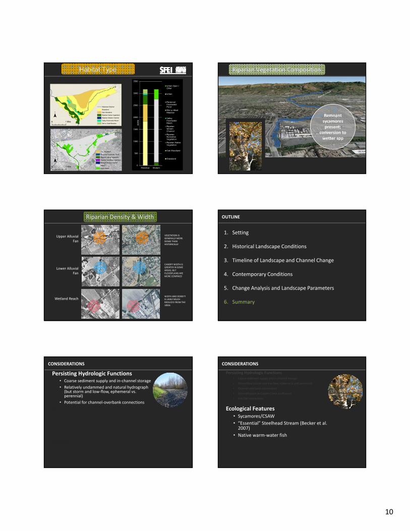
Runoff is now more rapidly delivered to the creek during storm events by a storm drain network and flood flows are constrained by earthen berms along the lower reaches of the creek. Coarse sediment transported along the channel in the wet season now gets trapped under bridges and culverts, causing some localized flooding issues and impediments to fish and wildlife passage (Stillwater Sciences 2006). Due to changes in dry season hydrology and land management practices, riparian vegetation composition has changed considerably and is now generally denser than it was historically (DeJager and Martel 2006, Grossinger et al. 2006), with wider canopy width in some areas, even though floodplains are generally more confined.
Despite these changes, hydrologic and ecological processes still support wildlife in Upper Penitencia Creek. The relatively undeveloped watershed upstream of the valley floor results in a relatively natural storm hydrograph and relatively high coarse sediment supply compared to other Santa Clara Valley streams, despite the presence of Cherry Flat Reservoir. The creek is home to a persisting stand of California sycamore (Platanus racemosa) trees, which were once extensive in Santa Clara County, but are now a rare cover type (Keeler-Wolf et al. 1996, Sawyer et al. 2009). The creek is also critical steelhead habitat, providing steelhead with a relatively continuous riparian corridor along one of the shortest routes to spawning areas in the South Bay (Leidy et al. 2005, Stillwater Sciences 2006, Leidy 2007). In addition to steelhead, the creek also provides habitat for other native aquatic species, including Pacific lamprey (Entosphenus tridentatus) and Sacramento sucker (Castomous occidentalis) (CDFG 2009, CDFW and SJSU 2013). The riparian corridor also provides a pathway by which a variety of mammals and birds such as bobcats (Felis rufus) and oak titmice (Baeolophus inornatus) can disperse from the Diablo Range westward into the urbanized Santa Clara Valley. Enhancements along the Upper Penitencia and Coyote creek corridors could potentially promote movement along Coyote Creek to the Bay (Bay Area Open Space Council 2011).
Riparian density along Upper Penitencia Creek in 1939 (left) and in 2009 (right).
5
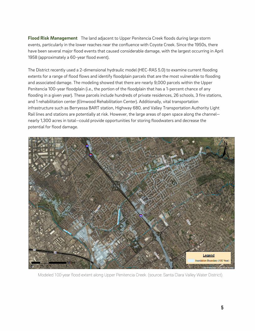
Flood Risk Management The land adjacent to Upper Penitencia Creek floods during large storm events, particularly in the lower reaches near the confluence with Coyote Creek. Since the 1950s, there have been several major flood events that caused considerable damage, with the largest occurring in April 1958 (approximately a 60-year flood event).
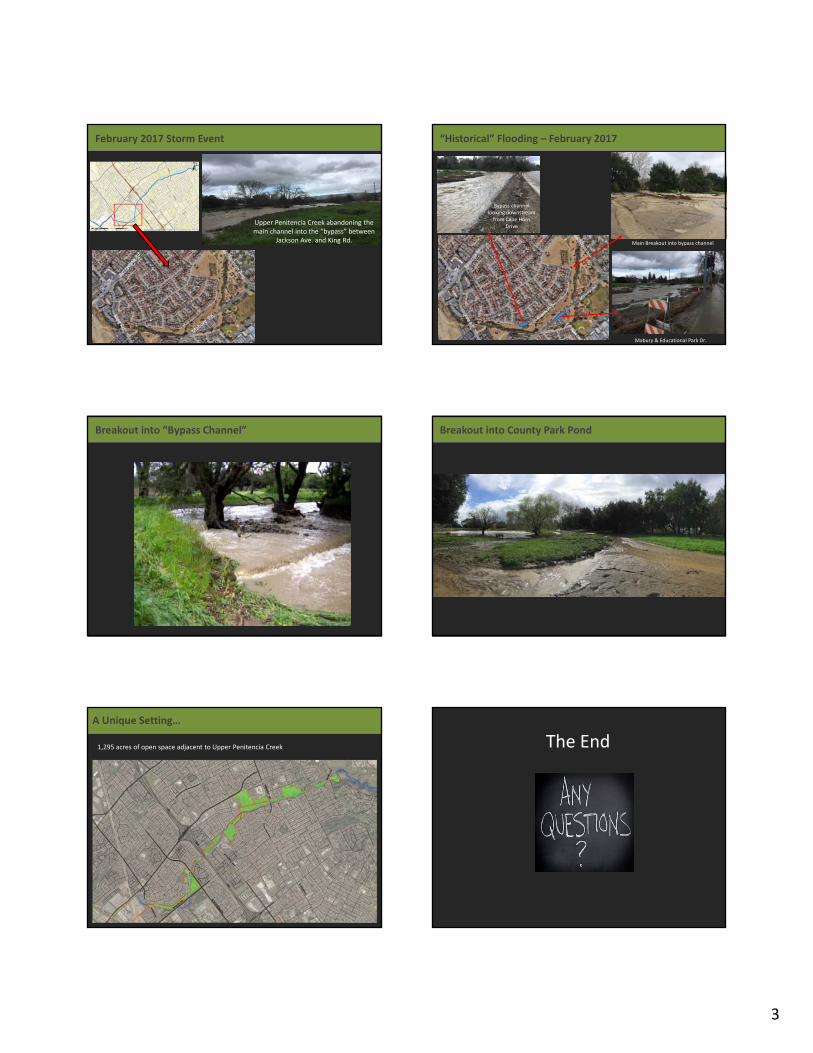
The District recently used a 2-dimensional hydraulic model (HEC-RAS 5.0) to examine current flooding extents for a range of flood flows and identify floodplain parcels that are the most vulnerable to flooding and associated damage. The modeling showed that there are nearly 9,000 parcels within the Upper Penitencia 100-year floodplain (i.e., the portion of the floodplain that has a 1-percent chance of any flooding in a given year). These parcels include hundreds of private residences, 26 schools, 3 fire stations, and 1 rehabilitation center (Elmwood Rehabilitation Center). Additionally, vital transportation infrastructure such as Berryessa BART station, Highway 680, and Valley Transportation Authority Light Rail lines and stations are potentially at risk. However, the large areas of open space along the channel—nearly 1,300 acres in total—could provide opportunities for storing floodwaters and decrease the potential for flood damage.
Modeled 100-year flood extent along Upper Penitencia Creek. (source: Santa Clara Valley Water District).

6
Groundwater Management The District manages groundwater throughout the Santa Clara Valley for potable use by nearly 2 million people that live and work in the region (SCVWD 2016a). In the first half of the 20th century, excessive groundwater withdrawal to support the growing population and increasing agricultural production caused land subsidence in the northern portion of the Valley. Nearly 13 feet of permanent subsidence had occurred in San Jose by 1970 (SCVWD 2016b). To address this subsidence, reservoirs were built and water imported to increase infiltration into the groundwater basins, thereby helping maintain sustainable groundwater levels and halt permanent land subsidence. Upper Penitencia receives imported water from the State Water Project via the South Bay Aqueduct, mostly during the summer months. Water deliveries are variable and depend on the water year type and State Water Project operations. When water is available, it is stored within the Bob Gross Groundwater Recharge Ponds and then released into Upper Penitencia Creek during the summer months after natural creek flow recedes. The released flows are infiltrated into the groundwater basin through the creek bed between the ponds outfall and around the Mabury Road bridge crossing over 2 miles downstream. On average, about one-third of total groundwater recharge for this system is through instream recharge, while the remaining two-thirds is through percolation ponds (SCVWD 2016b). Habitat and Water Quality Upper Penitencia Creek provides habitat for a diverse set of native and non-native plants, fish, and wildlife that are well adapted to the creek’s high seasonal and interannual flow variability. The rural Upper Penitencia Creek watershed supports California tiger salamander (Ambystoma californiense), California red-
legged frog (Rana aurora draytonii), and western pond turtle (Actinemys marmorata). Common and special status fish species in Upper Penitencia Creek include riffle and prickly sculpin (Cottus gulosus, C. asper), Sacramento sucker, steelhead
trout, and Pacific lamprey.
The California Department of Fish and Wildlife has conducted steelhead genetic analyses, steelhead and lamprey spawning surveys, and other aquatic inventories in Upper Penitencia Creek (e.g., CDFG 2009, CDFW and SJSU 2013). Their work has shown low but consistent steelhead use of the creek corridor since they began surveying in 2007.
Groundwater recharge ponds adjacent to Upper Penitencia Creek.
Adult steelhead trout (Oncorhynchus mykiss)
Pacific lamprey (Entosphenus tridentatus)
Photo: Melissa Moore
Photo: Melissa Moore
Photo: Melissa Moore
Photo: Scott Dusterhoff

7
The creek riparian corridor also supports non-native amphibians (e.g., bullfrog (Rana catesbeiana)) and reptiles (red-eared sliders (Trachemys scripta elegans) and painted turtles (Chrysemys picta)), as well as native (e.g., oak titmouse) and non-native birds, and mammals such as bats (e.g., Pacific pallid bat (Antrozous pallidus pacificus)), coyotes (Canis latrans) and bobcats.
The Santa Clara Valley Urban Runoff Pollution Prevention Program (SCVURPPP 2014, 2015) reported poor biological conditions in Upper Penitencia during creek status monitoring in 2012 and 2013 and identified increased temperatures, altered flow regime, altered physical habitat, reduced dissolved oxygen, and the addition of nutrients and pesticides as potential factors explaining conditions in the creek. As a result, a bioassessment program was initiated in 2016 for Upper Penitencia Creek, including water quality, benthic macroinvertebrate (BMI) and algae surveys to monitor conditions more fully (SCVURPPP 2017). This study concluded that anthropogenic sources of poor conditions in the ephemeral segment of the creek are likely associated in part with diversions from the percolation ponds to the channel. Recreation and Education The relatively extensive area of parks, trails, and open spaces along Upper Penitencia Creek provides local and regional residents opportunities for enjoyment of outdoor amenities including hiking, picnicking, bicycling, and wildlife viewing. The public land along the creek
between Alum Rock Park and Coyote Creek is subject to a tri-party agreement among the County of Santa Clara, the City of San Jose, and the District, which allows and encourages use of the creek corridor for recreation, water conservation, and flood management. The City and County parks along the creek cover over 200 acres and contain amenities such as ponds, playgrounds, and public restrooms. The Master Plan for the Penitencia Creek County Park (1977) was
developed with assistance from the two neighboring school districts, indicating the strong collaboration among the tri-party agreement partners. The Upper Penitencia Creek Trail runs along the creek from Dorel Drive approximately 3 miles downstream to King Road. The well-used trail is operated by the City of San Jose and connects the array of parks along the creek, from Noble Park down to Penitencia Creek Gardens.
Penitencia Creek Park near the Wildlife Center of Silicon Valley. Penitencia Creek Park near the Wildlife Center of Silicon Valley. Penitencia Creek Park near the Wildlife Center of Silicon Valley.
Photo: Amy Richey

8
Management Recommendations from the Science Advisors Drawing on the information given in the workshop presentations and subsequent discussions, Hub members and workshop participants discussed a suite of management recommendations during an afternoon brainstorm session. The Hub’s recommendations focused on holistic landscape management actions that benefit people and wildlife, and those that will enhance resiliency to changing climatic conditions. Here we provide a high level summary of the Hub recommendations discussed, with supporting information regarding key considerations for each recommendation, and the associated landscape concept with actions for discrete reaches of the creek.
Support Physical Drivers of Ecological Function Management actions should support physical processes, such as sediment transport and groundwater recharge, which in turn support key ecological functions such as food web support.
Focus on the watershed scale when considering sediment management. Managing the supply of fine and coarse sediment to the channel impacts flood management as well as in-channel habitat. For example, decreasing the total sediment supply can help maintain a high flood flow capacity in some reaches but also decrease spawning and rearing habitat for native steelhead. Therefore, both should be considered when developing a watershed-scale sediment management plan that addresses multiple objectives. Example approaches could include replacing bridge culverts with bridge spans that allow sediment to move more freely, or analyzing grazing and road patterns in the upper watershed for effects on fine sediments.
Manage imported water to be more ecologically beneficial. The State
Water Project water supply can be unpredictable from year to year, and may change considerably in the future. The supply is very
dependent on the amount of wintertime precipitation, and operations lie mostly outside the control of the District. Currently, the creek bed is used as a recharge facility during summer months, which has effects on instream water quality and biota, such as allowing persistence of non-native warm-
water fish. Flows could be released in a manner that better supports native fish and riparian vegetation while still meeting
local water supply needs.
Photo: Steve Thompson
Restored reach adjacent to the Berryessa BART station.
Nuttall’s woodpecker (Picioides nuttallii)
Photo: Amy Richey

9
Support Habitat for Native Wildlife. The District and its partners have the opportunity to take an integrated ecosystem perspective that can balance wildlife, flood risk management, and recreation in the Upper Penitencia Creek corridor. There is potential to support natural streamflow and sediment transport, and enhance habitat for native plants and animals.
Enhance wildlife habitat patches and connectivity with corridors and nodes. There is an opportunity to improve functional connectivity for wildlife to support greater species diversity and resilience to climate change (Heller and Zavaleta 2009). Habitat can be enhanced within ‘nodes,’ larger areas that can support a variety of habitat functions for wildlife, while connectivity between nodes can be achieved with narrower wildlife-friendly riparian corridors (Koen et al. 2014). Management tactics within
nodes could include replacing non-native trees with natives such as oaks, willows and sycamores, expanding wooded areas,
planting more multi-layered vegetation, and making room for wildlife by excluding human uses from certain areas, for example, by moving trails away from the creek on one side.
Enhance steelhead habitat. There are opportunities to improve creek flow and sediment management to benefit steelhead. For example, Cherry Flat Reservoir releases could be managed to improve dry season water temperatures in the creek’s bedrock reaches, thereby benefiting rearing steelhead as well as other native fish species.
Enhance urban ecology. Sycamores, oaks, and other native trees could be planted throughout the urban areas adjacent to the creek to expand feeding and migration habitat for native birds (e.g., Acorn woodpecker (Melanerpes formicivorus)) and mammals (e.g., bats). This could include plantings in parks and other public open space areas as well as in yards and gardens of private residences, which could be incentivized through subsidies and rebate programs.
Manage Flood Risk and Seek Opportunities for Floodplain Enhancements It may be possible for the District and its partners to create and support landscape configurations that enhance both flood protection and habitats in the Upper Penitencia watershed.
Implement Low Impact Development (LID). Incorporating LID elements into streetscapes and other urban developments would slow, sink, and filter surface waters before entry into the river and stormwater systems, help recharge groundwater, and provide neighborhood and habitat amenities. LID elements that should be considered include rain gardens, vegetated drainage swales, and permeable pavement.
California sycamore (Platanus racemosa)
Photo: Amy Richey
Photo: Amy Richey
10
Consider variable riparian widths. The widths of riparian areas protected from development encroachment could be determined based on desired riparian function, such as surface water filtration, stream shading, habitat. There are new tools that can be used to help the District and its partners to determine riparian functional width along the creek (e.g., the Riparian Zone Estimator Tool (RipZET)).
Expand flood storage capacity. Current flood storage capacity along the creek could be expanded by increasing the area of existing open space next to the creek that regularly floods. Open space areas such as public parks and school athletic fields could be configured to store wintertime flood flows that then infiltrate into the underlying groundwater basin.
Envision and Prepare for Future Conditions For the San Francisco Bay Area, climate models suggest that in 50 years, there may be an increase in precipitation variability and large storm event frequency (Flint and Flint 2012). Multi-benefit management strategies need to account for this uncertainty in the Santa Clara Valley’s water future.
Conduct Scenario Planning. Use models to assess runoff, flow discharge, flow stage and velocity, and sediment transport for a suite of management scenarios and climate predictions. The output can be used to spark discussions among stakeholders regarding the range of options that meet management objectives and promote landscape resilience. Engaging local stakeholders early in scenario planning can reveal tradeoffs and optimize ecological and economic outcomes (Lester et al. 2013).
Invest in Low Impact Development. In addition to helping filter runoff and recharge groundwater, LID elements can slow runoff and help decrease the time to reach peak storm discharge and the peak discharge value (i.e., decrease storm ‘flashiness’), which would help maintain overall channel stability and prevent excess erosion.
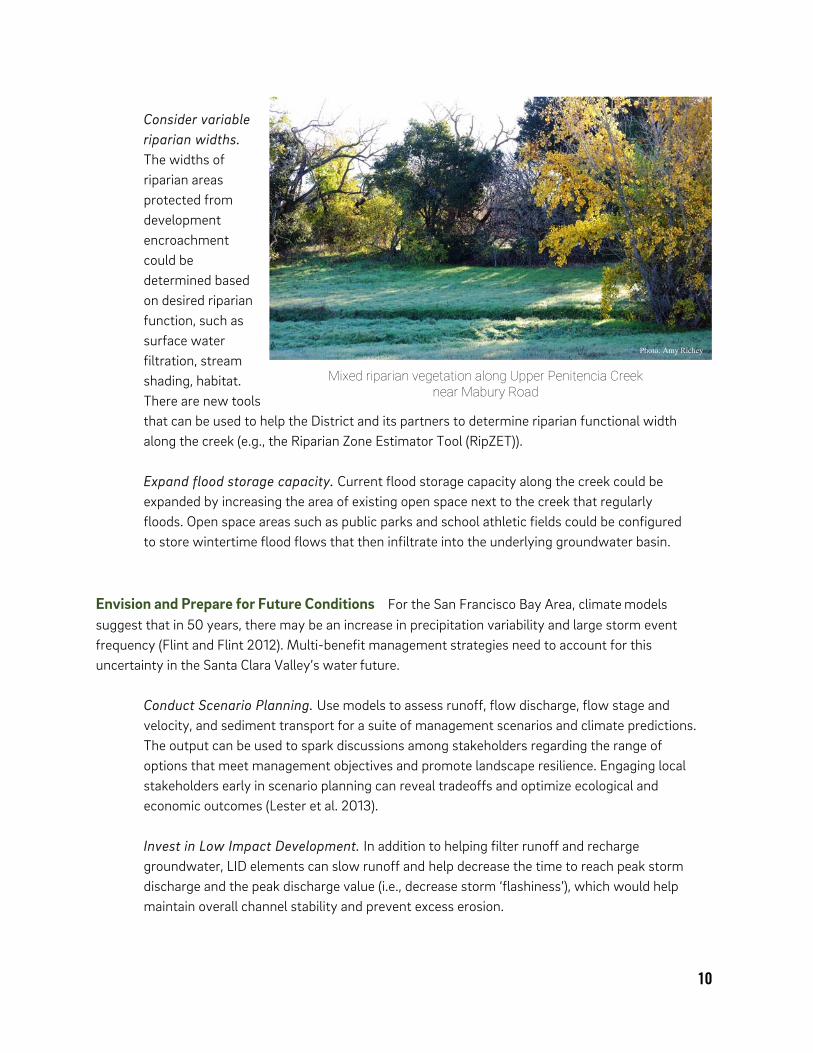
Mixed riparian vegetation along Upper Penitencia Creek near Mabury Road
Photo: Amy Richey

Reaches 2 and 3(King Rd. to N. Capitol Ave.)These reaches include the Mabury Road crossing and bypass channel, and the Highway 680 crossing. County Park and Mabury Park attract picnickers, hikers, and walkers. This reach dries in the summer until flows are augmented with imported water.
Reach 1(Coyote Creek to King Rd.)At the confluence with Coyote Creek, the lower portion of the reach forms a series of pools and riffles within a confined channel that flows through an area that is almost entirely paved. The upper portion of the reach is ephemeral and has recently been restored with habitat enhancements for salmonids.
• ConsiderconvertingMaburybypasschanneltoalow-flowchanneland planting riparian vegetation to improve fish habitat
• Increasefloodstoragecapacitywithin open spaces
• Improveconveyanceandwildlifeconnectivity under Jackson Avenue and I-680, enhancebridgeareas with mosaic of native plantings
• Plantnativeunderstoryvegetationandconsiderrestrictingpublicaccess along one side of the creek to support wildlife
• Re-considersedimentremovalpolicyunder Highway 680 bridge, which currently calls for hauling coarse sediment off site
• Reconfigurefloodplainattheconfluence of Upper Penitencia and Coyote Creeks to maximize habitat connectivity for wildlife migration and dispersal
• Considervariable-widthsetbacks to enhance wildlife connectivity and flood storage
• Designbankslopesandmanagevegetation to enhance in-channel wildlife migration and dispersal
COYOTE CREEK REACH 1 REACHES 4 & 5REACHES 2 & 3
I - 68
0
Berryessa Rd.Co
yote
Cre
ek
Uppe
r Pen
itenc
ia Cre
ek
• Utilize Low Impact Development techniques to slow stormwater, recharge groundwater, reduce pollution, and provide neighborhood and habitat amenities
CONSIDERATIONS FOR THE ENTIRE VALLEY FLOOR (REACHES 1-7):
• Manage non-native woody vegetation in favor of native trees, including California sycamore
• Plant native shrubs and herbaceous vegetation where appropriate
• Daylight storm drains and set back hardscapes from stream corridor as feasible.
The urbanized reaches within the valley floor contain nearly 1300 acres of public or open space.
UPPER PENITENCIA CREEK P R E L I M I N A R Y L A N D S C A P E C O N C E P T

Reaches 4 & 5(N. Capitol Ave. to Piedmont Rd.)These reaches contain two schools, a nature center, and Penitencia Creek Park. Several roads cross over the creek within these reaches. These reaches dry down in the summer until flows are augmented with imported water.
Reaches 6 & 7(Piedmont Rd. to Hills)These reaches generally flow perennially upstream of the Bob Gross Ponds, and contain a higher concentration of California sycamore than other reaches.
Upper Reaches(Hills to Watershed Boundary)The upper watershed of Upper Penitencia Creek mainly drains rangeland, with few roads. Current land use is primarily cattle grazing. Cherry Flat Reservoir dams a minority of the watershed, allowing for nearly natural sediment transport within these reaches.
• Enhanceterrestrialhabitatstructure for wildlife within open spaces
• Improvewildlifepassageandnativeplantassemblages surrounding and under bridges and culverts
• Increasefloodstoragepotential of open spaces and parking lots
• ExplorereconfigurationofPenitenciaCreekRoad for flood protection of properties to the south
• Replacenon-nativetrees with native trees
• Considerreplacingsmallbridgesanddrivewaycrossings with higher capacity structures
• EnhancehabitatqualityofBobGrossPondsareafor terrestrial wildlife
• ConsiderwaystouseBobGrossPondsasfloodplainfeatures to increase flood storage
• Maintainfishladderand/or improve its function
• Sediment output may increase with future climatic changes so modifyingroadsandgrazingregimeupstream may benefit instream conditions for salmonids and native fishes
• RevisitCherryFlatReservoiroperationsandmanagementopportunities in the context of fisheries support
REACHES 4 & 5 REACHES 6 & 7 UPPER REACHES
Pied
mont
Rd.
N

13
Next Steps The landscape concept for Upper Penitencia Creek presented here contains preliminary ideas developed during the one-day workshop by the Science Advisory Hub in coordination with the District, SFEI-ASC, and workshop participants. Ultimately, these concepts will need thorough analyses to explore their feasibility, costs versus benefits, and their overall effectiveness at helping to meet flood management and other management objectives.
Additionally, there are challenges, constraints and knowledge gaps present along the creek corridor, including:
Implications of managing the Mabury bypass channel differently, including potential impacts to riparian cover and fish passage
Cherry Flat Reservoir operations in relation to potential management of instream conditions for fish
Implications of use of groundwater supply ponds for flood storage
Impacts of changes in management to current human uses of parklands, including recreation and homeless encampments
Lack of long-term stream temperature and sediment processes data
The following topics could be explored during future analyses: Key ecosystem drivers Climate change impacts Long-term sediment dynamics Optimal size and
arrangements for habitat nodes and corridors
Ways to improve instream habitat conditions for wildlife, including support for salmonids
Shallow groundwater monitoring to guide habitat enhancement and flood control basins
Flood risk challenges are great on Upper Penitencia Creek, but the potential for improved flood management and habitat enhancement benefits is even greater. Tradeoffs will be inevitable, so an essential next step is to engage with a broader group of key stakeholders in the watershed, including the City of San Jose, Santa Clara County Parks and Recreation, and members of the regulatory community.
Upper Penitencia Creek near the Noble Ave. Bridge. Photo: Amy Richey
Photo: Amy Richey

14
Acknowledgments We would like to give special thanks to Caitlin Sweeney for moderating the workshop, to the Science Hub members for providing their ideas, and to the Santa Clara Valley Water District staff who made the workshop possible, and provided critical information during the pre-workshop creek field visit and during the workshop. District staff includes Sara Duckler, Jim Manitakos, Carole Fisher, Brian Mendenhall, Gabriel Vallin, Ben Hwang, Afshin Rouhani, Melissa Moore, Chad Grande, and Aaron Baker.

15
Literature Cited Bay Area Open Space Council. 2011. The Conservation Lands Network: San Francisco Bay Area Upland Habitat Goals Project Report. Berkeley, CA. Beller, E., Grossinger, R., Nicholson, M., Salomon M. 2012. Upper Penitencia Creek Historical Ecology Assessment. A report of SFEI’s Historical Ecology Program, SFEI Publication #664, San Francisco Estuary Institute, Richmond, CA.
CDFG. 2009. California Department of Fish and Game. Memorandum. Upper Penitencia Creek Fish Sampling. August 27, 2009.
CDFW and SJSU. 2013. Upper Penitencia Creek Fish Resources in 2013. Michelle Leicester, CDFW and Jerry Smith, Department of Biological Sciences, San Jose State University. December 28, 2013. DeJager, B. and Martel, D. 2006. Upper Penitencia Creek Feasibility Study Draft Functional Assessment. U.S. Army Corps of Engineers, San Francisco District. 29 August. Flint, L.E., and Flint, A.L. 2012. Simulation of climate change in San Francisco Bay Basins, California: Case studies in the Russian River Valley and Santa Cruz Mountains: U.S. Geological Survey Scientific Investigations Report 2012–5132, 55 p. Grossinger, R.M., R.A. Askevold, C.J. Striplen, E. Brewster, S. Pearce, K.N. Larned, L.J. McKee, and J.N. Collins, 2006. Coyote Creek Watershed Historical Ecology Study: Historical Condition, Landscape Change, and Restoration Potential in the Eastern Santa Clara Valley, California. Prepared for the Santa Clara Valley Water District. A Report of SFEI’s Historical Ecology, Watersheds, and Wetlands Science Programs, SFEI Publication 426, San Francisco Estuary Institute, Oakland, CA. Heller, N.E. and Zavaleta, E.S., 2009. Biodiversity management in the face of climate change: a review of 22 years of recommendations. Biological conservation, 142(1), pp.14-32. Keeler-Wolf, T., K. Lewis, and C. Roye. 1996. The definition and location of Sycamore Alluvial Woodland in California. State of California, Resources Agency, California Department of Fish and Game, Sacramento. Koen, E. L., Bowman, J., Sadowski, C. and Walpole, A. A. (2014), Landscape connectivity for wildlife: development and validation of multispecies linkage maps. Methods Ecol Evol, 5: 626–633. Leidy, R.A. 2007. Ecology, Assemblage Structure, Distribution, and Status of Fishes in Streams Tributary to the San Francisco Estuary, California. San Francisco Estuary Institute Contribution No. 530.

16
Leidy, R.A., G.S. Becker, B.N. Harvey. 2005. Historical distribution and current status of steelhead/ rainbow trout (Oncorhynchus mykiss) in streams of the San Francisco Estuary, California. Center for Ecosystem Management and Restoration, Oakland, CA. Lester S., Costello C., Halpern B., Gaines S., White C., and Barth J. 2013. Evaluating tradeoffs among ecosystem services to inform marine spatial planning. Marine Policy. 2013 March 31;38:80-9.
Sawyer, J. O., T. Keeler-Wolf, and J. M. Evens. 2009. A Manual of California Vegetation. Second edition. California Native Plant Society Press, Sacramento. SCVURPPP. 2014. Santa Clara Valley Urban Runoff Pollution Prevention Program. Watershed Monitoring and Assessment Program. Integrated Monitoring Report, Part A, Water Quality Monitoring Water Years 2012 and 2013 (October 2011-September 2013). March 15. SCVURPPP. 2015. Santa Clara Valley Urban Runoff Pollution Prevention Program. Watershed Monitoring and Assessment Program. Integrated Monitoring Report, Water Quality Monitoring Water Year 2014 and 2013 (October 2013-September 2014). March 15. SCVURPPP. 2017. Santa Clara Valley Urban Runoff Pollution Prevention Program. Watershed Monitoring and Assessment Program. Upper Penitencia Creek Stressor/Source Identification Project, Water Year 2016. March 31. SCVWD. 2008. Santa Clara Valley Water District. Mid-Coyote Creek Baseline Flood Protection Project. Baseline Fisheries Monitoring Report. Year 2. Watershed Management Division. April 5, 2009. SCVWD 2016a. Santa Clara Valley Water District 2015 Urban Water Management Plan. Lead: T. Hemmeter, et al. May 2016. SCVWD 2016b. Santa Clara Valley Water District 2016 Groundwater Management Plan, Santa Clara and Llagas Subbasins. Leads: B. Kassab and G. Cook. November 2016. Stillwater Sciences. 2006. Upper Penitencia Creek Limiting Factors Analysis Final Technical Report Prepared for Santa Clara Valley Urban Runoff Pollution Prevention Program (Program Manager, EOA, Inc.). Thompson, Steve. 2017. Nuttall’s Woodpecker (photo). Attribution-NonCommercial-ShareAlike 2.0 Generic (CC BY-NC-SA 2.0). Downloaded from: https://www.flickr.com/photos/srdt6458/34653935520/

17
Appendix A Workshop Attendees Don Arnold, SCVWD Aaron Baker, CVWD Carol Boland, City of San Jose Setenay Bozkurt-Frucht, RWQCB Brett Calhoun, SCVWD Jennifer Castillo, SCVWD Andy Collison, ESA (Hub Member) Sara Duckler, SCVWD Scott Dusterhoff, SFEI Lorraine Flint, USGS (Hub Member) Carole Foster, SCVWD Errol Gabrielson, SCVWD Vince Gin, SCVWD Susan Glendening, State Water Board Chad Grande, SCVWD Robin Grossinger, SFEI Ben Hwang, SCVWD Hieu Huynh, SCVWD Rob Leidy, EPA (Hub Member) James Manitakos, SCVWD Michael Martin, SCVWD Brian Mendenhall, SCVWD John McKeon, NMFS Katie McKnight, SFEI Dave Mitchell, CSJ-PRNS Melissa Moore, SCVWD Katie Muller, SCVWD Bruce Orr, Stillwater Sciences (Hub Member) Paul Randall, SCVURPPP Amy Richey, SFEI Steve Rottenborn, HT Harvey (Hub Member) Afshin Rouhani, SCVWD Jake Smith, SCVOSA Gary Stern, NMFS Kirsten Struve, CVWD Caitlin Sweeney, SFEP (Moderator) Tim Tidwell, SCVWD Andrew Trent, NMFS

18
Appendix B Workshop Presentation Slides
1
Upper Penitencia Creek Landscape Concept Workshop
Landscape Workshops
• Novato Baylands (2015)
• Lower Walnut Creek (2016)
• Calabazas‐San Tomas Aquino‐Pond A8 (planned May 2017)
Landscape Workshops• multi‐project scale• multi‐benefit (particularly flood protection and
sediment management)• regional + local expertise• environmental science + engineering• eye towards regulatory drivers• long‐term resilience; incorporate climate change• pastpresentfuture approach• One Water and Resilient Silicon Valley
Multi‐benefit Goals
March 13, 2017
Upper PenitenciaCreek Workshop
UPPER PENITENCIA CREEK LANDSCAPE:Historical functions and change‐through‐time
1. Setting
2. Historical Landscape Conditions
3. Timeline of Landscape and Channel Change
4. Contemporary Conditions
5. Change Analysis and Landscape Parameters
6. Summary
OUTLINE

2
HILLS
VALLEYFLOOR
WATERSHED BOUNDARY
UPPER PENITENCIA WATERSHED
San Jose
NAIP 2009
Alum Rock Park
Cherry Flat Reservoir
REGIONAL CONTEXT
Upper Penitencia Water Treatment
Plant
Alum Rock Park
Groundwater Recharge Ponds
ToyonElementary School
San Jose Country Club
Piedmont Middle School/Penitencia
Creek Park
UPPER REACH
Cherry Flat Reservoir ~4
miles upstream
Independence High School
Penitencia Creek County Park
East Side Union High School District
Piedmont Middle School/Penitencia
Creek Park
San Jose Flea
Market
San Jose Municipal
Golf Course
LOWER REACH
REGIONAL CONTEXT
INACTIVE STREAM LEVEE
ACTIVE STREAM LEVEE
SCALE 1 : 50,000
ALLUVIAL FAN OF UPPER PENITENCIA CREEK
CONFINED ZONE
UNCONFINED ZONE
30 ft 290 ftELEVATION:
REGIONAL CONTEXT
INACTIVE STREAM LEVEE
ACTIVE STREAM LEVEE
SCALE 1 : 50,000
QUATERNARY STREAM LEVEES, SANTA CLARA VALLEY
Source: Kenneth R. Lajoie (March 2002)
CONFINED ZONE
UNCONFINED ZONE
APPROX. BOUNDARY

3
STUDY AREA
1. Setting
2. Historical Landscape Conditions
3. Timeline of Landscape and Channel Change
4. Contemporary Conditions
5. Change Analysis and Landscape Parameters
6. Summary
OUTLINE
Maps
Texts
Photographs
PREVIOUS STUDIES
THEN AND NOW
CONCEPTUAL MODEL: Historical
THEN AND NOW
CONCEPTUAL MODEL: Contemporary
CONCEPTUAL MODEL: Contemporary
4
Lundy Ave.
Highway 680
Noble Ln.
Oak Woodland Oak savanna/Grassland
Willow Grove
Freshwater MarshWet Meadow
HISTORICAL CHANNEL AND HABITATS
Riparian Woodland
Modern Aerial Imagery; Historical Habitats
Lundy Ave.
Highway 680
Noble Ln.
Oak Woodland Oak savanna/Grassland
Willow Grove
Wet Meadow
HISTORICAL CHANNEL AND HABITATS
Riparian Woodland
Modern Aerial Imagery; Historical Habitats
Freshwater Marsh
Lundy Ave.
Highway 680
Noble Ln.
Oak Woodland Oak savanna/Grassland
Willow Grove
Wet Meadow
HISTORICAL CHANNEL AND HABITATS
Riparian Woodland
Modern Aerial Imagery, Modern Channels; Historical Habitats
Freshwater Marsh
Lundy Ave.
Highway 680
Noble Ln.
OAKSAVANNA/ GRASSLAND
WILLOW GROVE
ALKALI MEADOW (low concentration)
FRESHWATER MARSH
SEASONAL LAKE / PONDSYCAMORE GROVE
WET MEADOW
BAR WITH RIPARIAN
WOODLAND
ALKALI MEADOWWETMEADOW
WET MEADOW
OAK WOODLAND
HISTORICAL: HABITAT TYPES
OAK WOODLAND
HISTORICAL: FEATURES
5
HISTORICAL: FEATURES
WETLANDS/FLOODING
NATURAL LEVEE
NATURAL ALLUVIAL
FAN
OUTFLOW TO TIDAL MARSH AND SAN FRANCISCO BAY
FLOW REPLENISHED
GROUNDWATER
PERIODIC CONNECTIONS
BETWEEN FLUVIAL CHANNEL AND FLOODPLAIN
HISTORICAL: FLOW PATTERNS
CONNECTED DURING RAINY
PERIODS
SEASONALLY DRY
SPREADING SURFACE WATERS LED FISH TO FORAGE IN
BOTTOMLAND FLOODPLAIN HABITATS
OUTFLOW TO TIDAL MARSH AND SAN FRANCISCO BAY
SEASONAL BACKWATERS SERVED AS FISH HABITAT
SEASONAL CONNECTION FOSTERED WILDLIFE CONNECTIVITY TO BAY
HISTORICAL: WILDLIFE CONNECTIVITY
TRANSITION BETWEEN ECOTONES FOR
AMPHIBIANS AND TERRESTRIAL WILDLIFE
UNCONFINEDZONE
CONFINED ZONE
HISTORICAL: GROUNDWATER
APPROX. BOUNDARY
1. Setting
2. Historical Landscape Conditions
3. Timeline of Landscape and Channel Change
4. Contemporary Conditions
5. Change Analysis and Landscape Parameters
6. Summary
OUTLINE
Ranching, farming, ‘milpitas’
TIMELINE: EARLY TO MID 1800s
< 1800 Farming, ranching

6
“In that year a settler dug a ditch and built fences, and in the fall the creek sent down its waters, which entered the ditch and continued on, cutting a channel through which the waters were afterward discharged.”
(Sawyer 1922, History of Santa Clara County, pp 302)
1852: Connection to Coyote
TIMELINE: MID TO LATE 1800s
< 1800
1852
Farming, ranching
Connection to Coyote
< 1800
1852“In 1889 George W. Page developed … the Auzerais Ditch on the Penitencia creek.”(Payne 1987, Santa Clara County: Harvest of change, pp137)
1880s: Ditching for Irrigation
Farming, ranching
Connection to Coyote
Late 1800s-Early 1900s
TIMELINE: LATE 1800s to EARLY 1900s
Channel Modifications for Agriculture
< 1800
1852
1880s: Roads and RailroadsFarming, ranching
Connection to Coyote
Late 1800s-Early 1900s
Channel Modifications for Agriculture
TIMELINE: LATE 1800s to EARLY 1900s
Late 1800s-Early 1900s
Channel Modifications for Roads and Railroads
Continued Diversions for Irrigation, Groundwater Pumping
“ ‘several small dams’ along the creek divert water to adjoining farms. Diversions appear to have principally occurred during the wet season.”
(Tibbetts and Kieffer 1921)
TIMELINE: 1920s – 1950s
< 1800
1852
Farming, ranching
Connection to Coyote
Late 1800s-Early 1900s
Channel Modifications for Agriculture
Channel Modifications for Roads and Railroads
1920s-1950s
Groundwater Pumping, Suburbanization
Late 1800s-Early 1900s
“A majority of the area was urbanized by 1980.”(DeJager and Martel, Draft Functional Assessment, pp 6)
Suburbanization
TIMELINE: 1950s ‐ 1980s
< 1800
1852
Farming, ranching
Connection to Coyote
Late 1800s-Early 1900s
Channel Modifications for Agriculture
Channel Modifications for Roads and Railroads
1920s-1950s
Groundwater Pumping, Suburbanization
Late 1800s-Early 1900s
Water Infrastructure
TIMELINE: 1980s to present
< 1800
1852
Farming, ranching
Connection to Coyote
Late 1800s-Early 1900s
Channel Modifications for Agriculture
Late 1800s-Early 1900s
Channel Modifications for Roads and Railroads
1950s-1970s
Water Infrastructure
COUNTY PARK POND
PENITENCIA PARK POND
HELMSLEY POND
MABURY POND
MIGUELITA CREEK
UPPER PEN. WATER TREATMENT PLANT
SOUTH BAY AQUEDUCT TERMINAL TANK
1920s-1950s
Groundwater Pumping, Suburbanization

7
Flood Events
TIMELINE: 1980s to present
< 1800
1852
Farming, ranching
Connection to Coyote
Late 1800s-Early 1900s
Channel Modifications for Agriculture
Late 1800s-Early 1900s
Channel Modifications for Roads and Railroads
1980s-present
Several Major Floods
1950s-1970s
Water Infrastructure
January 1983 at San Jose Flea Market (5 year flood)
March 1982 at King Road Bridge (10 year flood)
1920s-1950s
Groundwater Pumping, Suburbanization
1. Setting
2. Historical Landscape Conditions
3. Timeline of Landscape and Channel Change
4. Contemporary Conditions
5. Change Analysis and Landscape Parameters
6. Summary
OUTLINE
CONTEMPORARY: LAND COVER TYPES
OAK WOODLAND
GRASSLAND / SAVANNA
PARK OR GOLF COURSE
RESIDENTIAL / DEVELOPED
FARMLAND
RIPARIAN WOODLAND
COASTAL SCRUBFRESHWATER
MARSHPOND OR RESERVOIR
75% OF THE VALLEY FLOOR WITHIN THE UPPER PENITENCIA WATERSHED IS URBANIZED
RESIDENTIAL / DEVELOPED
FARMLAND
CONTEMPORARY: FLOW PATTERNS
DIRECT DISCHARGE INTO COYOTE CREEK (c. 1850)
NO LONGER FLOWS INTO SEASONAL WETLAND
CONTEMPORARY: FLOW PATTERNS
CULVERTS AND STORM DRAINS ALTER FLOW PATHWAYS
FEMA 100‐YEAR FLOOD EXTENT (2016)
CHANNEL MODIFICATIONS ALTER HYDRAULICS &
MORPHOLOGY
EARTHEN BERMS
CONTEMPORARY: SEDIMENT TRANSPORT
water diversion facility & fish
ladder
culvert
critical riffle
water diversion facility & fish ladder
gaging weirlow flowvehicle crossing
weir
recreationalweir
gaging weir

8
CONTEMPORARY: SEDIMENT TRANSPORT
STRUCTURES & CHANNEL DIVERSIONS AFFECT
SEDIMENT TRANSPORT AND FISH PASSAGE
UPPER PENITENCIA CONTINUES TO BE AN IMPORTANT SEDIMENT SOURCE FOR LOWER REACHES BUT THIS ALSO
CAUSES A NEGATIVE IMPACT OF SEDIMENT BUILD‐UP AT THE
CONFLUENCE
CONTEMPORARY: GROUNDWATER
CONTEMPORARY: GROUNDWATER
APPROX. CONFINED‐UNCONFINED BOUNDARY
Source: Summary data for ARCO #0674 (T0608533095) (from GeoTracker website)
CONTEMPORARY: WILDLIFE CONNECTIVITY
Source: Critical Linkages Map (2013) http://www.bayarealands.org/mapsdata.html
Lower ReachesRearing & feeding for anadromous fishes
CONTEMPORARY: WILDLIFE CONNECTIVITY
Upper ReachesSpawning & cover
Lundy Ave.
Highway 680
Noble Ln. Rearing & feeding for native fishes
CONTEMPORARY: WILDLIFE CONNECTIVITY
Lundy Ave.
Highway 680
Noble Ln.
Lamprey, California Tiger Salamander, Western Toad. Photos: Melissa Moore
Breeding & rearing for amphibians & reptiles

9
Lundy Ave.
Highway 680
Noble Ln.
CONTEMPORARY: WILDLIFE CONNECTIVITY
Bobcat. Photo: Tanya DiamondYellow‐Breasted Chat. Photo: Scott Walker
Movement & foraging
for mammals &
birds
FUTURE: CLIMATE CHANGE
Models project…
• Warming air temps
• Longer and drier summers
• Increased dry season evapotranspiration
• Increased water deficit
• Potential increased precipitation variability
Source: Flint and Flint. 2012. Simulation of Climate Change in San Francisco Bay Basins, California: Case Studies in the Russian River Valley and Santa Cruz Mountains
Need to manage for an uncertain water future
Courtesy Dipika Bhattacharya
Source
: Flint an
d Flin
t (2012)
OUTLINE
1. Setting
2. Historical Landscape Conditions
3. Timeline of Landscape and Channel Change
4. Contemporary Conditions
5. Change Analysis and Landscape Parameters
6. Summary
LANDSCAPE PARAMETERS
Flow Patterns
Channel Planform
Riparian Veg Composition
Riparian Density & Width
Habitat Type
Channel Length (miles) Intermittent Perennial
Historical 3.9 0
Modern 1.9 3.0
Dry Season Flow Patterns
0
1
2
3
4
5
6
Historical Modern
Perennial
Intermittent
Chan
nel length (mi)
Chan
nel length (mi)
Channel Planform
Channel Length (miles)
Surface Channel
Subsurface Storm Drain
Historical 3.9 0
Modern 4.9 12.7
0
2
4
6
8
10
12
14
16
18
20
Historical Modern
Subsurface StormDrain
Surface Channel
10
Habitat Type
0
500
1000
1500
2000
2500
3000
3500
Historical Modern
Urban Open /Other
Urban
PerennialFreshwaterPond
Wet or AlkaliMeadow
ValleyFreshwaterMarsh
RiparianStreamChannel
RiparianNonnativeVegetation
Riparian NativeVegetation
Oak Woodland
Grassland
acre
s
Noble Ln.
Riparian Vegetation Composition
Remnant sycamores present;
conversion to wetter spp
Upper Alluvial Fan
Riparian Density & Width
Lower Alluvial Fan
Wetland Reach
20091939
VEGETATION IS GENERALLY MORE DENSE THAN HISTORICALLY
CANOPY WIDTH IS GREATER IN SOME AREAS; BUT FLOODPLAINS ARE MORE CONFINED
WIDTH AND DENSITY IS LIKELY MUCH REDUCED FROM THE 1850s
1. Setting
2. Historical Landscape Conditions
3. Timeline of Landscape and Channel Change
4. Contemporary Conditions
5. Change Analysis and Landscape Parameters
6. Summary
OUTLINE
CONSIDERATIONS
Persisting Hydrologic Functions• Coarse sediment supply and in‐channel storage
• Relatively undammed and natural hydrograph (but storm and low‐flow, ephemeral vs. perennial)
• Potential for channel‐overbank connections
Regionally Unique Habitats • Riparian species comp, density, structure
• Sycamores/CSAW
• Ecotones (riparian/oak savanna)
Wildlife Connectivity• Fishes
• Amphibians, reptiles, birds,mammals
CONSIDERATIONS
Persisting Hydrologic Functions• Coarse sediment supply and in‐channel storage
• Streamflow (storm and low‐flow, ephemeral and perennial)
• Channel‐overbank connections
• Channelization at Coyote Creek confluence
• GW/SW interactions
Ecological Features• Sycamores/CSAW
• “Essential” Steelhead Stream (Becker et al. 2007)
• Native warm‐water fish
Wildlife Connectivity• Fishes
• Amphibians, reptiles, birds,mammals

11
CONSIDERATIONS
Persisting Hydrologic Functions• Coarse sediment supply and in‐channel storage
• Streamflow (storm and low‐flow, ephemeral and perennial)
• Channel‐overbank connections
• Channelization at Coyote Creek confluence
• GW/SW interactions
Ecological Features• Riparian species comp, density, structure
• Sycamores/CSAW
• Ecotones (riparian/oak savanna)
Wildlife Connectivity• Relatively continuous riparian corridor –short route for steelhead
• Amphibians, reptiles, birds, mammals to Baylands resources
• Potential ecotones (riparian<‐>oak savanna)
QUESTIONS?

1
Upper Penitencia Flood Risk
Gabriel Vallin, Asc. EngineerBenjamin Hwang, Ast. Engineer
Upper Penitencia Watershed
Project Area
USACOE Flood Risk Management Study
Design Flows
USACOE Flood Risk Management Study
Storm Event Peak Flows (CFS)
Location
43% (2.33 year)*
20% (5 year)*
10% (10 year)
4% (25 year)*
2% (50 year)
1% (100 year)
0.5% (200 year)
0.2% (500 year)
Upper Pen @ Dorel Dr 400 900 1400 2300 3000 3800 4500 5600Upper Pen @ Piedmont Rd 400 900 1400 2300 3000 3800 4600 5700Upper Pen @ I‐680 400 900 1400 2300 3000 3800 4600 5600Upper Pen U/S Coyote 400 900 1500 2400 3100 4000 4800 6000
Existing Channel Capacities (need to update)
USACOE Flood Risk Management Study
History of Flooding in Upper Penitencia Creek
• Significant flooding has occurred in 1955, 1958, 1980, 1982, and 1983
• Lesser but more recent floods in 1986 and 1995• Largest recorded flood in 1958 with an estimated peak flow of 3,730 CFS (approx. 1.7% annual chance exceedance event)
USACOE Flood Risk Management Study
January 1983: (5-year flood Event)Flooding at San Jose Flea Market
March 1982: (10-year flood event)Flooding at King Road Bridge

2
Hydraulic Model
HEC‐RAS 5.0
Hydraulic Modeling – 2D Components
Terrain Map – 2006 County LiDAR
Hydraulic Modeling – 2D Components
National Land Cover Database (NLCD) from USGS
Flooding – Variable Storm Events
Parcels Within 100 Year Floodplain
Roughly 9,800 parcels within Upper Penitencia’s100 year floodplain
Notable Facilities within the 100 Year Floodplain
Notable Facilities within the 100 year floodplain include:• 33 Schools• 3 Fire stations
Notable Transportation Infrastructure:• Berryessa BART Extension• Highway 680• VTA Light Rail
3
February 2017 Storm Event
Upper Penitencia Creek abandoning the main channel into the “bypass” between
Jackson Ave. and King Rd.
“Historical” Flooding – February 2017
Main Breakout into bypass channel
Bypass channel looking downstream from Cape Horn
Drive
Mabury & Educational Park Dr.
Breakout into “Bypass Channel” Breakout into County Park Pond
A Unique Setting…
1,295 acres of open space adjacent to Upper Penitencia Creek The End

1
SCVWD Water Supply Infrastructure
• South Bay Aqueduct – feeds Penitencia Water Treatment Plant
• Penitencia Water Treatment Plant (WTP)– treats raw water to produce potable water, adjacent to Reach 6
• Water Diversions – upstream of Noble Ave (Reach 7) and at Mabury Meander (Reach 2), Mabury Diversion feeds Mabury Pond and Overfelt Gardens ( CSJ Park)
Groundwater Recharge Ponds
• Bob Gross Ponds (SCVWD) – Reach 6
• Piedmont Ponds (SCVWD) – Reach 5
• Penitencia Park Ponds (CSJ) – Reach 5
• Helmsley Pond, Upper and Lower Capitol Ponds, Reaches 4 and 5
• County Pond (SCC) – Reach 2
• Mabury Pond – Reach 2
Penitencia WTP

1
Upper Penitencia CreekAquatic Ecology
Native Fish Fauna California
High annual seasonal variability in flows; native fish are adapted to hydrologic extremes
Of 124 native inland fishes (defined as those breeding in freshwater) 64% are endemic to the state, with 19% also found in Nevada or Oregon.
California has a unusually high proportion of anadromous (sea‐run taxa) (23%)
Upper Penitencia Creek has 2 andromousspecies, steelhead and lamprey
SCVWD Aquatic Ecology SCVWD Native Fish Distribution
Coyote Creek Watershed
Central Valley Subprovence(2d) center of speciation, with 35 native taxa, (16) endemic taxa
Fishes of Coyote Creek Steelhead Genetics
2
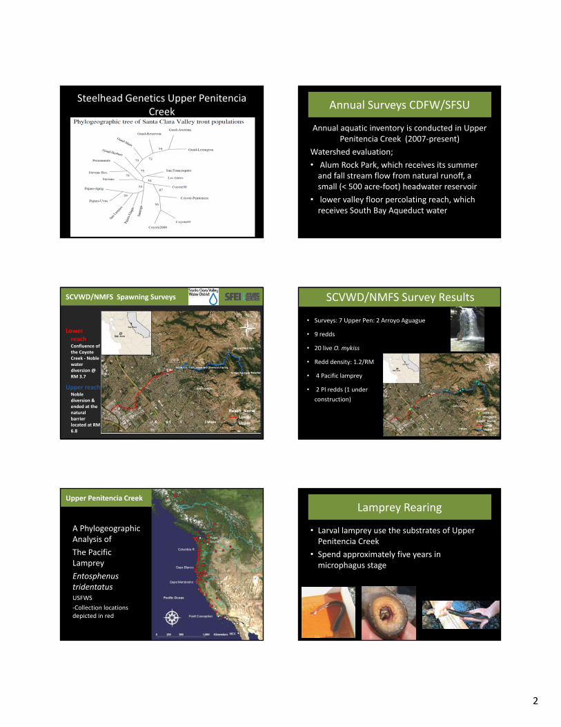
Steelhead Genetics Upper PenitenciaCreek
Annual Surveys CDFW/SFSU
Annual aquatic inventory is conducted in Upper Penitencia Creek (2007‐present)
Watershed evaluation;
• Alum Rock Park, which receives its summer and fall stream flow from natural runoff, a small (< 500 acre‐foot) headwater reservoir
• lower valley floor percolating reach, which receives South Bay Aqueduct water
SCVWD/NMFS Spawning Surveys
Lower reach: Confluence of the Coyote Creek ‐ Noble water diversion @ RM 3.7
Upper reach Noble diversion & ended at the natural barrier located at RM 6.8
SCVWD/NMFS Survey Results
• Surveys: 7 Upper Pen: 2 Arroyo Aguague
• 9 redds
• 20 live O. mykiss
• Redd density: 1.2/RM
• 4 Pacific lamprey
• 2 Pl redds (1 under
construction)
Upper Penitencia Creek
A Phylogeographic Analysis of
The Pacific Lamprey
EntosphenustridentatusUSFWS
‐Collection locations depicted in red
Lamprey Rearing
• Larval lamprey use the substrates of Upper Penitencia Creek
• Spend approximately five years in microphagus stage

3
Sycamore Alluvial Woodland Mapping and Regeneration Study
Water Quality Upper Penitencia Creek 2016
Santa Clara Valley Urban Runoff Pollution Prevention Program
(Stressor ID Project)
Upper Penitencia Creek SSID (MRP 1.0)
• Triggered by low biological condition scores in adjacent sites
Four Steps Provision C.8.d.i
1. Identify source
2. Evaluate control options
3. Implement control
4. Confirm reduction of cause
Upper Penitencia Creek Results - Biological Conditions
• What do the bugs tell us?
– Fluctuating habitat conditions
• BMI with short life cycles; Chironomids and black flies comprise over 90% of the BMI taxa at all sites in April/May;
• More stable flow conditions at site 121 in June
– Non-perennial flow (site 114)
• Absence of both larval and adult life stages of Coleoptera taxa (beetles) and predator taxa
– Perennial flow (site 121)
• Presence of long-lived, predator and intolerant taxa
Upper Penitenica Creek Results - Biological Conditions
• What does the algae tell us?– Evidence of more stressors at site 114 (both events)
• Greater proportion of taxa tolerant of fine sediment and dissolved salts (halobiontic).
– Response to nutrients at site 114 (June event)• Greater proportion of diatom taxa that utilize organic bound
nitrogen (heterotrophic)
• Possible dispersal of algae from percolation ponds to the creek
Upper Penetencia Creek – Preliminary Conclusions
• Identify Source– No clear linkage
between stressor and biological condition data
– Site 114 - Historically non-perennial; groundwater percolation zone
– Frequent changes in flow and water quality; both natural and managed (imported water)
DRAFTDo Not Cite or Quote

4
Upper Penetencia Creek – Preliminary Conclusions
• Evaluate and Implement Control Options
– Current study did not identify sources to control
– Natural variability of flow during spring/summer
– Some uncertainty in potential impacts to biological condition from imported water
• Timing and magnitude of discharge from percolation ponds
• Impacts associated with water quality (e.g., temperature)
• Confirm Reduction of Cause
– Difficult to evaluate flow related impacts; variable year to year
Reptiles and Amphibians
Birds and Mammals RUpper Penitencia Creek Considerations for Management
Spawning Lamprey

1
Recreation: SF Bay Basin Plan Fig. 2‐7a
Upper Penitencia Creek
Beneficial Uses of Upper Penitencia Cr
San Francisco Bay Basin Plan (Regional Water Quality Control Board ) designates the following beneficial uses for Upper Penitencia Creek:
‐ Water‐contact recreation (REC‐1)
‐ Non‐contact water recreation (REC‐2)
‐ Natural/artificial maintenance of surface water quality or quantity (FRSH)
‐ Groundwater recharge (GWR)
‐ Cold freshwater habitat (COLD)
‐ Fish migration (MIGR)
‐ Preservation of rare and endangered species (RARE): steelhead, chinook, CA red‐legged frog
‐ Fish spawning (SPWN)
‐ Warm freshwater habitat (WARM)
‐ Wildlife habitat (WILD)
Upper Penitencia Cr Joint Use Agrmnt
• Agreement among City of San Jose, County of Santa Clara, and SCVWD; executed in 1981, renewed in 2007 for 25 years
• Alum Rock Park (upstream terminus) to coyote Creek confluence (downstream terminus)
• Allow and encourages joint use of public lands in the creek corridor for “parks, recreation, open space, flood management, and water conservation.”
• Objectives include:
– “aesthetically pleasing flood control improvements” and
– “minimizing disturbance of natural stream.”
Penitencia Creek County Park
• 163 Acres, includes Penitencia Creek Gardens
• Linear park and regional trail following creek alignment
• Hiking, picnicking, bicycling, walking dogs on leash wildlife viewing
• Operated by Santa Clara County Parks
• Master Plan developed with assistance from East Side Union School District (SD) and Berryessa Union SD
San Jose Penitencia Creek Park
• 38 Acres
• Amenities: youth playground, picnic sites, trail, parking, restrooms
• Operated by City of San Jose (CSJ) Dept. of Neighborhood Services, Parks, and Recreation
Upper Penitencia Creek Trail
• 3.15 miles from King St to Toyon St
• Mostly paved Class 1 bike/pedestrian trail
• Operated by City of San Jose (CSJ) Dept. of Neighborhood Services, Parks, and Recreation
• Connects to Many Parks: Penitencia Creek, Commodore, Penitencia Creek County, and Alum Rock Parks

2
Upper Penitencia Creek Trail City of San Jose Overfelt Gardens Park
• 32. 6 acre park with picnic areas and Chinese cultural garden
• About 0.5 mile south of Reach 2 of Upper Penitencia Creek
• SCVWD provides water for park via Mabury diversion on Upper Penitencia Creek, Mabury Pond and pipeline
• Stormwater flows to Miguelita Creek