tally ho activity centre urban design and landscape guidelines · the burvale hotel,...
TRANSCRIPT

urban planning | urban design | landscape architecture
tally ho activity centre urban design and landscape guidelinesprepared by hansen partnership pty ltd
march 2013
(updated february 2015)
tally ho activity centre urban design & landscape guidelines | hansen partnership pty ltd
2
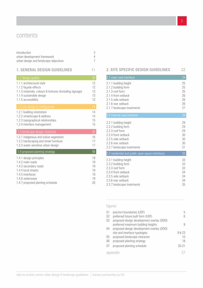
introduction 3urban development framework 4urban design and landscape objectives 7
1. GENERAL DESIGN GUIDELINES 11
1.1 design quality 12
1.1.1 architectural style 121.1.2 façade effects 121.1.3 materials, colours & textures (including signage) 131.1.4 sustainable design 131.1.5 accessibility 13
1.2 site design & configuration 14
1.2.1 building orientation 141.2.2 streetscape & address 141.2.3 topographical relationships 151.2.4 interface management 15 1.3 landscape design character 16
1.3.1 indigenous and native vegetation 161.3.2 hardscaping and street furniture 171.3.3 water sensitive urban design 17
contents
2. SITE SPECIFIC DESIGN GUIDELINES 22
2.1.1 building height 252.1.2 building form 252.1.3 roof form 252.1.4 front setback 262.1.5 side setback 262.1.6 rear setback 262.1.7 landscape treatments 27
2.2.1 building height 292.2.2 building form 292.2.3 roof form 292.2.4 front setback 302.2.5 side setback 302.2.6 rear setback 302.2.7 landscape treatments 31
figures01 precinct boundaries (UDF) 502 preferred future built form (UDF) 603 proposed design development overlay (DDO) preferred maximum building heights 804 proposed design development overlay (DDO) site and interface typologies 9 & 2305 proposed landscape character 10 06 proposed planting strategy 1807 proposed planting schedule 20-21
appendix 37
2.2 internal road interface 28
2.1 main road interface 24
2.3 residential and public open space interfaces 321.4 proposed planting strategy 18
2.3.1 building height 332.3.2 building form 332.3.3 roof form 332.3.4 front setback 342.3.5 side setback 342.3.6 rear setback 342.3.7 landscape treatments 35
1.4.1 design principles 191.4.2 main roads 191.4.3 secondary roads 191.4.4 local streets 191.4.5 interfaces 191.4.6 waterways 191.4.7 proposed planting schedule 20

tally ho activity centre urban design & landscape guidelines | hansen partnership pty ltd
3
The Tally Ho Activity Centre is a regional hub for high tech commerce and a centre for the local community. It is an area incorporating a number of key commercial, recreational and residential precincts generally oriented around the intersection of Springvale Road and Burwood Highway. Its key components include;
▪ The Tally Ho Business Park,
▪ The Burwood East Reserve,
▪ The Crossway Baptist Church,
▪ Burwood Terrace Retirement Village,
▪ The Burvale Hotel,
▪ Hewlett-Packard, and
▪ Peter James Centre and former Crown Coaches Site.
The Centre does not include adjoining housing areas (refer to Amendment C110 Panel Report).
The Tally Ho Activity Centre Urban Design Framework (2007) represents Whitehorse City Council’s vision for the progressive growth and development of Tally Ho and adjoining land.
The Urban Design Framework (UDF) sets out objectives and strategies that will guide development within the precinct for the next 15 to 20 years. The key objectives of the framework are;
▪ To encourage economic development based on new generation commerce and knowledge.
▪ To facilitate growth and development to meet current and future needs whilst maintaining amenity and liveability.
▪ To create a sustainable urban environment.
▪ To encourage use of alternative modes of transport by improving the extent and quality of bicycle and pedestrian networks and enhancing public transport infrastructure.
▪ To reduce at grade car parking in the area.
▪ To increase the mix of uses in existing and new developments.
▪ To ensure community facilities can meet the current and future needs of the local population.
▪ To enhance the quality and extent of landscaping.
The Whitehorse Planning Scheme included an interim Clause 22.08 for the Tally Ho Activity Centre, which entrenched the above objectives as relevant to development applications and public realm initiatives within the precinct. It is now appropriate to articulate a clear urban form and landscape vision as permanent planning parameters that may apply to the precinct. This is to be complimented by further heritage advice which may form part of permanent controls.
introduction
Part 1
Part 2
These Urban Design and Landscape Guidelines have been prepared to assist in realisation of the Tally Ho UDF. The intention of these guidelines is not to replace or supersede the framework, rather to provide detail as to ultimate built form and landscape outcomes.
These guidelines are intended to be used by anyone who is interested or involved in the planning and development process (land owners, designers, developers, community or Council) to better understand how to respond to planning policies and design within the Tally Ho Activity Centre. A Design and Development Overlay (DDO) is intended to be applied to key parts of the Activity Centre which set out key goals and ambitions for development on key parcels. These guidelines have been arranged so as to provide clarity as to Council’s ambition and have been broken down into parts as follows:
Outlines a series of General Design Guidelines relating to buildings and landscape that are applicable to the whole of the Centre. This includes key principles regarding design quality, site design, sustainable design practice, interface management and landscape effects.
Outlines a series of Site Specific Guidelines that are applicable to sites with certain attributes, including parcels which front Springvale Road and Burwood Highway. Different built form and landscape design responses are sought for land addressing internal roads, or sharing an interface with residential areas.
These guidelines are not intended to be restrictive or absolute parameters. As ‘guidelines’ they seek to provide directions for both designers and Council officers in relation to development applications and/ or public realm works. The UDF as adopted by Council sets out the key structure for the Centre over time. These guidelines seek to further articulate how the urban form and landscape vision is realised.

tally ho activity centre urban design & landscape guidelines | hansen partnership pty ltd
4
The key UDF objectives are as follows;
economic sustainability ▪ To strengthen the centre’s role as a high tech business hub of
state significance.
▪ To strengthen relationships between high tech commerce and high quality education.
▪ To develop Tally Ho as an Activity Centre that meets the diverse needs of both business users and the broader community.
built form and density ▪ To create a built environment that is attractive, safe and
establishes a strong sense of place.
▪ To accomplish required growth within the Tally Ho Activity Centre within a consistent urban built form solution.
▪ To develop new built form characterised by architectural design excellence.
▪ To enable additional capacity to be achieved without unreasonable impacts on surrounding residential areas.
▪ To maximise the efficient use of buildings.
sustainability ▪ To create a sustainable urban environment.
transport and car parking ▪ To create high quality amenity for all users of the Tally Ho
Activity Centre (pedestrians, cyclists and motorists).
▪ To diminish Tally Ho’s traditional reliance on private motor vehicle transport for accessing employment and services.
▪ To meet current and future car parking needs without a deleterious effect on landscape and amenity.
▪ To reduce existing at-grade parking areas.
▪ To improve safety of vehicular and pedestrian movements at intersections and across major roads, particularly Burwood Hwy and Springvale Road.
▪ To enable the community to access all transport modes.
open space, connectivity & linkages ▪ To enhance the quality and extent of landscaping in existing
open space areas.
▪ To enhance the quality, extent and interconnectivity of pedestrian and cycle linkages through the Tally Ho Activity Centre and connecting to surrounding networks.
▪ To foster a culture of walking, cycling and public transport utilisation.
streetscapes and landscapes ▪ To create vibrant, active and safe streets.
▪ To provide high quality and visually continuous streetscapes.
▪ To achieve high quality resolution of interfaces between areas of different land uses.
land use & zoning ▪ To provide high quality and increased mix of activity in new and
existing developments.
▪ To facilitate the development of land uses consistent with the vision and objectives of the Tally Ho UDF.
community ▪ To provide places and facilities for the area’s resident and
working population to interact and form community links.
▪ To ensure the long term viability of vital existing community facilities and services including their need to continue to grow and change to meet emerging community needs.
▪ To provide access to community facilities for all members of the community.
As background, the vision statement and key objectives of the Urban Design Framework are noted below. The vision statement for Tally Ho is;
identity + knowledge + sustainability + vitality + community = tally ho
urban development framework

tally ho activity centre urban design & landscape guidelines | hansen partnership pty ltd
5
figure 01 – precinct boundaries (UDF)

tally ho activity centre urban design & landscape guidelines | hansen partnership pty ltd
6
figure 02 – preferred future built form (UDF)

tally ho activity centre urban design & landscape guidelines | hansen partnership pty ltd
7
urban design objectives ▪ To reinforce an image of innovation through the establishment
of contemporary buildings that are nestled within a native Australian landscape.
▪ To create a built environment that represents the highest quality and a good ‘sense of place’.
▪ To configure uses that are connected in a way that encourages further business development and cohesion.
▪ To coordinate a uniform image for the Activity Centre and a character defined by innovative contemporary architectural design.
▪ To establish a ‘sense of place’ through a clear demarcation of the Activity Centre as its public edges.
▪ To improve and encourage active street frontages to create street address and interest at the pedestrian level.
▪ To encourage the concealment of car parking in basement, undercroft or decked format.
▪ To ensure sensitive design at the precinct’s interface with adjoining residential precincts.
▪ To ensure that the form and scale of new development is influenced by local topography, native vegetation and key views.
▪ To create ‘campus style’ development for non-residential uses within a generous landscape setting.
▪ To establish development that optimises the potential for Ecologically Sustainable Design (ESD).
▪ To ensure future development recognises the importance of local heriatge assets.
▪ To unify the disparate nature of the Activity Centre.
As an expression of the Urban Design Framework, the following 3 figures set out the key Built Form and Landscape Character ‘Types’ to be articulated in future planning controls.
These are also a key as to how to apply the ‘General’ and ‘Site Specific Design Guidelines’.
landscape design objectives ▪ To ensure that the proposed landscape compliments and
enhances existing and new developments within the precincts.
▪ To further develop a landscape regime that builds on the image of a contemporary business park.
▪ To develop a sustainable landscape response, enhancing the existing indigenous and native Australian vegetation.
▪ To use landscape as a common thread to connect various parts of the Activity Centre.
▪ To encourage building envelopes to sit within the landscape, which supports a tree-dominated environment.
▪ To ensure public spaces enjoy good solar access and shade in combination.
▪ To encourage the retention and regeneration of existing native vegetation and support native habitat.
▪ To provide a balance between landscape amenity areas and other settings for active recreation.
▪ To provide landscape treatments that can be easily maintained to a high standard.
▪ To ensure drainage management within the Activity Centre is addressed sustainably.
▪ To strengthen existing landscape character.
▪ To provide outdoor areas which are engaging and functional.
The following further design objectives are the basis for these guidelines:
urban design and landscape objectives
As an expression of the Urban Design Framework, thefollowing 3 figures set out the key Built Form and LandscapeCharacter ‘Types’ to be articulated in future planning controls.
These are also a key as to how to apply the ‘General’ and ‘Site Specific Design Guidelines’.

tally ho activity centre urban design & landscape guidelines | hansen partnership pty ltd
8
figure 03 – proposed design development overlay (DDO) – preferred maximum building heights

tally ho activity centre urban design & landscape guidelines | hansen partnership pty ltd
9
figure 04 – proposed design development overlay (DDO) – site and interface typologies

1 GENERAL DESIGN GUIDELINES
tally ho activity centre urban design & landscape guidelines | hansen partnership pty ltd
10
figure 05 – proposed landscape character

1 GENERAL DESIGN
GUIDELINESThis section includes a series of general guidelines to be applied
to all development within the Tally Ho Activity Centre. Refer to Figure
01 – Precinct Boundaries (UDF).
These general guidelines seek to encourage development which
meets the urban design and landscape guidelines. General
Design Guidleines should be read concurrently with the place
specific guidelines where they apply (refer to Part 2).

1 GENERAL DESIGN GUIDELINES
tally ho activity centre urban design & landscape guidelines | hansen partnership pty ltd
12
The presentation of new development within the Tally Ho Activity Centre will be a critical measure of its success. As a place to exhibit the very best in business services and innovation, it is important to ensure that design quality and design innovation are realised. The vision seeks to encourage contemporary design across the Centre and variety of design, rather than individual buildings that look the same.
The matters that are important to design quality include the following:
a. Ensure that the design of new buildings represent a high quality, contemporary architectural standard.
b. Encourage designs of distinction at key corner locations.
c. Encourage architectural design and the use of materials that is drawn from the themes of innovation and knowledge.
d. Encourage integrated designs that realise a combination of both architecture and landscape.
e. Encourage the design of buildings in the round, that can be viewed from all sides.
1.1 design quality
1 GENERAL DESIGN GUIDELINES
a
d
1.1.1 architectural style
a. Encourage the use of visually interesting facade effects, including glazed elevations.
b. Support the design of facades that allow for a high degree of transparency to allow for views in and out.
c. Activate building edges with the logical placement of entries, fenestration and openings and avoid the presentation of blank walls.
d. Apply feature materials and finishes that wrap around corner buildings at street frontages to heighten the sense of address.
e. Contribute to a more engaging street level by locating active uses and entries to the street edge.
c
1.1.2 facade effects
ensure that the design of new buildings represent high architectural quality, contemporary and representative of its time (refer 1.1.1)
encourage integrated design responses that realise a combination of architecture and landscape (refer 1.1.1)
activate building edges (refer 1.1.2)

1 GENERAL DESIGN GUIDELINES1 GENERAL DESIGN GUIDELINES
tally ho activity centre urban design & landscape guidelines | hansen partnership pty ltd
13
1.1.3 materials, colours & textures
a. Elevations visible from the public realm should be visually interesting and be composed with a mix of solid and glazed treatments.
b. Materials and finishes in the precinct should reflect a highly contemporary palette.
c. Colours should generally complement the landscape character.
d. Incorporate design detailing and material treatments that assist in articulation of the building form and limit the potential for visual bulk.
e. Integrate signage into building design, so it does not compromise the integrity of the streetscape or the landscape setting.
1.1.4 sustainable design
a. Refer to the objectives of Clause 21.05-3 of Whitehorse Planning Scheme relating to environment and any future environmental and sustainable design policy.
b. Use Sustainable Tools for Environmental Performance Strategy (STEPS) / Sustainable Design Scorecard (SDS) or similar programs (Whitehorse Sustainability Strategy 2008-2013) in assessing sustainable practice.
b
e
a
1.1 design quality
signage could be integrated into the overall building / facade design (refer 1.1.3)
improve accessibility and safety for all transport modes (refer 1.1.5)
contemporary palette (refer 1.1.3)
1.1.5 accessibility
a. Improve accessibility and safety for all transport modes with improved facilities especially for pedestrians, cyclists and public transport commuters.
b. Improve areas with no formal footpath connection within Tally Ho Activity Centre with new continuous wide footpaths.
c. Upgrade ‘wayfinding’ signage to assist pedestrians and cyclists to navigate their way within the precinct.
d. Seek to improve the safety of vehicular and pedestrian movements at key intersections (Burwood Highway / Mahoneys Road and Springvale Road / Vision Drive) with appropriate traffic control measures.
e. Encourage the development of commercial decked carparking facilities.
1 GENERAL DESIGN GUIDELINES1 GENERAL DESIGN GUIDELINES
tally ho activity centre urban design & landscape guidelines | hansen partnership pty ltd
14
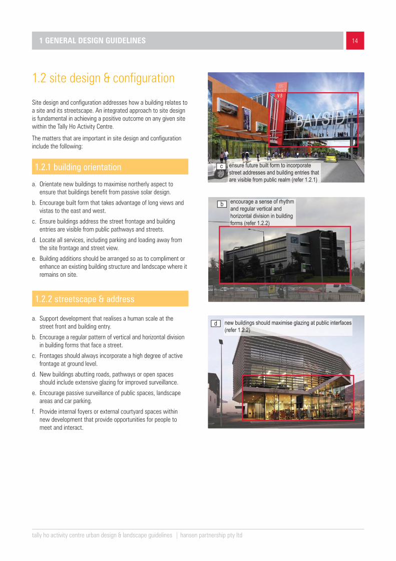
Site design and configuration addresses how a building relates to a site and its streetscape. An integrated approach to site design is fundamental in achieving a positive outcome on any given site within the Tally Ho Activity Centre.
The matters that are important in site design and configuration include the following:
1.2.1 building orientation
a. Orientate new buildings to maximise northerly aspect to ensure that buildings benefit from passive solar design.
b. Encourage built form that takes advantage of long views and vistas to the east and west.
c. Ensure buildings address the street frontage and building entries are visible from public pathways and streets.
d. Locate all services, including parking and loading away from the site frontage and street view.
e. Building additions should be arranged so as to compliment or enhance an existing building structure and landscape where it remains on site.
1.2 site design & configuration
a. Support development that realises a human scale at the street front and building entry.
b. Encourage a regular pattern of vertical and horizontal division in building forms that face a street.
c. Frontages should always incorporate a high degree of active frontage at ground level.
d. New buildings abutting roads, pathways or open spaces should include extensive glazing for improved surveillance.
e. Encourage passive surveillance of public spaces, landscape areas and car parking.
f. Provide internal foyers or external courtyard spaces within new development that provide opportunities for people to meet and interact.
b
d
encourage a sense of rhythm and regular vertical and horizontal division in building forms (refer 1.2.2)
new buildings should maximise glazing at public interfaces (refer 1.2.2)
ensure future built form to incorporate street addresses and building entries that are visible from public realm (refer 1.2.1)
c
1.2.2 streetscape & address

1 GENERAL DESIGN GUIDELINES1 GENERAL DESIGN GUIDELINES
tally ho activity centre urban design & landscape guidelines | hansen partnership pty ltd
15
1.2.3 topographical relationships
a. Ensure that the siting of new building forms responds to local topography and the retention of existing vegetation.
b. On sloping sites, buildings should maximise opportunities for split level design.
c. Minimise the use of high retaining walls.
d. Access driveways and pedestrian paths should where possible follow contours and avoid significant excavation works or retaining walls.
e. Ensure that basements are not exposed above ground level at the pedestrian interface.
f. The natural drainage of land should be considered in the design of development on sloping sites and the adoption of Water Sensitive Urban Design (WSUD) is encouraged.
avoid extensiveearthworks, designbuildings andaccessways tofollow naturalcontours
extensive cut and fill
step buildings to follow natural contours
�
�
a
b
c
1.2 site design & configuration
a. The design of new buildings within the Activity Centre should have regard to interfaces with residential properties.
b. Separation between commercial buildings and housing should allow for layered canopy planting.
c. Development with residential interfaces should be designed to limit unreasonable amenity impacts such as overlooking, overshadowing and visual bulk.
d. Encourage both canopy and understorey landscaping at interfaces with housing and residential streets.
b separation between buildings should allow for canopy planting (refer 1.2.4)
1.2.4 interface management

1 GENERAL DESIGN GUIDELINES
tally ho activity centre urban design & landscape guidelines | hansen partnership pty ltd
16
The landscape character of the Tally Ho Activity Centre is a key feature which sets it apart from other urban envrionments. The existing landscape character of the precinct, including native canopy plantings and an internal waterway system complement the ‘Business Park’ model of development. Expansion and consolidation of the Centre should build on this landscape theme and adapt it to a 21st century design language.
The matters that are important in landscape design include the following:
1.3.1 indigenous and native vegetation
a. Ensure contemporary landscape design to reflect the innovative character of the Activity Centre.
b. Encourage the use of indigenous and native vegetation throughout the Centre.
c. Support a hierarchy of canopy plantings within the Centre that distinguish between main road frontages, internal streets and pedestrian ways (Refer to Figure 6 - Proposed Planting Strategy, page 18).
d. New development within the precinct should seek to retain existing indigenous and native vegetation where possible.
e. Ensure that central median landscape planting within road reservations is regularly maintained to ensure clear sightlines across streets.
f. Maintain existing significant exotic species where possible.
g. Establish a street tree regime that grows to a scale that suits both the road network and the building context.
h. Avoid the use of large screening shrubs to improve passive surveillance and safety.
i. Reduce mown lawn or turfed areas and replace with mulched garden beds, native ground covers and/or native grasses so as to lower maintenance requirements.
j. Use drought tolerant and low maintenance species to reduce overall water use.
k. Avoid the use of known branch dropping species to prevent the risk to people and property.
l. Incorporate vertical gardens and green roofs where possible.
1.3 landscape design character
c
a
l
use canopy trees to distinguish between main road frontages, internal streets and pedestrian ways (refer 1.3.1)
ensure contemporary landscape design within the Activity Centre (refer 1.3.1)
incorporate vertical gardens where possible (refer 1.3.1)

1 GENERAL DESIGN GUIDELINES
tally ho activity centre urban design & landscape guidelines | hansen partnership pty ltd
17
1.3.2 hardscaping and street furniture
a. Avoid large expanses of one form of paving and consider the use of contrasting pavement materials to define pedestrian and vehicular areas for safety and wayfinding purposes.
b. Use porous paving to reduce runoff velocities and grade paving surfaces to promote on site water re-use in garden beds consistent with WSUD principles.
c. Plant shade trees in open air and at-grade car parking areas.
d. Adopt a consistent suite of public and street furnishings and fixtures that are comfortable and consistent within the landscape theme.
e. The siting and design of seating, bins, bollards, lighting structures and shelters should be considered as an integral part of the landscape setting.
b use porous paving to promote on site water re-use (refer 1.3.2)
1.3 landscape design character
1.3.3 water sensitive urban design
Water Sensitive Urban Design (WSUD) is an integral design approach to improve the landscape character of the Tally Ho Activity Centre. WSUD will assist in managing urban water both at an individual building and a broader activity centre scale. WSUD is an important tool to protect existing natural features of Tally Ho whilst protecting water quality, minimising the demand on the water supply and reducing wastewater discharges to the environment.
a. Where appropriate, provide rain garden systems to new developments with indigenous and native species to improve aesthetic value and provide treatment function by filtering storm water and reducing overflow during storm events.
b. Design small scale WSUD installations.
c. Encourage land owners to enhance the current lake system in the business park to serve a large scale WSUD function.
d. Detention basins should be stocked with indigenous aquatic plants to filter contaminants and sediments.
b design small scale WSUD installations (refer 1.3.3)
e ingrate seating within the landscape setting (refer 1.3.2)

1 GENERAL DESIGN GUIDELINES
1 GENERAL DESIGN GUIDE-LINES1 GENERAL DESIGN GUIDE-LINES
1 GENERAL DESIGN GUIDELINES
tally ho activity centre urban design & landscape guidelines | hansen partnership pty ltd
18
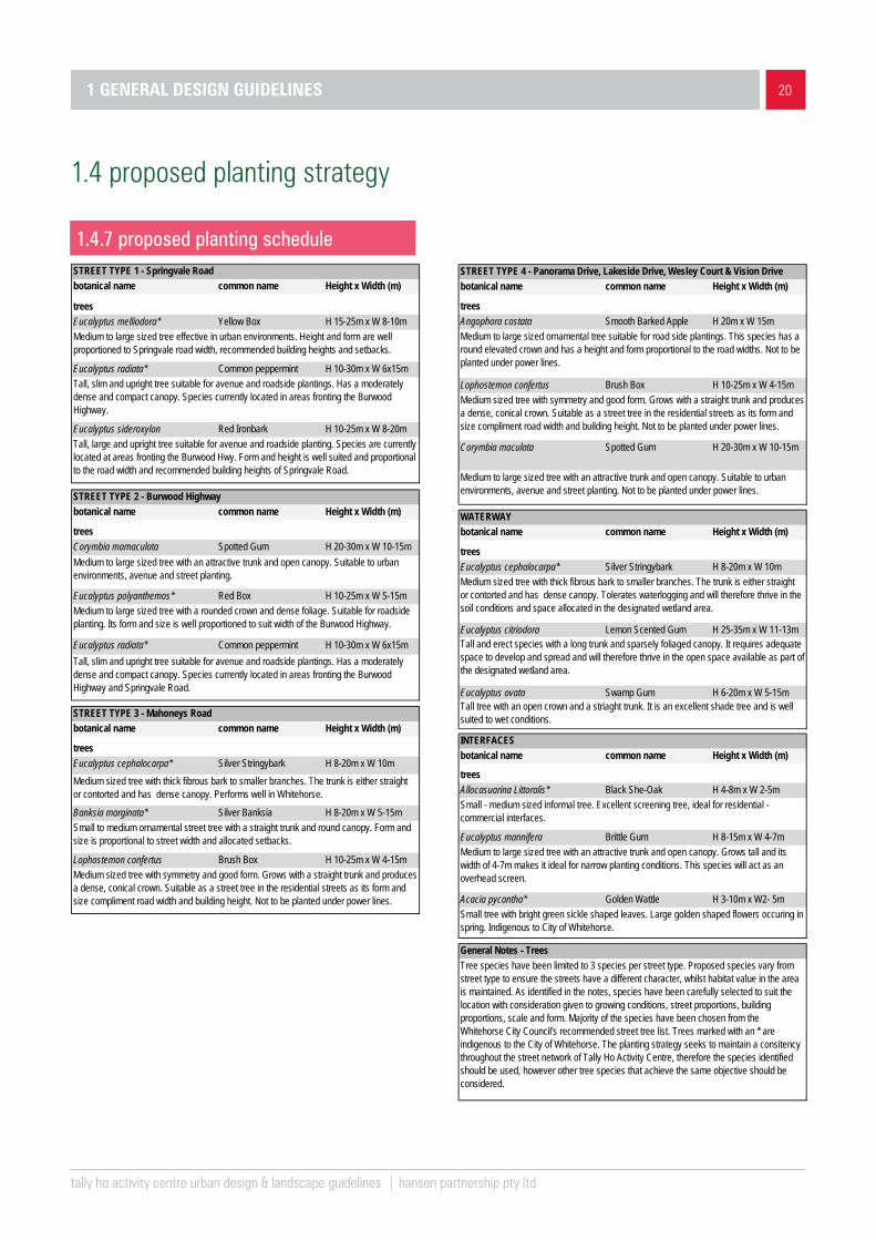
1.4 proposed planting strategyfigure 06 – proposed planting strategy

1 GENERAL DESIGN GUIDELINES
tally ho activity centre urban design & landscape guidelines | hansen partnership pty ltd
191 GENERAL DESIGN GUIDELINES
The objective of the planting strategy for the Tally Ho Activity Centre is to establish a ‘business garden identity’ for the precinct.
1.4 proposed planting strategy
1.4.1 design principles
▪ Establish distinct character differentiations between street types through species choice.
▪ Select species proportional to road width and effective building height.
▪ Establish a clear canopy cover with low lying ground planting regime.
1.4.2 main roads
Springvale Road (Street Type 1) and Burwood Highway (Street Type 2) are considered arterial roads that carry high traffic volumes. The intention of the planting strategy for these arterial roads is to create an avenue of trees that signifies to drivers that they have entered the Tally Ho Activity Centre. The species chosen are therefore tall, narrow and upright to match the scale of the wide roads and ensure carriage ways are kept clear of tree limbs.
Planting and maintenance along Springvale Road and the Burwood Highway is the responsibility of VicRoads. Landscaping along Springvale Road and the Burwood Highway is subject to VicRoads consent and should reinforce the existing avenue effects.
1.4.3 secondary roads
Mahoneys Road (Street Type 3) is a two lane road with room for parallel parking on either side. It runs north-south with a speed limit of 50km/h and power lines located on the eastern side. The street tree character currently consists of small mixed species with no apparent pattern. The planting strategy seeks to establish a formal avenue as it is an important north south connection through Tally Ho Activity Centre. Medium to large native species (Eucalyptus cephalocarpa and Lophostemon confertus) will form an alternating row to the western side of the road. The eastern side of the road will consist of a row of Banksia marginata as they can be shaped to sit under power lines.
1.4.4 local streets
Local street types are significant connections within and around the Tally Ho Activity Centre. They have been identified as Street type 4 in the planting strategy and include Panorama Drive, Lakeside Drive, Wesley Court and Vision Drive. The planting strategy seeks to formalise these thoroughfares with avenue planting consisting of Angophora costata, Lophostemon confertus and Corymbia maculata.
1.4.5 interfaces
Interfaces treatments involve plant species suitable for growing in narrow conditions and provide adequate screening.
1.4.6 waterways
The waterway area is an important feature that runs through the heart of the Tally Ho Business Precinct. There is substantially more space available for planting and therefore species with wider canopies and interesting forms have been selected to act as features throughout the waterway landscape.
1 GENERAL DESIGN GUIDELINES
tally ho activity centre urban design & landscape guidelines | hansen partnership pty ltd
201 GENERAL DESIGN GUIDELINES
1.4 proposed planting strategy
1.4.7 proposed planting scheduleSTREET TYPE 1 - Springvale Roadbotanical name common name Height x Width (m)
treesEucalyptus melliodora* Yellow Box H 15-25m x W 8-10m
Eucalyptus radiata* Common peppermint H 10-30m x W 6x15m
Eucalyptus sideroxylon Red Ironbark H 10-25m x W 8-20m
STREET TYPE 2 - Burwood Highwaybotanical name common name Height x Width (m)
treesCorymbia mamaculata Spotted Gum H 20-30m x W 10-15m
Eucalyptus polyanthemos* Red Box H 10-25m x W 5-15m
Eucalyptus radiata* Common peppermint H 10-30m x W 6x15m
STREET TYPE 3 - Mahoneys Roadbotanical name common name Height x Width (m)
treesEucalyptus cephalocarpa* Silver Stringybark H 8-20m x W 10m
Banksia marginata* Silver Banksia H 8-20m x W 5-15m
Lophostemon confertus Brush Box H 10-25m x W 4-15m
Medium to large sized tree with an attractive trunk and open canopy. Suitable to urban environments, avenue and street planting.
Tall, slim and upright tree suitable for avenue and roadside plantings. Has a moderately dense and compact canopy. Species currently located in areas fronting the Burwood Highway.
Tall, large and upright tree suitable for avenue and roadside planting. Species are currently located at areas fronting the Burwood Hwy. Form and height is well suited and proportional to the road width and recommended building heights of Springvale Road.
Medium to large sized tree effective in urban environments. Height and form are well proportioned to Springvale road width, recommended building heights and setbacks.
Medium sized tree with symmetry and good form. Grows with a straight trunk and produces a dense, conical crown. Suitable as a street tree in the residential streets as its form and size compliment road width and building height. Not to be planted under power lines.
Small to medium ornamental street tree with a straight trunk and round canopy. Form and size is proportional to street width and allocated setbacks.
Medium sized tree with thick fibrous bark to smaller branches. The trunk is either straight or contorted and has dense canopy. Performs well in Whitehorse.
Tall, slim and upright tree suitable for avenue and roadside plantings. Has a moderately dense and compact canopy. Species currently located in areas fronting the Burwood Highway and Springvale Road.
Medium to large sized tree with a rounded crown and dense foliage. Suitable for roadside planting. Its form and size is well proportioned to suit width of the Burwood Highway.
STREET TYPE 4 - Panorama Drive, Lakeside Drive, Wesley Court & Vision Drivebotanical name common name Height x Width (m)
treesAngophora costata Smooth Barked Apple H 20m x W 15m
Lophostemon confertus Brush Box H 10-25m x W 4-15m
Corymbia maculata Spotted Gum H 20-30m x W 10-15m
WATERWAYbotanical name common name Height x Width (m)
treesEucalyptus cephalocarpa* Silver Stringybark H 8-20m x W 10m
Eucalyptus citriodora Lemon Scented Gum H 25-35m x W 11-13m
Eucalyptus ovata Swamp Gum H 6-20m x W 5-15m
INTERFACESbotanical name common name Height x Width (m)
treesAllocasuarina Littoralis* Black She-Oak H 4-8m x W 2-5m
Eucalyptus mannifera Brittle Gum H 8-15m x W 4-7m
Acacia pycantha* Golden Wattle H 3-10m x W2- 5m
Medium to large sized ornamental tree suitable for road side plantings. This species has a round elevated crown and has a height and form proportional to the road widths. Not to be planted under power lines.
Medium sized tree with symmetry and good form. Grows with a straight trunk and produces a dense, conical crown. Suitable as a street tree in the residential streets as its form and size compliment road width and building height. Not to be planted under power lines.
Medium to large sized tree with an attractive trunk and open canopy. Suitable to urban environments, avenue and street planting. Not to be planted under power lines.
Tall and erect species with a long trunk and sparsely foliaged canopy. It requires adequate space to develop and spread and will therefore thrive in the open space available as part of the designated wetland area.
Tall tree with an open crown and a striaght trunk. It is an excellent shade tree and is well suited to wet conditions.
Medium sized tree with thick fibrous bark to smaller branches. The trunk is either straight or contorted and has dense canopy. Tolerates waterlogging and will therefore thrive in the soil conditions and space allocated in the designated wetland area.
Small - medium sized informal tree. Excellent screening tree, ideal for residential - commercial interfaces.
Small tree with bright green sickle shaped leaves. Large golden shaped flowers occuring in spring. Indigenous to City of Whitehorse.
Tree species have been limited to 3 species per street type. Proposed species vary from street type to ensure the streets have a different character, whilst habitat value in the area is maintained. As identified in the notes, species have been carefully selected to suit the location with consideration given to growing conditions, street proportions, building proportions, scale and form. Majority of the species have been chosen from the Whitehorse City Council's recommended street tree list. Trees marked with an * are indigenous to the City of Whitehorse. The planting strategy seeks to maintain a consitency throughout the street network of Tally Ho Activity Centre, therefore the species identified should be used, however other tree species that achieve the same objective should be considered.
Medium to large sized tree with an attractive trunk and open canopy. Grows tall and its width of 4-7m makes it ideal for narrow planting conditions. This species will act as an overhead screen.
General Notes - Trees

1 GENERAL DESIGN GUIDELINES
tally ho activity centre urban design & landscape guidelines | hansen partnership pty ltd
211 GENERAL DESIGN GUIDELINES
1.4 proposed planting strategy
1.4.7 proposed planting schedules
botanical name common name Height x Width (m) ex
otic
nativ
e
shrubsAcacia acinaceae Gold Dust Wattle 2.0 x 2.0 xAgonis flexuosa 'nana' Dwarf Willow Myrtle 1.5 x 1.5 xBursaria spinosa Sweet Bursaria 3.0 x 2 .0 xCallisetmon ssp. Bottlebrush 6.0 x 4.0 xCorrea ssp. Correa 1.0 x 0.5 xGoodenia ovata Hop Bush 1.5 x 1.5 xLeucophyta brownii Cushion Bush 0.5 x 1.0 x
grassesAnigonzanthus ssp. Kangaroo Paw 0.5 x 0.4 xArthropodium strictum Chocolate Lily 0.4 x 0.2 xCarex appressa Tall Sedge 1.0 x 1.0 xCarex incomitata Sedge 0.5 x 0.5 xDianella ssp. Black-anther Flax Lily 0.6 x 0.5 xDietes bicolor Wild Iris 1.0 x 1.0 xDiplarrena moraea Butterfly Flag 0.5 x 0.8 xFicinia nodosa Knobby Club-Rush 0.8 x 0.4 xLiriope ssp. Lily Turf 0.3 x 0.4 x xLomandra ssp. Spiny-Headed Mat-rush 0.6 x 0.6 xPoa ssp. Tussock Grass 1.0 x 0.5 x
groundcoversArtemisia 'Powis Castle' Dwarf Artemisia 0.4 x 1.0 xAtriplex semibaccata Creeping Saltbush 0.3 x 2 xBanksia spinulosa 'Dwarf Form' Hairpin Banksia 0.5 x 0.8 xGrevillea ssp. Gevillea 0.6 x 0.6 xMyoporum parvifolium Creeping Boobialla 0.2 x 2.5 xWestringia ssp. Rosemary 0.4 x 1.0 x
UNDERSTOREY PLANTING - SUGGESTED
General Notes - Understory PlantingsThese species have been chosen from the Whitehorse City Council's recommended plant list. Understorey planting should be prodominantly indegenous and native species. The planting schedule is suggested as a guide only. Any other species that provide the same effect and desired outcome will also be considered.

In addition to general guidelines for the whole of the activity centre, site specific guidelines are applicable to particular locations:
▪ The Tally Ho Business Park
▪ the Burvale Hotel,
▪ Hewlett-Packard, and
▪ Peter James Centre and former Crown Coaches Site.
The Activity Centre includes land parcels on opposite corners of the junction of Springvale Road and Burwood Highway, and the successful integration between the various sites and the established image of the Tally Ho Business Park remain an important matter. In order to address the differences between sites, specific design guidelines have been proposed to address the particular urban conditions, such as at;
▪ A main road address,
▪ A frontage to an internal street or
▪ An interface with housing or parkland.
2 SITE SPECIFIC DESIGN GUIDELINES

232 SITE SPECIFIC DESIGN GUIDELINES
tally ho activity centre urban design & landscape guidelines | hansen partnership pty ltd
2 SITE SPECIFIC DESIGN GUIDELINES
figure 04– proposed design development overlay (DDO) – site and interface typologies

2 SITE SPECIFIC DESIGN GUIDELINES 24
tally ho activity centre urban design & landscape guidelines | hansen partnership pty ltd
The first typology includes sites with frontage to a Main Road within the Activity Centre, i.e. Springvale Road or Burwood Highway. It applies to sites fronting both sides of Burwood Highway and Springvale Road of the Tally Ho Business Park, the Hewlett-Packard precinct, including sites within the mixed-use corridor to the west of the Peter James Centre and the Burvale Hotel site. These sites are illustrated in orange in Figure 4.
These sites are of particular importance because they represent the ‘facade’ and ‘frontage character’ of the precinct and are viewed by traffic passing through.
The importance of the main roads are acknowledged in the Tally Ho UDF, which promotes higher form and a sense of address at the critical junction of Springvale Road and Burwood Highway.
Guidelines applying to Main Road Interfaces relate both to urban design and landscape matters and reinforce the findings of the UDF. Where sites occupy an Internal Road address with an interface to a Main Road, Residential or Public Open Space Interface, then it is necessary for development to comply with both guidelines.
The following guidelines apply to sites abutting Springvale Road or Burwood Highway;
2.1 main road interface
type A - main road interface
hardscape dominated 5m setback with small
landscape interventions
greater setback on groundfloor for more activated frontages
pedestrian priority areas with integrated landscape elements
main road interface (refer to fi gure 4, page 23, typologies)
252 SITE SPECIFIC DESIGN GUIDELINES
tally ho activity centre urban design & landscape guidelines | hansen partnership pty ltd
1
2
3
4
5
6
4m3.5
m3.5
m3m
3m3m
property5m (min.)street setback
main road
roof form to be legible from long distance view
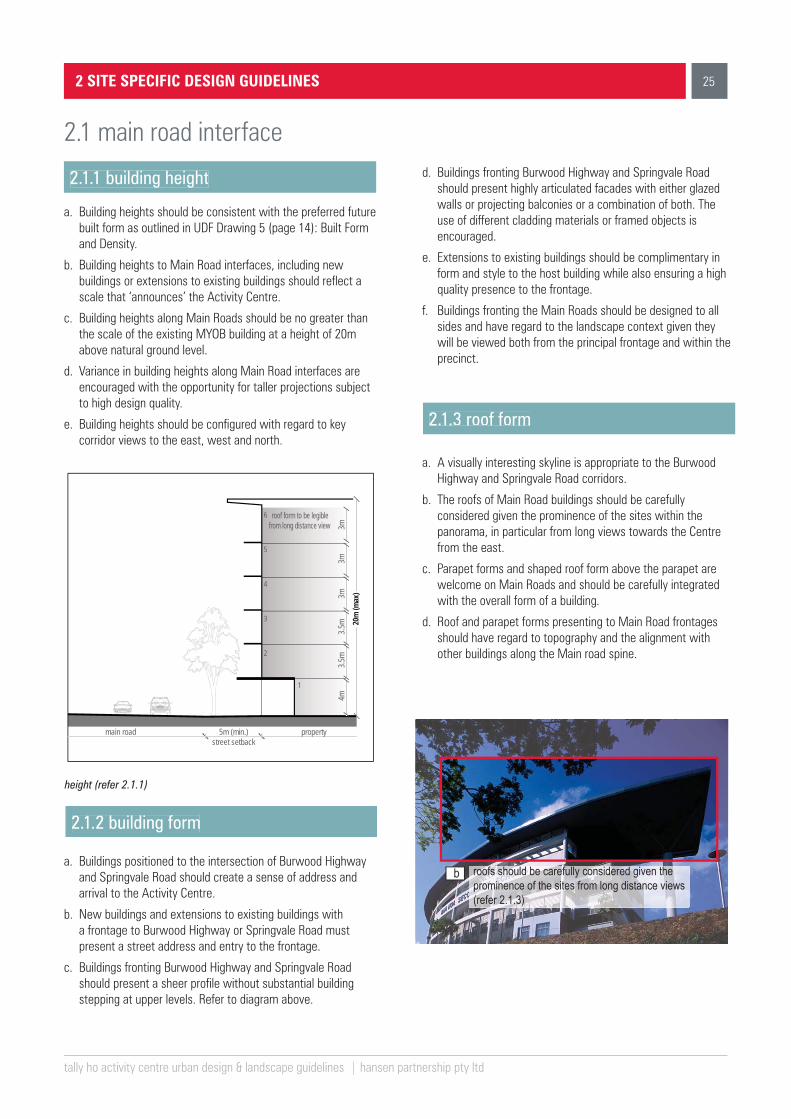
2.1.1 building height
a. Building heights should be consistent with the preferred future built form as outlined in UDF Drawing 5 (page 14): Built Form and Density.
b. Building heights to Main Road interfaces, including new buildings or extensions to existing buildings should reflect a scale that ‘announces’ the Activity Centre.
c. Building heights along Main Roads should be no greater than the scale of the existing MYOB building at a height of 20m above natural ground level.
d. Variance in building heights along Main Road interfaces are encouraged with the opportunity for taller projections subject to high design quality.
e. Building heights should be configured with regard to key corridor views to the east, west and north.
2.1.2 building form
height (refer 2.1.1)
2.1 main road interface
b roofs should be carefully considered given the prominence of the sites from long distance views (refer 2.1.3)
a. Buildings positioned to the intersection of Burwood Highway and Springvale Road should create a sense of address and arrival to the Activity Centre.
b. New buildings and extensions to existing buildings with a frontage to Burwood Highway or Springvale Road must present a street address and entry to the frontage.
c. Buildings fronting Burwood Highway and Springvale Road should present a sheer profile without substantial building stepping at upper levels. Refer to diagram above.
d. Buildings fronting Burwood Highway and Springvale Road should present highly articulated facades with either glazed walls or projecting balconies or a combination of both. The use of different cladding materials or framed objects is encouraged.
e. Extensions to existing buildings should be complimentary in form and style to the host building while also ensuring a high quality presence to the frontage.
f. Buildings fronting the Main Roads should be designed to all sides and have regard to the landscape context given they will be viewed both from the principal frontage and within the precinct.
a. A visually interesting skyline is appropriate to the Burwood Highway and Springvale Road corridors.
b. The roofs of Main Road buildings should be carefully considered given the prominence of the sites within the panorama, in particular from long views towards the Centre from the east.
c. Parapet forms and shaped roof form above the parapet are welcome on Main Roads and should be carefully integrated with the overall form of a building.
d. Roof and parapet forms presenting to Main Road frontages should have regard to topography and the alignment with other buildings along the Main road spine.
2.1.3 roof form
20m
(max
)

262 SITE SPECIFIC DESIGN GUIDELINES
tally ho activity centre urban design & landscape guidelines | hansen partnership pty ltd
2.1 main road interface
2.1.4 front setback
a. Buildings fronting Burwood Highway and Springvale Road should be setback a minimum of 5m from the property boundary at the ground level to allow for a generous pedestrian realm.
b. Treatments within the front setback should be dedicated for public use, in the form of pedestrian pathways and access areas with an open profile.
c. Front setback areas to Burwood Highway and Springvale Road should consist of hardstand surfaces with complimentary canopy plantings for shade and shelter, street furniture, public art and opportunities for street activity.
d. The arrangement of elements within the front setback should support an open aspect to the building frontage for surveillance and safety.
10m rear setback property
5m front setback
property
10m
5m
5m
buildingseparation
side setback
sidesetback
main
road
indicitive building envelope
active frontage
landscape
potential concealed at gradecar parking
legend
semi active frontage
pedestrian access
vehicular access
retain existing significantvegetation where possible
potential at grade car parking concealed behind topography and/or landscape
Typical Site Plan – Main Road Interface
Grading land within rear setbacks (refer 2.1.6)
ensure a matching to existing grade within 2m of the common boundary
boun
dary
2m (min.)
a. Buildings fronting Burwood Highway and Springvale Road should apply setbacks of at least 5m from side boundaries so as to allow for vehicular and pedestrian access between properties and landscaping with good light penetration, ventilation and visability.
b. Side setbacks should be applied both at ground level and above so as to ensure good building separation.
c. Where Main road development abuts a residential or parkland interface, a side setback of 10m is preferred (to allow a substantial layered landscape effect).
d. The design and presentation of side elevations addressing setback areas should be attractive so as to ensure an inviting access or interface.
a. Buildings fronting Burwood Highway and Springvale Road should be setback at least 10m from rear boundaries so as to allow for access between properties and landscaping.
b. Any grading of land within rear setbacks should match grades within 2m of the common boundary on adjoining properties.
c. Elevations presenting to an adjoining property should be attractive and organised to support landscape screening and an appropriate level of amenity.
d. Rear setbacks which interface to an internal roadway should be designed to be consistent with the guidelines for Internal Road Interfaces (Refer 2.2).
2.1.6 rear setback
2.1.5 side setback

272 SITE SPECIFIC DESIGN GUIDELINES
tally ho activity centre urban design & landscape guidelines | hansen partnership pty ltd
2.1.7 landscape treatments
a. Provide a consistent canopy landscape to Springvale Road and Burwood Highway.
b. Have regard to the retention of existing established vegetation on the site and reinforce public landscape along Burwood Highway and Springvale Road.
c. Support a pedestrian network consistent with the Tally Ho UDF Drawing 7: Open Space, Pedestrian Linkages and Landscapes (page 16). Ensure minimum pathway width of 2.5m with a clear visibility for at least 3m to either side.
d. Ensure that the front setback treatments provide opportunities for outdoor dining, leisure and access.
e. Encourage different materials and treatments at key entries to Lakeside Drive and Hewlett-Packard site.
f. Provide consistent street furnishings to encourage street life and activity. The use of timber furnishings and other natural materials is encouraged.
g. Use lighting to highlight features in the landscape such as avenue trees, feature canopies, garden beds, entrances, pathways and signage.
h. Integrate WSUD into hardstand spaces, including the use of tree pits and rain gardens.
i. Ensure side and rear setback areas incorporate native canopy tree plantings with an open understorey for maximum visibility and surveillance.
j. Boundary fencing and other barriers are not supported along Burwood Highway or Springvale Road within 15m of the Main Road frontage. Any side or rear boundary fencing should be no greater than 1.8m in height.
f
h
d
2.1 main road interface
street furnishing (refer 2.17)
WSUD integrated into urban context
(refer 2.1.7)
encourage outdoor dining
(refer 2.1.7)
28
tally ho activity centre urban design & landscape guidelines | hansen partnership pty ltd
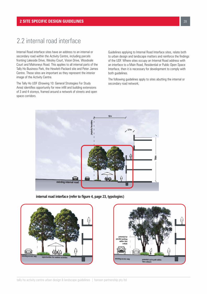
Internal Road interface sites have an address to an internal or secondary road within the Activity Centre, including parcels fronting Lakeside Drive, Wesley Court, Vision Drive, Woodvale Court and Mahoneys Road. This applies to all internal parts of the Tally Ho Business Park, the Hewlett-Packard site and Peter James Centre. These sites are important as they represent the interior image of the Activity Centre.
The Tally Ho UDF (Drawing 10: General Strategies For Study Area) identifies opportunity for new infill and building extensions of 3 and 4 storeys, framed around a network of streets and open space corridors.
Guidelines applying to Internal Road Interface sites, relate both to urban design and landscape matters and reinforce the findings of the UDF. Where sites occupy an Internal Road address with an interface to a Main Road, Residential or Public Open Space Interface, then it is necessary for development to comply with both guidelines.
The following guidelines apply to sites abutting the internal or secondary road network;
2 SITE SPECIFIC DESIGN GUIDELINES
2.2 internal road interface
existing internal road
potential cycle path within 10m setback
potential for parallel parking
within 10m setbak
existing access way opportunities for outdoor activities
existing access way
14m
internal road interface (refer to fi gure 4, page 23, typologies)
29
1
2
3
4
14m
(max
)
property10m (min.)rear/ front setback
internal road
2.5m (min.)recessed
upper levels
8.0m
(max
)
height (refer 2.2.1)
tally ho activity centre urban design & landscape guidelines | hansen partnership pty ltd
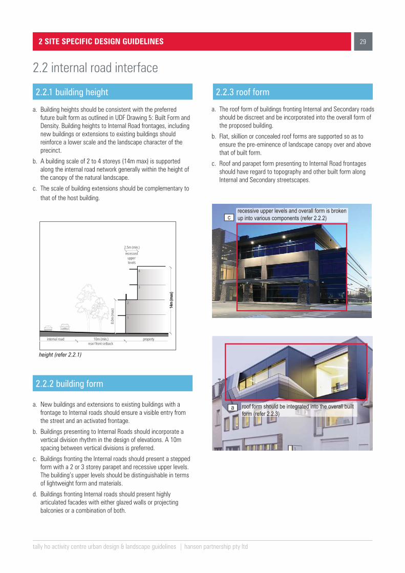
2.2.1 building height
a. Building heights should be consistent with the preferred future built form as outlined in UDF Drawing 5: Built Form and Density. Building heights to Internal Road frontages, including new buildings or extensions to existing buildings should reinforce a lower scale and the landscape character of the precinct.
b. A building scale of 2 to 4 storeys (14m max) is supported along the internal road network generally within the height of the canopy of the natural landscape.
c. The scale of building extensions should be complementary to that of the host building.
2 SITE SPECIFIC DESIGN GUIDELINES
2.2 internal road interface
a
crecessive upper levels and overall form is broken up into various components (refer 2.2.2)
roof form should be integrated into the overall built form (refer 2.2.3)
2.2.2 building form
2.2.3 roof form
a. New buildings and extensions to existing buildings with a frontage to Internal roads should ensure a visible entry from the street and an activated frontage.
b. Buildings presenting to Internal Roads should incorporate a vertical division rhythm in the design of elevations. A 10m spacing between vertical divisions is preferred.
c. Buildings fronting the Internal roads should present a stepped form with a 2 or 3 storey parapet and recessive upper levels. The building’s upper levels should be distinguishable in terms of lightweight form and materials.
d. Buildings fronting Internal roads should present highly articulated facades with either glazed walls or projecting balconies or a combination of both.
a. The roof form of buildings fronting Internal and Secondary roads should be discreet and be incorporated into the overall form of the proposed building.
b. Flat, skillion or concealed roof forms are supported so as to ensure the pre-eminence of landscape canopy over and above that of built form.
c. Roof and parapet form presenting to Internal Road frontages should have regard to topography and other built form along Internal and Secondary streetscapes.
14m
(max
)
30
tally ho activity centre urban design & landscape guidelines | hansen partnership pty ltd
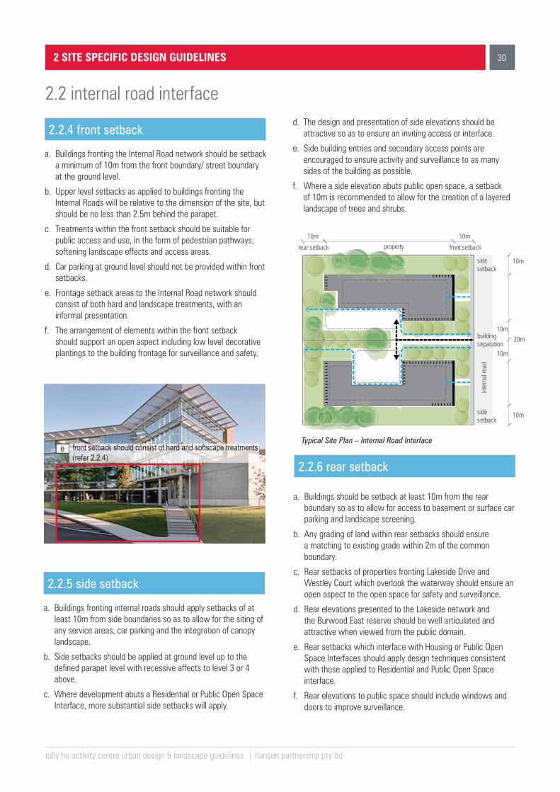
2.2.4 front setback
a. Buildings fronting the Internal Road network should be setback a minimum of 10m from the front boundary/ street boundary at the ground level.
b. Upper level setbacks as applied to buildings fronting the Internal Roads will be relative to the dimension of the site, but should be no less than 2.5m behind the parapet.
c. Treatments within the front setback should be suitable for public access and use, in the form of pedestrian pathways, softening landscape effects and access areas.
d. Car parking at ground level should not be provided within front setbacks.
e. Frontage setback areas to the Internal Road network should consist of both hard and landscape treatments, with an informal presentation.
f. The arrangement of elements within the front setback should support an open aspect including low level decorative plantings to the building frontage for surveillance and safety.
2.2.5 side setback
a. Buildings fronting internal roads should apply setbacks of at least 10m from side boundaries so as to allow for the siting of any service areas, car parking and the integration of canopy landscape.
b. Side setbacks should be applied at ground level up to the defined parapet level with recessive affects to level 3 or 4 above.
c. Where development abuts a Residential or Public Open Space Interface, more substantial side setbacks will apply.
2 SITE SPECIFIC DESIGN GUIDELINES
2.2 internal road interfaced. The design and presentation of side elevations should be
attractive so as to ensure an inviting access or interface.
e. Side building entries and secondary access points are encouraged to ensure activity and surveillance to as many sides of the building as possible.
f. Where a side elevation abuts public open space, a setback of 10m is recommended to allow for the creation of a layered landscape of trees and shrubs.
2.2.6 rear setbacke front setback should consist of hard and softscape treatments
(refer 2.2.4)
10m rear setback property
10m front setback
buildingseparation
10m
10m
20m
10m
10mside setback
sidesetback
inter
nal ro
ad
Typical Site Plan – Internal Road Interface
a. Buildings should be setback at least 10m from the rear boundary so as to allow for access to basement or surface car parking and landscape screening.
b. Any grading of land within rear setbacks should ensure a matching to existing grade within 2m of the common boundary.
c. Rear setbacks of properties fronting Lakeside Drive and Westley Court which overlook the waterway should ensure an open aspect to the open space for safety and surveillance.
d. Rear elevations presented to the Lakeside network and the Burwood East reserve should be well articulated and attractive when viewed from the public domain.
e. Rear setbacks which interface with Housing or Public Open Space Interfaces should apply design techniques consistent with those applied to Residential and Public Open Space interface.
f. Rear elevations to public space should include windows and doors to improve surveillance.

31
vv
f
tally ho activity centre urban design & landscape guidelines | hansen partnership pty ltd
2.2.7 landscape treatments
a. Provide an informal landscape comprising clear stemmed canopy trees to all Internal road frontages above a native grass or ground cover understorey.
b. Where possible, retain existing established vegetation.
c. Encourage designated pedestrian access in between buildings connected to the broader network of links identified in the Tally Ho UDF.
d. Within setback areas, ensure minimum pathway width of 2.5m with a clear visibility for at least 3m to either side.
e. Utilise durable paving materials such as exposed aggregate concrete for pedestrian footpaths, lakeside walkways and accessways.
f. Ensure that the landscape frontage treatment to Internal Roads allow for a clear aspect to building entry from the public pathways.
g. Use lighting to highlight features in the landscape such as avenues, feature trees, garden beds, entrances, pathways and wayfinding signage.
h. Avoid the use of boundary fencing to frontages or the use of high security fencing to side and rear interfaces. Any side or rear boundary fencing should be no greater than 1.8m in height.
2 SITE SPECIFIC DESIGN GUIDELINES
2.2 internal road interface
cencourage pedestrian access between buildings (refer 2.2.7)
ensure landscape frontage treatments allow for clear asect to building entries (refer 2.2.7)
g use lighting to highlight features in landscape (refer 2.2.7)

32
tally ho activity centre urban design & landscape guidelines | hansen partnership pty ltd
These sites have an interface with an established residential area or public open space. This condition exists at the edge of the Tally Ho Activity Centre, including the Burwood East reserve to the south west and the residential precincts to the south of Wesley Court. This condition also exists to the north of the Peter James and Hewlett-Packard site along Panorama Drive and Dehaviland Avenue and to the east and north of the Burvale site.
At each interface, it is necessary to transition buildings down to the scale of suburban housing or open space assets. While there is some change anticipated in these areas, it is critical that larger office buildings respect the residential or open space amenity outside of the Activity Centre.
Guidelines applying to Residential and Parkland Interfaces relate both to urban design and landscape matters and reflect a consistency with the findings of the UDF. Where certain sites also occupy a Main or Internal Road frontage, then it is necessary for development to comply with other guidelines.
The following guidelines apply to sites abutting residential and parkland Interfaces;
2 SITE SPECIFIC DESIGN GUIDELINES
2.3 residential and public open space interfaces
public open space 10m setback
existingresidence
residential interface
public open space interface
14m

33
1
2
3
4
14m
(max
)
2.5m (min.)recessed
upper levels
8.0m
(max
)
property10m (min.)setback / landscape buffer
residential interface
roof form should be recessive &
integrated
tally ho activity centre urban design & landscape guidelines | hansen partnership pty ltd
2.3.1 building height
a. Building heights should be consistent with the preferred future built form as outlined in the UDF Drawing 5: Built Form and Density.
b. Building heights to residential and public open space interface areas should reflect a transition down in height.
c. The scale of building extensions should be complementary to that of the host building and any new buildings should present a scale that is commensurate with that of established canopy landscape.
d. A buiding scale of 2 to 4 storeys (14m max) is supported along housing or parkland interfaces generally within the height of the canopy of the natural landscape.
height - sites with residential and public open space interface
2 SITE SPECIFIC DESIGN GUIDELINES
2.3 residential and public open space interfaces
aa
c
roof form should be
integrated into the overall built
form (refer 2.3.3)
buildings with public open space interface should realise a stepped form up to 3 storeys (refer 2.3.2)
2.3.2 building form
2.3.3 roof form
a. Buildings at interfaces should use a stepped form away from the frontage, with a scale of no more than 2 storeys at a residential interface and 3 storeys at a public open space interface.
b. The objectives and standards of ResCode (Clause 55) should apply to interface boundaries, in particular where a rear or side boundary on a residential lot abuts a site within the Activity Centre.
c. Buildings that have a direct interface with public open space can realise a stepped form of up to 3 storeys to allow for activation and surveillance across open space.
d. Elevations adjacent to houses or parkland should include a high degree of articulation including vertical and horizontal division.
e. The use of natural tones and finishes at interfaces areas is encouraged, so as to establish a harmonious relationship with surrounding suburban or open space context.
a. The roof form of buildings within interface areas should be incorporated into the overall form of the proposed building or extension.
b. Flat, skillion or concealed roof forms are supported so as to ensure the pre-eminence of landscape canopy over and above that of the built form.
c. Roof form within interface areas may also be utilised in a way that assists in the transition of buildings to a lower scale, such as the inclusion of upper levels within pitched roof forms.
d. The use of non-reflective materials and natural tones is encouraged.
14m
(max
)

34
tally ho activity centre urban design & landscape guidelines | hansen partnership pty ltd
2 SITE SPECIFIC DESIGN GUIDELINES
2.3 residential and public open space interfaces
2.3.4 front setback
a. Buildings within interface areas with a street frontage should be setback a minimum of 10m from the street at the ground level and up to levels 2 or 3 according to its height designation in the UDF.
b. The front setback should be dedicated for public access and use, in the form of pedestrian pathways, softening landscape effects and vehicular access.
c. Car parking at ground level should not be provided within front setbacks.
d. The arrangement of elements within the front setback should support an open aspect to the building frontage for surveillance and safety.
d
b
potentially integrating green wall into the side elevation (refer 2.3.5)
front setback to be dedicated for public access and use within a landscape setting (refer 2.3.4)
buildingseparation
side setback
10m rear setback property
10m front setback
10m
10m
20m
10m
10m
Typical Site Plan - Sites with residential
and public open space interface
2.3.5 side setback
2.3.6 rear setback
a. Buildings within interface areas should apply setbacks of at least 10m from side boundaries so as to allow for the siting of access, parking and the integration of canopy landscape.
b. The design and presentation of side elevations should be attractive so as to ensure an inviting and amenable access or interface.
c. Where a side elevation abuts a residential property, side setback areas should allow for a minimum 5m landscape screen that can serve as a green buffer between properties.
d. Buildings with residential and public open space interface should incorporate green walls into side elevations where possible.
e. In instances where a side elevation abuts open space, a more open arrangement is preferred for surveillance and safety.
a. Rear setback areas should allow for the retention of existing established vegetation on site and must not affect the integrity of existing vegetation on neighbouring sites.
b. Any grading of land within rear setbacks should ensure a matching to existing grade within 2m of the common boundary.
c. Rear setbacks which interface a residential or parkland area should employ design techniques that ensure the protection of residential amenity as set out in Clause 55 of the planning scheme as it relates to overshadowing, overlooking and the presentation of visual bulk.
35
tally ho activity centre urban design & landscape guidelines | hansen partnership pty ltd
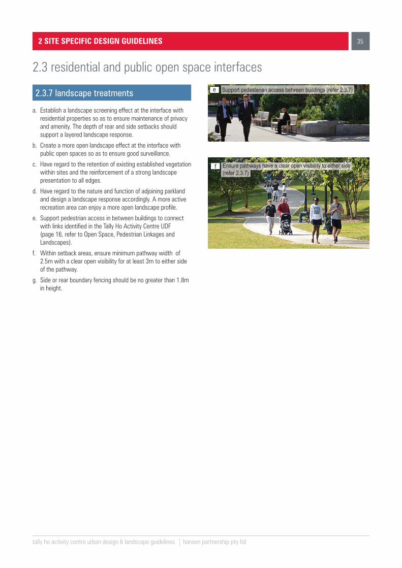
2.3.7 landscape treatments
a. Establish a landscape screening effect at the interface with residential properties so as to ensure maintenance of privacy and amenity. The depth of rear and side setbacks should support a layered landscape response.
b. Create a more open landscape effect at the interface with public open spaces so as to ensure good surveillance.
c. Have regard to the retention of existing established vegetation within sites and the reinforcement of a strong landscape presentation to all edges.
d. Have regard to the nature and function of adjoining parkland and design a landscape response accordingly. A more active recreation area can enjoy a more open landscape profile.
e. Support pedestrian access in between buildings to connect with links identified in the Tally Ho Activity Centre UDF (page 16, refer to Open Space, Pedestrian Linkages and Landscapes).
f. Within setback areas, ensure minimum pathway width of 2.5m with a clear open visibility for at least 3m to either side of the pathway.
g. Side or rear boundary fencing should be no greater than 1.8m in height.
2 SITE SPECIFIC DESIGN GUIDELINES
2.3 residential and public open space interfaces
f
e
Ensure pathways have a clear open visibility to either side (refer 2.3.7)
Support pedesterian access between buildings (refer 2.3.7)

APPENDIX
tally ho activity centre urban design & landscape guidelines | hansen partnership pty ltd
2
existing condition - site analysis
Appendix
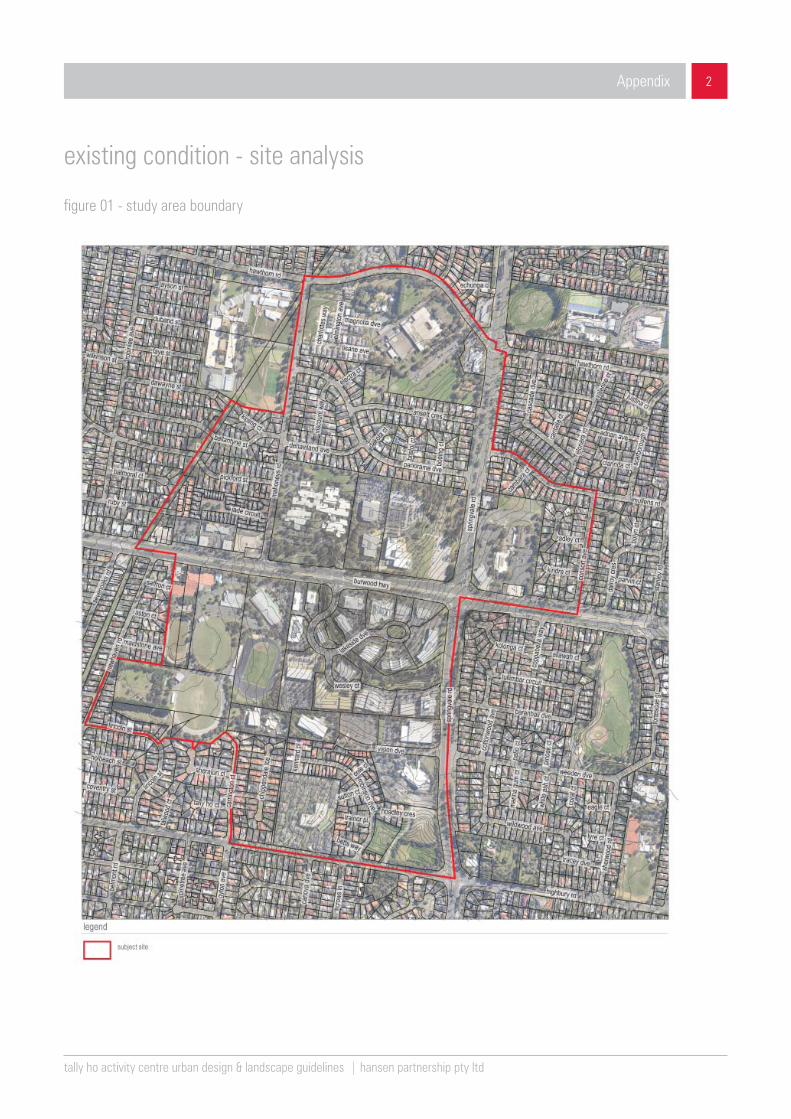
figure 01 - study area boundary
tally ho activity centre urban design & landscape guidelines | hansen partnership pty ltd
3
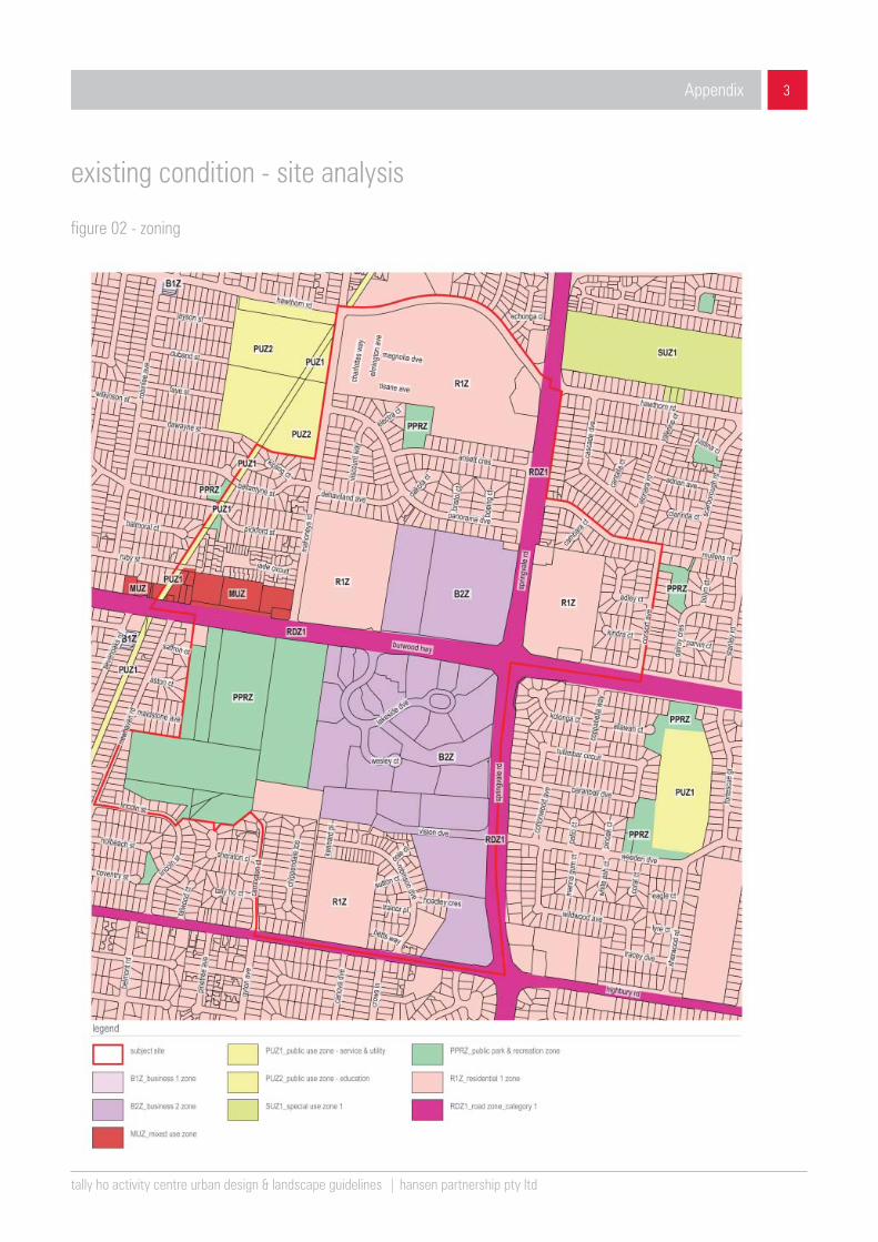
figure 02 - zoning
existing condition - site analysis
Appendix

tally ho activity centre urban design & landscape guidelines | hansen partnership pty ltd
4
existing condition - site analysis
Appendix
figure 03 - land use

tally ho activity centre urban design & landscape guidelines | hansen partnership pty ltd
5
existing condition - site analysis
Appendix
figure 04 - built form
tally ho activity centre urban design & landscape guidelines | hansen partnership pty ltd
6
existing condition - site analysis
Appendix
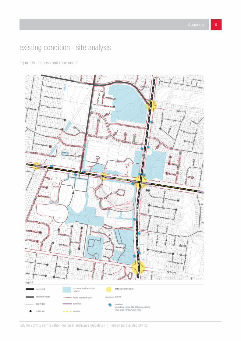
figure 05 - access and movement
tally ho activity centre urban design & landscape guidelines | hansen partnership pty ltd
7
existing condition - site analysis
Appendix
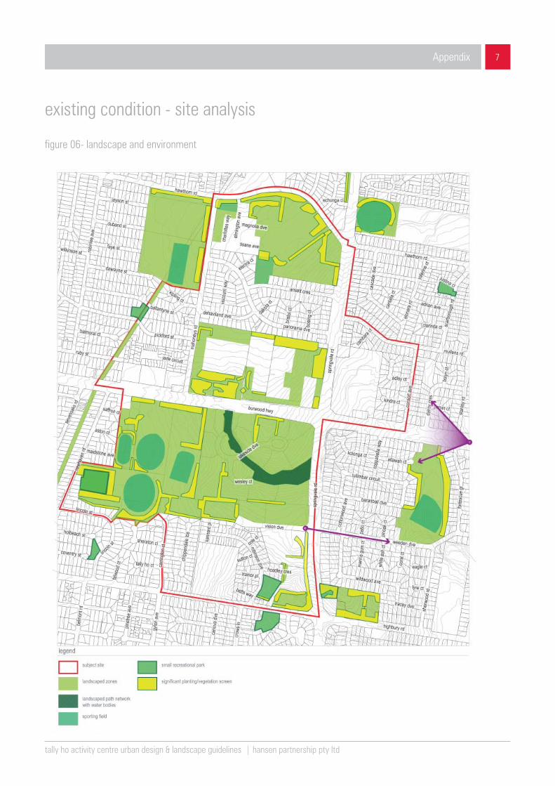
figure 06- landscape and environment