talus preliminary plat parcels 7, 8, 9 staff …...talus preliminary plat parcels 7, 8, 9 staff...
TRANSCRIPT
TALUS PRELIMINARY PLAT PARCELS 7, 8, 9 STAFF REPORT
March 25, 2014
Project: TALUS Preliminary Plat, Parcels 7, 8, 9 (PP14-00001)
Applicant: Al Fure Triad Associates 12112 115th Ave NE Kirkland, WA 98034
Legal Owner: Talus Management Services Parcel 7 & 8 Investment LLC; Parcel 9 Investment, LLC
22430 SE 231st Street Maple Valley, WA 98038
Engineer: Al Fure
Triad Associates 12112 115th Ave NE Kirkland, WA 98034
Staff Contact: Mike Martin, Associate Planner, Development Services Department (425) 837-3103
Dan Ervin, DSD Engineering Consultant (425) 951-5304
Request: Application for approval of a preliminary plat for Parcels 7-9 of TALUS,
establishing 153 lots on 34.75 acres for single family attached and detached homes and 16 tracts for critical areas, trails, utility, access, recreation, and open space.
Location: Property encompassing portions of Section 29, Township 24 North, Range 6 East. The site is generally located in the southwestern corner of TALUS, along the extension of Shangri-La Way.
Talus: Preliminary Plat, Parcels 7-9 (PP14-00001) 3/25/2014
2
X:\Pwd\MDRT\Permit Applications\TALUS\Planning\Pre. Plats\PP14-00001 Talus Parcels 7-9\Staff Report
Existing Land Use: Parcels 7-9 have been cleared but are otherwise undeveloped. Surrounding Land Uses: South: Reservoir, Shangri-La Way, Parcels 10-12, West Fork
Tibbetts Creek North: Undeveloped land within unincorporated King County West: Western project boundary, its buffer, and Cougar Mountain
Regional Wildland Park East: Shangri-La Way, Existing residences (Talus Parcel 6)
Comprehensive Plan Designated "Urban Village"
Recommendation
Based upon the application, submitted plans (received February 19, 2014), listed Attachments, and rationale contained in this Staff Report, the Administration recommends approval of the Preliminary Plat, with conditions. See Page 28 for Draft Motion and proposed conditions.
Summary of Proposed Action
The applicant is requesting preliminary plat approval for 153 single family residential lots on Parcels 7, 8 and 9 of the Talus Urban Village. Development Parcels 7-9 are comprised of two tax parcels – Parcel 6C and Parcel 9. Development Parcels 7-9 are located within the highest elevations of Talus in areas with dramatic and varied topographic relief. Much of the site is encumbered by steep slope critical areas which necessitates constructing a network of retaining walls in order to provide level surfaces for buildings, roads and open spaces. Primary circulation to all three parcels is provided via Shangri-La Way which will be extended from its current terminus near the southwest portion of Parcel 9. Additional roads, all of which are classified as Residential Streets, will provide vehicular access to the individual lots within each parcel. These roads are shown as Drives A, B and C and Road A within the application drawings. Single family detached homes are proposed on fifty-six lots of Parcel 7 and seven lots of Parcel 8. Access to the lots for Parcel 7 will be provided via a loop road (Road A to the east and Drive C to the north and east). Road A and Drive C connect with Shangri-La Way at the south side of Parcel 7. Because of topographic constraints, the road serving Parcel 8 (Drive B) cannot connect elsewhere in the plat. A hammerhead turnaround is proposed for this road near the top to allow emergency access. This road will also provide access to the existing 752’ elevation water reservoirs which are located near the west boundary of the project.
Talus: Preliminary Plat, Parcels 7-9 (PP14-00001) 3/25/2014
3
X:\Pwd\MDRT\Permit Applications\TALUS\Planning\Pre. Plats\PP14-00001 Talus Parcels 7-9\Staff Report
The proposal for Parcel 9 contains 90 single family attached lots which are proposed as zero-lot-line townhomes placed within 19 building groupings, placed around a loop road (Drive A). Drive A has two connections with Shangri-La Way at the south end of the development parcel. An Administrative Minor Modification, AMM14-00004, was approved by the Development Services Department on March XX, 2014 which allowed the raised sidewalk for the loop road to be replaced with a pedestrian circulation facility that is at grade with the road. This will create a road section that functions in a similar manner to a mews. Sixteen tracts (Tracts A-P) are proposed for utilities, open space, access, critical areas and City use (see page 12 for a summary of these tracts). Tracts A, C, D, G, H, J, K, M, N, O and P are primarily for open space and recreational uses. Trail access to the regional Shangri-La Trail is provided via a connection in Tract D. Additional trails are located within Tracts A, C, D, J, K and N. Tracts B, E, F and L are primarily used for access and utilities. Finally, Tract I will be dedicated to the City for uses specified in the First Amendment to the Development Agreement and will be determined at a later date.
Talus: Preliminary Plat, Parcels 7-9 (PP14-00001) 3/25/2014
4
X:\Pwd\MDRT\Permit Applications\TALUS\Planning\Pre. Plats\PP14-00001 Talus Parcels 7-9\Staff Report
Vehicular, utility, and pedestrian access easements are also shown on the plat. Some of easements are necessary for utility or property access are not shown in the plat and will be required by Final Plat. (Condition 1) The total acreage of the plat is 34.75 acres, with residential lot sizes ranging from just under 800 to almost 9,000 square feet.
Background
Talus (formerly East Village) is an Urban Village designated by the City of Issaquah Comprehensive Plan. Talus is governed by the Cougar Mountain East Village Development Agreement, approved on December 6, 1999. Upon entering into the Development Agreement, the City rezoned the site to the Urban Village - East Village (UV) zone pursuant to IMC 18.06.120.
The Talus preliminary master plat was approved by the Issaquah City Council on June 19, 2000. The final master plat was reviewed and approved by the City of Issaquah Hearing Examiner on December 20, 2000, and a written decision from the Examiner was issued on December 28, 2000.
Construction within TALUS overall is predominantly complete, with most of the development parcels being previously constructed. The roadways adjacent to the site are complete and the new roads proposed with this plat will complete the roads west of the Talus Drive/Shangri-La Way intersection as envisioned in the Development Agreement.
There have been some additional permits that affect the area proposed for platting:
A lot line adjustment, (LLA00-001EV) adjusted the boundaries throughout the original property. All of Parcels 7-9 appear to be within Lots 1 and 3 of this LLA.
A final master plat, (FP00-001EV) created the first development parcels within Talus. Parcel 9 was created with this plat; however, Parcels 7 and 8 were not included.
A short plat, (SP02-001EV) created Parcel 6C which encompasses Parcels 7 and 8 of this Preliminary Plat application.
A final plat, (FP04-002EV) subdivided a portion or Parcel 6C into 72 lots. This development is known as Parcel 6B.
A lot line adjustment, (LLA06-003EV) adjusted the boundary of Parcel 9 and Tract B in order to accommodate the 616’ zone reservoir.
A lot line adjustment, (LLA14-00001) adjusted the northern boundary of Parcel 9 in order to accommodate the lots within this plat.
Public Notice
A Notice of Application was distributed on March 5, 2014. A sign was posted on the property on March 7, 2014. Notice of the UVDC public meeting and hearing was mailed to residents within 300’ of the property on March 13, 2014. Notice of the UVDC public meeting appeared in the March 19, 2014 edition of the Issaquah Press.
Talus: Preliminary Plat, Parcels 7-9 (PP14-00001) 3/25/2014
5
X:\Pwd\MDRT\Permit Applications\TALUS\Planning\Pre. Plats\PP14-00001 Talus Parcels 7-9\Staff Report
Notice of the UVDC public hearing will appear in the March 26, 2014 edition of the Issaquah Press. All noticing has been provided in accordance with the requirements of Appendix J (Processing).
Two public comments were received. See Page 27 of this report for a summary and response to these comments.
Basis for Review and Approval
RCW
According to State law, to be approved, the proposed plat must comply with the requirements of IMC Chapter 18.13 (Subdivisions), and make appropriate provisions, as specified in RCW 58.17, that the public interest will be served by the subdivision and dedication; and that provisions have been made for, but not limited to, the public health, safety, and general welfare; for open spaces, drainage ways, streets or roads, alleys, other public ways, transit stops, potable water supplies, sanitary wastes, parks and recreation, playgrounds, schools and school grounds; and shall consider all other relevant facts, including sidewalks and other planning features that assure safe walking conditions for students who only walk to and from school.
TALUS Development Agreement
In addition, the review of the proposed preliminary plat is based on its consistency with the Development Agreement (DA) and, where appropriate, City Code and the Comprehensive Plan. The DA contains a variety of development goals and standards that are organized into individual appendices. Each appendix provides direction to the applicant generally in the form of guidelines and/or development standards for a particular aspect of the project. Together, the development standards contained in the DA are intended to implement the urban village concept for TALUS, as envisioned in the Comprehensive Plan, while accommodating and integrating development with the site's unique environmental features and development opportunities.
Not all of the appendices or standards contained in the DA are directly applicable to the preliminary plat, since the plat deals only with the layout of lots, tracts, easements, and streets. Building design standards as applicable, for example, would likely not come into play until individual building permits are under review by the Architectural Review Committee (ARC). Only those goals and standards that apply to the preliminary plat application are discussed in this report.
The following staff review is organized by applicable appendix subject headings as they appear in the DA.
Talus: Preliminary Plat, Parcels 7-9 (PP14-00001) 3/25/2014
6
X:\Pwd\MDRT\Permit Applications\TALUS\Planning\Pre. Plats\PP14-00001 Talus Parcels 7-9\Staff Report
Review
MAIN BODY OF DEVELOPMENT AGREEMENT The Main Body of the Development Agreement establishes the framework for satisfying the requirements of the Development Agreement, as established by Section 18.06.120.B of the Issaquah Municipal Code. It also contains the base information for the overall allowable development (i.e. land allocation, number of residential units, amount of commercial, required mitigation, etc.). The following discusses a few specific elements of the Main Body that are relevant to this plat:
Section 5.3.2: the proposed plat maintains the Westerly Buffer between development and Cougar Mountain Regional Wildland Park per AMM14-012EV (Condition 2)
Section 5.3.3: the proposed plat maintains connections to existing trails. Specifically the plat has a connection to the Shangri-La Trail in Tract D.
FINDING: This proposed preliminary plat is consistent with the Main Body of the Development Agreement.
APPENDICIES A AND B: PLANNING GOALS AND URBAN DESIGN GUIDELINES
The Planning Goals and Urban Design Guidelines comprise a key part of defining the vision for Talus. The design guidelines serve the overall purpose of creating a framework by ensuring the buildings, the landscape, the circulation system, the social gathering places, and the limited use of open spaces and private parks relate to one another in a way that achieves the Talus vision as described in both this Appendix and Appendix A – Planning Goals. However, since this is a plat, it is the circulation network, open space, and parcels that must implement the guidelines in review of this plat. Subsequent permits, e.g. ASDP for the open spaces, will also use the guidelines for review.
Vehicle Circulation
Traffic flow within Talus is only one of the considerations of street design. The circulation system also connects Development Parcels, promotes walking and bicycling, and contributes to the visual character of the community. Streets should be designed so that they provide comfortable, safe and interesting space for vehicles, pedestrians and bicyclists. Guidelines for road types and road patterns and pedestrian circulation are discussed in this chapter. Specific standards for road and sidewalk designs are contained in Appendix F – Public and Private Street Standards.
In general, the layout of the streets and trails is consistent with the guidelines in that circulation facilities are comprehensible, pedestrian oriented and they do not support high vehicular speeds. The proposed circulation network has been designed to respond to the steep terrain of these parcels while looking for opportunities to provide vehicular and/or pedestrian connectivity.
Many of the roads within the plat are steep (in excess of 12 percent grade). Dead-ends have been generally avoided, except at the project edges, and Road A can be extended if the area to the north is annexed to the City. The curves in the street layout as well as the narrow streets
Talus: Preliminary Plat, Parcels 7-9 (PP14-00001) 3/25/2014
7
X:\Pwd\MDRT\Permit Applications\TALUS\Planning\Pre. Plats\PP14-00001 Talus Parcels 7-9\Staff Report
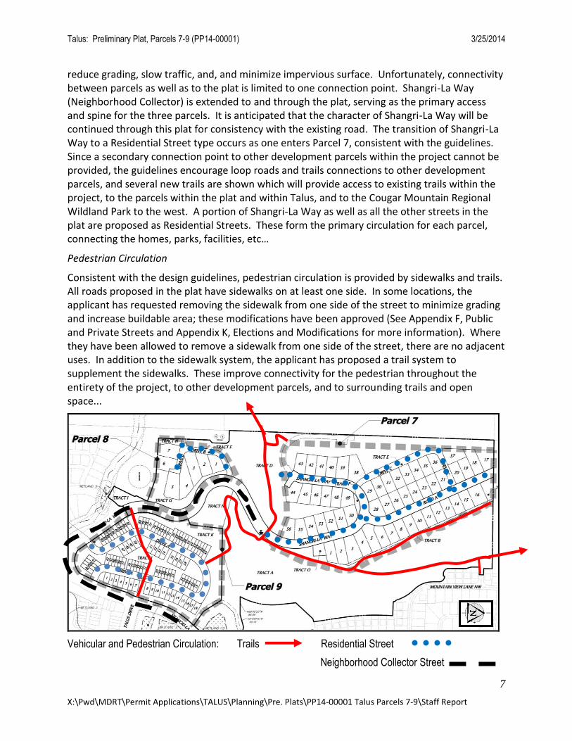
reduce grading, slow traffic, and, and minimize impervious surface. Unfortunately, connectivity between parcels as well as to the plat is limited to one connection point. Shangri-La Way (Neighborhood Collector) is extended to and through the plat, serving as the primary access and spine for the three parcels. It is anticipated that the character of Shangri-La Way will be continued through this plat for consistency with the existing road. The transition of Shangri-La Way to a Residential Street type occurs as one enters Parcel 7, consistent with the guidelines. Since a secondary connection point to other development parcels within the project cannot be provided, the guidelines encourage loop roads and trails connections to other development parcels, and several new trails are shown which will provide access to existing trails within the project, to the parcels within the plat and within Talus, and to the Cougar Mountain Regional Wildland Park to the west. A portion of Shangri-La Way as well as all the other streets in the plat are proposed as Residential Streets. These form the primary circulation for each parcel, connecting the homes, parks, facilities, etc…
Pedestrian Circulation
Consistent with the design guidelines, pedestrian circulation is provided by sidewalks and trails. All roads proposed in the plat have sidewalks on at least one side. In some locations, the applicant has requested removing the sidewalk from one side of the street to minimize grading and increase buildable area; these modifications have been approved (See Appendix F, Public and Private Streets and Appendix K, Elections and Modifications for more information). Where they have been allowed to remove a sidewalk from one side of the street, there are no adjacent uses. In addition to the sidewalk system, the applicant has proposed a trail system to supplement the sidewalks. These improve connectivity for the pedestrian throughout the entirety of the project, to other development parcels, and to surrounding trails and open space...
Vehicular and Pedestrian Circulation: Trails Residential Street
Neighborhood Collector Street
Talus: Preliminary Plat, Parcels 7-9 (PP14-00001) 3/25/2014
8
X:\Pwd\MDRT\Permit Applications\TALUS\Planning\Pre. Plats\PP14-00001 Talus Parcels 7-9\Staff Report
Distances between points
Parking
As single family residential (both attached and detached), parking will be provided in garages associated with each unit or home. This is the minimum required by code. In addition, on street parking is provided in each of the parcels. No surface parking is provided, though Parcel 9 relies on head in parking, tucked around the project, to ensure there is additional guest stalls. This is consistent with the parking priorities and guidelines in this appendix. Also there is a guideline regarding siting garage entries away from the front of buildings. Due to topography this isn’t possible, but the design of the buildings will need to minimize the presence of the garages through overhangs, placement of uses, design of the drive/sidewalk, placement of the front door, etc… This will be reviewed with building permits.
Residential Neighborhoods
The design of residential neighborhoods is particularly important in establishing the character of Talus because of their dominance throughout the community. A range of housing types is envisioned with higher density neighborhoods located near the Village Center and lesser density neighborhoods located toward the northern areas of the project. Parcels 7-9 contain two neighborhood density types – Low Density (Parcels 7 and 8) and Medium Density (Parcel 9).
Neighborhood design characteristics are to a large part defined through community design motifs and building architecture. Those aspects of community design are outside of the scope of a preliminary plat application; however, other features, mainly lot placement are an important function of a communities form and feel. That said, some of the lots are shaped in a way that will be challenging for the homes to have a strong relationship to the street as
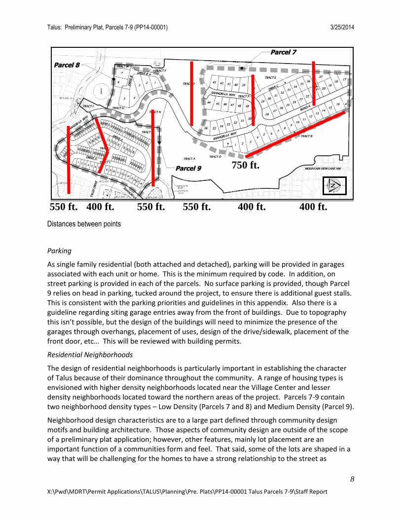
400 ft. 550 ft. 550 ft. 400 ft. 400 ft. 550 ft.
750 ft.
Talus: Preliminary Plat, Parcels 7-9 (PP14-00001) 3/25/2014
9
X:\Pwd\MDRT\Permit Applications\TALUS\Planning\Pre. Plats\PP14-00001 Talus Parcels 7-9\Staff Report
Guideline #1 under Architectural and Site Design anticipates. During review of the final plat and/or building permit, pie shaped lots or those that are quite narrow shall be adjusted, e.g. Lot #4 Parcel 8 and Lot #6 Parcel 7. (Condition 3) In general, the project anticipates that homes will be sited and designed to minimize impact on the views from surrounding areas. Given the wall heights and grades, many of these homes will be highly visible. There are tools in the guidelines to lessen the impact such as building colors, detailing, fence types, etc… (Condition 4).
Parcels 7 and 8 are classified as Low Density Residential Neighborhoods. The placement of lots is appropriate and lots are adequately sized in order to provide space for yards and building setbacks; however, the low density neighborhoods rely on variety in lot sizes to create diversity and interest. Parcel 8’s lots have diversity in size and shape; however, Parcel 7’s lots are very consistent, primarily along Road A and Drive C. During the final plat review, these lots should have more variety in lot widths or other methods acceptable to the Designated Official to add diversity and interest. (Condition 5) Also the backyards of homes should not face the street. Though there is an open space tract between Parcel 8’s lots and Shangri-La Way, near the intersection of the spine road and Drive B, the rear lots may become more prominent. These lots views should be preserved through careful placement of trees which frame views and yet create a fairly heavy landscape adjacent to Shangri-La Way. (Condition 6) The above Condition #4 will also assist in lessening the impact of the homes.
Parcel 9 is a Medium Density Residential Neighborhood. These neighborhoods are designed to promote shared spaces, such as the proposed trails and overlooks, and a strong edge to the street. While the proposed lots will create an intimate public space and strong streetwall within the parcel, the buildings do not relate to Shangri-La Way. In fact, near Talus Drive, the walls holding up the homes range from 4 to 20 feet in height. Along the new portion of Shangri-La Way west of Parcel 9, the homes are 10-40 feet below Shangri-La Way. Only the homes on Lots 46 and 81-90 will have a relationship with Shangri-La Way. This really identifies one of the most challenging characteristics of this parcel: between the intersection of Talus Dr. and Shangri-La Way and the western edge of the Parcel, there is 120+ feet of grade change. In other aspects of this proposal, the design is more compliant: the units are ground-related, minimal setbacks from the street and each unit, and the units are single-family attached. Walls
Site walls are an integral part of the design of a Mountain Village community. In the more mountainous parcels, homes nestle into hillsides and step up the topography, necessitating retaining walls to accommodate grade changes (see Sheets 6-8 of the submittal). To summarize the guidelines: • Multiple, terraced low retaining walls should be used, and the proposed plat utilizes terraced walls in some areas such as the west side of Parcels 7 and 9. • Low (4-10 ft), single walls are proposed in other areas such as the middle of Parcel 9 as well as the southern edge of the parcel, along Shangri-La Way; the southern edge of Parcel 8; and in the middle of Parcel 7.
Talus: Preliminary Plat, Parcels 7-9 (PP14-00001) 3/25/2014
10
X:\Pwd\MDRT\Permit Applications\TALUS\Planning\Pre. Plats\PP14-00001 Talus Parcels 7-9\Staff Report
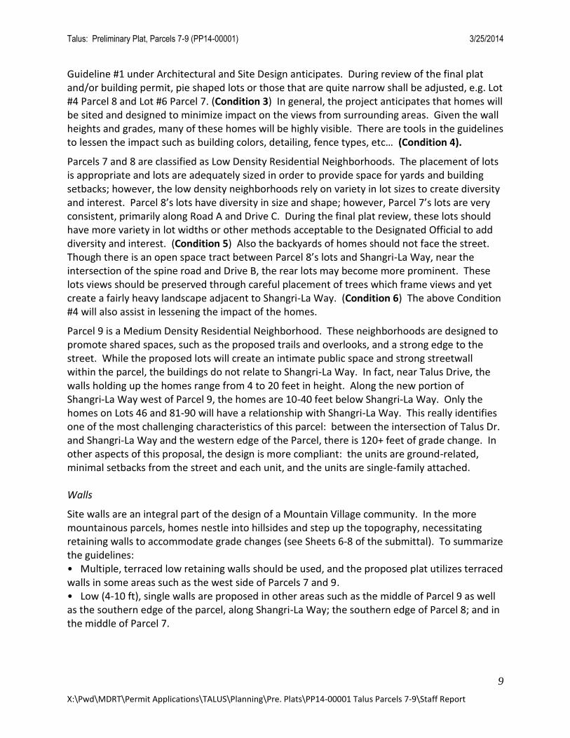
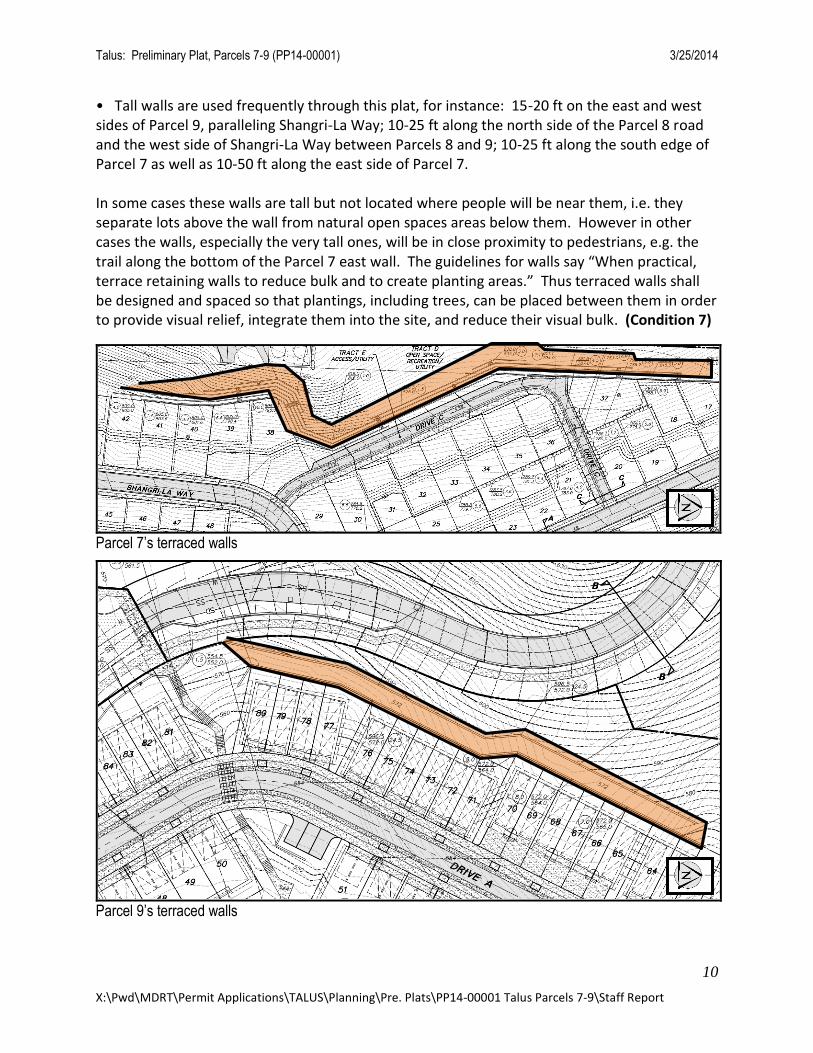
• Tall walls are used frequently through this plat, for instance: 15-20 ft on the east and west sides of Parcel 9, paralleling Shangri-La Way; 10-25 ft along the north side of the Parcel 8 road and the west side of Shangri-La Way between Parcels 8 and 9; 10-25 ft along the south edge of Parcel 7 as well as 10-50 ft along the east side of Parcel 7. In some cases these walls are tall but not located where people will be near them, i.e. they separate lots above the wall from natural open spaces areas below them. However in other cases the walls, especially the very tall ones, will be in close proximity to pedestrians, e.g. the trail along the bottom of the Parcel 7 east wall. The guidelines for walls say “When practical, terrace retaining walls to reduce bulk and to create planting areas.” Thus terraced walls shall be designed and spaced so that plantings, including trees, can be placed between them in order to provide visual relief, integrate them into the site, and reduce their visual bulk. (Condition 7)
Parcel 7’s terraced walls
Parcel 9’s terraced walls
Talus: Preliminary Plat, Parcels 7-9 (PP14-00001) 3/25/2014
11
X:\Pwd\MDRT\Permit Applications\TALUS\Planning\Pre. Plats\PP14-00001 Talus Parcels 7-9\Staff Report
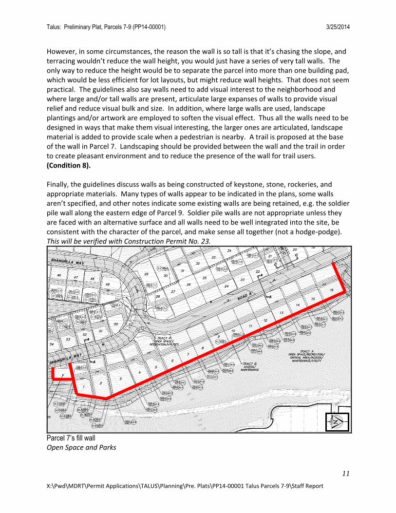
However, in some circumstances, the reason the wall is so tall is that it’s chasing the slope, and terracing wouldn’t reduce the wall height, you would just have a series of very tall walls. The only way to reduce the height would be to separate the parcel into more than one building pad, which would be less efficient for lot layouts, but might reduce wall heights. That does not seem practical. The guidelines also say walls need to add visual interest to the neighborhood and where large and/or tall walls are present, articulate large expanses of walls to provide visual relief and reduce visual bulk and size. In addition, where large walls are used, landscape plantings and/or artwork are employed to soften the visual effect. Thus all the walls need to be designed in ways that make them visual interesting, the larger ones are articulated, landscape material is added to provide scale when a pedestrian is nearby. A trail is proposed at the base of the wall in Parcel 7. Landscaping should be provided between the wall and the trail in order to create pleasant environment and to reduce the presence of the wall for trail users. (Condition 8). Finally, the guidelines discuss walls as being constructed of keystone, stone, rockeries, and appropriate materials. Many types of walls appear to be indicated in the plans, some walls aren’t specified, and other notes indicate some existing walls are being retained, e.g. the soldier pile wall along the eastern edge of Parcel 9. Soldier pile walls are not appropriate unless they are faced with an alternative surface and all walls need to be well integrated into the site, be consistent with the character of the parcel, and make sense all together (not a hodge-podge). This will be verified with Construction Permit No. 23.
Parcel 7’s fill wall Open Space and Parks
Talus: Preliminary Plat, Parcels 7-9 (PP14-00001) 3/25/2014
12
X:\Pwd\MDRT\Permit Applications\TALUS\Planning\Pre. Plats\PP14-00001 Talus Parcels 7-9\Staff Report
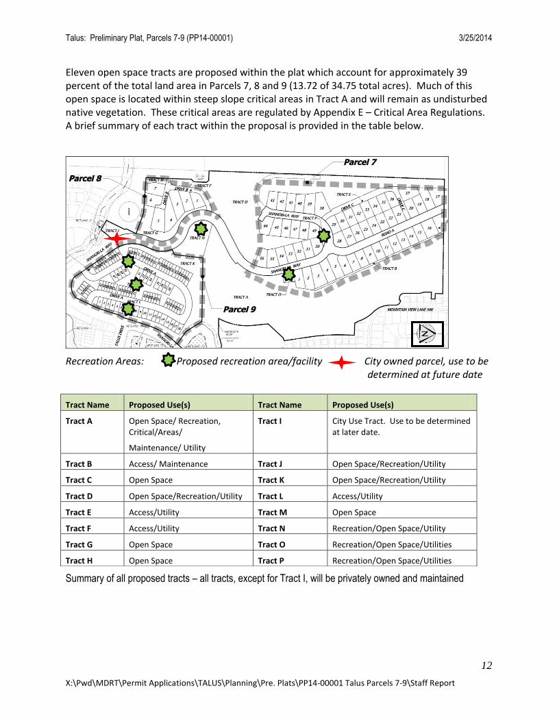
Eleven open space tracts are proposed within the plat which account for approximately 39 percent of the total land area in Parcels 7, 8 and 9 (13.72 of 34.75 total acres). Much of this open space is located within steep slope critical areas in Tract A and will remain as undisturbed native vegetation. These critical areas are regulated by Appendix E – Critical Area Regulations. A brief summary of each tract within the proposal is provided in the table below.
Recreation Areas: Proposed recreation area/facility City owned parcel, use to be b determined at future date
Summary of all proposed tracts – all tracts, except for Tract I, will be privately owned and maintained
Tract Name Proposed Use(s) Tract Name Proposed Use(s)
Tract A
Open Space/ Recreation, Critical/Areas/
Maintenance/ Utility
Tract I City Use Tract. Use to be determined at later date.
Tract B Access/ Maintenance Tract J Open Space/Recreation/Utility
Tract C Open Space Tract K Open Space/Recreation/Utility
Tract D Open Space/Recreation/Utility Tract L Access/Utility
Tract E Access/Utility Tract M Open Space
Tract F Access/Utility Tract N Recreation/Open Space/Utility
Tract G Open Space Tract O Recreation/Open Space/Utilities
Tract H Open Space Tract P Recreation/Open Space/Utilities
Talus: Preliminary Plat, Parcels 7-9 (PP14-00001) 3/25/2014
13
X:\Pwd\MDRT\Permit Applications\TALUS\Planning\Pre. Plats\PP14-00001 Talus Parcels 7-9\Staff Report
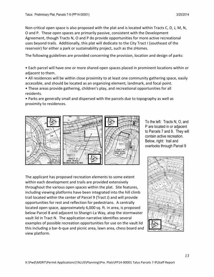
Non-critical open space is also proposed with the plat and is located within Tracts C, D, J, M, N, O and P. These open spaces are primarily passive, consistent with the Development Agreement, though Tracts N, O and P do provide opportunities for more active recreational uses beyond trails. Additionally, this plat will dedicate to the City Tract I (southeast of the reservoir) for either a park or sustainability project, such as the zHomes.
The following guidelines are provided concerning the provision, location and design of parks:
• Each parcel will have one or more shared open spaces placed in prominent locations within or adjacent to them. • All residences will be within close proximity to at least one community gathering space, easily accessible, and should be located as an organizing element, landmark, and focal point. • These areas provide gathering, children’s play, and recreational opportunities for all residents. • Parks are generally small and dispersed with the parcels due to topography as well as proximity to residences.
The applicant has proposed recreation elements to some extent within each development and trails are provided extensively throughout the various open spaces within the plat. Site features, including viewing platforms have been integrated into the hill climb trail located within the center of Parcel 9 (Tract J) and will provide opportunities for rest and reflection for pedestrians. A centrally located open space, approximately 6,000 sq. ft. in area, is proposed below Parcel 8 and adjacent to Shangri-La Way, atop the stormwater vault lid in Tract N. The application narrative identifies several examples of possible recreation opportunities for use on the vault lid this including a bar-b-que and picnic area, lawn area, chess board and view platform.
To the left: Tracts N, O, and P are located in or adjacent to Parcels 7 and 8. They will contain active recreation. Below, right: trail and
overlooks through Parcel 9
Talus: Preliminary Plat, Parcels 7-9 (PP14-00001) 3/25/2014
14
X:\Pwd\MDRT\Permit Applications\TALUS\Planning\Pre. Plats\PP14-00001 Talus Parcels 7-9\Staff Report
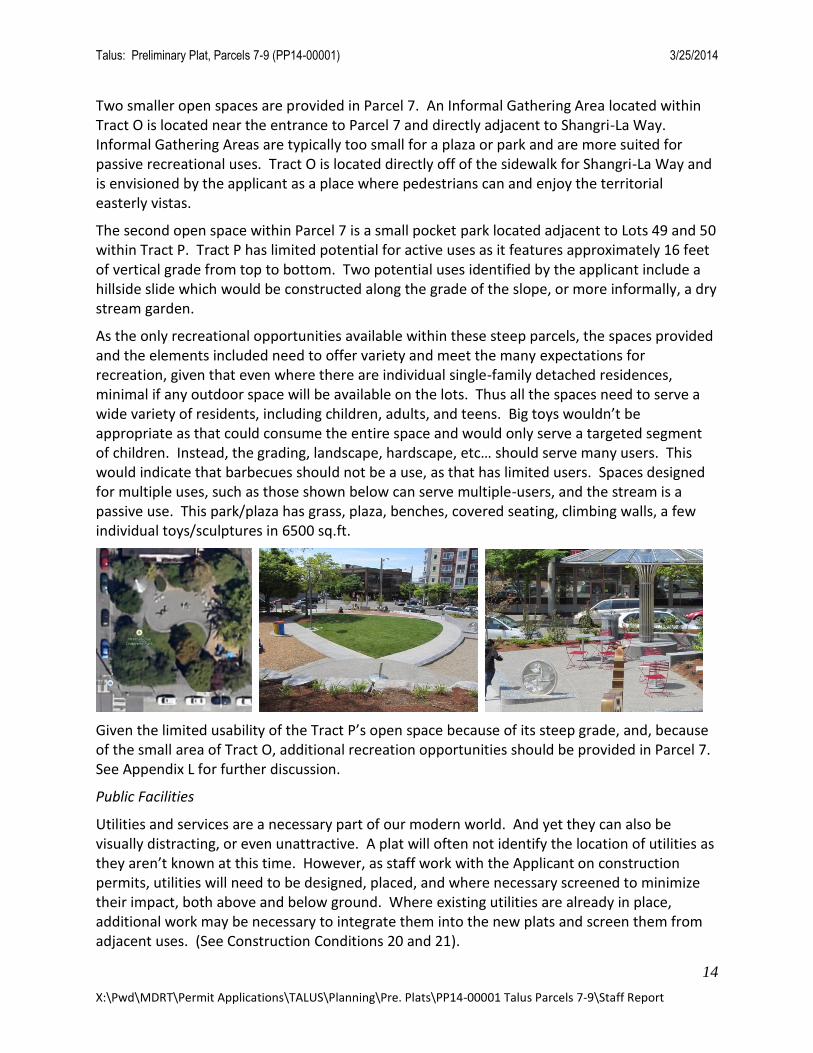
Two smaller open spaces are provided in Parcel 7. An Informal Gathering Area located within Tract O is located near the entrance to Parcel 7 and directly adjacent to Shangri-La Way. Informal Gathering Areas are typically too small for a plaza or park and are more suited for passive recreational uses. Tract O is located directly off of the sidewalk for Shangri-La Way and is envisioned by the applicant as a place where pedestrians can and enjoy the territorial easterly vistas.
The second open space within Parcel 7 is a small pocket park located adjacent to Lots 49 and 50 within Tract P. Tract P has limited potential for active uses as it features approximately 16 feet of vertical grade from top to bottom. Two potential uses identified by the applicant include a hillside slide which would be constructed along the grade of the slope, or more informally, a dry stream garden.
As the only recreational opportunities available within these steep parcels, the spaces provided and the elements included need to offer variety and meet the many expectations for recreation, given that even where there are individual single-family detached residences, minimal if any outdoor space will be available on the lots. Thus all the spaces need to serve a wide variety of residents, including children, adults, and teens. Big toys wouldn’t be appropriate as that could consume the entire space and would only serve a targeted segment of children. Instead, the grading, landscape, hardscape, etc… should serve many users. This would indicate that barbecues should not be a use, as that has limited users. Spaces designed for multiple uses, such as those shown below can serve multiple-users, and the stream is a passive use. This park/plaza has grass, plaza, benches, covered seating, climbing walls, a few individual toys/sculptures in 6500 sq.ft.
Given the limited usability of the Tract P’s open space because of its steep grade, and, because of the small area of Tract O, additional recreation opportunities should be provided in Parcel 7. See Appendix L for further discussion.
Public Facilities
Utilities and services are a necessary part of our modern world. And yet they can also be visually distracting, or even unattractive. A plat will often not identify the location of utilities as they aren’t known at this time. However, as staff work with the Applicant on construction permits, utilities will need to be designed, placed, and where necessary screened to minimize their impact, both above and below ground. Where existing utilities are already in place, additional work may be necessary to integrate them into the new plats and screen them from adjacent uses. (See Construction Conditions 20 and 21).
Talus: Preliminary Plat, Parcels 7-9 (PP14-00001) 3/25/2014
15
X:\Pwd\MDRT\Permit Applications\TALUS\Planning\Pre. Plats\PP14-00001 Talus Parcels 7-9\Staff Report
FINDING: The proposed preliminary plat is consistent with the Planning Goals, Objectives, and Design Guidelines, as identified in Appendices A and B of the Development Agreement, and the City of Issaquah Comprehensive Plan, provided the recommended conditions are met.
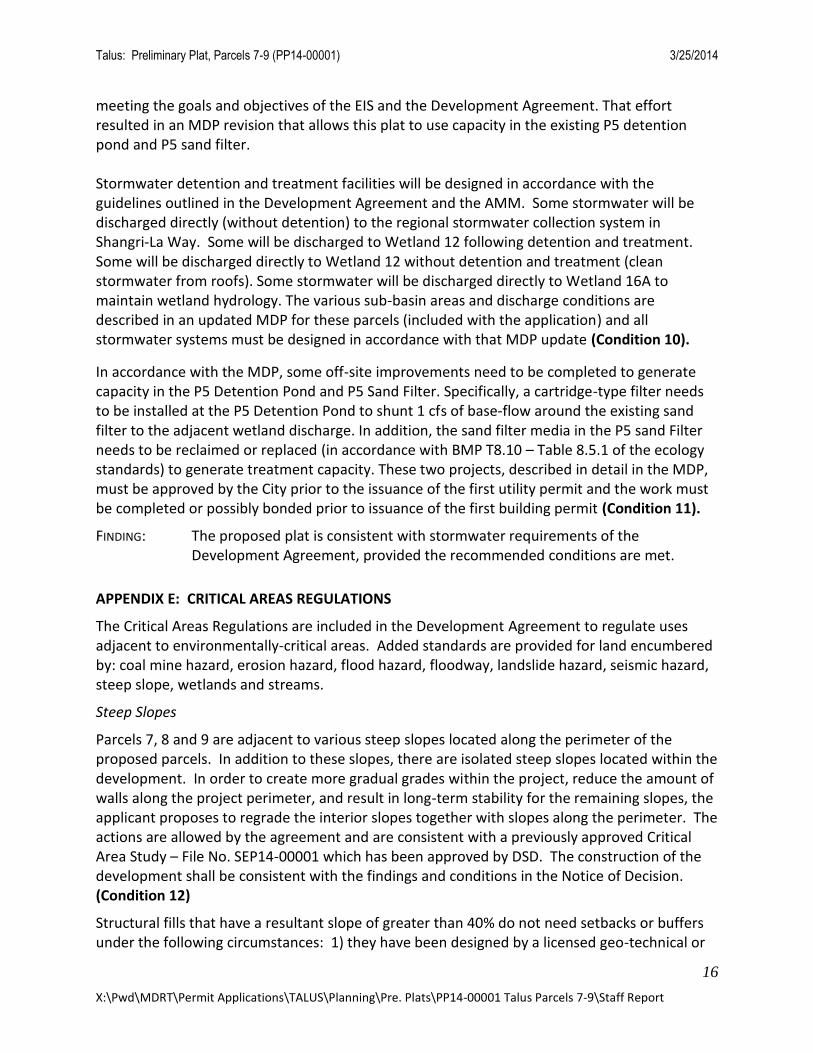
APPENDIX C: LAND USE AND DENSITIES
Appendix C establishes the land uses and densities for the development of this site. Each respective development parcel is assigned with a different Density Range per Exhibit C-1 (Talus Land Use Categories) of Appendix C as follows:
The proposed densities for Parcels 8 and 9 are less than those identified within Appendix C and the applicant has requested an Authorized Election to shift down one density category. This election is specifically allowed by Appendix K – Elections and Modifications; Section 1.1.10. Prior to approval of any permit other than this application, the applicant must receive Master Developer approval for this election and City confirmation. (Condition 9)
FINDING: The proposed land uses, their locations, and densities are consistent with the development standards permitted by the Development Agreement, provided the recommended condition is met.
APPENDIX D: SURFACE WATER MANAGEMENT STANDARDS Appendix D (and a subsequent Administrative Minor Modification, AMM (AM04-022EV)) specifies the required surface water management standards. These standards regulate stormwater collection, conveyance, detention, and treatment.
Detention for these parcels was originally planned to be on-site within the plat boundaries. This would require the construction of detention facilities (most likely vaults) and sand filters for treatment.
Since the adoption of the original Master Drainage Plan (MDP), however, it has become clear that a distributed network of sand filters throughout the various plats in Talus will be less predictable to operate and maintain. As a result, the City asked the Developer to revise the MDP in order to minimize the number of privately owned and maintained facilities while still
Appendix C Density Category
Proposed Density Category and Density
Total Acreage Proposed with Development Agreement
Total Acreage After Modification
Parcel 7 Low (3-12 du/ac)
Low (4.9 du/ac)
8.83 acres 11.43 acres
Parcel 8 Medium (13-22 du/ac)
Low (3.15 du/ac)
3.75 acres 2.22 acres
Parcel 9 High (23-150 du/ac)
Medium (15.2 du/ac)
3.57 acres 5.94 acres
TOTAL 16.15 acres 19.59 acres
Talus: Preliminary Plat, Parcels 7-9 (PP14-00001) 3/25/2014
16
X:\Pwd\MDRT\Permit Applications\TALUS\Planning\Pre. Plats\PP14-00001 Talus Parcels 7-9\Staff Report
meeting the goals and objectives of the EIS and the Development Agreement. That effort resulted in an MDP revision that allows this plat to use capacity in the existing P5 detention pond and P5 sand filter. Stormwater detention and treatment facilities will be designed in accordance with the guidelines outlined in the Development Agreement and the AMM. Some stormwater will be discharged directly (without detention) to the regional stormwater collection system in Shangri-La Way. Some will be discharged to Wetland 12 following detention and treatment. Some will be discharged directly to Wetland 12 without detention and treatment (clean stormwater from roofs). Some stormwater will be discharged directly to Wetland 16A to maintain wetland hydrology. The various sub-basin areas and discharge conditions are described in an updated MDP for these parcels (included with the application) and all stormwater systems must be designed in accordance with that MDP update (Condition 10).
In accordance with the MDP, some off-site improvements need to be completed to generate capacity in the P5 Detention Pond and P5 Sand Filter. Specifically, a cartridge-type filter needs to be installed at the P5 Detention Pond to shunt 1 cfs of base-flow around the existing sand filter to the adjacent wetland discharge. In addition, the sand filter media in the P5 sand Filter needs to be reclaimed or replaced (in accordance with BMP T8.10 – Table 8.5.1 of the ecology standards) to generate treatment capacity. These two projects, described in detail in the MDP, must be approved by the City prior to the issuance of the first utility permit and the work must be completed or possibly bonded prior to issuance of the first building permit (Condition 11).
FINDING: The proposed plat is consistent with stormwater requirements of the Development Agreement, provided the recommended conditions are met.
APPENDIX E: CRITICAL AREAS REGULATIONS
The Critical Areas Regulations are included in the Development Agreement to regulate uses adjacent to environmentally-critical areas. Added standards are provided for land encumbered by: coal mine hazard, erosion hazard, flood hazard, floodway, landslide hazard, seismic hazard, steep slope, wetlands and streams.
Steep Slopes
Parcels 7, 8 and 9 are adjacent to various steep slopes located along the perimeter of the proposed parcels. In addition to these slopes, there are isolated steep slopes located within the development. In order to create more gradual grades within the project, reduce the amount of walls along the project perimeter, and result in long-term stability for the remaining slopes, the applicant proposes to regrade the interior slopes together with slopes along the perimeter. The actions are allowed by the agreement and are consistent with a previously approved Critical Area Study – File No. SEP14-00001 which has been approved by DSD. The construction of the development shall be consistent with the findings and conditions in the Notice of Decision. (Condition 12)
Structural fills that have a resultant slope of greater than 40% do not need setbacks or buffers under the following circumstances: 1) they have been designed by a licensed geo-technical or
Talus: Preliminary Plat, Parcels 7-9 (PP14-00001) 3/25/2014
17
X:\Pwd\MDRT\Permit Applications\TALUS\Planning\Pre. Plats\PP14-00001 Talus Parcels 7-9\Staff Report
structural engineer and 2) construction was performed under the guidance of a licensed structural or geo-technical engineer, and 3) the as-built plans are certified by a licensed structural or geo-technical engineer. Otherwise, these areas will be treated as steep slopes under Appendix E. (Condition 13)
Several walls are proposed in the project to mitigate the regrading proposed in the Critical Area Report. A proposed wall on the western project boundary will intrude into a 50’ vegetation buffer, which is an allowed activity as long as the re-graded area can be vegetated to match predevelopment conditions. (Condition 14)
At Final Plat, the BSBL for critical areas shall be shown on all lots on which critical areas are located adjacent. (Condition 15)
FINDING: The proposed plat is consistent with Critical Areas Standards, provided the
recommended conditions are met.
APPENDIX F: PUBLIC AND PRIVATE STREET STANDARDS
The purpose of this appendix is to ensure that pedestrians, bicyclists, and vehicles can safely move through the community on its roads while at the same time recognizing that the roads are a primary component of the TALUS character. Additionally, the Public and Private Street Standards should: limit impervious surfaces, ensure consistency and standardization of public and private streets, establish a Mountain Village streetscape, and protect the health, safety and general welfare of the public.
Parcels 7-9 will be primarily served via an extension of Shangri-La Way NW. Several additional roads and drives are also proposed within the residential areas of each parcel and will provide localized pedestrian and vehicular access to the lots. Only Shangri-La Way and Road A will be right-of-way and the other drives within the project will be privately owned and maintained. Access easements shall be granted to the City with the final plat to permit public access onto the roads and sidewalks that are located within privately owned tracts. (Condition 16) The following is a summary of the new roads that are proposed with this preliminary plat application:
Shangri-La Way NW (extension): The extension to Shangri-La Way NW will begin at the intersection with NW Stoney Creek Drive adjacent to Parcel 9’s west boundary and is comprised of two sections. Shangri-La Way is proposed as Right-of-Way. The first section of road is classified in the Development Agreement as a Neighborhood Collector and is comprised of two travel lanes, on-street parking, sidewalks and planter strips. On-street parking and sidewalk sections were removed for a majority of the west side of the road per AMM14-00001 in order to reduce the amount of grading necessary to construct the road and since no access is possible due to adjacent grades.
The second section of road transitions into a Residential Street at the entrance into Parcel 7 (approximately 80 south of Lot 56) and continues on to provide access to the Parcel’s southwestern lots.
Talus: Preliminary Plat, Parcels 7-9 (PP14-00001) 3/25/2014
18
X:\Pwd\MDRT\Permit Applications\TALUS\Planning\Pre. Plats\PP14-00001 Talus Parcels 7-9\Staff Report
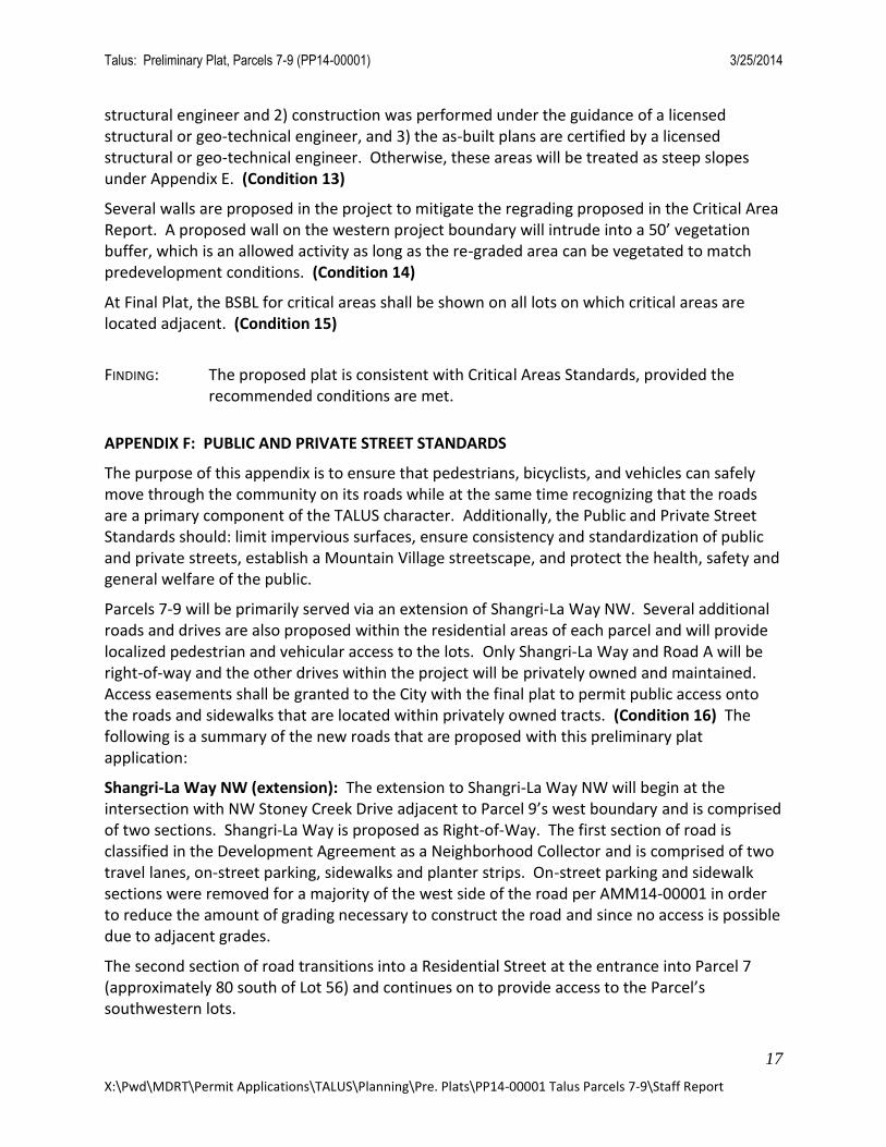
Road A: Road A, serving Parcel 7 is designed as a standard Residential Street. Road A will provide access to the Parcel 7’s northern lots. The Right-of-Way will extend to the northern boundary of the plat in order to provide a future connection to the parcels located within King County to the north.
Road A and Drive C: Parcel 7 – Residential Streets
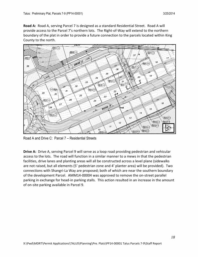
Drive A: Drive A, serving Parcel 9 will serve as a loop road providing pedestrian and vehicular access to the lots. The road will function in a similar manner to a mews in that the pedestrian facilities, drive lanes and planting areas will all be constructed across a level plane (sidewalks are not raised, but all elements (5’ pedestrian zone and 4’ planter area) will be provided). Two connections with Shangri-La Way are proposed; both of which are near the southern boundary of the development Parcel. AMM14-00004 was approved to remove the on-street parallel parking in exchange for head-in parking stalls. This action resulted in an increase in the amount of on-site parking available in Parcel 9.
Talus: Preliminary Plat, Parcels 7-9 (PP14-00001) 3/25/2014
19
X:\Pwd\MDRT\Permit Applications\TALUS\Planning\Pre. Plats\PP14-00001 Talus Parcels 7-9\Staff Report
Drive A: Parcel 9 – Residential Street
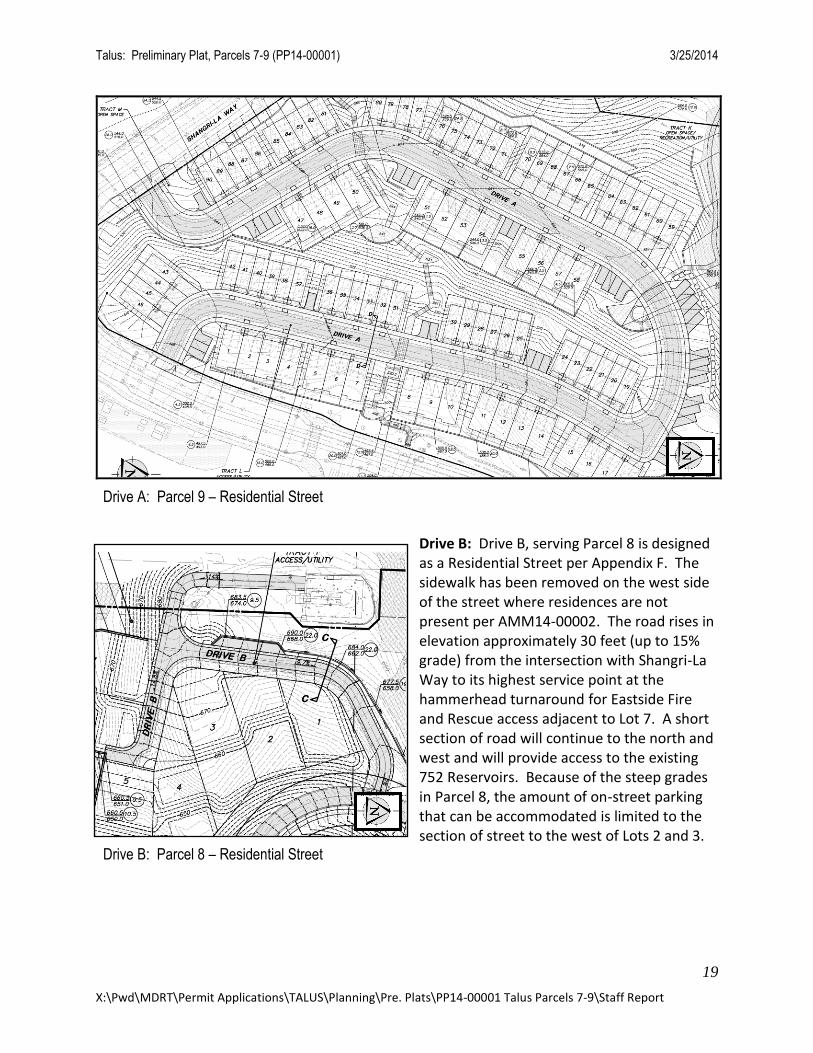
Drive B: Drive B, serving Parcel 8 is designed as a Residential Street per Appendix F. The sidewalk has been removed on the west side of the street where residences are not present per AMM14-00002. The road rises in elevation approximately 30 feet (up to 15% grade) from the intersection with Shangri-La Way to its highest service point at the hammerhead turnaround for Eastside Fire and Rescue access adjacent to Lot 7. A short section of road will continue to the north and west and will provide access to the existing 752 Reservoirs. Because of the steep grades in Parcel 8, the amount of on-street parking that can be accommodated is limited to the section of street to the west of Lots 2 and 3.
Drive B: Parcel 8 – Residential Street
Talus: Preliminary Plat, Parcels 7-9 (PP14-00001) 3/25/2014
20
X:\Pwd\MDRT\Permit Applications\TALUS\Planning\Pre. Plats\PP14-00001 Talus Parcels 7-9\Staff Report
The approval of AMM14-00002 requires that between 31 and 38 feet of width be provided within Tract F in order to accommodate the road, sidewalk, planters and parking. The application specifies only 26 feet of width for these elements. Compliance with AMM14-00002 will require additional width for the planters and sidewalk. This will be verified with the site work permits and the Final Plat. (Condition 17)
Drive C: Drive C, serving a portion of Parcel 7 will serve Lots 29-37. An Administrative Minor Modification, AMM14-00003, removed the sidewalk on the side of the street where there are no residences with direct frontage; however, pedestrian access will still be provided around the entire loop road. Parking is provided on the west side of Drive C across from Lots 30-35.
General:
Sheets 6 - 8 identify road grades. Eastside Fire and Rescue allows limited use of 15% road grades. Due to steep existing topography of Parcels 7-9, there remain some road grades up to 15%. To ensure that constructed center-line road grades do not exceed 15%, a surveyor must confirm the actual grades in the field. (Condition 18) The DSD will also work with the applicant to identify means to improve traction where 15% road grades, at the center-line, occur.
As the roads within the plat provide emergency access and as sidewalks are key elements of pedestrian circulation, and in some cases ADA access, it is important that the design of individual lots doesn’t impinge on roads and sidewalks. Specifically, driveway lengths must ensure that cars can fully park on site. (See Construction Condition 28)
FINDING: The proposed plat is consistent with roadway requirements as identified in the
Development Agreement, provided the recommended conditions are met.
APPENDIX G: SEPA COMPLIANCE FOR IMPLEMENTING APPROVALS
The proposed urban development within the TALUS project area has been addressed and analyzed in prior environmental documents, such as environmental impact documents prepared for King County’s 1994 Comprehensive Plan, the City’s Comprehensive Plan, and the Environmental Impact Statement accompanying King County’s Newcastle Community Plan. A more specific review and analysis occurred in 1998 and 1999 with the East Village EIS.
Pursuant to Subsection 25.2.3 of the Development Agreement, the City acknowledges the EIS satisfies the SEPA requirement and may, pursuant to the procedures and standards set forth in this appendix, require measures beyond those in the Agreement, only to the extent:
- An implementing approval or requested modification exceeds the project envelope;
- It is concluded, pursuant to WAC 197-11-600(3)(b), that substantial changes have been made to the project; or,
- It is concluded that there is new information indicating probable significant adverse environmental impacts.
Talus: Preliminary Plat, Parcels 7-9 (PP14-00001) 3/25/2014
21
X:\Pwd\MDRT\Permit Applications\TALUS\Planning\Pre. Plats\PP14-00001 Talus Parcels 7-9\Staff Report
The City has determined this proposal is an Implementing Approval within the Project Envelope, as defined in Appendix G of the Development Agreement. As specified in Appendix G, the existing East Village Environmental Impact Statement shall be utilized and no further State Environmental Policy Act (SEPA) checklist or threshold determination is required when an application for an Implementing Approval is within the Project Envelope.
FINDING: The proposed preliminary plat meets the Project Envelope as defined in the East Village EIS and is, therefore, consistent with the Development Agreement.
APPENDIX H: MASTER TRANSPORTATION FINANCING AGREEMENT
The environmental impacts of the proposed TALUS project have been analyzed in detail. Transportation mitigation measures have been identified in the DEIS and FEIS, not only to meet the City’s Concurrency Ordinance, but also to improve existing operational levels along SR 900.
All improvements to SR-900 and other off-site improvements required of the Master Developer by the MTFA are complete or have been guaranteed.
FINDING: Improvements along SR-900 and other off-site improvements required of the Master Developer are complete. All other improvements are guaranteed. The proposed plat is consistent with this section of the Development Agreement.
APPENDIX I: CAPITAL FACILITIES
This appendix ensures that TALUS contributes its fair share of facilities and/or services related to police, public works, fire and emergency medical, general government, and parks in the City of Issaquah.
The Police capital facility fee has been paid in full. Fire, School, and General Government mitigation fees are due to be paid on a per unit basis at the time of building permit approval. Park and recreation fees are required for each plat or site development permit. Provision of recreation requirements was eliminated with the 1st Major Amendment to the Development Agreement.
Parks mitigation fees are required at Talus pursuant to Appendix I of the Development Agreement. The fees will need to be paid unless it is determined that other recreation facilities offset the required fees, pursuant to Section 5 of Appendix I. (Condition 19)
School mitigation fees are required at Talus pursuant to School Mitigation Agreement. One-half of the required school mitigation fees shall be paid at the time of final plat. The second half of the fees shall be paid upon issuance of each respective building permit (Condition 20)
FINDING: The proposed plat is consistent with applicable capital facilities requirements and the Development Agreement, provided that the recommended conditions are met.
Talus: Preliminary Plat, Parcels 7-9 (PP14-00001) 3/25/2014
22
X:\Pwd\MDRT\Permit Applications\TALUS\Planning\Pre. Plats\PP14-00001 Talus Parcels 7-9\Staff Report
APPENDIX J: PROCESSING OF IMPLEMENTING APPROVALS
Appendix J establishes the permit procedures for Talus. In addition, it establishes procedures for appeals and public notice and empowers the Development Services Department and Urban Village Development Commission.
FINDING: The processing of this proposed plat is consistent with this appendix and the Development Agreement.
APPENDIX K: ELECTIONS AND MODIFICATIONS
This Appendix identifies the method and procedures for Elections as well as Modifications to the standards and guidelines. The applicant has applied for two Elections and six Modifications in accordance with the procedural provisions of Appendix K. The Elections and Modifications are summarized below:
Elections
The applicant has elected to shift down one density category for Parcels 8 and 9. The Designated Official hereby approves the request pursuant to Section 1.1.10 – Change in Land Use Density.
Modifications
The applicant applied for and was granted the following modifications: AMM04-012EV REVISED – Modification to allow intrusion into 50’ Westerly Buffer AMM14-00001 – Modification to Shangri-La Way road section AMM14-00002 – Modification to Parcel 8 road section AMM14-00003 – Modification to Parcel 7 road section AMM14-00004 – Modification to Parcel 9 road section AMM14-00006 – Modification to Development Boundaries and Shangri-La Way road placement
FINDING: The proposed plat is consistent with applicable procedural requirements of the Development Agreement.
APENDIX L: PARK, PLAZA, AND INFORMAL GATHERING AREA STANDARDS
The purpose of this appendix is to encourage a variety of gathering and recreational opportunities through the inclusion of Parks, Plazas and Informal Gathering Areas in Talus. The appendix encourages a flexible approach to the provision of such spaces.
The First Amendment to the Development Agreement removed the requirement for each dwelling unit to provide at least 100 square feet of recreation space within the development parcels. However, Section 6.1.1 of the Main Body and Section 5.0.B of Appendix L requires Development Parcels that are at least two acres in size to provide a Park or Plaza in order of priority as follows: (1) entirely within the Development Parcel; (2) partially within the Development Parcel; or (3) within an adjacent Development Parcel or Noncritical Open Space
Talus: Preliminary Plat, Parcels 7-9 (PP14-00001) 3/25/2014
23
X:\Pwd\MDRT\Permit Applications\TALUS\Planning\Pre. Plats\PP14-00001 Talus Parcels 7-9\Staff Report
area within a reasonable walking distance (approximately 800 feet). Additionally, Appendix B, also anticipates that primarily active recreation spaces will be provided within each parcel including parks, plazas, trails and informal gathering areas.
Parcels 8 and 9 are generally in compliance with the standard. Though the recreation elements in Parcel 9 are generally passive (hillclimb trail and overlooks), the parcel’s close proximity to the proposed recreation facilities in Tract N will provide an opportunity for those residents to have a recreation space within a reasonable proximity to their homes. Parcel 8 is also located within close proximity to Tract N, thus satisfying the required recreation provision of Section 5.0.B.
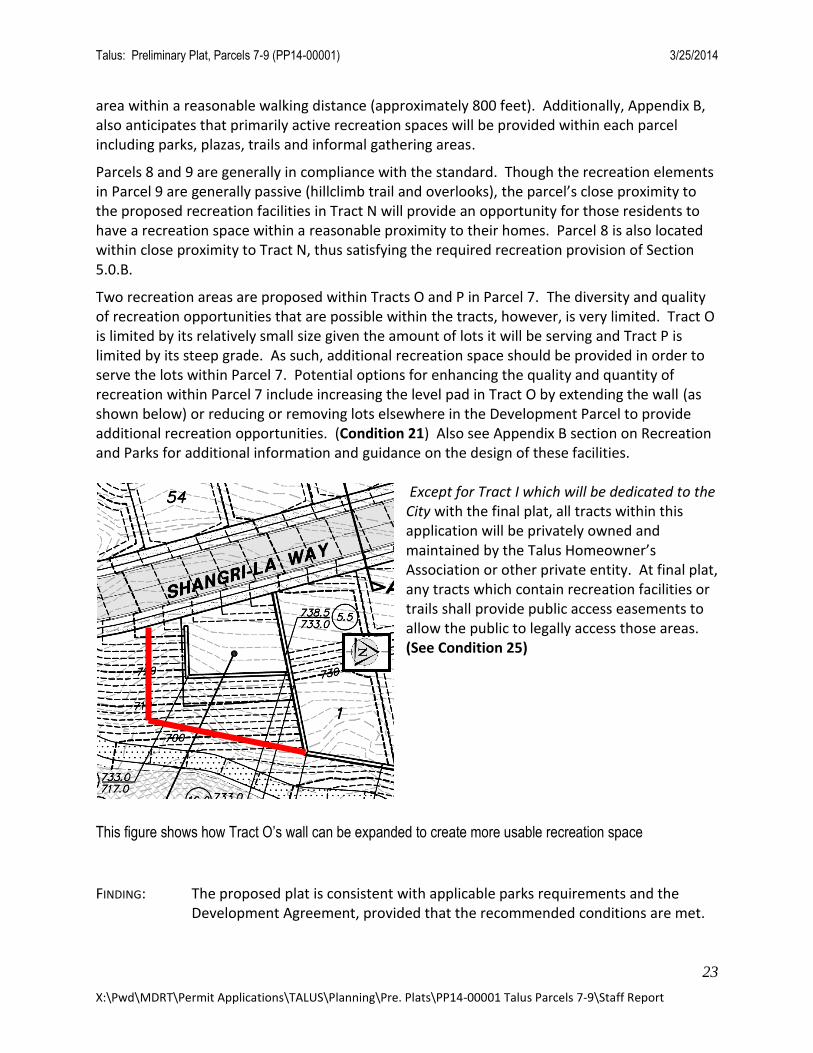
Two recreation areas are proposed within Tracts O and P in Parcel 7. The diversity and quality of recreation opportunities that are possible within the tracts, however, is very limited. Tract O is limited by its relatively small size given the amount of lots it will be serving and Tract P is limited by its steep grade. As such, additional recreation space should be provided in order to serve the lots within Parcel 7. Potential options for enhancing the quality and quantity of recreation within Parcel 7 include increasing the level pad in Tract O by extending the wall (as shown below) or reducing or removing lots elsewhere in the Development Parcel to provide additional recreation opportunities. (Condition 21) Also see Appendix B section on Recreation and Parks for additional information and guidance on the design of these facilities.
Except for Tract I which will be dedicated to the City with the final plat, all tracts within this application will be privately owned and maintained by the Talus Homeowner’s Association or other private entity. At final plat, any tracts which contain recreation facilities or trails shall provide public access easements to allow the public to legally access those areas. (See Condition 25)
This figure shows how Tract O’s wall can be expanded to create more usable recreation space
FINDING: The proposed plat is consistent with applicable parks requirements and the Development Agreement, provided that the recommended conditions are met.
Talus: Preliminary Plat, Parcels 7-9 (PP14-00001) 3/25/2014
24
X:\Pwd\MDRT\Permit Applications\TALUS\Planning\Pre. Plats\PP14-00001 Talus Parcels 7-9\Staff Report
APPENDIX M: AFFORDABLE HOUSING
The Master Developer has the option to provide affordable housing for this project at its discretion per the First Amendment to the Development Agreement.
The Master Developer has elected not to provide any affordable housing with this plat application as allowed per Section 7.3.3 - “Master Developer may elect to not provide any or all of the remaining Group 2 housing, at its discretion.”
FINDING: The proposed plat is consistent with applicable affordable housing standards of the Development Agreement.
APPENDIX N: TALUS WATER SERVICES
Appendix N details the required standards for the construction of water transmission facilities within the TALUS development. All domestic water facilities will be designed in accordance with Appendix N of the Development Agreement and the 1996 Water Comprehensive Plan.
The Project includes ground elevations that range from 500 feet to 800 feet and will span three separate water pressure zones. The lower areas of Parcel 9 will be served by the existing 616 reservoir which can provide domestic water service and commercial fireflows. The upper areas of Parcel 9 will be served by the existing 752 reservoir which can provide domestic water service and residential fireflows. All structures within parcel 9, above ground elevation 548, must be designed to meet the residential fireflow requirement. No commercial fireflows are available above this elevation. Parcels 7 and 8 must be served from a new reservoir and pressure zone that will be constructed concurrent with this project by the applicant. The new reservoir and pressure zone must be designed in accordance with city standards for redundancy and reliability and a report identifying the details of the system (and compliance with codes and standards) must be approved by the City and DOH prior to issuance of the first Building Permit (Condition 22).
All of the water system facilities, including the 916 Reservoirs, will become a part of the City’s water system upon completion and water service must be online prior to the construction of combustible materials. (Condition 23).
FINDING: The proposed plat is consistent with applicable water system requirements and the Development Agreement, provided the recommended conditions are met.
APPENDIX O: SEWER SERVICE
Appendix O details the required standards for construction of sanitary sewer service within the TALUS development. Sanitary sewer facilities in this parcel will be designed in accordance with Appendix O and City standards.
There is sufficient capacity for the proposed Plat.
These facilities will become a part of the City’s sewer system upon completion.

Talus: Preliminary Plat, Parcels 7-9 (PP14-00001) 3/25/2014
25
X:\Pwd\MDRT\Permit Applications\TALUS\Planning\Pre. Plats\PP14-00001 Talus Parcels 7-9\Staff Report
FINDING: The proposed plat is consistent with applicable sewer system requirements and the Development Agreement.
APPENDIX P: PARKING STANDARDS
Appendix R provides the parking requirements for Talus. While no parking information is provided with the plat, the application shows more detail than is necessary for a plat, thus some assumptions can be made with regards to parking:
Each lot within Parcels 7 and 8 is anticipated to have two-car garages, at a minimum and thus meets the minimum parking requirement. Additional on-street parking, beyond the code requirement, will also be provided in those parcels.
Each lot within Parcel 9 appears to have at least two car parking spaces, either in a side by side garage or tandem parking. Some units with tandem parking configuration also provide driveway aprons on the lots where cars park. Tandem parking is limited to 50% of the required parking. It appears that more than 50% of the required parking is tandem; however, this can be addressed by other on-site parking, which is available. It is also assumed that required bike parking will occur within the garages. This will be reviewed with the Building Permit.
FINDING: The proposed plat is consistent with the parking requirements of the Development Agreement.
APPENDIX Q: LANDSCAPING STANDARDS
Preliminary landscape plans were provided on Sheets 13-15 of the Preliminary Plat Drawings. The provided plans provide a conceptual look at where planting and trees are proposed within the project. The review of the proposed landscape falls outside of the purview of a preliminary plat application and thus the submitted drawings were not reviewed for compliance with any applicable regulations or design guidelines.
A complete review of the landscaping will occur with the development of each parcel within the plat and with the Administrative Site Development Permits for open space tracts.
All Maintained Landscape Areas and Natural Open Space tracts must be completed by the final inspection for the last adjacent unit or upon 60% occupancy of the surrounding development, whichever occurs first. (Condition 24)
FINDING: The proposed plat is consistent with applicable landscaping requirements and the Development Agreement.
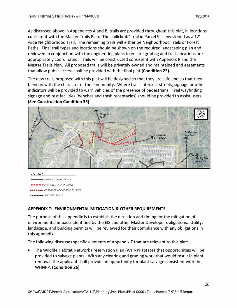
APPENDIX R: URBAN TRAILS STANDARDS
The purpose and intent of this appendix is to encourage a variety of experiences for pedestrians, bicycles and other non-motorized modes of transportation within Talus through public trails. Trails are also to be approved consistent with the Master Trails Plan for Talus, which has previously been reviewed and approved.
Talus: Preliminary Plat, Parcels 7-9 (PP14-00001) 3/25/2014
26
X:\Pwd\MDRT\Permit Applications\TALUS\Planning\Pre. Plats\PP14-00001 Talus Parcels 7-9\Staff Report
As discussed above in Appendices A and B, trails are provided throughout this plat, in locations consistent with the Master Trails Plan. The “hillclimb” trail in Parcel 9 is envisioned as a 12’ wide Neighborhood Trail. The remaining trails will either be Neighborhood Trails or Forest Paths. Final trail types and locations should be shown on the required landscaping plan and reviewed in conjunction with the engineering plans to ensure grading and trails locations are appropriately coordinated. Trails will be constructed consistent with Appendix R and the Master Trails Plan. All proposed trails will be privately owned and maintained and easements that allow public access shall be provided with the final plat (Condition 25).
The new trails proposed with this plat will be designed so that they are safe and so that they blend in with the character of the community. Where trails intersect streets, signage or other indicators will be provided to warn vehicles of the presence of pedestrians. Trail wayfinding signage and rest facilities (benches and trash receptacles) should be provided to assist users. (See Construction Condition 35)
APPENDIX T: ENVIRONMENTAL MITIGATION & OTHER REQUIREMENTS
The purpose of this appendix is to establish the direction and timing for the mitigation of environmental impacts identified by the EIS and other Master Developer obligations. Utility, landscape, and building permits will be reviewed for their compliance with any obligations in this appendix.
The following discusses specific elements of Appendix T that are relevant to this plat:
The Wildlife Habitat Network Preservation Plan (WHNPP) states that opportunities will be provided to salvage plants. With any clearing and grading work that would result in plant removal, the applicant shall provide an opportunity for plant salvage consistent with the WHNPP. (Condition 26)
Talus: Preliminary Plat, Parcels 7-9 (PP14-00001) 3/25/2014
27
X:\Pwd\MDRT\Permit Applications\TALUS\Planning\Pre. Plats\PP14-00001 Talus Parcels 7-9\Staff Report
FINDING: The proposed plat is consistent with this appendix of the Development Agreement.
PUBLIC COMMENTS
Public notice was distributed as required. Two comments were received and are summarized below.
1. Letter received from Toni Letendre and Cynthia Lesferd on March 7, 2014:
- The developer should work to preserve existing evergreen trees and provide green areas to limit the development’s impact upon existing homes in Talus. The Developer or the City should add evergreen trees between the bridge to Talus Parcels 10-12 northward to where there are existing tall evergreens
Response: The Development Agreement permits up to 100 percent clearing of the development parcels within Parcels 7-9. The owner has the right to clear all the
developable property; however, they are also required to replant any areas that have
been cleared as part of their development. The trees between homes on NW Alpine Crest
Way and the reservoir are outside of this plat and will not be impacted by the actions
associated with this plat.
- Traffic going downhill toward Talus Drive will be heavy and an additional connection point should be provided at the east or north end of the development; the intersection of Talus Drive and Shangri-La Way currently poses difficulty for drivers due to visibility concerns and adding more cars into the network will exacerbate the problem.
Response: Traffic within the Talus development is regulated by the Development Agreement and by City Codes and Standards which define acceptable levels of service for design and operation of the roadways. Those codes and standards were used to plan and design the roadway network and that network was designed to accommodate the traffic from the proposed development. While the proposed development will increase the amount of traffic on the City roadways, that increase complies with the Level of Service Standards.
- A new trail connection should be established to provide a link to the Shangri-La Trail to the west.
Response: The proposal includes a connection to the existing Shangri-La Trail in Tract D.
2. Email received from Ingrid Lundin, King County Parks and Recreation Division, on December 12, 2013:
- Trail connections should remain open to the public with no restrictions to public access.
Response: All proposed trails within the proposal will be have public access easements (in perpetuity) to allow the public to access them at all times. See Condition 25.
- The question was asked as to who will own and maintain the open space tracts.
Talus: Preliminary Plat, Parcels 7-9 (PP14-00001) 3/25/2014
28
X:\Pwd\MDRT\Permit Applications\TALUS\Planning\Pre. Plats\PP14-00001 Talus Parcels 7-9\Staff Report
- Response: Except for Tract I which will be dedicated to the City with the final plat, all tracts within this application will be privately owned and maintained by the Talus Homeowner’s Association or other private entity.
- Will legal access routes be provided through the project to the northern parcels within King County
Response: Yes. The extension of the Road A Right-of-Way extends to the north boundary of Parcel 7 in order to preserve future access to the parcels to the north.
CITY DEPARTMENT REVIEW COMMENTS
A. Fire: Comments were received from Eastside Fire and Rescue and incorporated into the project design or conditions above.
B. Planning: No comments.
C. Public Works Operations: Comments were received did not result in any conditions related to the preliminary plat. They will be incorporated into the construction conditions to be verified during future permit reviews.
D. Police: No comments.
PROPOSED MOTION
Based upon the application, submitted plans (received February 19, 2014), listed Attachments, and rationale contained in this Staff Report, the Administration recommends that the Urban Village Development Commission move to:
Recommend approval of the Preliminary Plat Application for Talus – Parcels 7, 8 and 9, File No. PP14-00001, subject to the terms and conditions of the Staff Report dated March 25, 2014, Attachments A thru E and the following conditions:
1 Various easements are required to provide access for the City of Issaquah or property owners. These easements shall be provided with the final plat. These include: ▪ When the right-of-way is located at the back of sidewalk or similar paved area, and it is determined to be necessary by the Designated Official, a two-foot maintenance and repair easement shall be granted to the City. For instance if a building or wall is located at the back of publicly owned paved area, the easement is not necessary. ▪ Access to retaining walls to allow for maintenance and replacement by the private owners.
2 At Final Plat, a mechanism for ensuring the preservation of the westerly buffer in Tract D as well as an easement for protection of the steep slope therein, shall be provided.
Talus: Preliminary Plat, Parcels 7-9 (PP14-00001) 3/25/2014
29
X:\Pwd\MDRT\Permit Applications\TALUS\Planning\Pre. Plats\PP14-00001 Talus Parcels 7-9\Staff Report
3 At final plat, irregular or pie shaped lots and lots that are narrow in the front shall be adjusted to ensure that the homes have a strong relationship with the street. For example, this condition will require an adjustment to the shape or building placement and/or design on Lot 6 Parcel 7 and Lot 4 Parcel 8.
4 In order to minimize the aesthetic impacts of the development, the following shall be incorporated into the Building Permit applications for homes visible from off site: a. Blank walls shall be avoided, especially where visible from off-site; if necessary, articulation or other features will be provided. Articulation would incorporate tiering, building offsets, and/or other means to soften the building’s form. Appropriate features would include doors, windows, building articulation, and/or other architectural features to create a visually interesting environment. b. In addition to landscape in the adjacent steep slope tracts, the visible side of the homes may have open-style fences or varied hedges up to 4 ft in height. A covenant or other mechanism, acceptable to the Designated Official, shall be recorded to ensure that if a hedge is used it is maintained at 4 ft. If a fence is used, the appropriate amount of fence openness will be evaluated in combination with the landscaping and building architecture as viewed from outside these parcels. Solid fences or unvaried shrubbery plantings (such as a wall of only arborvitae) will not be permitted. c. The prominent finish of building facades visible from off-site shall be muted, non-reflective material incorporating neutral to dark earth tones.
5 The applicant shall use varied building setbacks, modulations in building facades, architectural details and colors to provide added interest and character to achieve a more appropriate mountain village character.
6 The landscaping for Tract G, between Parcel 8 and Shangri-La Way, shall be designed so that views from Lots 1-5 are framed but there remains a continuation of the open space character established in Tract D adjacent to Shangri-La Way.
7 Design terraced walls shown in the plat to allow and encourage landscaping from below, between, and above the terraced walls. This will be reviewed with the Site Work Permit for the walls and with the Landscape Permit.
8 Where it is not practical to terrace walls, long and/or tall walls will be articulated, add visual interest to the community, and use landscape to soften the wall and transition the scale of the wall where pedestrians are nearby. For instance, at the base of the eastern wall in Parcel 7, landscaping, which includes the use of coniferous trees where feasible, shall be placed between the base of the wall and the trail in order to reduce the wall’s scale and presence to pedestrians. This will be reviewed with the Wall permits and the Landscape Permit.
9 Prior to approval of any permit other than this Preliminary Plat, the applicant must receive Master Developer approval and City confirmation for the election to shift down one land use density category, i.e. from Medium Density Residential to Low Density Residential.
Talus: Preliminary Plat, Parcels 7-9 (PP14-00001) 3/25/2014
30
X:\Pwd\MDRT\Permit Applications\TALUS\Planning\Pre. Plats\PP14-00001 Talus Parcels 7-9\Staff Report
10 The stormwater system shall comply with the Master Drainage Plan submitted with the Pre Plat application. This will be reviewed with the Site Work Permit.
11 Prior to issuance of any Utility Permit that allows the construction of impervious surfaces, the design work necessary to generate stormwater treatment capacity in the P5 Detention Pond and P5 Sand Filter must be approved by the City. The associated work must be completed, prior to issuance of the first Building Permit. The Designated Official may consider accepting surety to alter the completion date based upon a plan to have necessary facilities in place consistent with the Development Agreement, MDP and stormwater generation.
12 Future Utility Permits implementing the plat and plat construction shall be consistent with the findings and conditions of approval in Critical Areas Study Notice of Decision – File No. SEP14-00001.
13 Structural fills that have a resultant slope of greater than 40% do not need setbacks or buffers under the following circumstances: 1) they have been designed by a licensed geo-technical or structural engineer and 2) construction was performed under the guidance of a licensed structural or geo-technical engineer, and 3) the as-built plans are certified by a licensed structural or geo-technical engineer. Otherwise, these areas will be treated as steep slopes under Appendix E. This will be reviewed with the Site Work Permits.
14 The constructed walls that are proposed on the western project boundary must be designed to accommodate revegetation plantings without landscaping or irrigation restrictions. The intent is to revegetate immediately adjacent to the walls with deciduous Douglas Fir and Cedar Trees that can be allowed to grow to a full mature height. This will be reviewed with the Site Work Permit for walls and with the Landscape Permit.
15 At final plat, the BSBL for critical areas shall be shown on all lots with adjacent critical areas.
16 At final plat, any private streets shall have an easement allowing emergency vehicles and Public Works to access the street network. In addition, a public access easement shall be granted from the owner to the City.
17 Per AMM14-00002, the Parcel 8 road and Tract F (Drive B) must be widened as necessary in order to provide sidewalk and planter facilities. This condition will be verified with the Final Plat.
18 To ensure that center-line of roads within the plat do not exceed 15% slope or 600 feet in length, road grades and lengths will be confirmed with Site Work Permits and certified by a surveyor or other professional acceptable to the Designated Official, following construction. This certification must be provided prior to issuing the first Building Permit in the plat. If grades exceed 15% then all homes past the 15+% slopes must be sprinklered.
19 Capital facility fees due at final plat shall be paid prior to final plat approval, and shall be collected based upon the number of lots contained in the final plat and in accordance with Appendix I. The applicant shall be obligated to pay required Appendix I Parks Mitigation
Talus: Preliminary Plat, Parcels 7-9 (PP14-00001) 3/25/2014
31
X:\Pwd\MDRT\Permit Applications\TALUS\Planning\Pre. Plats\PP14-00001 Talus Parcels 7-9\Staff Report
Fees, unless the Designated Official determines that credit for other recreational facilities are adequate to offset those fees.
20 A condition shall be placed on the face of the final plat which requires the payment of mitigation fees per the School Mitigation Agreement.
21 With the final plat, the Tract O recreation and open space tract shall be increased in size or another area within Parcel 7 shall be provided in order to accommodate for a more usable and diverse variety of recreation activities. In either case, the Parcel 7 tract identified for recreation will be graded flat, though it may be terraced into 2-3 flat usable pieces.
22 Prior to issuance of the first Building Permit the applicant must submit and receive approval for (both from Issaquah and DOH) a design report that identifies the details of the water supply system to serve parcels in the upper (presumably 906) pressure zone. The report must detail the redundant storage and supply facilities and how they comply with City codes and standards.
23 Building permits for combustible construction served by the 916 reservoir may be issued as soon as the 916 reservoir is on-line, full of water, and the water mains serving any specific parcel are connected to the 916 reservoir. Building occupancy may not occur until the water system is accepted by the City of Issaquah.
24 All Maintained Landscape Areas and Natural Open Space tracts must be completed by the final inspection for the last adjacent unit or upon 60% occupancy of the surrounding development, whichever occurs first.
25 At final plat, Tract A, C, D, J, K, M, N, O and P as well as any other tracts that have trails or recreation facilities shall allow public access on the trails in perpetuity if the tracts containing the trails or recreation facilities are privately owned.
26 With any clearing and grading work that would result in plant removal, the applicant shall provide an opportunity for plant salvage consistent with the Wildlife Habitat Network Preservation Plan.
PP14-00001 - Staff Report Attachments: A. Talus – Parcels 7-9 Construction Conditions B. Appendix A excerpts C. City of Issaquah Comprehensive Plan excerpts D. Public Comments E. Preliminary Plat Package: - Permit Application
- Narrative -Plat Drawings, Shts 1-17, received February 19, 2014
Talus: Preliminary Plat, Parcels 7-9 (PP14-00001) 3/25/2014
32
X:\Pwd\MDRT\Permit Applications\TALUS\Planning\Pre. Plats\PP14-00001 Talus Parcels 7-9\Staff Report
cc: Lucy Sloman, DSD Land Development Manager Dan Ervin, DSD Engineering Consultant Mark Lawrence, Eastside Fire and Rescue Dan Hayes, Hayes and Sons Al Fure, Triad Associates Ryan Kohlmann, Triad Associates