tanzania-kenya - arusha-namanga-athi river road development
TRANSCRIPT
Language: English Original: English
PROJECT: MULTINATIONAL: ARUSHA – NAMANGA - ATHI RIVER ROAD DEVELOPMENT PROJECT
ONE-STOP-BORDER-POST
COUNTRY: KENYA
ENVIRONMENTAL AND SOCIAL IMPACT ASSESSMENT SUMMARY
Date: February 10, 2010
Project Team
Team Leader: L.. Kiggundu, Transport Engineer, OITC.2 Team Members: N. Kulemeka, Socio-economist, ONEC.3
Regional Director: G. Negatu, OREA Sector Director: G. Mbesherubusa (OITC) Sector Manager: A. Oumarou, OITC.2 Country Manager: D. Buzingo
2
ENVIRONMENTAL AND SOCIAL IMPACT ASSESSMENT (ESIA)
SUMMARY
Project Name: Multi-National: Arusha-Namanga-Athi River Road
Development Project One-Stop-Border-Post Countries: Kenya and Tanzania Project Number: PZ1-DB0-040 1. Background The Multinaltional Arusha – Namanga – Athi River road construction and upgrading project was approved by the African Development Bank (AfDB) in 2007 with co-financing from the Japanese International Cooperation Agency (JICA). The main part Arusha - Namanga - Athi River Road Development Project consists of construction of 242 km road crossing the Kenya – Tanzania border at Namanga. The specific country sections are Kenya 136 km and Tanzania 106 km. The construction works commenced in November 2007 on the Kenya side and July 2009 on the Tanzania side. Significant progress as been made on both sides with the expectations that the road works may be completed by 2011. During preparation of the Arusha-Namanga-Athi River project, provisions were made for the construction of a One-Stop-Border-Post (OSBP) at Namanga. However, during this moment the detailed designs and feasibility studies had not been carried out. The detail designs have included a set each of the Environmental and Social Impact Assessment (ESIA) and Resettlement Action Plan (RAP) for the two countries. The detailed design and Bills of Quantities are being finalized financed by JICA. This Summary reflects environmental and social impacts assessment done on the Kenya side of the boarder post. A separate summary will be prepared for the Tanzania side of the border post. 2. Introduction The Japanese International Cooperation Agency (JICA) has commissioned GIBB Africa Ltd to undertake an Environmental and Social Impact Assessment (ESIA) Study for the proposed One Stop Border Post (OSBP) at Namanga in Kenya and Tanzania. As part of the Environmental Impact Assessment (ESIA) Study process in Kenya GIBB Africa prepared an ESIA Project Report and Terms of Reference for full Environment and Social impact, identification and assessment in February 2010 and submitted the Report to the National Environment Management Authority (NEMA). The project is situated at Namanga Border between Kenya and Tanzania, a distance of approximately 136km on the Kenyan side. On the Tanzanian side, the border is approximately 106km from Arusha. The project is a continuation of the current construction of the Athi River – Namanga Road side in Kenya, which starts at the junction with the A109 Mombasa – Nairobi road at Athi River, approximately 25km south west of Nairobi. The proposed project is located in Namanga town, Namanga Division of Kajiado district. The project area is under the jurisdiction of the Namanga District Officer and the Olkejuado County Council. Both the Namanga District Officer
3
and the Administrative Secretary of Olkejuado County Council have offices in Namanga town, currently located within the proposed project site. During the stakeholders meeting held on 15 September 2010, details of the detailed design and cost estimates for each side of the OSBP were presented. On the Kenyan side the total cost of the civil works amounts to USD8.4 million and the compensation and resettlement at USD13.6 million. The proposed location will require demolishing some of the existing buildings and surrounding structures. Therefore, facilities should be provided during construction to temporarily accommodate the border personnel to carry on with their functions. Attached to the Summary is a summary of the Resettlement Action Plan which has been prepared for the project. The supervision cost is estimated at USD1.8 million giving a total financial requirement of USD23.8 million. Since the construction of the OSBP is part of the overall road construction which, in conformity with the AfDB’s Environmental and Social Assessment Procedures (ESAP), was classified as a Category 1 project and the number of affected persons exceeds 200, an ESIA Summary has to be disclosed on the Bank’s webpage and deposited at the Bank’s Public Information Center (PIC) and distributed to the Bank’s Kenya Field Office. This summary presents in first section the project description and justification; legal and regulatory framework; project alternatives considered; potential project environmental and social impacts and mitigation; environmental and social management and monitoring plan; public consultations; conclusions; and references and contacts. 3. Project Description and Justification The proposed project aims to centralise all operations at the border control post. It also aims to reduce the number of stops a user makes when crossing from one country to the other to one (hence the One Stop Border Post).To achieve this objective all human and vehicular traffic from Kenya will only stop in Tanzania and vice-versa, all traffic from Tanzania will only stop in Kenya. Border operation officials from both countries will be housed together in one building. This project aims to develop the infrastructure that makes these operations possible.
The OSBP has been developed as a result of excessive delays experienced in cargo clearance at border points. The delays in cargo clearance are mainly caused by poor institutional, management systems, inadequate physical infrastructure and services required to support cross border cargo management. Facilities at the OSBP shall include the establishment of integrated Information and Communication Technology (ICT) based cargo clearance system; application of ICT in freight tracking; border post restructuring and privatization; and environmental improvement program.
The project involves the following:
Cordoning and fencing an area, approximately 6.5 hectares, which will be designated as the border control zone (BCZ), within which access, will be limited to those persons crossing the border or offering services;
Construction of roads to bypass the BCZ, approximately 1.5 km long;
Construction of parking areas for trucks crossing the border within the BCZ;
4
Construction of an office complex, verification sheds and warehouses;
Construction and installation of an incinerator for disposal of impounded goods and animals and also solid waste;
Installation of support mechanical, electrical and security devices and services
Construction of civil engineering services including water supply and waste treatment plants;
Construction of other minor buildings and infrastructure to support the operation of the border post.
The construction cost estimated US$8 million dollars per country.
4. Legal and Regulatory Framework
The proposed OSBP ESIA Report has been developed in line with the existing local and international laws, regulations and policies. The key legislative frameworks relevant to the project are presented in the table below:
National Context
Legislation Relevance
Environmental Management Act 2005 (EMA)
Development in relation to the following provisions:
Environmental impact assessment,
Environmental Audit and Monitoring, Environmental Quality standards and environmental protection orders.
Land Acquisition Act (1967) and Village Land Act No.5 (1999)
Construction area requirements;
Land title as a written document confirming a person's rights to land, relevant laws and related competent authorities;
Land compensation;
Expropriation and Compensation requirements;
Right of Land ownership conditions.
Highway Ordinance Cap 167 (Width of Highway Rules, 1960);
Encroachment of the road reserves.
The Water Utilisation (Control and Regulation) Act No. 42 (1974) as amended in 1981 (Act No. 10)
Development in relation to the following:
Water Supply and Utilisation.
Mining Act (1998)
Materials investigation and re-sourcing.

5
National Context
Legislation Relevance
Regional and International Context
Millennium Development Goals (MDGs).
The role of the project in ensuring environmental sustainability through reversal of current trends in environmental degradation in order to sustain the health and productivity of the world’s ecosystem.
The Nile Basin Initiative.
The role of the proposed project in enabling transboundary environmental resources management.
East African Community Protocols and Strategies.
The anticipated development as a result of the OSBP development. Undertake ESIA as required by the Treaty for Transboundary Projects.
BASEL Convention on the Control of Trans boundary Movements of Hazardous wastes and their disposal as adopted at BASEL on 22 March 1989.
The role of the project as an international point of exit and entry in ensuring implementation of necessary measures to ensure that the management of hazardous wastes and other wastes including their transboundary movement and disposal is consistent with the protection of human health and the environment whatever the place of disposal.
5. Project Alternatives Considered Seven alternative options for the border control zones in both Kenya and Tanzania have been considered in this analysis. The seven options are:
Option 1: Building new facility opposite the current Immigration Offices;
Option 1.5: Reduce parking areas of the BCZ, & create new parking areas outside the BCZ;
Option 2: Relocate both facilities (Kenya and Tanzania) about 1km away, each side of border;
Option 3: Trans-locate facilities away from each other, shifting them approximately 200 m East & West;
Option 4: Relocate both facilities together in Kenya and Tanzania, by approximately 1 km into Kenya;
Option 5: Build the new facilities at the existing border locations of immigration offices in each country;
Option 6: Construct a new bypass road starting approximately 1 km from the existing border.
From a ranking and elimination analysis taking into account capital costs, operational, environmental and social impacts, all other options except Options 1 and 5 were eliminated.
Option 1 and 5 were then subjected to a final analysis in which, additional design cost, reusability of structures by Government Agencies on both sides, costs of temporary relocations and delays to overall project were taken into account. Based on all these factors, Option 1 ranks best.

6
6. Potential Project Environmental and Social Impacts and Mitigation
Environmental and Social Impact Assessment (ESIA) is a systematic examination conducted to determine whether or not a programme, activity or project will have a diverse impact on the environment. It is an activity designed to identify, interpret, predict and communicate information about the impact of a human action such as the case for OSBP. A number of impacts associated with the proposed development have been identified by the Environmental and Social Impact Assessment team and the public participation process.
(a) Assessment of Positive impacts
The key expected benefits include:
Years of cross-border trade experience around the world and not just in Africa have shown that the costs of doing business are invariably distorted where the efficiency of supply chains, both in exports and imports, is thwarted by poor facilitation at border points. A recent study report of the World Bank points out that in fact only 25% of the supply chain high costs are attributable to poor physical infrastructure. 75% of the cost distortion is contributed by what are described as soft infrastructure deficits. These are principally people-driven and related to cumbersome customs procedures, bureaucratic behavior and corruption. It is these trade facilitation deficits that the One Stop Border Posts seeks to address, and the Namanga One-Stop Border Post is in this sense a milestone project.
In conjunction with the rehabilitation of the Arusha - Namanga – Athi River Road, use of weighbridges, police checks (inspections), and escorts (police accompanying cargo vehicles), the OSBP is expected to contribute to growth in cross-border transport in Eastern African countries. The combined strategies are aimed at prevention of smuggling and evasion of customs duties which are contributing factors to delays in cross-border transport.
It will promote regional integration and reduce the cost of doing business in the region, as well as promote trade through efficiency in clearance procedures;
The establishment of a one-stop border post will stimulate economic activity with the improvement of infrastructure, establishment of bulk storage facilities, a container depot and bonded warehouse;
The increased economic activities will lead to the establishment of hotels, lodges conference centers and trade centre investments, which will benefit the border community.
Reduction in high transport costs thus reducing high overhead costs that negatively affect industrial development in the country. This also applies to industries in agriculture and transboundary trade;
It will lead to reduction in congestion and transit turnaround time for traffic, as well as significant cuts in transport costs;
Under the one-stop border post concept, travelers will be cleared just once for passage into another country unlike the current set-up in which they have to undergo immigration and customs formalities on both sides

7
of the border. This development is expected to address delays as well as promote the smooth flow of goods through the removal of restrictive operational procedures.
Reduction in time wastage in cross border trade
Reduction of spread of HIV / AIDS at the Border;
Harmonization of Customs and Immigration procedures
Expected Economic Benefits at the Local Level
Foreign exchange;
Restaurant businesses from sale of meals and refreshments;
Boarding and lodging services;
Sale of curios and cultural items by the increasing number of tourists.
Creation of employment
(b) Assessment of negative impacts
The key negative impacts identified by the Environmental Assessment Project team are highlighted in this section, according to the relevant project phases. Design and planning issues have informed the mitigation measures which are presented for the preconstruction and construction, operational and closure stages. The negative impacts are discussed below:
Land take and Resettlement
Prior to construction of the OSBP, land totalling to 8.09 ha or 20.00 acres is going to be acquired, and the buildings and structures therein demolished. This is within the built up area of Namanga town where land use consists of businesses, the Tanzania - Kenya Border and relevant offices as well as residential use for government staff and other citizens of Namanga.
Mitigation measures
The Full Report of land acquisition and resettlement and related socio-cultural impacts and mitigation measures to the community has been presented in Resettlement Action Plan Report. Land acquisition and resettlement will be carried out in accordance with Kenya’s, AfDB and JICA Resettlement laws. The compensation and resettlement will be guided by the principal objectives that the Project Affected Persons (PAPs) will have their former living standards and income-earning capacity improved or at least restored. The PAPs must be provided with adequate support during the transition period.
Spread of Communicable Diseases
Aspects of the physical environment that promote transmission of diseases include: inadequate housing, disposal of wastes, ventilation and use of chemicals which are likely to occur during the construction phase of the project. During the assessment it was found that poor sanitation currently exists in town due to lack of VIP (ventilation improved pit) latrines, toilets and sewer in the town with frequent outbreaks of cholera.
8
Sexually Transmitted Infections and HIV/AIDS
The link between mobility and HIV vulnerability is also increasingly recognized, and highways and borders have been identified as environments of elevated HIV vulnerability (Family Health International, 2005). HIV/AIDS will therefore be an issue during construction and operations due to the new population attracted to the town centre by the available employment opportunities. It will also be an issue during the operation phase due to its location within a border town compounded by the expected increase in transitory population. The presence of unaccompanied men and women in the project area would exert a direct influence on promiscuity due to the fact that sexual misconduct will be so common that many locals will inadvertently adopt the habit.
Land capability and potential The urban and rural residential, business and related activities will be constrained by the need to conform to new safety requirements for the border control zone. The impact will be high if all the business premises are all relocated. Guidelines for the minimum safety distance will be written based on design considerations and facilities on site. Solid wastes During the construction phase, three types of solid wastes will be generated: Debris from demolitions, spoils and domestic refuse. During operations the waste will be mainly paper and plastic (for example from packaging materials and lagging). Apart from visual impacts, debris can affect water quality. Geology and Topography The soil cover in the proposed area is thin and the rocks are exposed to the surface in some areas. The topography is rolling towards the River Oldonyo Rok. Therefore levelling will be done and this will involve excavation and blasting of rocks. The blasted rocks will either be used during construction or will be disposed off as spoils. During construction, there will be high risk of soil erosion, namely due to removal of vegetation during pre-construction and construction activities. During operation, the risk of erosion is low, as less soil will be exposed, and is thus not assessed. Water supply Available water resources in the area will be hampered due to high water demand for construction purposes. It is difficult to meet the water demand for construction works, local community domestic uses and for livestock without exploring alternative means of water supply which will include water hauling from near-by rivers and water harvesting.

9
Wastewater No significant changes are forecast to the water supply and quality classification of the receiving water bodies which can’t be mitigated. However for good practice mitigation measures are proposed especially during construction phase, where there could be significant pollution if proper procedures are not followed. Noise and Vibrations The main sources of noise during construction phase will include blasting, heavy equipment, transportation vehicles and the demolition of existing buildings, which are within the project area. There are has a number of sensitive spots such as customs and immigration offices, Police Station which will be within the Border Post.
Surface water (nearby river) The closest river is within the project area. The river is seasonal and thus is normally dry for the most part of the year. The slope of this area is rolling towards the river and therefore can exacerbate the runoff response times, erodibility and pollutant transport from the construction site to the river. During all phases of the Project, the spillage of oils and other substances may impact the river. Air quality degradation The potential impact is considered to be a once-off event occurring during the pre-construction and construction phases. Groundwater The project area has a moderate quantity and quality of groundwater and therefore, this groundwater requires protection from potential pollutants. The source of water for the operations will also be from a proposed borehole in the site. Handling of environmentally hazardous chemicals There is definitely going to be hazardous waste during construction which will be handled by the Contractor. During operational phase of the project, no hazardous waste will be generated from the OSBP, however there is going to be counterfeit goods, unclaimed goods and non-compliance materials which will either be destroyed at the border or may need to be taken back to there place of origin.
7. Environmental and Social Management and Monitoring Plan An environmental and social management plan (ESMP) has been prepared to cover all the phases of the project life: design, construction, operation and maintenance. The plan describes each of the main mitigation measures to be implemented, their frequency, and who should be responsible during and after construction. Environmental and social monitoring, as integral parts of the environmental management plan, has also been included.
10
Prior to mobilisation, the Contractors should also prepare their own environmental management plans, including a schedule of works, for review by the Supervising Consulting Engineer. 8. Public Consultations
Public consultation is an important tool in the EIA process as it provides a two-way communication between project proponents and the public. It aims at improving decision making on proposed projects by actively involving individuals, communities, organisations and government agencies with a stake in the project. The following were consulted during the Study:
Provincial Administration;
Joint stakeholders as identified by JICA;
Truck Drivers;
Ministry of Local Government;
Olkejuado County Council;
Project Beneficiaries (Ministry of Immigrations, KRA);
Household Survey of Namanga Village Residents;
Land and Property Owners in the Project Area;
Business community Namanga
Public Residents of Namanga Town;
Women and Youth. A summary of the comments on the OSBP raised from the consultations is presented below:
The main negative impact of the project is land loss and resettlement as a result of the project. There are concerns over whether the affected persons would be justly compensated through a transparent process. Other expected impacts of resettlement are as follows:
The people of Namanga in Tanzania also do business with the people of Namanga in Kenya. Business interactions could be affected as SME’s are replaced by larger businesses in the town;
Children and livestock would have travel distances to reach their destination, i.e. school and home for children and pastures for animals due to the design concept of OSBP;
Demolition of churches without re-establishment in the town could impact on the spiritual growth of the community;
Resettlement should be done properly and people resettled and/or compensated before the project commences.
The community requested if it is possible for income generating activities around and within the project area can be given to locals this included casual labour, formal employment and businesses.
The community recommended that the construction sites should have adequate security to prevent theft of building materials and machinery. Fencing should also be done to prevent accidents especially for children and disabled members of the community who may have access to the site. There was the fear of increased cases of tuberculosis and respiratory infections from fumes arising from use of

11
flammable substances and construction dust. It was suggested that the project could invest in health services within the project area to increase their capacity to handle cases emerging during both the construction and operation period of the proposed project.
HIV/AIDS and STIs are a major concern and could increase due to interactions with the community and the project construction and operation staff.
9. Conclusions
The proposed project has great economic significance to the country, given the increasing demand for economic integration of East Africa.
The project is expected to reinforce physical infrastructure, reduce transportation costs, and improve transport system reliability to help increase traffic capacity. The increase in traffic capacity is expected to facilitate industrial development, trade, and economic growth thus contributing to poverty reduction. Furthermore, OSBP is considered to quicken trade within the two countries.
The study has established a number of negative environmental consequences that the project activities are likely to induce. The main negative impacts are social impacts related to the land acquisition for the project and therefore resettlement and compensation. It is believed that land acquisition and resettlement will be carried out in accordance with Kenya’s, AfDB and JICA Resettlement laws. The compensation and resettlement will be guided by the principal objectives that the Project Affected Persons (PAPs) will have their former living standards and income-earning capacity improved or at least restored. The PAPs must be provided with adequate support during the transition period, both materially and psychologically. Changes in biophysical environment would be compensated for by the sound mitigation measures and engineering interventions proposed in this report.
Several alternative options for locations of the OSBP have also been reviewed and Option 1 the one which maintains the current location has been found to be the best in terms of long term environment and economic trade offs.
In conclusion, therefore, provided the recommended mitigation and environmental and social management measures including the Resettlement Action Plan are effectively implemented during the construction and operation phases of the proposed project, the anticipated environmental and social impacts will be mitigated.
The Resettlement Action Plan for the affected community has been prepared as separate Report.

12
References Design Study for One Stop Border Post (OSBP) at Namanga, Kenya. Environmental and Social Impact Assessment, Report, Gibb Africa Consulting, Design, Management, August 2010. Design Study for One Stop Border Post (OSBP) at Namanga, Kenya. Resettlement Action Plan, Report (Volumes I, II, III), Gibb Africa Consulting, Design, Management, August 2010. Feasibility Study and Detailed Engineering Design of Multinational Arusha-Namanga-Athi River Road, Environmental and Social Impact Assessment Report, June 2006. NEMA Draft EIA Guidelines, November 2002. The Proposed Constitution of Kenya, 6 May 2010, Attorney General, Republic of Kenya. Contacts Ministry of Roads Works Building, Ngong Road PO Box 30260 GPO 00100 Nairobi. Tel : +254 20 272 3101 www.roads.go.ke Kenya National Highways Authority Blue Shield Insurance Building, Upper Hill PO Box 49712 GPO 00100 Nairobi. Tel: +254 20 801842 www.kenha.co.ke NEMA National Environmental Management Authority Popo Road, South B PO 67839 – 00200 Nairobi. tel : +254 20 605522/26 www.nema.go.ke
13
ENVIRONMENTAL AND SOCIAL IMPACT ASSESSMENT (ESIA) SUMMARY ANNEX
SUMMARY RESETTLEMENT ACTION PLAN (RAP)
Project Name: Multi-National: Arusha – Namanga - Athi River Road Development Project
One-Stop-Border-Post Country: Kenya Project Number: PZ1-DB0-040
1. Introduction and Background
The Japanese International Cooperation Agency (JICA) commissioned GIBB Africa Ltd to undertake Detailed Design, Environmental and Social Impact Assessment (ESIA) and Resettlement Action Plan (RAP) for the proposed One Stop Border Post (OSBP) at Namanga in Kenya and Tanzania. The East African countries entered into a protocol with the World Bank, called the East African Trade Facilitation Project (EATFP) in 2004. The improvement of border crossings all over East Africa was one of its many components. However, such improvement requires structural, legal and institutional changes. The OSBP project is situated at Namanga Border between Kenya and Tanzania, a distance of approximately 136km on the Kenyan side. On the Tanzanian side, the border is approximately 106km from Arusha. 2. Project Description
The project involves the following:
Cordoning and fencing an area, approximately 6.5 hectares, which will be designated as the border control zone (BCZ), within which access, will be limited to those persons crossing the border or offering services;
Construction of roads to bypass the BCZ, approximately 1.5 km long;
Construction of parking areas for trucks crossing the border within the BCZ;
Construction of an office complex, verification sheds and warehouses;
Construction and installation of an incinerator for disposal of impounded goods and animals and also solid waste;
Installation of support mechanical, electrical and security devices and services;
Construction of civil engineering services including water supply and waste treatment plants;
Construction of other minor buildings and infrastructure to support the operation of the border post.
14
3. Assessment of Resettlement and Compensation Impacts
The project will have various social impacts, mostly discussed in the ESIA report, and notably loss of land and assets to allow for the construction of the border post and an additional road to connect to the existing Amboseli Road. This is because the location of the OSBP would block access to the existing junction of Amboseli Road to Athi River- Namanga Road. The land is currently occupied as follows:
Private Land;
Land occupied by Government Offices;
Land held in “trust” (Trust Land) by Olkejuado County Council;
Government land in the form of internal roads, road reserves and land reserved for roads.
Identification of Project Affected Persons (PAPs) was done through door to door consultations with people living or working within the confines of the proposed OSBP, including service roads to and from it. The boundary of the project was established through a topographical survey that was done as part of the detailed design engineering studies.
Land Loss
The total land to be taken by the OSBP is estimated at 8.09 ha or 20.00 acres. A total of 57 private land owners were identified. This number is therefore exclusive of land occupied by government structures. Some of the PAPs in this category are expected to experience total land loss while others will experience partial land loss. PAPs left with a viable land parcel are expected to experience a low impact on land loss while the rest will experience high impacts on land loss. The total compensation due to land loss under this RAP was estimated at three hundred and thirty million, three hundred and thirty eight thousand, and ninety two shillings (KShs 330,338,092.00).

15
Possible Resettlement Sites From consultations with Olkejuado County Council, the Council owns a large piece of land (over 600 acres) about one kilometre from Namanga Town Centre. This site was reserved for a cattle holding ground and that could be improved and infrastructure provided for issue to the local population. The land parcel currently borders the Athi River Namanga Road. The total land demand for Category 1 PAPs stands at less than 2% of the available land at the identified resettlement site. As the PAPs would be moving 1km away, it is expected that the impact on social fabric of the resettled persons will be minimal. It is also expected that at the radius of 1km the PAPs will not be moving to a new neighbourhood thus minimal community sensitisation is required at the RAP implementation stage. Resettlement in the identified resettlement site will lead to impacts on the bio-physical environment of the proposed site due to change of land use. The site is mostly vacant land and it is expected that the resettlement site will be selected in an unoccupied and undeveloped area. The land identified for the construction of the proposed Amboseli road was selected based on the fact that there are no structures within it. From the land maps availed during the RAP study, there will be minimum impact on land loss on individual PAPs. Cash compensation for lost land is therefore recommended. Loss of Structures The structures affected consist of buildings, fences, pit latrines, a borehole, a well, the Olkejuado County Council Lorry Park, petrol and filling stations with their appurtenant structures, including pumps and forecourts. The total value of structures, including informal structures was estimated at three hundred and fifty eight million, one hundred and one thousand, four hundred and thirty shillings (Kshs 358,101,430). Loss of Incomes Relocation of businesses requires compensation and relocation assistance but does not cover long term impacts on customer loyalty, differences in local tastes or other forms of intangible costs. For purposes of this RAP therefore compensation for loss of income is proposed only for the transitional period between demolition of structures and re-establishment of the businesses. In the spirit of a developmental approach however, an assessment was made on possible measures to help improve the living standards of this category of PAPs. Vulnerable Groups Vulnerable groups identified during the study are:
Women whose husbands have died and have lost land ownership documentation or are unable to get other documents to replace the lost ones;
The poor relying on informal businesses including the youth who carry out car wash business;
Households with elderly household heads. Compensation and Re-establishment of Livelihoods
16
Recommendations are given for cash or in-kind compensation of losses to PAPs depending on the entitlements for each group as per AfDB guidelines and the laws of Kenya. To promote re-establishment of livelihoods, a 15% disturbance allowance and 5 % relocation allowance based on the total value of assets is included for each category of PAPs. In addition, land has been set aside by the council and a provisional Kshs1 million budgeted for to enable the council establish social infrastructure and services in the new site. Cut-Off Date for Eligibility of Compensation The actual cut-off date was set at a public meeting held in Namanga Town on 16 March 2010 as the last day of the household survey which was 26 February 2010. In all the stakeholder meetings the purpose of the cut-off date for eligibility of compensation was communicated to the stakeholders. Expected Project Benefits Benefits expected from the project include reduced travel time due to the efficient clearance and forwarding procedures at the border. On the residual level this is expected to result in reduced transport cost thus possible reduced cost of business. On a local level it is expected that there will be employment opportunities for the residents of Namanga during the construction phase. Study Methodology Specific methodologies to collect primary and secondary qualitative and quantitative data included household surveys; interviews/meetings with institutional PAPs; key stakeholder interviews; public sensitization meetings; land and asset valuation; calculation of resettlement implementation costs. Lack of proper land surveys in the project area led to challenges in the field work studies. However to counter this, the RAP implementation arrangements will allow for a land adjudication process for the affected PAPs.
4. Implementation Arrangements An eight member RAP Implementation Committee is recommended. This committee should be chaired by the District Commissioner Kajiado District and at a minimum be comprised of the following persons:
District Settlement Officer;
District Officer Namanga;
Village Chairmen/ Elders;
Women representative: preferably one head of a female headed household;
Youth representative;
Construction contractor’s representative;
KeNHA Representative;
Representative from Ministry of Immigration;
Representative from Ministry of Trade.

17
5. Public Consultation and Disclosure Stakeholders Consulted The overall goal of the consultation process is to disseminate project information and to incorporate the views of the Project Affected Persons (PAP) in the design of the mitigation measures, management plan and Resettlement Action Plan. Two key stakeholder groups were identified for this process: (i) Primary (PAPs whose land and assets would be affected by the resettlement and/or relocation process); (ii) Secondary (institutions that would be involved in the implementation of the RAP). Secondary stakeholders included the Olkejuado County Council, Ministry of Lands, Ministry of Immigration, Ministry of Trade and the Kajiado District Commissioner’s Office. Before the commencement of any fieldwork activities, consultative meetings were held with the provincial administration within the project area. Issues Raised and Future Consultations From the consultations, the community is aware of the international dimension of the project and the need for integration with “foreign” populations that may come into the area as construction staff or the resultant increase in traffic at the border post. The construction site staff will therefore be sensitised to prevent conflicts during their socialisation with the local community. There is concern over the availability of resettlement land as some fear that it would be scarce, become expensive or there would arise corruption cases during acquisition of new land. The ESIA Report recommended a grievance mechanism aimed at providing an avenue for active community participation and provision of feedback on fears raised by community members. Project affected persons are expected to participate through the following platforms through out the implementation programme:
RAP Implementation Committee;
Proposed grievance mechanism for the RAP implementation process;
Focus Group Discussions and Social Surveys during monitoring and evaluation of the Rap implementation process by internal and external reviewers;
Training of project team/staff and awareness raising activities with community members.
RAP Disclosure and Future Consultations
The RAP Summary is being posted in the AfDB’s Public Information Centre (PIC) as well as AfDB’s and JICA websites for public review and comments. Future consultations will include mechanisms to promote consultations to ensure that stakeholders remain maintain active participation during consultations. Project Affected Persons will be expected to participate through the RAP Implementation Committee; proposed grievance mechanism for the RAP implementation process; Focus Group Discussions and Social Surveys during monitoring and evaluation of
18
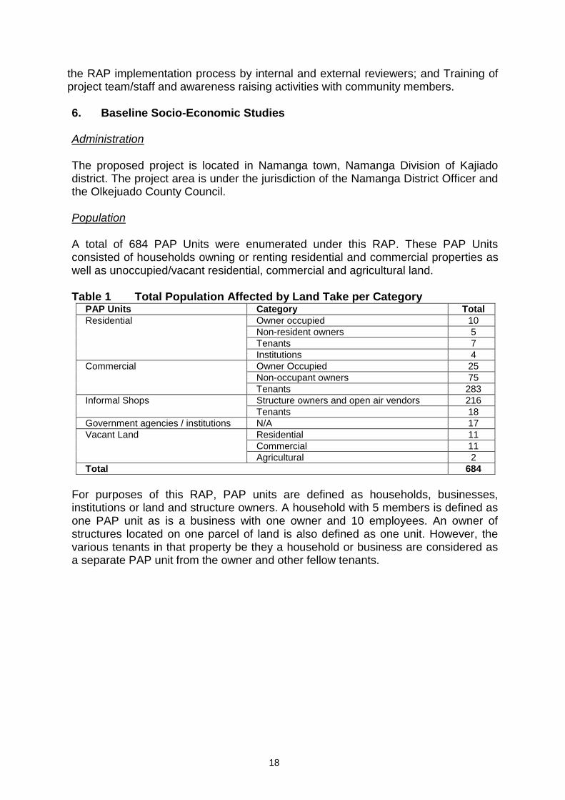
the RAP implementation process by internal and external reviewers; and Training of project team/staff and awareness raising activities with community members. 6. Baseline Socio-Economic Studies Administration The proposed project is located in Namanga town, Namanga Division of Kajiado district. The project area is under the jurisdiction of the Namanga District Officer and the Olkejuado County Council. Population A total of 684 PAP Units were enumerated under this RAP. These PAP Units consisted of households owning or renting residential and commercial properties as well as unoccupied/vacant residential, commercial and agricultural land. Table 1 Total Population Affected by Land Take per Category
PAP Units Category Total
Residential Owner occupied 10
Non-resident owners 5
Tenants 7
Institutions 4
Commercial Owner Occupied 25
Non-occupant owners 75
Tenants 283
Informal Shops Structure owners and open air vendors 216
Tenants 18
Government agencies / institutions N/A 17
Vacant Land Residential 11
Commercial 11
Agricultural 2
Total 684
For purposes of this RAP, PAP units are defined as households, businesses, institutions or land and structure owners. A household with 5 members is defined as one PAP unit as is a business with one owner and 10 employees. An owner of structures located on one parcel of land is also defined as one unit. However, the various tenants in that property be they a household or business are considered as a separate PAP unit from the owner and other fellow tenants.
19
Education Education levels among the PAPs was measured by years of formal schooling from kindergarten through to university. The education level of the household head was measured using both the years of schooling and the ability to read and write in either English or Swahili. The survey shows that 20.83% of the household heads had no years of formal schooling and a percentage of 9.55% can neither read nor write English and/or Swahili. However a majority (74.32%) can at least read English and/or Swahili. The main challenges to education in the project area are:
Generally there is understaffing in the district where the student teacher population is as low as 1:70 as opposed to the intended 1:40
The girl child is discriminated against in terms of exposure to education;
Shortage of field officers which makes monitoring of schools in Kajiado district difficult. The few available officers are also faced with logistical challenges due to a lack of resources such as financing to conduct field visits for monitoring exercises and lack of permanent offices.
Land Tenure Study findings show that the immediate Northern section of Namanga Town touching the current Amboseli Road had been planned but not surveyed but with structures. Letters of allotment as well as title deeds for this section were shown by PAPs to the survey team. Leases of 99 years had been issued within town centre. There were also some 33 year leases issued in the seventies, which have since expired. Some subdivisions of land in the immediate periphery of the town had retained the freehold titles, while others have changed to leases of 99 years. The western section of the tarmac road from the bridge up to junction to Namanga River Lodge was planned but not surveyed. Consulted PAPs presented letters of allotment that appear to have been issued by the County Council. Incomes and Economic Activities Survey results show that majority (81.66%) of the PAPs have their own businesses. These businesses are mostly small and medium enterprises (SMEs).
Retail shops;
Pharmacies;
Bars;
Petrol stations;
Restaurants, lodgings and guest houses;
Sale of commodities like clothes, shoes, wireless telephone airtime and cultural artefacts.
Private sector semi-skilled employment was estimated at 4.16% and includes drivers, waiters, bar maids, hair dressers, car and generator mechanics. Farming is also practiced by the PAPs but there were no farms within the area proposed for the border control zone. From the site walks farms in Namanga Town were however identified at the boundary of the proposed site and mostly along the boundary of the Namanga River riparian land.

20
The PAPs earn an average of Kshs 676,311.75 per year or Kshs 56,359.31 per month. The principal source of household income among the PAPs is proceeds from business at 92.78%, with low percentages from wage earnings, and farming. The highest costs are allocated to food and school. There is minimal cash input into agricultural activities as costs for agricultural inputs account for only 3.21% of the total average household expenses. Health The results of the study show that Malaria was the most prevalent disease among PAP households (41.8%) in the four months preceding the study. This was followed by stomach pains, eye infections, diarrhoea, respiratory diseases and complications during childbirth. The eight disease incidences as experienced by PAPs (pregnancy and childbirth are excluded), are among the top ten prevalent diseases in the greater Namanga Town. According to the Namanga Border Health Office under the Ministry of Health, the health facilities available in the project area are:
Namanga Health Centre;
Torosoi Health Centre;
Karero Dispensary;
Olgulului Dispensary;
Maprasha Dispensary. According to the social survey, 0.93% of the households in the project area have had incidences and/or cases of Sexually Transmitted Infections (STIs) and HIV/AIDS four months prior to the survey. According to the Namanga Border Health Office there are over 200 reported cases of HIV/AIDS infections in the project area. This is reportedly due to the busy border that attracts commercial sex workers in the area. Water and Sanitation There are two main sources of water for domestic use by PAPs. These are piped water sourced from springs at Ol Donyo Rok in Kenya and piped water from various boreholes dug in Namanga area. Management of water services is done by the Namanga Water Users Trust (NWUT) in conjunction with the Water Resources Management Authority (NWUT, 2010). Majority of the households (74.5%) had piped water directly to their households or yards. According to the social survey adults normally fetch water for the households but in some households everyone fetches water, while 0.41% said only children fetch water. 73.64% of the PAPs share their toilet facilities with the other households and/or the public but 61.75% use improved varieties of pit latrines or flush systems. From the survey data it can therefore be deduced that only 19.39% of the households use improved sanitation facilities. Energy The main energy sources used are electricity, kerosene and charcoal. The most

21
preferred source of energy for cooking in the project area is charcoal (84.72%) followed by fossil fuels at 66.44%. Namanga town is connected to the Kenyan National Electricity Grid with a substation on the Kenyan side. Gender According to the Gender and Institutional Capacity Assessment by the European Union in Namanga, Kajiado District (2004), men own and control all the productive resources including land, livestock, money, water, etc. Women on the other hand have control of things like milk, skins, poultry, petty businesses and equipment and material from NGOs or individuals under government guarantee or sponsorship such as milling or grinding machines. Recent studies, however, show that gender roles in the District are changing under the impact of urbanisation and commercialisation. Commercialisation in particular can reduce women’s control over resources they may previously have managed, such as dairy production. The welfare of women and girls is also directly threatened by environmental problems, which increase the pressures of providing for the household, particularly water and fuel-wood collection. (Office of the Prime Minister, 2009). At the time of the ESIA study, there were 22 women groups, 8 youth groups and 2 Community Based Organisations (CBOs) registered in the project area under the Ministry of Social Services, Gender and Cultural Heritage.
7. Policy Legal and Regulatory Framework
Currently there is no Resettlement Policy in Kenya. However following the promulgation of the New Constitution of Kenya, it is expected that the existing legal instruments will be reviewed and enacted for a period ranging between 18 months and five years. For purposes of the OSBP RAP, the following existing legal instruments under the former constitution were used to provide the legal framework for compensation and resettlement in Kenya:
Kenyan Land Policy;
Land Acquisition Act;
Trust Land Act;
Government Land Act;
Registration of Titles Act;
Physical Planning Act.
The project is under the administrative authority of the Kenya National Highways Authority (KeNHA). Other stakeholders that would be involved in the project including its resettlement component are:
Ministry of Immigration;
Ministry of Trade;
Ministry of Roads;
Ministry of Lands and Settlement (Physical Planning Department);
Office of the President, Kajiado District;
Olkejuado County Council;
Ministry of Lands;
22
Ministry of East Africa Community;
East Africa Community Secretariat.
Kenyan Law allows for compensation for loss of land or assets to owners in the event of involuntary resettlement. The AfDB and JICA Policies on involuntary resettlement however have a wider criterion for eligibility of compensation to include “…..those who have no recognisable legal right or claim to the land they are occupying…”
JICA Policies also require that “appropriate participation by the people affected and their communities must be promoted in planning, implementation and monitoring of involuntary resettlement plans and measures against the loss of their means of livelihood”.
8. Grievance Redress Mechanism The Compulsory Land Acquisition Act has a grievance redress mechanism to deal with grievances against compensation offered and it outlines the people who would be entitled. However, in the event that the community may not want to have the matter settled within the RAP Implementation Committee (RIC), the following is the redress process to be followed. The PAP will file a complaint with the RIC. The Committee will be given a seven day notice to hold a meeting. Two days after the meeting, the Committee will cal the PAP for the decision made, discussions held and subsequent agreement. This will be done within 14 days. In the vent that the Committee does not communicate with the PAP, or an agreement is not made, the PAP can resort to the relevant District Commissioner’s (DC’s) office through the District Resettlement office. He/she will then wait 30 days for a decision to be made. If the DC’s office cannot resolve the matter, the PAP may resort to Court of Law. This is however, avoided as the focus is usually on resolving the issue without involving the courts as this could take a long time hence become counter productive in the long run.
9. Evaluation of Alternative Sites Alternatives were studied in a bid to reduce the impact of resettlement. Social, environmental and engineering factors were used to provide final rankings and systematically eliminate all the proposed options in order to help identify the Optimum Design and Location of the OSBP. Option 1 ranked best. The decision to proceed with the design considered on this report was made by both the Government of Kenya and the Government of Tanzania in August 2010. 10. Environmental Protection Among the recommendations made for the new site identified for the creation of the new CBD and plot allocation for some of the PAPs including services, is to undertake an Environmental Impact Assessment (EIA). The project has, therefore, earmarked an estimated Kshs1 million for this exercise. KeNHA in collaboration with the local authorities will identified an accredited service provider to undertake the EIA study.
23
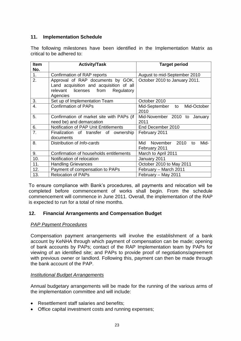
11. Implementation Schedule The following milestones have been identified in the Implementation Matrix as critical to be adhered to:
Item No.
Activity/Task Target period
1. Confirmation of RAP reports August to mid-September 2010
2. Approval of RAP documents by GOK, Land acquisition and acquisition of all relevant licenses from Regulatory Agencies
October 2010 to January 2011.
3. Set up of Implementation Team October 2010
4. Confirmation of PAPs Mid-September to Mid-October 2010
5. Confirmation of market site with PAPs (if need be) and demarcation
Mid-November 2010 to January 2011
6. Notification of PAP Unit Entitlements End December 2010
7. Finalization of transfer of ownership documents
February 2011
8. Distribution of Info-cards Mid November 2010 to Mid-February 2011
9. Confirmation of households entitlements March to April 2011
10. Notification of relocation January 2011
11. Handling Grievances October 2010 to May 2011
12. Payment of compensation to PAPs February – March 2011
13. Relocation of PAPs February – May 2011
To ensure compliance with Bank’s procedures, all payments and relocation will be completed before commencement of works shall begin. From the schedule commencement will commence in June 2011. Overall, the implementation of the RAP is expected to run for a total of nine months. 12. Financial Arrangements and Compensation Budget PAP Payment Procedures Compensation payment arrangements will involve the establishment of a bank account by KeNHA through which payment of compensation can be made; opening of bank accounts by PAPs; contact of the RAP Implementation team by PAPs for viewing of an identified site; and PAPs to provide proof of negotiations/agreement with previous owner or landlord. Following this, payment can then be made through the bank account of the PAP. Institutional Budget Arrangements Annual budgetary arrangements will be made for the running of the various arms of the implementation committee and will include:
Resettlement staff salaries and benefits;
Office capital investment costs and running expenses;
24
Staff capacity building and personnel training;
Implementation Committee capacity building, especially for community representatives;
Logistical costs for travel to meetings and field visits to both the departure and receiving sites will also be included. These costs will include:
Fuel costs for staff;
Logistical costs for inclusion of implementation committee members;
Logistical costs for inclusion of the independent evaluation panel;
Purchase of field equipment and vehicles;
Resettlement preparation costs;
Public participation costs for activities such as social surveys, public meetings, interest group meetings and/or workshops etc;
Logistical costs for grievance handling and resolution;
Financial auditing costs;
Monitoring and Evaluation costs;
Specialized surveys to evaluate the improvements required, and/or the success of the re-establishment of incomes and livelihoods.
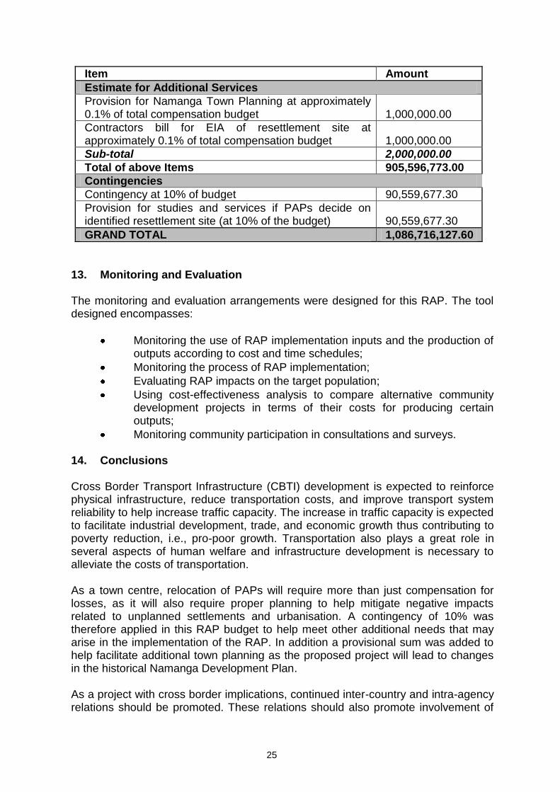
Entitlement Matrix An entitlement matrix has been developed and PAPs have been informed accordingly. The entitlements shall include the following: type of loss incurred; category of PAPs; entitlement expected; and additional assistance to be provided to PAPs. Budget for Implementation of Recommended Mitigation Measures The budget for implementation of the RAP and its recommended mitigation measures stand at Kshs 1,086,716,127.60 or USD 13,932,258.05 (I USD-Ksh.78) as outlined in the Table below. This amount is however exclusive of the institutional costs of implementing the RAP. Table 2 RAP Budget Estimate
Item Amount
Compensation for Land
Compensation for Land 251,514,626.00
Contingency for compensation for land after land adjudication 78,823,466.00
Sub-Total 330,338,092.00
Compensation for Structures
Formal Structure Owners 546,225,331.00
Formal Structure Tenants 9,615,500.00
Sub-Total 555,870,831.00
Informal Structure Owners 1,662,000.00
Informal Structure Tenants 540,000.00
Sub-Total 2,202,000.00
Government Structures 15,185,850.00
Sub-Total 903,596,773.00
25
Item Amount
Estimate for Additional Services
Provision for Namanga Town Planning at approximately 0.1% of total compensation budget 1,000,000.00
Contractors bill for EIA of resettlement site at approximately 0.1% of total compensation budget 1,000,000.00
Sub-total 2,000,000.00
Total of above Items 905,596,773.00
Contingencies
Contingency at 10% of budget 90,559,677.30
Provision for studies and services if PAPs decide on identified resettlement site (at 10% of the budget) 90,559,677.30
GRAND TOTAL 1,086,716,127.60
13. Monitoring and Evaluation
The monitoring and evaluation arrangements were designed for this RAP. The tool designed encompasses:
Monitoring the use of RAP implementation inputs and the production of outputs according to cost and time schedules;
Monitoring the process of RAP implementation;
Evaluating RAP impacts on the target population;
Using cost-effectiveness analysis to compare alternative community development projects in terms of their costs for producing certain outputs;
Monitoring community participation in consultations and surveys.
14. Conclusions Cross Border Transport Infrastructure (CBTI) development is expected to reinforce physical infrastructure, reduce transportation costs, and improve transport system reliability to help increase traffic capacity. The increase in traffic capacity is expected to facilitate industrial development, trade, and economic growth thus contributing to poverty reduction, i.e., pro-poor growth. Transportation also plays a great role in several aspects of human welfare and infrastructure development is necessary to alleviate the costs of transportation. As a town centre, relocation of PAPs will require more than just compensation for losses, as it will also require proper planning to help mitigate negative impacts related to unplanned settlements and urbanisation. A contingency of 10% was therefore applied in this RAP budget to help meet other additional needs that may arise in the implementation of the RAP. In addition a provisional sum was added to help facilitate additional town planning as the proposed project will lead to changes in the historical Namanga Development Plan. As a project with cross border implications, continued inter-country and intra-agency relations should be promoted. These relations should also promote involvement of

26
the local communities on both sides of the borders through their representatives. Feedback from such consultations should be transparent to ensure success of the resettlement program as well as that of the OSBP Project.
***********************************************