tauranga harbour catchment action plan progress … harbour catchment action plan progress report...
TRANSCRIPT

Tauranga Harbour catchment action plan progress report 2013-16
Caring for Te Awanui Tauranga Harbour
Bay of Plenty Regional Council is investing more than $63.8m over the coming ten years to help care for land, water and wildlife in the Tauranga Harbour and catchment.
Together with tangata whenua, Tauranga City and Western Bay of Plenty District Councils, local businesses, landowners, community groups and the wider community, we’re leading work to support:
Hei oranga te whenua Healthy land
Hei oranga te moana Healthy harbour
Hei oranga te tangata Healthy people
One component of Regional Council’s Tauranga Harbour care work has been to deliver on catchment action plans for each of the Harbour’s 16 sub-catchments. This report provides a summary of what’s been achieved against catchment action plan targets since they were developed in 2013.
Te Awanui Tauranga Harbour
Programme - our partners in caring for the Harbour and catchment
Community groups Estuary care groups Coast care groups Enviroschools Kaimai Catchments Forum Land care groups Recreational groups Harbour wardens
Central Government agencies Department of Conservation Ministry for Primary Industries Toi Te Ora Public Health
Researchers University of Waikato Manaaki Te Awanui Bay of Plenty Polytech NIWA Cawthron Institute Te Whare Wānanga o Awanuiarangi
Iwi/hapū Kaitiaki o Te Awanui Ngāi te Rangi Ngāti Ranginui Ngāti Pūkenga
Local government Bay of Plenty Regional Council Tauranga City Council Western Bay of Plenty District Council
Landowners and Residents
Industry & business

Catchment action plan delivery is just one part of our work to care for Te Awanui Tauranga Harbour. Together with our partners we’re also working on:
Keeping water clean Helping landowners to protect stream, drain, wetland and coastal margins. We’re aiming to protect 50 kilometres of waterway margins each year, to reduce sediment, nutrient and bacterial pollution from erosion and agricultural run-off.
Keeping wildlife wonderfulSupporting landowners and community groups to care for natural areas and wildlife through work like fencing, pest control and planting. We’re aiming to protect 122 new biodiversity sites, in addition to the 122 sites and 53 kilometres of sand dunes we already help out with.
Preventing pollutionRegularly checking industrial areas, water takes and consented discharges such as from stormwater, agricultural effluent, irrigation and spray systems for consent and plan compliance. We maintain a 24/7 oil spill and other pollution response system. To report pollution incidents to the Pollution Hotline call 0800 884 883.
Empowering iwiAssisting the Tauranga Moana Iwi Collective to develop and implement a framework for co-management of the Tauranga rohe, following treaty settlement. We’re also supporting Manaaki Taha Moana to integrate matauranga Māori (traditional knowledge) with western science methods to measure the cultural and environmental health of the harbour.
Monitoring land, air, water and wildlife Recording data and trends on ground water, rivers, soil, air and coastal environmental health indicators at more than 160 monitoring sites. See real-time data at www.boprc.govt.nz/livemonitoring.
Improving water managementFrom 2018 we’ll be starting implementation of central government’s National Policy Statement for Freshwater in the Tauranga Harbour catchment. We’ll be involving the community in plan changes to set local water quality and quantity targets.
New researchSupporting the University of Waikato Coastal Science Chair to lead research and PhD studies into topics such as harbour nutrient dynamics, sea lettuce management options and aquaculture opportunities.
Holding the line on mangrove expansionMangrove spread is sediment and climate led. We’re trialling new ways to reduce sedimentation, and supporting 11 Estuary Care groups to control mangrove seedlings in 600 hectares of harbour bed that they want to keep open for public access, fishing and water sports.
Cleaning up the harbourSea lettuce is natural but a nuisance. We work with Tauranga City Council and Western Bay of Plenty District Council to collect large sea lettuce accumulations from busy beaches over summer. We also involve school children in litter pick-ups around their local estuaries and streams.
Keeping boating brilliantProviding Harbourmaster services including maintaining marker buoys, managing swing moorings, harbour safety patrols and reviewing the Navigation Safety Bylaws.
Stopping the spread of pestsWe keep watch for new plant, animal, freshwater and marine pests. We help landowners to contain or eradicate more than 137 different pest species around the catchment. Visit www.boprc.govt.nz/pestpatrol or call 0800 STOP PESTS (0800 786 773) for pest identification and advice.
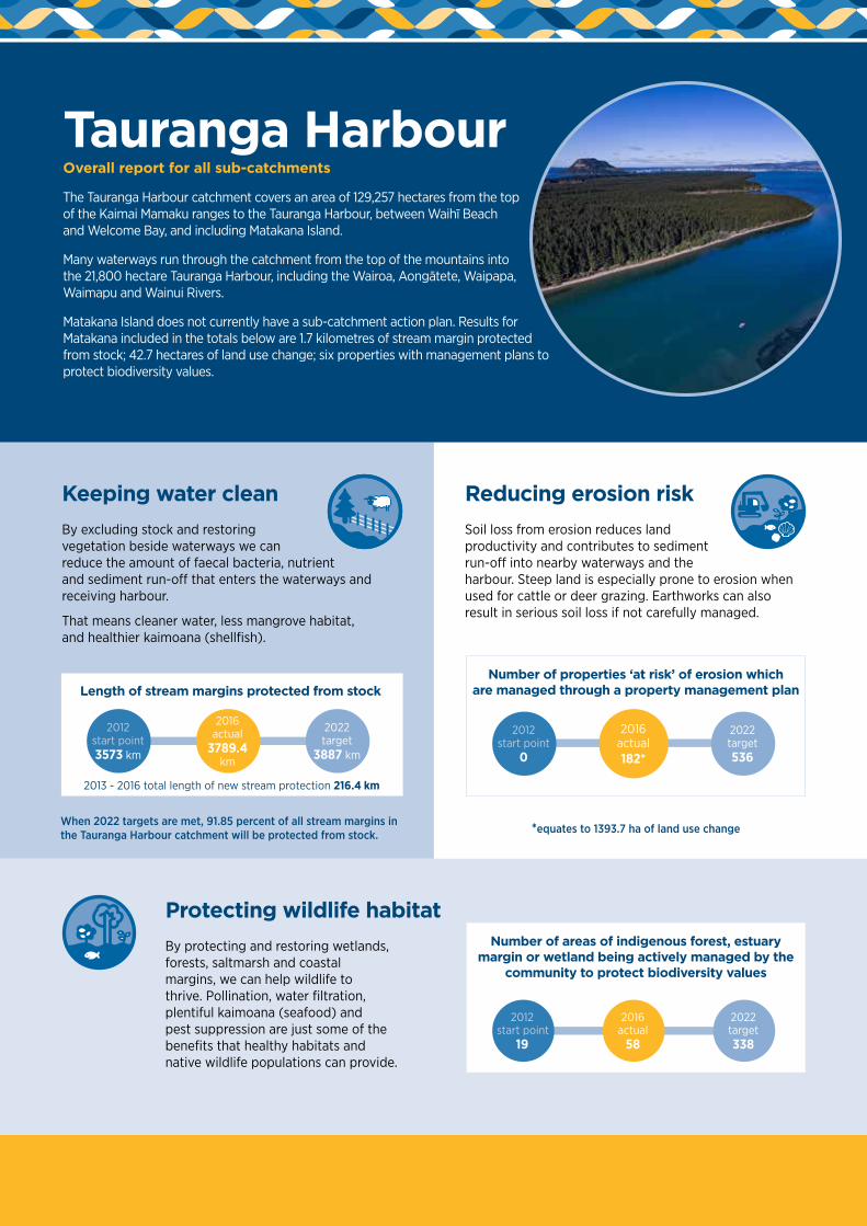
Tauranga Harbour Overall report for all sub-catchments
The Tauranga Harbour catchment covers an area of 129,257 hectares from the top of the Kaimai Mamaku ranges to the Tauranga Harbour, between Waihī Beach and Welcome Bay, and including Matakana Island.
Many waterways run through the catchment from the top of the mountains into the 21,800 hectare Tauranga Harbour, including the Wairoa, Aongātete, Waipapa, Waimapu and Wainui Rivers.
Matakana Island does not currently have a sub-catchment action plan. Results for Matakana included in the totals below are 1.7 kilometres of stream margin protected from stock; 42.7 hectares of land use change; six properties with management plans to protect biodiversity values.
Protecting wildlife habitatBy protecting and restoring wetlands, forests, saltmarsh and coastal margins, we can help wildlife to thrive. Pollination, water filtration, plentiful kaimoana (seafood) and pest suppression are just some of the benefits that healthy habitats and native wildlife populations can provide.
Reducing erosion riskSoil loss from erosion reduces land productivity and contributes to sediment run-off into nearby waterways and the harbour. Steep land is especially prone to erosion when used for cattle or deer grazing. Earthworks can also result in serious soil loss if not carefully managed.
Keeping water cleanBy excluding stock and restoring vegetation beside waterways we can reduce the amount of faecal bacteria, nutrient and sediment run-off that enters the waterways and receiving harbour.
That means cleaner water, less mangrove habitat, and healthier kaimoana (shellfish).
Length of stream margins protected from stockNumber of properties ‘at risk’ of erosion which
are managed through a property management plan
Number of areas of indigenous forest, estuary margin or wetland being actively managed by the
community to protect biodiversity values
2016 actual
58
2022 target338
2012 start point
19
2016 actual182*
2012 start point
0
2022 target536
2016 actual
3789.4 km
2012 start point3573 km
2022 target
3887 km
2013 - 2016 total length of new stream protection 216.4 km
When 2022 targets are met, 91.85 percent of all stream margins in the Tauranga Harbour catchment will be protected from stock. *equates to 1393.7 ha of land use change

B A Y O F P L E N T Y
M
an gaka
rengorengo
Wai
roa
Rive
r
Ma
ngapapaR
iver
Kopu
rererua St
ream
Wai
map
uSt
ream
Wai
tao
Stre
am
2
Aong
atete
Rive
r
2
29
36
2A
Waihi Beach
Ōmokoroa
Katikati
TAURANGA
Mt. Maunganui
Pāpāmoa
Waitekohe Stream
Tah a w ai
Stream
Uret ara River
Tuapir o St ream
2
Matakana Island
Waia u Rive
r
Wai
n ui
Riv
er
Ma
ng
ap
apa
Ri v
er
Ng
am
uw ah ine
R iver
Om
an
aw
aR
ive r
O p u ia k i Riv
e rW
aipa
pa R
iver
HORIZONTAL DATUM:New Zealand Geodetic Datum 2000 (NZGD2000)
For practical purposes, NZGD2000 equates to WGS84
VERTICAL DATUM:Moturiki Datum
PROJECTION:New Zealand Transverse Mercator 2000 (NZTM2000)
Tauranga Harbour Subcatchments
GSP-513339Printed 14/06/2016
0 10 205
© Bay of Plenty Regional Council, 2016© CNS 2009 Distribution SPOT Image S.A., France. ALL RIGHTS RESERVED
© Sourced from Land Information New Zealand data. CROWN COPYRIGHT RESERVED
Kilometres
Scale 1:275000 (A4)
Waiau
Tuapiro
Uretara
Te Rereatukahia Te Mania
Waitekohe
AongateteTe
Puna/Waipapa
Wainui
OturuMangatawa
Kaitemako
Welcome Bay
Waimapu
Kopurererua
Wairoa
Tauranga Harbour sub-catchments
Individual action plans and 2013‑16 progress report cards for each of the 16 Tauranga Harbour sub‑catchments are available at www.boprc.govt.nz/catchmentaction
• Aongātete
• Kaitemako
• Kopurererua
• Mangatawa
• Oturu
• Te Mania
• Te Puna/Waipapa
• Te Rereatukāhia
• Tuapiro
• Uretara
• Waiau
• Waimapu
• Wainui
• Wairoa
• Waitekohe
• Welcome Bay
GD
S 37
63 -
09/
16