technical analysis report for air quality control minor
TRANSCRIPT
ALASKA DEPARTMENT OF ENVIRONMENTAL CONSERVATION
AIR PERMITS PROGRAM
TECHNICAL ANALYSIS REPORT For Air Quality Control Minor Permit AQ1227MSS04
Usibelli Coal Mine, Inc. Wishbone Hill Coal Mining and Processing Operation
DEVELOPMENT OF COAL MINING OPERATIONS
Prepared by: Aaron J. Simpson (ADEC) and Enviroplan Consulting (EVP) Supervisor: Fathima Z. Siddeek Date: Final – June 10, 2014 G:\AQ\PERMITS\AIRFACS\Usibelli Coal\Wishbone Hill\Minor\MSS04\Final\AQ1227MSS04 Final TAR.docx
TAR for Minor Permit AQ1227MSS04 Date: Final – June 10, 2014 Usibelli Coal Mine, Inc. – Wishbone Hill
TABLE OF CONTENTS 1.0 Introduction 4
1.1 Stationary Source Description 4
1.2 Permit History 5
1.3 Application Description 6
1.4 Emissions Summary and Permit Applicability 8
1.5 Department Findings 10
2.0 Permit Conditions 12
2.1 Requirements for all Minor Permits. 12
2.2 Requirements for a Minor Permit under18 AAC 50.502(b)(3), 18 AAC 50.502(b)(5), and
18 AAC 50.502(c) for Air Quality Protection 12
2.3 Requirements for Stationary Sources not Subject to Title V Permitting 13
2.4 Ambient Air Quality Protection Requirements 13
2.5 State Emission Standards 15
2.6 Other Permit Conditions 16
3.0 Permit Administration 16
Appendix A - Emission Calculations 1
Appendix B: Air Quality Modeling Review Report 3
Page 2 of 16
TAR for Minor Permit AQ1227MSS04 Date: Final – June 10, 2014 Usibelli Coal Mine, Inc. – Wishbone Hill
ABBREVIATIONS/ACRONYMS AAC ..............................Alaska Administrative Code ACMP ............................Alaska Coastal Management Plan ADEC ............................Alaska Department of Environmental Conservation AS ..................................Alaska Statutes ASTM ............................American Society of Testing and Materials CEMS ............................Continuous Emission Monitoring System C.F.R. ............................Code of Federal Regulations COBC ............................Compliance Order by Consent EPA ...............................Environmental Protection Agency NA .................................Not Applicable NESHAPS .....................National Emission Standards for Hazardous Air Pollutants NSPS .............................New Source Performance Standards ORL ...............................Owner Requested Limit PSD................................Prevention of Significant Deterioration PTE ................................Potential to Emit RM .................................Reference Method TAR ...............................Technical Analysis Report TBD ...............................To Be Determined
Units and Measures gr./dscf ...........................grains per dry standard cubic feet (1 pound = 7,000 grains) dscf ................................dry standard cubic foot gph .................................gallons per hour kW .................................kiloWatts1 lbs ..................................pounds MMBtu ..........................million British thermal units ppm ................................parts per million ppmv ..............................parts per million by volume tph ..................................tons per hour tpy ..................................tons per year wt%................................weight percent
Pollutants CO .................................Carbon Monoxide HAP ...............................Hazardous Air Pollutant H2S ................................Hydrogen Sulfide NOX ...............................Oxides of Nitrogen NO2 ................................Nitrogen Dioxide NO .................................Nitric Oxide PM-10 ............................Particulate Matter with an aerodynamic diameter less than 10 microns SO2 ................................Sulfur Dioxide VOC ..............................Volatile Organic Compound
Permit Specific EVP ...............................Enviroplan Consulting bcy .................................bank cubic yards VMT ..............................vehicle miles traveled
1 kW refers to rated generator electrical output rather than engine output
Page 3 of 16
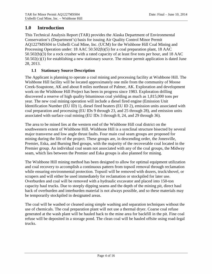
TAR for Minor Permit AQ1227MSS04 Date: Final – June 10, 2014 Usibelli Coal Mine, Inc. – Wishbone Hill 1.0 Introduction This Technical Analysis Report (TAR) provides the Alaska Department of Environmental Conservation’s (Department’s) basis for issuing Air Quality Control Minor Permit AQ1227MSS04 to Usibelli Coal Mine, Inc. (UCM) for the Wishbone Hill Coal Mining and Processing Operation under: 18 AAC 50.502(b)(5) for a coal preparation plant, 18 AAC 50.502(b)(3) for a rock crusher with a rated capacity of at least five tons per hour, and 18 AAC 50.502(c)(1) for establishing a new stationary source. The minor permit application is dated June 28, 2013.
1.1 Stationary Source Description The Applicant is planning to operate a coal mining and processing facility at Wishbone Hill. The Wishbone Hill facility will be located approximately one mile from the community of Moose Creek-Soapstone, AK and about 8 miles northeast of Palmer, AK. Exploration and development work on the Wishbone Hill Project has been in progress since 1983. Exploration drilling discovered a reserve of high quality bituminous coal yielding as much as 1,815,000 tons per year. The new coal mining operation will include a diesel fired engine (Emission Unit Identification Number (EU ID) 1), diesel fired heaters (EU ID 2), emission units associated with coal preparation and processing (EU IDs 9 through 23, and 25 through 28), and emission units associated with surface coal mining (EU IDs 3 through 8, 24, and 29 through 36).
The area to be mined lies at the western end of the Wishbone Hill coal district on the southwestern extent of Wishbone Hill. Wishbone Hill is a synclinal structure bisected by several major transverse and low angle thrust faults. Four main coal seam groups are proposed for mining during the life of the project. These groups are, in descending order, the Jonesville, Premier, Eska, and Burning Bed groups, with the majority of the recoverable coal located in the Premier group. An individual coal seam not associated with any of the coal groups, the Midway seam, which lies between the Premier and Eska groups is also planned for mining.
The Wishbone Hill mining method has been designed to allow for optimal equipment utilization and coal recovery to accomplish a continuous pattern from topsoil removal through reclamation while ensuring environmental protection. Topsoil will be removed with dozers, truck/shovel, or scrapers and will either be used immediately for reclamation or stockpiled for later use. Overburden and coal will be removed with a hydraulic excavator and placed into 150-ton capacity haul trucks. Due to steeply dipping seams and the depth of the mining pit, direct haul back of overburden and interburden material is not always possible, and so these materials may be temporarily stockpiled in designated areas.
The coal will be washed or cleaned using simple washing and separation techniques without the use of chemicals. The coal preparation plant will not use a thermal dryer. Coarse coal refuse generated at the wash plant will be hauled back to the mine area for backfill in the pit. Fine coal refuse will be deposited in a storage pond. The clean coal will be hauled offsite using road-legal trucks.
Page 4 of 16
TAR for Minor Permit AQ1227MSS04 Date: Final – June 10, 2014 Usibelli Coal Mine, Inc. – Wishbone Hill The main elements of the coal processing plant are a run-of-mine stockpile, a run-of-mine hopper, the 350 ton per hour crushing and screening plant, the preparation plant, and the clean coal stockpile. The coal will be transported to the wash plant from the pit area in 150-ton capacity haul trucks. At the wash plant, the coal will be either stockpiled or direct loaded into the run-of-mine hopper for processing through the wash plant. The run-of-mine stockpile has a capacity of 100,000 tons to enable continued plant operation during any unexpected lapses in haulage from the pit area. A front end loader will be used to load the stockpiled coal into the hopper for processing. The hopper will feed coal to a grizzly for sizing, then onto a feed breaker to further reduce the material size to a maximum of 8 inches. This feed will proceed to the crushing and screening circuit for sizing at 3-inch and 3/8-inch. The material falling between 3-inch and 3/8-inch will be the feed to the preparation circuit. Plus 3-inch material will pass through a grizzly and be crushed to a maximum 3-inch size. These two streams will be recombined before entering the preparation circuit. The minus 3/8-inch material will be separated and will either be blended into the feed stream for the washing circuit or blended with the clean coal being shipped from the facility. The 3-inch to 3/8-inch material will be processed through the wash plant which will consist of heavy media cyclones and spirals to separate the coal from the parting material. The final step will be to centrifuge the fine clean coal to reduce the moisture content.
Under maximum production, the plant will be operated seven days per week with three 8-hour shifts per day. No chemicals, other than inert flocculent used to settle the fine coal waste, will be used in the washing process. Drying will be accomplished using a centrifuge and, as indicated above, no thermal drying of washed coal will occur at the site.
Coarse coal refuse will be loaded from the coarse coal refuse bin into the same trucks hauling coal to the plant for transport back to the pit area. The refuse will be directly placed in areas of current backfilling and will be buried a minimum of four feet below the regarded surface of the overburden material.
Onsite coal storage will be located, adjacent to the processing plant. A truck loadout bin will be used to load the stockpiled coal into highway-legal, covered trucks for delivery.
1.2 Permit History The Department issued several permits to operate for the Wishbone Hill site during the 1990s, but the permits were never operated under, and have subsequently expired.
UCM has since submitted several permit applications to establish mining and processing operations at the Wishbone Hill site, but due to project scope changes these applications were withdrawn.
On June 28, 2013, the Applicant submitted a new application, as Project ID AQ1227MSS04. The June 2013 application is the subject of this permitting action.
Page 5 of 16
TAR for Minor Permit AQ1227MSS04 Date: Final – June 10, 2014 Usibelli Coal Mine, Inc. – Wishbone Hill
1.3 Application Description In this application, UCM proposed to establish the Wishbone Hill stationary source with the main purpose of coal extraction and processing. UCM has requested the following:
1. Install a new 900 hp backup diesel electric generator, listed as EU ID 1;
2. Install space heaters up to, and including, a maximum of 10 MMBtu/hr total, listed as EU ID 2;
3. Install a coal preparation and processing plant consisting of related coal conveying, crushing, and cleaning, listed as EU IDs 9 through 23, and 25 through 28. Use centrifuge for drying the coal and not use thermal dryers in the preparation of the coal. Not using thermal dryers in preparation of the coal allows the source to avoid being classified as one of the 100 tpy special category sources under 40 CFR 52.21(b)(1)(iii);
4. Install emission units associated with surface coal mining, listed as EU IDs 3 through 8, 24, and 29 through 36;
5. Maintain adherence to the Public Access Control Plan;
6. Maintain adherence to the Fugitive Dust Control Plan; and
7. Characterize the stationary source fugitive emissions and their impact on ambient air quality.
The Applicant provided an emissions unit inventory in the application as shown in Table 1 (Emission Unit Inventory) of Minor Permit AQ01227MSS04.
The majority of the emissions identified in the permit application, are fugitive dust emissions. Minor permits must conditionally assess their fugitive emissions for the purposes of permit classification in accordance with the federal rules adopted under 18 AAC 50.502(i). These adopted federal rules, detailed in 40 C.F.R. 51.165, include a list of stationary source categories for which fugitive emissions must be assessed, i.e. a list of major stationary sources. The last stationary source category listed under 40 C.F.R. 51.165(a)(1)(iv)(C)(27) states that “Any other stationary source category which, as of August 7, 1980, is being regulated under section 111 or 112 of the [Clean Air] Act”, is included among the list of major stationary sources.
Similarly, fugitive emissions from certain emission units associated with the coal preparation and processing plant should be included in determining whether the stationary source is or is not a major Prevention of Significant Deterioration (PSD) stationary source. Per 18 AAC 50.306(b), to meet the requirement to obtain a PSD permit an owner or operator must comply with the requirements of 40 Code of Federal Regulation (C.F.R.) 52.21, as opposed to the requirements of 40 C.F.R. 51.165. The applicable requirement in this case is 40 C.F.R. 52.21(b)(1)(iii)(aa), which states “The fugitive emissions of a stationary source shall not be included in determining for any of the purposes of this section whether it is a major stationary source, unless the source belongs to one of the following categories of stationary sources: Any other stationary source category which, as of August 7, 1980, is being regulated under section 111 or 112 of the Act.”
A “new source performance standard” (NSPS) for coal preparation and processing plants2, i.e. a stationary source category regulated under Section 111 of the Act, became effective in January,
2 40 C.F.R. 60, Subpart Y
Page 6 of 16
TAR for Minor Permit AQ1227MSS04 Date: Final – June 10, 2014 Usibelli Coal Mine, Inc. – Wishbone Hill 19763. The NSPS for coal preparation and processing plants is found at 40 C.F.R. 60, Subpart Y (§§60.250 – 60.258).
A coal preparation and processing plant is defined at 40 C.F.R. 60.251(e) as “any facility (excluding underground mining operations) which prepares coal by one or more of the following processes: breaking crushing, screening, wet or dry cleaning, and thermal drying.” Affected facilities within the coal preparation and processing plant are thermal dryers, pneumatic coal-cleaning equipment (air tables), coal processing and conveying equipment (including breakers and crushers), coal storage systems, transfer and loading systems, and open storage piles, per 40 C.F.R. 60.250(d).
In a letter to the Indiana Department of Environmental Management dated March 6, 2003, the U.S. Environmental Protection Agency (EPA) provided guidance with respect to determining which fugitive emissions count toward permit applicability for stationary sources such as the Wishbone Hill coal mine that are not themselves affected under 40 C.F.R. 52.21(b)(1)(iii)(aa) and 51.165(a)(1)(iv)(C)(27), but include facilities that are affected under those rules. A specific example from that guidance, which is applicable in this case, states:
“A coal mine with an onsite coal cleaning plant with a thermal dryer. The primary activity of the source, in this example, is the mining of coal, and coal mines are not a listed source category. The coal cleaning plant, however, does fall within a listed source category. You include fugitive emissions only from the coal cleaning plant to determine if the source is a major stationary source.”
Based on the definition of coal preparation and processing plant and the aforementioned EPA guidance addressing fugitive emissions, the following Wishbone Hill emission units and activities are determined to be included as part of the coal preparation and processing plant.
• EU ID 9: Coal Dumping – Crusher Feeder • EU ID 10: Coal Dumping – Run-of-Mine Pile • EU ID 11: Coal Reclaim – Run-of-Mine Pile • EU ID 12: Crusher • EU ID 13: Transfer – Crusher to Conveyor 1 • EU ID 14: Transfer – Conveyor to Raw Stockpile • EU ID 15: Transfer – Raw Stockpile to Conveyor 2 • EU ID 16: Transfer – Conveyor 2 to Jig Plant • EU ID 17: Transfer – Jig Plant to Conveyor 3 • EU ID 18: Transfer – Conveyor 3 to Reject Stockpile • EU ID 19: Transfer – Jig Plant to Conveyor 4 • EU ID 20: Transfer – Conveyor 4 to Clean Coal Stockpile • EU ID 21: Transfer – Clean Coal Stock Pile to Conveyor 5 • EU ID 22: Transfer – Conveyor 5 to Loadout Bin • EU ID 23: Transfer – Loadout Bin to Truck • EU ID 25: Wind Erosion – Run-of-Mine Coal Stockpile • EU ID 26: Wind Erosion – Raw Coal Stockpile • EU ID 27: Wind Erosion – Clean Coal Stockpile • EU ID 28: Wind Erosion – Reject Stockpile
3 Federal Register Volume 74 Number 194 Pages 51950 - 51985
Page 7 of 16

TAR for Minor Permit AQ1227MSS04 Date: Final – June 10, 2014 Usibelli Coal Mine, Inc. – Wishbone Hill With respect to the above, EU IDs 9, 10, and 11 are included as elements of the coal preparation and processing plant because, in the case of Wishbone Hill, the run-of-mine pile is located immediately adjacent to the coal crusher. These emission units might not be included as elements of the coal preparation and processing plant if the run-of-mine pile was not located in the immediate vicinity of that plant.
EU ID 32 (Coal Hauling within Mine) is not included as an element of the coal preparation and processing plant because coal hauling is a function of the mining operation, not the coal preparation and processing plant operation. Since coal mining is not affected under 40 C.F.R. 52.21(b)(1)(iii)(aa) and 51.165(a)(1)(iv)(C)(27), fugitive emissions from coal hauling within the mine do not count toward permit applicability. Similarly, EU ID 35 (Coal Truck Haul – Loop Road) is not included as an element of the coal preparation and processing plant because delivering coal to off-site locations is not an element of the coal preparation and processing plant operation.
Therefore, the fugitive emissions associated with the Wishbone Hill coal preparation and processing plant units listed above are included for the purposes of determining PSD applicability and minor air quality permit classification. Since surface coal mines are not among the listed stationary source categories, the fugitive emissions associated with the surface coal mine, i.e. those emissions not associated with the primary activity4 of the listed stationary source, are not included for the purposes of permit classification5.
The Applicant evaluated the mine emissions to ensure that they do not cause or contribute to a violation of the 1-hour and annual average nitrogen dioxide (NO2) and the 24-hour PM-10 Alaska Ambient Air Quality Standard (AAAQS).
The Department’s finding regarding this application are listed in Section 1.5.
1.4 Emissions Summary and Permit Applicability In their application dated June 28, 2013, UCM provided emissions calculations for the engines, heaters and fugitive dust sources. UCM used the following assumptions in their calculations.
1. Highline power will be the primary electrical power source for the mine, and EU ID 1 (Diesel Engine) will provide emergency backup electric power for the operations at the Wishbone Hill mine site when there is a loss of highline power. UCM used a conservative approach of 8,760 hours of operation for the emissions estimates and the AAAQS demonstration, even though the unit is an emergency generator that will be used only when highline power will be interrupted. UCM used the manufacturer not-to-exceed (NTE) emission factors, to show compliance at the maximum practical operations.
2. EU ID 2 (Heaters) will provide space heating to the structures at the mine site. Pollutant emission rates were computed using EPA’s AP-42 emission factors (Table 1.3-1) and 8,760 hour of operation per year to conservatively calculate potential emissions.
4 The primary activities associated with a coal preparation and processing plant include coal processing and conveying equipment (including breakers and crushers), coal storage systems, transfer and loading systems, and open storage piles.
5 Janet McCabe, Indiana Office of Air Quality (“2003 McCabe Memorandum” Pages 3 and 4).
Page 8 of 16
TAR for Minor Permit AQ1227MSS04 Date: Final – June 10, 2014 Usibelli Coal Mine, Inc. – Wishbone Hill
3. Fugitive Emission Sources – UCM based the fugitive emissions estimates for coal mining and processing activities on maximum expected operations and AP-42 emission factors. PM-10 emission factors for topsoil removal (EU ID 3), blasting operations (EU IDs 4 and 5), coal truck loading (EU ID 8), coal dumping and reclaim operations (EU IDs 9 through 11), and grader operations (EU ID 29) are from AP-42, Table 11-9.1. The PM-10 emission factor for rock crushing operations (EU ID 12) is from AP-42, Table 11.19.2-2 for uncontrolled tertiary crushing. PM-10 emission factors for overburden removal operations (EU IDs 6 and 7) and coal processing operations (EU IDs 13 through 23) are calculated using AP-42, Section 13.2.4, Eq. 1. PM-10 emission factors for mine site mobile equipment operations (EU IDs 29 through 36) are calculated using AP-42, Section 13.2.2, Eq. 1a. For PM-10 emissions attributable to wind erosion (EU IDs 24 through 28), UCM utilized the material classifications listed in AP-42, Table 13.2.5-2 to establish requisite threshold friction velocities, using the “uncrusted coal pile” classification for the site’s clean coal stockpile (EU ID 27) and the “scoria” classification for all other mine site stockpiles; and AP-42, Section 13.2.5, Eq. 2 to calculate the annual PM-10 potential emissions based on short-term wind speed data (maximum daily 2-minute average wind speed data from 7 years of Palmer Airport National Weather Service station data). NOx emissions from blasting operations (EU IDs 4 and 5) are calculated using AP-42, Table 13.3-1. Both NOx and PM-10 blasting emission rates are assumed by UCM to reflect one blast per day at a specified maximum blasting agent (ammonium nitrate and fuel oil (ANFO)) usage of 17,400 pounds ANFO per blast. Finally, to determine PM-2.5 emission rates, UCM provided (October 16, 2013 application supplement) PM-2.5 to PM-10 ratios from AP-42 for the point sources and the affected fugitive emission units listed in Section 1.3 above (except for EU IDs 1 and 12 which UCM assumed all PM-10 is PM-2.5).
4. The application used AP-42 emission factors to calculate fugitive emissions associated with topsoil operations (EU ID 3) and mobile equipment (EU IDs 29 through 36), along with an 80 percent emissions reduction to account for wet suppression or other control techniques. To achieve this control, the Department has imposed fugitive dust control permit conditions requiring frequent visible emissions monitoring (and record keeping and reporting), and application of wet suppression or other emissions reduction techniques in affected areas.
5. As discussed in Section 1.3, in addition to point source emissions (EU IDs 1 and 2), fugitive particulate emissions from the coal preparation and processing plant (EU IDs 9 through 23, and 25 through 28) are included for the purposes of determining PSD and minor air quality permit classification.
6. Based on Items 1 through 5 above, the unrestricted emissions for Wishbone Hill show that the stationary source is a true minor source. The Department is therefore not requiring a limitation or restriction on any of the emissions units for permit threshold applicability avoidance purposes. This notwithstanding, the permit does contain blast operating restrictions; however, such is for purposes of 1-hour NO2 AAAQS compliance (and for noise curtailment which is unrelated to this permit).
As indicated above, the Applicant used emission factors from a variety of sections of AP-42 and manufacturer’s data. Therefore, the Department has included tables in Appendix A to list the Emissions Factors and the origin of each factor in a single concise reference.
Page 9 of 16
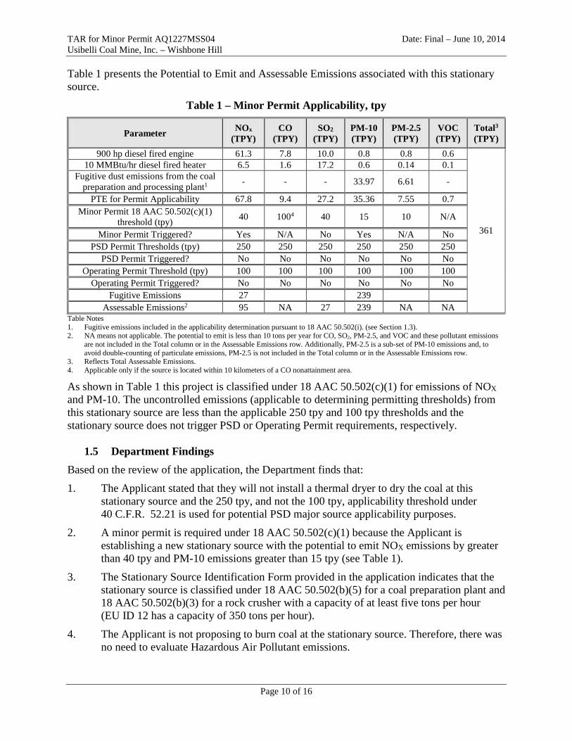
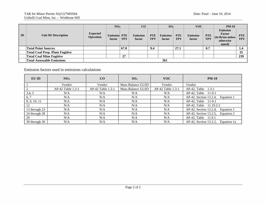
TAR for Minor Permit AQ1227MSS04 Date: Final – June 10, 2014 Usibelli Coal Mine, Inc. – Wishbone Hill Table 1 presents the Potential to Emit and Assessable Emissions associated with this stationary source.
Table 1 – Minor Permit Applicability, tpy
Parameter NOx (TPY)
CO (TPY)
SO2
(TPY) PM-10
(TPY) PM-2.5 (TPY)
VOC (TPY)
Total3 (TPY)
900 hp diesel fired engine 61.3 7.8 10.0 0.8 0.8 0.6
361
10 MMBtu/hr diesel fired heater 6.5 1.6 17.2 0.6 0.14 0.1 Fugitive dust emissions from the coal
preparation and processing plant1 - - - 33.97 6.61 -
PTE for Permit Applicability 67.8 9.4 27.2 35.36 7.55 0.7 Minor Permit 18 AAC 50.502(c)(1)
threshold (tpy) 40 1004 40 15 10 N/A
Minor Permit Triggered? Yes N/A No Yes N/A No PSD Permit Thresholds (tpy) 250 250 250 250 250 250
PSD Permit Triggered? No No No No No No Operating Permit Threshold (tpy) 100 100 100 100 100 100
Operating Permit Triggered? No No No No No No Fugitive Emissions 27 239
Assessable Emissions2 95 NA 27 239 NA NA Table Notes 1. Fugitive emissions included in the applicability determination pursuant to 18 AAC 50.502(i). (see Section 1.3). 2. NA means not applicable. The potential to emit is less than 10 tons per year for CO, SO2, PM-2.5, and VOC and these pollutant emissions
are not included in the Total column or in the Assessable Emissions row. Additionally, PM-2.5 is a sub-set of PM-10 emissions and, to avoid double-counting of particulate emissions, PM-2.5 is not included in the Total column or in the Assessable Emissions row.
3. Reflects Total Assessable Emissions. 4. Applicable only if the source is located within 10 kilometers of a CO nonattainment area.
As shown in Table 1 this project is classified under 18 AAC 50.502(c)(1) for emissions of NOX and PM-10. The uncontrolled emissions (applicable to determining permitting thresholds) from this stationary source are less than the applicable 250 tpy and 100 tpy thresholds and the stationary source does not trigger PSD or Operating Permit requirements, respectively.
1.5 Department Findings Based on the review of the application, the Department finds that:
1. The Applicant stated that they will not install a thermal dryer to dry the coal at this stationary source and the 250 tpy, and not the 100 tpy, applicability threshold under 40 C.F.R. 52.21 is used for potential PSD major source applicability purposes.
2. A minor permit is required under 18 AAC 50.502(c)(1) because the Applicant is establishing a new stationary source with the potential to emit NOX emissions by greater than 40 tpy and PM-10 emissions greater than 15 tpy (see Table 1).
3. The Stationary Source Identification Form provided in the application indicates that the stationary source is classified under 18 AAC 50.502(b)(5) for a coal preparation plant and 18 AAC 50.502(b)(3) for a rock crusher with a capacity of at least five tons per hour (EU ID 12 has a capacity of 350 tons per hour).
4. The Applicant is not proposing to burn coal at the stationary source. Therefore, there was no need to evaluate Hazardous Air Pollutant emissions.
Page 10 of 16
TAR for Minor Permit AQ1227MSS04 Date: Final – June 10, 2014 Usibelli Coal Mine, Inc. – Wishbone Hill 5. The Permit application for Wishbone Hill contains all the elements required by
18 AAC 50.540.
6. The Wishbone Hill mine project is not a PSD-major stationary source because the PTE does not exceed 250 tpy for any pollutant (see Table 1).
7. The Wishbone Hill mine project does not require an Operating Permit because the PTE does not exceed 100 tpy for any pollutant (see Table 1).
8. The annual and 1-hour NO2 and the 24-hour PM-10 AAAQS will be protected. UCM provided an ambient analysis of their NO2 and PM-10 impacts in order to satisfy the requirements of 18 AAC 50.540(c)(2)(A) that demonstrates protection. Details of this analysis are presented in Appendix B to this TAR.
9. In response to public comments, the Department made several revisions to the ambient analysis. The revisions are detailed in the Response to Comment (RTC) document. In summary, the Department: reduced the applied control efficiency for topsoil removal and grader operations (EUs 3 and 29) from 80 percent to 50 percent; included conveyor belt emissions; increased the receptor density around the maximum impact sites and where Right of Way 52715 crosses the access road; and included tailpipe emissions in the NO2 analysis. These changes slightly increased the maximum predicted impacts, but compliance with the AAAQS is still demonstrated. The revised results are provided in Section 2.4 of this TAR.
10. In response to public comments, the Department has included an additional fugitive particulate matter control requirement to the permit that requires Usibelli to perform daily inspections of the coal stockpile area as part of the inspection criteria located on the Daily Fugitive Dust Inspection Log. This is to ensure that coal stockpiles are inspected regularly to minimize potential emissions of fugitive dust, and to require mitigative action is taken if visible emissions are observed.
11. In response to public comments, the Department has removed the exemption from the fugitive particulate matter control requirement to ensure that particulate matter emissions are monitored once per active 8-hour shift, regardless of whether the ambient temperature is below freezing. The exemption for when the road surface is frozen has been removed.
12. In response to public comments, the Department is requiring Usibelli to install additional fencing along the southern ambient air boundary to ensure that a year-round barrier is present. More information on specific fencing locations can be found in the RTC.
13. In response to public comments, the Department has removed the term “credible” from the fugitive particulate matter control recordkeeping requirements to ensure that Usibelli review the fugitive dust plan for any dust complaints that can be attributed to their operations or activities. The Department also removed the underline from the term “any”, as requested by Usibelli.
14. In response to public comments, the Department has included fugitive emissions from haul roads within the coal preparation plant (EU ID 35 coal hauling – loop road), in the potential to emit calculations.
Page 11 of 16
TAR for Minor Permit AQ1227MSS04 Date: Final – June 10, 2014 Usibelli Coal Mine, Inc. – Wishbone Hill 2.0 Permit Conditions
2.1 Requirements for all Minor Permits. As described in 18 AAC 50.544(a)(1), each minor permit issued under 18 AAC 50.542 must identify the stationary source, the project, the Permittee, and contact information. The permit cover page identifies the stationary source, the project, Permittee and contact information.
As required under 18 AAC 50.544(a)(2), the minor permit must contain the fee requirements of 18 AAC 50.400 – 18 AAC 50.499. As shown in Table 1 the assessable emissions are 361 tpy after the issuance of Minor Permit AQ1227MSS04.
The requirements in 18 AAC 50.544(a)(3) do not apply to this permit since the Department did not establish any conditions under 18 AAC 50.201.
The requirements in 18 AAC 50.544(a)(4) do not apply to this permit since it does not contain any owner requested limits under 18 AAC 50.225 that apply to this stationary source.
As described in 18 AAC 50.544(a)(5), the permit contains standard permit conditions under 18 AAC 50 that apply to this stationary source. These limits are in Sections 5 through 8 of the permit.
As described in 18 AAC 50.544(a)(6), the permit contains conditions necessary to protect the ambient air quality in Section 2 of the permit. Additional discussion of these requirements is contained in Section 2.4 of this TAR.
2.2 Requirements for a Minor Permit under18 AAC 50.502(b)(3), 18 AAC 50.502(b)(5), and 18 AAC 50.502(c) for Air Quality Protection
As required under 18 AAC 50.544(b), each minor permit classified under 18 AAC 50.502(b) must contain
(1) terms and conditions as necessary to ensure that the source will comply with the requirements prescribed at 18 AAC 50.544(b)(1) and (2). Sections 5 through 7 of the Permit contain the applicable requirements for sampling emissions according to the methods prescribed by the Department, providing source test reports, monitoring data, emissions data, and information on analyses of any test samples, keeping records, and making periodic reports on process operations and emissions; and
(2) maintenance requirements according to the manufacturer’s or operator’s maintenance procedures, keep records of any maintenance that would have a significant effect on emissions, and keep a copy of either the manufacturer’s or the operator’s maintenance procedures. As required in 18 AAC 50.544(b)(2), the permit includes a condition for maintenance of equipment according to manufacturer’s or operator’s maintenance procedures to ensure compliance with 18 AAC 50 in both Condition 1.1 and Section 7 of the permit.
Page 12 of 16

TAR for Minor Permit AQ1227MSS04 Date: Final – June 10, 2014 Usibelli Coal Mine, Inc. – Wishbone Hill As required under 18 AAC 50.544(c), each minor permit classified under 18 AAC 50.502(c) must contain
(1) terms and conditions as necessary to ensure that the source will not cause or contribute to a violation of an ambient standard. Section 4 of the Permit contains applicable requirements for sampling emissions according to the methods prescribed by the Department, providing monitoring data, emissions data, and information on analyses of any test samples, keeping records, and making periodic reports on process operations and emissions. See Section 2.4 for additional discussion of the ambient air quality analysis;
(2) maintenance requirements according to the manufacturer’s or operator’s maintenance procedures. As required in 18 AAC 50.544(c)(3), the permit includes a condition for maintenance of equipment according to manufacturer’s or operator’s maintenance procedures to ensure compliance with 18 AAC 50 in Section 7 of the permit.
2.3 Requirements for Stationary Sources not Subject to Title V Permitting As required by 18 AAC 50.544(d), each stationary source that is not subject to Title V permitting under 18 AAC 50.326 must periodically affirm that the stationary source is still accurately described by the application and minor permit and whether the owner or operator has made changes that would trigger the requirement for a new permit. This provision is included in Section 5 of the minor permit.
For this project, the requirement pertains to an annual affirmation that there have not been any changes to the source described in the application. This requirement will preclude the additions of new emissions units, addition of thermal dryers or other like changes to the source that could affect Air Quality.
2.4 Ambient Air Quality Protection Requirements The project requires an ambient NO2 and PM-10 analysis per 18 AAC 50.540(c)(2)(A), because the NOX emissions from the new source are greater than 40 tons per year and PM-10 emissions are greater than 15 tons per year (see Table 1). An ambient analysis is not required for other project pollutants since they are emitted at less than applicable thresholds (see Table 1).
In accordance with 18 AAC 50.540(c)(2)(A), UCM submitted an ambient air quality analysis to demonstrate that the impacts associated with the Wishbone Hill Coal Mine comply with the NO2 and PM-10 AAAQS listed in 18 AAC 50.010. UCM included the ambient analysis in their June 28, 2013 application; with supplemental modeling information submitted to the Department on October 16, 2013, February 11, 2014 and February 14, 2014.
Section 4 of the permit contains Conditions to protect the ambient air quality standards for the annual and 1-hour NO2 and for the 24-hour PM-10 AAAQS.
Page 13 of 16
TAR for Minor Permit AQ1227MSS04 Date: Final – June 10, 2014 Usibelli Coal Mine, Inc. – Wishbone Hill Because this stationary source has the potential to create fugitive dust, the Department included Conditions in Section 4 for adherence to the fugitive dust control plan proposed by the Applicant. Included in their dust plan, UCM has committed to reducing emissions associated with the vehicle movements inside the mine and on the access roads. Therefore, the Department has included permit conditions to adhere to these reduction techniques in the Fugitive Dust Control Plan. The Department also added additional dust monitoring requirements to ensure that UCM performs visual surveys at regular intervals, initiates corrective actions upon discovering dust leaving the ambient boundary, keeps records of visual surveys, records and reports any complaints received, and if necessary revise the Fugitive Dust Control Plant with Department approval.
For the annual and 1-hour NO2, and the 24-hour PM-10 air quality compliance purposes, the Department has also included in Section 4 of the permit, restrictions on UCM’s coal and overburden blasting operations.
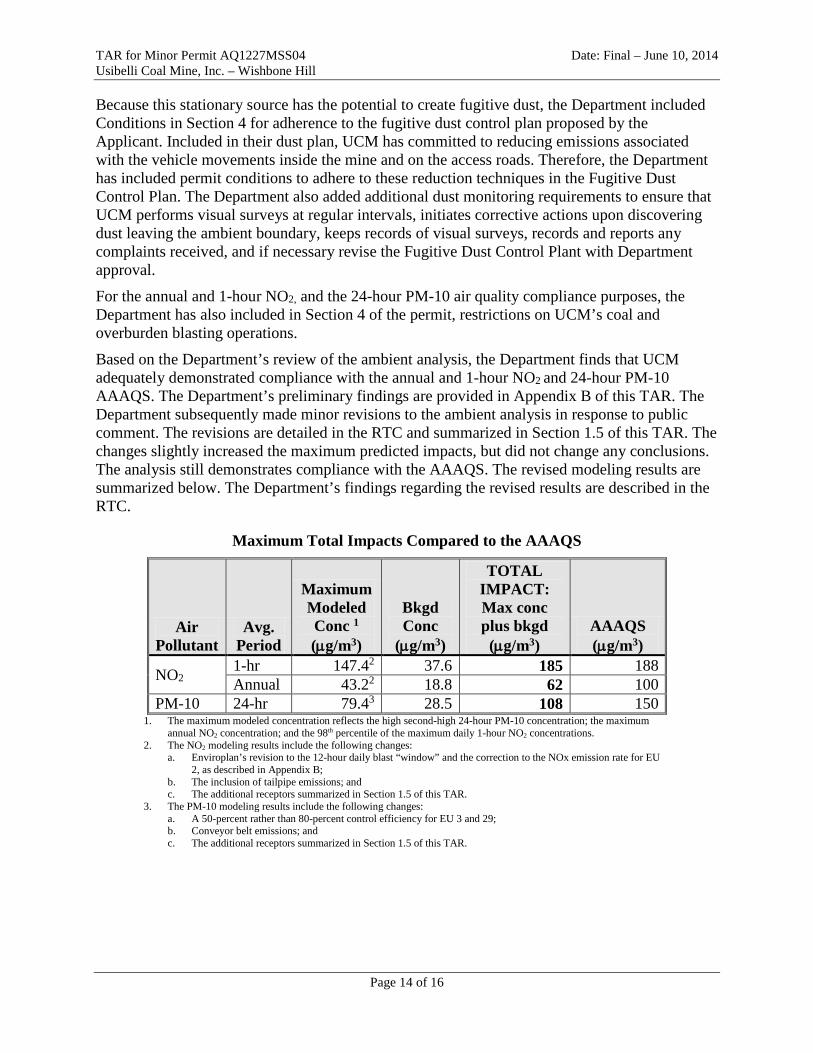
Based on the Department’s review of the ambient analysis, the Department finds that UCM adequately demonstrated compliance with the annual and 1-hour NO2 and 24-hour PM-10 AAAQS. The Department’s preliminary findings are provided in Appendix B of this TAR. The Department subsequently made minor revisions to the ambient analysis in response to public comment. The revisions are detailed in the RTC and summarized in Section 1.5 of this TAR. The changes slightly increased the maximum predicted impacts, but did not change any conclusions. The analysis still demonstrates compliance with the AAAQS. The revised modeling results are summarized below. The Department’s findings regarding the revised results are described in the RTC.
Maximum Total Impacts Compared to the AAAQS
Air Pollutant
Avg. Period
Maximum Modeled Conc 1 (µg/m3)
Bkgd Conc
(µg/m3)
TOTAL IMPACT: Max conc plus bkgd
(µg/m3) AAAQS (µg/m3)
NO2 1-hr 147.42 37.6 185 188 Annual 43.22 18.8 62 100
PM-10 24-hr 79.43 28.5 108 150 1. The maximum modeled concentration reflects the high second-high 24-hour PM-10 concentration; the maximum
annual NO2 concentration; and the 98th percentile of the maximum daily 1-hour NO2 concentrations. 2. The NO2 modeling results include the following changes:
a. Enviroplan’s revision to the 12-hour daily blast “window” and the correction to the NOx emission rate for EU 2, as described in Appendix B;
b. The inclusion of tailpipe emissions; and c. The additional receptors summarized in Section 1.5 of this TAR.
3. The PM-10 modeling results include the following changes: a. A 50-percent rather than 80-percent control efficiency for EU 3 and 29; b. Conveyor belt emissions; and c. The additional receptors summarized in Section 1.5 of this TAR.
Page 14 of 16
TAR for Minor Permit AQ1227MSS04 Date: Final – June 10, 2014 Usibelli Coal Mine, Inc. – Wishbone Hill
2.5 State Emission Standards The following sections pertain to the new Wishbone Hill coal mining and processing stationary source.
2.5.1 Visible Emission Standard The diesel fired engine and the diesel heaters (EU IDs 1 and 2) are fuel-burning equipment subject to the state standards for visible emissions in 18 AAC 50.055(a)(1).
The coal preparation and processing plant emission units (EU IDs 9 through 23) are subject to the state standards for visible emissions in 18 AAC 50.055(a)(5). The open storage piles, EU IDs 25 through 28, have not been included as part of the coal preparation and processing plant (i.e., are not determined as an industrial process). While 18 AAC 50.990(22) does define a coal preparation plant, such does not include open storage piles. Further, the open storage piles do not meet the definition of an industrial process at 18 AAC 50.990(49).
All other emission units at the source are associated with coal mining operation and are not industrial processes and not subject to the state standard for visible emissions in 18 AAC 50.055(a)(1).
The diesel-fired engine, diesel-fired heaters, and coal preparation and processing plant equipment have the potential to exceed the visible emission standard. Therefore, the Department is requiring UCM to verify compliance by conducting initial visible emission observations on the equipment within 30-days after startup and to perform periodic monitoring for continued compliance with the standard.
Periodic MR&R requirements have been added to the permit to ensure that the new units comply with the state opacity standard on a continuous basis.
2.5.2 Particulate Matter Standard EU IDs 1 and 2 are fuel-burning equipment and EU ID 12 is considered an industrial process, they are subject to the state standards for particulate matter (PM) emissions of 0.05 grains per dry standard cubic foot of exhaust gas (gr./dscf) in 18 AAC 50.055(b)(1).
All other emission units at the source are associated with coal mining operation and are not industrial processes and not subject to the state standard for PM in 18 AAC 50.055(b)(1).
UCM included a compliance demonstration in the application for the diesel engine and heaters, EU IDs 1 and 2. The PM emissions for the diesel engine is derived from manufacturer supplied emission data. The PM emissions for the diesel heaters are based on AP-42 emission factors. The permit does not include requirements of an initial source test for these units, as the Department concurs with the submitted compliance demonstration.
UCM did not include an initial compliance demonstration in the application for the rock crusher, EU ID 12, and therefore must demonstrate continuous compliance with the PM standard by taking reasonable precautions to prevent the release of airborne fugitive dust. Compliance with the standard will be demonstrated through monitoring, using visible observations to ensure that dust is continuously controlled.
Page 15 of 16
TAR for Minor Permit AQ1227MSS04 Date: Final – June 10, 2014 Usibelli Coal Mine, Inc. – Wishbone Hill Since Wishbone Hill will not have a Title V operating permit after issuance of AQ1227MSS04, the Department included periodic monitoring, recordkeeping, and reporting (MR&R) requirements in the minor permit, along with the fugitive dust control plan to ensure continued compliance with the state PM emissions standards.
2.5.3 Sulfur Dioxide Standard EU IDs 1 and 2 are fuel-burning equipment subject to the state standards for SO2 emissions in 18 AAC 50.055(c). All other emission units, including coal preparation and processing plant emission units, are not sources of sulfur compound emissions and not subject to the state standard for SO2 emissions in 18 AAC 50.055(c).
UCM included a compliance demonstration in the application for the diesel engine, EU ID 1, and diesel heater, EU ID 2. To comply with the state standards, a Permittee must combust a fuel with a sulfur content less that 0.75 percent Sulfur (which is 7,500 ppm), which conservatively ensures that the emission unit will comply with the state standard of 500 ppm of SO2 in the exhaust. Since ultra-low sulfur diesel (ULSD) fuel is 15 ppm of sulfur, versus the maximum allowable, the resulting SO2 emissions on a ppm basis are many orders of magnitude below the state standard for SO2, resulting in an SO2 concentration in the exhaust of approximately 1 ppm.
The Department has included MR&R requirements for fuel oil sulfur content in Section 3 of the permit to ensure compliance with the state standards in 18 AAC 50.055(c).
2.6 Other Permit Conditions The minor permit contains additional requirements as necessary to ensure that the Permittee will construct and operate the stationary source in accordance with 18 AAC 50, as described in 18 AAC 50.544(i). These requirements are listed in the minor permit under “Standard Conditions”.
3.0 Permit Administration UCM is authorized to construct and operate the stationary source upon issuance.
New Source Performance Standards (NSPS) and National Emission Standards for Hazardous Air Pollutants (NESHAP) requirements are not part of the State of Alaska’s minor permit program, and are not included in Minor Permits. The stationary source based on its emissions level is not subject to Title V permitting (18 AAC 50.326), where the NSPS or NESHAP requirements would reside in a State issued permit, therefore UCM is obligated to coordinate all associated NSPS and NESHAP requirements with EPA, and courtesy copy the state on all submittals to the EPA. The Department has determined that at a minimum, the stationary source is subject to one NSPS, specifically 40 C.F.R. 60 Subpart Y, as a Coal Preparation and Processing Plant.
Based on the manufacturer date of the diesel engine being selected, and that the stationary source is an Area Source in regards to NESHAP, the Department believes that Unit 1 will be subject to provisions of NESHAP Subpart ZZZZ, the actual portions that it is subject to will not be included in this permit.
Page 16 of 16

TAR for Minor Permit AQ1227MSS04 Date: Final – June 10, 2014 Usibelli Coal Mine, Inc. – Wishbone Hill
Appendix A - Emission Calculations
ID Unit ID/ Description Expected Operation
NOX CO SO2 VOC PM-10
Emission factor
PTE TPY
Emission factor
PTE TPY
Emission factor
PTE TPY
Emission factor
PTE TPY
Emission Factor
(In lb/ton unless otherwise
noted)
PTE TPY
1 Power Generation - Diesel-fired Engine 8,760 hr/yr 14.0 lb/hr 61.3 1.77 lb/hr 7.8 0.75 % S 10.0 0.14 lb/hr 0.6 0.18 lb/hr 0.8
2 Diesel-fired Heaters 8,760 hr/yr 20 lb/103 gal 6.5 0.036
lb/MMBtu 1.6 0.75 % S 17.2 0.002 lb/MMBtu 0.1 2 lb/103 gal 0.6
3 Topsoil removal and storage 2,660 hr/yr N/A N/A N/A N/A N/A N/A N/A N/A 32.0 lb/hr 21.28 4 Overburden blasting 240 blast/yr N/A N/A N/A N/A N/A N/A N/A N/A 11.32 lb/blast 1.3584 5 Coal blasting 120 blast/yr N/A 27 N/A N/A N/A N/A N/A N/A 11.32 lb/blast 0.6792 6 Overburden truck loading 4,234,000 tpy N/A N/A N/A N/A N/A N/A N/A N/A 0.00013 0.285 7 Overburden dumping 4,234,000 tpy N/A N/A N/A N/A N/A N/A N/A N/A 0.00013 0.285 8 Coal removal 1,815,000 tpy N/A N/A N/A N/A N/A N/A N/A N/A 0.01779 16.148 9 Coal dumping –Crusher feeder 1,815,000 tpy N/A N/A N/A N/A N/A N/A N/A N/A 0.01779 16.148 10 Coal dumping from run of mine pile 605,000 tpy N/A N/A N/A N/A N/A N/A N/A N/A 0.01779 5.383 11 Coal Reclaim from run of mine pile 605,000 tpy N/A N/A N/A N/A N/A N/A N/A N/A 0.01779 5.383 12 Crusher 350 tph N/A N/A N/A N/A N/A N/A N/A N/A 0.0024 3.679 13 Transfer-Crusher to conveyor 1,815,000 tpy N/A N/A N/A N/A N/A N/A N/A N/A 0.00020 0.183 14 Transfer-Conveyor 1 to raw stockpile 1,815,000 tpy N/A N/A N/A N/A N/A N/A N/A N/A 0.00020 0.183 15 Transfer-Raw stockpile to conveyor 2 1,815,000 tpy N/A N/A N/A N/A N/A N/A N/A N/A 0.00020 0.183 16 Transfer-Conveyor 2 to Jig Plant 1,815,000 tpy N/A N/A N/A N/A N/A N/A N/A N/A 0.00020 0.183 17 Transfer-Jig Plant to Conveyor 3 815,000 tpy N/A N/A N/A N/A N/A N/A N/A N/A 0.00013 0.055 18 Transfer-Conveyor 3 to reject stockpile 815,000 tpy N/A N/A N/A N/A N/A N/A N/A N/A 0.00013 0.055 19 Transfer- Jig plant to conveyor 4 1,000,000 tpy N/A N/A N/A N/A N/A N/A N/A N/A 0.00013 0.067 20 Transfer-Conveyor 4 to clean stockpile 1,000,000 tpy N/A N/A N/A N/A N/A N/A N/A N/A 0.00013 0.067 21 Transfer-Clean stockpile to conveyor 5 1,000,000 tpy N/A N/A N/A N/A N/A N/A N/A N/A 0.00013 0.067 22 Transfer-Conveyor 5 to loadout bin 1,000,000 tpy N/A N/A N/A N/A N/A N/A N/A N/A 0.00013 0.067 23 Transfer- loadout bin to truck 1,000,000 tpy N/A N/A N/A N/A N/A N/A N/A N/A 0.00013 0.067 24 Wind erosion- mine area 168 acres N/A N/A N/A N/A N/A N/A N/A N/A 52.4 g/m2/yr 41.017 25 Wind erosion - run-of-mine coal stockpile 4 acres N/A N/A N/A N/A N/A N/A N/A N/A 52.4 g/m2/yr 0.977 26 Wind erosion- raw coal stockpile 1.5 acres N/A N/A N/A N/A N/A N/A N/A N/A 52.4 g/m2/yr 0.366 27 Wind Erosion – clean coal stockpile 1.5 acres N/A N/A N/A N/A N/A N/A N/A N/A 124.8 g/m2/yr 0.835 28 Wind Erosion –reject stockpile 0.1 acres N/A N/A N/A N/A N/A N/A N/A N/A 52.4 g/m2/yr 0.024 29 Mobile Equipment – grader operations 13,122 VMT/yr N/A N/A N/A N/A N/A N/A N/A N/A 0.765 lb/VMT 2.51 30 Mobile Equipment – overburden hauling - backfill 19,340 VMT/yr N/A N/A N/A N/A N/A N/A N/A N/A 4.46 lb/VMT 8.626 31 Mobile Equipment – overburden hauling - stockpile 137,413 VMT/yr N/A N/A N/A N/A N/A N/A N/A N/A 4.46 lb/VMT 61.286 32 Mobile Equipment – coal hauling within mine 14,103 VMT/yr N/A N/A N/A N/A N/A N/A N/A N/A
0.874 lb/VMT 26.274 33 Mobile Equipment – miscellaneous mine traffic 50,000 VMT/yr N/A N/A N/A N/A N/A N/A N/A N/A 34 Mobile Equipment – other vehicle traffic 236,520 VMT/yr N/A N/A N/A N/A N/A N/A N/A N/A 35 Mobile Equipment – coal truck haul – loop road 4,410 VMT/yr N/A N/A N/A N/A N/A N/A N/A N/A 2.42 lb/VMT 1.067 36 Off Source – coal truck haul – access road 101,430 VMT/yr N/A N/A N/A N/A N/A N/A N/A N/A 2.42 lb/VMT 24.546
Page 1 of 2
TAR for Minor Permit AQ1227MSS04 Date: Final – June 10, 2014 Usibelli Coal Mine, Inc. – Wishbone Hill
ID Unit ID/ Description Expected Operation
NOX CO SO2 VOC PM-10
Emission factor
PTE TPY
Emission factor
PTE TPY
Emission factor
PTE TPY
Emission factor
PTE TPY
Emission Factor
(In lb/ton unless otherwise
noted)
PTE TPY
Total Point Sources 67.8 9.4 27.1 0.7 1.4 Total Coal Prep. Plant Fugitive 35 Total Coal Mine Fugitive 27 239 Total Assessable Emissions 361 Emission factors used in emissions calculations
EU ID NOX CO SO2 VOC PM-10
1 Vendor Vendor Mass Balance ULSD Vendor Vendor 2 AP-42 Table 1.3-1 AP-42 Table 1.3-1 Mass Balance ULSD AP-42 Table 1.3-1 AP-42, Table 1.3-1 3,4, 5 N/A N/A N/A N/A AP-42, Table 11-9.1 6, 7 N/A N/A N/A N/A AP-42, Section 13.2.4, Equation 1 8, 9, 10, 11 N/A N/A N/A N/A AP-42, Table 11-9.1 12 N/A N/A N/A N/A AP-42, Table 11.19.2-2 13 through 23 N/A N/A N/A N/A AP-42, Section 13.2.4, Equation 1 24 through 28 N/A N/A N/A N/A AP-42, Section 13.2.5, Equation 2 29 N/A N/A N/A N/A AP-42, Table 11.9.1 30 through 36 N/A N/A N/A N/A AP-42, Section 13.2.2, Equation 1a
Page 2 of 2

Appendix B: Air Quality Modeling Review Report Usibelli Coal Mine, Inc. – Wishbone Hill
Appendix B – Review of Usibelli Coal Mine, Inc. – Wishbone Hill March 4, 2014 Ambient Assessment Minor Permit AQ1227MSS04
EXECUTIVE SUMMARY This report summarizes the Department’s findings regarding the ambient assessment submitted by Usibelli Coal Mine, Inc. (UCM) in support of their June 28, 2013 minor permit application (AQ1227MSS04) for the Wishbone Hill Coal Mining and Processing Operation (Wishbone Hill). The review was conducted on behalf of the Department by Enviroplan Consulting. The pollutants subject to this ambient assessment review are oxides of nitrogen (NOx) and particulate matter with an aerodynamic diameter of less than 10 microns (PM-10). UCM’s ambient analysis is consistent with the U.S. Environmental Protection Agency’s (EPA’s) Guideline on Air Quality Models (40 C.F.R. Part 51, Appendix W), 18 AAC 50.215(b) - (e), and the Department approved modeling protocol, except as otherwise indicated herein. UCM’s analysis adequately shows that operating their emissions units (EUs) within the restrictions listed in this report will not cause or contribute to a violation of the 1-hour or annual average nitrogen dioxide (NO2) and 24-hour PM-10 Alaska Ambient Air Quality Standards (AAAQS) provided in 18 AAC 50.010.
BACKGROUND UCM is planning to develop the coal reserves at Wishbone Hill through topsoil removal and coal removal/reclamation. The major project components include a surface coal mine removing 1,815,000 U.S. tons-per-year of raw coal at full production and a coal washing plant for improvement of coal quality. The project will also include topsoil, overburden, and coal removal, handling and storage; and the installation of a coal preparation plant to grind and wash the coal before hauling away from the site. UCM will use a 350 ton-per-hour rock crusher. The Wishbone Hill facility will be located approximately one mile from the community of Moose Creek-Soapstone, AK and about eight miles northeast of Palmer, AK. UCM submitted a modeling protocol for Department review prior to submitting their permit application and ambient demonstration. SLR International Corporation (SLR) prepared the protocol on behalf of UCM. UCM submitted the protocol on December 30, 2011. SLR provided supplemental information upon Department request on January 15, 2012; January 30, 2012; May 10, 2012; July 11, 2012; August 17, 2012; August 30, 2012; December 18, 2012; January 2, 2013; and February 12, 2013. The Department conditionally approved the protocol on February 21, 2013. UCM submitted the minor permit application on June 28, 2013. UCM provided supplemental modeling-related information on October 16, 2013, January 17, 2014, February 11, 2014 and February 14, 2014. UCM’s minor permit application is classified under 18 AAC 50.502(c)(1) for a potential to emit (PTE) of NOx above 40 tons per year (TPY) and PM-10 above 15 TPY. Pursuant to 18 AAC 50.540(c)(2)(A), applicants subject to 18 AAC 50.502(c)(1) must provide an AAAQS analysis for each pollutant for which a permit is required under this classification. UCM fulfilled this requirement by providing an AAAQS demonstration for both NOx and PM-10.
Page 1 of 20

Review of Usibelli Coal Mine, Inc. – Wishbone Hill March 4, 2014 Ambient Assessment Minor Permit AQ1227MSS04 UCM’s minor permit application is also classified under 18 AAC 50.502(b)(3) for a rock crusher with a capacity of at least five tons-per-hour, and 18 AAC 50.502(b)(5) for a coal preparation plant. Both operations have a throughput rating of 350 tons of coal per-hour. Ambient demonstrations are not required for these classifications, unless specifically requested by the Department under 18 AAC 50.540(c)(2)(D). The Department did request a PM-10 analysis as part of its protocol approval. However, the request was unnecessary since the project subsequently triggered the PM-10 demonstration requirement due to the 18 AAC 50.502(c)(1) project classification. APPROACH UCM used computer analysis (modeling) to predict the ambient air quality impacts of NO2 and PM-10. SLR conducted the analysis on behalf of UCM. UCM’s modeling approach is described below. Model Selection There are a number of air dispersion models available to applicants and regulators. EPA lists these models in their Guideline, which the Department has adopted by reference in 18 AAC 50.040(f). UCM used EPA’s AERMOD Modeling System (AERMOD) for the ambient analysis. AERMOD is an appropriate modeling system for this application. The AERMOD Modeling System consists of three major components: AERMAP, used to process terrain data and develop elevations for the receptor grid and EUs; AERMET, used to process the meteorological data; and the AERMOD dispersion model, used to estimate the ambient pollutant concentrations. UCM used AERMAP version 11103; AERMET version 12345; and AERMOD version 12345. These were the current versions at the time UCM submitted their application. EPA revised the AERMOD and AERMET components on December 16, 2013. The current version for both components is now 13350. The Department does not generally make applicants update their ambient demonstrations if there is a subsequent model change. These particular revisions also regard non-applicable, or innocuous aspects, which should not alter UCM’s findings or conclusions. In addition to the non-applicable aspects, EPA has issued a subsequent warning that the changes they made in AERMET version 13350 contains an error that they intend to correct in another update. UCM’s use of AERMET version 12345 and AERMOD version 12345 is, therefore, acceptable. Meteorological Data AERMOD requires hourly meteorological data to estimate plume dispersion. The required surface parameters are wind direction, wind speed, ambient temperature, and either cloud cover or solar radiation and delta-temperature (SRDT) data. AERMOD will also accept a wide-range of additional surface parameters. According to the Guideline, a minimum of one-year of site-specific data, or five years of representative National Weather Service (NWS) data should be used. Per Section 8.3.1.2b of the Guideline, site-specific data is preferred when available.
Page 2 of 20
Review of Usibelli Coal Mine, Inc. – Wishbone Hill March 4, 2014 Ambient Assessment Minor Permit AQ1227MSS04 When modeling with site-specific data, the Guideline states that additional years (up to five) are preferred when available to account for year-to-year variation in meteorological conditions. In all cases the data must be representative of the meteorological transport conditions at the source. Section 8.3 of the Guideline states that “[t]he representativeness of the data is dependent on: (1)The proximity of the meteorological monitoring site to the area under consideration; (2) the complexity of the terrain; (3) the exposure of the meteorological monitoring site; and (4) the period of time during which data are collected.” The data must also meet EPA’s quality assurance requirements. UCM used one year of site-specific surface data, with Palmer NWS cloud cover data and concurrent NWS upper air (sounding) data from the Ted Stevens Anchorage International Airport. This is an acceptable data set for new source review modeling purposes. Additional information regarding this data set, and the Department’s basis for accepting it, are provided below. Usibelli’s Site-Specific Surface Data UCM’s predecessor, McKinley Mining Consultants, Inc. (MMCI), collected surface meteorological data at Wishbone in circa-1990 to support anticipated air quality permit applications. MMCI submitted a monitoring plan for Department review in July 1988. Meteorological monitoring started October 23, 1988. The Department approved MMCI’s monitoring plan on March 1, 1989. The meteorological parameters measured by MMCI were: horizontal wind speed and direction, horizontal wind direction standard deviation (i.e., sigma-theta), ambient temperature, and precipitation. Except for the precipitation data, these were the typical parameters used to support air quality modeling at that time. Precipitation data was not required and was likely collected for non-modeling reasons. MMCI operated their meteorological monitoring station for three years (October 23, 1988 through October 31, 1991); however, they only submitted the October 1988 through December 1990 data for Department review and approval. The initial year of meteorological monitoring had substantive data loss due to high wind events and power loss. MMCI did meet EPA’s 90-percent annual data capture requirement for dispersion modeling applications during monitoring year 1990. UCM used their January - December 1990 data since it meets the requirements in Section 8.3 of the Guideline. They did not use data from the remaining periods since that data does not meet the Section 8.3 requirements for quality assurance reasons. Among other atmospheric parameters, AERMOD requires hourly heat flux values. Daytime (unstable boundary layer) heat flux estimates are determined in AERMET using measurements of either net radiation or solar radiation, temperature data and cloud cover data; and nighttime (stable boundary layer) heat flux estimates utilize cloud cover data. Since the 1990 MMCI meteorological data set did not include on-site net radiation or cloud cover, UCM used concurrent 1990 Palmer NWS cloud cover data to determine heat flux values for their modeling analysis. Given that cloud cover could vary between the mine site and the Palmer Airport, the Department requested UCM to conduct an analysis to determine whether UCM’s modeled impacts are sensitive to variations in cloud cover. UCM conducted the sensitivity analysis, as
Page 3 of 20
Review of Usibelli Coal Mine, Inc. – Wishbone Hill March 4, 2014 Ambient Assessment Minor Permit AQ1227MSS04 described in detail under the Cloud Cover section below, and it showed that variations in cloud cover do not substantively alter the modeling results. This aside, the NWS only recorded 1990 cloud cover data during daylight hours at Palmer, and this resulted in 4,767 missing hours of cloud cover data. UCM used a method to fill the missing cloud cover data, as described in detail under the Cloud Cover section below. The Department approves of UCM’s use of Palmer cloud cover data and their procedure to fill the missing data. While the Department has approved use of the Palmer cloud cover data, the Department does not accept the use of Palmer NWS wind data as a substitute for any missing on-site wind data. The topographical and elevation differences between the Wishbone and Palmer sites are substantive. These terrain differences produce a major shift in predominate wind direction, and the lower elevation and geography surrounding Palmer will likely lead to increased drainage flow (i.e., increased wind speeds and/or directional bias) than what occurs at the Wishbone site. Therefore, the Palmer wind data is not representative of the Wishbone Hill site for air quality modeling purposes and was not used in the AERMET meteorological data processing. Please see the Cloud Cover Sensitivity Analysis section for additional detail on this topic. UCM used all of the measured parameters in their modeling analysis, including the optional sigma-theta and precipitation data. The model uses sigma-theta data to refine atmospheric stability calculations. The model also utilizes precipitation data for the optional particle deposition algorithm (see Particle Deposition discussion herein). In accordance with the Guideline, meteorological data used in a modeling application must be spatially and temporally representative of the source site. The spatial requirement was addressed initially by the Department’s approval of the monitoring plan, and tower siting; and subsequently by UCM in the supplemental cloud cover sensitivity analysis discussed in the section below. In regards to temporal representativeness, the Guideline states that newer data is preferred to older data, but there is no age restriction on a data set. Section 8.3a of the Guideline instead states that the data must “…be viewed in terms of the appropriateness of the data for constructing realistic boundary layer profiles and three dimensional meteorological fields…” This approach is consistent with the general understanding that seasonal variations can be a larger factor in air quality assessments than the climatic variations that may occur over time. The Guideline, therefore, established minimum requirements for meteorological data periods (one year of site-specific data or five years of NWS data), rather than “sunset” timelines for meteorological data. UCM complies with this requirement by using one year of site-specific data. Cloud Cover Sensitivity Analysis UCM submitted a supplemental analysis, “Wishbone Hill – Cloud Cover Sensitivity Analysis and Procedure to Fill Missing Cloud Cover Data – 1990 Year of Meteorological Data” to the Department on February 11, 2014. As presented therein, UCM used the following approach to justify their use of Palmer NWS cloud cover data for their ambient assessment. UCM conducted a sensitivity analysis to determine the effect of cloud cover on the high second-high (h2h) 24-hr PM-10 impact. UCM modeled PM-10 impacts under two annual meteorological data sets, one using only clear sky cover and one using only overcast sky cover. Table 1 of UCM’s supplemental analysis shows a maximum predicted PM-10 concentration difference of 10 percent between the two annual cloud cover modeling runs (clear skies showed slightly higher
Page 4 of 20
Review of Usibelli Coal Mine, Inc. – Wishbone Hill March 4, 2014 Ambient Assessment Minor Permit AQ1227MSS04 predicted concentrations). Based on the sensitivity analysis results and the fact that cloud cover is not constant throughout the modeled year, the Department agreed with UCM’s use of Palmer Airport’s cloud cover data.1 The above notwithstanding, the Palmer Airport cloud cover data from 1990 does not include nighttime cloud cover observations and a total of 4,767 hours of cloud cover observations are missing from the 1990 Palmer data. Since cloud cover (or SRDT) data is a required parameter for AERMOD, UCM developed a cloud cover filling method based on best scientific judgment, as the Guideline does not provide a suggested method for cloud cover data gap-filling2. The method developed by UCM was based on an examination of available cloud cover data for Palmer from 1986 through 1995. For each hour of the year, UCM determined the minimum cloud cover value among all available hourly values from the 10-year dataset. UCM substituted this minimum value for any coincident missing hour of the 1990 dataset. This method allowed UCM to fill in approximately 1,900 missing hours of cloud cover data. For the remaining missing cloud cover values, UCM calculated the weighted average of the existing cloud cover data over the 10-year period to use as a gap-filling value. UCM’s final value to fill in the missing parameters is a value of 7, based on a 0 (clear) to 10 (overcast) cloud-cover scale. The Department reviewed UCM’s method and conducted its own sensitivity analysis to verify the UCM findings. As indicated above, UCM’s cloud cover sensitivity analysis showed that clear sky values produce slightly larger modeled impacts as compared to use of overcast sky values. The Department therefore investigated the effect of filling in the missing cloud cover hours with clear sky values instead of UCM’s approach described in the preceding paragraph. The Department found that both approaches produced nearly identical modeling results. The Department therefore accepts UCM’s method for filling in the missing cloud cover values. Surface Characteristics AERMET requires the area surrounding the meteorological tower to be characterized in regards to the following three surface characteristics: noon-time albedo, Bowen ratio, and surface roughness length. EPA has provided additional guidance regarding the selection and processing of these values in their AERMOD Implementation Guide. The entirety of the area surrounding the UCM meteorological tower is characterized by a homogenous deciduous/coniferous forest surface condition. As such, UCM selected a single 360 degree sector to characterize surface roughness length within a one kilometer (km) radius of the meteorological tower. UCM used the standard 10 km by 10 km domain for developing the area-wide values for albedo and Bowen ratio. UCM assigned these surface parameter values by month, based on monthly seasonal definitions shown in Table 1 below. The seasonal surface
1 The Department’s determination is case-specific and may not be applicable for other projects. Usibelli adequately demonstrated that their modeling results are insensitive to changes in cloud cover. However, projects with tall stacks and extremely buoyant plumes could be sensitive to changes in cloud cover, and therefore may warrant other data/solutions.
2 Beginning with AERMET version 13350 released by EPA on December 16, 2013, EPA incorporated a feature to fill 1 to 2 hours of missing cloud cover (or temperature) data through linear interpolation. This feature was not available at the time of the above described cloud-cover gap-filling method; nor could it be used to fill the multi-hour data gaps found in the Palmer cloud cover data.
Page 5 of 20

Review of Usibelli Coal Mine, Inc. – Wishbone Hill March 4, 2014 Ambient Assessment Minor Permit AQ1227MSS04 characteristics in Table 1 reflect values recommended by EPA in the AERMET User’s Manual. The Department accepts UCM’s surface parameter characterization for the Wishbone Hill project.
Table 1 – Approved AERMET Surface Characteristics for Wishbone Hill
Month Season Albedo Bowen Ratio Surface Roughness January
Winter
0.43 2 0.9 February 0.43 2 0.9 March 0.43 2 0.9 April 0.43 2 0.9 May Spring 0.12 1.5 1.15 June 0.12 1.5 1.15 July Summer 0.12 0.6 1.3 August 0.12 0.6 1.3 September Autumn 0.12 1.8 1.05 October
Winter 0.43 2 0.9
November 0.43 2 0.9 December 0.43 2 0.9
Upper Air Data The AERMET meteorological processor requires concurrent (1990) full upper air soundings (radiosonde data) representing the vertical potential temperature profile near sunrise in order to calculate convective mixing heights. Data from the nearest NWS upper air station is used to meet this requirement. The nearest upper air station to the Wishbone Hill meteorological tower is at the Ted Stevens Anchorage International Airport. The Department finds this upper air data set acceptable. Comments Regarding UCM’s AERMET Files The AERMET Stage 3 input file submitted by UCM contains extraneous commands that lead to initial confusion during the review. UCM included the RANDOM keyword in the METHOD processing command line, which would typically instruct AERMET to randomize NWS surface wind direction values. In UCM’s case, UCM did not use NWS wind data in the ambient assessment (only on-site wind data are used) so inclusion of this keyword is superfluous. UCM also used commented-out (i.e., double asterisk) non-applicable command lines from previous runs, rather than deleting them. For example, UCM included the SUBNWS keyword in a commented-out METHOD processing command line, which would have directed AERMET to substitute NWS wind data for missing on-site data. Finally, UCM included “secondary” surface parameter values (surface roughness length, Bowen ratio, and albedo) representing the Palmer NWS site, even though they were not used or needed in the AERMET run. AERMET uses such “secondary” site information only when the SUBNWS keyword is active, which is not the case for this analysis. Since the aforementioned Stage 3 input file settings are immaterial in terms of the data processing performed by AERMET for this project, the Department accepts the Stage 3 file as submitted. However, the Department encourages UCM to delete non-applicable lines in future submittals to avoid potential delays in assessing their work.
Page 6 of 20

Review of Usibelli Coal Mine, Inc. – Wishbone Hill March 4, 2014 Ambient Assessment Minor Permit AQ1227MSS04 Design Concentrations EPA generally allows applicants to use modeled concentrations that are consistent with the form of the standard. UCM used the high-second-high (h2h) predicted concentration to compare to the 24-hour PM-10 air quality standard; the maximum predicted annual average NO2 concentration to compare to the annual average NO2 air quality standard; and the predicted maximum 98th percentile of highest daily 1-hour average NO2 concentrations (i.e., the high-eighth-high) to compare to the 1-hour NO2 air quality standard. UCM’s approach is consistent with EPA guidance. Summary UCM’s use of site-specific surface data from 1990, which includes the substitution of Palmer NWS cloud-cover data, and Ted Stevens Anchorage International Airport upper air data complies with the Guideline requirements. The Department accepts the use of UCM’s 1990 meteorological data, with Palmer NWS cloud-cover data, because
• the surface data is site-specific, which is the preferred approach under the Guideline; • MMCI met the 90-percent data capture requirement for the measured parameters (wind
speed and direction, ambient temperature, and precipitation); and • UCM adequately showed that modeling of their stationary source is not sensitive to cloud
cover data. Mine Layout Mining entails various operations that would lead to numerous modeling scenarios if each of operation was individually accessed. Applicants instead typically combine various activities, or focus on worst-case scenarios, in order to manage the number of modeling runs. UCM used the worst-case approach with respect to the mine layout. UCM intends to mine Wishbone Hill in sequential phases. UCM will initially mine the southwest area, which they have designated as “Mine Area 1.” They will then mine the northeast portion, which they have designated as “Mine Area 2.” The winds at Wishbone Hill are typically from the east, which means the impacts will typically occur on the western side. Of the two mine areas, Mine Area 1 provides the shortest distance between the larger fugitive dust activities and the western ambient air boundary. UCM therefore performed the ambient assessment based on the Mine Area 1 layout. UCM’s approach is intuitively reasonable and was subsequently justified by their modeling results. The maximum PM-10 impacts occur on the western side of their operations, in an area with relatively short EU to ambient boundary distances. Emission Unit Inventory Wishbone Hill has a large EU inventory covering a variety of activities occurring at the mine. UCM’s EU inventory includes:
• Diesel-fired generator and comfort heaters; • Topsoil Operations; • Blasting Operations; • Overburden Operations;
Page 7 of 20
Review of Usibelli Coal Mine, Inc. – Wishbone Hill March 4, 2014 Ambient Assessment Minor Permit AQ1227MSS04
• Coal Mining; • Coal Processing; • Wind Erosion; • Mobile Equipment (such as coal hauling); and • Off-source access road leading to/from the mine site.
UCM used AERMOD’s open pit algorithm to characterize PM-10 emitted from the surface coal mine; and all other dust emitting activities were characterized as volume sources. UCM used a line of separated volume sources to characterize the unpaved plant road running from the mine to the highway. UCM characterized the diesel fired generator and heater as point sources. These are acceptable methods for characterizing UCM’s emission activities. Only two of the EUs (the diesel-fired generator and the diesel-fired comfort heaters) are characterized as point source emissions of NOx. NOx is also emitted from blasting that is performed to loosen overburden and coal from the ground. UCM characterized the blast cloud as a volume source. These are appropriate methods for characterizing these emissions. All of the EUs and activities listed in Usibelli’s permit application emit PM-10 (either directly or as fugitive dust). Many of the units and activities operate sequentially, rather than concurrently (e.g., active coal removal cannot occur until topsoil and overburden removal has been completed; and any blasting would occur prior to these activities). The large number of EUs and wide range of combinations/duration that could occur within a 24-hour period could result in development of numerous and possibly unrealistic modeling scenarios. UCM instead developed a mine activity profile that assumes all activities (concurrent and sequential) potentially occur within a 24-hour (daily) work schedule under a maximum daily (24-hour) PM-10 emission rate scenario. The Department accepts UCM’s daily mine activity profile and maximum daily emission rates as representing a conservative estimate of 24-hour PM-10 predicted concentrations. Emission Rates and Source Release Parameters The assumed emission rates and stack parameters have significant roles in an ambient demonstration. Therefore, the Department checks these parameters very carefully. UCM used vendor data to estimate the NOX emissions from the diesel-fired generator and EPA’s Compilation of Air Pollutant Emission Factors (AP-42) to estimate the NOX emissions from the comfort heaters. However, UCM incorrectly applied a 0.19 gram-per-second (g/s) NOx emission rate for EU 2 (heaters) instead of the correct NOx emission rate of 0.22 g/s to EU 2 Enviroplan corrected this error, as noted in Table 5 herein. UCM assumed these EUs operate continuously throughout the year. The Department accepts UCM’s related stack parameters as reasonable for these EUs. UCM used AP-42 to estimate the NOx emissions from blasting, assuming:
• one blast per-calendar-day for the removal of either coal or overburden at the mine site; and
• up to 17,400 pounds (lbs) of ammonium nitrate and fuel oil (ANFO) per-day will be used for blasting.
Page 8 of 20

Review of Usibelli Coal Mine, Inc. – Wishbone Hill March 4, 2014 Ambient Assessment Minor Permit AQ1227MSS04 Since these blast-related operating restrictions are reflected in the ambient assessment, the Department has included these restrictions as permit conditions. In terms of defining the dimensions of a blast cloud (i.e. volume source characterization), UCM relied on mine characteristics to determine the potential daily blast area and the maximum amount of ANFO (up to 17, 400 lbs) needed to relieve that amount of material. UCM then used the EPA Open Burn/Open Detonation Dispersion Model (OBODM) under two detonation scenarios (300 lbs and 17,400 lbs of ANFO) to assess sensitivity to blast cloud dimensions. The Department acknowledges the volume of a blast cloud as not being prescriptive, and accepts UCM’s use of the OBODM model and sensitivity analysis to define the dimensions of the related modeled volume source. The Department also recognizes the transient nature of mine blasting. As such, UCM conservatively positioned the simulated blasting activity at the southwest corner of the Mine Site 1 open pit, which is in close proximity to the southwest mine property air boundary. For 24-hour PM-10 compliance modeling, UCM primarily used AP-42 to estimate their PM-10 emissions. UCM also applied an 80 percent control efficiency for topsoil removal and road-related travel activities (i.e., EUs 3 and 29 through 36). This is an acceptable control efficiency based on AP-42 for regular application of dust suppressants. The Department has included a related ambient air permit condition that requires compliance with the UCM fugitive dust control plan. As previously indicated, UCM assumed that all mine operations will occur during a 24-hour period; and that emission estimates reflect year-four of mining as the worst case year in terms of total emissions attributable to the maximum amount of overburden removal and in-mine storage/transport. Except for the continuously operated generator and heater point sources, mine activities are intermittent operations during a 24-hour period. In order to more accurately account for such intermittent operating conditions in the 24-hour PM-10 compliance modeling, UCM assumed the mine operating conditions discussed in detail below. Topsoil and Overburden Operations UCM’s air permit application states the following sequence will be used to mine the coal. Topsoil must first be removed (dozers, truck/shovel, or scrapers) and stored. Overburden is then removed through blasting/hydraulic excavator and then hauled away before mining can commence. For safety reasons, topsoil removal, blasting, overburden hauling, and coal mining cannot occur within the same 24-hour period. Regardless, UCM characterized this sequential operation by making the following assumptions in their 24-hour PM-10 ambient assessment:
• Topsoil removal, blasting, overburden hauling, and coal mining occur concurrently. This assumption makes the analysis conservative since it overestimates the amount of PM-10 emissions that could really occur within a 24-hour period.
• Topsoil removal would only occur for up to 2,660 hours per year (hr/yr). Regardless, UCM applied the controlled maximum hourly emission rate, rather than an annualized emission rate, over all hours of modeling to reflect this otherwise intermittent activity.
• While UCM intends to blast no more than 240 times-per-year for overburden removal and 120 times per year for coal removal (i.e., one blast-per-day), UCM conservatively assumed that the amount of material removed per day equals the amount of material
Page 9 of 20

Review of Usibelli Coal Mine, Inc. – Wishbone Hill March 4, 2014 Ambient Assessment Minor Permit AQ1227MSS04
removed per blast (i.e., 725 bank cubic yards-per-hour) times 24 hours. This is 24-times as much material than what would really occur in any given day.
• Since the potential for blasting (one blast-per-day) is limited to a 12-hour period (i.e., 7 a.m. to 7 p.m.), UCM averaged the daily blast emission rate over the 12-hour operating period.
• Overburden loading and dumping occurs no more than 30 days-per-year, and, therefore, is not part of the typical daily emission profile. Regardless, UCM assumed the emissions from this activity, as well as emissions from overburden hauling, occur continuously throughout the 24-hour averaging period for each day of modeling.
• Fugitive dust emissions from the mine area and coal stockpiles (run-of-mine (ROM), raw, clean, and reject) are based on AP-42 for wind erosion equations, which requires short-term (2-minute) wind speed information. While the anemometer installed by MMCI at Wishbone would have detected peak local wind speeds, the 2-minute wind speeds were kept as a separate record. UCM therefore used 2-minute wind data from the Palmer NWS station as an upper bound of the local 2-minute wind speeds. UCM evaluated 7 years-worth of short-term wind speed data (i.e., maximum daily 2-minute average values) from the Palmer Airport NWS station; and conservatively used the resultant largest episodic (24-hour) emission rate from any year as a constant emission rate for each activity in the ambient assessment, except for the mine area (EU 24). For the mine area, UCM applied an acceptable approach of using the largest episodic emission rate (of the 7-year evaluation) when the wind speed exceeded the related threshold value needed to cause a potential wind erosion event for a given hour (i.e., 7.5 m/s), and a zero emission rate when the wind speed was below this threshold value.
• All other EUs operate continuously within a 24-hour period. Except for the generator and heater point sources, all PM-10 emitting mine activities are characterized in the modeling as passive non-point sources. Except for the excavated mine itself, all passive non-point mine-site activities are characterized as volume sources. Volume source exhaust parameters include initial lateral and vertical dispersion parameters as descriptors of the size of the volume source. The initial lateral dimension (σy0) and initial vertical dimension (σz0) are respectively calculated by dividing the length of the side of the volume source by 4.3 and dividing the vertical dimension by 2.15. The open pit source parameters reflect the physical orientation and size (i.e., depth and horizontal dimensions) of the surface mine. The open pit emissions include mining operations emissions (i.e., EUs 8 through 11. UCM provided source release characteristics for all emission sources (EU IDs 1 through 36) as Table 4 of their ambient assessment report. These parameters are consistent with those provided in UCM’s December 18, 2012 protocol amendment; which the Department approved on February 21, 2013. Particle Deposition UCM utilized the particle deposition option within AERMOD to refine their 24-hour PM-10 predicted concentrations. This included dry deposition, and wet deposition which utilizes the precipitation data recorded as part of the Wishbone onsite meteorological data set. Deposition refers to the natural settling of particles that occurs as the plume travels downwind. AERMOD has two algorithms for estimating this occurrence: “Method 1” and “Method 2”. The
Page 10 of 20
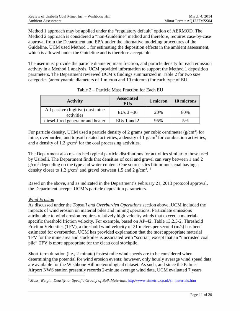
Review of Usibelli Coal Mine, Inc. – Wishbone Hill March 4, 2014 Ambient Assessment Minor Permit AQ1227MSS04 Method 1 approach may be applied under the “regulatory default” option of AERMOD. The Method 2 approach is considered a “non-Guideline” method and therefore, requires case-by-case approval from the Department and EPA under the alternative modeling procedures of the Guideline. UCM used Method 1 for estimating the deposition effects in the ambient assessment, which is allowed under the Guideline and is therefore acceptable. The user must provide the particle diameter, mass fraction, and particle density for each emission activity in a Method 1 analysis. UCM provided information to support the Method 1 deposition parameters. The Department reviewed UCM’s findings summarized in Table 2 for two size categories (aerodynamic diameters of 1 micron and 10 microns) for each type of EU.
Table 2 – Particle Mass Fraction for Each EU
Activity Associated EUs 1 micron 10 microns
All passive (fugitive) dust mine activities EUs 3 –36 20% 80%
diesel-fired generator and heater EUs 1 and 2 95% 5% For particle density, UCM used a particle density of 2 grams per cubic centimeter (g/cm3) for mine, overburden, and topsoil related activities, a density of 1 g/cm3 for combustion activities, and a density of 1.2 g/cm3 for the coal processing activities. The Department also researched typical particle distributions for activities similar to those used by Usibelli. The Department finds that densities of coal and gravel can vary between 1 and 2 g/cm3 depending on the type and water content. One source sites bituminous coal having a density closer to 1.2 g/cm3 and gravel between 1.5 and 2 g/cm3. 3
Based on the above, and as indicated in the Department’s February 21, 2013 protocol approval, the Department accepts UCM’s particle deposition parameters. Wind Erosion As discussed under the Topsoil and Overburden Operations section above, UCM included the impacts of wind erosion on material piles and mining operations. Particulate emissions attributable to wind erosion requires relatively high velocity winds that exceed a material-specific threshold friction velocity. For example, based on AP-42, Table 13.2.5-2, Threshold Friction Velocities (TFV), a threshold wind velocity of 21 meters per second (m/s) has been estimated for overburden. UCM has provided explanation that the most appropriate material TFV for the mine area and stockpiles is associated with “scoria”, except that an “uncrusted coal pile” TFV is more appropriate for the clean coal stockpile. Short-term duration (i.e., 2-minute) fastest mile wind speeds are to be considered when determining the potential for wind erosion events; however, only hourly average wind speed data are available for the Wishbone Hill meteorological dataset. As such, and since the Palmer Airport NWS station presently records 2-minute average wind data, UCM evaluated 7 years
3 Mass, Weight, Density, or Specific Gravity of Bulk Materials, http://www.simetric.co.uk/si_materials.htm
Page 11 of 20
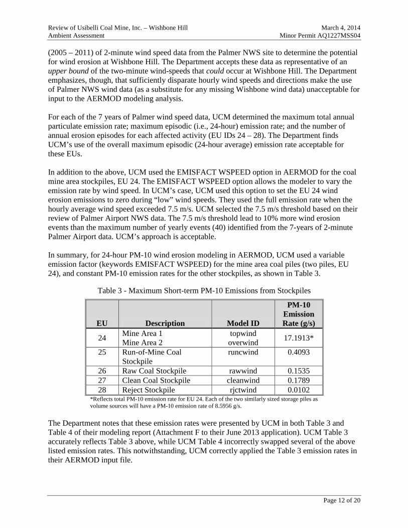
Review of Usibelli Coal Mine, Inc. – Wishbone Hill March 4, 2014 Ambient Assessment Minor Permit AQ1227MSS04 (2005 – 2011) of 2-minute wind speed data from the Palmer NWS site to determine the potential for wind erosion at Wishbone Hill. The Department accepts these data as representative of an upper bound of the two-minute wind-speeds that could occur at Wishbone Hill. The Department emphasizes, though, that sufficiently disparate hourly wind speeds and directions make the use of Palmer NWS wind data (as a substitute for any missing Wishbone wind data) unacceptable for input to the AERMOD modeling analysis. For each of the 7 years of Palmer wind speed data, UCM determined the maximum total annual particulate emission rate; maximum episodic (i.e., 24-hour) emission rate; and the number of annual erosion episodes for each affected activity (EU IDs 24 – 28). The Department finds UCM’s use of the overall maximum episodic (24-hour average) emission rate acceptable for these EUs. In addition to the above, UCM used the EMISFACT WSPEED option in AERMOD for the coal mine area stockpiles, EU 24. The EMISFACT WSPEED option allows the modeler to vary the emission rate by wind speed. In UCM’s case, UCM used this option to set the EU 24 wind erosion emissions to zero during “low” wind speeds. They used the full emission rate when the hourly average wind speed exceeded 7.5 m/s. UCM selected the 7.5 m/s threshold based on their review of Palmer Airport NWS data. The 7.5 m/s threshold lead to 10% more wind erosion events than the maximum number of yearly events (40) identified from the 7-years of 2-minute Palmer Airport data. UCM’s approach is acceptable. In summary, for 24-hour PM-10 wind erosion modeling in AERMOD, UCM used a variable emission factor (keywords EMISFACT WSPEED) for the mine area coal piles (two piles, EU 24), and constant PM-10 emission rates for the other stockpiles, as shown in Table 3.
Table 3 - Maximum Short-term PM-10 Emissions from Stockpiles
EU Description Model ID
PM-10 Emission Rate (g/s)
24 Mine Area 1 Mine Area 2
topwind overwind 17.1913*
25 Run-of-Mine Coal Stockpile
runcwind 0.4093
26 Raw Coal Stockpile rawwind 0.1535 27 Clean Coal Stockpile cleanwind 0.1789 28 Reject Stockpile rjctwind 0.0102
*Reflects total PM-10 emission rate for EU 24. Each of the two similarly sized storage piles as volume sources will have a PM-10 emission rate of 8.5956 g/s.
The Department notes that these emission rates were presented by UCM in both Table 3 and Table 4 of their modeling report (Attachment F to their June 2013 application). UCM Table 3 accurately reflects Table 3 above, while UCM Table 4 incorrectly swapped several of the above listed emission rates. This notwithstanding, UCM correctly applied the Table 3 emission rates in their AERMOD input file.
Page 12 of 20

Review of Usibelli Coal Mine, Inc. – Wishbone Hill March 4, 2014 Ambient Assessment Minor Permit AQ1227MSS04 Ambient NO2 Modeling The modeling of ambient NO2 concentrations can sometimes be refined through the use of ambient air data or assumptions. Section 5.2.4 of the Guideline describes several approaches that may be considered in modeling annual average NO2 impacts. These approaches are also generally applicable in modeling 1-hour NO2 impacts. UCM used the same approach and assumptions to estimate both the annual average and 1-hour NO2 impacts. They used the Ozone Limiting Method (OLM) to refine the predicted NO2 concentrations. OLM is considered a Tier 3 screening method for estimating annual average NO2 impacts per Section 5.2.4 of the Guideline. UCM’s use of OLM for estimating the 1-hour NO2 impacts is likewise appropriate. Nevertheless, the following aspects warrant discussion. EPA and Department Approval OLM is an allowed option for estimating annual average NO2 impacts in a new source review permitting action. EPA has not yet promulgated OLM as an approved regulatory option in AERMOD for estimating 1-hour NO2 impacts; however, EPA’s June 29, 2010 and, particularly, their March 1, 2011 1-hour NO2 modeling guidance discuss how OLM could be used for this purpose. The use of OLM for estimating 1-hour NO2 impacts therefore requires Commissioner4 and EPA approval, per 18 AAC 50.215(c)(2). EPA Region 10 granted permission to use OLM for the Wishbone Hill project on September 25, 2012; and the Air Permits Program Manager granted permission the following day (September 26, 2012). Copies of these approvals were forwarded on September 26, 2012 to both UCM and their modeling consultant, SLR. Public Comment The use of a “non-Guideline” modeling technique is subject to public comment per Alaska’s State Implementation Plan (SIP) and 40 C.F.R. 51.160(f)(2). The Department is therefore requesting public comment regarding the use of OLM for estimating the 1-hour NO2 impacts in the public notice for the preliminary permit decision. In-Stack NO2-to-NOx Ratio The NOx emissions created during combustion is partly nitric oxide (NO) and partly NO2. After the combustion gas exits the stack, additional NO2 is created as the exhaust mixes with atmospheric ozone. The assumed NO2-to-NOx in-stack ratio (ISR) is a variable that must be set for each EU with NOx emissions. Source-specific ISR data should be used when available. When source-specific data is not available, EPA guidance indicates that a 0.50 ISR may be used without justification for purposes of modeling the 1-hour NO2 impact. This value represents “a reasonable upper bound based on the available in-stack data.” EPA has not provided a similar “default” ratio for purposes of modeling annual average NO2 impacts. UCM used an ISR of 0.1 for their point sources (generator and heaters), which is a commonly used value for these types of combustion units. UCM used an ISR of 0.036 for the NOx emissions from blasting. This is a reasonable value based on the field studies provided by UCM.
4 The Commissioner delegated authority regarding the use of non-guideline models to the Air Permits Program Manager on June 3, 2008.
Page 13 of 20

Review of Usibelli Coal Mine, Inc. – Wishbone Hill March 4, 2014 Ambient Assessment Minor Permit AQ1227MSS04 Ozone Data OLM requires ambient ozone (O3) data in order to determine how much of the NO is converted to NO2. On-site O3 data was not available for the Wishbone Hill project and, therefore, O3 data collected at a site representative of the project location was used. Specifically, UCM used a single ambient O3 concentration representative of the expected maximum concentration within the project area. The Department accepts this single O3 value approach, rather than an alternatively acceptable, but less conservative, approach of using seasonally adjusted values or hour-by-hour data. UCM used the Department recommended value of 50 parts per billion (ppb). 50 ppb is the maximum 1-hour ozone concentration measured in Anchorage during the 2010 and 2011 monitoring seasons, which makes it a conservative upper bound of the maximum ambient ozone concentration at Wishbone Hill. Miscellaneous Aspects UCM also used the “combined plume” approach for running OLM (keywords OLMGROUP ALL), rather than the “source-by-source” approach. UCM’s approach is consistent with EPA’s June 29, 2010 and March 1, 2011 guidance and is therefore, appropriate. UCM used the AERMOD default NO2/NO ambient equilibrium ratio of 0.90. The use of the EPA default value is appropriate. The Department did find that UCM incorrectly applied a 0.19 gram–per-second (g/s) NOx emission rate to EU ID 2 (heaters), instead of the correct NOx emission rate of 0.22 g/s. The effect of this error was evaluated by Enviroplan, as reflected in Table 5 of the Results section herein. Blasting (EUs 4 and 5) UCM has proposed to restrict mine site blasting to one blast-per-day (for either coal or overburden) to occur only during the 12-hour period, 7 a.m. to 7 p.m. UCM intended to use the hour-of-day option (EMISFACT HROFDY) to limit the blasting-related NOx emissions to this 12-hour period. However, they miscoded the option and instead simulated the blast emissions as if they occur between 5 a.m. and 7 p.m. While this is a clear error, it conservatively overstates the daily emission rate and is therefore acceptable. UCM also assumed that the maximum hourly NOx emissions occur during each hour of this 14-hour period. This approach leads to an extremely conservative annual average NO2 estimate since the total modeled emission rate is fourteen-fold greater than what would be allowed. This approach also ensures the 1-hour NO2 AAAQS is protected, regardless of when the blast occurs during the 7 a.m. to 7 p.m. period. AERMOD uses the maximum hourly concentration from each day to estimate the impact within the form of the 1-hour NO2 AAAQS. UCM’s coding error would therefore overstate the final 1-hour NO2 estimate if the maximum modeled impact occurs between 5 a.m. and 6 a.m. Enviroplan therefore reset the HROFDY option to the intended 7 a.m. to 7 p.m. period and they reran the NO2 analysis to correct the above discussed NOx emission rate error for EU2. The HROFDY change did lead to a decrease in the 1-hour and annual average NO2 results. The revised values are provided in the Results section of this report.
Page 14 of 20
Review of Usibelli Coal Mine, Inc. – Wishbone Hill March 4, 2014 Ambient Assessment Minor Permit AQ1227MSS04 Since the 7 a.m to 7 p.m blasting operating restriction is reflected in the ambient assessment, the Department has included this restriction as permit condition. Ambient Air Boundary For purposes of air quality modeling, “ambient air” means outside air to which the public has access. Applicants may, therefore, exclude that portion of the atmosphere within their boundary that they own or control, and from which public access is “precluded by fence or other physical barrier.”5 UCM will need to preclude public access to Wishbone Hill for both air quality and public safety reasons. They own some of the land, and, therefore, have clear authority to restrict access to those areas. The rest of the mine will be on land leased from the State of Alaska or the Matanuska-Susitna Borough. UCM has written authority from these land owners to preclude access. UCM’s method for restricting access will vary by location. The ambient boundary and means for restricting access will also change as the mine grows. In all cases, a physical barrier will be used to preclude public access. This restriction will include a combination of installed partial perimeter fencing and natural access restrictions, including surrounding terrain, bluffs/ridges and local dense vegetation.6 UCM will also post signs near-boundary trails and mine access roads to inform the public of the ambient boundary; as well as have mine personnel monitor the boundary to further ensure the public is not accessing the mine. UCM generally used the Wishbone Hill property boundary as the ambient air boundary. However, parts of their ambient air boundary are well inside of the property boundary – i.e., UCM will allow the public access to various parts of their property. The ambient air boundary and means for precluding public access are detailed in UCM’s February 14, 2014 public access control plan. Several points of interest are also described below. The western portion of the project site includes an existing public trail (Right of Way (R.O.W.) 52715) which is popular with recreational enthusiasts. UCM plans to relocate the trail to the outer edge of the southern and western mining area. UCM plans to close off the old surrounding trail by installing a berm at the junction. UCM does not plan to preclude access to the trail along Moose Creek (western portion of the mine) and has treated the trail as ambient air by including model prediction locations (receptors) along the western trial in their modeling analysis. The relocated trail will also transect two distinct sections of the mine property. UCM correctly treated these transects as ambient air. They will also install barriers along the transects to prevent access to the active mine area. One transect crosses the access road that runs into the mine site. UCM will either put gates on both sides of the trail at the road crossing, or install a culvert to separate the trail and road. The other trail transect section runs along the southwestern and west portion of the mine site, inside the mine boundary. UCM plans to preclude public access to the active mine area by installing a fence between the trail and mining area in the southwest mine area, and through natural barriers as the trail progresses northward. UCM has considered the western
5 See letter on ambient air from Douglas Costle to Senator Jennings, December 19, 1980. 6 Natural features can be acceptable physical barriers. In many cases, they are even more difficult to traverse than a fence.
Page 15 of 20

Review of Usibelli Coal Mine, Inc. – Wishbone Hill March 4, 2014 Ambient Assessment Minor Permit AQ1227MSS04 R.OW. 52715 trail, and southwest on-site property inside the mine boundary as ambient air in the modeling. As indicated above, UCM plans to install a vehicle gate at the entrance of the access road at the Glenn Highway intersection, and also install gates on each side of the public trail crossing this road. The Department is imposing UCM’s Public Access Control Plan as a permit condition. Receptor Grid UCM used a 50 meter (m) spacing around the ambient air boundary and along the public trails and creek that transect the ambient boundary. UCM extended the receptor grid outward about 200 m at 100 m spacing from the Wishbone Hill ambient boundary. UCM used receptor spacing typical for modeling geographically large sources, such as mines. The tighter spacing suggested in the Department’s Modeling Review Procedures Manual presumes the more common modeling scenario: a downwash dominated source located near their ambient air boundary.7 In a prior iteration of this ambient assessment, the Department conducted a sensitivity analysis to assess the adequacy of UCM’s grid. The Department used a 25 meter grid spacing (i.e., doubled the receptor density) around the location of maximum impact and re-ran the 24-hour PM-10 modeling analysis. The location and concentration of the maximum impact did not change. Additionally, the 24-hour PM-10 concentration gradients in Figures 10 and 11 of Attachment F to the June 2013 application8 are relatively shallow. Therefore, the same results would likely be found even if a denser receptor grid was used. As expected for low-level non-buoyant sources which typify this mine, the greatest predicted concentrations occurs at and immediately adjacent to the ambient boundary receptors. As such, the Department continues to accept UCM’s receptor grid as adequate for this analysis. Downwash Downwash refers to conditions where structures influence the plume from an exhaust stack. It can be a critical factor when a stack and structure are in close proximity to each other, and ambient boundary is within the structure’s downwash region. It is not a factor when the stacks and structures are far apart, or the ambient boundary is beyond the downwash region. UCM’s modeling analysis includes only two, relatively small-emitting point sources. These EUs have short exhaust stacks and are located several hundred meters within the ambient air boundary. Therefore, UCM did not include downwash the modeling analysis. UCM’s approach is reasonable for this situation. Off-Site Impacts The impact from neighboring (off-site) sources must be accounted for in a cumulative impact assessment. Per Section 8.2.3 of the Guideline, “all sources expected to cause a significant
7 Downwash can create extremely steep concentration gradients (i.e., the impacts rapidly change with distance). Therefore, a denser receptor grid is typically warranted when modeling a downwash dominated source located near their ambient boundary.
8 Figures 10 and 11 of Attachment I of the June 2013 permit application did not contain prediction receptors immediately southwest of the on-site public trail located in the southwest portion of the mine property. UCM, however, did include such receptors in their AERMOD input file. Enviroplan re-ran AERMOD and re-generated concentration isoplots to confirm the location of maximum model predictions.
Page 16 of 20
Review of Usibelli Coal Mine, Inc. – Wishbone Hill March 4, 2014 Ambient Assessment Minor Permit AQ1227MSS04 concentration gradient in the vicinity of the [applicant’s source] should be explicitly modeled.” The impact from other sources can be accounted for through ambient monitoring data. There are no off-site stationary sources near Wishbone Hill, let alone sources that would cause a significant concentration gradient within the vicinity of the project site. Therefore, there are no off-site sources that should be explicitly modeled. The impact from distant off-site sources should instead be accounted for through ambient monitoring data. Background Concentrations The background concentration represents impacts from sources not included in the modeling analysis. Typical examples include natural, area-wide, and long-range transport sources. The background concentration must be evaluated on a case-by-case basis for each ambient analysis. Once the background concentration is determined, it is added to the modeled concentration to estimate the total ambient concentration. There is no current ambient pollutant data from the Wishbone Hill mine area. In this type of situation, minor permit applicants use surrogate values to estimate the expected background concentrations. UCM used the data described below. PM-10 The Department recommended to UCM that they use the maximum concentration measured from the 2009 ambient PM-10 data set for Eagle River. Eagle River is the nearest monitoring site to Wishbone Hill with a readily available PM-10 data set; and 2009 represents the Department agreed-to data period. Like Wishbone Hill, Eagle River is subject to the wind-blown dust events prevalent in the Mat-Su Valley. The monitoring station would also include impacts from anthropogenic sources, such as dust from the Glenn Highway and local streets. The 2009 maximum 24-hr PM-10 Federal Reference Method (FRM) concentration is 50 µg/m3 (i.e., one-third of the ambient standard). The above Department recommendation notwithstanding, UCM felt the Eagle River data would be overly conservative since the Eagle River traffic is much greater than what occurs in the Wishbone Hill area. They also felt the use of the maximum recorded concentration was overly conservative. They therefore elected to average the dataset based on the meteorological period(s) of concern, as provided for in Section 8.2.2 of the Guideline. The goal of this methodology is to identify under which meteorological conditions high impacts occur, and then average the concentrations with similar meteorology, to develop a representative background concentration. Depending on the data, there may be more than one meteorological condition of concern. The Guideline is silent on how these periods are identified. However, Phillips Alaska, Inc. (now ConocoPhillips Alaska, Inc.) developed an approach in March 2002 for processing PM-10 data measured at Nuiqsut9. Their approach was reviewed and approved by the Department and EPA Region 10.
9 Short-Term PM-10 Background Concentration Determination for the Proposed Alpine CDN & CDS Satellite Drilling Pads Colville River Unit, Alaska, March 2002, Prepared by SECOR International Incorporated on behalf of Phillips Alaska, Inc.
Page 17 of 20
Review of Usibelli Coal Mine, Inc. – Wishbone Hill March 4, 2014 Ambient Assessment Minor Permit AQ1227MSS04 UCM processed the Eagle River PM-10 data in a manner similar to the method used for the Nuiqsut dataset. In summary, UCM processed the 2009 Eagle River data as follows:
1. UCM calculated the 95th percentile of the Eagle River hourly concentrations to create a subset of the highest concentrations. Hourly concentrations were used instead of the FRM 24-hour values so that hourly wind speed and direction could be correlated to each hourly concentration value. The 95th percentile value (referred to by UCM as the significant monitor concentration) was determined to be 56 µg/m3.
2. UCM sorted the high values (i.e., hourly values at or above 56 µg/m3) by coincident wind direction to determine if there were specific directions of concern. The highest PM-10 concentrations were attributed to wind directions between 010 – 050 degrees and 340 – 360 degrees. For the rest of the wind direction sectors, the data were primarily below the significant monitoring concentration.
3. UCM investigated coincident hourly wind speeds for each sector of concern: a. For the 010 – 050 degree sector, the wind speeds were as high as 45 mile-per-hour
(mph), with a significant cluster of high concentrations between 15 mph and 45 mph. This suggests the high values may be due to wind-driven dust events from the Matanuska Glacier.
b. For the 340 – 360 degree sector, the wind speeds were primarily between 5 mph and 15 mph. UCM indicated these values are likely dust impacts due to vehicular traffic on the nearby Glenn Highway. UCM provided a figure (Figure 8 of the UCM application, Attachment F) showing spikes in PM-10 concentration during rush hour in April (the time of year when gravel is most prevalent on roads).
UCM averaged the hourly PM-10 data for each of the two wind direction sectors of concern, and for the remaining 060 – 330 degree sector. The highest hourly average PM-10 concentration was 28.5 µg/m3 (010 – 050 degree sector), and UCM used this value as the background concentration for the Wishbone Hill ambient assessment. The Department agrees with UCM’s method and final results. NO2 Due to the lack of NO2 ambient monitors near Wishbone Hill, UCM reviewed available NO2 background data within Alaska. In response to a Department information request, UCM provided on January 15, 2012 their proposed surrogate NO2 background concentrations. UCM used an annual average NO2 concentration of 10 parts per billion (ppb), equivalent to 18.8 μg/m3, and a 1-hour concentration of 20 ppb (37.6 μg/m3). The Department notes the following regarding these values:
• The annual average value of 18.8 μg/m3 is in the range of values measured near the Fort Wainwright coal-fired power plant in 2003 – 2004. Since there are no NOx sources of this type near Wishbone Hill, this value reflects a conservative estimate of the NO2 concentrations expected near Wishbone Hill.
• The 1-hour NO2 value of 37.6 μg/m3 is identical to the maximum (first-high) 1-hour concentration measured at Donlin Creek in 2008. The Department deems this concentration as a reasonable estimate of the expected existing maximum 1-hour NO2 concentration near Wishbone Hill.
Page 18 of 20
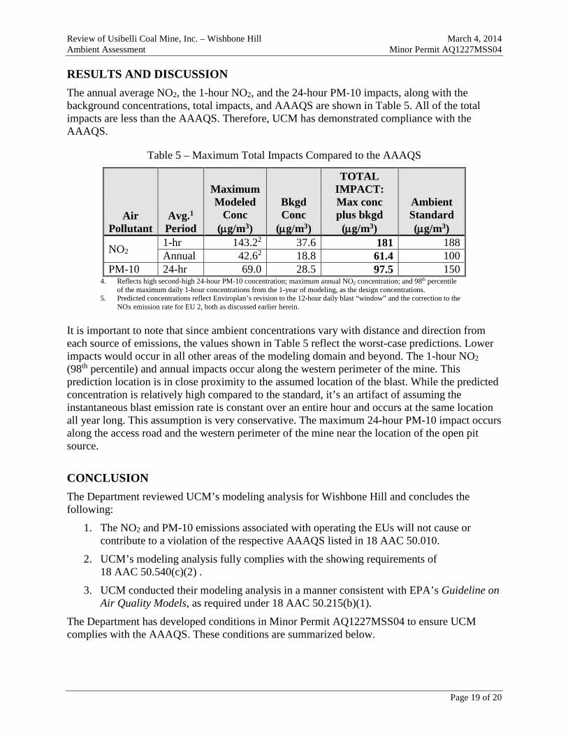
Review of Usibelli Coal Mine, Inc. – Wishbone Hill March 4, 2014 Ambient Assessment Minor Permit AQ1227MSS04 RESULTS AND DISCUSSION The annual average NO2, the 1-hour NO2, and the 24-hour PM-10 impacts, along with the background concentrations, total impacts, and AAAQS are shown in Table 5. All of the total impacts are less than the AAAQS. Therefore, UCM has demonstrated compliance with the AAAQS.
Table 5 – Maximum Total Impacts Compared to the AAAQS
Air Pollutant
Avg.1 Period
Maximum Modeled
Conc (µg/m3)
Bkgd Conc
(µg/m3)
TOTAL IMPACT: Max conc plus bkgd
(µg/m3)
Ambient Standard (µg/m3)
NO2 1-hr 143.22 37.6 181 188 Annual 42.62 18.8 61.4 100
PM-10 24-hr 69.0 28.5 97.5 150 4. Reflects high second-high 24-hour PM-10 concentration; maximum annual NO2 concentration; and 98th percentile
of the maximum daily 1-hour concentrations from the 1-year of modeling, as the design concentrations. 5. Predicted concentrations reflect Enviroplan’s revision to the 12-hour daily blast “window” and the correction to the
NOx emission rate for EU 2, both as discussed earlier herein. It is important to note that since ambient concentrations vary with distance and direction from each source of emissions, the values shown in Table 5 reflect the worst-case predictions. Lower impacts would occur in all other areas of the modeling domain and beyond. The 1-hour NO2 (98th percentile) and annual impacts occur along the western perimeter of the mine. This prediction location is in close proximity to the assumed location of the blast. While the predicted concentration is relatively high compared to the standard, it’s an artifact of assuming the instantaneous blast emission rate is constant over an entire hour and occurs at the same location all year long. This assumption is very conservative. The maximum 24-hour PM-10 impact occurs along the access road and the western perimeter of the mine near the location of the open pit source.
CONCLUSION The Department reviewed UCM’s modeling analysis for Wishbone Hill and concludes the following:
1. The NO2 and PM-10 emissions associated with operating the EUs will not cause or contribute to a violation of the respective AAAQS listed in 18 AAC 50.010.
2. UCM’s modeling analysis fully complies with the showing requirements of 18 AAC 50.540(c)(2) .
3. UCM conducted their modeling analysis in a manner consistent with EPA’s Guideline on Air Quality Models, as required under 18 AAC 50.215(b)(1).
The Department has developed conditions in Minor Permit AQ1227MSS04 to ensure UCM complies with the AAAQS. These conditions are summarized below.
Page 19 of 20

Review of Usibelli Coal Mine, Inc. – Wishbone Hill March 4, 2014 Ambient Assessment Minor Permit AQ1227MSS04 To protect the 24-hour PM-10 Ambient Air Quality Standard:
1. Comply with the Fugitive Dust Control Plan that UCM submitted to the Department in the June 28, 2013 application and the supplemental information provided on October 16, 2013.
To protect the 24-hour PM-10, and the 1-hour and Annual NO2 Ambient Air Quality Standards:
1. UCM shall establish and maintain a physical ambient air boundary as described in their February 14, 2014 Public Access Control Plan, or a subsequent written version approved by the Department that only contains editorial revisions.
2. UCM shall limit their blasting operations as follows:
a. No more than one blast per-calendar day;
b. Blasting shall occur only between the local hours of 7 a.m. to 7 p.m.; and
c. No more than 17,400 pounds of the blasting agent, ANFO, shall be used per blast.
Page 20 of 20