tectonic controls of volcanism and complex movements along ... · structures were interpreted as...
TRANSCRIPT
Geol. Soc. Malaysia, Bulletin 6, July 1973; pp. 43-60.
Tectonic Controls of Volcanism and Complex Movements Along the Sumatran Fault System
M. POSAVECl, D. TAYLOR2, Th. VAN LEEUWEN3, AND A. SPECTOR1
Abstract: Recent geological work within the Contract Area of P.T. Riotinto Bethlehem Indonesia in West Sumatra, including aerial photographic and aeromagnetic surveys by Lockwood Survey Corporation, have yielded much new data on the Sumatran Fault Zone and have revealed its intimate connection with volcanism.
Three major fault zones each characterized by complex wrench, thrust and subordinate normal faulting can be recognized from aerial photographic interpretation. During the Quaternary significant displacements along the Sumatran Fault Zone occurred and are still continuing, and in consequence morphological features and especially drainage patterns are in the closest correspondence to the fracture systems. Strong E-W magnetic lineaments thought to represent major intermediate intrusives at depth are found associated with volcanic centres. Where these lineaments are cut by strands of the fault zones volcanoes are located.
Igneous act ivity a long original E-W alignments and dextral tranSCUlTent faulting along NNW trending zones interact to produce a barrier range of volcanic rocks along the active fault zone with evenly spaced active volcanic centres at 75-100 km. distances along it. The total horizontal shift along the fault is approximately 130 km. since the inception of the present volcanic cycle.
The fault system is thought to be a fundamental fracture whose full explanation is to be sought within the concept of a plate tectonic interpretation of the geology of Southeast Asia.
INTRODUCTION
The topography of the main mountain backbone of the island of Sumatra, the Barisan, is dramatic. The main watershed lies generally within 50 km. of the west coast of the island, and the Barisan is crowned by active volcanic cones rising to a maximum height of 3800 metres in Gunung Kerintji. Not all the range is volcanic however, and the core of the range in north and central Sumatra is made up of folded sediments of Palaeozoic and Mesozoic age (van BemmeIen, 1970, p. 659-672).
Following closely the crest of the Barisan and markedly aligned with the active volcanoes in central and south Sumatra are a series of tectonic or volcano tectonic depressions, named by earlier investigators the Semangko Fault Zone from the bay in the Sunda Strait at its southern end (van Bemmelen, 1970, p. 24). At first these structures were interpreted as simple, rather superficial graben associated with geanticlinal up-arching of the Barisan in late Tertiary times. Van Bemmelen (1970, p. 672), noting the occurrence of Palaeocene basins within the zone however postulated at least an early Tertiary origin for the zone of faulting.
Durham (1940), impressed by the extreme linearity of the northern part of the fault zone (the Ulu Air Fault) postulated wrench movements and Katili and Hehewat (1967) and Katili (1969) adduced evidence for a consistent right lateral wrench fault character for the main movements throughout its 1650 krn. length. Tjia (1970) how-
1 Photogeologist: Lockwood Survey Corporation Ltd., Toronto, Canada. 2 Con zinc Riotinto Malaysia Sdn. Bhd., P.O. Box 291 , Kuala Lumpur. 3 P.T. Riotinto Bethlehem Indonesia, Kotak Pos 83, Padang, Sumatra Barat, Indonesia.

44 M. POSAVEC, D. TAYLOR, Th. VAN LEEUWEN AND A. SPECTOR
, I
I .... - .... (~~
SCALE.
!5OOKm """""'..-......... !!I!!!I!!!!lI ___ """"""..s
\l\ ""~ I'" \ ' I!l° \ :§ - "'"
~
"J Il (\9 4,~ ..,l K 0°
.. ~
Uaralabutl Fault . .. • ~Gunon9 Kerinlji
.\. . 110-.07
/
w r \ .,,', .g-'?-.~ •. I I. <;II"' 50
o
'" '"
• .X
f )
\. ~> '- - ,5: )
/-
-LEGEND . -
1000 M.I.r Ilobath .
5000 M.I.r Isobath.
~
Epicont,.. 01 Major Earthquak .. .
Epiconlr.. 01 L •••• r Earthquak .. .
x
x"" « "x", •
X X ~x 100
o g
in Allal 01 the Tropical Nettlerlands
1938. 12 0 Volcano wilh hiltorlcal .rocord 01 activity.
}
From Mop by B. G. Esdl!r ( 111511)
\'flth odditions from Von B.mm.Hn (1949)
Alter. J. Kat~r. 1969. Figur •. I .
Fig. 1.
Faull aligned Volleys .
Plan of Sumatra showing faults of the Semangko System, Active Volcanoes, Earthquake Epicentres and Bathymetry.

TECTONIC CONTROLS OF VOLCANISM AND COMPLEX MOVEMENTS 45
ever, published the results of a map study which indicated much local complexity of movement with locally important vertical movements and some evidence of sinistral movements in places. The location of the major known faults and their relationship to the seismically and volcanically active zone is summarized in Figure 1.
In May of 1970 the company Riotinto Bethlehem Indonesia (RBI) was incorporated in Indonesia to undertake a Contract of Work (Kontrak Karya) with the Indonesian Ministry of Mines over an area of 40,000 sq. km. approx. astride the Barisan Range in West Sumatra (see Fig. 2). A sub-contract was awarded by
PHUKET
7 Indonesian Ministry of Mines Tender Block Number
~ Air Photographic Coverag~
~ Aeromagnetic Coveroge
\OOOE
500km
~=---------~--~! - SCALE-
SOUTH CHINA SEA
EQUATOR
~< o~~o
PALEMBANG
Fig. 2. Location plan showing RBI Contract Area.

46 M. POSAVEC, D. TAYLOR, Th. VAN LEEUWEN AND A. SPECTOR
RBI to the Lockwood Survey Corporation of Canada for airphoto and aeromagnetic surveys of the contract area, and this work was carried out in June-August 1970. Photointerpretation and field inspections by Messrs. Posavec and van Leeuwen in the second half of 1970, carried out without knowledge of the prior publications of Katili and Tjia referred to above, independently convinced them of the right lateral wrench character of the fault system.
Further work by a large team of RBI geologists in the field, photointerpretation by M. Posavec and an in depth aeromagnetic interpretation by A. Spector, both of Lockwood Survey Corporation combined with a study of the literature by D. Taylor has served to convince the authors of this interpretation of the fault movements and of the intimate correlation between the faulting and volcanism. The present interpretation is however provisional and will be subject to modification and amplification as the work continues. In presenting the material at the present time we are following the sage advice of McKinstry (1948) who wrote: "Unless the geologist resolves at a certain stage to publish what he has, there is danger that he will be called to another district, if not to the Elysian Fields, before he gets his results in form for submission to a society or journal".
LOCATION AND NATURE OF MAIN FAULT ZONE
Within the detailed study area shown in Fig. 2 there are thTee major fault zones and within this area they seem to be separate fault systems. A more complete study of Sumatra may however indicate that they are in fact parts of the same large scale structural pattern.
The major fault structures which have been identified in West and Central Sumatra (see Fig. 4) are:-
1. The Central Barisan Fault Zone with dominant and continuing right lateral transcurrent movements of large horizontal displacement.
2. The Eastern Barisan Fault Zone with transcurrent movements on its northwest aligned portions and thrust movements where the fault traces swing to the east.
3. The Takung River Fault with largely thrust movements.
The Central Barisan Fault Zone
The Central Barisan Fault Zone is a part of the Sumatran Fault Zone or Semangko Zone of earlier authors. It is active; major earthquakes have taken place along its length in recent times, most notably the Padang Panjang earthquake of 1926. Along the main fault and some of its splays morphological evidence of considerable recent movement is strong. Streams show recent offsets of up to a kilometer, lahars from active volcanoes are cut, as are lake terraces and valley alluvium. A detailed study of the Lake Singkarak - Gunung Talang region (Tjia and Posavecin preparation) shows a bewildering abundance and variety of faulting. The overall effect is a major right lateral transcurrent movement with subordinate, but still large, normal faults bounding structural depressions.
A number of major river systems rise on one side of the fault zone, flow along it for distances of 15-35 kID. and then leave it on the opposite side. There is a consistent pattern to these offsets of major rivers which is compatible with, although it

"I 1 /~A"'t: :'i;y::::'':6,?!,~
3"](/ 1 =:." V"':-" "':-:"':"'(1
.~ •• oun4 ••••• tlen 2,!)O(I-SOOO h.L
~6f-.und.".rl)OOOf •• f
Fig. 3a. The course of the Air Ketaun across the Lebong Valley. Fig. 3b. The course of the Batang Merangin through the Danau Kerintji Valley.
~ (') >-l
~ (')
(J
~ ;;d o ~ o >Tj
-< ~
~ -CI:l
s:: > 8 g ~ ~ ~
I >-l CI:l
::s

48 M. POSAVEC, D. TAYLOR, Th. VAN LEEUWEN AND A. SPECTOR
cannot prove, a major right lateral wrench movement along the fault zone. Where a definite head water system exists on one side of the fault, it is deflected to the right across the fault zone. The clearest example of this is afforded by the Air Ketaun which shows the apparent offset of 35 km. across the Lebong Valley which can be seen in Figure 3a. Other examples are furnished by the Air Seblat, the Air Dikit, the Batang Merangin (Figs. 3b & 9) and the Batang Hari. The consistency of the offsets suggests that they are due to a single cause, rather than to independent causes in each case. It is our view that the single cause is major transcurrent fault movements as proposed by Katili and Hehewat (1967) and Katili (1969).
For much of its length the Central Barisan Fault Zone consists of two or three parallel or sub-parallel faults. The present active master fault is the central one and this can be traced continuously for 550 km. right across the area studied and, as can be seen in Figure 4, it is exceedingly straight. Where it can be seen in the field cutting older rocks it is marked by mylonite zones, but for most of its course it is cutting recent volcanics or alluvium. The only deviations from absolute linearity are found where the fault passes through an active volcanic centre.
The easternmost fault of the zone is less easy to trace at the surface and may be older. Numerous bodies of serpentinite are found along the trace of this fault between the Kerintji and Talang volcanic centres. The present active volcano cones of Kerintji and Marapi lie almost directly over its trace. To the west of the main fault are further active faults which begin at their south ends as splays from the main fault. These faults swing to a rough parallelism to the main fault but are much less regular in their courses. They finally trend back towards the main fault and develop numerous splays. The best example is the fault which splays from the main fault at the Pan dan Volcanic centre and then controls the upper Air Dikit valley and passes through Gunung Raja and along the west side of the Kerintji Valley before trending back towards the main fault again near the Kerintji Volcanic centre. A similar fault leaves the main fault under the Danau di-Atas and probably trends north through the Maninjau Caldera. These western faults are in part active and carry some of the lateral movement of the zone but the active stretches are discontinuous and are separated by inactive stretches with no evidence of current movement. These faults are clearly subordinate to the main fault.
To the west there is evidence for a further fault running parallel to this zone but closer to the coast. This may be a separate system and could be named the West Barisan Fault Zone, but it is inactive and as yet poorly defined.
It is clear that horizontal movements predominate along the whole of this central fault zone at the present time, but vertical displacements occur locally as a consequence of the horizontal displacements forming five structural, volcano tectonic depressions. Secondary faults are of the scissors and normal types.
The Eastern Barisan Fault Zone
To the east of the Central Barisan Fault Zone at a distance of 15 km.-35 km. is a further major system of fractures for which we propose the name Eastern Barisan Fault Zone. Tlus fault zone is presently inactive but locally cuts recent volcanic rocks and has strong topographic expression in places. It has been traced as a complex of faults from the Umbilan Coal Basin in the north, where it cuts Eocene and Miocene sedimentary rocks to the valley of the Batang Asai in the southeast of the

TECTONIC CONTROLS OF VOLCANISM AND COMPLEX MOVEMENTS 49
Fig. 4. Major Fault Zones S \t)lconoes of West Sumatra .
I ... "" .....
j
",
_ L £6£ND _
• MO l fl ~(Ih . \lo lcoflc fI .
o Other \,oltCIII( P, ch .
-- ", Un ~; i l'l SI.e:l'ld of C, ntrol Bothen foult.
__ Subordiller , f CuUl O' Ct nlrcIBerl l cnfclIlIZon • .
---- !fl aclio', Nejor fcuil i .
-+-- Ea .1 Se rilOll rcull Zan . 8 Ohmbl f01l 11 Sl"l lIn .
-"""-- To kul\a Rlur f cult .
.Os
Fig. 4. Major Fault Zones and Volcanic Centres in West Sumatra.
area studied, a total distance of 350 kIn. In places a plexus of several sub-parallel faults is present, as to the north of Gunung Tudjuh, where a strong fault in this

50 M. POSAVEC, D. TAYLOR, Th. VAN LEEUWEN AND A. SPECTOR
position was first mapped by Tobler (1919). To the south of Gunung Tudjuh two strong thrust faults, mapped and described as the Djambi Thrust by Tobler, swing southeastwards from the Eastern Barisan Fault. A recent paper by Katili (1970) ascribes this thrusting to a subordinate role to major transcurrent faulting, and with this opinion we are in agreement.
Between Gunung Tudjuh and the Merangin River the trace of the main fault is marked by the occurrence of basaltic rocks, while in the Merangin River an ultrabasic body crops out where the fault trace intersects the river. In this zone the fault forms the western margin of the 'old slate' series and there is a very strong contrast in the aero magnetics between the two sides of the fault. These features and the linearity of the fault trace suggest that the fault is a fundamental wrench fault of similar type to the Central Barisan Fault. The sense of movement of the fault is less obvious however; major drainage offsets are smaller and inconsistent in sense. The relation to the Djambi Thrust Faults however suggests a dominant dextral shift for the zone as a whole. Further geological work may however call for a revision of this view.
The Takung River Fault Zone
In the northeast corner of the area studied a strong thrust fault follows the line of the Takung River. For tlus fault we propose the name Takung River Fault Zone. Little is yet known of the geological features of this area but along part of its length the fault appears to thrust Palaeozoic rocks onto the Eocene of the Umbilan Basin. To the north the fault trends towards the trace of the Eastern Barisan Fault Zone and they may merge in the vicinity of Gunung Malintang. The Takung River Fault has many resemblances to the Djambi Fault and may similarly be related to the Eastern Barisan Fault Zone.
Most of these fault zones form very important geological boundaries. Both the Takung River and Djambi Thrusts have rocks of very different facies on their upper and lower plates. In the case of the Djambi Thrust tlus led Zwierzycki (1925) and later van Bemmelen (1970, p. 669-672) to seek for a source for the overthrust sheets in the Malayan Peninsula 300 km. to the northeast of their present location. Both the Eastern Barisan as noted above the Central Barisan Fault Zones are major geological boundaries. Over much of its length the Central Barisan Fault Zone separates folded pre-Tertiary sediments from a Tertiary igneous complex of volcanic and intrusive rocks. This relationship is well seen along the Muaralabuh Valley.
LOCATION OF VOLCANOES AND MAGNETIC LINEAMENTS
When the active volcanoes of Sumatra are plotted onto a small scale map (Fig. 4) which also shows the line of the Central Barisan Fault Zone they can be seen to lie along it like a string of beads. Between the Toba Lake and Semangko Bay the correlation is particularly close and none of the active volcanoes lies more than a few kilometers from the trace of the active master fault.
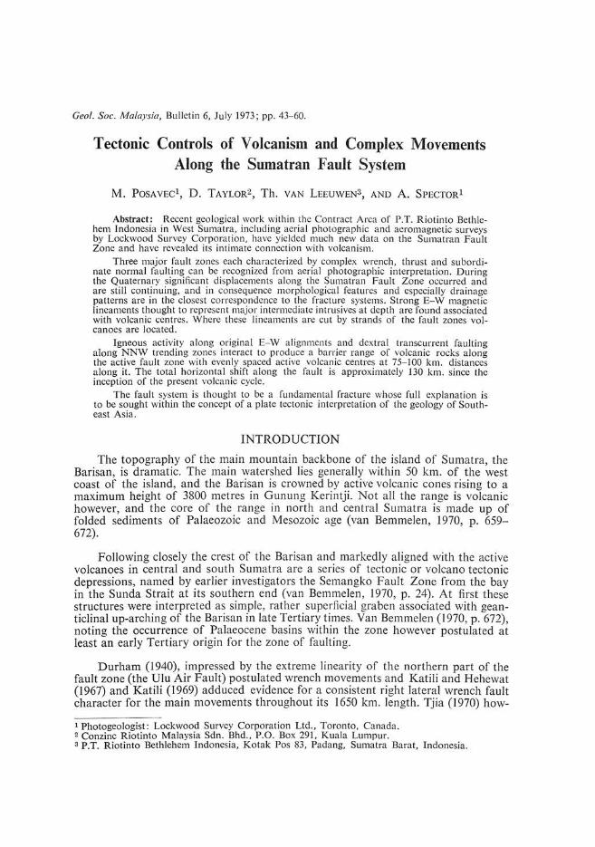
Within the area studied in more detail between the Equator and 4 0 south there are six active and one recently extinct volcanic centres. Each active centre contains one or more active volcanoes and a number of dormant or extinct peaks or calderas. These peaks dominate the topography as can be seen in figure 5 and divide the tectonic depressions along the Central Barisan Fault Zone one from another. The even
TECTONIC CONTROLS OF VOLCANISM AND COMPLEX MOVEMENTS 51
~ I~OO_ 2!JOO
fi1IIlIl] !JOO - I !JOO
~ O . !JOO".'I 'l.
~'" 'wll l1li' kI • S.,.. C..,1tlI1 ''''UII ''''%011 • .
Fig. 5. Outline topographic map of West Sumatra.
/

~O , .... " .. ..... " "." . • 6 Do,,,, •• ' "( .". n V .......
1_-_-_ 1 ""," 'w!l b,,'" ~'Y.' .. ~:c .. ..... :. . ( •• , .. uti .. .... "
-- .""."",. --~1I"''' ·~ '' r1''''''.' ' ' ' '''t ''r l. " ., .. hOt, . , ...
"~""";V'''''''( '' '''' . ,.-.-.-., ,,, ..... ""., """.
I!. t_-_~_-J h . ... v ..... '" C"""
, ,.-.-.-., .... .. ",," """ " r::::;:::;:::;: ....... ,-, ''''''.
E2Z22l ." ' "'''''' .... ,.
Fig. 6. Generalized Geology of West Sumatra.
TECTONIC CONTROLS OF VOLCANISM AND COMPLEX M OVEMENTS 53
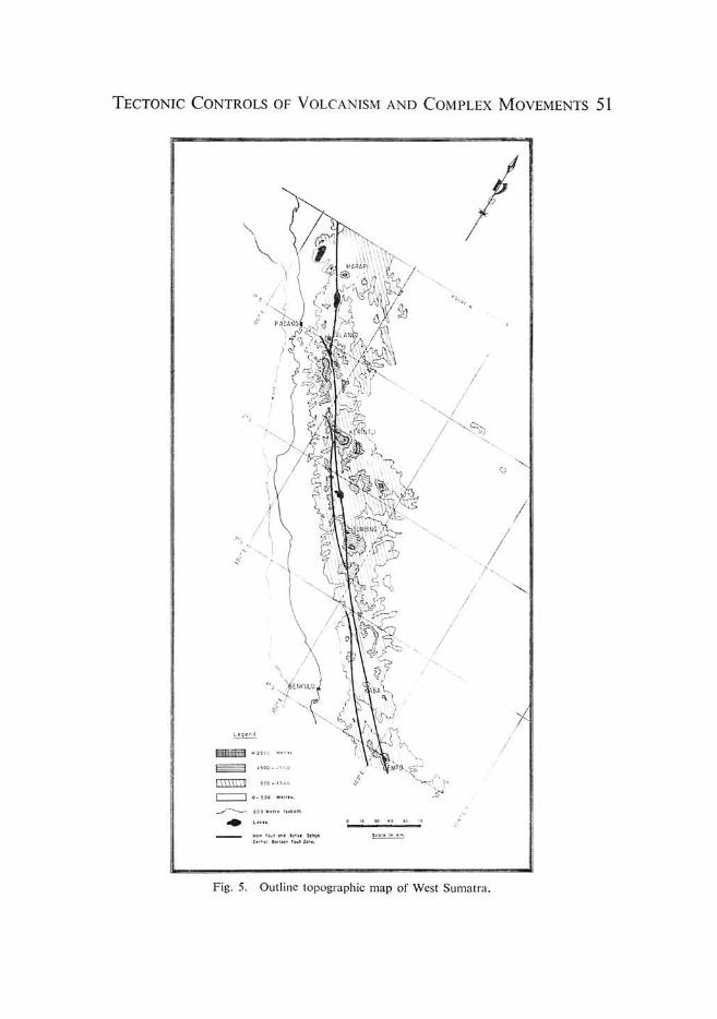
spacing of these centres of volcanism, they are all between 75 and 100 km. apart, is very striking as is their close relation to the Central Barisan Fault which can be seen in Fig. 6. We have named each volcanic centre from its most striking or active
. ~ lOS
@ "'2~~~~1 .cll,. Volcano.wil~ h.ightln mol".
• "';~~NITANG Extinct Volcano I with heig ht In ml'er.
Moln .trand Centrol Borl.on Faull Syst.m
Subordinate .trond. C.ntral Borllon Fault Syst.m
EOII Barllon Fault Zonl
Takun; Rlvtr Foult t. 2. 3'.
EOUATOR
? 1. ___ S_C.A_L_t~I _I(_K",~_. __ ...... 3.0
Main Volcanic Mountaln •• 1 lluk lttlnggl C •• lr.
Other tuff spread, from SUklttlnQQi Centr •
Volconlc product. from othflr centres
'" . 2
IOl\lmbrite." ru.dlm. nl,d tuff .. 8t oliuvlUJl"l
Umbllim BO lin - Low.r a Nlddl, Tertiary
Succ.ul .... uplollon centres of Monlnlou Cold"ro Older rocks blank
Fig. 7. The Marapi Volcanic Centre.

54 M. POSAVEC, D. TAYLOR, Th. VAN LEEUWEN AND A. SPECTOR
member as follows (from north to south), Marapi, Talang, Kerintji, Hulumajang, Pandan, Kaba and Dempo.
The Marapi Centre is one of the more active with the two great active cones of Marapi and Tandikat rising to 3,000 meters on either side of Bukit Tinggi town. Also included in this group is the extinct cone of Gunung Malintang on the east and the Caldera of Danau Manindjau on the west. In Fig. 7 these features are shown and the four recent eruptive centres can be seen to fall in an almost straight line. Each volcanic centre lies directly over a strand of either the Central or Eastern Barisan Fault Zones, while the lineation joining the centres makes an angle of approximately 70° with the trend of the faults, and runs almost E-W.
A striking feature of the Marapi Centre is the Danau (lake) Manindjau Caldera. This 18 by 8 km. caldera is the product of three major eruptions which blasted the heart out of a large central volcano and buried the surrounding region with tuff. The three craters are contiguous and one lake occupies all three, but the relative ages can be estimated from the slope angle and degree of erosion of the walls. The northern crater is the oldest, the central one is intermediate and the southern is the youngest. It is the southern crater which lies near to the E-W lineament A.
There is no aeromagnetic survey data for the Marapi Centre, but the Talang Centre to the south was flown. An extremely strong aeromagnetic anomaly coincides with the Talang Volcano, and is shown in Fig. 8. The anomaly at its western end is shifted twice by fault strands of the Central Barisan Fault Zone, the evident shift being right lateral, and in good accord with the other data on this region (Tjia and Posavec, in preparation). To the east of the active centre the anomaly continues strongly to the east, the trend making an angle of 70° with the alignment of the
t LEGEND
PAOA~~~~Ir'····· · ·· 300 IIlocjntiic I nttn~itt ' .... : '~ " ":, 1":;=
100
o Arbitror, ZtfO
200 in l' units
100
100
Volcan ic Mounhlin
2 50
SCALE IN K IlOM£TE~S
Fig. 8. Regional Magnetic Component Map of the Talang Volcanic Centre.

TECTONIC CONTROLS OF VOLCANISM AND COMPLEX MOVEMENTS 55
fault. At the intersection of this anomaly with the Eastern Barisan Fault Zone a previously unknown volcanic centre is located. This strong magnetic anomaly is certainly not due to the tuffs and vitric volcanic rocks building the active volcanic centre as magnetic susceptibility tests on specimens of these (by Lockwood Survey Corporation in Toronto) showed very low values. Sophisticated interpretation procedures by Spector (1971) showed the anomalies to be related to deep seated large structures, and they are interpreted as being due to a major buried intrusive of possibly dioritic composition.
Aeromagnetic cover over the Kerintji and Hulumajang Centres is incomplete, but similar very intense anomalies occur over the part of the Hulumajang Centre flown and over the Pan dan Centre. No survey was carried out over the Kaba or Dempo Centres. At Hulumajang and Pandan the active strands of the Central Barisan Fault Zone sharply cut off the magnetic anomalies.
A strong aeromagnetic anomaly extends from the vicinity of G. Tudjuh across the older rocks of the Barisan Range to an area of late-Tertiary volcanic rocks on the eastern margin of the Barisan, forming the eastern part of lineament C (Fig. 6).
The intensity of the anomalies and the relationship of the anomalies to the faults is very similar to that at the Talang Centre and the structures are in every way comparable. The offset of the magnetic lineaments by the faults is however much greater, and it is possible that the more disrupted centres are older, or that from time to time the active centres are rejuvenated by fresh intrusive activity from great depth below.
THE RELATIONSHIP BETWEEN VOLCANISM AND FAULTING
The formation of the Lake Kerintji Valley The development of the Lake Kerintji Valley is intimately connected with the
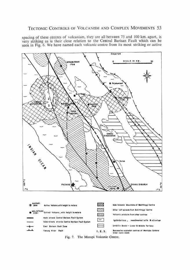
activity of the Hulumajang Centre and the dextral wrench faulting along the Central Barisan Fault Zone. In Fig. 9 we present our interpretation of the development of this system. This may be summarized as follows: -
In Fig. 9A is shown the position with the apparent drainage, and magnetic offsets restored. The four major volcano centres of the Hulumajang group fall into line when this is done and the general situation closely resembles the present situation at the Marapi Centre, and no deep tectonic valley is present. The present position is shown in 9B with an offset across the fault zone of some 60 km. as measured from X to Y or la to 4.
In moving from the position shown in 9A to the position shown in 9B the following assumptions have been made.
1. The relative positions of the volcanic centres now marked by Gunung Kerintji and Gunung Sumbing have remained constant.
2. The fault movements have taken place parallel to the straight stretches of the fault of the Central Barisan Fault Zone. Figure 9C shows the tension zones opened up by this movement. The close correlation of these tension zones with the Sg. Penuh -Dan au Kerintji VaHey and the Hulumajang Caldera and Gunung Sumbing volcanic features can be clearly seen.
A. Drainage, Magnelic and Volcano Offsets restored A. Bil e. O'l1 llal Localioat at kfri~clll ~raup V,lcOltO II . X- V l ltkl,.t wm 14!.Riur ,
1.2 .3.4 OI .. llltQjluld,....~ja,.,rllu'Y*um.
- Mn l •• t"8ltdI Il I;'i fl ItSla~fVlolt_CIall1. B. The Presenl Position
A.aat A',a'ac'
Pm. I.otIliwolXlluW "GI;IpVtk_1
~B":.II=ro~=~~rlK~1 'rlO:~'I\Ilt_ I , x-v Oillotcl14wdiol WUGn,I_ III," .
!o,'.,2.30,3b,4 PIn,,' I.Ic;llolU oIS\Jllbi~t,ro.l' VeltCN .. AJI"'F\clhol"'CfO lcIln1lCl4~IPtllOllOtpnllitlll.
C. Locolion 01 Tension Zones 1~lowin9 Wrench Faulting
E3 E3
E3
1I •• _II'""" .. a.~ .. r ... ','I .. '*'_ ._ ... ..r r. .... t!{Ml ... ... __ Sf< ....
hlCZ2l"~ . ...... ___ .11 __ ·. < .. • ..
c::J O!J '_ ... 1 .......... ___ . _
B 1i_ > . .... I.' .. WI .... .. ........ _
selu LIII.
Fig. 9. The opening of the Muaralabuh and Sungei Penuh Depressions by Wrench Movements on the Central Barisan Fault Zone.

TECTONIC CONTROLS OF VOLCANISM AND COMPLEX MOVEMENTS 57
Identical movements along the main fault of the Central Barisan Fault Zone can also account for the following features of the Gunung Kerintji-Muaralabuh area to the north.
1. The presence of the Muaralabuh Valley.
2. The location of the large caldera west of the present Gunung Kerintji peak.
3. The fact that Gunung Lumut (location Bl on figures 9B and 9C) is the centre of drainage and not G . Kerintji itself can be explained if it is in fact an older location of the volcanic centre.
General Features of the Volcanic Centre-Fault Zone Relationship When the distribution of volcanic rocks in West Sumatra is viewed as a whole
(Figure 6) in relation to the major fault zones, a very interesting pattern emerges.
To the west of the Central Barisan Fault Zone the ground is largely occupied by volcanic products with numerous small to medium sized intrusions of sub-volcanic type. Basins and fringes of clastic sediment of volcanic parentage are also present. Most of the volcanic rocks are considerably dissected by erosion and only small amounts of tuff are piled up around the active vents. Where a succession of volcanic centres can be seen, as in the Manindjau Lake area, the southernmost is the youngest, indicating a shifting of the old volcanoes to the NW with the block of ground SW of the fault.
On the east side of the same fault zone, in contrast, are large central volcanoes surrounded by extensive tuff spreads, which feed laterally eastwards into broad basins of Quaternary sediment. To the north, in the Padang Highlands between the Marapi and Talang Centres and between the Talang and Kerintji Centres, the ground between the volcanoes is largely occupied by pre-Tertiary rocks. To the south of the Kerintji Centre these pre-Tertiary rocks are largely hidden by older volcanoes, including large spreads of ignimbrite. Where a series of volcanic centres can be seen, as in Gunung Tudjuh east of Gunung Kerintji, the northernmost is the youngest, suggesting that the ground NW of the fault has moved to the southeast relative to the active volcanic centre.
The volcanoes seem to originate in approximately E-W lines over major intrusives of granodiorite-diorite composition in depth which give rise to strong aeromagnetic anomalies. These intrusive zones, which we call lineaments, are at least 60 kms. long from E to Wand are not generally visible as fracture zones at the surface. Volcanoes are found at all intersections of all major transcurrent fault zones with one of these lineaments while volcanoes with a recorded history of magmatic activity since 1600 are only found at intersections of the currently most active fault zone, the Central Barisan Fault Zone, and the E-W lineaments. Movement along the fault zones, while the volcanism and igneous activity continues, disrupts the lineaments and breaks up the E-W alignments of the volcanoes, reSUlting in staggered lines of volcanoes as at the Hulumajang Centre. There is some evidence for the occurrence of normal block faulting on a NE-SW trend offsetting the Tertiary-Barisan boundary and it may be that the main volcanic centres are located at triple intersections.
Volcanoes which are shifted away from the major active centre by these fault movements decline in activity and eventually become extinct. The westernmost vol-

58 M. POSAVEC, D. TAYLOR, Th. VAN LEEUWEN AND A. SPECTOR
cano of a centre is usually located NW of the centre and shows only solfatara stage activity. Good examples are the volcanoes NW of Gunung Kaba (the Lebong Group) and Gunung Kunjet NW of the Hulumajang centre. Further NW in both cases are extinct volcanoes, still morphologically identifiable as volcanoes but with no sign of activity. With increasing distance NW from an active volcanic centre the degree of erosion of these extinct volcanoes increases exposing increasing amounts of subvolcanic intrusives and older lavas. Four extinct volcano centres lie NW of the Gunung Kerintji Centre, forming the main Barisan and separating the Muaralabuh valley from the sea. The northernmost of these, lying just SE of Padang, is the most deeply eroded with inliers of pre-Tertiary rocks visible under the volcanics. This most northerly volcano is now located 95 km. northwest of the G. Kerintji Centre where it is thought to have originated.
In Figure 6, the distribution of volcanic rocks belonging to the present cycle of volcanism is shown with rocks derived from different centres shown separately. This distribution is the result of the continuous activity of very deep seated igneous centres which have maintained at least their relative positions, combined with rapid crustal movements along major transcurrent faults. The major shift relative to the volcanic centres is shown by the coastal strip west of the Central Barisan Fault, where a shift of 95 km. is indicated by the movement of volcanoes of the Kerintji Centre. To the east of the fault volcanoes of the Hulumajang and possibly the Kerintji Centre show shifts to the southeast relative to the present volcanic centre of up to 35 km. This indicates a likely crustal movement since the inception of the present igneous centres of 130 km. The nett effect of this movement combined with volcanism has been to build up a continuous strip of igneous material to form the coastal Barisan.
OTHER RELATED GEOLOGICAL FEATURES
To the east of the Barisan in Sumatra is a broad basin of Tertiary Sediments. Locally this is interrupted by inliers of older rocks, notably the Tigapuloh and Duabelas Mountains and Bukit Pendopo, and overlaid by basins of largely volcanically derived quaternary sediments. These basins generally lie on the south, i.e. the downthrow, side of thrust faults related to the major fault zones described above, and the inliers on the north side, as shown in Figure 6. Each major volcanic centre fills a basin on its eastern side.
In the north the alignment of two of the volcanic centres is continued eastward across Sumatra by the major watersheds between the Kuantan, Kampar and Hari Rivers and in consequence the distribution of Quaternary sedimentation right across Sumatra to the Sunda Shelf is influenced, in a subtle way, by the faulting and volcanism of West Sumatra.
SUMMARY AND CONCLUSIONS
The Barisan of Sumatra is cut by a complex of faults, both active and inactive along which major transcurrent movements have taken place in the Tertiary. On the Central Barisan Fault Zone these movements are continuing and are right lateral in character with a measurable shift of 130 km. There is a most intimate relationship between faulting and volcanism, with both processes proceeding simultaneously to build up a continuous strip of igneous rocks down the backbone of Sumatra, from a series of emanative igneous centres. The evidence suggests that the west coastal strip of Sumatra is moving rapidly to tile NW relative to the main part of the island and to deep crustal features.
TECTONIC CONTROLS OF VOLCANISM AND COMPLEX MOVEMENTS 59
The Sumatran Fault Zone has many of the features of the "Great Fundamental Faults" described and defined by de Sitter (1956), namely;-
1) Great length and linearity.
2) Trending parallel to the orogenic zone.
3) Complex movements with wrench, thrust and normal displacements.
4) Difficulty of correlation across the fault zone.
5) Ultrabasic, basic and acid intrusive and extrusive rocks along the zone.
It is likely that the other major feature noted by de Sitter is also present, namely a long and complex geological history. As yet the geology of West Sumatra is not sufficiently well known for this to be worked out and the role of this fault zone in pre-Tertiary times is a problem for the future.
The structure and position of Sumatra is intermediate between that of the very volcanic Java-Flores arc to the south and of the less obviously volcanic and largely submarine Andaman Sea arc to the north. It is also the present edge of the Asian continent. An understanding of the activity of the Sumatran Fault Zone is fundamental to our understanding of the present day geological activity of Southeast Asia. It is hoped that the new data presented in this paper will assist in elucidating the history of the complex interaction of igneous activity and tectonic movement along this island arc-continental margin zone, a subject which has exercised the minds of many able geologists since the beginnings of geological work in the region. It is the authors' view that the igneous activity and fault motions in Sumatra are related to the interaction of the Indian Ocean and Asian plates, and can only be fully explained in the context of a broader view of plate interactions than can be attempted here.
ACKNOWLEDGEMENTS
The authors would like to thank the management of P.T. Riotinto Bethlehem Indonesia for permission to publish the material included in this paper. Particular thanks are due to Mr. K.B. Smale-Adams, and Dr. K.J. Ackermann, Executive Director and Chief Geologist respectively of RBI, for their helpful attitude and encouragement towards this publication.
We would like to record our appreciation for useful and stimulating discussions with other geologists working in the area, and in particularly with Mr. c.J. Holcombe of RBI, Mr. K. Robinson, with the Geological Survey of Indonesia and Dr. H.D. Tjia of the Universiti Kebangsaan, Kuala Lumpur. All the geologists presently working with RBI have contributed their quota to the basic data on which we have based our opinions and to them all we are grateful. We should like to thank the drawing office staff of Con zinc Riotinto Malaysia for draughting the illustrations.
The opinions expressed in this paper are however the responsibility of the authors alone and we accept full responsibility for any errors, omissions or solecisms incorporated herein.

60 M. POSAVEC, D. TAYLOR, Th. VAN LEEUWEN AND A. SPECTOR
REFERENCES
VAN BEMMELEN, R.W. The Geology of Indonesia. Mal'tinus Nijhoff, The Hague 1970 (Second Edition).
DURHAM, J.W. Oeloe Ail' Fault Zone, Sumatra. Bull. Am. Ass. Pet. Geol. Vol. 24.2, Feb. 1940, p.359-362.
KATILI, J.A. and HEHEWAT, F. On the occurrence of Large Transcurrent Faults in Sumatra, Indonesia. Journal of Geoscience, Osaka City Univ. 10 1967, p. 5-17.
KATILI, J.A. Large Transcurrent Faults in Southeast Asia with Special Reference to Indonesia. Bull. NIGM Bandung Vol. 2, No.3, 1969, p. 1-20.
KATILI, J.A. Naplet Structures and Transcurrent Faults in Sumatra Bull. NIGM Bandung Vol. 3 No. I, Jan. 1970, p. 11-28 .
McKINSTRY, J.E. Mining Geology. Prentice Hall, 1948, 516 pp.
DE SlITER, L.U. Structural Geology. McGraw Hill, 1956, 552 pp.
SPECTOR, A. Aeromagnetic Map Interpretation with the Aid of the Digital Computer. CIM Bull. No. 711 July, 1971, p. 27-33.
TJIA, H.D. Nature of Displacements along the Semangko Fault Zone, Sumatra. The Journal of Tropical Geography Vol. 30 June, 1970, p. 63-67.
TJIA, H.D. and POSAVEC, M.M. Complex Movements along the Sumatran Fault Zone in the Padang Highlands, Sumatra, Indonesia, in preparation.
TOBLER, A. Djambi verslag, Uitkomsten van het geol. mijnb. onderzoek in de Residentie Djambi 1906-1912, Jaarb. Mijnb . 1919, Verh III + Atlas, Batavia 1922.
ZWIERZYCKI, J. Die geologischen Ergebnisse der palaobotanischen Djambi-Expedition 1925. Jaarb. Mijnw. Ned. Ind. 1930, Verh. II Batavia 1935.