tectono-sedimentary evolution and geochronology of the middle
TRANSCRIPT

Tectonophysics 532–535 (2012) 134–155
Contents lists available at SciVerse ScienceDirect
Tectonophysics
j ourna l homepage: www.e lsev ie r .com/ locate / tecto
Tectono-Sedimentary evolution and geochronology of the Middle Miocene AltınapaBasin, and implications for the Late Cenozoic uplift history of the Taurides,southern Turkey
Ayten Koç a,⁎, Nuretdin Kaymakci a, Douwe J.J. van Hinsbergen b,c, Klaudia F. Kuiper d, Reinoud L.M. Vissers e
a Department of Geological Engineering, Middle East Technical University, Ankara, 06531, Turkeyb Physics of Geological Processes, University of Oslo, Sem Sælands vei 24, NO-0316 Oslo, Norwayc Center for Advanced Study, Norwegian Academy of Science and Letters, Drammensveien 78, 0271 Oslo, Norwayd Department of Petrology, Free University of Amsterdam, De Boelelaan 1085, 1081 HV Amsterdam, The Netherlandse Department of Earth Sciences, Utrecht University, 3508 TA Utrecht, The Netherlands
⁎ Corresponding author. Tel.: +90 3122105743.E-mail address: [email protected] (A. Koç).
0040-1951/$ – see front matter © 2012 Elsevier B.V. Alldoi:10.1016/j.tecto.2012.01.028
a b s t r a c t
a r t i c l e i n f oArticle history:Received 22 July 2011Received in revised form 23 December 2011Accepted 18 January 2012Available online 1 February 2012
Keywords:Miocene basins in Turkey40Ar/39Ar geochronologyPaleostress inversionEastern Mediterranean
The Tauride range in southern Turkey is flanked and overlain by Neogene sedimentary basins. To the southand on top of the high range, these basins are mainly marine, whereas poorly studied intramontane basinsdominated by continental deposits are exposed to the north. In this paper, we study the stratigraphy andstructure of the continental Altınapa Basin, and provide 40Ar/39Ar geochronology for volcanic deposits inthe stratigraphy. The stratigraphy can be subdivided into a Lower Group, displaying ~400 m of fining upwardfluvio-lacustrine sediments, unconformably overlain by an Upper Group with ~500 m of lacustrine deposits,andesitic lavas and volcaniclastic sediments. 40Ar/39Ar dating of three volcaniclastic samples across the UpperGroup provide 11.8–11.6 Ma ages. The Altınapa Basin is an extensional basin, which formed predominantlydue to N–S to NE–SW directed stretching. The main basin forming phase occurred during deposition of theLower Group, prior to 11.8 Ma. Paleostress inversion analyses demonstrate uniaxial stress, with highly vari-able extension directions that are consistent with currently observed seismicity patterns. The Middle Mio-cene extension history of the Altınapa Basin is consistent with a regional pattern of Middle Miocene NE–SW to NW–SE extension north of the Cyprus subduction zone. This suggests that the Cyprus subductionzone has been in retreat relative to central Anatolia since at least Middle Miocene time. The continentalAltınapa Basin is currently at an elevation of ~1 km, whereas partly contemporaneous marine sediments inthe Mut Basin that lies on top of the Tauride range are elevated to 2 km. This shows strong late Cenozoic dif-ferential uplift in southern Turkey, with at least 1 km more uplift of the Tauride range than of the intramon-tane basins to the north. We conclude that the current high elevation of the Taurides is related to lateNeogene extension and does not result from the late Cretaceous to perhaps Oligocene folding and thrustingthat deformed the rocks in the range.
© 2012 Elsevier B.V. All rights reserved.
1. Introduction
In the eastern Mediterranean region (Fig. 1), convergence be-tween Africa and Europe since the Cretaceous was accommodatedby northward subduction of various branches of the NeotethysOcean (Barrier and Vrielynck, 2008; Şengör and Yılmaz, 1981). As aresult, the geology of Turkey includes a number of suture zones thatdemarcate the former positions of now subducted oceans. The mostimportant of these is the İzmir–Ankara–Erzincan suture zone, wherethe Pontides to the north, belonging to Eurasia since the early
rights reserved.
Mesozoic (Torsvik and Cocks, 2009), and the Tauride–Anatolide Plat-form to the south, rifted away from Gondwana in the Triassic, collidedafter the complete subduction of the Northern Branch of theNeotethys. The collision of the Tauride–Anatolide Platform with thePontides started at the end of Cretaceous and may have lasted untilthe end of the Eocene (Kaymakci et al., 2009; Meijers et al., 2010;Okay and Özgül, 1984; van Hinsbergen et al., 2010c). A second Creta-ceous to Paleocene subduction zone existed to the south of the İzmir–Ankara suture zone, between the Kırşehir Block and the Taurides incentral Turkey (the Inner Tauride Suture; e.g. Okay et al., 1996;Pourteau et al., 2010) and led to the formation of the Tauride fold–thrust belt in southern Turkey.
South of the Taurides, oceanic crust of the Southern Branch of theNeotethys still subducts today in the Cyprus subduction zone (Khairand Tsokas, 1999) (Fig. 1). In Eastern Turkey, this Southern Branch

Fig. 1. a) Major tectonic zones of Turkey (modified from Okay et al. (1996) and Kaymakci et al. (2010). b) simplified geological map of southern Turkey overlaid on an SRTM to-pographic and bathymetric image (geological map is simplified from MTA 1/500.000 map series). c) Profile along the line XX′. Note that altitude of the Tauride range is ~1 kmhigher than the elevation of central Anatolia.
135A. Koç et al. / Tectonophysics 532–535 (2012) 134–155
has been entirely subducted and is demarcated by the Bitlis suturezone, with the arrest of subduction at the end of the Middle Miocene(Faccenna et al., 2006; Hüsing et al., 2009; Keskin, 2003; Okay et al.,2010; Şengör and Yılmaz, 1981; Şengör et al., 2003). Subductionbelow the Taurides is in its latest stages, and was probably associatedwith slab break-off and slab roll-back processes since the MiddleMiocene (Biryol et al., 2011; Faccenna et al., 2006; Gans et al., 2009;van Hinsbergen et al., 2010c).
The Tauride fold–thrust belt forms a carbonate-dominated moun-tain range in southern Turkey, with dominantly southward thrustinguntil Late Eocene time (Altıner et al., 1999; Andrew and Robertson,2002; Mackintosh and Robertson, 2009; Meijers et al., 2011; Özeret al., 2004; Ricou et al., 1975). Although the belt shows large wave-length folds and thrusts, its high topography today is bounded by nor-mal faults associated with Neogene sedimentary basins. These basinsfilled by marine to continental sediments and volcanics, formed in theoverriding plate of the preset-day Cyprus subduction zone and theirdevelopment may shed light on the geodynamic evolution of theeastern Mediterranean subduction zone since the Miocene. Thedominantly marine basins are located mainly in the southern limbof the belt and include the well-described Adana, Mut and Antalya(including the Manavgat, Köprüçay and Aksu) basins (e.g. Bassant etal., 2005; Çiner et al., 2008; Darbas and Nazik, 2010; Derman andGürbüz, 2007; Eriş et al., 2005; Gül, 2007; Janson et al., 2010;Karabıyıkoğlu et al., 2005; Poisson et al., 2003; Yetiş, 1988). A dia-chronous marine transgression flooded the southern part of the beltin Cyprus from the late Oligocene onward, and reached the Antalya,Mut and Adana regions in the north during the Early Miocene(Bassant et al., 2005).
To the north of the present-day Taurides, intramontane basinsstarted to form during an ill-defined time interval in the Neogene.These include the Altınapa, Yalvaç and Ilgın basins (Fig. 2), descrip-tions of which are limited to Turkish language literature (Eren,
1993, 1996; Göğer and Kıral, 1969; Özcan et al., 1990; Özkan, 1998;Özkan and Söğüt, 1999; Yağmurlu, 1991a,b). The Altınapa Basin, lo-cated in the eastern limb of the Isparta Angle (Blumenthal, 1963)(Fig. 2), is one of the best exposed of these intramontane basins. Ithas a clastic and volcano-sedimentary infill of more than 850 mthick and rests on metamorphosed Mesozoic carbonates of the Taur-ide Belt, as well as on late high-pressure rocks of the inner-Tauridesuture zone (Pourteau et al., 2010). These high-pressure rocks, withCretaceous to Paleocene metamorphic ages, include Silurian–Permianmeta-carbonates, flysch-type metaclastics and meta-magmatiticrocks (Karakaya, 1991), and massive Triassic–Cretaceous platform-type meta-carbonates, meta-dolerites and continental meta-clastics(Eren, 1996).
In this paper, the stratigraphic succession of the Altınapa Basin isdescribed and 40Ar/39Ar geochronology from volcanics is provided..In addition, we show results from kinematic studies aided byremote-sensing and field mapping techniques, and discuss the evolu-tion of the basin in the context of the regional geodynamics and upliftof the Anatolian Plateau during the late Neogene.
2. Lithostratigraphy
The infill of the Altınapa Basin is dominated by continental clasticsediments, lava flows and volcaniclastic deposits. It was first mappedby Göğer and Kıral (1969), who included the entire Neogene stratig-raphy in the Dilekçi Formation. After this pioneering study, variousstudies including Eren (1992, 1993, 1996), Özkan (1998), Özkanand Söğüt (1999), concentrated mainly on the Neogene stratigraphy.Eren (1993) made a detailed subdivision of the Neogene Dilekçi For-mation into six lithostratigraphic units (Fig. 3). Özkan (1998) andÖzkan and Söğüt (1999) provided additional stratigraphic data andintroduced a revised stratigraphy and proposed five formations(Fig. 3). For the sake of convenience, we revise the lithostratigraphy

Fig. 2. Generalized geological map of the study area and its surrounding.
136 A. Koç et al. / Tectonophysics 532–535 (2012) 134–155
of the Neogene deposits in the Altınapa Basin and define three mainstratigraphic units, namely the Lower and Upper Altınapa groups,and the Topraklı Formation, separated by regional unconformities.Below, we describe their lithology, age and contact relationships,and provide a first-order interpretation of their depositional environ-ments (Fig. 4).
2.1. Lower Altınapa Group (LAG)
The LAG is characterized by conglomerate, sandstone and siltstoneat the bottom, grading upwards and basinwards into claystone, marl,sandstone and medium to thick-bedded massive lacustrine limestones.These lithologies were included in the Dilekçi Formation by Göğerand Kıral (1969). Özkan and Söğüt (1999) divided this sequenceinto three separate formations, in which a lower conglomeratic unit is
ll
ll
ll
ll ll
l
l
ll ll
ll
l
ll
Fig. 3. Stratigraphic classification of the study area and its surro
named “Sille Formation”, an intermediate stromatolitic limestone unit“Yalitepe Formation” and an upper limestone/marl unit “UlumuhsineFormation” (4). These units are well-exposed along the Kızılören Fault(Figs. 5 and 6a), near Dereaşıklar (Fig. 7) and north of Küçük Muhsine(Fig. 8) which was selected as the type locality for the LAG. It uncon-formably overlies Mesozoic basement, and is unconformably overlainby the Upper Altınapa Group.
The sequence starts at the bottom with coarse, angular, well-cemented, limestone-dominated breccias that grade upwards intoreddish/purple, unsorted and polymict, subangular to subroundedpebble to boulder-size (occasionally up to 1 m diameter) conglomer-ates (Fig. 6b), overlying the high-relief carbonate basement of theLoras Mountain. At stratigraphically higher levels, sedimentary struc-tures such as pebble imbrications and channel deposits are occasion-ally observed. The large clasts are dispersed in a poorly sorted, finer
ll
ll
l l
l
l
l
l
l
l
ll
lll
l
l
ll
ll
ll ll
l
ll
undings in previous studies, modified from Özkan (1998).

l
ll
ll
l l l
l
l
l l l
l l
ll l
l
ll l
ll
l
l
l ll l l
l ll l l
lll l l
l ll l l
l l llll
l l l l
ll
l l l
l
l l
l
ll
ll
l l
lll
l
ll
ll
ll
l l lll l l
Fig. 4. Generalized stratigraphic column for the Altınapa Basin.
137A. Koç et al. / Tectonophysics 532–535 (2012) 134–155
matrix and are typically matrix supported. These clasts consist mostlyof sub-rounded limestones (60%) which have been deformed andcontain calcite veins; subangular radiolarites, various radiolariancherts and subrounded but ellipsoidal ultramafic rocks (~30%) domi-nated by serpentinites set in a silty–sandy matrix with ironoxidecement (Fig. 6c). The clast composition compares well with theregional basement lithology. The maximum observable thickness ofthis succession is approximately 200 m along the SW margin of thebasin.
Around Dereaşıklar, the LAG turns to red, thick-bedded (Fig. 7),matrix supported (Fig. 6d) conglomerates, interfingering with darkgray to white, clast-supported, polymict conglomerates consisting ofdominantly subangular to subrounded pebbles up to 10 cm diameter,
with chert (20%) and limestone (80%) derived directly from the near-by basement (Fig. 6e). It unconformably overlies the basement, whichconsists of ophiolitic mélange (Fig. 7).
The location of the type section (Fig. 9) is chosen north of KüçükMuhsine village where, apart from the red basal conglomeratic unit,the complete sequence is exposed. In the type section, the sequencebegins with conglomerates (Fig. 10a), which correspond to thedark gray to white, clast-supported, polymict conglomeratic unit inDereaşıklar. The sequence continues upward with yellowish, occa-sionally cross-bedded and bioturbated, fresh-water gastropod bearingsandstones (Fig. 10b). It is succeeded towards the central and NEparts of the basin by rhythmic alternations of siltstone, green-bluecoal bearing claystone, marls (Fig. 10d), and medium to thick (15 cm

Fig. 5. (a) Revised geological map of the study area according to our mapping. (b) Inset map showing the location of the measured type sections for the Lower (L–L′) and Upper (U–U′)Altınapa groups. UM: Ulumuhsine Monocline. Dashed lines named as A, B, C, D and E indicate the trace of the cross-sections given in Fig. 20.
138 A. Koç et al. / Tectonophysics 532–535 (2012) 134–155
to 5 m) well bedded fresh water stromatolitic limestone (Fig. 10c). TheLAG has a minimum thickness of 430 m.
From the Loras Mountain in the west to Küçük Mühsine village inthe east, there is a gradual decrease in grain size from reddish con-glomerates to fine grained yellowish/white marly deposits (Figs. 11and 12). To the east of the Altınapa Lake near Küçük Muhsine Village,an erosional window provides exposure of the unconformity betweenthe LAG and the underlying basement. The LAG in this area consists ofmuch finer clastics than those adjacent to Loras Mountain. Similargrain size distributions are also observed elsewhere in the basin,and suggest that the basin detritus was dominantly shed from theSW margin. Note that the spatial distribution of the various litholo-gies as shown in Fig. 12 is consistent with that inference.
We did not observe fossils in the lower conglomeratic unit of theLAG, and previous studies (Eren, 1993; Özkan, 1998; Özkan andSöğüt, 1999) also did not report any fossil assemblages in thispart of the LAG. To the west, however, around Kızılören, well outsideof the Altınapa Basin, Görmüş (1984) reported fossil vertebratesincluding Protoryx carolinae Major, Gazella deperdita Gaudry, Suserymanthius Roth andWagner, Prostrepticerus rothundicordis Weithofes,Ouis sp. Hiparious sp., and Ictitherium sp. were collected from a redconglomeratic horizon pointing to Late Miocene–Pliocene age. Giventhe similar lithology, Özkan and Söğüt (1999) suggested a similarage for the LAG. We note, however, that the LAG underlies volcanicsof the UAG, whereas the Kızılören overlies these. The age of theKızılören unit therefore merely provides a minimum age for the LAGand UAG. On the other hand, Göğer and Kıral (1969) found freshwater fossils including Unio sp., Radix sp., ostracodes, bivalves andChara sp. in limestones which have a lateral transition with these
reddish conglomerates, and they suggested a Pliocene age. Eren(1993) assigned a Late Miocene–Early Pliocene age based on strati-graphic orders together with K/Ar radiometric ages obtained fromthe Konya volcanics to the east (Keller et al., 1977). Furthermore,Özkan (1998) described Schizotrix sp., Chara sp., and Scytonema sp.from their Yalitepe Formation, which corresponds to the centralpart of the LAG, and ascribed the formation to the Upper Miocene–Lower Pliocene. We note, however, that dating of endemic lacustrinefauna is subject to large uncertainties, and we will show that the ageof the overlying Upper Altınapa Group is Middle Miocene based onour new 40Ar/39Ar data.
Unsorted, angular, occasionally reversely graded, matrix sup-ported and boulder- to pebble-sized conglomerates indicate that theLAG was probably deposited in colluvial wedges, alluvial fans and ter-restrial debris flows. From the SW margin towards the basin center, agradual decrease occurs in the particles' size (Figs. 11 and 12), indi-cating a lateral transition from alluvial fans to lacustrine deposition.For the upper part of the LAG, lithologic characteristics (clay/siltstoneand stromatolite limestone) and fossil content suggest a shallowlacustrine environment. Hence, the Lower Altınapa Group comprisesfacies associations extending from proximal alluvial fans along thebasin margin to lacustrine facies in the central parts of the basin.
2.2. Upper Altınapa Group (UAG)
The UAG is characterized by limestones and marls interbeddedwith volcanic and volcaniclastic rocks. The limestone/marl and thevolcano-sedimentary parts of the sequence have previously been sub-divided into separate formations (Niehoff, 1961; Wiesner, 1968).

Fig. 6. Picture depicting basal conglomerates of the Lower Altınapa Group along the Kızılören Fault (a). Poorly bedded basal conglomerate observed along the Konya-Beyşehir Road(b). Close up view of the basal conglomerate with reverse graded beds (c). Note coarse, poorly sorted, subangular breccio-conglomerates. Matrix supported basal conglomerate,located close to Dereaşıklar (d). The conglomerate interfingeres with clast-supported, polymict conglomerates (e).
139A. Koç et al. / Tectonophysics 532–535 (2012) 134–155
Göğer and Kıral (1969) included these rocks in the Dilekçi formation,in which the upper part of the sequence was named the Ulumuhsinelimestone member, while the volcano-sedimentary parts werenamed the Küçük Muhsine Agglomerate Member and Erenkaya TuffMember. On the other hand, Eren (1993) named the whole sequence,including limestone and volcanic rocks, Küçük Muhsine Formation(Fig. 3).
Around Küçük Muhsine (Figs. 8 and 12), the base of the UAG is de-fined by a well-exposed angular unconformity with the underlying
LAG. To the north of Başarakavak, it onlaps onto basement rocks(Figs. 12 and 13). The UAG is unconformably covered by conglomer-ates of the Topraklı Formation (Fig. 14).
Unlike the LAG, the UAG contains intervals of volcanogenic mate-rial composed of intercalations of ignimbrites, dark gray to buff tuffsand tuffites, andesitic lava, lapilli/tuff and volcanic breccias (ash andblock), intercalated with white to buff lacustrine limestones andcreamy-white to greenish marls. These volcanic rocks are calc-alkaline in character and interpreted as belonging to the Miocene

Fig. 7. Picture showing the basal conglomeratic unit of the Lower Altınapa Group near Dereaşıklar. Note the Neogene conglometatic unit unconformably overlies Mesozoic ophioliticmélange. The white line is the Konya (normal) fault. View towards the East.
140 A. Koç et al. / Tectonophysics 532–535 (2012) 134–155
volcanic arc associated with the Cyprus subduction zone (Keller et al.,1977; Temel et al., 1998).
The type locality of the UAG starts from Küçükmühsine Villagewhere the sequence starts with partly consolidated tuffs at the bot-tom (Fig. 15) and comprising floats of pumice fragments having di-ameters as large as 3–4 cm (Fig. 16a, b). The size and concentrationof the pumice fragments increase upwards in each tuff horizon. Thesequence continues upwards with a thick layer of volcanic brecciawith andesite and dacite blocks with maximum block sizes up to70 cm diameter. This level is succeeded by well-consolidated, well-bedded tuffite sequences with bed thicknesses up to 1 m and a totalthickness of approximately 300 m. Tuffaceous layers generally con-tain crystals of plagioclase, quartz, biotite, amphibole, and volcanicglass (Eren, 1992). These sequences are succeeded by clay-marl alter-nations and intercalations of thick-bedded, well-cemented algallimestones. The thickness of the limestones around Ulumuhsine Vil-lage, where they are best exposed, is approximately 65 m (Figs. 14and 15), while they are approximately 90 m around NE of Başaraka-vak Village located at north-eastern part of the study area. The topof the sequence consists of white tuff and tuffites and pinkish block-and-ash deposits (Figs. 14 and 16c, d). These deposits contain angu-lar, poorly sorted clasts comprising 90% of volcanogenic and 10% oflimestone origin. The sizes of the contained clasts are less than 30and 10 cm, respectively. The measured stratigraphic thickness of theUAG is 480 m.
As mentioned above, Göğer and Kıral (1969) reported fresh waterfossils in some limestone units, including Unio sp., Radix sp., Planorbis
Fig. 8. Picture showing the angular unconformity b
sp., ostracodes, and Chara sp. and suggested a Pliocene age for thisformation. Özkan and Söğüt (1999) also proposed Late Miocene–early Pliocene age for the unit based on gastropoda fossils such asRadix sp., Planorbis sp., bivalves such as Unio sp., and algae such asChara sp. These ages do not fit in our stratigraphy and radiometricages. However, Alçiçek (2010) observed similar fossil assemblages to-gether with some mammal fossils in SW Turkey which are indicatingMN 3–4 Zone, an age range starting in the Burdigalian. Additionally,K–Ar ages of volcanic units in the east of the Altınapa Basin start asold as 11.95 Ma (Besang et al., 1977; Keller et al., 1977), which indi-cates the age of the volcanic activity in the Altınapa Basin and fitswith our observations and age range. Therefore, the ages proposedby Göğer and Kıral (1969) and Özkan and Söğüt (1999) need to berevised.
The absence of conglomerates and channeled sandstones, as wellas the dominance of clay/siltstone and limestone of the UpperAltınapa Group, and its fossil content indicate a quiet lacustrine envi-ronment, adjacent to volcanic centers.
2.3. Topraklı Formation
The Topraklı Formation unconformably covers the UAG (Fig. 14)and is characterized by reddish–brownish conglomerate, sandstoneand occasional mudstone. It has a limited distribution close to thewestern boundaries of the basin (Fig. 12). The rocks were mappedas Topraklı conglomerates and Alluvium by Doğan (1975), and Eren(1993) and Özkan (1998) named the sequence “Topraklı Formation”,
etween the Lower and Upper Altınapa groups.

ll
ll
l
l
l
l
l
l
l
l
l
l
l
l
l
Fig. 9. Type-section of the Lower Altınapa Group.
Fig. 10. Pictures showing typical facies of the Lower Altınapa Group: a) clast-supported, polymict conglomeratic units b) cross-bedded and bioturbated, fresh-water gastropods-bearing sandstones, c) well bedded fresh water stromatolitic limestone and d) alternation of siltstone, green-blue coal bearing claystone, marls.
141A. Koç et al. / Tectonophysics 532–535 (2012) 134–155

Fig. 11. Picture depicting facies changes of Lower Altınapa Group from SW margin towards northeast into the basin center. The white line represents the Kızılören (normal) fault(ticks on the hanging-wall block). Note that coarse, poorly sorted, subangular coarse clastics dominate along the SW margin while they rapidly become finer-grained to marl-dominated towards NE (view to NW).
142 A. Koç et al. / Tectonophysics 532–535 (2012) 134–155
which is also adopted in this study. The Topraklı Formation is wellexposed NW of the Ulumuhsine Village and it unconformablyoverlies pinkish tuffs and algal limestone belonging to the UAG(Figs. 12 and 14).
NW of Ulumuhsine, the formation is composed of a coarseningupward sequence of loosely cemented, unsorted and polymict, angu-lar, pebble- to boulder-size (occasionally up to 80 cm diameter),matrix-supported conglomerates. Clasts originate from mostly lime-stones, sandstones, quartzites and cherts, i.e., lithologies that areabundant in the basement of the region. In addition, it reworks lacus-trine limestone, dacite and andesite derived from Neogene units. Theclasts are floating in a muddy/sandy matrix with iron-oxide cement.In addition, normally graded, polymict, sub-angular clast-supported
Fig. 12. Schematic illustration of the lithostratigraphy of the Altınapa Basin (not to scale). Thdecreases from west to east. Vertical bars indicate the scales of each column independently
conglomerates were also observed in some levels. Sedimentary struc-tures such as planar cross-bedding and pebble imbrications are com-mon in these stratigraphic levels. Another common facies within thisunit comprises alternations of mudstone and matrix-supported con-glomerate. There are also well-developed channels and occasionalconcretions within the mudstones, both indicating alluvial plain de-position with paleosol horizons.
No fossils have been observed from the unit, so far, and its age canonly be constrained by superposition. The Topraklı Formation covers allof the Neogene units in the basin and is in turn overlain by Quaternaryalluvium.
Unsorted, as well as upward-coarsening, matrix-supported andboulder- to pebble-size conglomerates with angular pebbles suggest
e section number is given on the geological map of the study area. Notice that grain size.

Upper Altınapa Group Basement Non-conformity
NESW
Fig. 13. Picture showing onlapping lacustrine algal limestones of the Upper Altınapa Group over the basement (location is 2 km north of Başarakavak, view to NW).
143A. Koç et al. / Tectonophysics 532–535 (2012) 134–155
deposition in alluvial fans and continental debris flows. Additionally,sub-rounded, normally graded, grain-supported conglomeratesshowing pebble imbrications and erosional surfaces represent chan-neled fluvial stages within the alluvial fan deposition. Mudstoneswere most likely deposited by over concentrated currents, which de-fine the flooding area and the distal part of the alluvial fan deposits.The caliche profiles in the mudstone suggest interruptions of sedi-mentation in a dry environment.
3. 40Ar/39Ar geochronology
Because previous age assignments rely on poorly dated endemiclacustrine faunae, we provide three 40Ar/39Ar ages from lavas andpumice horizons in the UAG (Fig. 4). One sample was taken fromthe lowermost lava we encountered (S3), one sample was takenfrom a gray tuff halfway the sequence (S2), and the third was collect-ed from the uppermost pinkish tuffs (S1).
Bulk samples were crushed, washed and sieved. Grain size fractionsof 1000–2000 μm (S1, S2) or 500–1000 μm (S3)were used for standardmagnetic and heavy liquid separations. Final mineral fractions wereseparated by hand-picking under a microscope. The samples werewrapped in Al-foil packages and loaded in a 9 mm ID quartz vial.Between each set of 4 samples and at top and bottom positions, FishCanyon Tuff sanidine (FCs) standard was used as neutron fluence mon-itor. The vialwas irradiated for 10 h in the OSU Triga CLICIT facility, USA.After irradiation, samples and standardswere loaded in 2 mmdiameterholes of a copper tray and placed in an ultra-high vacuum extractionline. Single crystal 40Ar/39Ar fusion experiments were performed at
w E
Topraklı Formation Tuff Limestone Tuff/Marl Unconformity
Fig. 14. Picture showing the angular unconformity between the Upper Altınapa Group (UAG)tuff, freshwater limestone (65 m) and marl/tuff alternation.
the Vrije Universiteit Amsterdam, The Netherlands using a Synrad48–5 CO2 laser and custom made beam delivery system. Sampleswere purified in an in-house designed sample clean up line andanalyzed on a MAP215-50 noble gas mass spectrometer fitted with aBalzers SEV217 detector. Mass discrimination was monitored by 3 rep-licate runs of air pipettes every 12unknowns and blankswere run every3 unknowns.
Ages are calculated using the in-house developed ArArCalc software(Koppers, 2002) with Steiger and Jäger (1977) decay constants. Agesare calculated relative to the FCs of 28.198±0.23 Ma (Kuiper et al.,2008); note that this study reports 28.201 Ma using decay constantsof Min et al. (2000), which converts to 28.198 Ma using Steiger andJäger (1977). Correction factors for neutron interference reactions are(2.64±0.04)×10−4 for (36Ar/37Ar)Ca, (6.73±0.08)×10−4 for (39Ar/37Ar)Ca, (1.211±0.006)×10−2 for (38Ar/39Ar)κ and (8.6±1.4)×10−4
for (40Ar/39Ar)κ. The 40Ar/36Ar ratio of 295.5 of Nier (1950) is used inthe calculations. Errors are reported at 2 sigma level. Outliers are iden-tified by comparing MSWD with the T-student distributions. The sum-mary of the 40Ar/39Ar results is given Table 1 and plateaus andisochrones are given in Fig. 17. Full analytical data are given in theSupplementary Data.
Sample S2 is the deepest level in the statigraphy (Fig. 4). It doesnot yield a reliable weighted mean age. The sample is low on potassi-um and has low radiogenic 40Ar yields. It most likely represents aglass fraction. The inverse isochron shows clear indications of excessargon and the inverse isochron age is 11.88±0.11 Ma (±0.26 Ma,full external error). K and/or Ar mobility can be an issue in glass frac-tions (Morgan et al., 2009) and this age is therefore considered to be
Ulumuhsine Village
and overlying Topraklı formation near Ulumuhsine. The UAG consists of pinkish/white

200
225
250
275
300
125
150
175
200
1000
25
50
75
100
LAG
S3
S2
( )
OTHERS
consealed part ofthe section
Unconformity
limestone
tuff/marl/claystonealternationvolcanic flow
tuff/tuffite
LITHOLOGY
lapilli-and-ash
block-and-ash
325
350
375
400
( )
( )
400
425
450
475
( )
( )
S1
SEDIMENTARY STRUCTURES
well bedded
poorly bedded
inversely graded pumice
erosive base
cross bedding (poor)
pumice particle
chara (algea)
ostracode
Ar/Ar sample levels
bedding less than 20cm
bedding grater than 20cm
radix
( )massive-non=bedded
EXPLANATIONS
Fig. 15. Type-section of the Upper Altınapa Group around Ulumuhsine (see Fig. 5b for location of the section).
144 A. Koç et al. / Tectonophysics 532–535 (2012) 134–155
less reliable. However, its age is consistent with the stratigraphy withsamples S3 and S1 being younger and stratigraphically higher in thesection.
Sample S3 has a mixed population of grains based on K/Ca ratios.The four youngest grains with highest K/Ca ratio yield a weightedmean age of 11.67±0.05 Ma (±0.24 Ma full external error).
Sanidine of the highest sample S1 yields a weighted mean age of11.61±0.02 Ma (analytical error); or ±0.24 Ma (full external errorincluding standard age and decay constant uncertainties). The samplehas high radiogenic 40Ar⁎ contents and therefore data points clustertogether on the isochrones. Although the 40Ar/36Ar atmospheric in-tercept on the inverse isochron deviates from the atmospheric inter-cept the weighted mean and isochron ages are similar.
4. Structural geology
The major structures which shaped the Altınapa Basin includelarge scale normal faults, numerous mesoscopic faults commonly
Fig. 16. Tuff facies of Upper Altınapa Group (UAG). a) The tuff facies at the bottom andb) the
with no more than a few meters offset, and non-systematic openfolds. Most of these structures were mapped using remote sensingtechniques and subsequently verified in the field. Kinematic datawere collected from mesoscopic faults for construction of paleostressconfigurations.
4.1. Remote sensing
The applied remote sensing techniques include processing and in-terpretation of satellite images and interpretation of stereographicaerial photographs of 1/40.000 scale, using mirror stereoscopes. Theused satellite imagery includes Landsat TM and ETM+and Terra-ASTER images. In addition, Quickbird images obtained from GoogleEarth were used for areas where higher resolution was required. Allof these images were co-registered using 1/25.000 scale topographi-cal maps and combined in a GIS medium together with previouslyobtained maps and a field database.
ir close up view. c) block and ash facies at the top of the UAG and d) their close up view.

Table 1Summary of 40Ar/39Ar data. Full data tables are given in the appendix. Errors are reported with 2σ uncertainty and represent analytical error. Full external errors are reported be-tween brackets. MWSD is Mean Square Weighted Deviate. N is the number of analysis included in the weighted mean age, between brackets the number of experiments excluded.
IrradiationID
Location Material Weighted meanage
MSWD N Inverse ısochron 40Ar/36Arıntercept
Long Lat
VU78B-S1 32.24106 37.92545 Sanidine 11.54±0.02(0.24) 1.61 9(1) 11.53±0.01(0.24) 333±25VU78B-S2 32.28291 37.92859 Glass No reliable age 0.48 7(3) 11.88±0.11(0.26) 310.6±2.3VU78B-S3 32.26722 37.92645 Feldspar 11.67±0.05(0.24) 1.14 4(5) 11.70±0.03(0.24) 276±11
145A. Koç et al. / Tectonophysics 532–535 (2012) 134–155
In addition to aerial photos and satellite images, 25x25 m resolu-tion digital elevation models (DEMs) prepared from 1/25.000 scaletopographical maps were used, together with 90x90 m (3 arc sec)resolution Shuttle Radar Topographical Mission (SRTM) data. Theseimages and DEMs have different spatial resolutions, which is usefulfor detection and delineation of structures at different scales. In addi-tion, the images were draped on the DEMs for 3D visualization in dif-ferent directions, enhancing morphological expressions of structuresin all directions. After the images were enhanced, lineaments weredelineated manually on the images. Lineaments showing appreciablemorphological expressions were labeled as faults. Digital elevationdata and a resultant lineament map are shown in Fig. 18. In addition,a length-weighted rose diagram prepared from the trends of thesestructures (Fig. 18) displays two dominant directions (NE–SW andNW–SE) having approximately 60° acute angles.
4.2. Field observations
The major structures that shaped the Altınapa Basin are normalfaults along at the margins of the basin. The basin stratigraphy is de-formed along gentle to open folds and, in one locality, in a conspicu-ous 100 m scale monocline. In addition, numerous mesoscopic faults,which developed after and during sedimentation (Fig. 19) have per-vasively affected the basin (Fig. 5).
Morphologically, the most prominent faults are identified at themargins of the basin (Fig. 5). Generally they are recognized as linearto curvilinear mountain fronts rising steeply at the contact of thebasin fill units and basement rocks. Among these, the Kızılören Fault(KF) is inferred mainly on the basis of a thick accumulation of redclastics abutting against the basement rocks, although the mainfault plane was not observed during field studies (Fig. 5). Neverthe-less, the fault zone is characterized by smaller scale syn- and anti-tethic normal faults exposed along the sediment-basement contact.
The Mülayim Fault (MF) is oriented NNW–SSE and dips to the NE.It controls the northwestern margin of the basin and separates gentlydipping Plio-Quaternary Topraklı sediments from the carbonate base-ment units (Fig. 18). Along the fault, the basin fill units are character-ized by unsorted, angular to sub-angular, boulder- to pebble-size (upto 1 m) sedimentary breccias and conglomerates. In Mülayim village,adjacent to the fault, the basin fill units are almost horizontal.
The Tepeköy Fault Set (TFS) located at the northern margin of thebasin comprises two ENE–WSW oriented conjugate normal faults.The northern branch of the fault set dips southwards while the south-ern branch dips northwards defining a graben around Tepeköy(Fig. 5). Both of the branches of the TFS extend beyond the presentboundaries of the Altınapa Basin and are delimited in the SW by theMülayim Fault, which is almost perpendicular to the TFS. The south-dipping branch of the Tepeköy Fault delimits the northern boundaryof the basin. The basement at this part of the basin comprises Paleo-zoic to Jurassic marbles and quartzites.
The Selahattin Fault (SF) is developed in the NW part of the studyarea and is oriented parallel to the TFS. It is also delimited by theMülayim Fault in the west. Along the SF the Topraklı Formation is jux-taposed with the basement units, which are composed mainly ofTriassic carbonates. The eastward continuation of the fault within
the Upper Altınapa Group is uncertain. Morphologically, however,the fault can be followed eastward where it seems to link-up withone of the north-dipping branches of Başarakavak Fault Set (BFS)(Fig. 5).
The Başarakavak Fault Set (BFS) comprises a number of E–W strik-ing faults with horst and graben morphology. Along the major faultsof the BFS, basement and basin fill units are juxtaposed. Lateral conti-nuity of the fault set within the basement is morphologically wellexpressed while within the basin towards the west the BFS is notexposed.
The southeastern boundary of the basin is delineated by the active(Öğütcü et al., 2010) Konya Fault which controls the northwesternboundary of the vast Konya Plain. The Konya fault is about 45 kmlong and shows an approximately NNE–SSW trend. It dips SE and sep-arates the Neogene sedimentary fill of the Altınapa Basin in the foot-wall from the Quaternary alluvial sediments of the Konya Basin in thehanging wall. Well preserved fault planes with slip lines are exposed,and linear coalesced alluvial fan and apron systems developed withinthe Konya Basin, consistent with its ongoing activity as evident fromthe 11 September 2009 Sille Earthquake, (Mw=4.9) along the fault.Finally, the eastern margin of the basin is characterized by onlap of la-custrine algal limestones of the UAG (Figs. 13 and 20), showing anasymmetric development of the basin.
The mainly E–W trending open folds that deform the stratigraphyof the Altınapa Basin are developed within both the Lower and UpperAltınapa groups. However, the dips of the limbs of these folds seemmore gentle within the Upper Altınapa Group, with dips not exceed-ing 30°, whereas they are steeper within the Lower Altınapa Group,with dips up to 50° (Fig. 20). All of these folds form a series of anti-clines and synclines parallel to the Tepeköy and Başarakavak Faultsand almost perpendicular to the NNW–SSE trending basin boundingfaults (Kızılören Fault). Their maximum observed wavelength is ap-proximately 10 km and they developed in the hanging-walls of thenormal faults. An exception to this general fold trend is formed bythe Ulumuhsine Monocline, which strikes N15E, parallel to theKonya Fault and dips 30° W (Figs. 5, 14 and 20). This monocline,which is consistent with a buried blind normal fault at depth, deformsthe UAG, but is unconformably covered by the Topraklı Formation.
5. Paleostress analysis
5.1. Data and method
In addition to the large-scale structural analysis, we carried out adetailed kinematic analysis from mesoscopic structures in order tounravel paleostress configurations during the development of theAltınapa Basin.
The paleostress configurations are reconstructed using Angelier'ssoftware to analyse fault slip data collected from exposed fault planes.Analysis of fault attitudes and their associated directions and sense ofslip are used to infer principal stresses, a procedure also known aspaleostress inversion (Angelier, 1990; 1994; Carey and Burinier,1974; Etchecopar et al., 1981). Two assumptions are fundamental tothese methods: 1) the bulk state of stress in a small area is uniform,and 2) the slip direction is parallel to the maximum resolved shear

8
9
10
11
12
13
14
15
16
17
18
Ag
e [
Ma
]
0.07
0.08
0.09
0.10
0 10 20 30 40 50 60 70 80 90 100
K/C
a
Cumulative 39Ar Released [ % ]
0.0000
0.0010
0.0020
0.0030
0.0040
0.00 0.10 0.20 0.30 0.40 0.50
36A
r / 4
0Ar
39Ar / 40Ar
Sample S2
No Plateau
isochron age: 11.88±0.26 Ma
40Ar/36Ar intercept : 310.6±2.3 Ma
11.67 ± 0.05 Ma
8
9
10
11
12
13
14
15
16
17
0 10 20 30 40 50 60 70 80 90 100
Ag
e [
Ma
]
Cumulative 39Ar Released [ % ]
5
10
15
20
25
30
35
40
45
50
55
K/C
a
0.0000
0.0010
0.0020
0.0030
0.0040
0.00 0.10 0.20 0.30 0.40 0.50
36A
r / 4
0Ar
39Ar / 40Ar
Sample S3
isochron age: 11.70±0.24 Ma
40Ar/36Ar intercept : 276±11 Ma
11.61 ± 0.02 Ma
11
12
13
0 10 20 30 40 50 60 70 80 90 100
Ag
e [
Ma
]
Cumulative 39Ar Released [ % ]
40
50
60
70
80
90
K/C
a
0.00000
0.00010
0.00020
0.00030
0.00040
0.00050
0.30 0.34 0.38 0.42 0.46 0.50
36A
r / 4
0Ar
39Ar / 40Ar
isochron age: 11.53±0.23 Ma
40Ar/36Ar intercept : 333±25 Ma
Sample S1
Fig. 17. Replicate single crystal fusion 40Ar/39Ar ages are plotted versus the% of 39ArK released in each fusion analysis for the three lava samples from the Upper Altınapa Group. Thewidth of the bars/steps represents the 2σ analytical error. On top the K/Ca ratio (gray area, width is 2σ error) is displayed. Weighted mean ages are given. The small insets show theinverse isochron diagrams.
146 A. Koç et al. / Tectonophysics 532–535 (2012) 134–155

Fig. 18. Structural map of the Altınapa Basin, indicating faults and lineaments overlain on a 25×25m resolution digital elevation model. Rose diagram indicating orientations of bothfaults and lineaments.
147A. Koç et al. / Tectonophysics 532–535 (2012) 134–155
stress on each fault plane. Paleostress analyses determine the best-fitting reduced stress tensor based on the given fault slip data, identi-fying the orientations of the three principal stress axes (σ1: maxi-mum, σ2: intermediate and σ3: minimum) and the shape ratio ofstress ellipsoid, Ф=(σ2−σ3)/(σ1−σ3) ranging between two ex-treme values of 0 and 1. The Ф ratio constraints all-possible cases be-tween uniaxial (σ2=σ3; Ф=0 or σ1=σ2; Ф=1) to tri-axial stressconfigurations (σ1>σ2>σ3; Ф=0.5) (Angelier, 1994).
From 29 sites, 377 fault-slip measurements (Fig. 21a), includingdirection and sense of relative movements were collected. Most ofthe data were collected from the infill of the Altınapa Basin, andfrom faults juxtaposing basement and basin-fill units. Strikes of themezoscopic fault planes clustering around E–W and NE–SW direc-tions (Fig. 21b) are consistent with the general trend of the majorfaults. Dips range between 45° and 90°. Inversion of the data was car-ried out on each site separately and 29 stress configurations are con-structed (Fig. 21c and Table 2).
5.2. Spatial characteristics
In order to understand the type of deformation, the constructedpaleostress orientations are analyzed for their regional consistency.Fig. 22 shows that σ1 is generally oriented (sub-) vertically in allsites, whereas σ2 and σ3 do not show a consistent direction. Such dis-tributions are characteristic for uniaxial stress conditions and result instress permutation in regions where the magnitudes of σ2 and σ3 areclose to or equal to each other (Homberg et al., 1997). The deforma-tion that affected the Altınapa Basin is clearly extensional, as indicat-ed by the vertical σ1, and consistent with normal fault activity alongthe major faults in the basin. The near equal σ2 and σ3 magnitudes
should produce Ф values approaching zero in the case of σ1 magni-tudes much greater than that of σ2. As seen in Fig. 22d and Table 2,the frequency distribution of Ф values are bimodal and has peakvalues at 0.15 and 0.35. In other words, in more than 20 sitesФ valuesare less than 0.5. This indicates that uniaxial stress conditions pre-vailed in the region.
In order to verify the compatibility of the constructed paleostressconfigurations relative to regional structures, the horizontal compo-nent of the minor principal stress is plotted on the map of Fig. 23.Apart from some strike-slip solutions (sites 4, 8, 15 and 19), most ofthe σ3 directions are (near-) orthogonal to the dominant trends ofthe major structures (except for sites 3 and 6). This pattern impliesunconstrained slip (somewhat similar to free fall of hanging-wallblocks along fault planes) along the major normal faults, as expectedin uniaxial stress conditions. The sites with strike-slip solutions areindications of transfer faults and/or stress perturbations due to ac-commodation of local space problems.
5.3. Temporal relationships
In addition to spatial distribution of the paleostress directions,temporal changes of the paleostress configurations throughout thestratigraphy are very important to unravel any paleostress stratigra-phy of the basin. In paleostress stratigraphy, the basement rockspotentially record the entire paleostress history during basin subsi-dence, whereas basin strata record paleostress tensors that were coe-val with sedimentation. Structures developed in the upper most basinfill offer insight into only the youngest tectonism (Kleinspehn et al.,1989). Therefore, the younger events need to be extracted from theolder ones, successively from younger to older. We therefore ordered

Fig. 19. Syn-sedimentary normal fault in the tuff units of Upper Altınapa Group.
148 A. Koç et al. / Tectonophysics 532–535 (2012) 134–155
our paleostress data according to the age of the rocks fromwhich theywere collected (Fig. 24), and according to cross-cutting relationships.The paleostress directions for the Lower and Upper Altınapa groupswere plotted separately, and the resultant contour diagrams werecompared. As seen in Figs. 22, 23 and 26, there is no notable differ-ence between the measurements from the Lower and Upper Altınapagroups.
The youngest, still active extension direction in the Altınapa Basinis reflected by the Konya Fault, reflected by paleostress sites 10 and15. This extension direction trends approximately E–W to NW–SE.This youngest tectonic regime is consistent with focal mechanism so-lutions of the Sille Earthquake (11 September 2009, Mw=4.9, ETHZ)(Fig. 24). However, recent earthquakes along the Akşehir-Afyon Gra-ben (AAG) to the north of the Altınapa Basin (Ergin et al., 2009;Taymaz et al., 2004) demonstrate extension directions ranging fromN–S to NE–SW (Fig. 24), attesting to the fact that currently centralTurkey has strongly varying σ3 directions while σ1 is (sub-) vertical.This is consistent with the paleostress patterns obtained throughoutthe stratigraphical successions of the Altınapa Basin.
6. Discussion
6.1. Altınapa Basin evolution
The Altınapa Basin developed unconformably on top of the Taur-ides fold-thrust belt which itself formed during subduction and
collision in late Cretaceous to perhaps Oligocene time. The onset ofsedimentation in the basin predates 11.8 Ma, which is the oldestage we obtained from the UAG. The age of the onset of sedimentationremains unknown, but if sedimentation rates in the LAG were compa-rable to those in the UAG, the onset of sedimentation may also be ofMiddle Miocene age. However, UAG and LAG are divided by angularunconformity with an unknown stratigraphic hiatus, which meansthat LAG may also be older.
Subsidence was most likely related to extension, with a N–S toNE–SW dominant direction. The fining upwards sequence in theLAG, together with the unconformable contact with the overlying la-custrine UAG suggests that most of the accommodation space wasformed during UAG deposition. The dominance of coarse clastic sedi-mentation along the southwestern fault-controlled margin, togetherwith the onlap of the UAG over the northeastern basin margin sug-gests that initial subsidence was fault (NW–SE) controlled, and thatthis faulting gave rise to the development of a half-graben geometryto the basin.
The E–W trending open folds that affect the LAG more thanthe UAG are probably extension related since no compressionalfaults were observed in the basin. Similarly, all of the paleostressconfigurations indicate extension in the basin throughout its stra-tigraphy since Middle Miocene. The angular unconformity ob-served between the LAG and UAG indicates that some erosionoccurred prior to UAG deposition. This angular unconformity maymark lake level fall or complete drought possibly due to climatic

Fig. 20. Structural Cross-sections constructed fromthe geologicalmap. Insetmap shows the locations of the sections. Different colors for faults correspond to the same fault in different sections.
149A. Koç et al. / Tectonophysics 532–535 (2012) 134–155
changes. Alternatively, the inception of volcanism in the vicinity ofthe Altınapa Basin may have led to local uplift and tilting of theLAG units. It seems unlikely that uplift was related to a local en-hancement of relief, as the UAG is characterized by lacustrine de-position, and is fine-grained in nature. Our data show that sincethe Middle Miocene, the Altınapa Basin has been in a uniaxial ex-tensional regime which is evidenced by spatially and temporallyunconstrained extensional directions (Fig. 24).
6.2. Regional implications
Our structural and geochronological analysis of the Altınapa Basinprovides evidence that extension to the north of the Tauride moun-tain range was already active since Middle Miocene time, and formedintramontane, continental basins on top of the late Cretaceous to Ol-igocene Taurides fold–thrust belt. To the south, west and southeast ofthe study area, sedimentation and extension in the Adana, Mut and
Manavgat basins appear to have started earlier, in the Early Mioceneor locally perhaps in Late Oligocene time, and was marine in character(e.g. Burton-Ferguson et al., 2005; Çiner et al., 2008; Şafak et al.,2005). Our results may indicate that inception of Neogene extensionstarted later in the north than in the south, consistent with the dia-chronous onset of sedimentation younging northwards from Cyprus(Bassant et al., 2005).
Miocene extension appears to be spatially restricted to the regionnorth of the Cyprus subduction zone. To the east of the Adana Basin(Fig. 1), Middle Miocene and younger deformation has been dominat-ed by N–S compression and strike-slip faulting related to westwardAnatolian escape as a result of the Arabia–Europe collision (e.g.,Faccenna et al., 2006; Hüsing et al., 2009; Kaymakci et al., 2010;Şengör et al., 2003), and to the west of the central Taurides, Mid-dle–Late Miocene deformation was transpressional, related to verticalaxis rotations of the Bey Dağları platform and Lycian Nappes at theeastern limit of the Aegean–west Anatolian orocline (Kissel and

Fig. 21. (a) Stereoplot showing all of the collected fault slip measurements (N=377), (b) bidirectional rose diagram of fault strikes. Note that there are three distinct dominantdirections. (c) Stereoplots showing constructed paleostress orientations, fault planes and slip lineations (lower hemisphere equal area projection).
150 A. Koç et al. / Tectonophysics 532–535 (2012) 134–155
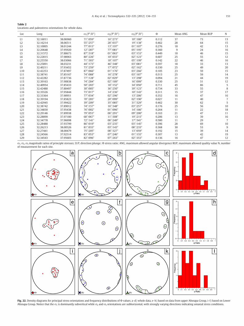
Table 2Locations and paleostress orientations for whole data.
Loc Long Lat σ1(P°/D°) σ2(P°/D°) σ3(P°/D°) Ф Mean ANG Mean RUP N
L1 32.16011 38.06960 71°/059° 16°/273° 10°/180° 0.112 37 73 13L2 32.16214 38.06511 55°/257° 28°/037° 19°/138° 0.462 28 64 15L3 32.10005 38.01244 77°/013° 13°/197° 01°/107° 0.276 18 42 13L4 32.20648 37.95920 12°/287° 77°/081° 05°/195° 0.360 9 24 16L5 32.31572 37.88673 87°/318° 01°/063° 03°/153° 0.449 18 46 15L6 32.22815 37.98963 80°/226° 10°/033° 02°/123° 0.607 25 55 12L7 32.25550 38.03066 71°/303° 18°/107° 05°/199° 0.142 22 46 16L8 32.25891 38.03231 44°/173° 46°/348° 03°/081° 0.597 18 33 13L9 32.40211 37.93452 73°/259° 17°/072° 02°/162° 0.330 25 49 20L10 32.42253 37.87497 87°/066° 01°/176° 03°/266° 0.105 23 59 15L11 32.38741 37.85167 74°/088° 16°/278° 03°/187° 0.513 25 59 14L12 32.42282 37.87736 77°/128° 02°/029° 13°/298° 0.094 21 44 19L13 32.39163 37.90838 74°/284° 02°/189° 16°/099° 0.330 25 51 12L14 32.40954 37.85433 50°/265° 18°/152° 34°/050° 0.711 45 86 5L15 32.42488 37.88497 30°/005° 36°/250° 39°/123° 0.734 33 55 8L16 32.35526 37.95844 73°/017° 14°/236° 10°/143° 0.311 15 37 17L17 32.33364 37.90951 77°/034° 02°/296° 13°/206° 0.352 16 47 16L18 32.39194 37.85823 70°/285° 20°/099° 02°/190° 0.027 11 40 7L19 32.42945 37.99422 39°/209° 35°/085° 31°/329° 0.462 30 62 5L20 32.38742 37.89012 74°/157° 16°/348° 03°/257° 0.176 25 56 10L21 32.34830 37.95438 76°/002° 01°/096° 14°/186° 0.264 11 22 18L22 32.29146 37.89938 79°/053° 06°/291° 09°/200° 0.163 21 47 11L23 32.28899 37.97180 68°/067° 11°/308° 19°/215° 0.206 13 39 16L24 32.34778 37.96698 72°/141° 06°/249° 17°/341° 0.580 11 29 7L25 32.28488 37.93799 86°/019° 03°/235° 03°/145° 0.396 28 69 10L26 32.26213 38.00526 81°/033° 03°/143° 08°/233° 0.368 30 53 9L27 32.27441 38.00479 75°/205° 08°/327° 13°/059° 0.192 15 39 14L28 32.24566 37.92514 83°/053° 07°/246° 01°/155° 0.307 13 42 19L29 32.34543 37.95603 82°/096° 07°/263° 02°/353° 0.136 16 47 12
σ1, σ2, σ3 magnitude ratios of principle stresses; D/P, direction/plunge;Ф stress ratio; ANG, maximum allowed angular divergence RUP, maximum allowed quality value N, numberof measurement for each site.
Fig. 22. Density diagrams for principal stress orientations and frequency distributions ofФ values. a–d) whole data, e–h) based on data from upper Altınapa Group, i–l) based on LowerAltınapa Group. Notice that the σ1 is dominantly subvertical while σ2 and σ3 orientations are subhorizontal, with strongly varying directions indicating uniaxial stress conditions.
151A. Koç et al. / Tectonophysics 532–535 (2012) 134–155

Fig. 23. (a) Major faults and lineament map of the study area. Arrows indicate horizontal component of the minor principal stress (σ3) and numbers indicate the paleostressmeasurement sites which correspond to site numbers in Fig. 21c.
152 A. Koç et al. / Tectonophysics 532–535 (2012) 134–155
Poisson, 1987; Morris and Robertson, 1993; Poisson et al., 2003; vanHinsbergen, 2010; van Hinsbergen et al., 2010a,b). The spatial restric-tion of NE–SW to NW–SE extension to the region north of the Cyprussubduction zone suggests a direct relationship to the dynamics of theeastern Mediterranean subduction system, which has likely been in astate of relative southward trench retreat since at least Middle Mio-cene time (see also Over et al., 2004). Our analysis shows that notonly the forearc, but also the volcanic arc region of the Cyprus sub-duction zone, to which the Altınapa Basin belongs, has been affectedby this extension for at least the last ~12 Ma.
Finally, our analysis has an important implication for the evolutionof southern Anatolian topography. In Middle to Late Miocene time,the Mut Basin, which has been uplifted since Late Miocene time to el-evations up to 2 km, was marine (Cosentino et al., 2012), whereas theAltınapa Basin, currently at elevations around 1 km, was continental.No data are available to constrain the paleo-elevation of the AltınapaBasin during Middle Miocene sedimentation, but the fact that the MutBasin lies presently at an about 1 km higher elevation than the Altı-napa Basin demonstrates that the late Neogene history of the south-ern Turkey was characterized by strong differential uplift, with thesouthern Tauride mountain range uplifting at least 1 km more thanthe intramontane basins to their north. Cosentino et al. (2012) inter-preted the uplift of the Taurides since the Late Miocene as a dynamictopographic effect, uplifting all of the Central Anatolian plateau. Al-though such dynamic topographic effects may have well played animportant role, the major uplift difference between the Altınapa andMut basins illustrates that at least half of the uplift of the southernTaurides resulted from regional tectonics rather than Anatolia-widedynamic topography. The Tauride range as exposed today thereforelikely represents a horst system, with regions to the north and
south showing smaller magnitudes of uplift than the range itself.We finally note that the modern topography of the Tauride range isthus a late Neogene phenomenon that is unrelated to the late Creta-ceous to Oligocene folding and thrusting responsible for the domi-nant deformation within the range.
7. Conclusions
Our results demonstrate that the Altınapa Basin is an extensionalbasin, with a stratigraphy that can be subdivided in a Lower andUpper Altınapa Group. Volcanic deposits in the Upper Altınapa Grouphave been dated with 40Ar/39Ar geochronology, and demonstrate anage range of ~11.8–11.6 Ma. Extension-related subsidence, controlledalong large basin-bounding faults, therefore started prior to 11.8 Ma.Paleostress analysis shows that σ2 and σ3 directions during and afterdeposition, up to and including the modern-day patterns, vary stronglyand locally. A regional pattern of open, extension-related folds shows anapproximately E–W trend and suggests that the dominant extensiondirection responsible for formation of the basin was ~N–S to NE–SW.These folds affect the Lower Altınapa Group more than the UpperAltınapa Group, between which an angular unconformity exists. This,together with the fact that the Lower Altınapa Group has a clear finingupward trend, suggests that the main basin forming phase predates11.8 Ma. Our results are consistent with a regional pattern of NE–SWtoNW–SE extension along the southern Taurides,which seems spatiallycoincident with the location of the Cyprus subduction zone.
The continental Middle Miocene sediments of the Altınapa Basin lieat present at an elevation of ~1 km, whereas partly contemporaneousmarine deposits in the Mut Basin to the south, on top of the Tauriderange, are elevated up to 2 km. This demonstrates that the southern

ll
lll l
lll
l
ll
l
l
Fig. 24. Paleostress stratigraphy of the Apa Basin from the Middle Miocene to Recent. Arrows represent σ3 directions. 1) 11 September 2009 Sille Earthquake (Mw=4.9, ETHZ), 2)15 December 2000 Afyon Earthquake (Ms=5.8, Taymaz et al., 2004), 3), 03 February 2002 Sultandağı Earthquake (Ms=6.4, Taymaz et al., 2004). Note that the unconstrained na-ture of σ3 directions and from Middle Miocene to Recent and variation of extension directions of recent earthquakes in the region.
153A. Koç et al. / Tectonophysics 532–535 (2012) 134–155
Tauride range uplifted at least 1 km more than the flanking intramon-tane basins to the north, attesting to strong differential uplift in thelate Neogene of southern Turkey. The high topography of the Tauriderange is unrelated to the late Cretaceous to Oligocene thrusting that de-formed the rocks in the range.
Acknowledgments
Research for this paper occurred within the context of the Nether-lands Research School of Integrated Solid Earth Sciences (ISES) andwas supported by ÖYP research fund of Turkish Government No:BAP-08-11-DPT.2002K120510 and DARIUS Programme. DJJvH ac-knowledges financial support from Statoil (SPlates Model project).KK is funded by grant 814.01.004 of the Netherlands Organisationfor Scientific Research. AK would like to thank Kemal Koç, HasanKocatepe, M. Onur Öztepe, Erhan Gülyüz, Murat Özkaptan, Mustafa
Y. Kaya, Kıvanç Yücel and Şule Gürboğa for their support during field-works in 2008 and 2009. Finally, we thank Domenico Cosentino andan anonymous reviewer for their valuable comments.
Appendix A. Supplementary data
Supplementary data to this article can be found online at doi:10.1016/j.tecto.2012.01.028.
References
Alçiçek, H., 2010. Stratigraphic correlation of the Neogene basins in southwesternAnatolia: regional palaeogeographical, palaeoclimatic and tectonic implications.Palaeogeography, Palaeoclimatology, Palaeoecology 291, 297–318.
Altıner, D., Yılmaz, I.O., Ozgul, N., Akcar, N., Bayazıtoglu, M., Gaziulusoy, Z.E., 1999. High-resolution sequence stratigraphic correlation in the Upper Jurassic (Kimmeridgian)–Upper Cretaceous (Cenomanian) peritidal carbonate deposits (Western Taurides,Turkey). Geological Journal 34, 139–158.

154 A. Koç et al. / Tectonophysics 532–535 (2012) 134–155
Andrew, T., Robertson, A.H.F., 2002. The Beysehir–Hoyran–Hadim nappes: genesis andemplacement of Mesozoic marginal and oceanic units of the northern Neotethys insouthern Turkey. Journal of the Geological Society of London 159, 529–543.
Angelier, J., 1990. Inversion of field data in fault tectonics to obtain the regional stress—III. A new rapid direct inversion method by analytical means. Geophysical JournalInternational 103, 363–376.
Angelier, J., 1994. Fault slip analysis and paleostress reconstruction. In: Hancock, P.L.(Ed.), Continental Deformation. Pergamon Press, Oxford, pp. 53–101.
Barrier, E., Vrielynck, B., 2008. MEBE Atlas of Paleotectonic maps of the Middle East.Commission for the Geological Map of the World. .
Bassant, P., van Buchem, F.S.P., Strasser, A., Görür, N., 2005. The stratigraphic architec-ture and evolution of the Burdigalian carbonate–siliciclastic sedimentary systemsof the Mut Basin, Turkey. Sedimentary Geology 173, 187–232.
Besang, C., Eckhart, F.J., Harre, W., Kreuzer, G., Muller, P., 1977. RadiometrischeAlterbestimmung am neogenen Eruptivgesteinen der Türkei. Geologisches Jahrbuch25, 3–36.
Biryol, C.B., Beck, S.L., Zandt, G., Ozacar, A.A., 2011. Segmented African lithospherebeneath the Anatolian region inferred from teleseismic P-wave tomography.Geophysical Journal International 184, 1037–1057.
Blumenthal, M.M., 1963. Le système structural du Taurus sud Anatolies. Bull. Soc. Géol.Fr. Livre à Mémoire de Professor P. Fallot, Mémoir hors-série, 1, pp. 611–662.
Burton-Ferguson, R., Aksu, A.E., Calon, T.J., Hall, J., 2005. Seismic stratigraphy and struc-tural evolution of the Adana Basin, eastern Mediterranean. Marine Geology 221,189–222.
Carey, E., Burinier, B., 1974. Analyse théorique et numérique d'un modèle mécaniqueélémentaire appliqué à l'étude d'une population de failes. Comptes Rendus de l'Academie des Sciences Paris D279, 891–894.
Çiner, A., Karabiyikoglu, M., Monod, O., Deynoux, M., Tuzcu, S., 2008. Late Cenozoicsedimentary evolution of the Antalya Basin, Southern Turkey. Turkish Journal ofEarth Sciences 17, 1–41.
Cosentino, D., Schildgen, T.F., Cipollari, P., Faranda, C., Gliozzi, E., Hudácková, N.,Lucifora, S., Strecker, M.R., 2012. Late Miocene surface uplift of the southern marginof the Central Anatolian Plateau, Central Taurides, Turkey. Geological Society ofAmerica Bulletin 124 (1–2), 133–145. doi:10.1130/B30466.1.
Darbas, G., Nazik, A., 2010. Micropaleontology and paleoecology of the Neogene sedi-ments in the Adana Basin (South of Turkey). Journal of Asian Earth Sciences 39,136–147.
Derman, A.S., Gürbüz, K., 2007. Nature, provenance and relationships of Early Miocenepalaeovalley fills, northern Adana Basin, Turkey: their significance for sediment-bypassing on a carbonate shelf. Turkish Journal of Earth Sciences 16, 181–209.
Doğan, A., 1975. Sizma–Ladik (Konya) Civa Sahasinin Jeolojisi ve Maden YataklariSorunlarinin Incelenmesi. I.Ü. Fen Fakültesi Min. Pet. Kürsüsü, Yük. Müh. DiplomaÇalismasi, Istanbul., 40.
Eren, Y., 1992. Eldes-Gökçeyurt-Derbent (Konya kuzeybatisi) Dolaylarinda KocaçaldağYükseltisinin Jeolojisi. S.Ü. Arastirma Fonu, Proje No: 88-026. .
Eren, Y., 1993. Eldes-Derbent-Tepeköy-Sögütözü Arasinin Jeolojisi, PhD Thesis, S.Ü. FenBil. Enst. Konya, Turkey. 224.
Eren, Y., 1996. Ilgin-Sarayönü (Konya) güneyinde Bozdaglar Masifinin Yapisal Özellikleri.Geological Bulletin of Turkey 39, 49–64.
Ergin, M., Aktar, M., Özalaybey, S., Tapirdamaz, M.C., Selvi, O., Tarancioglu, A., 2009. Ahigh-resolution aftershock seismicity image of the 2002 Sultandagi-Çay earth-quake (Mw—6.2), Turkey. Journal of Seismology 13, 633–646.
Eriş, K.K., Bassant, P., Ülgen, U.B., 2005. Tectono-stratigraphic evolution of an Early Mio-cene incised valley-fill (Derinçay Formation) in the Mut Basin, Southern Turkey.Sedimentary Geology 173, 151–185.
Etchecopar, A., Vasseur, D., Daignières, M., 1981. An inverse problem in microtectonicsfor determination of stress tensors from faults striation analysis. Journal of Struc-tural Geology 3, 51–65.
Faccenna, C., Bellier, O., Martinod, J., Piromallo, C., Regard, V., 2006. Slab detachmentbeneath eastern Anatolia: a possible cause for the formation of the North AnatolianFault. Earth and Planetary Science Letters 242, 85–97.
Gans, C.R., Beck, S.L., Zandt, G., Biryol, C.B., Ozacar, A.A., 2009. Detecting the limit of slabbreak-off in central Turkey: new high-resolution Pn tomography results. GeophysicalJournal International 179, 1566–1572.
Göğer, E., Kıral, K., 1969. Kizilören Dolayinin Jeolojisi. M.T.A. Rappor, 5204.Görmüş, M., 1984. Kizilören (Konya), Dolayinin Jeoloji Incelemesi. S. Ü. Fen Bil. Enst. M.
Sc, Konya, Turkey, 67.Gül, M., 2007. Effects of antecedent topography on reefal carbonate deposition: Early–
Middle Miocene of the Adana Basin, S Turkey. Journal of Asian Earth Sciences 31,18–34.
Homberg, C., Hu, J.-C., Angelier, J., Bergerat, F., Lacombe, O., 1997. Characterization ofstress perturbations near major fault zones : insights from field studies (JuraMountains) and numerical modelling. Journal of Structural Geology 19, 703–718.
Hüsing, S.K., Zachariasse, W.J., van Hinsbergen, D.J.J., Krijgsman, W., Inceöz, M.,Harzhauser, M., Mandic, O., Kroh, A., 2009. Oligo-Miocene foreland basin evolutionin SE Anatolia: constraints on the closure of the eastern Tethys gateway. In: vanHinsbergen, D.J.J., Edwards, M.A., Govers, R. (Eds.), Collision and Collapse at theAfrica-Arabia-Eurasia subduction zone: Geological Society, London, Special Publi-cation, pp. 107–132.
Janson, X., van Buchem, F.S.P., Dromart, G., Eichenseer, H.T., Dellamonics, X., Boichard,R., Bonnaffe, F., Eberli, G.P., 2010. Architecture and facies differentiation within aMiddle Miocene carbonate platform, Ermenek, Mut Basin, southern Turkey. In:van Buchem, F.S.P., Gerdes, K.D., Esteban, M. (Eds.), Mesozoic and Cenozoic Car-bonate Systems of the Mediterranean and the Middle East: Stratigraphic and Dia-genetic Reference Models: Geological Society, London, Special Publications, pp.265–290.
Karabıyıkoğlu, M., Tuzcu, S., Çiner, A., Deynoux, M., Örçen, S., Hakyemez, A., 2005. Fa-cies and environmental setting of the Miocene coral reefs in the late-orogenic fillof the Antalya Basin, western Taurides, Turkey: implications for tectonic controland sea-level changes. Sedimentary Geology 173, 345–371.
Altiekin (Konya) civarinin jeolojisi ve mineralojik-petrografik incelenmesi. MSc thesis,Selçuk University, Konya.
Kaymakci, N., Özçelik, Y., White, S.H., van Dijk, P.M., 2009. Tectono-stratigraphy of theÇankiri Basin: late Cretaceous to early Miocene evolution of the Neotethyan suturezone in Turkey. In: van Hinsbergen, D.J.J., Edwards, M.A., Govers, R. (Eds.), Collisionand Collapse at the Africa-Arabia-Eurasia subduction zone: Geological Society ofLondon Special Publication, pp. 67–106.
Kaymakci, N., Inceöz, M., Ertepinar, P., Koç, A., 2010. Late Cretaceous to Recent kinematics ofSE Anatolia (Turkey). In: Sosson, M., Kaymakci, N., Stephenson, R.A., Bergerat, F.,Starostenko, V. (Eds.), Sedimentary basin tectonics from the Black Sea and Caucasusto the Arabian Platform: Geological Society, London, Special Publications, pp. 409–435.
Keller, J., Jung, D., Burgath, K., Wolff, F., 1977. Geologie und Petrologie des NeogenenKalkalkalivulkanismus von Konya (Erenler Dagi, AlacadagMassiv, Zentral Anatolian).Geologisches Jahrbuch, B 25, 37–117.
Keskin, M., 2003. Magma generation by slab steepening and breakoff beneath a sub-duction–accretion complex: an alternative model for collision-related volcanismin Eastern Anatolia, Turkey. Geophysical Research Letters 30 (24), 8046.doi:10.1029/2003GL018019.
Khair, K., Tsokas, G.N., 1999. Nature of the Levantine (eastern Mediterranean) crustfrommultiple-source Werner deconvolution of Bouguer gravity anomalies. Journalof Geophysical Research 104, 25469–25478.
Kissel, C., Poisson, A., 1987. Étude paléomagnetique préliminaire des formations céno-zoïques des Bey Daglari (Taurides occidentales, Turquie). Comptes Rendus de l'Academie des Sciences Paris 304 (8), 343–348 Série II.
Kleinspehn, K.L., Pershing, J.C., Teyssier, C., 1989. Paleostress stratigraphy: a new techniquefor analyzing tectonic control on sedimentary-basin subsidence. Geology 17, 253–256.
Koppers, A.A.P., 2002. ArArCALC-software for 40Ar/39Ar age calculations. Computers &Geosciences 28, 605–619.
Kuiper, K.F., Deino, A.L., Hilgen, F.J., Krijgsman, W., Renne, P.R., Wijbrans, J.R., 2008.Synchronizing rock clocks of Earth history. Science 320, 500–504.
Mackintosh, P., Robertson, A.H.F., 2009. Structural and sedimentary evidence from thenorthern margin of the Tauride platform in south central Turkey used to test alter-native models of Tethys during Early Mesozoic time. Tectonophysics 473, 149–172.
Meijers, M.J.M., Kaymakci, N., van Hinsbergen, D.J.J., Langereis, C.G., Stephenson, R.A.,Hippolyte, J.-C., 2010. Late Cretaceous to Paleocene oroclinal bending in the CentralPontides (Turkey). Tectonics 29, TC4016. doi:10.1029/2009TC002620.
Meijers, M.J.M., van Hinsbergen, D.J.J., Dekkers, M.J., Altiner, D., Kaymakci, N., Langereis,C.G., Stephenson, R.A., 2011. Pervasive Paleogene remagnetization of the centralTaurides fold-and-thrust belt (southern Turkey) and implications for rotations inthe Isparta Angle. Geophysical Journal International 184, 1090–1112.
Min, K., Mundil, R., Renne, P.R., Ludwig, K.R., 2000. A test for systematic errors in 40Ar/39Ar geochronology through comparison with U/Pb analysis of a 1.1-Ga rhyolite.Geochimica et Cosmochimica Acta 64, 73–98.
Morgan, L.E., Renne, P.R., Taylor, R.E., WoldeGabriel, G., 2009. Archaeological age con-straints from extrusion ages of obsidian: examples from the Middle Awash, Ethio-pia. Quaternary Geochronology 4, 193–203.
Morris, A., Robertson, A.H.F., 1993. Miocene remagnetisation of carbonate platform and An-talya Complex units within the Isparta Angle, SW Turkey. Tectonophysics 220, 243–266.
Niehoff, W., 1961. 1/100.000 ölçekli Aksehir 90/2 paftasi, Ilgin 91/1, 91/3 ve 91/4 paf-talari üzerinde 1961 yaz mevsiminde yapilmis revizyon çalismalari hakkindarapor. M.T.A. Rappor, 3387.
Nier, A.O., 1950. A redetermination of the relative abundances of the isotopes of car-bon, nitrogen, oxygen, argon, and potassium. Physical Review 77, 789.
Öğütcü, Z., Horason, G., Kalafat, D., 2010. Investigation of microseismic activity sourcesin Konya and its vicinity, central Turkey. Natural Hazards 58 (1), 497–509.doi:10.1007/s11069-010-9683-6.
Okay, A.I., Özgül, N., 1984. HP/LT metamorphism and the structure of the Alanya Massif,Southern Turkey: an allochthonous composite tectonic sheet. In: Dixon, J.E.,Robertson, A.H.F. (Eds.), The Geological Evolution of the Eastern Mediterranean:Geological Society Special Publication, pp. 429–439.
Okay, A.I., Satir, M., Maluski, H., Siyako, M., Monié, P., Metzger, R., Akyüz, S., 1996.Paleo- and Neo-Tethyan events in northwestern Turkey: geologic and geochrono-logic constraints. In: Yin, A., Harrison, T.M. (Eds.), The tectonic evolution of Asia.Cambridge University Press, Cambridge, pp. 420–441.
Okay, A.I., Zattin, M., Cavazza, W., 2010. Apatite fission-track data for the MioceneArabia–Eurasia collision. Geology 38, 35–38.
Over, S., Ozden, S., Ulugenc, U.C., 2004. Late Cenozoic stress distribution along the MisisRange in the Anatolian, Arabian, and African plate intersection region, SE Turkey.Tectonics 23, TC3008. doi:10.1029/2002TC001455.
Özcan, A., Göncüoğlu, M.C., Turhan, N., Şentürk, K., Uysal, S., Isik, A., 1990. Konya-Kadinhani-Ilgin Dolayinin Temel Jeolojisi. M.T.A. Rappor, 9535.
Özer, E., Koc, H., Ozsayar, T.Y., 2004. Stratigraphical evidence for the depression of thenorthernmargin of theMenderes–Tauride Block (Turkey) during the Late Cretaceous.Journal of Asian Earth Sciences 22, 401–412.
Özkan, A.M., 1998. Konya Batisindaki Neojen Çökellerinin Stratigrafisi ve Sedimantolo-jisi, PhD Thesis, S.Ü. Fen Bil. Enst., Konya, Türkey, 208 pp.
Özkan, A.M., Söğüt, A.R., 1999. Dilekçi (Konya batısı) çevresindeki Neojen çökellrininstratigrafisi. Journal of Engineering Science 5, 1131–1138.
Poisson, A., Wernli, R., Sagular, E.K., Temiz, H., 2003. New data concerning the age ofthe Aksu Thrust in the south ofthe Aksu valley, Isparta Angle (SW Turkey): conse-quences for the Antalya Basin and the Eastern Mediterranean. Geological Journal38, 311–327.

155A. Koç et al. / Tectonophysics 532–535 (2012) 134–155
Pourteau, A., Candan, O., Oberhänsli, R., 2010. High-pressure metasediments in centralTurkey: constraints on the Neotethyan closure history. Tectonics 29, TC5004.doi:10.1029/2009TC002650.
Ricou, L.E., Argyriadis, I., Marcoux, J., 1975. L'axe calcaire du Taurus, un alignement defenêtres arabo-africaines sous des nappes radiolaritiques, ophiolitiques et méta-morphiques. Bulletin de la Societe Geologique de France 17, 1024–1043.
Şafak, Ü., Kelling, G., Gökçen, N.S., Gürbüz, K., 2005. The mid-Cenozoic succession andevolution of the Mut basin, southern Turkey, and its regional significance. Sedi-mentary Geology 173, 121–150.
Şengör, A.M.C., Yılmaz, Y., 1981. Tethyan evolution of Turkey: a plate tectonic approach.Tectonophysics 75, 181–241.
Şengör, A.M.C., Özeren, S., Genç, T., Zor, E., 2003. East Anatolian high plateau as amantle-supported, north–south shortened domal structure. Geophysical ResearchLetters 30 (24), 8045. doi:10.1029/2003GL017858.
Steiger, R.H., Jäger, E., 1977. Subcommission on geochemistry: convention on the use ofdecay constants in geo- and cosmochronology. Earth and Planetary Science Letters36, 359–362.
Taymaz, T., Tan, O., Yolsal, S., 2004. Seismotectonics of western Turkey: a synthesis ofsource parameters and rupture histories of Recent earthquakes. Eos TransactionsAGU 85, 47.
Temel, A., Gündogdu, M.N., Gourgaud, A., 1998. Petrological and geochemical charac-teristic of Cenozoic high-K calcalkaline volcanism in Konya, Central Anatolia,Turkey. Journal of Volcanology and Geothermal Research 85, 327–354.
Torsvik, T.H., Cocks, L.R.M., 2009. The Lower Palaeozoic palaeogeographical evolutionof the northeastern and eastern peri-Gondwanan margin from Turkey to New
Zealand. In: Bassett, M.G. (Ed.), Early Palaeozoic Peri-Gondwana terranes: New in-sights from tectonics and biogeography: Geological Society, London, Special Publi-cations, pp. 3–21.
van Hinsbergen, D.J.J., 2010. A key extensional metamorphic complex reviewed and re-stored: the Menderes Massif of western Turkey. Earth-Science Reviews 102, 60–76.
van Hinsbergen, D.J.J., Dekkers, M.J., Bozkurt, E., Koopman, M., 2010a. Exhumation with atwist: paleomagnetic constraints on the evolution of the Menderes metamorphiccore complex (western Turkey). Tectonics 29, TC3009. doi:10.1029/2009TC002596.
van Hinsbergen, D.J.J., Dekkers, M.J., Koç, A., 2010b. Testing Miocene remagnetization ofBey Daglari: Timing and amount of Neogene rotations in SW Turkey. Turkish Jour-nal of Earth Sciences 19, 123–156.
van Hinsbergen, D.J.J., Kaymakci, N., Spakman, W., Torsvik, T.H., 2010c. Reconciling thegeological history of western Turkey with plate circuits and mantle tomography.Earth and Planetary Science Letters 297, 674–686.
Wiesner, K., 1968. Konya civa yataklari ve bunlar üzerindeki etütler. M.T.A. Dergisi,Sayi, 70, pp. 178–213.
Yağmurlu, F., 1991a. Stratigraphy and depositional environments of Yalvaç-YarıkkayaNeogene basin, SW-Anatolia. Geological Bulletin of Turkey 34, 9–19.
Yağmurlu, F., 1991b. Yalvaç-Yarikkaya Neojen havzasinin tektono-sedimanter özelliklerive yapisal evrimi. M.T.A. Dergisi, Sayi, 112, pp. 1–13.
Yetiş, C., 1988. Reorganization of the Tertiary stratigraphy in the Adana basin, southernTurkey. Newsletters in Stratigraphy 20, 43–58.