telegraph road - monroe, mi
TRANSCRIPT

Telegraph Roadcorridor improvement planMONROE, MI
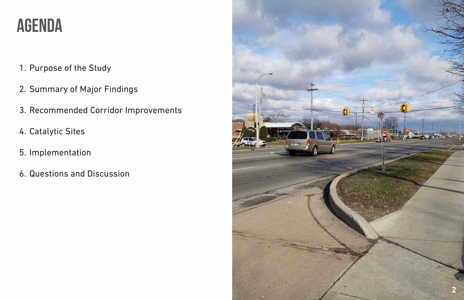
1. Purpose of the Study
2. Summary of Major Findings
3. Recommended Corridor Improvements
4. Catalytic Sites
5. Implementation
6. Questions and Discussion
agenda
2

purpose of the study
• Understand existing conditions of the area
• Identify market based strategies and concepts for catalytic sites along the corridor
• Promote changes to improve safety and travel for all types of users
• Improve identity and visual appeal of the corridor
• Set the stage for potential action steps
33
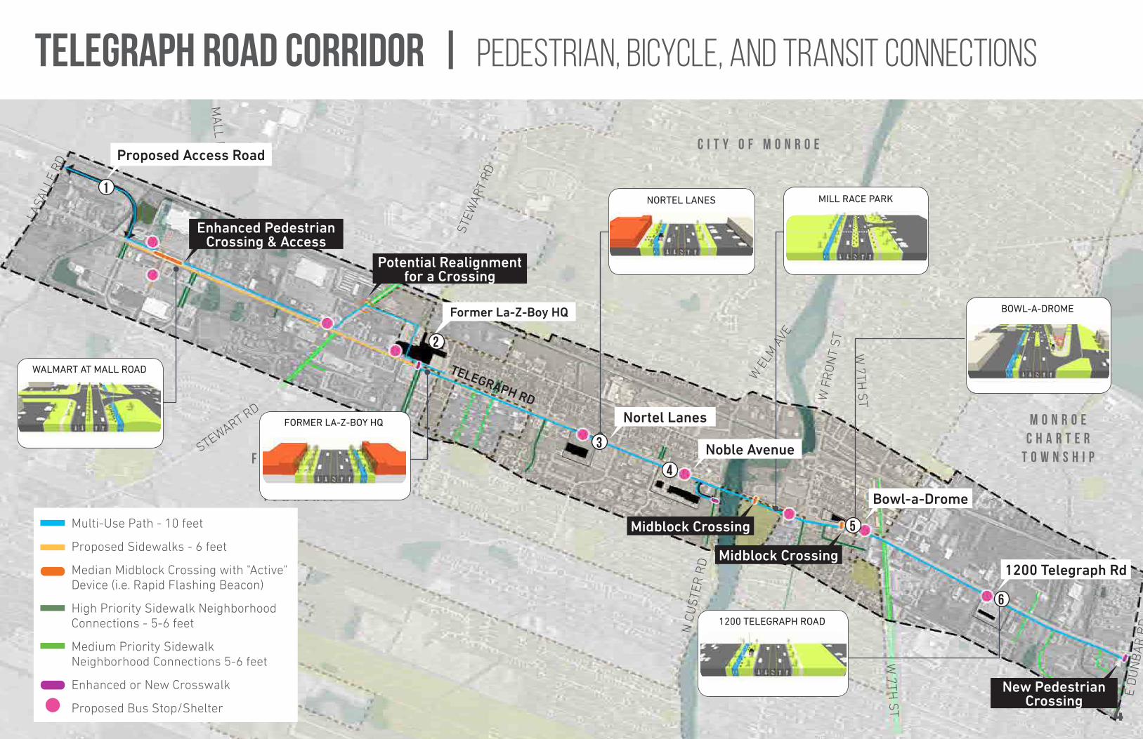
Telegraph Road Corridor | Pedestrian, Bicycle, and Transit connections
N O R T H 4
Multi-Use Path - 10 feet
Proposed Sidewalks - 6 feet
Median Midblock Crossing with "Active" Device (i.e. Rapid Flashing Beacon)
High Priority Sidewalk Neighborhood Connections - 5-6 feet
Medium Priority Sidewalk Neighborhood Connections 5-6 feet
Enhanced or New Crosswalk
Proposed Bus Stop/Shelter
F R E N C H T O W N C H A R T E R
T O W N S H I P
M O N R O EC H A R T E R
T O W N S H I P
C I T Y O F M O N R O E
TELEGRAPH RD
STEWART RD
STEW
ART
RD
N C
US
TER
RD
W E
LM A
VE
W F
RO
NT
ST
S C
US
TER
RD
W 7TH
ST
W 7TH
ST
LASA
LLE
RD
MA
LL RD
E D
UN
BA
R R
D
WALMART AT MALL ROAD
FORMER LA-Z-BOY HQ
NORTEL LANES MILL RACE PARK
BOWL-A-DROME
1200 TELEGRAPH ROAD
Former La-Z-Boy HQ
1
2
3
4
5
6
Nortel Lanes
Proposed Access Road
Noble Avenue
Bowl-a-Drome
1200 Telegraph Rd
Enhanced Pedestrian Crossing & Access
Potential Realignment for a Crossing
Midblock Crossing
Midblock Crossing
New Pedestrian Crossing
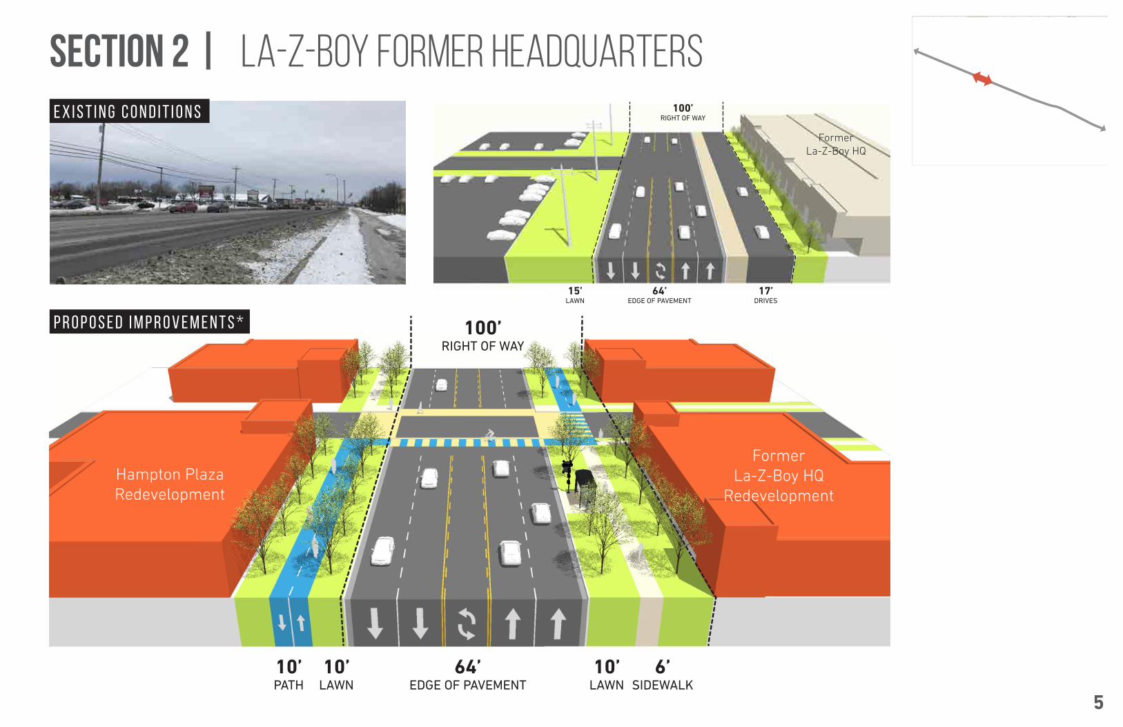
section 2 | la-z-boy former headquarters100’
RIGHT OF WAY
64’EDGE OF PAVEMENT
17’DRIVES
15’LAWN
Former La-Z-Boy HQ
64’EDGE OF PAVEMENT
6’SIDEWALK
10’LAWN
10’LAWN
10’PATH
100’RIGHT OF WAY
Hampton Plaza Redevelopment
Former La-Z-Boy HQ
Redevelopment
5
E X I S T I N G C O N D I T I O N S
P R O P O S E D I M P R O V E M E N T S *

section 3 | nortel lanes100’
RIGHT OF WAY
63’EDGE OF PAVEMENT
11’LAWN
10’LAWN
5’WALK
5’WALK
2.5’LAWN
4’LAWN
Nortel LanesParking Lot
100’RIGHT OF WAY
63’EDGE OF PAVEMENT
11’LAWN
4’LAWN
5’WALK
2.5’LAWN
10’PATH
5’LAWN
Nortel Lanes Redevelopment
Strip Mall
6
E X I S T I N G C O N D I T I O N S
P R O P O S E D I M P R O V E M E N T S *
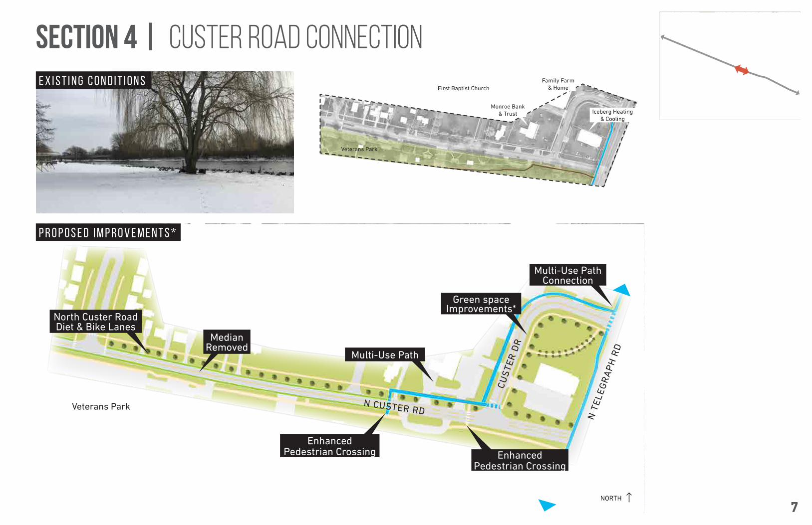
NORTH
N CUSTER RD
CU
STE
R D
R
N T
ELE
GR
AP
H R
D
Veterans Park
Multi-Use Path Connection
Green space Improvements*
North Custer Road Diet & Bike Lanes
Enhanced Pedestrian Crossing Enhanced
Pedestrian Crossing
Multi-Use Path
Median Removed
section 4 | custer road connection
Iceberg Heating & Cooling
Monroe Bank & Trust
First Baptist Church
Veterans Park
Family Farm & Home
7
E X I S T I N G C O N D I T I O N S
P R O P O S E D I M P R O V E M E N T S *
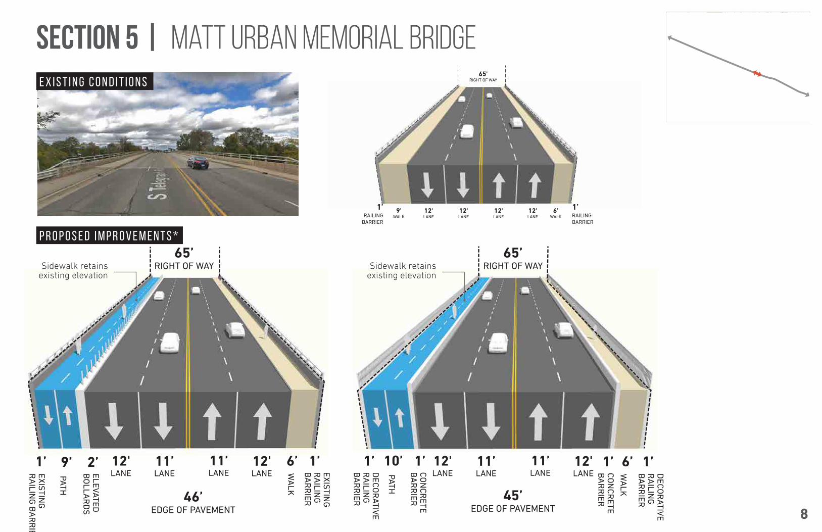
section 5 | matt urban memorial bridge65’
RIGHT OF WAY
1’1’RAILING BARRIER
RAILING BARRIER
12'LANE
12'LANE
12'LANE
12'LANE
6’WALK
9’WALK
46’EDGE OF PAVEMENT
65’RIGHT OF WAY
9’ 1’1’ 2’
45’EDGE OF PAVEMENT
65’RIGHT OF WAY
6’6’ 10’ 1’1’ 1’ 1’
DEC
OR
ATIVE R
AILIN
G
BA
RR
IER
EXISTIN
G
RA
ILING
B
AR
RIER
DEC
OR
ATIVE R
AILIN
G
BA
RR
IER
EXISTIN
G
RA
ILING
BA
RR
IER
CO
NC
RETE
BA
RR
IER
CO
NC
RETE
BA
RR
IER
ELEVATED
BO
LLAR
DS
WA
LK
WA
LK
PATH
PATH
12'LANE
12'LANE
12'LANE
12'LANE
11’LANE
11’LANE
11’LANE
11’LANE
Sidewalk retains existing elevation
Sidewalk retains existing elevation
8
E X I S T I N G C O N D I T I O N S
P R O P O S E D I M P R O V E M E N T S *

section 6 | mill race park
61’EDGE OF PAVEMENT
6’LAWN
6’WALK
8’WALK
18’LAWN
10’LAWN
110-120’RIGHT OF WAY
RiverBend Commons
Parking Lot
Mill Race Park
9
E X I S T I N G C O N D I T I O N S
P R O P O S E D I M P R O V E M E N T S *
61’EDGE OF PAVEMENT
6’LAWN
6’WALK
10’PATH
18’LAWN
10’LAWN
110-120’RIGHT OF WAY
RiverBend Commons
Parking Lot
Mill Race Park

section 7 | bowl-a-drome100’
RIGHT OF WAY
63’EDGE OF PAVEMENT
18’WALK
16-18’LAWN
Don Larson’s Bar Parking
LaRoy Door Sales & Service
100’RIGHT OF WAY
63’EDGE OF PAVEMENT
6’LAWN
10’PATH
12’WALK
8’LAWN
Don Larson’s Bar Parking
LaRoy Door Sales & Service
New PlazaDriveway Closure Driveway Closure
10
E X I S T I N G C O N D I T I O N S
P R O P O S E D I M P R O V E M E N T S *
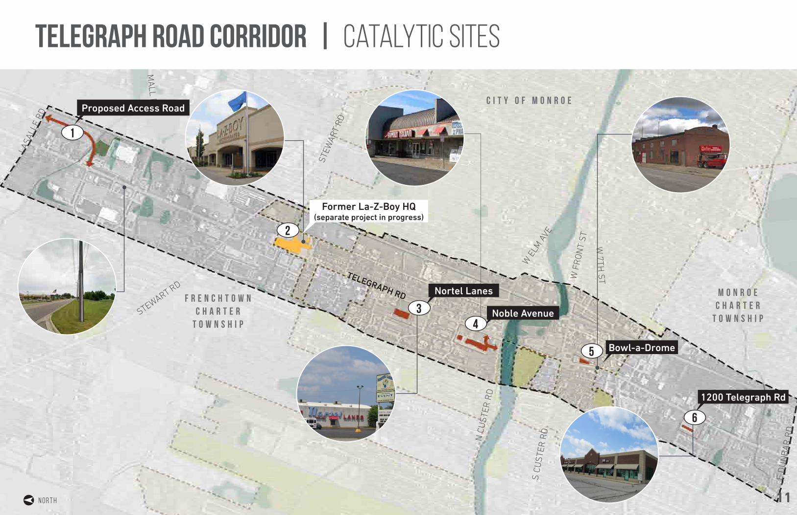
telegraph road corridor | catalytic sites
11N O R T H
TELEGRAPH RD
STEWART RD
STEW
ART
RD
N C
US
TER
RD
W E
LM A
VE
W F
RO
NT
ST
S C
US
TER
RD
W 7TH
ST
W 7TH
ST
LASA
LLE
RD
MA
LL RD
E D
UN
BA
R R
D
F R E N C H T O W N C H A R T E R
T O W N S H I P
M O N R O EC H A R T E R
T O W N S H I P
C I T Y O F M O N R O E
Former La-Z-Boy HQ(separate project in progress)
1
6
Nortel Lanes
Proposed Access Road
Noble Avenue
Bowl-a-Drome
1200 Telegraph Rd
2
34
5
6

Catalytic site #2 | former la-z-boy headquarters
MARKETABILITY AND POTENTIAL USES
Lifestyle Anchors:• Westborn Market• Men’s Wearhouse• Gap, Old Navy outlets
Supporting Uses:
• Townhomes• Lofts• Single-Family • Neighborhood Scale Retail
HU
BER
DR
IVE
BEN
TLEY
DR
IVE
HOLIDAY BOULEVARD
EATON DRIVE
JOH
N L
DR
IVE
NO
RTH
RO
ESSL
ER S
TREE
T
DA
ZAR
OW
DR
IVE
STEWART ROAD
LAVE
ND
ER S
TREE
T
Cottage and Neo-Traditional Homes
Mason Run Open Space
Townhomes
Townhomes
Lofts
Lofts
Retail
Retail
10' Multi-Use Path
Proposed Bus Stop
HU
BER
DR
IVE
BEN
TLEY
DR
IVE
HOLIDAY BOULEVARD
EATON DRIVE
JOH
N L
DR
IVE
NO
RTH
RO
ESSL
ER S
TREE
T
DA
ZAR
OW
DR
IVE
STEWART ROAD
LAVE
ND
ER S
TREE
T
Office Build-to-Suit Campus
Mason Run Open Space
Townhomes
Townhomes
Lofts
Lofts
Retail
Retail
10' Multi-Use Path
CONCEPT 1 SITE PLAN
CONCEPT 2 SITE PLAN
TELE
GRA
PH R
OAD
TELE
GRA
PH R
OAD
Proposed Bus Stop
12

Catalytic site #3 | nortel lanes
N T
ELEG
RAPH
RD
BEN
TLEY
DR
JOH
N A
ND
ERSO
N C
T
W LORAIN ST
Community-Wide Entertainment and Fun
Center 80,663 SF total
Neighborhood Connection
Outdoor DiningVolleyball Courts
Enhanced Pedestrian Access
Multi-Use Path
Proposed Bus StopEnhanced
Pedestrian Access
FOUR SEASONS ENTERTAINMENT CENTER
ADULTS - INDOORS• Gourmet Pizzas, Grill• Micro-brewery• Bocce Ball / Fowling Lanes
ADULTS - OUTDOORS• Patio extension of bar & grill• Volleyball Courts• Shuffleboard
FAMILIES - INDOORS• Bowling Lanes• Simulation Arcade• Beginner’s Bounce• Childcare Services
13

Catalytic site #4 | noble avenue
Multi-Use PathProposed Bus
Stop
Enhanced Entrance Drive and Pedestrian
Access
N T
ELEG
RAPH
RD
BEN
TLEY
DR
W NOBLE AVENUE
CUST
ER D
RN CUSTER RD
Existing Building
14,350 SF
Proposed Outparcel7,000 SF
Proposed Outparcel7,000 SF
Existing Building 78,700 SF
MARKETABILITY AND POTENTIAL USES
• Fast Food Casual Dining• Bar and Grill • Outdoor Dining Space• Coffee Shop
14

Catalytic site #5 | bowl-a-drome
Existing Buildings 20,000 SF
Enhanced Pedestrian Crossing
Driveway Closure
Driveway Closure
Public Plaza & Outdoor Dining
Proposed Bus Stop
PROSPECTIVE TENANTS
• Micro-brewery, Brewpub• Special Event Center• Community Theater• Artisan Studios• Lofts above Retail
15
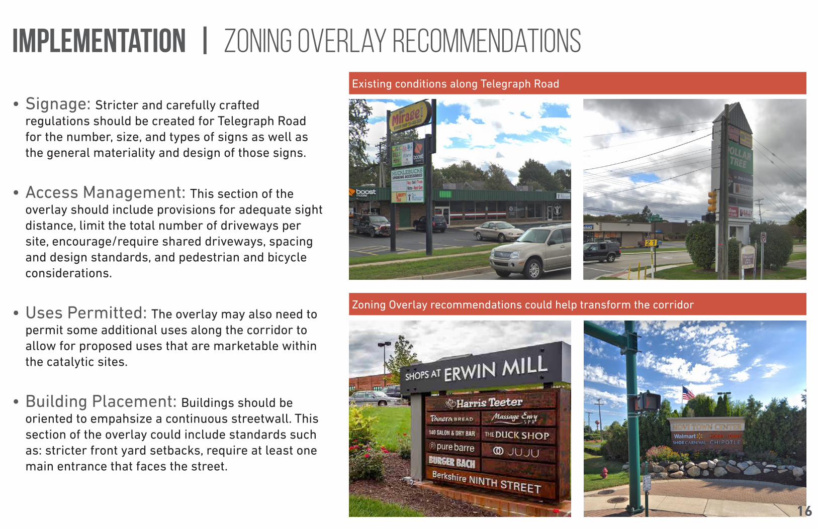
• Signage: Stricter and carefully crafted regulations should be created for Telegraph Road for the number, size, and types of signs as well as the general materiality and design of those signs.
• Access Management: This section of the overlay should include provisions for adequate sight distance, limit the total number of driveways per site, encourage/require shared driveways, spacing and design standards, and pedestrian and bicycle considerations.
• Uses Permitted: The overlay may also need to permit some additional uses along the corridor to allow for proposed uses that are marketable within the catalytic sites.
• Building Placement: Buildings should be oriented to empahsize a continuous streetwall. This section of the overlay could include standards such as: stricter front yard setbacks, require at least one main entrance that faces the street.
Existing conditions along Telegraph Road
Zoning Overlay recommendations could help transform the corridor
implementation | zoning overlay recommendations
16

• Parking: Altering parking requirements and design standards could lead to transformative changes along the corridor. Standards that could be adopted include: limit parking to the side and rear yards, create a maximum ratio or percentage of parking spaces to a site, permit parking reductions and allow for shared parking.
• Landscaping and Streetscape: Landscaping within the overlay should include uniformly planted canopy trees, permit sidewalk cafes, and native vegetation of bushes and flowers should be planted along foundation walls and fences.
The Zoning Overlay should limit parking to the rear and/or side yards.
Amenity outdoor space with plentiful and lush landscaping creates an inviting and pleasant experience.
implementation | zoning overlay recommendations
17

• Permits the usage of tax increment financing to implement capital improvements within the corridor
• Would help with redevelopment efforts by allowing communities to use tax dollars from different sources for economic development purposes
• Participating communities can plan and coordinate development through a TIF (requires approval of all taxing jurisdictions, including schools and counties)
• Telegraph Road corridor is eligible and meets all of the criteria to become a CIA (except for the requirement for areas to be zoned for mixed-use development which would require a zoning change)
• A board oversees the decisions and TIF plans for the corridor
implementation | corridor improvement authority
18

• Transportation Alternatives Program (TAP): Provides funding for projects that enhance the multi-modal transportation system and provide safe alternatives to vehicular travel.
• Congestion Mitigation Air Quality (CMAQ): Provides funding to non-attainment counties to help meet the requirements of the Clean Air Act. Projects that are selected are those that are the most effective in reducing congestion and transportation related emissions.
• Michigan State Infrastructure Bank (SIB) Loan Program: Meant to be complmentary to other private and public funding resources, this program reduces borrowing costs for transportation projects.
implementation | POTENTIAL FUNDING RESOURCES
19

SH
OR
T-T
ER
M T
AS
KS
1-2
YE
AR
S
Traffic Conduct a study on intersection signalization optimization of Telegraph Road to increase progression and decrease congestion along the corridor
City, Townships, MDOT, County Road Commission
Traffic Further investigate and implement recommended roadway and geometry mitigation measures at key intersections per the Traffic Analysis section of this plan
City, Townships, MDOT, County Road Commission
Transit Coordinate with Lake Erie Transit to confirm priority locations for future bus stops and enhancements based on their existing and projected ridership numbers. Use bus stop locations to help support approval for mid-block crossings.
City, Townships, Lake Erie Transit, MDOT
Zoning Create a zoning overlay district that can be adopted by all three communities to maximize pedestrian-oriented development opportunities
City, Townships
CIA Begin the Corridor Improvement Authority application process and coordinate with the necessary partners; ensure that the corridor meets all necessary eligibility requirements
City, Townships, County, Schools
Funding Further investigate funding resources for implementing the components of the plan and determine priority resources
City, Townships, SEMCOG, MDOT
Non-motorized Conduct an engineering and design study of the mulit-use pathway to determine cost estimates, acquisition needs, and phases of construction
City, Townships, County Road Commission, MDOT,SEMCOG
Streetscaping Create a corridor-wide streetscape plan to determine cost estimates, plant types, proper spacing, lighting, and seating details
City, Townships, County Road Commission, MDOT
Adoption Adopt the Telegraph Road Corridor Improvement Plan as part of each community Master Plan
City, Townships, Telegraph Corridor Task Force
Traffic Require Traffic Impact Studies for new developments to address access management, safety, non motorized travel, and transit.
City, Townships, MDOT
Access Management and Adoption
Adopt the 2005 Access Management Study and amendments to each community’s Zoning Ordinance. Ensure that MDOT is included in future site plan reviews.
City, Townships, MDOT
CATEGORIES TASKS PARTNERS
implementation chart
20

21
DISCUSSION & QUESTIONS