the 48th and o street redevelopment plan · the 48th and "o" street redevelopment plan is...
TRANSCRIPT
City of Lincoln, Nebraska
Prepared by:City of Lincoln, Nebraska
Urban Development DepartmentColeen J. Seng, Mayor
Approved:January 24, 2005
Marc Wullschleger, DirectorUrban Development Department
The 48th and "O" StreetRedevelopment Plan

i
INTRODUCTION . . . . . . . . . . . . . . . . . . . . . . . . . . . . . . . . . . . . . . . . . . . . . . . . .1Plan Requirements . . . . . . . . . . . . . . . . . . . . . . . . . . . . . . . . . . . . . . . . . . . . . . . . . . . . . . . . .2
EXISTING CONDITIONS . . . . . . . . . . . . . . . . . . . . . . . . . . . . . . . . . . . . . . . . . . .5Land Use . . . . . . . . . . . . . . . . . . . . . . . . . . . . . . . . . . . . . . . . . . . . . . . . . . . . . . . . . . . . . . . . .5
Commerce Center . . . . . . . . . . . . . . . . . . . . . . . . . . . . . . . . . . . . . . . . . . . . . . . . . . . . . .5Land Use Issues . . . . . . . . . . . . . . . . . . . . . . . . . . . . . . . . . . . . . . . . . . . . . . . . . . . . . . . .6
Zoning . . . . . . . . . . . . . . . . . . . . . . . . . . . . . . . . . . . . . . . . . . . . . . . . . . . . . . . . . . . . . . . . . .8Public Facilities . . . . . . . . . . . . . . . . . . . . . . . . . . . . . . . . . . . . . . . . . . . . . . . . . . . . . . . . . . . .9Parks and Open Space . . . . . . . . . . . . . . . . . . . . . . . . . . . . . . . . . . . . . . . . . . . . . . . . . . . . . .9Transportation . . . . . . . . . . . . . . . . . . . . . . . . . . . . . . . . . . . . . . . . . . . . . . . . . . . . . . . . . . . . .9
Traffic . . . . . . . . . . . . . . . . . . . . . . . . . . . . . . . . . . . . . . . . . . . . . . . . . . . . . . . . . . . . . . . .9Parking . . . . . . . . . . . . . . . . . . . . . . . . . . . . . . . . . . . . . . . . . . . . . . . . . . . . . . . . . . . . . .10Sidewalks and Pedestrian Activity . . . . . . . . . . . . . . . . . . . . . . . . . . . . . . . . . . . . . . . . .10Public Transportation Services . . . . . . . . . . . . . . . . . . . . . . . . . . . . . . . . . . . . . . . . . . . .11Pedestrian/Bicycle Trails . . . . . . . . . . . . . . . . . . . . . . . . . . . . . . . . . . . . . . . . . . . . . . . . .11
Utilities . . . . . . . . . . . . . . . . . . . . . . . . . . . . . . . . . . . . . . . . . . . . . . . . . . . . . . . . . . . . . . . . .11Water System . . . . . . . . . . . . . . . . . . . . . . . . . . . . . . . . . . . . . . . . . . . . . . . . . . . . . . . . .11Sanitary Sewer System . . . . . . . . . . . . . . . . . . . . . . . . . . . . . . . . . . . . . . . . . . . . . . . . .12Stormwater System . . . . . . . . . . . . . . . . . . . . . . . . . . . . . . . . . . . . . . . . . . . . . . . . . . . . .12Street Lighting . . . . . . . . . . . . . . . . . . . . . . . . . . . . . . . . . . . . . . . . . . . . . . . . . . . . . . . . .13
Historic Significance . . . . . . . . . . . . . . . . . . . . . . . . . . . . . . . . . . . . . . . . . . . . . . . . . . . . . . .14Blight and Substandard Determination Study . . . . . . . . . . . . . . . . . . . . . . . . . . . . . . . . . . . .14Summary of Existing Conditions . . . . . . . . . . . . . . . . . . . . . . . . . . . . . . . . . . . . . . . . . . . . . .16
REDEVELOPMENT PLAN . . . . . . . . . . . . . . . . . . . . . . . . . . . . . . . . . . . . . . . .19Guiding Development Principles for the Area . . . . . . . . . . . . . . . . . . . . . . . . . . . . . . . . . . . .19Sub-Project Areas . . . . . . . . . . . . . . . . . . . . . . . . . . . . . . . . . . . . . . . . . . . . . . . . . . . . . . . . .20Redevelopment Activities: Infrastructure Improvements . . . . . . . . . . . . . . . . . . . . . . . . . . . .21Redevelopment Activities: Commercial . . . . . . . . . . . . . . . . . . . . . . . . . . . . . . . . . . . . . . . . .22Activities by Sub-Project Areas . . . . . . . . . . . . . . . . . . . . . . . . . . . . . . . . . . . . . . . . . . . . . . .24Future Land Use . . . . . . . . . . . . . . . . . . . . . . . . . . . . . . . . . . . . . . . . . . . . . . . . . . . . . . . . . .25Redevelopment Processes . . . . . . . . . . . . . . . . . . . . . . . . . . . . . . . . . . . . . . . . . . . . . . . . . .25
Property Acquisition . . . . . . . . . . . . . . . . . . . . . . . . . . . . . . . . . . . . . . . . . . . . . . . . . . . .25Relocation . . . . . . . . . . . . . . . . . . . . . . . . . . . . . . . . . . . . . . . . . . . . . . . . . . . . . . . . . . . .25Demolition . . . . . . . . . . . . . . . . . . . . . . . . . . . . . . . . . . . . . . . . . . . . . . . . . . . . . . . . . . . .25Redevelopment/Land Disposition Agreement . . . . . . . . . . . . . . . . . . . . . . . . . . . . . . . . .25Requests for Proposals . . . . . . . . . . . . . . . . . . . . . . . . . . . . . . . . . . . . . . . . . . . . . . . . .26
Estimated Expenditures . . . . . . . . . . . . . . . . . . . . . . . . . . . . . . . . . . . . . . . . . . . . . . . . . . . .26Conformance with Comprehensive Plan . . . . . . . . . . . . . . . . . . . . . . . . . . . . . . . . . . . . . . . .26Financing . . . . . . . . . . . . . . . . . . . . . . . . . . . . . . . . . . . . . . . . . . . . . . . . . . . . . . . . . . . . . . . .26
Impact Fees . . . . . . . . . . . . . . . . . . . . . . . . . . . . . . . . . . . . . . . . . . . . . . . . . . . . . . . . . .27
APPENDIX A: Land Acquisition Policy Statement . . . . . . . . . . . . . . . . . . .A-1APPENDIX B: Relocation Assistance . . . . . . . . . . . . . . . . . . . . . . . . . . . . . .B-1
Table of Contents
ii

iii
LIST OF EXHIBITSExhibit 1: City Context Map . . . . . . . . . . . . . . . . . . . . . . . . . . . . . . . . . . . . . . . . . . . . . . . . . . .2Exhibit 2: 48th and "O" Redevelopment Area . . . . . . . . . . . . . . . . . . . . . . . . . . . . . . . . . . . . .3Exhibit 3: Generalized Existing Land Use . . . . . . . . . . . . . . . . . . . . . . . . . . . . . . . . . . . . . . . .5Exhibit 4: Existing Structures Condition . . . . . . . . . . . . . . . . . . . . . . . . . . . . . . . . . . . . . . . . .6Exhibit 5: Deterioration of Site Improvements . . . . . . . . . . . . . . . . . . . . . . . . . . . . . . . . . . . . .7
Exhibit 6: Existing Zoning . . . . . . . . . . . . . . . . . . . . . . . . . . . . . . . . . . . . . . . . . . . . . . . . .8Exhibit 7: Preliminary Concept for "O" Street Improvements - 48th to 52nd . . . . . . . . . . . .10Exhibit 8: Existing Utility Piping . . . . . . . . . . . . . . . . . . . . . . . . . . . . . . . . . . . . . . . . . . . . . . .12Exhibit 9: Sub-Project Areas . . . . . . . . . . . . . . . . . . . . . . . . . . . . . . . . . . . . . . . . . . . . . . . . .20Exhibit 10: Future Land Use . . . . . . . . . . . . . . . . . . . . . . . . . . . . . . . . . . . . . . . . . . . . . . . . .25
LIST OF TABLESTable 1: Redevelopment Activities Within Sub-Project Areas . . . . . . . . . . . . . . . . . . . . . . . .24Table 2: 48th and "O" Street Redevelopment Area Project Expenditure Summary . . . . . . .26
iv
Exhibits 1, 3, 4, 5 and 6 were prepared for the City of Lincoln by Hanna:Keelan Associates,P.C. and Architecture 1 NE.
Exhibits 2, 7, 8 and 9 were prepared by the City of Lincoln, Urban Development Department.

v
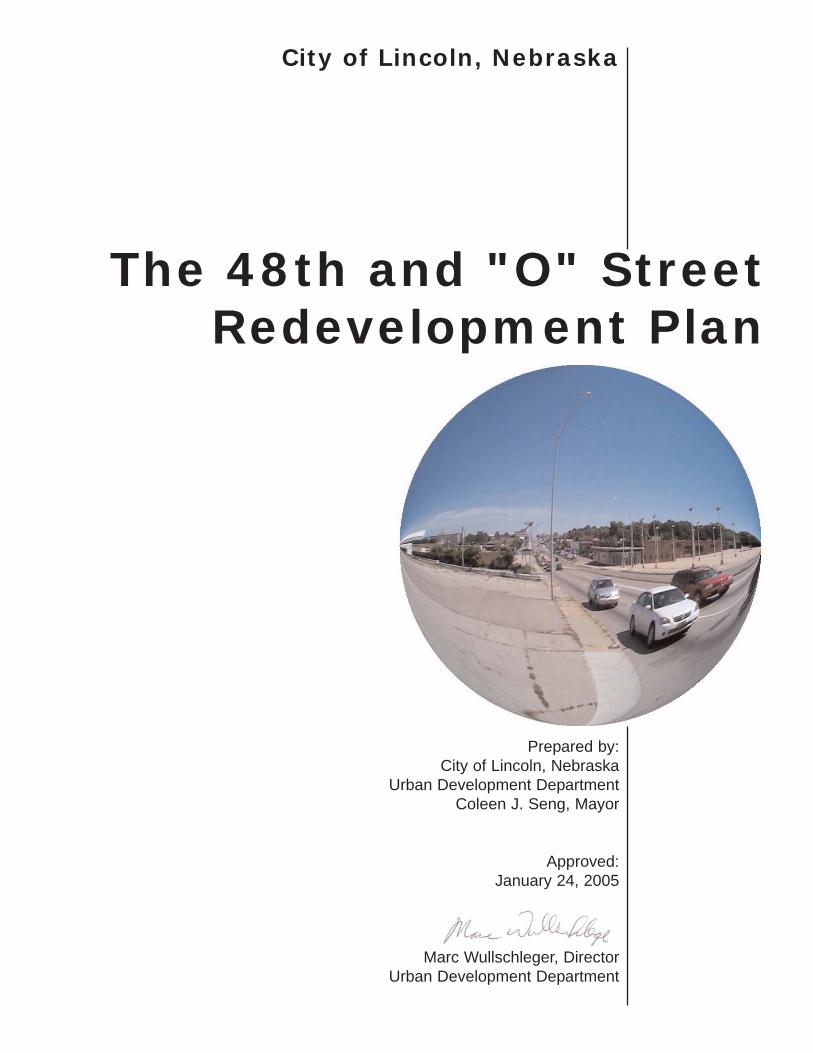
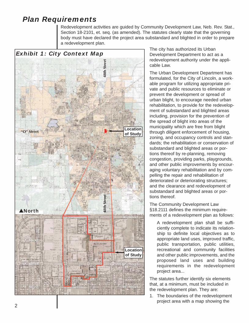
The 48th and "O" Street Redevelopment Plan is a guide for redevelopment activitieswithin the Redevelopment Area. Exhibit 1 illustrates the location of the area within thebroader context of the city of Lincoln. The boundaries are generally "R" Street on thenorth, 48th Street on the west, 52nd Street on the east, and approximately "N" Streeton the south (see Exhibit 2). Located in north central Lincoln, the area includes one ofthe busiest intersections in the City. It is primarily a commercial area, although theWitherbee neighborhood, a residential area, is located to the south, adjacent to theRedevelopment Area. The Redevelopment Area contains approximated 41.7 acres.
The intersection of 48th & O Streets has been an important crossroads in this commu-nity for more than a century, with change its one constant factor. The founding of thetowns of University Place to the northeast of Lincoln in the late 1880s and of CollegeView to the southeast a few years later shared several factors, including that their east-west main streets were aligned along the same section-line road, which eventuallybecame 48th Street. University Place called the road Warren Avenue, while in CollegeView it was L Street. The annexations of University Place in 1926 and of College Viewin 1931 resulted in the regularizing of the street names and the intersection became48th & O Streets.
By the mid-20th century the intersection reflected the increased importance of the auto-mobile in urban life, with gas stations appearing on the northeast and southwest cor-ners, and Ken Eddy's Drive-In restaurant on the northwest corner. Cool Crest minia-ture golf course and Sleepy Hollow Motel occupied portions of the northeast quadrant,and further east on O St. was the popular Italian eatery Tony & Luigi's.
The city's commercial and residential growth to the east, led by such trendsetters asthe new headquarters of Bankers Life Insurance Company (now Ameritas) at Cotner &O and their adjacent development of Gateway Shopping Center, made 48th & O amore central intersection in the city, rather than its eastern edge. Automobile dealersoccupied major tracts east of 48th Street by the 1960s.
However, in recent years, auto dealerships that occupied both the north and south sideof "O" Street moved, leaving behind buildings designed and constructed for a specificuse. Due to their design for automobile sales and service, the buildings are not suit-able for rehabilitation or adaptive reuse. Acres of land remain vacant and unkemptwhere automobile sales lots were located. Other buildings have been vacant andunoccupied and have deteriorated to the point where structures may not be cost effec-tive to rehabilitate. Incompatible and mixed land uses exist south of "O" Street. With acombination of residential and commercial uses in close proximity, conflicts occur withinand adjacent to the Redevelopment Area, due to the lack of separation or buffering. Inaddition, the lack of storm water capacity has resulted in flooding on and adjacent tothe Redevelopment Area. The fact that 50th Street is not a through street has limitedaccessibility throughout the area and further hinders commercial development.
As a result of these conditions, the City of Lincoln commissioned a Blight andSubstandard Determination Study. On August 23, 2004, the Lincoln City Councilagreed with the findings of the Study and declared the area blighted and substandard.
The City recognizes that continuing blight and deterioration is a threat to the stabilityand vitality of the 48th and "O" Street area and that revitalization efforts cannot reason-ably occur without pubic action. The 48th and "O" Street Redevelopment Plan repre-sents the City's efforts to guide public and private redevelopment of the area.
Introduction
1
2
Plan RequirementsRedevelopment activities are guided by Community Development Law, Neb. Rev. Stat.,Section 18-2101, et. seq. (as amended). The statutes clearly state that the governingbody must have declared the project area substandard and blighted in order to preparea redevelopment plan.
Exhibit 1: City Context Map
Locationof Study
Locationof Study
North
The city has authorized its UrbanDevelopment Department to act as aredevelopment authority under the appli-cable Law.
The Urban Development Department hasformulated, for the City of Lincoln, a work-able program for utilizing appropriate pri-vate and public resources to eliminate orprevent the development or spread ofurban blight, to encourage needed urbanrehabilitation, to provide for the redevelop-ment of substandard and blighted areasincluding, provision for the prevention ofthe spread of blight into areas of themunicipality which are free from blightthrough diligent enforcement of housing,zoning, and occupancy controls and stan-dards; the rehabilitation or conservation ofsubstandard and blighted areas or por-tions thereof by re-planning, removingcongestion, providing parks, playgrounds,and other public improvements by encour-aging voluntary rehabilitation and by com-pelling the repair and rehabilitation ofdeteriorated or deteriorating structures;and the clearance and redevelopment ofsubstandard and blighted areas or por-tions thereof.
The Community Development Law§18.2111 defines the minimum require-ments of a redevelopment plan as follows:
A redevelopment plan shall be suffi-ciently complete to indicate its relation-ship to definite local objectives as toappropriate land uses, improved traffic,public transportation, public utilities,recreational and community facilitiesand other public improvements, and theproposed land uses and buildingrequirements in the redevelopmentproject area...
The statutes further identify six elementsthat, at a minimum, must be included inthe redevelopment plan. They are:1. The boundaries of the redevelopment
project area with a map showing the
existing uses and condition of the realproperty within the boundaries;
2. A land-use plan showing proposeduses of the area;
3. Information showing the standards ofpopulation densities, land coverage,and building intensities in the areaafter redevelopment;
4. A statement of the proposed changes,if any, in zoning ordinances or maps,street layouts, street levels or grades,or building codes and ordinances;
5. A site plan of the area;6. A statement as to the kind and number
of additional public facilities or utilitieswhich will be required to support thenew land uses in the area after rede-velopment.
In making its recommendation to approvethis plan, the Urban DevelopmentDepartment has considered the land usesand building requirements and determinedthat they:1. are in conformance with the general
plan for redevelopment in the City and,2. represent a coordinated, adjusted, and
harmonious development of the cityand its environs. These determinationsare in accordance with:a) present and future needs to pro-
mote health, safety, morals, order,convenience, prosperity;
b) the general welfare; andc) efficiency and economy in the
process of development. North
3
Locationof Study
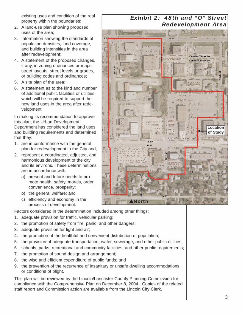
Exhibit 2: 48th and “O” Street Redevelopment Area
Factors considered in the determination included among other things:1. adequate provision for traffic, vehicular parking;2. the promotion of safety from fire, panic, and other dangers;3. adequate provision for light and air;4. the promotion of the healthful and convenient distribution of population;5. the provision of adequate transportation, water, sewerage, and other public utilities;6. schools, parks, recreational and community facilities, and other public requirements;7. the promotion of sound design and arrangement;8. the wise and efficient expenditure of public funds; and9. the prevention of the recurrence of insanitary or unsafe dwelling accommodations
or conditions of blight.
This plan will be reviewed by the Lincoln/Lancaster County Planning Commission forcompliance with the Comprehensive Plan on December 8, 2004. Copies of the relatedstaff report and Commission action are available from the Lincoln City Clerk.

4
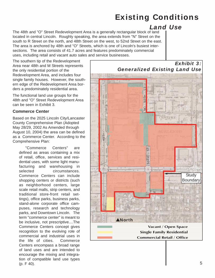
The 48th and "O" Street Redevelopment Area is a generally rectangular block of landlocated in central Lincoln. Roughly speaking, the area extends from "N" Street on thesouth to R Street on the north, and 48th Street on the west, to 52nd Street on the east.The area is anchored by 48th and "O" Streets, which is one of Lincoln's busiest inter-sections. The area consists of 41.7 acres and features predominately commercialuses, including retail and vacant auto sales and service businesses.
Existing ConditionsLand Use
StudyBoundary
North
Exhibit 3: Generalized Existing Land Use
5
The southern tip of the RedevelopmentArea near 48th and M Streets representsthe only residential portion of theRedevelopment Area, and includes foursingle family houses. However, the south-ern edge of the Redevelopment Area bor-ders a predominately residential area.
The functional land use groups for the48th and "O" Street Redevelopment Areacan be seen in Exhibit 3.
Commerce CenterBased on the 2025 Lincoln City/LancasterCounty Comprehensive Plan (AdoptedMay 28/29, 2002 As Amended throughAugust 10, 2004) the area can be definedas a Commerce Center. According to theComprehensive Plan:
"Commerce Centers" aredefined as areas containing a mixof retail, office, services and resi-dential uses, with some light manu-facturing and warehousing inselected circumstances.Commerce Centers can includeshopping centers or districts (suchas neighborhood centers, largescale retail malls, strip centers, andtraditional store-front retail set-tings), office parks, business parks,stand-alone corporate office cam-puses, research and technologyparks, and Downtown Lincoln. Theterm "commerce center" is meant tobe inclusive, not prescriptive....TheCommerce Centers concept givesrecognition to the evolving role ofcommercial and industrial uses inthe life of cities. CommerceCenters encompass a broad rangeof land uses and are intended toencourage the mixing and integra-tion of compatible land use types(p. F 40).
The Comprehensive Plan identifies three separate size categories for CommerceCenters. The variations in size distinguish between the uses occurring in the centersand the differing impacts the centers have on adjacent land uses and the pubic infra-structure (p. E 20). The 48th and "O" Redevelopment Area is likely to fit into theComprehensive Plan's Community Center category, where square footage ranges from300,000 to 1 million square feet.
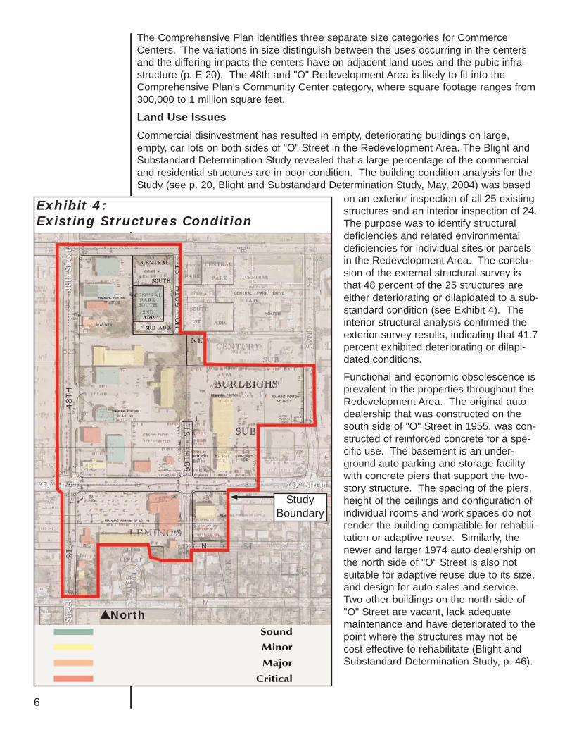
Land Use Issues Commercial disinvestment has resulted in empty, deteriorating buildings on large,empty, car lots on both sides of "O" Street in the Redevelopment Area. The Blight andSubstandard Determination Study revealed that a large percentage of the commercialand residential structures are in poor condition. The building condition analysis for theStudy (see p. 20, Blight and Substandard Determination Study, May, 2004) was based
North
Exhibit 4:Existing Structures Condition
6
StudyBoundary
on an exterior inspection of all 25 existingstructures and an interior inspection of 24.The purpose was to identify structuraldeficiencies and related environmentaldeficiencies for individual sites or parcelsin the Redevelopment Area. The conclu-sion of the external structural survey isthat 48 percent of the 25 structures areeither deteriorating or dilapidated to a sub-standard condition (see Exhibit 4). Theinterior structural analysis confirmed theexterior survey results, indicating that 41.7percent exhibited deteriorating or dilapi-dated conditions.
Functional and economic obsolescence isprevalent in the properties throughout theRedevelopment Area. The original autodealership that was constructed on thesouth side of "O" Street in 1955, was con-structed of reinforced concrete for a spe-cific use. The basement is an under-ground auto parking and storage facilitywith concrete piers that support the two-story structure. The spacing of the piers,height of the ceilings and configuration ofindividual rooms and work spaces do notrender the building compatible for rehabili-tation or adaptive reuse. Similarly, thenewer and larger 1974 auto dealership onthe north side of "O" Street is also notsuitable for adaptive reuse due to its size,and design for auto sales and service.Two other buildings on the north side of"O" Street are vacant, lack adequatemaintenance and have deteriorated to thepoint where the structures may not becost effective to rehabilitate (Blight andSubstandard Determination Study, p. 46).
7
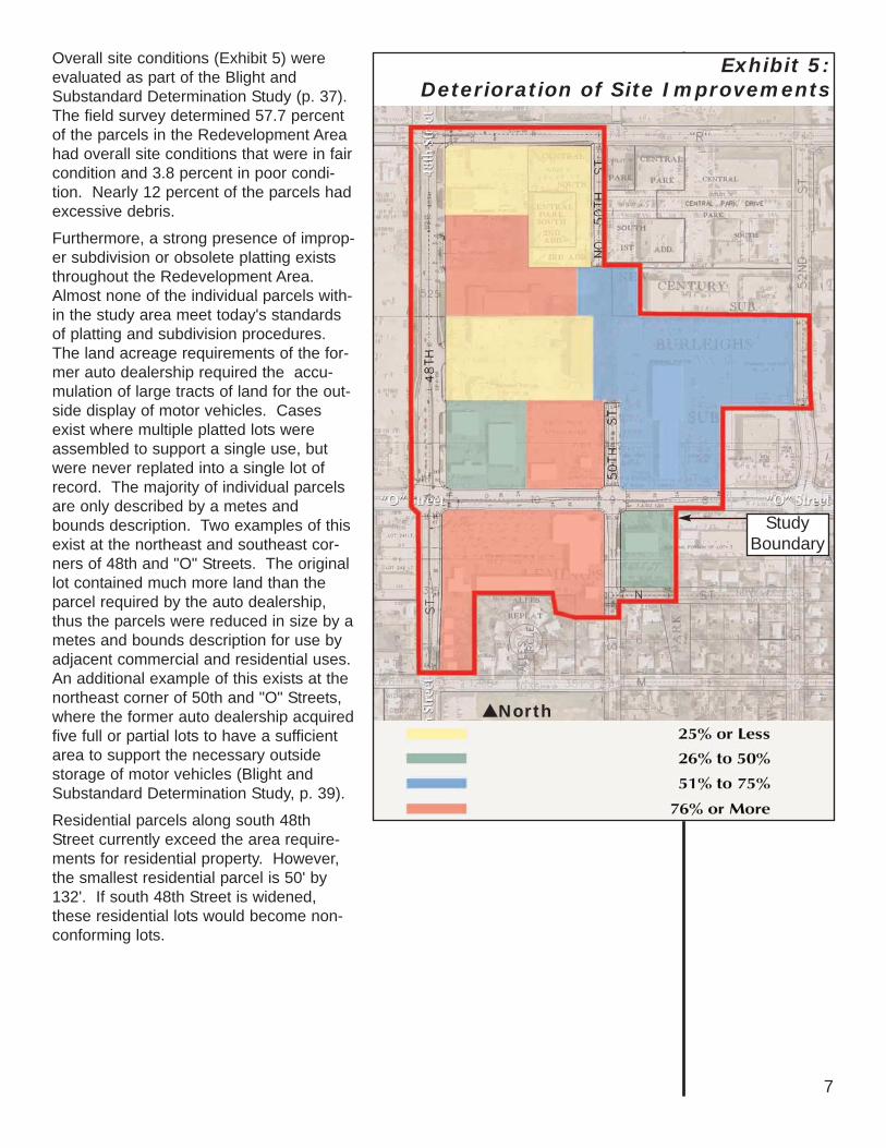
Overall site conditions (Exhibit 5) wereevaluated as part of the Blight andSubstandard Determination Study (p. 37).The field survey determined 57.7 percentof the parcels in the Redevelopment Areahad overall site conditions that were in faircondition and 3.8 percent in poor condi-tion. Nearly 12 percent of the parcels hadexcessive debris.
Furthermore, a strong presence of improp-er subdivision or obsolete platting existsthroughout the Redevelopment Area.Almost none of the individual parcels with-in the study area meet today's standardsof platting and subdivision procedures.The land acreage requirements of the for-mer auto dealership required the accu-mulation of large tracts of land for the out-side display of motor vehicles. Casesexist where multiple platted lots wereassembled to support a single use, butwere never replated into a single lot ofrecord. The majority of individual parcelsare only described by a metes andbounds description. Two examples of thisexist at the northeast and southeast cor-ners of 48th and "O" Streets. The originallot contained much more land than theparcel required by the auto dealership,thus the parcels were reduced in size by ametes and bounds description for use byadjacent commercial and residential uses.An additional example of this exists at thenortheast corner of 50th and "O" Streets,where the former auto dealership acquiredfive full or partial lots to have a sufficientarea to support the necessary outsidestorage of motor vehicles (Blight andSubstandard Determination Study, p. 39).
Residential parcels along south 48thStreet currently exceed the area require-ments for residential property. However,the smallest residential parcel is 50' by132'. If south 48th Street is widened,these residential lots would become non-conforming lots.
North
Exhibit 5:Deterioration of Site Improvements
StudyBoundary
Incompatible and mixed land uses exist south of "O" Street. A combination of residen-tial and commercial uses are in close proximity. Conflicts exist due to the lack of prop-er land use separation or buffering.
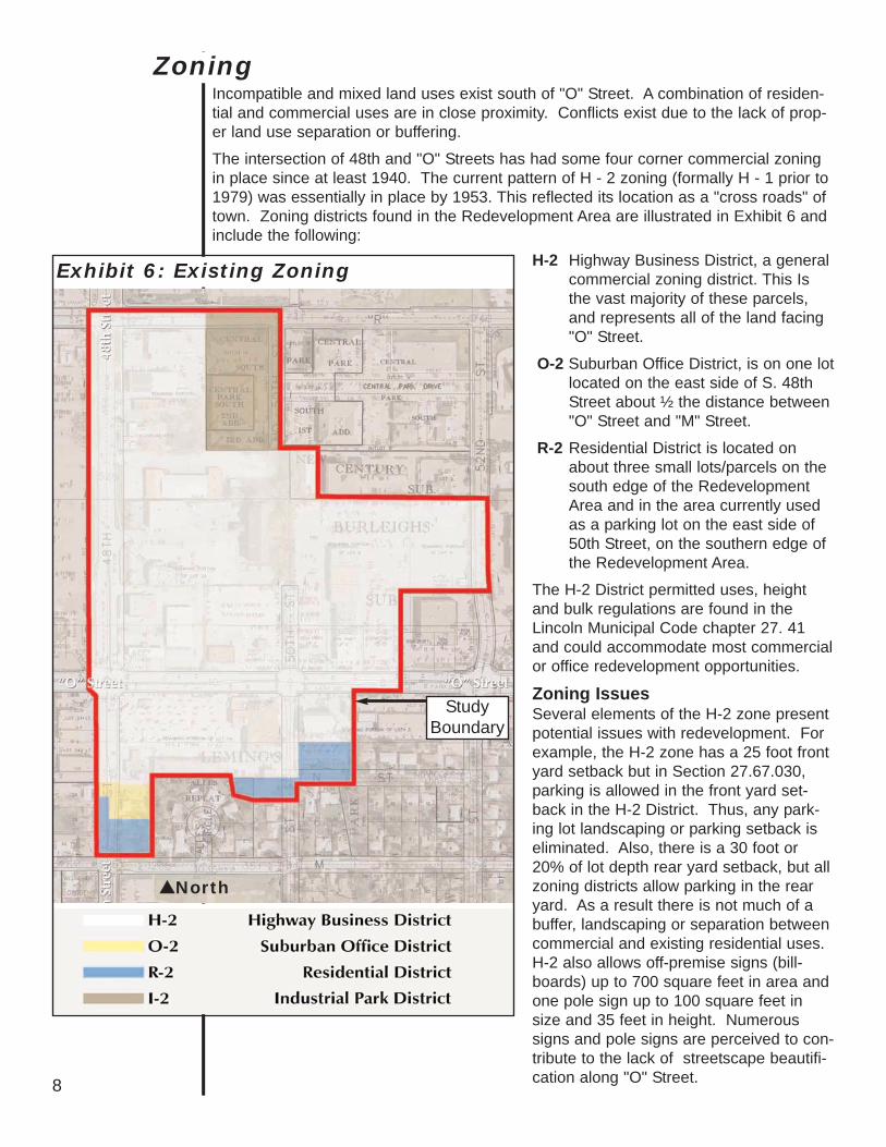
The intersection of 48th and "O" Streets has had some four corner commercial zoningin place since at least 1940. The current pattern of H - 2 zoning (formally H - 1 prior to1979) was essentially in place by 1953. This reflected its location as a "cross roads" oftown. Zoning districts found in the Redevelopment Area are illustrated in Exhibit 6 andinclude the following:
8
North
Exhibit 6: Existing Zoning
StudyBoundary
Zoning
H-2 Highway Business District, a generalcommercial zoning district. This Isthe vast majority of these parcels,and represents all of the land facing"O" Street.
O-2 Suburban Office District, is on one lotlocated on the east side of S. 48thStreet about ½ the distance between"O" Street and "M" Street.
R-2 Residential District is located onabout three small lots/parcels on thesouth edge of the RedevelopmentArea and in the area currently usedas a parking lot on the east side of50th Street, on the southern edge ofthe Redevelopment Area.
The H-2 District permitted uses, heightand bulk regulations are found in theLincoln Municipal Code chapter 27. 41and could accommodate most commercialor office redevelopment opportunities.
Zoning IssuesSeveral elements of the H-2 zone presentpotential issues with redevelopment. Forexample, the H-2 zone has a 25 foot frontyard setback but in Section 27.67.030,parking is allowed in the front yard set-back in the H-2 District. Thus, any park-ing lot landscaping or parking setback iseliminated. Also, there is a 30 foot or20% of lot depth rear yard setback, but allzoning districts allow parking in the rearyard. As a result there is not much of abuffer, landscaping or separation betweencommercial and existing residential uses.H-2 also allows off-premise signs (bill-boards) up to 700 square feet in area andone pole sign up to 100 square feet insize and 35 feet in height. Numeroussigns and pole signs are perceived to con-tribute to the lack of streetscape beautifi-cation along "O" Street.
Parks and Open SpaceNo parks exist within the Redevelopment Area. However, a city park borders the south-east portion of the Redevelopment Area at 51st and N St. The neighborhood park is2.2 acres in size and features a small playground.
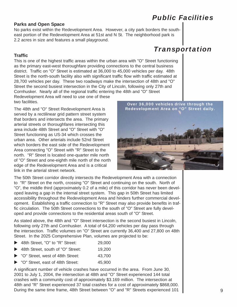
TrafficThis is one of the highest traffic areas within the urban area with "O" Street functioningas the primary east-west thoroughfare providing connections to the central businessdistrict. Traffic on "O" Street is estimated at 36,000 to 45,000 vehicles per day. 48thStreet is the north-south facility also with significant traffic flow with traffic estimated at28,700 vehicles per day. These two roadways make the intersection of 48th and "O"Street the second busiest intersection in the City of Lincoln, following only 27th andCornhusker. Nearly all of the regional traffic entering the 48th and "O" StreetRedevelopment Area will need to use one of thesetwo facilities.
The 48th and "O" Street Redevelopment Area isserved by a rectilinear grid pattern street systemthat borders and intersects the area. The primaryarterial streets or thoroughfares intersecting thisarea include 48th Street and "O" Street with "O"Street functioning as US-34 which crosses theurban area. Other arterials include 52nd Streetwhich borders the east side of the RedevelopmentArea connecting "O" Street with "R" Street to thenorth. "R" Street is located one-quarter mile northof "O" Street and one-eighth mile north of the northedge of the Redevelopment Area and is a criticallink in the arterial street network.
The 50th Street corridor directly intersects the Redevelopment Area with a connectionto "R" Street on the north, crossing "O" Street and continuing on the south. North of"O", the middle third (approximately 0.2 of a mile) of this corridor has never been devel-oped leaving a gap in the internal street system. This gap in 50th Street has limitedaccessibility throughout the Redevelopment Area and hinders further commercial devel-opment. Establishing a traffic connection to "R" Street may also provide benefits in traf-fic circulation. The 50th Street connections to the south of "O" Street are fully devel-oped and provide connections to the residential areas south of "O" Street.
As stated above, the 48th and "O" Street intersection is the second busiest in Lincoln,following only 27th and Cornhusker. A total of 64,200 vehicles per day pass throughthe intersection. Traffic volumes on "O" Street are currently 36,400 and 27,800 on 48thStreet. In the 2025 Comprehensive Plan, volumes are projected to be:
48th Street, "O" to "R" Street: 29,000 48th Street, south of "O" Street: 19,200 "O" Street, west of 48th Street: 43,700"O" Street, east of 48th Street: 45,900
A significant number of vehicle crashes have occurred in the area. From June 30,2001 to July 1, 2004, the intersection at 48th and "O" Street experienced 144 totalcrashes with a community cost of approximately $3.169 million. The intersection at48th and "R" Street experienced 37 total crashes for a cost of approximately $868,000.During the same time frame, 48th Street between "O" and "R" Streets experienced 101 9
Public Facilities
Transportation
Over 36,000 vehicles drive through theRedevelopment Area on “O” Street daily.
crashes for a cost of approximately $2.229 million. Out of these 101 crashes, overhalf were at the two main entrances to the shopping areas along the west side of thestreet and involved people turning into or out of the shopping center.
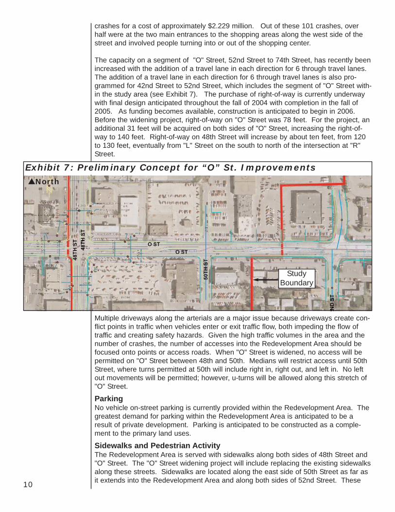
The capacity on a segment of "O" Street, 52nd Street to 74th Street, has recently beenincreased with the addition of a travel lane in each direction for 6 through travel lanes.The addition of a travel lane in each direction for 6 through travel lanes is also pro-grammed for 42nd Street to 52nd Street, which includes the segment of "O" Street with-in the study area (see Exhibit 7). The purchase of right-of-way is currently underwaywith final design anticipated throughout the fall of 2004 with completion in the fall of2005. As funding becomes available, construction is anticipated to begin in 2006.Before the widening project, right-of-way on "O" Street was 78 feet. For the project, anadditional 31 feet will be acquired on both sides of "O" Street, increasing the right-of-way to 140 feet. Right-of-way on 48th Street will increase by about ten feet, from 120to 130 feet, eventually from "L" Street on the south to north of the intersection at "R"Street.
10
North
Exhibit 7: Preliminary Concept for “O” St. Improvements
StudyBoundary
Multiple driveways along the arterials are a major issue because driveways create con-flict points in traffic when vehicles enter or exit traffic flow, both impeding the flow oftraffic and creating safety hazards. Given the high traffic volumes in the area and thenumber of crashes, the number of accesses into the Redevelopment Area should befocused onto points or access roads. When "O" Street is widened, no access will bepermitted on "O" Street between 48th and 50th. Medians will restrict access until 50thStreet, where turns permitted at 50th will include right in, right out, and left in. No leftout movements will be permitted; however, u-turns will be allowed along this stretch of"O" Street.
Parking No vehicle on-street parking is currently provided within the Redevelopment Area. Thegreatest demand for parking within the Redevelopment Area is anticipated to be aresult of private development. Parking is anticipated to be constructed as a comple-ment to the primary land uses.
Sidewalks and Pedestrian ActivityThe Redevelopment Area is served with sidewalks along both sides of 48th Street and"O" Street. The "O" Street widening project will include replacing the existing sidewalksalong these streets. Sidewalks are located along the east side of 50th Street as far asit extends into the Redevelopment Area and along both sides of 52nd Street. These

are all considered to be in good condition. The field analysis for the Blight andSubstandard Determination Study identified approximately 26.9 percent of the side-walks as being in either fair or poor condition.
The major conflicts to pedestrian movements are the high traffic volumes on both 48thand "O" Streets and the numerous drives that cross the sidewalks. There are nopedestrian walkways or facilities located internal to the study area.
The primary shortcoming in the sidewalk system is the lack of pedestrian connectionsalong the 50th Street corridor into the neighborhood to the south; and the incompletestreet and sidewalk along the 50th Street corridor to the north. Additionally, there arefew sidewalks leading from the street to the stores or from one store to another.
Public Transportation Services Public transportation service in the Redevelopment Area consists of one StarTran busroute - 48th Street Shuttle, that travels primarily north and south on 48th Street andserves the 27th and Superior commercial area and the 70th and Pioneer commercialarea.
Pedestrian/Bicycle TrailsAn on street route has been identified along 52nd Street which runs through the east-ern edge of the Redevelopment Area. This route provides a connection between theMoPac Trail on the north and the Billy Wolff Trail on the south.
The MoPac Trail, located along the old MoPac Railroad corridor, is the nearest bike trailand is approximately 1/2 mile north of the Redevelopment Area. The trail extends from30th and X street on the west to approximately 84th and "O" Street on the east withinthe city limits. The MoPac then extends east of 84th and "O" Street into the county.This trail will eventually connect with Antelope Valley on the west and Omaha and intoIowa on the east. The trail is identified in a Quad States Trail Plan as providing a majorconnection between Kansas, Nebraska, Iowa and Missouri.
11
UtilitiesThe basic infrastructure is in place within the Redevelopment Area; however, it is oldand facing increasing demands. As a result, utilities are in need of maintenance and,in some cases, replacement. A detailed analysis should be conducted to identify spe-cific needs and projects, particularly on a case by case basis as redevelopment proj-ects occur.
The 48th and "O" Street Redevelopment Area is served by the following utilities:• Sanitary sewer system (underground)• Storm sewer system (underground)• Water system (underground)• Gas lines (underground)• Electrical conduits (overhead and underground)• Telephone conduits (overhead and underground)• Cable conduits (overhead and underground)
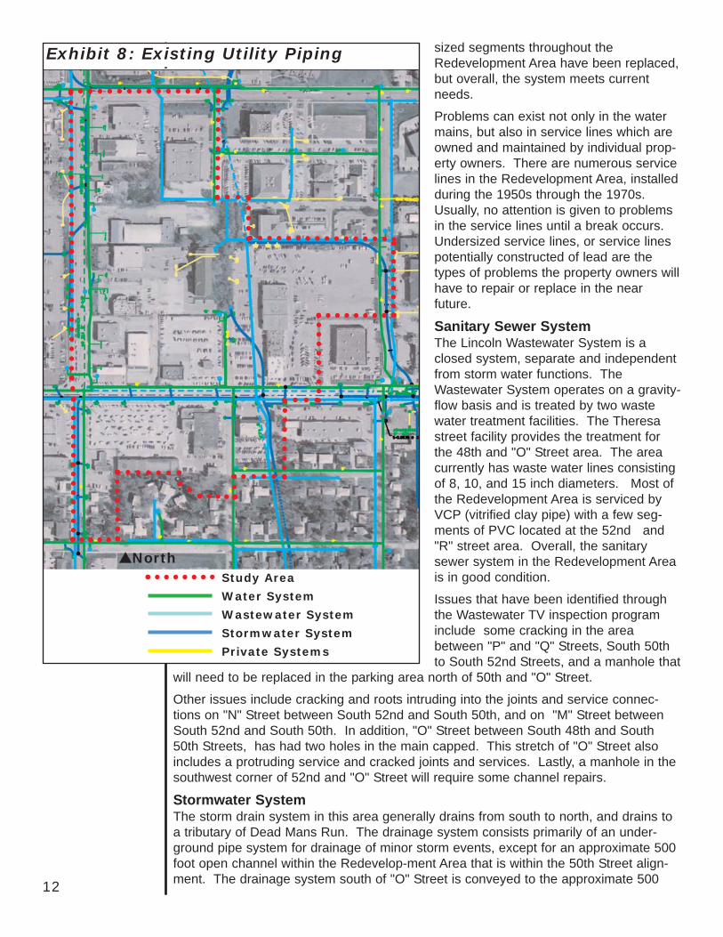
Existing utility piping is illustrated in Exhibit 8,(see next page).
Water SystemAccording to today's development standards, a minimum 6" diameter residential watermain and 8" in commercial districts is recommended to insure adequate water pressurefor fire protection purposes. Water mains along "O" Street were replaced with a new12" diameter main in 2001. Water mains west of 48th and "O" Street will be replacedwith larger diameter mains when the "O" Street widening project occurs. A few under-
sized segments throughout theRedevelopment Area have been replaced,but overall, the system meets currentneeds.
Problems can exist not only in the watermains, but also in service lines which areowned and maintained by individual prop-erty owners. There are numerous servicelines in the Redevelopment Area, installedduring the 1950s through the 1970s.Usually, no attention is given to problemsin the service lines until a break occurs.Undersized service lines, or service linespotentially constructed of lead are thetypes of problems the property owners willhave to repair or replace in the nearfuture.
Sanitary Sewer System The Lincoln Wastewater System is aclosed system, separate and independentfrom storm water functions. TheWastewater System operates on a gravity-flow basis and is treated by two wastewater treatment facilities. The Theresastreet facility provides the treatment forthe 48th and "O" Street area. The areacurrently has waste water lines consistingof 8, 10, and 15 inch diameters. Most ofthe Redevelopment Area is serviced byVCP (vitrified clay pipe) with a few seg-ments of PVC located at the 52nd and"R" street area. Overall, the sanitarysewer system in the Redevelopment Areais in good condition.
Issues that have been identified throughthe Wastewater TV inspection programinclude some cracking in the areabetween "P" and "Q" Streets, South 50thto South 52nd Streets, and a manhole that
will need to be replaced in the parking area north of 50th and "O" Street.
Other issues include cracking and roots intruding into the joints and service connec-tions on "N" Street between South 52nd and South 50th, and on "M" Street betweenSouth 52nd and South 50th. In addition, "O" Street between South 48th and South50th Streets, has had two holes in the main capped. This stretch of "O" Street alsoincludes a protruding service and cracked joints and services. Lastly, a manhole in thesouthwest corner of 52nd and "O" Street will require some channel repairs.
Stormwater SystemThe storm drain system in this area generally drains from south to north, and drains toa tributary of Dead Mans Run. The drainage system consists primarily of an under-ground pipe system for drainage of minor storm events, except for an approximate 500foot open channel within the Redevelop-ment Area that is within the 50th Street align-ment. The drainage system south of "O" Street is conveyed to the approximate 50012
North
Exhibit 8: Existing Utility Piping
Study Area
Water System
Wastewater System
Stormwater System
Private Systems
13
foot open channel through a 48" stormdrain outlet north of "O" Street (88 acredrainage area) and a 60" storm drain out-let west of 52nd Street (142 acre drainagearea). The drainage system in "O" Streetis due for rehabilitation with the future "O"Street widening project. Most of the cur-rent system is typically of sufficient size toconvey the frequent design storm events(5 year and 10 year) for which they wereconstructed. It is planned that the future"O" Street project will include replacingstorm drains where they are currentlyundersized.
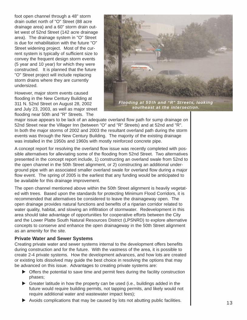
However, major storm events causedflooding in the New Century Building at311 N. 52nd Street on August 28, 2002and July 23, 2003, as well as major streetflooding near 50th and "R" Streets. Themajor issue appears to be lack of an adequate overland flow path for sump drainage on52nd Street near the Villager Inn (between "O" and "R" Streets) and at 52nd and "R".In both the major storms of 2002 and 2003 the resultant overland path during the stormevents was through the New Century Building. The majority of the existing drainagewas installed in the 1950s and 1960s with mostly reinforced concrete pipe.
A concept report for resolving the overland flow issue was recently completed with pos-sible alternatives for alleviating some of the flooding from 52nd Street. Two alternativespresented in the concept report include, 1) constructing an overland swale from 52nd tothe open channel in the 50th Street alignment, or 2) constructing an additional under-ground pipe with an associated smaller overland swale for overland flow during a majorflow event. The spring of 2005 is the earliest that any funding would be anticipated tobe available for this drainage improvement.
The open channel mentioned above within the 50th Street alignment is heavily vegetat-ed with trees. Based upon the standards for protecting Minimum Flood Corridors, it isrecommended that alternatives be considered to leave the drainageway open. Theopen drainage provides natural functions and benefits of a riparian corridor related towater quality, habitat, and slowing an infiltration of stormwater. Redevelopment in thisarea should take advantage of opportunities for cooperative efforts between the Cityand the Lower Platte South Natural Resources District (LPSNRD) to explore alternativeconcepts to conserve and enhance the open drainageway in the 50th Street alignmentas an amenity for the site.
Private Water and Sewer SystemsCreating private water and sewer systems internal to the development offers benefitsduring construction and for the future. With the vastness of the area, it is possible tocreate 2-4 private systems. How the development advances, and how lots are createdor existing lots dissolved may guide the best choice in resolving the options that maybe advanced on this issue. Advantages to creating private systems are:
Offers the potential to save time and permit fees during the facility constructionphases;Greater latitude in how the property can be used (i.e., buildings added in thefuture would require building permits, not tapping permits, and likely would notrequire additional water and wastewater impact fees);Avoids complications that may be caused by lots not abutting public facilities.
Flooding at 50th and “R” Streets, lookingsoutheast at the intersection.
Examples of other developments using this method include Westfield ShoppingtownGateway Mall, Southpoint Pavilions and the Home Depot located on Highway 2. Theseareas developed as single meter/private water and sewer systems.
Street LightingStreet lights on "O" St. were replaced in 1986 with 40' galvanized poles, undergroundwire, and 400 watt HPSV luminaries. The system is in good condition. Street lights on48th St., north of "O", were replaced in 1983 with 35' galvanized poles, undergroundwire, and 250 watt HPSV luminaries. This system is also in good condition. The lightson 48th St., south of "O" were installed more than 40 years ago. The poles are 30'painted with overhead wire and 150 watt HPSV luminaries. They are in fair to poorcondition. The lights on 52nd St. are 150 watt HPSV on overhead distribution poles.All of the streets are adequately lit.
Despite the long-standing importance of this intersection, it's relatively rapid and contin-uing evolution has the result than none of the buildings in the redevelopment areaappear to have achieved sufficient age or historic significance, nor have they retainedenough physical integrity, to be regarded as historic resources.
The City of Lincoln, through its Urban Development Department, entered into a contractwith Hanna:Keelan Associates, P.C. to complete the 48th & "O" Streets RedevelopmentArea Lincoln, Nebraska Blight and Substandard Determination Study. The study wascompleted in May, 2004. This section of the Redevelopment Plan is taken directly fromthat study.
Blight Factors The Community Development Law identifies 12 factors that, when the majority arepresent, are sufficient to determine a finding of blighted. In the Blight and SubstandardDetermination Study eight factors were found to have a "Strong Presence" in the area:1. A substantial number of deteriorated or deteriorating structures. A total of 48
percent of the 25 structures were found to be deteriorated or dilapidated, from theexterior analysis, and 41.7 percent from the interior analysis.
2. Faulty lot layout in relation to size, adequacy, accessibility or usefulness.Conditions contributing to the presence of this factor include inadequate lot size,limited pedestrian circulation and lack of planned open space.
3. Insanitary or unsafe conditions. Contributing factors include age of structuresand frame structural members of buildings.
4. Deterioration of site or other improvements. A significant number and percent-age of parcels in the Area have fair to poor overall site conditions. Deterioratinginfrastructure also contributes to the strong presence of this factor.
5. Improper subdivision or obsolete platting. Generally, lot sizes are too small forefficient development, based on today's planning standards. Several blocks havebeen reconfigured by metes and bounds descriptions, in the absence of individuallyplatted lots, especially along 48th Street, between "M" and "R".
6. The existence of conditions which endanger life or property by fire or othercauses. The age of infrastructure is the primary issue throughout theRedevelopment Area.
7. Other environmental blighting factors. Functional and economic obsolescenceis prevalent in the properties throughout the Redevelopment Area.
Historic Significance
14
Blight and Substandard Determination Study

15
Substandard FactorsThe Community Development Law definesa substandard area as one in which thereis a predominance of buildings orimprovements, nonresidential or residen-tial, with the presence of:1. Deterioration/dilapidation of structures.2. Age or obsolescence.3. Inadequate provision for ventilation,
light, air, sanitation, or open spaces; or4. a. High density of population and
overcrowding; orb. The existence of conditions which
endanger life or property by fireand other causes; or
c. Any combination of such factors isconductive to ill health, transmis-sion of disease, infant mortality,juvenile delinquency, and crime, and is detrimental to public health safety,morals, and welfare.
The Blight and Substandard Determination Study determined that three of the four fac-tors had a strong presence in the area and one factor had a reasonable presence.Factors 1, 2 and 4b had a strong presence while factor 3 had a reasonable presence.
It was the conclusion of the study, ...that the number, degree, and distribution of substandard and blighting factors,as documented in this Study, are beyond remedy and control solely by regulato-ry processes in the exercise of the police power and cannot be dealt with effec-tively by the ordinary operations of private enterprise without the aids providedin the Nebraska Community Development Law. It was also the opinion of theConsultant, that the findings of this Blight and Substandard Determination Studywarrant designating the Redevelopment Area as "substandard" and "blighted"(p. 10).
The Lincoln City Council, by resolution, declared the area blighted and substandard onAugust 23, 2004.
8. One of the other five conditions. According to the field analysis, the average ageof commercial and residential buildings is 40+ years of age.
The Blight and Substandard Determination Study also found the following factors had a"reasonable presence:"1. Defective or inadequate street layout. A significant amount of streets and alleys
exhibit fair to poor conditions.2. Diversity of ownership. The total number of owners within the Redevelopment
Area is 19.
Of the twelve factors set forth in the Nebraska Community Development Law, just twohad little or no presence: 1. Tax or special assessment exceeding the fair value of land.2. Defective or unusual condition of title.
Vacant, deteriorating site in theRedevelopment Area, south of “O” Street.

16
Following is a list of key existing conditions identified in this section that should be con-sidered, in conjunction with Guiding Development Principles (p. 19), in the identificationof projects for the Redevelopment Plan. 1. Commercial disinvestment has resulted in empty, deteriorating buildings on large,
empty, car lots on both sides of "O" Street. 2. Functional and economic obsolescence is prevalent in the properties throughout the
Redevelopment Area.3. Few of the individual parcels within the study area meet today's standards of plat-
ting and subdivision procedures. 4. Incompatible and mixed land uses exist south of "O" Street. Conflicts exist due to
the lack of proper land use separation or buffering.5. Although existing zoning should accommodate most commercial or office redevel-
opment opportunities, issues with the H-2 zoning district do not necessarily make itthe most appropriate zoning. Re-zoning should be considered.
6. No parks exist within the Redevelopment Area; however, a small, 2.2 acre neigh-borhood park borders the southeast portion of the Redevelopment Area.
7. The Redevelopment Area has one of the highest traffic areas within the city, with anestimated 36,000 to 45,000 vehicles per day on "O" Street and 28,700 vehicles perday on 48th Street.
8. North of "O" Street, the middle third of 50th street (approximately .2 of a mile) hasnot been completed, leaving a gap in the internal street system. This gap has limit-ed accessibility and hinders further commercial development.
9. Traffic volumes in 2025 are anticipated to increase to between 19,200 and 29,000on 48th Street and between 43,700 and 45,900 on "O" Street.
10. A significant number of vehicle crashes have occurred. 48th and "O" experienced144 crashes between June 30, 2001 and July 1, 2004. 48th and "R" had 37 crash-es and 101 occurred on 48th between "O" and "R". Over half were at the two mainentrances to the shopping areas along the west side of the street and involved peo-ple turning into or out of the shopping center.
11. "O" Street was recently widened between 74th and 52nd Streets and the project isplanned to continue through the Redevelopment Area, to 42nd Street. Right-of-wayacquisition has begun and construction is anticipated as early as 2006, subject tothe availability of funding.
12. Multiple driveways along the arterials impede traffic flow and create safety hazards.With construction of the "O" Street widening project, access into theRedevelopment Area should be focused onto points or access roads.
13. No vehicle on-street parking is provided within the Redevelopment Area. Parking isanticipated to be constructed as a complement to the private redevelopment.
14. Sidewalks will be replaced on "O" Street and 48th Street with the "O" Street widen-ing project.
15. 27 percent of the sidewalks in the area are in fair or poor condition. 16. Major conflicts to pedestrian movements are the high traffic volumes on both 48th
and "O" Streets and numerous drives that cross sidewalks.17. There is a lack of pedestrian connections along the 50th Street corridor into the
neighborhood to the south and the incomplete street and sidewalk to the north.18. One StarTran bus route serves the area.
Summary of Existing Conditions
17
19. An on-street trail has been identified along 52nd Street on the eastern edge of theRedevelopment Area. The MoPac Trail is the nearest bike trail and is approximate-ly ½ mile north of the Redevelopment Area.
20. The basic infrastructure in the Redevelopment Area is old and facing increasingdemands. Many utilities are in need of maintenance and in some cases, replacement.
21. Overall, the current water system meets current needs. However, service lineswere installed during the 1950s through the 1970s and may need to be repaired orreplaced in the near future.
22. Most of the Redevelopment Area is serviced by vitrified clay pipe with a few seg-ments of PVC located at the 52nd and "R" Street area. Overall, the sanitary sewersystem is in good condition although some cracking, cracked joints and services,and manhole repairs are needed.
23. The lack of an adequate overland flow path for sump drainage on 52nd and "R" hascaused flooding of area businesses. This is a serious issue when major stormevents occur and possible alternatives for alleviating the problem have been identi-fied in a recently completed concept report.
24. The street lights south of "O" on 48th Street were installed more than 40 years agoand are in fair to poor condition. However, all the streets in the RedevelopmentArea are adequately lit and the system is in good condition.
25. There are no historic buildings in the Redevelopment Area.26. The Lincoln City Council, by resolution, declared the area Blighted and
Substandard on August 23, 2004.

18
Based on the 2025 Lincoln City/Lancaster County Comprehensive Plan, the 48th and"O" Street Redevelopment Area can be identified as a Community Center. According tothe Comprehensive Plan:
Community Centers are intended to be smaller in scale and intensity of usesthan Regional Centers and serve a more targeted market and geographic area.Community Centers tend to be dominated by retail and service activities,although they can also serve as campuses for corporate office facilities andother mixed-use activities....One or two department stores or "big box" retailoperations may serve as anchors to the Community Center with smaller generalmerchandise stores located between any anchors or on surrounding sitepads...Community Centers can have a community wide appeal but primarilyserve a geographic subarea within Lincoln and surrounding areas within theCounty. Depending on the mix of stores and other shopping opportunities in thearea, existing Community Centers can have a market area that is quite exten-sive, even rivaling some Regional Centers (p. F 45).
Given this definition, several guiding principles identified in the Comprehensive Plan forall Commerce Centers (Regional, Community, and Neighborhood) should be used as aguide for redevelopment activities at 48th and "O". The following principles begin withthose identified in the Comprehensive Plan, then also build on expectations of theWitherbee Neighborhood Association and general redevelopment principles. The rede-velopment of the 48th and "O" Redevelopment Area to the extent possible should: 1. Encourage a diverse mix of uses, such as office, retail, multi-family residential and
service uses. 2. Encourage redevelopment to occur as clusters or hubs with appropriate site design
features to accommodate shared parking, ease of pedestrian movement within thesite and possessing a unique urban (rather than suburban) character, while mini-mizing impacts on the adjacent residential area.
3. Redevelopment should occur in ways that strengthen and support the existing busi-ness communities outside the Redevelopment Area along, and in the vicinity of, the"O" Street and 48th Street corridors.
4. Physical linkages (i.e., sidewalks, trails, roads) should be utilized to directly connectthe Redevelopment Area with adjacent development.
5. Encourage project designs which place commercial buildings rather than parkinglots along 48th and "O" Streets.
6. Buildings should be designed to be compatible, in form and proportion, with theneighboring buildings and should include a variety of forms, materials and colors,yet these elements should be composed to maintain a unified appearance.
7. Buildings should include a richness of architectural detail to help define their scale,pedestrian access and visual rhythm and interest.
8. Building Entrances should be given emphasis or "pride of place." 9. The Redevelopment Area should provide a safe and positive environment for
pedestrian movement by:A. Using pedestrian scale lighting and graphics within the Redevelopment Area.B. Encouraging public security design features including lighting and open spaces
with a high degree of street visibility.
Redevelopment Plan
Guiding Development Principles for the Area
19
C. Encouraging public amenities suchas plazas, squares and other typesof facilities or meeting areas forpedestrians.
10. Where feasible, provide for transitopportunities in the design of the area.
11. Redevelopment should not encroachupon, or expand into, the existing resi-dential neighborhood to the south andshould protect and enhance it by:A. Establishing defensible edges
between the residential and non-residential uses. Use streets orgreen ways to provide boundaries,thus realizing the benefits of mixeduse while screening the negativeeffects of commercial growth onresidential environments. A frontyard setback, landscape screen-ing, and a pedestrian system withcontinuity into and through the siteis preferable.
B. Locating the most intensive com-mercial uses nearer to the majorstreets and furthest from the resi-dential area. Lighting, dumpsters,loading docks and other serviceareas should be shielded from theresidential area.
C. The major access points to thearea should not bring outside traf-fic through the residential area.
The Guiding Principles of theRedevelopment Plan, along with issuesidentified in the Existing Conditions sec-tion of this plan, provide the basis for theredevelopment projects.
StudyBoundary
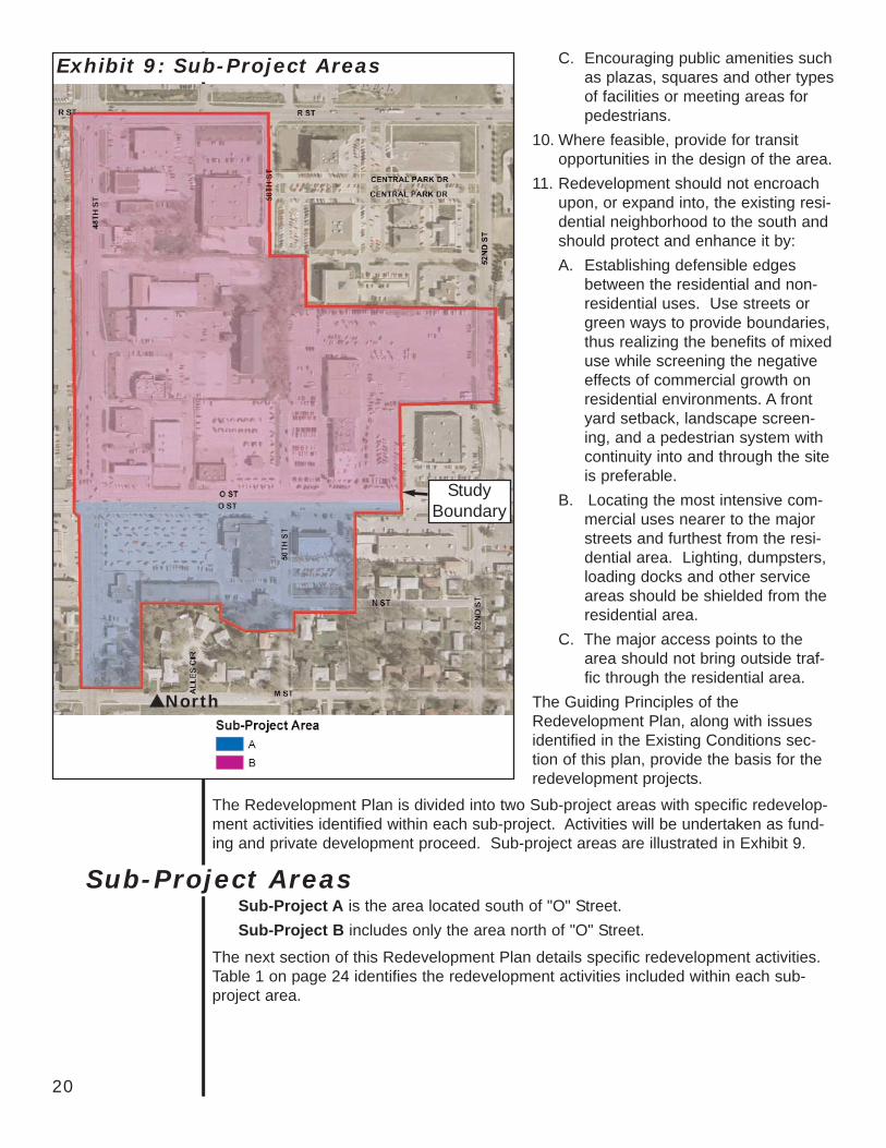
Exhibit 9: Sub-Project Areas
North
The Redevelopment Plan is divided into two Sub-project areas with specific redevelop-ment activities identified within each sub-project. Activities will be undertaken as fund-ing and private development proceed. Sub-project areas are illustrated in Exhibit 9.
Sub-Project A is the area located south of "O" Street.Sub-Project B includes only the area north of "O" Street.
The next section of this Redevelopment Plan details specific redevelopment activities.Table 1 on page 24 identifies the redevelopment activities included within each sub-project area.
20
Sub-Project Areas

Infrastructure issues that include streets, alleys, sidewalks, and utilities - impede newdevelopment throughout the Redevelopment Area and contribute to the blighting condi-tions. Therefore, the following public improvement activities should occur:
Streets and Alleys1. North of "O", the middle third (approximately 0.2 of a mile) of the 50th Street corri-
dor has never been developed leaving a gap in the internal street system. If cor-recting the 50th Street gap enhances and benefits redevelopment by establishing atraffic connection to "R" Street and benefitting traffic circulation, the connectionshould be constructed.
2. The excessive number of driveways and access points along 48th and "O" Streetsimpedes traffic flow and creates unsafe driving conditions. Identify access points tothe Redevelopment Area and close/consolidate existing drives to help maintain traf-fic flows and increase safety along the main thoroughfares of 48th and "O" Streets.
3. Dedicate and build public alleys as needed in conjunction with redevelopment activ-ities.
Sidewalks and Connectors The Blight and Substandard Determination Study identified 27 percent of the sidewalksas in either fair or poor condition. Additional surveys will be completed and sidewalksrepaired or replaced as necessary in conjunction with redevelopment projects.1. Replace existing sidewalks along 48th and "O" Streets with the "O" Street widening
project. 2. The major conflict to pedestrian movements are the numerous drives that cross the
sidewalks. Consolidate and eliminate vehicular access points (see #2 above, underStreets and Alleys).
3. Construct pedestrian walkways or facilities internally within the RedevelopmentArea.
4. Construct pedestrian connections along the 50th Street corridor into the neighbor-hood to the south and along the 50th Street corridor to the north if the 50th Streetconnection is built.
Public TransportationProvide transit opportunities within and adjacent to the Redevelopment Area, when fea-sible. May include construction of bus shelters and kiosks with transit information.
Pedestrian/Bicycle Trails Continue to identify 52nd Street as an on-street bike route, providing a connectorbetween the MoPac Trail on the north and the Billy Wolf Trail on the south. Continue tomonitor hiker/biker trail needs in the area.
Streetscape BeautificationDesign and implement a design plan for 48th and "O" Streets beautification. Elementsshould include but not be limited to lighting, thematic entrances, landscaping andstreetscape.
Public UtilitiesIn the Existing Conditions section of this Plan, much of the infrastructure in the areawas identified as inadequate - in need of maintenance and, in some cases, replace-ment. In order for new development to occur, the following public improvements shouldoccur:
Redevelopment Activities: Infrastructure Improvements
21
1. Complete a detailed analysis of storm water sewers, sanitary sewers, and the watersystem to determine additional needed improvements. Complete improvements asrequired to support current and anticipated development.
2. Based on the Wastewater TV inspection program, repair or replace as needed(although some improvements extend beyond the Redevelopment Area boundaries,construction should be coordinated):
Multi-quad cracking between "P" and "Q", south 50th to 52nd StreetsReplace a manhole in the area north of 50th and "O" Streets.Multi-quad cracking and roots intruding into the joints and service connectionson both "M" and "N" Street between south 50th and south 52nd Streets.
3. Evaluate water mains within the Redevelopment Area to assure fire fighting andservice requirements are met. Identify where main extensions and abandonmentsmay be appropriate in conjunction with redevelopment.
4. Abandon services to existing buildings for both water and wastewater.5. With construction of the "O" Street widening project, replace water mains west of
48th and "O". 6. Identify and construct solutions to inadequate storm water drainage issues.
Solutions may include providing an overland flow path, swale, storm water conduit,and construction of a bioretention/rain garden or similar innovative storm watertechnology solution.
The Redevelopment Area is highly visible and includes vacant blighted buildings andunderutilized land. Major redevelopment will occur and require land assembly with newmixed use commercial development. Projects include:1. South of "O" Street: property acquisition of vacant, underutilized land and blighted
buildings to create the opportunity for new, mixed use development that mayinclude one or two story commercial retail, office and multi-family housing. Projectelements include:
Acquisition of lots:Leming's Sub Lot 4 ex W 135' S 423' & ex S 221' E 135' & ex that partdeeded for street, generally known as 4949 "O" St.Leming's Sub Lot 3 N 156' W 240' ex W 30' N ½ & ex N 6', generally knownas 5001 "O" St.Leming's Sub S 129.2' W 240' N ½ Lot 3 ex W 30' for street & ex street,generally known as 5038 "N" St.Leming's Sub Lot 4 S 170 of N 377 W 135 ex 1622 sq. ft for street, general-ly known as 140 S. 48th St.Lemings Sub Part of Lot 4 ex rd N 60' S 253' W 135' L4, generally known as200 S. 48th St.Leming's Sub ex rd N 60' S 193' W 135' L4, generally known as 224 S. 48thSt.Leming's Sub Lot 4 N 50 of S 133 of W 135 ex street, generally known as230 S. 48th St.Leming's Sub N 58' S 83' W 135' Lot 4, generally known as 240 S. 48th St.
Relocation of tenants, if any.Demolition of existing structures.Grading and site preparation.Elimination of environmental hazards.
Redevelopment Activities: Commercial
22
Paving off-street parking and construction on on-street parking (except on arteri-al streets).Relocating/upgrading utilities as needed including relocation of overhead utilitylines.Eliminating driveways and curb cuts, constructing consolidated entrances asrequired, including paving and landscaping driveways, approaches and side-walks outside property lines. Construction of turn lanes and frontage roads, as required. Vacation of alleys and streets as required.Subdivision and rezoning if necessary.Obtaining access easements as required.
2. North of "O" Street: property acquisition of vacant, underutilized land and blightedbuildings to create the opportunity for new, one story mixed use development that mayinclude commercial retail, office and multi-family housing. Project elements include:
Acquisition of lots:J G Millers Sub (S ½ 20-10-7) N 125' W ½ Lot 20 ex road, generally knownas 366 N. 48th St.Central Park south third Add Outlet AJ G Millers Sub (S ½ 20-10-7) S 125' N 250' W ½ ex road & N 15' S 100' N350' W, generally known as 360 N. 48th St.Central Park south second Add Lot 1, generally known as 333 N. 50th St.J G Millers Sub (S ½ 20-10-7) S 85' N 350' W ½ Lot 20 ex W 60', generallyknown as 330 N. 48th St.J G Millers Sub (S ½ 20-10-7) S 100' N 450' W ½ Lot 20 ex road, generallyknown as 320 N. 48th St.J G Millers Sub (S ½ 20-10-7) Lot 20 S 179.3' W ½ ex road, generallyknown as 300 N. 48th St.J G Millers Sub (S ½ 20-10-7) Lot 20 E 302' of S 179 & 25 hundredths ft.,generally known as 300 N. 48th St.Cool Crest Condo base account located on: J G Millers sub 20-10-7: N ½ lot29 EBurleighs Sub Lots D, E & F ex S 6' for street & Lot G ex S 150' E 36' & LotH ex S, generally known as 5000 "O" St.Cool Crest Condominium Unit #A, generally known as 222 N. 48th St.Cool Crest Condominium Amended Unit C, generally known as 216 N. 48thSt.Cool Crest Condominium Unit #B, generally known as 210 N. 48th St.J G Millers Sub (of 20-10-7) W 137' E 167' S ½ ex street & W 143' E 310' N150.65' S, generally known as 4940 "O" St.J G Millers Sub (of 20-10-7) Lot 29 E 142' W 352' S ½ ex S 6', generallyknown as 4850 "O" St.J G Millers Sub 20-10-7 N 150' S 300' E 150' W210' or W 210' S ½ Lot 29ex S 150', generally known as 140 N. 48th StJ G Millers Sub 20-10-7 W 143' E 310' S 166' Lot 29 ex S 6', generallyknown as 4900 "O" St.J G Millers Sub 20-10-7 Lot 29 S 150' of S 300' E 150' W 210' ex S 6', gen-erally known as 4802 "O" St.
Relocation of tenants, if any.Demolition of existing structures.
23
Grading and site preparation.Elimination of environmental hazards.Paving off-street parking.Relocating/upgrading utilities as needed including relocation of overhead utilitylines.Construction of facility to eliminate storm water hazards.Eliminating driveways and curb cuts, constructing consolidated entrances asrequired, including paving and landscaping driveways, approaches and side-walks outside property lines. Construction of 50th Street.Construction of turn lanes and frontage roads, as required. Vacation of alleys and streets as required.Subdivision and rezoning if necessary.Obtaining access easements as required.
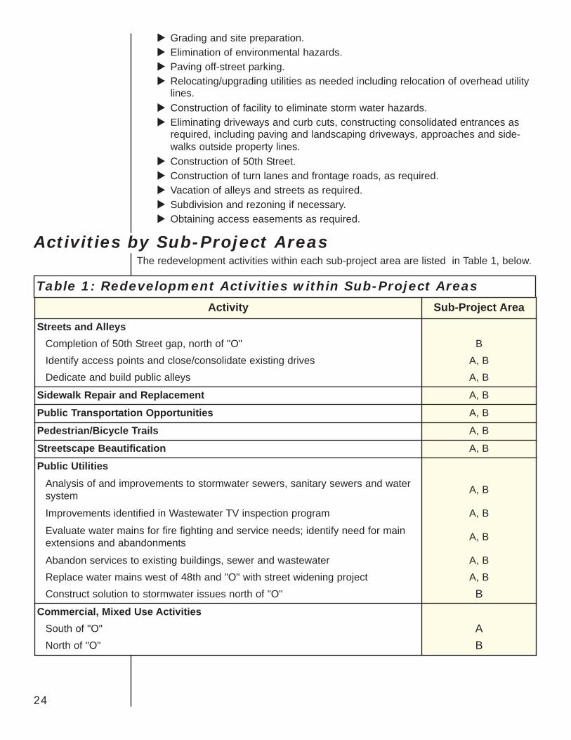
The redevelopment activities within each sub-project area are listed in Table 1, below.
Table 1: Redevelopment Activities within Sub-Project Areas
Activity Sub-Project AreaStreets and Alleys
Completion of 50th Street gap, north of "O" BIdentify access points and close/consolidate existing drives A, BDedicate and build public alleys A, B
Sidewalk Repair and Replacement A, B
Public Transportation Opportunities A, B
Pedestrian/Bicycle Trails A, B
Streetscape Beautification A, B
Public UtilitiesAnalysis of and improvements to stormwater sewers, sanitary sewers and watersystem A, B
Improvements identified in Wastewater TV inspection program A, B
Evaluate water mains for fire fighting and service needs; identify need for mainextensions and abandonments A, B
Abandon services to existing buildings, sewer and wastewater A, BReplace water mains west of 48th and "O" with street widening project A, BConstruct solution to stormwater issues north of "O" B
Commercial, Mixed Use ActivitiesSouth of "O" ANorth of "O" B
24
Activities by Sub-Project Areas
25
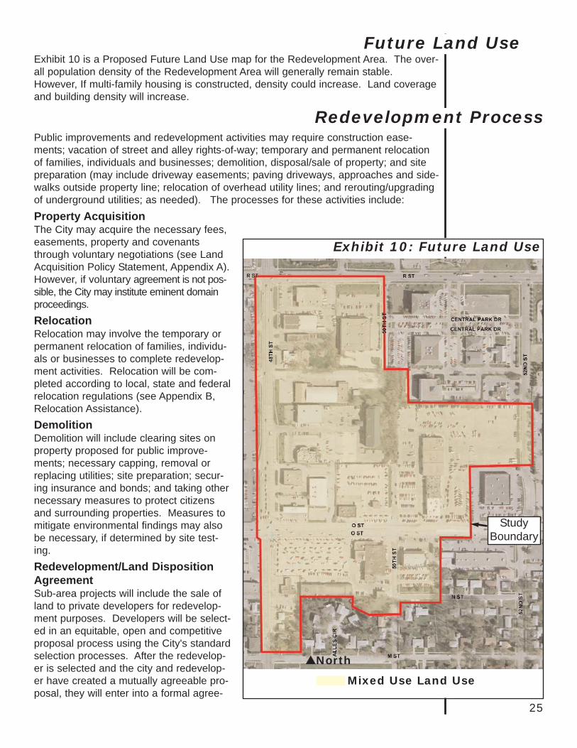
Exhibit 10 is a Proposed Future Land Use map for the Redevelopment Area. The over-all population density of the Redevelopment Area will generally remain stable.However, If multi-family housing is constructed, density could increase. Land coverageand building density will increase.
Public improvements and redevelopment activities may require construction ease-ments; vacation of street and alley rights-of-way; temporary and permanent relocationof families, individuals and businesses; demolition, disposal/sale of property; and sitepreparation (may include driveway easements; paving driveways, approaches and side-walks outside property line; relocation of overhead utility lines; and rerouting/upgradingof underground utilities; as needed). The processes for these activities include:
StudyBoundary
Exhibit 10: Future Land Use
North
Redevelopment Process
Future Land Use
Property Acquisition The City may acquire the necessary fees,easements, property and covenantsthrough voluntary negotiations (see LandAcquisition Policy Statement, Appendix A).However, if voluntary agreement is not pos-sible, the City may institute eminent domainproceedings. Relocation Relocation may involve the temporary orpermanent relocation of families, individu-als or businesses to complete redevelop-ment activities. Relocation will be com-pleted according to local, state and federalrelocation regulations (see Appendix B,Relocation Assistance). Demolition Demolition will include clearing sites onproperty proposed for public improve-ments; necessary capping, removal orreplacing utilities; site preparation; secur-ing insurance and bonds; and taking othernecessary measures to protect citizensand surrounding properties. Measures tomitigate environmental findings may alsobe necessary, if determined by site test-ing.Redevelopment/Land DispositionAgreement Sub-area projects will include the sale ofland to private developers for redevelop-ment purposes. Developers will be select-ed in an equitable, open and competitiveproposal process using the City's standardselection processes. After the redevelop-er is selected and the city and redevelop-er have created a mutually agreeable pro-posal, they will enter into a formal agree-
Mixed Use Land Use
26
ment. This agreement will specify each party's specific roles and obligations in theimplementation of the project. The negotiated Redevelopment/Land Disposition agree-ment will be subject to public hearing and review and final approval by the City Council.It is anticipated the redevelopment would be able to proceed within 12-18 months ofthe final selection of a redeveloper. Requests for Proposals Architects and engineers will follow the City's standard selection processes to designthe public facilities and improvements. Primary contractors will also be competitivelyselected. The selection process involves issuing a Request for Proposals (RFP).Standard City practices are used for the selection process.
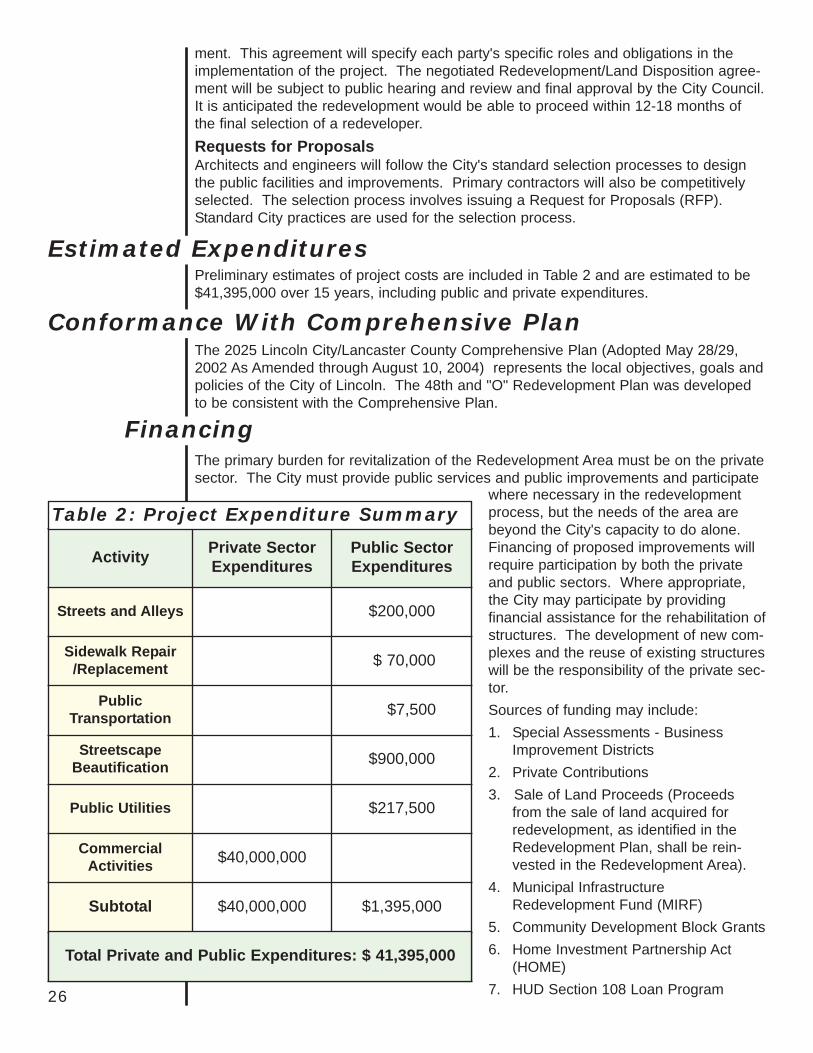
Preliminary estimates of project costs are included in Table 2 and are estimated to be$41,395,000 over 15 years, including public and private expenditures.
The 2025 Lincoln City/Lancaster County Comprehensive Plan (Adopted May 28/29,2002 As Amended through August 10, 2004) represents the local objectives, goals andpolicies of the City of Lincoln. The 48th and "O" Redevelopment Plan was developedto be consistent with the Comprehensive Plan.
The primary burden for revitalization of the Redevelopment Area must be on the privatesector. The City must provide public services and public improvements and participate
Estimated Expenditures
Activity Private SectorExpenditures
Public SectorExpenditures
Streets and Alleys $200,000
Sidewalk Repair/Replacement $ 70,000
PublicTransportation $7,500
StreetscapeBeautification $900,000
Public Utilities $217,500
CommercialActivities $40,000,000
Subtotal $40,000,000 $1,395,000
Table 2: Project Expenditure Summary
Total Private and Public Expenditures: $ 41,395,000
Conformance With Comprehensive Plan
Financing
where necessary in the redevelopmentprocess, but the needs of the area arebeyond the City's capacity to do alone.Financing of proposed improvements willrequire participation by both the privateand public sectors. Where appropriate,the City may participate by providingfinancial assistance for the rehabilitation ofstructures. The development of new com-plexes and the reuse of existing structureswill be the responsibility of the private sec-tor. Sources of funding may include:1. Special Assessments - Business
Improvement Districts2. Private Contributions3. Sale of Land Proceeds (Proceeds
from the sale of land acquired forredevelopment, as identified in theRedevelopment Plan, shall be rein-vested in the Redevelopment Area).
4. Municipal InfrastructureRedevelopment Fund (MIRF)
5. Community Development Block Grants6. Home Investment Partnership Act
(HOME)7. HUD Section 108 Loan Program
27
8. Community Improvement (Tax Increment) Financing (Ad Valorem Tax)9. Capital Improvements Program Budget10. Federal and State Grants11. Interest Income12. Advance Land Acquisition Fund - property rights/easements, public facility site
acquisition.13. Brownfields funding
Project activities will be undertaken subject to the limit and source of funding authorizedand approved by the Mayor and City Council.
According to the Community Development Law, any ad valorem tax levied upon realproperty in the redevelopment project for the benefit of any public body shall be divid-ed, for a period not to exceed 15 years after the effective date of such provision, by thegoverning body as follows:
• That portion of the ad valorem tax which is produced by the levy at the rate fixedeach year by or for each such public body upon the redevelopment project valua-tion shall be paid into the funds of each such public body in the same proportion asare all other taxes collected by or for the body; and
• That portion of the ad valorem tax on real property in the redevelopment project inexcess of such amount, if any, shall be allocated to and, when collected, paid into aspecial fund of the authority to be used solely to pay the principal of, the interest on,and any premiums due in connection with the bonds of, loans, notes, or advancesof money to, or indebtedness incurred by, whether funded, refunded, assumed, orotherwise, such authority for financing or refinancing, in whole or in part, the rede-velopment project. When such bonds, loans, notes, advances of money, or indebt-edness, including interest and premiums due, have been paid, the authority shall sonotify the county assessor and county treasurer and all ad valorem taxes upon tax-able real property in such a redevelopment project shall be paid into the funds ofthe respective public bodies.
The effective date for the Community Improvement Financing provisions of The 48thand "O" Street Redevelopment Plan for each Sub Project is declared to be the daterehabilitation, acquisition, or redevelopment of substandard and blighted property in thesub-project area first commences.
Impact FeesImpact Fees Redevelopment will be subject to impact fees. However, since buildingswill likely be demolished, Lincoln Municipal Code §27.82.050 (7) states:
In the case of a demolition or termination of an existing use or structure, theimpact fee for future redevelopment of that site shall be based upon the netincrease in the impact fee for the new or proposed land use as compared to theprevious use. Credit for the prior use shall not be transferable to another loca-tion, except that if the old location was acquired by the City for use for an ImpactFee Facility and will not be redeveloped, the City will receive a credit againstfuture impact fees equal to the impact fee that would have been assessed againstthe relocated use which may be transferred by the City to a community redevel-opment project in another location within the same benefit area.

28

Appendix ALand Acquisition Policy Statement
A-1

A-2
LAND ACQUISITION POLICY STATEMENTI. ADMINISTRATIVE ORGANIZATION FOR LAND ACQUISITION OPERATIONS
A. All land acquisition functions, including negotiations and closings, will be performed by the City ofLincoln, or its agents. The conduction of condemnations will be performed by the Legal Counsel forthe City. The staff is experienced and capable in the conduct of acquisition programs.
B. The City of Lincoln approved land acquisition policies and procedures within the limits prescribed bythe statutes of the State of Nebraska. Each individual property purchase, and the disbursement ofpayment, therefore, is approved by the Mayor. Condemnation proceedings are instituted by the CityLaw Department only after all efforts to reach a negotiated settlement have failed. Legal services willbe performed by the Legal Counsel for the City.
II. POLICIESA. Real Estate appraisals are made by staff or selected fee appraisers. Second real estate appraisals, if
required, may also be by fee appraisers.The following are policies for Real Property Acquisition:1. Every reasonable effort will be made to expeditiously acquire real property by negotiation.2. Real property will have separate appraisals before initiation of negotiations and the owner, or his
representative, will be given the opportunity to accompany the appraisers on their inspection tourof the property.
3. Before initiation of negotiations for real property, the City's Reviewing Appraiser will establish anamount considered to be just compensation and the City shall make prompt effort to acquire theproperty for that amount.a. The established amount shall not be less than the approved appraisal of fair market value for
the property.b. Any decrease or increase in the fair market value of the property, prior to the date of valuation,
caused by public improvement; by physical deterioration within reasonable control of the owner,has been disregarded by the City and by the Appraisers in making the determination of fairmarket value.
c. The City's negotiator shall provide the owner with a written statement summarizing the basis forthe amount established as just compensation. Where appropriate, compensation for propertyacquired and for damages to any remaining real property shall be separately stated.
4. No owner shall be required to surrender possession until the City of Lincoln pays the agreed pur-chase price, or deposits with the Court the amount of award determined by the CondemnationAppraisers.
5. Improvements will be scheduled so the owner or tenant shall receive a minimum 90 days writtennotice before having to move. Every effort will be made by the City to provide such notice as isrequired without undue hardship to the owner or tenant. (This is applicable to total acquisition ofproperty.)
6. If Owner or Tenant is permitted to rent property, the amount of rent shall not exceed fair rentalvalue of subject property.
7. The City of Lincoln will not take any action coercive in nature to compel an agreement on price forproperty.
8. If acquisition must be by eminent domain, the City of Lincoln shall institute formal condemnationproceedings. The City shall not intentionally make it necessary for the owner to institute legal pro-ceedings to prove fact of taking of his real property.
9. If the owner feels the City of Lincoln's offer does not represent the true value of his property, he
A-3

may refuse to accept it. He should then provide evidence concerning value, or damage, that war-rants a change in the City's determination of just compensation. Should the City determine theadditional information is valid, the price will be adjusted accordingly.
10. If as a result of the real estate acquisition there is a portion of your property which is considered bythe City of Lincoln to be an uneconomic remnant, you have the right to request an offer from theCity of Lincoln to acquire the remnant.
B. Owner will be reimbursed for the following expenses incidental to conveyance of real property:1. Recording fee, transfer taxes and similar expenses.2. Penalty cost for repayment of any pre-existing recorded mortgage encumbering real property, pro-
vided the mortgage was entered into in good faith.3. Pro-rate portion of real property taxes paid which are allocable to a period subsequent to date of
vesting title, or effective date of possession, whichever is earlier.4. The cost of abstract continuation and/or evidence of assurance of title.5. Litigation expenses such as legal, appraisal, engineering fees, etc., when:
a. Court determines that condemnation was unauthorized.b. City of Lincoln abandons a condemnation.c. Property owner brings inverse condemnation action and obtains award of compensation.
C. If a separate fixture appraisal is obtained, it shall contain the following immovable fixtures and personalproperty:1. Determination of division of appraisal coverage, enumerating and classifying improvements in-
place.2. Appraisal of improvable fixtures, correlating their findings with both real estate appraisers.
D. All appraisal contracts shall provide terms and conditions and fix the compensation for expert witness-es. These services will be utilized by the City of Lincoln to the extent necessary.
E. Both real estate acquisition appraisals and immovable fixture appraisals will be reviewed by the CityAppraisal Staff. All appraisals will be reasonable free of error and conferences with appraisers willascertain that methods of approach and documentation are compatible, with no elements of valuebeing omitted from consideration. City staff will conduct relocation interviews to verify ownership ofcertain fixtures and personal property claimed. Said claims will then be checked against existing leas-es and through interviews with fee owners.
F. Preparation for acquisition includes:1. Preliminary title information supplied by local abstract companies; contents reviewed and entered
in individual parcel folios.2. Individual parcel folios prepared; chronological activity indexed and all pertinent historical informa-
tion entered.3. Basic forms of Real Estate Agreement (real estate, personal property and fixtures) reflecting policy
for negotiations to acquire all classifications of property.4. Closing methods and policy determined.5. Policy for possession, property management, salvage and demolition, timetable of activities pre-
pared.6. Closing statement form prepared together with such internal administration forms for notice to vari-
ous units of inspection, accounting, property management, finance and legal counsel as may berequired.
7. Information letters prepared for distribution to all owners and tenants.8. Deed forms for conveyance of real estate, bill of sale forms for personal property, and condemna-
tion forms for eminent domain procedure prepared.
A-4
(NOTE: Paragraphs G, H, and portions of I cover items of notice, relocation assistance, etc., relating to totalproperty acquisitions as well as general policies.)
G. The "single offer" system for acquisition will be utilized in all negotiations. The City will establish fairmarket value and be prepared to justify and substantiate the determination in the event it is chal-lenged. Staff will present and explain forms, terms and conditions of purchase in personal interviewswith each property owner and tenants. The date of this interview will establish the beginning of negoti-ations which regulates many relocation payments.For the purpose of all negotiated transactions, the City will require conveyance of real estate byWarranty Deed or deed instrument sufficient to place marketable title in the City of Lincoln. Standardforms of such instruments conforming to Nebraska Law are on hand and will be used in every case.Each owner executing a Real Estate Agreement should furnish a current abstract of title as specified insaid offer. Legal Counsel for the City will render an opinion of the condition of said title, and upondetermination that in his opinion said title appears merchantable, will assist with the closing process.Title to all property will be vested in the City of Lincoln on the date of closing, which will also be thedate of payment of the purchase price and the date of conveyance instruments. The City of Lincolnshall have the right to possession within 90 days of closing date, (or 90 days from date of writtennotice if later than closing date), or as provided in the Real Estate Agreement. A statement by aresponsible City Official, resulting from an inspection of the property acquired, will be contained ineach acquisition folio. This statement will precede payment and closing and must determine that allproperty purchased is present and in place in substantially the condition as of the date appraised.
H. Immovable items attached to the Real Property, that would incur substantial economic damage ifremoved, will be negotiated for and acquired at the appraised value-in-place for continued use in thepresent location. A "Single Offer" at the maximum price will be offered the owner of such property, butif the owner elects to move any such appraised item it will be relocated rather than acquired and theappraised amount deducted. Until the business to be displaced has definitely located a relocation site,it is almost impossible to determine whether certain process fixtures can be relocated or should beacquired by the City of Lincoln. When such fixtures have been acquired, paid for, and a bill of saleconveyed, and the seller then finds it would have been desirable to have relocated them, it shall be theCity of Lincoln's policy to reconvey such items to the original owner in return for the exact amount ofvalue-in-place price paid for them, and then pay for their relocation. Under no circumstances will fix-tures sold back to the original owner by the City of Lincoln be at salvage value, or any amount lessthan that paid for them. Generally, the terms and conditions of existing leases and pre-acquisitionconferences with owners and tenants by all appraisers and City Staff will have clarified ownership.
NOTE: Process utilities that are service entrances and concealed utilities are ineligible for compen-sation as relocation expenses and will be treated as immovable fixtures. The utilities listed by thefixture appraiser as "Eligible for Relocation" formerly would have been compensated in relocationfor those items. Therefore, process utilities are appraised even though eligible for relocation com-pensation. However, the claimant may still enter a claim for payment for replacement of those eli-gible utilities at the new location providing the appraised value-in-place of the claimed utilities isdeducted from the relocation claim.Immovable fixtures and process utilities not appraised will be handled through the direct loss ofproperty process. It is expected that claims for severance damages caused by partial taking willbe minimal.All fixtures and improvements appraised and acquired become the property of the City of Lincolnas clarified in the Real Estate Agreement and may not be removed by any other than authorizedpersonnel or the demolition contractor.
A-5

I. Upon thoroughly exhausting every avenue of negotiation available, the City of Lincoln will direct theirLegal Counsel to prepare for the appropriation of all property to be acquired through eminent domainproceedings. Such petitions will be drafted by the Legal Counsel clearly defining the property to beacquired and the ownership thereof, land, improvements, immovable and movable property (if any)located therein, with such particularity that the petitions and the resulting action of the condemnationappraisers, or district court appeals, will clearly establish such ownership and rights to compensation.Owner-Occupants of dwelling units that may be eligible for the Replacement Housing Payment will bemade aware that the award received through eminent domain proceedings (excluding interest thereon,or consequential damages), determined by the condemnation appraisers, or by District Court willbecome the basis for any Replacement Housing Payment to be claimed. Immediately precedingpreparation of petitions, preliminary title information will be updated. Fee appraisals and fixtureappraisals will be reviewed.To the extent necessary, a reinspection of each property to be condemned will be conducted by theappraisers to determine that the property, on the date of taking, is in substantially the same conditionas it was on the date of their original appraisal and that their opinions of value, therefore, hold true asof the date of taking. Each appraiser's testimony may then be presented to the condemnation apprais-ers and, in case an appeal is filed, to the District Court.The City of Lincoln will not require any owner to surrender the right to possession of his property untilthe City pays or causes to be paid, to the Lancaster County Court the amount due each interestacquired for the taking thereof as determined by the condemnation. Immediately following the deter-mination of the amount of the condemnation award for the property, or each separate interest thereintaken, the City will direct that payment to be made in an amount equal to the City's offer by theissuance of warrants drawn in favor of those entitled thereto to the County Court of Lancaster County,Nebraska, for payment of the condemnation appraiser's fees connected with the taking. Uponapproval of the City's Legal Counsel, such warrants shall be deposited with the County Court and willrepresent full compensation for the property taken, subject to appeal to District Court. In any event,title to the property rests with the City of Lincoln as of the date of payment of the condemnation award,as does the right to possession thereof within 90 days of said date, provided compensation due hasbeen paid as prescribed and proper notice given.Nebraska statutes provide a 30-day period from the award of condemnation during which an appealcan be filed by either party. Acceptance of the award deposited with the County Court extinguishesthe right of appeal as to that particular party. In the event an award is not claimed and no appeal isfiled during the statutory period, the right to appeal is barred and the County Judge immediately caus-es the condemnation papers to be recorded in the records and transfer books of Lancaster County,Nebraska.In case an appeal is filed, the County Judge forwards copies of all pertinent papers to the Clerk ofDistrict Court for subsequent trial and determination of the damages in the condemnation appealedfrom. At that point, the City of Lincoln, with or without the consent of condemnee, may petition theDistrict Court to order payment immediately of the award appealed from, thereby reducing interestcosts on the award while the case is being prepared and subjected to trial.Although title and right to possession is vested in the City of Lincoln as of the date of payment of thecondemnation award, no lawful occupant of property taken will be required to surrender possessionwithout at least 90 days written notice (a separate notice in addition to the notice of condemnation)from the City of Lincoln stating the date on which possession will be required. Terms and conditionsfor temporary rental of condemned property for owner-occupants and tenants are detailed in the proj-ect property management policy.District Court trial of all condemnation awards appealed will be defended by the City of Lincoln's LegalCounsel utilizing the services of contract appraisers as expert witnesses for the City. Compensationfor witness services is provided for in existing appraisal contracts. After condemnation suits, awardsand appeals therefrom have been filed, agreements as to value may be entered into by stipulation.Appeal cases will be diligently prosecuted to bring the case to trial and judgment in the shortest time
A-6
possible and necessary for the preparation of an adequate defense. In this manner, and with the courtdirected partial payments of awards outlined previously, interest and court costs will be held to a mini-mum level.In most instances, the sale of privately-owned property to the City of Lincoln for public purposes isconsidered "involuntary conversion" by the Internal Revenue Service, and the owner may not have topay capital gains tax on any profit from the sale of the property to the City of Lincoln, if the money isreinvested in similar property within two years. Internal Revenue Service Publication 549, entitled"Condemnations of Private Property for Public Use", is available from the IRS. It explains how the fed-eral income tax applies to gains or loses resulting from the condemnation of property, or its sale underthe threat of condemnation, for public purposes. IRS Publication 17, "Your Federal Income Tax", avail-able from the IRS contains similar guidance. The owner is advised to discuss his particular circum-stances with his personal tax advisor or local IRS office. State income tax considerations should alsobe discussed as appropriate.
A-7

A-8

Appendix BRelocation Assistance
B-1

B-2
Use the following URL / link for Relocation Assistance:http://lincoln.ne.gov/city/urban/real/pdf/reloc.pdf