the north 48th street/ university place plan · the north 48th street/ university place plan ......
TRANSCRIPT

Prepared for Prepared for Prepared for
The City of Lincoln, Mayor Coleen J. Seng, The City of Lincoln, Mayor Coleen J. Seng, The City of Lincoln, Mayor Coleen J. Seng,
The Urban Development Department, and The Urban Development Department, and The Urban Development Department, and
The Public Works & Utilities DeThe Public Works & Utilities DeThe Public Works & Utilities Departmentpartmentpartment
ByByBy The Schemmer Associates Inc.The Schemmer Associates Inc.The Schemmer Associates Inc.
and RDG Planning & Designand RDG Planning & Designand RDG Planning & Design
JuneJuneJune 200420042004
THE NORTH 48TH STREETHE NORTH 48TH STREETHE NORTH 48TH STREET/T/T/
UNIVERSITY PLACE PLAUNIVERSITY PLACE PLAUNIVERSITY PLACE PLANNNA Neighborhood RevitalizationA Neighborhood RevitalizationA Neighborhood Revitalization
and Transportation Analysis and Transportation Analysis and Transportation Analysis
THE CITY OF LINCOLN
Mayor Coleen Seng
Public Works and Utilities Allan Abbott
Virendra Singh Randy Hoskins
Scott Opfer
Urban Development Marc Wullschleger Bradd Schmeichel
Maggie Aldrich
Police Chief Tom Casady Capt. Doug Srb
Parks and Recreation Lynn Johnson Mark Canney
Planning Marvin Krout
Steve Henrichsen Edward Zimmer
Building and Safety Michael Merwick
TASK FORCE
The Rev. Ed Bonneau Art Case
Clark Chandler Jim Cook
Vickie Daharsh Sharon Fitch
Marilyn Schnieber Gade Barb Gaither
Charles & MaryAnn Genrich Peggy Green Steve Guittar
John Hall Lois Haupt
Conley Hinrichs Matt Ludwig
Robert Manzer Patte Newman
Mary Hepburn O'Shea Sara Olson
David Peterson Margie Phillipson
Jennifer Ripa Janelle Schmale Pam Sedlacek
Kathy Shada-Marsh Coleen Seng
Jerry & Donna Shaw Jack Siemsen Terry Uland
Brian Watkins Debbie White
Dale Vanderholm Larry Zink
AACKNOWLEDGMENTSCKNOWLEDGMENTS
CITY CO-PROJECT
MANAGERS
Urban Development Wynn Hjermstad, AICP
Public Works and Utilities, Engineering Services Division
Kelly Sieckmeyer
The Schemmer Associates Linda Weaver Beacham, P.E.
Mark Stursma, AICP Mark Lutjeharms, P.E., PTOE
Becky Matzke Andrea Bopp
RDG Planning & Design Martin Shukert, AICP
Dave Nicholas, LA Amy Haase
The study team would like to acknowledge Mayor Coleen Seng, and the City department directors and staff for their participation and commitment to this unique study.
We would like to thank the members of the Task Force for their time, patience, and insight. Their assis-tance has been invaluable in helping the study team understand the University Place Neighborhood and much of the credit for the success of the project is due to their diligence and hard work.
SSTUDYTUDY T TEAMEAM
CONSULTANT TEAM
EXECUTIVE SUMMARY ………………………………..……………………………….……..1
INTRODUCTION ………………………………………….…………………………..……..5
Part OneEXISTING CONDITIONS ……………………………………………..……………………...9
Study Area Boundaries ……………………………………………………..……..9
Demographic Information …………………………………………….…...……..9
Land Use and Development Patterns ………………………………………….....12
Residential Occupancy…………………………………………………...…..…...15
Residential Assessed Values ……………………………………………....….…..17
Commercial/Industrial Assessed Values ……………………………….…….…..17
Building Conditions ………………………………………………………..……..18
Historic Significance ………………………………………………….…....……..20
Neighborhood Assessment and Development Issues ……………………………………….………….…..…20
Transportation Analysis …………………………………………...……….……..26
Transportation Alternatives ……………………………………………..………..31
Part Two PLAN / PARTICIPATORY PROCESS .………………………………………………………..35
Task Force …………………………………………………………..………..…..35
TTABLE OF ABLE OF CCONTENTSONTENTS

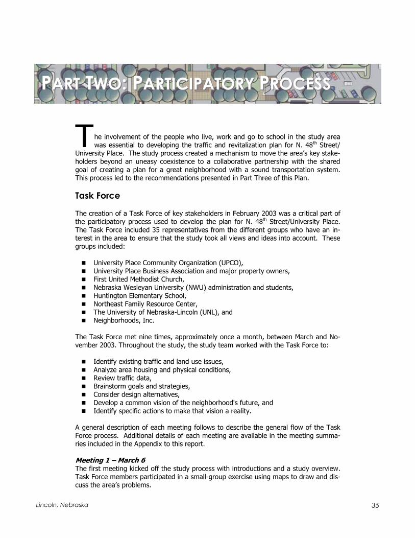
Outreach ………………………………………………………………….……...37
General Public Involvement ……………………………………………………..37
Plan Recommendations ……………………………………………..…………..40
Part ThreeTHE UNIVERSITY PLACE PLAN ……………………………………………….……………..43
Transportation ……………………………………………………….…………..44
Streetscape and Business Environment ……………………………………………..…………….49
Redevelopment …………………………………………………….…………….54
Local Traffic Circulation and Parking …………………………………………..………………………….61
Linkages …………………………………...……………………………………..68
Neighborhood Development and Land Use ………………………………………………….………………...73
Implementation ………………………………………..………………………...81
APPENDIX ……………………………………………...……….……..… Separate Document
Task Force Meeting Notes
Traffic Data
Revitalization and Goals Ranking Exercise
LIST OF MAPS (FOLLOWS PAGE:)
Study Area Boundaries ……………………………………………………..……..7
Existing Building Use ……………………………………….…………..…..……..34
University Place Land Use ……………………………………………..…...….....34
Occupancy Status …………………………………………….………….…….....34
University Place Study Residential Assessed Values …………………………...…34
University Place Multi-family Assessment Values ………………………………...34
University Place Study Area Commercial/ Industrial Assessed Values and Exempt Properties ………………………..……..34
48th Street/University Place Development Concept ……………………...………68
Linkage Strategies …………………………………….………….……...……..…72
Residential Policy Categories ………………………………..……….…………..82
Potential Zoning Modifications ……………………….………….…..………..82
Proposed Zoning Map …………………………………………………..………..82

1Lincoln, Nebraska
The North 48th Street/University Place Plan outlines a concept for the future devel-opment of the N. 48th Street/University Place business district and neighborhood.
The Lincoln City Council and Lancaster County Board approved the N. 48th Street/University Place Plan as an amendment to the Lincoln-Lancaster County Comprehensive Plan in June 2004. This Plan addresses the area of N. 48th Street between Leighton Ave-nue and Adams Street, and the business district and neighborhood defined by Adams Street to the north, Francis Street to the south, 46th Street to the west and 56th Street to the east. The purpose of this planning study was to define deficiencies, opportunities and recommendations within the study boundaries under the following subject areas:
Transportation, Streetscape and Business Environment, Redevelopment, Local Traffic Circulation and Parking, Linkages,Neighborhood Development and Land Use.
This study was a partnership between the University Place Business Association and major commercial property owners, the University Place Community Organization (UPCO), Nebraska Wesleyan University (NWU), and the City of Lincoln. A Task Force composed of representatives of the partnership and other interested stakeholders, all with an interest in the future of this unique district, assisted in developing this Plan.
Transportation Recommendations
N. 48th Street should maintain four through-lanes between Leighton Avenue and Adams Street.
Left-turn lanes should be provided at the Huntington Avenue and Madison Avenue intersections, and prohibited at other intersections between Leighton Avenue and Adams Street.
Provide full traffic signals at Huntington and Madison Avenue and a pedestrian signal at St. Paul Avenue. Initially, the existing pedestrian signal at Huntington should be replaced by full signalization. The Madison Avenue signal should be installed when warranted. Warrants will probably be achieved as part of major redevelopment of the Green’s redevelopment site on the southwest corner of 48th
and Madison and/or after the closing of vehicular access onto 48th Street from St. Paul Avenue. The pace and impact of area redevelopment and traffic redirection will influence the timing and sequencing of these traffic signal upgrades.
St. Paul Avenue should be converted to a pedestrian plaza on both sides of 48th
Street, to about one-half block east and west of the intersection.
EEXECUTIVEXECUTIVE S SUMMARYUMMARY

2 The North 48th Street/University Place Plan
Streetscape Recommendations
The current planters should be replaced by boundary walls, providing a sense of greater sidewalk space adjacent to commercial buildings developed on the prop-erty line.
St. Paul Avenue should be converted to a pedestrian plaza one-half block east and west of the N. 48th Street intersection.
The 48th Street frontage of Huntington School should be attractively landscaped. This landscaping and site improvement project should include acquisition of the auto dealership on the southwest corner of 48th and Adams.
The 48th Street frontage of UNL’s East Campus should be enhanced, including such features as a trail paralleling 48th Street, enhanced landscaping and/or an attractive edge wall, and a campus gateway feature at 48th and Leighton.
Redevelopment Recommendations
Madison Avenue, from 48th to 47th, should be developed as an extension of the traditional business district.
The Green’s site should be developed with a mixed-use project, providing strong street definition along Madison Avenue, with street level commercial and at least one upper level of residential or office use.
The Hall’s site should be developed with a mixed-use project, completing the Madison Avenue “main street” extension and continuing a clear street definition along 48th Street toward Huntington Elementary School.
Street-oriented commercial redevelopment should occur along the east side of 48th Street between Huntington and Walker Avenues.
All redevelopment on opportunity sites should maintain a strong street orienta-tion, typically orienting parking to the rear of the site.
City involvement in the redevelopment process should include evaluation criteria that encourage desirable businesses, with a focus on businesses that appeal to the university communities.
The City should assist redevelopment of strategic sites as the private market re-sponds to improving neighborhood conditions.

3Lincoln, Nebraska
Local Circulation and Parking Recommendations
Public parking for the business district should be expanded west of 48th Street, with pedestrian connections to rear building entrances and to the residential ar-eas to the west.
Parking facilities and circulation on the east side of 48th Street between St. Paul and Madison should be reconfigured and expanded to provide more parking and greater convenience to customers of area businesses. St. Paul Avenue should be designed as an auto “court,” providing convenient on-street parking and access to all existing lots and driveways.
A signage system clearly directing customers to parking areas should be installed in the business district to supplement existing signing.
Intersection or street design features should be installed to channel left turns and cross movements to improved intersections.
Improvements should be considered at the Hy-Vee shopping center on the north side of Leighton Avenue to reduce functional conflicts, improve connections to the neighborhood, and reduce the visual and operating conflicts created by truck loading and service areas adjacent to the residential neighborhood.
The City should consider traffic calming concepts along Leighton Avenue between 48th and 56th Streets, and implement measures found to be appropriate through this investigation.
The City should monitor traffic and parking performance along 47th Street and 49th Street, the two local streets that parallel 48th Street.
A drop-off loop drive should be provided off Cleveland Avenue for Huntington Ele-mentary School.
A new local street segment will improve access to commercial development on the east side of 48th Street south of Leighton Avenue and improve access to Uni-versity Place Park.
Linkages Recommendations
The City and UNL should develop a trail along the west side of 48th Street, with a connection to University Place Park along Dead Man’s Run under a new 48th
Street bridge. This project should be fully integrated into an enhancement pro-gram for the 48th Street edge of the UNL East Campus.
A future East Campus entrance at Francis Street should be developed as a major gateway to University Place as well.

4 The North 48th Street/University Place Plan
A trail should be developed through the UNL East Campus, either along Dead Man’s Run or the south side of Leighton Avenue, connecting to the John Dietrich Trail at 33rd Street and Fleming Fields Recreational Sports Park. This trail should cross under 48th Street through a redesigned system in University Place Park. In addition, a sidewalk connector trail should be developed along the south side of Leighton/Huntington Avenue to provide a secondary connection to the Dietrich Trail and new sports park.
50th Street should be evaluated and adapted as a share-the-road bicycle route be-tween University Place Park and the NWU campus. This route may continue north to connect with the John Dietrich/Murdock Trail system near 49th and Benton.
St. Paul and Baldwin Avenues should be reinforced as promenades between 48th
and 50th Streets, forming a strong functional and visual connection between the NWU campus and the University Place business district.
A north-south connection, linking NWU and the neighborhood, should be consid-ered along the approximate alignment of 53rd Street.
University Place Park north of Dead Man’s Run should be master-planned as a neighborhood park.
Neighborhood Development and Land Use
Recommendations
Lincoln should implement a neighborhood development strategy in University Place, with strategies designed to help bring about desirable outcomes on each block face.
The City and neighborhood should implement a surgical rezoning strategy, based on the character and preferred occupancy outcome of each blackface.
Redevelopment of selected sites can create new housing resources for prospec-tive homeowners, including members of the university community. One opportu-nity could be the east side of an improved 51st Street.
The improvement of the residential quality of the University Place neighborhoods is a widely shared goal. One important step in achieving that goal is to provide the neighborhood residents, particularly those in the blocks surrounding the Ne-braska Wesleyan University campus, with a plan that helps them feel confident that future University expansion will not have a detrimental impact on their prop-erty values and overall quality of life. This plan should also include provisions, which facilitate collaborative efforts by the University, the neighborhood, and the City to invest in the revitalization of these neighborhoods.
5Lincoln, Nebraska
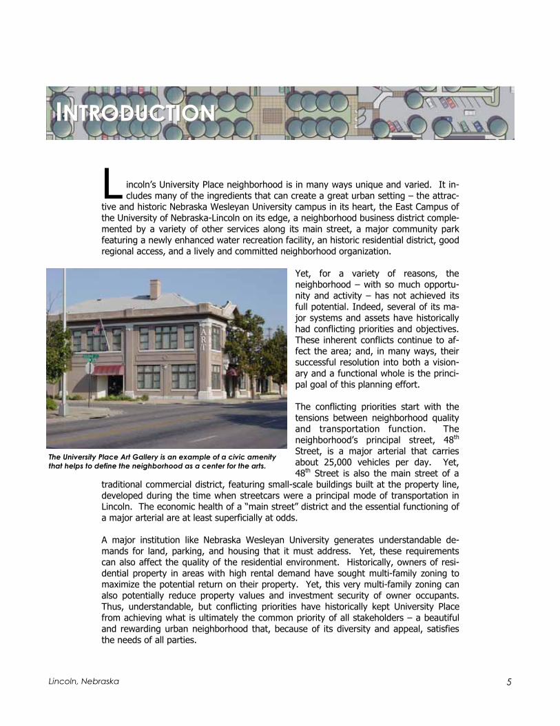
L incoln’s University Place neighborhood is in many ways unique and varied. It in-cludes many of the ingredients that can create a great urban setting – the attrac-
tive and historic Nebraska Wesleyan University campus in its heart, the East Campus of the University of Nebraska-Lincoln on its edge, a neighborhood business district comple-mented by a variety of other services along its main street, a major community park featuring a newly enhanced water recreation facility, an historic residential district, good regional access, and a lively and committed neighborhood organization.
Yet, for a variety of reasons, the neighborhood – with so much opportu-nity and activity – has not achieved its full potential. Indeed, several of its ma-jor systems and assets have historically had conflicting priorities and objectives. These inherent conflicts continue to af-fect the area; and, in many ways, their successful resolution into both a vision-ary and a functional whole is the princi-pal goal of this planning effort.
The conflicting priorities start with the tensions between neighborhood quality and transportation function. The neighborhood’s principal street, 48th
Street, is a major arterial that carries about 25,000 vehicles per day. Yet, 48th Street is also the main street of a
traditional commercial district, featuring small-scale buildings built at the property line, developed during the time when streetcars were a principal mode of transportation in Lincoln. The economic health of a “main street” district and the essential functioning of a major arterial are at least superficially at odds.
A major institution like Nebraska Wesleyan University generates understandable de-mands for land, parking, and housing that it must address. Yet, these requirements can also affect the quality of the residential environment. Historically, owners of resi-dential property in areas with high rental demand have sought multi-family zoning to maximize the potential return on their property. Yet, this very multi-family zoning can also potentially reduce property values and investment security of owner occupants. Thus, understandable, but conflicting priorities have historically kept University Place from achieving what is ultimately the common priority of all stakeholders – a beautiful and rewarding urban neighborhood that, because of its diversity and appeal, satisfies the needs of all parties.
IINTRODUCTIONNTRODUCTION
The University Place Art Gallery is an example of a civic amenity
that helps to define the neighborhood as a center for the arts.

6 The North 48th Street/University Place Plan
This Plan is dedicated to the proposition that these conflicts can be resolved and that these obstacles to University Place’s continued health can be removed by a carefully crafted set of policies and directions. It was funded through a partnership of the City’s Public Works & Utilities Department and Urban Development Department, acting on the premise that the priorities of transportation and community revitalization can lead to common solutions. The process that led to its preparation involved a close collabora-tion of City staff, consultants, and a partnership of primary stakeholders that included the University Place Community Organization, the University Place Business Association, Nebraska Wesleyan University, and other business and property owners, who were united in their commitment to develop strategies that would work toward common benefits.
The individuals and groups involved in this process contributed good will, hard work, and creativity to find common ground and develop innovative solutions to both the transportation and revitalization challenges presented by University Place. The intent of this process was to provide a sound blueprint that guides these same partners toward implementation of these strategies and, ultimately, an urban neighborhood that fulfills its promise.
48th Street is a major arterial and the “main street” of a traditional commercial district.

7Lincoln, Nebraska

8 The North 48th Street/University Place Plan
Neighborhood Revitalization Study Area Traffic Analysis Study Area

9Lincoln, Nebraska
This section describes the existing conditions and some of the key issues affecting the University Place neighborhood. The information found in this section was
derived from previous studies, data from City GIS databases, field inventories, and dis-cussions with stakeholders.
Study Area Boundaries
The University Place study area is defined by Adams Street on the north, Leighton Ave-nue on the south, 46th Street on the west, and 56th Street on the east. The revitaliza-tion component of the Plan also considered the area bounded by Leighton Avenue on the north, Francis Street on the south, 48th Street on the west, and 52nd Street on the east.
Demographic Information
Total study area population / housing units / density, Housing occupancy, Household by type, Age distribution, Race.
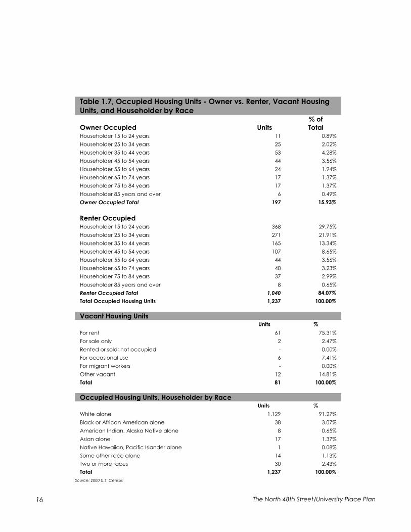
The total population of the University Place Study area, based on 2000 Census Data, is 3,123, which is roughly 1.4 percent of the City of Lincoln’s total population. The study area contains 1,318 housing units of which 1,237, or 93.85 percent, are occupied. This occupancy rate is slightly lower than the overall city occupancy rate of 95.05 percent.
Of the 1,237 housing units, 197 are owner occupied, and 1,040 are renter occupied. This equates to 15.93 percent owner-occupied units and 84.07 percent renter-occupied units, a ratio of greater than five renter-occupied units to one owner-occupied unit. This contrasts significantly with the overall city ratio where there are more owner occu-
PPARTART O ONENE: E: EXISTINGXISTING C CONDITIONSONDITIONS
Uni-Place
Study Area Lincoln
Total Population 3,123 225,581
Total Housing Units 1,318 95,199
Total Occupied Housing Units 1,237 90,485
Population in occupied housing units: Total 2,441 213,938
Density (Total Pop/Total Housing Units) 2.37 2.37
Density (Occ. Housing Pop/Occ. Housing Units) 1.97 2.36
Source: 2000 U.S. Census
Table 1.1, Population, Housing Units, Density

10 The North 48th Street/University Place Plan
pied units (58 percent) than renter-occupied units (42 percent). The contrast in terms of population is even greater. The University Place study area has 21.06 percent of its population in owner-occupied units and 78.94 percent of its population in renter-occupied units. The city, overall, has a much greater percent-age of its population (63.53 percent) in owner-occupied units.
A difference between the makeup of the study area and the overall city does not necessarily identify a problem, but does help us understand the character of the neighborhood. At less than 2 percent of the total population, the sample is not large enough to expect identical ratios. The higher incidence of renter-occupied units, for example, is expected of a neighborhood with a university within its perimeter. However, the entire University Place neighborhood it-self, which makes up only about 1.5 percent of the city’s population, has 49.28 percent owner-occupied units and 50.72 percent renter-occupied units; a ratio that is only slightly less than that of the overall city. This comparison seems to indicate that the study area is fairly unique in its housing makeup.
The study area has 1,237 households with 34.44 per-cent classified as family households. This is signifi-cantly lower than the city’s 59.21 percent of family
Table 1.2, Housing Occupancy
Occupied vs. Vacant Housing Units
Uni-Place Study Area Lincoln
Units % Units %
Occupied 1,237 93.85% 90,485 95.05%
Vacant 81 6.15% 4,714 4.95%
Total 1,318 100.00% 95,199 100.00%
Owner vs. Renter Occupied Housing Units
Uni-Place Study Area Lincoln
Units % Units %
Owner occupied 197 15.93% 52,448 57.96%
Renter occupied 1,040 84.07% 38,037 42.04%
Total 1,237 100.00% 90,485 100.00%
Population in Occupied Housing Units
Uni-Place Study Area
Pop. % Pop. %
Owner occupied 514 21.06% 135,922 63.53%
Renter occupied 1,927 78.94% 78,016 36.47%
Total 2,441 100.00% 213,938 100.00%
Source: 2000 U.S. Census
Lincoln
Table 1.3, Households by Type
Uni-Place Study Area Lincoln
Total Households 1,237 90,485
Average Family Size 2.99
Family Households 426 34.44% 53,580 59.21%
Married-couple family 253 20.45% -
With own children under 18 years 111 8.97% -
No own children under 18 years 142 11.48% -
Other family 173 13.99% 11,653 12.88%
Male householder; no wife present 52 4.20% 3,061 3.38%
With own children under 18 years 24 1.94% -
No own children under 18 years 28 2.26% -
Female householder; no husband present 121 9.78% 8,592 9.50%
With own children under 18 years 81 6.55% -
No own children under 18 years 40 3.23% -
Non-family Households 811 65.56% 36,905 40.79%
Male householder not living alone 127 10.27% 5,363 5.93%
Female householder not living alone 122 9.86% 4,024 4.45%
Male householder living alone 286 23.12% 12,173 13.45%
Female householder living alone 276 22.31% 15,345 16.96%
Source: 2000 Census
2.84

11 Lincoln, Nebraska
households. Of these families, the study area has a slightly higher percentage classified as “other family,” which indicates a single-parent household. Of the 426 family households in the study area, 173 or 13.99 per-cent are classified as “other family” compared to the citywide percentage of 12.88 percent. The distribu-tion of single-parent households is significant because they are more likely to have low incomes and more frequently require support services.
The age distribution of the study area compared to the overall city indicates a much higher incidence of 15-to-24-year-olds and a slightly higher incidence of 25-to-29-year-olds. This, again, is due to a significant student population located within the study area. The study area has a lower incidence of persons in the 30-to-59 age groups, which is significant because these age groups tend to earn the highest wages.
The makeup of racial characteristics within the Univer-sity Place study area is typical of the City of Lincoln, with relatively few minorities.
University Place Traditional Business District along 48th Street.
Table 1.4, Population by Age Cohort
University Place Study Area City of Lincoln
Age Cohort
Both
sexes Male Female
Both
sexes Male Female
Both
sexes Male Female
Both
sexes Male Female
Under 5 yrs 160 79 81 5.1% 5.2% 5.1% 15,199 7,727 7,472 6.7% 6.9% 6.6%
5 to 9 yrs 89 53 36 2.8% 3.5% 2.3% 14,272 7,351 6,921 6.3% 6.5% 6.1%
10 to 14 yrs 115 50 65 3.7% 3.3% 4.1% 13,840 7,037 6,803 6.1% 6.3% 6.0%
15 to 19 yrs 539 231 308 17.3% 15.1% 19.3% 18,472 9,171 9,301 8.2% 8.2% 8.2%
20 to 24 yrs 1,007 495 512 32.2% 32.3% 32.2% 27,110 14,103 13,007 12.0% 12.6% 11.5%
25 to 29 yrs 290 153 137 9.3% 10.0% 8.6% 19,224 10,293 8,931 8.5% 9.2% 7.9%
30 to 34 yrs 172 88 84 5.5% 5.7% 5.3% 16,596 8,752 7,844 7.4% 7.8% 6.9%
35 to 39 yrs 151 90 61 4.8% 5.9% 3.8% 16,778 8,691 8,087 7.4% 7.7% 7.1%
40 to 44 yrs 138 80 58 4.4% 5.2% 3.6% 16,703 8,425 8,278 7.4% 7.5% 7.3%
45 to 49 yrs 124 68 56 4.0% 4.4% 3.5% 15,591 7,716 7,875 6.9% 6.9% 7.0%
50 to 54 yrs 86 44 42 2.8% 2.9% 2.6% 12,839 6,343 6,496 5.7% 5.6% 5.7%
55 to 59 yrs 60 26 34 1.9% 1.7% 2.1% 8,832 4,283 4,549 3.9% 3.8% 4.0%
60 to 64 yrs 39 16 23 1.2% 1.0% 1.4% 6,624 3,135 3,489 2.9% 2.8% 3.1%
65 to 69 yrs 41 19 22 1.3% 1.2% 1.4% 6,055 2,776 3,279 2.7% 2.5% 2.9%
70 to 74 yrs 31 14 17 1.0% 0.9% 1.1% 5,739 2,486 3,253 2.5% 2.2% 2.9%
75 to 79 yrs 41 15 26 1.3% 1.0% 1.6% 5,015 2,003 3,012 2.2% 1.8% 2.7%
80 to 84 yrs 23 7 16 0.7% 0.5% 1.0% 3,475 1,258 2,217 1.5% 1.1% 2.0%
85 yrs + 17 3 14 0.5% 0.2% 0.9% 3,217 811 2,406 1.4% 0.7% 2.1%
Total Pop. 3,123 1,531 1,592 100.0% 100.0% 100.0% 225,581 112,361 113,220 100.0% 100.0% 100.0%
Source: 2000 U.S. Census
Pop. %
White 2,811 90.01%
Hispanic 107 3.43%
Black 95 3.04%
Asian 72 2.31%
American Indian/Alaskan 21 0.67%
Hawaiian/Pacific Islander 5 0.16%
Other 12 0.38%
Total Pop. 3,123 100.00%
Source: 2000 U.S. Census
Table 1.5, University Place Race

12 The North 48th Street/University Place Plan
Land Use and Development Patterns
The University Place study area is a mixed-use urban neighborhood, deriving much of its character from this variety. Two maps illustrate the existing land use patterns within the study area. The “Existing Building Use” map represents the land use inventory that was conducted in March 2003. The “University Place Land Use” map illustrates the ex-isting land use patterns, as recorded at the Lancaster County Assessor’s Office. General land use patterns are described below.
Commercial Uses
Commercial development is concentrated along the 48th Street corridor and exhibits two development configurations. The area between Madison and Baldwin resembles a “main street” district, characterized by historic buildings and zero-depth setbacks. This part of the University Place district is typical of the transit-oriented commercial clusters
that grew around Lincoln’s streetcar sys-tem in the early part of the 20th Century. This traditional business district includes a mix of retail, service and restaurant uses, with recent trends producing additional restaurant, antique, and home-design re-lated establishments.
Residential uses in the traditional business district consist of several second-story apartments and an historic apartment building at 48th and Madison. A fire in 2003 at the Green’s Furnace & Plumbing site destroyed one-half block of storefront buildings along 48th immediately south of Madison, creating an immediate opportu-nity for redevelopment.
Auto-oriented commercial development is located north and south of the traditional main street district. This development pattern includes freestanding commercial build-ings, often separated from the street by parking lots. The largest commercial blocks in-clude the Hy-Vee center and adjacent commercial strip development on the northwest corner of 48th and Leighton; and the more recently developed Walgreen’s on the east side of 48th between Huntington and Baldwin. Business types south of Baldwin include a variety of consumer-based establishments, while commercial uses north of Madison are dominated by used-car dealerships, auto repair, and more marginal businesses. Several of the freestanding commercial buildings have long orientations perpendicular to 48th Street. This pattern creates at least some pedestrian connection to the street and reduces the amount of parking directly parallel to 48th Street.
The center of the traditional business district along 48th Street.

13 Lincoln, Nebraska
Civic Uses
Civic uses, most notably the Nebraska Wesleyan University (NWU) campus, define the University Place neighborhood. The NWU campus is bounded by Madison Street on the north, Huntington Street on the south, 50th Street on the west and 56th Street on the east. The University, founded in 1887 and affiliated with the Methodist Church, has a student body of 1,500 students and employs 390 faculty and staff.
The university community extends to proper-ties around the periphery of the campus, north of Madison, south of Huntington, and west of 50th Street. Some of these proper-ties are owned by NWU and are utilized for parking, student services, campus organiza-tions, and university-related housing. Other sites on the periphery accommodate frater-nities and sororities.
The University of Nebraska-Lincoln’s (UNL) East Campus forms the other dominant insti-tutional use in University Place, lining the 48th Street frontage between Leighton Ave-nue and Holdrege Street. The campus adja-cent to University Place is used largely for experimental crop production, and appears agricultural in character. Long-range campus development plans call for a new en-trance at Francis Street and environmental enhancements to the eastern part of the campus.
The district also hosts more local nonprofit or public uses. Huntington Elementary School includes most of a two-block area between Cleveland Avenue, Adams Street, 48th Street, and 46th Street. This new Lincoln Public School structure offers pre-kindergarten through fifth-grade classes, and had a 2003 enrollment of 418 students. Most of the site east of the school building is used for unstructured play and is a gravel-and-earth surface lacking landscaping.
University Place Park, located at the southern edge of the study area, is a community park of about 22 acres. The park’s major improvement is a recently reconstructed aquatic recreation facility, located in the southwest corner of the site. Other features include a ball field, tennis courts, horseshoe pits, playground equipment, picnic shelter, and unstructured open space. Dead Man’s Run creek bisects the park with most of the park facilities located south of the creek. The north side of the park, with greatest ad-jacency to the residential neighborhood, is largely undeveloped, and is linked to the rest of the open space by a pedestrian bridge.
The western edge of the Nebraska Wesleyan University Cam-
pus along 50th Street.

14 The North 48th Street/University Place Plan
The landmark First United Methodist Church also is a significant civic land use. The church site is located along 50th Street between St. Paul and Madison Avenues, adjacent to the NWU campus.
Residential Uses
A diverse mix of residential uses makes up the balance of the study area. High-density zoning, applied to a formerly single-family neighborhood, has produced a heterogene-ous residential pattern, where apartment buildings, single-family conversions, and sin-gle-family houses are likely to occur on the same block. In general, however:
The north side of the neighborhood, between Madison and Adams fully mixes multi-family and single-family use types. Larger-scale multi-family buildings are somewhat predominant between 52nd and 56th Streets, while single-family and smaller multi-family structures are more dominant between 49th and 52nd Streets.
Single-family uses are more dominant in the southeastern part of the study area, along and south of Walker Avenue and east of 50th Street. This area includes the primarily single-family Charles F. Creighton Historic District.
A single-family residence in the University Place neighborhood.

15 Lincoln, Nebraska
Multi-family uses and conversions are dominant around the edges of the NWU campus and in the transitional areas between the campus and the 48th Street cor-ridor.
Multi-family uses are predominant along 47th Street, giving way to single-family uses toward the western edge of the University Place study area.
Based upon the building-by-building field inventory conducted by the study team, the University Place study area contains 276 single-family residences (many of which are rentals), 72 two- to four-unit residences, 73 multi-family structures, six fraternities or sororities, and one assisted-living residence facility.
Residential Occupancy
Based on data from the County Assessor’s Office, the study area includes 265 renter-occupied parcels and 178 owner-occupied parcels, a ratio of about three-to-two. How-ever, the distribution varies for different parts of the district. West of 48th Street, renter- and owner-occupied parcels are in approximate balance, with rental occupancy more prevalent toward 48th Street. Areas south of Huntington Avenue also display an approximate balance.
The highest percentage of renter-occupied parcels are found east of 48th Street to the north and west of the NWU campus. North of Madison Avenue, renter-occupied parcels outnumber owner-occupied parcels by a ratio of nearly two-to-one, while the area east of 48th Street and west of 50th Street between Madison and Huntington approaches a ratio of five renter-occupied to two owner-occupied parcels.
These ratios reflect the influence of a large student population within the study area and gradual changes in land use, including trends toward multi-family conversions and replacement of single-family with multi-family. The “Occupancy Status” map illustrates which residential parcels within the study area are owner-occupied and which are renter-occupied.
Parcels %
Single-family 257 58.01%
Sorority/fraternity 6 1.35%
Converted houses 57 12.87%
Duplexes 22 4.97%
Multi-family 101 22.80%
Total 443 100.00%
Owner Occupied 178 40.18%
Rental 265 59.82%
Total 443 100.00%
Source: 2003, Lancaster County Assessor
Table 1.6, Residential Unit Parcels
Many single-family homes have been converted to, or re-
placed with, multi-family residences.
16 The North 48th Street/University Place Plan
Table 1.7, Occupied Housing Units - Owner vs. Renter, Vacant Housing
Units, and Householder by Race% of
Owner Occupied Units Total
Householder 15 to 24 years 11 0.89%
Householder 25 to 34 years 25 2.02%
Householder 35 to 44 years 53 4.28%
Householder 45 to 54 years 44 3.56%
Householder 55 to 64 years 24 1.94%
Householder 65 to 74 years 17 1.37%
Householder 75 to 84 years 17 1.37%
Householder 85 years and over 6 0.49%
Owner Occupied Total 197 15.93%
Renter Occupied
Householder 15 to 24 years 368 29.75%
Householder 25 to 34 years 271 21.91%
Householder 35 to 44 years 165 13.34%
Householder 45 to 54 years 107 8.65%
Householder 55 to 64 years 44 3.56%
Householder 65 to 74 years 40 3.23%
Householder 75 to 84 years 37 2.99%
Householder 85 years and over 8 0.65%
Renter Occupied Total 1,040 84.07%
Total Occupied Housing Units 1,237 100.00%
Vacant Housing Units Units %
For rent 61 75.31%
For sale only 2 2.47%
Rented or sold; not occupied - 0.00%
For occasional use 6 7.41%
For migrant workers - 0.00%
Other vacant 12 14.81%
Total 81 100.00%
Units %
White alone 1,129 91.27%
Black or African American alone 38 3.07%
American Indian, Alaska Native alone 8 0.65%
Asian alone 17 1.37%
Native Hawaiian, Pacific Islander alone 1 0.08%
Some other race alone 14 1.13%
Two or more races 30 2.43%
Total 1,237 100.00%
Source: 2000 U.S. Census
Occupied Housing Units, Householder by Race

17 Lincoln, Nebraska
Residential Assessed Values
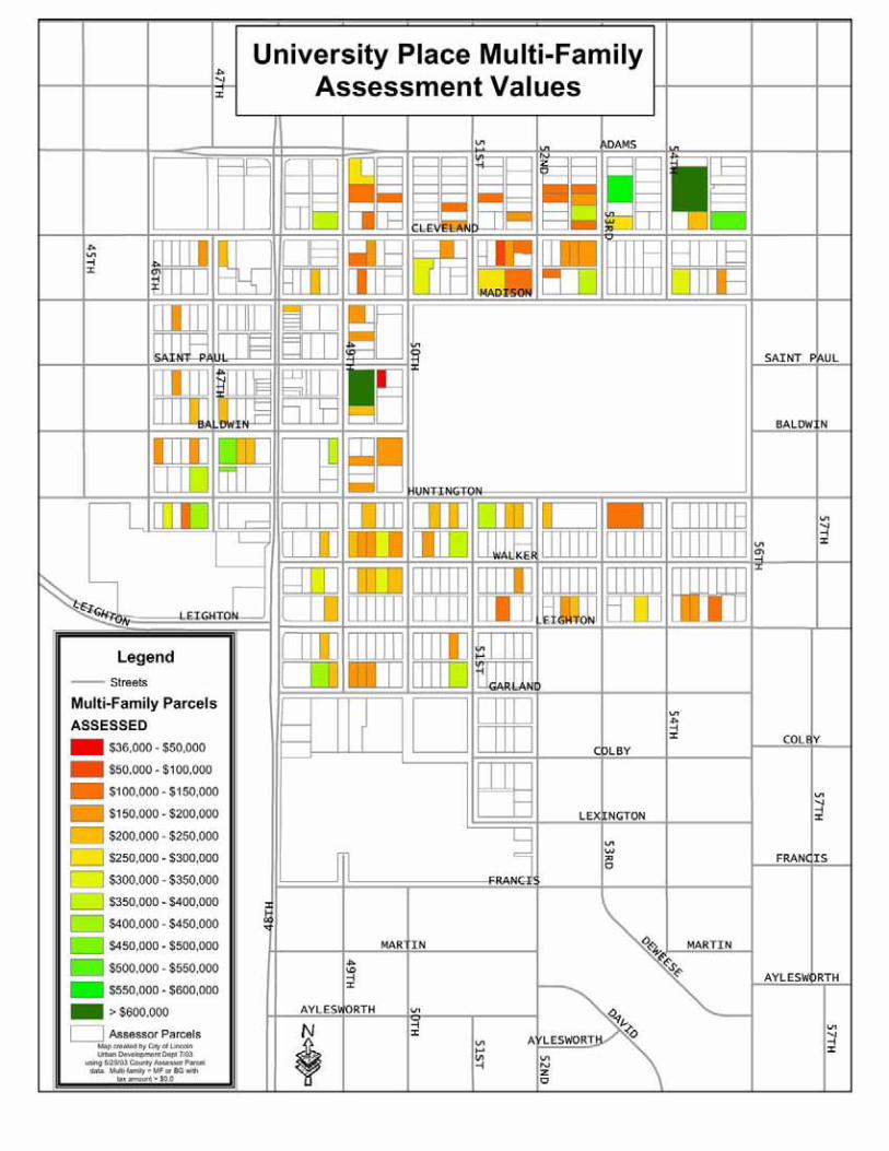
Assessed values of residential properties within the study area generally fall within low-to-moderate ranges for the City of Lin-coln, with approximately 74 percent within the $60,000-$100,000 range and 91 per-cent within the $60,000-$120,000 range. The “University Place Residential Assessed Values” and “University Place Multi-family Assessment Values” maps illustrate the range of assessed values for residential properties. Table 1.8 presents the number of residential properties within each as-sessed value range and the percent of properties within each range.
Commercial/Industrial Assessed Values
Assessed values for commercial and industrial properties also vary within the study area, but are generally low. More valuable properties tend to be located in the south-ern portion of the district, related largely to the scale of the lot and improvements. Properties in the southern portion of the study area, with a contemporary orientation to the automobile, are typically larger than parcels in the traditional “main street” district between Baldwin and Madison Avenues.
Table 1.9 illustrates the number of commer-cial/industrial properties within each as-sessed value range and the percent of prop-erties within each range. Nearly half of the commercial and industrial properties within the study area are assessed at less than $100,000; and nearly 90 percent are as-sessed at less than $300,000.
The “Commercial/Industrial Assessed Val-ues” map illustrates two categories of value ranges for commercial and residential prop-erties within the study area.
Table 1.9, Distribution of Assessed Values for
Commercial and Industrial Parcels Range Properties % of Total
$0 - $100,000 40 49.38%
$100,000 - $200,000 17 20.99%
$200,000 - $300,000 15 18.52%
$300,000 - $400,000 2 2.47%
$400,000 - $500,000 2 2.47%
$500,000 - $600,000 1 1.23%
$600,000 - $700,000 1 1.23%
Greater than $700,000 3 3.70%
Total 81 100.00%
Source: Lancaster County Assessor’s Office
Table. 1.8, Distribution of Assessed Values for
Residential Parcels No. of % of
Range Properties of Total
$6,000 - $20,000 2 0.63% $20,000 - $40,000 1 0.32% $40,000 - $60,000 6 1.89% $60,000 - $80,000 95 29.97% $80,000 - 100,000 140 44.16% $100,000 - $120,000 54 17.03% $120,000 - $140,000 12 3.79% $140,000 - $160,000 4 1.26% $160,000 - $180,000 1 0.32% $180,000 - $200,000 2 0.63% Total 317 100.00%
Source: Lancaster County Assessor’s Office

18 The North 48th Street/University Place Plan
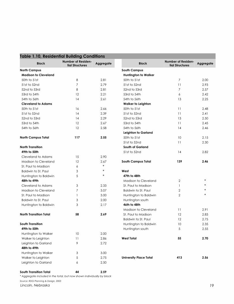
Building Conditions
Table 1.10 displays an assessment of building conditions for residential structures in the University Place study area. The condition assessment is based on an exterior walking inspection, completed in October 2003. Buildings are rated on a five-point scale, from 1 for excellent to 5 for deteriorated. The tabulation compiles information by block. It also assembles information by subdistrict, corresponding to definable parts of the resi-dential neighborhood. These compilation districts include:
NWU North Campus Area, including the area between Madison and Adams from 50th to 56th Streets.
North Transition, from 50th to 48th, Huntington to Adams.
South Transition, from 50th to 48th, Garland to Huntington.
South Campus, from 50th to 56th, Huntington to Garland and Leighton.
West, from 46th to 48th, Leighton to Cleveland.
A University Place business in a converted residence along Baldwin Avenue.
19 Lincoln, Nebraska
Table 1.10, Residential Building Conditions
Block Number of Residen-
tial Structures Aggregate Block
Number of Residen-
tial Structures Aggregate
North Campus South Campus
Madison to Cleveland Huntington to Walker
50th to 51st 8 2.81 50th to 51st 7 2.00
51st to 52nd 7 2.79 51st to 52nd 11 2.93
52nd to 53rd 8 2.81 52nd to 53rd 7 2.57
53rd to 54th 12 2.21 53rd to 54th 6 2.42
54th to 56th 14 2.61 54th to 56th 13 2.25
Cleveland to Adams Walker to Leighton
50th to 51st 16 2.66 50th to 51st 11 2.48
51st to 52nd 14 2.39 51st to 52nd 11 2.41
52nd to 53rd 14 2.29 52nd to 53rd 13 2.50
53rd to 54th 12 2.67 53rd to 54th 11 2.45
54th to 56th 12 2.58 54th to 56th 14 2.46
Leighton to Garland
North Campus Total 117 2.55 50th to 51st 10 2.15
51st to 52nd 11 2.30
North Transition South of Garland
49th to 50th 51st to 52nd 14 2.82
Cleveland to Adams 15 2.90
Madison to Cleveland 12 2.67 South Campus Total 139 2.46
St. Paul to Madison 6 * Baldwin to St. Paul 3 * West
Huntington to Baldwin 5 * 47th to 48th
48th to 49th Madison to Cleveland 2 * Cleveland to Adams 3 2.33 St. Paul to Madison 1 * Madison to Cleveland 7 3.07 Baldwin to St. Paul 2 * St. Paul to Madison 1 3.00 Huntington to Baldwin 2 * Baldwin to St. Paul 3 2.00 Huntington south
Huntington to Baldwin 3 2.17 46th to 48th
Madison to Cleveland 11 2.91
North Transition Total 58 2.69 St. Paul to Madison 12 2.83
Baldwin to St. Paul 12 2.75
South Transition Huntington to Baldwin 10 2.35
49th to 50th Huntington south 5 2.55
Huntington to Walker 10 2.00
Walker to Leighton 11 2.86 West Total 55 2.70
Leighton to Garland 9 2.72
48th to 49th
Huntington to Walker 3 3.00
Walker to Leighton 5 2.75 University Place Total 413 2.56
Leighton to Garland 6 2.50
South Transition Total 44 2.59
* Aggregate included in the total, but now shown individually by block
Source: RDG Planning & Design, 2003
20 The North 48th Street/University Place Plan
Historic Significance
The University Place neighborhood includes the Charles F. Creighton Historic District, generally located along Walker and Leighton Avenues between 49th and 54th
Streets. Other currently designated his-toric sites include:
The Saint Charles Apartments at 4717 Baldwin.
Old Main at the NWU campus.
Other potential historic designations in the study area include:
University Place City Hall (Art Center) at 48th and Baldwin.
Citizen State Bank (Berry Law Office) at 48th and St. Paul.
Wesleyan Hospital (Madison Avenue Apartments) at 48th and Madison.
Carnegie Library (MEG engineering office) at 48th and Cleveland.
First United Methodist Church at 50th
and St. Paul.
The University Place business district between Baldwin and Madison may have sufficient integrity to merit landmark or National Register district designation. Other individual buildings of architectural or historic distinction are dispersed throughout the study area. However, modifications or new construction make additional district designations unlikely.
Neighborhood Assessment and Development Issues
The University Place neighborhood is unusual for its combination of major educational institutions, established residential neighborhoods, neighborhood business district, con-temporary retailing, and a major neighborhood park. This provides most of the ingredi-ents of success and vitality for a lively and high-value urban neighborhood. Yet, to many residents and stakeholders in the neighborhood, University Place has not realized
Historic Old Main at Nebraska Wesleyan University.

21 Lincoln, Nebraska
its full potential. The previous section presented the “facts” of this neighborhood – its demographic, land use, housing, commercial, and historic environments. This discus-sion will assess issues in the area, examining the diverse neighborhood by analytical subdistricts. These districts are similar to those considered in the housing conditions evaluation, and include:
The 48th Street commercial corridor.
The North Campus area, including residential and institutional uses directly north of the Nebraska Wesleyan University (NWU) campus.
The transitional areas between 48th and 50th Streets, where the campus and resi-dential communities blend into the 48th Street transportation and commercial cor-ridor.
The South Campus area.
The portion of the study area west of 48th Street.
This discussion presents a brief description and a review of key issues and opportunities for each subarea.
The 48th Street Corridor
This major corridor can be divided into three sections with distinct characteristics. Most people visualize University Place as a traditional “main street” district bounded by Bald-win on the south and Madison on the north. Between Madison and Adams, the main street character of the district breaks down, and the street frontage includes a variety of relatively small freestanding commercial buildings. Huntington Elementary School also takes up much of this frontage. More contemporary, automobile-oriented retailing and services occur south of Baldwin.
Significant issues and trends for this part of the study area include:
North of Madison
Relative underutilization of commer-cial land along 48th Street.
Unattractive district entrance at 48th
and Adams, including a small used-car dealership and unlandscaped Huntington School site.
Heavy traffic on 48th Street, north of Madison Street.

22 The North 48th Street/University Place Plan
Traffic conflicts with convenience-store curb-cuts close to the 48th and Madison intersection.
Attractive reuse of the Carnegie Library provides an anchor for this two-block area.
Traditional Business District between Madison and Baldwin
Recent trends have included several new retail and service businesses, focusing on restaurants, home design, antiques, and specialty retailers.
Narrow sidewalks, planter placement, and 48th Street traffic create a relatively un-friendly pedestrian environment along the “main street.”
The Carnegie Library, converted to an office, provides an an-
chor for future redevelopment north of Madison Street.
The alleys parallel to 48th Street provide comfortable outdoor
spaces.
Convenience store location creates turning-movement con-
flicts near the intersection of 48th Street and Madison Street.
Pedestrians and traffic must coexist within close proximity
along 48th Street.

23 Lincoln, Nebraska
Vacant property, the result of a major fire during 2003, creates a half-block rede-velopment site at 48th and Madison.
Difficult and confusing parking and circulation patterns around the business core. The combination of public and private parking and access easements contribute to difficulty of use.
Business district to NWU-campus linkages along Madison, St. Paul, and Baldwin are relatively weak on the ground, despite a direct linear connection.
Development of some rear-entrance activity has occurred, particularly on the southwest quadrant of 48th and St. Paul.
South of Baldwin
Recent development has included Walgreen’s at 48th and Huntington, and com-mercial construction at 48th and Leighton.
Confusing local circulation into strip centers and the post office from 48th Street.
Underuse and possible availability of commercial site between Huntington and Walker on the east side of 48th Street.
Traffic and internal-circulation conflicts within the Hy-Vee center at 48th and Leighton. Poor pedestrian and vehicular access and connectivity between this site and the neighborhood to the north.
Relatively unattractive streetscape through this portion of the district.
48th Street contains a mix of traditional and contemporary
commercial development.
Benches and landscaping at the intersection of 48th Street and
Baldwin Avenue.

24 The North 48th Street/University Place Plan
Poor internal neighborhood access to commercial development south of Leighton on the east side of 48th Street.
NWU North Campus Area
The NWU North Campus Area has been influenced both by campus expansion and asso-ciated development, and the effects of relatively high-density zoning. As a result, it ex-hibits a relatively unplanned mixture of campus-related uses, conversions of single-family houses to multi-family use, and as-built multi-family development. Islands of sin-gle-family occupancy continue within this mixed-use area. Significant issues and trends in this area include:
Encroachment of marginal commercial and industrial uses east from the 48th and Adams intersection.
Significant housing deterioration in certain parts of the subarea.
Unsightly additions to large houses as part of earlier multi-family conversions.
New dormitory development by NWU on the north edge of the campus. These new units may alter the demand for off-campus housing, reducing the marketabil-ity of more marginal multi-family building. This in turn creates opportunities for new, more appropriate infill development.
Parking demand that exceeds capacity of local streets, created by high-density housing on relatively small lots. NWU student housing construction may also in-crease parking demand on the north campus area.
Uncertainties over University expansion directions.
Transitional Areas
Areas of transition are found among the blocks between NWU and the 48th Street corri-dor, which possess very diverse land uses and development patterns. The blocks be-tween 48th and 50th are the university’s front door and include extensive visitor and stu-dent parking. This location also represents the primary interface with the commercial corridor. In between are a mix of residential and office buildings and First United Meth-odist Church.
Significant issues and trends in this area include:
A major and growing demand for parking. Despite large, University-owned sur-face lots on the west side of 50th Street, parking demand appears highest in this part of the neighborhood.

25 Lincoln, Nebraska
Local circulation. Two-sided, on-street parking, local traffic generated by both the university and business communities, and relatively narrow streets create some congestion, especially along 49th Street.
Campus/business district connections and campus visibility from 48th Street. De-spite a large presence in the neighborhood, the University is tucked two blocks away from its primary approach route. The University campus and the business district are also not strongly connected, despite their relative adjacency.
NWU South Campus
This area includes University Place’s most identifiably single-family streets, and incorpo-rates the Charles Creighton Historic District. The University also maintains a major presence along Huntington, and has purchased property on the south side of the street, used largely for parking and campus services. Its recent parking study recommends parking development along Huntington.
Major issues and trends in this part of the district include:
Campus development on the south side of Huntington, along with residential area impacts. Campus development could have significant impacts on the adjacent Creighton historic district without appropriate buffering. In addition, uncertainties can arise from possibilities of additional University acquisitions.
Neighborhood stabilization in the face of high-density zoning. The Creighton his-toric district is zoned for multi-family use yet maintains a single-family, primarily owner-occupied character. Current zoning is inconsistent with present use, and can be a destabilizing influence.
Increasing traffic on Leighton Avenue. The removal of on-street parking on Leighton in 2003, brought about by increasing traffic volumes, raises concerns about higher traffic speeds, threatening the continued residential quality of this key street.
Connection to University Place Park. The park south of Garland Street is relatively undeveloped, to some degree dividing the main part of the park from the residen-tial neighborhood.
West
This area includes the study area north of Leighton Avenue between 46th and 48th
Streets. The block from 47th to 48th is largely influenced by the commercial corridor, and presents a relatively undefined edge to the residential area. The blocks from 46th
to 47th, on the other hand, are solidly residential, and include a combination of single-family residential and smaller-scale multi-family uses.

26 The North 48th Street/University Place Plan
Issues and trends in this area include:
Relatively undefined boundary conditions between the commercial corridor and the residential neighborhood. These conditions include both the 47th Street front-age and the north edge of the Hy-Vee center along Leighton Avenue.
Business district traffic and parking demands along 47th Street.
Local circulation and pedestrian connections between the neighborhood and Hy-Vee along 47th Street.
The lack of landscaping for Huntington Elementary School along 48th Street and concern about drop-off movements on Cleveland Avenue.
Transportation Analysis
The N. 48th Street corridor serves a vital role in the overall transportation network for the City of Lincoln. The street is identified as an urban minor arterial for both the exist-ing and future functional classification systems. Currently, 48th Street provides four
through-lanes of travel (two in each direc-tion) between “O” Street and Adams Street, allows continuous travel between Old Cheney Road on the south and Supe-rior Street on the north, and provides a grade-separated underpass at the B.N.S.F. railroad tracks south of Cornhusker High-way.
Because of the street’s important role in both the city arterial network and the local street system, transportation functions de-serve special attention as part of the N. 48th Street/University Place study. Indeed, the premise of this work is to identify di-rections and policies that serve the needs of both transportation and neighborhood development.
Traffic Volumes and Operations
Traffic data collected in May 2003 show that N. 48th Street currently carries about 31,000 vehicles per day (vpd) south of Leighton Avenue, 25,000 vpd between Leighton Avenue and Adams Street, and 20,000 vpd north of Adams Street. An origin-destination study, with the general limits of Adams Street (north), Leighton Avenue (south), 56th Street (east) and 48th Street (west), was performed to track where vehi-
48th Street, north of Leighton Street, carries approximately
25,000 vehicles per day.
27 Lincoln, Nebraska
cles are both coming from and going to. The results of this study indicate that 60 per-cent of the vehicular traffic on 48th Street is “through-traffic.” In this case, “through–traffic” is defined as vehicles entering the project area at one location and exiting at an-other, without starting or stopping at a location within the project area. This informa-tion indicates that:
A significant volume of vehicular traffic is using 48th Street, and
While a moderate volume of vehicular traffic is turning on and off 48th Street via cross streets, the majority of 48th Street traffic is moving through the project area without starting or stopping at businesses, residences, or schools within the pro-ject area.
Currently N. 48th Street within the project area is composed of two through-lanes in each direction with left-turn lanes at Leighton Avenue and Adams Street. Between these two east-west arterials, the street does not provide dedicated left-turn lanes. Therefore, left-turning vehicles waiting to turn must do so in the inside through-lane. Waiting left-turn vehicles therefore block vehicles traveling straight through intersec-tions, adding to traffic congestion and increasing the potential for both rear-end crashes and problems associated with lane changes, as some traffic weaves to the right around a stopped vehicle.
Signalization
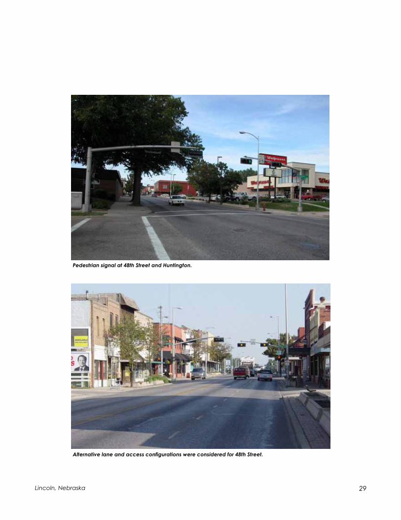
The existing roadway network is supplemented with full, four-way traffic control signals at the intersections of Leighton Avenue, St. Paul Avenue and Adams Street. Also, a pe-destrian signal for crossing 48th Street is provided on the north side of Huntington Ave-nue. Because this pedestrian signal is closer to the intersection than allowed by federal guidelines, the City of Lincoln Public Works and Utilities Department is considering ei-ther relocating it to a point farther from the intersection or fully signalizing the intersec-tion for both vehicles and pedestrians.
Transit Service
University Place is serviced by three City bus routes:
The “Havelock” route, operating along St. Paul Avenue west of 48th Street and 48th Street north of St. Paul Avenue.
The “University Place” route, operating along 48th Street south of Huntington Ave-nue, Huntington Avenue between 48th and 56th Streets and 56th Street north of Huntington Avenue.
The “48th Street Shuttle,” traversing 48th Street throughout the project study area.

28 The North 48th Street/University Place Plan
A fourth route, “Bethany,” touches the southeast corner of the project area as it travels along 56th Street and Leighton Avenue. The “Bethany” route serves the southeast por-tion of the University Place residential areas but has little, if any, impact on the Univer-sity Place business district along N. 48th Street.
Pedestrian Activity
Volumes of pedestrians crossing 48th Street were also observed and recorded during three two-hour time periods on an average weekday at each of the east-west cross streets within the project area. Pedestrians crossing at “mid-block” location — that is, at locations between two adjacent intersections — were also noted. Pedestrian vol-umes along N. 48th Street are summarized in Table 1.11.
Pedestrians at 48th Street and St. Paul Avenue.
Table 1.11, Pedestrian Movements Crossing N. 48th Street
Location
A.M. Midday P.M.
Adams Street 30 3 22
Cleveland Avenue 4 3 5
Madison Avenue 7 7 6
St. Paul Avenue 14 34 12
Baldwin Avenue 6 13 3
Huntington Avenue 20 19 28
Walker Avenue 8 12 0
Leighton Avenue 1 4 8
"Mid-block" 16 20 23
Total 106 115 107
Source: The Schemmer Associates, 2003
2-hour Time Periods
Existing bus stop at St. Paul Avenue.
29 Lincoln, Nebraska
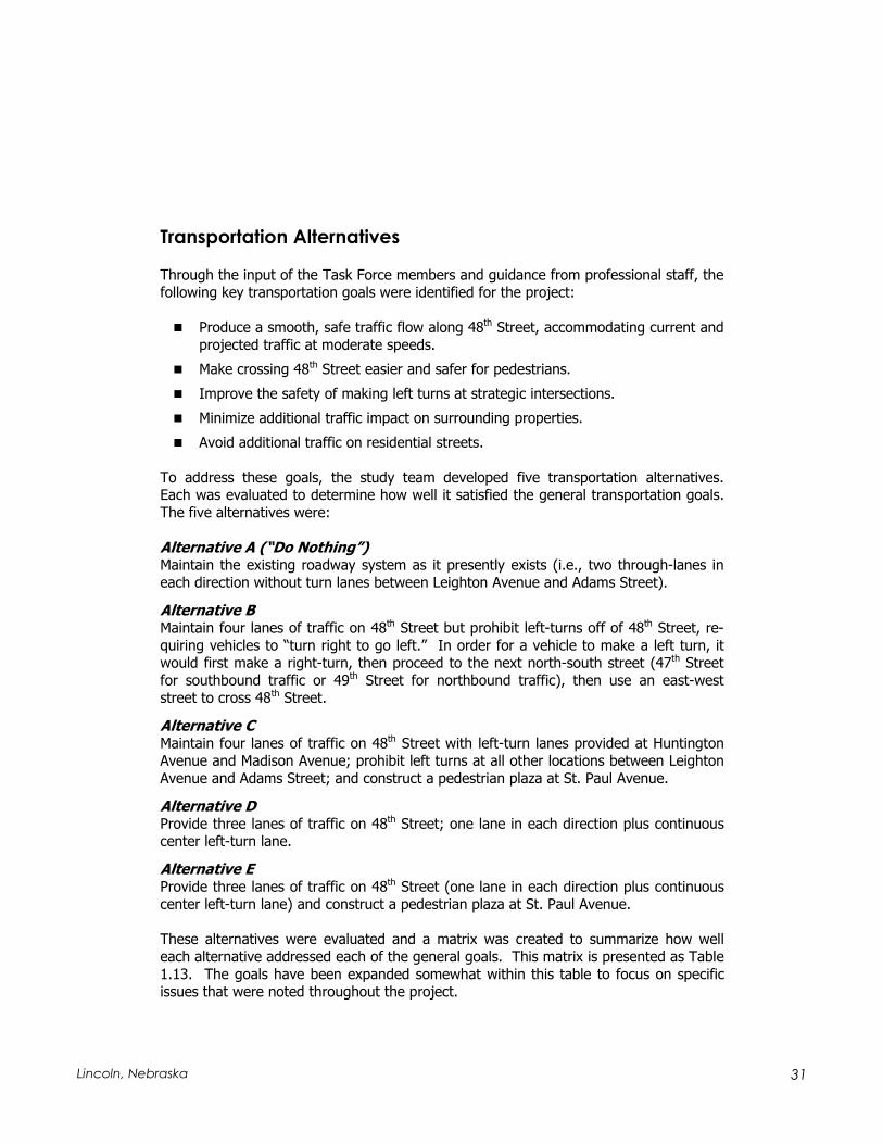
Alternative lane and access configurations were considered for 48th Street.
Pedestrian signal at 48th Street and Huntington.

30 The North 48th Street/University Place Plan
Crash Rates
Recent three-year (January 1, 2000 – December 31, 2002) crash data were obtained to assess the relative safety of the 48th Street corridor within the University Place project area. A summary of these statistics is provided in Table 1.12.
The data presented in Table 1.12 indicate that the intersections throughout the N. 48th
Street corridor experience relatively low crash rates (i.e., less than 1.0). However, the segments between intersections have much higher rates, largely a result of rear-end crashes. In fact, of the 41 crashes that occurred during this three-year period along street segments between intersections, 26 – or 63 percent – were rear-end collisions. These crashes are most likely a byproduct of general vehicle congestion and/or left-turn vehicles stopped in the inside through-lane waiting to complete their turns.
Table 1.12, N. 48th Street Crash Statistics (Jan. 1, 2000—Dec. 31, 2002)
Location No. of Crashes
Segment
Length (mi.) ADT1 Crash Rate2,3
at Leighton 30 - 35,100 0.78
Leighton to Walker 7 0.0679 22,200 4.24
at Walker 5 - 29,450 0.16
Walker to Huntington 9 0.0682 22,200 5.43
at Huntington 20 - 26,500 0.69
Huntington to Baldwin 4 0.0700 22,200 2.35
at Baldwin 8 - 26,500 0.28
Baldwin to St. Paul 6 0.0700 22,200 3.53
at St. Paul 25 - 27,550 0.83
St. Paul to Madison 5 0.0691 22,200 2.98
at Madison 18 - 26,500 0.62
Madison to Cleveland 7 0.0691 22,200 4.17
at Cleveland 2 - 26,500 0.07
Cleveland to Adams 3 0.0893 22,200 1.38
at Adams 33 - 36,600 0.82
1 Average Daily Traffic
2 Accidents per million (1,000,000) vehicle miles (segment)
3 Accidents per million (1,000,000) entering vehicles (intersection)Source: City of Lincoln
31 Lincoln, Nebraska
Transportation Alternatives
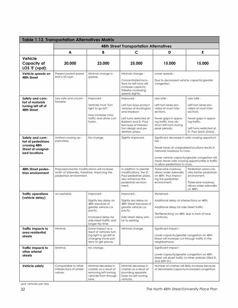
Through the input of the Task Force members and guidance from professional staff, the following key transportation goals were identified for the project:
Produce a smooth, safe traffic flow along 48th Street, accommodating current and projected traffic at moderate speeds.
Make crossing 48th Street easier and safer for pedestrians.
Improve the safety of making left turns at strategic intersections.
Minimize additional traffic impact on surrounding properties.
Avoid additional traffic on residential streets.
To address these goals, the study team developed five transportation alternatives. Each was evaluated to determine how well it satisfied the general transportation goals. The five alternatives were:
Alternative A (“Do Nothing”) Maintain the existing roadway system as it presently exists (i.e., two through-lanes in each direction without turn lanes between Leighton Avenue and Adams Street).
Alternative B Maintain four lanes of traffic on 48th Street but prohibit left-turns off of 48th Street, re-quiring vehicles to “turn right to go left.” In order for a vehicle to make a left turn, it would first make a right-turn, then proceed to the next north-south street (47th Street for southbound traffic or 49th Street for northbound traffic), then use an east-west street to cross 48th Street.
Alternative C Maintain four lanes of traffic on 48th Street with left-turn lanes provided at Huntington Avenue and Madison Avenue; prohibit left turns at all other locations between Leighton Avenue and Adams Street; and construct a pedestrian plaza at St. Paul Avenue.
Alternative D Provide three lanes of traffic on 48th Street; one lane in each direction plus continuous center left-turn lane.
Alternative E Provide three lanes of traffic on 48th Street (one lane in each direction plus continuous center left-turn lane) and construct a pedestrian plaza at St. Paul Avenue.
These alternatives were evaluated and a matrix was created to summarize how well each alternative addressed each of the general goals. This matrix is presented as Table 1.13. The goals have been expanded somewhat within this table to focus on specific issues that were noted throughout the project.
32 The North 48th Street/University Place Plan
Table 1.13, Transportation Alternatives Matrix
48th Street Transportation Alternatives
A B C D E
Vehicle
Capacity at
LOS 'E' (vpd):
20,000 23,000 25,000 15,000 15,000
Vehicle speeds on
48th Street
Present posted speed
limit is 25 mph.
Minimal change in
speeds.
Minimal change -
Concentrated loca-
tions for left turns will
increase capacity, thereby increasing
speeds slightly.
Lower speeds -
Due to decreased vehicle capacity/greater
congestion.
Safety and com-
fort of motorists
turning left off of
48th Street
Less safe and uncom-
fortable.
Improved -
Vehicles must "turn
right to go left."
May increase cross
traffic and driver con-fusion.
Improved -
Left-turn bays protect
vehicles at Huntington
and Madison.
Left turns restricted at Baldwin and St. Paul
because of intersec-tion design and pe-
destrian plaza.
Less safe -
Left-turn lanes pro-
vided at most inter-
sections.
Fewer gaps in oppos-ing traffic may ob-
struct left-turns during
peak periods.
Less safe -
Left-turn lanes pro-
vided at most inter-
sections.
Fewer gaps in oppos-ing traffic.
Left turns restricted at St. Paul (ped. plaza).
Safety and com-
fort of pedestrians
crossing 48th
Street at unsignal-
ized locations
Limited crossing op-portunities.
No change. Slightly improved. Significant decrease in safe crossing opportuni-ties -
Fewer lanes at unsignalized locations results in narrower roadway to cross.
Lower vehicle capacity/greater congestion will
mean fewer safe crossing opportunities in traffic
to allow pedestrians to cross.
48th Street pedes-
trian environment
Proposed planter modifications will increase
width of sidewalks, therefore, improving the pedestrian environment.
In addition to planter
modifications, the St. Paul pedestrian plaza
also enhances the pedestrian environ-
ment.
Three-lane roadway
allows wider sidewalks on 48th, thus improv-
ing the pedestrian environment.
Traffic operations
(vehicle delay)
Acceptable. Improved -
Slightly less delay on
48th because of
greater vehicle ca-pacity.
Increased delay for
side street traffic and
longer trip time.
Improved -
Slightly less delay on
48th Street because of
greater vehicle ca-pacity.
Side street delay simi-
lar to existing.
Worsened -
Additional delay at intersections on 48th.
Additional delay for side street traffic.
"Bottlenecking" on 48th due to lack of lane continuity.
Traffic impacts to
area residential
streets
Minimal. Some impact as a
result of vehicles turn-ing right to go left or
changing travel pat-terns to get places.
Minimal change. Significant impact -
Lower capacity/greater congestion on 48th
Street will increase cut-through traffic in the neighborhood.
Traffic impacts to
other arterial
streets
Minimal. No change. Significant impact -
Lower capacity/greater congestion on 48th
Street will divert traffic to other arterials (33rd St.
and 56th St.).
Vehicle safety Comparable to other
intersections of similar
nature.
Minimal decrease in
crashes as a result of
removing left-turning vehicles from through
lane.
Minimal decrease in
crashes as a result of
providing separate lanes for left-turning
vehicles.
Number of crashes will likely increase because
of decreased capacity/increased congestion.
vpd: vehicles per day
Pedestrian plaza cre-
ates better pedestrian environment.
Three-lane roadway
allows wider sidewalks
on 48th.

33 Lincoln, Nebraska
Obstructed view at Madison Avenue.
48th Street looking north from Leighton Avenue.

34 The North 48th Street/University Place Plan

Adams
Cleveland
Madison
Saint Paul
Baldwin
Huntington
Walker
Leighton
Garland
Colby
Lexington
FrancisFrancis
46th
47th
48th
49th
51st
52nd
53r
d
54th
56th
51st
52n
d
53rd
54th
56th
50th
Adams
Cleveland
Madison
Huntington
Leighton
50th
48th
49th
Garages
Single Family
2-4 Family
Multi-Family
Fraternity/Sorority
Green Space
Trails
Office
Service
Restaurant
Other Paved Areas
RDG Planning & DesignOmaha and Des Moines
0 10050NORTH
March 2003
Retail
Auto
Warehousing
School
Public Facility
Retirement
Civic
Parking Lots
Streets
Vacant
Existing Building Use
Legend


35 Lincoln, Nebraska
The involvement of the people who live, work and go to school in the study area was essential to developing the traffic and revitalization plan for N. 48th Street/
University Place. The study process created a mechanism to move the area’s key stake-holders beyond an uneasy coexistence to a collaborative partnership with the shared goal of creating a plan for a great neighborhood with a sound transportation system. This process led to the recommendations presented in Part Three of this Plan.
Task Force
The creation of a Task Force of key stakeholders in February 2003 was a critical part of the participatory process used to develop the plan for N. 48th Street/University Place. The Task Force included 35 representatives from the different groups who have an in-terest in the area to ensure that the study took all views and ideas into account. These groups included:
University Place Community Organization (UPCO), University Place Business Association and major property owners, First United Methodist Church, Nebraska Wesleyan University (NWU) administration and students, Huntington Elementary School, Northeast Family Resource Center, The University of Nebraska-Lincoln (UNL), and Neighborhoods, Inc.
The Task Force met nine times, approximately once a month, between March and No-vember 2003. Throughout the study, the study team worked with the Task Force to:
Identify existing traffic and land use issues, Analyze area housing and physical conditions, Review traffic data, Brainstorm goals and strategies, Consider design alternatives, Develop a common vision of the neighborhood's future, and Identify specific actions to make that vision a reality.
A general description of each meeting follows to describe the general flow of the Task Force process. Additional details of each meeting are available in the meeting summa-ries included in the Appendix to this report.
Meeting 1 – March 6 The first meeting kicked off the study process with introductions and a study overview. Task Force members participated in a small-group exercise using maps to draw and dis-cuss the area’s problems.
PPARTART T TWOWO: P: PARTICIPATORYARTICIPATORY PPROCESSROCESS

36 The North 48th Street/University Place Plan
Meeting 2 – April 3 The study team presented an overview of the traffic component of the study, and discussed the origin-destination study that would be used to evaluate travel patterns in the project area. The group discussed the upcoming Focus Group meetings on April 15 and 21, and the Design Workshop meetings on April 30 and May 1. The group worked on developing strategies from the issues identified by the Task Force during Meeting 1.
Meeting 3 – May 1 This meeting followed the Neighborhood Design Charrette, discussed below. The study team presented the detailed results of the Focus Group and Charette meetings.
Meeting 4 – June 5 The study team gave a presentation on the existing traffic conditions within the district and the traffic issues on 48th Street, based on the data collection and analysis that had occurred to date. This included results of the origin-destination survey. The Task Force discussed five alternatives developed for meeting the study goals. The study team explained the traffic analysis that would be necessary to evaluate the effects of each alternative.
Meeting 5 – August 14 The study team provided an update of the revitalization component of the study and results of the traffic analysis of each alternative.
Meeting 6 – September 11 The study team presented the conceptual neighborhood development plan addressing the housing and neighborhood revitalization objectives of the study. This session ad-dressed a comprehensive community development strategy for the neighborhood, based on principles of housing and neighborhood conservation.
Meeting 7 – October 2 The Task Force discussed the conceptual plan and written summary with study team members. The purpose of this meeting was to reach consensus on the overall recom-mendations of the coordinated plan.
Task Force members develop strategies for addressing
neighborhood issues at the second Task Force meeting on
April 3, 2003.
37 Lincoln, Nebraska
Meeting 8 – October 9 The Task Force continued its discussion of the conceptual plan with study team mem-bers, and indicated a general agreement on plan recommendations.
Meeting 9 – November 6 The final meeting of the Task Force fol-lowed the public open-house meeting. Task Force and study team members dis-cussed the community meeting and future steps for implementing the plan.
Outreach
Outreach efforts throughout the study in-cluded informal conversations with busi-ness owners and residents during site vis-its, individual meetings with business own-ers, meetings with NWU leadership and student government, and presentations to City department directors and the UNL fa-cilities planning group.
General Public Involvement
The broader public was also invited to learn about and participate in the N. 48th
Street/University Place planning process. A project Web site and e-mail address were set up to give an overview of the process, an-nounce public meetings, and allow citizens an easy way to make comments. The public was also invited to two rounds of intensive, participatory workshops on the project.
Focus Group Meetings
Focus group meetings were held throughout the day on April 15 and again on April 21 at First United Methodist Church. The purpose of these meetings was to gather input from people who live and work in the project area. The meetings were publicized by direct mail to project area addresses, on the project Web site, and by posters distrib-uted to several businesses in the project area.
Attendees included employees of area businesses, NWU students and staff, neighbor-hood residents, property owners and business owners.
The First United Methodist Church hosted the public participa-
tory process.
38 The North 48th Street/University Place Plan
Comments addressed:
The business district’s image/identity, streetscape, and redevelopment opportuni-ties, The relationship between the business district and NWU, its staff and students, Vehicle and pedestrian traffic concerns on 48th Street and other project area streets, Huntington Elementary School, Business and on-street parking, NWU’s place in the neighborhood, Parks, trails and recreation, and Neighborhood housing.
Consultants and City staff incorporated the comments from the Focus Group meetings into the work of the Task Force identifying challenges and possible solutions and oppor-tunities for the neighborhood and its transportation system.
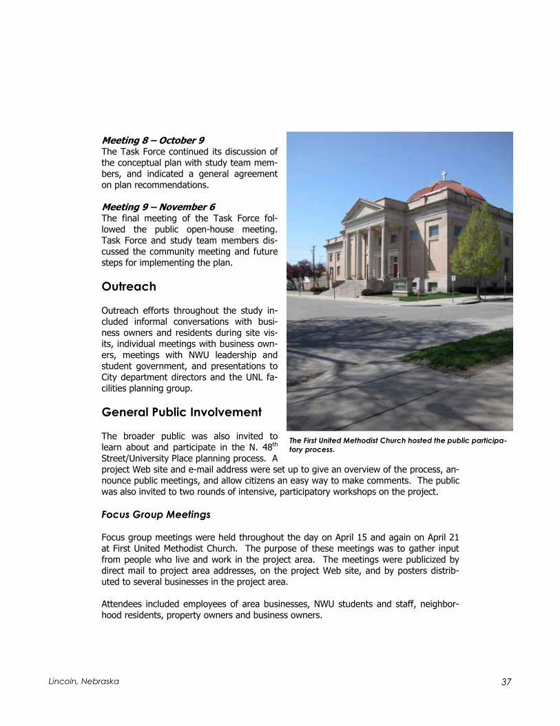
Design Workshop
A design workshop or “charette” was held over a two-day period on April 30 and May 1 at First United Methodist Church. The purpose of the workshop was to allow planners, landscape architects, and engineers on the study team to develop conceptual develop-ment plans openly and with simultaneous input from the public. Charrette results were presented to participants at the end of the session. The design concepts were then re-fined and enhanced during the subsequent planning process.
The concept of creating a pedestrian plaza at St. Paul and 48th Street was developed through discussions with participants of the
Design Workshop and Charrette held April 31 and May 1 of 2003.
39 Lincoln, Nebraska
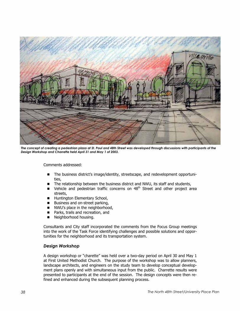
The workshop was publicized by direct mail to project area addresses, on the project Web site, and by posters distributed to many of the businesses in the project area. At-tendees included employees of area businesses, NWU students and staff, neighborhood residents, property owners and business owners.
Primary focuses of the charrette included:
Linkages. Addressing streets, trails and aesthetic elements that link the business districts, residential neighborhood, university campuses and parks to each other.
48th Street traffic and business district. The charrette proceedings con-cluded that 48th Street’s environment was incompatible with its function as a tra-ditional pedestrian-oriented “main street.” Rather, 48th Street provides a first contact and marketing presence for the district, with other, more pedestrian- friendly environments connected to but located off the arterial street. Concepts of intersection improvements and separate left-turn lanes at Madison and Hunt-ington evolved from these discussions. The charrette also suggested creating a street atmosphere at the backs of the businesses along 48th Street, encouraging use of rear entrances and parking.
Pedestrian friendliness. A pedestrian-friendly environment should be devel-oped in the business district, connected to but not directly on 48th Street. This concept, along with traffic concerns, led to the concept of a pedestrian plaza on St. Paul Avenue that would serve both traffic requirements and provide a signa-ture urban space for the district.
Redevelopment opportunities for the vacant Green’s site were discussed at the Design Workshop and Charrette held April 31 and
May 1 of 2003.
40 The North 48th Street/University Place Plan
Redevelopment. This focus considered the types and configurations for devel-opment of major opportunity sites within the district, including the north and south sides of Madison Avenue west of 48th Street.
Community Open-House Meeting
A community meeting took place on October 30 to present the study recommendations and obtain public comments before finalizing the recommendations. All addresses within the study area received a postcard notice of the meeting and posters were dis-played at various businesses and institutions. The City also distributed a press release announcing the meeting and placed changeable message boards along 48th Street an-nouncing the meeting in the project area.
The meeting was held at the First United Methodist Church, with 77 people attending. Two identical PowerPoint presentations of the study process and preliminary recom-mendations were provided. Five display stations were assembled based on the follow-ing subject areas: study recommendations, business, neighborhood, transportation/traffic, and comments. A handout summarizing the study was distributed.
Plan Recommendations
This process, designed to create many venues for community participation and delibera-tion, led directly to the specific concepts presented in Part Three of this Plan.

41 Lincoln, Nebraska
Early sketch of the pedestrian plaza and parking configuration developed during the public
participatory process.

42 The North 48th Street/University Place Plan
43 Lincoln, Nebraska
The North 48th Street / University Place planning process was built on relating the requirements of transportation system planning to those of neighborhood devel-
opment. Often, transportation and revitalization planning occur in isolation and, all too frequently, seem to work at crossed purposes. Transportation systems are sometimes measured by how quickly and smoothly traffic moves through an area. On the other hand, neighborhoods often see regional traffic as an imposition on them, and are nega-tively affected by rapid traffic and high parking demands. The University Place Plan recognizes these different demands and takes the position that it is possible to have a successful transportation system that also reinforces neighborhood development.
Given this approach, the Plan and its recommendations address six specific areas of concentration, together forming a comprehensive strategy that serves the needs of both transportation and neighborhood revitalization. These six areas include:
Transportation, considering the function of 48th Street within the University Place study area within the overall Lincoln transportation system, and how that functional role can best be satisfied.
Streetscape and business environment, addressing the health of the Univer-sity Place neighborhood business district and the type of environment that it pre-sents to residents, business owners, and customers.
Redevelopment, reviewing strategic reinvestment opportunities within the Uni-versity Place area and identifying physical forms and strategies that can most ef-fectively capitalize on these opportunities.
Local traffic and circulation parking, understanding that changes along 48th
Street also affect local traffic movement, and that local traffic in turn affects the livability of University Place as a quality residential neighborhood.
Linkages, addressing both the “internal” connections among the residential neighborhood, the business district, and the neighborhood’s large educational in-stitutions – Nebraska Wesleyan University (NWU) and the University of Nebraska-Lincoln (UNL) East Campus; and the external linkages between University Place and the rest of the city.
Neighborhood development and land use, considering the quality of the neighborhood environment for its residents and stakeholders, and addressing the pressures and changes that affect the neighborhood’s investment climate.
This section establishes the goals and principles that direct the recommendations for each of these areas of concentration. It continues by presenting the specific recom-mendations that will implement these principles.
PPARTART T THREEHREE: T: THEHE UUNIVERSITYNIVERSITY PPLACE LACE PPLANLAN

44 The North 48th Street/University Place Plan
Transportation
Vision: N. 48th Street will function successfully as a north-south arterial through north Lincoln, balancing speed and capacity with the urban context of a pedestrian-oriented neighborhood business district.
N. 48th Street is an important north-south arterial through the north-central part of the city. Of north-south routes east of 27th Street, only 48th Street provides direct access free of railroad grade crossings north to Cornhusker Highway and beyond. Although the Antelope Valley Project may have an effect on 48th Street traffic volumes, this effect is more likely to stabilize rather than reduce traffic volumes in the corridor. Concepts that reduce the capacity of 48th Street will either increase congestion in a way that is unacceptable to most users of the street; or divert traffic to other parallel streets that are even less able to handle these volumes.
However, an approach that places a primary priority on increasing the capacity or speed of traffic moving through the corridor will have highly negative effects on the quality of the University Place neighborhood. Lincoln’s neighborhood business districts lend a fab-ric and scale to the city that is fundamental to its quality of life. A program that sub-stantially increases the traffic capacity of N. 48th Street by widening would require major demolition of many of the district’s “main street” commercial buildings, effectively de-stroying the character of the business street. Such a program would eliminate one of the major features that adds distinction to the surrounding residential area. It would also harm the quality of the NWU’s neighborhood setting, degrading the environment that the University offers to its students and staff. Deterioration of University Place’s environment and ultimate value to the community is too high of a price to be paid for higher traffic capacity.
As a result, the University Place Plan recommends a middle course, diagnosing and ad-justing the street design to optimize traffic flow without affecting the urban fabric of the University Place district. Transportation policies should implement the following princi-ples and goals:
N. 48th Street through University Place should maintain a smooth, safe traffic flow, accommodating current and projected levels at moderate speeds. “Smooth” and “safe” does not mean “faster.” Design treatments should address problems that obstruct flow or create potential hazards and interruptions, such as left turns from moving lanes. However, the design speed and performance of the street should be appropriate to the environment of an urban “main street” business dis-trict.
Pedestrians should find crossing N. 48th Street to be easier and safer than at pre-sent. Transportation policy in urban districts should respect the needs of pedes-trians as well as vehicles, particularly in urban business districts. N. 48th Street should not be a barrier that divides neighborhoods and businesses on either side of the street. It should be relatively crossable at strategic points along its length.
45 Lincoln, Nebraska
Motorists should be able to turn left from 48th Street at strategic locations without impeding through-traffic. While most traffic on N. 48th is composed of north-south through-movements, a significant number of motorists turn left off the street to reach NWU, First United Methodist Church, and area businesses and residences. This requires turning from the inner moving lane, which creates both traffic friction and possible crash points. Limiting left turns to specific locations and moving left turning traffic from the stream of through-traffic reduces this fric-tion and helps create a smoother traffic flow.
Redesign of N. 48th Street should minimize the impact of traffic on the viability of adjacent properties. Commercial buildings along N. 48th are typically in a Main Street configuration, built out to the property line. Typically, the building façade is 12 to 12½ feet from the face of the curb. Reducing this distance will bring moving traffic closer to buildings, affecting their commercial viability. Any changes to the street channel should occur where space permits, without affect-ing existing development.
Changes to N. 48th Street should not channel additional traffic onto local residen-tial streets. Most land uses in University Place are institutional or residential. The relatively high density of residential development already produces significant lo-cal traffic. Changes to N. 48th Street should not have the unintended conse-quences of making local traffic conditions worse by diverting through-traffic to local streets.
The planning process led to the conclusion that Alternative C, presented in the Trans-portation Analysis section, most appropriately satisfied these various requirements. The recommendations presented in this section represent the actions prescribed by this al-ternative.
Transportation Recommendations
Four Through-Lanes N. 48th Street should maintain four through-lanes between Leighton Avenue and Adams Street.
Four lanes are necessary to move current traffic volumes efficiently, and can continue to handle projected traffic volumes adequately. Reducing the street to three lanes (one through-lane in each direction with a continuous center left-turn lane) would reduce its capacity below current volumes, thereby diverting traffic to other arterial streets, such as 33rd Street and 56th Street. Because these other arterial streets are already experi-encing traffic volumes above their design capacity, 48th Street traffic would also be di-verted to local, neighborhood streets. On the other hand, increasing the width to five lanes (two through-lanes with a continuous center left-turn lane) would require either substantial land acquisition or bring traffic to within five to six feet of the front facades of buildings. This would violate the principle of minimizing negative traffic impact on

46 The North 48th Street/University Place Plan
adjacent properties. The five-lane solution provides a dedicated left-turn lane through-out the district; but left-turn movements can be managed more appropriately by limit-ing their availability to strategic locations without negative effects on the district.
Left Turns at Madison and Huntington Left-turn lanes should be provided at the Huntington Avenue and Madison Avenue inter-sections, and prohibited at other intersections between Leighton Avenue and Adams Street.
This recommendation preserves the concept of four through-lanes that are unob-structed by left-turning traffic. Left-turn lanes would be maintained at Adams Street and Leighton Avenue and new left-turn lanes would be provided at Madison Avenue and Huntington Avenue. This will reduce the number of conflicts between through- and left-turning vehicles caused by left-turning vehicles turning from the inside through lane. These locations are logical because:
Huntington and Madison frame the NWU cam-pus and are the principal points of access to the University. The internal campus access drive intersects Madison Avenue. Campus facili-ties that attract public use, including the field house and theater, are located on the south side of the campus and are accessed along Huntington.
Adjacent development patterns, including the Green and Hall redevelopment sites at Madison and the Northeast Printer redevelopment site and existing Walgreen’s at the Huntington in-tersection, provide enough room to redesign these two intersections to accommodate a dedicated left-turn lane. Another logical loca-tion for a left-turn movement, St. Paul Avenue, does not have adequate space for a left-turn lane without property acquisition and probable demolition of commercial buildings. This inter-section is the commercial heart of the University Place business district; attempt-ing to widen the intersection would critically harm the character and function of the district.
Two Full Signals, One Pedestrian Signal Provide full traffic signals at Huntington and Madison Avenues and a pedestrian signal at St. Paul Avenue. Initially, the existing pedestrian signal at Huntington should be re-
Illustration of proposed redevelopment and left-
turn lane at 48th and Madison.
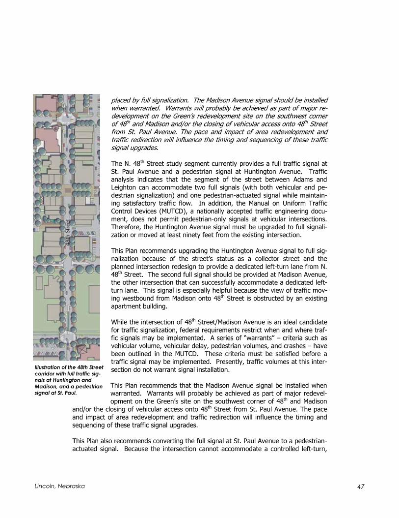
47 Lincoln, Nebraska
placed by full signalization. The Madison Avenue signal should be installed when warranted. Warrants will probably be achieved as part of major re-development on the Green’s redevelopment site on the southwest corner of 48th and Madison and/or the closing of vehicular access onto 48th Street from St. Paul Avenue. The pace and impact of area redevelopment and traffic redirection will influence the timing and sequencing of these traffic signal upgrades.
The N. 48th Street study segment currently provides a full traffic signal at St. Paul Avenue and a pedestrian signal at Huntington Avenue. Traffic analysis indicates that the segment of the street between Adams and Leighton can accommodate two full signals (with both vehicular and pe-destrian signalization) and one pedestrian-actuated signal while maintain-ing satisfactory traffic flow. In addition, the Manual on Uniform Traffic Control Devices (MUTCD), a nationally accepted traffic engineering docu-ment, does not permit pedestrian-only signals at vehicular intersections. Therefore, the Huntington Avenue signal must be upgraded to full signali-zation or moved at least ninety feet from the existing intersection.
This Plan recommends upgrading the Huntington Avenue signal to full sig-nalization because of the street’s status as a collector street and the planned intersection redesign to provide a dedicated left-turn lane from N. 48th Street. The second full signal should be provided at Madison Avenue, the other intersection that can successfully accommodate a dedicated left-turn lane. This signal is especially helpful because the view of traffic mov-ing westbound from Madison onto 48th Street is obstructed by an existing apartment building.
While the intersection of 48th Street/Madison Avenue is an ideal candidate for traffic signalization, federal requirements restrict when and where traf-fic signals may be implemented. A series of “warrants” – criteria such as vehicular volume, vehicular delay, pedestrian volumes, and crashes – have been outlined in the MUTCD. These criteria must be satisfied before a traffic signal may be implemented. Presently, traffic volumes at this inter-section do not warrant signal installation.
This Plan recommends that the Madison Avenue signal be installed when warranted. Warrants will probably be achieved as part of major redevel-opment on the Green’s site on the southwest corner of 48th and Madison
and/or the closing of vehicular access onto 48th Street from St. Paul Avenue. The pace and impact of area redevelopment and traffic redirection will influence the timing and sequencing of these traffic signal upgrades.
This Plan also recommends converting the full signal at St. Paul Avenue to a pedestrian-actuated signal. Because the intersection cannot accommodate a controlled left-turn,
Illustration of the 48th Street
corridor with full traffic sig-
nals at Huntington and
Madison, and a pedestrian
signal at St. Paul.

48 The North 48th Street/University Place Plan
retaining full signalization here is not recommended. The two full signals are more ap-propriately located where all traffic movements are allowed. A pedestrian signal at St. Paul, however, can accommodate the primary pedestrian demand and reinforce the in-tersection’s character as the heart of the district. In addition, coupled with the Pedes-trian Plaza recommendation below, pedestrian signalization can provide free movement to pedestrians to all corners of the intersection.
St. Paul Pedestrian Plaza St. Paul Avenue should be converted to a pedestrian plaza on both sides of 48th Street, to about one-half block east and west of the intersection.
This critical recommendation completes the main N. 48th Street recommendations, and can go far to reinforce the quality of University Place as a business environment. As the heart of the district, the St. Paul intersection is the focus for pedestrian activity, rein-forced by neighborhood attractions such as Ville Grille. The plaza concept reinforces this character and provides urban open space back from the main street for activities such as outdoor dining, performances, special events, and simply watching city and neighborhood life. Pedestrian activity and attractive design, as is proposed at this inter-section, can also have the additional beneficial tendency of slowing through-traffic.
However, the St. Paul Plaza has important transportation functions as well. If St. Paul were to remain open to vehicular traffic, a pedestrian actuated signal would not be al-lowed because pedestrian signals are required to be a minimum of ninety feet from an intersection. To maintain a smooth traffic flow, no more than two full signals can be provided between Leighton and Adams. Keeping a full signal at St. Paul would come at the cost of one of the proposed signals at Madison and Huntington. This Plan considers full signalization at intersections that can accommodate left turns a high priority.
Illustration of proposed pedestrian plaza at St. Paul Avenue. The plaza will extend approximately one-half block in either direction
from 48th Street, creating a pleasant location for pedestrians and events as well as providing a visual icon for the neighborhood
and business district.

49 Lincoln, Nebraska
Streetscape and Business Environment
Vision: N. 48th Street will provide an attractive physical environment, im-proving the ability of existing businesses to market themselves and creating an atmosphere that encourages investment on opportunity sites.
N. 48th Street, in common with other commercial corridors in Lincoln, is both a transpor-tation and business environment. However, in “main street” districts, the character of streetscape is particularly important to business success. This is true for two primary reasons:
Unlike contemporary commercial “strip” development, a substantial number of customers view the public street frontage at pedestrian rather than vehicular speeds. In the auto-oriented commercial environment, interaction with the street is at relatively high, vehicular speeds. The customer typically pulls into a parking lot off the street and, as a pedestrian, moves between the car and the entrance to the destination business. In a main street environment, customers typically park in common lots, and typically will experience a street environment as pedes-trians.
Businesses are less likely to be freestanding and more likely to be part of a block with common walls. Some of N. 48th Street’s businesses and commercial struc-tures are in an auto-oriented configuration. However, the core district between Baldwin and Madison Avenues is made up largely of buildings with common walls and no setback. This district character again emphasizes the sidewalk and ap-pearance of the street.
An attractive public environment, in the absence of reasonable marketing efforts and a good business mix, cannot create a strong business district. However, a positive envi-ronment can help a district market itself as a destination. It is one of the many tools that can help nurture more business and a stronger “brand” – a set of pleasant expec-tations that a potential customer has of the experience of visiting the district. Thus, it is not accidental that businesses along N. 48th Street have banded together to support a major city streetscape initiative and to create a Business Improvement District to main-tain these improvements. The following principles and goals should guide the district’s streetscape development efforts:
N. 48th Street should offer improved visual quality and pedestrian scale. However, the street’s primary through-transportation function will prevent it from ever be-coming a truly pedestrian-friendly environment. The street should offer the best front door environment possible, because the appearance of the street represents the image that the district presents to prospective customers. However, the street presently carries 25,000 vehicles per day on a street channel that is only twelve feet from the front façade of many businesses. As a result, 48th street itself will never be an environment for quieter or longer-term pedestrian activities – strolling, lei-

50 The North 48th Street/University Place Plan
surely shopping, or outdoor eating. Pedestrians on 48th Street, like motorists, will be in transit, walking along the sidewalks to reach a destination. The design of the streetscape, as well as the overall concept of how the business area works, should reflect this fact.
The overall project should provide pedestrian spaces that are related to and visible from the street, but are comfortably separated from the effects of heavy traffic.While N. 48th Street may never be a promenade for strolling, public space for the activities that lend texture to an urban business district must still be provided. In University Place, these spaces should be visible from the main arterial, so that the passing motorist can see their presence and that activities remain connected to the street. However, they should also be relatively insulated from the effects of heavy traffic – part of the street, but also away from it.
N. 48th Street should not be an undue barrier for pedestrians, and should be rela-tively crossable. This principle was discussed earlier from a transportation perspec-tive. However, it also makes economic sense. Business districts are most success-ful when customers visit for more than one purpose or destination. A physical envi-ronment that encourages pedestrians to use both sides of the street increases busi-ness and creates a more satisfying and interesting user experience.
Streetscape Recommendations
A Sense of Sidewalk Space Through Boundary Walls The current planters should be replaced by boundary walls, providing a sense of greater sidewalk space adjacent to com-mercial buildings developed on the prop-erty line.
The planters installed along N. 48th Street during the 1980s were designed to help insulate pedestrians from moving traffic and protect them from spray and other traffic effects. However, the planters pre-sent a relatively monolithic façade only about six feet from the building line. This emphasizes the narrowness of the side-walks and contributes to an unfriendly cor-ridor effect, typically a function of a high length-to-width ratio. This Plan recom-mends replacing the planters with a boundary wall concept. The main face of
An alternative sidewalk configuration along 48th Street, re-
placing the planter boxes with decorative walls to increase
space for pedestrians.

51 Lincoln, Nebraska
the wall is about the same distance from the curb as the existing planters, and it in-cludes enclosed returns at its ends. However, this treatment lacks a continuous side-walk edge. Instead, the structure defines enclaves for landscaping and street furniture. This design change reduces the corridor effect of the street and can give the sidewalk a softer, somewhat less uniform and sterile edge.
The boundary wall concept will provide the same protection from spray and splash that the planters offer, because it provides the same barrier to the street. However, the perceptual width of the sidewalk will increase, and more space will be available for amenity features. It is important that the street façade of the wall also be attractively detailed. Other aspects of the current N. 48th Streetscape Plan, including installation of ornamental lighting, should be implemented.
St. Paul Plaza St. Paul Avenue should be converted to a pedestrian plaza 1/2 block east and west of the N. 48th street intersection.
The transportation system necessity of the St. Paul Plazas was discussed in the previous section. However, this project may well be the central strategy for physical and eco-nomic revitalization as well. The plaza project will establish this central intersection as a pedestrian precinct, in a way reclaiming this part of the 48th Street corridor for the busi-ness community. The plazas will provide places for outdoor eating, events, and special programming that are connected to but separate from the noise of traffic on the street. Effectively implemented and designed, they will be a bridge between the east and west side of the street, and form gateways to the neighborhoods on either side. In short, the plazas and the scale and access that they bring will make city life dominant at the heart of the district without compromising the imperatives of traffic movement.
Two Full Signals, One Pedestrian Signal Provide full traffic signals at Huntington and Madison Avenues and a pedestrian signal at St. Paul Avenue. The Madison Avenue signal should be installed when war-ranted. Warrants will probably be achieved as part of major redevelopment on the Green’s site at the southwest corner of 48th and Madison and/or the closing of vehicu-lar access onto 48th Street from St. Paul Avenue.
This policy also repeats a traffic and transportation recommendation that serves dual purposes. The recommended signals will improve the ability of pedestrians to cross 48th
Street, increasing the likelihood that customers will use the district for more than one purpose. Improved signalization is likely to moderate traffic speeds, and discourage motorists from speeding up to beat a signal change at St. Paul, currently the only signal intermediate between Adams and Leighton. Finally, the pedestrian signal at St. Paul, permitting full access to all points of the intersection, will reinforce the role of this key location as the center of University Place.

52 The North 48th Street/University Place Plan
Huntington Elementary School Landscaping The 48th Street frontage of Huntington Elementary School should be attractively land-scaped. This landscaping and site improvement project should include acquisition of the auto dealership on the southwest corner of 48th and Adams.
The north entrance to the University Place neighborhood is both extremely visible, representing many people’s introduction to the neighborhood, and relatively unattrac-tive, despite the fact that most of the west side of the street is a school site. Replac-ing the current chain-link fence and land-scaping the 48th Street frontage would im-prove the visual quality of this critical en-trance, upgrading the district’s image and, consequently, increasing the probability of major reinvestment. Acquisition of the used car dealership on the corner elimi-nates a poorly located curb cut and pro-vides space for construction of an attrac-tive neighborhood gateway feature.
Illustration of proposed landscaping and site improvement of Huntington Elementary School grounds,
pick-up/drop-off lane along Cleveland Avenue, and neighborhood gateway feature at 48th and
Adams.
Eastern edge of Huntington Elementary School.

53 Lincoln, Nebraska
UNL East Campus Edge Enhancement The 48th Street frontage of UNL’s East Campus should be enhanced, including such features as a trail paralleling 48th Street, enhanced landscaping and/or an attractive edge wall, and a campus gateway feature at 48th and Leighton.
The East Campus exposure along 48th Street south of Leighton has a major impact on the quality of the neighborhood; yet, like the Huntington Elementary School site, it is relatively unattractive, marked only by a barrier fence. A corridor upgrade, completed as part of an overall East Campus development program, would have an enormously positive impact on the neighborhood, and would strengthen the link between the Uni-versity and the University Place neighborhood. A finer-grained streetscape on the west side of the street might also have the benefit of countering the “expressway” look of 48th Street south of Leighton, and consequently moderating traffic speeds. Elements of an East Campus corridor project should include:
Replacement or screening of the chain-link fence. The chain link fence should be screened with landscaping or replaced, possibly with an undulating decorative wall to create a sculptural feature and to help break the rigid linearity of the corri-dor. Features of the design may be coordinated with the boundary walls pro-posed as part of the business district streetscape program. However, any re-placement structure must accomplish the security needs of UNL.
Trail development along 48th Street. Trails have been developed along other edges of the East Campus, most notably Holdrege Street from 33rd to 48th. The Comprehensive Plan recommends a trail along 48th Street from Dead Man’s Run south as well as along Dead Man’s Run to 33rd Street, eventually connecting to the Dietrich trail. Trail connections are discussed more fully as part of the “Linkages” recommendations. Trail development would connect the neighbor-hood and campus to other major trails in the region, and would help to introduce activity to the west side of 48th Street.
Enhanced landscaping. The East Campus exposure presents a relatively barren appearance, despite the fact that this side of the campus is used primarily for ex-perimental crop production and other agricultural use. A successful landscaping program can be themed around the agricultural nature of the campus and help to define a transition between the rural nature of the East Campus and the urban street that passes by it. Landscaping can also add a needed vertical dimension to the 48th Street streetscape.
Leighton Avenue Gateway. The northeast corner of the UNL campus, at 48th and Leighton, is especially important because it represents the interface between the campus and University Place neighborhood. A physical gateway feature can rein-force this connection and provide the East Campus with a positive presence as a major component of the University Place community. It also reinforces the broad concept of the neighborhood as a connected progression of two universities and business and residential communities.
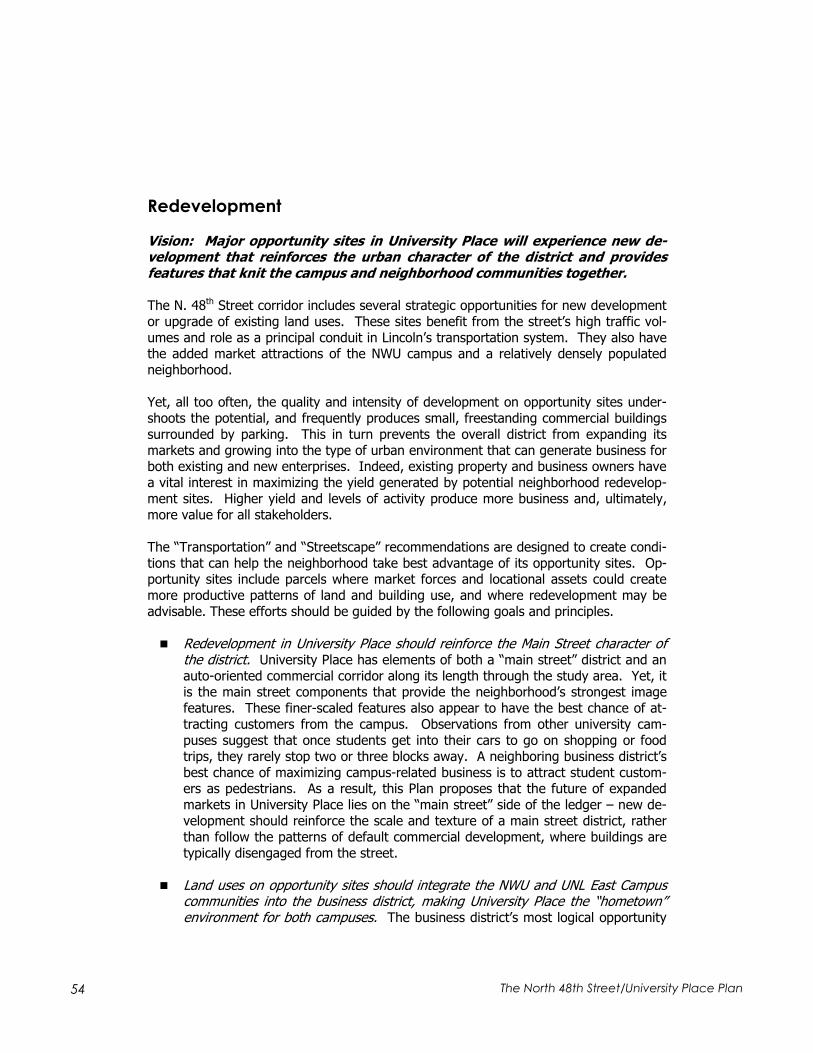
54 The North 48th Street/University Place Plan
Redevelopment
Vision: Major opportunity sites in University Place will experience new de-velopment that reinforces the urban character of the district and provides features that knit the campus and neighborhood communities together.
The N. 48th Street corridor includes several strategic opportunities for new development or upgrade of existing land uses. These sites benefit from the street’s high traffic vol-umes and role as a principal conduit in Lincoln’s transportation system. They also have the added market attractions of the NWU campus and a relatively densely populated neighborhood.
Yet, all too often, the quality and intensity of development on opportunity sites under-shoots the potential, and frequently produces small, freestanding commercial buildings surrounded by parking. This in turn prevents the overall district from expanding its markets and growing into the type of urban environment that can generate business for both existing and new enterprises. Indeed, existing property and business owners have a vital interest in maximizing the yield generated by potential neighborhood redevelop-ment sites. Higher yield and levels of activity produce more business and, ultimately, more value for all stakeholders.
The “Transportation” and “Streetscape” recommendations are designed to create condi-tions that can help the neighborhood take best advantage of its opportunity sites. Op-portunity sites include parcels where market forces and locational assets could create more productive patterns of land and building use, and where redevelopment may be advisable. These efforts should be guided by the following goals and principles.
Redevelopment in University Place should reinforce the Main Street character of the district. University Place has elements of both a “main street” district and an auto-oriented commercial corridor along its length through the study area. Yet, it is the main street components that provide the neighborhood’s strongest image features. These finer-scaled features also appear to have the best chance of at-tracting customers from the campus. Observations from other university cam-puses suggest that once students get into their cars to go on shopping or food trips, they rarely stop two or three blocks away. A neighboring business district’s best chance of maximizing campus-related business is to attract student custom-ers as pedestrians. As a result, this Plan proposes that the future of expanded markets in University Place lies on the “main street” side of the ledger – new de-velopment should reinforce the scale and texture of a main street district, rather than follow the patterns of default commercial development, where buildings are typically disengaged from the street.
Land uses on opportunity sites should integrate the NWU and UNL East Campus communities into the business district, making University Place the “hometown” environment for both campuses. The business district’s most logical opportunity
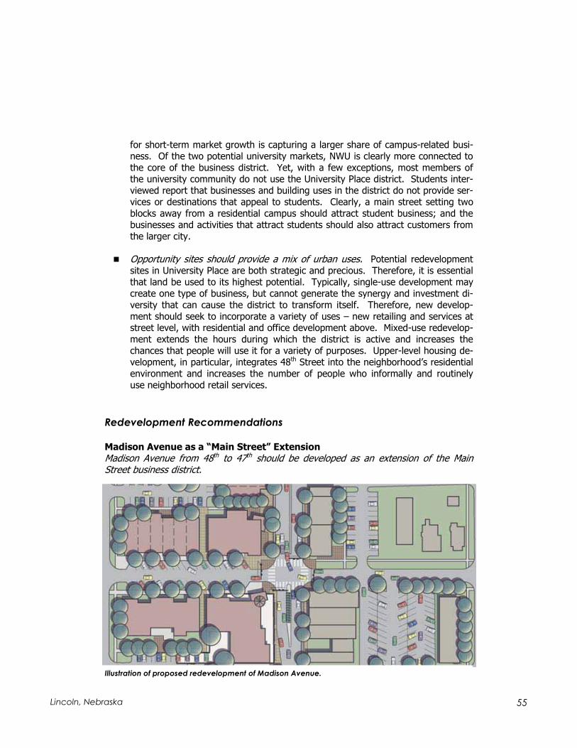
55 Lincoln, Nebraska
for short-term market growth is capturing a larger share of campus-related busi-ness. Of the two potential university markets, NWU is clearly more connected to the core of the business district. Yet, with a few exceptions, most members of the university community do not use the University Place district. Students inter-viewed report that businesses and building uses in the district do not provide ser-vices or destinations that appeal to students. Clearly, a main street setting two blocks away from a residential campus should attract student business; and the businesses and activities that attract students should also attract customers from the larger city.
Opportunity sites should provide a mix of urban uses. Potential redevelopment sites in University Place are both strategic and precious. Therefore, it is essential that land be used to its highest potential. Typically, single-use development may create one type of business, but cannot generate the synergy and investment di-versity that can cause the district to transform itself. Therefore, new develop-ment should seek to incorporate a variety of uses – new retailing and services at street level, with residential and office development above. Mixed-use redevelop-ment extends the hours during which the district is active and increases the chances that people will use it for a variety of purposes. Upper-level housing de-velopment, in particular, integrates 48th Street into the neighborhood’s residential environment and increases the number of people who informally and routinely use neighborhood retail services.
Redevelopment Recommendations
Madison Avenue as a “Main Street” Extension Madison Avenue from 48th to 47th should be developed as an extension of the Main Street business district.
Illustration of proposed redevelopment of Madison Avenue.

56 The North 48th Street/University Place Plan
Two primary opportunity sites, the Green’s Furnace & Plumbing property and the Hall Motors’ property are located along Madison Avenue between 47th and 48th Streets. Ap-propriately designed development can allow the 48th Street main street district to turn westward onto Madison. The Madison block, with local traffic only, provides the oppor-tunity for the pedestrian-friendly, street-oriented commercial environment that 48th
Street, with its high traffic volumes and limited right-of-way, cannot. The Madison streetscape also should include street landscaping, diagonal parking, and pedestrian amenities that can create a unique district. Orientation of redevelopment to this street further satisfies the principle of providing pedestrian-oriented public space that is con-nected to, but separate from, 48th Street.
Mixed-Use, Street-Oriented Development on the Green’s site The Green’s site should be developed with a mixed-use project, providing strong street definition along Madison Avenue, with street level commercial and at least one upper level of residential or office use.
The Green’s site, on the south side of Madison between 48th and 47th Streets, is a critical site whose ultimate reuse will deter-mine the personality of other development in University Place. Anticipated redevelop-ment includes the following features:
Street level commercial development oriented to Madison Avenue. Com-mercial development should consider establishments that are appealing to the University community. NWU it-self may consider establishing a sig-nificant commercial presence in this development.
One or two upper levels of development, with a priority to be placed on upper level housing. Quality housing for faculty, graduate students, staff, and other community members can further cement the relationship between the campus and the University Place district.
Short-term customer parking provided by diagonal stalls along Madison Avenue.This provides convenient parking and reinforces the potential main street environ-ment of the extended district.
Primary parking in an expanded public lot behind the Green’s site and existing 48th Street storefronts. This concept, discussed further under the Local Traffic Circulation and Parking recommendations, provides adequate parking to support
Illustration of proposed redevelopment of the vacant Green’s
Furnace & Plumbing site.

57 Lincoln, Nebraska
full yield of the site, yet avoids compromising the pedestrian character of the dis-trict. An attractive walk-through connection should be made between the rear parking and Madison Avenue.
Design with adequate setbacks off 48th Street to provide for the intersection im-provement. Redevelopment provides adequate space to accommodate the up-graded, signalized 48th and Madison intersection. This upgraded intersection, in turn, is fundamental to taking full economic advantage of the Madison Avenue redevelopment sites. The design of the project must accommodate the planned intersection improvement.
Mixed-Use Street-Oriented Development on the Hall’s Site The Hall’s site should be developed with a mixed-use project, completing the Madison Avenue “main street” extension and continuing a clear street definition along 48th Street toward Huntington School.
This site, accounting for much of the block between Madison, Cleveland, 48th and 47th,logically follows the successful redevelop-ment of the Green’s site. Currently, land uses include the John Hall auto dealership, an auto service facility and a convenience store. Proposed redevelopment patterns are consistent with those proposed for the Green’s site, and include:
Street level commercial development oriented to Madison Avenue. Com-mercial development on Madison should complement uses on the site across the street. Urban housing, such as townhouses, may be a possi-bility along Madison toward 47th
Street, depending on market de-mands.
Street-level commercial or office de-velopment along 48th Street. The street near Cleveland Avenue may have a smaller retail component, as distances from the center of the district increase. Office or service uses may be appropriate at street level; building configuration should maintain a clear definition of the street.
Residential development in either an upper-level or attached urban configuration.Residential development should be integrated into planning for the Hall’s site.
Illustration of proposed redevelopment of the Hall’s Motors site.

58 The North 48th Street/University Place Plan
Short-term customer parking provided by diagonal stalls off Madison Avenue.This extends the main street character of Madison Avenue, and provides conven-ient, on-street parking for short-term customer use.
Primary parking behind street frontages. Parking should be accessed from Cleve-land Avenue and 47th Street to avoid interrupting the street frontages. Walk-through connections should be provided from the rear parking and the Madison Avenue and 48th Street frontages.
Design with adequate setbacks off 48th Street to provide for the intersection im-provement.
Together, the two sites on either side of Madison Avenue will transform the character of the district. The Madison Avenue streetscape, intersection improvement, and traffic sig-nal create conditions that make this redevelopment likely, and more effectively tie 48th
and Madison into the campus environment. The overall redevelopment concept demon-strates the mutually beneficial effects of transportation and revitalization programs.
Commercial Redevelopment of the “Northeast Printer” Site Street-oriented commercial redevelopment should occur along the east side of 48th
Street between Huntington and Walker Avenues.
Redevelopment of this underused but strategic site, across from auto-oriented commercial development on the west side of the street, provides adequate space for the redesign of the 48th and Huntington intersection and provides another strategic commercial development op-portunity. Features of the redevelopment concept for this site include:
Urban commercial development oriented to N. 48th
Street. Commercial development should help de-fine the major street, with parking provided to the rear. Upper-level mixed-use development should be considered on this site; however, adjacent de-velopment is more typically single-level commer-cial.
Parking provided behind 48th Street development.Parking for a new project should be provided be-hind new buildings, with access from Huntington and Walker Avenues. A walk-through connection should be provided between parking and 48th
Street. Illustration of proposed redevelopment of the
Northeast Printer site.

59 Lincoln, Nebraska
Design with adequate setbacks off 48th Street to provide for the intersection im-provement. As at Madison, left-turn movements and full signalization create con-ditions friendly to commercial development. The design of any redevelopment project must provide adequate space for the planned intersection improvement.
Street-Oriented Development Design All redevelopment on opportunity sites should maintain a strong street orientation, typi-cally orienting parking to the rear of the site.
In an urban district that aspires to special quality and distinction, the street is very im-portant; streets in University Place and similar districts provide our primary spaces. Therefore, projects on the redevelopment sites discussed above, or on other sites in the district as development continues, should define the street frontage and emphasize an easy and pleasant connection between the public environment and the front door of buildings and businesses.
A strong orientation has benefits far beyond aesthetic philosophy. A good street envi-ronment will generally manage local traffic circulation more effectively than many curb cuts off the principal arterial. It provides better pedestrian access, in turn contributing to greater safety and reducing the use of cars for routine short-distance trips. From a site planning perspective, street-oriented development uses side streets more effec-tively and increases the development yield on parcels of land. Finally, by strengthening neighborhood character and encouraging the connections among businesses, the prob-ability of multiple-destination trips is increased, a major objective of urban retail strate-gies.
48th Street frontage of the vacant Green’s site.
60 The North 48th Street/University Place Plan
Targeting Desirable Outcomes Through the Redevelopment Process City involvement in the redevelopment process should include evaluation criteria that encourage desirable businesses, with a focus on businesses that appeal to the univer-sity communities.
A strategic retail development focus should be attracting businesses that appeal to cam-pus-related customers. The benefits of this strategy include:
Increasing linkages between the campuses and the University Place business dis-trict, expanding the retail customer base by increasing market share of an exist-ing resident market.
Extending the campus environment to 48th Street, giving the universities (and particularly NWU) a more positive neighborhood environment to market to pro-spective students, and increasing the quality and variety of life offered to stu-dents.
Opening the possibility of mixed-use development by making it more convenient for faculty, staff, and some students to live in and around the business district.
Encouraging retailing, services, and activities that tend to appeal to other market segments around the city.
The City of Lincoln is likely to be deeply involved in major redevelopment of opportunity sites, through property acquisition and conveyance and/or project financing. As such, it should evaluate proposals based on their consistency with the principles of this Plan and, for commercial projects, their ability to market space to businesses with appeal to the campus community.
Future Redevelopment Sites The City should assist redevelopment of strategic sites as the private market responds to improving neighborhood conditions.
The Green, Hall, and Northeast Printer properties are priorities for redevelopment, and will be strategic points that will establish a momentum for other redevelopment efforts. The City should be ready to assist desirable redevelopment of other strategic sites in the neighborhood when market demand emerges. These potential redevelopment sites will likely include:
The block between 48th, 49th, Adams, and Cleveland.
The block east of 48th between Huntington and Walker.

61 Lincoln, Nebraska
Local Traffic Circulation and Parking
Vision: University Place will offer adequate, convenient parking to its cus-tomers, businesses, and residents, and will provide a local circulation system that both functions effectively and avoids degrading its residential neighbor-hoods.
Much of the focus of this planning process has been on the transportation function of N. 48th Street. Indeed, this is important because many people in Lincoln will evaluate the effectiveness of this Plan based on their experiences of moving along this street. How-ever, people who live, work, and study in University Place are at least as concerned about the supply of parking and functioning of the neighborhood’s street system. These issues are especially important when a neighborhood originally developed for sin-gle-family residents has undergone a transition to higher residential densities through the conversion of houses or insertion of as-built multi-family buildings.
An urban university campus adds to these parking problems. NWU, like many colleges, does not meet its parking demand on campus. The University has completed a compre-hensive parking study that proposes substantial parking supply additions along Hunting-ton Avenue on the south side of the campus. However, new dormitory development on the campus’ north side will increase parking demand on that side as well. Universities have difficulty buying the land necessary for surface parking, which in any case can threaten the quality of the campus; but have equal difficulty raising funds to build very expensive parking structures. As a result, a good deal of parking demand is met by the neighborhood’s already crowded streets.
In this difficult milieu, planning for parking and local circulations must satisfy three es-sential criteria:
The overall supply of parking in the neighborhood should be increased, without de-stroying the character of the area. Parking demand is generated by three sources – the business district, the University, and the residential neighborhood – and each requires somewhat different solutions. Resolving business district parking issues involves increasing both the supply of convenient parking and the ease by which customers find that parking. The University must identify locations for new parking, including the consideration of decks over surface lots. However, it must take care not to harm the neighborhood by expanding opportunistically into the residential fabric. Residential parking issues involve assuring that development has adequate parking to meet demand; and, in some cases, reducing densities to be more consis-tent with the carrying capacity of local streets and the on-street parking supply.
The neighborhood should provide good local traffic circulation at speeds appropriate to residential areas. While most of University Place follows the City’s street grid, the NWU campus, University Place Park, and the Dead Man’s Run floodplain inter-rupt the grid’s continuity. This, along with existing traffic signal placement, tends

62 The North 48th Street/University Place Plan
to channel traffic onto a few continuous streets, such as Leighton Avenue between 48th and 56th Streets.
Good traffic circulation is also important to the business community. Many users find the University Place business district somewhat difficult to navigate and do not readily comprehend the location of parking. It is a function of an effective business district circulation system to get people from the main street to parking spaces as quickly as possible; and to minimize the amount of time that customers spend navi-gating local streets.
The overall traffic system should minimize the amount and effect of additional traf-fic on residential streets. In a stressed local traffic environment, proposed changes should not fix one problem while creating others. Local Circulation and Parking Recommendations
Local Circulation and Parking Recommendations
Expanded Business District Parking West of 48th Street Public parking for the business district should be expanded west of 48th Street, with pe-destrian connections to rear building entrances and to the residential areas to the west.
The district’s largest existing public parking is located south of St. Paul Avenue and west of 48th Street. With the development of the Green’s property and the pro-posed St. Paul pedestrian plaza, this lot should be ex-panded to the north. Features of this concept include:
A circulation loop through the lot, with access off 47th Street.
Pedestrian access through a landscaped sidewalk around the outside of the expanded lot, serving both rear building entrances and pedestrian paths to 48th and Madison. This rear access has already been developed near Mo Java Cafe south of St. Paul, and can provide another group of intimately scaled open spaces to complement the street front-age and the St. Paul Plaza.
A clear pedestrian connection through the lot along the axis of St. Paul. This helps link the plaza to the neighborhood and may include a gateway arch along 47th Street on the St. Paul alignment.
This concept provides convenient and expanded business parking, while maintaining the integrity of the main street business environment.
Illustration of proposed expansion of parking
and access for businesses west of 48th Street.

63 Lincoln, Nebraska
East Business District Parking and St. Paul Court Parking facilities and circulation on the east side of 48th Street between St. Paul and Madison should be reconfigured and expanded to provide more parking and greater convenience to customers of area businesses. St. Paul Avenue should be designed as an auto “court,” providing convenient on-street parking and access to all existing lots and driveways.
Business district parking on the east side of 48th Street is a combination of public and private lots that tends to be confusing to users and somewhat inefficient. The proposed pedestrian plaza on St. Paul provides an opportunity to rethink this area and expand both its parking supply and ease of use. Features of this redesign include:
Reconfiguring the private and public lots to provide convenient access off Madison Avenue. Because of the improved Madison intersection and the pedestrianization of St. Paul Avenue, most traffic will enter these lots from the north. Angled park-ing should be reconfigured for north to south access. An alley adjacent to the 48th Street commercial buildings would become a drive aisle, lining up with a private alley that ex-tends south of St. Paul. This reconfiguration should maintain preferential parking access for neighboring businesses, including the dentist’s of-fice, that currently maintain private parking. Therefore, a portion of this lot may be marked for proprietary use, and may be divided from the pub-lic portion of the lot by landscaping or pavement features. The final lot design should also provide convenient parking for people with disabilities.
Adding a parking module to the public lot along Madison. This can be done by acquiring part of the landscaped area adjacent to the currently vacant office building on 49th and Madison. The resulting lot also has access from 49th Street; however, its primary access is from Madison, limiting the num-ber of cars circulating into neighborhood streets.
Developing diagonal parking along St. Paul Court.This court is the remaining part of the street be-tween 49th Street and the pedestrian plaza. Diago-nal parking provides convenient front door parking for businesses along the street. It also replaces the small, front yard parking area in front of the dentist’s office building on the north side of St. Paul. Diagonal parking can be phased or modified to avoid conflicts with existing driveways. Indeed, St. Paul Court is designed to maintain access to all existing parking and private drives in the area.
Illustration of proposed reconfiguration of cir-
culation and parking east of 48th Street.

64 The North 48th Street/University Place Plan
Maintaining strong pedestrian access along St. Paul between 49th and 48th. The design of St. Paul Court includes a strong pedestrian connection east toward the NWU campus. Streetscape and gateway elements included in the pedestrian plaza should be continued along St. Paul Court.
Parking Directional Graphics A signage system clearly directing customers to parking areas should be installed in the business district to supplement existing signing.
Parking in the University Place business district is difficult to comprehend. A clear direc-tional graphics system should provide wayfinding information from key entrance points, especially the improved Huntington and Madison Avenue intersections, to parking lots. This clear signage can reduce confusion and get customers away from neighborhood streets as quickly as possible. Special graphics may also add to the marketing presence of the business district.
Traffic Controls to Prevent Improper Left Turns Intersection or street design features should be installed to channel left turns and cross movements to improved intersections.
Maintaining capacity and a smooth traffic flow on 48th Street depends on avoiding inter-ruptions or conflicts along the street. Thus, left turns and cross-movements between Adams and Leighton are limited to the future signalized intersections at Madison and Huntington. Traffic control devices should be included in the street and intersection de-sign to prevent these movements at other locations. These include:
Maintaining the existing raised medians at Cleveland and Walker Avenues.
Installing a “pork chop” diverter at the Baldwin intersection, forcing right-in/right-out movements from Baldwin to 48th.
Internal Traffic and Neighborhood Connectedness to the Hy-Vee Center Improvements should be considered at the Hy-Vee shopping center on the north side of Leighton Avenue to reduce functional conflicts, improve connections to the neighbor-hood, and reduce the visual and operating conflicts created by truck loading and service areas adjacent to the residential neighborhood.
Hy-Vee and associated commercial development at 48th and Leighton is a very impor-tant part of the neighborhood business picture. Some aspects of parking and circula-tion design within this project create potential hazards that can affect traffic flow and safety outside the boundaries of the site. In addition, it is in everyone’s interest to have all parts of the business community function as conveniently and safely as possible for customers.
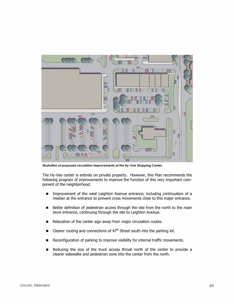
65 Lincoln, Nebraska
The Hy-Vee center is entirely on private property. However, this Plan recommends the following program of improvements to improve the function of this very important com-ponent of the neighborhood.
Improvement of the west Leighton Avenue entrance, including continuation of a median at the entrance to prevent cross movements close to this major entrance.
Better definition of pedestrian access through the site from the north to the main store entrance, continuing through the site to Leighton Avenue.
Relocation of the center sign away from major circulation routes.
Clearer routing and connections of 47th Street south into the parking lot.
Reconfiguration of parking to improve visibility for internal traffic movements.
Reducing the size of the truck access throat north of the center to provide a clearer sidewalks and pedestrian zone into the center from the north.
Illustration of proposed circulation improvements at the Hy-Vee Shopping Center.

66 The North 48th Street/University Place Plan
Providing landscaping and vertical buffering between the north boundary of the commercial center and adjacent residential properties.
Both Hy-Vee and the City have an interest in resolving these issues and creating a cen-ter that functions more safely for its customers. If a parking area redesign is agreed upon, the parties should discuss cooperative mechanisms to finance the program.
Leighton Avenue Traffic Calming The City should consider traffic calming concepts along Leighton Avenue between 48th
and 56th Streets, and implement measures found to be appropriate through this investi-gation.
Leighton Avenue, through the Charles F. Creighton Historic District, is experiencing in-creasing traffic volumes. This pattern is caused by the street’s continuity to 56th Street and the full signal at 48th Street. As a result, and mandated by federal requirements, the City’s Public Works and Utilities Department removed parking from the street and added a roadway centerline in 2003. This action in turn concerns residents, who be-lieve that it will produce higher traffic speeds.
This Plan recommends consideration of traffic calming applications to this segment of Leighton. Measures to assure that typical traffic speeds remain appropriate for a pri-marily single-family residential setting should be evaluated. It is important to note that many residents seem less concerned about the loss of on-street parking than the possi-ble increase of traffic speed that might result.
Performance Monitoring of 47th and 49th Streets The City should monitor traffic and parking performance along 47th Street and 49th
Street, the two local streets that parallel 48th Street.
Any change to flows and access along the 48th Street corridor are likely to have the greatest impact on the adjacent parallel streets – 47th to the west and 49th to the east. These streets already experience high on-street parking demand and relatively high vol-umes of traffic circulating around the business center. With implementation of the 48th
Street program, parking and circulation along these streets should be monitored. This ongoing process could result in:
Removal of on-street parking from one side of the street. Proposed additions to the parking supply between Baldwin and Madison could provide enough off-street parking to make one-side only parking feasible along these streets. This in turn could help reduce congestion and improve the performance of these local service streets. Typical of any request for on-street parking removal, it is the City’s policy for this request to be made by the adjacent property owners. The City will work with the neighborhood association, NWU, business owners, property owners and

67 Lincoln, Nebraska
other stakeholders to address parking needs along these streets and other issues such as traffic flow and the effect on pedestrian safety.
If warranted, installation of future traffic control devices such as stop signs to manage traffic flow and improve pedestrian safety.
South Neighborhood Access Improvements New local street segments in the south part of the neighborhood will improve access to commercial development on the east side of 48th Street south of Leighton, and to areas around University Place Park.
These specific improvements, designed to improve internal neighborhood street connec-tions and reduce traffic friction along 48th Street, include:
A rear commercial access south of Garland, serving commercial development along 48th Street and opening potential development sites west of 49th Street.This provides local access to the Dairy Queen and neighboring sites, making it un-necessary to use 48th Street to reach these establishments. It also provides ac-cess to other currently unused sites east of 48th, and may be used for additional neighborhood park access.
On-street parking along 49th Street.
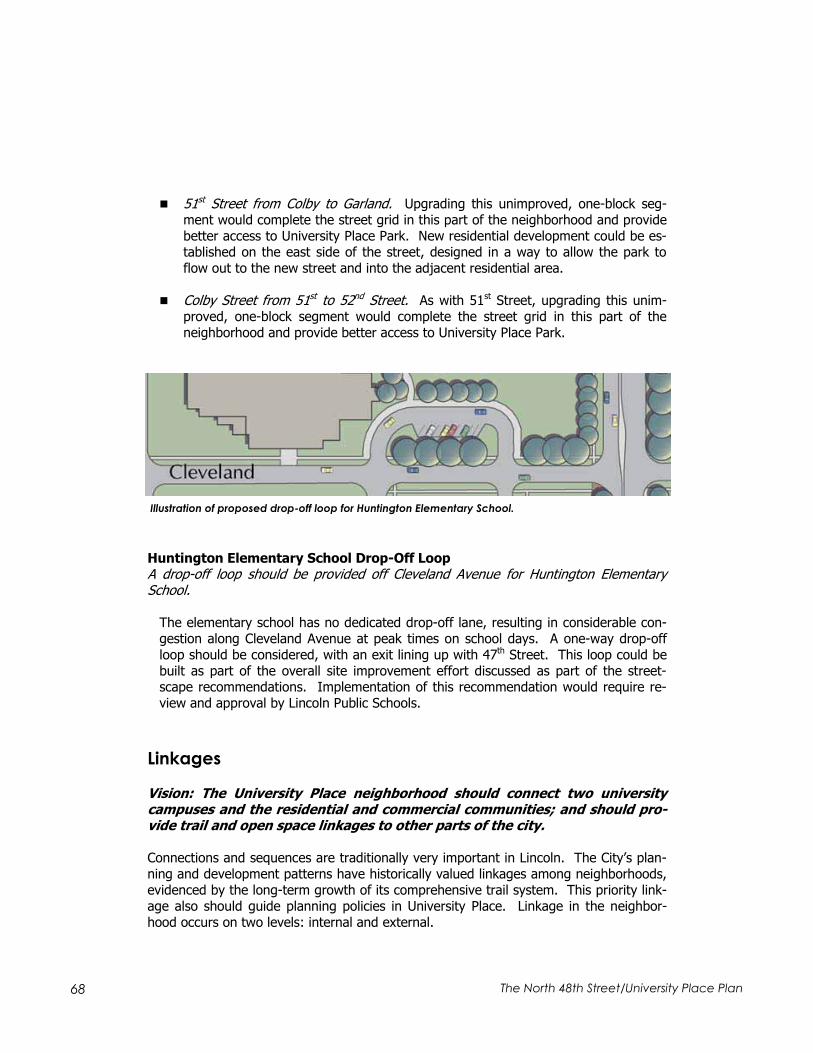
68 The North 48th Street/University Place Plan
51st Street from Colby to Garland. Upgrading this unimproved, one-block seg-ment would complete the street grid in this part of the neighborhood and provide better access to University Place Park. New residential development could be es-tablished on the east side of the street, designed in a way to allow the park to flow out to the new street and into the adjacent residential area.
Colby Street from 51st to 52nd Street. As with 51st Street, upgrading this unim-proved, one-block segment would complete the street grid in this part of the neighborhood and provide better access to University Place Park.
Huntington Elementary School Drop-Off Loop A drop-off loop should be provided off Cleveland Avenue for Huntington Elementary School.
The elementary school has no dedicated drop-off lane, resulting in considerable con-gestion along Cleveland Avenue at peak times on school days. A one-way drop-off loop should be considered, with an exit lining up with 47th Street. This loop could be built as part of the overall site improvement effort discussed as part of the street-scape recommendations. Implementation of this recommendation would require re-view and approval by Lincoln Public Schools.
Linkages
Vision: The University Place neighborhood should connect two university campuses and the residential and commercial communities; and should pro-vide trail and open space linkages to other parts of the city.
Connections and sequences are traditionally very important in Lincoln. The City’s plan-ning and development patterns have historically valued linkages among neighborhoods, evidenced by the long-term growth of its comprehensive trail system. This priority link-age also should guide planning policies in University Place. Linkage in the neighbor-hood occurs on two levels: internal and external.
Illustration of proposed drop-off loop for Huntington Elementary School.


69 Lincoln, Nebraska
The neighborhood planning area includes an unusually rich variety of features, including the University Place business district, the NWU campus, the UNL East campus, Hunting-ton Elementary School, University Place Park, the Charles Creighton Historic District, and landmark institutions like First United Methodist Church. These features, in close proximity, create the potential for an unusually rich neighborhood environment. Yet, in some cases, the connections are more apparent than real. Much of the NWU commu-nity feels only weakly connected to the 48th Street business district. The two university campuses, potentially linked together through the neighborhood and its business dis-trict, are instead two very distinct and somewhat reclusive places. Elements of the neighborhood that should reinforce each other sometimes stand in uneasy co-existence.
The other level of linkage is external, how the University Place neighborhood connects to the rest of the city. The neighborhood is not directly connected to the City’s trail sys-tem, except for an on-street route. The strongest inter-neighborhood link is 48th Street itself, but this street does not provide good non-motorized connections, particularly to the south.
The linkage system provides the framework that unifies University Place and connects it to the rest of the city. The following priorities should guide the development of this structure of internal and external linkages.
The University Place neighborhood should be connected directly to Lincoln’s trail system. The MoPac and John Dietrich Trails are relatively near to University Place, but connections from the neighborhood to these facilities are not clear. Safe and clearly designated trail links to these trails are important to integrate University Place into Lincoln’s greenway system.
The UNL East Campus, the neighborhood, and the NWU campuses should be con-nected into a unified sequence. While the NWU campus is the neighborhood’s dominant presence, University Place includes two major universities. Linking the East Campus and NWU through the neighborhood assures that the four critical components of the neighborhood – the two universities, the residential commu-nity, and the business district – form a unified sequence of elements that rein-force each other.
The University Place neighborhood and NWU must be integrated successfully.The University and neighborhood have strong interests in their mutual health and prosperity. Yet, this commonality of interests must go deeper than public pro-nouncements. If the neighborhood and University view each other as uneasy partners in co-existence, University Place will continue to fall short of this compel-ling potential. Strong physical linkages can start this process of understanding the vital importance of each partner to the health and quality of the other.

70 The North 48th Street/University Place Plan
Linkage Recommendations
48th Street Trail The City and UNL should develop a trail along the west side of 48th Street, with a con-nection to University Place Park along Dead Man’s Run under a new 48th Street bridge. This project should be fully integrated into an enhancement program for the 48th Street edge of the East Campus.
This trail would connect south along 48th Street to the MoPac Trail, which crosses 48th
Street at an overpass about one mile south of the neighborhood. South of Holdrege Street, the south boundary of the East Campus, the right-of-way has enough room to support a continuation of the sidewalk trail. Future roadway improvements to 48th
Street will include a new bridge over Dead Man’s Run. This bridge should be designed to provide trail access along the creek under 48th Street to University Place Park. This crossing will provide a strong, barrier-free link between the East Campus and the neighborhood. The 48th Street Trail should continue north of Dead Man’s Run to a pro-posed gateway feature at Leighton Avenue and connect to a campus periphery trail along Leighton/Huntington to 33rd Street.
Francis Street Gateway A future East Campus entrance at Francis Street should be developed as a major gate-way to University Place as well.
The master plan for the East Campus envisions a campus entrance at Francis Street. Francis also forms the south edge of University Place Park and is the main access to the swimming pool. As it develops, this new intersection should be designed as both a gateway to the campus and an entrance to the neighborhood – physically and function-ally expressing the connection between the East Campus and University Place.
Dead Man’s Run and Leighton/Huntington Trails A trail should be developed along Dead Man’s Run through the UNL east campus, con-necting to the John Dietrich Trail at 33rd Street and Fleming Fields Recreational Sports Park, provided that an alignment can adequately satisfy campus security concerns. This trail should continue under 48th Street through a redesigned system in University Place Park. In addition, a sidewalk connector trail should be developed along the south side of Leighton/Huntington Avenue to provide a secondary connection to the Dietrich Trail and new sports park.
The Dead Man’s Run Trail is proposed in Lincoln’s long range trail plan, and would con-nect through the East Campus to the Fleming Fields Recreational Sports Park and link to the existing Dietrich Trail at 33rd Street. The trail should continue along the creek under a new 48th Street Bridge and through University Place Park. This Plan recommends a new pedestrian connector bridge over the creek on the alignment of 50th Street, provid-

71 Lincoln, Nebraska
ing a clear connection to the front door of the NWU campus. The trail should include a loop around the edge of University Place Park, providing a direct link to the pool. The Dead Man’s Run alignment will require resolution of UNL concerns about campus security.
This Plan also recommends a sidewalk con-nector along the south side of the Leighton/Huntington Avenue system be-tween 48th and 33rd Streets as a secondary connection to the Dietrich Trail and Flem-ing Fields. This also serves apartment de-velopment along the north side of Hunting-ton Avenue. A sidewalk connector will pro-
vide a continuous access, available in the short-term, between University Place and the new park.
50th Street Share-the-Road Route 50th Street should be evaluated and adapted as a share the road bicycle route between the Dead Man’s Run Trail and the NWU campus. This route may continue north to con-nect with the John Dietrich/Murdock Trail system near 49th and Benton.
This street is the logical connection between a Dead Man’s Run Trail through University Place Park, the residential neighborhood, and the front door of the NWU campus. 50th
Street should be designated as a “share the road” (STR) route. The STR route should be consistent with signage conventions used on a citywide basis. It should also have continuous, barrier-free sidewalks on both sides of the street and may include direc-tional information and mileage. 50th Street could also continue north as an STR route across Adams Street to Somerset and 49th Street. Here, the route would connect with the John Dietrich Trail and its continuation northeast as the Murdock Trail. All recom-mendations are subject to review and approval by Lincoln’s Pedestrian/Bicycle Advisory Committee, Parks & Recreation, Planning Committee, and City Council.
St. Paul and Baldwin Avenue Promenades St. Paul and Baldwin Avenues should be reinforced as promenades between 48th and 50th Streets, forming a strong functional and visual connection between the NWU cam-pus and the University Place business district.
NWU’s campus design includes east-west malls on axis with Baldwin and St. Paul Ave-nues, marked by entrance arches on line with these streets. Its current campus plan includes an open space ellipse defined by these two malls. Clearly, continuation of the
Dead Man’s Run through University Place Park.

72 The North 48th Street/University Place Plan
promenade concept along St. Paul allows the campus to extend to the business district; and for the business district, in turn, to extend itself toward the campus. Promenade linkages along these two avenues, designed to give NWU a strong exposure to 48th
Street, is consistent with both the traditional campus plan and the fabric of the Univer-sity Place neighborhood.
Promenade development along St. Paul and Baldwin Avenues, including:
Enhanced, thematic lighting, providing both common campus/business district de-sign themes and a level of lighting that pedestrians find secure and reassuring.
Improved, consistent formal landscape design.
Graphics and design features that provide the University with a clear presence on 48th Street.
Attractive, continuous sidewalks, along with street furniture that includes benches and historic interpretive materials. The promenades, for example, could feature interpretive graphics of notable NWU graduates and neighborhood residents, highlighting the human history of the neighborhood and its historic relationship with the campus.
This Plan recommends the utilization of the Baldwin and St. Paul promenades as a way of expressing the linkage and partnership of Nebraska Wesleyan University and the neighborhood toward their mutual growth and prosperity.
North-South Campus Link A north-south connection linking the University and the neighborhood together should be considered along the approximate line of 53rd Street.
The campus plan for NWU proposes a north-south campus mall between Madison and Huntington Avenues just east of the proposed campus ellipse. If developed, this axis can form a secondary gateway and link to the neighborhood. Emphasizing a pedestrian connection south along 53rd Street can help tie the campus to the Charles Creighton Historic District, an attractive neighborhood that could prove especially attractive to fac-ulty residence.
University Place Park Enhancement University Place Park north of Dead Man’s Run should be master-planned as a neighbor-hood park.
University Place Park is an important neighborhood resource, but is not strongly con-nected to the University Place neighborhood. The area south of Garland Avenue is un-developed and, in some ways, is a barrier between the neighborhood and the pool to

Traffic CalmingStudy Area
Adams
Cleveland
Madison
Saint Paul
Baldwin
Huntington
Walker
Leighton
Garland
Colby
Lexington
FrancisFrancis
46th
47th
48th
49th
51st
52nd
53rd
54th
56th
51st
52nd
53rd
54th
56th
50th
Adams
Cleveland
Madison
Huntington
Leighton
50th
48th
49th
Parking
Parking
FutureRedevelopmentDistrict Gateway/
School GroundsEnhancements
University PlaceDistrict
University PlaceDistrict
Parking
Local
CampusArch
Campus
51st Street
49th Street
AdditionalAccessControl
PossibleDeadMan'sRun Trail
ParkwaySection
New 48thStreetBridge
ExistingRoundabout
48thStreetTrail
EastCampus
Landscaping orDecorative Wall
Trail
Existingpedestrianbridge Main
traillink
Creeksidewalk
Local Circulator
47th Street
St. Paul Street Link -Enhanced lighting,landscaping, andpedestrian paths
Baldwin Street Link -Enhanced lighting,landscaping, andpedestrian paths
Charles F. CreightonHistoric DistrictBoundary
MainCampus
Residential StreetRehabilitation
Main
ProposedEllipse
North-South
North-South
Share-the-RoadBicycle Route/enhancedpedestriancorridor
PotentialResidentialDevelopment
BackAccessfrom 49th
DevelopmentSite
FutureRedevelopment
New NWUlots
Potential 54thStreetVacation
Creighton
53rd StreetNeighborhoodtoCampus link
Buffer
ParkingParkingParking
HistoricDistrictGateway
Alley
Primary NWUVehicularAccess Route
Primary NWUVehicularAccess Route
ColbyStreet
48th StreetStreetscapeDevelopment
48th StreetStreetscapeDevelopment
University of NebraskaEast Campu s Gateway
Sidewalk Connector
NeighborhoodPark
Enhancement
University Place Historic Residential District
Linkage Strategies
0 10050NORTH
March 2003
RDG Planning & DesignOmaha and Des Moines
Full Signal
Pedestrian Signal
Legend

73 Lincoln, Nebraska
the south of the creek. In addition, the discontinuous street grid south of Garland also severs the park from the neighborhood. 48th Street actually becomes the major con-nection between the park and the residential community.
The area north of the creek and south of Garland, all part of the park, should be a re-source rather than a barrier. This park area should be master-planned as a neighbor-hood open space. As recommended above, trails or sidewalks/connectors should con-nect residential streets and the NWU campus with the main community park south of the creek and with the Dead Man’s Run Trail. Additionally, connecting 51st Street through to Colby Street will also help increase access to this part of the park.
Neighborhood Development and Land Use
Vision: The University Place neighborhood will offer a sound residential envi-ronment for a variety of people, but will emphasize its quality and security as a place to own a home.
The University Place Plan appropriately emphasizes issues of transportation and busi-ness revitalization. However, the dominant land use in the neighborhood is residential. For University Place to realize its potential as a unique urban district, it must offer a strong and stable residential environment. Indeed, poor housing affects other aspects
Newly redeveloped pool at University Place Park.

74 The North 48th Street/University Place Plan
of the neighborhood. Members of the university community will not venture toward the business district through a neighborhood that they perceive, rightly or wrongly, to be insecure or deteriorating. Neighborhood business districts require the support of strong residential constituencies. Finally, campuses in declining or stagnant neighborhoods in-creasingly become reclusive enclaves; if this happened in University Place, it would de-feat many of the outcomes envisioned by this Plan.
It is precisely in this area of residential quality that University Place has tended to fall short. High-density residential zoning has encouraged conversion of single-family struc-tures or insertion of multi-family buildings on relatively small sites, greatly changing the personality of the neighborhood. Members of the university community relate that many faculty members once lived near the campus, a desirable condition that no longer exists. Single-family conversions compound parking problems and frequently result in unsightly additions to structures and eventual deterioration. University Place, once a primarily single-family, urban neighborhood, is now largely marked by rental occupancy and, in many places, a major change in the scale of structures.
Yet, the neighborhood does have major assets. Despite multi-family buildings, the area retains a sense of its smaller scale character. Many of the as-built multi-family buildings are well maintained, and areas like the Charles Creighton Historic District exhibit high owner-occupancy and architectural quality. Indeed, appropriate residential and land use policies can conserve this strategic residential neighborhood. These policies should be guided by the following principles.
Public policy should reinforce existing, positive patterns of development, and dis-courage or prevent undesirable trends. Despite neighborhood change over the years, reinvestment is occurring in University Place. This is evident in purchase and rehabilitation of homes, and the designation and continued popularity of the Creighton Historic District. Community development policy should encourage and reinforce this quiet, one-house-at-a-time reinvestment. In addition, a substantial segment of the neighborhood’s housing stock will continue in rental occupancy. Efforts to rehabilitate and maintain rental housing should also be reinforced. Ac-tions should ultimately increase the value, and the rental yields, supported by the neighborhood.
In University Place, homeowner investments should be viewed as financially se-cure and the level of uncertainty should be reduced. Much of the premise of zon-ing (regardless of how maligned traditional zoning has become in planning the-ory) is to provide a property owner with some level of security and knowledge about what will happen next door. This accounts for the pervasive popularity and interest in this time-honored planning implementation tool. Unfortunately, much of University Place is over-zoned; even areas that are primarily single-family are zoned for multi-family development. As a result, the security of homeowner in-vestments is degraded. Zoning policy in the neighborhood should offer greater safeguards to owners.

75 Lincoln, Nebraska
However, zoning is not the only problem that leads to uncertainty. Major institutions like universities tend to expand to meet specific, sometimes short-term needs like a parking shortage. This is a problem common in urban neighborhoods and not just lim-ited to University Place. However, the fear that a lot next to a house might be pur-chased by the University and used for parking or a non-residential purpose adds uncer-tainty that can discourage reinvestment.
Good residential development policy reduces uncertainty, and helps to assure an owner that he/she will ultimately realize a return on investment.
University Place should be an increasingly attractive residential setting for NWU or UNL faculty and staff. The concept of a “university community” is very attractive, where faculty and staff live close to the focus of their careers. University Place once was this kind of community, and can be again in the future. Efforts should be considered that market the neighborhood to members of the university com-munity and create additional housing opportunities for them.
The overall level of owner-occupancy in University Place should increase. While a good supply of quality rental housing is important in a diverse urban neighbor-hood, it is owner-occupants with a financial stake in the area that form the core group that keeps a neighborhood healthy and strong. Therefore, a long-term ob-jective of community development strategy must be to increase the level of resi-dent equity in the neighborhood. The policies of all major actors – the City of Lincoln and its departments, the business community, and NWU – must be meas-ured against their effect on this long-term goal.
Neighborhood Development and Land Use Recommendations
Outcome-Based Neighborhood Investment Strategy Lincoln should implement a neighborhood development strategy in University Place, with strategies designed to help bring about desirable outcomes on each blackface.
Because different parts of University Place have different occupancy characteristics, an overall, “one size fits all” strategy is really not appropriate. Instead, this Plan recom-mends a development and investment program, based on the housing configuration and occupancy characteristics of each blackface. This program should be based on the projected, desirable occupancy outcome of each block, on a continuum ranging from completely owner-occupied to completely renter-occupied. The outcomes along this continuum include:
Owner Occupancy/Single-Family Focus These block faces are primarily built up with single-family houses and are predominately owner-occupied. The desired outcome should produce a primarily owner-occupied, sin-gle-family blackface. Strategies should redirect existing rental properties to ownership

76 The North 48th Street/University Place Plan
Multi-Use/Ownership Dominant These blackfaces include a combination of single-family and multi-family properties, usually in smaller structures such as 2 to 4-unit buildings. Typically, at least half the structures on the block are owner occupied. The desired outcome on blackface will in-clude both single-family and multi-family/rental properties. A majority of the property frontage, defining the character of the block, will be single-family, owner-occupied. As-built or rental conversions in good condition will be maintained and conserved. Resi-dential investments policies should increase the level of ownership on the block.
Multi-Use/Rental Dominant These blackfaces include a combination of single-family and multi-family properties, but as-built rental structures typically dominate. Typically, at least half of the structures on the block are owner occupied. The desired outcome on blackface will include both sin-gle-family and multi-family/rental properties. A majority of the frontage, defining the character of the block, will be multi-family/rental properties. Residential investment policies should reinforce ownership, such as owner-occupied rehabilitation. However, ownership redirection policies designed to convert rental units to owner-occupied units will generally not be applied.
Rental Focus The character of these blocks is almost entirely rental/multi-family. As a result, the pro-jected outcome on blackface will be primarily multi-family/renter-occupied. While exist-ing, sound single-family structures should be maintained, investment policies should re-inforce continuation of quality rental settings. Ownership redirection policies designed to convert rental units to owner-occupied units will not be applied.
Policy Concepts A variety of programs apply to these various contexts. A catalogue of strategies that apply to University Place’s various residential settings follows.
Conservation/Maintenance:
Applies to residential structures currently in good to excellent condition.
No significant capital investment necessary.
For multi-family structures, monitor maintenance. Preventive code enforcement, with quick response to complaints and notification to owners of incipient condition problems.
For single-family/owner-occupied structures, code enforcement on neighboring structures on block, action on emerging site condition problems on other proper-ties on block.
Supporting infrastructure improvements, including curb reconstruction and street surface rehabilitation.

77 Lincoln, Nebraska
Owner-Occupied Rehabilitation:
Same actions as conservation/maintenance.
Target rehabilitation financing to existing owners, including minor or moderate rehabilitation.
Rental Rehabilitation:
Monitor building conditions.
Active code enforcement on rental properties and site conditions.
Rental rehabilitation financing, in most cases minor rehabilitation, for multi-family structures.
Multi-Family Parking:
Applies to high residential density, multi-family areas with high building coverage and inadequate on-site parking.
Acquire deteriorated/unsustainable sites, build off-street parking to serve other buildings on street.
Potential assessment of multi-family properties using new parking.
Acquisition/Rehab/Resale:
Applies to single-family structures in declining condition that remain feasible for rehabilitation/recycling. Structures typically are vacant, investor-owned with lim-ited economic future, or owned by seniors seeking a different or more appropriate housing setting.
Purchase, rehabilitation, and resale by a neighborhood or university-based com-munity development corporation.
Interim financing provided by City CDBG, or through local lender involvement.
Deconversion Incentives:
Applies to single-family structures that have been converted to multi-family use. Candidate structures must be appropriately sized and configured for feasible sin-gle-family use.
Initiate incentives to encourage private owner acquisition and conversion back to single-family use. Incentives may include combined purchase/rehabilitation loan

78 The North 48th Street/University Place Plan
assistance, or Community Development Corporation (such as Neighborhoods, Inc.) acquisition/resale in as-is condition, combined with rehabilitation financing.
Redevelopment:
Applies to deteriorated or inappropriately used properties, or remnant land uses, such as single-family lots surrounded by higher-density uses.
Acquisition and reuse of sites. Final uses may include expanded commercial sites adjacent to 48th Street corridor, or infill residential use in residential areas. Final residential use should be consistent with the recommended occupancy outcome for each block.
Downzoning:
Applies to blocks that are zoned for higher-intensity uses than appropriate for the residential policy designator.
In ownership focus blocks, typical downzoning from R4, R5, or R6 to R2 or inter-mediate district.
In mixed-use/ownership dominant blocks, downzoning to R4 from higher-density districts.
In mixed-use/rental dominant blocks, downzoning to R4 or R5 from higher-density districts.
Residential Street Rehabilitation:
Curb replacement/repair, street resurfacing.
Sidewalk reconstruction.
Ownership
Focus
Mixed Use/
Ownership
Dominant
Mixed Use/
Rental Domi-
nant
Rental Focus
Conservation/Maintenance
Owner-occupied rehabilitation
Rental rehabilitation
Multi-family parking
Acquisition/rehab/resale
Deconversion Incentives
Redevelopment
Downzoning
Residential street rehabilitation
Table 3.1, Residential Policies Matrix
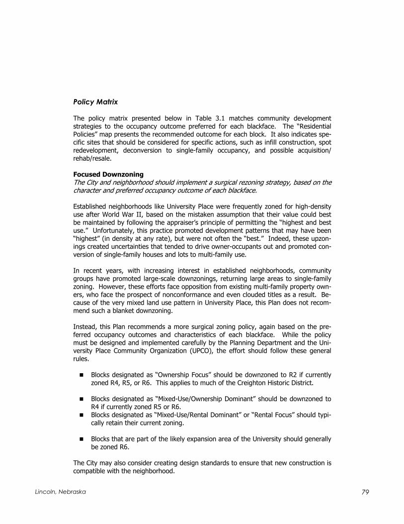
79 Lincoln, Nebraska
Policy Matrix
The policy matrix presented below in Table 3.1 matches community development strategies to the occupancy outcome preferred for each blackface. The “Residential Policies” map presents the recommended outcome for each block. It also indicates spe-cific sites that should be considered for specific actions, such as infill construction, spot redevelopment, deconversion to single-family occupancy, and possible acquisition/rehab/resale.
Focused Downzoning The City and neighborhood should implement a surgical rezoning strategy, based on the character and preferred occupancy outcome of each blackface.
Established neighborhoods like University Place were frequently zoned for high-density use after World War II, based on the mistaken assumption that their value could best be maintained by following the appraiser’s principle of permitting the “highest and best use.” Unfortunately, this practice promoted development patterns that may have been “highest” (in density at any rate), but were not often the “best.” Indeed, these upzon-ings created uncertainties that tended to drive owner-occupants out and promoted con-version of single-family houses and lots to multi-family use.
In recent years, with increasing interest in established neighborhoods, community groups have promoted large-scale downzonings, returning large areas to single-family zoning. However, these efforts face opposition from existing multi-family property own-ers, who face the prospect of nonconformance and even clouded titles as a result. Be-cause of the very mixed land use pattern in University Place, this Plan does not recom-mend such a blanket downzoning.
Instead, this Plan recommends a more surgical zoning policy, again based on the pre-ferred occupancy outcomes and characteristics of each blackface. While the policy must be designed and implemented carefully by the Planning Department and the Uni-versity Place Community Organization (UPCO), the effort should follow these general rules.
Blocks designated as “Ownership Focus” should be downzoned to R2 if currently zoned R4, R5, or R6. This applies to much of the Creighton Historic District.
Blocks designated as “Mixed-Use/Ownership Dominant” should be downzoned to R4 if currently zoned R5 or R6. Blocks designated as “Mixed-Use/Rental Dominant” or “Rental Focus” should typi-cally retain their current zoning.
Blocks that are part of the likely expansion area of the University should generally be zoned R6.
The City may also consider creating design standards to ensure that new construction is compatible with the neighborhood.

80 The North 48th Street/University Place Plan
Spot Redevelopment Redevelopment of selected sites can create new housing resources for prospective homeowners, including members of the university community. One opportunity could be the east side of an improved 51st Street.
Part of the residential strategy should be assembly and spot residential redevelopment of selected sites. The improved 51st Street between Garland and Colby Avenues could provide a venue for new housing adjacent to an expanded and upgraded University Place Park. This street frontage is out of the Dead Man’s Run floodplain, and could be done in such a way as to permit expansion of the park. The design of a project should include neighborhood park exposure to 51st Street.
Nebraska Wesleyan University Campus SurroundingsThe improvement of the residential quality of the University Place neighborhoods is a widely shared goal. One important step in achieving that goal is to provide the neighborhood residents, particularly those in the blocks surrounding the Nebraska Wesleyan University campus, with a plan that helps them feel confident that future Uni-versity expansion will not have a detrimental impact on their property values and over-all quality of life. This plan should also include provisions, which facilitate collaborative efforts by the University, the neighborhood, and the City to invest in the revitalization of these neighborhoods.
A major institution like NWU is a great boon to an established neighborhood, increasing both its marketability and quality. Yet, it can also be a source of uncertainty, especially if it tends to acquire property when opportunities arise. Uncertainty is the enemy of residential investment, and an important objective of these residential policies is to pro-vide homeowners with greater predictability about the future of the neighborhood. Therefore, this plan recommends the following:
The main academic uses be focused between the one-half block north of Madison and south of Huntington, between 48th and 56th Streets.
NWU is encouraged to regard the blocks to the West of the current core campus, between 50th and 48th Streets and Madison and Huntington as an area suitable for campus expansion. Campus-related commercial and residential activities should be increasingly integrated into the 48th Street business district, and could be ac-commodated in this transitional area.
NWU should not expand its campus domain more than one half block South of Huntington between 56th and 48th Streets. The purpose of this limit is to preserve the integrity of the Creighton Historic District.
In the area North of Madison Avenue to Adams Street, NWU and the neighbor-hood will work with the City to develop a plan for improving housing in this area. This plan will address additional strategies for improving housing and how NWU could help by investing in housing and renovation.

81 Lincoln, Nebraska
NWU and the neighborhood will work with the City to develop a plan to address parking issues.
This Plan also recommends the block along Madison Avenue between 53rd and 54th
Streets retain its current residential character. This architecturally distinctive block could be used to house visiting or permanent faculty, and contributes strongly to the charac-ter of the neighborhood.
Implementation
The Lincoln City Council and Lancaster County Board approved the North 48th Street/University Place Plan as an amendment to the Lincoln-Lancaster County Comprehensive Plan in June 2004. The N. 48th Street/University Plan is a guide for the future of N. 48th Street and University Place; it does not represent final design. Implementation of the Plan’s recommendations will require further refinement, decision-making, design and funding.
To ensure the recommendations of this Plan are properly implemented, the City will es-tablish an implementation committee comprised of stakeholders in the neighborhood and City staff. The committee's responsibility will be to prioritize the projects identified in this Plan, taking into consideration a number of elements, such as impacts on other projects, dependence on other projects, financing, timing, strategic importance, and other elements deemed appropriate by the committee.
After prioritizing specific projects, amendments will likely be made to the University Place Redevelopment Plan and possibly the City's Capital Improvement Program (CIP). Actual implementation for projects will need to follow the prescribed City processes for approval and obtaining additional funding.

82 The North 48th Street/University Place Plan
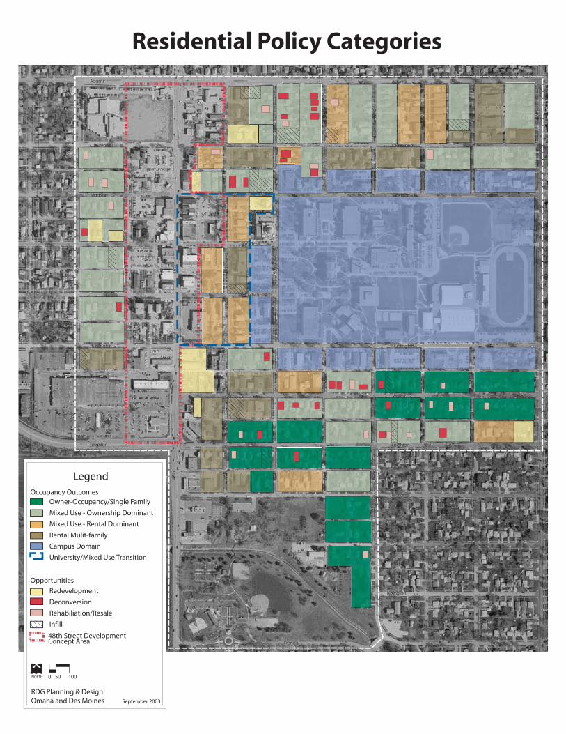
Adams
Cleveland
Madison
Saint Paul
Baldwin
Huntington
Walker
Leighton
Garland
Colby
Lexington
FrancisFrancis
46th
47th
48th
49th
51st
52nd
53rd
54th
56th
51st
52nd
53rd
54th
56th
50th
Adams
Cleveland
Madison
Huntington
Leighton
50th
48th
49thLegend
Residential Policy Categories
0 10050NORTH
September 2003
RDG Planning & DesignOmaha and Des Moines
Owner-Occupancy/Single Family
Mixed Use - Ownership Dominant
Mixed Use - Rental Dominant
Rental Mulit-family
Campus Domain
University/Mixed Use Transition
Occupancy Outcomes
Opportunities
Redevelopment
Deconversion
Rehabiliation/Resale
Infill
48th Street Development Concept Area

R5 R4R5 R4R5 R4
B3
B3
P
B3
B3
B3
B3
B3
B3
B3
B3
B3
B3
B3
P
B3
B3
R6
R5 R4R5 R4R5 R4
R6 R5R6 R5R6 R5R6 R5
R6 R2
R6 R4
R6 R4R6 R4 R6 R4
R6 R4
R6 R4 R5 R2 R5 R2
R5 R2
R5 R4R5 R2
R4 R2
R2 R6
R5 R2
R5 R2
R5 R2
R5 R2
R5 R2
R5 R2 R5 R4
R6 R4R6 R4
R6
R6R6R6R6
R6
R6
R6
R6
R6
R6
R6R6
R6R6
R6 R6
R6R6
R6
R6
R5
R6 R6 R6
R2
R2
R2
R2
R2
R2
R6
R5
R6
R6 R6
R6R6
R5R5R5R5 R5 R5
R6
R4
R5 R4
R5 R4 B3 R4
B3 R4
R5 R4 B3 R4
B3 R4R6 R4
R5 R2 R4 R2
R5 R4
Adams
Cleveland
Madison
Saint Paul
Baldwin
Huntington
Walker
Leighton
Garland
Colby
Lexington
FrancisFrancis
46th
47th
48th
49th
51st
52nd
53r
d
54th
56th
51st
52n
d
53rd
54th
56th
50th
Adams
Cleveland
Madison
Huntington
Leighton
50th
48th
49thLegend
Potential Zoning Modifications
0 10050NORTH
January 2004
RDG Planning & DesignOmaha and Des Moines
Downzone
Upzone
Maintain
Potential Zoning Modifications

Adams
Cleveland
Madison
Saint Paul
Baldwin
Huntington
Walker
Leighton
Garland
Colby
Lexington
FrancisFrancis
46th
47th
48th
49th
51st
52nd
53r
d
54th
56th
51st
52n
d
53rd
54th
56th
50th
Adams
Cleveland
Madison
Huntington
Leighton
50th
48th
49th
R6
R6
R6
R6
R6
R6R2
R5
R5R5R5
R5
P
R5
B3
B3
B3
B3
B3
R4R4
R2R2
R4
R4
R4
R2
R2
R2
R2
R2
R4
R4
P
R4
R4
R4
R4
R4
R6R6
R6
R6 R6
Legend
0 10050NORTH
January 2003
RDG Planning & DesignOmaha and Des Moines
B3
R2
R4
R5
R6
Proposed Zoning Map