the archaeological sites of the rohri hills (sindh, … is the site from which the eponymous kot...
TRANSCRIPT

Abstract
Il presenche sonodelle arediversi pad esem
r
Per quanapprese
Duranteregione un’attivituttora pcittà Bu
1. Intr
The RochapteHills nwide ((Fig. 2fringesin salthills costone rtion, EoceneThey agood brownwhich populalaeolitThe himenta
* Diparti1 Bladfo2 Biagi,
The Archaeological Sites of the Rohri Hills (Sindh, Pakistan): the Way they are Being Destroyed
Paolo Biagi*
te lavoro riguarda le colline di Rohri (Rohri Hills) nel Sindh Settentr onale (Pakistan) ed i siti archeologic sta i scoperti sulla sommità dei tavolati calcarei, e lungo i margini di questi ultimi. Si tratta di unae archeologiche più ricche del paese, nella quale sono stati riconosciuti migliaia di siti attribuibili aeriodi della preistoria dal Paleolitico più antico all’età del Bronzo oltre che all’epoca Buddista, qualipio Seeraj.
i i t
t l ri i I .
r , tt i
to riguarda le stazioni preis oriche si tratta per lo più di officine litiche, dato che le co line di Rohntano una delle fonti di approvvigionamento della selce p ù importanti del Subcontinente ndiano gli ultimi sessant’anni, lo sfruttamento del calca e dei tavolati in un primo momento limi ato alla più set entrionale delle colline e condotto in modo artigianale, s è moltiplicato di intensità diventandotà industriale vera e propria diffusa in quasi tutta l’area delle colline. Questo fatto ha portato e sta ortando alla distruzione di centinaia di siti di epoca preistorica ed anche storica, quali ad esempio la
ddista di Seeraj ed il grave danneggiamento dell’antica capitale del Sindh, Aror.
oduction
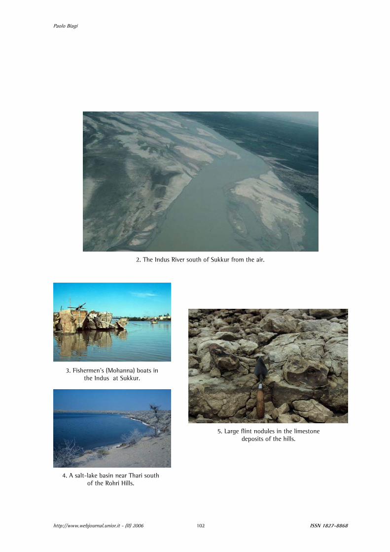
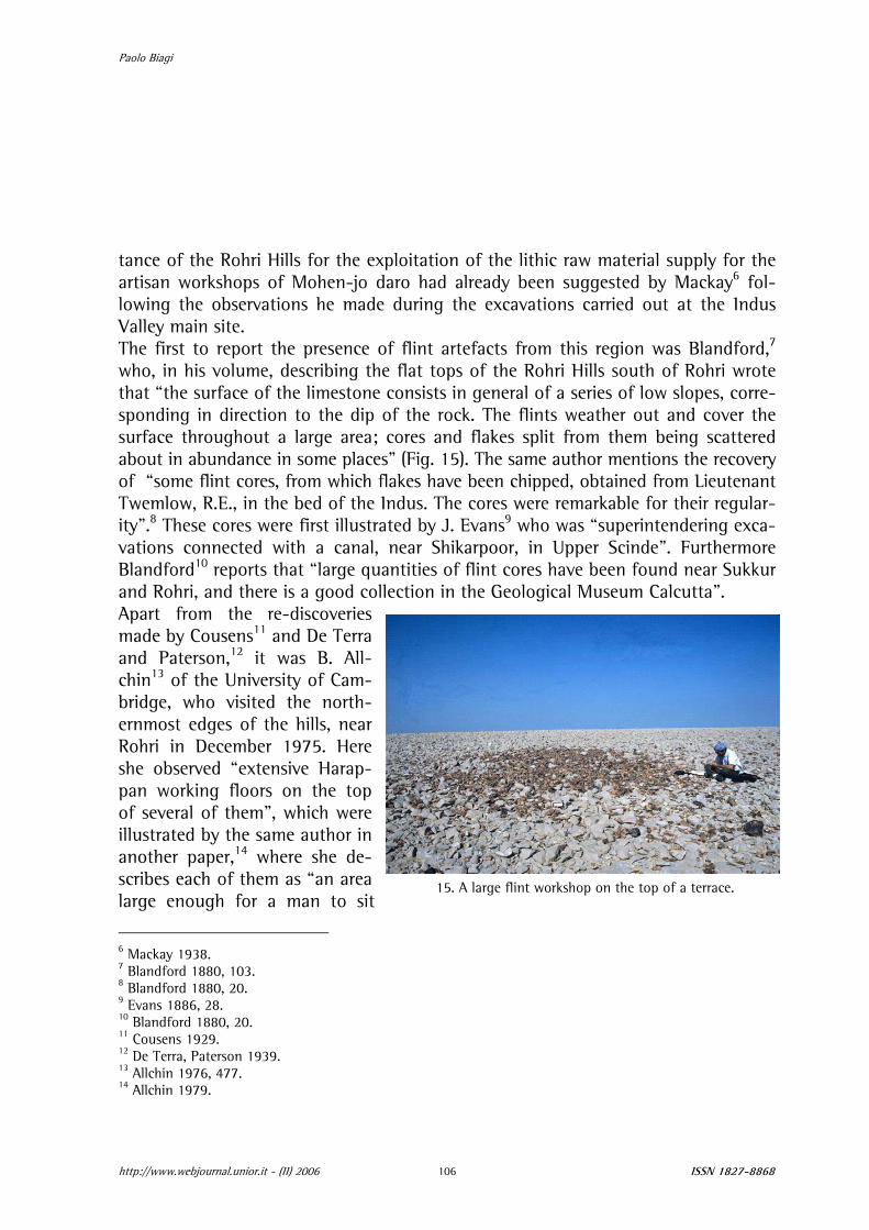
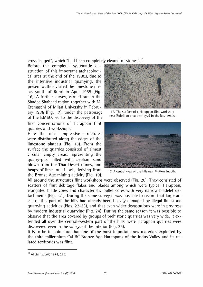
hri Hills were first described by Bladford1 in his “Geology of Western Sind”. In r V of his volume he provides the reader with a geological description of “The ear Sukkur and Rohri”. These limestone formations, some 40 km long and 16 Fig. 1), extend in a north-south direction between the course of the Indus ) and the cities of Sukkur and Rohri (Fig. 3), in the north, and the westernmost of the Thar Desert, in the south, which, in this part of the country is very rich -lake basins (Fig. 4). The nsist of fossiliferous lime-ocks of the Brahui forma-attributed to the Middle /Early Oligocene period. re very rich in seams of quality flint of light
ish-grey colour (Fig. 5), attracted the prehistoric tions from the Early Pa-
hic onwards.2 lls separate two environ-lly very different regions:
mento di Scienze dell’Antichità e del Vrd 1880. Cremaschi 1988.
1. A Rohri Hills landscape in the central region of the hills.
icino Oriente. Università Ca’ Foscari, Venezia.
Paolo Biagi
2. The Indus River south of Sukkur from the air.
3. Fishermen’s (Mohanna) boats in the Indus at Sukkur.
5. Large flint nodules in the limestone deposits of the hills.
4. A salt-lake basin near Thari south of the Rohri Hills.
http://www.webjournal.unior.it - (II) 2006 ISSN 1827-8868 102

The Archaeological Sites of the Rohri Hills (Sindh, Pakistan): the Way they are Being Destroyed
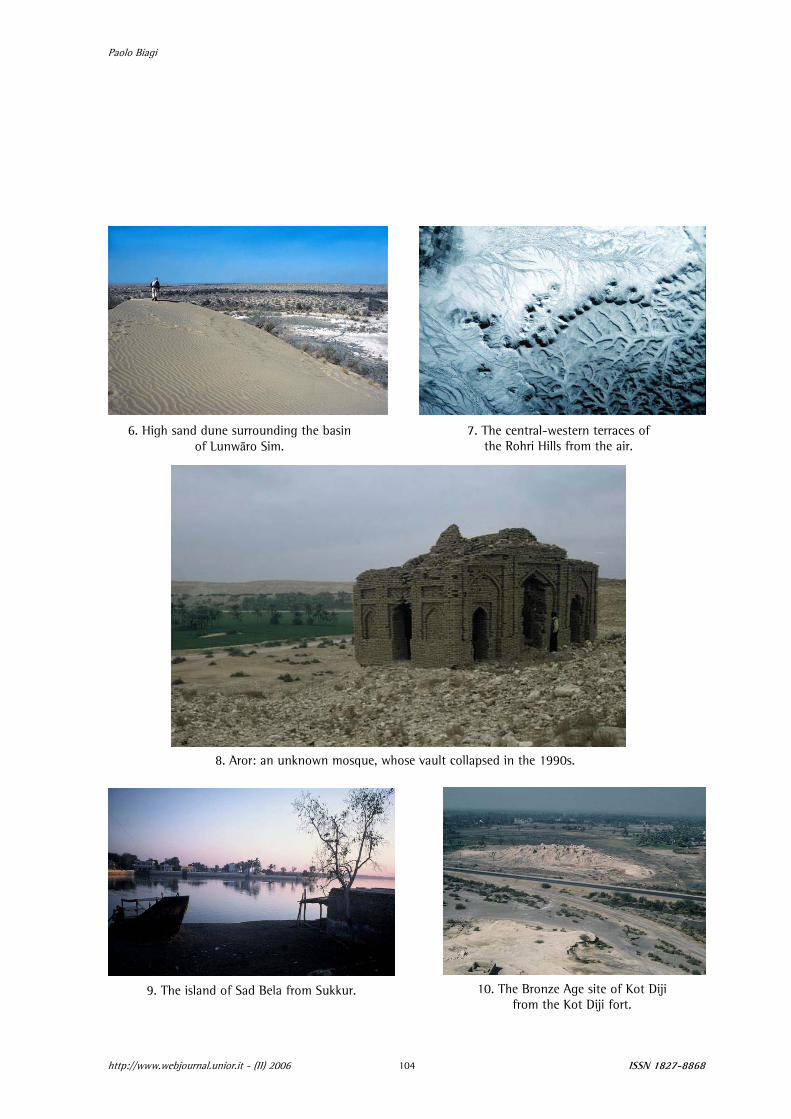
the fertile, cultivated plain of the Indus, to the west, and the poorly vegetated fossil sand dunes of Thar Desert, to the east (Fig. 6). Their eastern fringes are lapped by the Nara Canal, which flows inside the old bed of the Hakra-Gagghar River. The hills look like white limestone mesas abounding in nummulites, dissected by severe ero-sion and deeply incised by old river courses (Fig. 7). A break in the hills can be observed a few km east of Rohri, most probably due to the course of an old river channel. In effect the city of Aror (or Alor) itself lies close to another old river channel, which is said to have passed by the ancient capital of Sindh. The same is supposed to have been destroyed by an earthquake around the middle of the tenth century AD (Fig. 8). A few more isolated small limestone hills, detached from the major group of terraces, can be observed some 3 km north of the Indus river at Sukkur, where de Terra and Paterson3 were the first to discover scat-ters of man-made flint assemblages on their tops. Here the Indus turns west across a gorge between Sukkur and Rohri, where the island of Bukkur, on which Alexander the Great built up a fortress in the middle of the river, is located, as well as the smaller islet of Sad Bela, which is famous for the Hindu shrine (Fig. 9). Along the south-western fringes of the hills rises the multi-stratified site of Kot Diji (Fig. 10), west of the main road Karachi-Lahore, just in front of the Talpur mud-brick fort (Fig. 11). Its stratigraphic sequence covers the Early and Mature Harappan Civilisation. This is the site from which the eponymous Kot Diji Culture takes its name.4
It is important to point out that the Rohri Hills are located some 90 km as the crow flies north-east of the Harappan metropolis of Mohen-jo daro (Fig. 12). Although the city is built exclusively of bricks and mud-bricks, a few engineering works were made of squared limestone blocks quarried from the hills. Among the others this is the case for the cover of the narrow, deep canal (Fig. 13) that flows from the “Great bath”, one of the most important public constructions of the citadel (Fig. 14).
2. The research project
Although the Rohri Hills have been known since the end of the 1880s as a raw ma-terial source for the prehistoric populations that inhabited the Indus Valley, a pro-ject of systematic surveys and excavations in the region, called “Joint Rohri Hills Project”, was promoted only in the 1990s by Ca’ Foscari University, Venice (Italy) and Shah Abdul Latif University, Khairpur (Sindh, Pakistan).5 Nevertheless the impor-
3 De Terra, Paterson 1939. 4 Khan 2002. 5 Biagi, Shaikh 1994.
http://www.webjournal.unior.it - (II) 2006 ISSN 1827-8868 103
Paolo Biagi
6. High sand dune surrounding the basin of Lunwāro Sim.
7. The central-western terraces of the Rohri Hills from the air.
8. Aror: an unknown mosque, whose vault collapsed in the 1990s.
9. The island of Sad Bela from Sukkur. 10. The Bronze Age site of Kot Diji from the Kot Diji fort.
http://www.webjournal.unior.it - (II) 2006 ISSN 1827-8868 104

The Archaeological Sites of the Rohri Hills (Sindh, Pakistan): the Way they are Being Destroyed
http://www.webjournal.unior.it - (II) 2006 ISSN 1827-8868 105
11. The walls and bastions of the Talpur’s Kot Diji fort.
14. The “Great Bath” of Mohenjo-daro.
12. A general view of Mohenjo-daro.
13. Thethe ca
Rohri Hills limestone blocks that cover nal flowing from the “Great Bath”.
Paolo Biagi
tance of the Rohri Hills for the exploitation of the lithic raw material supply for the artisan workshops of Mohen-jo daro had already been suggested by Mackay6 fol-lowing the observations he made during the excavations carried out at the Indus Valley main site. The first to report the presence of flint artefacts from this region was Blandford,7 who, in his volume, describing the flat tops of the Rohri Hills south of Rohri wrote that “the surface of the limestone consists in general of a series of low slopes, corre-sponding in direction to the dip of the rock. The flints weather out and cover the surface throughout a large area; cores and flakes split from them being scattered about in abundance in some places” (Fig. 15). The same author mentions the recovery of “some flint cores, from which flakes have been chipped, obtained from Lieutenant Twemlow, R.E., in the bed of the Indus. The cores were remarkable for their regular-ity”.8 These cores were first illustrated by J. Evans9 who was “superintendering exca-vations connected with a canal, near Shikarpoor, in Upper Scinde”. Furthermore Blandford10 reports that “large quantities of flint cores have been found near Sukkur and Rohri, and there is a good collection in the Geological Museum Calcutta”. Apart from the re-discoveries made by Cousens11 and De Terra and Paterson,12 it was B. All-chin13 of the University of Cam-
15. A large flint workshop on the top of a terrace.
bridge, who visited ternmost edges of the hills, near
large enough for a man to sit
Rohri in December 1975. Here she observed “extensive Harap-pan working floors on the top of several of them”, which were illustrated by the same author in another paper,14 where she de-scribes each of them as “an area
he north-
6 Mackay 1938. 7 Blandford 1880, 103. 8 Blandford 1880, 20. 9 Evans 1886, 28. 10 Blandford 1880, 20. 11 Cousens 1929. 12 De Terra, Paterson 1939. 13 Allchin 1976, 477. 14 Allchin 1979.
http://www.webjournal.unior.it - (II) 2006 ISSN 1827-8868 106
The Archaeological Sites of the Rohri Hills (Sindh, Pakistan): the Way they are Being Destroyed
cross-legged”, which “had been completely cleared of stones”.15
Before the complete, systematic de-struction of this important archaeologi-cal area at the end of the 1980s, due to
lmost
sand , and from g. 19). shops were observed (Fig. 20). They consisted of
nd blades among which were typical Harappan, teristic bullet cores with very narrow bladelet de-
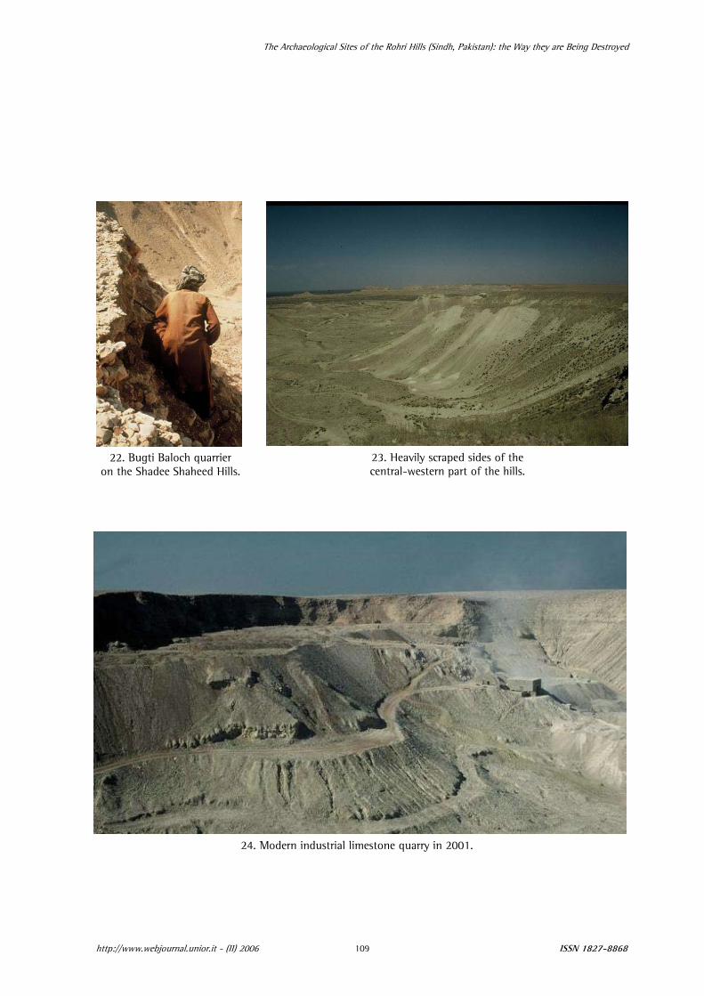
same survey it was possible to record that large ar-lready been heavily damaged by illegal limestone and th gress ig. 24). During the same season it was possible to
observe that the area covered by groups of prehistoric quarries was very wide. It ex-er the central-western part of the hills, were Harappan quarries were
erior (Fig. 25). t out that one of the most important raw materials exploited by m Cal BC Bronze Age Harappans of the Indus Valley and its re-
s was flint.
the intensive industrial quarrying, the present author visited the limestone me-sas south of Rohri in April 1985 (Fig. 16). A further survey, carried out in the Shadee Shaheed region together with M. Cremaschi of Milan University in Febru-ary 1986 (Fig. 17), under the patronage of the IsMEO, led to the discovery of the first concentrations of Harappan flint quarries and workshops. Here the most impressive structures were distributed along the edges of the
16. The surface of a Harappan flint workshop near Rohri, an area destroyed in the late 1980s.
17. A central view of the hills near Mutton Jugoth.
limestone plateau (Fig. 18). Fromsurface the quarries consisted of acircular empty areas, representing the quarry-pits, filled with aeolian blown from the Thar Desert dunesheaps of limestone block, derivingthe Bronze Age mining activity (FiAll around the structures flint workscatters of flint débitage flakes aelongated blade cores and charactachments (Fig. 21). During the eas of this part of the hills had aquarrying activities (Figs. 22-23), by modern industrial quarrying (F
the
at even wider devastations were in pro
tended all ovdiscovered even in the valleys of the intIt is to be to pointhe third millenniulated territorie
1978, 276. 15 Allchin et alii,
http://www.webjournal.unior.it - (II) 2006 ISSN 1827-8868 107

Paolo Biagi
18. The Harappan flint workshops discovered in 1986 on the Shadee Shaheed terraces.
19. The sandy top of a Harappan quarry-pit at Shadee Shaheed the day of its discovery.
20. A Harappan flint workshop.
21. Harappan bullet cores now in the Birmingham University collection.
http://www.webjournal.unior.it - (II) 2006 ISSN 1827-8868 108
The Archaeological Sites of the Rohri Hills (Sindh, Pakistan): the Way they are Being Destroyed
22. Bugti Baloch quarrier on the Shadee Shaheed Hills.
23. Heavily scraped sides of the central-western part of the hills.
24. Modern industrial limestone quarry in 2001.
http://www.webjournal.unior.it - (II) 2006 ISSN 1827-8868 109

Paolo Biagi
25. Harappan quarries in the internal regions of the Rohri Hills. 26. Surface of a workshop at Mohan-jo-daro.
Although the relevance of this siliceous stone has never been pointed out by the ar-cent publications on the subject,16 the researches ly during the last twenty years17 and also the ana-
chaeologists even in the most recarried out in the Rohri Hills main
tical study of artisan workshops of Mohen-jo daro (Fig. 26)18 have shown the fun-amental role played by flint in the wider context of this highly developed urban ivilisation of the Indian Subcontinent.
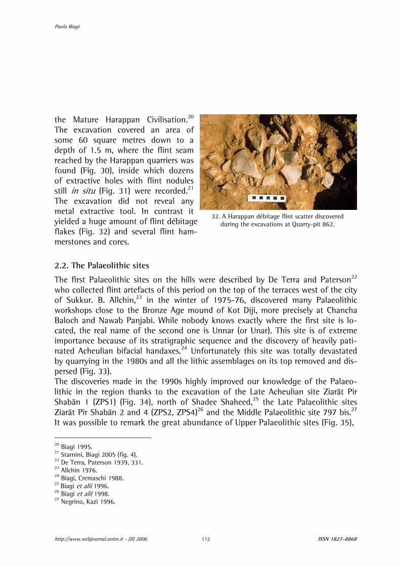
.1. The excavation of the Harappan quarry-pit 862
he excavation of quarry-pit 862 was carried out in four seasons of some two onths each between 1995 and 1998.19 This structure is located along the western
dge of the Shadee Shaheed Hills, some 3.5 km south of the shrine that bears the me name (Fig. 27). It is part of an impressive, wide ring-shaped group of features, me 120 m in diameter, attributed to a Harappan flint quarrying area (Figs. 28-29).
he excavation was opened in order to understand to the quarrying techniques em-loyed by the Harappans and to define the absolute chronology of the site. Thanks the recovery of two small charcoal pieces of Zyzyphus cf. nummularia, it was ra-
iocarbon-dated to 3870±70 uncal BP (GrA-3235), which attributes the quarry-pit to
lydc
2
TmesasoTptod
See for instance Lahiri 1992. Biagi in press. Vidale 2000. Negrino et alii 1986.
16
17
18
19
http://www.webjournal.unior.it - (II) 2006 ISSN 1827-8868 110

The Archaeological Sites of the Rohri Hills (Sindh, Pakistan): the Way they are Being Destroyed
27. The excavations at Quarry-pit 862. 28. The heavily corrugate landscape of the Shadee Shaheed Hills.
http://www.webjournal.unior.it - (II) 2006 ISSN 1827-8868 111
29. A group of quarrfrom t
y-pits and workshopshe air.
30. Quarrlas
y-pit 862 at the end of the t excavation season.
31. Flint nodule still in situ in the limestone at the bottom of Quarry-pit 862.
Paolo Biagi
the Mature Harappan Civilisation.20 The excavation covered an area of some 60 square metres down to a
thic sites
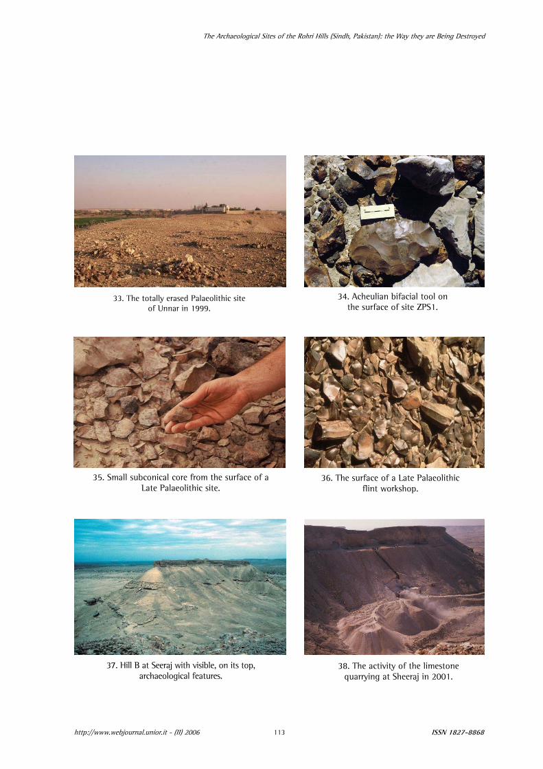
The first Palaeolithic sites on the hills were described by De Terra and Paterson22 who collected flint artefacts of this period on the top of the terraces west of the city of Sukkur. B. Allchin,23 in the winter of 1975-76, discovered many Palaeolithic workshops close to the Bronze Age mound of Kot Diji, more precisely at Chancha Baloch and Nawab Panjabi. While nobody knows exactly where the first site is lo-cated, the real name of the second one is Unnar (or Unar). This site is of extreme importance because of its stratigraphic sequence and the discovery of heavily pati-nated Acheulian bifacial handaxes.24 Unfortunately this site was totally devastated by quarrying in the 1980s and all the lithic assemblages on its top removed and dis-persed (Fig. 33). The discoveries made in the 1990s highly improved our knowledge of the Palaeo-lithic in the region thanks to the excavation of the Late Acheulian site Ziarāt Pir Shabān 1 (ZPS1) (Fig. 34), north of Shadee Shaheed,25 the Late Palaeolithic sites Ziarāt Pir Shabān 2 and 4 (ZPS2, ZPS4)26 and the Middle Palaeolithic site 797 bis.27 It was possible to remark the great abundance of Upper Palaeolithic sites (Fig. 35),
depth of 1.5 m, where the flint seam reached by the Harappan quarriers was found (Fig. 30), inside which dozens of extractive holes with flint nodules still in situ (Fig. 31) were recorded.21 The excavation did not reveal any metal extractive tool. In contrast it yielded a huge amount of flint débitage flakes (Fig. 32) and several flint ham-merstones and cores.
2.2. The Palaeoli
32. A Harappan débitage flint scatter discovered during the excavations at Quarry-pit 862.
20 Biagi 1995. 21 Starnini, Biagi 2005 (fig. 4). 22 De Terra, Paterson 1939, 331. 23 Allchin 1976. 24 Biagi, Cremaschi 1988. 25 Biagi et alii 1996. 26 Biagi et alii 1998. 27 Negrino, Kazi 1996.
http://www.webjournal.unior.it - (II) 2006 ISSN 1827-8868 112
The Archaeological Sites of the Rohri Hills (Sindh, Pakistan): the Way they are Being Destroyed
34. Acheulian bifacial tool on the surface of site ZPS1.
33. The totally erased Palaeolithic site of Unnar in 1999.
35. Small subconical core from the surface of aLate Palaeolithic site.
36. The surface of a Late Palaeolithic flint workshop.
w.webjournal.unior.it - (II) 2006 ISSN 1827-8868 113
37. Hill B at Seeraj with archaeological feature
visible, on its top,s.
38. The activity of the limestone quarrying at Sheeraj in 2001.
http://ww

Paolo Biagi
which are mainly distributed all over the western fringes of the central terraces of the hills (Fig. 36). During the same years Negrino and Kazi,28 thanks to the data provided by the excava-tion of the above-mentioned sites and the typological analysis of all the Palaeolithic assemblages discovered in the hills, were able to establish a first chrono-typological sequence of the Palaeolithic of Upper Sindh, although many sites continued to vanish due to the impending industrial activities. It is important to point out that a huge Acheulian site, very rich in bifacial tools, discovered in the same year very close to the
2.3. The Historical sites
Apart from the prehistoric sites, also a few historic settlements were destroyed or damaged during the last twenty years. Among these are Seeraj29 and a Buddhist stupa at Shah Shagar Ganj30 an area important also for the sequences recorded in the area31 not far from Aror, destroyed at the end of the 1980s. The Buddhist town of Seeraj32 (or Seeraj-ji Takri or Sheraz) was located along the central-western fringes of the Rohri Hills in the Khairpur District. More precisely it lay on two flat hilltops (A and B) (Fig. 37) some 120 m high, separated by a saddle, some 1.75 km northeast of the Tomb of Uban Shah. To the east and to the west of the town, two small seasonal streams flow in southeast-northwest direction. The coordinates of Hill A are 27°21’55” N and 68°47’00” E. A. Jafri33 was the first to mention “a perfectly planned small township with the clear distinction of living quarters and other amenities”. He also described some buildings and “traces of construction on three corners of the rock, which resemble to security posts” and that of “a smaller complex of rooms with thick walls of burned bricks” along the western end of the terrace, while the “central area of the hill accommo-dates a flat construction identical to a speakers stage or salute platform”.
eastern periphery of Rohri, along the northern fringes of the hills, was destroyed in January-February 2001 without conducting any rescue excavation. A few artefacts were collected by Prof. G.M. Veesar of Shah Abdul Latif University, Khairpur and are now in the stores of the Archaeology Museum of the same.
28 Negrino, Kazi 1996. 29 Biagi et alii 2002. 30 Verardi 1987, 48.
hi 1988, 423. oth in Sindhi and in Hindi. A similar name is also reported by Blanford (1880, 108),
e presence of “two limestone hills called Maleki Khánwári and Sherawári Tekri” near the M ong the central western margin of the Rohri Hills.
31 Biagi, Cremasc32 Seeraj means oil lamp bwhen he describes thvillage of ithunjo al33 Jafri 1980, 3-4.
http://www.webjournal.unior.it - (II) 2006 ISSN 1827-8868 114

The Archaeological Sites of the Rohri Hills (Sindh, Pakistan): the Way they are Being Destroyed
http://www.webjournal.unior.it - (II) 2006 ISSN 1827-8868 115
urther details were later provided by G.M. Shar, ” “on a hill top, immediately to the East of Seeraj-ji Takri”,
on Hill B. “On Hill A, remains of do-d walls built of burnt and plain mud
ap of burnt bricks was also noticed, of which some were carved in the dhist stupas”.35 ere he distinguished between “an in-
ncluding “a stupa…almost completely ricks”.
The present writer repeatedly visited the site between 1986 and 2001 when the town began to be systematically destroyed by the lim hill on which it had been built (Figs. 38). During this first visit (and not this), the remains of a squared construction, corresponding to Verardi’s37 stupa were observed (Fig.
A preliminary interpretation of the aeBaroni in 1999,38 revealed many habitation structHill A, which had already been totally destroyed during the industrial works undertaken between the 1950s and the 1980s. The study of the aerial photo-graphs demonstrate that origtended well beyond Hill-
brick wall northeast of the stupa was ra
F 34 who described “visible remains ofa massive stone wallwhich might represent an ancient fortification, mestic architecture consisting of lime-plasterebricks ……A hesame fashion as those known from Sindhi BudIn 1987 G. Verardi36 paid a visit to Seeraj, whhabited area and a sacred area”, this latter ideprived of its outer casing of carved baked b
estone quarrying of t e h
39), as well as those of a few rectangular stonewalled rooms and mud-brick walls. rial photographs of Seeraj area, made by C.
ures along the northern slope of
inally the town ex-
tops A and B and that an-other flat hilltop, north-east of Hill A was covered with archaeological re-mains most probably of the same Buddhist period. One charcoal sample collected in January
39. Remains of the Buddhist stupa at Seeraj in 2001.
2001 from the foundations of a mud-diocarbon-dated to 1270±20 BP (GrN-
34 Shar 1995, 37. 35 Shar 1995, 112. 36 Verardi 1987, 50. 37 Ibid. 38 Biagi et alii, 2002.

Paolo Biagi
26801), which corresponds to 680-780 AD at 2σ.39 This result indicates that the town was destroyed during the first half of the eighth Century AD, or slightly later, most probably during the sovereignty of the Umayyad Khalifas,40 probably as a con-sequence of the Arab invasion. The state of preservation of the historical capital of the country, Aror, is also critical because it is systematically robbed by the local inhabitants of the small village, which is continuously expanding, for the building of their new houses. The small mosque of fig. 8 partly collapsed at the end of the 1990s and the famous mosques of Mohammad bin Qasim and the Emperor Auranzgeb are also in a very bad state of
41
nevertheless totally
”.
t
S
t
R
adid not produce any concrete result either. The same can be said for an appeal to
C director in 2001.
preservation.
3. The disappearance of an archaeological landscape
The “Joint Rohri Hills Project” that unfortunately ended in 2002 after so many im-portant discoveries and the publication of so many data, was unable to stop the progressive, systematic destruction of the archaeological sites of the hills because of the absence of any interest by the local authorities, mainly the officers of the Institute of Archaeology of Shah Abdul Latif University, Khairpur, the only Institute of Archaeology of Sindh. The project itself had been included in the “Protocol for Scientific and Technical Cooperation between the Italian Republic and the Islamic Republic of Pakistan for the Years 1998-2000Repetitive appeals for the safeguard of the region personally made by the author to he Governor of Sindh in the company of the General Consul of Italy in Karachi
(2000), the Commissioners of Sukkur and Kot Diji (2001), the Vice-Chancellor of the hah Abdul Latif University, Khairpur and the Directors of the same Institute (1996-
2001) have systematically resulted in no action by all the above-mentioned authori-ies.
Furthermore the “Seminar and Exhibition on the Archaeological Discoveries of theohri Hills, Khairpur, Sindh” held at the Department of General History of Karachi
University in February 2000, promoted and financed by the General Consulate of Italynd in particular strongly supported by the then Consul General Dr. Mario Cristofoli,
the UNESCO-WH
39 Stuiver et alii, 1998. 40 Panhwar 1983. 41 Bukhari 1991; Mastoor 1997.
http://www.webjournal.unior.it - (II) 2006 ISSN 1827-8868 116
The Archaeological Sites of the Rohri Hills (Sindh, Pakistan): the Way they are Being Destroyed
ISSN 1827-8868 117
ern Cultures, Berlin, Heidelberg, in press
outh Asian Studies”, 12, 1996, 49-62.
Chronological, Archaeometrical and Archaeobotanical As-pects, in 9.
Biagi, N. Shaikh, An Italo-Pakistani Joint Project in the Rohri Hills (Sindh – Pakistan): Aims and Perspectives, in “Ancient Sindh”, 1, 1994, 1-12. W.T. Blandford, The Geology of Western Sind, in “Memoirs of the Geological Survey of India”, XVII (1), 1880, 1-210. M.F. Bukhari, The Archaeological Site of Aror, Jamshoro, 1991. H. Cousens, The Antiquities of Sind, Calcutta, 1929.
References
Allchin 1976 B. Allchin, Palaeolithic Sites in the Plain of Sind and theirGeographical Implications, in “The Geographical Jour-nal”, 142 (3), 1976, 471-489.
Allchin 1979 B. Allchin, Stone Blade Industries of Early Settlements in Sind as Indicators of Geographical and Socioeconomic Change, in M. Taddei (ed.), South Asian Archaeology 1977, Naples, 1979,173-211.
Allchin et alii 1978 B. Allchin, W. Goudie, K. Hedge, The Prehistory and Pa-laeogeography of the Great Indian Desert, London, 1978.
Biagi 1995 P. Biagi, An AMS radiocarbon date from the Harappan flint Quarry-pit 862 in the Rohri Hills (Sindh - Pakistan), in “Ancient Sindh”, 2, 1995, 81-84.
Biagi in press P. Biagi, Quarries in Harappa, in H. Selin (ed.), Encyclo-pedia of the History of Science, Technology, and Medi-cine in Non-West
Biagi, Cremaschi 1998 P. Biagi, M. Cremaschi, The early Palaeolithic sites of theRohri Hills (Sind, Pakistan) and their environmental sig-nificance, in “World Archaeology”, 19 (3), 1998, 421-433.
Biagi et alii 1996 P. Biagi, M.M. Kazi, F. Negrino, An Acheulian workshop at Ziarat Pir Shaban on the Rohri Hills (Sindh - Pakistan), in “S
Biagi et alii 1998-2000 P. Biagi, M.M. Kazi, M. Madella, C. Ottomano, Excavations at the Late Palaeolithic site of ZPS2 in the Rohri Hills, Sindh, Pakistan, in “Origini”, XXII, 1998-2000, 111-133.
Biagi et alii 2002 P. Biagi, M. Spataro, R. Nisbet, A Buddhist Town at Seeraj in Upper Sindh (Khairpur, Pakistan): Historical,
“Rivista di Archeologia”, XXVI, 2002, 16-2Biagi, Shaikh 1994 P.
Blandford 1880
Bukhari 1991
Cousens 1929
http://www.webjournal.unior.it - (II) 2006
Paolo Biagi
De Terra, Paterson 1939 H. De Terra, T.T. Paterson, Studies on the Ice Age of In-
o, C. Ottomano, E. Starnini, G.M. Veesar, Exca-vations at Site 862 (Rohri Hills, Sindh, Pakistan): a pre-liminary report of the 1995 and 1997 campaigns, in “An-cient Sindh”, 3, 1996, 67-104.
anhwar 1983 M.H. Panhwar, Chronological dictionary of Sind. Institute
Shar 1995 G esert. Thesis submitted for
lStarnini, Biagi 2005 E
(Sindh, Pakistan), in “Der
Stuiver et alii 1998 M
dia and associated human culture, Washington, 1939. Evans 1886 J. Evans, On some flint-cores from the Indus, Upper
Scinde, “The Geological Journal”, XXVIII, 1886, 433-435. Jafri 1980 A. Jafri, A report on the archaeological site “Seeraj” Dis-
trict Khairpur. Thesis submitted for M.A. Degree exami-nation. Department of Archaeology, Shah Abdul Latif University, Khairpur, 1980.
Khan 2002 F.A. Khan, The Glory that wa Kot Diji Culture of Paki-stan. An Archaeological Outline, Department of Archae-ology, Shah Abdul Latif University, Khairpur, 2002.
Lahiri 1992 N. Lahiri, The Archaeology of Indian Trade Routes (upto c. 200 BC), Dehli, Oxford, New York, 1992.
Mackay 1938 E.J.H. Mackay, Further Excavations at Mohenjo-Daro, 2 vols., New Delhi, 1938.
Mastoor 1997 F. Mastoor, Aror “the Metropolitan”, once the Capital of Sindh: its Past and Present, in “Ancient Sindh”, 4, 1997, 59-72.
Negrino, Kazi 1996 F. Negrino, M.M. Kazi, The Palaeolithic Industries of the Rohri Hills (Sindh, Pakistan), in “Ancient Sindh”, 3, 1996, 7-38.
Negrino et alii 1996 F. Negrin
Pof Sindhology, University of Sind, Jamshoro, 1983.
.M. Shar, Prehistoric and Historic sites in the west ofthe Rohri Hills and the Thar DPhD Degree examination. Free University Berlin (unpub-ished), 1995. . Starnini, P. Biagi, Excavations at the Harappan Flint
Quarry 862 on the Rohri HillsAnschnitt”, 19, 2005, 1-8.
. Stuiver, P.J. Reimer, T.F. Braziunas, High-precision radiocarbon age calibration for terrestrial and marine samples 1998, in “Radiocarbon”, 40 (3), 1998, 1127-1151.
http://www.webjournal.unior.it - (II) 2006 ISSN 1827-8868 118

The Archaeological Sites of the Rohri Hills (Sindh, Pakistan): the Way they are Being Destroyed
Verardi 1987 G. Verardi, Thoughts on the Buddhist sites of Sind, inJournal of Sindhological Studies”, Summer 1987, 40-75. . Vidale, The Archaeology of the Indus Crafts. Indus
“
Vidale 2000 M
moirs. Series Minor, IV. Istil
All the photographs, which illust by E. Starnini. This paper has been written with a grant from the Italian Ministry for Foreign Affairs (MAE).
Craftspeople and Why We Study Them. Reports and Me-tuto Italiano per l’Africa e
’Oriente, Rome, 2000.
Photographic references rate this paper, are by the author, except for fig. 22
http://www.webjournal.unior.it - (II) 2006 ISSN 1827-8868 119