the carson river watershed map - university of nevada ... · the carson river watershed map our...
TRANSCRIPT

The Carson RiverWatershed Map
Our Lifeline in the Desert
Map features:
■ Prominent Geographic Areas
■ Human and Natural History
■ Explanation of the Sources of our
Water Supply
■ Agricultural and Urban Uses of Water
■ Guiding Principles for the Carson River
Watershed
■ A Look at Future Challenges for Our
Community

What is the CarsonRiver Watershed?The Carson River Watershed isthe land in Nevada and California thatcaptures, stores, and releases rain andsnowmelt to the Carson River. Itsboundaries are defined by themountain ridgelines that form a hugebowl or drainage basin. Distributedacross the mountainous uplands,many springs and tributary streamsform the headwaters for the CarsonRiver. The Sierra Nevada snowpack is the principal source for bothsurface water and underground aquifers.
Unlike most rivers, the water of the Carson River never reaches anocean. Instead, it flows northeast from the Sierra Nevada out ontothe floor of the Great Basin, where the remaining water evaporatesfrom farmlands and wetlands including the Stillwater NationalWildlife Refuge in the Carson Sink. Most of Nevada, much of westernUtah including the Great Salt Lake, and parts of California, Oregon,and Idaho lie in the Great Basin. No rivers drain to the ocean fromthis enormous, enclosed high desert between the Rockies and theSierra Nevada range.
The Carson River Watershed is slightly larger than theTruckee River Watershed to the north and the Walker RiverWatershed to the south. These three watersheds are quite similar inclimate, topography and ecosystem characteristics. The CarsonRiver Watershed encompasses portions of six counties: Alpine,Douglas, Carson City, Storey, Lyon, and Churchill. The Carson Riveris 184 miles long from the headwaters on the East Fork to the endpoint in the Carson Sink, and its watershed encompasses 3,966square miles. Precipitation that falls within the watershed supportsthe plant and animal life, provides water for diverse human needs,and recharges groundwater basins.
The Carson River Watershed is located east of the Sierra Nevadarange. Elevations below 5,000 feet in the watershed are located in therain shadow of the Sierra Nevada. This is an area of low precipitationbecause Pacific storms drop most of their moisture as they pass fromwest to east over the high mountains. The Carson River is animportant lifeline for all residents from its headwaters in AlpineCounty, California, to the Newlands Irrigation Project surroundingFallon, Nevada. The rapidly-growing towns of Minden, Gardnerville,Carson City, Dayton, and Fallon all rely on the natural resources ofthe watershed as do all farmers and ranchers in the region.

A Sense of Place — Our HistoryDuring the last ice age, from 12,000 to 75,000 years ago, the climatewas so wet that the lower portion of the Carson RiverWatershed was covered by the immense prehistoric LakeLahontan, which was created by meltwater from numerous glaciers.During the wettest period, the surface level of Lake Lahontan at thesite of today’s Stillwater Wildlife Refuge was approximately 700 feetabove the current ground level! For the last 12,000 years, theclimate has varied, but the region has settled into a desertenvironment with wetlands fed by snowmelt from the Sierraheadwaters. The average annual precipitation at Carson City is seveninches to eight inches. Ten inches per year is often used to define themaximum precipitation for a desert climate.
The first humans arrived more than 12,000 years ago. By the early1800s, the Northern Paiute Tribe lived near the lower Carson Riverand the present Stillwater Wildlife Refuge, while the Washoe Tribeinhabited the upper watershed region.
The Carson River Watershed was home to the first permanentEuropean settlements in what is now Nevada. In 1851 settlementswere established at Mormon Station (Genoa) and at the mouth ofGold Canyon (Dayton). Roughly ten years later the Carson RiverWatershed was home to the world’s greatest silver rush, the Comstockmining boom. The Carson Valley provided food and forage for thesilver miners and their livestock.
The Comstock mining boom critically impacted the watershed andits water quality by causing deforested slopes, mine tailings, andsteep raw riverbanks above channels cut into the valley floor inmany places. For many years, professionals involved with naturalresources management, as well as private landowners practicingland stewardship, have worked to restore the Carson River and its watershed.

Carson RiverRestoration HistoryThe Carson River Watershedhas a long history of river uses,alterations, and restorationprojects. The first documentedriver/watershed restorationoccurred in the 1930s by CivilianConservation Corps crews.Watershed restoration effortsaccelerated in the 1990s. Localcommunities teamed up withstate and federal agencies,conservation districts, county governments, and ranchers to establishlocal river restoration groups in the six counties and two states of thewatershed. People from many backgrounds bring important ideasfor cooperative work and a shared vision of a restored river.
These groups design restoration projects to reestablish channelshape, floodplain accessibility, and meander patterns in variouslocations. Floodplains and vegetation trap sediment and reduce theerosive power of a river during flood events. Floodwaters soak intothe ground to replenish streams and rivers later in the year. State-of-the-art bioengineering restoration practices use nativevegetation for long-term bank stabilization. Vegetation serves toenhance water quality by holding soil in place, filtering pollutants,and cooling the water.
River restoration activities include:
■ Nonpoint source pollution reduction projects that provide bankstabilization with follow-up water quality monitoring
■ Wetlands enhancement and protection
■ Fencing of river pastures and controlled grazing to stimulatewillow and grass growth, which helps hold banks together andprevent erosion
■ Working with natural processes to restore floodplain access forthe river
■ Noxious weed management to prevent takeover by aggressiveand destructive weeds
■ Carson River workdays that involve thousands of volunteers inplanting willows, wire wrapping the base of trees to preventbeaver damage, mounting duck nesting boxes, picking up trash,and planting fish
Watershed Challengesof the 21st CenturyThe Carson River Watershed faces multiple challenges in theyears ahead. One concern is the limited water supply for a growingpopulation. In a Water Resources Analysis prepared in 2000,population figures for local communities were estimated for the next50 years. If the Carson Valley’s population grows at 3.5% annually,its population would increase from 31,000 in 2000 to 173,000 by2050. If Lyon County’s population grows at 4% per year, itspopulation would grow from 12,500 in 2000 to 90,700 in 2050. Theestimate for the entire watershed predicts growth from a populationof 122,226 in 2000 to 456,264 in 2050.
Current growth rates suggest that the annual urban water demandin the watershed will exceed the existing supply of approximately74,183 acre-feet by the year 2035. As counties foresee that waterdemand will exceed their permitted water rights, they will look forwater elsewhere, including increasing conservation and transferringwater from irrigated farmlands to urban subdivisions.
The watershed receives a widely-varying amount of precipitation inany year. There are frequent floods and droughts. One way ofillustrating the wide variation of our water supply is by comparingthe annual flow of the Carson River at Carson City between 1940and 1995. The average annual flow at this site during this periodwas 290,310 acre-feet. In the wettest year, 1983, the annual flow was826,770 acre-feet, while in the driest year, 1977, the annual flow was42,350 acre-feet (Carson River Chronology, Nevada Division ofWater Planning, 1997).
Given the frequency of multiyear droughts, which occur about every10 to 15 years, both urban and agricultural water users are likely toexperience severe water shortages in dry years prior to 2035. InNevada, a drought is defined as a “water year of 70% or less of theaverage annual precipitation.” In a recent 20-year period, theCarson River Watershed has experienced drought in 1981,1987, 1988, 1990, 1991, 1992, 1994, and 2001.
An additional challenge arises from urban and suburban growth thatmay reduce agricultural lands and open space. This change of landuse may make maintaining water quality more difficult. If we continueto lose our river’s buffer zones and its natural wetlands and floodplainareas, the quality of runoff from cities and the overall environment willbe further impaired. If land use practices continue to prevent naturalflooding and river functions, then water quality and fish and wildlifehabitats will decline even more.

Carson River CoalitionRules to Live BySince 1997, a large group of citizensand agency representatives have metmonthly as the Carson River Coalition(CRC). This group is dedicated tointegrated watershed management. Itspurpose is to build relationships amongpeople throughout the watershed toaddress watershed problems andopportunities in a spirit ofcommunication and cooperation.
In 2000, the CRC created a set of 11watershed guiding principles or rules to live by, which have beenadopted by more than 30 federal, state, and local organizations.
1. Respect private and public property rights toachieve economic sustainability.
2. Respect the watershed’s natural processes inland use decisions.
3. Improve water quality to support a variety ofbeneficial uses of water.
4. Protect the headwater regions as thesystem’s principal water source.
5. Respect all stakeholders by fosteringcollaborative relationships.
6. Maintain the watershed’s floodplains toaccommodate flood events.
7. Protect uplands and wetlands to enhancewater quality and wildlife habitat.
8. Promote water conservation by all waterusers in the watershed.
9. Encourage growth management and openspace in floodplains.
10. Protect and support public recreationalaccess to natural areas.
11. Promote awareness of watershed issuesthrough public education.
Watershed Guiding Principles

Newlands Irrigation ProjectIn 1902, the U.S. Reclamation Service (now the U.S. Bureau ofReclamation) was formed to construct projects that would bringwater to the arid West. The Newlands Project, named after U.S.Senator Francis G. Newlands from Nevada, who authored theReclamation Act, was the first project built by the U.S. ReclamationService. Construction of the Newlands Project began in 1903 and wascompleted in 1914.
The Lahontan Dam is the largest structure in the Newlands Project. Itis an earthen dam measuring about 120 feet high and 1,300 feetwide and forms the Lahontan Reservoir. The reservoir is 23 mileslong, covers 100,000 acres, has 70 miles of shoreline, and holds320,000 acre-feet of water. The Lahontan Reservoir is part of theLahontan Recreation Area that is operated by the Nevada Division ofState Parks. It is located 9 miles west of Fallon and includes beachesfor swimming, picnic areas, campsites, and boat-launching facilities.
The Newlands Irrigation Project provides water for farming inChurchill and Lyon Counties. Water from the Truckee River isdiverted into the Truckee Canal at Derby Dam, and water from theTruckee Canal and the Carson River flow into Lahontan Reservoir.The water from the Newlands Project, now operated by the Truckee-Carson Irrigation District, is used to irrigate more than 60,000agricultural acres.

Habitats and VegetationWildlife habitats, also known as ecological communities, range fromdry, salt desert shrub lands to lush, high mountain meadows, forests,and aspen groves. Many wildlife species thrive in their preferredhabitats throughout the watershed. Rangelands, farmlands, andriparian vegetation along the Carson River and on tributary streamsprovide abundant wildlife habitat as well.
The salt desert shrub habitats in the lower end of the watershed aredominated by plants that survive in very dry or salty soils with anannual rainfall of four inches or less. These plants include blackgreasewood, shadscale, fourwing saltbush, and squirreltail. The saltmarshes sustain cattails, bullrush, numerous sedges, and saltgrass.These species occur mostly east of Dayton in Lyon and Churchillcounties. Desert shrub lands support Wyoming big sagebrush,Nevada ephedra or squaw tea, rabbitbrush, desert peach, Indianricegrass, and desert needlegrass. Pinyon/juniper woodlands arefound in the foothills and mountains on shallow, rocky soils.
Forest habitats support ponderosa, Jeffrey, lodgepole and sugar pine,incense cedar, and white and red fir. Along the forest streams, blackcottonwood, aspen, alder, and willows flourish. The high mountainhabitats sustain quaking aspen groves, mountain meadows of grassand flowering plants, mountain big sagebrush, antelope bitterbrush,and numerous needlegrass and bluegrass species.
Gallery forests of Fremont cottonwood trees once lined parts of theCarson River from Woodfords, California, along the West Fork tothe Stillwater Wildlife Refuge. Habitat loss dating back to theComstock mining boom of the 1860s has reduced the cottonwoodacreage to approximately 20% of its coverage before Europeansettlement began.
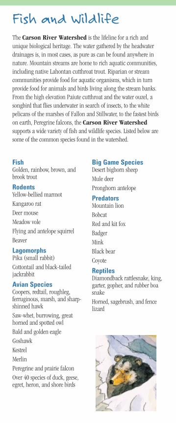
Fish and WildlifeThe Carson River Watershed is the lifeline for a rich andunique biological heritage. The water gathered by the headwaterdrainages is, in most cases, as pure as can be found anywhere innature. Mountain streams are home to rich aquatic communities,including native Lahontan cutthroat trout. Riparian or streamcommunities provide food for aquatic organisms, which in turnprovide food for animals and birds living along the stream banks.From the high elevation Paiute cutthroat and the water ouzel, asongbird that flies underwater in search of insects, to the whitepelicans of the marshes of Fallon and Stillwater, to the fastest birdson earth, Peregrine falcons, the Carson River Watershedsupports a wide variety of fish and wildlife species. Listed below aresome of the common species found in the watershed.
FishGolden, rainbow, brown, andbrook trout
Rodents Yellow-bellied marmotKangaroo ratDeer mouseMeadow vole Flying and antelope squirrelBeaver
LagomorphsPika (small rabbit)Cottontail and black-tailedjackrabbit
Avian SpeciesCoopers, redtail, roughleg,ferruginous, marsh, and sharp-shinned hawkSaw-whet, burrowing, greathorned and spotted owlBald and golden eagle Goshawk KestrelMerlin Peregrine and prairie falconOver 40 species of duck, geese,egret, heron, and shore birds
Big Game Species Desert bighorn sheepMule deerPronghorn antelope
PredatorsMountain lionBobcatRed and kit fox BadgerMinkBlack bearCoyote
ReptilesDiamondback rattlesnake, king,garter, gopher, and rubber boasnakeHorned, sagebrush, and fencelizard

Agriculture and RanchingRanching and farming are among the oldest businesses in thewatershed, dating back to the 1840s when pioneers first settled inCarson Valley. Today, water from the Carson River Watershedhelps to produce food, forage, and fiber.
Alfalfa and other hays are the most abundant crops produced in thewatershed. Alfalfa is baled and shipped to neighboring states fordairy cattle and milk production. Alfalfa is also pressed and cubedand shipped to various parts of the world for livestock to eat.
Every valley in the watershed produces food supplies and supports avariety of livestock. Meat is harvested from beef cattle, sheep, poultry,and swine. Goats, ostriches, and emus are typically raised for meatand novelty. Alpacas, sheep, and angora and cashmere goats providefiber for use in clothing and other materials. Horses, donkeys, mules,and llamas are used for recreation and packing. Livestock graze onprivate and public rangelands and irrigated pastures throughout thewatershed. The watershed also supports dairies that produce milkand cheese for northern Nevada and eastern California.
Crops for human and livestock consumption range from garlic,onions, corn, and sunflowers to cantaloupes, melons, wheat, andoats. Modest truck farms have been established in mostcommunities, raising over 100 kinds of fruits and vegetables and 200varieties of cut flowers for local farmer's markets and restaurants.
The Washoe Tribe has harvested pine nuts for thousands of yearsfrom the mountain ranges of the Carson River Watershed.Harvested from pinyon pines, pine nuts have become famous in bothNevada and California as gourmet delicacies.
Recreational Opportunities
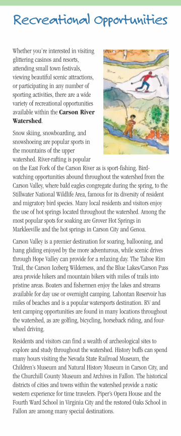
Whether you’re interested in visitingglittering casinos and resorts,attending small town festivals,viewing beautiful scenic attractions,or participating in any number ofsporting activities, there are a widevariety of recreational opportunitiesavailable within the Carson RiverWatershed.
Snow skiing, snowboarding, andsnowshoeing are popular sports inthe mountains of the upperwatershed. River-rafting is popularon the East Fork of the Carson River as is sport-fishing. Bird-watching opportunities abound throughout the watershed from theCarson Valley, where bald eagles congregate during the spring, to theStillwater National Wildlife Area, famous for its diversity of residentand migratory bird species. Many local residents and visitors enjoythe use of hot springs located throughout the watershed. Among themost popular spots for soaking are Grover Hot Springs inMarkleeville and the hot springs in Carson City and Genoa.
Carson Valley is a premier destination for soaring, ballooning, andhang gliding enjoyed by the more adventurous, while scenic drivesthrough Hope Valley can provide for a relaxing day. The Tahoe RimTrail, the Carson Iceberg Wilderness, and the Blue Lakes/Carson Passarea provide hikers and mountain bikers with miles of trails intopristine areas. Boaters and fishermen enjoy the lakes and streamsavailable for day use or overnight camping. Lahontan Reservoir hasmiles of beaches and is a popular watersports destination. RV andtent camping opportunities are found in many locations throughoutthe watershed, as are golfing, bicycling, horseback riding, and four-wheel driving.
Residents and visitors can find a wealth of archeological sites toexplore and study throughout the watershed. History buffs can spendmany hours visiting the Nevada State Railroad Museum, theChildren’s Museum and Natural History Museum in Carson City, andthe Churchill County Museum and Archives in Fallon. The historicaldistricts of cities and towns within the watershed provide a rusticwestern experience for time travelers. Piper’s Opera House and theFourth Ward School in Virginia City and the restored Oaks School inFallon are among many special destinations.
Resources andCooperatorsFor more information regarding the Carson River Watershed,the integrated watershed planning process or the Carson RiverCoalition, please contact any of the following organizations.
Presented by the members of the Carson River Coalition, awatershed management and planning roundtable composed ofconservation district representatives, ranchers, state and federalagency representatives, educators, Tribal members, resourcemanagers, scientists, county planners, and interested public.
Carson Water SubconservancyDistrict
(775) 887-7450 www.cwsd.org
University of Nevada CooperativeExtension
(775) 887-2252 (775) 782-9960www.unce.unr.edu
Western Nevada Resource,Conservation and Development, Inc.
(775) 883-2292www.nv.nrcs.usda.gov
Nevada Division of EnvironmentalProtection
(775) 687-4670www.ndep.state.nv.us
The University of Nevada, Reno is an Equal Opportunity/Affirmative Action employer and does
not discriminate on the basis of race, color, religion, sex, age, creed, national origin, veteran
status, physical or mental disability, and in accordance with University policy, sexual
orientation, in any program or activity it operates. The University of Nevada employs only
United States citizens and aliens lawfully authorized to work in the United States.
Suggested Retail $3.00
Pub SP-03-02 Copyright©2003 CRC

THE CARSON RIVER WATERSHEDTHE CARSON RIVER WATERSHED Our Lifeline in the Desert
Reno
NI
LakeTahoe
Carson City
Minden
Gardnerville
Hope Valley
Jobs Peak
MonumentPeak
Carson PassEbbett’s Pass
Area Monitor Pass
Mt. Seigel
East Fork Ca
rson River
Carson River
Carson River
Carson River
West Fork Carson River
Truckee Canal
West Fork Carson River
Brockliss Slough
Lahontan Reservoir
Indian CreekReservoir
Marlette Lake
Hobart Reservoir
Spooner Lake
Mud Lake
TopazLake
GardnervilleRanchos
Ruhenstroth
Johnson Lane
Indian Hills
Markleeville
Genoa
Woodfords
Dayton
Virginia City
Moundhouse
Silver Springs
FallonCarson Sink
Stillwater National Wildlife Refuge
Naval Air Station
Fernley
Yerington
Stagecoach
Fort ChurchillHistoric State Park
P I N E N U T M O U N TA I N S
D E A D C A M E L R A N G E
4 0 M I L E D E S E R T
V I R G I N I A R A N G E
C A R S O N R A N G E
SI E
RR
A N
EV
AD
A
50
LyonCounty
Carson River
Carson City
Reno
Fallon
Lake Tahoe
Pyramid Lake
Churchill County
Carson Sink
Carson RiverWatershedBasin Boundary
AlpineCounty
Douglas County
Storey County
NE
VA
DA
CA
LI
FO
RN
IA
50
50
5080
80
395
395
395
50
89
88 89
89
89
88
395
395
395
395
341
95
95
50
50
95
50
Carson Water Subconservancy District
University of Nevada Cooperative Extension
Western Nevada Resource, Conservation and Development, Inc.
Natural ResourcesConservation Service
Nevada Division of EnvironmentalProtection