the feasibility of further dredging of the cape fear...
TRANSCRIPT

The Feasibility of Further Dredging of the Cape Fear River
November 5, 2011
Prepared for Save the Cape, Inc.
_________________________
Risingwater AssociatesSouthport, North Carolina_________________________
Contents
Summary . . . . . . . . . . . . . . . . . . . . . . . . . . . . . . . . . . . . . . . . . . . . . . . . . . . . . . . 1
The Proposed Wilmington Harbor Improvements . . . . . . . . . . . . . . . . . . . . . . . . . . . . . 3
The Channel in the Cape Fear River . . . . . . . . . . . . . . . . . . . . . . . . . . . . . . . . . . . . . 4The Current Wilmington Harbor Project . . . . . . . . . . . . . . . . . . . . . . . . . . . . . . 5Shoaling and Navigation . . . . . . . . . . . . . . . . . . . . . . . . . . . . . . . . . . . . . . . . 8Erosion of the Beaches . . . . . . . . . . . . . . . . . . . . . . . . . . . . . . . . . . . . . . . . . 9
The Turn at Battery Island . . . . . . . . . . . . . . . . . . . . . . . . . . . . . . . . . . . . . . . . . . . 13Simulation Studies . . . . . . . . . . . . . . . . . . . . . . . . . . . . . . . . . . . . . . . . . . . 15The Wilmington District’s Proposal . . . . . . . . . . . . . . . . . . . . . . . . . . . . . . . . 16Larger Ships . . . . . . . . . . . . . . . . . . . . . . . . . . . . . . . . . . . . . . . . . . . . . . . 18Prudent Practice . . . . . . . . . . . . . . . . . . . . . . . . . . . . . . . . . . . . . . . . . . . . 19Conclusion . . . . . . . . . . . . . . . . . . . . . . . . . . . . . . . . . . . . . . . . . . . . . . . . 20
The Turning and Anchorage Basin at the Port of Wilmington . . . . . . . . . . . . . . . . . . . . 21Conclusion . . . . . . . . . . . . . . . . . . . . . . . . . . . . . . . . . . . . . . . . . . . . . . . . 23
Economic Analysis . . . . . . . . . . . . . . . . . . . . . . . . . . . . . . . . . . . . . . . . . . . . . . . 23
Study Format . . . . . . . . . . . . . . . . . . . . . . . . . . . . . . . . . . . . . . . . . . . . . . . . . . . 25
Sources . . . . . . . . . . . . . . . . . . . . . . . . . . . . . . . . . . . . . . . . . . . . . . . . . . . . . . . 27
Appendix A Review of the Section 905(b) AnalysisAppendix B Corps of Engineers Feasibility Studies

Risingwater Associates Save the Cape, Inc.
The Feasibility of Further Dredging of the Cape Fear River
If you find yourself in a hole, the first thing to do is stop digging.–Will Rogers
Summary
The Secretary of the North Carolina Department of Environment and Natural Resourceshas issued a letter of intent to the Wilmington District of the US Army Corps of Engineerscommitting the State to share the cost of a feasibility study for modifications to the channel inthe Cape Fear River. This presents the results of a preliminary investigation of the issues theletter of intent identifies for study:
! Modifications to the alignment within the Bald Head portion.! Modifications to the turn within the Battery Island portion.! Modifications to the size of the existing turning and anchorage basin at the Port of
Wilmington.
The Channel at Bald Head Island. The channel at the river entrance at Bald Head Island issubject to rapid and persistent shoaling, resulting in limits to vessel draft, erosion of beaches,and a requirement for obtaining dredging funds from a stingy Congress annually. The onlysolution with any promise is reevaluation of the economics of maintaining the channel, andselecting an optimal, shallower depth at which transportation benefits exceed maintenancecosts. To the extent that the Military Ocean Terminal at Sunny Point requires a deeper channelthan commerce justifies, that cost should be shifted to the defense budget.
The Turn at Battery Island. The channel turn at Battery Island presents difficulties for thelarger vessels now navigating the Cape Fear River. That turn does not comply with Corps ofEngineers or international standards for channel turns for those vessels, and the configurationof the river at that point prevents modification of the channel sufficient ot achieve suchconformance. Transit of that turn by larger vessels should not be considered. Transit of thatturn by existing vessels should be reconsidered.
The Turning and Anchorage Basin at the Port of Wilmington. The turning basin at the Port ofWilmington is subject to shoaling, and the largest vessels calling at the Port can only be turnedaround under limited conditions of tide. The turning basin is already as wide as the river;enlarging the turning basin would involve excavation of rock, loss of 28 acres of primarymarine nursery area and nine more acres of other habitat, and penetration of land nowcontaminated with PCP and other toxic materials.
A wider turning basin would have limited utility: larger vessels could not reach the Portof Wilmington because of the sharp turn at Battery Island.
Risingwater Associates 2 Save the Cape, Inc.
All of these problems illustrate that the Cape Fear River has no capacity for deeper-draft vessels, and indeed cannot safely or efficiently accommodate the vessels now calling. The river is not a deep-water harbor, and efforts to make it so are not only a poor use ofeconomic resources but are destructive of natural resources.
The “Section 905(b) Analysis” prepared by the Wilmington District of the US ArmyCorps of Engineers to determine whether a feasibility study should be conducted on the projectcontemplated by the letter of intent contains many flaws, the most notable of which is theanalysis of benefits and costs which has been rigged to show a surplus of benefits over costs. The report also includes as an alternative the dredging related to the planned North CarolinaInternational Terminal, a project specifically excluded from the letter of intent. The analysisof benefits and costs for that alternative is also rigged to show a surplus of benefits overcosts–by including “capture” of container traffic from other ports. That is specificallyprohibited by law. See Appendix A.
The Wilmington District of the Corps of Engineers recommends a feasibility study,although in cases involving issues covered in a previous study (which these are) Corpsregulations and practice require use of a different format, a general reevaluation report. Sucha report, related to the Wilmington Harbor improvement project commenced in 1998 and stillunderway, was begun in 2005 but stopped in 2009. The share of the costs to be borne by theState of North Carolina as the “non-Federal sponsor” in the general reevaluation report wouldbe substantially less than for a new feasibility study, 35% instead of 50%.
The Section 905(b) Analysis is a modification of the analysis for the North CaroilinaInternational Terminal begun in 2009. The authorization was deemed adequate to change thescope of the analysis to the minor improvements in the Cape Fear River channel contemplatedby the Secretary of NCDENR’s letter of intent, and funds originally authorized for the NCITanalysis were redirected. Use of the feasibility study format instead of a general reevaluationreport would facilitate later redirection back to the NCIT project.

Risingwater Associates 3 Save the Cape, Inc.
The Proposed Wilmington Harbor Improvements
On December 7, 2010, Dee Freeman, Secretary of the North Carolina Department ofEnvironment and Natural Resources, sent a letter to the District Engineer of the WilmingtonDistrict of the US Army Corps of Engineers stating that the States intends to share the costs of a study of modifications to the channel in the Cape Fear River “to retain existing vessel calls aswell as accommodate slightly larger vessels.” The letter identified three projects to beexamined closely:
! Modifications to the alignment within the Bald Head portion.! Modifications to the turn within the Battery Island portion.! Modifications to the size of the existing turning and anchorage basin at the Port of
Wilmington.
No further description of the scope of the study was provided or appears in NCDENRpublic records. There is not any indication of what is meant by “slightly larger vessels.” Noestimate of the cost was provided in the letter of intent.
In April 2011, the Wilmington District of the US Army Corps of Engineers released a areport entitled “Section 905(b) Analysis, Wilmington Harbor Navigation Improvements, NewHanover and Brunswick Counties, North Carolina.” That report provides preliminary costs,benefits, and environmental impacts of those three projects, and includes a recommendation toproceed to a full feasibility study of those projects.
The report also includes investigation of two alternatives:
! NCIT. A combination of substantial deepening of the lower reaches of the channel andconstruction of a channel extension, turning basin and berthing area for the proposedNorth Carolina International Terminal, a very large marine container terminal plannedfor Southport near the mouth of the Cape Fear River.
! No Action. Continued maintenance of the existing channel and completion of thecurrent project to deepen the channel to 42 feet.
The Section 905(b) Analysis estimated the cost of the feasibility study at $5.3 million,
of which $2.5 million would be for the account of the “non-Federal sponsor,” the State ofNorth Carolina. That has since been increased to $10.1 million, with $4.8 million for theaccount of the State. The study would be conducted and controlled by the Corps of Engineers.
The cost of the three improvement projects is estimated to be $41.1 million. The Stateshare would be 35%: $14.3 million.

Risingwater Associates 4 Save the Cape, Inc.
The Channel in the Cape Fear River
The channel in the CapeFear River is about 26 milesfrom the river mouth toWilmington harbor. Becausethe continental shelf falls offgradually at the Cape Fear, thedredged channel extends aboutsix and a half miles beyond theriver mouth.
The channel has beenmaintained at a depth of 42 feetsince being dredged to thatdepth in 2004. However,when first measured inColonial times the depth of theriver in the natural channel wasthree to six feet; the entranceto the river over the bar wasten feet deep. In 1761, a stormcreated an opening to the oceanabout eight miles north of theCape Fear. That inlet, called“New Inlet,” became analternate channel used byblockade runners to reachWilmington during the CivilWar. In the 1870's the USArmy Corps of Engineersblocked New Inlet in case theSouth should rise again. Thereafter, all vessel traffic for the port at Wilmington used the mainchannel through the mouth of the river at the Cape Fear.
The Corps increased the depth and width of the main channel in a succession ofprojects. During the Second World War the channel to Wilmington was maintained at a depthof 30 feet. In 1956-1958, to accommodate the new Military Ocean Terminal at Sunny Point,the channel was dredged to 34 feet, and the entrance to the river channel at Bald Head wasdeepened to 35 feet. In 1971-1973, the depth of the channel to Wilmington was increased to38 feet. A depth of 40 feet at the ocean bar was planned but not accomplished.

Risingwater Associates 5 Save the Cape, Inc.
In 1998, the Corps received authorization and funding to increase the channel depth to42 feet in the river, 44 feet at the ocean entrance. That project is still in progress, although thechannel was opened at the new depth in 2004.
The Current Wilmington Harbor Project
The Wilmington District of the Corps of Engineers is in the 13 year of construction ofth
the Wilmington Harbor Improvement Project, a project to deepen the channel in the Cape FearRiver from 38 to 42 feet. The project traces its ancestry to authorization in the WaterResources Development Act of 1986. Current plans call for completion in 2014, depending onthe availability of funds.
The feasibility study and the environmental impact statement were started in 1992, andcompleted in 1996. Construction of the project began in 1998; the channel was opened at thedeeper depth in 2004, but many of the environmental mitigation parts of the project remain tobe funded and constructed.
The cost of the feasibility study and environmental impact statement are not apparent inthe record. The feasibility study estimated the project cost at $250 million, and on that basisdetermined that the benefits would exceed costs in a ratio of 1.2 to 1.
When design work commenced, the Wilmington District determined that there would becost savings from realignment of the channel at the ocean bar, where the river meets the seabetween Bald Head Island and Caswell Beach. The realignment involved moving the lowerreaches of the channel, beyond the river mouth, to the east to avoid rock formations. Anenvironmental assessment of modifications of the plan was made in 2000, and themodifications were adopted.
In 2009, the Wilmington District estimated the cost to complete the project at $533million. The channel had been opened at the new depth of 42 feet in 2004, but much of theenvironmental mitigation had not been done. Some parts of the project have since beenabandoned. In July 2011, NCDENR reported the current estimate to complete the project tobe about $384 million.
The cost to July 2011 is $317,548,550. Of that, the State share is 35%, approximately$111 million. Federal law permits 10% of the cost of the project to be deferred by the State. The State has so far contributed $73,995,550; approximately $37 million remains owed by theState to the Federal government for project costs to date.
The cost to complete the project was estimated in July 2011 to be $67 million. TheState share of the work to be done, after repayment of deferred amounts, would be $23.5
Risingwater Associates 6 Save the Cape, Inc.
million. The aggregate balance for account of the State to the completion of the project is thus$60.5 million.
The total cost of the Wilmington Harbor Project is thus estimated to be $384 million. The State share, ultimately, would be $134.4 million.
In 2005, a general reevaluation report was begun to address environmental mitigationand other issues that had arisen. In 2007, the project team determined that peer review wouldnot be required, and that decision was approved by the South Atlantic Division. In early 2009,the general reevaluation report process stopped, and has not been resumed.
The benefit/cost ratio has not been recalculated to take into account actual benefits. The Corps determines the benefit/cost ratio on an average annual basis. The construction costis amortized over 50 years at the then prevailing interest rate of government bonds, and annualbenefits are discounted to present value. Interest rates have come down considerably since theratio was calculated in 1998. Reduction in rates reduces the annual cost of the constructionand increases the present value of future benefits.
It is difficult to count the project a success. In 2009, the last year reported by theCorps of Engineers, 97 vessels with drafts greater than 35 feet called at the State Port and theprivate facilities at Wilmington–less than two a week. The annual cost of construction of theproject over 50 years at 4.125% would be $18.25 million. The Corps budget for maintenancedredging is about $12.6 million per year, for a total annual cost of $30.85 millon. Thatrepresents $318,000 per vessel call.
Container traffic has increased considerably since the channel was opened at the deeperdepth in 2004. Allocating 90% of the cost of the project to container traffic (about ten deep-draft vessel calls per year are tankers), and assuming all of the new container traffic was indeep-draft vessels, each container added represents $360 of the cost of the project. Considering only operating costs, the marginal profit for the State Ports Authority is about $16per container. Thus the taxpayers provide a subsidy of $344 per container.
The Corps of Engineers is having difficulty maintaining the channel at the new depth. Shoaling is persistent, particularly at the turning basin at Wilmington and at the channelthrough the ocean bar at the mouth of the river. An annual budget of $12.6 million is requiredfor maintenance dredging, and Congress does not always provide that. In the current state of astingy Congress, the channel is rarely available at the full authorized depth of 42 feet, and thepilots must use the tides to traverse the channel to Wilmington.

Risingwater Associates 7 Save the Cape, Inc.
The Channel Alignment at Bald Head
The first twoprojects specified inSecretary Freeman’s letterof intent relate to problemswith an S-curve in thechannel in the lower portionof the river. This chartexcerpt shows the CapeFear River channel withthat S-curve where, coming downriver, it turnssharply around Battery Island and then reversesdirection to pass WestBeach on Bald Head Islandto the ocean. (Bald HeadIsland is in the lower rightcorner of the chart.)
Early charts showtwo natural channels at themouth of the Cape FearRiver, one on each side ofthe river mouth, separatedby Jay Bird Shoals. Thenatural depth of each was inthe range of 12-16 feet. When the “New Inlet”upriver near the site of FortFisher was closed after theCivil War, the channel onthe eastern side, near BaldHead Island, was chosen as the main navigation channel.
The 42-foot deep channel created in the period 2001-2003 has proven susceptible torapid and persistent shoaling, attributed to beach sand being interrupted in its natural driftalong the shore and being captured by the channel instead of moving to the next beach. Thesand must be dredged out of the channel and placed back on the beaches constantly–andperpetually. That shoaling and the related erosion of beaches had been anticipated, and theCorps of Engineers established a plan of maintenance dredging at two-year intervals. The
Risingwater Associates 8 Save the Cape, Inc.
sand was to be restored to Bald Head Island in two dredging cycles out of three, the thirdgoing to Caswell Beach on the west side of the channel.
Unfortunately, after three dredging events the Federal appropriation for the biennialproject was no longer forthcoming, and the Village of Bald Head has resorted to privatefunding to restore its beaches. In December 2010, the Village brought suit against theWilmington District of the Corps over the issue of beach erosion related to the channel.
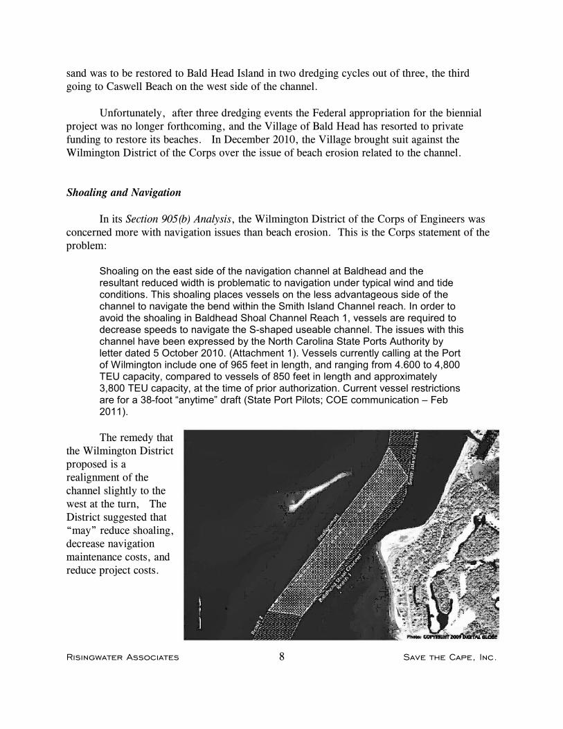
Shoaling and Navigation
In its Section 905(b) Analysis, the Wilmington District of the Corps of Engineers wasconcerned more with navigation issues than beach erosion. This is the Corps statement of theproblem:
Shoaling on the east side of the navigation channel at Baldhead and theresultant reduced width is problematic to navigation under typical wind and tideconditions. This shoaling places vessels on the less advantageous side of thechannel to navigate the bend within the Smith Island Channel reach. In order toavoid the shoaling in Baldhead Shoal Channel Reach 1, vessels are required todecrease speeds to navigate the S-shaped useable channel. The issues with thischannel have been expressed by the North Carolina State Ports Authority byletter dated 5 October 2010. (Attachment 1). Vessels currently calling at the Portof Wilmington include one of 965 feet in length, and ranging from 4.600 to 4,800TEU capacity, compared to vessels of 850 feet in length and approximately3,800 TEU capacity, at the time of prior authorization. Current vessel restrictionsare for a 38-foot “anytime” draft (State Port Pilots; COE communication – Feb2011).
The remedy thatthe Wilmington Districtproposed is arealignment of thechannel slightly to thewest at the turn, TheDistrict suggested that“may” reduce shoaling,decrease navigationmaintenance costs, andreduce project costs.

Risingwater Associates 9 Save the Cape, Inc.
Erosion of the Beaches
The rapid shoaling of the navigation channel is a consequence of a much more visibleand controversial problem–loss of sand from the beaches into the channel.
Coastal beaches are dynamic. Sand erodes under certain conditions of wind, tide, andstorm and is replenished in a complex mechanism. That is understood in general butapplication of theory to specific locations can be challenging.
In the simplest terms, waves striking the beach at an angle create a current parallel tothe shore called the “longshore current.” That carries sand along the beach, so that sand lostfrom one area is placed on another. Inlets can interrupt that flow; a natural inlet is usuallybypassed by the sand, so it can continue and accrete on the downstream side. But a navigationchannel dredged into an inlet creates a “sediment sink” that captures some of the sand as theriver tries to fill and restore itself to its natural configuration. The result is loss of sand onboth sides of the inlet, and shoaling of the navigation channel. You can’t fool Mother Nature.
The Cape Fear, Bald Head Island, and the mouth of the Cape Fear River represent anextraordinarily complex system. The inlet, 6,650 feet wide, is the largest river inlet insoutheastern North Carolina. The tidal flows and river currents interact with the longshorecurrent, and all of that natural activity has been altered by dredging of the channel over nearlytwo centuries.
The Cape Fear River inlet is naturally quite shallow, less than twelve feet at the deepestpoint. In 1871, the channel on the east side was dredged to 12 feet, 100 feet wide. Between1890 and 1985, the channel was increased to 40 feet deep, 400 feet wide, removing 70 millioncubic yards of material out to disposal areas at sea This large-scale dredging led tosegmentation of the tidal delta and an eventual reorganization of the shoal complex into distincteast and west segments. Jay Bird Shoal on the western side of the inlet gained approximately11 million cubic yards, while Bald Head Shoal on the eastern side, no longer nourished by theeastward longshore current, lost 29 million cubic yards. almost 45% of its 1857 volume.
In 1998, the project to further deepen the channel in the Cape Fear River wasauthorized. Plans specified deepening the channel at the river mouth and seaward to 44 feet,with substantial widening. An analysis of cost of the deepening project in 2000 resulted in achange in the alignment of the seaward extension of the channel, giving it an eastward bend to south-southwest of Bald Head Island to avoid rock formations.
The impact on the beaches from this new project was anticipated by the WilmingtonDistrict of the Corps and municipal authorities on both sides of the channel. The largersediment sink of the enlarged channel would attract sand from the beaches at a rapid rate. TheDistrict adopted a sand management plan, calling for maintenance dredging every two years,with the sand so removed piped back to the beaches from whence it came, to Bald Head Island
Risingwater Associates 10 Save the Cape, Inc.
lsland in two dredging cycles out of three, with the third going to Caswell Beach on the westside of the inlet.
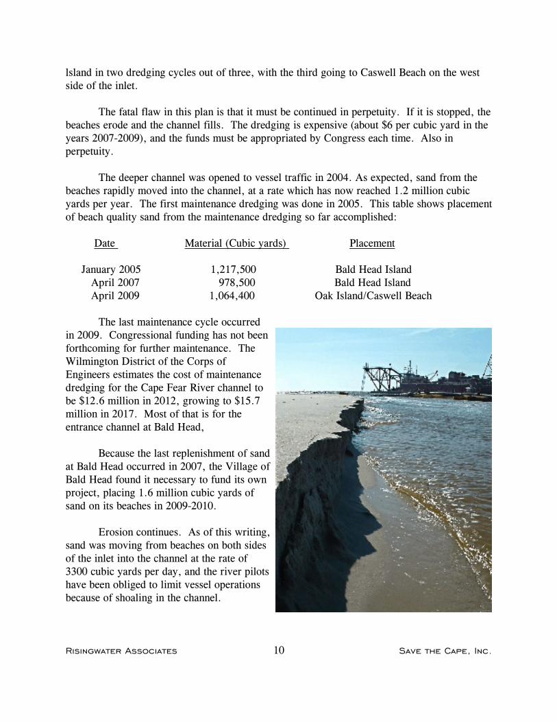
The fatal flaw in this plan is that it must be continued in perpetuity. If it is stopped, thebeaches erode and the channel fills. The dredging is expensive (about $6 per cubic yard in theyears 2007-2009), and the funds must be appropriated by Congress each time. Also inperpetuity.
The deeper channel was opened to vessel traffic in 2004. As expected, sand from thebeaches rapidly moved into the channel, at a rate which has now reached 1.2 million cubicyards per year. The first maintenance dredging was done in 2005. This table shows placementof beach quality sand from the maintenance dredging so far accomplished:
Date Material (Cubic yards) Placement
January 2005 1,217,500 Bald Head Island April 2007 978,500 Bald Head Island April 2009 1,064,400 Oak Island/Caswell Beach
The last maintenance cycle occurredin 2009. Congressional funding has not beenforthcoming for further maintenance. TheWilmington District of the Corps ofEngineers estimates the cost of maintenancedredging for the Cape Fear River channel tobe $12.6 million in 2012, growing to $15.7million in 2017. Most of that is for theentrance channel at Bald Head,
Because the last replenishment of sandat Bald Head occurred in 2007, the Village ofBald Head found it necessary to fund its ownproject, placing 1.6 million cubic yards ofsand on its beaches in 2009-2010.
Erosion continues. As of this writing,sand was moving from beaches on both sidesof the inlet into the channel at the rate of3300 cubic yards per day, and the river pilotshave been obliged to limit vessel operationsbecause of shoaling in the channel.

Risingwater Associates 11 Save the Cape, Inc.
In December 2010, the Village brought suit against the Corps of Engineers, allegingfailure of the Corps to fulfill its agreements regarding placement of sand on the Villagebeaches, which can be summed up in the allegation of “Failure to maintain the shoreline in itscondition as it existed on the date of the Corps’s final agency decision approving theAuthorized Project.“
Alternatives
This problem will not be resolved by realignment of the channel. The situation isunstable. The sediment sink would still be there, capturing sand from beaches on both sides ofthe inlet. These are alternative approaches to the problem:
Permanent funding. Annual or biennial funding by Congressional appropriation is unreliableat best, and the current discontent with the system of “earmarks” for specific projects makesthis approach unattractive without some sort of permanent funding mechanism.
The Federal Harbor Maintenance Tax. $1.25 per $1000 in value of imports, yieldsabout $2.6 million from traffic at the Port of Wilmington. Although there is a related HarborMaintenance Trust Fund, that is only a book entry. The money goes into the general fund andcan only be spent with Congressional authorization. The system would have to be revised toallocate funds to the harbor where they are earned. But in the case of the Cape Fear, It wouldbe insufficient anyway: the annual receipts would be $10 million less than the annual cost ofmaintenance dredging.
Restoration. Shoaling and the need for maintenance dredging is a function of channel depth atthe ocean bar, due primarily to the additional length of channel needed to reach deep water. Corps of Engineers records show these historical maintenance dredging volumes:

Risingwater Associates 12 Save the Cape, Inc.
In planning for the most recent channel deepening project, the Wilmington District providedthese figures.
Depth Annual Shoaling
34 feet 533,000 cubic yards38 735,00042 850,000
The figure for 42 feet was an estimate. The most recent experience with the channel,however, is shoaling at the rate of 1.2 million cubic yards per year, suggesting that therelationship of depth to annual shoaling is not linear, and that the current depth is beyond thepoint that can reasonably be sustained.
A possible solution is to abandon the efforts to maintain the channel depth and permitit to shoal back to a shallower depth, recognizing that the larger ships could no longer call atWilmington . Other river ports, on the Connecticut, Potomac, James, and other rivers in theEast have long since given up trying to serve ocean commerce, letting the vessel traffic moveto naturally deep harbors and relying on overland transportation. The incremental cost of thatwould have to be weighed against the savings in maintenance dredging for various depths.
In the case of the Cape Fear River, the stated needs of the Military Ocean Terminal atSunny Point are for a channel to be maintained from that facility to the sea at a depth of 38feet (although the depth at the terminal’s berths are shown on the chart at 31-34 feet). If a 38-foot channel cannot be justified for commerce, the cost of maintenance to that depth should beshifted to the Department of Defense.
Hardened structures. The Village of Bald Head Island has had some success with sand-filledgroins on its beaches, and suggests some sort of hardened structure between the beach and thechannel would serve to inhibit erosion. However, this is a very controversial approach,prohibited in North Carolina until the last session of the General Assembly. It falls in thecategory of “serial engineering,” in which engineered changes in waterways causeunanticipated results that then require further engineered changes.
Conclusion
The only solution with any promise is reevaluation of the economics of maintaining thechannel, and selecting an optimal shallower depth at which transportation benefits exceedmaintenance costs. To the extent that the Military Ocean Terminal at Sunny Point requires adeeper channel than commerce, that cost should be shifted to the defense budget.
Risingwater Associates 13 Save the Cape, Inc.
The Turn at Battery Island
The other part of the troublesome S-curve in the channel is the turn at Battery Island. Moving downriver, this has a 65-degree turn immediately followed by a 30-degree turn,resulting in a 95-degree change of direction for vessels using the channel. This isimmediately followed by a reverse turn to pass through the river mouth at Bald Head Island.
The configuration of the turn at Battery Island does not comply with the Corps ofEngineers standards in its Engineering Manual for vessels of the size for which the existingchannel was designed–“Panamax” vessels of 965-foot length and 106-foot beam, nor does itcomply with international standards for such turns. The problems with this configuration areaddressed in a recent Corps of Engineers report, the Wilmington Harbor Initial Appraisal(“section 216 report’) dated July 2010:
This turn is problematic for certain container vessels under specific conditionsof wind and tide. These particular vessels are being forced to delay their transitand await favorable tide conditions in order to serve the harbor. These delaysare expensive and result in increased transportation costs. Certain vessels arebeing subject to draft restrictions as a result of this turn (see Attachment 1).Contributing factors influencing safe maneuvering of these ships through thechannel include the ship handling characteristics and size, channelconfiguration, tide conditions, and inbound or outbound transit operation. Thehandling characteristics of certain companies' container ships are lessresponsive than other container ships of the same class. Turning these ships ischallenging due to the dimensions of the turn and the adjacent channels. BatteryIsland Channel is 2,589 feet long with a 30 degree, 36 minute turn angle at thesouthern end and a 65 degree, 3 minute turn angle at the northern end. Giventhe dimensions of the channel and a combined north and south turningmaneuver of95 degree, 39 minute, safely navigating these ships through theBattery Island Channel, and the turns at either end, is an extremely complexmaneuver. Strong ebb and flood tidal currents significantly affect shipmaneuverability. The most difficult transit of the Battery Island Channel occurswhen a ship is inbound with a maximum ebb tide current. These issues haveresulted in vessel delays and issues of vessel safety in serving the Port ofWilmington.
The river pilots have been obliged to impose draft restrictions on the larger vesselscalling at Wilmington.

Risingwater Associates 14 Save the Cape, Inc.

Risingwater Associates 15 Save the Cape, Inc.
This is not a new problem. The 1998 channel deepening was intended toaccommodate the largest vessel able to transit the Panama Canal. The issue of the channelturn for such vessels was recognized, although not addressed. In Appendix D, Engineeringand Design, to the Record of Decision released for that project in 1996, the WilmingtonDistrict compared the turns to the recently released criteria for channel turns in the Corps ofEngineers Engineering Manual 1110-2-1613:
Some of the turns did not fit the new criteria as far as the combinations of turndeflection angle and ratio of turn radius to ship length. It was decided that theauthorized turn designs were adequate at this time. The turn widths will bestudied during preparation of the plans and specifications as part of the shipsimulation model.
Simulation Studies
After the project was authorized, the Corps of Engineers arranged for tests to beconducted at a private ship simulator, the Raymond T. McKay Simulation Training andResearch Center at Dania, Florida, in 1999. The facility has a full-size mockup of a ship’sbridge, and the ability to simulate response of a vessel in a programmed channel configurationunder various conditions of current.
Test runs were conducted for a “design vessel” of 950 feet overall length and 106-footbeam, drawing 38 or 42 feet, in both ebb and flood tides. In all runs, five for each testcondition, the vessels left the marked channel. Although in a few runs grounding would haveoccurred, most were without incident because the simulation included the areas of deep waterscoured by currents on the outside of the marked channel at the turns, providing extra space.
At the suggestion of the pilots conducting the tests, a widener was added to the apex ofthe turn between Bald Head Shoal and Smith Island Range. Otherwise, the dredging projectproceeded with the original design of the channel configuration.
This issue was not addressed in a later report, an Environmental Assessment issued bythe Wilmington District in February 2000 for modifications of the alignment of the offshorepart of the channel. However, it has been a persistent problem, the subject of concern by theriver pilots who are compelled to limit passage of certain vessels to flood tide. Some vesselsare compelled to use the limits of maneuverability to negotiate the turn, and may be usingareas outside of the turn that the river has scoured to a depth equal to the channel. In 2005,the Lijnbaansgracht was involved in a grounding incident when moving downriver.
In 2011, Moffatt & Nichol revisited the issue in the NCSPA Port Business CaseProject prepared for the North Carolina State Ports Authority. Using ship simulationsoftware developed by Maritime Research Institute Netherlands, Moffatt & Nichol tested an
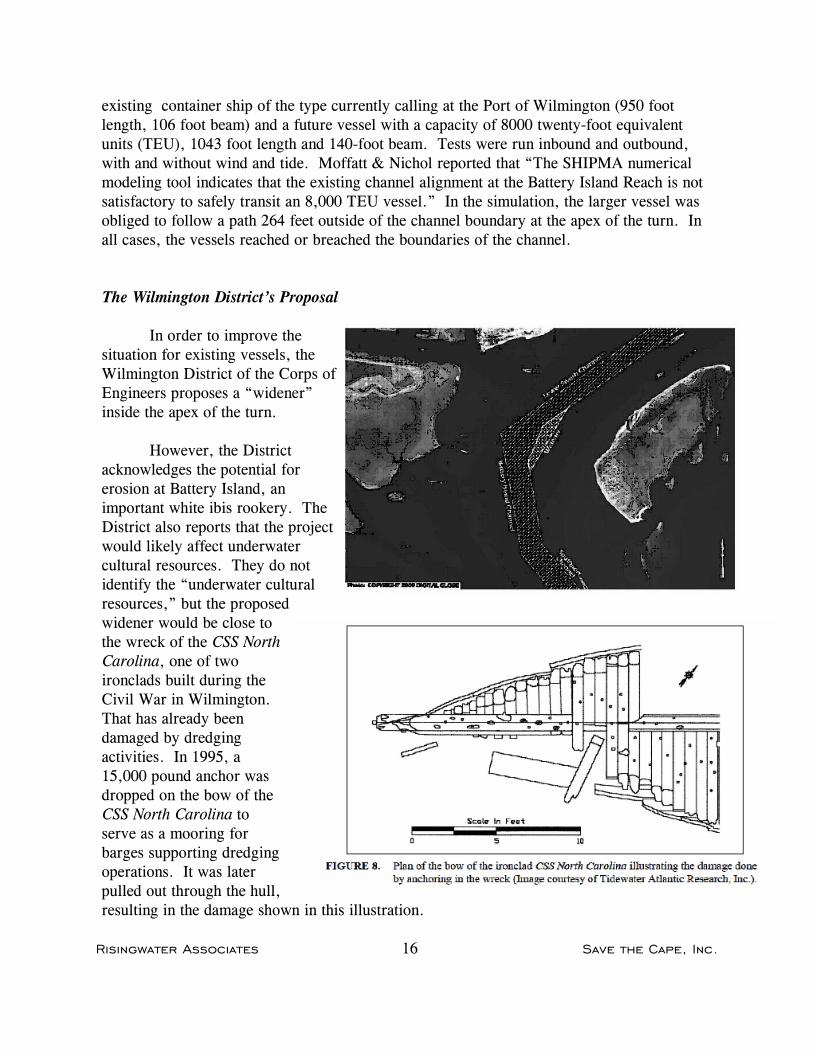
Risingwater Associates 16 Save the Cape, Inc.
existing container ship of the type currently calling at the Port of Wilmington (950 footlength, 106 foot beam) and a future vessel with a capacity of 8000 twenty-foot equivalentunits (TEU), 1043 foot length and 140-foot beam. Tests were run inbound and outbound,with and without wind and tide. Moffatt & Nichol reported that “The SHIPMA numericalmodeling tool indicates that the existing channel alignment at the Battery Island Reach is notsatisfactory to safely transit an 8,000 TEU vessel.” In the simulation, the larger vessel wasobliged to follow a path 264 feet outside of the channel boundary at the apex of the turn. Inall cases, the vessels reached or breached the boundaries of the channel.
The Wilmington District’s Proposal
In order to improve thesituation for existing vessels, theWilmington District of the Corps ofEngineers proposes a “widener”inside the apex of the turn.
However, the Districtacknowledges the potential forerosion at Battery Island, animportant white ibis rookery. TheDistrict also reports that the projectwould likely affect underwatercultural resources. They do notidentify the “underwater culturalresources,” but the proposedwidener would be close tothe wreck of the CSS NorthCarolina, one of twoironclads built during theCivil War in Wilmington. That has already beendamaged by dredgingactivities. In 1995, a15,000 pound anchor wasdropped on the bow of theCSS North Carolina toserve as a mooring forbarges supporting dredgingoperations. It was laterpulled out through the hull,resulting in the damage shown in this illustration.
Risingwater Associates 17 Save the Cape, Inc.
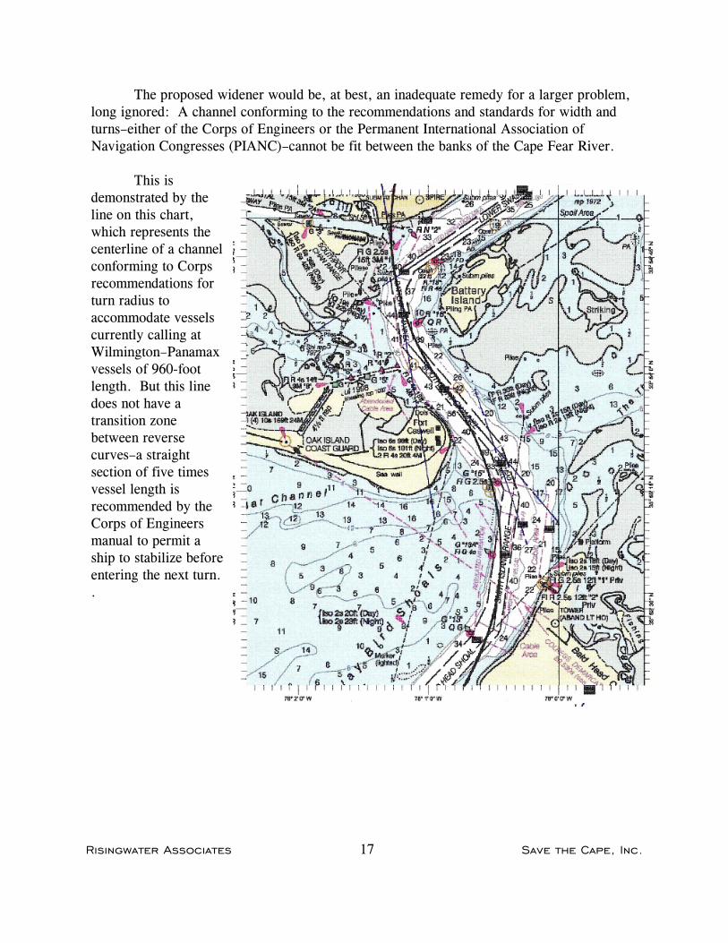
The proposed widener would be, at best, an inadequate remedy for a larger problem,long ignored: A channel conforming to the recommendations and standards for width andturns–either of the Corps of Engineers or the Permanent International Association ofNavigation Congresses (PIANC)–cannot be fit between the banks of the Cape Fear River.
This isdemonstrated by theline on this chart,which represents thecenterline of a channelconforming to Corpsrecommendations forturn radius toaccommodate vesselscurrently calling atWilmington–Panamaxvessels of 960-footlength. But this linedoes not have atransition zonebetween reversecurves–a straightsection of five timesvessel length isrecommended by theCorps of Engineersmanual to permit aship to stabilize beforeentering the next turn..

Risingwater Associates 18 Save the Cape, Inc.
Larger Ships
The limitations of the Cape Fear River were recognized by CH2M Hill, Inc., theengineering firm doing the preliminary studies for the proposed North Carolina InternationalTerminal, which would handle larger ships. In the firm’s Conceptual Dredging Study,provided to the State Ports Authority in 2008, the matter of the channel turn was addressed:
A recent engineering manual (USACE EM 1110-2-1613, Hydraulic Design ofDeep Draft Navigation Projects, Chapter 8 – Channel Width, 2006 –APPENDIX B) was used as the basis for the channel width and channel curves.One-way ship traffic was the design criterion for determining channel width.The existing channel into the Cape Fear River has a dramatic “S” curve in thefirst 4 miles inside the inlet. Once a ship passes through Baldhead and JaybirdShoals, it makes a 45-degree turn to port, immediately followed by a 105-degree turn to starboard around Battery Island, before straightening into thechannel reach known as the Lower Swash Channel and heading upriver. Thisarea is known to have a high current state on both the incoming and fallingtide. Multiple attempts were made to design a channel that followed theexisting course; however, it was found that the standards in Chapter 8 of themanual (USACE, 2006) could not be met without causing obvious impacts atthe east end of Caswell Beach or the riverfront at Southport.
Another consulting team, TEC Inc. and PF Richardson Associates, engaged to findways to reduce the cost of the planned container terminal, reached the same conclusion:
With assistance from Gahagan and Bryant Associates, Inc.(GBA) and referencesto USACE Channel Width Design Manual, it was concluded that this alignmentdid not meet USACE design standards and there were no viable modificationsthat could be performed to meet these standards.
And:
According to USACE Engineering Manual EM 1110-2-1613, reverse turns (S-bends) require a straight segment at least five times the design ship lengthbetween successive turns. This is not possible to accomplish within theconfinements of the existing waterway
Risingwater Associates 19 Save the Cape, Inc.
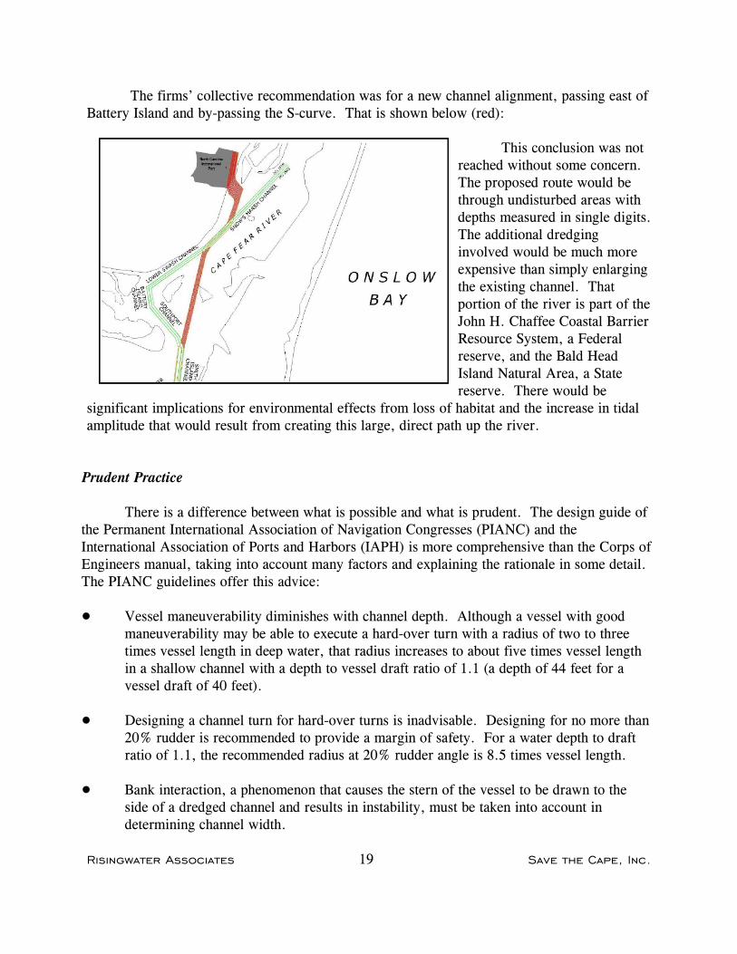
The firms’ collective recommendation was for a new channel alignment, passing east ofBattery Island and by-passing the S-curve. That is shown below (red):
This conclusion was notreached without some concern. The proposed route would bethrough undisturbed areas withdepths measured in single digits. The additional dredginginvolved would be much moreexpensive than simply enlargingthe existing channel. Thatportion of the river is part of theJohn H. Chaffee Coastal BarrierResource System, a Federalreserve, and the Bald HeadIsland Natural Area, a Statereserve. There would be
significant implications for environmental effects from loss of habitat and the increase in tidalamplitude that would result from creating this large, direct path up the river.
Prudent Practice
There is a difference between what is possible and what is prudent. The design guide ofthe Permanent International Association of Navigation Congresses (PIANC) and theInternational Association of Ports and Harbors (IAPH) is more comprehensive than the Corps ofEngineers manual, taking into account many factors and explaining the rationale in some detail. The PIANC guidelines offer this advice:
! Vessel maneuverability diminishes with channel depth. Although a vessel with goodmaneuverability may be able to execute a hard-over turn with a radius of two to threetimes vessel length in deep water, that radius increases to about five times vessel lengthin a shallow channel with a depth to vessel draft ratio of 1.1 (a depth of 44 feet for avessel draft of 40 feet).
! Designing a channel turn for hard-over turns is inadvisable. Designing for no more than20% rudder is recommended to provide a margin of safety. For a water depth to draftratio of 1.1, the recommended radius at 20% rudder angle is 8.5 times vessel length.
! Bank interaction, a phenomenon that causes the stern of the vessel to be drawn to theside of a dredged channel and results in instability, must be taken into account indetermining channel width.

Risingwater Associates 20 Save the Cape, Inc.
The channel turn from Battery Island Channel to Lower Swash is far sharper than theradius recommended by PIANC. Some vessels must use the limits of maneuverability, rudderhard over, in this area, which PIANC does not recommend.
In a recent paper presented to the New York Metropolitan Section of the Society ofNaval Architects and Marine Engineers, the authors, staff members of the Naval Academy, theCoast Guard, and the Maritime Administration, pointed out that as vessel size has increased,channels have been dredged deeper, but not wider, and maneuverability issues have not beenadequately addressed. This is a particular problem with container ships. The authors identifiedthese problems with newer generations of such ships:
! Container ships have large windage that can complicate ship controllability in narrowchannels as well as during slow speed maneuvering;
! Increases in service speeds may also increase the bare steerage speed. Direct-drive dieselships with high installed power to achieve design service speeds can, in some cases,have a minimum bare steerage speed of about 8 knots —quite a high speed in confinedwaters;
! Even the largest container ships usually have single screws, a maneuvering handicap.
! There is a trend to smaller rudders. While such rudders may be adequate at servicespeeds in open water, maneuverability in confined waters at low speed is compromised.
! Marine architects are taking advantage of the beam increases that will be possible withthe opening of new locks in the Panama Canal to decrease the ratio of vessel length tobeam, which improves load capacity without increasing draft. However, decreasing thatratio also decreases directional stability. Although this makes it easier to initiate a turn,it also makes it more difficult to check a turn.
Thus while the inadequacies of the channel in the Cape Fear River and the difficulties ofmaneuvering large container ships so far have been overcome by skillful piloting, this conflictshould not be exacerbated by opening this channel to even larger vessels.
Conclusion
The Cape Fear River cannot accommodate larger vessels than now call at Wilmington,even with channel modifications. Continued passage by the largest of the vessels currentlycalling violates the recommended practice of the Corps of Engineers and internationalstandards.

Risingwater Associates 21 Save the Cape, Inc.
The Turning and Anchorage Basin at the Port of Wilmington
The NCDENR letter of intent for cost sharing of the feasibility study includes the item:“Modifications to the size of the existing turning and anchorage basin at the Port ofWilmington.”
The chart excerpt on the right shows the existingturning and anchorage basin upriver from the facilities atthe Port of Wilmington, where the Cape Fear River is atits widest in this area. This basin was deepened to 42feet in the recent Wilmington Harbor dredging project. It is 1200 feet wide in the widest section, approximatelythe width of the river.
The 1200-foot width is intended to accommodatethe design vessel for the project, a ship 960 feet long. Twelve hundred feet feet is 1.25 times the vessel length,the minimum; 1.5 times vessel length is regarded asdesirable. Because the basin is at the minimum width,shoaling from silt moving downriver and accumulating atthe sides of the basin reduces the effective width andlimits vessel movement. The Wilmington District of theCorps of Engineers reports:
Current anchorage (turning) basin dimensions are notadequate to properly accommodate turning of some ofthe larger container vessels currently calling at the NorthCarolina State Ports Authority. Concerns regarding theseturning basin dimensions have been expressed by theNorth Carolina States Ports Authority and the shippingindustry. This is also documented in Attachment 2. Currently vessels are being turned on high tides,executing turning more slowly than normal, and engagingextra tug assistance to perform turning maneuvers.
There is little opportunity to increase the size of
the turning basin in Wilmington Harbor. As it is, it fillsthe available space. Any dredging project near the riverbanks must take into account the necessity for sloping sides, having a ratio of three feet laterallyfor every foot of depth. For 42 feet with an overdredge of two feet, 152 feet must be allowedon each side of the nominal width of the basin, unless the sides of the basin are hardened walls. The last few feet of depth of any expansion must be cut into rock.
Risingwater Associates 22 Save the Cape, Inc.
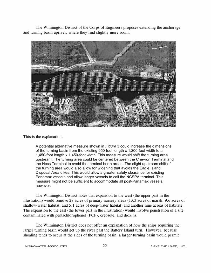
The Wilmington District of the Corps of Engineers proposes extending the anchorageand turning basin upriver, where they find slightly more room.
This is the explanation.
A potential alternative measure shown in Figure 3 could increase the dimensionsof the turning basin from the existing 950-foot length x 1,200-foot width to a1,450-foot length x 1,450-foot width. This measure would shift the turning areaupstream. The turning area could be centered between the Chevron Terminal andthe Hess Terminal to avoid the terminal berth areas. The slight upstream shift ofthe turning area would also allow for widening that avoids the Eagle IslandDisposal Area dikes. This would allow a greater safety clearance for existingPanamax vessels and allow longer vessels to call the NCSPA terminal. Thismeasure might not be sufficient to accommodate all post-Panamax vessels,however.
The Wilmington District notes that expansion to the west (the upper part in theillustration) would remove 28 acres of primary nursery areas (13.3 acres of marsh, 9.6 acres ofshallow-water habitat, and 5.1 acres of deep-water habitat) and another nine acreas of habitate. The expansion to the east (the lower part in the illustration) would involve penetration of a sitecontaminated with pentachlorophenol (PCP), creosote, and dioxins.
The Wilmington District does not offer an explanation of how the ships requiring thelarger turning basin would get up the river past the Battery Island turn. However, becauseshoaling tends to occur at the sides of the turning basin, a larger turning basin would permit

Risingwater Associates 23 Save the Cape, Inc.
longer periods between dredging to maintain adequate clearance for the current generation ofvessels.
Conclusion
The turning basin at the Port of Wilmington is subject to shoaling, and the largestvessels calling at the Port can only be turned around under limited conditions of tide. Theturning basin is already as wide as the river; enlarging the turning basin would involveexcavation of rock, loss of 37 acres of habitat (including 28 acres of primary marine nurseryarea), and penetration of land now contaminated with PCP and other toxic materials.
A wider turning basin would have limited utility: larger vessels could not reach the Portof Wilmington because of the sharp turn at Battery Island.
Economic Analysis
Before undertaking a feasibility study of a dredging or other water resources project,section 905(b) of the Water Resources Development Act of 1986 requires the Corps ofEngineers to perform a “reconnaissance study ...to determine whether or not planning todevelop a project should proceed to the preparation of a feasibility report.” Section 905(b)further requires “a preliminary analysis of the Federal interest, costs, benefits, andenvironmental impacts of such project... .”
In its Section 905(b) Analysis, the Wilmington District of the Corps estimates the cost ofthe three minor improvements to Wilmington Harbor at $41.1 million. Over a 50-year lifetime,that represents an average annual cost of $2,450,000.
The Corps calculates benefits of a project from the improvements based on anticipatedtransportation cost savings. For the three minor improvements, the Wilmington District basesits benefit calculations on the use of post-Panamax vessels loaded to less than capacity in orderto reduce draft to less than 42-feet. The District does not specify the size of the vessels, but bydefinition, a “post-Panamax” vessel is larger than the largest of those now calling atWilmington, which are called “Panamax,” the largest that can fit through the Panama Canaltoday.
The calculations are not fully set out in the report. The District determined that the useof light-loaded vessels would save $16.80 per twenty-foot equivalent unit (TEU) of containers. Then the average annual benefits are stated to be $9,750,000.
To achieve average annual benefits of $9,750,000 at $16.80 per TEU, 580,000 TEUwould have to be carried in light-loaded post-Panamax vessels. Earlier in the Section 905(b)

Risingwater Associates 24 Save the Cape, Inc.
analysis, the District states the capacity of the container terminal at the Port of Wilmington tobe 300,000 TEU annually. That means the claimed benefits are impossible. The District doesstate that the capacity can be increased, but does not speculate as to the amount of such increasenor does the District provide an estimate of the cost. We note that the Port of Wilmington hasnever handled 300,000 TEU in a single year.
The Wilmington District disregards these factors:
! It would not be prudent, practical, or even possible for post-Panamax vessels to navigatethe turn at Battery Island, even with the proposed widening.
! The use of a new generation of vessels loaded to less than capacity is inefficient, and thelikelihood of a shipping line using assets in that manner when fully-loaded vessels can besent to Charleston, Norfolk, Baltimore, and Port Elizabeth/Port Newark, New Jersey isremote.
The economic analysis of the North Carolina International Terminal, the very largecontainer terminal planned for Southport and included in the report as an alternative, is alsodistorted to show a surplus of benefits over costs. That analysis assumes “capture” of containertraffic from other ports to achieve annual container movements of 3.000,000 TEU, which is tento twelve times the container movements through the Port of Wilmington in its best year andmore than any container terminal on the Atlantic coast except the combined terminals at PortElizabeth and Port Newark, New Jersey. The use of benefits transferred from other ports is notonly improper in an analysis that is supposed to have a National perspective, but is expresslyprohibited by section 904 of the Water Resources Development Act of 1986.
See Appendix A.
Inasmuch as the project involves three separate issues, the correct approach would beseparate evaluation:
(a) If the problem of beach erosion at the river mouth can be attenuated to some extent,savings in maintenance dredging and beach nourishment would be very substantial.
(b) Any improvement to the channel turn at Battery Island would have some measurablebenefit in reduction of delays for tides, but there is no prospect of permitting passage bylarger vessels.
(c) Widening the turning basin at Wilmington would also have measurable benefits inreduction of delays for tides and longer periods between maintenance dredging. Therewould not be savings for larger vessels–they could not get there.

Risingwater Associates 25 Save the Cape, Inc.
Study Format
The Wilmington District of the Corps of Engineers and the Secretary of the NorthCarolina Department of Environment and Natural Resources both contemplate a feasibilitystudy under section 905(a) of the Water Resources Development Act of 1986, as if this were anew project.
It is not. The three issues identified in the NCDENR letter of intent for a feasibilitystudy all emerge from the Wilmington Harbor Improvement Project authorized and commencedin 1998. That project is not yet complete. The three issues would constitute reanalyses ofissues covered in a previously completed study, and as such should be addressed in a generalreevaluation report as specified in the Corps of Engineers Engineering Regulation 1105-2-100,Planning Guidance Notebook. Indeed, the Wilmington District of the Corps of Engineerscommenced a General Reevaluation Report for the Wilmington Harbor Project in 2005, andincluded in its scope another turning and anchorage basin in the Cape Fear River above theanchorage basin intended to be studied in the feasibility study contemplated by NCDENR. Progress on that report stopped in 2009.
The cost sharing formulae for general reevaluation reports and feasibility studies are notthe same. The costs of feasibility studies are shared equally between the Federal governmentand the State sponsor (with some costs borne entirely by the Federal government). A generalreevaluation report would be part of the authorized project and costs would be shared in thesame ratio as that project, 65% Federal and 35% non-Federal. The non-Federal sponsor, theState of North Carolina, would be responsible for 25% of the cost as the study progressed, with10% of the cost being deferred.
For a feasibility study costing $10.1 million, the amount estimated by the WilmingtonDistrict, this table shows the difference in the North Carolina share (assuming the cost can beheld to $10.1 million):
Feasibility Study General Reevaluation Initial Final
Federal share $5,293,000 $7,565.000 $6.556,000 State share 4,793,000 2,521,000 3,530,000 Total $10,086,000 $10,086,000 $10,086,000
If the cost of the study is held to $10,086,000, the State would have an immediate savingof $2,272,000 with the general reevaluation, but would be obliged to reimburse the Federalgovernment $1.009,000 over 30 years, reducing the final savings to $1.263,000. However,such feasibility studies are rarely completed within the original cost estimate. Navigation

Risingwater Associates 26 Save the Cape, Inc.
improvement studies usually disclose a plethora of problems–environmental and otherwise–thatrequire substantial unanticipated analysis and extend the schedule and the costs significantly.Recent experience with studies for the Savannah River and the Delaware River suggest that afinal cost in the range of $20 million to $30 million is more likely.
See Appendix B.

Risingwater Associates 27 Save the Cape, Inc.
Sources
CH2M Hill, Inc., Conceptual Dredging Study, North Carolina State Ports Authority (2008).
William J. Cleary, Overview of Oceanfront Shorelines: Cape Lookout to Sunset Beach, NC(2008).
William O. Gray, Jennifer Waters, Alan Blume, and Alexander C. Landsburg, Channel Designand Vessel Maneuverability - Next Steps (2002)
International Maritime Organization, Standards for Ship Manoeuverability, ResolutionMSC.137(76) (2002).
Moffatt & Nichol, NCSPA Port Business Case Project (2011).
Olsen Associates, Inc., Bald Head Island, N.C., Beach Monitoring Program, MonitoringReport No. 9, (May 2010 to May 2011).
Permanent International Association of Navigation Congresses (PIANC), Approach Channels, aGuide for Design, Final Report of the Joint Working Group PIANC-IAPH, Supplement toBulletin no 95, (1997).
Risingwater Associates, A Look at the Channel Turns in the Cape Fear River (2011).
TEC Inc./PF Richardson Associates, North Carolina International Terminal, Review ofPlanning Concepts and Privatization Options (2010).
United States Army Corps of Engineers, Deep-Draft Coastal Navigation Entrance ChannelPractice, Coastal and Hydraulic Engineering Technical Note IX-1 (1999).
United States Army Corps of Engineers, Hydraulic Design of Deep Draft Navigation Projects,Chapter 8 – Channel Width– APPENDIX B (USACE EM 1110-2-1613, 2006 )
United States Army Corps of Engineers, Civil Works Review Policy, EC 1165-2-209 (2010).
United States Army Corps of Engineers, Planning Guidance Notebook, ER 1105-2-100 (2000).
United States Army Corps of Engineers,, Review of Decision Documents, EC 1105-2-410(2008).
United States Army Corps of Engineers, Philadelphia District, Delaware River ComprehensiveNavigation Study, Main Channel Deepening, Final Interim Feasibility Study and EnvironmentalImpact Statement (1992).

Risingwater Associates 28 Save the Cape, Inc.
United States Army Corps of Engineers, Philadelphia District, Delaware River Main ChannelDeepening Project (Pennsylvania, New Jersey, and Delaware) Economic Update for FY 2011Budget (2009).
United States Army Corps of Engineers, Wilmington District, Environmental Assessment.Preconstructi/on Modifications of Authorized Improvements, Wilmington Harbor, NorthCarolina. (2000).
United States Army Corps of Engineers, Wilmington District, Feasibility Report onImprovement of Navigation, Cape Fear–Northeast Cape Fear Rivers Comprehensive Study,Wilmington, North Carolina (1996)
United States Army Corps of Engineers, Wilmington District, Reevaluation Report, SandManagement Plan, Wilmington Harbor Navigation Project (Draft 2011).
United States Army Corps of Engineers, Wilmington District, Section 905(b) Analysis,Wilmington Harbor Navigation Improvement Project, North Carolina International Terminal(2010)
United States Army Corps of Engineers, Wilmington District, Section 905(b) Analysis,Wilmington Harbor Navigation Improvements, North Carolina International Terminal (2011)
United States Army Corps of Engineers, Wilmington District, Wilmington Harbor InitialAppraisal (2010)