the flood spillway rees - wsv · coordinates the requirements of the flood control, the general...
TRANSCRIPT

The flood spillway Rees
Wir machen Schifffahrt möglich.

2
The Rhine – important European waterway
Legends and fairy tales, sunny and charming landscapes – that is associated with the romantic side of the Rhine.
But not only the romance of the Rhine characterises this great European river. It was and still is essential for the economic and social development of the riparian states.
Large economic and trade centres have been established along the Rhine. Many of them use the Rhine as a major shipping waterway. With approximately 171 million tons of freight, the Rhine remains, also in 2008, the busiest waterway in Europe. Approx. 70 % of all German water-way transports are moved on the Lower Rhine, between the Rhine estuary ports and the German inland ports.
The Rhine, however, has not only brought economic wealth for its residents. In earlier times, devastating floodwaters have flooded the cities and people lost their lives. The river stayed unpredictable, it changed its course with every flood. Not until the rule of Frederick the Great, it was started to define the riverbed on sched-ule, to fix the river banks and to protect the settlements against floods.
The next step was to improve the navigability. At the Middle and Lower Rhine the water engineers succeed-ed in preventing the progressive brutalization of the navigable riverbed. The existing, but too shallow ship-ping lanes were made better navigable by regulatory measures. These interventions for the protection of the people and for the safety and smoothness of the ship-ping traffic did not only have positive effects.
Today the relationships between the riverbed width, the water depth, the current and the amount of bed load are known:If the Rhine has the space to spread out, it flows too slowly and deposits its bed load. This results in hinder-ing sedimentation in the stream – at high tide also on the banks.
If narrowed down in its riverbed, the Rhine sets the pace and picks up too much scree, gravel and sand from its ground (erosion).
At slower flow, this bed load is then deposited at un-wanted places again. Freed of such load, the water with its renewed power picks up bed load again and affects the downstream riverbed again.
This problematic cycle which causes millions of costs be-cause the sedimentations of the river have to be dredged again and again and the erosion areas have to be refilled again. This is necessary to ensure the safety of the shipping and the buildings on the banks of the Rhine.

3
Nature and landscape are also saved this way, because it prevents a down welling of the ground water levels.
The Federal Waterways and Shipping Administration is working on an eco-friendly design and stabilization of the Rhine, so that it can flow balanced at all water levels and the damaging erosions and sedimentations are reduced over time.
The Federal Waterways and Shipping Administration coordinates the requirements of the flood control, the general water management, the nature protection and the shipping. The flood spillway Rees is a water con-struction project of the Waterways and Shipping Office Duisburg-Rhine.
Total length
Spring
Water mouth
Catchment area
Population
Navigable area
1,240 km
Swiss Alps
North Sea
185,000 km2
Rd. 50 million
885 km (from Rheinfelden - North Sea)
Upper Rhine
Middle Rhine
Lower Rhine
from Rheinfelden to Kaub
from Kaub to Cologne
from Cologne to Emmerich
The navigable Rhine is divided into sections because of
different gradient:
Data

mean water flood spillwayhighest flood water
Sketch flood spillway and Rhine
4
At the “Reeser Rheinbogen” the river curves… which is quite a picturesque view to an observer.
But if one looks beneath the idyllic surface, the problems of this narrow point become visible. The soil erosion here adds up to about two centimetres per year, which makes the water increase its speed rapidly.
This has serious consequences: the current pressure on the city wall of Rees increases and the threat of a flood is getting stronger for the residents. The shipping traffic has no stable waterway conditions any more. Further-more, the groundwater level drops in near-shore areas causing the flood plains to dry out in the long term, which in turn has negative effects on moisture-loving animals and plants.
In order to control these erosion processes at these narrow points sustainable, a soil stabilization program is carried out between Duisburg and Emmerich since the early 90s. The construction of the flood spillway Rees forms a tessera in the entire catalogue of measures, which rediscovers the benefits of slowness and uses it for the river, its residents and the environment.
The three kilometre long and between 150 and 180 metres wide flood spillway, which arises on the left bank opposite Rees, offers the Rhine an additional out-flow option from a water level of 80 centimetre above mean water. It can absorb up to 18 percent of the total
amount of water of the main current.
In this case the flood plains are also flown through, which significantly improves the flood water situation for the upper Rhine riparian. The water level is reduced by up to ten centimetres.
The construction of the flood spillway Rees will cost the Federal Government around 50 million euros. With it is also used for flood control, the state of NRW is engaged in it with 4 million euros. The flood spillway is built starting September 2009. Within five years, it is designed as a near-natural branch with a trapezoidal cross-section. Its ground is 30 to 40 metres wide and receives a slightly rising embank-ment.
Starting in the area of the ferry ramp, the flood spillway takes its final shape step by step in a total of 21 sectors towards the direction of Obermörmter. Work is done respectively in a section of 100 metres. In this way it is ensured that for the benefit of the environment, always only the smallest possible area is used as a building site.
The ecological monitoring by experts ensures, that the needs of the nature are respected. Consideration is given to the breeding seasons of the bird species, taboo areas are not entered. In order to reach benefits with regard to good living conditions for the endangered crested newt, the amphibian’s pond is sealed with a clay blanket.
* Mean water (MW): average of the daily water levels that was
measured over a longer period of time at a certain point.
Flood spillway Rees – the construction project

mean waterhighest flood water
Rhine
Rees
5
In addition, surfaces are lowered to ecologically en-hance the Reeserschanz, which has been excavated and refilled in large parts in the 20s. Before the vegetation of the construction field is re-moved, there will be an ecological inspection to ensure the safety of possible animals living there. After that the floater dredgers begin their work. The excavated topsoil is stored before it is used again to cover the other sur-face. The soil mass that is not needed – a total of 2.1 mil-lion cubic metres – is taken away with hopper barges where they are either recycled or disposed of.
Erosion protection mats are laid on the fine sand of the riverbed. Water blocks are filled on top of it, which have an overall weight of 370,000 tons. Before they are
positioned, construction divers check the exact location of the geotextile mats. Wire mesh baskets filled with topsoil, hydro seeding and reed beds are embedded and planted in places where the current pressure allows it. Finally, an overflow barrier to the Rhine is secured with stones, so that the flood spillway can undertake its task after its completion.
The ferry service can be maintained during the entire construction period. A new ferry ramp is formed at the landward bank of the flood spillway. Even at this point, the line of sight to the Rhine promenade of Rees on the opposite bank is ensured for the ferryman at all times.

6
May there always be a hand‘s width of water beneath the keel … as one wishes it at every ship’s christening.
The depth of the navigation channel is for the Lower Rhine 2.80 metres at low water level. To provide a secure waterway depth and width of 150 metres for the ship-ping at all water levels is one of the duties of the Water-ways and Shipping Administration.
The Lower Rhine between Orsoy and the Dutch border evolved over time to the waterway with the largest volume of traffic in Europe. Forecasts assume that the transport of bulk goods by ship will continue to increase. Inland navigation is one of the most efficient, cost-effec-tive and safest modes of transport. It thereby contributes to the environment and climate protection and achieves a high economic value for the society.
In its narrow curves, the Rhine digs itself more and more into its bed because of the soil erosion. In Rees this adds up to approximately two centimetres per year. Due to the erosion, sedimentation occurs in other areas, which impede the shipping.
In the outer curves of the course of the river, consider-able current forces concentrate which tear open the riverbed. Large cavities are formed there, also called scours. In the inner curves on the other hand, the water flows rather sluggish and deposits gravel and sand. In the long run, these deformations of the riverbed lead to a reduction in the water depth and width, causing serious restrictions for the shipping traffic, since the ships can load less.As a result, these bottleneck routes determine the effi-ciency of the entire waterway.
Flood spillway Rees –safety and smoothness for the shipping traffic

7
For the safety and smoothness of the shipping traffic, stable waterways of sufficient depth and width as well as moderate current velocities are essential. For this reason, the Federal Transport Infrastructure Plan for the Lower Rhine provides a soil stabilization program. Up to now, this task was performed by backfilling the erosion areas over and over again in order to balance the sediment deficit, which was very time-consuming and cost-intensive. The flood spillway Rees now contributes to reduce this deficit significantly.
Once the flood spillway is put into operation, it takes over the function of a bypass. It lowers the water level of the main current and, consequently, also the extreme current velocity. It is as it were “held back”.
The targeted reduction of the soil erosion is perma-nently achieved, so that future restrictions for the shipping can be avoided. The ships can continue to drive economi cally, because they always have a steady hand‘s width of water beneath the keel.

8
They still exist – the endangered bird species black-tailed godwit, the crested newt and the wolf spider Arctosa ci-nerea, even though not much of the original animal and plant communities of the Reeserschanz were preserved.
Today, these flood plains are again among the valuable and protected habitats, which are found as a relatively dense setting of nature and landscape protection areas along the Rhine.
The Reeserschanz is under nature protection in the area of the county Wesel and under landscape protection in the area of the county Kleve. The nature protection area comprises two FFH* - areas and is also part of the EU bird sanctuary as well as “the wetland of international importance Lower Rhine”, according to the RAMSAR Convention*. The goal is to restore and preserve “the good state of preservation of the natural habitats and of the wild fauna and flora”.
The flood spillway Rees –for the protection of nature and habitat
* FFH: The fauna – flora – habitat guideline from 1992 created
a legal instrument for the habitat and species protection in the
European Union.
* The RAMSAR Convention is an international contract about
wetlands of international importance. The composition was initi-
ated by the UNESCO and entered into force in 1975.
9
The groundwater consistently dropped here because of the soil erosion of the Rhine and led to ecological damage. In recent years, therefore, the blinks were filled up by sedimentation – these are shallow ponds that may fall dry in summer. This caused a lack of larger shallow water and mud expanses, which decreased the species diversity of the grassland birds on a continuing basis. In the near-natural developed flood spillway the water level at low water is about 2.20 to 2.50 metres. At 80 cen-timetres above mean water – at the time when the flood spillway “starts operating” – it measures four metres. At the same time, in this case, foreland areas are flooded which will revive the wetland fauna and flora. The pop-ulation of the black-tailed godwit, the corn bunting, the redshank, the meadow pipit, the oystercatcher as well as the lapwing and the skylark can increase again.
Between the branch of the flood spillway and the main current a relatively sheltered island area of about 300,000 square metres evolves. This area is not acces-sible for visitors, so that the animals and plants find an optimal habitat.
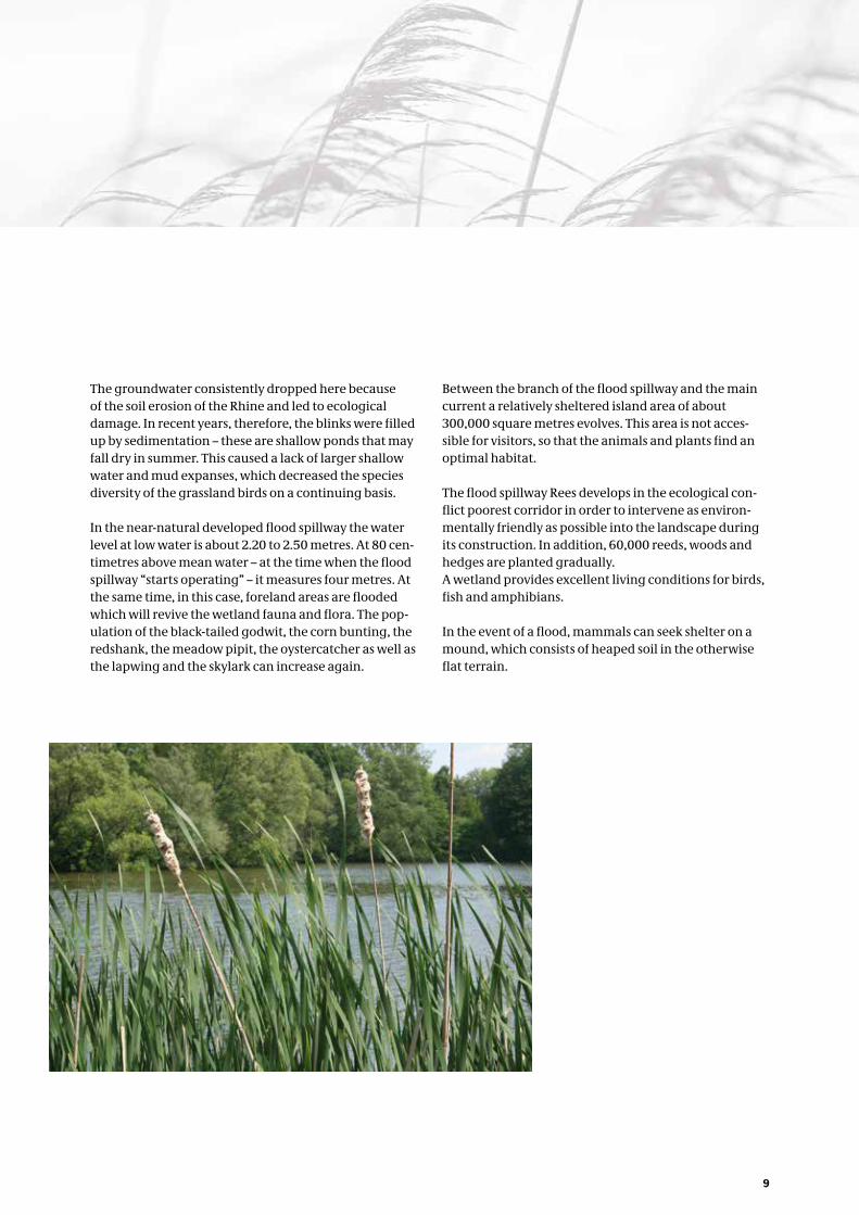
The flood spillway Rees develops in the ecological con-flict poorest corridor in order to intervene as environ-mentally friendly as possible into the landscape during its construction. In addition, 60,000 reeds, woods and hedges are planted gradually.A wetland provides excellent living conditions for birds, fish and amphibians.
In the event of a flood, mammals can seek shelter on a mound, which consists of heaped soil in the otherwise flat terrain.

10
A river starting with the letter R? That is a popular question in the quiz “City-Land-River”. Not only puzzle players spontaneously answer to that with the solution word “Rhine”. The river has a high level of popularity and attracts residents, daily visitors and tourists from all over the world every year.
To the question “Why is it so beautiful at the Rhine?” they give, however, quite different answers. People, who live near the river and enjoy their front row seat, already know what a recent study has found out: that the vast majority of the population enjoys spending their spare time at or on the river and recover there.
Some love it to sit in a café comfortably, which offers them a grand view of the “Father Rhine” and the leisure-ly passing ships. Others enjoy the stay at the river rather on one of the passenger ships or pleasure boats, while some directly make a reservation for one of the popular river cruises.
The more athletic-minded people prefer to discover the region and the Rhine on the bike. Touring cyclists select routes that grant them, apart from the exercise in the fresh air, an unhindered view of the wide flood plains with its willows, poplars, meadows and the stream.
Leisure and recreation on the waterway
Although the triad of “Summer-Rhine-Tourism” heralds a new high season every year, boosting the economic development of the region, the river landscape has its own charm in every season. These result from unusual perspectives of space, special view relations and light reflections. The Artic geese, that set up their winter quarters at the Rhine, as well as the flood water attract and fascinate numerous trippers over and over again. The Rhine, with its improved water quality attracts fish-ermen strongly in the meantime again. Just as well as swimmers, who should absolutely abandon a life threat-ening bath in the river. Skilled water sportsmen like canoeists, sailors, rowers and skippers of a pleasure craft experience on their trips the fascination of their sport as a direct encounter with the water, wind and waves.
The area around the Reeserschanz is a popular des-tination. It is part of a bicycle track that highlights in crossing the Rhine between Reeserschanz and Rees with the passenger and bicycle ferry “Rääße Pöntje”. The construction of the flood spillway Rees is another attraction and invites ecologically and structurally en-gineered interested visitors to inform themselves there. From the ferry boat, visitors can easily get an overview of the flood spillway and its construction progress.

11
The Federal Waterways and Shipping Administration
The Federal Government is the owner of the Federal Waterways. It is managed through its own authorities: the WSV.
Its task is,- To provide an efficient waterway infrastructure and
adapt it to the traffic-economic and technical require-ments of increasing transport flows of goods through development and new construction.
- To regulate the shipping traffic and to ensure the safe-ty and smooth of the shipping traffic, e.g. with modern traffic control systems, with quality assurance of trans-port, qualification of traffic participants.
- To monitor and to protect the transport system ship/waterway, e.g. with maintenance, with the setting and operation of nautical signals, with current police measures to prevent damage.
The WSV is subjected to the Federal Ministry of Trans-port and digital Infrastructure (BMVI) and is divided into a central instance with a Generaldirectorate for Water-ways and Shipping and its 7 branch offices and a sub instance with 39 Waterways and Shipping Authorities as well as 7 new Construction Authorities.
We make shipping possible
Waterways and Shipping Office (WSA) Duisburg- Rhine – Developer of the construction project
The Waterways and Shipping Office Duisburg-Rhine is a sub-authority in the field of the Waterways and Shipping Generaldirectorate. Its regional responsibility refers at the Lower Rhine from the city limits of Duisburg to the German-Dutch border.
The focus of the structural engineered work of the authority is the soil stabilization of the Lower Rhine. The construction of the flood spillway Rees is also associated with that. It is one of the most important and – because of its importance for the many different stakeholders – also one of the most demanding projects of the WSA Duisburg-Rhine.
The engineers of the WSA Duisburg-Rhine work in close cooperation with the Dutch colleagues on the sections of the Rhine affected by erosion. They observe very closely the changes in the structure of the riverbed and the sole, in order to react cautiously to these changes. Erosion and sedimentation processes can be controlled. It com-bines structural changes of the discharge cross-sections with a direct intervention in the sediment balance by adding sediment or dredging.
With this strategy, the employees of the WSA Duis-burg-Rhine fulfil their mission to provide an efficient and reliable infrastructure for the shipping, while con-sidering at the same time the interest of the nature and the environment.

Publisher
Wasser- und
Schifffahrtsamt Duisburg-Rhein
Waterways and
Shipping Office Duisburg-Rhine
Königstraße 84
47198 Duisburg
Phone +49 2066 418-111
Fax +49 2066 418-315
www.wsa-duisburg-rhein.wsv.de
Concept / Design
www.heyl2hopp.de
Pictures
www.wsv.de
www.plan-b-fotografie.de
© Flarotof/fotolia.com
© Heinrich Witthake/fotolia.com
© martina/fotolia.com
© V.RUMI/fotolia.com
November 2014
This publication, as part of the public relations of
the Federal Water and Shipping Administration,
is published free of charge. It may not be used for
campaigning.