the mabopane-centurion development corridor: a historical
TRANSCRIPT
The Mabopane-Centurion Development Corridor:
A historical analysis of successes and constraints and proposals for improvement
CHAPTER THREE
THE MCDC-PROJECT
SECTION A: GENERAL
1. Introduction
The Mabopane-Centurion Development Corridor" (MCDC)-project. as referred to in Chapter Two, is discussed in depth in this chapter. This incorporates a reference to the development corridor approach in the Republic of South Africa, but focuses primarily on sections reflecting the key focuses, project strategies, success stories and the institutional arrangements for the MCDC-project.
2. Background issues to the corridor development approach in the Republic of South Africa
As far back as the early 1970's, the Republic of South Africa experienced a general lack of focused urban development contributing to principles such as urban efficacy, efficiency and productivity, especially as far as public transport-orientated development is concerned. This view was expressed repeatedly in reports compiled in the past by government, amongst them the report of the Driessen Commission on Urban Transportation in South Africa, compiled in 1976 (Department of Transport, 1993).
Furthermore, the fact that government could not succeed in integrating public transport and the government's economic development policies in the 1980's and 1990's, contributed (together with the former apartheid policies) to the development of the fragmented urban complexes, as known today. The latter is expressed in official government reportsSO compiled by the national Department of Transport in the 90's, which recognised the " .. . need for affirmatively restructuring South African cities in favour of those who are disadvantaged by poverty, limited access to cars and the legacy of apartheid .. . " (Department of Transport, 1993).
Although several attempts were since then initiated to promote the government's economic development policy and to implement projects (to get public transportation to support adjacent development), the Department of Transport in terms of an investigation into "Joint venturing institutions for integrated development along public transport corridors" (completed in 1993),
49 The MCDC is localed within the boundaries of the former GPMC (now the City of Tshwane Metropolitan Municipal ity) , situated in the Gauteng Province of the Republic of South Africa.
50 See African National Congress (1994), Department ofTransport (1993 and 1998a) and Naude (1996).
97
could not obtain substantial results where public transport supports adjacent land-use development enough. It could therefore be deliberated that the development corridor initiatives launched in 1995 as a joint venture between national and local government spheres, were the first real attempts to pilot projects focussing on the integration of land-use and transport planning .
The initiation of development corridors, with the primary purpose of integrating transport and land-use planning as to promote public transport use, was for the first time introduced actively through the "Four Cities"-project (see paragraph 2 on page 1 9 in Chapter Two for detail) . The national Department of Transport initiated the "Four Cities "-p roject in 1995, as the Department's contribution to the national government's SDI programme. When evaluating the nature of the individual "Four Cities"-projects, all are related in some or another way in addressing unbalanced development, with special focuses to relieve urban and transportrelated problems experienced by the disadvantaged. The MCDC-project51 is no different (as is explained in more detail in the rest of this chapter) .
The Spatial Development Initiatives (SDI 's) such as the Maputo Development Corridor discussed in Chapter Two, are considered to be the first attempt to implement the country's economic development policy. It is generally developed according to a process based on the identification of key areas, each with its own specific economic focus and core characteristics. Strategies on lead economic sectors to promote investment are then compiled and marketed as catalyst projects to enhance economic growth. Furthermore, the SDI's encompass existing or proposed infrastructure especially road infrastructure, causing the creation of one or other form of development corridor (Naude, 2000). The SDI 's took on different forms, such as Special Economic Zones (SEZ's) , Development Corridors, Industrial Development Zones (IDZ's) , or specific city precincts (Urban-Econ Development Economists, 2000b) .
In 1998 the national Department of Transport introduced the "Moving South Africa Strategy (MSA)", to further enhance the development and use of public transport (Department of Transport, 1998a) as well as to density areas along transport corridors (Krynauw, 2000) . Regarding the latter, the MSA is strongly taking into account the " ... global context of falling trade barriers, increasing linkages to the global economy and increased competition for global markets .. . ".
However, the MSA regards the improvement of transport in the Republic of South Africa as an "enabling industry", to function as a "guarantor of national integration". From an urban development point of view, MSA strongly promotes volume concentration through the development of "high volume corridors" to reduce cost for both operator and user as well as to address users' transport needs. In fact, three key strategies emerge from the MSA. These include the densification of corridors and nodes to reach appropriate economies of scale for public transport and the economic activities found along the corridor, improving the affordability of different transport modes and to improve public transport efficiency.
51 Just more than 82% of the poorest part of the population of the former Greater Pretoria Metropolitan Area reside in the identified Primary Study area of the MCDC-project (see paragraph 4.1 on page 118). When considering the Secondary Study area (see paragraph 4.1 on page 118), the MCDC-project has a direct influence on almost 95 % of the poorer communities resid ing in and around the fenner Greater Pretoria Metropolitan Area (now included in the City of Tshwane Metropolitan Municipality).
98
SECTION B: THE KEY FOCUS OF THE MCDC-PROJECT
This section reflects the project focus of the MCDC-project by means of an explanation of the chronological sequence of events which happened between the initiation of the idea to establish a development corridor in the former Greater Pretoria Metropolitan Area and the 1 sl
of May 1996 when the planning activities of the MCDC-project were initiated.
1. Introduction
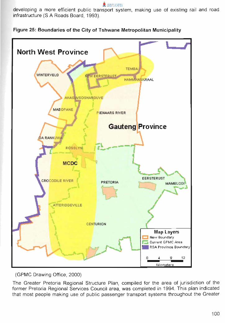
The MCDC-project" is a joint venture project initiated in November 1995 and involves all spheres of government, the private sector and communities. The former GPMC managed the project until the establishment of its successor-in-Iaw, the City of Tshwane Metropolitan Municipality (see Figure 25 on page 100), which was established on 5 December 2000, took it over. The establishment processes of the MCDC were initiated after the approval of the MCDC Integrated Growth and Development Implementation Strategy (IGDIS) (see paragraph 4.8 in Section C: on page 139 for detail) in September 1997 (GPMC, 1997c). This IGDIS report was the result of 15 months of multi-dimensional background research , brainstorming exercises , workshops, participative processes and focused strategic thinking . It forms the backbone of the establishment of the corridor and consists of a development perspective of the MCDC area , an economic development rationale and development strategy, an integrated development framework, strategic implementation projects and implementation strategies. (Urban-Econ Development Economists, 1997b)
2. Background to the initiation of the MCDC-project
2.1. General
A study tour group to South American cities, consisting of officials representing the Gauteng and North West provincial authorities, SA rail authority, Johannesburg City Counci l, PREMET, taxi operators and transportation planning consultants in 1995 (14 to 28 August 1995), came to the final conclusion that " .. . integrated land-use planning is essential to, inter alia, successful public passenger transport services. This needs to be backed up by the committed implementation of politicians and developers, if success is ultimately to be achieved ... ". (Department of Transport , 1995).
In a study done by the SA Roads Board on the improvement of mobility as a result of land-use planning, it was concluded with regard to Pretoria as a case study, that a " ... combination of infilling and densification will produce significant travel time and travel cost savings, particularly if the infilling and densification are complementary to the development of public transport corridors ... ". This conclusion stressed the need for the development of corridors in the former Greater Pretoria Metropolitan region, especially that of the MCDC area , which focuses on improving mobility and accessibility in the western parts of the former Greater Pretoria Metropolitan Area (S A Roads Board , 1993). The same study revealed that significant "accessibility benefits" are obtained where economic development activities are concentrated in mixed-use corridors. The study also confirmed that corridor development will assist in
52 The MCDC-project is regarded as an urban reconstruction project with the aim of developing a metropol itan development corridor on the western side of the former Greater Pretoria Metropolitan Area (Urban-Econ Development Economists, 1997b).
99
developing a more efficient public transport system, making use of existing rail and road infrastructure (S A Roads Board, 1993).
Figure 25: Boundaries of the City of Tshwane Metropolitan Municipality
North West Province
ROSSLYN
MCDC
ATIERIDGEVILLE
I ('
TEMBA
HAM N fl RAAL
PIENAARS RIVER
Gauteng Province
PRETORIA
CENTURION
(GPMC Drawing Office, 2000)
Map Layers C New Boundary
~ Current GPMC Area
• RSA Province Boundary
O ... _4,==:::::J8 ... _ 12 Kilometers
The Greater Pretoria Regional Structure Plan, compiled for the area of jurisdiction of the former Pretoria Regional Services Council area, was completed in 1994. This plan indicated that most people making use of public passenger transport systems throughout the Greater
100
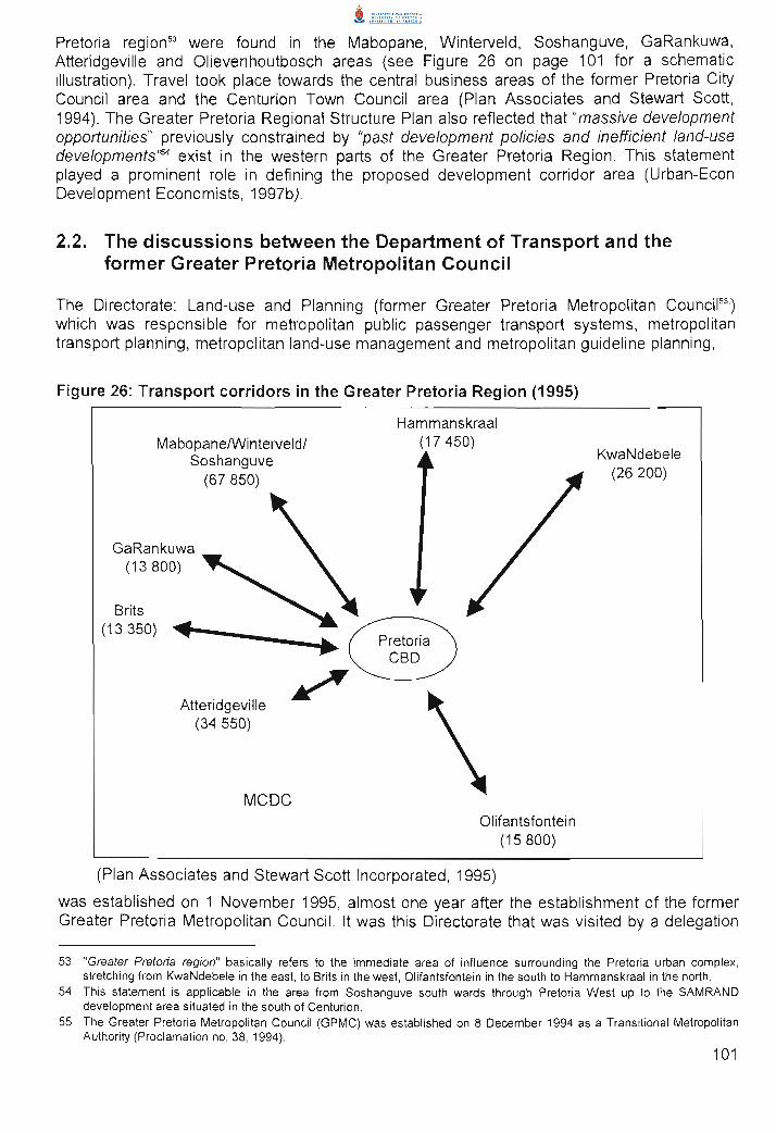
Pretoria region" were found in the Mabopane, Winterveld, Soshanguve, GaRankuwa, Atteridgeville and Olievenhoutbosch areas (see Figure 26 on page 101 for a schematic illustration). Travel took place towards the central business areas of the former Pretoria City Council area and the Centurion Town Council area (Plan Associates and Stewart Scott, 1994). The Greater Pretoria Regional Structure Plan also reflected that "massive development opportunities" previously constrained by "past development policies and inefficient land-use developments'''' exist in the westem parts of the Greater Pretoria Region. This statement played a prominent role in defining the proposed development corridor area (Urban-Econ Development Economists, 1997b).
2.2. The discussions between the Department of Transport and the former Greater Pretoria Metropolitan Council
The Directorate: Land-use and Planning (former Greater Pretoria Metropolitan Council") which was responsible for metropolitan public passenger transport systems, metropolitan transport planning , metropolitan land-use management and metropolitan guideline planning ,
Figure 26: Transport corridors in the Greater Pretoria Region (1995)
MabopanelWinterveldl Soshanguve
(67850)
GaRankuwa (13800)
Brits (13 350) "IIII .. t--__ -4~ ..
Atteridgeville (34550)
~
MCDC
Hammanskraal (17450)
Pretoria eBD
Olifantsfontein (15 800)
(Plan Associates and Stewart Scott Incorporated, 1995)
KwaNdebele (26200)
was established on 1 November 1995, almost one year after the establishment of the former Greater Pretoria Metropolitan Council. It was this Directorate that was visited by a delegation
53 "Greater Pretoria region" basically refers to the immediate area of influence surrounding the Pretoria urban complex, stretching from KwaNdebele in the east, to Brits in the west, Olifantsfontein in the south to Hammanskraal in the north.
54 This statement is applicable in the area from Soshanguve south wards through Pretoria West up to the SAMRAND development area situated in the south of Centurion.
55 The Greater Pretoria Metropolitan Council (GPMC) was established on 8 December 1994 as a Transitional Metropolitan Authority (Proclamation no. 38, 1994).
101
of the national Department of Transport on 14 November 1995 to discuss the possibility and interest of the former GPMC to initiate a development corridor project in the former Greater Pretoria Metropolitan Area.
During the meeting it was mentioned by the representatives of the Department of Transport that funds for development corridor projects were negotiated with the former office of the Reconstruction and Development Programme. The approved funds were earmarked strictly for projects aimed at integrating land-use and transport planning by applying urban development corridor principles. Specific attention was also requested for the incorporation of fast track implementation projects in the initiation of such development corridor projects.
The interest of the former Greater Pretoria Metropolitan Council to initiate such a development corridor project was followed with a request from the representatives of the national Department of Transport to submit a business plan for consideration. This business plan had to be submitted to the Department of Transport by 22 November 1995, only 8 days after the meeting on the 14 November 1995 took place (Krynauw, 2000b) .
3. The project processes of the MCDC-project
3.1. Nov 1995 to April 1996
3.1.1. The Nov 1995 business plan
The Division: Metropolitan Guideline Planning (a former Division in the former Directorate Land-use and Planning of the former GPMC), took the responsibility of compile the business plan for the proposed corridor project. The business plan was compiling according to the standard guidelines for the preparation of business plans for the former Office of the Reconstruction and Development Programme. The contents of the business plan, as given below, forms an important base of the focus of this project, as it provides specific background information on why the western parts of the former Greater Pretoria Metropolitan Area were chosen for the corridor project.
The business plan addressed aspects such as the project name, decision-making and control, the decision-making authority (responsible officer), the location of the proposed corridor project, background information, project phases, aims and objectives of the corridor project, deliverables, planning done previously, actions already underway/completed, possible roleplayers and possible funding (GPMC, 1995).
Some of the above aspects are discussed briefly below.
(a) The project name
The name that was at first chosen for the corridor project, was the PWV-9-corridor. However, this name was changed during the business plan compilation process. This name-change was a result of input received from the other three local government structures in the former Greater Pretoria Metropolitan Area, namely the former City Council of Pretoria , the former Town Council of Centurion and the former Northern Pretoria Metropolitan Sub-Structure. Reasons provided at the time were the following : .:. residents in the northern metropolitan local councils of the Greater Johannesburg
102

Metropolitan Area were negative about the construction of the PWV-9 for reasons of their own. Therefore, using the term "PWV-9" as the basis for a name for the corridor area could result in unnecessary confusion and negative perceptions about the project from the start;
.:. on the other hand, the northern section of the envisaged corridor area incorporated an urban complex (MabopanelWinterveld/Soshanguve), which has amongst the communities in general/collective terms been referred to as "Mabopane" . The Mabopane railway station (situated in Soshanguve) , being the busiest rail station (pedestrian wise) in the country, was regarded as a potentially important economic activity node. Therefore, the term "Mabopane" was chosen as a reference to the area forming the northern end of the proposed corridor area; and
.:. with regard to the southern end of the proposed corridor area, it was deliberated that the Midrand Development Axis, and not Johannesburg, be regarded the southern economic anchor of significance. Therefore, the PWV-9 (which could at the time be considered a major link between the western parts of the Greater Pretoria Metropolitan Area and Johannesburg) , was not considered to form the spine in the southern parts of the proposed corridor, but rather the so-called route R55.
The name that was then collectively chosen for the corridor project, was the "Mabopane-Centurion Development Corridor" (GPMC, 1995).
(b) Decision-making and control
In the business plan it was proposed that the "accountable officer" (also see Diagram 6 below for a schematic illustration) for the project be the former Director-General of the Department of Transport, Mr. Khetso Gordhan.
The proposed "accountability chain" for the project included the Director-General of the Department of Transport, the Chief Director: Strategic Planning of the Department of Transport and Public Works of the Gauteng Provincial Government, the Chief Director: Development Planning of the former Department of Development Planning and Environment, also of the Gauteng Provincial Government and lastly, the then Executive Director: Directorate Land-use and Planning of the former Greater Pretoria Metropolitan Council.
The former Greater Pretoria MetropOlitan Council was also proposed to be the "decision-making authority", with the Executive Director: Directorate Land-use and Planning as the "Responsible Officer" for the corridor project (GPMC, 1995).
(c) The motivation for the project
The motivation for the need to initiate the corridor project, summarised from the MCDC Business Plan , was as follows: .:. urban development throughout the entire western parts of the former Greater
Pretoria Metropolitan Area took place in an uncoordinated manner. The area also experienced a lack of accessibility;
103
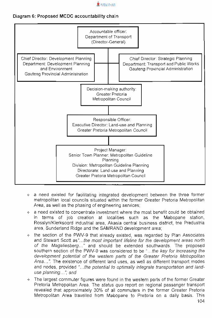
Diagram 6: Proposed MCDC accountability chain
Accountable officer: Department of Transport
(Director-General)
Chief Director: Development Planning Chief Director: Strategic Planning Department: Development Planning Department: Transport and Public Works
and Environment Gauteng Provincial Administration Gauteng Provincial Administration
Decision-making authority: Greater Pretoria
Metropolitan Council
Responsible Officer: Executive Director: Land-use and Planning
Greater Pretoria Metropolitan Council
Project Manager: Senior Town Planner: Metropolitan Guideline
Planning Division: Metropolitan Guideline Planning
Directorate: Land-use and Planning Greater Pretoria Metropolitan Council
.:. a need existed for facilitating integrated development between the three former metropolitan local councils situated within the former Greater Pretoria Metropolitan Area, as well as the phasing of engineering services;
.:. a need existed to concentrate investment where the most benefit could be obtained in terms of job creation at localities such as the Mabopane station , Rosslyn/Klerksoord industrial area, Akasia central business district, the Predustria area, Sunderland Ridge and the SAMRAND development area;
.:. the section of the PWV-9 that already existed, was regarded by Plan Associates and Stewart Scott as" .. . the most important lifeline for the development areas north of the Magaliesberg ... " and should be extended southwards. The proposed southern section of the PWV-9 was considered to be " ... the key for increasing the development potential of the western parts of the Greater Pretoria Metropolitan Area ... ". The existence of different land uses, as well as different transport modes and nodes, provided " .. . the potential to optimally integrate transportation and landuse planning ... "; and
.:. The largest commuter figures were found in the western parts of the former Greater Pretoria Metropolitan Area. The status quo report on regional passenger transport revealed that approximately 30% of all commuters in the former Greater Pretoria Metropolitan Area travelled from Mabopane to Pretoria on a daily basis. This
104

represented a figure of 67 850 commuters per direction per weekday at the time. This figure represented the total of all three modes of public transport , namely bus (17800 per weekday per direction) , rail (24 800 per weekday per direction) and taxi (25250 per weekday per direction) .
(d) The initial corridor areas
The MCDC Business Plan indicated that the MCDC area (see Figure 27 below) is located in the western half of the former Greater Pretoria Metropolitan Area and stretches north-south over a distance of approximately 60 kilometres. The proposed corridor area included " .. .the areas of Soshanguve North, Soshanguve, Klip- and Kruisfontein, Rosslyn, Klerksoord, Akasia, Lady Selborne, Suiderberg, Kirkney, Atteridgeville, Laudium, Mnandi Agricultural Holdings, Sunderland Ridge (Centurion) and the Blue Hills area" (GPMC, 1995).
During the "background research"-process (as discussed in paragraph 4.2 in Section C: on page 120), the corridor's study area was demarcated as that area which includes the following areas: Tswaing; Soshanguve; Klip- and Kruisfontein; Rosslyn/Klerksoord; Akasia; Parts of Pretoria North; West Moot; Pretoria West; Atteridgevilie/Lotus Gardens; Predustria; Laudium/Claudiusl Erasmia; Sunderland Ridge; Rooihuiskraall Heuweloord; SAMRAND development area; and Olievenhoutbosch (Snelco Pro; 1999).
The layout of the different corridor areas are schematically illustrated on Figure 28 (see page 107 for detail). Hereunder a brief discussion on the reasons for including the respective areas into the proposed MCDC area.
Figure 27: The location of the MCDC and the former Greater Pretoria Metropolitan Area within the Gauteng Province.
(No-Line and Snelco Pro, 1999)
105
i. Soshanguve North
A community-supported framework plan was compiled for this area , situated at the most northern end of the MCDC (see Figure 28 on page 107 for a schematic illustration) , furthest away from job opportunity centres. It is located in an area characterised by rural settlements, which is located in the Northwest Province. The fact that Soshanguve North was vacant and the need for land amongst residents in the adjacent rural settlements high, put Soshanguve North under severe pressure for illegal land invasion. The other problems experienced in the area, related to the lack of public transport in the area and the existence of the Tswaing crater, a sensitive historic heritage and conservation site.
ii. Soshanguve
At the time of the compilation of the business plan , Soshanguve consisted of 44 500 fully occupied residential sites and had almost no land for any further development to accommodate the poor (see Figure 28 on page 107 for a schematic illustration). The only portions of land available were for infill development (mixed land-use development). These could only be used to relieve the real short-term need for housing. The short-term need to settle illegal invaders in this area , entailed approximately 15 000 families at the time. For this reason , the Soshanguve North and also the Klip- and Kruisfontein areas were earmarked for affordable housing projects for the total spectrum of income groups. Soshanguve also provided for several other land uses (i.e. business, industrial , education, social), which were not fully utilised as yet. A structure plan was compiled for Soshanguve in 1988, which , due to extreme growth rates, were already outdated in 1995. A new draft structure plan was being compiled during the year when the MCDC Business Plan was formulated .
iii. Klip- and Kruisfontein
The Klip- and Kruisfontein area is situated just south of Soshanguve and just north of the Rosslyn industrial area (see Figure 28 on page 107 for a schematic illustration). The area was in terms of infill development suitable for urbanisation and was due to this potential identified by the Gauteng Provincial Administration as a "Special Development Area". The area was largely vacant when the MCDCproject was initiated. This area was under severe pressure to accommodate lower income levels, which was confirmed by the influx of illegal squatters. The area experienced a lack of public facilities whilst having the potential to accommodate approximately 45 000 families . A development framework was at the time of the preparation of the MCDC Business Plan available, to guide the development of the area as a single entity only and not as an integrated part of the larger urban fabric found in this part of the former Greater Pretoria Metropolitan Area.
iv. Rosslyn/Klerksoord
Rosslyn is an industrial area just south of the Klip and Kruisfontein area (see Figure 28 on page 107 for a schematic illustration) . Approximately 70 % of its wellserviced industrial sites were occupied with development. The area was in the past identified as an industrial decentralised point. It was considered a major job
106
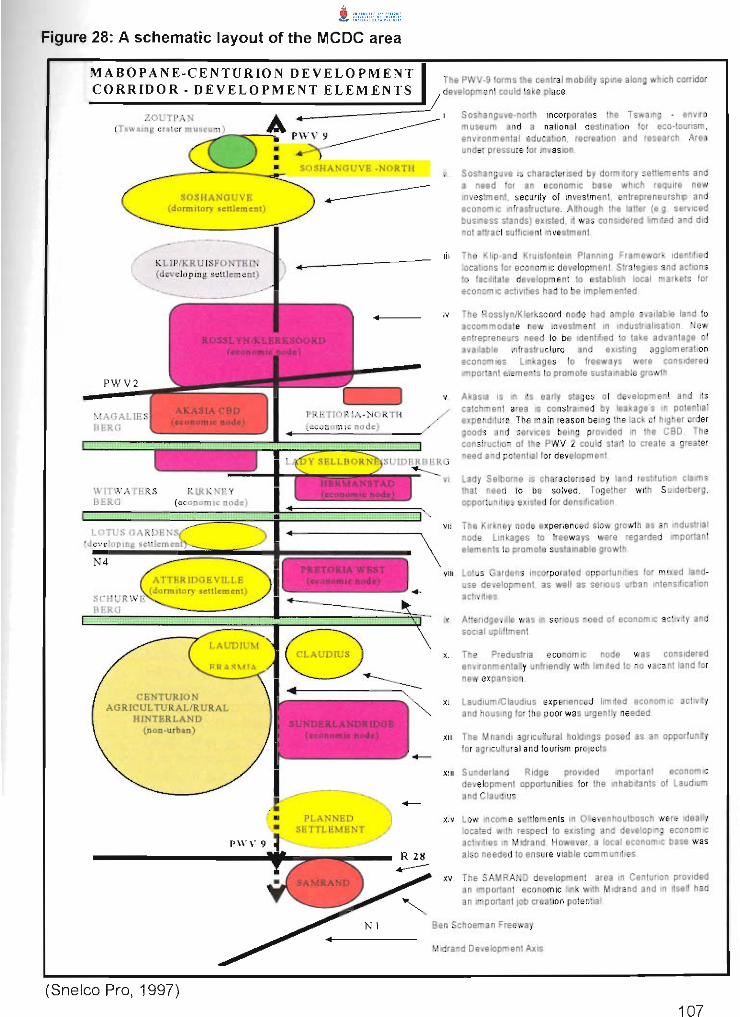
Figure 28: A schematic layout of the MCDC area
MABOPANE -C ENTURION DEVELOPMENT CORRIDOR - DEVELOPMENT ELEMENTS
The PWV-9 forms the central moblhty spme along whICh cOrridor jdeVelopment could lake place
----~:-;;;::-------;:-:~::::=====::~ I Soshanguve-north Incorporales the TswamQ - envr o
(Tswamg crater rr'""~:;2_ .... =-.J~~ ~ museum and a national destmallon for eca-toUrlsm ,
PWV2
MAGAL BERG
SOSHANGUVE (do rmitory sctliement)
KLIP/KRUfSFONTEIN (develop ing. scu lement)
\J,lITWA T ERS BERG
N4
SC HUR
CENTURION AGRICUL TURALIRURAL
HINTERLAND (non-urban)
(Snelco Pro, 1997)
• •
PWV 9 environmental education , recreation and research Area under pressure for InvaSion
SO SHANGUVE ·NORTH
~
PLANNED SETTLEMENT
+-
Soshanguve IS characterised by dormrtory set1lemenls and a need for an economIC base whICh require new Investment. security of Investment. entrepreneurship and economIC Infrastructure Although the latter (e g servICed bUSiness stands) eXisted , II was conSidered limrted and did not allracl sufficient Investment
111 The Khp-and Krulsfonteln Planning Framework Idenflfled locahons for econom IC development Strategies and actions to facllrtate development 10 establish local markets for economIC actlvlhes had to be Implemented
IV The Rosslyn/Klerksoord node had ample available land to accommodate new Investment In mdustnahsatlon New enlfepreneurs need to be Identified to take advantage of available mfrastructure and eXlstmg agglomeration economies linkages to freeways were considered Important elements to promote sustainable growth
v AkasiB IS In lis early stages of development and lis catchment area IS constrained by leakages In potentia l expenditure The m am reason bemg the lack of higher order goods and servICes being prollided In the CBD The constructIOn of the PWV 2 could slaTi to create a greater need and potential for development
lady Selborne IS characterISed by tand restllutlon claims that need to be solved Together with SUlderberg opportunities eXisted for denslflcahon
VII The Klrkney node expenenced slow growth as an mdustrtal
elements to promote sustainable growth
\
node Lmkages to freeways were regarded Important
VIII Lotus Gardens Incorporated opportunities for mixed landuse development as well as serIOUS urban intensification actlvilies
IX Attendgeville was In serious need of econom IC acllvrty and SOCial upliflment
x The Predustna economic node was conSidered envlfonmentally unfriendly with !tmlled to no vacant land for new expansion
XI Laudlum/Claudlus experienced 11m lied economic achvlly and hOUSing for the poor was urgenlly needed
XII The M nandl agricultural holdings posed as an opportunlfy for agrICultural and touflsm projects
XIII Sunderland Ridge prOVided development opportunities for the and ClaudiUS
Important econom IC inhabitants of Laudlum
XIV Low Income settlements In Ollevenhoutbosch were Ideally localed with respect to eXisting and developlOg econom IC acllvil ies 10 Mldrand However a local econom ic base was also needed to ensure viable communities
xv The SAMRAND development area In Centurion prOVided an Important economic link with Mldrand and In Itself had an Important Job crea tion potential
Ben Schoeman Freeway
M Idrand Development AXIS
provider in the area . The area, however, was characterised by a lack of proper regional accessibility and it seemed at the time that this had a direct effect on the rate of industrial development.
v. Akasia
Akasia was considered a "white new town" area, which was properly planned, but developed at low residential densities with vast areas of agricultural holdings in between. Installed infrastructure, especially bulk services, only made provision for the developed residential areas, and not for the agricultural holdings, which were earmarked for future urbanisation (see Figure 28 on page 107 for a schematic illustration). Ample opportunity existed for densification to increase threshold values for economic activities found in Akasia . A location for a central business district was also planned, but except for a large shopping centre, no major development took place. The lack of proper regional accessibility was again identified as the reason for this lack in business development. The development opportunities also provided a potential platform to promote social integration.
vi. Lady Selborne/Suiderberg
The Lady Sellborne/Suiderberg area was considered a partly serviced but primarily vacant area (also see Figure 28 on page 107 for a schematic illustration) . This area was unfortunately subject to land restitution claims, providing the reason why this area was underdeveloped. In terms of potential , it had a favourable potential for higher density development. The area is close to the Pretoria central business district, which further makes this area attractive for development purposes. However, in the MCDC business plan an opinion was expressed that this valley where Lady Sellborne/Suiderberg is situated, is extremely pollution sensitive and government will have to be very careful with regard to the type and density of development allowed in this area . The area is also close to the Kirkney/Zandfontein industrial area, which has the potential to become a prominent employment opportunity area.
vii. Kirkney
Kirkney is a light industrial/commercial area situated in the same pollution-sensitive valley as the Lady Sellborne area (also see Figure 28 on page 107 for a schematic illustration) Fully serviced industrial land had been vacant for some time. The lack of regional accessibility and north-south mobility routes, which could link the area directly to the Rosslyn industrial area in the north and other economic nodes in the south, was seriously hampering economic growth (GPMC, 1995). It was expected that the southward extension of the PWV-9 could solve this problem, as it would facilitate access to the labour market situated in Atteridgeville, just south of the Witwatersberg, which separates the two mentioned areas.
viii. Lotus GardenslWestfortiElandspoort
Although limited residential development was found in the Lotus Gardens area , it was mainly characterised by vacant land suitable for further housing provision projects, as well as some employment creation opportunities (also see Figure 28 on page 107 for a schematic illustration). The adjacent Westfort area is a historic site and was earmarked as an area with ample opportunities for tourist-related
108
economic activities, such as site-seeing and hiking. The Elandspoort-area was characterised by higher density development. These areas are only approximately ten kilometres from the Pretoria central business district.
ix. Atteridgeville and surroundings
Atteridgeville was regarded as a fast developing higher density township area, characterised by very limited economic activity (also see Figure 28 on page 107 for a schematic illustration) . The population was dependent on employment opportunities in the Pretoria central business district, situated approximately 12 kilometres from the economic core of the former Greater Pretoria Metropolitan Area and only two to three kilometres from Predustria industrial area. The area was also in need of a variety of community and social services and amenities.
x. Predustria
Predustria is an old heavy-industry area accommodating , amongst others , the former ISCOR-plant and the Pretoria West Power Station (a lso see Figure 28 on page 107 for a schematic illustration). Due to the abolishment of the ISCOR-plant, the consequent loss of employment opportunities and the heavy industry-nature of this area , the Directorate: Metropolitan Economic Development (of the former GPMC), believed that this area was in fact ready for improved smaller scale manufacturing activities . The rail line from Atteridgeville stretches through this area, and could , therefore, be considered as a major potential employment provider to the people of this part of the former Greater Pretoria Metropolitan Area. The rail line was also regarded as an opportunity to reduce travel distances by creating jobs closer to the place of residence of those staying in Atteridgeville and the Pretoria west area.
xi. Laudium/Claudius
Both these areas were characterised by the settlement of Greater Pretoria's Asian community (also see Figure 28 on page 107 for a schematic illustration). Laudium, which is located to the west of route R55, primarily housed the older and poorer part of the Asian community. Limited economic activity was present in this area. Claudius, located east of route R55, was the wealthy part of the Asian community. No economic activity was found in this area .
xii. Sunderland Ridge
Sunderland Ridge is an industrial area within the southern part of the proposed MCDC area and accommodated those industries which were regarded as a hindrance and which could not be accommodated elsewhere in the former Centurion Town Council Area (also see Figure 28 on page 107 for a schematic illustration). In terms of road linkages, this area lacked direct road links with the major economic activity areas in and around the proposed MCDC area, although it benefited from the direct link with some higher order provincial mobility routes such as the R28 highway.
109
xiii. Mnandi Agricultural Holdings
The Mnandi Agricultural Holdings were characterised by many informal and illegal industrial uses, which spontaneously occurred on the farm portions and small holdings situated in the western parts of Centurion (also see Figure 28 on page 107 for a schematic illustration). The area could directly benefit by the construction of the PWV-9, as it would increase mobility, regional and local accessibility which in turn could create the potential to attract urban development to this area. The development of this area could also assist with correcting the urban form in the southern part of the former Greater Pretoria Metropolitan Area, which was considered to be continuously expanding towards the east.
xiv. Olievenhoutbosch
This area was largely vacant but under extreme pressure to accommodate lowincome high-density development. It is situated close to the employment areas of both the Midrand and Centurion areas (also see Figure 28 on page 107 for a schematic illustration) . The area was unfortunately characterised by underlying dolomite, which has a direct impact on the infrastructure installation costs as it demands infrastructure of an extremely high standard . These high standard infrastructure services had a direct bearing on the housing cost , which made it difficult to develop real low-income suburbs in this part of the proposed MCDC area .
xv. The SAMRAND development area
This area, which was largely vacant, is situated between the former Centurion Town Council area and the fast growing Midrand development axis (also see Figure 28 on page 107 for a schematic illustration) . It was considered to have the potential to become an upmarket mixed land-use development area, accommodating golf estates, commercial and office activities , as well as high-tech industries.
(e) The proposed two-phased project approach
The business plan suggested a two-phased project approach. Firstly, to establish a growth and development strategy for the MCDC area and , secondly, to establish a detail design and development strategy for the Klip- and Kruisfontein/Soshanguve area for fast track implementation. However, the business plan suggested that the two phases should be executed simultaneously. The focus related to the second phase changed early during the execution of the technical part of the project processes, as further discussed in paragraph 2.2 on page116 (GPMC, 1995).
(f) Aims and objectives
According to the MCDC Business Plan, the main aim was to establish a " .. . growth and development strategy for the Mabopane-Centurion Development Corridor in order to achieve fully integrated and sustainable development ... " (GPMC, 1995).
110

(g) Deliverables
The MCDC Business Plan indicated that two sets of expected deliverables were determined. The one set was guiding the compilation of the proposed Growth and Development Strategy and the other the fast-track implementation of development in the Klip- and Kruisfontein area.
It was proposed that the process to compile the proposed Growth and Development Strategy had to include technical processes focused at: .:. analysing the multi-dimensional status quo situation of all proposed areas for
inclusion in the proposed MCDC area;
.:. completing a SWOT analysis of the results of the status quo investigation;
.:. identifying projects for implementation;
.:. the preparation of a development framework, policies and strategies; and
.:. the preparation of implementation actions (GPMC, 1995).
The foreseen deliverables for the Detail Design and Development Strategy for the Klipand Kruisfontein/Soshanguve area, were primarily focused at identifying implementation projects and the preparation of implementation processes and programmes for priority projects (GPMC, 1995).
(h) Participation process during the compilation of the business plan
A draft business plan was compiled by the former Greater Pretoria Metropolitan Council within the limited time available. This draft business plan was submitted to heads of departments (involved in town planning and transport engineering) from the three former metropolitan local councils situated within the borders of the former Greater Pretoria Metropolitan Area. The draft business plan was also submitted to TRC Africa'". The inputs received from the three metropolitan local councils and from TRC Africa formed the total opportunity for the preparation of the business plan. As a result of the limited time available to request the widest possible input, no input could be obtained from the private sector, nor from communities staying in the identified corridor areas. To overcome this problem, a comprehensive community participation process was proposed in the business plan (that was to be executed once the business plan was approved) . All inputs received at the time stressed support for the proposed corridor project.
The revised business plan was re-submitted to the Department of Transport via TRC Africa, on 22 November 1995. (Krynauw, 2000b).
3.1.2. The RDP approval
On the 12'h of January 1996, the former Greater Pretoria Metropolitan Council received telephonic confirmation from the national Department of Transport that the former office of the Reconstruction and Development Programme had approved the business plan for the project. The approval also included an amount of R2 million to execute the business plan accordingly
56 TRe Africa is a private sector consultancy specialising in land-use and transport integration, which was appointed by the national Department of Transport to assist with the final submission of a combined business plan rece ived from all four councils taking part in the "Four-Cities"-project. The company also reacted in an advisory capacity to the Department of Transport in terms of promoting land-use and transport integration, as well as co-ordinating events during which the progress with the respective projects were evaluated and discussed.
111
(Krynauw, 2000b) . Conditions for the approval of the project and the project's budget, focused on ensuring inclusivity, community involvement, dedicated project management and project results , as well as proper financial management and feedback reporting (Office of the RDP, 1996).
3.1.3. The project proposal
As a result of the telephonic confirmation received from the national Department of Transport, the former Greater Pretoria Metropolitan Council proceeded on a risk basis to request private sector consultancy firms to prepare project proposals for the implementation of the approved business plan . This request to the private sector companies was made in January 1996.
The private sector firms invited to submit project proposals were identified by the Division : Metropolitan Guideline Planning (former Greater Pretoria Metropolitan Council). At the time , the same Division was also initiating a process to compile Land Development Objectives (in accordance with the Development Facilitation Act, Act 67 of 1995) for the former Greater Pretoria Metropolitan Area. Officials of the Division did a survey of existing town planning and urban economist firms located in the former Greater Pretoria Metropolitan Area. Ten of the larger firms were identified and listed. Of these ten companies, five companies for each project were " allocated' to the two projects for an invitation to submit project proposals.
The project proposals were received in February 1996 and were evaluated and considered by an evaluation panel that consisted of representatives57 of the former Greater Pretoria Metropolitan Council and the three metropolitan local councils (GPMC, 1996).
The project proposal of the firm "Urban-Econ Development Economists" was unanimously chosen by the evaluation panel as the firm to be recommended to the former Council of the Greater Pretoria Metropolitan Area for appointment (see detail on the resolution by the Council of the former Greater Pretoria Metropolitan area in paragraph 3.1.4 below) (GPMC, 1996a).
The project proposal of Urban-Econ Development Economists was considered a thoroughly structured and comprehensive proposal, which incorporated important project processes and approaches that were well accepted by the applicable authorities comprising the evaluation panel. The criteria used for the evaluation of the project proposals included the following :
• the respective firm 's interpretation of the business plan, prepared for the proposed MCDCproject as approved by the Office of the Reconstruction and Development Programme;
• the availability of knowledge related to concepts, benefits and implications of development corridors. It was, however, expected that as the corridor concept is new in South Africa , companies would not have appropriate experience in this regard . Nevertheless, this criterion was included to test companies ' ability to study the concept in a record period of time and to determine what urban, transport and economic elements they will incorporate into the planning and foreseen implementation processes;
• an understanding of government's development programmes and pOlicies that existed at the time and which could have an influence on the proposed MCDC-project;
• the methodology proposed to execute the project, which included a well-structured technical as well as participation approach ;
57 The representatives included officials and Councillors from the fonmer Grealer Pretoria Metropolitan Council, as well as the former metropolitan local councils found within the boundaries of the former Greater Pretoria Metropolitan Council.
11 2
• the multi-disciplinary nature of the proposed project team needed to position the MCDCproject as a multi-faceted and integrated development attempt;
• the timeframes and programmes to support quick planning and implementation processes; and
• the proposed budget and its allocation to execute the project processes and phases.
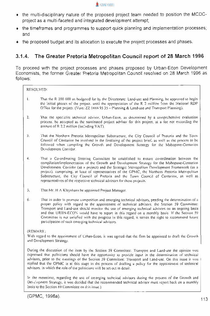
3.1.4. The Greater Pretoria Metropolitan Council report of 28 March 1996
To proceed with the project processes and phases proposed by Urban-Econ Development Economists, the former Greater Pretoria Metropolitan Council resolved on 28 March 1996 as follows:
RESOLVED:
I . That the R 200 000 as budgeted for by the Directorate: Land-use and Planning, be approved to begin the initial phases of the project, until the appropriation of the R 2 million from the Nat ional RDP O ffi ce lor the project. (Vote: ZZ 1444 9S 3S - Planning & Land·use and Transport Planning).
2. That the specia li st technica l advisor, Urban-Ecan, as determined by a comprehensive evaluation process, be accepted as the nominated project advisor for this project. at a fee not exceeding the amount of R 2,2 million (including VAT).
3. That the Northern Pretoria Metropolitan Substructure, the City Council of Pretor ia and the Town Council of Centurion be invo lved in the finalising of the project brief, as well as the process to be followed when compiling the Growth and Development Strategy for the Mabopane-Centurion Development Corridor.
4. That a Co-ordinat ing Steer ing Committee be established to ensure co-ordination between the compil ation/implementation of the Growth and Development Strategy for the Mabopane-Cel1lurion Development Corridor (as a project) and the Strategic Metropolitan Development Framework (as a project), comprising, at least of representatives of the GPMC, the Northern Pretor ia Metropolitan Substructure, the City Council of Pretoria and the Town Council of Centurion, as well as representatives of the respective technical adv isors for these projects.
S. That Mr. H A Kleynhans be appointed Project Manager.
6. That in order to promote competition and emerging technical advisors, pending the determ ination of a proper policy with regard to the appointment of technical advisors. the Section 59 Committee: Transport and Land-usc should monitor the usc of emerging technical advisors on an ongoing basis and that URBN-ECON would have to report in this regard on a monthly basis. If the Section 59 Committee is not satisfied with the progress in this regard , it serves the right to recommend future participation of such emerging technical advisors.
(REMARK: With regard to the appointment of Urban-Econ, it was agreed that the firm be appointed to draft the Growth and Development Strategy.
During the discuss ion of the item by the Section 59 Committee: Transport and Land-usc the opinion was expressed that politicians should have the opportunity to provide input in the determination of technica l advisors, prior to the meetings of the Section 59 Committee: Transport and Land-use. On this issue it was rep lied that the GPMC is at this stage in the process of drafting a policy for the appointment or technical adv isors, in which the role of the politicians will be set out in detail.
In the meantime, regarding the use of emerging technical advisors during the process of the Growth and Development Strategy, it was decided that the recommended technical adv isor must report back on a monthly basis to the Section 69 Comm ittee on this issue .)
(GPMC, 1996a). 113

3.1.5. The project contract between the former Greater Pretoria Metropolitan Council and the Project Advisor
The former Greater Pretoria Metropolitan Council compiled a comprehensive contract to ensure the proper execution of the project proposal submitted by Urban-Econ Development Economists. This contract and the contract to compile the first Land Development Objectives for the former Greater Pretoria Metropolitan Area for 1996 were the first of its kind signed in the former Greater Pretoria Metropolitan Council to execute town planning projects.
The contract with the appointed project advisor addressed aspects related to the responsibilities of the respective affected parties, the project fees and the financial arrangement for the project, the project approaches, project execution and project management arrangements. It also included the RDP-approved business plan and the compilation of a workbook within which the entire project had to be determined and documented (see paragraph 3.1 .7 below for detail on the contents of the project workbook)
The contract between Urban-Econ Development Economists and the former Greater Pretoria Metropolitan Council was signed by the Acting Chief Executive Officer of the former Greater Pretoria Metropolitan Council on 16 April 1996 (GPMC, 1996b).
3.1.6. The project contract between the national Department of Transport and the former Greater Pretoria Metropolitan Council
A contract for the execution of the MCDC-project was also signed between the national Department of Transport and the former Greater Pretoria Metropolitan Council, although more than 18 months (4 December 1997) after the MCDC planning processes had been commenced with. This contract provided guidelines and parameters according to which the RDP funds had to be used for the execution of the approved business plan. It also provided clarity with regard to the role, responsibilities and relationship between the national Department of Transport and the former GPMC, guidelines for urban development projects, as well as guidelines for the development planning processes in government (Department of Transport, 1997).
3.1.7. The project workbook
As referred to in paragraph 3.1.5 above, the first step executed according to the contractual agreement referred to, was the compilation of the "project workboo/{', with the involvement of the respective role-players determined by the Council of the former Greater Pretoria Metropolitan Council (refer to paragraph 3.1.4 on page 113). This project workbook was compiled to manage the project processes and results , as well as to ensure the effective implementation of the business plan and the project proposal. The project workbook also ensured that each project team member knew exactly what was expected from him/her during each stage, at what time the deliverables were expected and at what cost. This project workbook was completed and accepted by the MCDC Steering Committee in April 1996.
The project workbook consisted of five sections, viz.:
• An introduction: This section focused on the objective of the study, the composition of the project team, the two distinct project phases to be executed and the expected role of the MCDC Steering Committee in the project processes;
114
• The formulation of an Integrated Growth and Development Strategy: This included strategy focuses to use an integrated planning process as basis for the execution of the MCDC-project, as well as to clarify the community participation process. The technical planning process, the main responsibility of each member of the project team and the deliverables to be completed for each project step, were also described;
• The formulation of a development facilitation plan: This section focused on fast track implementation projects, especially in the Klip-and Kruisfontein area, as Phase Two of the project;
• The project programme: An exposition of time frames and deliverables was formulated ; and
• The project budget: The cost per deliverable and per project team member were determined. The project team consisted of a core team, which included the following disciplines:
• urban and development economists;
• transport and other service engineers;
• town planners;
• a development corridor expert; and later also
• urban designers.
This combination of disciplines was proposed by Urban-Econ Development Economists in their project proposal and so accepted by the former Greater Pretoria Metropolitan Council.
The core team was backed by a support team representing a number of specialists of other disciplines viz. that of: a community faCilitator; a small-scale farming specialist; a commercial farming specialist; a human resources development consultant; an environmental developer; an economic development service specialist; a financial development expert; and an institutional development specialist (Urban-Econ Development Economists , 1996b).
SECTION C:THE PROJECT STRATEGIES OF THE MCDC-PROJECT
This section reflects the strategies of the MCDC-project by means of an explanation of the chronological sequence of events starting with the initiation of the planning activities on 1 May 1996 until the initiation of implementation actions on 17 September 1997.
1. Introduction
The implementation of the project workbook discussed in paragraph 3.1.7 above, was initiated on the 151 of May 1996. This Section, therefore, reflects the results of the execution of the project and planning processes of Phases One and Two of the MCDC-project in the form of a set of multi-sectoral strategies. These strategies were structured in such a manner that it also provided a planning framework for the identified strategies as the project planning was commencing and as implementation took place.
115