the mitigation of landslide disaster at the area that ... · the mitigation of landslide disaster...
TRANSCRIPT

International Journal of Mining Science (IJMS)
Volume 4, Issue 1, 2018, PP 1-10
ISSN 2454-9460 (Online)
DOI: http://dx.doi.org/10.20431/2454-9460.0401001
www.arcjournals.org
International Journal of Mining Science (IJMS) Page | 1
The Mitigation of Landslide Disaster at the Area that Formerly a
Soil and Rock Mining in Bukit Permai Singkawang
Marsudi1,4
*, Budi Purwoko1,4
, Singgih Saptono2,4
, Nurmaya Putri Ira2,4*
, Fahrul Indrajaya3,4
1Universitas Tanjungpura
2Universitas Pembangunan Nasional “Veteran” Yogyakarta
3Universitas Palangka Raya
4Universities Consortium for Open Mining Methods, Indonesia
1. INTRODUCTION
From geology point of view, landslide is usually happening due to the natural movement of soil
materials at the slope or hilly area. This cyclical occurrence of this natural disaster is not uncommon,
from monthly period up to decades, usually during raining season.
Almost all of geology catastrophes, such as earthquake, tsunami, volcano eruption, and other tectonic
movements, are purely natural disaster due to geology process, which unfortunately are impossible to
prevent and very difficult to predict. Intensive research works in geology fields in particular, should
be carried out to mitigate these natural disasters.
On the other hand, natural disasters like landslide, land subsidence, and flooding are not only caused
by prone and unstable geological conditions, but in many cases also due to human activities,
particularly in intensifying land exploitation. In addition, climate change also contributes significantly
to escalating the number of landslides in many places in Indonesia.
Fundamentally, like many other natural phenomena, landslide is happening when the driving force
works on the slope is greater than the resistance force. The main factors affecting the driving force are
the angle of the slope, the quantity of water flowing, the load and the densities of soil and rock,
specifically when unconsolidated soil is exist in a great quantity. The resistance force is determined
by the strength of the rock as well as the solidity of soil.
Abstract: Earth movement or landslide is one of the most frequently geological natural disasters happening
in many places in Indonesia. From topology point of view, the landslide occurs on the slope of more than 35
degree and comprises of weathered soil in particular, is very dangerous to the nearby infrastructures.
Generally, the research method employed to mitigate and to detect earth movement is geoelectrical
(resistivity) survey. This technique is applied to understand the condition or the geology structure under the
surface based on the variation on the specific resistance or resistivity of the rocks. This method in particular
could distinguish the geology structures that are significantly different or contrast in their resistivity from
their surrounding areas. In addition to identify the area which likely to have landslide, the technique could
also be used to explore ground water, minerals, and geothermal potency.
The geophysics evidence observed on the slope landslide occurred several years ago. The downhill was cut to
obtain the soil and rock materials for the land fill purpose. The hill was cut up to ± 22 m above sea level, with
the thickness of 10 m to 15 m. And this obviously resulted in the loss in support capability at the downhill.
The landslide then occurred from the bottom side of the hill to the uphill at 108 above sea level. Prior to the
occurrence, the cracks and fragmented materials were observed in various points, from 22 m to 108 m above
sea level. The crack dimensions were varied from 10 cm to 50 cm, in the length of 1 m to 20 m, transverse
perpendicular to the slope of the hill.
Keywords: Disasters, Infrastructure, Geoelectrical, landslide, slope stability and Mitigation
*Corresponding Author: Nurmaya Putri Ira, Universitas Pembangunan Nasional “Veteran” Yogyakarta,
Universities Consortium for Open Mining Methods, Indonesia

The Mitigation of Landslide Disaster at the Area that Formerly a Soil and Rock Mining in Bukit Permai
Singkawang
International Journal of Mining Science (IJMS) Page | 2
Therefore, the identified factors that are causing landslide are including rain intensity, steep slope,
thickness of unconsolidated soil, weak soil/rock, mining activities of rocks and soil at the bottom of
the cliff, improper land use, vibration caused by earthquake, drop in water level, additional load due
to rainwater absorption, erosion, unconsolidated pile of material on the cliff, present of discontinue
field, deforestation, and unstable or unconsolidated pile of waste disposal.
During landslide, the downward movement of mass soil is due to the gravity force and the higher soil
surface tension than soil friction strength. This soil mass then damaging the lower side area, destroy
infrastructures such as property, housing, warehouse, etc. The outcomes are not only physical
damages on the infrastructures, but also life casualties. These backgrounds lead to the following
objectives of this paper, which includes:
To understand the landslide mechanism, which then can be used to mitigate this geology disaster,
in order to protect the infrastructures in the area where the study has been carried out.
To apply geoelectric survey in order to obtain the analyses on landslide field.
2. RESEARCH METHOD
In order to mitigate landslide disaster, the geoelectric prediction method employed in this study was
resistivity imaging technique. This technique was to obtain data on landslide fields during the
landslide event in the area that was formerly a soil and rock mining. This area, Bukit Permai, is now
utilized as water treatment plant and water reservoir as well.
Geoelectric prediction had been done in three different paths as can be seen in Figure 1. Based on
geology classification, the compositions of the rock type in the area are: as follow.
Laterite soil (weathering soil) with the thickness of 6 to 13.9 m, that is soft and weak.
Half weathered rock in the form of frozen rock chunk with the thickness between 2 to 4 m. This is
compact and relatively hard rock.
At the bottom, there is fresh rock (grano-diorite rock). This kind of rock is massif, strong, and
hard.
Geoelectric measurement used Wenner – Alpha configuration with the span length of 75 to 100 m, to
acquire the prediction of 25 to 50 m in depth.
2.1. Location
Figure 1 shows Bukit Permai Water Treatment Plant area, in which the study was conducted. The
three different prediction point paths were made parallel with the slope, as can be seen in Figure 2.1.
The paths/tracks are Path 1 (A – B), Path 2 (C – D), and Path 3 (E – F). These are to predict or do
detect the thickness of soil/rock layers under the geoelectric prediction points.
Figure2.1. The map of Bukit Permai Water Treatment Plant area with geoelectric prediction path

The Mitigation of Landslide Disaster at the Area that Formerly a Soil and Rock Mining in Bukit Permai
Singkawang
International Journal of Mining Science (IJMS) Page | 3
2.2. Basic Theory
The research study shall be conducted systematically, which are including preparation stage, field data
collecting, data processing, evaluation, and report presentation. And all of those steps shall be in
accordance with scientific standard. During this study several basic theory are used as follow.
2.2.1. Resistivity
When DC current applied on certain medium, the ratio between electric potential (V) and quantity of
the current (I) is constant. And the quantity of this constant number depends on the medium, which
called resistance (R). Therefore the resistance (R) can be expressed as below:
And when the electric current applied on wire or homogeneous cylinder through its axis, the
resistance R will directly proportion to the cylinder length (L) and inversely proportional to cylinder
cross-sectional area (A). If is a constant ratio called resistivity in the unit of Ohm.m, thus from
above equation it can derived the following equation:
2.2.2. Electrode Configuration
The measurement of geoelectric resistivity during this aquifer mapping work employedSchlumberger
method. Electrode arrangement according to Schlumberger principle is basically consist of two
current electrodes and potential electrodes, as can be seen in Figure 2.2. below.
Figure2.2. Two current electrode and two potential electrode on earth surface
The potential in P1 that is caused by C1 is:
Since the current is the same but different in pole, thus the potential in P2 caused by current in C2 is :
It is expected that the measurement not depend on touch resistance on current electrode A and B.
Wenner (1917) and C & M Schlumberger (1920) proposed the technique which called Schlumberger
configuration. In this technique, electrode A and electrode B are placed in symmetric against the
centre point and then adding potential electrodes M and N, which are also positioned symmetric
against the centre point, between electrode A and B. The schematic figure of Schlumberger
configuration is presented in Figure 2.3.
(Ohm) I
V = R
m)(Ohm LI
V A = .
m)(Ohm A
L R .
VI
r1
12
VI
r2
22

The Mitigation of Landslide Disaster at the Area that Formerly a Soil and Rock Mining in Bukit Permai
Singkawang
International Journal of Mining Science (IJMS) Page | 4
Figure2.3. The arrangement of Schlumberger Electrode
If R = AB/2
r = MN/2
Thus the geometri factor of Schlumberger configuration is:
K is a geometri factor in meter unit. It is obvious that geometri factor depends on the position of
current electrode as well as potential electrode. In this technique, the distance between potential
electrodes is seldom to change eventhough the space between current electrodes are always altered.
During the change in electrode spatial distance, the current electrode distance must be significantly
greater than the potential electrode distance. The optimum space of AB/2 must be larger than 5 MN/2.
2.3. Data Interpretation
A. Path A - B
Path A-B situated at the eastern part (right hand side), and the result of geoelectric prediction is
presented in profile A-B as can be seen in Figure 2.4.
Figure2.4. Soil profile resulted from geoelectric prediction on A – B
B. Path C - D
Path C-D positioned right at the center, and the result of geoelectric prediction is presented in profile
C-D as can be seen in Figure 2.5.
K
AM BM AN BN
2
1 1 1 1
K
R r R r R r R r
2
1 1 1 1
=
2p2
R- r-
2
R+ r
æ
èç
ö
ø÷
é
ëê
ù
ûú
=2p4r
R- r
æ
èç
ö
ø÷
é
ëê
ù
ûú
K
R r
r
AB MN
MN
2 2
2
2 2
2 2
22
The Mitigation of Landslide Disaster at the Area that Formerly a Soil and Rock Mining in Bukit Permai
Singkawang
International Journal of Mining Science (IJMS) Page | 5
Figure2.5. Soil profile resulted from geoelectric prediction on Path C – D
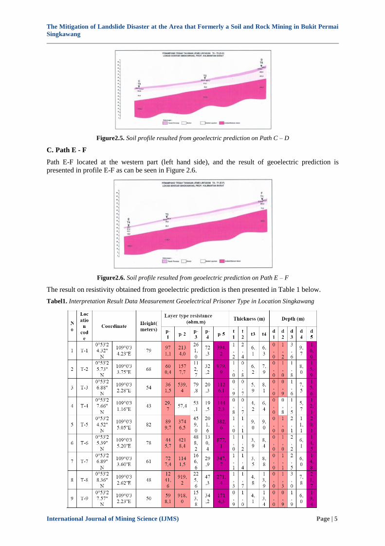
C. Path E - F
Path E-F located at the western part (left hand side), and the result of geoelectric prediction is
presented in profile E-F as can be seen in Figure 2.6.
Figure2.6. Soil profile resulted from geoelectric prediction on Path E – F
The result on resistivity obtained from geoelectric prediction is then presented in Table 1 below.
Tabel1. Interpretation Result Data Measurement Geoelectrical Prisoner Type in Location Singkawang

The Mitigation of Landslide Disaster at the Area that Formerly a Soil and Rock Mining in Bukit Permai
Singkawang
International Journal of Mining Science (IJMS) Page | 6
3. RESULTS
The landslide potential is described as zone with the broken line as can be seen in Figure 2.7.
Figure2.7. The distribution of Block A and B, and the cut & fill area, and zone dangerous zone on the
upper side.
In Figure 2.8. below, the 2D cross section of geoelectric path C – D is shown to represent the
landslide field.
Figure2.8. The 2D cross section of geoelectric path C – D to show the landslide field

The Mitigation of Landslide Disaster at the Area that Formerly a Soil and Rock Mining in Bukit Permai
Singkawang
International Journal of Mining Science (IJMS) Page | 7
3.1. Slope Stability Analysis
The Basic Principle of the Fellenius Method in general the collapse is assumed to result from the
movement of the ground block on a circular or circularly shaped surface of the sphere. On an analyzed
slope which divides it in n segments / slices, there will be (5n-2) variables that are not known, while
there are only 3n pieces of static equations are:
Normal force balance equations
Tangential equilibrium equation
Moment balance equation
To be able to solve the problem on a. In general there are three things that can be made, namely:
1. Assumptions about the normal stress distribution along the slip plane
2. Assumptions about the inclination of inter-slice forces
3. Assumptions about the position of the thrust line of inter-slice forces
In table below, the Fellenius Method Analysis is tabulated.
Tabel2. Analysis with Fellinius Method
Where:
SF = 𝑐𝐿+𝑡𝑎𝑛 ∅ 𝑊𝑖 𝐶𝑜𝑠 𝛼𝑖−𝑈𝑖𝑙𝑖
(𝑊𝑖 𝑆𝑖𝑛 𝛼𝑖
Landslide resistance = 𝑐𝑖.𝑎𝑖 = 1,8 x 120 = 216 ton
Tan 48o x 13017,4 = 14490
Safety number in Bukit Permai cliff therefore is:
SF= 216 + 14490
18101 = 0,81 < 1
Which is not safe.
In Figure 3.1. below, the slope in Water Treatment Plant and water reservoir of 150 LPD (Liter Per
Day) in Bikat Permai – Roban is presented.

The Mitigation of Landslide Disaster at the Area that Formerly a Soil and Rock Mining in Bukit Permai
Singkawang
International Journal of Mining Science (IJMS) Page | 8
Figure3.1. The slope in Water Treatment Plant and water reservoir in Bikat Permai – Roban
3.2. The Possible Risk
A. Cut and Fill in Water Treatment Plant (WTP) and Reservoir
Volume ± 25.410 m3 with γ = 1,8 t/ m
3,
W = 45738 ton, SF=W Cos θi- Ui / W Sin θi
Cohesion ( c ) = 1,6 t/m2, θ = 1 – 2
o,
The length of landslide field 66 m
Landslide resistance = 𝑐𝑖.𝑎𝑖 = 1,6 x 66 = 105 ton
SF = 𝑐𝐿+𝑡𝑎𝑛 ∅ 𝑊𝑖 𝐶𝑜𝑠 𝛼𝑖−𝑈𝑖𝑙𝑖
(𝑊𝑖 𝑆𝑖𝑛 𝛼𝑖
W Cos θi = 45.738 x cos 2o = 45.710 ton
Ui = 3630 x 4 x 1 = 14.520 ton
W Sin θi = 45.738 x sin 2o = 1.596 ton
SF = 106 +( 45.738−14490)
1596 = 16,5 > 1, indicating stable
Thus in cut and fill area (WTP and reservoir), structurally it is stable. It is only required to install
piling for foundation, based on hard soil sondir at 3.4 m from surface of S-1 at the direction kit area.
At this point, the piling is already penetrating landslide field (refer to Fig. 2.7).
B. Block A (on the upper side of landslide field) with the area of 9,350 m2
The landslide potency at the upper side area (55 m x 170 m) with the thickness of 7 m, hence:
W (Potency to landslide) = 65.450 m3, θ = 35
o - 38
o, γ = 1,8 t/ m
3, with the length of landslide field is
170 m.
Landslide resistance = 𝑐𝑖.𝑎𝑖 = 1,6 x 170 = 256 ton
Thus W = 117.810 ton
W Cos θi = 117.810 x cos 38o = 87.977 ton
Ui = 9350 x 5,5 x 1 = 51.425 ton
c = 1,8 t/m2 γ = 1,96 t/m3 Ø = 15o θ = 34o
R = 80 m, AB = 114 m
Jumlahsegmenirisan = 10

The Mitigation of Landslide Disaster at the Area that Formerly a Soil and Rock Mining in Bukit Permai
Singkawang
International Journal of Mining Science (IJMS) Page | 9
W Sin θi = 117.810 x sin 38o = 68.850 ton
SF = 256+(87.977−51.425)
68850 = 0,55 < 1, indicatingunstable.
C. Block B (block below landslide field), with the area of 6,600 m2
Landslide potency at the upper side area (55 m x 160 m) with the thickness of 6 m, hence
W (Potency to landslide) = 39.600 m3, θ = 34
o - 38
o, γ = 1,8 t/ m
3, with the length of landslide field is
160 m.
Landslide resistance = 𝑐𝑖.𝑎𝑖 = 1,6 x 160 = 256 ton
Thus W = 71.280 ton
W Cos θi = 71.280 x cos 35o = 58.543 ton
Ui = 6600 x 4,5 x 1 = 29.700 ton
W Sin θi = 71.280 x sin 35o = 41.035 ton
SF = 256+(58.543−29700)
41035 = 0,71 <1, indicatingunstable
D. Block danger for landslide at the upper side of danger zone with the area of 79,818 m2
Landslide potency at this area (79,818 m2) with the thickness of 5 m, hence:
W (Potency to landslide) = 399.090 m3, θ = 30
o - 35
o, γ = 1,8 t/ m
3, with the length of landslide field
is200 m.
Landslide resistance = 𝑐𝑖.𝑎𝑖 = 1,6 x 200 = 320 ton
Thus W = 718.362 ton
W Cos θi = 718.362 x cos 30o = 622.119 ton
Ui = 79818 x 4,5 x 1 = 323.629 ton
W Sin θi = 718.362 x sin 30o = 359.181 ton
SF = 320+(622.119−323.629)
359181 = 0,83 < 1, indicating unstable
4. CONCLUSIONS
From analytical calculation and geoelectric interpretation, it is concluded that:
1. In general, the cliff of Bukit Permai from 18 m to 120 above sea level, under raining condition and
the ground water level close to the surface, is not safe with SF = 0,80 < 1 (which is indicating
unstable condition). Under dry condition, and level of ground water close to lower side of the
slope, it is relatively safe, with SF = 1,08. The slope will stable if SF > 1,25 (safe situation).
2. Based on analytical calculation for each block, it is indicating that WTP site plan and reservoir will
be safe for cut and fill, since the slope has SF = 16,5 > 1,25 (indicating very stable condition). The
foundation with bored piling is required to prevent soil settlement/subsiding. The piling must
penetrating landslide line. And to secure the structure, it is necessary to provide drainage for site
area.
3. However, Block A and B, which are situated above the site plan of WTP and reservoir are not safe.
The Safety Factors (SF) are 0.55, 0.71, and 0.83 respectively. These are obvious indication that the
slope is not safe. Landslide prevention could be done by reducing soil load on the upper side of the
slope (trapping/terracing).
4. Other efforts are including drying the ground water at upstream together with strengthening the
turap (flowing wall) into the left and right sides of the WTP site plan and reservoir. All of these
efforts are the since landslide possibly moves toward the WTP and reservoir infrastructures due to
the cliff angle, which is on the direction from north east to south west.

The Mitigation of Landslide Disaster at the Area that Formerly a Soil and Rock Mining in Bukit Permai
Singkawang
International Journal of Mining Science (IJMS) Page | 10
REFERENCES
[1] Bishop, A.W. (1955), “The Use of the Slip Circle in the Stability Analysis of Slopes”, Geotechnique, Vol.
5, pp. 7-17.
[2] Chowdhury, R. N., 1981. Discussion of “Stability Analysis of Embankments and Slopes,” by S. K. Sarma,
journal of the Geotechnical Engineering Division, ASCE, Vol.107, No.GT-5, May, pp.691-693.
[3] Chugh, A.K. (1981), Discussion: “Stability Analysis of Embankments and Slopes”by Sarma S.K.
American Society of Civil Engginering, Journal of the Geotecnical Engineering Division, Vol. 107, No.
GT5, pp. 693-697.
[4] Muchlis. (2015). Interpretasi Potensi Massa Longsoran Dengan Metoda Geolistrik (Studi Kasus Daerah
Gayo Lues). Jurnal Natural, 15(1), 16–18.
[5] Pusat Vulkanologi dan Mitigasi Bencana Geologi. (2015). Prakiraan Wilayah Potensi Terjadi Gerakan
Tanah/Tanah Longsor dan Banjdengan
[6] Schlumberger, C., M. Schlumberger, and E.G. Leonardon, 1934. Electrical exploration of water-covered
areas. Trans. Am. Inst. Mining Metall. Eng., 110, 122–134.
[7] Suriadi, A. B., Arsjad, M. dan Hartini, S. (2014). Analisis Potensi Risiko Tanah Longsor Kabupaten
Ciamis dan Kota Banjar, Jawa Barat. Majalah Ilmiah Globe, 16, 165–172. Bandang di Seluruh Indonesia.
Bandung: ESDM, Kementrerian
Citation: Nurmaya Putri Ira et al. (2018). The Mitigation of Landslide Disaster at the Area that Formerly a
Soil and Rock Mining in Bukit Permai Singkawang, International Journal of Mining Science (IJMS), 4(1),
pp.1-10, DOI: http://dx.doi.org/ 10.20431/2454-9460.0401001.
Copyright: © 2018 Nurmaya Putri Ira. This is an open-access article distributed under the terms of the
Creative Commons Attribution License, which permits unrestricted use, distribution, and reproduction in any
medium, provided the original author and source are credited