the naval research laboratory’s marine meteorology ......the naval research laboratory’s marine...
TRANSCRIPT

The Naval Research Laboratory’s
Marine Meteorology Division Dust Forecasting Capabilities
Annette Walker
Arizona Dust Storm Workshop
March 5, 2019

Navy Aerosol and Visibility Forecast Needs: Tactical and strategic planning
Target Acquisition
Port Navigation
Carrier landings Ship defense

Mediterranean, 22 March, 2018
Korea, 28 March, 2018 Southwest Asia, 04 December, 2017
Impact of Dust Aerosols on DoD Activities

Global and Mesoscale Aerosol Models
Navy Aerosol Analysis and Predication System (NAAPS)
•World’s first operational global aerosol model (at 1/3 degree resolution) •6-day forecasts dust, smoke, pollution, and sea salt aerosols (run 4x/day) •Utilizes world’s first operational aerosol data assimilation & fire data streams
Coupled Ocean Atmosphere Mesoscale Prediction System (COAMPS)
•Operational dust forecasts at FNMOC since 2001 (currently 1.6 and 15 km resolution, run 2x/day; 72 hr forecasts) •Accurately forecasts the onset/cessation of low visibility conditions, and individual dust plumes •Uses the NRL high-resolution dust source database
COAMPS 48 hr forecast VT 12Z 20171204
NAAPS Analysis 00Z 20180322 Dust Aerosol Optical Depth

High-resolution Dust Source Database
• COAMPS 10 m wind overlays (plume head vs tail) • Surface weather maps (showing dust storms, reduced visibility) • Cross-correlate land and water features (using maps, atlases, GE)
Approach and Methodology
20140622 NRL msg_DEBRA 20030820 NRL DEP
Iran
Pakistan
20030820 True Color
Iran
Pakistan Nigeria
Chad
• NRL Dust Enhancement Products • Used 17 years of NRL DEP + 8 years of
DEBRA msg_RGB to locate/update dust plume sources • Dust source area entered into database
(cursor location tool = 1km precision)

High-resolution Dust Source Database
• COAMPS 10 m wind overlays (plume head vs tail) • Surface weather maps (showing dust storms, reduced visibility) • Cross-correlate land and water features (using maps, atlases, GE)
Approach and Methodology
20140622 NRL msg_DEBRA 20030820 NRL DEP
Iran
Pakistan
20030820 NRL DEP
Iran
Pakistan Nigeria
Chad
• NRL Dust Enhancement Products • Used 17 years of NRL DEP + 8 years of
DEBRA msg_RGB to locate/update dust plume sources • Dust source area entered into database
(cursor location tool = 1km precision)

High-resolution Dust Source Database
SW Asia DSD
Saudi Arabia
• Solid red shapes identify dust source areas located using DEP and msg_DEBRA • DSD used in COAMPS (1 km sources gridded to 1.6, 5, 15, and 45 km resolution)
Fluxdust α Erodible Fraction * u*4
• GE kml used on the watch floors at the FWC and OWS
North Africa DSD

Arizona and Colorado: April 17, 2006 21Z Plumes originate in Painted Desert and San Luis Valley Corresponding SOM-Classes: 218, 228, 229, 249, 258, 260 (blue) 513, 521, 525, 526 (yellow green)
• Same approach taken with North America (added machine learning component) • Used NASA/USGS MODIS global land surface and albedo datasets • Formed self-organizing map (SOM) containing 1,000 classes
North America High-resolution DSD
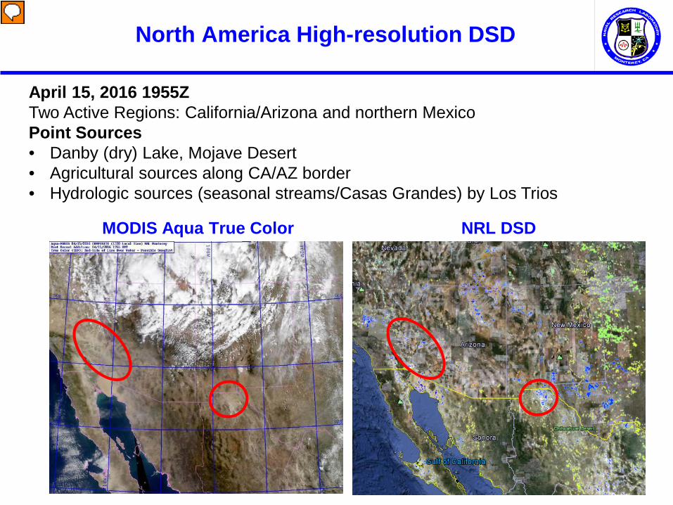
North America High-resolution DSD
April 15, 2016 1955Z Two Active Regions: California/Arizona and northern Mexico Point Sources • Danby (dry) Lake, Mojave Desert • Agricultural sources along CA/AZ border • Hydrologic sources (seasonal streams/Casas Grandes) by Los Trios
MODIS Aqua True Color NRL DSD

North America High-resolution DSD
April 15, 2016 1955Z Two Active Regions: California/Arizona and northern Mexico Point Sources • Danby (dry) Lake, Mojave Desert • Agricultural sources along CA/AZ border • Hydrologic sources (seasonal streams/Casas Grandes) by Los Trios
MODIS Aqua NRL DEP NRL DSD

North America High-resolution DSD
April 15, 2016 1955Z Two Active Regions: California/Arizona and northern Mexico Point Sources • Danby (dry) Lake, Mojave Desert • Agricultural sources along CA/AZ border • Hydrologic sources (seasonal streams/Casas Grandes) by Los Trios
MODIS Aqua NRL DEP NRL DSD

Navy Aerosol Analysis Activities
Basic research
Parameterizations
Air and ground based measurements
Ensemble modeling Data assimilation
Operational satellites
Models Forecasting and Verification
Field Campaigns (NASA, NCAR, NOAA)

Aqua MODIS, 9/7/15 1035Z
South China Sea
Dry
Wet
Dry Microburst
Wet Microburst
Convective Dust Storm (Haboob)
Gust Front (Moist Outflow)
Secondary Development
Cold Pools

Marine Meteorology Division Naval Research Laboratory
7 Grace Hopper Ave., Stop 2 Monterey, CA 93943-5502
(831) 656-4722
Group Members:
NRL Dust Forecasting Capabilities
Anthony Bucholtz Arunas Kuciauskas Rich Bankert Dave Peterson Chris Camacho Jeffery Reid James Campbell Betsy Reid Edward Hyer Mindy Surratt Chris Johnson Peng Xian